Embed Size (px)
Citation preview
for fhmIB USC^Qiilto^tt^fl^
> Scptth
<5E<^3U0OtCAlv P&PEJt

Revised Nomenclature, Definitions, and Correlations for the Cretaceous Formations in USGS-Clubhouse Crossroads #1, Dorchester County, South Carolina
By Gregory S. Gohn
U.S. GEOLOGICAL SURVEY PROFESSIONAL PAPER 1518
Revision of the Cretaceous stratigraphy in the USGS-Clubhouse Crossroads #1 stratigraphic test hole, South Carolina Coastal Plain
UNITED STATES GOVERNMENT PRINTING OFFICE, WASHINGTON: 1992
U.S. DEPARTMENT OF THE INTERIOR
MANUEL LUJAN, Jr., Secretary
U.S. GEOLOGICAL SURVEY
Dallas L. Peck, Director
Any use of trade, product, or firm names in this publication is fordescriptive purposes only and does not imply endorsement by the
U.S. Government
Library of Congress Cataloging in Publication Data
Gohn, Gregory S.Revised nomenclature, definitions, and correlations for the Cretaceous formations in USGS-Clubhouse Crossroads #1,
Dorchester County, South Carolina / Gregory S. Gohn. p. cm. (U.S. Geological Survey professional paper ; 1518)
Includes bibliographical references. Supt.ofDocs.no.: 119.16:1518 1. Geology, Stratigraphic Cretaceous. 2. Geology South Carolina Dorchester County. I. Title. II. Series: Geological
Survey professional paper ; 1518. QE685.G63 1991551.7'7'0975794-dc20 90-22798
CIP
For sale by Book and Open-File Report Sales, U.S. Geological Survey, Federal Center, Box 25425, Denver, CO 80225
CONTENTS
Abstract........................................................................Introduction...................................................................
Drilling Summary.....................................................Acknowledgments.....................................................
Stratigraphic Nomenclature..............................................Historical Perspective ...............................................Previous Stratigraphic Nomenclature...........................Revised Stratigraphic Nomenclature............................
Alternative Interpretations to the Stratigraphy ofSwift and Heron........................................
Revised Outcrop Stratigraphy ..............................Reconciliation of Stratigraphic Nomenclature ..........
Revised Cretaceous Stratigraphy, USGS-ClubhouseCrossroads #1....................................................
Magnitude of Stratigraphic Revision............................Revised Stratigraphy................................................
Peedee Formation...............................................Black Creek Group .............................................Caddin and Shepherd Grove Formations.................Middendorf and Cape Fear Formations ..................Clubhouse and Beech Hill Formations....................
Relation of Stratigraphic Units to Large-Scale Trends inSedimentation....................................................
Beech Hill Formation................................................Clubhouse Formation................................................Cape Fear Formation................................................Middendorf Formation...............................................Shepherd Grove Formation........................................Caddin Formation.....................................................Black Creek Group ...................................................
Cane Acre Formation..........................................
Page
1
1
1
22224
489
99
101012121213
131314151719212222
Revised Cretaceous Stratigraphy, USGS-ClubhouseCrossroads # 1 Continued
Black Creek Group ContinuedCoachman Formation............................................ 23Bladen Formation................................................. 25Donoho Creek Formation....................................... 26
Peedee Formation....................................................... 27Regional Distribution of Formations .................................... 28
Beech Hill, Clubhouse, and Cape Fear Formations........... 28Middendorf Formation................................................. 29Shepherd Grove Formation .......................................... 29Caddin Formation....................................................... 29Black Creek Group ..................................................... 29Peedee Formation....................................................... 30
Review of Biostratigraphy ................................................. 30Previous Work........................................................... 30Beech Hill Formation.................................................. 30Clubhouse Formation.................................................. 30Cape Fear Formation.................................................. 32Middendorf Formation................................................. 33Shepherd Grove Formation .......................................... 33Caddin Formation....................................................... 34Black Creek Group ..................................................... 34
Cane Acre Formation............................................ 34Coachman Formation ............................................ 35Bladen Formation................................................. 35Donoho Creek Formation....................................... 36
Peedee Formation....................................................... 36Summary........................................................................ 37References Cited.............................................................. 37
ILLUSTRATIONS
PLATE 1. Stratigraphic cross section showing Cretaceous units in southern Dorchester and central Charleston Counties,South Carolina...................................................................................................................................... In pocket
FIGURE 1. Map showing location of the Clubhouse Crossroads stratigraphic test holes near Charleston, S.C.................................. 32-4. Generalized stratigraphic cross sections showing:
2. Clubhouse Crossroads test holes ............................................................................................................ 43. Distribution and geometry of Cretaceous formations used by Swift and Heron (1969) in the Cretaceous
outcrop belt of the Carolinas Coastal Plain......................................................................................... 54. Distribution of sedimentary facies in the outcropping Bladen, Donoho Creek, and Peedee Formations along
the Cape Fear River in North Carolina and the Peedee River in South Carolina...................................... 65. Map showing outcrop belts of the Tar Heel, Bladen, and Donoho Creek Formations of the Black Creek Group and
the Peedee Formation in North Carolina and South Carolina............................................................................. 7
in
IV CONTENTS
PageFIGURES 6-8. Diagrams showing:
6. Schematic distribution of sedimentary facies in the outcropping Tar Heel, Bladen, and Donoho Creek Forma tions of the Black Creek Group and in the outcropping Peedee Formation .............................................. 8
7. Principal elements of Caster's (1934) facies model..................................................................................... 98. Formal and informal stratigraphic nomenclature used for the Cretaceous section in USGS-Clubhouse
Crossroads #1 core........................................................................................................................ 119. Gamma, caliper, spontaneous potential, and proximity logs for the Beech Hill and Clubhouse Formations in the
Clubhouse Crossroads #1 core ..................................................................................................................... 1410. Photographs showing core samples from the Beech Hill, Clubhouse, and Cape Fear Formations................................... 16
11, 12. Gamma, caliper, spontaneous potential, and proximity logs for:11. Cape Fear Formation in the Clubhouse Crossroads #1 core ....................................................................... 1812. Middendorf Formation in the Clubhouse Crossroads #1 core ...................................................................... 19
13. Photographs showing core samples from the Middendorf, Shepherd Grove, and Caddin Formations .............................. 2014-16. Gamma, caliper, spontaneous potential, and proximity logs for:
14. Shepherd Grove Formation in the Clubhouse Crossroads #1 core................................................................ 2115. Caddin Formation in the Clubhouse Crossroads #1 core ............................................................................ 2116. Cane Acre Formation of the Black Creek Group in the Clubhouse Crossroads #1 core.................................... 22
17. Photographs showing core samples from the Black Creek Group and the Peedee Formation......................................... 2418-21. Gamma, caliper, spontaneous potential, and proximity logs for:
18. Coachman Formation of the Black Creek Group in the Clubhouse Crossroads #1 core.................................... 2519. Bladen Formation of the Black Creek Group in the Clubhouse Crossroads #1 core......................................... 2520. Donoho Creek Formation of the Black Creek Group in the Clubhouse Crossroads #1 core............................... 2621. Peedee Formation in the Clubhouse Crossroads #1 core............................................................................ 27
22. Chart showing ages and zone assignments for the Cretaceous formations in the Clubhouse Crossroads #1 core............... 31
REVISED NOMENCLATURE, DEFINITIONS, AND CORRELATIONS FORTHE CRETACEOUS FORMATIONS IN USGS-CLUBHOUSE
CROSSROADS #1, DORCHESTER COUNTY, SOUTH CAROLINA
By GREGORY S. GOHN
ABSTRACT
The stratigraphy of the Cretaceous section in a continuously cored stratigraphic test hole, USGS-Clubhouse Crossroads #1, is reviewed and amended herein. Located in southern Dorchester County, S.C., the Clubhouse Crossroads #1 core is one of the principal stratigraphic reference sections in the southern Atlantic Coastal Plain.
Traditional and revised systems of stratigraphic nomenclature for the outcropping Cretaceous formations of the Carolinas are reviewed for their applicability in defining subsurface Cretaceous formations at Clubhouse Crossroads. The revised nomenclature, exemplified by the formations proposed by J.P. Owens in 1989 and by N.F. Sohl and Owens in 1991, is preferred for this purpose over the traditional nomenclature established by D.J.P. Swift and S.D. Heron, Jr., in 1969. The revised nomenclature is selected because of its greater emphasis on the historical succession of entire sedimentary systems (time- parallel formations), in contrast to the emphasis placed on the physical continuity of individual facies through time (time-transgressive forma tions) in the traditional nomenclature. Physical relationships between the two types of formations are discerned by using K.E. Caster's 1934 facies model, in which the time-transgressive units of the traditional model are his magnafacies and the time-parallel units of the revised model are sets of his laterally contiguous parvafacies.
In 1977, G.S. Gohn and others and J.E. Hazel and others provision ally delineated Cretaceous formations in the Clubhouse Crossroads #1 core by using Swift and Heron's traditional units. The publication of additional lithologic and paleontologic data since 1977 for Cretaceous units in the core and for Cretaceous units throughout the Carolinas provides a basis for reviewing and amending the original definitions of the Cretaceous formations at Clubhouse Crossroads. Ages assigned to the Cretaceous units at Clubhouse Crossroads by Hazel and others are also reviewed.
The boundaries and definitions of the Cape Fear, Middendorf, Black Creek, and Peedee Formations originally used for the core by Gohn and others and Hazel and others are substantially changed herein. In addition, the Black Creek Formation of the core is raised in rank to become the Black Creek Group, which consists of two newly defined formations (Cane Acre and Coachman) and two newly recognized formations previously described in outcrop (Bladen and Donoho Creek). Four subsurface formations that are not known in outcrop are newly defined in the core (Beech Hill, Clubhouse, Shepherd Grove, and Caddin). The revised stratigraphy of the Cretaceous section in the Clubhouse Crossroads #1 core, from base to top, is as follows: Beech Hill Formation (Cenomanian?), Clubhouse Formation (late Cenoman-
Manuscript approved for publication October 4, 1990.
ian? and Turonian), Cape Fear Formation (late Turonian? to early Santonian), Middendorf Formation (middle Santonian), Shepherd Grove Formation (late Santonian and early Campanian), Caddin For mation (early Campanian), Cane Acre Formation (middle Campanian, Black Creek Group), Coachman Formation (middle to late Campanian, Black Creek Group), Bladen Formation (late Campanian, Black Creek Group), Donoho Creek Formation (early Maastrichtian, Black Creek Group), and Peedee Formation (late early Maastrichtian to middle or late Maastrichtian).
INTRODUCTION
Stratigraphic test holes drilled by the U.S. Geological Survey (USGS) at Clubhouse Crossroads in southern Dorchester County, S.C., constitute an important refer ence section for Mesozoic and Cenozoic rocks in the southern Atlantic Coastal Plain. Drilled as part of a regional study of tectonics and seismicity (Rankin, 1977; Gohn, 1983), these test holes are important for docu menting the stratigraphy and depositional history of the Coastal Plain section of east-central South Carolina and the geology of pre-Cretaceous rocks beneath the South Carolina Coastal Plain.
This report reevaluates the stratigraphy of the contin uously cored Cretaceous section in one of these holes, USGS-Clubhouse Crossroads #1, in light of research conducted since the publication of preliminary studies in 1977. Post-1977 data from the Clubhouse Crossroads #1 core, as well as more recent regional paleontologic and lithostratigraphic studies of outcrop and subsurface Cre taceous sections, suggest that significant changes are required in the existing nomenclature, boundaries, and correlations of the Cretaceous formations at Clubhouse Crossroads.
DRILLING SUMMARY
USGS-Clubhouse Crossroads #1, #2, and #3 were drilled for the USGS by the U.S. Army Corps of Engi neers (Mobile, Ala., district) between January 1975 and

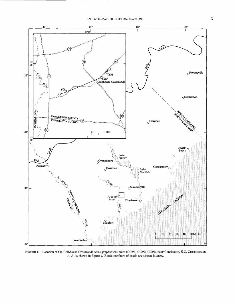
REVISED NOMENCLATURE, DEFINITIONS, AND CORRELATIONS, USGS-CLUBHOUSE CROSSROADS #1
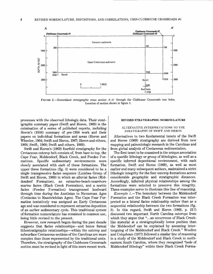
May 1977, near the hamlet of Clubhouse Crossroads southwest of Summerville and northwest of Charleston, S.C. (fig. 1). The test holes encountered Jurassic basalt flows and underlying Triassic(?) and Jurassic(?) sedimen tary red beds below a Cretaceous and Cenozoic Coastal Plain section (fig. 2). Coring was conducted continuously in the Coastal Plain and basalt sections in #1 and intermittently in the basalt and red-bed sections in #2 and #3. Geophysical logs were collected in the three holes, but the logs did not reach the top of the basalt in #2 and #3 because of blockages in the holes.
Geophysical logs (#1, #2) or a lithologic log (#3) are published for three drill holes (Rhodehamel, 1975; Hig- gins and others, 1978; Schneider and others, 1979). Lithologic, petrologic, geochemical, and paleomagnetic studies of the basalt and red-bed sections are published in several chapters of Gohn's (1983) compilation. The preliminary reports that include lithostratigraphic (Gohn and others, 1977) and biostratigraphic (Hazel and others, 1977) studies of the Cretaceous section in USGS- Clubhouse Crossroads #1 are examined critically herein.
In the following discussion, depths to given horizons in the Clubhouse Crossroads #1 drill hole are given in feet as measured on the geophysical logs. The log measuring point (kelly bushing) was at an elevation of approxi mately 23 ft above sea level and was 5 ft above the measuring point (land surface, approximately an 18-ft elevation) for the recovered core segments. Therefore, depths previously assigned to the core had to be adjusted for the difference in measuring points, for measuring errors caused by core expansion, and for errors intro duced by unrecovered intervals.
ACKNOWLEDGMENTS
Lithologic logs and notes prepared by Charles C. Smith (Unocal, Houston, Tex.) and Norman F. Sohl and Brenda B. Houser (U.S. Geological Survey) served as important supplements to my lithologic information for the Clubhouse Crossroads #1 core. Reviews by James P. Owens and the late Juergen Reinhardt (U.S. Geological Survey) substantially improved the format and content of the report. Additional comments by Norman F. Sohl and Bruce G. Campbell (U.S. Geological Survey) were also helpful. Credit for the core photographs (except fig. 17.D) is extended to Charles C. Smith. Digital files for the geophysical logs used in plate 1 were supplied by Bruce G. Campbell.
STRATIGRAPHIC NOMENCLATURE
HISTORICAL PERSPECTIVE
Criteria for the definition and correlation of Creta ceous formations in South Carolina and North Carolina
have changed significantly through the decades. In the first half of the century, lithologic and paleontologic data (principally from macroinvertebrates and plant macro- fossils) were used interchangeably to define broadly delineated, areally extensive formations in the pioneer ing works of Stephenson (1923), Cooke (1936), and others of that era.
No major changes to this practice occurred until the 1960's, when modern sedimentologic concepts were first integrated with stratigraphic studies and a stricter adherence to standardized stratigraphic codes reduced the use of biostratigraphic data in defining formal litho stratigraphic units. This change in concepts is best exemplified in the works of Brett and Wheeler (1961) and Swift and Heron (1969).
More recently, stratigraphic studies of the Carolina Coastal Plain have drawn upon integrated large-scale studies of the physical processes and chronostratigraphy of sedimentary basins to better understand the sedimen tary history and to define the Cretaceous stratigraphic units of that area. In particular, the long-standing rec ognition of cyclic, delta-influenced sedimentation pat terns in Coastal Plain deposits (Fisher, 1964; Owens and Sohl, 1969) has been updated and integrated with mod ern concepts of depositional and genetic stratigraphic sequences (Mitchum and others, 1977; Van Wagoner and others, 1988; Galloway, 1989a, b). Application of the rudiments of these concepts is apparent in recent studies of the Carolina Cretaceous, including those by Owens and Gohn (1985), Gohn and Owens (1989), Owens and Sohl (1989), and Sohl and Owens (1991).
The development of stratigraphic nomenclature for the Cretaceous section in the Clubhouse Crossroads #1 corehole is closely related to this evolution of strati- graphic concepts in the Carolinas. In the following sec tions, previous stratigraphic terminology is reviewed, and the bases for redefining the Cretaceous formations at Clubhouse Crossroads are discussed.
PREVIOUS STRATIGRAPHIC NOMENCLATURE
Gohn and others (1977) and Hazel and others (1977) used the stratigraphy established for outcropping Creta ceous sediments of the Carolinas by Swift and Heron (1969) as a basis for their preliminary studies of the subsurface Cretaceous section at Clubhouse Crossroads. In particular, the sequence of four formations identified by Swift and Heron in the outcrop section was used as a model for assigning provisional formation names to the Cretaceous units in the Clubhouse Crossroads #1 core.
The stratigraphic framework defined by Swift and Heron (1969) is a dynamic stratigraphy that combines their interpretations of depositional environments and
82°
STRATIGRAPHIC NOMENCLATURE
81° 80° 79°
35°
34C
33 C
Savannah
0 10 20 U 40I : --|: :' :i: .i. :l : 'I'...
32CQ -"x
I
FIGURE 1. Location of the Clubhouse Crossroads stratigraphic test holes (CC#1, CC#2, CC#3) near Charleston, S.C. Cross sectionA-A' is shown in figure 2. Route numbers of roads are shown in inset.
REVISED NOMENCLATURE, DEFINITIONS, AND CORRELATIONS, USGS-CLUBHOUSE CROSSROADS #1
A'
Clubhouse Crossroads #1
1000
- 2000
3000
Clubhouse Crossroads #2 Clubhouse Crossroads #3 \
800
2464 J
2599-
Cenozoic sediments
Upper Cretaceous sediments
L Basalt
Ba
-0 1 MILE l,l
Red
787
2543
;alt
-784
-2546
L2976 -
3382
beds L 3780
1000
2000
3000
FIGURE 2. Generalized stratigraphic cross section A-A' through the Clubhouse Crossroads test holes.Location of section shown in figure 1.
processes with the observed lithologic data. Their strat igraphic summary paper (Swift and Heron, 1969) is the culmination of a series of published reports, including Heron's (1958) summary of pre-1958 work and their papers on individual formations and areas (Heron and Wheeler, 1964; Swift and Heron, 1967; Heron and others, 1968; Swift, 1968; Swift and others, 1969).
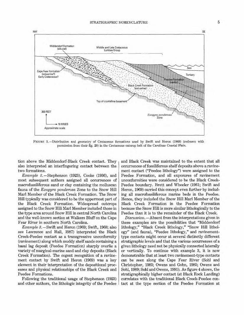
Swift and Heron's (1969) fourfold stratigraphy for the Cretaceous outcrop belt consists of, from base to top, the Cape Fear, Middendorf, Black Creek, and Peedee For mations. Specific sedimentary environments were closely associated with each of these formations. The upper three formations (fig. 3) were considered to be a single transgressive facies sequence (Lumbee Group of Swift and Heron, 1969) in which an alluvial facies (Mid dendorf Formation), an estuarine-beach-nearshore marine facies (Black Creek Formation), and a neritic facies (Peedee Formation) transgressed landward through time during the Austinian to Navarroan Ages (Coniacian to Maastrichtian Ages). The Cape Fear For mation tentatively was assigned an Early Cretaceous age and was considered to represent estuarine deposition of an earlier sedimentary cycle. This traditional system of formation nomenclature has remained in common use, being little revised to the present.
However, new research begun during the past decade suggests that facies relationships and hence formal lithostratigraphic relationships within the outcrop and subsurface Cretaceous sections of the Carolinas are more complex than those represented by the traditional units. Therefore, the stratigraphy of the Clubhouse Crossroads section must be revised in light of this more recent work.
REVISED STRATIGRAPHIC NOMENCLATURE
ALTERNATIVE INTERPRETATIONS TO THE STRATIGRAPHY OF SWIFT AND HERON
Alternatives to two fundamental tenets of the Swift and Heron (1969) stratigraphy are derived from new mapping and paleontologic research in the Carolinas and from global analysis of Cretaceous sedimentation.
The first tenet to be examined is the unique association of a specific lithology or group of lithologies, as well as a specific inferred depositional environment, with each formation. Swift and Heron (1969), as well as most earlier and many subsequent authors, maintained a strict lithologic integrity for the four outcrop formations across considerable geographic and stratigraphic distances. Accordingly, inferred physical relationships among the formations were selected to preserve this integrity. Three examples serve to illustrate this line of reasoning.
Example 1. The boundary between the Middendorf Formation and the Black Creek Formation was inter preted as a lateral facies relationship rather than as a sequential relationship between the two formations (fig. 3). In this regard, Swift and Heron (1969, p. 217) discussed two important North Carolina outcrops from which they argue that "...an occurrence of Black Creek- like material at a stratigraphically lower position than the Middendorf can be explained by assuming inter- tonguing of the Middendorf and Black Creek." Woollen and Colquhoun (1977) followed a similar line of reasoning in a study of the Middendorf and Black Creek in north eastern South Carolina, where they recognized "beds of Middendorf lithology" within their Black Creek Forma-
STRATIGRAPHIC NOMENCLATURE
NW SE
Middendorf Formation (alluvial) \
Middle and Late Cretaceous Lumbee Group
Cape Fear Formation(estuarine?)
Early Cretaceous?
Top of crystalline basement
300 FEET
> 10 MILES
Approximate scale
Exogyra ponderosa Zone
FIGURE 3. Distribution and geometry of Cretaceous formations used by Swift and Heron (1969) (redrawn with permission from their fig. 20) in the Cretaceous outcrop belt of the Carolinas Coastal Plain.
tion above the Middendorf-Black Creek contact. They also interpreted an interfingering contact between the two formations.
Example 2. Stephenson (1923), Cooke (1936), and most subsequent authors assigned all occurrences of macrofossiliferous sand or clay containing the molluscan fauna of the Exogyra ponderosa Zone to the Snow Hill Marl Member of the Black Creek Formation. The Snow Hill typically was considered to be the uppermost part of the Black Creek Formation. Widespread outcrops assigned to the Snow Hill Marl Member included those in the type area around Snow Hill in central North Carolina and the well-known section at Walkers Bluff on the Cape Fear River in southern North Carolina.
Example 3. -Swift and Heron (1969; Swift, 1968; also see Lawrence and Hall, 1987) interpreted the Black Creek-Peedee contact as a transgressive unconformity (ravinement) along which muddy shelf sands containing a basal lag deposit (Peedee Formation) sharply overlie a variety of marginal-marine sand and clay deposits (Black Creek Formation). The cogent recognition of a ravine ment contact by Swift and Heron (1969) was a key element in their interpretation of the depositional proc esses and physical relationships of the Black Creek and Peedee Formations.
Following the traditional usage of Stephenson (1923) and other authors, the lithologic integrity of the Peedee
and Black Creek was maintained to the extent that all occurrences of fossiliferous shelf deposits above a ravine ment contact ("Peedee lithology") were assigned to the Peedee Formation, and all exposures of ravinement unconformities were considered to be the Black Creek- Peedee boundary. Brett and Wheeler (1961; Swift and Heron, 1969) carried this concept even further by includ ing all macrofossiliferous marine beds in the Peedee. Hence, they included the Snow Hill Marl Member of the Black Creek Formation in the Peedee Formation because the Snow Hill is more similar lithologically to the Peedee than it is to the remainder of the Black Creek.
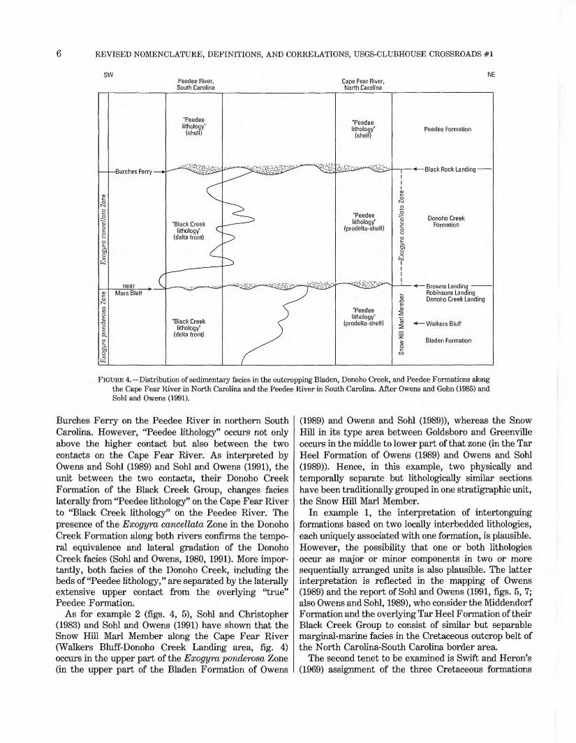
Discussion. Absent from the interpretations given in these examples are the possibilities that "Middendorf lithology," "Black Creek lithology," "Snow Hill lithol ogy" (and fauna), "Peedee lithology," and ravinement- type contacts might occur at several distinctly different stratigraphic levels and that the various occurrences of a given lithology need not be physically connected laterally or vertically. To continue with example 3, it is now demonstrable that at least two ravinement-type contacts can be seen along the Cape Fear River (Sohl and Christopher, 1983; Owens and Gohn, 1985; Owens and Sohl, 1989; Sohl and Owens, 1991). As figure 4 shows, the stratigraphically higher contact (at Black Rock Landing) correlates with the traditional Black Creek-Peedee con tact at the type section of the Peedee Formation at
REVISED NOMENCLATURE, DEFINITIONS, AND CORRELATIONS, USGS-CLUBHOUSE CROSSROADS #1
SW MEPeedee River, South Carolina
Cape Fear River, North Carolina
Robinsons Landing Donoho Creek Landing
FIGURE 4. Distribution of sedimentary fades in the outcropping Bladen, Donoho Creek, and Peedee Formations along the Cape Fear River in North Carolina and the Peedee River in South Carolina. After Owens and Gohn (1985) and Sohl and Owens (1991).
Burches Ferry on the Peedee River in northern South Carolina. However, "Peedee lithology" occurs not only above the higher contact but also between the two contacts on the Cape Fear River. As interpreted by Owens and Sohl (1989) and Sohl and Owens (1991), the unit between the two contacts, their Donoho Creek Formation of the Black Creek Group, changes facies laterally from "Peedee lithology" on the Cape Fear River to "Black Creek lithology" on the Peedee River. The presence of the Exogyra cancellata Zone in the Donoho Creek Formation along both rivers confirms the tempo ral equivalence and lateral gradation of the Donoho Creek facies (Sohl and Owens, 1980, 1991). More impor tantly, both facies of the Donoho Creek, including the beds of "Peedee lithology," are separated by the laterally extensive upper contact from the overlying "true" Peedee Formation.
As for example 2 (figs. 4, 5), Sohl and Christopher (1983) and Sohl and Owens (1991) have shown that the Snow Hill Marl Member along the Cape Fear River (Walkers Bluff-Donoho Creek Landing area, fig. 4) occurs in the upper part of the Exogyra ponderosa Zone (in the upper part of the Bladen Formation of Owens
(1989) and Owens and Sohl (1989)), whereas the Snow Hill in its type area between Goldsboro and Greenville occurs in the middle to lower part of that zone (in the Tar Heel Formation of Owens (1989) and Owens and Sohl (1989)). Hence, in this example, two physically and temporally separate but lithologically similar sections have been traditionally grouped in one stratigraphic unit, the Snow Hill Marl Member.
In example 1, the interpretation of intertonguing formations based on two locally interbedded lithologies, each uniquely associated with one formation, is plausible. However, the possibility that one or both lithologies occur as major or minor components in two or more sequentially arranged units is also plausible. The latter interpretation is reflected in the mapping of Owens (1989) and the report of Sohl and Owens (1991, figs. 5, 7; also Owens and Sohl, 1989), who consider the Middendorf Formation and the overlying Tar Heel Formation of their Black Creek Group to consist of similar but separable marginal-marine facies in the Cretaceous outcrop belt of the North Carolina-South Carolina border area.
The second tenet to be examined is Swift and Heron's (1969) assignment of the three Cretaceous formations

STRATIGRAPHIC NOMENCLATURE
TAR HEEL FORMATION
y NASOUTH CAROLINA
Q \ Wilmingt
Myrtle Beach
DONOHO CREEK FORMATION
o 0
V
V0 10 20 30 MILES
FIGURE 5. Outcrop belts of the Tar Heel, Bladen, and Donoho Creek Formations of the Black Creek Group and the Peedee Formation in North Carolina and South Carolina. The distributions of sedimentary facies within each formation (for example, the delta-plain facies of the Bladen Formation) are also shown. Modified from Owens and Sohl (1989) and Sohl and Owens (1991).
above the Cape Fear Formation to a single long-term transgressive episode. This concept contrasts with stud ies of global sedimentation patterns during the past decade (Haq and others, 1987) that emphasize numerous eustatic sea-level changes during the Mesozoic and Ceno- zoic Eras as a principal cause of observed coastal onlap cycles and related cyclic sedimentation patterns. In particular, Haq and others (1987) listed 10 third-order cycles of coastal onlap in the same time period (Coniacian
through Maastrichtian Ages) that Swift and Heron (1969) proposed a single, strictly transgressive sequence in the Cretaceous section of the Carolinas.
In summary, the discussion in this section illustrates that certain specific aspects of the Swift and Heron stratigraphy are problematic or, at the least, that alter native interpretations are possible. Accordingly, the following section describes an alternative, revised stra tigraphy.
REVISED NOMENCLATURE, DEFINITIONS, AND CORRELATIONS, USGS-CLUBHOUSE CROSSROADS #1
REVISED OUTCROP STRATIGRAPHY
Reports describing the Cretaceous sediments of the Carolinas published during the past decade include geo logic maps, paleontologic studies, and drill-hole studies by the USGS (Sohl and Christopher, 1983; Owens and Gohn, 1985; Gohn, 1988; Owens and Sohl, 1989; Gohn and Owens, 1989; Owens, 1989; Sohl and Owens, 1991; Gohn, 1992). The revised stratigraphy for outcropping Creta ceous units that resulted from these studies has as its central themes the delta-related origin of the sedimen tary section, the presence of recognizable patterns of vertical repetition as well as lateral gradation of fades, and the importance of transgressive marine sections above disconformable contacts in defining formations that are also process-related (genetic) sedimentary units. This model differs only in local detail and in scale from stratigraphic and sedimentologic models applied to Cre taceous and Cenozoic sections of the Gulf of Mexico Coastal Plain (for example, the papers collected by Roy, 1980; Galloway, 1989a, b).
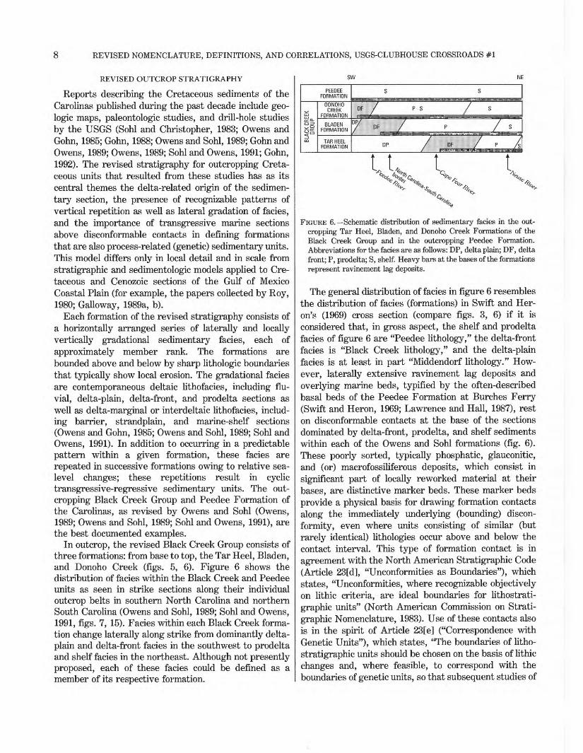
Each formation of the revised stratigraphy consists of a horizontally arranged series of laterally and locally vertically gradational sedimentary facies, each of approximately member rank. The formations are bounded above and below by sharp lithologic boundaries that typically show local erosion. The gradational facies are contemporaneous deltaic lithofacies, including flu vial, delta-plain, delta-front, and prodelta sections as well as delta-marginal or interdeltaic lithofacies, includ ing barrier, strandplain, and marine-shelf sections (Owens and Gohn, 1985; Owens and Sohl, 1989; Sohl and Owens, 1991). In addition to occurring in a predictable pattern within a given formation, these facies are repeated in successive formations owing to relative sea- level changes; these repetitions result in cyclic transgressive-regressive sedimentary units. The out cropping Black Creek Group and Peedee Formation of the Carolinas, as revised by Owens and Sohl (Owens, 1989; Owens and Sohl, 1989; Sohl and Owens, 1991), are the best documented examples.
In outcrop, the revised Black Creek Group consists of three formations: from base to top, the Tar Heel, Bladen, and Donoho Creek (figs. 5, 6). Figure 6 shows the distribution of facies within the Black Creek and Peedee units as seen in strike sections along their individual outcrop belts in southern North Carolina and northern South Carolina (Owens and Sohl, 1989; Sohl and Owens, 1991, figs. 7, 15). Facies within each Black Creek forma tion change laterally along strike from dominantly delta- plain and delta-front facies in the southwest to prodelta and shelf facies in the northeast. Although not presently proposed, each of these facies could be defined as a member of its respective formation.
FIGURE 6. Schematic distribution of sedimentary facies in the out cropping Tar Heel, Bladen, and Donoho Creek Formations of the Black Creek Group and in the outcropping Peedee Formation. Abbreviations for the facies are as follows: DP, delta plain; DF, delta front; P, prodelta; S, shelf. Heavy bars at the bases of the formations represent ravinement lag deposits.
The general distribution of facies in figure 6 resembles the distribution of facies (formations) in Swift and Her on's (1969) cross section (compare figs. 3, 6) if it is considered that, in gross aspect, the shelf and prodelta facies of figure 6 are "Peedee lithology," the delta-front facies is "Black Creek lithology," and the delta-plain facies is at least in part "Middendorf lithology." How ever, laterally extensive ravinement lag deposits and overlying marine beds, typified by the often-described basal beds of the Peedee Formation at Burches Ferry (Swift and Heron, 1969; Lawrence and Hall, 1987), rest on disconformable contacts at the base of the sections dominated by delta-front, prodelta, and shelf sediments within each of the Owens and Sohl formations (fig. 6). These poorly sorted, typically phosphatic, glauconitic, and (or) macrofossiliferous deposits, which consist in significant part of locally reworked material at their bases, are distinctive marker beds. These marker beds provide a physical basis for drawing formation contacts along the immediately underlying (bounding) discon- formity, even where units consisting of similar (but rarely identical) lithologies occur above and below the contact interval. This type of formation contact is in agreement with the North American Stratigraphic Code (Article 23[d], "Unconformities as Boundaries"), which states, "Unconformities, where recognizable objectively on lithic criteria, are ideal boundaries for lithostrati- graphic units" (North American Commission on Strati- graphic Nomenclature, 1983). Use of these contacts also is in the spirit of Article 23[e] ("Correspondence with Genetic Units"), which states, "The boundaries of litho- stratigraphic units should be chosen on the basis of lithic changes and, where feasible, to correspond with the boundaries of genetic units, so that subsequent studies of
REVISED CRETACEOUS STRATIGRAPHY, USGS-CLUBHOUSE CROSSROADS #1
genesis will not have to deal with units that straddle formal boundaries."
RECONCILIATION OF STRATIGRAPHIC NOMENCLATURE
Both the Swift-Heron and Owens-Sohl systems of stratigraphic nomenclature are in use by geologists in the Carolinas. Therefore, a reconciliation of the stratigraphic nomenclature of Sohl and Owens (1991; related papers) with the nomenclature of Swift and Heron (1969; related papers) is attempted by using the venerable facies model proposed by Caster (1934) (also see Moore, 1949) for certain Appalachian rocks. The applicability of Caster's (1934) model to the Cretaceous section of the Carolinas already has been suggested by Dennison (1990).
Before Caster's work in northwestern Pennsylvania and adjacent States, large belts of lithologically similar rocks presumed to be of similar age constituted the Upper Devonian stratigraphic units of that area. How ever, by repeatedly tracing marker beds from one Upper Devonian stratigraphic unit into another, Caster was able to demonstrate lateral facies relationships within these complexes of deltaic sediments. In his words, "The contemporaneously deposited facies of almost any Upper Devonian formation grade from deltaic red beds in the east, proximal to the Catskill delta, through normal marine elastics in the central area and eventually pass into carbonaceous shales deposited in an open or perhaps Sargasso-like sea in the west" (Caster, 1934, p. 19).
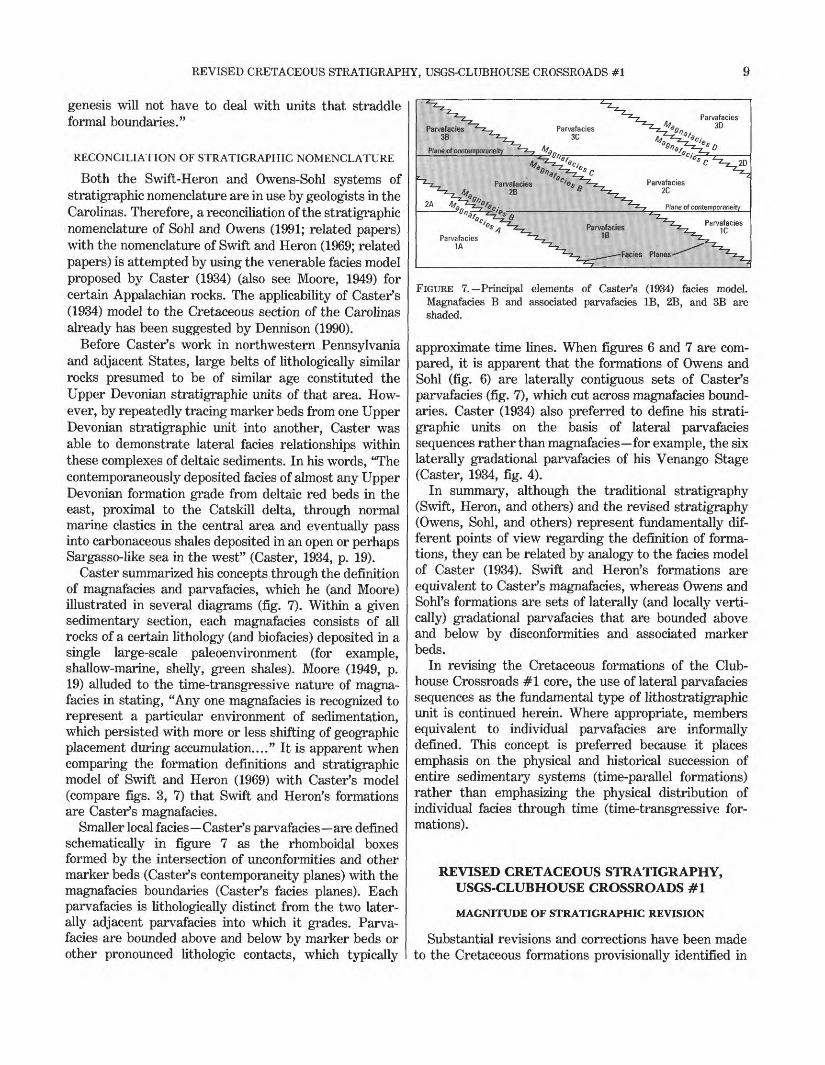
Caster summarized his concepts through the definition of magnafacies and parvafacies, which he (and Moore) illustrated in several diagrams (fig. 7). Within a given sedimentary section, each magnafacies consists of all rocks of a certain lithology (and biofacies) deposited in a single large-scale paleoenvironment (for example, shallow-marine, shelly, green shales). Moore (1949, p. 19) alluded to the time-transgressive nature of magna facies in stating, "Any one magnafacies is recognized to represent a particular environment of sedimentation, which persisted with more or less shifting of geographic placement during accumulation...." It is apparent when comparing the formation definitions and stratigraphic model of Swift and Heron (1969) with Caster's model (compare figs. 3, 7) that Swift and Heron's formations are Caster's magnafacies.
Smaller local facies Caster's parvafacies are defined schematically in figure 7 as the rhomboidal boxes formed by the intersection of unconformities and other marker beds (Caster's contemporaneity planes) with the magnafacies boundaries (Caster's facies planes). Each parvafacies is lithologically distinct from the two later ally adjacent parvafacies into which it grades. Parva facies are bounded above and below by marker beds or other pronounced lithologic contacts, which typically
FIGURE 7. Principal elements of Caster's (1934) facies model. Magnafacies B and associated parvafacies IB, 2B, and 3B are shaded.
approximate time lines. When figures 6 and 7 are com pared, it is apparent that the formations of Owens and Sohl (fig. 6) are laterally contiguous sets of Caster's parvafacies (fig. 7), which cut across magnafacies bound aries. Caster (1934) also preferred to define his strati- graphic units on the basis of lateral parvafacies sequences rather than magnafacies for example, the six laterally gradational parvafacies of his Venango Stage (Caster, 1934, fig. 4).
In summary, although the traditional stratigraphy (Swift, Heron, and others) and the revised stratigraphy (Owens, Sohl, and others) represent fundamentally dif ferent points of view regarding the definition of forma tions, they can be related by analogy to the facies model of Caster (1934). Swift and Heron's formations are equivalent to Caster's magnafacies, whereas Owens and SohPs formations are sets of laterally (and locally verti cally) gradational parvafacies that are bounded above and below by disconformities and associated marker beds.
In revising the Cretaceous formations of the Club house Crossroads #1 core, the use of lateral parvafacies sequences as the fundamental type of lithostratigraphic unit is continued herein. Where appropriate, members equivalent to individual parvafacies are informally defined. This concept is preferred because it places emphasis on the physical and historical succession of entire sedimentary systems (time-parallel formations) rather than emphasizing the physical distribution of individual facies through time (time-transgressive for mations).
REVISED CRETACEOUS STRATIGRAPHY, USGS-CLUBHOUSE CROSSROADS #1
MAGNITUDE OF STRATIGRAPHIC REVISION
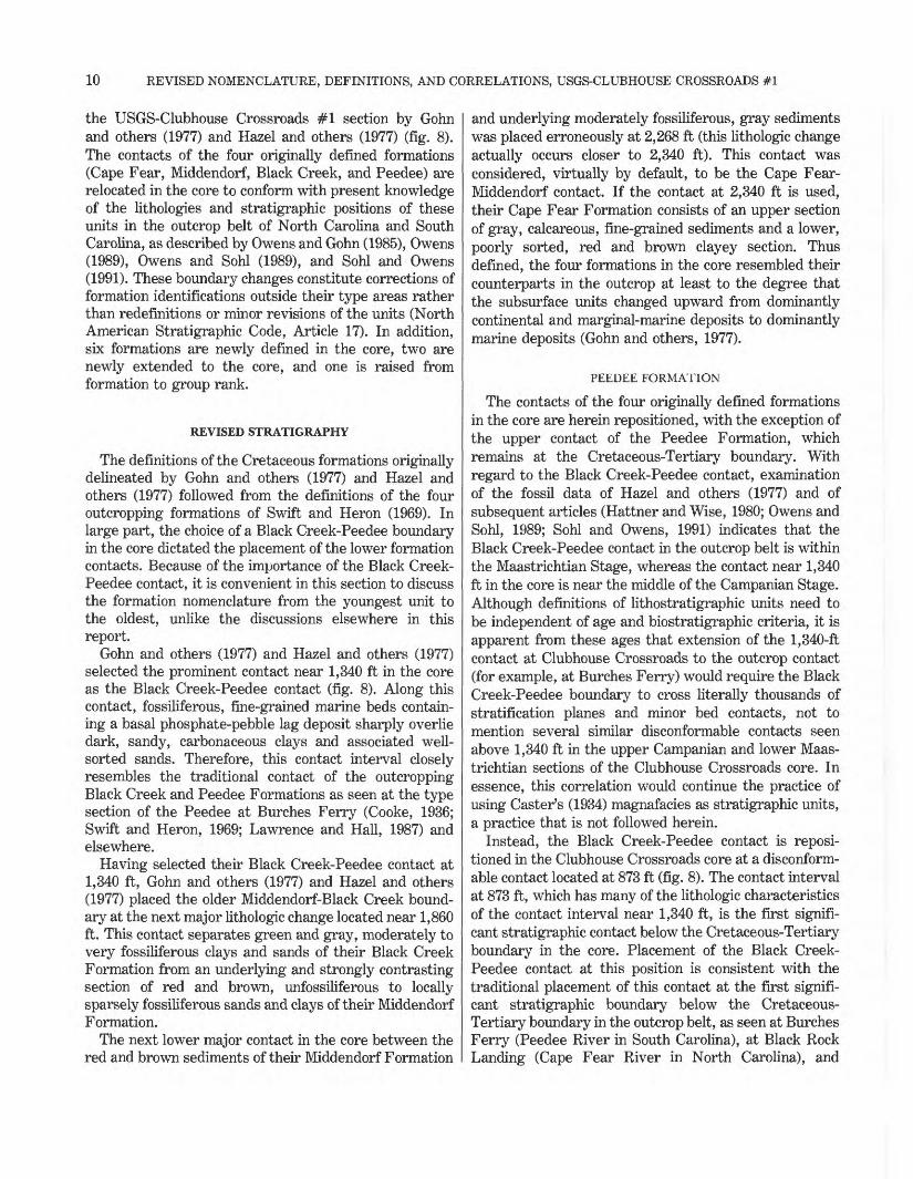
Substantial revisions and corrections have been made to the Cretaceous formations provisionally identified in
10 REVISED NOMENCLATURE, DEFINITIONS, AND CORRELATIONS, USGS-CLUBHOUSE CROSSROADS #1
the USGS-Clubhouse Crossroads #1 section by Gohn and others (1977) and Hazel and others (1977) (fig. 8). The contacts of the four originally defined formations (Cape Fear, Middendorf, Black Creek, and Peedee) are relocated in the core to conform with present knowledge of the lithologies and stratigraphic positions of these units in the outcrop belt of North Carolina and South Carolina, as described by Owens and Gohn (1985), Owens (1989), Owens and Sohl (1989), and Sohl and Owens (1991). These boundary changes constitute corrections of formation identifications outside their type areas rather than redefinitions or minor revisions of the units (North American Stratigraphic Code, Article 17). In addition, six formations are newly defined in the core, two are newly extended to the core, and one is raised from formation to group rank.
REVISED STRATIGRAPHY
The definitions of the Cretaceous formations originally delineated by Gohn and others (1977) and Hazel and others (1977) followed from the definitions of the four outcropping formations of Swift and Heron (1969). In large part, the choice of a Black Creek-Peedee boundary in the core dictated the placement of the lower formation contacts. Because of the importance of the Black Creek- Peedee contact, it is convenient in this section to discuss the formation nomenclature from the youngest unit to the oldest, unlike the discussions elsewhere in this report.
Gohn and others (1977) and Hazel and others (1977) selected the prominent contact near 1,340 ft in the core as the Black Creek-Peedee contact (fig. 8). Along this contact, fossiliferous, fine-grained marine beds contain ing a basal phosphate-pebble lag deposit sharply overlie dark, sandy, carbonaceous clays and associated well- sorted sands. Therefore, this contact interval closely resembles the traditional contact of the outcropping Black Creek and Peedee Formations as seen at the type section of the Peedee at Burches Ferry (Cooke, 1936; Swift and Heron, 1969; Lawrence and Hall, 1987) and elsewhere.
Having selected their Black Creek-Peedee contact at 1,340 ft, Gohn and others (1977) and Hazel and others (1977) placed the older Middendorf-Black Creek bound ary at the next major lithologic change located near 1,860 ft. This contact separates green and gray, moderately to very fossiliferous clays and sands of their Black Creek Formation from an underlying and strongly contrasting section of red and brown, unfossiliferous to locally sparsely fossiliferous sands and clays of their Middendorf Formation.
The next lower major contact in the core between the red and brown sediments of their Middendorf Formation
and underlying moderately fossiliferous, gray sediments was placed erroneously at 2,268 ft (this lithologic change actually occurs closer to 2,340 ft). This contact was considered, virtually by default, to be the Cape Fear- Middendorf contact. If the contact at 2,340 ft is used, their Cape Fear Formation consists of an upper section of gray, calcareous, fine-grained sediments and a lower, poorly sorted, red and brown clayey section. Thus defined, the four formations in the core resembled their counterparts in the outcrop at least to the degree that the subsurface units changed upward from dominantly continental and marginal-marine deposits to dominantly marine deposits (Gohn and others, 1977).
PEEDEE FORMATION
The contacts of the four originally defined formations in the core are herein repositioned, with the exception of the upper contact of the Peedee Formation, which remains at the Cretaceous-Tertiary boundary. With regard to the Black Creek-Peedee contact, examination of the fossil data of Hazel and others (1977) and of subsequent articles (Hattner and Wise, 1980; Owens and Sohl, 1989; Sohl and Owens, 1991) indicates that the Black Creek-Peedee contact in the outcrop belt is within the Maastrichtian Stage, whereas the contact near 1,340 ft in the core is near the middle of the Campanian Stage. Although definitions of lithostratigraphic units need to be independent of age and biostratigraphic criteria, it is apparent from these ages that extension of the 1,340-ft contact at Clubhouse Crossroads to the outcrop contact (for example, at Burches Ferry) would require the Black Creek-Peedee boundary to cross literally thousands of stratification planes and minor bed contacts, not to mention several similar disconformable contacts seen above 1,340 ft in the upper Campanian and lower Maas trichtian sections of the Clubhouse Crossroads core. In essence, this correlation would continue the practice of using Caster's (1934) magnafacies as stratigraphic units, a practice that is not followed herein.
Instead, the Black Creek-Peedee contact is reposi tioned in the Clubhouse Crossroads core at a disconform able contact located at 873 ft (fig. 8). The contact interval at 873 ft, which has many of the lithologic characteristics of the contact interval near 1,340 ft, is the first signifi cant stratigraphic contact below the Cretaceous-Tertiary boundary in the core. Placement of the Black Creek- Peedee contact at this position is consistent with the traditional placement of this contact at the first signifi cant stratigraphic boundary below the Cretaceous- Tertiary boundary in the outcrop belt, as seen at Burches Ferry (Peedee River in South Carolina), at Black Rock Landing (Cape Fear River in North Carolina), and
REVISED CRETACEOUS STRATIGRAPHY, USGS-CLUBHOUSE CROSSROADS #1 11
DUAL INDUCTION LATEROLDG-(-
%\j\
<w
j\1
\
j£~~^~X.
/i\
j5?I^
*i
4Jr
g^<2!
«7^4^<?
C5 CO
O O
O OCM
O
CO
o oCO
o o
o oCM CM
o
CM
ir-
i
jJ^
^V-Ht
VI
Ji^
i^
-i-i1
*
THIS REPORT
800 Peedee Formation
873
Donoho Creek
Formation
1072
Bladen Formation
1214
Coachman Formation
1344
Cane Acre
Formation
Black Creek Group
1544 Caddin
Formation
1644Shepherd Grove
Formation
1754 Middendorf Formation
1861
Cape Fear
Formation
2338 Clubhouse Formation
2417 Beech Hill Formation
2464 Basalt
HAZEL AND OTHERS (1977) GOHN AND
OTHERS (1977)
800
Peedee Formation
1340
Black Creek
Formation
1860
Middendorf Formation
2268
Cape Fear Formation
2462 Basalt
GOHN AND OTHERS
(1978)
K6
K5
K4
K3
K2
K1
Basalt
BROWN AND
OTHERS (1979)
800
A
1100
B
1540
C
1860
D
2262
F (part)
Basalt
OWENS AND
GOHN (1985)
6
5
4
3B
3A
2
1 (part)
Basalt
GOHN (1992)
Not studied
1072
5
1214
4
1344
3
1544
2
1644
1
1754
Not studied
- + Feet 10mV 0 100ohm-m2/m
FIGURE 8. Formal and informal stratigraphic nomenclature used for the Cretaceous section in USGS- Clubhouse Crossroads #1 core. Depths of contacts (in feet) are given where stated explicitly by previous authors. Electric log for the Cretaceous section is shown at left.
12 REVISED NOMENCLATURE, DEFINITIONS, AND CORRELATIONS, USGS-CLUBHOUSE CROSSROADS #1
elsewhere (Cooke, 1936; Swift and Heron, 1969; Lawrence and Hall, 1987; Sohl and Owens, 1991).
The previous miscorrelation of the section between 1,344 and 873 ft with the outcropping Peedee Formation is herein corrected. The Peedee Formation in the Club house Crossroads core is now restricted to the section between 873 and 800 ft. That part of the Clubhouse Crossroads #1 core below 873 ft that was assigned to the Peedee Formation by Gohn and others (1977) and Hazel and others (1977) and that is herein assigned to the Black Creek Group (Black Creek unit revised from formation to group herein) is specifically excluded from the revised Peedee Formation (fig. 8).
BLACK CREEK GROUP
The definition of the Black Creek Formation in the Clubhouse Crossroads #1 core used by Gohn and others (1977) and Hazel and others (1977) is substantially revised herein. In addition, the rank of the unit is raised to the group level, following the use of a Black Creek Group in the Cretaceous outcrop belt of the Carolinas by Owens (1989) and Sohl and Owens (1991).
The base of the Black Creek Group is relocated in the core from 1,860 ft to a disconformable contact at 1,544 ft. Gohn (1992) has shown that the unit immediately above 1,544 ft (his unit 3, Cane Acre Formation of this report) (fig. 8) oversteps the beds between 1,754 and 1,544 ft in the core toward the outcrop belt. Because the beds in this interval (units 1 and 2 of Gohn, 1992) do not reach the outcrop belt, they cannot be part of the outcropping Black Creek Group and must represent older, strictly subsurface units. Still lower beds between 1,861 and 1,754 ft are obviously separate from the Black Creek. Therefore, the base of the Black Creek Group in the core could not be lower than 1,544 ft.
Correlation of the newly created Black Creek Group of the core with the outcropping Black Creek Group of Owens and Sohl is hampered by the recognition of four formations in the core but only three formations in the outcrop. The two highest formations in the outcrop, the Bladen and overlying Donoho Creek Formations, can be recognized in their correct stratigraphic positions below the Peedee Formation in the core, where they consist of virtually the same lithology (parvafacies) as that found in the Cape Fear River area of North Carolina. Therefore, the Bladen and Donoho Creek Formations are newly extended herein to the Clubhouse Crossroads core. Cor relation of the lower outcrop unit, the Tar Heel Forma tion, with the lower part of the Black Creek Group in the core is less certain. Hence, two new formations, Cane Acre (lowest) and Coachman, are newly defined in the Black Creek Group of the Clubhouse Crossroads core (fig. 8). It is likely that one of the subsurface Black Creek
formations oversteps another toward the outcrop belt, in much the same manner described above for the base of the Cane Acre Formation; the number of formations seen at the surface is thereby reduced.
In summary, the section between 1,861 and 1,544 ft is removed herein from the Black Creek Group and is reassigned to other formations (fig. 8). The section between 1,544 and 1,344 ft is retained within the Black Creek Group as the Cane Acre Formation. The section between 1,344 and 873 ft is removed from the Peedee Formation and assigned to the Coachman, Bladen, and Donoho Creek Formations of the Black Creek Group.
CADDIN AND SHEPHERD GROVE FORMATIONS
Below the revised Black Creek Group, Gohn's (1992) subsurface units 1 and 2 between 1,754 and 1,544 ft are herein newly defined as the Shepherd Grove Formation and the overlying Caddin Formation, respectively. All correlations of the 1,754- to 1,544-ft section with the Black Creek Group (Formation) are herein abandoned.
MIDDENDORF AND CAPE FEAR FORMATIONS
Revisions of the formation definitions in the section below the Shepherd Grove Formation require substan tial revisions to the original definitions of the Cape Fear and Middendorf Formations in the core. The section of alternating coarse feldspathic sands and reddish clays originally assigned to the Middendorf Formation in the core was subsequently shown to be one of the most distinctive lithologic units throughout the subsurface of eastern South Carolina, where it has been traced as informal units K3 of Gohn and others (1978) and D of Brown and others (1979) (fig. 8). In core holes located in updip positions relative to Clubhouse Crossroads #1, this distinctively oxidized and internally cyclic unit directly overlies pre-Cretaceous rocks and has been assigned to the Cape Fear Formation (Reid and others, 1986a, b; Fallaw and others, 1990). The lithologic simi larity of this unit to the outcropping Cape Fear Forma tion (Heron and others, 1968; Swift and Heron, 1969; Sohl and Owens, 1991) supports this correlation.
Therefore, the section originally assigned to the Mid dendorf Formation at Clubhouse Crossroads is removed herein from the Middendorf and assigned to the Cape Fear Formation (fig. 8). The Cape Fear Formation at Clubhouse Crossroads is revised to include part of the section previously assigned to the Cape Fear (2,338- 2,268 ft) by Gohn and others (1977) and Hazel and others (1977) and virtually all of the section previously assigned to the Middendorf (2,268-1,861 ft) by those authors. All correlations of the section assigned to the revised Cape Fear Formation with the outcropping Middendorf For mation of the Carolinas are herein abandoned.

REVISED CRETACEOUS STRATIGRAPHY, USGS-CLUBHOUSE CROSSROADS #1 13
The Middendorf Formation in the core is revised to include the section of coarse sands and dark-gray carbo naceous clays between the oxidized Cape Fear section at 1,861 ft and the fine-grained marine section of the newly defined Shepherd Grove Formation at 1,754 ft. The previous assignment of this interval to the Black Creek Group (Formation) is abandoned herein, as is correlation of the interval now assigned to the Middendorf in the core with the outcropping Black Creek Group of the Carolinas.
CLUBHOUSE AND BEECH HILL FORMATIONS
Older sediments previously assigned to the Cape Fear Formation by Gohn and others (1977) and Hazel and others (1977) but located below the revised Cape Fear Formation of this report are assigned to two newly defined formations. These units, the Beech Hill Forma tion (2,464-2,417 ft) and the Clubhouse Formation (2,417-2,338 ft), are overstepped in the updip direction by the Cape Fear Formation and do not occur in the outcrop belt. The previous assignment of these intervals to the Cape Fear Formation is abandoned herein, as are all correlations of these intervals with the outcropping Cape Fear Formation of the Carolinas.
RELATION OF STRATIGRAPHIC UNITS TO LARGE-SCALE TRENDS IN SEDIMENTATION
The Cretaceous section at Clubhouse Crossroads can be separated into two parts on the basis of general sediment types, internal organization of units, and inferred sedimentary environments. No formal or infor mal stratigraphic status is suggested for these two large-scale divisions.
Approximately the lower 40 percent of the Cretaceous section, specifically those units below the Middendorf- Shepherd Grove contact, consists of oxidized, red and brown, unfossiliferous to sparingly fossiliferous conti nental sections that alternate on a large scale with black and gray, moderately fossiliferous, marginal-marine sec tions. These sections are now assigned (from base to top) to the Beech Hill (red-brown), Clubhouse (gray), Cape Fear (red-brown), and Middendorf (gray) Formations. The substantial lithologic differences between these ver tically adjacent units are the basis for locating formation contacts in the lower part of the core. Each of these formations represents a single sedimentary lithofacies (parvafacies) of its respective sedimentary system. No internal cyclicity of sediment types was discerned for the Beech Hill, Clubhouse, and Middendorf Formations, whereas the Cape Fear Formation consists of internal cycles developed on a scale of tens of feet.
In contrast, the upper 60 percent of the Cretaceous section consists of fully marine to marginal-marine sec tions of gray and gray-green fossiliferous clays, silts, and fine sands. Within formations, small-scale cyclicity dis played as textural variations involving major or minor changes in grain size and sorting does occur locally; however, cyclicity at the scale of entire formations is the dominant pattern. Each formation consists of a thin, basal, coarse-grained deposit (commonly a phosphatic, glauconitic, and (or) shelly lag deposit) that is overlain by poorly sorted, fine-grained deposits, which in turn grade upward into better sorted silts and sands. Hence, each formation contains more than one parvafacies of its respective sedimentary system. Repetition of this large- scale upward trend toward coarser and better sorted deposits (above the thin basal deposits) defines transgressive-regressive cyclic sedimentation units that are a typical architectural element in Coastal Plain geology (Owens and Sohl, 1969; Roy, 1980; Galloway, 1989a, b).
This cyclic pattern is typical of six of the upper seven formations in the Cretaceous section. These six units are the Shepherd Grove Formation, the four formations of the Black Creek Group, and the Peedee Formation (fig. 8). The Caddin Formation represents an additional albeit truncated cycle.
The following sections discuss lithologies and revised stratigraphic nomenclature for each formation. Contacts, thicknesses, and lithologies are described by using infor mation from cores, cuttings, and the geophysical logs. Brief statements regarding the sedimentary environ ments represented by each unit also are given. Following the individual formation descriptions, a brief discussion of the regional distribution of the units is illustrated by means of the cross section on plate 1.
BEECH HILL FORMATION
The Beech Hill Formation is newly defined herein as the section of dominantly brown-colored, noncalcareous clays and clayey sands that occur at the base of the Coastal Plain sedimentary section in USGS-Clubhouse Crossroads #1 (fig. 9). The interval in the Clubhouse Crossroads #1 core from 2,464 to 2,417 ft is designated as the type section. The formation name is taken from Beech Hill Cemetery and Beech Hill Road located about 6 mi north of the Clubhouse Crossroads drill site.
The Beech Hill sediments originally were assigned to the lower part of the Cape Fear Formation of Gohn and others (1977) and Hazel and others (1977) in the Club house Crossroads #1 core (fig. 8). Sediments of the Beech Hill Formation in Clubhouse Crossroads #1 and other wells also have been assigned previously to infor-
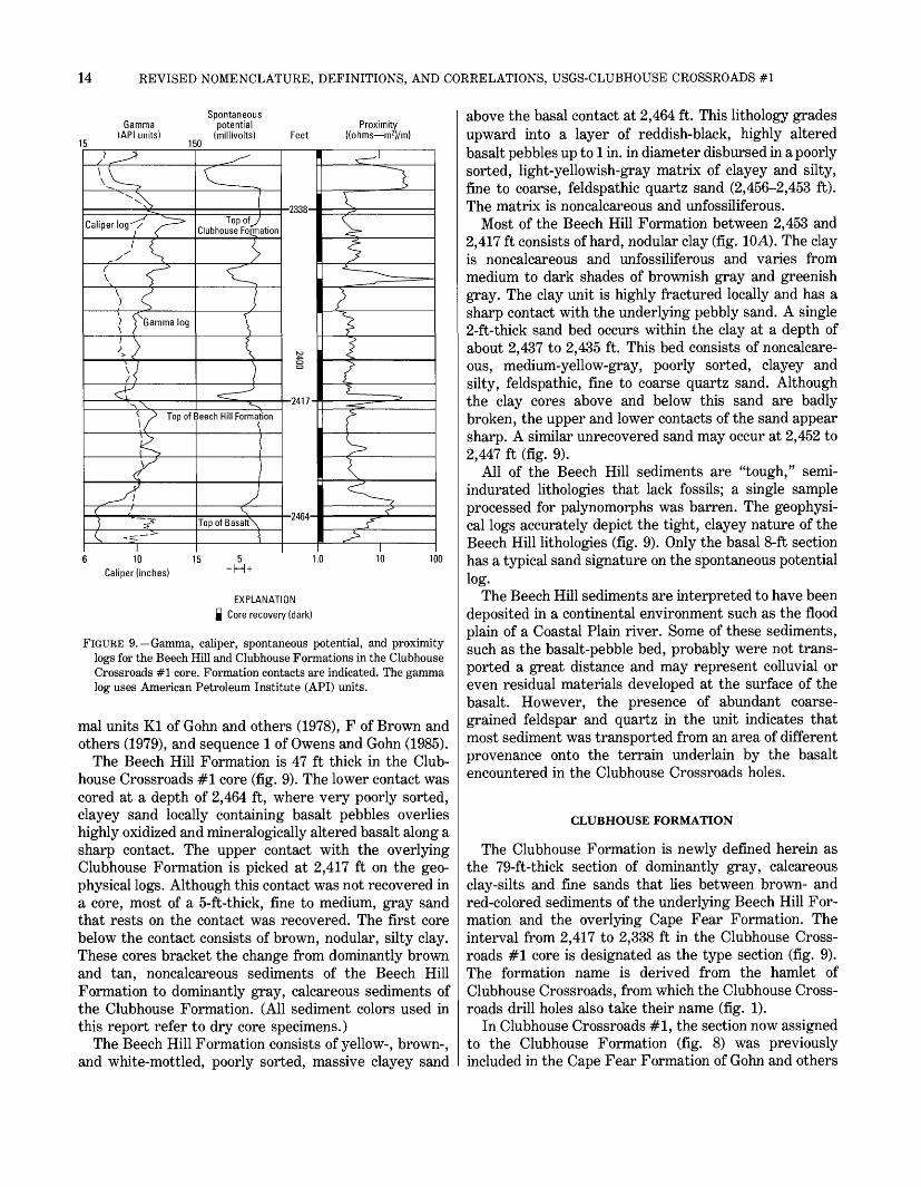
14 REVISED NOMENCLATURE, DEFINITIONS, AND CORRELATIONS, USGS-CLUBHOUSE CROSSROADS #1
15
SpontaneousGamma potential Proximity
(API units) (millivolts) Feet ((ohms m 2)/m) 150
Caliper log-"/
? \ Gamma log
Top of 3eech Hill Formation
I10
Caliper (inches)
Top of^Clubhouse Formation
\
Top of Basalt
-2338-
-2417-
-2464-
5 1.0~M +
100
EXPLANATION | Core recovery (dark)
FIGURE 9. Gamma, caliper, spontaneous potential, and proximity logs for the Beech Hill and Clubhouse Formations in the Clubhouse Crossroads #1 core. Formation contacts are indicated. The gamma log uses American Petroleum Institute (API) units.
mal units Kl of Gohn and others (1978), F of Brown and others (1979), and sequence 1 of Owens and Gohn (1985).
The Beech Hill Formation is 47 ft thick in the Club house Crossroads #1 core (fig. 9). The lower contact was cored at a depth of 2,464 ft, where very poorly sorted, clayey sand locally containing basalt pebbles overlies highly oxidized and mineralogically altered basalt along a sharp contact. The upper contact with the overlying Clubhouse Formation is picked at 2,417 ft on the geo physical logs. Although this contact was not recovered in a core, most of a 5-ft-thick, fine to medium, gray sand that rests on the contact was recovered. The first core below the contact consists of brown, nodular, silty clay. These cores bracket the change from dominantly brown and tan, noncalcareous sediments of the Beech Hill Formation to dominantly gray, calcareous sediments of the Clubhouse Formation. (All sediment colors used in this report refer to dry core specimens.)
The Beech Hill Formation consists of yellow-, brown-, and white-mottled, poorly sorted, massive clayey sand
above the basal contact at 2,464 ft. This lithology grades upward into a layer of reddish-black, highly altered basalt pebbles up to 1 in. in diameter disbursed in a poorly sorted, light-yellowish-gray matrix of clayey and silty, fine to coarse, feldspathic quartz sand (2,456-2,453 ft). The matrix is noncalcareous and unfossiliferous.
Most of the Beech Hill Formation between 2,453 and 2,417 ft consists of hard, nodular clay (fig. 10A). The clay is noncalcareous and unfossiliferous and varies from medium to dark shades of brownish gray and greenish gray. The clay unit is highly fractured locally and has a sharp contact with the underlying pebbly sand. A single 2-ft-thick sand bed occurs within the clay at a depth of about 2,437 to 2,435 ft. This bed consists of noncalcare ous, medium-yellow-gray, poorly sorted, clayey and silty, feldspathic, fine to coarse quartz sand. Although the clay cores above and below this sand are badly broken, the upper and lower contacts of the sand appear sharp. A similar unrecovered sand may occur at 2,452 to 2,447 ft (fig. 9).
All of the Beech Hill sediments are "tough," semi- indurated lithologies that lack fossils; a single sample processed for palynomorphs was barren. The geophysi cal logs accurately depict the tight, clayey nature of the Beech Hill lithologies (fig. 9). Only the basal 8-ft section has a typical sand signature on the spontaneous potential log.
The Beech Hill sediments are interpreted to have been deposited in a continental environment such as the flood plain of a Coastal Plain river. Some of these sediments, such as the basalt-pebble bed, probably were not trans ported a great distance and may represent colluvial or even residual materials developed at the surface of the basalt. However, the presence of abundant coarse grained feldspar and quartz in the unit indicates that most sediment was transported from an area of different provenance onto the terrain underlain by the basalt encountered in the Clubhouse Crossroads holes.
CLUBHOUSE FORMATION
The Clubhouse Formation is newly defined herein as the 79-ft-thick section of dominantly gray, calcareous clay-silts and fine sands that lies between brown- and red-colored sediments of the underlying Beech Hill For mation and the overlying Cape Fear Formation. The interval from 2,417 to 2,338 ft in the Clubhouse Cross roads #1 core is designated as the type section (fig. 9). The formation name is derived from the hamlet of Clubhouse Crossroads, from which the Clubhouse Cross roads drill holes also take their name (fig. 1).
In Clubhouse Crossroads #1, the section now assigned to the Clubhouse Formation (fig. 8) was previously included in the Cape Fear Formation of Gohn and others

REVISED CRETACEOUS STRATIGRAPHY, USGS-CLUBHOUSE CROSSROADS #1 15
(1977) and Hazel and others (1977). This interval also has been assigned to informal units K2 of Gohn and others(1978), F of Brown and others (1979), and sequence 2 of Owens and Gohn (1985).
Above the contact with the underlying Beech Hill Formation, the basal bed of the Clubhouse Formation consists of medium- to dark-gray, massive, moderately well sorted, silty, fine to medium sand. The upper contact of the Clubhouse Formation with the overlying Cape Fear Formation is readily discerned in the core. In particular, the gray and gray-green colors of the domi- nantly fine-grained Clubhouse sediments contrast with the red and brown colors of the locally very coarse grained Cape Fear sediments. At the contact, a thinly interlayered section of pale-olive, micaceous fine sands and grayish-olive, lignitic clays of the Clubhouse Forma tion is sharply overlain by pale-reddish-brown, nodular- appearing clay of the Cape Fear Formation.
The Clubhouse Formation is lithologically homoge neous throughout most of its extent in the core. The unit consists primarily of moderately well sorted silts and fine sands that alternate on a scale of inches and tenths of inches with dark silty clays (fig. 10J5, C). Flaser and lenticular bedding are characteristic, and cross lamina tion is commonly present in the sand beds and lenses. The thin bedding produces a "poker-chip" parting in some of the core. The microdigitate pattern of the proximity (resistivity) log in part reflects this thin bed ding (fig. 9). A variety of small burrows, including vertical U-shaped burrows, are common. The silts and sands are typically light gray to pale olive and contain common to locally abundant sand-sized mica and lignitic wood and other plant material. The silty clays are grayish olive to medium dark gray and also contain common to abundant mica and lignitic material, which are typically concentrated along partings in the clays, as well as common small pyrite clusters.
Sediments of the Clubhouse Formation are calcareous except for approximately the upper 20 ft. Sand-sized and locally larger fragments of mollusks are present in the sands, as are sparse ostracode specimens. Calcareous nannofossils and sparse dinoflagellates are present in numerous samples from the Clubhouse Formation (Hazel and others, 1977; Hattner and Wise, 1980; Valentine, 1982).
In addition to the basal sand at 2,417 to 2,413 ft, a sand also occurs at 2,368 to 2,364 ft. This upper sand is hard (cemented), is laminated and cross laminated, and has sharp upper and lower contacts (fig. 10J5). This bed consists of light gray, calcareous, medium sand contain ing common mica, lignitic material, and pebble-sized clay intraclasts.
The general lithologic character of the Clubhouse Formation suggests deposition in a marginal-marine
environment, although the exact nature of this sedimen tary system is not known. The association of abundant burrows and common marine microfossils with abundant detrital mica and plant material suggests a shallow subtidal to peritidal environment in which a variable energy regime produced the alternating deposition of sands and clays.
CAPE FEAR FORMATION
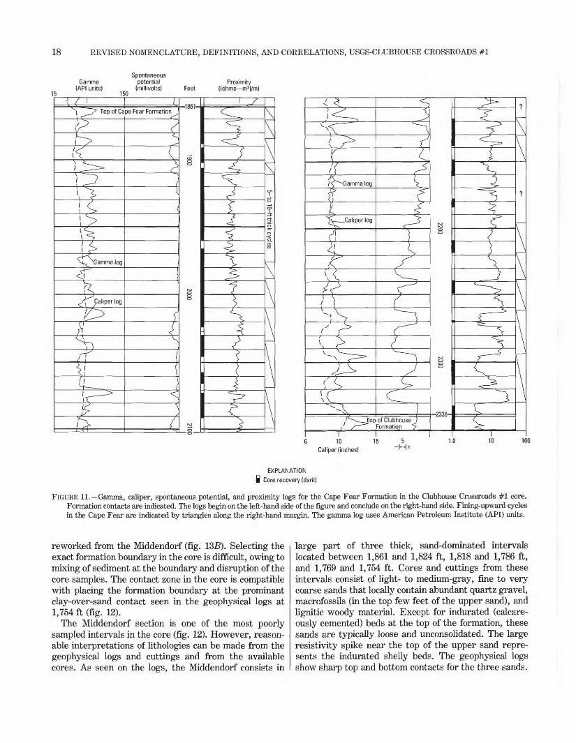
The definition of the Cape Fear Formation in the Clubhouse Crossroads #1 core used by Gohn and others (1977) and Hazel and others (1977) is substantially revised herein. The Cape Fear is revised as the section of alternating yellowish-gray, red, and brown, noncalcare- ous or sparingly calcareous clays and tan feldspathic sands that occur between the top of the newly defined Clubhouse Formation at 2,338 ft and the base of the newly revised Middendorf Formation at 1,861 ft (fig. 11). The Cape Fear Formation is the thickest (477 ft) unit in the Cretaceous section.
The section assigned herein to the Cape Fear Forma tion (fig. 8) was originally included in the Cape Fear and Middendorf Formations of Gohn and others (1977) and Hazel and others (1977). This section also was included in informal units K3 of Gohn and others (1978), F and D of Brown and others (1979), and sequence 3A of Owens and Gohn (1985).
The basal contact of the Cape Fear juxtaposes gray, fine-grained sediments of the underlying Clubhouse For mation against the oxidized Cape Fear sediments. The contact between the Cape Fear Formation and the overlying Middendorf Formation was not recovered in a core. However, distinctive differences between these units are apparent in the available cores, cuttings, and logs. The upper bed of the Cape Fear consists of grayish yellow to dusky yellow, massive, noncalcareous clay. In contrast, the basal 36-ft-thick unit of the Middendorf consists of friable medium to coarse sand and common lignite and possibly sparse macrofossils, as seen in cut tings. Clays associated with the Middendorf sands are typically dark gray and lignitic. The Cape Fear- Middendorf contact is also readily picked on geophysical logs (fig. 11), where the lower resistivities of sands in the upper part of the Cape Fear (about 8-15 ohm-m on the proximity log) contrast with the higher resistivities of the Middendorf sands (30-40 ohm-m on the proximity log).
Clays throughout the Cape Fear resemble the clay at the top of the unit (described above). They typically show a variety of red, yellow, and brown colors and may be silty, sandy, or both. Sands in the Cape Fear tend to be yellowish gray, clayey, poorly sorted, coarse to very coarse, and locally gravelly (fig. IOD). Feldspar consti-
16 REVISED NOMENCLATURE, DEFINITIONS, AND CORRELATIONS, USGS-CLUBHOUSE CROSSROADS #1
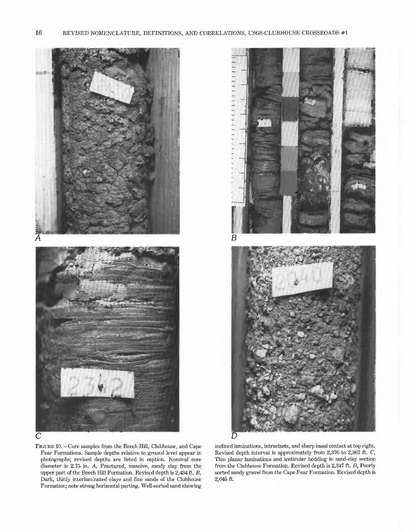
FIGURE 10. Core samples from the Beech Hill, Clubhouse, and Cape Fear Formations. Sample depths relative to ground level appear in photographs; revised depths are listed in caption. Nominal core diameter is 2.75 in. A, Fractured, massive, sandy clay from the upper part of the Beech Hill Formation. Revised depth is 2,434 ft. B, Dark, thinly interlaminated clays and fine sands of the Clubhouse Formation; note strong horizontal parting. Well-sorted sand showing
inclined laminations, intraclasts, and sharp basal contact at top right. Revised depth interval is approximately from 2,376 to 2,367 ft. C, Thin planar laminations and lenticular bedding in sand-clay section from the Clubhouse Formation. Revised depth is 2,347 ft. D, Poorly sorted sandy gravel from the Cape Fear Formation. Revised depth is 2,045 ft.
REVISED CRETACEOUS STRATIGRAPHY, USGS-CLUBHOUSE CROSSROADS #1 17
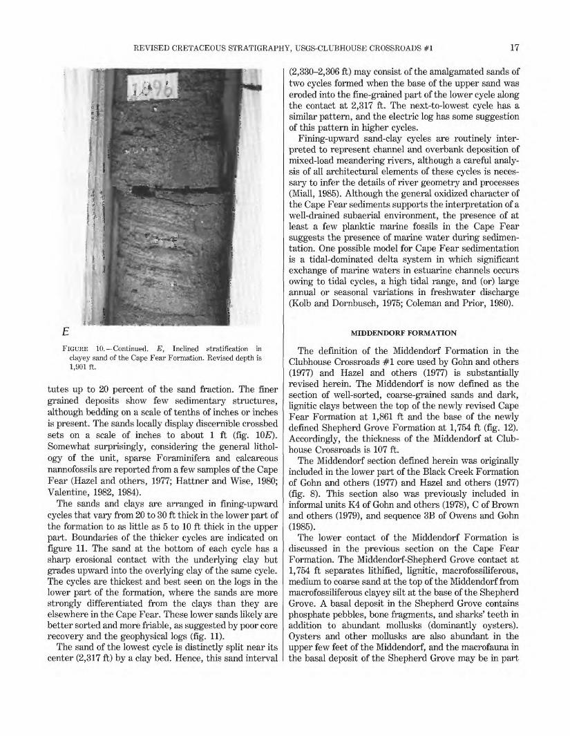
FIGURE 10. Continued. E, Inclined stratification in clayey sand of the Cape Fear Formation. Revised depth is 1,901 ft.
tutes up to 20 percent of the sand fraction. The finer grained deposits show few sedimentary structures, although bedding on a scale of tenths of inches or inches is present. The sands locally display discernible crossbed sets on a scale of inches to about 1 ft (fig. 1QE). Somewhat surprisingly, considering the general lithol- ogy of the unit, sparse Foraminifera and calcareous nannofossils are reported from a few samples of the Cape Fear (Hazel and others, 1977; Hattner and Wise, 1980; Valentine, 1982, 1984).
The sands and clays are arranged in fining-upward cycles that vary from 20 to 30 ft thick in the lower part of the formation to as little as 5 to 10 ft thick in the upper part. Boundaries of the thicker cycles are indicated on figure 11. The sand at the bottom of each cycle has a sharp erosional contact with the underlying clay but grades upward into the overlying clay of the same cycle. The cycles are thickest and best seen on the logs in the lower part of the formation, where the sands are more strongly differentiated from the clays than they are elsewhere in the Cape Fear. These lower sands likely are better sorted and more friable, as suggested by poor core recovery and the geophysical logs (fig. 11).
The sand of the lowest cycle is distinctly split near its center (2,317 ft) by a clay bed. Hence, this sand interval
(2,330-2,306 ft) may consist of the amalgamated sands of two cycles formed when the base of the upper sand was eroded into the fine-grained part of the lower cycle along the contact at 2,317 ft. The next-to-lowest cycle has a similar pattern, and the electric log has some suggestion of this pattern in higher cycles.
Fining-upward sand-clay cycles are routinely inter preted to represent channel and overbank deposition of mixed-load meandering rivers, although a careful analy sis of all architectural elements of these cycles is neces sary to infer the details of river geometry and processes (Miall, 1985). Although the general oxidized character of the Cape Fear sediments supports the interpretation of a well-drained subaerial environment, the presence of at least a few planktic marine fossils in the Cape Fear suggests the presence of marine water during sedimen tation. One possible model for Cape Fear sedimentation is a tidal-dominated delta system in which significant exchange of marine waters in estuarine channels occurs owing to tidal cycles, a high tidal range, and (or) large annual or seasonal variations in freshwater discharge (Kolb and Dornbusch, 1975; Coleman and Prior, 1980).
MIDDENDORF FORMATION
The definition of the Middendorf Formation in the Clubhouse Crossroads #1 core used by Gohn and others (1977) and Hazel and others (1977) is substantially revised herein. The Middendorf is now defined as the section of well-sorted, coarse-grained sands and dark, lignitic clays between the top of the newly revised Cape Fear Formation at 1,861 ft and the base of the newly defined Shepherd Grove Formation at 1,754 ft (fig. 12). Accordingly, the thickness of the Middendorf at Club house Crossroads is 107 ft.
The Middendorf section defined herein was originally included in the lower part of the Black Creek Formation of Gohn and others (1977) and Hazel and others (1977) (fig. 8). This section also was previously included in informal units K4 of Gohn and others (1978), C of Brown and others (1979), and sequence 3B of Owens and Gohn (1985).
The lower contact of the Middendorf Formation is discussed in the previous section on the Cape Fear Formation. The Middendorf-Shepherd Grove contact at 1,754 ft separates lithified, lignitic, macrofossiliferous, medium to coarse sand at the top of the Middendorf from macrofossiliferous clayey silt at the base of the Shepherd Grove. A basal deposit in the Shepherd Grove contains phosphate pebbles, bone fragments, and sharks' teeth in addition to abundant mollusks (dominantly oysters). Oysters and other mollusks are also abundant in the upper few feet of the Middendorf, and the macrofauna in the basal deposit of the Shepherd Grove may be in part
18 REVISED NOMENCLATURE, DEFINITIONS, AND CORRELATIONS, USGS-CLUBHOUSE CROSSROADS #1
15
Gamma (API units)
150
Spontaneous potential
(millivolts) FeetProximity
((ohms m2)/m)
Top of Cape Fear Formation
H^ Gamma log
Caliper log
'£>
\\
-1861-
r*
f
Gamma log
I_Caliper log
Z
T"op of Clubhouse ) Formation__>_
I 6 10
Caliper (inches)
-2338-
Z
5-H+
1.0 10 100
EXPLANATION i Core recovery (dark)
FIGURE 11. Gamma, caliper, spontaneous potential, and proximity logs for the Cape Fear Formation in the Clubhouse Crossroads #1 core. Formation contacts are indicated. The logs begin on the left-hand side of the figure and conclude on the right-hand side. Fining-upward cycles in the Cape Fear are indicated by triangles along the right-hand margin. The gamma log uses American Petroleum Institute (API) units.
reworked from the Middendorf (fig. 135). Selecting the exact formation boundary in the core is difficult, owing to mixing of sediment at the boundary and disruption of the core samples. The contact zone in the core is compatible with placing the formation boundary at the prominant clay-over-sand contact seen in the geophysical logs at 1,754 ft (fig. 12).
The Middendorf section is one of the most poorly sampled intervals in the core (fig. 12). However, reason able interpretations of lithologies can be made from the geophysical logs and cuttings and from the available cores. As seen on the logs, the Middendorf consists in
large part of three thick, sand-dominated intervals located between 1,861 and 1,824 ft, 1,818 and 1,786 ft, and 1,769 and 1,754 ft. Cores and cuttings from these intervals consist of light- to medium-gray, fine to very coarse sands that locally contain abundant quartz gravel, macrofossils (in the top few feet of the upper sand), and lignitic woody material. Except for indurated (calcare- ously cemented) beds at the top of the formation, these sands are typically loose and unconsolidated. The large resistivity spike near the top of the upper sand repre sents the indurated shelly beds. The geophysical logs show sharp top and bottom contacts for the three sands.
REVISED CRETACEOUS STRATIGRAPHY, USGS-CLUBHOUSE CROSSROADS #1 19
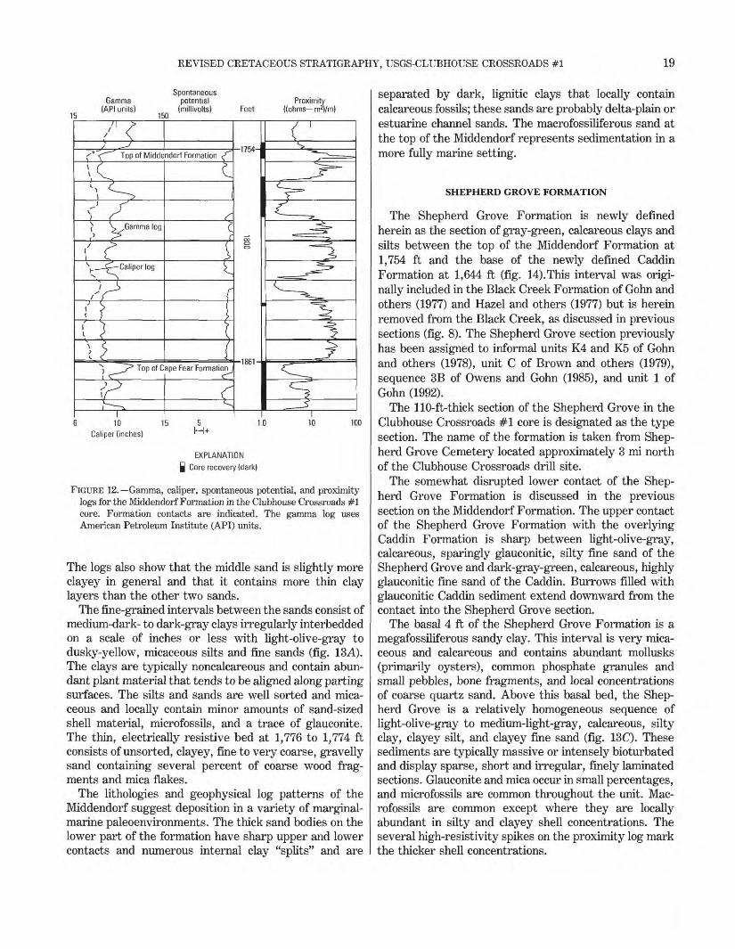
15
Gamma (API units)
150
Spontaneous potential
(millivolts) FeetProximity
((ohms m2)/m)
Top of Middendorf Formation
^Gamma log
Caliperlog
Top of Cape Fear Formation
1754-
-186V
10 Caliper (inches)
5
EXPLANATION
Core recovery (dark)
100
FIGURE 12. Gamma, caliper, spontaneous potential, and proximity logs for the Middendorf Formation in the Clubhouse Crossroads #1 core. Formation contacts are indicated. The gamma log uses American Petroleum Institute (API) units.
The logs also show that the middle sand is slightly more clayey in general and that it contains more thin clay layers than the other two sands.
The fine-grained intervals between the sands consist of medium-dark- to dark-gray clays irregularly interbedded on a scale of inches or less with light-olive-gray to dusky-yellow, micaceous silts and fine sands (fig. ISA). The clays are typically noncalcareous and contain abun dant plant material that tends to be aligned along parting surfaces. The silts and sands are well sorted and mica ceous and locally contain minor amounts of sand-sized shell material, microfossils, and a trace of glauconite. The thin, electrically resistive bed at 1,776 to 1,774 ft consists of unsorted, clayey, fine to very coarse, gravelly sand containing several percent of coarse wood frag ments and mica flakes.
The lithologies and geophysical log patterns of the Middendorf suggest deposition in a variety of marginal- marine paleoenvironments. The thick sand bodies on the lower part of the formation have sharp upper and lower contacts and numerous internal clay "splits" and are
separated by dark, lignitic clays that locally contain calcareous fossils; these sands are probably delta-plain or estuarine channel sands. The macrofossiliferous sand at the top of the Middendorf represents sedimentation in a more fully marine setting.
SHEPHERD GROVE FORMATION
The Shepherd Grove Formation is newly defined herein as the section of gray-green, calcareous clays and silts between the top of the Middendorf Formation at 1,754 ft and the base of the newly defined Caddin Formation at 1,644 ft (fig. 14).This interval was origi nally included in the Black Creek Formation of Gohn and others (1977) and Hazel and others (1977) but is herein removed from the Black Creek, as discussed in previous sections (fig. 8). The Shepherd Grove section previously has been assigned to informal units K4 and K5 of Gohn and others (1978), unit C of Brown and others (1979), sequence 3B of Owens and Gohn (1985), and unit 1 of Gohn (1992).
The 110-ft-thick section of the Shepherd Grove in the Clubhouse Crossroads #1 core is designated as the type section. The name of the formation is taken from Shep herd Grove Cemetery located approximately 3 mi north of the Clubhouse Crossroads drill site.
The somewhat disrupted lower contact of the Shep herd Grove Formation is discussed in the previous section on the Middendorf Formation. The upper contact of the Shepherd Grove Formation with the overlying Caddin Formation is sharp between light-olive-gray, calcareous, sparingly glauconitic, silty fine sand of the Shepherd Grove and dark-gray-green, calcareous, highly glauconitic fine sand of the Caddin. Burrows filled with glauconitic Caddin sediment extend downward from the contact into the Shepherd Grove section.
The basal 4 ft of the Shepherd Grove Formation is a megafossiliferous sandy clay. This interval is very mica ceous and calcareous and contains abundant mollusks (primarily oysters), common phosphate granules and small pebbles, bone fragments, and local concentrations of coarse quartz sand. Above this basal bed, the Shep herd Grove is a relatively homogeneous sequence of light-olive-gray to medium-light-gray, calcareous, silty clay, clayey silt, and clayey fine sand (fig. 13C). These sediments are typically massive or intensely bioturbated and display sparse, short and irregular, finely laminated sections. Glauconite and mica occur in small percentages, and microfossils are common throughout the unit. Mac- rofossils are common except where they are locally abundant in silty and clayey shell concentrations. The several high-resistivity spikes on the proximity log mark the thicker shell concentrations.
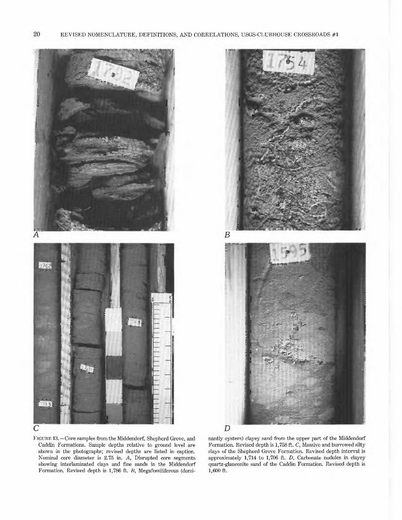
20 REVISED NOMENCLATURE, DEFINITIONS, AND CORRELATIONS, USGS-CLUBHOUSE CROSSROADS #1
FIGURE 13. Core samples from the Middendorf, Shepherd Grove, and Caddin Formations. Sample depths relative to ground level are shown in the photographs; revised depths are listed in caption. Nominal core diameter is 2.75 in. A, Disrupted core segments showing interlaminated clays and fine sands in the Middendorf Formation. Revised depth is 1,786 ft. B, Megafossiliferous (domi-
nantly oysters) clayey sand from the upper part of the Middendorf Formation. Revised depth is 1,758 ft. C, Massive and burrowed silty clays of the Shepherd Grove Formation. Revised depth interval is approximately 1,714 to 1,706 ft. D, Carbonate nodules in clayey quartz-glauconite sand of the Caddin Formation. Revised depth is 1,600 ft.
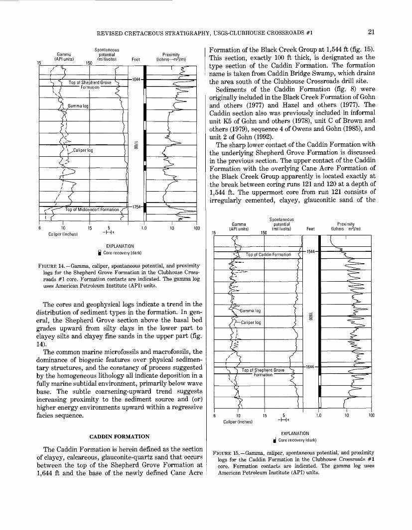
REVISED CRETACEOUS STRATIGRAPHY, USGS-CLUBHOUSE CROSSROADS #1 21
SpontaneousGamma potential Proximity
(API units) (millivolts) Feet ((ohms m 2 )/m) 150
*-) ^ Top of Shepherd Grove \ T Formation
\ Gamma log
) 1. Caliper log
I10
Caliper (inches)
-1644-
Top of Middendorf Formation-1754-
c
15 5 1.0 -H + 100
EXPLANATION | Core recovery (dark)
FIGURE 14. Gamma, caliper, spontaneous potential, and proximity logs for the Shepherd Grove Formation in the Clubhouse Cross roads #1 core. Formation contacts are indicated. The gamma log uses American Petroleum Institute (API) units.
The cores and geophysical logs indicate a trend in the distribution of sediment types in the formation. In gen eral, the Shepherd Grove section above the basal bed grades upward from silty clays in the lower part to clayey silts and clayey fine sands in the upper part (fig. 14).
The common marine microfossils and macrofossils, the dominance of biogenic features over physical sedimen tary structures, and the constancy of process suggested by the homogeneous lithology all indicate deposition in a fully marine subtidal environment, primarily below wave base. The subtle coarsening-upward trend suggests increasing proximity to the sediment source and (or) higher energy environments upward within a regressive facies sequence.
CADDIN FORMATION
The Caddin Formation is herein defined as the section of clayey, calcareous, glauconite-quartz sand that occurs between the top of the Shepherd Grove Formation at 1,644 ft and the base of the newly defined Cane Acre
Formation of the Black Creek Group at 1,544 ft (fig. 15). This section, exactly 100 ft thick, is designated as the type section of the Caddin Formation. The formation name is taken from Caddin Bridge Swamp, which drains the area south of the Clubhouse Crossroads drill site.
Sediments of the Caddin Formation (fig. 8) were originally included in the Black Creek Formation of Gohn and others (1977) and Hazel and others (1977). The Caddin section also was previously included in informal unit K5 of Gohn and others (1978), unit C of Brown and others (1979), sequence 4 of Owens and Gohn (1985), and unit 2 of Gohn (1992).
The sharp lower contact of the Caddin Formation with the underlying Shepherd Grove Formation is discussed in the previous section. The upper contact of the Caddin Formation with the overlying Cane Acre Formation of the Black Creek Group apparently is located exactly at the break between coring runs 121 and 120 at a depth of 1,544 ft. The uppermost core from run 121 consists of irregularly cemented, clayey, glauconitic sand of the
Gamma (API units)
150
Spontaneous potential
(millivolts) FeetProximity
((ohms m 2 )/m)
Top of Caddin Formation
':X^G
S * Caliper log
f
Top of Shepherd Grove Formation
110
Caliper (inches)
c:
1544-
-1644-
I
r5 1.0
-H +100
EXPLANATION Q Core recovery (dark)
FIGURE 15. Gamma, caliper, spontaneous potential, and proximity logs for the Caddin Formation in the Clubhouse Crossroads #1 core. Formation contacts are indicated. The gamma log uses American Petroleum Institute (API) units.
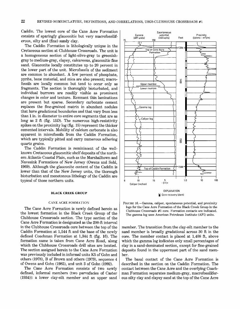
22 REVISED NOMENCLATURE, DEFINITIONS, AND CORRELATIONS, USGS-CLUBHOUSE CROSSROADS #1
Caddin. The lowest core of the Cane Acre Formation consists of sparingly glauconitic but very macrofossilif- erous, silty and (fine) sandy clay.
The Caddin Formation is lithologically unique in the Cretaceous section at Clubhouse Crossroads. The unit is a homogeneous section of light-olive-gray to greenish- gray to medium-gray, clayey, calcareous, glauconitic fine sand. Glauconite locally constitutes up to 20 percent in the lower part of the unit. Microfossils of the sediment are common to abundant. A few percent of phosphate, pyrite, bone material, and mica are also present; macro- fossils are locally common but tend to occur only as fragments. The section is thoroughly bioturbated, and individual burrows are readily visible as prominent changes in color and texture. Remnant thin laminations are present but sparse. Secondary carbonate cement replaces the fine-grained matrix in abundant nodules that have gradational boundaries and that vary from less than 1 in. in diameter to entire core segments that are as long as 2 ft (fig. 13D). The numerous high-resistivity spikes on the proximity log (fig. 15) represent the thicker cemented intervals. Mobility of calcium carbonate is also apparent in microfossils from the Caddin Formation, which are typically pitted and carry numerous adhering quartz grains.
The Caddin Formation is reminiscent of the well- known Cretaceous glauconitic shelf deposits of the north ern Atlantic Coastal Plain, such as the Marshalltown and Navesink Formations of New Jersey (Owens and Sohl, 1969). Although the glauconite content of the Caddin is lower than that of the New Jersey units, the thorough bioturbation and monotonous lithology of the Caddin are typical of those northern units.
BLACK CREEK GROUP
CANE ACRE FORMATION
The Cane Acre Formation is newly defined herein as the lowest formation in the Black Creek Group of the Clubhouse Crossroads section. The type section of the Cane Acre Formation is designated as the 200-ft interval in the Clubhouse Crossroads core between the top of the Caddin Formation at 1,544 ft and the base of the newly defined Coachman Formation at 1,344 ft (fig. 16). The formation name is taken from Cane Acre Road, along which the Clubhouse Crossroads drill sites are located. The section assigned herein to the Cane Acre Formation was previously included in informal units K5 of Gohn and others (1978), B of Brown and others (1979), sequence 4 of Owens and Gohn (1985), and unit 3 of Gohn (1992).
The Cane Acre Formation consists of two newly defined, informal members (two parvafacies of Caster (1934)): a lower clay-silt member and an upper sand
SpontaneousGamma potential
(API units) (millivolts) 150
Proximity Feet ((ohms m2)/m)
XL_Top of Cane Acre
Formation
Upper member
Lower member
Gamma log
yCaliper log
Top of Caddin Formation
I10
Caliper (inches)
-1344'
-1544-
I
I
1.0 100
EXPLANATION | Core recovery (dark)
FIGURE 16. Gamma, caliper, spontaneous potential, and proximity logs for the Cane Acre Formation of the Black Creek Group in the Clubhouse Crossroads #1 core. Formation contacts are indicated. The gamma log uses American Petroleum Institute (API) units.
member. The transition from the clay-silt member to the sand member is broadly gradational across 30 ft in the core. The member contact is placed at 1,408 ft, above which the gamma log indicates only small percentages of clay in a sand-dominated section, except for fine-grained deposits found in the uppermost part of the sand mem ber.
The basal contact of the Cane Acre Formation is described in the section on the Caddin Formation. The contact between the Cane Acre and the overlying Coach man Formation separates medium-gray, macrofossilifer- ous silty clay and clayey sand at the top of the Cane Acre
REVISED CRETACEOUS STRATIGRAPHY, USGS-CLUBHOUSE CROSSROADS #1 23
from light-olive-gray, clayey, phosphatic, fine to medium sand of the lowermost Coachman bed.
The lower clay-silt member of the Cane Acre between the base of the unit and about 1,430 ft consists of medium-light-gray to light-olive-gray, calcareous, silty and (fine) sandy clay (fig. 17A). Thin laminations are only locally preserved, and most of this interval is massive or bioturbated. The lower member contains only a few percent (probably less than 5 percent) of quartz silt and fine sand in its lower part, but this percentage increases upward to about 30 to 40 percent around 1,430 ft. A few percent of glauconite, mica, and fecal pellets occur throughout the lower member.
These fine-grained deposits are typically microfossilif- erous and macrofossiliferous; large fragments and unbro ken shells of mollusks are locally common. Abundant burrows appear in cross section as vertically compressed features containing generally better sorted sandy infill- ings.
The upper 30 ft of the lower member is transitional to the upper member, as recorded by the leftward drift of the gamma and spontaneous potential logs (fig. 16). This transitional interval consists of olive-gray to medium- gray, calcareous, clayey fine sands. These sands are rather thoroughly bioturbated, although distinct individ ual burrows are moderately common, and they contain common macrofossils and microfossils.
Poor core recovery hampers description of the upper sand member, although the geophysical logs indicate that it consists primarily of well-sorted sand (fig. 16). Most of the recovered core segments consist of hard, carbonate-cemented, macrofossiliferous, well-sorted, fine or medium sand (fig. 17B). Most of the mollusks have been leached to produce a secondary moldic porosity. Large-amplitude spikes on the proximity log represent the thicker cemented intervals. The indurated sands contain trace amounts to a few percent of glauconite, mica, and phosphate. Burrows are locally discernible as textural changes within the sand; Ophiomorpha is rec ognizable in one sample. Cuttings from the upper mem ber consist of friable, well-sorted, fine and medium sand that represents the uncemented intervals of the upper sand member.
The top 12 ft of the upper member consists of medium- gray, clayey, macrofossiliferous, fine to medium sand. As seen in the cores and on the logs, this interval is distinctly more clayey and less well sorted than the remainder of the member. Macrofossils are locally com mon to abundant, and small amounts of glauconite, phosphate, mica, and carbonaceous material are present.
The Cane Acre Formation is a dominantly regressive sedimentary section. Above the basal shelly bed, fine grained, fossiliferous marine deposits of the lower mem ber grade upward into nearshore sands of the upper
member. The considerable thickness of the fine-grained marine section and the presence of a single, lithologically uniform sand body at its top are characteristic of regres sive prodelta-barrier sections formed in areas marginal to major delta systems (for examples, see Ricoy and Brown, 1977).
COACHMAN FORMATION
The Coachman Formation is newly defined herein as the section of calcareous silty clays and clayey silts that occurs between the top of the Cane Acre Formation at 1,344 ft and the base of the Bladen Formation at 1,214 ft in the Clubhouse Crossroads #1 core (fig. 18). This 130-ft-thick section is designated the type section of the Coachman Formation of the Black Creek Group. The formation name is taken from the crossroads of Coach- mans Corners located about 7 mi northeast of the Club house Crossroads drill site.
Sediments assigned to the Coachman Formation were originally included in the lower part of the Peedee Formation of Gohn and others (1977) but are formally separated from the Peedee herein (fig. 8). This unit also was previously included in the informal units K6 of Gohn and others (1978), B of Brown and others (1979), sequence 5 of Owens and Gohn (1985), and unit 4 of Gohn (1992).
The basal bed of the Coachman is a lag deposit containing common phosphate pebbles and phosphatized shells as large as 2 to 3 in. in diameter. This bed is readily recognized as the large spike on the gamma log centered at 1,343 ft (fig. 18). A sharp contact between the Coach man Formation and the overlying Bladen Formation separates gray-green, slightly clayey, fine sand in the upper part of the Coachman from medium-gray, macro fossiliferous, clayey, fine to medium sand in the basal 2 ft of the Bladen. Differences in the sorting of the deposits on either side of the contact are apparent from the sharp deflections at the contact on the spontaneous potential and gamma logs (fig. 18).
The Coachman Formation is a relatively uniform sec tion of medium-gray to medium-gray-green, calcareous, silty clays and clayey silts to fine sands. However, there is a distinct trend in the distribution of these fine-grained lithologies. As the geophysical logs show (fig. 18), the section changes from more clayey, less well sorted lithologies in the lower part of the formation to better sorted silts and fine sands in the upper part.
Microfossils and macrofossils are moderately abundant throughout, although the macrofossils are typically com minuted. Glauconite, mica, and fecal pellets also are present throughout in small amounts. Physical sedimen tary structures are rarely observed, and the deposits are typically bioturbated or massive.

24 EEVISED NOMENCLATUEE, DEFINITIONS, AND COEEELATIONS, USGS-CLUBHOUSE CEOSSEOADS #1
FIGURE 17. Core samples from the Black Creek Group and the Peedee Formation. Sample depths relative to ground level are shown in photographs; revised depths are listed in caption. Nominal core diameter is 2.75 in. A, Strongly burrowed, fossiliferous, silty clay from the lower member of the Cane Acre Formation of the Black Creek Group. Eevised depth is 1,504 ft. B, Light-colored, carbonate- cemented sand (revised depth is 1,365 ft) and overlying darker, clayey sand (depth does not require revision) of the upper member of
the Cane Acre Formation of the Black Creek Group. C, Massive to burrowed silty clay of the Bladen Formation of the Black Creek Group. Lighter colored, carbonate-cemented core segments are present in the center row. Eevised depth interval is approximately 1,184 to 1,179 ft. D, Massive, macrofossiliferous and phosphatic (dark grains) clayey fine sand shown in core cross sections from the Peedee Formation. Eevised depth is 857 ft.

REVISED CRETACEOUS STRATIGRAPHY, USGS-CLUBHOUSE CROSSROADS #1 25
Spontaneous Gamma potential Prox mity
(API units) (millivolts) Feet ((ohms m 2 )/m) 5 150
) \
\ \if
r^>
f~\ Top of Coachman ^) \ hormatior
4 \</ ~~\
tpGamma log \
} \
^ Caliper log'v
> /' s. <*
y \< 1 1 %
/ /^ / S t
/ J r-J- f ^~~ - J.
S£
{
\]
\
\(
i
/~~ Top of Cane Acre S
Amation f
i 10 15 5
r-oCD
-1214-
CD
v__;>-~-__,^"/==\^}ri£-
/1(^ «_~~y*&_
1 1.0 10 10
Caliper (inches) +
EXPLANATION
| Core recovery (dark)
FIGURE 18. Gamma, caliper, spontaneous potential, and proximity logs for the Coachman Formation of the Black Creek Group in the Clubhouse Crossroads #1 core. Formation contacts are indicated. The gamma log uses American Petroleum Institute (API) units.
An upper well-sorted sand similar to the upper mem ber of the Cane Acre Formation is not present in the Coachman Formation at Clubhouse Crossroads. How ever, east of Clubhouse Crossroads, in the vicinity of the city of Charleston, S.C., the Coachman Formation is divided into two informal members, a lower clay-silt member and an upper sand member (see discussion of pi. 1 in section on regional distribution of formations). Unlike the contact of similar members in the Cane Acre Formation, the member contact in the Coachman is typically sharp. Descriptions of cuttings from water wells and the geophysical logs indicate that the lower member consists of calcareous clays and clayey silts and fine sands similar to those of the undivided Coachman Formation at Clubhouse Crossroads. In contrast, the upper member consists of well-sorted, fine to medium sands. Both members are fossiliferous.
The Coachman Formation is a dominantly regressive sequence whose division into a lower clay-silt member
Gamma (API units)
150
Spontaneous potential
(millivolts) FeetProximity
((ohms m2)/m)
T"Top of Bladen Formation
Gamma log
I ^Caliper log
1
iij
Top of Coachman C" i Formation *
1072-
-1214-
r
6 10Caliper (inches)
1.0 100
EXPLANATION
| Core recovery (dark)
FIGURE 19. Gamma, caliper, spontaneous potential, and proximity logs for the Bladen Formation of the Black Creek Group in the Clubhouse Crossroads #1 core. Formation contacts are indicated. The gamma log uses American Petroleum Institute (API) units.
and an upper sand member in the area east of Clubhouse Crossroads resembles the twofold division of the Cane Acre Formation at Clubhouse Crossroads. To the east, the presence of multiple sand bodies in the upper sand member of the Coachman suggests a prograding delta- front deposit overlying associated prodelta clay-silts of the lower member (Gohn, 1992, his unit 4). Although this prograding sand did not reach the Clubhouse Crossroads area, the upward trend to better sorted, coarser deposits is still evident in the Coachman section in the core.
BLADEN FORMATION
The Bladen Formation is recognized herein in the Clubhouse Crossroads #1 core as the section of calcare ous clayey silts and silty clays that occurs between the top of the Coachman Formation at 1,214 ft and the base of the Donoho Creek Formation at 1,072 ft (fig. 19). The Bladen Formation is the second highest formation in the

26 REVISED NOMENCLATURE, DEFINITIONS, AND CORRELATIONS, USGS-CLUBHOUSE CROSSROADS #1
newly revised outcropping Black Creek Group of the Carolinas (Owens, 1989; Sohl and Owens, 1991). Sedi ments of the Bladen Formation in the Clubhouse Cross roads #1 core were originally included in the Peedee Formation of Gohn and others (1977) and Hazel and others (1977) but are formally separated herein from the Peedee (fig. 8). The Bladen Formation in the core was previously included in informal units K6 of Gohn and others (1977), B and A of Brown and others (1979), sequence 5 of Owens and Gohn (1985), and unit 5 of Gohn (1992).
Macrofossiliferous, clayey, fine to medium sand con taining rounded phosphate grains and abundant bored oyster fragments in the basal few feet of the Bladen sharply overlies the Coachman Formation. The contact of the Bladen Formation with the overlying Donoho Creek Formation at 1,072 ft was not seen because the upper 19 ft of the Bladen and the basal few inches of the Donoho Creek were not recovered in cores.
The lower part of the Bladen Formation consists of light-olive-gray to medium-gray, calcareous, clayey silts and fine sands and similar silty clays. Macrofossils are only moderately abundant in general and tend to occur as comminuted fragments; microfossils are similarly sparse to common. Small percentages of glauconite, mica, and fecal pellets occur throughout the unit. The cores typi cally appear massive or thoroughly bioturbated.
The geophysical logs suggest a relatively uniform lithology for the upper 50 ft of the Bladen, which is represented by a single core from 1,100 to 1,095 ft (fig. 19). Half of this core consists of light-gray, calcareous, moderately well sorted, silty, fine sand. Mollusks (par ticularly oysters) are abundant in this sample. The remainder of the core consists of a similar lithology except that it is indurated, having been secondarily cemented with calcite. Numerous spikes on the proxim ity log suggest that cemented beds are moderately common throughout the Bladen (figs. 17C, 19).
The geophysical logs reflect the textural trend within the Bladen from more clayey and less well sorted depos its at the base to better sorted silts and fine sands higher in the unit. This trend resembles the distribution of similar lithologies in the Coachman Formation. The Bladen also resembles the Coachman in the area east of Clubhouse Crossroads, where the Bladen consists of two lithologic units that are assigned herein to two informal members, a lower clay-silt member and an upper sand member (see following discussion for pi. 1). The lower member consists of calcareous silty clays and clayey silts similar to the undivided Bladen section at Clubhouse Crossroads, whereas the upper member consists of well- sorted fine to medium sands. As it does for the older formations of the Black Creek Group, the presence of multiple sand bodies, at least locally, above a thick,
fine-grained marine section defines a regressive sequence that likely represents the progradation of delta-front sands over prodelta deposits.
DONOHO CREEK FORMATION
The Donoho Creek Formation is newly recognized herein in the Clubhouse Crossroads #1 core as the section of calcareous silty clays and clayey silts and fine sands that occurs between the top of the Bladen Forma tion at 1,072 ft and the base of the Peedee Formation at 873 ft (fig. 20). The Donoho Creek Formation is the highest formation of the outcropping Black Creek Group
15
Gamma (API units)
150
Spontaneous potential
(millivolts)
_Top of Donoho Creek Formation
Gammalog
Caliper log
uTop of Bladen Formation $T10
Caliper (inches)
Feet -873-
Proximity ((ohms m2)/m)
1072-
I
r
ir
1.0 100
EXPLANATION Q Core recovery (dark)
FIGURE 20. Gamma, caliper, spontaneous potential, and proximity logs for the Donoho Creek Formation of the Black Creek Group in the Clubhouse Crossroads #1 core. Formation contacts are indi cated. The gamma log uses American Petroleum Institute (API) units.

REVISED CRETACEOUS STRATIGRAPHY, USGS-CLUBHOUSE CROSSROADS #1 27
of the Carolinas, as recently revised by Owens (1989) and Sohl and Owens (1991).
Sediments of the Donoho Creek Formation at Club house Crossroads were originally included in the Peedee Formation of Gohn and others (1977) and Hazel and others (1977) but are formally separated from the Peedee Formation herein (fig. 8). The Donoho Creek Formation in the core also was previously included in informal units K6 of Gohn and others (1978), A of Brown and others (1979), and sequence 5 of Owens and Gohn (1985).
The contact of the Donoho Creek Formation with the underlying Bladen Formation was not recovered in core. Above an unsampled basal foot of section, the lower 10 ft of the Donoho Creek consists of bioturbated, megafossil- iferous, clayey, fine to medium sand. This poorly sorted, medium-gray sand contains common to locally abundant large mollusk fragments (some of which are worn and phosphatized), several percent of sand-sized phosphate and mica, and trace amounts of glauconite. The remain der of the Donoho Creek section consists of a relatively uniform sequence of calcareous clayey silts and fine sands and calcareous silty clays. These lithologies are typically micaceous and vary from light olive gray to medium gray. Well-sorted sands are absent from the Donoho Creek Formation at Clubhouse Crossroads. Bedding has been virtually obliterated in the clays and silts by bioturbation, which varies from intervals where individ ual (usually sand-filled) burrows can be discerned to sediments having mottled fabrics that indicate intense bioturbation. Trace amounts to a few percent of pyrite, glauconite, and phosphatic fecal pellets occur throughout the section. Microfossils and macrofossils are common throughout; mollusks are concentrated locally in shelly layers. The core is locally semilithified, probably owing to a secondary calcite cement.
The geophysical logs for the Donoho Creek Formation reflect the dominantly fine-grained nature of the sedi ments (fig. 20). Although no well-sorted sands are indi cated, several intervals (for example 1,020-1,008 ft) are less clayey and somewhat more porous than intervals elsewhere in the unit. Further, the logs suggest that several small-scale, coarsening-upward cycles are present, unlike the logs for the Coachman and Bladen Formations, which indicate a single coarsening-upward trend within each formation, The spontaneous potential and gamma logs in particular suggest intervals in which clay-dominated units grade upward into better sorted siltier or sandier units; cycle boundaries are present at approximately 990, 950, 938, and, perhaps, 912 ft.
The large volume of microfossiliferous, modestly glau- conitic, fine-grained sediments in the Donoho Creek section suggests deposition in a prodelta environment. The several coarsening-upward intervals likely repre sent cycles in which better sorted, coarser grained
sediments reached the study area during periods of local delta-lobe progradation.
PEEDEE FORMATION
The definition of the Peedee Formation in the Club house Crossroads #1 core used by Gohn and others (1977) and Hazel and others (1977) is substantially revised herein. The Peedee Formation in the core is now defined as the dominantly fine-grained section of calcar eous silty clay and clayey sand that occurs between the top of the Donoho Creek Formation at 873 ft and the base of the overlying Cenozoic section at 800 ft (fig. 21). Sediments assigned herein to the Peedee Formation were previously included in informal units K6 of Gohn and others (1978), A of Brown and others (1979), and sequence 6 of Owens and Gohn (1985).
In the Clubhouse Crossroads #1 core, the base of the Peedee Formation is repositioned at 873 ft, where a poorly sorted, relatively coarse grained basal unit of the Peedee overlies calcareous clayey silt of the Donoho Creek Formation. Approximately the lower 10 ft of the Peedee consists of medium-light-gray to light-olive-gray,
Spontaneous Gamma potential Proximity
(API units) (millivolts) Feet ((ohms m2 )/m) 5 150
<__ '^>
!" -^
\ S^Iop
' Gamma log '_^>
\ <£~) ^1 S 1 i^_
/ 7
>~~CaliperlogS
V
/ ^^x/
I
{Df Peedee Formation
s^H-
I
1I
> ^^ Top of Donoho Creek{ -T^~
n^, ^>
i
i-ormauoi)
i
oo§
§o
'.^^
t^^<=^
^^^?5 "*^^
^V
^-^^1
6 , 10 * Caliper (inches)
15 1.0 10 100
EXPLANATION | Core recovery (dark)
FIGURE 21. Gamma, caliper, spontaneous potential, and proximity logs for the Peedee Formation in the Clubhouse Crossroads #1 core. Formation contacts are indicated. The gamma log uses American Petroleum Institute (API) units.
28 REVISED NOMENCLATURE, DEFINITIONS, AND CORRELATIONS, USGS-CLUBHOUSE CROSSROADS #1
massive, calcareous, clayey and silty, fine to medium sand. This poorly sorted sand contains abundant micro- fossils, up to 15 percent sand-sized phosphate and glau- conite (particularly in the basal 5 ft), and up to 5 percent coarse and very coarse quartz. Although the exact contact was not seen, the distinct contrast in lithologies across the boundary suggests that the contact was probably sharp or at least that it was gradational across no more than about 1 ft of section.
The basal poorly sorted, clayey sand of the Peedee grades upward into similarly colored, calcareous, mas sive to indistinctly laminated, silty clay (fig. 17D). This clay typically contains common microfossils and small amounts of white mica, glauconite, pyrite, and phos phate. Local concentrations of sand-sized mica, glauco nite, phosphate, and megafossil fragments probably are burrow fillings.
The top 4 ft of the Peedee immediately below its upper contact at 800 ft consists of light-gray, indurated (sec ondary calcite cement), megafossiliferous and microfos- siliferous clayey siltstone and fine sandstone. The meg- afossils occur as sulfide-coated molds, which produce a significant macroscopic porosity in this interval. This lithology is represented by negative deflections on the spontaneous potential log and high resistivities on the proximity log (fig. 21). The continuation of these log patterns down to 820 ft suggests that much of the upper 20 ft of the Peedee consists of this porous, fossiliferous silt and fine sand. Poor core recovery in the 830- to 800-ft interval suggests that much of this interval is less well indurated than the 804- to 800-ft core. The sharp upper contact of the Peedee at 800 ft separates the indurated Cretaceous sandstone from the overlying Paleocene Black Mingo Group. The lower part of the Paleocene section consists of glauconitic, micaceous, microfossilif- erous clayey silt and fine sand that contains numerous large secondary calcite nodules.
In the Peedee, concentrations of phosphate grains up to pebble size occur in the basal bed, at 852 and 819 ft, and elsewhere within the unit. Because uranium and thorium tend to be concentrated in Coastal Plain phos- phatic materials (Force and others, 1978), high to very high gamma-log signatures are typical of phosphatic sediments, including the Peedee Formation (fig. 21).
The gamma log suggests a cyclicity to the distribution of the phosphate, if it is assumed that the variable gamma-log values are principally controlled by the amount of phosphate and its contained uranium and thorium. Gamma values decrease upward from a strong peak in the basal 5 ft of the formation to the base of a second strong gamma peak at 854 ft (fig. 21). This pattern is repeated from 854 to 820 ft and again from 820 to 800 ft. These cycles likely represent changes in the rate of terrigenous sedimentation, water depth, and
water chemistry in a shallow-marine setting. The upward change from microfossiliferous, clayey fine sands and clay-silts in the lower part of the Peedee to macro- fossiliferous sands at the top suggests increasing prox imity to the sediment source in a regressive marine section.
REGIONAL DISTRIBUTION OF FORMATIONS
The Cretaceous formations of the Clubhouse Cross roads #1 core are extended to three additional drill holes on plate 1. Recognition of the Clubhouse Crossroads #1 formations in these water wells from Clubhouse Cross roads to the Charleston city area, a distance of about 30 mi, illustrates that the Clubhouse Crossroads formations are laterally continuous and extensive lithologic units. Recognition of these units in other drill holes also illus trates the facies patterns and thickness changes of the Cretaceous formations. Lithofacies, thickness trends, and geophysical characteristics of the Cretaceous forma tions seen on the cross section in plate 1 are discussed briefly in the following sections.
The geophysical logs shown on plate 1 were digitized by using a 2-ft data interval. That is, data curves on the existing paper logs were read at 2-ft intervals, and the resulting values were used to produce the computer- generated logs seen on the plate. As a result, thin, high-amplitude peaks tend to be clipped or missing on the computer-generated logs. However, these generalized logs remain adequate for viewing the large-scale distri bution of lithologies. On the "reversed" spontaneous potential log for the Shadowmoss well (CHN-172) on the cross section, positive deflections of the curve occur opposite freshwater sands relative to the curve location opposite clays instead of the more typical negative deflections. Spontaneous potential logs of this type gen erally result from the use of drilling fluids that are more saline (higher ionic concentration) than the waters in the sand beds.
BEECH HILL, CLUBHOUSE, AND CAPE FEAR FORMATIONS
The water wells on plate 1 are too shallow to have penetrated the Beech Hill and Clubhouse Formations, if these two formations are assumed to be present along the line of section. In fact, only the three Clubhouse Crossroads drill holes are known to have penetrated these formations in Charleston, Dorchester, and Berke ley Counties (counties shown on inset, pi. 1). The Mid- dendorf Formation is the principal deep aquifer in the study area, and the deep municipal and industrial water wells of the area typically do not extend significant distances below the Middendorf. The Beech Hill and

REGIONAL DISTRIBUTION OF FORMATIONS 29
Clubhouse Formations are present, however, in deep wells southwest of the Clubhouse Crossroads-Charleston area, where they have been mapped as units Kl (Beech Hill) and K2 (Clubhouse) by Gohn and others (1978). However, they are absent updip in the continuously cored section in USGS-St. George #1 in northern Dorchester County (pi. 1), where the Cape Fear Forma tion rests directly on pre-Cretaceous rocks (data from Reid and others, 1986a).
The bottoms of the Mt. Pleasant #1 (CHN-163) and Bulls Bay #1 (CHN-185) wells are within the Cape Fear Formation, whereas the Shadowmoss well stopped short of the Cape Fear in the Middendorf (pi. 1). Hence, the full thickness of the Cape Fear is not seen on the cross section away from Clubhouse Crossroads. Partial thick nesses recorded for the Cape Fear are about 112 ft in the Bulls Bay well and about 274 feet in the Mt. Pleasant well.
The most obvious log characteristic of the Cape Fear Formation is the low resistivity of the sands in the upper part of the unit, particularly in comparison with the high resistivities of the overlying sands of the Middendorf Formation. These low resistivities likely result from high (secondary?) clay-matrix contents, as observed in the Clubhouse Crossroads core, and (or) saline formation waters. High salinities are typical of the Cape Fear Formation (Middendorf aquifer of Zack, 1977) in coastal areas of northeastern South Carolina. As a result of these factors, it is characteristically difficult to differen tiate clays and sands on many electric logs of the Cape Fear Formation. The uppermost Cape Fear sand in the Mt. Pleasant and Bulls Bay wells does have a higher resistivity than most upper Cape Fear sands (pi. 1); this higher resistivity may indicate a hydrologic connection with the overlying Middendorf sand.
Differentiation of sands and clays on gamma logs for Cape Fear sections also is impeded by the presence of potassium-bearing detrital feldspars in the sands. Gamma radiation from radioactive potassium in these materials tends to decrease the contrast between the Cape Fear sands and intervening clays on the gamma logs.
MIDDENDORF FORMATION
The Middendorf Formation virtually doubles in thick ness eastward from 107 ft at Clubhouse Crossroads to 196 ft at the Mt. Pleasant well and 202 ft at the Bulls Bay well. However, medium to coarse, electrically resistive freshwater sands and intervening dark clays remain typical of the Middendorf in the wells east of Clubhouse Crossroads. Individual sands tend to be 10 to 30 ft thick, and many cannot be correlated (or else change signifi cantly in thickness) between wells; this lack of correla
tion suggests lens or channel geometries for individual sands. For example, compare the Middendorf sections in the Mt. Pleasant and Bulls Bay wells. Thin spikes on the proximity logs that do not correspond with sand signa tures on the spontaneous potential logs represent highly lignitic clays or indurated (oyster-dominated?) shell beds, both of which were observed in the Middendorf section in the Clubhouse Crossroads #1 core.
SHEPHERD GROVE FORMATION
The Shepherd Grove Formation maintains a thickness in the range of 100 to 125 ft across the cross section. The Shepherd Grove is the oldest of the several coarsening- upward, dominantly marine sections seen on the cross section. Of these, the lower three formations of the Black Creek Group are the most completely developed, having a lower clay-silt member and an upper well-sorted sand member. The Shepherd Grove lacks a well-sorted upper sand throughout the cross section, although the upper part of the unit is somewhat coarser and better sorted than the lower part. As such, the Shepherd Grove sections in the water wells resemble the Shepherd Grove, Coachman, and Bladen sections at Clubhouse Crossroads. It is presently uncertain whether the absence of a sand unit at the top of the Shepherd Grove is a result of local nondeposition or whether the Shepherd Grove is a significantly truncated unit that has been eroded down from the top.
CADDIN FORMATION
Significant variations in the thickness of the Caddin Formation are apparent along the line of section on plate 1. At Clubhouse Crossroads, the Caddin is relatively thin and consists only of the nodular quartz-glauconite sand described in previous sections. Similar sections appear in the Shadowmoss and Bulls Bay wells. However, in the Mt. Pleasant hole, the unit is substantially thicker and consists of a silt-clay section (middle) and a clayey-sand section (top) above the quartz-glauconite sand. Hence, the relatively complete Mt. Pleasant section of the Caddin lithologically resembles the formations of the Black Creek Group. The large changes in thickness of the Caddin Formation and the absence of the upper part of the unit in most of the wells suggest major erosional truncation of the Caddin along the Caddin Formation- Cane Acre Formation contact.
BLACK CREEK GROUP
Similarities in the types and sequences of lithologies seen in the cyclic Cane Acre, Coachman, and Bladen
30 REVISED NOMENCLATURE, DEFINITIONS, AND CORRELATIONS, USGS-CLUBHOUSE CROSSROADS #1
Formations of the Black Creek Group are apparent in the three water wells (pi. 1). Each formation is divisible into a lower clay-silt member and an upper sand member (member contacts are shown by dashed lines on pi. 1). Phosphatic, glauconitic, and (or) shelly lag deposits are indicated at the base of each unit by moderate to large spikes on the gamma logs for the Bulls Bay and Club house Crossroads drill holes. The sand members can be correlated readily between the water wells despite changes in their thickness, the sharpness of their lower boundaries, and their internal organization. Therefore, it is inferred that sand members of the Black Creek forma tions have large-scale sheet geometries and extend throughout most but not all of the study area.
The Cane Acre and Bladen Formations thicken toward the eastern end of the cross section and gain an increas ing percentage of sand in the same direction. These trends suggest that the fluvial sediment source during deposition of the Cane Acre and Bladen was east or northeast of the study area. These observed trends in thickness and ratios of sand to clay should be expected to continue outside the present study area. Similar comple mentary trends in unit thickness and total sand content are also present in the Coachman Formation, although the maximum values occur at Shadowmoss well in the center of the cross section and not at the eastern end.
The Donoho Creek Formation presents a third depo- sitional trend within the Black Creek Group by thicken ing from east to west across the cross section (pi. 1). Although the Donoho Creek does not contain a large amount of well-sorted sand in the study area, the internal small-scale cyclicity seen within the Donoho Creek For mation at Clubhouse Crossroads also occurs in the other drill holes (pi. 1). The general east-to-west thickening trend suggests that the locus of Donoho Creek sedimen tation was to the west of the study area where well- sorted sand units within the Donoho Creek might be expected.
PEEDEE FORMATION
The Peedee Formation maintains a relatively constant thickness across the line of section on plate 1. The electric log signature for the Peedee is rather mundane and is recognized only with difficulty. In contrast, how ever, the high values for the Peedee on the gamma logs are typical of this unit in eastern South Carolina and constitute one of the most distinctive log patterns in the Cretaceous section.
REVIEW OF BIOSTRATIGRAPHY
PREVIOUS WORK
Biostratigraphic information for the newly defined and reorganized formations of the Clubhouse Crossroads #1
core is reviewed in the following sections. The distribu tions of important fossil taxa and assignments of forma tions to stages and biostratigraphic zones or chronozones are indicated (fig. 22).
The preliminary report by Hazel and others (1977) remains the principal reference for biostratigraphic data in the core. Indeed, for many units, the ages assigned by these authors are changed little herein. However, the wide spacing of samples used in the preliminary report (typically about 50 ft for several fossil groups) does not permit exact placement of some biostratigraphic bound aries. A few subsequent reports on the biostratigraphy of the core alleviate this problem in part. Particularly useful are the reports on calcareous nannofossils by Hattner and Wise (1980) and Valentine (1982, 1984). Planktic Foraminifera and ostracodes, in addition to calcareous nannofossils, are the fossil groups of greatest importance in the core (fig. 22). Palynologic studies of Santonian and older units are also discussed, as are the distributions of mollusks in some units.
This report refers to evolutionary appearances and extinctions of taxa as recorded in standard zonation schemes as first-appearance datums (FAD) and last- appearance datums (LAD), respectively. The lowest and highest appearances of fossils in the core are referred to as lowest and highest occurrences, respectively. In most cases, depths for fossil samples given by other authors are converted to the log depths used in this report by adding 5 ft to the original values. Depths converted by means of different corrections are labeled.
BEECH HILL FORMATION
The age of the Beech Hill Formation is uncertain because fossils are absent from this unit. However, the late Cenomanian(?) and Turonian age of the overlying Clubhouse Formation (see following section) and the Early Jurassic age of the underlying basalt provide constraints on the age of the Beech Hill. The sediments assigned herein to the Beech Hill Formation were assigned a late Cenomanian age by Hazel and others (1977) (primarily on the basis of Foraminifera in overly ing beds), a Fredericksburgian and Washitan age (mid dle Albian to early Cenomanian) by Brown and others (1979), and a Cenomanian(?) age by Valentine (1982). Given the unfossiliferous nature of the unit and the range of ages assigned by different authors, the Beech Hill Formation is provisionally assigned a Cenomanian(?) age herein (fig. 22).
CLUBHOUSE FORMATION
Hazel and others (1977) originally assigned a late Cenomanian age to the interval now placed in the Club house Formation primarily owing to the presence of
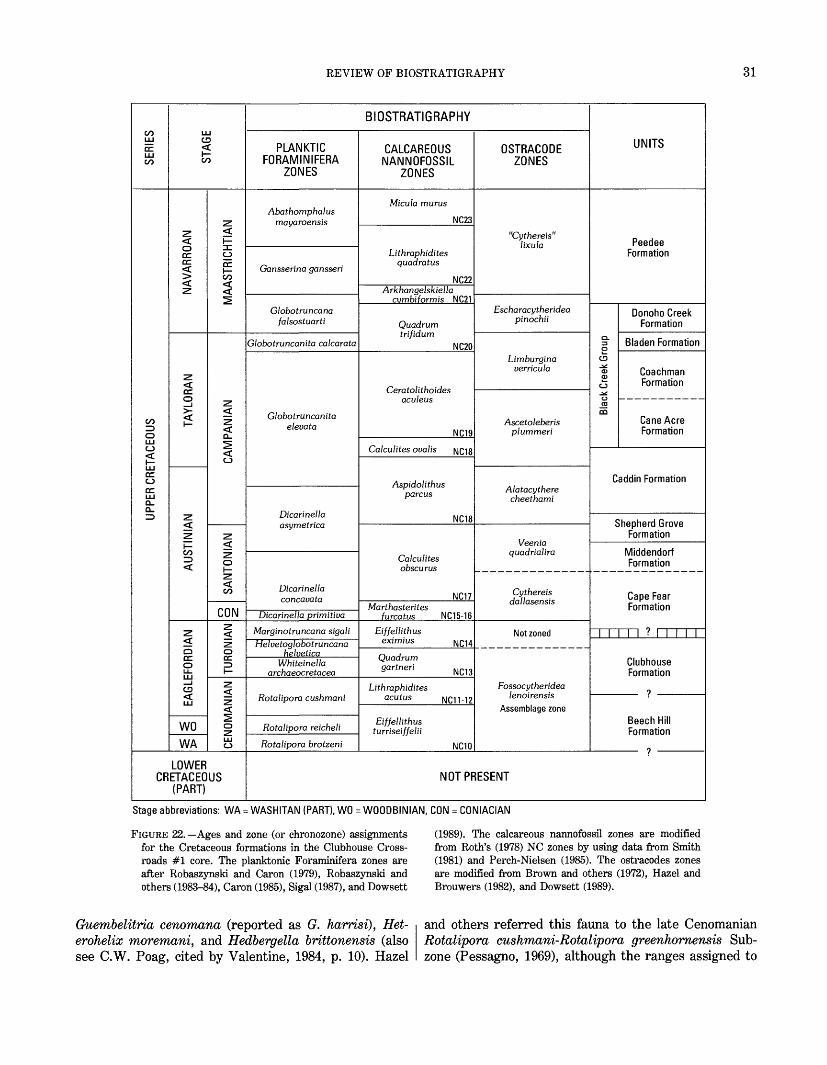
REVIEW OF BIOSTRATIGRAPHY 31
CO LU
DC LU CO
UPPER CRETACEOUS
LU CD <
CO
NAVARROAN
TAYLORAN
AUSTINIAN
EAGLEFORDIAN
WO
WA
MAASTRICHTIAN
CAMPANIAN
SANTONIAN
CON
TURONIAN
CENOMANIAN
LOWER CRETACEOUS
(PART)
BIOSTRATIGRAPHY
PLANKTIC FORAMINIFERA
ZONES
Abathomphalus mayaroensis
Gansserina gansseri
Globotruncana falsostuarti
Globotruncanita calcarata
Globotruncanita elevata
Dicarinella asymetrica
Dicarinella concavata
Dicarinella primitive
Marginotruncana sigali
Helvetoglobotruncana Helvetica
Whiteinella archaeocretacea
Rotalipora cushmani
Rotalipora reicheli
Rotalipora brotzeni
CALCAREOUS NANNOFOSSIL
ZONES
Micula mums
NC23
Lithraphidites quadratus
NC22Arkhangelskiella
cvmbiformis NC21
Quadrum trifidum
NC20
Ceratolithoides aculeus
NC19
Calculates ovatis NC18
Aspidolithus parcus
NC18
Calculates obscurus
NC17Marthasterites
furcatus NC15-16
Eiffellithus eximius N Q 14
Quadrum gartneri NC13
Lithraphidites acutus NC11-12
Eiffellithus turriseiffelii
NC10
OSTRACODE ZONES
"Cythereis"
lixula
Escharacytheridea pinochii
Limburgina verricula
Ascetoleberis plummeri
Alatacythere cheethami
Veenia quadrialira
Cythereis dallasensis
Not zoned
Fossocytheridea lenoirensis
Assemblage zone
UNITS
Peedee Formation
Donoho Creek Formation
§" Bladen Formationo
CD
°> Coachman £ Formation ^.
CO
QQCane Acre Formation
Caddin Formation
Shepherd Grove Formation
Middendorf Formation
Cape Fear Formation
I I I ? I I I I I
Clubhouse Formation
?
Beech Hill Formation
NOT PRESENT
Stage abbreviations: WA = WASHITAN (PART), WO = WOOOBINIAN, CON = CONIACIAN
FIGURE 22. Ages and zone (or chronozone) assignments for the Cretaceous formations in the Clubhouse Cross roads #1 core. The planktonic Foraminifera zones are after RobaszynsM and Caron (1979), RobaszynsM and others (1983-84), Caron (1985), Sigal (1987), and Dowsett
(1989). The calcareous nannofossil zones are modified from Roth's (1978) NC zones by using data from Smith (1981) and Perch-Nielsen (1985). The ostracodes zones are modified from Brown and others (1972), Hazel and Brouwers (1982), and Dowsett (1989).
Guembelitria cenomana (reported as G. harrisi), Het- erohelix moremani, and Hedbergella brittonensis (also see C.W. Poag, cited by Valentine, 1984, p. 10). Hazel
and others referred this fauna to the late Cenomanian Rotalipora cushmani-Rotalipora greenhornensis Sub- zone (Pessagno, 1969), although the ranges assigned to
32 REVISED NOMENCLATURE, DEFINITIONS, AND CORRELATIONS, USGS-CLUBHOUSE CROSSROADS #1
these species by Pessangno (1969) allow the possibility of a Turonian age for this assemblage, as do the ranges assigned by Caron (1985) and by references cited by Valentine (1984, p. 10).
Hazel and others (1977) also assigned the sediments of the Clubhouse Formation to pollen zone IV, which Christopher (1982) subsequently modified and formalized as the Complexiopollis-Atlantopollis Zone. Christopher (1979, 1982) studied the distribution of this zone in sections with calcareous fossils in the Atlantic and Gulf of Mexico Coastal Plains and concluded that the Complexiopollis-Atlantopollis Zone was of late Ceno- manian and early Turonian age (Christopher, 1982, p. 537, text-fig. 3).
In the most extensive biostratigraphic study of the interval now assigned to the Clubhouse Formation, Valentine (1982, 1984) examined the published ages and reported new calcareous nannofossil data for this unit at Clubhouse Crossroads and for correlative Coastal Plain units, including a core of the Eagle Ford Group of Texas studied by Christopher (1982). Valentine (1984) con cluded that the section assigned herein to the Clubhouse Formation was of Turonian age, although he showed that the extinction datum for Rotalipora (Cenomanian- Turonian boundary) in the Texas section almost certainly was within the Complexiopollis-Atlantopollis Zone; hence, that part of this zone is Cenomanian in age.
Hattner and Wise (1980) first reported a calcareous nannoflora from a single sample of the Clubhouse For mation at 2,377 ft. They reported Lithraphidites acutus and L. alatus among others and assigned a late Ceno manian age to this sample. Valentine (1982, 1984) extended the known distribution of L. alatus and L. acutus in the core and reported several additional spe cies, including Eiffellithus eximius and Corollithion achylosum. The FAD of E. eximius (first occurrence at 2,369 ft at Clubhouse Crossroads) is routinely placed at or slightly below the middle of the Turonian (Manivit and others, 1979; Perch-Nielsen, 1985). Because the top of the Complexiopollis-Atlantopollis Zone is known to occur near the middle of the Turonian (Valentine, 1984), it is apparent that the upper part of the Clubhouse Formation in the Clubhouse Crossroads #1 core can be assigned a Turonian age (fig. 22).
Below 2,369 ft, the data are equivocal regarding a Cenomanian or Turonian age. Perch-Nielsen (1985) restricted Lithraphidites alatus, L. acutus, and Corol lithion achylosum (as Stoverius achylosus) to Cenoman ian and older beds. However, Valentine (1984) reported L. acutus and C. achylosum from Turonian sections in Texas and New Jersey. To accommodate these uncer tainties, the Clubhouse Formation is assigned a late Cenomanian(?) and Turonian age (fig. 22).
Hazel and others (1977) reported the ostracode Fosso- cytheridea lenoirensis from the Clubhouse Formation at a depth of 2,370 ft. Brown and others (1972, 1979) used this species as a marker for their chronostratigraphic unit F of Albian and early Cenomanian (Fredericksburg- ian and Washitan) age. However, the presence of F. lenoirensis above the last occurrence of Lithraphidites acutus and immediately below the first occurrence of Eiffellithus eximius suggests that the range of this ostracode extends into the late Cenomanian and proba bly the early Turonian (fig. 22).
CAPE FEAR FORMATION
Hazel and others (1977) assigned a late Cenomanian age to most of the corehole section (2,268-1,923 ft) included herein in the revised Cape Fear Formation but noted that the upper part of the unit (1,923-1,860 ft) could represent the Turonian and Coniacian. Subsequent references continued the use of a Cenomanian (Eagle- fordian) age for this entire section (Gohn and others, 1978; Brown and others, 1979).
More recently, Valentine (1982, 1984) assigned a Con iacian and Santonian(?) age to this section in Clubhouse Crossroads #1. This age was determined primarily from the occurrence of sparse calcareous nannofossils at 1,948 ft in the core (Hattner and Wise (1980) found only a few nondiagnostic nannofossils in the revised Cape Fear section) and the occurrence of nannofossils in correlative beds in other South Carolina and Georgia drill holes. Eiffellithus eximius, Calculites obscurus (reported as Tetralithus obscurus), and Lithastrinus grillii occur at 1,948 ft in the Cape Fear Formation at Clubhouse Crossroads as well as higher (E. eximius, L. grillii) and lower (E. eximius) in the core. The FAD of L. grillii was placed within the Santonian by Perch-Nielsen (1985); however, Smith (1981) and Valentine (1984) reported L. grillii from Turonian strata of the Boquillas Formation and Eagle Ford Group of Texas. E. eximius also first appears near the middle of the Turonian, as it likely does in the Clubhouse Formation.
More importantly, although the FAD of Calculites obscurus is frequently placed in the late Santonian (Perch-Nielsen, 1985), Smith (1981) reported C. obscu rus (as Tetralithus obscurus) from the Atco Formation of the lower part of the Austin Group in Texas, where its lowest occurrence marks the top of Smith's Lucian- orhabdus cayeuxii Zone at the Coniacian-Santonian boundary. Doeven (1983) reported the occurrence of sparse specimens (as Phanulithus obscurus) down to about the Coniacian-Santonian boundary on the Cana dian Atlantic margin, and Dowsett (1989) placed the base of the Calculites obscurus Zone within the Santonian in the eastern Gulf of Mexico Coastal Plain. Hence, it would

REVIEW OF BIOSTRATIGRAPHY
appear that C. obscurus occurs throughout most or all of the Santonian Stage (and in younger beds). Therefore, at least the upper part of the Cape Fear Formation is no older than the Santonian (zone NC17, fig. 22).
Lower in the Cape Fear, Valentine (1982) reported the lowest occurrences of Marthasterites furcatus and Lith- astrinus grillii from about the middle of a section correlated with the revised Cape Fear Formation at Clubhouse Crossroads in a deep well on Fripp Island in Beaufort County, S.C. The FAD of M. furcatus typically is used to mark the Turonian-Coniacian boundary (Manivit and others, 1979; Perch-Nielsen, 1985); how ever, Smith (1981) reported M. furcatus as well as L. grillii from the late Turonian Langtry Member of the Boquillas Formation of Texas. Therefore, it is possible that the lower part of the revised Cape Fear Formation is as old as the Coniacian or even the late Turonian.
The Coniacian and Santonian(?) age for the revised Cape Fear Formation assigned by Valentine (1982, 1984) is followed herein with minor refinement (fig. 22). The presence of Calculites obscurus in the Cape Fear and the Santonian age of the overlying Middendorf Formation require an early Santonian age for the upper part of the Cape Fear. A late Turonian(?) to early Santonian age is extended to the unfossiliferous lower part of the forma tion because of the lithologic similarity and apparent continuity of depositional style throughout the formation and because of Valentine's data from the Fripp Island well. The age of the full Cape Fear Formation is consid ered herein to be late Turonian(?), Coniacian(?), and early Santonian.
Hazel and others' (1977) original assignment of a Cenomanian age to the beds included herein in the Cape Fear Formation was derived from the presence of Glo- bigerinelloides caseyi (at 1,927.5 ft), which does not occur above the Rotalipora extinction datum (Cenomanian-Turonian boundary) in the Texas sections studied by Pessagno (1969). However, Valentine (1982, 1984) listed reports of G. caseyi found in Turonian sediments. The presence of G. caseyi above Calculites obscurus at Clubhouse Crossroads suggests that G. caseyi ranges into Coniacian and Santonian strata, because there is no basis in the numerous reports of C. obscurus in the nannofossil literature for placing the FAD of C. obscurus below strata of that age (Smith, 1981).
MIDDENDORF FORMATION
Hazel and others (1977) assigned an early late Austin- ian age to the section described herein as the Middendorf Formation and stated that this assignment could indicate a Santonian age or an early Campanian age. Subsequent workers have agreed on an Austinian age for this inter
val (Brown and others, 1979; Gohn and others, 1978; Christopher, 1982; Valentine, 1982, 1984). However, on the basis of one nannofossil sample at 1,840 ft (core run 131, 1,830-1,860 ft), Hattner and Wise (1980) suggested a late Turonian and earliest Coniacian age for this interval.
Three palynologic samples from the Middendorf For mation can be assigned to pollen zone V (data from Hazel and others, 1977). Christopher (1979) divided zone V in the northern Atlantic Coastal Plain into three formal zones; the lowest of these zones, the Complexiopollis exigua-Santalacites minor Zone, was assigned a middle Turonian to Coniacian(?) age. However, Christopher (1982) later showed that the base of this zone must occur no lower than the Coniacian and Santonian part of the Austin Group (Pessagno, 1969; Smith, 1981) near Dallas, Tex. On this basis, the base of the Middendorf Formation is no older than Coniacian.
More importantly, the age of the Middendorf is con strained by the presence of Calculites obscurus in the underlying Cape Fear Formation, which requires that the upper part of the Cape Fear and the Middendorf be no older than the Santonian (zone NC17, fig. 22). The oyster Ostrea cretacea, which occurs in the upper part of the Middendorf in the core (N.F. Sohl; see Hazel and others, 1977), is restricted to the Santonian by Sohl and Owens (1991). In addition, the presence of the nannofos sil Eprolithus floralis in the overlying Shepherd Grove Formation (see following section) requires the lower part of the Shepherd Grove, and therefore the Middendorf, to be no younger than the Santonian. Finally, although he did not list the taxa, Valentine (1984, p. 9) reported "a rich Santonian nannofossil assemblage" from 1,757 ft in the Middendorf. In summary, information from a variety of fossil groups places the Middendorf Formation within the Santonian Stage and probably within the middle part of that stage (fig. 22).
SHEPHERD GROVE FORMATION
The section defined herein as the Shepherd Grove Formation was originally assigned a Santonian and Cam panian (late Austinian) age by Hazel and others (1977). This age assignment is unchanged herein.
Given the Santonian age of the Middendorf Formation, the highest occurrence of the nannofossil Eprolithus floralis at about 1,720 ft (Hattner and Wise, 1980, fig. 4,) (reported as Lithastrinus floralis) restricts the lower part of the Shepherd Grove Formation to the Santonian (no younger than Perch-Nielsen's (1985) zone CC16). Hattner and Wise (1980) reported (in their text and fig. 4) the lowest occurrence of Aspidolithus parcus constric- tus (as Broinsonia parca constricta) at 1,628 ft in the overlying Caddin Formation, but they also illustrated A.
34 REVISED NOMENCLATURE, DEFINITIONS, AND CORRELATIONS, USGS-CLUBHOUSE CROSSROADS #1
parcus constrictus (their pi. 7, fig. 8) and a species they assigned to Broinsonia parca sp. aff. B. parca (their pi. 7, fig. 10) from 1,695 ft in the Shepherd Grove. There fore, the interval between about 1,720 and 1,695 ft represents the uppermost part of zone NC17 (fig. 22) and the chronozone of Perch-Nielsen's (1985) zones CC17 and lower CC18; this interval is latest Santonian to early Campanian. The interval between 1,695 ft and the top of the Shepherd Grove Formation is within the lower part of zone NC18 (Perch-Nielsen's (1985) zone CC18b) and is Campanian in age (fig. 22).
Planktic Foraminifera studied by C.C. Smith (see Hazel and others, 1977; also unpub. data, 1976) from samples at 1,718 and 1,695 ft are compatible with a late Santonian and early Campanian age. Smith listed 10 species from 1,718 ft, including Archaeoglobigerina cre- tacea, A. blowi, Heterohelix reussi, and Marginotrun- cana augusticarenata. Robaszynski and Caron (1979) placed M. augusticarenata within the definition of M. sinuosa, a species that Caron (1985) restricted to the Dicarinella asymetrica Zone and older zones, although Robaszynski and others (1983-84) placed the LAD of M. sinuosa distinctly above the top of the Dicarinella asymetrica Zone. Caron (1985) placed the LAD of H. reussi at the top of the Dicarinella asymetrica Zone. The sample at 1,695 ft contains H. striata, H. globulosa, and Globotruncana bulloides, which first occur near the Santonian-Campanian boundary (Pessagno, 1967; Robaszynski and others, 1983-84; Caron, 1985).
Therefore, on the basis of the planktic fossils, the Santonian-Campanian boundary occurs at or near 1,695 ft within the continuously deposited marine section of the Shepherd Grove Formation. Accordingly, the Shepherd Grove Formation is assigned a late Santonian and early Campanian age.
Ostracodes from the Shepherd Grove Formation also indicate a late Santonian and early Campanian age (Hazel and others, 1977; this report). The presence of Brachy- cythere nausiformis (1,751 ft), "Cythereis" nodilinea (1,718 ft), "C." levis (1,718-1,695 ft), Veenia quadrialira (1,718 ft), Mosaleberisl hypha (1,718 ft), Haplo- cytheridea nanifaba (1,695 ft), and Schuleridea parva- sulcata (1,695 ft) requires assignment of the Shepherd Grove Formation to the Veenia quadrialira Zone and to the chronozone of the Alatacythere cheethami Zone of Hazel and Brouwers (1982) (fig. 22). Hazel and Brouwers (1982) and Dowsett (1989) placed the boundary between these zones very close to the Santonian-Campanian Stage boundary.
CADDIN FORMATION
Hazel and others (1977) assigned an early and middle Campanian (late Austinian and early Tayloran) age to the
sediments assigned herein to the Caddin Formation. That age assignment is only slightly modified herein.
Because Aspidolithus parcus constrictus first occurs in the underlying formation, the interval from the base of the Caddin Formation to the highest occurrence of the nannofossil Marthasterites furcatus at 1,565 ft (Hattner and Wise, 1980) is assigned to the lower part of the lower Campanian zone NC18, which is equivalent to Perch- Nielsen's (1985) zone CC18b and to the Eiffellithus eximius Zone of Hattner and Wise (1980).
The section from the highest occurrence of Martha sterites jurcatus at 1,565 ft to the first appearance of Ceratolithoides aculeus at 1,505 ft in the overlying Cane Acre Formation of the Black Creek Group is assigned to the upper part of zone NC18 (Calculites ovalis Zone, Perch-Nielsen's (1985) CC19; Hattner and Wise's (1980) Broinsonia parca Zone).
C.C. Smith (see Hazel and others, 1977; also unpub. data, 1976) listed planktic Foraminifera from samples at 1,645, 1,604, and 1,556 ft in the Caddin Formation. Included are species of Heterohelix, Globigerinelloides, and Archaeoglobigerina, as well as Globotruncana bul loides, Rosita fornicata, and Ventilabrella glabrata, all of which are consistent with an early Campanian age (Caron, 1985; Dowsett, 1989).
Stratigraphically important ostracodes in the Caddin Formation (Hazel and others, 1977; this report) include Haplocytheridea nanifaba (1,645-1,582 ft), "Cythereis" veclitella (1,605-1,582 ft), Cythereis dallasensis (1,605-1,582 ft), "C." bicornis, (1,582 ft), and Brachy- cythere acuminata (1,582 ft). This fauna indicates chron ologic equivalence of most of the Caddin Formation (unsampled above 1,578 ft) to the lower Campanian Alatacythere cheethami Zone (fig. 22). In summary, an early Campanian age is readily assigned to the Caddin Formation on the basis of several fossil groups.
BLACK CREEK GROUP
CANE ACRE FORMATION
Sediments assigned herein to the Cane Acre Forma tion were originally assigned a middle Campanian (mid dle Tayloran) age by Hazel and others (1977). That age assignment is unchanged herein.
As described in the previous section, the lower part of the Cane Acre Formation from the base of the unit to the lowest occurrence of Ceratolithoides aculeus at 1,505 ft (Hattner and Wise, 1980) is assigned to the upper part of the middle Campanian nannofossil zone NC18 (Calculites ovalis Zone, Perch-Nielsen's (1985) CC19) (fig. 22). No additional significant calcareous nannofossil datums are known above 1,505 ft in the Cane Acre Formation. Strictly interpreted, the first appearance of C. aculeus at
REVIEW OF BIOSTRATIGRAPHY 35
1,505 ft and the absence of Quadrum sissinghii and Q. trifidum in the formation place the Cane Acre section above 1,505 ft in zone NC19 (Perch-Nielsen's (1985) CC20).
Most species of planktic Foraminifera found in the Caddin Formation, including Ventilabrella glabrata, continue upward into the lower clay-silt member of the Cane Acre Formation. In addition, numerous specimens of Rugoglobigerina rugosa are present in the Cane Acre at 1,509 ft and above. The upper sand member of the formation was not sampled. The presence of V. glabrata probably restricts the minimum age of the sampled interval to the lower half of the Globotruncanita elevata chronozone (data from Pessagno, 1967; Dowsett, 1989).
The interval containing the ostracodes Antibytho- cypris minuta, Fissocarinocythere gapensis, and F. pittensis (samples at 1,461 and 1,415 ft) represents the middle part of the Ascetoleberis plummeri Zone (fig. 22), which is chronologically equivalent to the middle part of the Globotruncanita elevata Zone in the middle Campa- nian (Hazel and Brouwers, 1982; Dowsett, 1989). In summary, the studied Foraminifera, calcareous nanno- fossils, and ostracodes provide a substantial basis for assigning a middle Campanian age to the Cane Acre Formation.
COACHMAN FORMATION
The interval defined herein as the Coachman Forma tion was originally assigned a middle and late Campanian age by Hazel and others (1977). That age is essentially unchanged herein.
No important calcareous nannofossil or planktic Fora minifera datums occur within the Coachman Formation. Quadrum trifidum and Q. sissinghii are absent, and the Coachman Formation is placed along with the upper part of the Cane Acre Formation in zone NC19 (fig. 22). Similarly, although planktic Foraminifera are common within the Coachman at 1,309 and 1,268 ft, only long- ranging species are present (C.C. Smith; see Hazel and others, 1977). Strictly interpreted, the absence of Glo botruncanita calcarata, which is rarely reported from the southern Atlantic Coastal Plain, and the fauna present in the underlying Cane Acre Formation place the Coachman Formation within the chronozone of the upper part of the Campanian Globotruncanita elevata Zone.
The presence of the ostracodes Fissocarinocythere gapensis (1,342-1,268 ft), Haplocytheridea insolita (1,342-1,268 ft), and Ascetoleberis plummeri (1,342- 1,309 ft) above the highest appearance of F. pittensis (in the underlying Cane Acre Formation) place the Coach man Formation in the upper part of the Ascetoleberis plummeri Zone and (or) the chronozone of the Limbur- gina verricula Zone. The addition of Antibythocypris
elongata at 1,268 ft clearly places this sample within the Limburgina verricula chronozone (Hazel and Brouwers, 1982). This assignment also indicates a middle and late Campanian age and chronologic equivalence with the upper part of the Globotruncanita elevata Zone (fig. 22).
BLADEN FORMATION
Hazel and others (1977) originally assigned a late Campanian and early Maastrichtian age to the sediments assigned herein to the Bladen Formation. They placed the Campanian-Maastrichtian boundary at about 1,100 ft and tentatively placed the provincial Tayloran- Navarroan boundary at the same depth. Herein, a late Campanian age for the Bladen Formation is preferred, and the European and Provincial stage boundaries are both placed at the top of the formation (fig. 22).
Planktic fossils provide little stratigraphic resolution for the Bladen Formation. C.C. Smith (see Hazel and others, 1977; also unpub. data, 1976) reported only long-ranging Foraminifera from a sparse and poorly preserved fauna.
As for nannofossils, the highest appearance of Eiffel- lithus eximius at about 1,100 ft (Hattner and Wise, 1980) (core run 93, 1,095-1,125, 4 ft recovered) is a datum of uncertain stratigraphic utility. The extinction of E. exi mius has been used to mark or approximate the Campanian-Maastrichtian boundary by some nannofossil workers (for example, Perch-Nielsen, 1979). Perch- Nielsen (1985, fig. 7), however, placed this extinction below the stage boundary. In contrast, Doeven (1983) placed the highest occurrence of abundant E. eximius well down within the Campanian but the final appearance in the early Maastrichtian. At the present state of knowledge, the LAD of E. eximius serves as only a crude approximation of the Campanian-Maastrichtian Stage boundary. The lowest occurrence of Quadrum gothicum at about 1,097 ft (Hattner and Wise, 1980) (core run 93) is too high to represent the evolutionary appearance of this nannofossil in the early Campanian (Perch-Nielsen, 1985).
The distribution of benthic organisms provides some what better biostratigraphic resolution for the Bladen. The ostracodes Limburgina verricula (1,205 ft) and Planileberist costatana (1,158 ft) are both present in the unit and indicate an age no older than the upper Campa nian Limburgina verricula Zone (fig. 22). In particular, Hazel and Brouwers (1982) placed the FAD of P.? costatana virtually at the FAD of Globotruncanita cal carata and thereby suggested an age no older than that of the uppermost Campanian Globotruncanita calcarata Zone for at least part of the Bladen.
Mollusks are also an important fossil group in the Bladen (N.F. Sohl; see Hazel and others, 1977). The

36 REVISED NOMENCLATURE, DEFINITIONS, AND CORRELATIONS, USGS-CLUBHOUSE CROSSROADS #1
relatively short range of the small form of the bivalve Flemingostrea subspatulata is known to contain the Tayloran-Navarroan provincial stage boundary and the Exogyra ponderosa-Exogyra costata Zone boundary in the outcropping Cretaceous of the Carolinas (Sohl and Christopher, 1983; Sohl and Owens, 1991). At Clubhouse Crossroads, the range of F. subspatulata (small form) extends across the Bladen-Donoho Creek boundary from 1,095 to 1,035 ft. The Navarroan species E. costata occurs with F. subspatulata (small form) only in the lower part of the Donoho Creek Formation (down to 1,071 ft), whereas the Tayloran species E. ponderosa occurs in a single sample at 1,167 ft. Therefore, the Tayloran-Navarroan and Campanian-Maastrichtian Stage boundaries and the Exogyra ponderosa-Exogyra costata Zone boundary are present at or near the Bladen- Donoho Creek contact at 1,072 ft. Herein, these stage and zone boundaries are tentatively placed at the Bladen- Donoho Creek contact. In summary, the ostracodes and mollusks indicate a latest Campanian age for the Bladen Formation in the core (fig. 22).
DONOHO CREEK FORMATION
Sediments assigned herein to the Donoho Creek For mation were originally assigned an early to middle Maastrichtian (Navarroan) age by Hazel and others (1977) that has been generally accepted by later workers. Herein, the age of the Donoho Creek Formation is restricted to the early Maastrichtian.
The presence of Globotruncana bulloides (1,005-975 ft) and Archaeoglobigerina cretacea (975 ft) with or above Rugoglobigerina hexacamarata (1,006 ft) (C.C. Smith; see Hazel and others, 1977) indicates an early Maastrichtian age (chronozone of the Globotruncana falsostuarti Zone of Robaszynski and others (1983-84)) or an early and early middle Maastrichtian age (Caron, 1985) (fig. 22). Following Pessagno (1967) and Smith and Pessagno (1973), Smith (see Hazel and others, 1977) used the occurrence of Guembelitria cretacea to indicate a middle Maastrichtian age for the Donoho Creek sample at 928 ft. However, Caron (1985) showed the range of this species to extend from the late early Maastrichtian to the late Maastrichtian.
In combination with the occurrence of Exogyra costata at the base of the formation, the last appearance of the nannofossils Quadrum trifidum and Q. gothicum at the top of the unit (Hattner and Wise, 1980) indicates an early Maastrichtian age equivalent to that of the upper part of zone NC20 (Perch-Nielsen's (1985) CC23b). The first appearance of Q. trifidum at 1,010 ft above the lowest occurrence of Exogyra costata is too high to represent Q. trifidum's evolutionary appearance in the late Campanian.
Ostracode faunas provide little biostratigraphic infor mation for the Donoho Creek, except that the presence of Escharucytheridea pinochii in two closely spaced sam ples (928 and 926 ft) indicates an age no older than that of the early Maastrichtian Escharucytheridea pinochii Zone (fig. 22). In summary, data from several fossil groups restrict the Donoho Creek Formation to the Maastrichtian Stage and particularly to the early Maas trichtian below the zones or chronozones of the planktic fossils Lithraphidites quadratus and Gansserina gan- sseri, which are present in the overlying Peedee Forma tion.
PEEDEE FORMATION
The Peedee Formation as revised in this report was originally included in the middle Maastrichtian section of Hazel and others (1977). Later authors also have assigned Maastrichtian (Navarroan) ages to this interval (Gohn and others, 1978; Brown and others, 1979; Hattner and Wise, 1980; Valentine, 1982, 1984).
Planktic fossil groups provide most of the biostrati graphic information for the Peedee in the core (fig. 22); mollusks and ostracodes are represented primarily by long-ranging forms. The nannofossils Quadrum trifi dum, Q. gothicum, and Aspidolithus parcus constrictus do not occur above the Donoho Creek-Peedee contact in the core (Hattner and Wise, 1980), and Micula murus and Nephrolthus frequens are not reported from any unit in the core. Lithraphidites quadratus first appears low in the Peedee at 865 ft above an unsampled interval (873-865 ft) (Hattner and Wise, 1980). The distribution (or absence) of these several species places the unsam pled interval in the Arkhangelskiella cymbiformis Zone of Martini (1976) (LAD of Q. trifidum to FAD of L. quadratus, same definition as NC21) and the section above 865 ft to the Lithraphidites quadratus Zone of Cepak and Hay (1969) and Roth (1978) (NC22, fig. 22) (FAD of L. quadratus to FAD of N. frequens). This entire interval above 873 ft is approximately equivalent to zones 24 and 25 of Perch-Nielsen (1985). Valentine's (1982) report of Micula murus from near the top of the Cretaceous section in a well in Beaufort County, S.C., suggests that younger Peedee sediments (zone NC23, fig. 22) are present in the subsurface of South Carolina. Therefore, calcareous nannofossils indicate a late early Maastrichtian age for the lower 8 ft of the formation and a middle and perhaps late Maastrichtian age for the remainder of the Peedee Formation in the core.
The only Peedee sample studied for Foraminifera (809 ft) (C.C. Smith; see Hazel and others, 1977) contains a diverse fauna including Gansserina gansseri, Globiger- inelloides prairiehillensis, Rugoglobigerina reicheli, and Rugotruncana subpennyi, which indicate assign-
REFERENCES CITED 37
ment to the middle Maastrichtian Gansserina gansseri Zone (Caron, 1985) (fig. 22).
SUMMARY
Stratigraphic terminology for the Cretaceous sedi ments of the Carolinas is reviewed herein in the context of the subsurface Cretaceous section of east-central South Carolina. Taken from the model first described elsewhere by Caster (1934), the concept of laterally contiguous parvafacies is used to define Cretaceous formations in the outcrop belt of North Carolina and South Carolina (Owens, 1989; Sohl and Owens, 1991) and herein in the subsurface of South Carolina.
The focus of this report has been the Cretaceous section in the USGS-Clubhouse Crossroads #1 core hole, located in southern Dorchester County, S.C. The original stratigraphic nomenclature applied to this regionally important, continuously cored Cretaceous section by Gohn and others (1977) and Hazel and others (1977) is significantly revised and updated on the basis of infor mation published since 1977. Original definitions and outcrop correlations for the four formations described from the core in 1977 are significantly revised. In addi tion, the rank of the Black Creek Formation is raised to become the Black Creek Group, and four subsurface formations that are present in the core but not found in the outcrop belt are newly defined. Biostratigraphic information also is reviewed, and ages are assigned to each formation.
The new and revised Cretaceous formations at Club house Crossroads and their ages are as follows, from base to top: Beech Hill Formation (Cenomanian?), Club house Formation (late Cenomanian? and Turonian), Cape Fear Formation (late Turonian? to early Santonian), Middendorf Formation (Santonian), Shepherd Grove Formation (late Santonian and early Campanian), Cad- din Formation (early Campanian), Cane Acre Formation (Black Creek Group, middle Campanian), Coachman Formation (Black Creek Group, middle to late Campani an), Bladen Formation (Black Creek Group, late Campa nian), Donoho Creek Formation (Black Creek Group, early Maastrichtian), and Peedee Formation (late early Maastrichtian to middle or late Maastrichtian).
REFERENCES CITED
Brett, C.E., and Wheeler, W.H., 1961, A biostratigraphic evaluation of the Snow Hill Member, Upper Cretaceous of North Carolina: Southeastern Geology, v. 3, no. 2, p. 49-132.
Brown, P.M., Miller, J.A., and Swain, F.M., 1972, Structural and stratigraphic framework and spatial distribution of permeability of the Atlantic Coastal Plain, North Carolina to New York: U.S. Geological Survey Professional Paper 796, 79 p.
Brown, P.M., Brown, D.L., Reid, M.S., and Lloyd, O.B., Jr., 1979, Evaluation of the geologic and hydrologic factors related to the waste-storage potential of Mesozoic aquifers in the southern part of the Atlantic Coastal Plain, South Carolina and Georgia: U.S. Geological Survey Professional Paper 1088, 37 p.
Caron, M., 1985, Cretaceous planktic Foraminifera, in Bolli, H.M., Saunders, J.B., and Perch-Nielsen, K., eds., Plankton stratigra phy: New York, Cambridge University Press, p. 17-^86.
Caster, K.E., 1934, The stratigraphy and paleontology of northwestern Pennsylvania, pt. I, Stratigraphy: Bulletins of American Paleon tology, v. 21, no. 15, 185 p.
Cepek, P., and Hay, W.W., 1969, Calcareous nannoplankton and biostratigraphic subdivision of the Upper Cretaceous: Transac tions of the Gulf Coast Association of Geological Societies, v. 19, p. 323-336
Christopher, R.A., 1979, Normapolles and triporate pollen assem blages from the Raritan and Magothy Formations (Upper Creta ceous) of New Jersey: Palynology, v. 3, p. 73-121.
1982, The occurrence of the Complexiopollis-Atlantopollis Zone (palynomorphs) in the Eagle Ford Group (Upper Cretaceous) of Texas: Journal of Paleontology, v. 56, p. 525-541.
Coleman, J.M., and Prior, D.B., 1980, Deltaic sand bodies: American Association of Petroleum Geologists Continuing Education Course Note Series, no. 15, 171 p.
Cooke, C.W., 1936, Geology of the Coastal Plain of South Carolina: U.S. Geological Survey Bulletin 867, 196 p.
Dennison, J.M., 1990, Transition from magnafacies to isochronous stratigraphic mapping units: A comparison of Devonian Catskill delta and Cretaceous of the Carolinas [abs.]: Geological Society of America Abstracts with Programs, v. 22, no. 4, p. 11.
Doeven, P.H., 1983, Cretaceous nannofossil stratigraphy and paleoe- cology of the Canadian Atlantic margin: Bulletin of the Geological Survey of Canada, v. 356, 70 p.
Dowsett, H.J., 1989, Documentation of the Santonian-Campanian and Austinian-Tayloran Stage boundaries in Mississippi and Alabama using calcareous microfossils: U.S. Geological Survey Bulletin 1884, 20 p.
Fallaw, W.C., Thayer, P.A., and Price, V., 1990, Basal Coastal Plain deposits in southwestern South Carolina [abs.]: Geological Society of America Abstracts with Programs, v. 22, no. 4, p. 13.
Fisher, W.L., 1964, Sedimentary patterns in Eocene cyclic deposits, northern Gulf Coast region, in Merriam, D.F., ed., Symposium on cyclic sedimentation: State Geological Survey of Kansas Bulletin 169, v. 1, p. 151-170.
Force, E.R., Gohn, G.S., Force, L.M., and Higgins, B.B., 1978, Uranium and phosphate resources in the Cooper Formation of the Charleston region, South Carolina: South Carolina Geological Survey Geologic Notes, v. 22, p. 17-31.
Galloway, W.E., 1989a, Genetic stratigraphic sequences in basin analysis, I, Architecture and genesis of flooding-surface bounded depositional units: American Association of Petroleum Geologists Bulletin, v. 73, p. 125-142.
1989b, Genetic stratigraphic sequences in basin analysis, II, Application to Northwest Gulf of Mexico Cenozoic basin: American Association of Petroleum Geologists Bulletin, v. 73, p. 143-154.
Gohn, G.S., 1983, ed., Studies related to the Charleston, South Carolina, earthquake of 1886 Tectonics and seismicity: U.S. Geological Survey Professional Paper 1313, 375 p.
1988, Late Mesozoic and early Cenozoic geology of the Atlantic Coastal Plain: North Carolina to Florida, in Sheridan, R.E., and Grow, J.A., eds., The geology of North America, v. 1-2, The Atlantic Continental Margin, U.S.: Boulder, Colo., Geological Society of America, p. 107-130.
1992, Correlation, age, and depositional framework of subsur face upper Santonian and Campanian sediments in east-central
38 REVISED NOMENCLATURE, DEFINITIONS, AND CORRELATIONS, USGS-CLUBHOUSE CROSSROADS #1
South Carolina, in Gohn, G.S., ed., Proceedings of the 1988 U.S. Geological Survey workshop on the geology and geohydrology of the Atlantic Coastal Plain: U.S. Geological Survey Circular 1059, p. 115-120
Gohn, G.S., and Owens, J.P., 1989, Late postrift depositional sequences in landward segment of divergent continental margin: Campanian-Maestrichtian sections of United States Atlantic Coastal Plain (South Carolina to New Jersey): 28th International Geological Congress Abstracts, v. 1, p. 561.
Gohn, G.S., Higgins, B.B., Smith, C.C., and Owens, J.P., 1977, Lithostratigraphy of the deep corehole (Clubhouse Crossroads corehole 1) near Charleston, South Carolina, in Rankin, D.W., ed., Studies related to the Charleston, South Carolina, earthquake of 1886 A preliminary report: U.S. Geological Survey Professional Paper 1028, p. 59-70.
Gohn, G.S., Christopher, R.A., Smith, C.C., and Owens, J.P., 1978, Preliminary stratigraphic cross sections of Atlantic Coastal Plain sediments of the southeastern United States Cretaceous sedi ments along the South Carolina coastal margin: U.S. Geological Survey Miscellaneous Field Studies Map MF-1015-A.
Hattner, J.G., and Wise, S.W., Jr., 1980, Upper Cretaceous calcareous nannofossil biostratigraphy of South Carolina: South Carolina Geology, v. 24, p. 41-117.
Haq, B.U., Hardenbol, J., and Vail, P.R., 1987, Chronology of fluctuating sea levels since the Triassic: Science, v. 235, p. 1156-1166.
Hazel, J.E., and Brouwers, E.M., 1982, Biostratigraphic and chrono- stratigraphic distribution of ostracodes in the Coniacian- Maestrichtian (Austinian-Navarroan) in the Atlantic and Gulf Coastal province, in Maddocks, R.F., ed., Texas Ostracoda Guidebook of excursions and related papers for the Eighth Inter national Symposium on Ostracoda: Houston, Tex., University of Houston, Department of Geosciences, p. 166-198.
Hazel, J.E., Bybell, L.M., Christopher, R.A., Frederiksen, N.O., May, F.E., McLean, D.M., Poore, R.Z., Smith, C.C., Sohl, N.F., Valentine, P.C., and Witmer, R.J., 1977, Biostratigraphy of the deep corehole (Clubhouse Crossroads corehole 1) near Charleston, South Carolina, in Rankin, D.W., ed., Studies related to the Charleston, South Carolina earthquake of 1886 A preliminary report: U.S. Geological Survey Professional Paper 1028, p. 71-89.
Heron, S.D., Jr., 1958, History of terminology and correlations of the basal Cretaceous formations of the Carolinas: South Carolina Division of Geology Bulletin 2, p. 77-88.
Heron, S.D., Jr., and Wheeler, W.H., 1964, The Cretaceous forma tions along the Cape Fear River, North Carolina: Atlantic Coastal Plain Geological Association annual field excursion, 5th, 1964, Field guide, 55 p.
Heron, S.D., Jr., Swift, D.J.P., and Dill, C.E., Jr., 1968, Graded rhythmic bedding in the Cape Fear Formation, Carolina Coastal Plain: Sedimentology, v. 11, p. 39-52.
Higgins, B.B., Gohn, G.S., and Idler, G.E., 1978, Geophysical logs for a deep test hole, Clubhouse Crossroads #2, Dorchester County, South Carolina: U.S. Geological Survey Open-File Report 78-151, Ip.
Lawrence, D.R., and Hall, J.P., 1987, The Upper Cretaceous Peedee- Black Creek formational contact at Burches Ferry, Florence County, South Carolina: South Carolina Geology, v. 31, p. 59-66.
Kolb, C.R., and Dornbusch, W.K., 1975, The Mississippi and Mekong deltas A comparison, in Broussard, M.L., ed., Deltas, models for exploration: Houston, Tex., Houston Geological Society, p. 193-207.
Manivit, H., and others, 1979, Calcareous nannofossil events in the Lower and Middle Cretaceous: International Nannoplankton Asso ciation Newsletter, v. 1, no. 1, p. N7.
Martini, E., 1976, Cretaceous to Recent calcareous nannoplankton from the Central Pacific Ocean (DSDP Leg 33), in Initial reports of the Deep Sea Drilling Project: Washington, D.C., U.S. Govern ment Printing Office, v. 33, p. 383^23.
Miall, A.D., 1985, Architectural-element analysis: A new method of facies analysis applied to fluvial deposits, in Flores, R.M., Ethridge, F.G., Miall, A.D., Galloway, W.E., and Fouch, T.D., Recognition of depositional systems and their resource potential: Society of Economic Paleontologists and Mineralogists Lecture Notes for Short Course No. 19, p. 33-81.
Mitchum, R.M., Jr., Vail, P.R., and Thompson, S., Ill, 1977, Seismic stratigraphy and global changes of sea level, pt. 2, The deposi tional sequence as a basic unit for stratigraphic analysis, in Payton, C.E., ed., Seismic stratigraphy Applications to hydro carbon exploration: American Association of Petroleum Geologists Memoir 26, p. 53-62.
Moore, R.C., 1949, Meaning of facies, in Longwell, C.R., chairman, Sedimentary facies in geologic history: Geological Society of Amer ica Memoir 39, p. 1-34.
North American Commission on Stratigraphic Nomenclature, 1983, North American stratigraphic code: American Association of Petroleum Geologists Bulletin, v. 67, p. 841-875.
Owens, J.P., 1989, Geologic map of the Cape Fear region, Florence I°x2° quadrangle and northern half of the Georgetown I°x2° quadrangle, North Carolina and South Carolina: U.S. Geological Survey Miscellaneous Investigations Map I-1948-A, scale 1:250,000.
Owens, J.P., and Gohn, G.S., 1985, Depositional history of the Creta ceous Series in the U.S. Atlantic Coastal Plain: Stratigraphy, paleoenvironments, and tectonic controls of sedimentation, in Poag, C.W., ed., Geologic evolution of the United States Atlantic Margin: New York, Van Nostrand Reinhold, p. 25-86.
Owens, J.P., and Sohl, N.F., 1969, Shelf and deltaic paleoenviron ments in the Cretaceous-Tertiary formations of the New Jersey Coastal Plain, in Subitzky, S., ed., Geology of selected areas in New Jersey and eastern Pennsylvania and guidebook of excur sions: New Brunswick, N.J., Rutgers University Press, p. 235-278.
1989, Campanian and Maastrichtian depositional systems of the Black Creek Group of the Carolinas, in Carolina Geological Society field trip guidebook, October 28-29, 1989: Raleigh, North Carolina Geological Survey, 23 p.
Pessagno, E.A., Jr., 1967, Upper Cretaceous planktonic Foraminifera from the western Gulf Coastal Plain: Paleontographica Americana, v. 5, p. 245-445.
1969, Upper Cretaceous stratigraphy of the western Gulf Coast area of Mexico, Texas, and Arkansas: Geological Society of Amer ica Memoir 111, 139 p.
Perch-Nielsen, K., 1979, Calcareous nannofossils from the Cretaceous between the North Sea and the Mediterranean, in Wiedmann, J., ed., Aspekte der Kreide Europas: International Union of Geolog ical Sciences, ser. A, v. 6, p. 223-264.
1985, Mesozoic calcareous nannofossils, 1985, in Bolli, H.M., Saunders, J.B., and Perch-Nielsen, K., eds., Plankton stratigra phy: New York, Cambridge University Press, p. 329-426.
Rankin, D.W., 1977, ed., Studies related to the Charleston, South Carolina earthquake of 1886 A preliminary report: U.S. Geolog ical Survey Professional Paper 1028, 204 p.
Reid, M.S., Aucott, W.R., Lee, R.W., and Renken, R.A. 1986a, Hydrologic and geologic analysis of a well in Dorchester County, South Carolina: U.S. Geological Survey Water-Resources Inves tigations Report 86-4161, 23 p.
Reid, M.S., Renken, R.A., Wait, R.L., Aucott, W.R., and Lee, R.W., 1986b, Hydrologic and geologic analysis of two wells in Marion

REFERENCES CITED 39
County, South Carolina: U.S. Geological Survey Water-Resources Investigations Report 86-4102, 20 p.
Rhodehamel, E.G., 1975, Geophysical logs from a geologic test hole near Charleston, South Carolina: U.S. Geological Survey Open- File Report 75-247, 1 p.
Ricoy, J.U., and Brown, L.F., Jr., 1977, Depositional systems in the Sparta Formation (Eocene) Gulf Coast basin of Texas: Gulf Coast Association of Geological Societies Transactions, v. 27, p. 139-154.
Robaszynski, F., and Caron, M., coordinators, 1979, Atlas de Fora- miniferes planctoniques du Cretace moyen, pts. 1, 2: Cahiers de Micropaleontologie, v. 1, p. 1-185, v. 2, p. 1-181.
Robaszynski, F., Caron, M., Gonzalez Donoso, J.M., and Wonders, A., eds., 1983-84, Atlas of Late Cretaceous Globotruncanids: Revue de Micropaleontologie, v. 26, no. 3-4, p. 145-305.
Roth, P.H., 1978, Cretaceous nannoplankton biostratigraphy and oceanography of the Northwestern Atlantic Ocean, in Initial reports of the Deep Sea Drilling Project: Washington, D.C., U.S. Government Printing Office, v. 44, p. 731-759.
Roy, E.G., Jr., 1980, Readings in Gulf Coast geology, v. I, Depositional systems in the Gulf Coast: New Orleans, Gulf Coast Association of Geological Societies, 174 p.
Schneider, R.R., Gohn, G.S., Force, L.M., and King, S.L., 1979, Lithologic log for a deep stratigraphic test hole, Clubhouse Cross roads #3, Dorchester County, South Carolina: U.S. Geological Survey Open-File Report 79-449.
Sigal, J., 1987, Une echelle zonale du Cretace Mediterraneen et quelques reflexions suscitees par son etablissement a propos du Danien: Revue de Micropaleontologie, v. 30, no. 1, p. 32-51.
Smith, C.C., 1981, Calcareous nannoplankton and stratigraphy of late Turonian, Coniacian, and early Santonian age of the Eagle Ford and Austin Groups of Texas: U.S. Geological Survey Professional Paper 1075, 98 p.
Smith, C.C., and Pessagno, E.A., Jr., 1973, Planktonic Foraminifera and stratigraphy of the Corsicana Formation (Maestrichtian), north-central Texas: Cushman Foundation Foraminiferal Research Special Publication 12, 68 p.
Sohl, N.F., and Christopher, R.A., 1983, The Black Creek-Peedee formational contact (Upper Cretaceous) in the Cape Fear River region of North Carolina: U.S. Geological Survey Professional Paper 1285, 37 p.
Sohl, N.F., and Owens, J.P., 1980, First recognition of the molluscan Exogyra cancellata Subzone, South Carolina: U.S. Geological Survey Professional Paper 1175, p. 229.
1991, Cretaceous stratigraphy of the Carolina Coastal Plain, in Horton, J.W., Jr., and Zullo, V.A., eds., The geology of the Carolinas (50th anniversary volume, Carolina Geological Society): Knoxville, Tenn., University of Tennessee Press, p. 191-220.
Stephenson, L.W., 1923, Invertebrate fossils of the Upper Cretaceous formations, in The Cretaceous formations of North Carolina: North Carolina Geological and Economic Survey Report, v. 5, p. 1^02.
Swift, D.J.P., 1968, Coastal erosion and transgressive stratigraphy: Journal of Geology, v. 76, p. 444-456.
Swift, D.J.P., and Heron, S.D., Jr., 1967, Tidal deposits in the Cretaceous of the Carolina Coastal Plain: Sedimentary Geology, v. 1, p. 259-282.
1969, Stratigraphy of the Carolina Cretaceous: SoutheasternGeology, v. 10, p. 201-245.
Swift, D.J.P., Heron, S.D., Jr., and Dill, C.E., Jr., 1969, The CarolinaCretaceous: Petrographic reconnaissance of a graded shelf: Journalof Sedimentary Petrology, v. 39, p. 18-33.
Valentine, P.C., 1982, Upper Cretaceous subsurface stratigraphy andstructure of coastal Georgia and South Carolina: U.S. GeologicalSurvey Professional Paper 1222, 33 p.
1984, Turonian (Eaglefordian) stratigraphy of the Atlantic Coastal Plain and Texas: U.S. Geological Survey Professional Paper 1315, 21 p.
Van Wagoner, J.C., Posamentier, H.W., Mitchum, R.M., Jr., Vail, P.R., Sarg, J.F., Loutit, T.S., and Hardenbol, J., 1988, An overview of the fundamentals of sequence stratigraphy and key definitions, in Wilgus, C.K., and others, eds., Sea-level changes: An integrated approach: Society of Economic Paleontologists and Mineralogists Special Publication 42, p. 39^5.
Woollen, I.D., and Colquhoun, D.J., 1977, The Black Creek and Middendorf formations in Darlington and Chesterfield counties, South Carolina, their type area: South Carolina Geological Survey Geologic Notes, v. 21, p. 164-197.
Zack, A., 1977, The occurrence, availability, and chemical quality of ground water, Grand Strand area and surrounding parts of Horry and Georgetown counties, South Carolina: South Carolina Water Resources Commission Report 6, 100 p.