Embed Size (px)
Citation preview

i
Footloose in Hayle
A Series of Walks Around the town

ii
Footloose in Hayle
A SERIES OF WALKS AROUND THE TOWN
Compiled by Dave Philp. Additional text and nature notes by
Georgina Schofield. Title map and cover design by Dave Philp
©1995, 2002, D. H. Philp and G.A.D. Schofield

iii
This Walks Guide is a Community Project and was sup-ported by: Hayle Project Trust Hayle Heritage Group C.C.C. Tehidy/Hayle Countryside Service Penwith District Council West Cornwall L.E.A.D.E.R.

iv
CONTENTS Walk No. ....................................................................................... Page Introduction....................................................................................1 1. Foundry Square to the Customs House.........................5 2. Customs House to Phillack Hill ................................... 11 3. Phillack Hill to Penmare................................................ 17 4a. The Penmare to the Commercial Road Car Park...... 21 4b. The Penmare to the Commercial Road Car Park
(Alternative Route) ......................................................... 27 5. Commercial Road Car Park to Foundry Square ........ 33 6. Foundry Square to the Millponds and the Plantain .. 39 7. The Customs House to Phillack Hill via the Coastal Path ........................................................ 47 8. The Penmare to Loggans Mill, the Dynamite Works
and/or Angarrack ........................................................... 59 Acknowledgements .................................................................... 66 References.................................................................................... 67
v
ILLUSTRATIONS Title Page King George V Memorial Walk...................................Frontispiece Map, Walk No. 1............................................................................... 4 Isis Gardens and the Viaduct.......................................................... 6 Penpol Terrace .................................................................................. 7 The Swing Bridge.............................................................................. 8 Hayle Harbour from the Towans ................................................... 9 Map, Walk No. 2............................................................................. 10 The Customs House....................................................................... 11 Hayle Harbour after snowfall........................................................ 12 Copperhouse Pool looking towards Phillack.............................. 15 Map, Walk No. 3............................................................................. 16 Wilson's Pool from Black Bridge ................................................. 17 Glebe Row....................................................................................... 19 Map, Walk No. 4a........................................................................... 20 J. and F. Pool's No. 3 Works ........................................................ 21 Copperhouse Dock Gates ............................................................. 23 Fore Street, Copperhouse.............................................................. 24 Map, Walk No. 4b .......................................................................... 26 Penmare Hotel ................................................................................ 27 No. 2 Pond Walk ............................................................................ 28 The Cornish Arms.......................................................................... 31 Map, Walk No. 5............................................................................. 32 The War Memorial and Passmore Edwards Institute ............... 33 St. Elwyn's Church from Copperhouse Pool ............................. 34 The Wharves Branch Line Bridge ................................................ 35 Map, Walk No. 6............................................................................. 38 The Lower Millpond ...................................................................... 40 The Bird-in-Hand, Paradise Park ................................................. 42 Foundry Lane .................................................................................. 43 Foundry Barn .................................................................................. 44 Map, Walk No. 7............................................................................. 46 The Old Power Station, North Quay .......................................... 48

vi
Black Cliffs and the Old Cove Cafe............................................. 49 Churchtown, Phillack..................................................................... 53 The Runic Cross, Phillack Churchyard........................................ 55 Map, Walk No. 8............................................................................. 58 Loggans Mill .................................................................................... 59 Angarrack Viaduct .......................................................................... 64
Nature Notes - Illustrations by Dave Philp. Photographs - by Andrew Szmidla
Maps - Georgina Schofield and Dave Philp.
King George V Memorial Walk

1
INTRODUCTION Books can be born of many different things. Memories, faces and places and events that need to be recorded for future gen-erations to know and enjoy, but how they actually come about can, at times, be fairly bizarre. “Footloose in Hayle” was conceived on the platform of Hayle Railway Station while Dave was waiting for a train to Truro that was twenty minutes late. To pass the time he began to jot down ideas for various walks around the town, and put them to the Heritage Festival Committee as the basis for a Heritage Walks Brochure or a small Town Guide. Circumstances then took over. The notes were, unfortunately, shelved for a later date until they were handed to me for use by the Hayle Walks project. This is part of the “Sands of Time” initiative being undertaken by the Countryside Ranger Service of Tehidy Country Park, who also look after Hayle Towans. It was while I was putting all the material together that I began to realise that a printed “Town Walks” guide could still be a possibility, and so this slim volume was given a chance of life. This project has been generously supported by West Cornwall LEADER, who funded it in partnership with Tehidy Country Park, the County Council's Countryside Access Office, Hayle Heritage Group and the Hayle Walks Project. These walks can be classified as being of easy to intermediate difficulty, and for walkers of all ages and physical abilities. They can be used as individual walks or, if desired, the shorter walks, Nos. 2 and 3 can be combined. We realise that someone, somewhere, is bound to think of

2
points that we have overlooked. We hope that we have aroused enough interest by our efforts to prompt further research, either by reading the local history or by walking the routes described within this guide, to see what they can find. Georgina Schofield - August 5th 1995
Second Edition. “Footloose in Hayle” has been updated to reflect the changes which have taken place at some of the locations covered by the Walks and further developments now taking place in Hayle. Georgina Schofield - March 2000

3
PTii
S
H
Camp Site
KEY TO MAPS** (Please note the maps in this guide are not to scale and onlyrelevant details have been included)
By-pass/A Class Road
RoundaboutB ClassRoadFootbr idge
Old Track-bed(now publicright-of-way)
Main LineStation
Caravan Park(Touring and/or Stat ic)
Chalet Site
Steps
MinorRoad
Footpath
Rough Track
Old Track-bed(not publicright-of-way)
Bridge
Church/ChapelChurch/Chapel(former site)War MemorialCar ParkPublic ToiletsTourist InformationInformation PanelCoastal Footpath
Life Guard(Summer Season)
Surf Life Saving Club
Hospital(Not Accidentand Emergency)

4
P
PT
1
i24
5
3
6 8
7
9 10
13
11
12
14
15
N
17
16
18
19
20
21
22
2324
25
26
27

5
Walk No. 1 Foundry Square to the Customs House Walk No. 1 begins at the Information Panel (1), giving a brief history of the Square, set in the wall of the enclosed area in front of Lloyds Bank (2). Built in the 1850s, it has served as the Foundry Market House, a cinema and a store house before taking on its present role as a bank. On the opposite side of the road is Barclays Bank (3), for-merly Harvey's Emporium, the stately brick facade of the Cornubia Biscuit Factory (4), renamed Foundry House, and the Harvey's Office and Counting House (5), now being restored as part of the ‘Townscape’ project. Inside the building are specially designed cast-iron columns to hold up the floor of the steel-lined Strong Room above. It also has its original Victorian tiled toilets. This building has re-cently been acquired as part of the Foundry Barn Heritage Centre and is to be used as the project's Archive Centre. On the seaward side of the Square the original Hayle Sta-tion (6) once stood. The terminus of the Hayle Railway, opened in 1837, was situated in front of the magnificent viaduct (7), built in 1852 by the West Cornwall Railway to I. K. Brunel's design. The original viaduct, which was made of wooden trestle, stood for 34 years before being rebuilt in granite in 1886. The site of the station is now a public garden (8) recently named after the Isis, Hayle's first lifeboat. Donated to the town by Oxford University in 1866, she saved 51 lives dur-

6
ing her 21 years of service.
From Lloyds Bank, proceed past the old Post Office, around the Square and under the viaduct, noting the foun-dry Methodist Chapel (9) which bears the date 1854 and is now an indoor market with a varied selection of shops, and the mid-19th century houses of Chapel Terrace (10). At the pelican crossing you can either continue along Pen-pol Terrace (11), a solid Victorian Terrace with its original shop-fronts built in their front gardens such as Biggleston's (12), dated 1894, and the Carnsew Gallery (13), formerly a butcher's shop, with its terra-cotta heads and mural, or cross the road to Penpol Creek (14). This was formerly Harvey's Penpol Channel, used in the mid-eighteenth cen-tury , flanked by the granite walls of South Quay (15), built in 1819 and now sadly in a state of disrepair. The grassed area was the track-bed of the 1837 Hayle Railway which
Isis Gardens and the Foundry ViaductIsis Gardens and the Foundry Viaduct

7
was still in use until the early 1960s, the wagons being horse-drawn (16). A recent addition is the wooden statue, “Lady of the Sea” (17) by the late Max Barratt, a local sculptor who was internationally renowned for his work. He presented her to the town in December 1993.
When you reach “Pickle Jar” Corner, you come to the Royal Standard public house (18). It was known locally as the “Passage House” from where, at low tide, it was possible to cross to the Lelant Saltings by five different trackways. Each was marked by granite or wooden posts along the outer edges, to avoid the quicksands, thus granting safe passage for travellers across the Estuary. “Pickle Jar” Corner derives its name from the local practice of putting a wooden plank on the empty earthenware pick-
Penpol TerracePenpol Terrace

8
ling jars and using them as seats during Carnival and Feast Day parades. This, in effect, is the end of the Foundry as, from this point on, the land was controlled by the Cornish Copper Company (C.C.C.). Next to the Royal Standard, once also called the Royal Sov-ereign, is Bridge House (19). Built in 1770, it once served as the town's Police Station and Jail before becoming a pri-vate house. Opposite the Royal Standard are the remaining brick and granite buildings of the Hayle Gas Company (20), built in
1880, and behind them the C.C.C.'s New or East Quay, dating from 1818 (21). Continue around the corner and turn left towards the town Swimming Pool, crossing over the Swing Bridge (22), also built in 1880 to carry the road and the Wharves Branch Line linking the Hayle Railway to the Main Line. The Wharves Branch Line closed in 1983. The Swing Bridge replaced the original 1837 Drawbridge
The Swing BridgeThe Swing Bridge

9
which carried the track across the Copperhouse Canal roughly in line with the new Flood Prevention Gate (23). This replaced the 1788 Tidal Gates, the granite posts of which still remain next to the new one. The Hayle Railway then continued over another 1837 bridge (24), the abut-ments of which remain in front of the Swimming Pool, be-fore turning east along the side of Copperhouse Pool (25). Merchant Curnow's Quay, built in 1750, is the grassy area (26) to the right of the Swing Bridge. It was used to unload timber and coal by the C.C.C. This is the location for the painting entitled “Summer's Day”, by Stanhope Forbes. The next building along this road is the Customs House (27) where Walk 1 ends. Built in 1862 it is now owned by the Hayle H a r b o u r Company (1988). A point of particular i n t e r e s t here is the Compass Rose which is incised into the granite step at the entrance to the building which is aligned to true north. It was used to calibrate the compasses of ships due to sail from port. There was also a barometer fixed to the wall just beside the door which was removed when the original Harbour Office closed in the 1970s.
Hayle Harbour from Harvey’s TowansHayle Harbour from Harvey’s Towans

10
N
1
45
6
7
89
10
i
P
P

11
Walk No. 2 The Customs House to Phillack Hill (The King George V Memorial Walk) From the Customs House (1) proceed towards North Quay (2) and turn right, passing the town's Swimming Pool (3). This stands on the site of the outfall built by As-sociated Ethyl Ltd. Overlooking the harbour is the mid-Victorian Clifton Ter-race (4). Dating from 1849, it was named in honour of the Clifton Suspension Bridge the chains for which were forged in Hayle. There is a flight of steps leading up to the Terrace, just opposite the Customs House, made from blocks of black scoria, the waste material from the copper smelters, widely used for building around the Copperhouse area of the town. The path of the King George V Memorial Walk was for-
The Customs HouseThe Customs House

12
merly the track-bed of the Hayle-Redruth Railway, running along the northern bank of the tidal pool. The line was opened in 1837 and, although the Redruth connection was diverted in 1852, the section along the Memorial Walk (5) was used for other purposes by the Great Western Railway (G.W.R.). This beautiful walk at Undercliff is approximately ¾ of a mile long and was purchased from the G.W.R. and Harvey and Co. to commemorate the Silver Jubilee of King George V and Queen Mary. The gardens were laid out with the help of the Harvey family, but are being constantly improved through the hard work of our local gardeners. The King George V Arboretum (6), which is laid out par-allel to the Memorial Walk, is a very fine collection of specimen trees planted in 1952. It was the gift of the Har-vey family to the people of Hayle. In September 1998 the Memorial was adopted as Hayle's
The Harbour after The Harbour after

13
Millennium Project and has been totally upgraded. New street lights and seating has been installed plus decorative lighting for Christmas and summer illuminations along the water's edge. Part of the road forms the Hayle section of Cornwall's Cycleway, and a “scent and touch” garden has been planted for the blind. All these projects were devised and supported by local community groups and the Town and District Councils. To the right is Copperhouse Pool (7) which was built in 1788. With its black scoria block retaining walls, it was used as a Storage Reservoir to hold back the water at high tide. At low water this was released, thus scouring out the chan-nels leading towards the sea, allowing large ships to enter the harbour. Nature Note During the colder months of the year, being the most west-erly estuary in Britain, the milder climate attracts many birds driven south by the harsher weather in other parts of the country, Northern Europe and even further afield. Large flocks of Wigeon, Teal and Shelduck spend most of the winter feeding on the mudflats with the resident Swans. Small numbers of Goldeneye, Little Grebe and Coot also arrive from late October onwards. Up to 3,000 Golden Plover and several hundred Lapwings spend the hours of low water resting on the Pool, together with Dunlin, Redshank and Oystercatchers. Flocks of Cur-lew come down from the moors to hunt along the tide-line,

14
with tiny Sandlings and Turnstones for company. Snipe visit in very cold winters. Peregrines and Kestrels scour the estuary mud for weak birds and pigeons. Occasionally the bright
flash of a Kingfisher can be spotted near the Swimming Pool or the Stepping Stones in front of the Copperhouse Dock. Along the scoria wall flanking the north side of Copper-house Pool is an abundance of wildflowers. Kidney vetch, lucerne, glasswort, pale flax and rarities such as ivy broom-rape, balm-leaved figwort and rosy garlic can be found there, with many more colourful species, blooming around the Pool throughout the year. Unfortunately, since the Sluice Gates were replaced by the Flood Prevention Scheme, the silting, which had already started when sluicing operations were reduced, has vastly increased in the Harbour area. All sluicing was finally abandoned in the 1970s. The Pool is now a nationally important feeding ground for birds which can be seen in large numbers during the spring and autumn migration periods. At the foot of Phillack Hill (8), close to Riviere Cottage (9), a late 18th century residence built by the Cornish Copper Company, is another Information Panel (10) giving further details of the area. Riviere Cot-tage was originally two dwellings built in the 1790s and for
Teal
Plover

15
over a century they served as Alms Houses be-fore being made into a single private residence. They were referred to by John Betjeman in 1926 as being “fine examples of the Georgian style”, but had for some years been falling into a state of total dereliction. Restoration has now been completed to this
Grade II listed building and it has been returned to its original layout as two cottages. The gardens have also been renovated and re-planted. Two additional houses are now being built in the former orchard next to Riviere Cottages in a style complimentary to the original Georgian building.
Copperhouse Pool at low tideCopperhouse Pool at low tide
Lucerne
Kingfisher

16
i
i2
13 4
5
6
7
10
91
1
81
2
N
P

17
Walk No. 3 Phillack Hill to the Penmare (Since this was written the Penmare has been demolished and replaced by housing) From the bottom of Phillack Hill (1), where it meets the King George V Memorial Walk (2), head along the path which is the continuation of the Hayle Railway track-bed (3). Note the two-arched Black Bridge, built of scoria blocks from the Smelting Works in 1818 as part of the ac-cess road from Ventonleague to Riviere and North Quay (4).
At the request of the Reverend William Hockin, the rector of Phillack, one of the arches was made higher than the other to allow him to take his boat under it so that he could reach his own quay at the bottom of the Rectory garden. At about 1/3 of the way along the path you cross over
Wilson’s Pool towards PhillackWilson’s Pool towards Phillack

18
Loggans Mill Leat by way of one of Cornwall's oldest surviving Railway Bridges, built in 1835 (5). The track runs through the Wilson's Pool Salt-marsh (6), which was once part of the Mill-pool for the Cornish Copper Com-pany's tidal mill which was built in 1842 and known locally as “Paddy's Mill” after Richard Paddy, the first miller to be employed there. Nature Notes Wilson's Pool Salt-marsh has thick reed beds, an unusual
habitat in Cornwall, which attract many birds throughout the year. It is one of the main roosting sites for Pied Wagtails and an additional feeding/roosting site for the overwintering wildfowl. Botanically, it is very important, sup-porting well-developed plant communi-
ties , in particular the Halophytes or Salt Loving species, including round-fruited rush which is known from only one other site in Cornwall. Other species include sea thrift, sea aster and long -bracted sedge. The reed beds also attract Dragon- and Damselflies. The nationally rare Common Hawker Dragonfly has been re-corded on Wilson's Pool. A granite marker, inscribed C.C.C., can be found in the small field on the north side of the path (7). Cross the road when you come to the Recreation Ground (8). The line of the Railway continued along the pathway which runs through the Recreation Ground; this is also where the
Pied Wagtail

19
Branch Line to the National Explosives Company Works begins. If you turn left along Lethlean Lane you will again cross the Loggans Mill Leat by way of the Clapper Bridge (9), built in 1812 by the Reverend William Hockin. Note the cottages in Glebe Row (10), which were the subject of a painting by the internationally renowned artist Stanhope Forbes, a member of the “Newlyn School”.
Turn right into Brookway and, from the bridge leading to the modern Estate, look upstream where can be seen all that remains of the National Bridge (11), a 1914 brick and girder construction which carried the Branch Line to the National Explosives Works at Upton Towans. Continue along Brookway until you reach the main road at Penmare Terrace where the Penmare Hotel (12) stands opposite the junction. This hostelry was formerly the Hayle Hotel, built in 1824 as a Coaching Inn on the road to Penzance.
Glebe RowGlebe Row

20
P
P
i
iN
12
34
56
78
9
10
11
12
13
1415
212
2
Det
ail o
f Cop
perh
ouse
Are
a
i
201
9
181
716

21
Walk 4a The Penmare to the Commercial Road Car park Since this was written the Penmare has been demolished and replaced by housing) From the Penmare (1) walk to the junction of Caroline Row (2), a terrace of 19th century workers' cottages, then turn left towards Ventonleague (3). At the bottom of the hill turn right into Madison Vean, the lane to your right, running alongside J. & F. Pool's factory, which was once a Rope Walk where ropes were made for use in the mines. The factory was the site of the Cornish Copper Company's original Copper Smelting Works (4). It was in use from 1750 until 1819 when an Iron Foundry was established to rival that of Harvey and Sons.
Here the “Cornubia” was built in 1838, the first Railway En-gine to be designed and manufactured in Cornwall. The C.C.C. Foundry also produced links for the Royal Albert Bridge at Saltash and beam and pumping engines used in mines in Britain and throughout the world's mining com-
J. and F. Pool’s No.3 WorksJ. and F. Pool’s No.3 Works

22
munities. Together with Harvey's Foundry and Fox and Sons of Perran, another foundry about 10 miles from Hayle, the C.C.C. supplied parts for the three largest pump-ing engines ever made, which helped to drain the Haarlem Lakes in Holland, reclaiming a large area of land from the North Sea. In later years the Company became known as Sandys, Carne and Vivian. It was closed in 1867, when the mining industry slumped, and was bought out by Harvey's. The Phoenix Works, as the foundry was known, was demol-ished in the 1970s, following a disastrous fire, to make way for J. & F. Pool's No. 3 Works. This company was started in 1848 by James “Tinman” Pool to supply tools etc to the local mines. In 1862 his sons, James and Frederick, formed a partnership to produce perforated screens for the mining industry. They graded ore after it had passed through the Crushing Mills and led to the invention of the “Cornish Gauge”, a plate with holes of increasing size which allowed customers to choose the required hole size for their own screens. The end of the lane joins Pond Walk (5) where the former C.C.C. manager's house was situated at No. 2. This late 18th century building is now a private house. J. & F. Pool's No. 2 Works were on the corner of Pond Walk and are now commercial and light industrial units (6). Follow the Pond Walk around to your right until you come to the junction, noting the fine early 20th century houses of Bea-trice Terrace (7), built by Jack Luke, on your right. Jack Luke was a Hayle emigrant to South Africa who returned home a wealthy man and bought plots of land left vacant
23
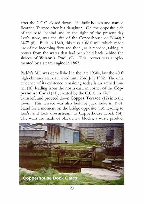
after the C.C.C. closed down. He built houses and named Beatrice Terrace after his daughter. On the opposite side of the road, behind and to the right of the present day Leo's store, was the site of the Copperhouse or “Paddy's Mill” (8). Built in 1840, this was a tidal mill which made use of the incoming flow and then , as it receded, taking its power from the water that had been held back behind the sluices of Wilson's Pool (9). Tidal power was supple-mented by a steam engine in 1862. Paddy's Mill was demolished in the late 1930s, but the 40 ft high chimney stack survived until 23rd July 1982. The only evidence of its existence remaining today is an arched tun-nel (10) leading from the north eastern corner of the Cop-perhouse Canal (11), created by the C.C.C. in 1769. Turn left and proceed down Copper Terrace (12) into the town. This terrace was also built by Jack Luke in 1901. Stand for a moment on the bridge opposite (13), leading to Leo's, and look downstream to Copperhouse Dock (14). The walls are made of black scoria blocks, a waste product
Copperhouse Dock GatesCopperhouse Dock Gates

24
from C.C.C.'s copper smelting furnaces, a building material unique to Hayle. At the end of the Dock Walls, the Dock Gates (15) are still in place which held the water in the ca-nal between high tides. Carry on down Copper Terrace into Fore Street, a fine ex-ample of a 19th century main street with many original shop fronts. The Market House (16) was formerly the of-fices of J. & F. Pool. Built in 1839 it is now a shopping ar-cade with flats above. The Cinema (17) dates from 1900, but closed in the early 1980s. It was one of the earliest to be built in Cornwall and was originally called St. George's Hall. The terra-cotta and tile facade is a very unusual feature as these are not a familiar building material in this area. The former Butcher's Shop on the corner of Market Street, now Copperhouse Farm Shop, was once the Assembly Room of the local Liberal Party, from the late 1890s until the 1920s. It is also reputed to be the site of the Round Chapel, known as the “House of Brass” because its scoria block walls gave it a brassy sheen, built in 1795 and demol-ished in 1815. It was replaced by Copperhouse Chapel in 1816. The Copperhouse Inn (18) was built in 1791, and the Cornubia Hotel (19) in 1867. The Cornubia was originally called the “Fifteen Balls”, a reference to the Cornish Coat of Arms, and it was later renamed again, the “One and All”. The Salt Gallery (20) was formerly Miss West's School.

25
This was attended by many of the local children in the years leading up to and immediately after the Second World War.
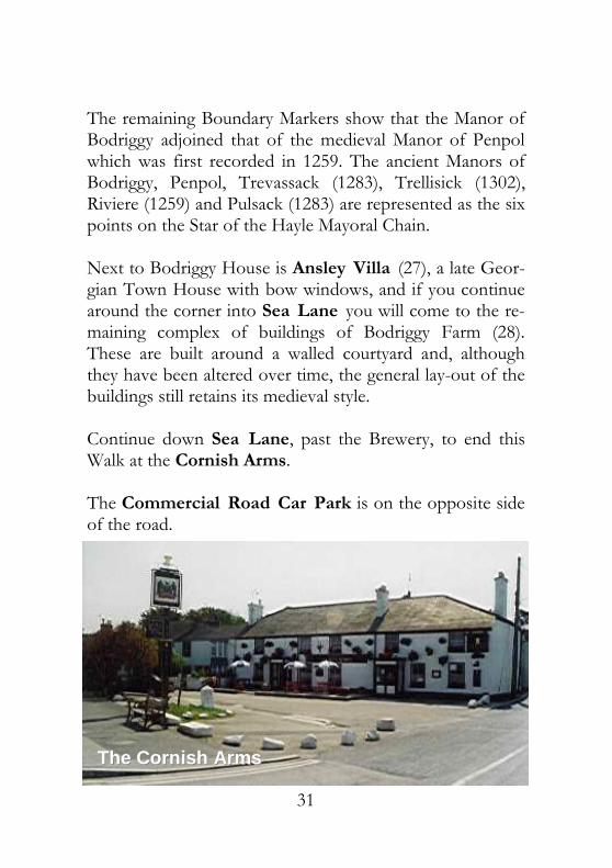
A good example of 19th century terraced housing runs from 108-88 Commercial Road (21), which shows varia-tion and character in spite of some minor alterations. This terrace leads to the Cornish Arms (22), a late 18th century public house at the corner of Sea Lane, opposite the Commercial Road Car Park.
Fore Street, CopperhouseFore Street, Copperhouse
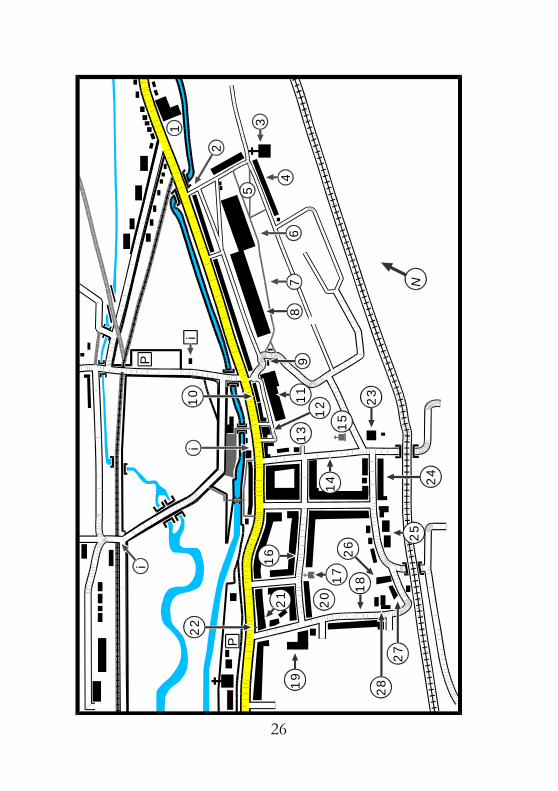
26
1210
4
P
P
i
i
i
N
1
2
35
67
89
111
3
1415
16
17
18
19
2021
22
23
2425
26
27
28

27
Walk No. 4b The Penmare to the Commercial Road Car Park (Alternative Route for Walk No. 4a) Since this was written the Penmare has been demolished and replaced by housing) This route, which, for the most part, runs parallel with the previous walk, offers a relatively traffic-free and quiet alter-native way to see a lesser-known, but nevertheless interest-ing, part of the town. From the Penmare (1), proceed westward to the junction with Caroline Row (2), houses built in the 19th century for workers in Copperhouse.
Turn left and walk up to the top of the hill to Ven-tonleague Chapel (3), dating from 1880, and turn right into Ventonleague Row (4). This solid terrace of houses was built for the Cornish Copper Company workers from gran-ite and scoria block, and faces Ventonleague Green (5). This was the local “Village Green” which once had a leat running along its lower edge into the Copperhouse Mill-
The Penmare HotelThe Penmare Hotel——now demolishednow demolished
28
pool (6). This mill-pool is now dry and overgrown. Part of it was reclaimed by a local builder's yard, but has since be-come a housing development. Head north west across the Green into Pond Walk (7), the lane which runs above and behind J. & F. Pool's No. 3 Works, built on the site of the original Copper Smelter be-longing to the Cornish Copper Company (8). Continue down Pond Walk, turning to your right. Pass the entrance to J. & F. Pool's on your right and No. 2 Pond Walk, an 18th century building formerly the offices of the C.C.C., on your left. At the junction, turn left across the Car Park of R. & J. Supplies (9), noting the remains of the walls of one of C.C.C.'s Gas Works Buildings, erected in 1830 of granite and scoria blocks.
Walk down the lane which runs between Copper Terrace (10), built by Jack Luke, a Hayle man who made his fortune in South Africa, in 1901, on the site of the C.C.C.'s smelter,
No 2. Pond WalkNo 2. Pond Walk

29
and Pool's No. 2 Works, now light industrial units (11), into Market Street (12). Pool's No. 1 Works previously stood on the site of Pool's Court (13), a modern housing development, leading into Chapel Lane (14). Turn to your left, with the site of Copperhouse Chapel (15), a 19th century Wesleyan Chapel of imposing propor-tions, in front of you. This chapel opened in 1816 and, like its later counterpart in Foundry Square, shows the great influence of Methodism in Hayle. Its design was based on the Great Wesley Chapel in City Road, London. One of the largest chapels in Cornwall, stones from Wesley's Round Chapel, built on Copperhouse Dock in 1795, were re-used in its construction. Turn right into St. John's Street (16). This is a very long terrace of good, varied, 19th century housing running par-allel with the town's main thoroughfare. About half way along the street is St. John's Chapel, an early 19th century building which is now the headquarters of Hayle Town Band (17). Continue down St. John's Street to Sea Lane (18). Opposite the junction stands the Penpol Brewery, a complex of large buildings (19) dating from 1815 onwards, founded by the Ellis family. The Brewery Malthouse (20), next to the Police Station, is now converted into flats. Brewing ceased in 1934 and the buildings are now used as a depot by the St. Austell Brewery. Turn into Sea Lane and continue down the hill to the Commercial Road junction. Here stands the Cornish Arms (21), a late 18th century public house. The first Ellis Brewery was sited behind it in what is now the Brewery's

30
Car Park. There is a Milestone (22) in its car park, which dates from the mid 19th century, marking the coaching route to Penzance and Land's End. As an alternative route to Sea Lane, continue up the hill, passing Wesley House (23) on the corner of Prospect Place. This early 19th century house with its fine garden served as the Manse for the Chapel until its closure when it became a private house. Turn right into Bodriggy Street (24), another solid 19th century Terrace, and continue past Bodriggy Lower School, with its two main buildings constructed of granite and local Trencrom stone (25), to the junction with Sea Lane. On the right-hand side stands Bodriggy House (26), an impressive late Queen Anne Town House with its walled garden. Rebuilding was completed in 1718 after fire had destroyed the earlier house, the foundations of which were medieval and the seat of the Manor of Bodriggy. Although the site was first mentioned in 1181, it has had a much longer history of occupation. The name Bodriggy is derived from “Bod-Druggan” which, in the Celtic tradition, means the “House of the Dragon”. It still retains many of its original Queen Anne features, such as the portico and windows, and was recently owned by the Caswell family, who made violins in the workshop next to the house. At that time, it had a very appropriate weather vane on the roof of its east wing, in the shape of a violin, made from copper.
31
The remaining Boundary Markers show that the Manor of Bodriggy adjoined that of the medieval Manor of Penpol which was first recorded in 1259. The ancient Manors of Bodriggy, Penpol, Trevassack (1283), Trellisick (1302), Riviere (1259) and Pulsack (1283) are represented as the six points on the Star of the Hayle Mayoral Chain. Next to Bodriggy House is Ansley Villa (27), a late Geor-gian Town House with bow windows, and if you continue around the corner into Sea Lane you will come to the re-maining complex of buildings of Bodriggy Farm (28). These are built around a walled courtyard and, although they have been altered over time, the general lay-out of the buildings still retains its medieval style. Continue down Sea Lane, past the Brewery, to end this Walk at the Cornish Arms. The Commercial Road Car Park is on the opposite side of the road.
The Cornish ArmsThe Cornish Arms

32
6
P
i
i
N
1
2
3
45
78
9 10
111
2
13
141
51
6

33
Walk No. 5 Commercial Road Car Park to Foundry Square This Walk begins at the Commercial Road Car Park op-posite the Cornish Arms, from where you proceed in a westerly direction along Commercial Road. At the western end of the Car Park is the town Library (1) which has an excellent local reference section. St. Joseph's R.C. Church (2) was formerly the Hayle Baptist Chapel, and the Immersion Bath, where baptisms took place, is still intact below the floor of the Church Hall. From the Church continue west until you come to the Passmore Edwards Institute (3).
This imposing granite building was the last to be designed by Silvanus Travail as a centre for adult education for John Passmore Edwards, the Cornish Newspaper Editor and philanthropist, in 1893. Built in 1893 on land given to the
War Memorial and Passmore Edwards War Memorial and Passmore Edwards

34
town by the Harvey Family, the Institute is used today by the Town Council and many of the local organisations for a variety of functions. Opposite the Passmore Edwards Institute, at the foot of Chapel Hill, is the town's War Memorial (4). Further along Hayle Terrace you will find the Drill Hall (5) with its terra-cotta date plaque showing that this single storey gran-ite building was erected in 1911. It is still used by Hayle's Army and Air Training Corps Cadets. Continue down Hayle Terrace, noting the small, granite shop front (6) dating from 1891. Depending on the direc-tion you are walking, this is the first or last of the “Front Garden” shops, and is the only one located on Hayle Ter-race. Note the interesting stained glass windows depicting agricultural scenes.
At the point where Hayle Terrace merges with Penpol Terrace, the most prominent building in this part of the
St. Elwyn’s Church over Copperhouse St. Elwyn’s Church over Copperhouse

35
town rises above the houses. St. Elwyn's Church (7) was the last building to be created by John B. Sedding, the de-signer of the Brompton Oratory. It was begun in 1886 and was completed in 1888. The Church is open daily and has some very fine stained glass windows including the “Friendship Window”, a memorial to its first vicar, William Hosburgh, and his life-long friends, Frank and Anne Har-vey of Glanmore House. The Church Hall (8), just below the church precinct, dates from 1905.
The garage, next to the Church Hall, has a mid 19th cen-tury industrial building, dating from 1852, built of stone and slate, incorporated as a workshop (9). This was part of the Hayle Cooperage Company's yard. Beyond the garage, turn left, up the track-bed of the Hayle Wharves Railway Branch Line (10) which connected Hayle to the Main Line. The Quay Overbridge (11) is a granite and iron structure dating from 1852, and the Quay Sand Drag (12), with its Barlow Rails still intact, can be seen beside it.
The Wharves BranchThe Wharves Branch--Line BridgeLine Bridge
36
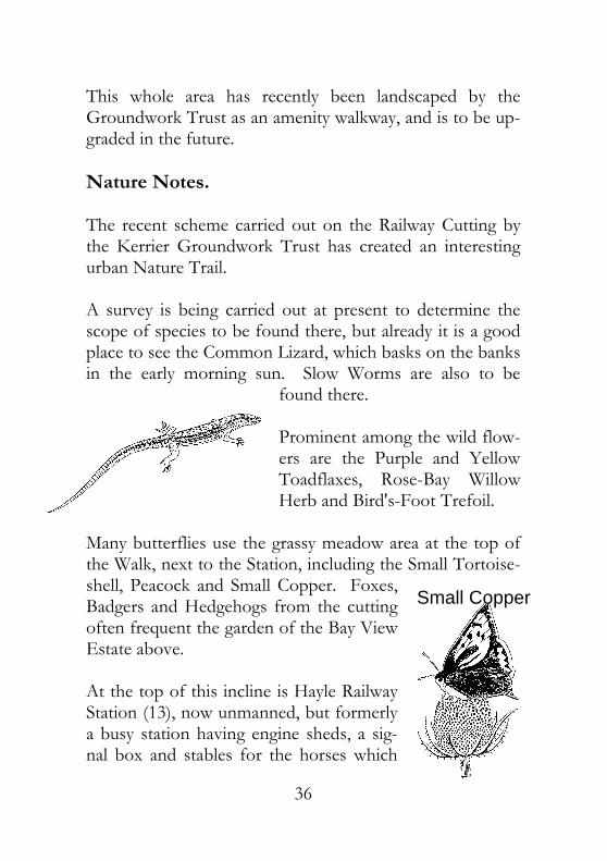
This whole area has recently been landscaped by the Groundwork Trust as an amenity walkway, and is to be up-graded in the future. Nature Notes. The recent scheme carried out on the Railway Cutting by the Kerrier Groundwork Trust has created an interesting urban Nature Trail. A survey is being carried out at present to determine the scope of species to be found there, but already it is a good place to see the Common Lizard, which basks on the banks in the early morning sun. Slow Worms are also to be
found there. Prominent among the wild flow-ers are the Purple and Yellow Toadflaxes, Rose-Bay Willow Herb and Bird's-Foot Trefoil.
Many butterflies use the grassy meadow area at the top of the Walk, next to the Station, including the Small Tortoise-shell, Peacock and Small Copper. Foxes, Badgers and Hedgehogs from the cutting often frequent the garden of the Bay View Estate above. At the top of this incline is Hayle Railway Station (13), now unmanned, but formerly a busy station having engine sheds, a sig-nal box and stables for the horses which
Small Copper

37
worked on the Wharves Branch Line. The Main Line can be crossed here, obviously taking great care, and, from the station, turn right down the hill into Foundry Square. I would, however, recommend a much safer route. Turn right at the top of the incline and then left into the lane which runs under the railway bridge. Walk down Station Hill (14) into Foundry Square (15). There, an Informa-tion Panel is situated on the wall in front of Lloyds Bank (16).
Bird’s Foot Trefoil

38
P
PT
H
i
N
i1
23
4
56
7 89
1011
12 131
41
5 16
17
18
19
20
21
2223
24
26
27
25
28
29
30
31
32 33 34

39
Walk No. 6 Foundry Square to the Millponds and the Planta-tion Beginning at Foundry Square (1), follow the B3302 past the White Hart Hotel (2). Built in 1838 by Henry Harvey, it replaced the original 1824 White Hart, owned by Jane Trevithick, which is now the Freemason's Hall (3). Opposite the former White Hart Stables (4), now a bak-ery, you will come to the walled Millpond Gardens (5). Turn right into the Gardens, following the path across what was once the Grist Mill (6) which operated from 1822. It was demolished in 1941. The path continues through the Hammer and Boring Mills (7) which worked from 1776 until 1903, and the Brass Foundry (8) to the Rope Walk (9). From 1796 until 1916 rope was produced here and, in the wall which runs through the wood , there are square holes at regular intervals where the spars to support the ropes were located (10). The “Key-Hole” Pit (11) is the site of the Rope Walk Capstan. After crossing the wooden footbridge, follow Footpath No. 9 around to the right into Millpond Avenue (12). The fine town villas were built in the 1850s for Harvey's Merchants and Sea-Captains (13), with the workers' cot-tages (14) next door. To your right is the Lower Millpond (15), once used as an

40
ornamental lake for the villas and now an important wild-life haven. On a hot summer's day you may be fortunate enough to see one of its rarer occupants, a turtle, basking in the sun on a log. The Upper Pool (16) dates from 1780 and was the source of power to turn the Water Wheels for the Hammer and Boring Mills. Nature Notes. Hayle Millponds have been studied extensively by the Hayle Town Trust's Ecological Survey over the past ten years, and, besides its small colony of turtles, found in 1989, it has logged nearly 800 different species of plants, trees, animals, birds, moths, butterflies and other insects. All around the site there are areas designated as Butterfly Gardens which are specially
Caspian Pond Turtle
The Lower MillpondThe Lower Millpond

41
planted to encourage some of the rarer species to breed there. Summer mi-grants include Panted Ladies, Short-Tailed Blues and a few Brimstones. The Millponds are also a good place to observe Dragon- and Damselflies, making a bright splash of colour among the lakeside vegetation.
Birds are easily observed around the ponds and, beside the resident wild-fowl, they are regularly visited by Kingfishers, Herons, Warblers, Bun-tings and Wagtails. Firecrests are winter visitors, as are Tufted Ducks and Gadwall. There are two resident species of bats. Of the 250 species of plants, 20 are almost totally indigenous to the South West, such as the Italian Arum Lily and the Three-Cornered Leek. You can be sure of finding something of
interest blooming along the Rope Walk Nature Trail or around the ponds through-out the year. At the end of the Avenue it is possible to tale two dif-ferent routes.
Dragonfly
Italian Arum Lily
Firecrest

42
Route A You can cross the B3302 and turn left up Foundry Hill (17). This was once called “Drovers' Row” after the Pack Horse Drivers and Muleteers who lived there. The Foun-dry School House was at No. 5 (18). At the top of the hill you will come to St. Michael's Hospital (19). In its grounds stands Downes House (20), a fine country man-sion built in 1880 by Sedding. This boasts a beautiful ter-raced garden, also to the original design by J. D. Sedding, who was the designer of St. Elwyn's Church. Downes House is now a Convent. Follow Trellisick Road until you arrive at Paradise Park (21) which does excellent work breeding endangered birds and animals from all over the world. One example of their work, the breeding of Choughs for re-release back into the wild, has great local interest, the Chough being the County Bird of Cornwall, appearing on many Coats of Arms throughout the County.
The BirdThe Bird--inin--Hand, Paradise ParkHand, Paradise Park

43
Within the grounds of Paradise Park stands Glanmor House (22) which was built by Harvey's in 1862 for their Transport Manager. It has a fine Victorian Walled Garden (23), recently restored as a feature of the Park. At its en-trance also stands the 1860 Coach House and Stable Block, now restored as the Bird-In-Hand public house (24), which sells Real Ales including some brewed in its own Brewery. Route B Opposite Millpond Avenue is Foundry Lane which is spanned by the Triumphal Arch (25), the entrance to Har-vey's, with the curved walls beyond bordering the vegetable garden. Follow the road around the corner and up the lane to your left which leads to the Plantation (26). For easier access for wheel- and pushchairs, continue to
walk down Foundry Lane, past the Foundry Farm Stables (27) and under I. K. Brunel's Viaduct (28), built in 1852. On your left you will find the lower entrance to the Planta-
Foundry LaneFoundry Lane

44
tion. At the highest point of the Plantation is an Informa-tion Panel (29) pointing out the landmarks across the Estu-ary. Walk down the gently winding pathways, passing the Cunaide Stone (30). This 5th century burial stone of a Christian woman was discovered in 1843.
A Mortar (31) from the Crimean War, which was cast at Harvey's Foundry and has recently been restored, stands on the Lower Terrace facing out to sea. Leaving the Plantation at the north-eastern corner, cross Foundry Lane. Turn left and then right across the open space where the Foundry Gas Works and the Copper-smiths' Shops (32) once stood. Continue under the Via-duct in the direction of Foundry Square, and you will pass the Pattern Shops (33) and the Foundry Barn (34). This is all that is left of the once-mighty Carnsew Foundry which produced many Beam and Pumping Engines, includ-ing one of a pair which are still working at Kew Bridge in London. The Cruquius Pumping Engine, the largest ever made,
Foundry BarnFoundry Barn

45
was cast here in 1847. It was used to drain the Haarlem Lake in Holland, with two other engines, the Leeghwater and the Ljinden, parts of which were jointly cast by Har-veys, the Cornish Copper Company and another local foundry, Fox and Sons of Perran. By draining the Lake, an area of some 80 square miles of land was reclaimed form the sea and is known as the Haarlemeer Polder. The Cru-quius Engine is now a Dutch National Monument and Mu-seum. These recently-listed buildings are now being restored as the Hayle Heritage Centre and Town Museum, thus pre-serving an important part of Hayle's Industrial History. It is hoped that this will just be the beginning of the long-awaited regeneration of the entire Foundry Conservation Area from Foundry Square to the final piece of land by the river. It would complete the work on the Millponds al-ready carried out since 1986 by the Hayle Town Trust, and give Hayle a unique urban Wildlife Sanctuary as well as pre-serving its many fine buildings for future generations to come. The site of the former Fitting Shop, or “Colesium” as it was traditionally called, is now the Guiness Trust's Trevoarn Housing Development, opened in July 1998. In May 1999, H.R.H. Prince Charles visited the Foundry Heritage Project and handed over the deeds of the Foundry Barn and Foun-dry Farm to the late Mayor, Tom Ellis, on behalf of Hayle Town Trust and Foundry Barn Steering Group. It is hoped that work will start on the 1st phase in autumn 2000.

46
P
PP P
P
T
S
AB
C
i
i
1
23
4
5
6
7
8
91
0
11
12
13
14
151
6
17
18
19
20
21 2
2
23
N P

47
Walk No. 7 The Customs House to Phillack Hill Via the Coastal Path (A Circular Walk) From the Customs House (1), follow the road onto North Quay (2), an early 19th century quay with its origi-nal frontage still surviving, in the direction of the mouth of the river. On route you will pass the site of the “Steampacket Inn” (3), demolished in 1961. The name Hayle in Cornish means “estuary”. It has been corrupted many times over the years, from “Heul” to “Hayl”, then “Heyl”, until it attained its present-day pro-nunciation and spelling. It was a thriving port until the 1970s. North Quay was, therefore, a very busy area, having a Shell Oil Storage Depot (4) on the right and, beyond that, the chemical works of Associated Ethyl Ltd. (5), both now also demolished. To the left is an area which used to be the extensive sidings of the Hayle Railway (6). Evidence of this can still be seen in the large blocks of granite, containing rows of holes, used as sleepers on which the rails were laid. The brick floor was revealed when the accumulated coal dust was cleared away after the coal yards closed. A little further along the quay, the boats, which brought in the cargoes of coal for domestic use and also as fuel for the Power Station (7), were actually unloaded. The Power Station was situated at the end of the quayside road where it forks towards the Towans, the coal being transported

48
directly to it from the quay via a large overhead conveyor belt. Built in 1910, the Power Station was finally closed in the 1970s and was then demolished. A modern Trans-former Station now stands on the site. Set in the wall op-posite the entrance to this area of land is the chimney stack of the Hayle Arsenic Works (8).
From this point, you have a choice of three routes. Route A Take the left-hand fork down onto the beach, following the course of the river towards the sea. By walking along the high-tide line at the base of the sand dunes you eventually reach the foot of the Black Cliffs (9). At low tide it is pos-sible to walk along the beach at the base of the cliffs, past the Life Guard Hut to the Cove Steps (10). Just beyond the cove there is what appears to be a cave.
Site of the old Power Station, North Site of the old Power Station, North

49
This is Batt's Adit which was used to aid the drainage of water from the Wheal Lucy Mine on the cliff top above. The Cove Steps lead up to the old Cove Café (11). Built in 1910, this was a local “Institution” favoured for Sunday af-ternoon cream teas and Chapel “Tea Treats”. Route B Again take the left hand fork, but this time follow the road through Harvey's Towans Chalet Site (12) until you come to the Coastal Path. This is marked by posts with the Acorn logo and directional arrows on them. It will lead you to the top of the Black Cliffs and, eventually, to the Cove Cafe after passing the Bluff public house (13) on your right.
From this point Routes A & B converge. Continue along the Coastal Path at the top of the cliffs. At the end of the Black Rocks you will find an Information Panel alongside the path. From here turn inland, keeping first the caravan site and then the farmland to your right.
Black Cliffs and the old Cove CafeBlack Cliffs and the old Cove Cafe
50
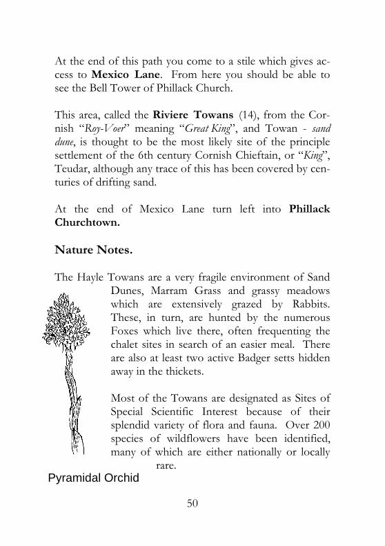
At the end of this path you come to a stile which gives ac-cess to Mexico Lane. From here you should be able to see the Bell Tower of Phillack Church. This area, called the Riviere Towans (14), from the Cor-nish “Roy-Voer” meaning “Great King”, and Towan - sand dune, is thought to be the most likely site of the principle settlement of the 6th century Cornish Chieftain, or “King”, Teudar, although any trace of this has been covered by cen-turies of drifting sand. At the end of Mexico Lane turn left into Phillack Churchtown. Nature Notes. The Hayle Towans are a very fragile environment of Sand
Dunes, Marram Grass and grassy meadows which are extensively grazed by Rabbits. These, in turn, are hunted by the numerous Foxes which live there, often frequenting the chalet sites in search of an easier meal. There are also at least two active Badger setts hidden away in the thickets. Most of the Towans are designated as Sites of Special Scientific Interest because of their splendid variety of flora and fauna. Over 200 species of wildflowers have been identified, many of which are either nationally or locally
rare. Pyramidal Orchid

51
Orchids are among the protected species that grow there in profusion during the late spring and summer. Cowslips, wild thyme and vernal squill can also be found among the short, springy grasses of the meadows. Many birds visit the Towans “on passage” during the spring and autumn migrations. Stonechats, wheatears and bluethroats can be seen annually, resting on the buck-thorn thickets. Peregrines and buz-zards hunt all along the coastline, while the skylarks soar above the meadows, their sweet song echoing across the sands. Among the visiting sea birds are Razor-bills and Guillimots, with some of the rarer gulls, such as icelandic, glaucous and sabine's, being often observed, par-ticularly in the later months of winter after severe gales. Eider ducks visit St. Ives Bay annually, either singly or in small groups. Small schools of Dolphins are frequently seen swimming in the bay, from St. Ives to Godrevy, and over the years they have become a regular attraction. The cliff-top holiday parks sometimes post the times that they are expected to be seen. Swimmers and fishermen often encounter these gentle mammals playing just off-shore during the summer months. As part of the Towans Management Plan, the Tehidy/Hayle Countryside Services have put up Information Pan-
Stonechat

52
els along the Coastal Path from Riviere Towans to Godrevy. These illustrate the range of Flora and Fauna to be found there and to encourage visitors to the Towans to adopt a “Tread Softly” approach to the very special environ-ment which exists along our coastline. Beware of Adders during prolonged periods of warm weather. Route C. Unfortunately both routes A and B cross sand, making access difficult for wheel- and push-chairs. An easier way to reach the cliff top would be to take the right hand fork in spite of the rather steep incline at the beginning of this route. Follow the road, keeping the old Power Station site on your left until you come to the chalets at Harvey's Towans. Con-tinue on the tarmac-surfaced section to the top of the next rise. In front of you is the public car park, and by taking the left fork around it you will pass the Bluff public house. From here, continue along this road until you come to Phillack Churchtown. Here Routes A, B and C converge. Carry on into Phillack Churchtown passing the “Bucket of Blood” public house (15). Once called the “New Inn”, dating from the 18th century, it is built on much older foundations which could date back as far as the 14th cen-tury. One of the origins of its rather grisly name is said to stem from the previous use of part of the building as the

53
village abattoir supplying the Butcher's Shop situated in the cottage next door.
This Inn was very probably a Pilgrims' et House, being on the western route, or Watershed Way, leading to St. Mi-chael's Mount and onwards to St. James of Compostella in Spain. Recently, several small pilgrim's tokens in the shape of a scallop shell, the sign of St. James, have been found in the Sanctuary Fields close by. Follow Churchtown Road until you come to Phillack Church (16). Its Rectory (17), a mid-19th century house with a fine terraced garden, was built by the Hocking family and stands directly opposite the Church. Several members of the family were Rectors of Phillack Church and, being wealthy landowners, they also had inter-ests in many enterprises including the local Wheal Lucy tin mine. This was situated about half a mile north-west of Phillack , on the cliff top, and was named after Canon Fre-derick Hocking's daughter. The mine was operated inter-
Churchtown Road, PhillackChurchtown Road, Phillack

54
mittently from 1872 until 1900 and produced about 50 ton-nes of black tin. The entire Churchtown area of Phillack is covered by a Conservation Area Status because of its picturesque ter-races of 18th and 19th century cottages. The scoria and granite farmhouse and outbuildings of Riviere Farm (18), situated on the road leading from the Towans, date from 1791. They are a good example of the use of these local building materials, as are many of the cottages in the village itself. The farm buildings have recently been cleaned out and renovated by the Hayle Harbour Company who now own Riviere Farm. The settlement of Phillack is one of great antiquity, proba-bly with its roots in the Iron Age and with a long history as an ecclesiastical centre. It is recorded in the Doomsday Survey of 1086, and became part of the Arundell family's estate in 1264 after the marriage of Renfrey de Arundell to Alice Alcard of the Manor of Conarditon, now Connor Downs. The Arundells held Phillack until 1808 when their estate was sold and the land was bought by the Cornish Copper Company. The church was first mentioned as “ Ecc de Egloshell”, the “church by the estuary” in 1130. The name of Phillack, a corruption of Piala, is Patron Saint, latinised as St. Felicitas, and dates from the early 17th century. Phillack has had a series of churches built on the site of the present 19th century one, which dates from 1856/57, and it records an unbroken succession of Rectors starting in

55
1257. It is now believed that a Christian community was already established here by the 4th century, and a small granite block above the South Porch of the present church which bears the “chi-rho” symbol gives support to this. It is of an early Mediterranean form which would predate the arrival of the Irish Saints by over a century.
A tall wheel-headed Cross from the 10th century (19) stands at the top of the steps leading from the Lych Gate, above the Coffin Stone, which lies just inside the gate. Note the old Vestry (20) to the east of this point, facing the Rectory, built of brick and locally-produced scoria blocks. Opposite the Church, at the top of Phillack Hill, is the Holy Well of St. Piala (21), the sister of the Irish Saint Fingar (Gwinear) who landed at Hayle Estuary in the 6th century. The Well was recently restored and reconsecrated by the Hayle Old Cornwall Society, the service being held in both Cornish and English.
The Runic Cross, Phillack ChurchyardThe Runic Cross, Phillack Churchyard
56
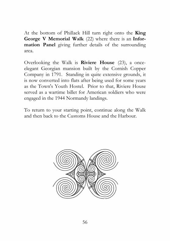
At the bottom of Phillack Hill turn right onto the King George V Memorial Walk (22) where there is an Infor-mation Panel giving further details of the surrounding area. Overlooking the Walk is Riviere House (23), a once-elegant Georgian mansion built by the Cornish Copper Company in 1791. Standing in quite extensive grounds, it is now converted into flats after being used for some years as the Town's Youth Hostel. Prior to that, Riviere House served as a wartime billet for American soldiers who were engaged in the 1944 Normandy landings. To return to your starting point, continue along the Walk and then back to the Customs House and the Harbour.

57

58
N
1
23
5
4
6
78
9
10
11
12
13
14
59
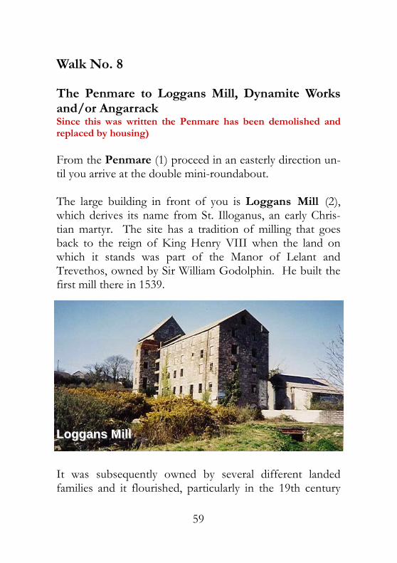
Walk No. 8 The Penmare to Loggans Mill, Dynamite Works and/or Angarrack Since this was written the Penmare has been demolished and replaced by housing) From the Penmare (1) proceed in an easterly direction un-til you arrive at the double mini-roundabout. The large building in front of you is Loggans Mill (2), which derives its name from St. Illoganus, an early Chris-tian martyr. The site has a tradition of milling that goes back to the reign of King Henry VIII when the land on which it stands was part of the Manor of Lelant and Trevethos, owned by Sir William Godolphin. He built the first mill there in 1539.
It was subsequently owned by several different landed families and it flourished, particularly in the 19th century
Loggans MillLoggans Mill

60
when it was considered to be one of the largest and up-to-date in the West Country. In 1890 it was owned by Hosken, Trevithick and Polkinghorne and Co. (H. T. P.). It was last used by Farm Industries in the 1960s as a retail Agricultural Warehouse. Loggans Mill Leat (3) is a branch of the Angarrack Stream which flows through Wil-son's Pool Salt-marsh into Copperhouse Pool. From this point you have a choice of two routes. Route A. If you turn left at this junction towards Gwithian you will eventually come to the site of the National Explosives Company, known locally as the Dynamite Works (4) on your left at Upton Towans. This is where the Spur Line (5) from the Recreation Ground terminated. The Railway Line, after joining the road where it levels out behind the Mill, ran parallel to it where the present-day row of bunga-lows is situated on Loggans Road. It then ran diagonally across the large field beyond the entrance to the St. Ives Bay Holiday Camp. At the end of this section the Spur-Line Platform (6) can be seen behind the line of houses and bungalows at Upton Towans. The entrance to the Dy-namite Works site is next to the former depot of Triplet Car Spares. The National Explosives Company was established in 1888 to produce Gun-Cotton and Dynamite for blasting underground in the mines. It produced 3 tons per day by 1890 and the factory expanded rapidly, manufacturing Cordite, Gelatine Gelignite and Nitro-Glycerine for the

61
Navy and Army until 1919, when production stopped. At the height of its output, 1800 people were employed on the site, producing up to 2,000 tons of explosives per year. Ex-plosives were still stored there until the 1960s. The Glycerine-Nitrating vat was situated on “Jack Straw's Hill”. This is the highest sand dune on the site and is named after a priest who took part in the Peasants' Revolt of 1381. To the north and east of the site evidence can still be found of the remaining buildings, bunds, storage bays and the Chimney-Stack (7), now being vandalised for its special acid-resistant bricks, connected by an extensive road and rail system. Some of the Storage-Pits are very overgrown, so great care should be taken when visiting this site. Also to be found on the National Explosives site are the shafts of the Boiling Well Mine (8). Opened and aban-doned at least three times between 1815 and 1862, Boiling Well produced 3906 tons of Copper Ore, 410 tons of Lead and 5,000 ounces of Silver during its working life. The springs in its shafts later supplied water for the Dynamite Works during its period of greatest production when extra water sources were needed. Close to Boiling Well Mine is the site of Upton Barton Farm (9). This was once one of the principal farms of the area which disappeared overnight in 1869 during the sec-ond “Great Storm” which shaped Upton Towans as we know it today.

62
Nature Notes The Towans around the Dynamite Works are of high wildlife value, with one fifth of the Cornish flora having been recorded there. It is part of the Upton Towans Site of Special Scientific Interest and a site of nationally-significant areas of Calcareous Fixed Dune Grassland in the South West. Three nationally-rare species have been recorded there and seven nationally-scarce species are also supported by the grassland of the Towans. Among the interesting species of moths and butterflies are the sliver-studded blue, the yellow form of the Six-Spotted Burnet Moth and the crimson Cinnabar Moth, with its cat-erpillars decked out in the Cornish colours of gold and black stripes. The large Pond Snail, a rare, non-marine mollusc, is found locally in the Willow Pond at Williams' Quarry, as well as the Painted Snail and the White-Lipped Banded Snail which flourish in the dune grassland. Among the 250 species of plants recorded on the Towans are the Pyramidal Orchid, Hairy-Fruited Cornsalad, Sea Buckthorn, Variegated Horsetail, Adder's Tongue Fern, Blue and Yellow Alkenets and the Small-Flowered Butter-cup. The Dynamite Works, having been closed for over fifty years, is a haven for many of them.
Cinnabar Moth with caterpillars on

63
Beware of Adders in warm weather. In 1998, Cornwall County Council's Countryside Office took over the management of Upton Towans, including the former Dynamite site, and it has been cleared of debris and made safe for walkers. Interpre-tation Boards are to be put up detail-ing the site's history and the wild-life to be found there. Route B. If you turn right at the Loggans Mill Roundabout into Guildford Road going towards the Fish and Chip Shop, and then left into Marsh Lane alongside the river, you will come to the Footbridge (10) which crosses the By-Pass. From the Footbridge you can see the raised Track-Bed (11) of the now re-routed Hayle to Redruth Railway Line running across the fields towards Angarrack. The wagons were hauled up the steep 1:10 gradient of the Angarrack Incline by a steam engine, hence the name Steamer's Hill. The line ran parallel to the road which climbs steadily after it passes the Angarrack Inn (12). This incline can be seen from the Footbridge as a row of trees and shrubs, as can the magnificent Viaduct (13) which replaced the original wooden structure in 1886. This, in turn, had replaced the system of wagon-haulage when the line was re-routed by the West Cornwall Railway. Between 1852 and 1853 Angarrack also had its own Rail-
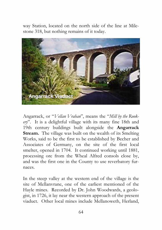
64
way Station, located on the north side of the line at Mile-stone 318, but nothing remains of it today.
Angarrack, or “Vellan Vrahan”, means the “Mill by the Rook-ery”. It is a delightful village with its many fine 18th and 19th century buildings built alongside the Angarrack Stream. The village was built on the wealth of its Smelting Works, said to be the first to be established by Becher and Associates of Germany, on the site of the first local smelter, opened in 1704. It continued working until 1881, processing ore from the Wheal Alfred consols close by, and was the first one in the County to use reverbatory fur-naces. In the steep valley at the western end of the village is the site of Mellanvrane, one of the earliest mentioned of the Hayle mines. Recorded by Dr. John Woodwards, a geolo-gist, in 1726, it lay near the western approach of the present viaduct. Other local mines include Mellanoweth, Herland,
Angarrack ViaductAngarrack Viaduct

65
Nanpusker, Prince George and Relistan, an ancient “Tynn Working”, open-cast site, exploiting the exposed veins of pure Cassiterite (Tin Ore), first listed in 1502. Tin Stamps are recorded at Hillside from 1670 onwards. The Grist Mill and Forge, at the top of Grist Lane, date from 1703, but corn-milling on the Angarrack Stream be-gan in about 1343. The village boasted a Bolitho Count-ing-House, a Wesleyan Chapel and a Pump by the mid-19th century, when its population was recorded as being 100 persons. The Angarrack Stream follows the road back towards Hayle, past the Rugby Club (14) alongside Marsh Lane and, from there, flows back towards your starting point at the Penmare via the Caravan Park. This has a small section of one of the original Railway Bridges situated in it from the West Cornwall Line. By following either the path through the Caravan Park or Guildford Road back up to the roundabout, you can return to your starting point at the Penmare Hotel.
*******************

66
ACKNOWLEDGEMENTS To West Cornwall LEADER, Penwith District Council and their Economic Development Officer, John Lindfield, for his patience and understanding. To Joan Kay and Amanda Hawkins of the Tehidy/Hayle Countryside Service and to Chris Williams of Cornwall County Council's Countryside Access Office. To Hayle Heritage Group and the Hayle Walks Project, sincerest thanks for all the financial support they gave to this project. Thank you to Andrew Szmidla for the photographs to illus-trate this booklet and also for printing it for us. Sincerest thanks to Mr. Brian Sullivan, President of the Hayle Old Cornwall Society, who kindly read the manu-script and advised on its correctness. To Mrs. Shirley Oliver of the Penwith Ramblers Association, the Mayor of Hayle, for her help and advice. Dave Wallis, Cathryn Ferrell and Ken Hart of Breadline Employment Training, Penzance, for their invaluable help. To Denzil Ralphs of Truro College. To John, Stephanie and Michael Nash. To the Editorial Team of the Hayle “Pump” and to all those residents of Hayle who have contributed information to this Walks Guide, thus helping to keep the Town's History very much alive. © 1997, 2002 D.H.Philp and G.A.D.Schofield While I have endeavoured to check that all the information in this booklet is correct during the preparation of the final

67
manuscript, I am sure that someone, somewhere will point out possible factual and grammatical errors. Good! Because that will mean that all the hard work put into this Project by myself and those previously mentioned has not been in vain, and that people have been interested enough in Hayle and its history to read this booklet and, hopefully, to want to learn more. So my final thanks go to you, the reader. D.H.P. 1996 My thanks to Richard Travers for patiently re-editing our manuscript. G.S. 2000 REFERENCES The Great Western Railway in Cornwall ......Allan Bennett Cornish Explosives................................. Bryan Earle (1976) History of the Cornish Copper Company.... W. H. Pascoe The Book of Hayle ...................................Cyril Noall (1988) Millponds Ecological Survey................ Georgina Schofield Hayle Town Trust, 1987, Revised 1991) Hayle Estuary Ecological Report Cornwall Wildlife Trust Hayle Town Survey .Cornwall Archaeological Unit (1995) Sands of Time . Tehidy/Hayle Countryside Service (1995) The Harveys of Hayle .....................................Edmond Vale Teudar - A King of Cornwall ......................... W. H. Pascoe Lakes Parochial History of Cornwall, Vol. 4Joseph Polsue (1873 - reprinted 1974)

68
Mines of Hayle (series) - Hayle Pump No. 8 ........Marshall Hutchens Dynamite Works - Hayle Pump No. 8 Marshall Hutchens Metalliferous Mining Region of the South West ...... Dines (1966) Mines and Miners in Cornwall Vol. 6 ......A. K. Hamilton-Jenkin - Hayle, Gwinear and Gwithian (1963)

69
NOTES

1
![Hayle Harbour Wall - schedule of worksA3rev Ha Hayle Harbour Report Revision [00] Harbour Wall Schedule of Works March 2005 Hayle Harbour Wall - schedule of worksA3rev.doc Page 4 ppold](https://img.pdfslide.us/doc/110x75/5ab20cd17f8b9a7e1d8d1c57/hayle-harbour-wall-schedule-of-ha-hayle-harbour-report-revision-00-harbour-wall.jpg)