Embed Size (px)
Citation preview
FOOD & AGRICULTUREORGANIZATION OF THE
UNITED NATIONS
Soil Survey And Land Classification
REPUBLIC OF YEMEN
INTERFACE BETWEEN THE YEMEN SOIL DATABASE AND THE AUTOMATED LAND
EVALUATION SYSTEM (ALES)
Version 1 - July 1990
By: Erik Van Waveren
Ministry of Agriculture and Water ResourcesAgricultural Research and Extension Authority
UNITED NATIONS
DEVELOPMENTde PROGRAMME
Dhamar, 1990
AG: YEM 87/002Field Document 5
REPUBUCOF
YEMEN
The conclusions given in this report are considered appropriate at the time ofits preparation. They may be modified in the light of further knowledge gainedat subsequent stages of this project.
The definitions employed and the presentation of the material in this documentdo not imply the expression of any opinion whatsoever on the part of the Foodand Agriculture Organization of the United Nations concerning the legal orconstitutional status of any country, territory or sea area or concerning thedelimitation of frontiers.
ABSTRACT
The Soil Survey and Land Classification Project is developing a computerizedland evaluation system for Yemen using an expert system shell (ALES) which isconnected to the soil database (SDB).
This report describes the technical and operational aspects of the interfacewhich links the soil database with the expert system shell.
KEYWORDS: Quantified land evaluation, soil database

Contents
INTRODUCTION ..... ,........................,..., ..... ...... .,........
THE SDB -ALES INTERFACE .................................. ..... ........ 2
1.1 System Overview ......,....... ...... .......,.......,.............. 2
1.2 Creation of Basic Data Files ..... ......,...................... 5
1.3 Creation of Ales Datafiles .....,........... ..... ................. 7
1.4 Defining Ales Data Templates .............,........ ...... ....... 9
RUNNING THE SAL INTERFACE PROGRAM .....,.......... ..... ............... 10
Appendix 1:Example of printout basic dataset and origanal soil description 11
Appendix 2:Structure of SAL Basic Datafile (Dbase III+ format) 14
Appendix 3:Technical specifications and description of source code 16
List of tables:
1. Classification of land characteristics and land qualities for:Potato, intermontane plainsIrrigated sorghum, Tihamah
List of res:
I. SDB-Ales interface, dataflow and datafile structures2. Conversion of actual soil profile information to a st:andardized profile
with fixed depth. intervals
INTRODUCTION
The Soil Survey & Land Classification Project YEN 87/002 is developing aputerized land evaluation system for Yemen. The main components of thisare an expert system shell (ALES), the Yemen Soil Database (SDB software), at:an interface to link SDB to ALES (SAL).
This document describes the operational and technical aspects of this inter-face between SDB and ALES.
An essential part of the interface is the conversion of so [1 horizon informa-tion to standard depth intervals. The method presented in Section 1.2 hastested on a number of profiles with satisfactory results. However, the tostprofiles are mostly slight and moderate devoln¡,ed soils typical for h 1-
luvial areas in the Yemen Republic, therefore t1: method presented hercnot necessarily apply under different conditions (e .g. deeply weathered'cal soils).
Section 1.3 describes the creation of the 'Icturd datafles. The StotIC-tures of this files are specific for a :,Luation
General reference is made to the following manuals and reporto:
FAC-ISRIC, 1990; BAC-ISRIt Soil Database (SDB) Manual. World Soils F i 64,
FAO, Reine.
Rhebergen, 1990; Crop requirements for Potato, Sorghum, Apele Ind Grapevine,YEN 87/002 field document 3, UNDP/FAC/MAWR-AR7.A. Dhamar.
Rossiter & Van Wambeke, 1989:, ALES Version 2, User's Manual, CoiceellUniversity, Ithaca, N.Y.
Van ',7averen Rhebergen, J939; Yemen Soil D, Guidelines for soildescription. 'YEN 37/002 Field document I. UNDPIFAC/MAF,Sanea.
1. THE SDB-ALES INTERFACE
1.1 SYSTEM OVERVIEW
The SDB-ALES Interface (SAL) allows the Ales user to automatically create ex-ternal ALES datafiles from the SDB databases. The datafiles consist of sets ofsoil profile data which can be used as basis for evaluation runs.
The interface between SDB and ALES functions as follows (see also Figure 1):
Selection of relevant soil profiles (in SDB).The interface requires a subset of soil profile data prepared with the
SDB Import/Export or Selection mode (SDB output files). Typically, thiswill be all soil profiles representative for one, or for a number of
mapping units in the area of interest. The SDB output files are in DbaseIII/IV format (see the SDB Manual for further instructions).
Creation of a basic datafile (using SAL),The Interface extracts the relevant site, profile and analytical datafor each soil profile from the SDB output files, and converts the soildata to standard depth intervals (O-25, 25-75 and 75-125cm).Availability of soil analytical data is checked, if not, it will use
descriptive field information (texture. EC, free carbonates and pH).The results are written to a dbase datafile. This file is the basicdatafile for any subsequent evaluation. A printout (summary report) foreach processed soil profile is optional.
Creation of evaluation specific datasets (using SAL).The interface generates ALES datafiles (ASCII format) from the basicdatafile created in step 2.Those files contain only the information that is required to run a par-
ticular evaluation model, and therefore are evaluation model specific.Consequently the structures of the ALES datafiles generally consist uf asubset of the datafields of the basic datafile.In addition, classes of some latid characteristics may be combined into asmaller number of new classes if the determination of the land qualitiesdoes not require the scale of detail given by the original class-
ification.
Prepare data entry templates (.in ALE).See the ALES Manual for further information on this subject.
eaIt is important to realiza that the interface generates soil profile data andnot the compiled information on mapping units, i.e. it assumes the evaluationto be carried out on the individual soil profiles. Based on this the followingmethods can be followed:
(a) A representative soil profile is selected for a soil or mappingunit, or
(b) The whole set of soil profiles is evaluated first (evaluation of
point data) and the results are subsequently spatially interpolated inorder to obtain inforMation on land or Rapping units. If required, syn-
thethic soil profile descriptions could be added to the datasets, repre-senting the average characteristics of the soil units. Those synthethicprofiles can be stored directly in Ales using the 'data entry from
keyboard' option.
The advantages of the second method are:
The evaluation procedure itself is no longer scale dependent and repeatableas basic data are used and not a preselected set for a specific map 5cale.
The results give a good indication of the variability of che suitability ofa mapping unit for a specific land use.The disadvantage is of course that much more data need to be processed.However, a computer is the proper medium to work with large datasets.
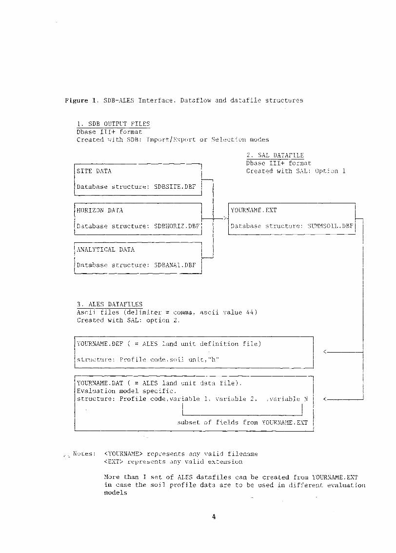
Figure 1. SDB-ALES Interface. Dataflow and datafile structures
1. SDB OUTPUT FILESDbase III+ formatCreated with SDB: Import/Export or Selection modes
SITE DATA
Database structure: SDBSITE.DBF
HORIZON DATA
'atabase structure: SDBHORIZ.DBF
ANALYTICAL DATA
Database structure: SDBANALDBF
3. ALES DATAFILESAscii files (delimiter = comma, ascii value 44)Created with SAL: option 2.
Notes: <YOURNAME> represents any valid filename<EXT> represents any valid extension
More than 1 set of ALES datafiles can be created from YOURNAME.EXTin case the soil profile data are to be used in different evaluationmodels
4
2. SAL DATAFILEDbase III+ formatCreated with SAL; ption 1
YOURNAME.EXT
Database structure: SUMMSOIL. DBE
YOURNAME.DEF ( = ALES land unit definition file)
structure: Profile code.soil unit,"h'
YOURNAME.DAT ( = ALES land unit data file).Evaluation model specific.structure: Profile code.variable 1, variable 2variable N
subset of fields from YOURNAME.EXT
1.2. CREATION OF BASIC DATAFILES
The interface uses SDB output files and extraets for each soil profile a set
of site profile and analytical data. This dataset contains all variableswhich are presently thought to be relevant for land evaluation procedures for
arable farming in Yemen. The analytical dataset only contains the essentialparameters as reliable analytical data is presently scarce.
All data is written to a single Dbase datafile in which each soil profiledescription fills one record. The structure of this file is given in appendix2
This file will be the basic datafile for any further evaluation procedures andwill be stored on disk under a user defined filename in any required subdirec-tory. Optionally, a printout of the results can be obtained- See appendix 1.
The basic datafile contains the iollowing variables:Site description data:
Soil profile code, soil unit, FAO soil unit and phase, I= gridreference, altitude, landform, land element, position of site slope
gradient and form, micro topography. flood frequency, percentage ofIface stones and rockoutcraps, occurrence of surface ts,
sealing/erusting, drainage class, occurrence of slow permeableeffective soil depth.
Soil horizon data:Depth of upper and lower boundary, field texture, structure grade andtype, total amount of coarse fragments (rocks and nodules), consistence,cementation grade, CaCO3 (effervescence), field measured pH and EC (bothin 1:2.5 soil/water solution),available waterholding cHpacity.
Analytical data:Sample depth, percentage ùf total sand silt and clay, pH and EC in :2.5
soil water solution, :!; free carbonates, extractable Na, CEC.
Standard depth intervals
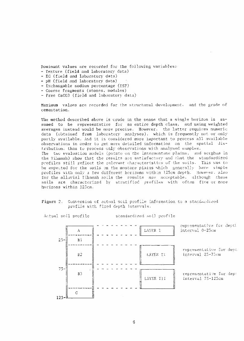
The soil profile information is converted to the following standard depthintervals: (I) O - 25 cm; (II) 25- 75 cm: (III) 75-125 cm.
If a depth interval includes a single horizon the relevant information of thishorizon is used to characterize this depth interval.Mostly, a depth interval includes (parts of) two or more horizons and then theinformation on the depth inten7val is obtained by using two different rethodsdepending on the type of variable:
For most variables the dominant value within the depth interval is reeor:lad,Dominant v:-Ilues are values meaured or descrihed fov thP major part ci Lht-,
depth interval (see figure 2).For other variables the maximum value within the depth interval is recorded.
Maximum values are the highest values that are measured or described in thedepth interval. Note that (parts of) horizons within the interval that areless than 5cm thick are excluded.
5
Dominant values are recorded for the following variables:,Texture (field and laboratory data)EC (field and laboratory data)pH (field and laboratory data) *
Exchangable sodium percentage (ESP)Coarse fragments (stones, nodules)Free CaCO3 (field and laboratory data)
Maximum values are recorded for the structural development, and the grade of
cementation.
The method described above is crude in the sense that a single horizon is as-
sumed to be representative for an entire depth class, and using weightedaverages instead would be more precise. However, the latter requires numericdata (obtained from laboratory analyses), which is frequently not or onlypartly available. And it is considered more bnportant to process all availableobservations in order to get more detailed information on the spatial dis-
tribution, than to process only observations with analyol samples.The two evaluation models (pofato on the intermontane plains, and sorghwn inthe Tihamah) show that the results are satisfactory :_at, the standardizedprofiles still reflect the relevant characteristics of oLe soils. This was tobe expected for the soils on the montane plaias which general] lave simpleprofiles with only a few different horizons within 125cm depth. Ho%,ever, also
for the alluvial Tihamah soils the results are acceptable, ' ,h these
soils are characterized by stratified profiles with often five or morehorizons within 125cm.
Figure 2- Conversion of actual soil profile information to a standardizedprofile with fixed depth intervals.
Actual soil profile
25
125-
B3
standardized soil profile
6
LAYER I
LAYER II
representative f-interval 0-25om
representative folinterval 25-75cm
representative for depLinterval 75-125cm
7
Classification of variables
For the horizon variables the classi ication is identical to the one given theGuidelines for soil profile description for Yemen (Van Waveren & Fhebergen,1989). Grain size distributions and free calcium carbonate contents derivedfrom laboratory analyses are classified accordingly.
Two land qualities are determined and included in the datasets: availablewaterholding capacity and structural development.
The available waterholding capacity is estimated using texture, amountof coarse fragments and soil depth.
Structural development combines the original variables structure gradeand structure type. The classification of this variable is as follows:
0 Includes structureless, massive and very weak strn,BL Blocky and prismatic/columnar structures (weak to ongPL Platy structures (moderate to strong)
The wide ran?e of structure grades in class BL is justified by the factthat strong structures hardly occur in Yemen, and the fact that somestructural development (class BL as opposed to class 0) in 1 soil ismore relevant for land evaluation purposes than the precise -1,,1 ofthis development.Moderate and strong platy structures are separated because they clearlyprevent penetration of roots and consequently limit the effective soildepth.
1.3 CREATION OF ALES DATAFILES
The interface generates for each dataset two files, an ALES land unit defini-tion file and an ALES land unit data file.The interface automatically assigns the following extensions to the generatedfiles:
DEF fcr the land unit definition fileDAT for the land unit data file
The actual filenames for the datasets are defined by the user.
As soil profiles are being evaluated the soil profile is the basic entity andequivalent to the homogeneous land unit in ALES.The fpcvdrpri file fr,rmatc are ripc.orjhed 411 d.ta41 in the ALES Manual, chapter9. According to these requirements the datafiles generated by the Interfacehave the following specifications:The datafiles are ASCII (DOS text) files. The field delimiter is the comma.(ASCII value 44).
Each soil profile is one line.
In the land unit definition file each line has the following format:
{Profile Code),{ apping unit},"h"
Note that the soil profiles are considered homogeneous land units ("h" inthird data field). The second datafield contains the mapping unit, instead ofa descriptive land unit definition. This allows the user to construct com-pound land units (i.e. mapping units) in ALES, using the soil profiles asbasic entities.
In the land unit datafile each line has the following forma.t:
{Profile code},{LcVall},LcVAL2"({LoValn}
Where, LcTALi = value for the land characteristic in field number i (asdefined in Ales Data entry template).
In order to limit the complexity of the evaluation model the land unit datafiles are generated according to the following general principles:
The datafiles only contain those land characteristics that areactuallyused in the evaluation model. For instance, the evaluation model "Potato onintermontane Plains" uses ten land characteristics (see table 1).
The number of classes used to describe a land characteristic does notexceed the number of classes required by the evaluation model, or the maximumnumber of classes allowed in ALES (16). For instance, for the same evaluation.model the textural classes are regrouped into 6 classes related to theiravailable waterholding capacities (see Table 1).Note that grouping of textural classes is a mere necessity, as the totalamount of texture classes exceeds maximum number of classes allowed in Ales.
Table 1. Classification of land characteristics and land qualities
A. Potato, Intermontane plains
Land characteristic classification No of classes
1 Slope gradient2 Rock outcrops (%)3 Drainage4 Effective soil depth5 Texture 0-25cm6 Texture 25-75cm7 Consistence 0-25cm8 Consistence 25-75cm
YAR-SDE coding systemYAR-SDB coding systemYAR-SDB coding systemYAR-SDB coding systemregrouped *
YAR-SDB coding system
8
6
6
7
.5
6
6
6
9 Coarse fragments 0-25cm as YAR-SDB coding system foY'rock fr. 6
10 Coarse fragments 25-75cm 6
11 CaCO3 0-25cm YAR-SDB coding system 4
12 CaCO3 25-75cm 4
13 Average EC rootzone numeric (continuous)
B. Irrigated Sorghum (Seifi) in Wadi Mawr
Land characteristic/quality classification No of classes
Texture classes: A Sands S, vfS, fS, cS, LcSB Loamy sands/coarse sandy loam: LS, LvfS, LfS,C Sandy (clay)loams : 51, fSL, vf5L,D (Clay-)loam, Sandy clay CL, SC, L,
E Silts 1 SiCL, SIC, SIL, SiF clay C
1.4 DEFINING ALES DATA ENTRY TEMPLATES
This topic is discussed in detall in the ALES Manual. Please note the
following:the actual sequence of the land characteristics in the land unit data file andthe ALES data entry template should correspond (the sequence is listed in Ap-pendix 2. Structure of SUMMSOIL.PRG). Similarly, the class codes of the landcharacteristics should correspond with the ALES land characteristic class ab-breviations. Keep in mind that all SUB codes-are in upper case.
9
1 Surface seaking YAR-SDB coding system 5
2 Drainage YAR-SDB coding system 7
3 Effective soil depth YAR-SDB coding system 5
4 Average EC rootzone numeric (continuous) O
5 Waterholding cap. 0-25cm 5
6 Waterholding cap. 25-75cm 5
7 Waterholding cap. 75-125cm 5
2. RUNNING THE SAL INTERFACE PROGRAM
This section gives general instructions to operate SAL. Specific instructionsfor the setup of the system the computer at AREA, Dhamar are given on aseparate leaflet.
SAL is started from DOS using the following command:
SAL
Before running the interface the soil profiles to be evaluated should be
selected and written to a diskfile with the SUB Import/Export or Selection1110de. Write the following information to the disk:
Site dataHorizon dataStandard analytical data
The SDB Import/Export mode proviJ.,s the quickest and easiest way t rite data
to diskfiles. The drawback is thLt it requires you to know the of cheprofiles you want to evaluate. The selection mode should be used [f the code,,are not known, for instance if you want to evaluate a particular mapping unitand you do not know all the codes of profiles within this unit.
Follow the instructions , en in the SUB Manual.
Subsequently run SAL. The basic datafile created with option 1. can be usedto prepare one or more ALES datafiles with option 2. Note that option 2
prepares a dataset for a specific evaluation model, for instance.: 'spate ir-rigated sorghum in the IihaMa', or 'improved, irrigated potato ( the int,!r-
montane plaias. The Dataflow and datafile structures are summaric n Ti'l
1.
To run the interface the following files should be in the active subdirectory:
SAL. EXE
SUMMSOIL.DBF
The structure of SUMMSOIL.DBF is given in appendix 2.
lo

APPENDIX 1. Examples of basic dataseis and original soil profile descriptions
11
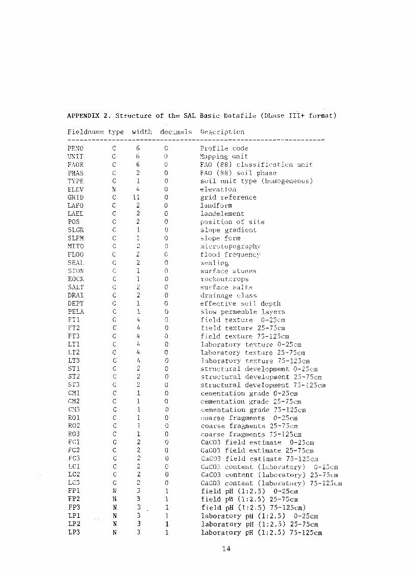
APPENDIX 2. Structure of the SAL Basic Datafile (Dbase TIT+ format)
Fielduame type width deCimals Description
PRNO C 6 0 Profile codeUNIT C 6 0 Mapping unitFAOR C 6 0 FAO (88) classification unitPHAS C 2 0 FAO (88) soil phaseTYPE C 1 0 soil unit type (homogeneous)ELEV N 4 0 elevationGRID C 11 0 grid referenceLAFO C 2 0 landformLAEL C 2 0 landelementPOS C 2 0 position of siteSLGR C 1 0 slope gradientSLFM C 1 0 slope formMITO C 2 0 microtp,graphyFLOO C 2 0 flood frequencySEAL C 2 0 sealingSTON C 1 0 surface stonesROCK C 1 0 rockoutcropsSALT C 2 0 surface saltsDRAT C 2 0 drainage classDEPT C 1 0 effective soil depthPELA C 1 0 slow permeable layersFT1 C 4 0 field texture 0-25cmFT2 C 4 0 field texture 25-75cmFT3 C 4 0 field texture 75-125cmLT1 C 4 0 laboratory texture 0-25cmLT2 C 4 0 laboratory texture 25-75cmLT3 C 4 0 laboTatory texture 75-125cmST1 C 2 0 structural development 0-25cmST2 C 2 0 structural development 25-75cmST3 C 2 0 structural development 75-125cmCM1 C 1 0 cementation grade 0-25cmCM2 C 1 0 cementation grade 25-75cmCM3 C 1 0 cementation grade 75-125cmRO1 C 1 0 coarse fragments 0-25cmRO2 C 1 0 coarse fragments 25-75cmR03 C 1 0 coarse fragments 75-125cmFC1 C 2 0 CaCO3 field estimate 0-25cmFC2 C 2 0 CaCO3 field estimate 25-75cmFC3 C 2 0 CaCO3 field estimate 75-125cmLCI C 2 0 CaCO3 content (laboratory) 0-25cmLC2 C 2 0 CaCO3 content (laboratory) 25-75cmLC3 C 2 0 CaCO3 content (laboratory) 75-125cmFP1 N- 3 1 field pH (1:2.5) 0-25cmFP2 N 3 1 field pH (1:2.5) 25-75cmFP3 N 3 1 field pH (1:2.5) 75-125cm)LP1 N 3 1 laboratory pH (1:2.5) 0-25cm..
LP2 N 3 1 laboratory pH (1:2.5) 25-75cmLP3 N 3 1 laboratory pH (1:2.5) 75-125cm
14
15
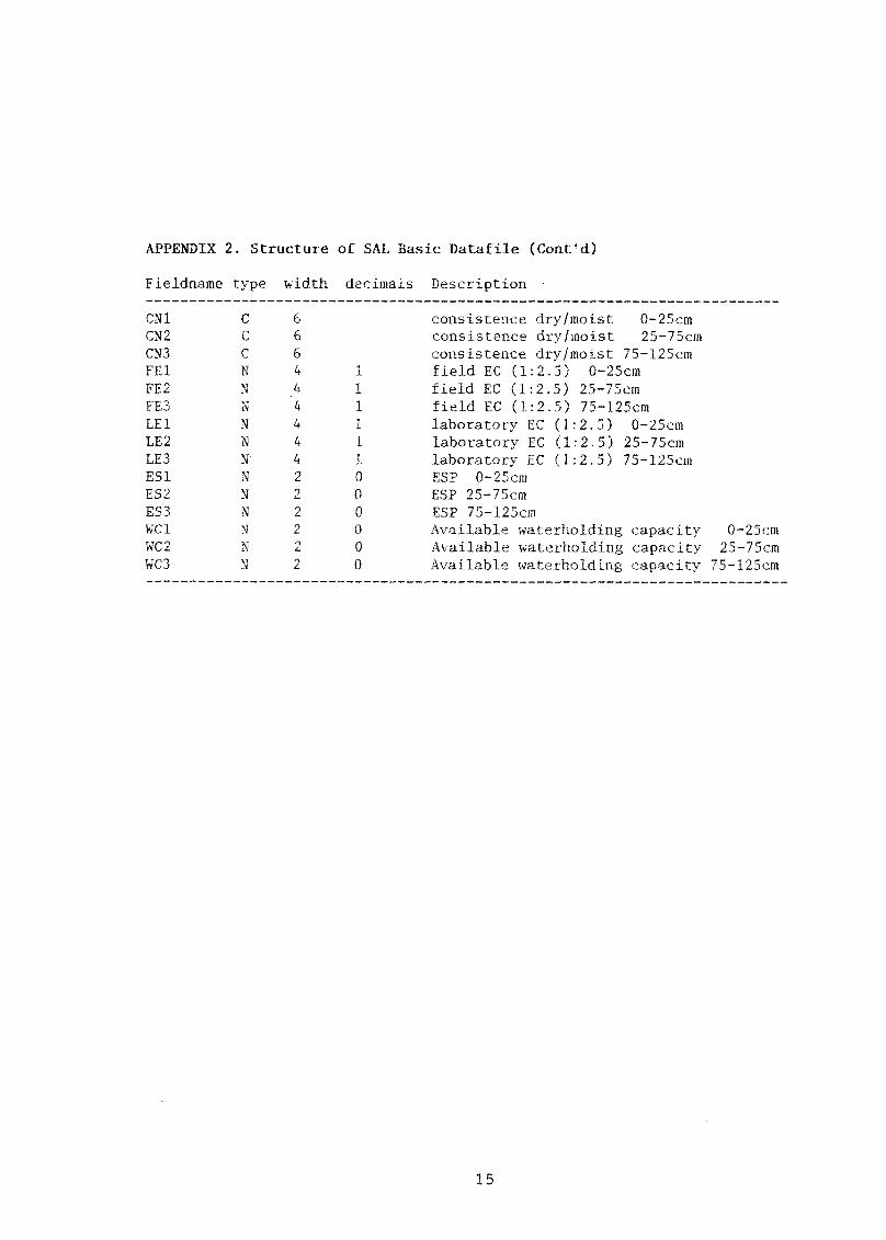
APPENDIX 2. Structure of SAL Basic Datafile (Coat'd)
Fieldname type width decimals Description .
CN1 C 6 consistence dry/moist 0-25cmCN2 C 6 consistence dry/moist 25-75cmCN3 C 6 consistence dry/moist 75-125cmFE1 N 4 1 field EC (1:2.5) 0-25cmFE2 N 4 1 field EC (1:2.5) 25-75cmFE3 N '4 1 field EC (1:2.5) 75-125cmLE1 N 4 1 laboratory EC (1:2.5) 0-25cmLE2 N 4 1 laboratory EC (1:2.5) 25-75cmLE3 N 4 1 laboratory EC .(1:2.5) 75-125cmES1 N 2 0 ESP 0-25cmES2 N 2 0 ESP 25-75cmE53 N 2 0 ESP 75-125cmWC1 N 2 0 Available waterholding capacity 0-25cmWC2 N 2 0 Available waterholding capacity 25-75cmWC3 N 2 0 Available waterholding capacity 75-125cm
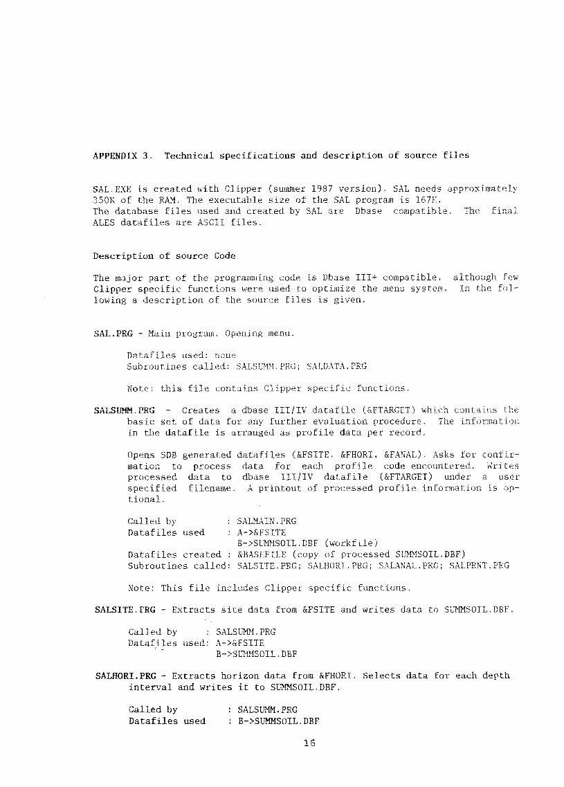
APPENDIX 3. Technical specifications and description of source files
SAL.EXE is created with Clipper (smaller 1987 version). SAL needs approximately350K of the RAM. The executable size of the SAL program is 167K.The database files used and created by SAL are Dbase compatible. Tbe final
ALES datafiles are ASCII files.
Description of source Code
The major part of the programming code is Dbase III+ c-ompatible, although fewClipper specific functions were used to optimize the menu system. In the fol-
lowing a description of the source files is given.
SAL.PRG - Main program. Opening menu.
Datafiles used: noneSubroutines called: SALSUMM.PRG, SALDATA.PRG
Note; this file contains Clipper specific functions.
SALSUMM.PRG - Creates a dbase III/IV datafile (&FTARGET) which ontH he
basic set of data for any further evaluation procedure. The infol H.oti
in the datafile is arranged as profile data per record.
Opens SDB generated datafiles (&FSITE, &FHORI, &FANAL). Asks for confir-mation to process data for each profile code encountered. 'V;rites
processed data to dbase III/IV datafile (&FTARGET) under a user
specified filename. A printout of processed profile information is op-tional.
Called by SALMAIN.PRGDatafiles used : A->&FSITE
B->SUMMSOIL.DBF (workfile)Datafiles created : &BASEFILE (copy of processed SUMMSOIL.DBF)Subroutines called: SALSITE.PRG: SALHORI.PRG; SALANAL.PRG: SALPRNI.PRG
Note: This file includes Clipper specific functions.
SALSITE.PRG - Extracts site data from &FSITE and writes data to SUMMSOII.DBF.
Called by : SALSUMM-PRGDatafiles used: A->&FSITE
_B->SUMMSOIL.DBF
SALHORI.PRG - Extracts horizon data from &FHORI. Selects data for each depthinterval and writes it to SUMMSOIL.DBF.
Called by : SALSUMM,PRGDatafiles used : B->SUMMSOIL.DBF
15
C->&FHORIDatafile created C->RAWDATA.DBF (workfile, contains profile data
copied from &FHORI)Subroutines called: SALRENUM.PRG: SALVARHO.PRG, SALRECOD.PRG
SALRENUM.PRG - Replaces character codes of decriptive horizon variables withnumbers. Combines abundance of rock fragments and mineral nodules into
coarse fragments. Reclassifies structure into structural development.
Called by : SALHORI.PRGDatafile used: C->RAWDATA.DBF
SALRECOD.PRG - Changes numerical codes generated with SALRENUM,PRG back tocodes. Memvars defined in SALHORI.PRG and filled in SALVARHO.PRG.
Called by: SALHORI.PRG
SALVARRO.PRG - Fills memvars defined in calling routine with representativehorizon data for each depth interval. Data source RAWDATA.DBF.Dominant values are recorded for texture, PH, EC, coarse fragments,carbonates, and consistence. Maximum values are recorded for struct(primary and secondary), cementation.
Called by : SALHORI.PRGDatabase used: C->RAWDATA,DBF
SALANAL.PRG - Extracts analytical data from &FANAL and writes data forstandard depth intervals to SUMMSOIL.DBF.
Called by : SALSUMM.PRGDatabases used : B->SUMMSOIL.DBF
C->&FANALDatabase created C->RAWDATA.DBF (Workfile copied from &FANAL, contains
analytical data for a single profile.Subroutine called: SALVARAN.PRG
SALVARAN.PRG - Selects dominant analytical data for each depth interval fromRAWDATA.DBF and stores data in memvars. Reclassifies 70 CaCO3 to fieldclasses.
Called by : SALANAL.PRGDatabases used : C->RAKDATA.DBFSubroutine called: SALTXT.PRG
SALTXT.PRG - Classifies laboratory textural analysis.
Called by: SALANAL.PRG
17
SALPRNT.PRG - Prints a summary of processed soil profile data.
Called by : SALSUMM.PRGDatabase used: B->SUMMSOIL.PRG
SALDATA.PRG - Prepares Ales datafiles (ASCII). Master.Specifies filenames of source and target files
Called by SALMAIN.PRGDatabases used : A->&BASEFILECalls : SALPO-IP.PRG, SALSO TI,PRG, SALPREP.PRG
Note: n's file contains Clipper specific functions
SALPREP.PRG -Estimates available waterholding capacityreplaces field data with laboratory data (if av able)
Converts EC (1:2.5) to ECecombines texture classes into a limited number of new classes
Called by SALDATA.PRGDatabases used : A->&BASEFILECalls: -
SALPO IP.PRG - Prepares ALES datafiles for potato on intermontane plains.* Selects appropriate fields for the evaluation
reclassifies consistencecalculates average EC and pi-1 values for total depth intervalWrites data to ASCII files with user defined names (ALES datafiles).
Called by : SALDATA.PRGDatabases used : A->&BASEFILEDatafile created: &TARGET1, &TARGET2
SALSO TI.PRG - Prepares ALES datafiles for irrigated sorghum in the Tihamah* Selects appropriate fields for the evaluation
calculates average EC and pH values for total depth intervalWrites data to ASCII files with user defined names (ALES datafiles).
Called by : SALDATA.PRGDatabases used : A->"&BASEFTLE_Datafile created: &TARGET1, &TARGET2
18
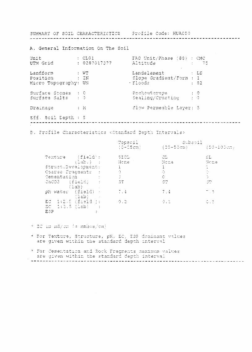
E. Profile Characteristics <Standard Depth intervals>
Tcpsoil Subscii(5-.5,5cm) (23-50cm) (50 "
Ienture
truct.Dvelopment:Coarss. c,-acmentE
(field)(1 ab)
pH water (fieid)(lab)
EC 1:2.5 (Field ):EC 1:2.5 (7a1-1)ESP
PC in mS/cm (= mmhcs/cmj
* For Te%ture, Structure, pH, ET, ESP dominant valu.are given within the standard (4-- th interval
k For Cementation and Rock Fracments ,11-aximum valuesare given within the standard depth interval
7, 4
0.1
k
SLNone1
SUMMARY OF SOEL CHARACTE5ISTICS
A. General Information On The Soil
Profile Code: HUA050
Unit : CLO1 FAO Unit/Phase (38) : CMCUTM Grid : 0287017377 Altitude 77
Landform : WT LandelementPosition : IN Sioe, Gradient/FormMicro Topography: UN floods : S2
Surface Stones : Rcckoutcrc,psSurface Salts : Sealing/Crusting :
Drainage : Slow Permeable Layer: 5
Eff.il ,,
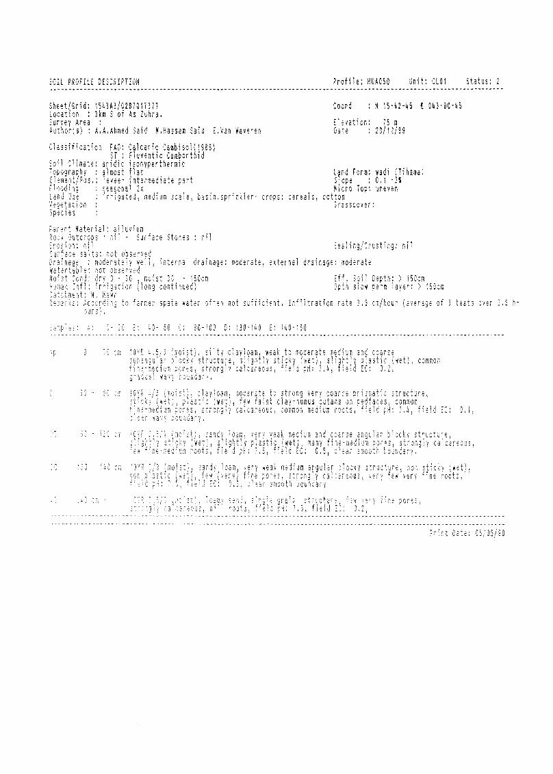
Sheit/Grid: 1543A3/0287011371 Coord : N 15-42-45 f 043-00-45
Location ; 3km 5 of As Cuhra,
Survey Area ; Elevation: 15 m
Author(s) A.A.Ahmed Said CHassam Said E.Van Waveren Date ; 20/12/89
Classification FAO: Calcaric Cambisol(1988)ST : Fluventic Camborthid
Soil Climate: aridic isohyperthermicTopography : almost flat Lano Form; wadi (Tihama)Eisreit/Pos levee- intermediate part Siope : 0.1 -2%
:no seasonal 2x 'i :o Top: uneven
Lard J3i : irrigated, medium scale, basin,sprinkier- cropa : ceral, cottonVer.,etation Crasscover;Sp:His
. Hieterial: alluvium
ril - Surface Stones : nil
in: ill! Sealing/Crusting: nil
ie salts: .. 7.1ser,
;, moderately ., internal drainage: moderate, external drainage: moderateWarertable: not observedkoi:t Cond: dry J- 30 moist 30 - 150cm Eff, Soil 0epth; > 150cm
Hu a, 'IX: irrigation Jong continued) Dpth slow pero layer; > 150cm
'A.:fit;,LC: "H; tO farmer spate water often not sufficient. Infiltration rate 3,3 cm/hour (average of 3 tests OV:7 2,5 h-
n.
A: 2- 20 E: 10- 50 0: 30-100 0: 130-140 E: 140-150..................
- 35,
30 - 1S0 om
yloamriltv cla, weak to moderate me,diid and cs.21r.,ssw
s
''''' ' : '' -"i"v (writ, ji p arntly ,a,,,,structure, sli, ,y u,,Lcwi , f.,1,,,,
,, rrongly cr. e-03 "),d pH: ,2,4, e,, ,-, ,,.,,, , ,
clayloam, m
5ti0 (WEtistrong-
san3Y,Ii3:1:medium roots,fleir
ate to strong very coa.:
faint clay-humus cutars
sm.ecus, common medium roots
5/3 inoisti,, sendv loam, very weak medium angular
stronPly
n.n oounuar.,
teak medium and coarse angular blocky structure,
(wet), many fine-medium pores, strongly calcareous,
field EC: 0,5, clear smooti - '
,ea,
. structure,
, common
-.4, field EC: 0,1,
, structure, non F.""F, YEPy few very fine : T5,
structure, iW fioe pore:,. roots, iieH i 7,3, field 20o U.
Cate: 05/05/90
SOIL PROFILE DESCRIPTION Profile: HUA050 Unit: CL01 Status: 2