Embed Size (px)
Citation preview
Structural Characterization and Passive Remediation of NAPL in Fractured Bedrock at a Former MGP Site: Mechanicville, New York
Michael Gutmann, URS Corporation; Eriko Fujita, URS Corporation; Beth Guidetti, URS Corporation; and
Tracy Blazicek, CHMM, New York State Electric & Gas Corporation. Abstract From approximately 1901 through 1955, New York State Electric & Gas Corporation (NYSEG) or predecessor companies operated a former Manufactured Gas Plant (MGP) in Mechanicville, New York. The blue gas process was used in the early years and later the carbureted water gas process was used to manufacture gas from coal at the former MGP. After 1955, most of the abovegrade former MGP structures, including the gas holders, were demolished. Since the 1980s a series of investigations have been completed at the site to evaluate the nature and extent of MGP-related residuals (ash, condensate, purifier chips, and coal tar). The former gas relief holder is believed to be the primary source of coal tar at the site. The base of the former gas relief holder was found to be of concrete and bedrock construction. Non-aqueous phase liquid (NAPL) has been detected in the overburden and underlying fractured shales of the Snake Hill Formation beneath and near the site. NAPL seeps are also present in the Anthony Kill, which is the northern boundary of the site. Since October 2001, approximately 584 liters of NAPL (i.e., coal tar) have been recovered from the site. Most of the NAPL has been recovered from the bedrock via passive remediation techniques. The New York State Department of Environmental Conservation has accepted passive recovery of NAPL as an Interim Remedial Measure. Conceptual Site Model The Snake Hill Formation is part of the Taconic Foreland sequence. Low angle thrust faults and narrow shear zones are commonly encountered in the rock sequence. West-northwest striking thrust segments separated by tear faults were identified on and near the site. The tear faults are generally perpendicular to the direction of thrusting and parallel to one another. Pencil cleavage zones visible in bedrock cores are more prominent near the tear faults, suggesting optimal stresses for the production of pencil cleavage existed adjacent to the tear faults. Light non-aqueous phase liquid (LNAPL) migrated primarily from the former relief holder, coincident with the slope of the water table toward the Anthony Kill stream immediately north of the site. The Anthony Kill is the surficial expression of the northern tear fault. Dense non-aqueous phase liquid (DNAPL) initially migrated generally eastward along the slope of the bedrock surface, downward through pencil cleavage zones and along the dip of bedding, and preferentially into the southern and northern tear faults. Most of the DNAPL is present on the top of bedrock and along the tear faults. The southern extent of DNAPL in the bedrock is limited due to the preferential migration of DNAPL along the southern tear fault. Similarly, the northern extent of the DNAPL is limited by the northern tear fault. DNAPL has not migrated west of the source area due to the slope of the bedrock to the east. Passive NAPL Recovery NAPL recovery activities are routinely conducted at two overburden wells and two bedrock wells at the site using a bailer or peristaltic pump. One of the overburden wells is situated near the former relief holder. The other three wells are downgradient from the source area along the southern tear fault. The two bedrock wells produce the largest amounts of recoverable NAPL with average recovery rates of over 2 liters per week. The average weekly recovery rates of NAPL from the overburden wells is less than 0.3 liter. URS continues to monitor all wells for NAPL, monitor the seeps in the Anthony Kill, and recover DNAPL on a biweekly basis. Passive recovery will be evaluated as a long-term remedy as part of the feasibility study. Background The former NYSEG MGP site is in the City of Mechanicville, Saratoga County, New York (Figure 1). The site is bordered on the east by North Central Avenue (formerly the Champlain Canal), on the south by Ferris Lane,
610

and on the west by a fuel distributor (Figure 2). The site is bordered on the north by the southern bank of the Anthony Kill, a small tributary that flows eastward into the Hudson River. The neighborhood around the former gas plant is a mixed commercial/residential section of Mechanicville. Site History From approximately 1901 through 1955, NYSEG (or predecessor companies) used the former MGP site on North Central Avenue in Mechanicville to manufacture gas, which was used by the local residents and
businesses near the site. In 1901, the Halfmoon Light, Heat, & Power, Co. began distributing gas, which was manufactured from
coal, to the citizens of Mechanicville. In 1924, Halfmoon Light, Heat, & Power Co. was acquired by the Associated Gas and Electric System, and in 1928 it became part of NYSEG. Coal gas production continued at the plant until 1955. NYSEG operated the site as a natural gas and electric service center from 1955 until 1990 when the operation was relocated to a new service center in the town of Halfmoon. The former MGP structures at the site included a 40,000 cubic foot (ft3) gas relief holder, a 100,000 ft3 distribution gas holder, a tartpr
Figure 1: Site Location dehydrator, a gas house, a purifier house, an oxide house, and filter beds. The blue gas process was used in the early years and laterhe carbureted water gas process was used to manufacture gas from coal at the former MGP. Blue gas was roduced by passing steam over incandescent coke to aid in the recovery of hydrogen and other gases by eacting with the carbon. Because the steam lowered the temperature of the fuel bed, air blasts were
periodically needed to restore the temperature. Thus, the process involved alternating cycles of steam injection and air blasts. The carbureted water gas process was developed to raise the Btu content of blue gas. The carbureted water gas process was done by passing blue gas through a carburetor where a spray of oil was added to the steam gas mixture and then thermally cracking the oil in a superheater. At the Mechanicville plant, the gas reportedly flowed from the gas house to the purifier house to the gas relief holder, and from there to the larger gas distribution holder. All piping was reportedly underground. This flow path differs from the typical water gas plant where the gas was stored in the gas relief holder prior to being
611
purified. The oxide house was apparently used to store fresh or spent oxide material that was used to purify the gas. Coal tar would settle out of the purified gas in the gas relief holder and mix with the water in the bottom of the holder. The base of the gas relief holder was constructed in bedrock. The distribution gas holder was an above grade structure in which only purified and cooled gas was stored. Therefore, residual coal tar accumulation is not associated with the distribution gas holder. The condensate from the water gas process was treated in the tar dehydrator (tar separator), located west of the gas house. The tar dehydrator consisted of a 1,000-gallon tank used to separate the oil in the condensate from the water. The oil was subsequently used for fuel. The water was piped through three filter beds, in series, behind the coal storage building in the northern part of the site. The filter beds were made of wood and were approximately ten feet long, four feet wide, and four feet deep. These wooden troughs were set into the ground and filled with coke. Baffles directed the flow of water through the coke, which filtered out residual oil. After passing through the filter beds, the water was discharged to the Anthony Kill. The oily coke in the beds was periodically collected and burned in the gas house. Wood chips, which were treated with iron oxide, were used to remove hydrogen sulfide from the gas in the purifier house. As the iron oxide absorbed the sulfur from the hydrogen sulfide gas and formed iron sulfides, the wood chips became inactive and required regeneration. This was accomplished by exposing the spent wood chips to air. The oxygen in the air converted the sulfide to free sulfur and restored the iron to active iron oxide. The iron also reacted with cyanide to produce ferrocyanides (iron cyanides), which could not be regenerated and did not react with hydrogen sulfide. By-products of the coal gasification process included coal ash, condensate material from the gas house, wood chips from the purifier house, coal tar, and oil sludge. There is no information concerning the methods employed to handle these materials in the early days of gas production at Mechanicville. However, it was common practice to dispose ashes and spent oxide material on site. Also, the tars produced in gas plants were an important raw material for the flourishing tar distillation industry in the early 1900s. During the latter days of gas production at the site, the ash and clinkers were reportedly picked up by anyone who had a use for them. In addition, spent wood chips were reportedly incinerated by the City of Mechanicville from 1951 to 1955, piled along the road until someone came and hauled them away, or spread on the ground surface. The former MGP site structures were concentrated on the eastern part of the site. The only structures that currently remain within the former MGP portion of the property are the storage and tool house building (former office) and the gas regulator building. NYSEG did not own the western part of the site during most of the operations of the MGP, which closed in 1955. After 1955, most of the above grade former MGP structures, including the gas holders, were demolished. Previous Investigations and Remedial Activities In the late 1980s and early 1990s, NYSEG conducted a series of remedial investigations and a feasibility study for the Mechanicville site. The results of the previous investigations indicated that the soils, groundwater, and sediments near the site were impacted by MGP-related contaminants. In general, the contaminants (commonly associated with MGP sites) included polycyclic aromatic hydrocarbons (PAHs), volatile organic compounds (VOCs), phenols, and cyanide. During the period from October 18, 1999 through September 27, 2000, NYSEG completed an Interim Remedial Measure (IRM) at the site. The overall goal of this IRM was to excavate contaminated soil and remnants of underground former MGP structures at the site and remove subsurface structures that could be potential preferential migration pathways for site contaminants to reach the Anthony Kill. The contents of the former gas relief holder foundation, the former filter bed, and any associated piping encountered during excavation were removed. During the IRM, the bedrock was partially exposed at the bottom of the gas relief holder and LNAPL was observed flowing into the excavation. During 2001 through 2003, additional data was collected to further characterize the site as part of the Supplemental Remedial Investigation (SRI). A total of 123 additional soil borings were advanced and 48 of the 123 soil borings were completed as monitoring wells. The existing monitoring well network, including wells
612
installed prior to the SRI, is comprised of 14 overburden monitoring wells, 21 shallow bedrock monitoring wells, and 25 deep bedrock monitoring wells. Also during the SRI, a total of 18 surface soil samples, 56 subsurface soil samples, seven sediment samples from the Anthony Kill, five sediment samples from the Hudson River near the confluence with the Anthony Kill, and 92 groundwater samples were collected for analysis by an off-site laboratory. The SRI focused on gathering observations regarding the presence or absence of NAPL in the overburden and bedrock beneath and near the site and evaluating the migration pathways of the NAPL within the subsurface away from the source areas. A hydraulic connection between the bedrock at the site and the Anthony Kill was evident as NAPL sheens and seeps were observed in the Anthony Kill during the SRI. The preferential migration pathways for DNAPL in bedrock were found to be: 1)thrust faults that strike approximately north-south and dip to the northeast; 2)a north-northeast striking bedrock trough immediately east of the former MGP site that generally parallels the axis of the Taconic thrusts; and 3)two nearly parallel south dipping tear faults that follow the trend of the Anthony Kill. The SRI drilling program was completed in an iterative fashion. Based upon the evaluation of the bedrock cores and the distribution of NAPL in the subsurface from the initial phase of drilling, subsequent monitoring well locations and depths targeted bedrock features such as the north-northeast striking bedrock trough and the two tear faults. Geology and Hydrogeology Overburden at the site is primarily fill material between four and 27 feet thick. The overburden material consists of sand and gravel, with lesser amounts of silt, clay, and pebbles. MGP-related wastes, including purifier chips, were observed in the overburden at the former MGP site, west of the former MGP portion of the site, and beneath North Central Avenue. Shallow groundwater flow within the overburden and shallow bedrock is generally from southwest to northeast toward the Anthony Kill. Bedrock beneath the site consists of the Late Middle Ordovician-aged Snake Hill Formation composed of dark gray shale interbedded with calcite. The Snake Hill Formation is part of the Taconic Foreland sequence, which is a series of flysch units that were deposited during the Taconic Orogeny. One or more volcanic island arcs collided with the North American craton to form north-northeast striking thrust faults, transporting rock from east to west. The collision resulted in the formation of a high mountain range along the eastern North American continental margin. In the northeastern New York region, these mountains are known as the Taconic Mountains. The Hudson River Valley is located between the Smith Basin Fault to the east and Ruedemann's Line to the west. The Smith Basin Fault, which is approximately six miles east of the site, represents the eastern boundary of the Taconic Foreland sequence. Ruedemann's Line, which is approximately seven miles west of the site, represents the western most extent of deformation of the Taconic Foreland sequence. Low-angle thrust faults and narrow shear zones are commonly encountered within the Taconic Foreland sequence. Two major thrusts are present within the sequence – one extending to Reudemann’s Line west of the site, and the other separating the Normanskill Shale from the Snake Hill Formation. Regional geology is represented at the site in bedrock outcrops along the south bank of the Anthony Kill as anticlinal, synclinal, and recumbent folds, and faults. Plesch (1994) describes the strata in this zone as deformed bedded shale. The transitional boundaries of this zone are 100 meters wide to the east and 10 meters wide to the west. The orientation of lithostructural belts parallel to regional strike suggests that zone boundaries are separated by major faults. The site is located along one of these lithostructural contacts. Bedding beneath and near the site generally dips west to east at an angle of approximately 10o to 30o. Bedrock cores evaluated as part of the SRI revealed that the shale bedrock exhibits “pencil-shaped” breaks. Pencil cleavage in bedrock forms as a result of the intersection of bedding and cleavage planes. Pencil cleavage occurs throughout most of the bedrock at an average strike of approximately N 23°E, which is roughly parallel to the axis of Taconic thrusts. Pencil cleavage is also present in an outcrop approximately two miles north of the site (Plesch 1994). There are zones of intense pencil cleavage beneath the site separated by zones of less intense cleavage within the bedrock. These zones show ramping to the west across the site, suggesting a relationship to thrust structures and/or stratigraphy. The bedrock near the site also features a north-northeast
613
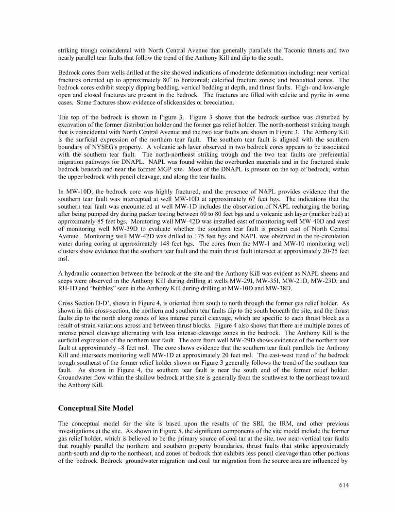
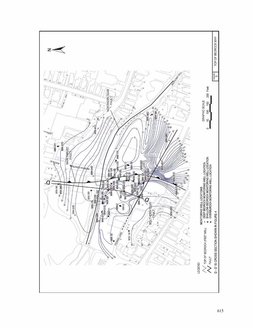
striking trough coincidental with North Central Avenue that generally parallels the Taconic thrusts and two nearly parallel tear faults that follow the trend of the Anthony Kill and dip to the south. Bedrock cores from wells drilled at the site showed indications of moderate deformation including: near vertical fractures oriented up to approximately 80o to horizontal; calcified fracture zones; and breciatted zones. The bedrock cores exhibit steeply dipping bedding, vertical bedding at depth, and thrust faults. High- and low-angle open and closed fractures are present in the bedrock. The fractures are filled with calcite and pyrite in some cases. Some fractures show evidence of slickensides or brecciation. The top of the bedrock is shown in Figure 3. Figure 3 shows that the bedrock surface was disturbed by excavation of the former distribution holder and the former gas relief holder. The north-northeast striking trough that is coincidental with North Central Avenue and the two tear faults are shown in Figure 3. The Anthony Kill is the surficial expression of the northern tear fault. The southern tear fault is aligned with the southern boundary of NYSEG's property. A volcanic ash layer observed in two bedrock cores appears to be associated with the southern tear fault. The north-northeast striking trough and the two tear faults are preferential migration pathways for DNAPL. NAPL was found within the overburden materials and in the fractured shale bedrock beneath and near the former MGP site. Most of the DNAPL is present on the top of bedrock, within the upper bedrock with pencil cleavage, and along the tear faults. In MW-10D, the bedrock core was highly fractured, and the presence of NAPL provides evidence that the southern tear fault was intercepted at well MW-10D at approximately 67 feet bgs. The indications that the southern tear fault was encountered at well MW-1D includes the observation of NAPL recharging the boring after being pumped dry during packer testing between 60 to 80 feet bgs and a volcanic ash layer (marker bed) at approximately 85 feet bgs. Monitoring well MW-42D was installed east of monitoring well MW-40D and west of monitoring well MW-39D to evaluate whether the southern tear fault is present east of North Central Avenue. Monitoring well MW-42D was drilled to 175 feet bgs and NAPL was observed in the re-circulation water during coring at approximately 148 feet bgs. The cores from the MW-1 and MW-10 monitoring well clusters show evidence that the southern tear fault and the main thrust fault intersect at approximately 20-25 feet msl. A hydraulic connection between the bedrock at the site and the Anthony Kill was evident as NAPL sheens and seeps were observed in the Anthony Kill during drilling at wells MW-29I, MW-35I, MW-21D, MW-23D, and RH-1D and “bubbles” seen in the Anthony Kill during drilling at MW-10D and MW-38D. Cross Section D-D’, shown in Figure 4, is oriented from south to north through the former gas relief holder. As shown in this cross-section, the northern and southern tear faults dip to the south beneath the site, and the thrust faults dip to the north along zones of less intense pencil cleavage, which are specific to each thrust block as a result of strain variations across and between thrust blocks. Figure 4 also shows that there are multiple zones of intense pencil cleavage alternating with less intense cleavage zones in the bedrock. The Anthony Kill is the surficial expression of the northern tear fault. The core from well MW-29D shows evidence of the northern tear fault at approximately –8 feet msl. The core shows evidence that the southern tear fault parallels the Anthony Kill and intersects monitoring well MW-1D at approximately 20 feet msl. The east-west trend of the bedrock trough southeast of the former relief holder shown on Figure 3 generally follows the trend of the southern tear fault. As shown in Figure 4, the southern tear fault is near the south end of the former relief holder. Groundwater flow within the shallow bedrock at the site is generally from the southwest to the northeast toward the Anthony Kill. Conceptual Site Model The conceptual model for the site is based upon the results of the SRI, the IRM, and other previous investigations at the site. As shown in Figure 5, the significant components of the site model include the former gas relief holder, which is believed to be the primary source of coal tar at the site, two near-vertical tear faults that roughly parallel the northern and southern property boundaries, thrust faults that strike approximately north-south and dip to the northeast, and zones of bedrock that exhibits less pencil cleavage than other portions of the bedrock. Bedrock groundwater migration and coal tar migration from the source area are influenced by
614
615
616
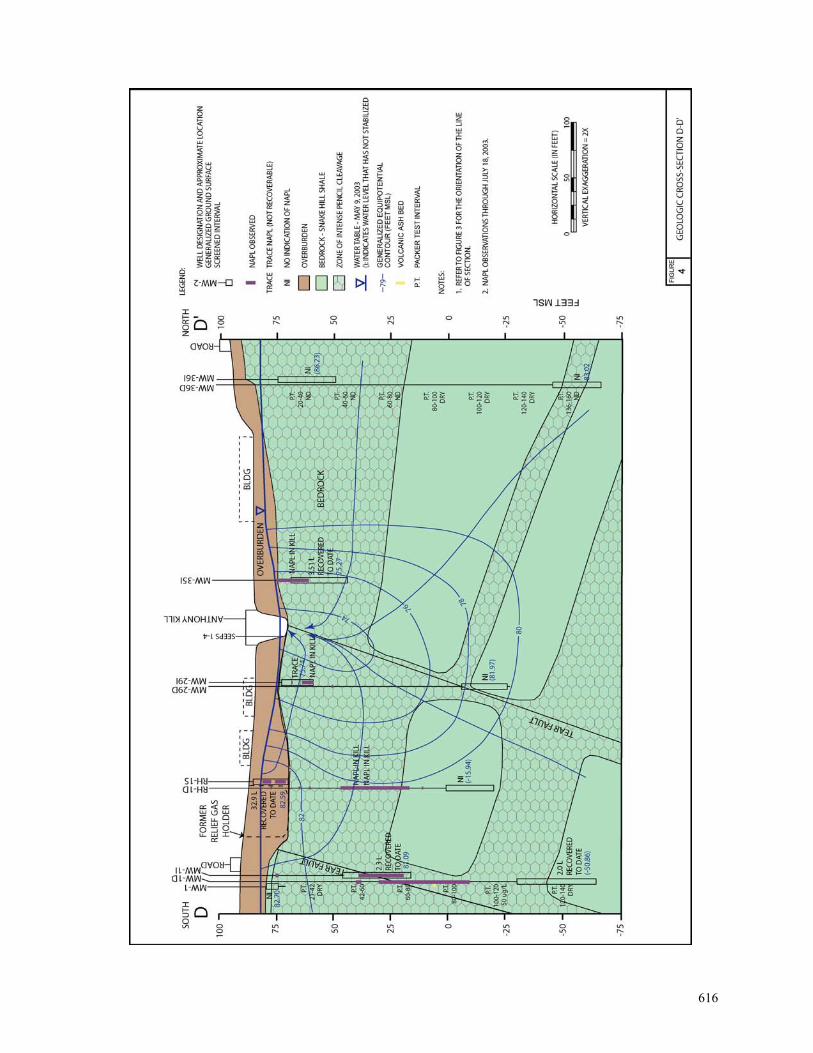
both small-scale and large-scale structures in the shale bedrock beneath the site. The large-scale structures in the bedrock are tear and thrust faults along which vertical and lateral movement of bedrock blocks occurred. The small-scale structures are zones within the bedrock that are more fractured than other portions of the bedrock. These zones of higher fracture densities, which are known as “pencil cleavage zones,” were produced by stresses associated with the movement of bedrock blocks along the tear and thrust faults. The tops of the zones of less intense pencil cleavage represent the base of the bedrock blocks thrusting to the west. Coal tar, which is observed at the site as both light non-aqueous phase liquid (LNAPL) and dense non-aqueous phase liquid (DNAPL), was present in the former gas relief holder. LNAPL migrated from the former gas relief holder, and to a lesser extent the other former MGP structures, with the slope of the water table toward the Anthony Kill. DNAPL generally migrated eastward along the slope of the bedrock surface to a bedrock trough that underlies North Central Avenue. DNAPL in the bedrock trough has migrated downward through the pencil cleavage zone, and has also migrated preferentially into a tear fault that is south of the source area. This southern tear fault dips steeply to the south. Where DNAPL migrating along the path of the southern tear fault intersects the thrust faults, which dip gently to the northeast, the DNAPL is transported to the north and east.
617
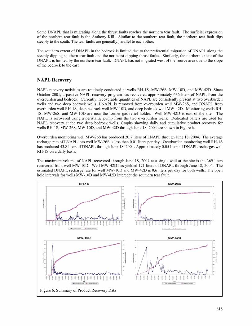
Some DNAPL that is migrating along the thrust faults reaches the northern tear fault. The surficial expression of the northern tear fault is the Anthony Kill. Similar to the southern tear fault, the northern tear fault dips steeply to the south. The tear faults are generally parallel to each other. The southern extent of DNAPL in the bedrock is limited due to the preferential migration of DNAPL along the steeply dipping southern tear fault and the northeast-dipping thrust faults. Similarly, the northern extent of the DNAPL is limited by the northern tear fault. DNAPL has not migrated west of the source area due to the slope of the bedrock to the east. NAPL Recovery NAPL recovery activities are routinely conducted at wells RH-1S, MW-26S, MW-10D, and MW-42D. Since October 2001, a passive NAPL recovery program has recovered approximately 636 liters of NAPL from the overburden and bedrock. Currently, recoverable quantities of NAPL are consistently present at two overburden wells and two deep bedrock wells. LNAPL is removed from overburden well MW-26S, and DNAPL from overburden well RH-1S, deep bedrock well MW-10D, and deep bedrock well MW-42D. Monitoring wells RH-1S, MW-26S, and MW-10D are near the former gas relief holder. Well MW-42D is east of the site. The NAPL is recovered using a peristaltic pump from the two overburden wells. Dedicated bailers are used for NAPL recovery at the two deep bedrock wells. Graphs showing daily and cumulative product recovery for wells RH-1S, MW-26S, MW-10D, and MW-42D through June 18, 2004 are shown in Figure 6. Overburden monitoring well MW-26S has produced 20.7 liters of LNAPL through June 18, 2004. The average recharge rate of LNAPL into well MW-26S is less than 0.01 liters per day. Overburden monitoring well RH-1S has produced 43.8 liters of DNAPL through June 18, 2004. Approximately 0.05 liters of DNAPL recharges well RH-1S on a daily basis. The maximum volume of NAPL recovered through June 18, 2004 at a single well at the site is the 369 liters recovered from well MW-10D. Well MW-42D has yielded 171 liters of DNAPL through June 18, 2004. The estimated DNAPL recharge rate for well MW-10D and MW-42D is 0.6 liters per day for both wells. The open hole intervals for wells MW-10D and MW-42D intercept the southern tear fault.
Figure 6: Summary of Product Recovery Data
618
References ABB Environmental Services, December 1993, Phase IIA Remedial Investigation And Feasibility Study Report.
ABB Environmental Services, June 1992, Investigation Of The Former Coal Gasification Site At Mechanicville, New York; Phase II Remedial Investigation Report And Work Plan For Phase IIA Supplemental Remedial Investigation And Feasibility Study.
ASTM. 1995. Standard Guide For Risk-Based Corrective Action Applied At Petroleum Release Sites. E 1739-95.
Dineen, R.J. and E.L. Hanson, 1983, Bedrock Topography And Glacial Deposits Of The Colonie Channel Between Saratoga Lake And Coeymans, New York, New York State Museum MAP And Chart Series Number 37.
EcoLogic, LLC, October 2002, Fish and Wildlife Impact Analysis, Former Manufactured Gas Plant Site, Mechanicville, New York.
Edison Electric Institute, April 1993, Manufactured Gas Plant Site Remediation Strategy, NYSDOH/USGS Open File Report 82-553, Atlas Of Eleven Selected Aquifers In New York.
Electric Power Research Institute, EPRI Journal, July/August 1989, Managing The Gas Light Legacy.
Electric Power Research Institute, June 8, 1994, Remediation Strategies For Source Materials And Contaminated Media At Manufactured Gas Plant (MGP) Sites.
Gas Research Institute, October 1987, Management Of Manufactured Gas Plant Sites, Volume II, Site Investigation.
Heath, R.C., F.K. Mack, And J.A. Tannenbaum, 1963, Groundwater Studies In Saratoga County, New York, US Geological Survey Bulletin GW-49.
E.C. Jordan Co., August 1986, Investigation Of The Former Coal Gasification Site At Mechanicville, New York; Task 1 Report, Preliminary Site Evaluation.
E.C. Jordan Co., December 1987, Investigation of the Former Coal Gasification Site at Mechanicville, New York; Task 2 Report, Initial Field Investigation Program.
E.C. Jordan Co., September 1989, Investigation of The Former Coal Gasification Site At Mechanicville, New York; Task 3 Expanded Problem Definition Program.
Meta Environmental, Inc., November 6, 2002. Environmental Forensic Report, Mechanicville, SDG: UR010417, UR021003.
New York State Department of Environmental Conservation, January 24, 1994, Division Technical and Administrative Guidance Memorandum: Determination of Soil Cleanup Objectives and Cleanup Levels (HWR-94-4046).
New York State Department of Environmental Conservation, 1999: Technical Guidance for Screening of Contaminated Sediments.
New York State Electric & Gas Corporation, March 12, 1997, Remedial Investigation/ Feasibility Study Request For Proposal No. 00-047, And One Addendum.
New York State Electric & Gas Corporation, March 27, 1991, NYSEG UST Closure and Removal, 3,000-Gallon Diesel Tank.
NY ew ork State Electric & Gas Corporation, July 26, 1991, NYSEG UST Closure and Removal, 3,000-Gallon Gasoline Tank.
619
New York State Electric & Gas Corporation, October 2000. Interim Remedial Measures Final Engineering Report for Activities at Mechanicville Central Avenue Former Manufactured Gas Plant (MGP) Site, City of Mechanicville, Saratoga County, New York.
Plesch, Andreas, 1994, Structure and Tectonic Significance of Deformed Medial Ordovician Flysch and Melange between Albany and Saratoga Lake and in Central Hudson Valley, New York. MS Thesis, The University of Albany, State University of New York, Department of Geological Sciences.
State of New York, Department of Environmental Conservation, February 5, 1993, Order on Consent, Index # A5-0276-91-10.
United States Environmental Protection Agency, 1998, Framework For Ecological Risk Assessment. EPA/630/R-92/001.
United States Environmental Protection Agency. 1997. Exposure To Factors Handbook. Office of Health and Environmental Assessment, Exposure Assessment Group, Washington, D.C. EPA/600/P-95/002Fc.
United States Environmental Protection Agency, 1995, Guidelines For Ecological Risk Assessment. EPA/630/R-95/002F.
United States Environmental Protection Agency (Region III). 1993. Selecting Exposure Routes and Contaminants Of Concern By Risk-Based Screening. EPA/903/R-93-001.
United States Environmental Protection Agency, 1992a, Fish And Wildlife Impact Analysis For Inactive Hazardous Waste Sites. (FWIA) (NYSDEC 1994) United States Environmental Protection Agency. 1992a.
United States Environmental Protection Agency. 1992. Guidance For Data Usability In Risk Assessment. Office of Solid Waste and Emergency Response. PB92-963356.
United States Environmental Protection Agency. 1989. Risk Assessment Guidance For Superfund. Volume I, Human Health Evaluation Manual (Part A). Interim Final. Office of Emergency And Remedial Response, Washington, D.C. EPA/540/1-89/002.
United States Geological Survey, 1954, Photorevised 1980. 7.5 Minutes Series Mechanicville, New York Quadrangle.
Utility Solid Waste Activities Group Superfund Committee/ERT and Koppers Company, Inc. September 1984, Handbook on Manufactured Gas Plant Sites, Ishwar P. Murarka, EPRI, Journal, September 1990, Manufactured Gas Plant Site Investigation.
Biographical Sketches Michael Gutmann – URS Corporation Mr. Gutmann is a Group Supervisor and Project Manager with over 15 years of experience. Mr. Gutmann has developed and implemented numerous remedial investigations, monitoring programs, and remedial actions at a variety of industrial, municipal, and hazardous waste sites. Mr. Gutmann can be contacted at URS Corporation, 640 Ellicott Street, 3rd Floor, Buffalo, New York 14203. 716.856.5636 (ph) 716.856.2545 (fax) [email protected]. Eriko Fujita – URS Corporation Ms. Fujita has over 10 years of experience as a geologist for URS Corporation. Ms. Fujita has extensive experience preparing site investigation work plans and facility investigation reports. Recently, Ms. Fujita has been involved with preparing work plans and reports for several former Manufactured Gas Plant sites in New York State.
620
621
Ms. Fujita can be contacted at URS Corporation, 28 Corporate Drive, Suite 200, Clifton Park, New York 12065. 518.688.0015 (ph) 518.688.0022 (fax) [email protected]. Beth Guidetti – URS Corporation Ms. Guidetti has over three years of experience in data collection, analysis, and interpretation for URS Corporation. Ms. Guidetti has used GIS extensively to analyze and present data. Ms. Guidetti has interpreted the structural geology at sites across New York State, and determined NAPL pathways through overburden and fractured bedrock systems. Ms. Guidetti can be contacted at URS Corporation, 28 Corporate Drive, Suite 200, Clifton Park, New York 12065. 518.688.0015 (ph) 518.688.0022 (fax) [email protected]. Tracy Blazicek, CHMM – New York State Electric & Gas Corporation Mr. Blazicek has over 11 years of experience as a project manager in NYSEG's site investigation and remediation group, specializing in former Manufactured Gas Plant (MGP) sites. Mr. Blazicek is currently a Lead Environmental Analyst and is responsible for managing remedial investigation and feasibility study projects for NYSEG's most complex former MGP sites. Mr. Blazicek has BS degrees in forest resources management and biology from SUNY's College of Environmental Science and Forestry. Mr. Blazicek can be contacted at NYSEG, PO Box 5224, Binghamton, New York, 13902-5224. 607.762.8839 (ph) 607.762.8451 (fax) [email protected].