Embed Size (px)
Citation preview

Brilliant ideas to get your students thinking creatively about polar exploration, with links across a wide range of subjects including maths, art, geography, science and literacy.
FOCUS ON SCIENCE

WHAT? WHERE? WHEN? WHO?
This object is part of the collection at the Polar Museum, Scott Polar Research Institute in Cambridge ̶ see more online at: www.spri.cam.ac.uk/museum
FOSSIL PLANT This rock contains fossils of leaves from an ancient plant called glossopteris. It was found in the Antarctic. Fossils like these show that the Antarctic was once much warmer than it is now and supported very different forms of life.
The stone is fine-grained mudstone. This suggests that the leaves were probably blown into a lake. Over millions of years, layers of mud formed over the leaves and hardened, fossilising the leaves. This fossil was collected during the Heroic Age of Antarctic exploration and science in the early 20th century. The Heroic Age includes the expeditions of Captain Scott, Ernest Shackleton and Roald Amundsen.
DID YOU KNOW?During Captain Scott’s journey to the south pole, his team stopped for a number of days to look at rocks and fossils. Realising how important their discovery was to science, they collected 35lbs of the rocks and fossils. In November 1912, the search party found a tent containing the bodies of Scott and two of his men. The rock and fossil collection was on the sledge outside the tent.
MORE DETAILS ABOUT THE OBJECT: bit.ly/PM-Y-2010-38-1
SHORT FILM ABOUT THIS OBJECT: www.vimeo.com/polarmuseum/science
DOWNLOAD A HIGH RESOLUTION IMAGE: bit.ly/PM-resourcesAccession number: Y: 2010/38/1 – Dimensions: height: 21mm, length 122mm, width: 85mm

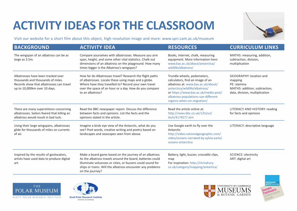
ACTIVITY IDEAS FOR THE CLASSROOMVisit our website for a short film about this object, high resolution image and more: www.spri.cam.ac.uk/museum
BACKGROUND ACTIVITY IDEA RESOURCES CURRICULUM LINKSThe majority of Antarctica is covered in ice and snow. Plants like this no longer grow in the Antarctic.
Scott’s scientists were thrilled to discover fossils of plants. Imagine that you are the geologist Frank Debenham, write a conversation between the men in the photo as they look for and find fossils.
Scott’s scientists looking for fossils:www.spri.cam.ac.uk/picturelibrary/catalogue/article/p54.16.218/
LITERACY: conversation, exclamation marks, speech marks
Antarctic plants have changed dramatically since the subtropical phase. Find out more: www.bas.ac.uk/about/antarctica/wildlife/plants/
Look carefully at a range of leaves from your local area. Draw a diagram of each leaf and label the key parts. Can you see any similarities between the leaves? Can you sort them into types?
A selection of leaves, magnifying glasses. Learn why plants have leaves here: www.bbc.co.uk/education/clips/zm89wmn
SCIENCE: plants, the function of leaves, classification
The leaves are from ‘glossopteris’, a type of subtropical tree fern that is now extinct.
Test plants in different temperature, light, and water conditions. Observe and record what happens to the plants. Research plants that grow in cold climates, are there any similarities between them?
Plants, box, fridge SCIENCE: plant adaptation, observation
These leaves fell in to a lake over 500 million years ago. They were covered in layers of mud which, over time, turned to stone. Geologists call this grainy rock formation ‘sedimentary.’
Sedimentary rocks often contain fossils. Sandstone is a grainy sedimentary rock that is very popular to build with or tile floors with. When you’re out and about in your local area, look around you. Can you spot any sedimentary rocks? Look even closer, can you see any fossils? (This could be a homework activity.)
More activity ideas can be found at:www.edenproject.com/learn/schools/lesson-plans/great-fossil-huntersThe Sedgwick Museum in Cambridge sells a geological trail of the city.
SCIENCE: rocks describe how fossils are formed, formation of sedimentary rocks
Most of the Antarctic bedrock is hidden below ice. There could still be fossils beneath the ice that are new to science.
Imagine you are in the Antarctic and have found a fossil plant that has never been seen before. Sketch it at full size. Trace and transfer the image to card, marking in the veins of the leaves. You could relief print the leaves or layer them up with tissue paper to emulate the layering of mud over the original leaves.
Card, paper, paint, ballpoint pen, tracing paper, tissue paper, glue.
For inspiration look at the works of Nick Gentry and Anne Ryan
ART: relief printing, negative images, layering, collage, colour

WHAT? WHERE? WHEN? WHO?
This object is part of the collection at the Polar Museum, Scott Polar Research Institute in Cambridge ̶ see more online at: www.spri.cam.ac.uk/museum
GEOLOCATOR This is a microwave PTT geolocator (PTT stands for Platform Transmitting Terminal). A geolocator is used to track the movement of animals and birds.
This type of geolocator was used by the British Antarctic Survey, and would be attached to the back of an albatross. It contains a light sensor, a timer, a battery and an aerial and weighs 30 grams
DID YOU KNOW?By using geolocators, scientists have been able to discover much more about the movements and behaviour of albatrosses.
The geolocator would be attached to the back of the albatross with glue. This does not harm the bird.
MORE DETAILS ABOUT THE OBJECT: bit.ly/PM-Y-2010-52-7
SHORT FILM ABOUT THIS OBJECT: www.vimeo.com/polarmuseum/science
DOWNLOAD A HIGH RESOLUTION IMAGE: bit.ly/PM-resources
Accession number: Y: 2010/52/7 – Dimensions: height: 168mm, width 33mm, length: 70mm
ACTIVITY IDEAS FOR THE CLASSROOMVisit our website for a short film about this object, high resolution image and more: www.spri.cam.ac.uk/museum
BACKGROUND ACTIVITY IDEA RESOURCES CURRICULUM LINKSThe wingspan of an albatross can be as large as 3.5m.
Compare yourselves with albatrosses. Measure you arm span, height, and some other vital statistics. Chalk out dimensions of an albatross on the playground. How many times bigger is the Albatross’s wingspan?
Books, internet, chalk, measuring equipment. More information here: www.bas.ac.uk/about/antarctica/wildlife/albatross/
MATHS: measuring, addition, subtraction, division, multiplication
Albatrosses have been tracked over thousands and thousands of miles. Records show that albatrosses can travel up to 10,000km over 10 days.
How far do Albatrosses travel? Research the flight paths of albatrosses. Locate these using maps and a globe. Where have they travelled to? Record your own travel over the space of an hour or a day. How do you compare to an albatross?
Trundle wheels, pedometers, calculators, find an image of an albatross at: www.bas.ac.uk/about/antarctica/wildlife/albatross/or https://www.bas.ac.uk/media-post/albatross-populations-use-different-regions-when-on-migration/
GEOGRAPHY: location and mappingPE: staminaMATHS: addition, subtraction, data, division, multiplication
There are many superstitions concerning albatrosses. Sailors feared that killing an albatross would result in bad luck.
Read the BBC newspaper report. Discuss the difference between facts and opinions. List the facts and the opinions stated in the article.
Read the article online at: http://news.bbc.co.uk/1/hi/sci/tech/4174577.stm
LITERACY AND HISTORY: reading for facts and opinions
Using their large wingspans, albatrosses glide for thousands of miles on currents of air.
Imagine a birds eye view of the Antarctic, what do you see? Pool words, creative writing and poetry based on landscapes and seascapes seen from above.
Use Google earth to fly over the Antarctichttp://video.nationalgeographic.com/video/oceans-narrated-by-sylvia-earle/oceans-antarctica
LITERACY: descriptive language
Inspired by the results of geolocators, artists have used data to produce digital art.
Make a board game based on the journey of an albatross. As the albatross travels around the board, batteries could illuminate volcanoes or cities, or buzzers could sound for ships or trains. Will the albatross encounter any problems on the journey?
Battery, light, buzzer, crocodile clips, mapFor inspiration: http://chrisdrury.co.uk/category/mapping/antartica/
SCIENCE: electricityART: digital art

WHAT? WHERE? WHEN? WHO?
This object is part of the collection at the Polar Museum, Scott Polar Research Institute in Cambridge ̶ see more online at: www.spri.cam.ac.uk/museum
GEOLOGICAL HAMMER This hammer was used in the Antarctic to break rocks.
The head of the hammer is metal. The short wooden handle has a hole at one end with a leather thong through it.
DID YOU KNOW?Geological hammers could also be used for other things. Over a century ago, a group of six men became stranded and were running out of food. Worried that they would starve, they used their geological hammers to throw up in the air in the hope of killing sea birds to eat. Thankfully all the men in the group survived. The birds weren’t so lucky.
MORE DETAILS ABOUT THE OBJECT: bit.ly/PM-Y-2010-34-2
SHORT FILM ABOUT THIS OBJECT: www.vimeo.com/polarmuseum/science
DOWNLOAD A HIGH RESOLUTION IMAGE: bit.ly/PM-resources
Accession number: Y: 2010/34/2 – Dimensions: width 135mm, length: 280mm, depth: 30mm

ACTIVITY IDEAS FOR THE CLASSROOMVisit our website for a short film about this object, high resolution image and more: www.spri.cam.ac.uk/museum
BACKGROUND ACTIVITY IDEA RESOURCES CURRICULUM LINKSGeological research in the Antarctic has shown that over 500 million years ago Antarctica was joined to Africa, Australia, India and South America.
Cut up a map of the world and see if you can piece together Africa, Australia, India, South America and the Antarctic. Discuss why they are no longer connected. What do they think happened? Work out how long ago the pieces broke apart on a timeline.
Copies of world map, scissors, calculators, glue
GEOGRAPHY: location, plate tectonics and movement, Gondwanaland MATHS: time, scale, subtraction, addition, division of large numbers
As well as being the coldest place on earth, Antarctica also has active volcanoes. Igneous rocks are formed by volcanic action.
Imagine that you are climbing Mount Erebus to study the volcano and collect some igneous rock samples. What sort of equipment would you need to pack? What sort of experiments might you want to do?
Image: www.spri.cam.ac.uk/picturelibrary/catalogue/article/p54.16.108/
SCIENCE: rocks and volcanoes, planning experiments, theories, predictions
The search party that went looking for Captain Scott found 35lbs (approximately 17.5Kg) of rocks and fossils on the sledge outside Scott’s tent. The men had been determined to keep the rocks because of their scientific importance.
Homework: collect rocks, then sort, group and classify them. Are there any igneous rocks? Weigh the rocks, work out the total weight. If you were only allowed to carry half of that weight, which ones would you take back?
Image, rock samples: www.spri.cam.ac.uk/museum/catalogue/article/y80.1/Image, collecting rocks in Antarctica www.spri.cam.ac.uk/picturelibrary/catalogue/article/p48.14.14/
MATHS: weight, additionSCIENCE: classification and labelling
In 1912 a group of Scott’s men climbed up the Antarctic volcano, Mount Erebus. They were there to study the volcano and collect rocks to help with their research.
Write a diary entry for this day in 1912. What does it feel like to climb a volcano? In 2012 their camp was discovered by another geologist. Read his account. What would the men of 1912 have thought about this?
Image, at the top of Mt Erebus: www.spri.cam.ac.uk/picturelibrary/catalogue/article/p54.16.505/News article: www.cam.ac.uk/research/news/heroic-age-campsite-location-discovered-near-summit-of-antarctic-volcano
LITERACY: diary writing,
The Scott Polar Research Institute was founded by the geologist Frank Debenham in order to continue the polar research that Scott had started.
Imagine that you are setting up your own research institute, what type of research would you want to support? Present your ideas to the rest of the group. Ask and answer questions about your ideas.
Image, Frank Debenham grinding geological specimens: www.spri.cam.ac.uk/picturelibrary/catalogue/article/p2005.5.457/
PSHE: speaking and listening, performance, questioning, interviewing, assessment opportunity
WHAT? WHERE? WHEN? WHO?
This object is part of the collection at the Polar Museum, Scott Polar Research Institute in Cambridge ̶ see more online at: www.spri.cam.ac.uk/museum
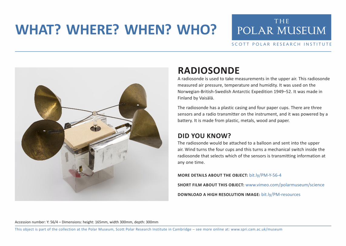
RADIOSONDE A radiosonde is used to take measurements in the upper air. This radiosonde measured air pressure, temperature and humidity. It was used on the Norwegian-British-Swedish Antarctic Expedition 1949–52. It was made in Finland by Vaisälä.
The radiosonde has a plastic casing and four paper cups. There are three sensors and a radio transmitter on the instrument, and it was powered by a battery. It is made from plastic, metals, wood and paper.
DID YOU KNOW?The radiosonde would be attached to a balloon and sent into the upper air. Wind turns the four cups and this turns a mechanical switch inside the radiosonde that selects which of the sensors is transmitting information at any one time.
MORE DETAILS ABOUT THE OBJECT: bit.ly/PM-Y-56-4
SHORT FILM ABOUT THIS OBJECT: www.vimeo.com/polarmuseum/science
DOWNLOAD A HIGH RESOLUTION IMAGE: bit.ly/PM-resources
Accession number: Y: 56/4 – Dimensions: height: 165mm, width 300mm, depth: 300mm
ACTIVITY IDEAS FOR THE CLASSROOMVisit our website for a short film about this object, high resolution image and more: www.spri.cam.ac.uk/museum
BACKGROUND ACTIVITY IDEA RESOURCES CURRICULUM LINKSCaptain Scott started the regular data collection of Antarctic weather and temperature information.
Collect regular weather recordings for your locality. Compare what you see with webcam footage from the Antarctic. Set up a daily comparison between here and the Antarctic.
Check out some Antarctic webcams: https://www.bas.ac.uk/data/our-data/images/webcams/ If it is snowing you can collect data for research: http://www.spri.cam.ac.uk/research/projects/snowlab/
MATHS: data handling, graphs, comparing dataGEOGRAPHY: environmentSCIENCE: data collection
Scientific staff were often taken on expeditions to help with Antarctic research.
Imagine that you are Dr Simpson (see photo) Write the weather report for this day. This could be turned in to a TV style weather report.
www.spri.cam.ac.uk/picturelibrary/catalogue/article/p2005.5.952/www.bas.ac.uk/about/antarctica/geography/weather/
LITERACY: reporting, formal languageSCIENCE: reporting
The wind turns the cups on the radiosonde. In turn they switch the mechanism inside the plastic box.
Wind also turns weather vanes. Design and make a simple weather vane of your own. Experiment with different sized cups and paddles, which works best? Does it matter which way the cups or paddles are facing?
Paper cups, dowelling, cardboardhttp://www.bbc.co.uk/education/clips/zx9q6sg
DT: design and make a simple weather vaneSCIENCE: testing
There are lots of weather vane designs that have been inspired by the Antarctic. Some of them feature whales, dog sleds, penguins, tents or boats.
Design and make a simple template for an Antarctic inspired weather vane. This could then be incorporated into your windmill mechanism (see above).
Cardboard, black paper, scissors, For extra inspiration look at the work of Jan Pienkowski or Augustin Edouart www.npg.org.uk/collections/search/person/mp06932/augustin-edouart
ART: silhouettes, outlines, inspiration from an artist
International collaboration is still really important in Antarctica. In such an extreme environment it is vital to co-operate.
Locate Helsinki, Norway and Sweden on a map. Discuss phrases that might be important to know in different languages. Research how to say them in the Norwegian, Swedish and Finnish. Practice them. Are there are similarities between the languages? Why might this be?
Online translations GEOGRAPHY: location, mapsMFL: basic phrases