Embed Size (px)
Citation preview

Volume 21
Naturalist Papers3 Global Warming: Where are we now? – S. J. Harrison.7 The Weather of 1997 – S. J. Harrison.
17 The Forth Area Bird Report 1997 – C. J. Henty.53 Bo’mains Meadow, Bo’ness – Angus Smith.55 The Douglas Society and Bicentenary of the Birth of David Douglas, 1799
– Archie Smith.57 Lawhill Community Woodland – a Year On – Martin Boardman.Book Reviews and Notes (Naturalist): Butterflies of the Millennium p62;Environmental Information in Scotland p62; Flanders Moss p16; Forth EstuaryForum p61; The Nature of Fife p16; Discovering the Firth of Forth p52; Manand the Landscape Symposia p62; The Effective Alternative p6; The GlasgowNaturalist p52.Historical Papers
63 The Wallace Oak, Torwood and Roy’s Military Survey – Colin D. I. G.Forrester.
71 James Watt’s Surveys Around Stirling – Richard L. Hill.85 Harvey’s ‘Lost’ Child Restored – and On Show! – Marie Devaney.89 The Legend of Robert Kirk Reconsidered – Louis Stott.97 The Kinrosses of Stirling and Dunblane. People of the Forth (11) – Lindsay
Corbett and John S. Kinross.109 The Bicentenary of the Raploch, Stirling’s Georgian Planned Village –
G. A. Dixon.117 The Built and Archaeological Heritage of the Forth – P. J. Ashmore and
I. Oxley.131 A Stirling Church – R. and C. Page.Book Reviews and Notes (Historical): Archive Photo Series p88; BannockburnYears pp135-6; Barbour’s Bruce p116; Menstrie Glen pp136-7; Stone Age Alphap88; Carron Iron Works p134; Towards Democracy in Education p96; BlindHarry’s Wallace p88.139 House Style and Guidelines for Authors.141 Addresses of Authors and Reviewers, and Erratum.142 The Forth Naturalist and Historian.
the ForthNaturalistHistorianand

Published by the Forth Naturalist and Historian, University of Stirling – anapproved charity and member of the Scottish Publishers Association. 1998.
ISSN 0309-7560
EDITORIAL BOARDStirling University – D. McLusky (Chairman), D. Bryant, N. Dix and
J. Proctor, Biological Sciences; S. J. Harrison, Environmental Sciences;N. Tranter, History.
K. J. H. Mackay, R. McCutcheon, J. M. Allan, W. Brackenridge, J. Gallagher.
Honorary Secretary:Lindsay Corbett, the University and 30 Dunmar Drive, Alloa.
Honorary Editors:L. Corbett and N. Dix.
ISBN 1-898008-27-2
Single copies may be taken of single articles provided due acknowledgementis made and the copies are for non-profit education or private use.
Supported by BP in Scotland.
Cover: front– The Wallace Oak, Torwoodback– The Smith Art Gallery and Museum, Stirling, and
R. McCutcheon
Printed by Meigle Printers Ltd., Tweedbank Industrial Estate, Galashiels.Set in Zapf Calligraphic on Amber 100 gsm and cover cream Lustralux.
Forth Naturalist and Historian, volume 21

GLOBAL WARMING: WHERE ARE WE NOW?
S. J. Harrison
In 1997 the average temperature near to the surface of the Earth, based onmore than a thousand climatological stations and available sea-surfacetemperature records, was 0.43°C above the 1961-1990 average (Parker et.al.,1998). This was 0.6°C higher than the average at the end of the nineteenthcentury. During 1998, the months up to June were the warmest on record andJuly eventually became globally the hottest month ever recorded, and it ishighly likely that the average for the current year will exceed that for 1997. Inthe Stirling area 1997 temperatures were well above average but 1998 hasproved to be cooler. On the whole, the available climatological data provide astrong indication of an upward trend in the global average temperature, theeffects of which have included:-
• the timing of the onset of spring in the Northern hemisphere, which ismore than seven days earlier than twenty years ago. Satellite imagesindicate that spring foliage has been emerging earlier and that summervegetation has been more verdant. Exotic species have begun to invadeareas outside their normal distribution and many weeds are experiencingclimatic conditions more conducive to their invasive habits. Higher airtemperatures have caused a world-wide resurgence of diseases such asmalaria and dengue fever, the latter being on the verge of enteringEurope.
• Sea-ice around Antarctica has been melting quite rapidly over the lasttwenty years at the rate of 1.4 % cent per decade. The indications are thatlarge areas of ice shelf have now disintegrated and an estimated 8000 km2
have been lost over fifty years. The rate of melting of Arctic sea-ice hasaccelerated from 2.5 to 4.3 % per decade, and parts of the Arctic Ocean arenow 1.0°C warmer than they were in the late 1980’s.
• High summer temperatures have impacted directly on the touristindustry in the United Kingdom, resulting in an increase in earnings ofthe order of 15 %. Recent changes in the Scottish climate (Harrison, 1997)indicate a widening difference in climatic conditions between a wetterand windier west and a drier and sunnier east, which has obviousimplications for the tourist industry (Harrison et.al., in press). Thereduction in winter snow lie on the Scottish mountains has had adeleterious effect on skiing on lower slopes but above 1000 m there hasbeen sufficient snow to sustain the industry.
Although there remain a substantial number of climatologists who aresceptical of the evidence for global warming, the majority view is that anongoing trend has been established and that action needs to be taken toalleviate its environmental and socio-economic impacts. Of the more direpredictions, changes in agricultural productivity could bring up to 70 million
Forth Naturalist and Historian, volume 21 3

people to the brink of starvation, and there may be an increase in the numberof people dying from disease and heat stress. Global warming has, therefore,been placed high on the international political agenda, but the emphasis hasbeen on achieving political accord rather than on dealing with the reality of theproblem being faced. While scientific opinion points towards a need to reduceemissions of greenhouse gases by as much as 60 %, the Kyoto conference,which was little more than political theatre, realised only an 8 % reduction overthe European Union and a 7 % reduction from the USA, the latter conditionalupon first-option terms regarding the trading in Russia’s spare carbon emissionpermits. There are powerful lobbies in the USA resisting the implementation ofthe Kyoto agreements, with Republican members of the Congress trying toblock any further funding for research into climate change, while funding hasbeen made available to those scientists willing to undermine the case for globalwarming. Kyoto also failed to reach any agreement on emissions from aircraftand shipping, which are important sources of greenhouse gases.
The principal questions which have yet to be answered fully are (1) is theobserved increase in temperature attributable directly to anthropogenicinfluences or is it simply a natural fluctuation and (2) are there other processeswhich will ameliorate or exacerbate the effects of enhancement of theGreenhouse Effect? In addressing these questions it must be remembered thatprediction of the future course of climate change is based on mathematicalmodels which are, by their very nature, no more than imperfectrepresentations of an infinitely complex web of interrelated environmentalprocesses.
Much of the warming has been associated with two important changes inelements of the atmosphere-ocean circulation. The Southern Oscillation(ENSO), referred to as El Niño, was responsible for the inflation oftemperatures in the tropical Pacific Ocean, while the North Atlantic Oscillation(NAO) has brought warmer wetter weather to western Europe and to Scotlandin particular. The current debate is whether such changes are a result of, orcausal factors in, global warming. More recent studies have reopened thedebate on the effects of externally forced climate changes resulting fromfluctuations in the amount, and characteristics of, solar radiation arriving in theupper atmosphere. This which would appear to explain a significantproportion of the warming trend experienced after the mid-nineteenthcentury. However, Mann et.al. (1998) claim to have established beyondreasonable doubt that much of the increase in global temperature during thetwentieth century can be attributed directly to anthropogenic factors. Currentinternational agreements are unlikely to result in a significant reduction inemissions of greenhouse gases, and sources such as cement manufacture andcatalytic converters are providing increasing emissions of carbon dioxide andnitrous oxide respectively.
The answers to the second question unfold as more research is undertakeninto the contributing processes. While the scattering effects of marine andindustrial sulphate aerosol in the lower troposphere appear to have offset some
4 S. J. Harrison

of the warming effects of greenhouse gases, the greatest concern is now beingfocussed on the role of ocean currents in determining long-term changes inclimate. Heat is moved around the oceans in what is commonly called a‘conveyor belt’, which is very sensitive to changes in temperature, density andsalinity of the water. This is of particular concern in Scotland because of thevery powerful influence exerted by the warm North Atlantic Drift. The effect ofa warming of the Arctic Ocean is to release large volumes of fresh water intothe North Atlantic which, being less dense than saline water, could well drivethe North Atlantic Drift away from the west coast of Scotland. Should such achange occur, its onset is likely to be quite rapid, while at the same time theprocesses involved may be difficult to reverse. The impact on the Scottishclimate would be severe, particularly during the winter months whenconditions would be more similar to those experienced along the easternseaboard of North America, where snow and frost are relatively frequent.Changes in ocean currents in the Pacific have already brought more cold waterto the surface, which has resulted in as much as a 20 % reduction in the amountof heat being transferred into the atmosphere.
In conclusion, the last few years have witnessed a consolidation of theevidence for global warming and there is now little doubt that there has beenan upward trend in temperature which began in the mid-nineteenth centuryand has accelerated over the last two decades. The implications for Scotlandcould be for largely advantageous changes in climate but the continuation ofthe warming trend could result in a change to a more severe climate regime.One fundamental problem, however, still remains and that is the identificationof the cause of such changes. These can be attributed directly to changes in theatmosphere-ocean circulation, but it is by no means easy to establish the natureof the relationship between these and global warming. The indications are thatthere is a strong anthropogenic factor in global warming and it is imperativethat a means is found to reduce emissions of carbon dioxide, methane andnitrous oxide. Such is the nature of international politics that it is highly likelythat agreement on this issue will remain a distant prospect.
ReferencesHarrison, S.J. (1997). Changes in the Scottish climate Botanical Journal of Scotland 49,287-300.
Harrison, S.J., Winterbottom, S. and Sheppard, C. (in press). The potential effects ofclimate change on the Scottish tourist industry Tourism Management.
Mann, M.E., Bradley, R.S., and Hughes, M.K., (1998). Global scale temperature patternsand climate forcing over the past six centuries Nature 392, 779-787.
Parker, D.E., Horton E.B., and Gordon, M. (1998). Global and regional climate in 1997Weather 53, 166-175.
Global Warming 5

BOOK REVIEW (Naturalist)
The Efficient Alternative. Agnew, P.W. 1994. Tarragon Press, Ravenstone,Whithorn. 93pp. ISBN 1-870781-07-4. £5.95.
This is a hard-hitting frontal assault on what the author sees as the mis-management of the energy industry and the vested interests which havehindered the development of efficient energy policies and supply alternatives.Pat Agnew has an industrial background and was, for more than 20 years, alecturer in mechanical engineering at Glasgow University. While the book isvery much a personal statement arising clearly from not inconsiderablefrustration, it is thoroughly researched, informative and well argued. Theauthor’s approach is summarised as “how we can do away with nuclear power,reduce pollution, conserve natural resources and save money” with which fewwould argue. The introduction outlines the false assumptions and poordecision making which have shaped energy supply in the UK today. He lists,amongst others, the “false” assumptions that coal is a dirty fuel, that societyneed more electricity to improve the quality of life and that we need morenuclear and gas powered stations in order to reduce emissions of greenhousegases. The answer is encapsulated in the two words “improved efficiency”. Thefollowing chapters examine the history of the National Grid and the criticalevents which have shaped energy supply. Agnew questions the wisdom ofincreasing dependence upon the use of gas-fuelled power stations and thebiasing of the market towards the energy produced by nuclear power stations.The third chapter has the emotive title “Economic growth – the god that failed”and questions the underlying need for growth. Surely a mature economy, likea mature adult, has a need for stability, not further growth. Chapters fourthrough to six examine nuclear power, fossil fuels and renewable resources,and look very closely at the efficiency and real sustainability of these as sourcesof energy.
A strong case is made for the use of renewable resources such as water, waveand wind power, alongside reductions in energy consumption. The final threechapters examine alternatives for the future and deal with increasing theefficiency of energy conversion, the role of politics in directing the future ofenergy supply and demand, and ways of reducing energy costs without theneed for nuclear energy.
There are several books on the market which address such issues many ofwhich, like this one, express very strongly held views. Unfortunately, in manycases the arguments have been based too much on emotion and not enough onscientific principle. Agnew’s background has provided him with excellentcredentials to address this topic which, in combination with an obvious passionfor the subject, makes for a compelling read. The final parting shot has anOrwellian feel to it when the Department of Energy are exhorted to “beprepared to publicise the truth and not allow the public to be misled by thevested interests that they themselves have created”.
S. J. Harrison
6 Forth Naturalist and Historian, volume 21

THE WEATHER OF 1997
S. J. Harrison
After a cold and exceptionally dry start to the year, January 1997 being thedriest for 200 years in the UK, the following months were exceptionally mild.The mean maximum air temperature was above average for every monthexcept May and June, while the mean minimum air temperature was belowaverage only in January (Fig. 1). Rainfall was above average in only fourmonths, February, May, June and December, and the annual total was only95 % of average (Fig. 2). Over the UK as a whole, 1997 was the third warmestyear this century behind 1990 and 1949, and again there was much talk aboutthe effects of global warming on the climate. The identification of an oscillatingweather condition in the Atlantic (North Atlantic Oscillation) has confirmedthat changes in the strength and persistence of the mid-latitude westerlycirculation are the primary cause of recent warm and moist winter weather inthe British Isles.
Temperature and rainfall values in the following refer to Parkhead II althoughreference is also made to the records from Bridge of Allan.
January Exceptionally dry, and cold
Snow fell overnight on the 1st/2nd and again on the 3rd and 4th. The 6th tothe 10th were dull, cold and dry, the daytime temperature struggling to riseabove freezing and reaching only 1.0°C in Bridge of Allan on the 8th. Strongsouth-westerly winds reached Scotland late on the 10th and snow was fallingby the late evening. The 11th was a grey and miserable day but thetemperature rose rapidly in mild tropical air. The daytime temperature topped11.0°C between the 12th and 14th but the weather stayed dull and damp. Nightfrost under clearing skies occurred briefly on the 20th but the cloud coverreturned on the 22nd and the weather was cold and raw until the 24th. Therewere patches of freezing fog by the morning of the 25th (–4.5°C). From the 28th,night-time temperatures fell sharply, reaching –5.2°C in Bridge of Allan by themorning of the 31st.
February Windy and very wet, but generally mild
Rain began late on the 1st in a freshening south-westerly breeze, which setthe pattern for much of the rest of the month. The sequence of wet and windyweather was broken only by brief calmer and clearer periods during whichnight temperatures fell, and there were sharp frosts on the 5th and 6th (–5.4°CBridge of Allan on the 5th). The wind turned briefly into the north-west on the7th, bringing blustery showers of sleet and snow. The wind freshened south-westerly again late on the 9th heralding the start of a wet 72 hours. The total
Forth Naturalist and Historian, volume 21 7
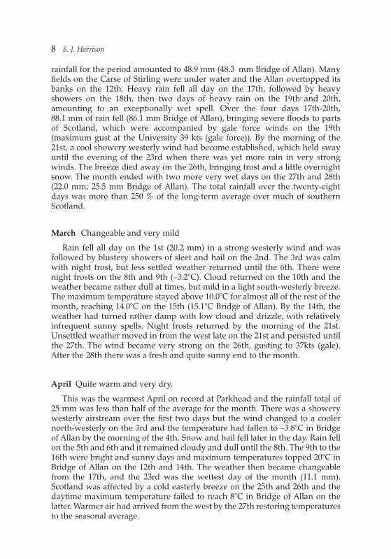
rainfall for the period amounted to 48.9 mm (48.3 mm Bridge of Allan). Manyfields on the Carse of Stirling were under water and the Allan overtopped itsbanks on the 12th. Heavy rain fell all day on the 17th, followed by heavyshowers on the 18th, then two days of heavy rain on the 19th and 20th,amounting to an exceptionally wet spell. Over the four days 17th-20th,88.1 mm of rain fell (86.1 mm Bridge of Allan), bringing severe floods to partsof Scotland, which were accompanied by gale force winds on the 19th(maximum gust at the University 39 kts (gale force)). By the morning of the21st, a cool showery westerly wind had become established, which held swayuntil the evening of the 23rd when there was yet more rain in very strongwinds. The breeze died away on the 26th, bringing frost and a little overnightsnow. The month ended with two more very wet days on the 27th and 28th(22.0 mm; 25.5 mm Bridge of Allan). The total rainfall over the twenty-eightdays was more than 250 % of the long-term average over much of southernScotland.
March Changeable and very mild
Rain fell all day on the 1st (20.2 mm) in a strong westerly wind and wasfollowed by blustery showers of sleet and hail on the 2nd. The 3rd was calmwith night frost, but less settled weather returned until the 6th. There werenight frosts on the 8th and 9th (–3.2°C). Cloud returned on the 10th and theweather became rather dull at times, but mild in a light south-westerly breeze.The maximum temperature stayed above 10.0°C for almost all of the rest of themonth, reaching 14.0°C on the 15th (15.1°C Bridge of Allan). By the 14th, theweather had turned rather damp with low cloud and drizzle, with relativelyinfrequent sunny spells. Night frosts returned by the morning of the 21st.Unsettled weather moved in from the west late on the 21st and persisted untilthe 27th. The wind became very strong on the 26th, gusting to 37kts (gale).After the 28th there was a fresh and quite sunny end to the month.
April Quite warm and very dry.
This was the warmest April on record at Parkhead and the rainfall total of25 mm was less than half of the average for the month. There was a showerywesterly airstream over the first two days but the wind changed to a coolernorth-westerly on the 3rd and the temperature had fallen to –3.8°C in Bridgeof Allan by the morning of the 4th. Snow and hail fell later in the day. Rain fellon the 5th and 6th and it remained cloudy and dull until the 8th. The 9th to the16th were bright and sunny days and maximum temperatures topped 20°C inBridge of Allan on the 12th and 14th. The weather then became changeablefrom the 17th, and the 23rd was the wettest day of the month (11.1 mm).Scotland was affected by a cold easterly breeze on the 25th and 26th and thedaytime maximum temperature failed to reach 8°C in Bridge of Allan on thelatter. Warmer air had arrived from the west by the 27th restoring temperaturesto the seasonal average.
8 S. J. Harrison

May Both cold and hot; wet at times
The first two days were sunny and exceptionally warm. The maximumtemperature reached 23.3°C in Bridge of Allan on the 2nd (24°C in Edinburgh).However, on the 3rd there was a sharp fall in daytime temperature to 12.1°C.The 3rd and 4th were very wet (48h total 25.0 mm), and thunder was heardduring the afternoon of the 4th. This was followed by a spell of very coldweather in a northerly polar airstream. Snow fell on the 5th and 6th, whichcaused problems on the roads in north-east Scotland. Some of the showers onthe 7th and 8th fell as hail. By the morning of the 9th the air temperature hadfallen to –2.4°C in Bridge of Allan, marking the last air frost. Rain returned lateon the 9th and the weather remained unsettled with further rain at times overthe following four days. The weekend of the 17th and 18th was cold and wetwith low cloud and rain, which was very heavy at times, and accompanied bythunder on the afternoon of the 17th. Bridge of Allan registered 23.1 mm of rainover the weekend. Heavy rain fell on the 20th in a freshening easterly breezeand the daytime temperature reached only 10.0°C in Bridge of Allan. The cloudcover gradually cleared away from the 22nd and the month ended with a spellof very warm and sunny weather. The maximum temperature reached 28.4°Cin Bridge of Allan on the 30th.
June Wet. Warm at first but becoming cooler
A fresh easterly breeze blew over the first three days which were sunny butcool. After a very warm and sunny day on the 4th, cloud increased from thesouth and the 5th and 6th were rather humid with isolated thunderyoutbreaks. The following four days were unsettled with occasional showers.The last ground frost was recorded on the morning of the 9th. The 11th waswet and cold (maximum temperature 13.8°C and 21.1 mm of rainfall), but wasfollowed by another brief warm spell from the 14th. Cool and wet weatherreturned on the 18th. Very unsettled weather arrived late on the 24th but theworst of the rain had cleared Scotland by the 27th after which the weatherbecame sunny and warm until the 31st. For much of the British Isles this wasthe wettest June this century.
July Warm and relatively dry
The first three days were dull with spells of locally heavy rain. Severeflooding affected northern Scotland on the 1st and the Aberdeen to Invernessrailway line was closed when embankments were washed away. There was arelatively warm and dry spell from the 4th to the 9th and the maximumtemperature reached 25°C. From the 9th there was a mixture of showers andsunny spells, although conditions became very muggy on the 12th and 13th.The weather remained unsettled until the 16th after which there were sevendays of hot and mainly dry weather, although there was a short thundery spell
Weather 1997 9

during the evening of the 20th. The daytime temperature reached 28.7°C inBridge of Allan on the 21st. The fine weather came to an end late on the 22ndas cloud and rain arrived from the west. Rainfall amounts were, however,relatively small and there were long sunny spells. By the 28th, the temperaturein Scotland was falling in a strengthening, and showery, south-westerly windwhich brought blustery showers on the 30th and 31st.
August Very Warm and dry
The weather was remarkably warm, maximum temperatures rising above20°C on all but six days. Although warm, the weather was occasionally ratherdull and by the 7th had turned very muggy with the daytime temperaturerising above 25°C. The temperature on the 10th rose rapidly in a very humidsoutherly airstream and had reached 30.2°C in Bridge of Allan on the 12th. Theweather broke on the 13th and torrential rain fell in a thunderstorm during thelate afternoon (27.5 mm). However, the temperature remained high over thefollowing days, although they were a little less oppressive. Minimumtemperatures were remarkably high and the overnight temperature droppedonly to an exceptional 17.7°C between the 20th and 21st. On the 21st afreshening south-westerly breeze brought an end to the muggy weather. As theclouds cleared, the night temperature fell to 5.4°C in Bridge of Allan by themorning of the 24th. The weather became unsettled and much cooler for theremainder of the month, with occasional rain and long sunny spells, and on the31st the maximum rose to only 15.7°C, in marked contrast to the rest of themonth.
September Sunny and warm, and generally rather dry
The weather over the first eight days was unsettled and there was heavyrain on the 2nd and 3rd (24.7 mm). There was bright and clear weather fromthe 9th but with an autumnal chill in the cold polar air. On the 11th, showers,some of hail, fell in a strong north-westerly breeze and the daytimetemperature reached only 12.5°C on the 12th. There was heavy rain on the13th, and between the 14th and 15th there were further falls in a strong south-westerly wind which gusted to 35kts (gale) at the University. The raincontinued into the 15th and 16th, resulting in a 48h total fall of 31.0 mm. Thiswas followed by a lengthy spell of calm, clear and dry weather in Scotland,which lasted from the 17th to the end of the month. Under clear night skies,minimum temperatures fell towards freezing, reaching 0.3°C in Bridge of Allanby the morning of the 20th, which also saw the first autumnal ground frost(–0.4°C). The weather was generally warm and sunny, but between the 21stand 25th the days began with dense fog. A freshening southerly breeze beganto blow on the 28th, and by the morning of the 29th the minimum temperaturehad fallen to only 14.4°C. Over much of the southern half of the UK this wasone of the driest Septembers this century.
10 S. J. Harrison

October Sunny: Warm at first but turning cold
The first four days were sunny and dry and the maximum temperaturereached 18.4°C on the 4th. The weather changed on the 5th at the start of anunsettled spell which lasted until the 12th. Rain was intermittent for the mostpart and the minimum temperature remained above 12.5°C on the 5th and 6th.Torrential rain began to fall during the evening of the 9th, and by the 10th24.2 mm had fallen. On the 12th a weak northerly airstream affected Scotland,bringing a sharp drop in temperature and the first nocturnal air-frost in Bridgeof Allan. but cloudy and wet weather returned on the 14th. The 15th to the 18thwere dull and wet days, but mild in a variable southerly airstream. The cloudbase remained low, barely rising above 65 m on the 16th. The four-day rainfalltotal 14th to 17th amounted to 35.4 mm. Colder weather began to set in on the19th and by the 20th, a cold north-easterly breeze had developed whichbrought the first snow to the local hills. As the breeze died away and the cloudscleared, there were night frosts. The minimum temperature had fallen to –5.8°Cin Bridge of Allan by the morning of the 29th. Days were bright and sunny afterearly morning ground fog.
November Mild and rather damp
Unsettled weather was in control for much of the month, with mainly dullweather and relatively rare sunny interludes. When the cloud cover did clearbriefly, night temperatures fell below freezing, but there were only two air-frosts at Parkhead over the course of the month. Frost was accompanied by fogon the morning of the 9th. A fresh southerly breeze began to blow on the 15thwhich imported moist tropical air from the Azores into Scotland. Minimumtemperatures exceeded 10.0°C locally between the 16th and 20th and thedaytime maximum reached 16.1°C on the 15th. The wind freshened and galesand widespread flooding had caused damage throughout Scotland by the 18th,although conditions in the Stirling area were less severe. There was a spell ofheavy rain on the 20th (12.4 mm). After the 23rd there were five very dull daysbefore an easterly breeze cleared the air on the 29th. The last day of the monthsaw a welcome change to bright sunny weather.
December Mild but changeableThe first three days were bright and clear in a light north-westerly breeze,
and there were moderate night frosts, the temperature falling to –5.7°C inBridge of Allan by the morning of the 1st. Air temperatures increased sharplyfrom the 5th in a freshening south-westerly, the maximum reaching 12.2°C onthe 6th, and rain was a feature of the weather on most days. There was asustained spell of wet weather from the 9th to the 11th (23.5 mm). Frostreturned by the morning of the 12th, which was accompanied by fog on the13th. Milder air from the south-west saw a return to cloud and drizzle but astrengthening easterly wind then blew between the 15th and 18th. The
Weather 1997 11

weather over this period was cloudy and dull, and felt very raw. The windgusted to gale-force at the University on the 17th as sleet and snow swepteastwards across Scotland. However, the cold snap was short-lived as milderweather was restored on the 18th, which was a particularly wet day (22.2 mm).The weather remained dull over the following days. Central Scotland escapedthe worst of the Christmas gales, but a wet spell, which started late on the 23rdand finished late on Christmas Day, brought a total rainfall of 37.0 mm. Theweather improved a little after Christmas and the 27th and 28th were muchbrighter as the cloud cover cleared away, only to return on the 29th.
WEATHER NOTES
Noteworthy Scottish Weather Events over 1997
Heavy rain and floods during FebruaryThere were two spells of particularly heavy rain, between the 10th and 12th
and the 19th and 20th. Rain was combined with strong winds which madedriving very difficult in places. Eskdalemuir (Dumfriesshire) registered 79 mmon the 19th/20th while the Butt of Lewis recorded a gust of 88 kts (hurricaneforce).
Snow in Scotland May 5th and 6thThere was severe disruption on the roads in Grampian Region.
July 1st Floods in North-East ScotlandThere was prolonged heavy rainfall over Scotland which led to flooding
around Elgin, Forres and Nairn. A great amount of damage was done toagricultural crops, several roads and railways lines were cut, and propertieswere damaged by flood water. More than 70 mm of rain fell in 48hr.
Floods in Scotland September 16thGales and heavy rain affected much of Scotland on the 16th and conditions
in western Scotland were particularly severe as more than 75 mm of rain fell insome areas.
Climate Change and its Effects on Scottish Tourism
An analysis of climate change in Scotland has been undertaken in anattempt to generate a meaningful picture of what the future may hold fortourism in Scotland. The study has been based on historical analogues and aGIS-based Digital Elevation Model. Specific attention has been focussed onwinter snowfall and summer wetness as these have a major bearing on visitoractivity in Scotland. The analysis suggests that, should the winter climate shiftto a more westerly maritime character, then lowland areas would experiencemore frequent snow-free months. As elevation increases then the reduction insnowlie becomes more pronounced, but above 1000 m the trend is reversed
12 S. J. Harrison

Weather 1997 13
Figure 1 Air temperatures at Parkhead I 1997.

and the highest ground experiences some of the smallest reductions inScotland. Analysis of summer wetness indicates a potential reduction in thenumber of wet days by as much as 10 % in lowland areas, but over higherground this increases to 20 %. Thus it would appear that the upland areas maywell offer the tourist a greater probability of being able to appreciate thescenery on offer.
Rainfall Measurements in Western Scotland
The initial encouragement and guidance provided to the LochaberRaingauge Network on behalf of the Royal Meteorological Society, and theefforts of George Clark as coordinator, have together ensured that more than40 people in the west of Scotland now have a focus for their interest in theirlocal weather. The data may also provide, in the long-term, an invaluablecontribution to the understanding of rainfall-topography relationships andmay challenge scientists to review the assumptions they have made in thisfield. An analysis of some of the data generated by the Network has indicatedthat local topography, and not elevation, is the most important factor indetermining the spatial distribution of rainfall.
14 S. J. Harrison
Figure 2 Monthly Rainfall at Parkhead I 1997.

Regional Climate of Central and Southern Scotland
An analysis of the principal features of the climate of that part of Scotlandlying south of the Highland Boundary Fault has been published as part of anew study of regional climates in the British Isles (Wheeler, D. and Mayes, J.1997 British Climates: A Regional Approach. Routledge: London). All the studiesuse the latest 1961-1990 climatological averages. Dr Harrison describes not onlythe principal spatial patterns of temperature, rainfall and snowfall, airflow,visibility and sunshine in the southern part of Scotland, but also notableweather events such as the Strathclyde Floods of December 1994 and theGlasgow Storm of 1968, and particular local features such as the Forth ValleyFrost Hollow and the East Coast Haar. References to old manuscripts add aninteresting historical dimension to the study. The climate of the northern partof Scotland, and the islands, is described by Marjory Roy, formerly of theMeteorological Office in Edinburgh.
Access to Parkhead Monthly Data
The monthly mean maximum and minimum temperatures, and monthlyrainfall totals for Parkhead climatological station on the campus of theUniversity of Stirling can now be obtained via E-Mail at no charge. Schoolswishing to access these data should E-Mail Dr Harrison at [email protected].
Acknowledgement
This paper is based on the Annual Climatological Bulletin which isproduced by the Department of Environmental Science at the University ofStirling.
Weather 1997 15

BOOK REVIEWS/NOTES (Naturalist)
Flanders Moss
A meeting of the British Ecology Society’s MIRES Research Group at theUniversity of Stirling from 30th June to 5th July 1998 included workingstudy/survey visits to – the species-rich fen at the south of Loch Lomond; thehigh level (550 m) blanket bog at Hart Hill in the Campsies; and a two day oneto Flanders Moss.Saturday 4th July was a symposium of eight presentations–
Geomorphology – David Smith, University of Coventry.Peat Stratigraphy – Jim Dickson, University of Glasgow.Vegetation – Alan Booth, Central Scotland Surveys.Hydrology – High Ingram, University of Dundee.Archaeology – R. Hingley, Historic Scotland.History – Ken Mackay.Peatland Conservation – Philip Imertzi, SNH.Management and Monitoring – Tim Jacobs, SNH.
Organised by John Proctor. The Forth Naturalist and Historian intends topublish a proceedings.
L.C.
The Nature of Fife. Edited by Gordon R. Corbet for the Fife and Kinross Boardof Scottish Wildlife Trust. Scottish Cultural Press, Edinburgh. 1998. 356pp.,illustrated, including colour. ISBN 1-84017008-5. £14.95.
In an easy to read style this is a comprehensive work on the diversity ofwildlife and habitats of Fife by specialists in their fields – including GeorgeBallantyne who has contributed to the Forth Naturalist and Historian with florasurveys on West Fife in volume 12, and Balmerino in 14.
It includes a comprehensive inventory of species of plants, fungi andanimals so far recorded in Fife and adjacent seas. The inventory is available at£7.00 separately on disk from Fife Nature, Fife House, Glenrothes.
Contents of the book – include – Geology and landform, R. MacGregor;Climate, N. Elkins; Landscape and history, Whittington and Smout; Landwardcoast, R. Crawford; Shore, estuaries and sea, Bentley and Fairlamb; Farms andfields, Warrener; Woodland, Ingram and Larson; Freshwater, S. Pritchard;Heathers and grassland, A. Irvine; Living with man, Corbet and Ballantyne;Conservation, F. Spragge; an inventory of the flora and fauna of Fife.
L.C.
16 Forth Naturalist and Historian, volume 21

FORTH AREA BIRD REPORT 1997
C. J. Henty
Sixty-four contributors appear this year, some sent notes direct to the author,others via the RSPB local group. The extensive use of record cards has greatlyhelped the compilation of notes by species. In addition, others have assisted inthe wildfowl counts and the breeding birds survey and I have extracted somerecords from the logbook of the SWT hide at Kinneil though not allcontributors are identifiable. Notable records for this year include the firstRosefinch (a singing male), Bittern, a summer Little Ringed Plover and the firstClackmannanshire Honey Buzzard. At least eleven Quail were calling on thecarse and a brood was seen. Most contributors – and many non-birdwatchers –will be aware that Ospreys have been nesting in the area for some years and itis now felt sensible to acknowledge this publicly in a summary of breedingsuccess. Lesser Blackbacked and Herring Gulls now have well establishedcolonies on the roofs of whisky bonds, these are prominent but difficult tocensus. On the estuary in autumn there were few Skuas but a modest passageof waders and a massive Swallow roost developed above Cambus.
This report is compiled from a larger archive of records submitted to thelocal recorder under the national scheme organised by the ScottishOrnithologists Club. The area covered by the report comprises the councilareas of Falkirk and Clackmannan together with Stirling, excluding LochLomondside and other parts of the Clyde drainage basin. Please note that wedo not include the Endrick water, i.e Fintry and Balfron. Records from CarronValley Reservoir are published here but it is proposed that Clyde should coverall the forest south of the reservoir. Observations are not spread evenly, theinland part of Falkirk is once more neglected and the extensive and ofteninaccessable hill area in the north of our area has had only sporadic coveragealthough a second likely breeding area for Dunlin has been found.
Though 1997 was overall a very mild year it started with snow in earlyJanuary and severe frosts at the end of the month. Heavy rain in early and midFebruary caused extensive flooding, including the Forth overtopping its bankson both sides of the Devon, and the continuing unsettled weather dominatedMarch though there were a few frosts early on. From mid April it was warmerthan usual and there was only half the normal monthly rainfall, however, Maywas very varied with snow and hail in the first week leading to wet and coldconditions and then warm and sunny in the last week. Through June and Julydry sunny spells alternated with rain though the third week of July was hotand dry. Most of August was very warm and dry, becoming unsettled late on.Spells of rain and wind in early September gave way to calm high pressureweather and some morning fog but it soon became unsettled in early Octoberuntil an anticyclone in the last week gave northeast winds, sunny but withnight frosts. Mild but wet and windy conditions dominated most of November
Forth Naturalist and Historian, volume 21 17

and December though there was a brief sunny and cold spell midway and alsoeasterly gales with sleet and snow in mid December.
The 1997 information on the breeding numbers of common species comefrom two studies of mapped territories. One is a Common Birds Census ploteast of Doune, this is 87 Ha of undulating, dry-field farmland at about 70 ma.s.l, mixed pasture and winter cereal, which is referred to as “Doune CBC” intext. The other is a Waterways Birds Survey along 5 km of the R.Devon at Alvawhich has much damp scrub surrounded by mixed pasture and arable,referred to as “Devon WBS”, or, for species that are not fully mapped, as “5 kmof lower Devon”.In addition the Breeding Bird Survey, based on transectcounts, is now sufficiently extensive to calculate numbers of birds recorded perten kilometres for several habitat types and these are regularly mentioned inthe species paragraphs. Note that the “Urban” term includes suburban areaswith large gardens. For less common species I can sometimes mention data interms of the numbers of pairs or apparently occupied territories for particularlocations. Several observers send in a list largely or entirely for their homelocality, much of this information is not appropriate for these annual reportsbut it is valuable to have on record and I am keeping them in a special file. Atthe moment there are fourteen such lists referring to the whole district fromFalkirk to Killin.
For many species the records sent in are very unrepresentative of theirgeneral distribution, this applies particularly to very common species or tothose that are secretive or breed in inaccessable places. Readers can consult thethe Check List published in the Forth Naturalist and Historian vol 15, but inaddition I have in this report put, after the species name, a coded summary ofgeneral distribution – which often apparently contradicts the detailed recordsthat are published for the year.
B - Breeding status, widespread (in more than five 10 km squares)b “ “ , local , scarce (in fewer than five 10 km squares)W - Winter status, widespread or often in groups of more than ten.w - “ “ , local, scarce (local and usually fewer than ten in a group)P - Passage (used when species is usually absent in winter, P or p used for
widespread or local as in winter status)S or s - a few species are present in summer but do not normally breed.
Thus BW would be appropriate for Robin, B for Swallow, p for Ruff and SWfor Cormorant. No status letter is used if a species occurs less than every otheryear.
An asterix (*) in front of the species name means that all records receivedhave been quoted.
The SOC has pressed for a more systematic vetting of records of species thatare unusual locally, this area now has an informal panel of five – C. Henty(Recorder), W. Brackenridge (Dep. Recorder), J. Crook (local SOC rep), A. Blairand D. Thorogood. The judging of national UK or Scottish rarities continues asbefore, but we have produced for the upper Forth a list of species that are
18 C. J. Henty

scarce locally and where the records need to be supported by either a fulldescription or sufficient evidence to remove any reasonable doubt. This list anda background explanation have been circulated to a hard core of observers andcan be got from the recorder at SOC meetings or by post. Any species which isa vagrant to the area, and most of those which are asterisked in this report, willcome into this category.
The organiser for the inland waters part of the national wildfowl counts(WEBS), has made available an account of the results for the winter 1996-1997.These often contribute to the species accounts and there is also a separatesummary which concentrates on localities.
There is an ever-increasing amount of information coming in: records onthe standard species cards need only to be sorted and I would urge observersto use these wherever possible (putting several records for one species on asingle card); records on sheets, whether written, hand-typed or computer-typed, need to be either retyped onto a computer database or cut and pastedonto species sheets. This is time consuming and the recorder can no longer dothis systematically without extensive help from contributors; otherwise theserecords will be scanned on arrival and only those items seeming to be salientwill be transferred to the database, all the original sheets will be kept on file butthat information is very difficult to unearth and inevitably some uncopiedrecords will in fact be important but remain hidden. Appeals for assistance willcontinue!
The following abbreviations have been used : AoT - apparently occupiedterritory, BoA - Bridge of Allan, c/n - clutch of n eggs, BBS - Breeding BirdSurvey, CBC- Common Bird Census, CP - Country Park, F - Female, GP - gravelpit, J - juvenile, L. - Loch, NR - Nature Reserve, M - Male, ON - on nest, Res -Reservoir, SP - summer plumage, V - Valley, WBS- Waterways Bird Survey,WG - Wildlife Garden, Y - young.
This report has been compiled from records submitted by:
P. & M. Ashworth, A. Ayre, M. Adam, B. D. Allan, M. Anderson, B. W. Barker,B. Bear, M. V. Bell, N. Bielby, Birdline Scotland, A. Blair, W. R. Brackenridge,R. .A Broad, G. J. Brock, D. M. Bryant, G. Bryson, R. Bullman, M. Callan,D. J. Cameron, R. Chapman, D. A. Christie, Z. Clayson, M. Cooper, S. D. Dick,H. M. Dott, A. Downie, K. & R. Egerton, D. S. Fotheringham, C. J. Henty,T. Jacobs, R. Jones, H. Kerridge, M. Kobs, G. & E. Leisk, A. K. McNeil (AKM),W. McEwan, L. J. Mallett, J. Marshall (JMr), A. McKillop, G. Mason, J. Mitchell,J. Nimmo, R. Nudds, D. Orr-Ewing, R. L. Osborn, G. Owens, R. K. Pollock,D. Rees, H. Robb, P. W. Sandeman, J. Sankie, S. Sankey, R. E. Scott, R. Shand,A. Smith, P. Stirling-Aird, D. Thorogood, A. Thiel, B. R. Thomson, M. Trubridge,H. Weir, J. Watson, J. Wheeler, M. Wilson, T. Young, R. Youngman.
Thanks are due to the Deputy Recorder, W. R. Brackenridge, for assistanceand advice on records, to A. Thiel for putting a batch of records on computer,to Dr S. J. Harrison for a copy of the Annual Climatological Bulletin (1997), andto P. Stirling -Aird for data from the Raptor Study Group.
Bird Report 1997 19

RESULTS OF THE BBS SURVEYS FOR CENTRAL REGION(Based on a comprehensive summary by NB.)
Readers will have noted that in this year’s report extensive use is made inthe species accounts of results from the Breeding Birds Survey, these are interms of the frequency of occurence of a species along linear transects inseveral habitat types. This use is now possible since in 1997 the number of 1x1kilometre squares surveyed has more than doubled to a total of twenty-threeand there is a much fairer coverage of the habitat types (the British Trust forOrnithology district is not quite the same as the SOC recording area since itincludes some squares in neighbouring parts of Perth and Kinross, howeverthese are very similar in type to the rest). Each square is visited twice inspring/summer, a total of two kilometres on a set route is walked per visit andall birds noted in 200 metre sections; a standardised habitat survey is done onanother visit. In the main report I have presented selected results, calculated asbirds per ten kilometres of habitat, for the major habitats where it is likely thatthe birds are breeding locally.
Each 200 m section and the birds noted in it have been attributed to one offive major habitats – Mountain and moorland (=moor), Moor/coniferwoodland edge, Conifer woodland, Farmland, Urban/suburban. Broadleavedwoodland occurs mainly as copses in farmland whilst conifer woodlandincludes both young plantations and mature woods
Eighty-eight species were seen overall, with an average of 27 per square buta great variation from four on blanket bog to 46 on mixed farmland, numbersof individuals varied similarly from five to 135.
Most Abundant Birds on Four Major HabitatsMoor Conifer Farmland UrbanMeadow Pipit Willow Warbler Rook StarlingCarrion Crow Chaffinch Black-h Gull BlackbirdBlack-h Gull Coal Tit Chaffinch JackdawSkylark Wren Starling House sparrowStarling Goldcrest Wood pigeon Carrion CrowCommon Gull Siskin Swallow L.Black-b GullCurlew Robin Feral Pigeon RookRook Great Tit Carrion Crow GreenfinchL.Black-b Gull Blue Tit Common Gull SwiftRed Grouse Redpoll Blue Tit Blue TitMallard Wood pigeon Jackdaw Feral PigeonWheatear Carrion Crow Willow Warbler Willow Warbler
I have put in italics those species where the great majority of recordspresumably relate to birds commuting to feed, not breeding. Another hazard ininterpretation is that no account has been taken of differences inconspicuousness (it is possible in principle to use BBS data to correct for thisbut the procedures have not yet been developed). Thus large species will beoverrepresented in open country, and a voluble small bird compared to a silent
20 C. J. Henty

one. Nevertheless, these data are the best comprehensive indications availableof the quantitative distribution of birds over our area.
The lists of the 12 commonest species contain no real surprises for mosthabitats, however in Urban areas Willow Warbler appears above Magpie,Chaffinch, Collared Dove, Robin, Wren, and Dunnock – this seems odd ingeneral experience but may be due to one area containing patches of scrub.Further expansion of this project would be most worthwhile and I would urgemore people to take on unsurveyed squares; the most taxing part is the habitatform!
1997 contributors were: M.A., B.D.A., R.B., W.R.B., Z.C., P .Crayton, R.C., S.Harley, A. Hibbert, C.J.H., L. Johnstone, P. McManamen, R. Osborn, L. O’T, S.S.,A.T., J.W., R. Young, T.Y.
WILDFOWL REPORT (1996-97)
This report concerns the inland waters part of this area’s Wetlands andEstuary Bird Survey (WEBS) organised by NB and is a condensed version of afuller report by him.
WEBS is a monthly waterfowl census under the auspices of the British Trustfor Ornithology (BTO) and the Wildfowl & Wetlands Trust (WWT), it runs fromSeptember to March inclusive. For this report ‘wildfowl’ includes Divers,Grebes, Cormorants, Herons, Swans, Geese (excluding Pink-footed andGreylag for which the WWT organises separate counts), Ducks and Rails
This report covers the area occupied by the new local government councilsof Stirling, Falkirk and Clackmannanshire (the ‘region’). In total, 114 still watersites, 136.5 km of river and 24.4 km of canal were counted by 44 counters.
Still Water Sites
Standing water in Central Region amounts to 7693 hectares or 2.9 % of thearea.
The following table consists of matched monthly data taken from 14 sites inthe top 25. Those sites holding fed Mallard have been excluded.
Month 1995/6 1996/7 1997/8September 1814 1583 1756October 3359 2039 2454November 3699 3235 3037December 4513 3955 3396January 2885 4477 3332February 2750 2771 2940March 1549 1646 1930Totals 20804 19706 18845
This season’s numbers are down 4.6 % on the previous but this only appliesfrom November to January and is only really marked in the three top sites ofGartmorn Dam, Gart Complex, and Airthrey Loch.
Bird Report 1997 21

Turning to individual sites, the top nine along with monthly averages arelisted below:- (previous seasons figures in brackets)
Site Average1. (1) Gartmorn Dam 996 (1300)2. (3) Gart Complex 366 (243)3. (5) Airthrey Loch 279 (181)4. (2) Lake of Menteith 267 (264)5. (4) Loch Earn 206 (217)6. (9) L.Venachar-Achray 170 (141)7. (6) Blairdrummond Park 162 (178)8. (12) L.Dochart-Iubhair 155 (123)9. (13) Doune Ponds 121 (149)
The above table excludes sites where Mallard are reared and released for shooting.
As shown above, Gartmorn is still far and away the most populous site,holding 37 % of all still water birds in the region.
Linear Water Features: Rivers & Canals
This season all of the canals in the region were counted.and the river lengthincreased to 125.5 km due to the R. Teith between Doune and Callander beingincluded. Some data are still to be sent in but these waters contribute at least22.5 % of inland wildfowl.
WEBS contributors to these data additional to report list were: M. Cooper,P. Dearing, A. Hibbert, D. Mason, D. Minard, L. O’Toole, J. Peterson, D. Series,N. Sharpe, D. Shenton.
SYSTEMATIC LIST
Codes – S, F and C indicate records from Stirling, Falkirk and Clackmannan -shire “Districts”.
RED-THROATED DIVER Gavia stellata (b,w)F 2 Bo’ness 11 Jan. Kinneil: 3 on 2 Jan, 1 on 18 & 19 Jan; 1 on 10 Aug &
20 Dec. 1 Kincardine Bridge 28 Dec (DMB DT GO AB DSF).S 2 L. Katrine 21 Mar. 1 L.Achray 21 & 28 Mar. (NB DAC). 1 Glen Finglas
12 Apr (SS). 1 L.Lubhair 29 Apr. 1 Killin 4 May to 3 Jul, 2 on 9 May(PWS).
BLACK-THROATED DIVER Gavia arctica (b,w)F 1 Bo’ness 11 Jan (DMB). 1 Kinneil 19 Jan, 30 Sep & 8 Oct (AB DSF
CKM).S 2 pairs & a single seen on 2 lochs in breeding season, 2 nests failed
through flooding (DAC BDA RES DOE).
LITTLE GREBE Tachybaptus ruficollis (B,w)F Kinneil: 1 on 23 Jan; 17 Sep to 14 Dec, max 6 on 11 Nov. Skinflats 17
Sep to 27 Dec, max 4 on 28 & 30 Oct (CJH GO DSF DT DAC AB). 2 on
22 C. J. Henty

R.Carron at Larbert 7 Jan & 3 on 7 Feb (MA).C 1 calling at Cambus Pools 20 Oct (WRB). 17 Gartmorn Dam 20 Oct &
19 on 12 Nov (MC).S 4 Airthrey 9 Mar. 4 Cocksburn Res 22 Mar, pair + 2Y 2 Jul & 6 Aug (AT
JS JMi). Pairs L.Voil & Hutchison Dam in May, Arivurichardich Res on14 Jun (DT WRB SS). As usual regular on wildfowl counts on highlandlochs, max 8 L.Lubnaig 28 Jan & 7 on 24 Oct. 2 Killin Marshes 28 Novwas 1st WEBS record (NB). Scarce on main rivers, 3 Lecropt 25 Jan &1 Cambuskenneth 28 Nov (DAC AT).
GREAT CRESTED GREBE Podiceps cristatus (b,W)F 20 Blackness 18 Oct (CJH). 1 Skinflats 2 Nov (MVB).
Kinneil monthly max: Jan 74, Feb 10, Mar 7, Apr 4, May 0, Jun 2, Jul 34,Aug 32, Sep 69, Oct 103, Nov 100, Dec 48 (DT DMB AB).
C 4 Gartmorn 15 Jan, 9 on 17 Mar; 19 on 12 Nov (still 17 on 6 Dec)presumably included juvs (MC).
S At Carron Valley Res 2 on 12 Jan & 5 on 9 Feb, 3 pairs raised 1Y (WMEGJB). 1 Lake of Menteith 29 Jan, 11 in BP on 26 Feb & 22 on 23 Mar,only 4 pairs in Apr; 17 (4 J) on 26 Sep, still 6 on 29 Dec (NB DT DAC).2 L.Watston 18 Mar (CJH). 2 Pairs W. Loch of Daldorn 9 Mar (BWB).Pair L.Coulter 4 Mar. Pair with 1J Vale of Coustry (Blairdrummond)26 Sep (NB).
*SLAVONIAN GREBE Podiceps auritusS 1 Carron Valley Res 10 Oct (RKP).
*FULMAR Fulmarus glacialis (p)F Kinneil: 1 on 10 Aug & 2 on 30th; 3 on 5 Sep & 4->W on 6th(DT BDA).
*MANX SHEARWATER Puffinus puffinusS 1 Kinneil 15 Sep (DSF).
GANNET Sula bassana (p)C At Cambus on 25 Sep a Juv came from down river & left inland over
Airthrey (CJH).F 14 Juv Kinneil 26 Sep (GO).
CORMORANT Phalacrocorax carbo (S,W)F 71 Skinflats 2 Nov (MVB). 65 Higgins Neuk 15 Feb & 133 on 6 Oct
(DSF).C 164 S.Alloa roost 2 Oct & 162 on 30 Nov (CJH AT). 9 Gartmorn 6 Dec
(MC).S 17 L.Earn 28 Dec. Max Lake of Menteith 15 on 29 Jan & 20 on 28 Oct
(NB). Regular in winter on upper Forth: 6 at Teith confluence 9 Feb, 9there to 6 km upstream 10 Mar (AMK RC). At Airthrey Jan-Mar, max 9on 14 Mar (MVB).
*SHAG Phalacrocorax aristotelisF 1 Higgins Neuk 25 Oct (DSF).
Bird Report 1997 23

*BITTERN Botauris stellarisF 1 Skinflats reedbed 31 Jan & 1 Feb, once stayed in full view for 20 min,
also did cryptic posture with vertical bill. Full description includeddark crown and streaks on centre and sides of neck. (GO AB JMrWRB).
GREY HERON Ardea cinerea (B,W)F 13 Skinflats 30 Jun & 22 on 21 Sep (GO MVB). S 31 used nests Blairdrummond (Nyadd) 22 May (CJH). Pair nested on
Airthrey Loch, 2Y (MK). 31 L.Earn 28 Dec (NB). 11 BoA 4 Oct (AD).During snow by the A811 at Kippen on 3 Jan, one hunted on the vergewithin 3 m of traffic (DT).
MUTE SWAN Cygnus olor (B,W)WEBS total up 32 % on 96-97 season (NB)
F Pair + 6Y on Union Canal at Falkirk 10 Jun; Pair +3Y on Carron atLarbert 8 Jun (MA). Pair + 4Y Larbert Loch 4 Sep. Pair Little DennyRes 16 Sep (NB). 33 on Forth/Clyde Canal at Bonnybridge 14 Feb (AA).20 Skinflats 28 Feb (GO).
C 47 included 14 juvs at Gartmorn 11 Sep, 112 there on 21st & record 122on 12 Nov (CJH MC). 1 nest fledged 5 at Cambus, 2 pairs on 17 Mar.17 on Devon WBS 12 Apr, pair reared 4 there, also pair + 8Y fromupstream (CJH). Pair raised 5Y Tullibody Pond (NB).
S 28 Craigforth 15 Mar – might be same as 23 above the Teith confluenceon the 10th (DT RC). 27 Lake of Menteith 29 Dec (NB). Pair at Airthreywith 8 juvs on 21 Sep (MK). At Cromlix 18 Sep, pairs with 3J at LodgePond & at House Pond. 10 (6J) Vale of Coustry (Blairdrummond)26 Sep. Pair Hutchison dam 22 Feb (WRB).
WHOOPER SWAN Cygnus cygnus (W)F 10 Kinneil 8 Oct (CKM) was the earliest & very transient herd, on
6 Nov 5 flew in from E and continued W (GO). 24 Larbert 7 Dec (AB).A yellow ringed adult at Dunmore on 29 Jul (DSF) may be one of 2 atCambus 14 May (RJ), the bird at Alloa Inch on 22 Jun (DMB) or atKennetpans on 20 Sep (CJH), or, indeed, the yellow ringed adult thatsummered at Kinneil last year.
C 12 Tullibody 9 Feb & 9 Mar (PMA). 11 Gartmorn 1 & 12 Nov (DACMC).
S Widespread on highland lochs. 50 Killin in Jan (PWS). 21 (5J)L.Dochart 28 Jan, 26 on 3 Apr, 13 on 15th, 4 on 25th, 4 very late nearbyon 29th & a straggler on 20 May (NB PWS DOE). 20 Carron Valley31 Dec (RKP).On Carse of Stirling 24 Kippen 20 Jan (HK) seem to have movedthrough Feb to Gargunnock (Birkenwood) with max of 28 on 11 Mar,last 15 on 14 Apr (DR DAC DOE NB). A separate herd further east atDrip carse peaked at 16 on 29 Mar & probably were the 15 atCraigforth on 17 Apr (AMK). On upper Forth, 1 on 21 Sep & 2 on 23rd might have summered (RCMT), otherwise 1st of autumn were 3 ->W Killin 7 Oct. 19 L.Dochart
24 C. J. Henty

14 Oct & 27 on 28 Dec (PWS NB), a neck collared bird here had beenmarked as an adult F in Iceland in 1994 and was later seen: Ireland,Oct 94; Orkney, Oct 96 & Glen Lyon, Nov 96; Orkney, Oct & Nov 97.27 Kippen 29 Dec (TY). 12 Drip Carse 1 Dec, 12 on Teith on 30th, 16Carron Valley Res on 14th &13 Lake of Menteith on 29th (RJ ZC WMENB).Counts of juvs in distinct herds gave: Spring, 27 % Juv. Autumn 19 %Juv. However, any comparison may be biased since no carse herdswere aged in spring and these often have very few juveniles. AtL.Lubnaig on 24 Oct 2 Ad were accompanied by 6 Juv – all similarsized so probably a large family (NB CJH).
PINK-FOOTED GOOSE Anser brachyrhynchus (W)The Goose Study Group ceased operating after the l997-8 season andMVB is no longer able to summarise records, thus the account here islargely based on non-systematic coverage and is much less reliable.In Jan, 2540 at Lecropt on 2nd and 3000 at Thornhill on the 25thprobably included the same birds, since a full carse count on the 23rdtotalled 4000. In March large flocks were reported from the Lake ofMenteith to Blairdrummond with a whole carse count of 4300 on the23rd; there continued to be no reports east of Stirling. However, inApril there were up to 3000 in the Buchlyvie-Gartmore area 9th to17th and in addition 500 at Skinflats on the 18th and 1610 at AlloaInches on the 20th – this a typical spring feature. The last flock haddwindled to 50 by 3 May and there was the usual visible movementwith 100 flying W over Stirling on 25 April.In autumn 4 at Cambus on 8 Aug were very early, the main arrival was18th to 21st September with moderate flocks widespread, maximum780 at Skinflats on the 21st. The last group seem to have stayed in theKincardine Bridge-Clackmannan area at least to 22 Nov. On the carseof Stirling the largest flocks were 700 at Buchlyvie on 18 Oct, 700Aberfoyle on 21 Dec and 540 Blairdrummond on the 21st. The earlywinter total seems unlikely to be much greater than 1300, much lowerthan last year.
BEAN GOOSE Anser fabalis (W)F 100 L.Ellrig 19 Feb (JN). Around Slamannan: 51 on 1 Feb (GO); 100 on
31 Oct, 127 on 7 Dec (MA GO); max 157 on 11 Nov feeding in floodedpasture, a record flock (NB).
S 35 Carron Valley Res 26 Oct (WME).
*WHITE-FRONTED GOOSE Anser albifrons (w)S 1 Lecropt 1 Jan (DT), 1 Thornhill Carse 11 & 14 Feb (DR). All were
Greenland race.
GREYLAG GOOSE Anser anser (b,W)Substantial flocks were noted in the north of the area with 200 atL.Venachar on 19 Jan and at Killin on 7 Feb. Full counts on the carseof Stirling gave 1100 on 23 Feb and 520 on 23 March; there were
Bird Report 1997 25

individual flocks of 300 at Aberfoyle on 29 Jan, 400 Drip carse on 15March and 120 Thornhill carse on 6 Apr (the last, except for 2 onR.Devon 10 May).Numbers were low early in the autumn but there sems to have beena late influx: after 35 flew W at Ashfield on 25 Oct there were 120 atGartmorn on 1 Nov, 200 L.Coulter on the 11th, and 278 at Kennetpanson 14 Dec.
CANADA GOOSE Branta canadensis (b W)WEBS 97-98 season total up 30 % (NB).
C 21 Cambus Pools 9 Sep (CJH).S 44 Vale of Coustry (Blairdrummond, biggest flock to date) 28 Jan, 9 on
28 Oct (NB). 8 L.Venachar 25 Jan (with Greylags) & 19 from 10 to20 Nov (DJC). 9 L.Mahaick 19 Mar was return to breeding site (NB).14 ->SW Ashfield 30 Sep (WRB). 14 ->W Buchlyvie 1 Oct (DAC). 42Buckieburn Res 10 Oct, 20 Lake of Menteith on 28th & 22 Glen Finglason 31st (NB DOE). 27 Lecropt 16 Nov & 12 on 13 Dec (DT DAC). 7Thornhill Pond 20 Jan & 3 on 27 Apr (DOE).
BARNACLE GOOSE Branta leucopsis (w)F Skinflats: 15 ->W 22 Sep, 26 on 28 Sep & 12 on 30th, 10 on 11 Oct (GO
DSF AB DT). 62 ->SW Kinneil 26 Sep (BDA GO).C 2 Alloa Inch 20 Apr & 2 on 2 Oct (DMB CJH). 2 (with Greylags)
Gartmorn 1 Nov (DAC).S 20 ->S Stirling & 11 ->E Carron Valley Res 27 Sep (DMB). 2 Lecropt
31 Dec (MVB). 2 on Forth around Cambuskenneth Feb to Apr & Nov-Dec, apparently feral residents. 2 at mouth of R.Allan 12 Jan had darkgrey necks (AT - presumably some hybridisation, Ed).
*BRENT GOOSE Branta berniclaF 1 Skinflats 30 Nov (GO).
SHELDUCK Tadorna tadorna (b,W)F 105 Higgins Neuk 26 Jan & 420 on 6 Sep (DSF). Moult flock at Kinneil
totalled 5067 on 16 Aug; 1810 at Skinflats on 14 Sep & 540 Kinneil on18th, total only 322 in Dec (DMB CJH MVB). 129 Skinflats 22 May, 1stbrood (11) on 21st, other broods were 5,8,11,12 on 28 May & 9,6,14,8,4on 12 Jul (AB GO).
C 147 Alloa Inch 4 May, 125 Tullibody Inch 6 Jul (DMB). 2 pairs on DevonWBS 15 May, last 2 on 25th (CJH). 3 Gartmorn 17 Mar (MC).
S 2 pairs Cambuskenneth in Apr were highest up Forth (AT). 1 ->EAirthrey 13 May (DMB).
WIGEON Anas penelope (b,W)1166 Forth Estuary in Feb (DMB). WEBS totals of 464 on rivers in Feb(NB).
F Kinneil: max 500 on 2 Feb, 45 on 28 Mar; 1st of autumn 8 on 17 Aug,300 on 20 Oct (DMB DT). 94 Higgins Neuk 26 Jan (DSF). Skinflats: 106on 9 Feb, last 3 on 25 May; 2 on 6 Sep, 86 on 16 Oct (MVB AB GO).
26 C. J. Henty

C 844 Gartmorn 15 Jan, 360 on 6 Dec (MC). 2 Cambus Pools 24 Aug(WRB). 150 on lower Devon 21 Dec (GEL).
S Max Gart Lochs (Cambusmore) 225 on 20 Feb, 10 on 1 Aug & 200 on17 Oct (NB PWS). Other large loch counts included 135 L.Venachar20 Jan. There are more on the upper Forth between the Teith andKippen, max 302 on 14 Jan (CJH NB RC). 1 Nest Torrie Lochan (BWB).
GADWALL Anas streperaMore records over whole district (Ed).
F 4 Skinflats 10 Mar & pair 4 to 15 Apr; 14 on 14 Dec (AA GO AB).C Pair Gartmorn 13 Feb & from 21 Sep to 6 Dec, 6 on 20 & 25 Oct (MC
PMA DOE). 3 (2M) Cambus Pools 22 Mar, pair to 20 Apr & M on 26th(WRB DMB DAC).
S 2 Carron Valley Res 21 Sep (WME). 1 L.Mahaick 24 Nov (NB).
TEAL Anas crecca (B,W)1045 Forth Estuary in Dec (DMB). 840 inland in Nov (NB).
F Kinneil: 120 on 28 Mar; 1 on 8 Aug & 30 on 29th, 200 on 18 Oct. 200Skinflats 9 Feb, 6M to 26 May; 9 on 8 Aug & 120 on 31st, 140 on 2 Nov(DT BDA CJH MVB GO).
C Few on Inches, 210 Gartmorn Dam 15 Jan but only 68 13 Feb (MC). 117on Devon, Alva-Dollar, 18 Jan; last, pair on 3 Apr (RN GEL CJH)
S High numbers on inland lochs, WEBS counts of 388 in Oct & 500 inNov, max of 166 L.Laggan 19 Nov, 120 L.Macanrie 19 Oct & 102L.Dochart on 24th. 68 Cambuskenneth 28 Nov (AT).
MALLARD Anas platyrhynchos (B,W)619 Forth Estuary in Dec (DMB). WEBS total 3805 inland in Oct (NB).
F 165 Skinflats 11 Jan & 213 on 14 Dec (MVB). 180 Kinneil 29 Aug & 150on 14 Dec (DT AB). 262 Larbert 21 Oct (MA).
C 22 AoT on Devon WBS, 17 in 1996 (CJH). 430 Gartmorn 15 Jan & 264on 20 Oct (MC).
S 234 Airthrey 3 Jan & 282 on 16 Nov, 1st brood 9 Mar, median 8Y in 10broods (AT MK). 6 pairs per sq km Doune CBC. 322 Blairdrummond23 Dec. About 1500 released at 7 shooting sites around Dunblane(NB).
PINTAIL Anas acuta (W)F Skinflats: 62 on 1 Mar, last 1 on 22 May; 1 on 4 Aug, 15 on 16 Oct & 46
on 27 Dec (GO MVB). Kinneil: 16 on 28 Mar, last 7 on 15 Apr; 1stautumn on 24 Aug, max 20 on 5 Oct (DT GO).
C 2M Tullibody Inch 22 Mar (CJH).S 2M Gargunnock 25 Feb (DR).
Area SummaryJan Feb Mar Apr - Aug Sep Oct Nov Dec52 39 80 16 9 16 35 48 46
SHOVELER Anas clypeata (p)F 2 Skinflats 21-28 Feb, 2 pairs 11-22 Apr; pair bred with 5Y seen 26 May,
brood probably stayed to 5 Sep; 1 on 16 Oct (GO). 3 Grangemouth 14
Bird Report 1997 27

Sep & 4 on 21st (DMB). 3 Kinneil 22 Feb & 11 Apr, M or F to 29 Jun; 3on 8 Aug, 5 on 12th, last on 1 Sep (GO DMB BDA DT).
C F Gartmorn 17 Mar (MC). 5 Cambus Pools 19 Jul, last on 6 Sep (CJHWRB).
S M Lake of Menteith 22 Mar (DAC)
POCHARD Aythya ferina (W)F 6 singles around Grangemouth Jan, May, Oct (AS DT GO).C 7 appeared on floodwater, Cambus,16 Mar (WRB). 42 Gartmorn 6 Dec
(MC).S 22 Vale of Coustry 29 Jan (NB); 28 L.Watston 13 Feb (CJH). 2 pairs
L.Achray 12 May (DOE). Highest monthly autumn counts: 10 Carron Valley Res 21 Sep & 45 on26 Oct, 70 L.Walton 4 Nov, 32 L.Venachar 22 Dec (WME MF NB).
TUFTED DUCK Aythya fuligula (B,W)F 47 Black Loch on 7 Feb & 59 on 10 Oct (NB). C 3 pair + M on Devon WBS (CJH). 6 Cambus Pools 5 Apr, 2 on 6 Sep
(WRB). 40 Kersiepow pond 5 Mar (NB). 164 Gartmorn 16 Feb & 98 on6 Dec (MC).
S 188 on Forth at Cornton 10 Jan (CJH). 75 L.Earn 28 Jan (NB). 1 nestAshfield & 2 at Torrie Lochan (WRB BWB). 60 Gart 1 Aug (PWS). Lateautumn counts low, max 53 Lake of Menteith 29 Dec (NB).
SCAUP Aythya marila (w)F Kinneil: 5 on 19 & 22 Jan, 4 on 1 Feb (AB WRB); 5M on 16 Jul then max
6 from 31 Aug to 13 Oct & a remarkable 36 on 16 Oct. M Skinflats21 May & 12 Oct (GO DAC DT).
S F Carron Valley Res 21 Sep (WME).
EIDER Somateria mollissima (w)F 7 (5M) Carriden 23 Mar (AS). Pair Kinneil 22 Mar & 5 Apr, M on 4 May;
F on 30 Nov (GO DT AB). Pair Kincardine Bridge 8 Apr & M on 9th(DSF). 2 M Skinflats 16 Oct (GO). 3M Blackness 21 Mar; 7 on 3 Aug & 2 on 27 Oct ( GO AB CJH).
GOLDENEYE Bucephula clangula (W)54 Forth Estuary in Feb (DMB). WEBS total inland 383 in Jan (NB).
F 29 Carronshore 22 Jan. 15 Skinflats 23 Mar, 5 on 8 Jul (early) & 22 on22 & 27 Oct; 14 Kinneil 22 Feb & 27 on 16 Oct (AB GO). 48 Black Loch4 Mar & 33 on 12 Dec (NB).
C 62 Gartmorn 15 Jan & 43 on 6 Dec (MC). 19 on Devon at Dollar 23 Feb(RN). 12 on Devonmouth flood 16 & 22 Mar (WRB CJH).
S 125 on Forth at Cornton 5 Jan (CJH). 44 Cambuskenneth 9 Feb & 52 on8 Nov(AT). 58 (14M) Lake of Menteith on 26 Feb. 36 L.Venachar 21 Mar& 22 L.Ard, 33 L.Dochart/Iubhair 30 Mar (NB). No May reports.1 R.Teith 30 Sep (ZC). 52 Cambuskenneth 28 Nov (AT). 59 Lake ofMenteith 29 Dec (NB). 28 % M (n=171) in March.
28 C. J. Henty

*SMEW Mergus albellus (w)S M L.Dochart 28 Jan & on L.Iubhair 2 & 25 Feb. M L.Dochart 27 & 28
Dec (NB DAC).
*LONGTAILED DUCK Clangula hyemalisS 1996 M & 2F at Lake of Menteith 27 Mar (NB).
RED-BREASTED MERGANSER Mergus serrator (B,W)39 Forth Estuary in Dec (DMB).
F Last Blackness 8 (4M) on 23 Mar (AS). 1st Kinneil 11 Sep, 16 on 29th &25 on 1 Nov (GO DT). 17 Skinflats 9 Feb, 20 on 2 Nov & 18 on 14 Dec(MVB). 29 Higgins Neuk 30 Nov (DSF). 4 on F/C Canal at Falkirk 11Jan; 1 on R.Carron at Larbert 12 Jan & 9 Feb (DM MA).
S 10 Cambuskenneth + 7 above Stirling Bridge 12 Jan (AT AMK).Unusually frequent on upper Forth in winter: 9 from Jan-mid Mar upto Arnprior & 1 Kippen 25 Oct. In spring at Lake of Menteith,L.Katrine (RC TY DAC HR).
GOOSANDER Mergus merganser (B,W)F 36 Black Loch 11 Nov (NB). 5 Skinflats 5 May; 1 on 2 Sep, 11 on 14 Oct
& max 15 on 26 Nov (BDA GO AB).C 10 Tullibody Inch 20 Apr (DMB). At Cambus 2F+6Juv on 22 Jun, 13 on
19 Oct & 20 on 22 Nov (PMA CJH DAC). 19 on Devon at Dollar 6 Nov(RN).
S 22 Lake of Menteith 29 Jan, largest loch count except 26 (roost) GartLoch 25 Feb (NB). Max Cambuskenneth 38 on 12 Jan & 24 on 16 Dec(AT). 29 Allanmouth 9 Feb & 21 on 9 Nov (AMK DT). On Teith up toDoune: 18 on 23 Feb, 38 on 28 Oct & 45 on 26 Nov (ZC). Totals on theupper Forth between the Teith and Kippen: 28 in Jan, 21 on 10 Mar(RC MT DAC). 1st ad M of autumn at L.Lubhair 24 Oct (NB).2 pairs bred Doune CBC (NB). In spring/summer noted at L.Doine,L.Lubnaig, L.Katrine, L.Chon, L.Ard, L.Achray, Lake of Menteith,Ashfield, Lanrick, Gleann A’Chroin (DAC HR DOE WRB CJH).
*RUDDY DUCK Oxyura jamaicensis (b)F 2 Black Loch 12 Dec (NB).C Gartmorn: 2 on 15 Jan, F on 25 Feb & 28 Mar; 2 from 1 Nov to 6 Dec
(MC PMA AT DAC).
*HONEY BUZZARD Pernis apivorusC 1 Tillicoultry Glen 31 May (DMB). Circled overhead as close as 30 m
showing ‘translucent’ wrist patches against light, underwing heavilybarred and the longish, pale tipped, tail had a terminal bar and twoothers near base; rest of plumage dull brown with underparts slightlypaler. Head was small and protruding more than Buzzard. Whengliding the wings were held below the horizontal, the bird left towardMenstrie. (The first documented record for Clackmannan, Rintoul andBaxter make only a general statement in their Vertebrate Fauna of Forth, Ed.)
Bird Report 1997 29

RED KITE Milvus milvusOf the 19 birds released in 1996, 8 attended a communal roost near therelease cages during the 1996/7 winter and 11 are assumed to havedispersed. 9 were located at wintering grounds in: southwestScotland (2), Lanark, Northern Ireland (3), Cumbria, Yorkshire andDevon. 2 of the dispersed birds are known to have returned to therelease area in March and April 1997 and 2 territorial first year pairswere located. In late July 1997 a further 18 birds were released. By October a singlecommunal roost had formed which through the winter was attendedby 19 birds, 10 had been released locally in 1997, 7 were local 2nd yearbirds and 2 were wild bred from Easter Ross. (L. O’Toole, reportslightly edited).Singles seen Flanders Moss 15 May, Dunblane 24 Sep & Gleann anDubh Corrie 23 Oct & 11 Nov (TJ AD DJC).
HEN HARRIER Circus cyaneus (b, w)One coastal record. 15 males and 10 Ringtails noted, omittingrepeated records.
F 1 Skinflats 20 Aug (GO).S 1 Cock Hill 6 Mar, Gargunnock Hills 5 Apr, Ben Venue 26 Jul. 1
Flanders Moss 6 Jul & 3 at roost on 14 Feb. Many singles on Carse ofStirling 1 Jan to 6 Mar and 14 Sept to 29 Dec. On Braes of Doune &nearby 17 Sep to 21 Dec. 1 Dumyat 7 Jan, 1 Kippen Muir 4 Mar &7 Dec. (NB RB DMB MVB WRB DJC DAC DOE CJH HK RLO DR DT).
GOSHAWK Accipiter gentilisS 1 Carron Valley Forest 9 Sep (GJB).
SPARROWHAWK Accipiter nisus (B,W)Many records throughout area, including built up areas in Stirlingand Falkirk. Few noted in midsummer when it is presumablysecretive. Breeding records from Skinflats, L.Ard, Braes of Doune,Doune CBC (DT JW AB DOE NB et al).Perched under bird table in Stirling in Feb & Dec (RJ). Seen chasingChaffinches, Magpies (DJC DAC). Perched bird shook wings at anapproaching Grey Squirrel (AT).
BUZZARD Buteo buteo (B,W)As breeding bird: widespread & increasing S, scarce C, no proof F.F 9 Torwood 4 Mar (AB). Around Falkirk: 4 Wallacebank Wood 19 Apr &
present to Aug (AS); otherwise in Apr, Sep & Dec (JW DT). 1Bonnybridge 21 Jan & 1 on 23 Feb (MA).
C 1 Menstrie 9 Apr, 1 Gartmorn 28 Mar & 11 Sep (AT CJH).S In main breeding range to W & N, largest group was 4 Invertrossachs
3 Aug . Frequent Braes of Doune, estimated one pair per sq km (DOECJM DAC). Wintered on Carse of Stirling, 8 Lecropt 12 Jan, 9 on 4 Oct& 8 on 17th (DT); along Forth at Kippen 4 in Jan-Feb & 6 on 21 Sep(DAC TY). 6 Ashfield in Mar & 5 Dunblane 15 Jul (WRB NB). 9 BoA15 Feb & present through summer (AT CJH). 5 Airthrey 20 Sep (DMB).
30 C. J. Henty

GOLDEN EAGLE Aquila chrysaetos (b,w)S 8 territories checked, all occupied by pairs; 5 successful reared 6Y
(PSA). No records outwith highlands.
OSPREY Pandion haliaetusF 1 Skinflats 4 Jul, arrived from N (mobbed by Herring Gulls), left SE
(GO). 1 ->E Carronshore 20 Jul (AB).S 1st seen 2 Apr, last 10 Aug (DOE LJM et al). Five pairs held territories
of which 3 laid eggs and reared 9 young – good success (RSPB). 1Killin 16 May & 11 Aug (PWS). 1 Carron V Res 2 Jul to 24 Aug (AKMJW). 1 ->SW Ashfield 25 Jul & 1 Doune on 31st (WRB).
KESTREL Falco tinnunculus (B,W)Difficult to make significant observations, hence greatly underrecorded.C Pair at nest Tillicoultry Glen 1 Jun (AT).F Through year at Skinflats (AB GO). Feeding young Kinneil 10 Jun, 5Y
fledged 16 Jul (AS).
MERLIN Falco columbarius (b?,w)F 1 with prey Skinflats 2 Jan & 1 on 23 Feb (AB GO). Kinneil: 1 on 25 Jan
& 28 Mar; 1 caught a Dunlin on 16 Oct & 1 Nov but on last date lost itto two crows (GO JF DT). M Blackness 22 Oct (AS).
S In summer, pair Touch & M Glen Ogle (DOE). 1 Sheriffmuir 8 Feb;M Stronend 25 Sep; 1 Braeleny 20 Oct (RC DOE DJC). Attending finchflock at Cromlix: F on 3 & 5 Jan, M &/or F 1 Nov to 20 Dec (MVB).
PEREGRINE Falco peregrinus (B,W)F Six coastal records Feb & Aug-Nov, 1 Kinneil 14 Jun was odd date
(DT). Inland singles at Falkirk 22 Feb & Denny on 23rd, R.Carron on21 Sep (stooped at Blackheaded Gull on ground), Slamannan on15 Nov (MA WRB).
C 2 territories checked, 2 pairs were successful rearing 4Y (PSA).S 20 territories checked, 11 pairs + 2 apparent singles, 8 successful pairs
of which 6 reared 15Y (PSA). Seen on carse Jan, Mar, Dec (WRB DT TJDR).
RED GROUSE Lagopus lagopus (B,W)Generally under-recorded
F 2 Darnrig Moss 4 Mar (MA).S In spring at Kippen Muir (4),Earlsburn (8), Cock Hill (6), (DAC CJH
DT). Frequent in summer on Eildreach plateau, Glen Ogle (DOE). 4Sheriffmuir 13 Jan & 10 on 18 Sep (AD CJH). 7 Glen Lochay 12 Oct(PWS). 3 Breac-nic ridge, L.Lubnaig 23 Nov (DJC).
PTARMIGAN Lagopus mutus (b,w)No records received
*BLACK GROUSE Tetrao tetrix (B,W)There are clearly leks that are not being visited.
S 11 (7M) Braeleny 23 Oct & 18M (+4 at 3km NE) on 12 Dec. Single M
Bird Report 1997 31

L.Katrine, Hart Hill 5 Apr (dead), Stronend 4 Aug, Carron Valley Res15 Nov. F+4Y Braeval 3 Jul, 10 Glen Finglas 31 Oct (DJC DOE DTDAC).
GREY PARTRIDGE Perdix perdix (B,W)F 6 Skinflats 7 Feb, 26 on 30 Oct & 29 on 2 Nov (GO DT). 12
Grangemouth 14 Dec (DMB). 21 Kinneil 25 Jan,10 on 1 Dec & 7 on29th (GO CJH). 10 Camelon 6 Jan (MA).
C 23 Menstrie 2 Jan & 19 on 19 Oct (BRT PMA). 3 AoT on Devon WBS(CJH).
S 12 Thornhill Carse 9 Feb &13 on 2 Nov (DAC DOE). 9 Hill of Row15 Jan (RC). 8 Lecropt 22 Nov (RJ). 38 Forthbank 15 Dec & 15Cambuskenneth on 5th (AT RC). 10 Earlsburn 1 Nov (DOE).
*QUAIL Coturnix coturnix (b)S 3M calling W of Thornhill 16 Jun & F+11Y seen 4 Aug (SS). M E of
Thornhill on 30 Jul & 3 on 31st. 3 M Drip Carse 14 Jul (P HancockWRB). 2 M Thornhill Carse (Frew) 19 Jul & 1 on 12 Aug (DR).
PHEASANT Phasianus colchicus (B,W)Abundant (usually by releases) on fields next to keepered estates.
C Probably only 2 AoT on Devon WBS (approx. 1 km sq) (CJH).S 13 AoT per km sq on Doune CBC- 64 % of 1996 (NB). Albino Dunblane
6 Jan (RB).
*WATER RAIL Rallus aquaticus (w)F Kinneil: 1 on 22 Feb & 24 Sep 6 Sep (BDA GO). Skinflats: 2 on 2 Aug &
25-29 Sep, 1 on 21 Oct (AB GO).C Cambus Pools: 1 on 19 Jul, then 1 or 2 to 22 Dec. 1 Gartmorn 17 Mar. 1
Tullibody Inch 2 Oct. (CJH WRB MC)S 2 Hutchinson Dam 21 Sep; 1 L.Watston 13 Nov (WRB CJH).
MOORHEN Gallinula chloropus (B,W)F 18 Kinneil 23 Feb, nest 11 May. Pair +2Y Skinflats 6 Aug, 12 on 4 Dec.
(GO AB). Max on Union Canal at Brightons 24 on 9 Mar & 38 on16 Nov (JW). Max on Forth/Clyde Canal 13 on 9 Feb & 20 on 20 Dec(DM).
C 3 AoT Cambus in Jun, max 15 on 20 Sep (CJH WRB). 3 AoT on DevonWBS (CJH).
S Airthrey: 23 on 3 Jan, 12 on 14 Dec. 9 Cambuskenneth 12 Jan & 7 on9 Feb, 10 on 10 Nov (AT MK). 2 pair Ashfield Ponds 4 Apr (WRB). 2pair bred Torrie Lochan (BWB). 4Y Gartmore 11 May (DAC). At Killinmarshes from 22 Apr, 1Y seen 26 Aug (PWS). Max 7 at river roostCallander in Jan, only 2 in Dec (DJC).
COOT Fulica atra (B,W)WEBS peak in Dec was 11x the Sep count, implying heavyimmigration (NB).
F 1 nest Kinneil. Returned to Skinflats 8 Feb, Pair + 1Y 15 Jun (AB GO). C 34 suddenly appeared on floods at Cambus 16 Mar, + 9 to E of
32 C. J. Henty

Devonmouth on 22nd; only 3 AoT on pools in Jun (WRB CJH). 620Gartmorn 15 Jan to 110 on 17 Mar; 250 on 25 Oct to 810 on 26 Dec (MCDOE).
S Airthrey: 29 on 9 Mar, 46 on 16 Nov (AT MK). 297 Lake of Menteith29 Jan, 21 on 26 Sep to 140 on 29 Dec (NB). 17 L.Watston 18 Mar (CJH).40 Cambusmore 1 Aug (PWS). 1 nest Torrie Lochan (BWB).
OYSTERCATCHER Haematopus ostralegus (B,W)101 on Forth estuary Feb (DMB). Spring return inland in Feb: Ashfield 8th, 2 Airthrey 12th, over Stirling17th, 4 L.Dochart 18th, Kippen 22nd; also 500 Craigforth 22nd & 23rd(WRB MVB DT DAC NB).
F 140 Blackness 27 Oct. Kinneil: 60 on 8 Apr, 105 on 30 Aug, partialalbino present 23 Jan (DT DMB CJH). 46 Skinflats 2 Nov & 15 on15 Jun (MVB AB). 72 Higgins Neuk 25 Feb (DSF).
C 50 on Cambus floods 17 Mar. 9 AoT Devon WBS, as 1997 (CJH).S 25 Killin 2 Mar & 100 Cambusmore GP on 4th; 171 by Forth,
Gargunnock-Kippen, on 10th; 305 Blairdrummond 17th; 122 Ashfieldon 23rd (PWS MT NB MW). Breeding pairs: 6 Braes Doune (Severie),10 Glen Finglas, 2 Lake ofMenteith, 10 per sq km Doune CBC (DOE NB).
*LITTLE RINGED PLOVER Charadrius dubiusS 1 on Allan Water above Kinbuck 7 Jun, absence of wingbar & typical
call noted (WRB). Only second record for area, Ed.
RINGED PLOVER Charadrius hiaticula (b,W)F Pair Grangemouth 29 Jun. lst of autumn Skinflats 2 Jul & 35 on 16 Aug.
43 Kinneil 14 Aug. 20 Blackness 3 Aug. 64 Bo’ness 31 Dec.(GO DMBAS).
S Pair Barbush GP 16 Mar, 2Y on 28 May (WRB). 1 Killin Marshes 22 Apr,14 & 29 Jul (PWS).
GOLDEN PLOVER Pluvialis apricaria (B,W)The small number of likely breeding records may indicate a reductionin range compared with twenty years ago. Inland passage in springnegligible, numbers high but localised by estuary in late October.
F 15 Blackness 3 Aug, 850 on 22 Oct & 280 on 27th (AB AS CJH).Skinflats: 1st on 14 Jul & 20 on 15th, 147 on 2 Nov & 120 on 14 Dec (GOMVB). 80 Kinneil 23 Nov. 572 Higgins Neuk 25 Oct, 182 on 28 Dec(DSF).
C 1 Ben Cleuch 31 May (DMB).S 3 Glen Lochay (Meall nan Subh) 16 Jul (WRB). 20 Lecropt 4 Oct (DT).
41 Braes of Doune 23 Nov (DOE).
GREY PLOVER Pluvialis squatarola (W)F Few on estuary this year. 12 Kinneil 9 Feb; 1 Kinneil & 3 Higgins Neuk
on 6 Sep. Skinflats: 1 on 21 May; lst of autumn 2 on 6 Aug, max 5 on1 Sep (DMB BDA DSF GO AB).
Bird Report 1997 33

LAPWING Vanellus vanellus (B,W)2509 Forth estuary in Dec (DMB).
F Skinflats: 720 on 9 Feb; 65 on 9 Jul to 400 on 3 Aug, 1505 on 2 Nov &1220 on 14 Dec. Kinneil: 450 on 2 Jan; 65 on 29 Jun, 600 on 26 Sep &1000 on 30 Nov (MVB DT DMB). 224 Higgins Neuk 26 Jan, 201 on6 Sep & 1400 on 15 Nov (DSF).
C 3 AoT Cambus 28 Mar but only 1 by 3 Jun. 19 AoT Devon WBS (WRBCJH). 416 Cambus 8 Aug (DSF).
S Spring return to Ashfield 10 Feb, 16 AoT Kinbuck 5 Apr (WRB). 7pairs/ sq km Doune CBC, x1.5 1996 (NB). 60 Cambusmore 4 Mar, 2 AoTKillin on 6th (PWS). 20 AoT Braes of Doune (Severie) 12 May (DOE).600 Lecropt on 11 Sep & 800 on 30th (DOE LJM). 300 Cambuskenneth10 Nov (AT).
KNOT Calidris canutus (W)5380 Forth Estuary in Jan (DMB).
F 3000 Bo’ness 31 Dec (AS). Kinneil: 5200 on 23 Jan; 1 on 16 Jul, 33 on7 Sep, 1000 on 18 Nov & 1400 on 29 Dec. Skinflats: 800 on 11 Jan; 1 on15 Jul, 17 on 20 Sep (CJH GO DT AB MVB). 32 Higgins Neuk 26 Jan(DSF).
SANDERLING Calidris alba (p)F 5 Kinneil 29 Jul, 4 on 17 Aug & 2 on 3 Sep (GO DT DSF).
*LITTLE STINT Calidris minuta (p) F 1 Kinneil 10 & 12 Aug (DT). 1 juv Skinflats 1 to 4 Sep (GO AB).
CURLEW SANDPIPER Calidris ferruginea (p)F 1st Kinneil 2 (adults) on 17 Aug to 2 on 3 Sep (DT DSF). 5 Skinflats
1 Sep, max 11 on 3rd, last 2 on 17th, all juvs (GO AB).Area Summary (half monthly)Aug Sep0 2 13 4
DUNLIN Calidris alpina (b?,W)7644 Forth Estuary Dec (DMB).
F Kinneil: 3600 on 29 Feb; 120 on 3 Aug & 350 on 30th, 1000 on 1 Nov,6000 on 13 Dec (DMB DT CJH). Skinflats: 3120 on 11 Jan & 2850 on9 Feb; 2500 on 2 Nov & 1600 on 14 Dec (MVB). 1545 Higgins Neuk26 Jan, 12 on 2 Aug & 320 on 30 Nov (DSF).
S Pair + 2 singles Glen Ogle (Eildreach peat hags) in summer (DOE). 1Killin 29 Jul (PWS).
RUFF Philomachus pugnax (p)F 1st Skinflats 2 Aug, max 15 on 30th & 14 on 1-2 Sep, last 4 on 19th (AB
GO BDA). Kinneil: 1 on 28 Mar & 14 Apr; 1st of autumn 30 Aug, max3 on 6 Sep, last 1 on 26th (DT GO DMB BDA).
C 3 Tullibody Inch 11 Oct (DMB).Area Summary (half monthly)Mar Apr Aug Sep Oct0 1 1 0 1 17 17 8 3 0
34 C. J. Henty

*JACK SNIPE Lymnocryptes minimus (w)F 1 Grangemouth 12 Jan. 1 Kinneil 2 Jan & 22 Feb, 3 on 28 Mar, 4 on
1 Nov & 5 on 1 Dec (DMB BDA DT GO). C 1 Alva Moss 22 May (MA). A remarkable date and place which repeats one
seen in spring 1987 by a NCC survey team (Ed).S 1 Ashfield 1 Dec (WRB).
SNIPE Gallinago gallinago (B,W)Probably under-recorded in breeding season but may have decreased(Ed).
F 28 Grangemouth 11 Jan (DMB). Max Kinneil 6 on 25 Jan, 17 on 3 Aug& 20 on 1 Dec .1st Skinflats 31 Jul & max only 9 on 25 Sep (GO DT). 10Larbert (R.Carron) 21 Oct (MA).
C 15 Cambus Pools 19 Jul & 38 on 9 Aug (CJH WRB). 32 Gartmorn Dam20 Oct (MC).
S Drumming in Apr-May at Kippen Muir, Glen Finglas, Severie (3)(DAC DOE). 1 Glen Buckie 5 May, 3 Inverlochlarig 18 Jul & 1 L.Dhu(Rusky) on 29th (DT AT). 1 Killin Marshes 18 Jun to 18 Jul (PWS).Autumn numbers not above 5.
WOODCOCK Scolopax rusticola (B,W)Under-recorded (Ed).
F/S Roding or in breeding season at: L.Ard, Blairdrummond, Dunblane,Pendreich (BoA), North Third Res (DOE AT MVB BDA). 1 L.Dhu(Rusky) 2 Dec (DJC).
F 1 Skinflats 31 Jan (GO), 1 Kinneil 28 Mar (DT).
BLACK-TAILED GODWIT Limosa limosa (W)F Kinneil was the major site with Skinflats being significant only in May
and late Sep to Nov, site max was 92 Kinneil 16 Nov (GO et al). Thespring decline here fits with fresh records at other sites. After very fewin late May to early July, numbers built up to an autumn plateau ofaround 65 by early Sep. The high area total in November is probablydue to double counting of birds commuting from Kinneil to Skinflats.
C 29 Alloa Inch 4 May (DMB).S 5 at Killin on 28 Apr (PWS). NB similarity in date to birds found dead in
Glen Lochay in 1996 (Ed).Area Summary (half monthly)Jan Feb Mar Apr May Jun Jul Aug Sep Oct Nov Dec
Knnl 68 60 84 58 61 59 60 45 30 2 12 2 6 21 32 20 51 42 25 42 8 92 54 57Skn 9 11 4 7 6 7 28 30 28 17 40 3wArea 68 60 84 58 61 59 60 50 68 13 13 2 10 28 32 26 58 70 55 70 101 132 60 47
BAR-TAILED GODWIT Limosa lapponica (W)301 Forth Estuary Feb (DMB).
F Kinneil: 285 on 11 Jan, 300 on 9 Feb, last 2 on 13 Apr; lst of autumn 1on 9 Jul, 55 on 1 Nov, 160 on 29 Dec (DMB AB DT CJH). 6 Skinflats4 Jul (GO).
Bird Report 1997 35

WHIMBREL Numenius phaeopus (p)F 1 ->W Skinflats 23 Apr, 4 on 11 May (GO AB), 1 Kincardine Bridge
17 May (DSF). 1st of autumn, 2 Skinflats 8 Jul, max 7 Skinflats 5 Aug &7 Kinneil on 17th, last 1 Skinflats 18 Sep (GO DT).
C 1 R.Devon (Alva) 15 May (CJH). 1 Alloa Inch 14 Jun (DMB).1 Cambus8 Aug (DSF).
S 4 L.Mahaick 12 May (DOE).Area Summary (half monthly)May Jun Jul Aug Sep10 1 1 0 4 4 10 8 3 1
CURLEW Numenius arquata (B,W)The March return is clear in inland records, and early return to estuary. Alsocontrast in breeding populations E & W of Callander (Ed).906 Forth estuary Sep (DMB).
F 181 Skinflats 9 Feb, 69 Higgins Neuk on 26th (DSF MVB). Kinneil: 200on 6 Jul, 440 on 16 Aug (AB DMB). Skinflats: 100 on 5 Aug; 374 on14 Dec (AB MVB). 78 Higgins Neuk 19 Jul & 228 on 2 Aug (DSF).Inland in winter: 78 Polmont 28 Dec (JW).
C 29 R.Devon Dollar 22 Mar (RN). 2 AoT Devon WBS (CJH). 65 Cambus12 Jan, 42 on 27 Dec (CJH BRT).
S 20 Thornhill Carse 1 Mar, 25 Kippen Muir on 4th & 70 on 5th; 40Lecropt 15 Mar (DT DAC). 1 AoT on Doune CBC (NB). Frequent onSheriffmuir 30 Mar & Glen a’Chroin (Callander) 30 May (AT CJH). OnBraes of Doune, 12 May, 15 pr Drumloist, 25 pr Severie & 4 prBuchany. 1 pr Glen Finglas 13 Apr (DOE).
SPOTTED REDSHANK Tringa erythropus (p)F 1 Skinflats 19 Jan to 6 Mar; 28 Aug & 19 Sep (AD AB GO BDA). Kinneil:
1 from 11 Jan to 15 Apr (changed to BP); 2 on 27 Apr, 1 on 28 May. 1 or2 from 16 Jul to 30 Sep, 1 from 1 Nov to 20 Dec (GO DT et al).
C 2 Cambus Pools 9 Sep (CJH). Area Total (half monthly)Jan Feb Mar Apr May - Jul Aug Sep Oct Nov Dec1 1 0 1 2 1 1 2 0 1 0 1 0 3 4 4 0 0 1 1 1 1
REDSHANK Tringa totanus (B,W)1967 Forth Estuary Sep (DMB).
F Skinflats: 590 on 9 Feb; 100 at pools 6 Aug, 740 on 2 Nov (MVB AB).Kinneil: 400 on 18 Apr; 350 on 28 Jul, 750 on 12 Aug,1270 on 14 Sep,1175 on 14 Dec. (DT DMB). 140 Higgins Neuk 25 Feb; 48 on 2 Aug, 156on 30 Nov(DSF).
C 6 Cambus floods 16 Mar, none bred (WRB CJH). 3 on R.Devon 11 Mar(NB), 3 AoT Devon WBS (CJH).
S 6 Kippen Muir 23 Mar (DAC). 7 on Forth at Stirling 10 Mar (AT). 1Ashfield 19 Jan (MW). 5 AoT Kinbuck 5 Apr; 28 nearby 7 Jun (WRB).
GREENSHANK Tringa nebularia (p)F Skinflats: 1 on 3 to 11 May, 2 on 12th; 1 on 9 Jul, regular from 20 Aug
to 29 Sep, max 8 on 2 Sep, last 3 on 11 Oct. 1 Carronshore 8 Jul. 1
36 C. J. Henty
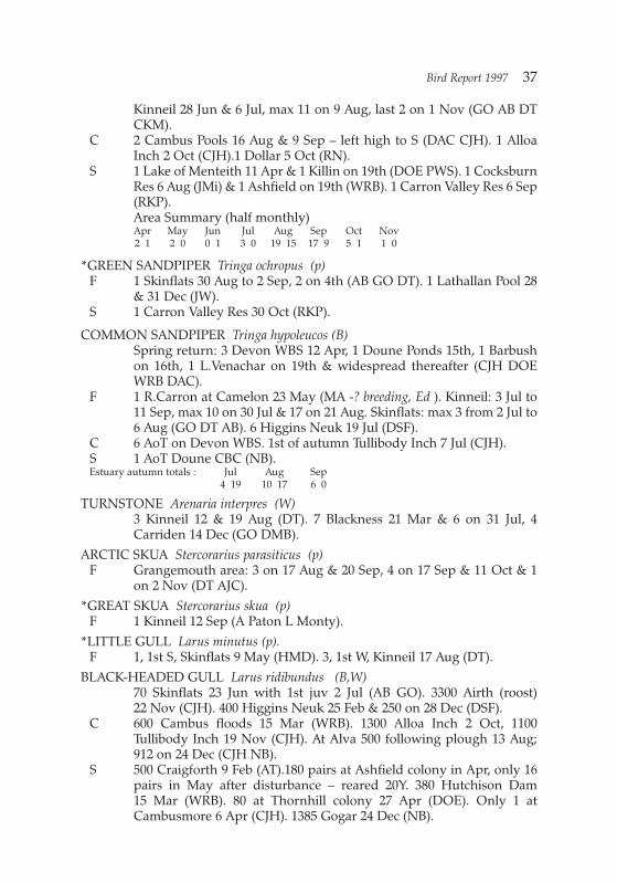
Kinneil 28 Jun & 6 Jul, max 11 on 9 Aug, last 2 on 1 Nov (GO AB DTCKM).
C 2 Cambus Pools 16 Aug & 9 Sep – left high to S (DAC CJH). 1 AlloaInch 2 Oct (CJH).1 Dollar 5 Oct (RN).
S 1 Lake of Menteith 11 Apr & 1 Killin on 19th (DOE PWS). 1 CocksburnRes 6 Aug (JMi) & 1 Ashfield on 19th (WRB). 1 Carron Valley Res 6 Sep(RKP).Area Summary (half monthly)Apr May Jun Jul Aug Sep Oct Nov2 1 2 0 0 1 3 0 19 15 17 9 5 1 1 0
*GREEN SANDPIPER Tringa ochropus (p)F 1 Skinflats 30 Aug to 2 Sep, 2 on 4th (AB GO DT). 1 Lathallan Pool 28
& 31 Dec (JW).S 1 Carron Valley Res 30 Oct (RKP).
COMMON SANDPIPER Tringa hypoleucos (B)Spring return: 3 Devon WBS 12 Apr, 1 Doune Ponds 15th, 1 Barbushon 16th, 1 L.Venachar on 19th & widespread thereafter (CJH DOEWRB DAC).
F 1 R.Carron at Camelon 23 May (MA -? breeding, Ed ). Kinneil: 3 Jul to11 Sep, max 10 on 30 Jul & 17 on 21 Aug. Skinflats: max 3 from 2 Jul to6 Aug (GO DT AB). 6 Higgins Neuk 19 Jul (DSF).
C 6 AoT on Devon WBS. 1st of autumn Tullibody Inch 7 Jul (CJH).S 1 AoT Doune CBC (NB).Estuary autumn totals : Jul Aug Sep
4 19 10 17 6 0
TURNSTONE Arenaria interpres (W)3 Kinneil 12 & 19 Aug (DT). 7 Blackness 21 Mar & 6 on 31 Jul, 4Carriden 14 Dec (GO DMB).
ARCTIC SKUA Stercorarius parasiticus (p)F Grangemouth area: 3 on 17 Aug & 20 Sep, 4 on 17 Sep & 11 Oct & 1
on 2 Nov (DT AJC).*GREAT SKUA Stercorarius skua (p)F 1 Kinneil 12 Sep (A Paton L Monty).
*LITTLE GULL Larus minutus (p).F 1, 1st S, Skinflats 9 May (HMD). 3, 1st W, Kinneil 17 Aug (DT).
BLACK-HEADED GULL Larus ridibundus (B,W)70 Skinflats 23 Jun with 1st juv 2 Jul (AB GO). 3300 Airth (roost)22 Nov (CJH). 400 Higgins Neuk 25 Feb & 250 on 28 Dec (DSF).
C 600 Cambus floods 15 Mar (WRB). 1300 Alloa Inch 2 Oct, 1100Tullibody Inch 19 Nov (CJH). At Alva 500 following plough 13 Aug;912 on 24 Dec (CJH NB).
S 500 Craigforth 9 Feb (AT).180 pairs at Ashfield colony in Apr, only 16pairs in May after disturbance – reared 20Y. 380 Hutchison Dam15 Mar (WRB). 80 at Thornhill colony 27 Apr (DOE). Only 1 atCambusmore 6 Apr (CJH). 1385 Gogar 24 Dec (NB).
Bird Report 1997 37

COMMON GULL Larus canus (B,W)F 400 Higgins Neuk 25 Feb (DSF). 610 Black Loch 4 Sep; 424 Slamannan
4 Mar & 543 on 11 Nov (NB).S 461 Drymen 15 Jan & 1026 on 11 Mar (NB). 600 Cambusmore GP
4 Mar, only 72 by 6 Apr (PWS CJH). 600 Killin 5&6 Mar, 40 (10 nests)Breachlaich Res 29 May (PWS).
LESSER BLACK-BACKED GULL Larus fuscus (b,S)0Few mid-winter records, as usual; increasing nest attempts on roofs;more stayed late into autumn.
F 1 Skinflats 22 Feb, 8 on 27 Dec (GO). 4 Larbert 9 Feb & 6 L.Ellrig on19th (NB-maybe start of spring return, Ed). 3 (1 Pr) Carronmouthcairns 29 Jun (DMB).
C 54 AoT on Menstrie bond roofs 9 Apr (CJH). 100 around Cambus bondin Apr (WRB).
S 1 Arnprior 5 Jan, 1 L.Coulter 14 Jan, 2 Killin on 23rd; 2 Carron ValleyRes 14 Dec & 5 R.Forth on 16th (DAC NB PWS WME AT). 500 Fallintip 24 Aug, on carse of Stirling 400 on 23 Sep, 144 on 21 Oct, 5 on 5 Nov(WRB MT CJH).
HERRING GULL Larus argentatus (b?,S,W)F 4600 Kinneil 29 Dec (CJH). 1200 Higgins Neuk 25 Feb & 1274 on
29 May (DSF).C 2 AoT Menstrie bond roofs 9 Apr (CJH). Nest attempts on roof of
Cambus bond in May (WRB).S 2000 on Fallin tip 24 Aug. Roosting Cambus-Tullibody Inch: 1700 on
28 Aug, & 3400 on 19 Nov (WRB CJH).
ICELAND GULL Larus glaucoidesF 1 (imm, prob. 2nd W) Kinneil 5 Jan (CKM).
GREAT BLACK-BACKED GULL Larus marinus (S,W)Highly under-reported (Ed).
F 100 Kinneil 8 Oct (CKM). 27 Higgins Neuk 19 Jul (DSF). 20 L.Ellrig5 Jan & 10 on 15 Oct (MA NB). 87 Black Loch 5 Jan (MA – v.high inlandcount, Ed)
S 20 Buchlyvie 11 Mar (NB).
KITTIWAKE Rissa tridactyla (P,w)F Skinflats (estuary) 160 left high to E on 2 Nov. 1 ad Kinneil 25 Jul (DT).
SANDWICH TERN Sterna sandvicensis (P)F 440 Blackness 31 Jul & 350 on 3 Aug (GO AB). 200 Carriden 23 Sep
(DMB). 78 Kinneil 11 Sep, last 5 on 10 Oct (GO DT). 71 Higgins Neuk6 Sep (DSF).
COMMON TERN Sterna hirundo (B)F lst, 5 Kinneil 4 May (DT). 125 pairs Grangemouth Docks 10 Jun (DMB).
34 Skinflats 12 Aug flying high W (GO). 12 Higgins Neuk 6 Sep (DSF).
38 C. J. Henty

*ARCTIC TERN Sterna paradisaeaF 2 Higgins Neuk 6 Sep (DSF).
*GUILLEMOT Uria aalge (W)F 2 Kinneil 19 Sep & 1 Skinflats on 29th (AJC GO).
FERAL PIGEON Columba liviaF 80 Bo’ness 27 Oct (CJH).C 40 Menstrie in Dec (BRT). 500 Tullibody 31 Oct. 200 Stirling 4 Nov
(NB).
STOCK DOVE Columba oenas (B,W)Widespread in small numbers, surely much overlooked though BBS recordsonly in farmland, 0.2 per 10 km (Ed)F 36 by R.Carron at Larbert 4 Nov (MA). Max 7 Skinflats Feb-Sep (DT
GO).C Probably 1 AoT on Devon WBS (CJH). 17 Cambus 29 Sep (WRB).
WOODPIGEON Columba palumba (B,W)Greatly underreported. BBS shows 48 per 10 km on farmland, 3x morethan urban or conifer habitats (NB).
F 1900 on brassicas Kinneil 4 Jan (MVB). 100 Skinflats 27 Dec (AB).C Max on Devon WBS 21 on 3 Apr (CJH).S 7 AoT per km sq on Doune CBC (NB). 750 Lecropt 15 Mar (DT). 18 ->S
L.Lubnaig 4 Nov (CJH).
COLLARED DOVE Streptopelia decaocto (B,W)Under-reported, but scarce away from suburbs and large farms (Ed)
F Vagrant to Skinflats, 2 on 31 Aug &12 Sep (GO). C 46 Menstrie on 13 Dec & 44 on 31st (PMA BRT).
1 pair on Doune CBC (NB). 1 Killin 5 Apr & 10 Jun. 4 Glen Dochart(Ledcharrie) 4 Jun (PWS).
CUCKOO Cuculus canorus (B)1st records at Balquhidder on 4 May, Cambushinnie on 11th, Killin on14th & North Third Res on 15th (DOE AT PWS BDA).
BBS shows 8 per 10 km on farmland, 2 in conifers and 3 at moor/conifer edge(NB).
BARN OWL Tyto alba (b,w)S Regular Thornhill Carse Feb to Dec (DR). 1 at Thornhill, Lecropt &
Stirling in Jan-Feb (SS JW WRB). Noted Killin, Callander, Doune,Dunblane (dead), Blairdrummond, Craigforth, L.Watston, Forthbank(PWS DJC SS GO DOE LKM WRB AT).
TAWNY OWL Strix aluco (B,W).C Reported Menstrie, Alva (BRT PMA).S Reported Killin, Balquhidder, Aberfoyle, Lake of Menteith,
W Flanders Moss, Stirling, Buchlyvie (PWS BDA DOE DT DAC).
Bird Report 1997 39

*LONG-EARED OWL Asio otus (b,w)F 2 Ad +2Y Skinflats 5 -26 May (GO BDA AB)C 1 Cambus 22 Jun (PMA).S 2Y heard Drip Carse14 Jul (WRB). Seen hunting Thornhill Carse
(Frew) Jun & Jul, Y heard from 4 Aug with 3 on 12th, 1 on 23 Sep (DRMT).
SHORT-EARED OWL Asio flammeus (b,W)F Kinneil: 1 on 18 Jan, 1 on 9 Feb & 3 on 22nd to 28 Apr, 1 on 10 Nov. 1
Skinflats 15 & 22 Feb (AS GO BDA DT). S 1 Cringate Muir 26 Jun (GO). 1 Carron Valley Forest 1 Aug (RKP). 1
Invertrossachs 17 Jul (DOE). 1 Braeleny 30 May (CJH). 1 ThornhillCarse 8 Jan & 6 Mar (DR). 2 Thornhill 2 Oct (SS).
SWIFT Apus apus (B)1st records: Stirling (10) & Buchlyvie on 5 May, Dunblane on 6th,Airthrey on 7th, Alva on 9th, Ashfield on 10th (DT DAC NB DMBPMA). Last August records Dunblane on 7th, Ashfield & Killin (30) on8th, Alva & Kinneil on 12th, BoA on 13th, Stirling on 28th (NB WRBPMS PMA DT CJH). 2 Cambusbarron 6 Sep (DAC).
F 150 over Kinneil woods 14 Jun (DT).S Arrival at Killin 18 May (PWS). Max in July: 55 BoA 24th (CJH), 30
Dunblane 26th (NB). 45 BoA 3 Aug circled round a Sparrowhawk, thesingle Swift at Stirling on 28th was chased by one (CJH DT).
KINGFISHER Alcedo atthis (b,w)F 1 Skinflats 18 Jan & 2 on 2 Nov; 1 Kinneil 23 Nov to 26 Dec (GO MVB
DSF DT M&JC). 1 on Avon at Grangemouth 23 & 25 Sep (AS). 1 onUnion Canal at Maddiston 14 Dec (JW). 2 pairs on Carron at Larbertall year, one burrow seen & two broods (5J) in Jun (MA).
C 2 on Devon at Alva 10 Sep (GEL). 1 Tullibody 25 Oct (WRB).S 1 Killin 15 Sep (PWS). 3 Balquhidder 9 Jul. 1 L.Lubnaig 15 Sep &
28 Nov. 1 Callander 9 Feb, 26 Aug, 21 Oct (WRB DOE DJC D WarnockDAC). 1 Sheriffmuir 8 Feb & on R.Allan at BoA 23 Aug (BB CJH); atAshfield 14 Feb & 9 Sep (WRB). 1 Stirling 16 Dec (AT).
GREEN WOODPECKER Picus viridis (B,W)F 1 Torwood 7 Apr (AB).C 2 AoT Menstrie in Apr (CJH).S In spring/summer many reports from L.Ard Forest (2AoT) through
Callander to BoA; also North Third Res, Plean CP.GREAT SPOTTED WOODPECKER Dendrocopus major (B,W)F F+Juv Falkirk in Jul & Aug (JW). M Larbert in Jan/Feb. 1 Denny 4 Jan
& Fankerton on 5th, Bonnybridge on 19 Nov (DT MA MC).M Skinflats 15 Feb , 23 Oct to 3 Dec (GO).
C Through year at Alva, Juv in Jul-Aug (PMA). 1 on Devon WBS 25 Maywas 1st in 3 years (CJH).In spring/summer many reports from L.Ard Forest through Callanderto BoA; also Plean CP.
40 C. J. Henty
SKYLARK Alauda arvensis (B,W)F 280 Kinneil 2 Jan (DT). Singing Skinflats 6 Mar, Higgins Neuk on 18th
(AB DSF). C 11 AoT on Devon WBS (CJH). S 9 AoT per sq Km on Doune CBC, x2.5 1996 (NB). Widespread and
frequent Braeleny-A’Chroin 30 May (CJH). Song Cambuskenneth9 Feb. 30 Kippen 9 Mar, 34 Forthbank 15 Dec (HK AT). 40 ->W Lecropt4 Oct & 50 ->SW on 17th. 10 ->S BoA 7 Oct (DT CJH). 60 ThornhillCarse 2 Nov & 102 (2nd site) on 8th (DOE SS).
SAND MARTIN Riparia riparia (B)1st records: 15 Lake of Menteith & 1 Airthrey 3 Apr, 1 Skinflats & 20L.Voil on 12th, 13 Barbush on 13th, 12 BoA on 16th (DOE MVB DACWRB AT). Last 4 Ashfield 4 Sep, some Cambus on 5th (WRB CJH).
F 31 -> E Skinflats 15 Aug (GO). C Probably over 100 in huge Swallow flock at Cambus 28 Aug (CJH)S 200 L.Dochart 20 May (PWS). 35 nests Inverlochlarig 15 Jul (WRB).
SWALLOW Hirundo rustica (B)1st records: Falkirk on 7 & 9 Apr, Skinflats & Lake of Menteith on 11th, Doune,
Strathyre & Killin on 12th, BoA & Carron Valley Res on 13th, Alva &Buchlyvie on 14th. Last in late October: Larbert, Gargunnock &Stronend on 21st, Falkirk on 22nd, Airthrey on 24th, Callander on25th, Blackness (6) on 27th, Alva on 28th (MA GO DOE DAC PWSDMB CJH PMA DJC).
F 12->W Kinneil 27 Apr & 100->W on 25 Aug (DT).C Immense roost in Forth reedbed upstream of Cambus, assembling
after sunset: 13,000 on 28 Aug & 14,000 on 31st, 13,500 on 5 Sep (CJH). S 7 AoT per sq km on Doune CBC, as 1996 (NB). 200 at roost Doune
Ponds 6 Aug, 300 on 30th & 1000 on 15 Sep (DOE).HOUSE MARTIN Delichon urbica (B)
1st records: 5 BoA 16 Apr, 3 L.Venachar on 19th, Carronshore on 22nd; next reported were 3 Airth 4 May, Skinflats on 5th, Doune on 6th &Lake of Menteith on 7th; arrived Killin 14 May (AT DAC AB DT GONB DOE PWS). Early departure, last 120 Dunblane 26 Sep (MVB)
S 3 nests per sq km on Doune CBC, 20 % of 1994-5 average (NB). 12nests Ashfield, increase (WRB).
TREE PIPIT Anthus trivialis (B)1st records: 3 in song Aberfoyle on 27 Apr, 1 L.Katrine on 30th, 2Rhuveag on 5 May (BDA DAC DT).
S 6 Glen Lochay 16 Jul (WRB), still in L.Ard Forest 12 Aug (CJH).MEADOW PIPIT Anthus pratensis (B,W)
BBS shows 93 per 10 km in moor/conifer edge, 73 on moorland,13 inconifers & 0.4 on farmland.
F Song Skinflats 23 Mar, 20 on 11 Apr; 60 on 20 Sep (AB DT).On lower Devon to 12 Apr, return 13 Aug (CJH).
Bird Report 1997 41

S Return to Cock Hill 6 Mar (CJH). 20 Killin 2 Apr, 100 on 4 Sep (PWS).13 in 70 min Ben Bhreac (L.Ard Forest) 23 May, frequent Braeleny -A’Chroin on 30th. 250 Sheriffmuir 30 Aug, still frequent 18 Sep (MVBCJH).
*ROCK PIPIT Anthus petrosus (w)F Kinneil: 1 on 2nd Jan & 2 on 11th; 1 on 1 & 30 Nov (DT GO DMB). 1
Blackness 18 Oct (CJH).GREY WAGTAIL Motacilla cinerea (B,w)
Winter records Jan-Feb: R.Devon, Alva; Nov-Dec: Gart, R.Devon,Alva, Cocksburn Res, Manorneuk, R.Carron (Larbert, 6 on 15 Dec)Forth-Clyde Canal (GEL PMA AT MA NB DM).Average breeding population, after poor 1996 (HR). 1 pair Doune CBC(NB). Summer records at 8 sites Trossachs (1st juv seen 10 May) &Hillfoots (DAC AT). Pair on R.Avon, Grangemouth, 6 Apr (AS).
PIED WAGTAIL Motacilla alba (B, w)F 5 Grangemouth 17 Jan (AT). White Wagtails M.a.alba : 1 Glen Finglas
13 Apr (DOE).C 3 AoT on Devon WBS (CJH).S 5 inland records in Jan-Feb, Buchlyvie-Stirling (DAC AT). 5 AoT per sq
km Doune CBC, 1st juv seen 4 Jun (NB). 28 Barbush 10 Sep, 14Buchlyvie 16 Nov (WRB DAC).
WAXWING Bombycilla garrulusF 8 Aberfoyle 29 Jan to 16 Feb (DOE DAC). 1 Stirling 10 & 28 Jan, then
50 St Ninians 12 Feb (DSF) & 25 nearby 16th to 21st (DAC); 27Springkerse 22 & 23 Feb (DT GO).
DIPPER Cinclus cinclus (B,W)The WEBS data total 23 records for January but only 3 in February and1 in March (NB), this shows an early spring departure to breedingterritories though many of them are occupied through the winter(DAC AD DJC); note that some records are from lower stretches ofDevon & Allan where Dippers do not breed (Ed). In Dec at least 19 on3 river sections of WEBS circuit.
F 2 in Apr & Sep on R.Avon at Birkhill, 2 km above tidal limit (AS). ?Lowest breeding pair on Avon (Ed). 3 pairs in Jan on Carron ( MA –about 4 km above tidal limit).
S 1 pair on Doune CBC, 1st juv seen 7 May (NB). Average siteoccupancy in Trossachs (HR). Nested in outflow pipe of L.Katrineweir (DAC).
WREN Troglodytes troglodytes (B,W)Under-recorded (Ed). BBS shows 42 per 10 km in conifers, 19 onfarmland & 11 in ‘Urban’.
C 11 AoT on 5 Km of lower Devon, much as 1996 (CJH).3 AoT per sq Km Doune CBC (NB). In Dec still at head of Gleann anDubh Corrie (DJC). In Mine Wood on 1 Dec 2M were countersingingin dark, 40 min after sunset (AT).
42 C. J. Henty

HEDGE SPARROW Accentor modularis (B,W)Under-recorded (Ed).BBS shows 11 per 10 km in ‘Urban’, 10 inmoor/conifer edge, 4 in conifers & 3 in farmland.
C 5 AoT on 5 km of lower Devon, much as 1996 (CJH).S 6 pair per sq km on Doune CBC (85 % of 1996). 1 at Dunblane 27 Aug
bathed in rain runoff from eaves (NB).
ROBIN Erithacus rubecula (B,W)Under-recorded (Ed). BBS shows 21 per 10 km in conifers, 8 onfarmland & 15 in ‘Urban’.
C 2 AoT on 5 km of lower Devon (2 in 1996) (CJH).S 4 pairs per sq Km on Doune CBC, much as 1996, 1st juv seen 4 Jun
(NB). Autumn song at Airthrey from 6 Aug, sang at night on 18 Jan(CJH AT).
REDSTART Phoenicurus phoenicurus (B)1st records 1 (F) L.Katrine on 30 Apr, 4 Balquhidder 3 May (DAC BDA).In Aug 2 juv in heather at Invertrossachs on 3rd & a M Alva on 25thwould have left breeding territories (DAC PMA).
S 44 nest attempts at Trossachs colony produced 240 Y, number of pairsup 50 % (HR). F with Juv Buchlyvie 10 Aug was 1st record in 4 years(suggests local breeding, Ed) (DAC).
WHINCHAT Saxicola rubetra (B)BBS shows 5 per 10 km in conifers, 4 on moorland & 1 on farmland.1st records: 2 BoA 20 Apr; 1 Balquhidder on 3 May & 2 Glen Buckie on5th (AT BDA DT). Autumn migrants: 2 Kinneil 30 Aug, 1 Higgins Neukon 6 Sep & 2 Skinflats on 13th (DMB DSF DAC).
S 8 pairs Braes of Doune (Drumloist) 12 May (DOE), c10 Inverlochlarig18 Jul (DT), widespread Braeleny-A’Chroin 30 May. However scarceon heather Ben Bhreac (L.Ard Forest) 23 May (CJH).
*STONECHAT Saxicola torquata (b,w)Breeding population seems very small (Ed).
F 1 L.Ellrig 23 Nov (BDA).S M Doune Ponds 5 Apr & M Flanders Moss on 19th (AD SS). Pair Glen
Finglas 5 Oct & M on 25 Nov. 2 Cocksburn on 29 Oct. Pair Braeleny11 Nov (DMB AT DJC).
WHEATEAR Oenanthe oenanthe (B)BBS shows 7 per 10 km on moorland & 3 in moor/conifer edge.M Barbush 16 Mar – very early (WRB). Most 1st records in April: 1
Braeval on 6th, Earlsburn Res on 5th, 14 Kinneil on 6th, Inverlochlarig& Glen Finglas on 12th; on estuary to 9 May with 4 Bandeath on 4th& 3 Skinflats on 5th. (DT MT DAC SS DMB GO). Autumn migrants atKinneil & Skinflats included 6 on 30 Sep & 1 on 5 Oct (DSF DT).
S 20 pairs Inverlochlarig 2 Aug (DOE). 2 AoT Braeleny 30 May, 2 pairs +juvs Glen Lochay 16 Jul (CJH WRB).
Bird Report 1997 43

*RING OUSEL Turdus torquatus (b)S 1 Monachyle Glen 21 Apr & 1 Cruach Ardrain on 25th (AD DOE). 5
Rhuveag 5 May (DT). 2 M Ben Each 15 Jun & anxious pair Glen Ogle(DMB DOE).
BLACKBIRD Turdus merula (B,W)BBS shows 113 per 10 km in ‘Urban’, 16 on farmland & 10 in conifers.
C 8 AoT on 5 km of lower Devon, 9 in 1996 (CJH).S 13 pairs per sq km on Doune CBC, 72 % of 1996, 1st juv seen 6 May
(NB).
FIELDFARE Turdus pilaris (W)Spring departure ceased early and included 55 Plean CP & 200Thornhill 29 Mar & 125 Trossachs on 30th, 110 Cocksburn 6 Apr & 40Stronend on 8th (DT JS HR AT DAC). 1st of autumn 5 Kinneil 5 Oct, then 200 ->SW Lecropt on 17th, 12Gargunnock on 18th & 320 Cambus on 19th. Large parties widespreadto mid Nov, max 700 Thornhill Carse 23 Oct, 3000 Flanders Moss2 Nov & 500 Slamannan 15 Nov. Visible movement included flights toeast: 40 Dunipace 23 Oct & 260 Callander 4 Nov. In Dec only 120 Alvaon 24th (AB DT DAC CJH DOE MVB WRB NB PMA).
F 18 on shore Bo’ness 2 Jan (AS). 210 Skinflats 1 Jan (MVB).S 220 Kippen 9 Feb (DAC).
SONG THRUSH Turdus philomelos (B,W)BBS shows 12 per 10 km in conifers, 7 farmland, & 6 ‘Urban’. Few inmid-winter – 1 BoA 28 Nov (AT).
F Numerous, with Blackbirds, Skinflats 28 Sep – presumed migrants(AB).
C 2 AoT in 5 Km lower Devon, 1 in 1995 (CJH).Regular in Stirling garden from 16 Feb, juvs seen 8 Jun but one strucka window and another predated (RJ). By contrast, 1 in Grangemouthgarden 3 Jul was “a very rare bird !” (GO).
REDWING Turdus iliacus (W)1st of autumn 2 Doune 25 Sep & 3->SW Airthrey on 30th, then nonetill 20 Tullibody Inch 13 Oct & 16 Skinflats on 14th.Large partieswidespread from 19 Oct, max 400 Flanders Moss 2 Nov & 200Slamannan on 15th. Visible movement: 100->SW Lecropt 17 Oct; on4 Nov 100->E Callander & 95 ->E Cromlix. Much scarcer throughDecember – 102 Cambus on 27th (DOE DMB CJH GO WRB BRT).
S Flocks of 20 to 50 in Jan & Feb (DJC MVB), none March.
MISTLE THRUSH Turdus viscivorus (B,W)Under-recorded. BBS shows 3 per 10 km in conifers but none in‘Urban’.
S 1 AoT Plean CP 19 Apr (AB). 33 L.Dhu (Rusky) 7 Aug (AT), 60 Braes ofDoune 4 Oct (DOE). Scarce in winter – 1 Menstrie 2 Jan & 1Balquhidder 28 Nov (BRT DJC).
44 C. J. Henty

GRASSHOPPER WARBLER Locustella naevia (b)More this year.
F 1 Skinflats 30 Apr to 15 Jul. 1 Kinneil 14 Jun to 10 Aug (AB BDA GODT).
C 3 singing Devon WBS 30 Apr then none to 17 Jun (CJH). Song atCambus Pools 9 Aug (WRB).
S 1Aberfoyle 2 May (DAC). 3 Flanders Moss 15 May (TJ). 2Inverlochlarig 18 Jul & 1 at two other sites Balquhidder 19 & 26 Jul (DTWRB). 3 Drip carse 14 Jul & 1 Gartmore on 21st (WRB).
SEDGE WARBLER Acrocephalus schoenobaenus (B)F 1 Kinneil on 3 May & 3 on 4th; last 1 on 7 Sep (GO DT).C 2 AoT Cambus, last on 24 Aug (CJH WRB). 54 AoT on Devon WBS,
none on 30 Apr but 70% arrived by 10 May, still 2 arriving 11 Jun; last6 on 13 Aug (CJH). 3 Aberfoyle & M Ashfield 10 May (DAC WRB).1 AoT Doune CBC from19 May (NB). Bred L.Dhu (Rusky) (AT).
LESSER WHITETHROAT Sylvia currucaF 1 Skinflats, with Willow Warblers, 3 Aug (DT).
WHITETHROAT Sylvia communis (B)BBS shows 6 per 10 km in ‘Urban’, 2 on farmland & 1 in conifers.1st record a very early bird Brig o’Turk 13 Apr (DOE), most in May:Bandeath & Plean on 4th, Doune on 5th (DMB DT NB).
F Bred Skinflats, last 2 on 20 Sep (AB DT). 1 Kinneil 20 Sep (DAC)C 9 AoT on Devon WBS (as 1996), none on 30 Apr but 6 by 10 May; last
5 on 13 Aug (CJH).SWP 5 pairs per sq km Doune CBC, as 1996; 1st juv on 23 Jun (NB).
GARDEN WARBLER Sylvia borin (B)1st records in May: Bridge of Allan & Lake of Menteith on 7th,R.Devon (all AoT) on 10th, Braes of Doune on 12th (AT DOE CJH).
C 5 AoT Devon WBS (CJH).
BLACKCAP Sylvia atricapilla (B)Under-recorded as breeder (Ed)
Winter records: F Alva 1 Jan, F Falkirk 21 Dec (PMA JW).F F Grangemouth 25 Sep (GO), 1 Skinflats 17 & 28 Sep (AB). M Bo’ness
3 Nov (AS).C 1st Cambus 20 Apr (DMB). M Alva 4 & 21 Oct (PMA).S M Blairlogie 15 Apr (DAC). 1 AoT Doune CBC from 7 May (NB).
WOOD WARBLER Phylloscopus sibilatrix (B)1 L.Katrine 30 Apr, other 1st records in May: 2 Balquhidder on 5th,BoA (3) on 7th, L.Ard(Doon Hill, 6) on 9th, L.Ard Forest (Couligart) on12th, 1 Howierigg on 14th (DAC DT AT DOE MA).
CHIFFCHAFF Phylloscopus collybita (B)1st records in March: Alva 15th, BoA 17th, Blairlogie 20th, Lake ofMenteith 22nd, Carriden 23rd, Grangemouth 25th, Stirling 27th,
Bird Report 1997 45
Larbert & Plean CP 29th (PMA AT MA DAC AS GO DT). Last, 1Grangemouth 25 Sep & 2 Ashfield on 29th, 1 Plean CP 19 Oct (GOWRB AB).
WILLOW WARBLER Phylloscopus trochilus (B)1st records in April: 1 Doune Ponds & Lake of Menteith on 8th,Skinflats & Buchlyvie on 11th, Ashfield (3), Menteith Hills (6) andDevon WBS (4) on 12th, Stirling & Kinneil & Gartmorn Dam(10) on14th (DOE GO DAC WRB DT CJH RJ PMA). Autumn dispersal notedwith juvs in Stirling garden from 6 Jul, 15 Skinflats on 3 Aug & 16Cambus Pools on 8th, 100 Killin 15 Sep. Last Buchlyvie & Stirling 21Sep(RJ DT DSF PWS DAC).
BBS shows 107 per 10 km in conifers, 21 in farmland (NB).C 14 AoT on 5 km of lower Devon, 12 in 1996 (CJH).S 9 pairs per sq km on Doune CBC, as 1996 (NB).
GOLDCREST Regulus regulus (B,W)Greatly under-recorded (Ed). BBS shows 44 per 10 km in conifers, 3 onfarmland (NB).
F Through year at Skinflats (AB).1 Kinneil 16 Sep & 31 Dec (GO BDA).S Regular in Stirling garden Sep, Nov, Dec (RJ).
SPOTTED FLYCATCHER Muscicapa striata (B)Under-recorded (Ed). Scarce in BBS, 0.7 per 10 km, only in farmland(NB).1st records: in May, Gartmore 11th, Ashfield 12th, Alva 28th &Buchlyvie 30th ; (DAC WRB PMA). Last, 1 Skinflats 6 Sep (BDA).
S In summer also at Killin, L.Ard Forest, Aberfoyle, Balquhidder(Inverlochlarig & Rhuveag), Plean CP (PWS CJH DAC JMi DT WRBAB).
PIED FLYCATCHER Ficedula hypoleuca (b)1st records: L.Ard Forest 27 Apr, Balquhidder (Rhuveag 5) on 3 May,L.Katrine on 10th (DOE BDA DAC).
S 62 nest attempts at Trossachs colony, 320 Y reared, another 6 nestsproduced 29 Y (HR). F Killin 18 May (PWS).
LONG-TAILED TIT Aegithalos caudatus (B,W)F 28 Bo’ness 17 Nov & 26 on 21st (AS). 4 Kinneil 4 Nov & 7 on 21 Dec
(GO BDA).C 15 Cambus Pools 20 Dec (WRB).S 17 Loch Ard Forest 26 Aug; 12 L.Venachar 23 Nov (CJH). 13 Callander
7 Oct; 17 Brig o’Turk 25 Nov (DJC). Max 8 Stirling 6 Oct (RJ), 13Riverside 10 Nov & 16 Forthbank 15 Dec (AT).1 AoT on Doune CBC(NB).
COAL TIT Parus ater (B,W)Greatly under-recorded (Ed). BBS shows 44 records per 10 km inconifers, 3 on farmland (NB).
F In Nov/Dec almost as common as Blue Tits in Polmont (JW) – but in
46 C. J. Henty

Grangemouth 3 in garden 29 Sep was “big count” (GO).S At Glenartney col on 19 Sep, 6 with Blue Tits in a small plantation flew
off W toward Callendar (CJH).
BLUE TIT Parus caeruleus (B,W)Under-recorded (Ed). BBS shows 35 per 10 km in ‘urban’ squares, 26on farmland & 17 in conifers.
C 9 Menstrie 2 Jan (BRT). 10 in Alva garden Jan to Feb (PMA). 7 AoT on5 Km of lower Devon, 4 in 1996 (CJH).
S 50 Dunblane 17 Jul (MVB). 7 pair per sq km on Doune CBC, 12 in 1996(NB). Breeding population in Trossachs up 200 % on 1996 (HR).
GREAT TIT Parus major (B,W)Under-recorded (Ed). BBS shows 18 per 10 km in conifers, 14 onfarmland and 8 in ‘Urban’ squares.
C 5 AoT on 5 km of lower Devon, 2 in 1996(CJH).S Singing in mild weather 13 Jan & 28 Nov (AT). 7 AoT per sq km on
Doune CBC, 8.5 in 1996 (NB). Breeding population in Trossachs up150 % on 1996 (HR).
TREECREEPER Certhia familiaris (B,W)Under-recorded (Ed). BBS shows 1 per 10 km on farmland.Recorded from Bo’ness, Skinflats, Callander, Leny (AS GO DJC). Pairnested in willow by Carron at Camelon, 5Y fledged 23 May (MA).
JAY Garrulus glandarius (B,W)BBS records largely from conifers, 2 per 10km.
F All year at Torwood (AB) – continuous with range around Stirling(Ed).
C Recorded Alva in Jun & Dec, Gartmorn/Fishcross in Jan-Feb (PMA).S Recorded from some 24 sites from Killin & L.Ard Forest to Blairlogie
& North Third; no records from north edge of Gargunnocks. Max 12Strathyre 16 Sep (AT).
MAGPIE Pica pica (B,W)Its abundance around Stirling is not necessarily noted in the west andeast of the area (Ed). BBS shows 33 per 10 km in ‘urban’ squares, 5 infarmland & 1 in conifers.
F 5 Skinflats 21 Feb & 30 Mar (GO AB). 8 Larbert 12 Dec (NB).C 3 AoT on 5 km of lower Devon, 4 in 1996 (CJH).S 20 Lecropt 9 Nov, 20 BoA 10 Sep, 13 Forthbank 14 Dec (DT CJH AT),
but roost numbers higher: 44 Airthrey 27 Feb & 35 on 10 Dec (MVB).1 AoT on Doune CBC (NB). 2 Sheriffmuir 18 Sep, in conifers at 230m.1 Blairdrummond 26 Sep & 1 nearby on 14 May were both firstrecords for NB & CJH. At W end of range, 3 Kippen 11 Apr &1 Lake ofMenteith 19 Mar (NB).
JACKDAW Corvus monedula (B,W)An overlooked species, about 5 reports (Ed). BBS shows highestfrequency in urban areas.
Bird Report 1997 47

S 400 Killin 21 Jan (PWS). Max 200 on roost flight Callander 29 Oct(DJC). 100 BoA 28 Nov (AT). 4 pair per sq km on Doune CBC, as 1996;1st juvs 23 Jun (NB).
ROOK Corvus frugilegus (B,W)Rookery counts: BoA(N) 25 in decid, 122 in pines; BoA(S) 161; WitchesCraig 55; Myretoun 65; 58 Menstrie nursery (new in 1996). Total 486(522 in 1996) (CJH). Survey of 72 rookeries in Stirling district counted2134 nests; largest 173 Buchlyvie & 171 Craigforth (NB).
CARRION CROW Corvus corone (B,W)Possibly the most widespread species: BBS shows 59 per 10 km in‘Urban’ squares, 38 in farmland & 37 on moorland.
F 143 Kinneil 3 May, feeding on musselbank (GO).C 40 Cambus Pools 19 Jul (CJH).S 6 AoT per km sq at Doune CBC (NB). Birds with white wingstripes
seen Riverside 10 Nov & 16 Dec (AT). Hoodies: 9 records (includinghybrids) were from the usual breeding range N & W of Lake ofMenteith (DAC DJC), plus 1 Kippen 18 Jan & 1 L.Mahaick 2 Nov (NBDOE).
RAVEN Corvus corax (B,W)S 15 territories checked, 11 pairs, 8 successful pairs of which 3 raised 11Y
(PSA). 18 Glen Artney col 11 Nov & 14 Meall na Iolaire 12 Dec (DJC).Outwith of immediate breeding areas: 1 L.Ard Forest 25 Aug, 1 Lakeof Menteith 25 Oct (DT CJH). 2 Earls Hill 2 Aug (CJM).
STARLING Sturnus vulgaris (B,W)Greatly underreported (Ed). BBS show most frequent in ‘Urban’squares.
F Post breeding arrival at Kinneil, 150 on 14 Jun (DT). 1220 KincardineBridge roost 26 Oct & 1550 on 7 Nov (CJH).
C Roosts: Cambus Haugh reedbed 5700 on 28 Aug; Tullibody Inch 2700on 27 Sep & 13 Oct (CJH).
S 11 AoT per sq km on Doune CBC, 16 in 1996; fledglings from 4 Jun(NB).
HOUSE SPARROW Passer domesticus (B,W)Under-recorded (Ed). BBS shows mainly in ‘Urban’ areas.
F 60 Higgins Neuk 25 Sep (DSF). 30 Dunipace 6 Nov (CJH).S 14 pairs per sq km on Doune CBC as 1996; fledglings from 21 May
(NB). 35 Ashfield 2 Aug (WRB). 30 Killin 9 Aug (PWS).
TREE SPARROW Passer montanus (B,W)F 5 by R.Carron at Larbert 29 Mar (GO JMr). 4 Maddiston 14 to 30 Dec
(JW). 1 Grangemouth 6 Oct – “great tick on feeder” (GO).C 3 Cambus 19 Sep (WRB).S Lecropt: max 60 on 2 Jan to 13 on 15 Mar; 15 on 9 Nov, max 40 on 13
Dec (WRB DT AD DAC CJM). 20 Blairdrummond Carse 20 Dec. 1Arnprior 21 Sep (DAC). 15 Cambuskenneth 10 Mar (AT).
48 C. J. Henty

CHAFFINCH Fringilla coelebs (B,W)BBS shows 75 per 10 km in conifers, 51 on farmland & 25 in ‘Urban’squares.
F 230 Drumbowie 11 Nov (NB); 50 Skinflats 27 Dec (AB).C 13 AoT on lower Devon in May, 16 in 1996 (CJH).S 28 pairs per sq km on Doune CBC, 34 in 1996 (NB). 250 Kippen & 300
Thornhill 2 Nov; 300 Doune 29 Nov (DOE). 600 Argaty 221 Dec(WRB). 2000 Kinbuck 23 Nov (MVB).
BRAMBLING Fringilla montifringilla (W)F 12 Avonbridge 4 Mar (MA). S 600 Kinbuck on 3 Jan, only 5 on 23 Nov (MVB). 15 L.Lubnaig 11 Jan &
90 (under Oak-Beech) L.Voil on 28th (RB NB). 18 L.Venachar 9 Feb &29 Glen Tye on 13th (WRB DSF). Scarce in autumn: earliest 1 GlenFinglas 9 Oct (DMB), 5 Kinbuck 23 Nov (MVB).
GREENFINCH Carduelis chloris (B,W)Underrecorded. BBS shows 39 per 10 km in ‘Urban’ squares, 3 infarmland & in conifers.
F 35 Skinflats 5 Aug & 50 from 16th to 31st; 50 on 27 Dec (DT AB). Max8 at feeder Bo’ness Jan-May & Dec (AS).160 Cambuskenneth 10 Jan (CJH). 150 Kinbuck 28 Sep (MVB). 40L.Watston 12 Dec & 50 Thornhill (rape stubble) on 16th (CJH NB).
GOLDFINCH Carduelis carduelis (B,W)BBS shows 6 per 10 km in farmland and 5 in ‘Urban” squares.
F 18 Kinneil 2 Jan & 25 on 5 Oct (DT). 12 Skinflats 22 Feb, 15 on 22 Apr& 18 on 17 Sep (DAC GO). 120 on saltmarsh Kincardine Bridge 14 Dec(MVB). 18 Larbert 4 Jan; 30 Camelon 1 Oct (MA). 16 Polmont 21 Dec(resident flock JW).
C 4 AoT on Devon WBS, 3 in 1996. 20 Menstrie 8 Jan & 21 on Burdockon 29 Dec (PMA BRT).
S 2 pairs per sq km on Doune CBC, 2 in 1996 (NB). 130 Kinbuck 12 Jan(MVB). 10 Killin 17 Mar (PWS).16 Braes of Doune 29 Jan & 40 on 4 Oct.15 L.Venachar 8 Oct & 23 Keltie Glen on 20th (DOE DJC). 120Thornhill in uncut Rape 8 Oct (NB).
SISKIN Carduelis spinus (B,W)BBS shows 34 per 10 km in conifers, 2 on farmland.
F 28 Wallacebank Wood 20 Aug (AS). 15 Grangemouth 26 Sep wasgarden record (GO). 100 on Knapweed at Union Canal 20 & 21 Sep(JW).
C 30 Alva 7 Aug to 30 Sep (PMA). Many parties Gartmorn 11 Sep (CJH).S lst of winter at Stirling feeder on 22 Jan, a few to end Feb (RJ). 120
Balquhidder (Kirkton) 1 Jan, 30 L.Lubnaig on 11th (WRB RB). 60Doune 16 Feb (DOE). Abundant Carron Valley Res 13 Apr, 30 on 10Sep. 30 Port of Menteith 2 Jul, 20 Glen Lochay on 16th & 24Inverlochlarig on 18th (CJH WRB DT). 200 Kippen 1 Aug (AT). 55 inBeech at BoA 8 Aug & 130 Airthrey on 11th (CJH MVB). 200 in Rapestubble at Thornhill 10 Sep (M Evans).
Bird Report 1997 49

LINNET Carduelis cannabina (B,W)BBS shows 5 per 10 km on moorland, 4 in conifers, 3 on farmland & 2in ‘Urban’.
F 100 Skinflats 31 Aug & 60 on 27 Dec (DT AB). 20 Higgins Neuk 6 Sep(DSF). 18 on shore Bo’ness 31 Dec (AS).
C 70 Menstrie 2 Jan (BRT).3 AoT on Doune CBC, 1 in 1996 (NB).10 AoT Braes Doune (Drumloist)12 May (DOE). 650 on uncut Rape at Thornhill 8 Oct & 300 on thestubble 17 Dec (NB). 1200 Thornhill Carse 9 Nov (MVB).120 Lanrick &200 Kinbuck 28 Sep, 100 in stubble L.Watston 12 Dec (DOE MVB CJH)
TWITE Carduelis flavirostris (b,W)BBS shows 1 per 10 km on moorland.
F 10 Kinneil 2 Jan & 1 on 13 Oct (DT AB). 100 Kincardine Bridge 14 Dec(MVB).
C 1 with Linnets Menstrie 2 Jan (BRT).Spring/summer reports from Inverlochlarig (20), Glen Buckie,Aberfoyle, Braeleny, Stuc a’Chroin (CJH DT DOE SS). 120 Kippenrait6 Jan (RB). 400 Kinbuck on 3 Jan to 41 on 23 Mar, 300 on 1 Nov (MVBNB). 25 Glenartney col 19 Sep & 1 Stronend on 25th (CJH DOE).
REDPOLL Carduelis flammea (B,W)BBS shows 17 per 10 km in conifers.
F 3 in Bo’ness garden 31 Jan (AS). 4 Union Canal 20 Sep (JW). 5 Kinneil6 Nov (GO), of 15 on 14 Dec 10 were typical C.f.cabaret but 5 showedfeatures of C.f.flammea with paler plumage (especially below), streakedwhitish rumps & bulkier with deeper calls (DMB).
C 10 on Tansy at Cambus 27 Dec (BRT).S Several displaying groups Carron Valley Res 13 Apr (CJH). 35
Inverlochlarig 18 Jul (DT). 16 Dunblane 22 Jan (AT).
COMMON CROSSBILL Loxia curvirostra (b,W)BBS shows 14 per 10 km in conifers
S 15 Flanders Moss, near Ward Toll, 3 Jan (DT). Widespread L.Ard Forest9 Feb, 2 families 9 Apr, 15 on 18 Jul & 5 on 21st 5 km to S (CJH DOEWRB). 6 Aberfoyle 14 Feb & 2 families on 6 Apr (DOE). Song at CarronValley Forest in early spring,13 on 21 Oct (DJB GO). 35 L.Rusky 9 Nov.3 North Third 15 May. 11BoA 6 Jun to 5 on 12 Jul. 12 Braes of Doune28 Sep & 23 Oct. 8 Dunblane 21 Oct & 5 on 13 Nov (MVB BDA CJHDMB DOE).
COMMON ROSEFINCH Carpodacus erythrinusS An adult male singing at Inverlochlarig (Balquhidder) 22 Jun to 14 Jul.
The bird was found and identified by D Greenwood and reported toBirdline Scotland, who have supplied the dates. It was seen by manyobservers but the only description is from GO (5 Jul) who noted thescarlet red head nape, throat, breast and rump; upperparts dulloatmeal brown with prominent rusty-brown double wing bar, heavy& slate coloured bill, dark eye, pale straw legs. This is the first record
50 C. J. Henty

for the area. The species is a late migrant and seems to be slowlycolonising the UK after a prolonged westward spread throughnorthern Europe. At this stage in an expansion of range it is typical formales to appear and sing but fail to find mates.
BULLFINCH Pyrrhula pyrrhula (B,W)BBS shows 4 per 10 km in conifers & 2 on farmland.
Widespread in groups less than ten.C 10 Upper Glendevon* 29 Jan (MA).
In spring at Stirling fed on buds of Greengage, Amelanchier, Apple(RJ). 9 Glen Tye* 13 Feb (DSF). 11 Doune 16 Sep, 12 L.Ard Forest 15 Oct(DOE DJC). *exposed high ground in midwinter.
*SNOW BUNTING Plectrophenax nivalis (W)C F/Imm Bengengie 29 Jan (MA).S 5 Craigmore (Aberfoyle) 14 Feb (DOE). 2 Glen Lochay 23 Nov &
1 Glen Buckie on 30th (DMB DT).
YELLOWHAMMER Emberiza citrinella (B,W)BBS shows 6 per 10 km on farmland & 5 in conifers.
C 9 AoT in 5 km on lower Devon, 14 in 1996 (CJH). 30 Gartmorn 16 Dec(PMA).
S 10 AoT per sq km on Doune CBC, 20 in 1996 (NB). 2 singing GlenLochay (Low Botaurie) 15 Jul (WRB) scarce in smaller highland glens, Ed.Thornhill Carse: 40 on 5 Jan, 9 Feb & 2 Nov. 40 Blairdrummond Carse20 Dec (DAC DOE)
REED BUNTING Emberiza schoeniclus (B,W)BBS shows 2 per 10 km in farmland and ‘Urban’ & 1 in conifers andmoorland.
C 10 AoT on Devon WBS, 13 in 1996 (CJH). 7 Cambus Pools 20 Dec(WRB) & 7 Alva Ponds on 24th (BRT). 10 Menstrie 2 Jan & 12 on 29 Dec(BRT).
S 1 AoT on Doune CBC (NB). Widespread Braeleny-A’Chroin 30 May(CJH). 10 Thornhill Carse & 10 Lecropt on 2 Nov (DOE DT).
CORN BUNTING Emberiza calandraNo records.
ESCAPED SPECIES
BLACK SWAN Cygnus atratusC 2 Gartmorn 27 Oct to 7 Dec (PMA DAC AT)
WOOD DUCK Aix sponsaF F on R.Carron , Larbert, 11 Mar (MA). (Only an excellent view that gave
a detailed description and sketch allowed separation from F Mandarin, Ed.)
RED-LEGGED PARTRIDGE Alectoris rufaS Apparently regularly released Cromlix: 2M countercalling 4 Nov, 29
on 23rd (CJH MVB). Also noted above BoA Apr & Oct (AD AT).
Bird Report 1997 51

BOOK REVIEWS/NOTES (Naturalist)
Discovering the Firth of Forth. W. F. Hendrie. Edinburgh, 1998. 285pp.ISBN 0-85976-458-3. £9.95.This book provides a wealth of detail on the history of the coastline of the
Firth of Forth, from North Queensferry to Fife Ness on the northern (Fife)coast, and from Dalmeny to Coldingham on the southern (Lothian) shore. Inan easy to read style the author takes the reader for a walk along the shorelinesof the Firth describing the town and villages along the way, with a wealth ofdetail on their history. There is a particular emphasis on the history anddevelopment of the settlements in the last 100 years, with a wealth of detail onthe ups and down of the shipping trade and of the vessels which ply on theForth. All the recent history is also set in the context of the history of Scotlandback to the 12th century.It is clear that the Firth of Forth has played a vital role throughout Scottish
history. In earlier centuries the Forth provided Scotland’s main trading route,and although the Clyde eclipsed that role for many years, the Forth is againnow the main trading connection for Scotland. This book shows that the shoresof the Firth of Forth are fascinating places to explore, and I am sure that thisbook will encourage many to discover it for themselves.
D.S. McLusky
The Glasgow Naturalist
The May issue of the Glasgow Naturalist (vol. 23, 3) includes these items ofinterest. Wildlife conservation in Glasgow Parks; Loch Lomondside depictedand described, myths, marvels and monsters; The Haloscene history of ScotsPine at Loch Sloy; Whale lice from stranded whales in the Firth of Forth;Scottish insect records for 1996, a 15p supplement on the Natural History ofGlasgow’s Botanic Gardens; Legacy of the Loch Lomond Wolf; Old limestoneworkings, further notes; spread of the Orange Tip butterly in Scotland; mink inthe Forth and Clyde Canal; 8pp of book reviews.
L.C.
52 Forth Naturalist and Historian, volume 21

BO’MAINS MEADOW – BO’NESS
Angus Smith
Bo’mains Meadow, a small herb rich hay meadow, is situated on the northfacing slope near to the top of the Airngath Hill, on the urban fringe of Bo’ness,about three-quarters-of-a-mile west of the A706 road between Linlithgow andBo’ness (Grid Ref: NS 988 794 – OS Sheet 65). The meadow is part of a ScottishWildlife Trust (SWT) Reserve and access to it is from an unclassified road and agate at its south-west corner, where there is room to park a single vehicle on thegrass verge (Figure 1).
The meadow is a remnant (0.94 ha – 2.32 acres) of species rich neutralgrassland and it is known to have been virtually untouched, apart from lightgrazing, since 1884 (Salmon, 1913) when it was acquired by the former WestLothian County Council as part of the lands of Borrowstoun Service Reservoir.On Local Authority Regionalisation in 1975 respsonsibility for the reservoir
was transferred to Central Regional Council and the Bo’ness area became partof the secondary Falkirk District Council area. In 1990 Bo’mains ServiceReservoir, immediately adjoining the meadow on its north side, was drained,the earth walls bulldozed inwards and the area seeded with grass. Themeadow, however, was left intact and continued to flourish.
Forth Naturalist and Historian, volume 21 53
Figure 1 Bo’mains Meadow SWT Reserve – location and access.

Late in 1990 local rumour began to circulate to the effect that the area of theformer reservoir was to be used for a housing development and because of theperceived threat to the meadow the author approached the SWT suggestingthat they endeavour to acquire the meadow and area of the former reservoir asa wildlife reserve. The Nature Conservancy Council (now Scottish NaturalHeritage) designated the Meadow a Site of Special Scientific Interest (SSSI) on5th February 1991, and the SWT then came to an informal managementagreement with Central Regional Council to manage the meadow until it wasfinally decided whether or not the land would be disposed.In 1996 the unitary Local Authorities and Water Board areas were
established and Bo’ness came under the jurisdication of the new FalkirkCouncil. Ownership of the former reservoir lands then passed to the East ofScotland Water Board and negotiations between the Water Board and SWTwere pursued until finally, in June 1998, agreement was reached and Bo’mainsMeadow, together with the area of the former reservoir (1.736 ha – 3.79 acres)became an SWT Reserve and has SWT ownership.The meadow is considered to be of national importance and is sheltered on
its west and south sides by belts of trees. To date seventy-six vascular plantspecies have been recorded including Common Twayblade (Listera ovata),Common spotted-orchid (Dactylorhiza fuchsii), Northern Marsh-orchid(Dactylorhiza purpurella), and Greater Butterfly-orchid (Platanthera chlorantha).In addition there is a good variety of hay meadow grasses and other plantssuch as Lady’s-mantle (Alchemilla xanthochlora), Mouse-ear-hawkweed (Pilosellaofficinarum), Common Knapweed (Centaurea nigra), Meadow Vetchling(Lathyrus pratensis), Yellow-rattle (Rhinanthus minor), Tufted Vetch (Vicia cracca)and Water Avens (Geum rivale).Management of the Reserve follows the regime adopted over the past
century. This entails cutting hay in late August and clearing it from the site.Initially the hay was spread on the former reservoir to benefit that area fromresidual seed and this appears to have been successful, as a good variety ofplants from the meadow are now appearing there. A specialist company hasbeen employed during the last three harvests, and it gathers the seed for a seedbank and subsequent distribution to create new meadows elsewhere.Foxes (Vulpes vulpes) have been observed passing through the Reserve and
Grey Partridges (Perdix perdix) are known to have successfully nested. Themeadow also has a large variety of invertebrate species, which have still to beproperly surveyed, and is habitat for a variety of smaller mammals and birds.There is little doubt that Bo’mains Meadow is a remnant of what the
surrounding uncultivated agricultural land would have been like in 1884 andhas many species which have been lost elsewhere. Visitors are welcome, butare asked to exercise due care regarding the sensitivity of the site and the rarityof a number of the species it contains by refraining from picking flowers ordigging up plants.
ReferenceSalmon, T. J. (1913). Borrowstounness and District. William Hodge & Company: Edinburgh& London.
54 Angus Smith

DAVID DOUGLAS OF THE FIRS
Archie Smith
Great trees grow up the Teith and upper Forth valleys. Spires in a sylvanlandscape, they leave behind the matrix of native species and earlier Europeanintroduced specimens. West of Stirling they thrive on the increasingly wetterclimate similar to home, the wet west Pacific coast of North America.
Keir, Blairdrummond, Doune Lodge, Lendrick, all have still the arboretumscommenced over a century and a half ago. Cambusmore entrance commencesan area of fine specimens in and around Callander. Over the hill, the Forthvalley too has many of those sylvan spires, especially at Cardross andGartmore.
All stand as monuments to a trio of Taysiders who became, after furthereducation at the Edinburgh and Glasgow Botanic Gardens, scientific travellers.Archibald Menzies, David Douglas, and John Jeffries over the period 1792 to1851, were involved in exploration, scientific survey, and plant procurement.Their main focus was on that part of North America west of the PacificMountain chain. Current American writers call it “Ecotopia”, ecological utopia.John Muir of Dunbar, the father of the American conservation movement,declared that all America was a garden before European settlement andexploitation.
The trio of travellers all made a contribution to enriching the gardens ofEurope, but the greatest of all was David Douglas. His contribution amountedto over 200 plants; flowers, shrubs, and tall trees. A recent traveller visiting asubstantial section of the preserved remnant of the Pacific Temperate RainForest declared, “Douglas Fir is king”.
So it is in the arboreta of the Forth and Teith. Two specimens on Scottish sitestie for the record of the tallest tree overall in the British Isles. They stand at 212feet, and many of our trees in those valleys will catch up in the not too distantfuture.
An impressive monument to David Douglas stands beside the old ParishChurch at the village of New Scone, erected in 1840. Near the town cross of themedieval burgh of Scone, a lone marker of the site, stands the oldest DouglasFir growing in the British Isles. A notice tells that it was grown from seed sentfrom the Columbia River of north west America in 1826, by David Douglas. Hisfirst employer, the third Earl of Mansefield, was first to receive this bounty. Thetree stands today, an arboreal monument to an adventurer.
When, in April 1825, David Douglas arrived at the mouth of the ColumbiaRiver only five fur trade forts followed its course as available bases; south ofsimilar Russian settlements in Alaska and north of Spanish California. Most ofthe time he was alone with the native Americans. He was helped and hinderedby the Indians. Unable to understand a white man who was not greedy for
Forth Naturalist and Historian, volume 21 55
pelts and sought plants, they thought him mad. He was called ‘The GrassMan’, one to be exploited or at least humoured. They soon came to respect himas ‘one of King George’s Chiefs’. His journals tell tales of treachery andextraordinary kindness. He lived in their lodges and recorded their lives forposterity.
Once a year, a little party left the Columbia River base, Fort Vancouver, andpaddling and portaging, crossed the Rocky Mountains and away on to HudsonBay. Most years their journey was an epic of adventure. Not satisfied with oneyear’s gleaning in the wilderness, David Douglas had decided to stay a secondone. He might have then returned then as he came, by sea. However, to crossthe great continent was too much of a challenge to pass over. He came homeby Hudson Bay during 1827.
Initially lionised in London by the scientific society of his day he soon foundfame to be fickle. He longed to return to go further north. In time opportunitycame. With a remit to survey the great river as a possible boundary betweenthe United States and the United Kingdom’s territories west of the Rockies, hereturned to the Columbia. This time being a plant procurer was a cover. He hadmultiple sponsors, but he had also his own agenda.
With the help of the Russian Government, David Douglas intended to travelby Alaska through Siberia to Europe. He set out on this secret mission andreached northern New Caledonia as British Columbia was then designated. Itwas more than his broken body could achieve. Broken, blind in one eye, beatenin spirit, he turned back. This time he intended to return home by Hawaii. Stillthe explorer, he met his end there in a tragic accident in 1834, aged 35.
Next year is the bi-centenary of his birth. A David Douglas Society has beenformed to ensure it does not pass unobserved in Scotland. A long establishedone in North America will complement the celebration on that continent. Atappropriate places they intend to erect monuments.
Further Reading
All for a Handful of Seed: the Life and Adventures of David Douglas. A. K. Smith, 16 KatrineCrescent, Callander, FK17 8JS. 95pp, 1997. ISBN 1-900489-08-2, £7.99.
For information on the David Douglas Society contact the author.
56 A. K. S. Smith

LAWHILL COMMUNITY WOODLAND – A YEAR ON
Martin BoardmanEamonn Wall & Co.
It is now two years since local landowner and Lord Lieutenant ofClackmannanshire, Col. Robert Stewart, identified the need for an accessibleplace close to Dollar where locals could come and enjoy the countryside.
After consultation, a 24 acre agricultural site was duly identified by Col.Stewart, and with the assistance of Dollar based woodland design andmanagement company Eamonn Wall & Co., a mixture of broadleaved andconiferous trees were planted to create a varied and attractive woodland.
The site, situated to the north east of Dollar, lies in the valley of the Kellyburn and extends up the lower north facing slopes of Lawhill. The highestpoints afford good views over the rest of the site and across the valley to theOchils. Much of Dollar and its surrounding area is visible and the high rise flatsof Glasgow can be seen on a clear day. The top of Lawhill is a popular viewpoint with many local people.
Four main objectives were set for the woodland:• to provide an attractive and well designed Community Woodland foraccess and enjoyment by local residents
• to produce good quality hardwood and softwood timber• to enhance the landscape• to create and improve wildlife habitats
Design
With these objectives in mind the woodland was designed around anetwork of paths allowing a variety of circular routes of varying lengths.Included within the path network are a number of benches, a picnic table,welcome boards and a small car park and litter bin.
The main hardwood timber species is oak, with significant amounts of ash,beech, sycamore and gean. The main softwood species are sitka spruce,European larch and Scots pine. Other species were planted for landscape andconservation purposes such as silver and downy birch, aspen, alder, willow,rowan and crab apple. Woody shrubs such as dogwood, guelder rose and hollywere also planted to provide wildlife cover and a variety of colour and texture.For added interest a number of large growing specimen trees such as copperbeech, lime, horse and sweet chestnut have been planted around the car parkand picnic areas. The wood comprises of a mixture of 40 % broadleavedspecies, 40 % conifer species and 20 % open ground for paths and view points.
The layout of the wood was divided into three main areas. The lowerground to the north of the Kelly burn has been planted predominantly with
Forth Naturalist and Historian, volume 21 57

58 Martin Boardman
Figure 1 Lawhill Community Woodland looking east, and the proposed landscape plan.
Figure 2 Lawhill – a view westwards – down the Devon Valley.
Eamonn Wall & Co., January 1996

broadleaved timber species planted in an intimate mixture of 3000 trees perhectare (1.8 m spacing). This spacing is close so that future timber quality willbe improved as a result of side branches being suppressed. A block of Douglasfir has also been planted in the sheltered south west. As well as being anexcellent timber tree, Douglas fir is of local interest as David Douglas whodiscovered the species originated as a gardener in the Valleyfield estate nearDunfermline.
The second area along the burnside is a mixture of open ground and nativeriparian broadleaves designed to provide 40 % dappled shade to enhance theburn ecology.
The third area on the slopes of Lawhill is predominantly coniferous with avariety of sitka spruce, larch and Scots pine, 5 % birch has been mixed throughto provide visual and ecological variety while helping to nurse the spruceduring their early years.
Community Involvement
The local community has played a key role in the project. Local interests andopinions were sought during the planning phases by contacting organisationssuch as schools, youth groups and community councils. Questionnaires wereplaced in local shops and schools and Civic Trust presentations were given. Thelocal schools were involved in helping to plant some of the trees, and theDrystone Wall Association helped to restore the boundary wall by the car park.The official opening was well attended and consisted of a site tour followed bylunch at Arndean House courtesy of Col. and Mrs Stewart. The day was wellattended by the Dollar public and local media and over £100 was raised for TreeAid, a charity supporting community tree planting projects in Africa.
Current Management Issues
Since the wood was planted a year ago, managements has mainly involvedthe control of woodland pests such as voles, rabbits and roe deer, and weeding.Pest control obviously requires sensitivity and careful planning to avoidconflict with the visiting public. However, the heavy access pressure andnumerous dogs help to discourage unwelcome pests.
Conclusion
The Lawhill Community Woodland project has been successful in meetingits first objective with the site already gaining a high number of regular localvisitors. The removal of grazing pressure has led to a flourish of wild flowerswith a carpet of bluebells appearing along the burnside pointing to itswoodland past. As the trees begin to grow, other ecological changes will takeplace and regular visitors will notice new plants and birds beginning to maketheir home at Lawhill.
Lawhill Community Woodland 59

Obviously it will take time for the woodland to make a contribution to thelocal landscape, however, much has already been achieved, for whichCol. Stewart and the people of Dollar can be justifiably proud.
Notes
Near Lawhill is the Muckhart Community Woodland planned and managed by E. Walland illustrated in the FNH volume 17 pp15-21 paper by A. Seaman ‘Woodlands for theCommunity’.
60 Martin Boardman
Lawhill – young oaks coming to leaf.
Figure 4.
Advert/Poster.

BOOK REVIEWS/NOTES (Naturalist)
Forth Estuary Forum (FEF) – promoting the wise and sustainable use of theForth.
The Forth Estuary and Firth from the river’s tidal water limit at Stirling tothe Isle of May at its North Sea entrance, is 96 km long and covers an area ofsome 1700 km2. It is a major focus for industry, commerce, transport andrecreation. However many of the activities that make the Forth so importantcan also be damaging to its long term future. Increasing demands on space andresources make it crucial to find a balance between the interests of people andcommerce, and the protection of the natural heritage.
The Forum is a voluntary partnership, comprising members from diverseorganisations, including industry and commerce, local government, recreationand conservation bodies, as well as interested individuals. It is helping tosecure that vital balance, and achieve sustainable economic development forthe area.
The Forum has been directed by government to put in place a ManagementStrategy by the end of 1998. The survey/review work undertaken by its tenTopic Groups has been done and the Forum is now at the important stage ofintegrating the various issues and recommendations that each Topic Group hasdocumented. The discussion paper The Forth: The Way Forward for an integratedmanagement strategy, is now being made available widely, offered as anopportunity for discussion and decision making at all levels, so that solutionswhich meet local needs can be constructed.
The reports of the ten Topic Groups –Awareness and EducationBuilt and Archaeological HeritageCoastal DefenceEconomical DevelopmentFisheriesInformation and ResearchLandscape and AmenityMarine and Coastal PollutionNature ConservationTourism and Recreation
include a wealth of information and discussion supplemented by acomprehensive computer database ‘Forth Information System’ linked to theInternet to take advantage to today’s technology in making the informationwidely available to promote the effective management of all aspects of theForth in a sustainable fashion.
The Forth Naturalist and Historian and the University of Stirling aremembers of the Forth Estuary Forum.
L.C.
Forth Naturalist and Historian, volume 21 61

BOOK REVIEWS/NOTES (Naturalist)
Man and the Landscape Symposium.
The 23rd annual in this series on 20th November 1997 was onTransportation – People and Environment. There were seven presentations onhistorical, current and environmental aspects of walking, cycling, cars, canals,trains and the oil industry, and their impact on the countryside and wildlife.Summary notes on the presentations made by members of ClackmannanshireField Studies Society (CFSS) have been published in CFSS Newsletter no. 60,April 1998.
As noted in FNH volume 19, 1996, pp142-3, CFSS have published brief noteson nearly all of these symposia in the April issue of the CFSS Newsletter sincethe first event in 1975. Reports on the November 1996 symposium onEnvironmental Awareness and Education were in CFSS Newsletter no. 58.
The November 1998, 24th symposium, is on Woodlands – past, present andfuture, with eight presentations and displays by leading individuals andorganisations – touching on some historical (post 1500) and current aspects ofnative woodlands and their management.
Butterflies for the Millennium. Proceedings of the Scottish Regional Meeting(1997). Editor R. Fox. 1998. 23pp.
Organised by Butterfly Conservation and the Institute of Terrestrial Ecology,Biological Records Office and held in the Smith Art Gallery and Museum,1 November 1997 – a loan copy is available from L. Corbett.
Papers include – Recording needs in Scotland, P. Kirkland; How SNH usesthe data, D. Phillips; Butterfly recording in Scotland, R. Sutcliffe; Recording inremote areas, S. Moran; New Millennium project and progress, J. Asher.
Environmental Information in Scotland: Where do we go from here?Proceedings of a seminar on 21st February 1997 at the National Library ofScotland, edited by Morag Nisbet. 36pp. £10.
Includes:SEPA activity over its first year – Sargent.Role of Information in enabling citizen action in environment – Baxter, FOE.Environmental information needs – Amyes.A National Environmental Information Centre – Jevens, ENFO, Dublin.Notes on the Scottish Environmental Information Network – SEIN.
Available on loan from L. Corbett.L.C.
62 Forth Naturalist and Historian, volume 21

THE WALLACE OAK, TORWOOD and ROY’S MILITARY SURVEY
Colin D. I. G. Forrester
The Military Survey of Scotland conducted by William Roy in the years1747-1755 (1) following the Jacobite Rebellion of 1745, was the precursor of theOrdnance Survey, and mapped the whole of Scotland in colour. The ‘fair ’ copywas to the scale of one inch to 1000 yards, and concentrated on features of theterrain of use in military manoeuvers, such as mountain slopes, rivers, roads,boggy lands, fields and buildings. It has been thoroughly described bySkelton (2), and there was a critique of it in 1986 (3).
There is an extra and unusual feature of this great work – William Roy wasdeeply interested in antiquities and mapped ancient ruins, Roman camps andsimilar places, and in 1793 he published his researches in his Military Antiquitiesof the Romans (4). Research for my official history of Clan Forrester (5) lead tostudying Roy’s maps, particularly on Torwood, a small Royal forest in theparish of Dunipace, for which the Forresters were Heritable Foresters to theStewart Kings from “beyond the memory of man”, according to old charters.Torwood has many associations with great figures and episodes in Scottishhistory, e.g. it was the gathering place for the Scottish army before the battle ofBannockburn, and of Charles II’s stand against Cromwell at Torwood Castle.
Of special interest was the intent to discover the possible site of thelegendary historic tree, the Wallace Oak, in whose interior the great Scottishpatriot and Guardian of Scotland, Sir William Wallace of Elderslie, is said tohave hidden after defeat at the nearby Battle of Falkirk on 22nd July 1298 in theWar of Independence. The tree was very famous in its time and much visited.Sir Walter Scott referred to it in his Tales of a Grandfather, and in Waverley hespoke of the Torwood as “glorious to the recollections of the Scottish peasantfor the feats of Wallace”.
The tree itself was said to have had a girth of 22 feet when measured fourfeet from the ground, and when largely cut down, some 42 feet girth. There arevarious reports of souvenirs made from the wood of the tree e.g. Scott himselfpresented a snuffbox to George IV on his state visit to Scotland in 1822; a boxcontaining wheat from the Antonine Wall elegantly worked in gold waspresented to the Prince Regent in 1812 by the Royal Watchmaker of Falkirk (6);the present Queen has a similar box at Frogmore House in Windsor (7); and theEarl of Buchan sent a snuff-mull to George Washington the first president ofthe United States. The remains of the tree were eventually cut down about1779, and thereafter its site has been largely forgotten, even locally, until theseresearches by the author.
Various accounts of the Wallace Oak were noted in parish and countyhistories, letters and other documents (8-16). While none of these descriptionswas sufficient in itself, their combination built up a detailed picture of the treeand its possible location. A number of features recorded for the site could be
Forth Naturalist and Historian, volume 21 63

considered as identified – viz. it was said to be a) in low lands; b) on a slight‘hillock’ or swelling in the ground; c) surrounded by marshy or boggy lands ofwet clay soil; d) being in the Lower Torwood, later called Woodside orGlenbervie; e) having a road nearby passing through the wood; f) near toanother famous tree, the so called “Cargill Thorn” – this was said to be twomiles north of Larbert, in the land of the Blairs, in a square field enclosed by aditch, near Torwood Glen, and east of the main Stirling to Edinburgh highway.Under it the Covenanting field preacher Donald Cargill publiclyexcommunicated King Charles II and others in 1680. The Wallace Oak is alsosaid to have been approached by a rough stone “Druidical causeway” whichthen circled round it. But none of these accounts, and others, were clearenough, and to some extent they conflicted with one another, so that aresulting site could not really be decided on. However, while the Torwood areaof William Roy’s map (1 and 17) was being examined in the British Museum, asignificantly peculiar feature was noticed in a conventionaly marked ‘woods’area north of the Stirling to Edinburgh road, indicating the remains of theTorwood. Inside this area (Figure 1) was noticed a small yet clearly definedfeature resembling a round-topped tree, accompanied by its ‘shadow’ to theright. The curator of the Map Library agreed that this could be considered torepresent an isolated tree, and in view of Roy’s known interest in antiquities itseemed likely that this could be the Wallace Oak. William Roy’s surveyorsworked at speed, using primitive techniques for triangulation, andconcentrated on features of importance to a military campaign, sketching inmuch else by eye. Now, whatever alignment was used, the wood and the ‘tree’on the map fell in an area now called significantly, Wallacebank Wood – ownedby Glenbervie Golf Course, and formerly a private estate with various owners,including Russell, Darroch, and Carron Iron (16 and 18). A more precise siteresulted when an alignment of the main roads was used, in conjunction withthe sites of Torwood Castle, and the Tappoch Broch, an Iron-Age stone toweron a hill top. The tree then fell on the edge of that little wood.
The Map Library of the National Library of Scotland then located an estateplan of Woodside or Glenbervie, by William Crawford, dated 1830 (18). On thisplan the outline of Wallacebank Wood was virtually identical to its shape onmodern maps (Figure 2). Here on this estate plan a later hand has added apencilled cross and the words “Wallace Oak” (Figures 3 and 4). Neither map byitself would have proved the location, the estate plan could have recorded alater tree misidentified as the original. But the two documents supported eachother to within the accuracy of William Roy’s triangulation methods.Examination of the plans, and correspondence with W. F. Howie, then adirector of the golf course, confirmed the possible site. It agreed in severalpoints with the earlier accounts – to the north was the land of the Blairs, wherethe Cargill Thorn used to stand; it was on lower land than the remainder of theTorwood; that land had been waterlogged and was of boulder clay; there wasa private road within the estate crossing through Wallacebank Wood; the wooditself was on slightly rising land which reached its summit within the wood. Itwas accepted that this was likely to be the true location, and the Scotsman’s
64 Colin D. I. G. Forrester

James Johnson ran a short feature on the discovery (19) and a slightly fulleraccount was published in the Scottish American (20). There was an attemptmade by the author to arrange for an engraved stone to mark the site, but thiswas postponed as being more appropriate in 1998, the 700th Anniversary of thefirst battle of Falkirk. Whether the legend of the Wallace Oak has substance isuncertain. Such a tree might have existed in the time of Wallace, thoughforestry experts have considered it unlikely to have been this 18th centuryoak (21); though mid 12th century trees have been recently evidenced to early19th century (22). Nonetheless the Wallace Oak and its site are of historicinterest.
The author has also used Roy’s map to study the development of the landsand village of Corstorphine, Edinburgh, former territory of the Chiefs of ClanForrester. The plan of this village, though minute, is impressively accuratewhen enlarged and compared with slightly later plans, and with the modernlayout of remaining streets and houses. A set of such comparison plans hasbeen deposited in the Map Library of the National Library of Scotland.
These modest successes might encourage others to investigate and useRoy’s Military Survey, now available as coloured slides. It was made in threeforms, a) the ‘fair ’ copy of northern Scotland at one inch to the mile, b) anunfinished reduction at one inch to 4000 yards, and c) the Original Plan of theSouth of Scotland, with no fair copy. There are distortions, due to the crudity ofthe surveying techniques. Terrain was more important than accuracy ofoutline, but the relief hydrography and the land cover were plotted accuratelyfor their military importance. The river courses and roads were also accuratelysurveyed. There were conventions for field boundaries; water features were inblue; woodlands conventionally marked in green; moors in buff; and greywashes in various tones for relief. Houses were coloured solid red, with thinred outlines to formal lands, and roads in brown. The symbol for moorland isthe usual modern one, and there is stippling for sand and shoal. There areclearly defined limits of cultivation and waste, for enclosed and unenclosedland, for drained and undrained, and for woodland and open country. Themap is elegant, detailed, and an amazing cartographic achievement for its timeas evidenced in Skelton (2).
References, Notes, Sources
1. W. Roy, Military Survey of Scotland, British Library – London (copies in Edinburghas reference 17 below).
2. R.A. Skelton, The Military Survey of Scotland 1747-1755. Royal Geographical Society,Special Publication no. 1 1967; reprint in Scottish Geographical Magazine 83 (1), April1967.
3. G. Whittington and A.T.S. Gibson. The Military Survey of Scotland. A Critique.Historical Geography Series no. 18 1986.
4. W. Roy, Military Antiquities of the Romans in North Britain, 1973.5. Colin D.I.G. Forrester. The Forresters, a Lowland Clan and its Lands. Gronow Press,1989, pp20-30.
The Wallace Oak 65

6. W.R. McPherson. John Russell (1745-1817) Watchmaker and Clockmaker of Falkirk.Calatria 9, 85-96.
7. Julia Harland, Assistant to the Surveyor of the Queen’s Works of Art. pers. comm. 3June 1985.
8. John C. Gibson. Lands and Lairds of Larbert and Dunipace Parishes. 1908.9. Wallace’s Tree in Torwood, in Local Antiquarian Notes and Queries, by Lowepublished by the Falkirk Herald 1927, p55.
10. Sir John Lauder of Fountainhall. Some Historical Observes of Memorable Occurrentsof Church and State from October 1680 to April 1686. Bannatyne Club, Edinburgh1840, pp44-5.
11. William Nimmo. The History of Stirlingshire. 3rd edition. 1880. volume 1, p 98-9.12. Samuel Lewis. Topographical Dictionary of Scotland. London. 1846, volume 2, p555.13. F.H. Croome. Ordnance Gazetteer of Scotland, Caxton. 1903. volume 1, p1574.14. The Statistical Account of Scotland. 1792, Stirlingshire volume, Larbert and Dunipace
Parish, p 557.15. The New Statistical Account. 1845, volume 8, pp348-9, 381-2.16. Glenbervie Golf Club. Souvenir Booklet, Golden Jubilee, 1932-1982. 26pp17. National Library of Scotland, Edinburgh, Maps c9b, sheet 6 2/2 colour slide 111146.18. William Crawford. Plan of the Estate of Woodside, the property of James Russell, Esq.
1830. MS.NLS Deposit 240, Russell and Aitken Papers. Many of the pencilledcomments are said to have been made by James Aitken Darroch, who acquired theestate in 1899; but the site of the Wallace Oak was probably marked around 1850 byAnne Stirling of Glenbervie, whose daughter Mrs Houston of Johnstone claimed in1908 to have identified the site of the Oak. (Keeper of Manuscripts, NLS, PatrickCadell, pers. comm. 3 May 1985)
19. James Johnston. Scot uncovers historic tree in family roots. Scotsman 8 April 1985.20. Colin D.I.G. Forrester. Finding the site fo the Wallace Oak in Torwood. The Scottish
American 5 (3), 1987.21. W.E.S. Much, University of Edinburgh, Forestry and Natural Resources pers. comm.
22 February 1985.22. T.C. Smout, editor Scottish Woodland History. Scottish Cultural Press. 1997
(reviewed in Forth Naturalist and Historian, volume 20).
Further Reading
R. Oliver, OS Maps: a Concise Guide for Historians 1993.
Editorial Notes
1. This paper was submitted to the Map Collector and to The Forth Naturalist and Historianin 1992, but publication has been delayed by the author’s illness. The author accordsacknowledgements to - W.F. Howie, Ann Ross of Southhampton University, GordonMiller of Torwood Castle, and Walter Gardner for topography and history of theTorwood area.
2. With more information becoming available, and 1998 being the 700th anniversary ofthe Battle of Falkirk with Wallace’s survival of it and the possible relevance of theWood thereto, a supplementary paper is intended.
3. Wallacebank Wood, owned by Glenbervie Golf Club, is a restricted access NatureReserve managed by the Scottish Wildlife Trust.
66 Colin D. I. G. Forrester

The Wallace Oak 67
Figure 1 Left – Roy’s original of Torwood that shows the ‘the tree’.
Right – clarifying enlargement by Forrester showing ‘the tree’ with shadow to the right.

68 Colin D. I. G. Forrester
Figure 2 The shape of Roy’s Torwood ‘wood’ in modern maps.

The Wallace Oak 69
Figure 3 The wood of Figure 2 as in the 1830 Woodside Estate Plan – with the pencilled Wallace Oak location.

70 Colin D. I. G. Forrester
Figure 4 The pencilled Wallace Oak location, enlarged and highlighted.
JAMES WATT’S SURVEYS AROUND STIRLING
Richard L. Hills
Beginning in 1766 until early in 1774, James Watt (1736-1819) was occupiedprincipally in trying to develop a career as a civil engineer in Scotland. In theStirling area, he was involved through Charles, Ninth Baron Cathcart (1721-1776), at two different periods in various surveys for canals and for improvingriver navigations. With Robert Mackell, Watt proposed a canal to carry coalfrom somewhere near Sauchie to Alloa. This may have been surveyed in thespring of 1767. Then in July 1767, Watt carried out his first independent surveyfor a canal to make the River Forth navigable past Stirling over to Loch Lomondand then to the Clyde at Dumbarton. That August or September, he madeanother survey to make the River Devon navigable. In 1770, he gave up hisexperiments on his own new type of steam engine in order to supervise theconstruction of the Monkland Canal. These schemes for improvements aroundStirling were revived in the autumn of 1773, and, although the canal over theBollat Pass to Loch Lomond was dropped, making the River Gudie or GoodieWater navigable was added. These notes and records from research on Watt’ssurveys include comments on their background and on people, particularlyLord Cathcart.
The Rivers Forth and Devon
From Aberfoyle on the edge of the Highlands, the River Forth follows awinding course past Gartmore across flat peaty lands until it reaches a weir atCraigforth about a mile to the north of Stirling, where the tidal stretch ends. Asthe crow flies, this distance is about fifteen miles but by river is very muchfarther, probably nearly thirty miles. However, as Sir John Sinclair pointed outin 1799,
“The fall of the river, in its whole extremity of this parish, through the great moss,to Stirling, is very inconsiderable; and the ground consisting almost wholly ofmoss and clay, is easily wrought”.(1)
In fact, the river at Aberfoyle is only about sixty feet above sea level and thefall from Gartmore to Craigforth about thirty feet. The river was described asdeep and slow moving but there were shoals where the depth was only acouple of feet.
Below Stirling and beyond Alloa, the tidal stretch of the Forth is alsoextremely twisting and, in places, shallow. “The distance from the quay of Alloato … the bridge of Stirling is 191/2 miles; whereas the distance by land … doesnot exceed seven miles”(2). There was a quay at Stirling which coastal vesselscould reach, often with great difficulty, and, at spring tides, those which couldlower their masts to pass under Stirling bridge, could get as far as the weir atCraigforth. There all goods had to be transhipped into very small boats whichcould make their way up the Forth, being dragged over the fords and shoals.
Forth Naturalist and Historian, volume 21 71

The region to the north-west of Stirling seemed to present great potentialfor development. There was slate at Aberfoyle and limestone had been foundat Gartmore (3). Agricultural improvement was all the rage at this time,although the various reports about navigation make no mention of it. Animproved river would have assisted with drainage of the moss or peat lands.Lord Kames, who entered into the possession of the Blair-Drummond estate in1766, did improve part of the area near Monteith and straightened the GoodieWater (4). Improving the soil with lime was another aspect of agriculturaldevelopment. If the navigation could be developed, then coal could be broughtup more cheaply from the collieries around Alloa both for making lime and forhousehold fuel. This was where the River Devon became important.The River Devon rises to the north of the range of the Ochil hills. It starts by
flowing north, then turns east before it again turns in a south-easterly directionto reach the Crook of Devon. In a sudden bend, it then heads more or less westtowards Stirling, following the foot of the Ochils, but at Menstrie twists againdue south to reach the River Forth at Cambus, a couple of miles west of Alloa.In the latter part of the eighteenth century, the streams flowing off the Ochilsinto the Devon would power many textile mills (5), but in the 1760s, thisindustry did not yet exist. However there was exploitation of mineral depositsin these hills, such as the Airthrey silver mine in 1761.(6) But these mineraldeposits proved to be disappointing in their extent and alone would not havejustified making the River Devon navigable.In its course along the foot of the Ochils, the River Devon follows a
geological fault line, and beneath the relatively flat lands to the south,stretching down to Alloa and the Forth, are large deposits of coal at quiteshallow depths. This is the western end of the coal-field running throughCulross and eastwards into Fife (7). Coal had been mined here from at least1519 and, by 1640, there were extensive workings in the Clackmannan andSauchie districts. Much was shipped both around the Firth of Forth and furtherafield to the Netherlands and the Baltic principally through the port of Alloawhere a Custom House was provided in 1710 (8). This coal was described as”the finest … in all this country … and has always been held in the highestestimation, on account of its superior quality”(9).The principal landowners around Alloa in the 1760s were the Erskines of
Mar and Lords Cathcart and Kennet. Around 1730, Sir John Erskine hadcanalised part of the Devon in order to carry his coal to the banks of the Forthfrom where it could be more easily despatched to market (10). He achieved thispartly by improving the channel of the Devon and partly by installing sluicesat ”Tilli Body Bridge”, presumably a form of flash lock (11). This canal could nothave been functioning in the 1760’s when Lord Cathcart wanted to extend theexploitation of the deposits at his Sauchie colliery. This mine was very ancientand at this period was drained by an engine which took its water from theRiver Devon, probably a waterwheel operating lever pumps.
Charles Schaw, Ninth Baron CathcartLord Cathcart was born at Edinburgh in 1721. He succeeded to his father in
72 Richard Hills

1740 and, on the death of his maternal grandfather, Sir John Schaw, inheritedhis estates which included Schaw Park, the estate of Sauchie inClackmannanshire, as well as the Schaw estates in Renfrewshire where thetown of Greenock was situated (12). Cathcart was an important political figure,being a Lord of the Bedchamber and aide-de-camp to HRH the Duke ofCumberland at the battle of Fontneroy in 1745. As well as continuing hismilitary career, he held many high positions in Scotland such as that of LordCommissioner of Police between 1764 and 1768. In the latter year, he becameAmbassador to the Court of St. Petersburg until 1771. He died in London aftera long illness in August 1776.
Greenock, where James Watt was born in 1736, formed a crucial linkbetween Cathcart and Watt. James Watt senior was an important figure in thetown where he was a baillie for a number of years and knew Cathcart well. Inan age of patronage when whom you knew was probably more important thanwhat you knew, it looks as if Lord Cathcart took the opportunity to advance thecareer of the young Watt through his position as a Commissioner of Police.Cathcart employed Watt both before and after his time as ambassador inRussia. The Board of Police was established in 1714 with a First Commissioner,five Lords, three Gentlemen, a Secretary, cashier, solicitor and doorkeeper, paidby the English Treasury. It was intended that they should help to improve thegovernment in Scotland and at first had the duty of making proposals onvarious topics such as the exercise of Crown patronage in the Kirk, reducingthe Highlands to tranquility, maintaining the poor, repairing the highways,encouraging the export of naval stores from Scotland, etc. Howevermembership became a comfortable sinecure and the Commission was finallydisbanded in 1782 when its records were lost (13). Yet it seems that LordCathcart may have tried to revive it because he used it to support at least threeof the surveys carried out by Watt.
The Forth and Clyde Canal
Lord Cathcart was involved with the promotion of Scottish canals certainlyas early as 1764 when he asked John Smeaton for further information aboutparts of his report on the project for making a navigable canal between thefirths of Forth and Clyde (14). The suggestion for such a canal can be tracedback at least to the autumn of 1726 when Alexander Gordon carried out asurvey (15). The next step was in 1762 when Lord Napier of Merchistonemployed Robert Mackell and James Murray to survey a line from the RiverCarron to the Clyde about five miles below Glasgow (16). As a result of this, inthe following year, the Board of Trustees for the Encouragement of Fisheries,Manufactures and Improvements in Scotland asked John Smeaton to makeanother survey. His long and careful report was dated 1 March 1764 (17).Smeaton replied to Cathcart’s queries on 22 December 1764.
Smeaton’s preferred route left the Firth of Forth near the Carron Ironworksand followed the River Bonny westwards before crossing the summit to theRiver Kelvin. This route would have served Glasgow with a branch canal and
James Watt’s Surveys 73

entered the Clyde further down at Yoker. He had also made a quick survey ofa more northerly route. This would have followed the Forth past Stirling,nearly up to Aberfoyle before striking south-westerly across the Bollat or BallatPass to the Endrick Water and so down to Loch Lomond. To gain the Clyde, itwould have used the River Leven as far as Dumbarton. The climb up to Bollat,222 feet above the high water of neap tides in the Clyde, passed throughdifficult country and one of Smeaton’s maps shows that water would have tohave been brought from quite long distances to keep the summit levelsupplied.
Because both these routes by-passed Glasgow, the tobacco merchants therecommissioned Robert Mackell in December 1766 ”to examine whether theremight not be found some track, which, though it was higher, might be shorter,and which should fall into the Clyde nearer Glasgow” (18). Mackell looked atroutes through the Monkland area which would enter the Clyde to the east ofthat city. During February 1767, he was certainly assisted by James Watt (19). Itseems that this was Watt’s first major canal survey and together they publishedtheir report, An Account of the Navigable Canal, Proposed to be cut from the RiverClyde to the River Carron (20). They recommended a canal 24 feet wide but only4 feet deep, which would be suitable for small boats but not coasting vessels.Hence its opponents referred to it as a ”ditch, a gutter, a mere puddle” (21).When James Watt junior was writing his father ’s obituary for theEncyclopaedia Britannica in 1820, he confused this scheme with that for theForth and Lomond passage (22).
Watt was asked to go to London to assist with the passage throughParliament of a bill for this ”ditch” canal. He set out on 10 March 1767 andstopped at Brighouse three days later where he looked at some locks beingconstructed on the Calder Navigation which Smeaton ”proposed to make …better than most of the locks he had seen on any river in England” (23). Thiswas most likely the first time that Watt had seen any canal under constructionand it would leave a profound impression on his later schemes. The drawingsof these locks preserved at the Royal Society in London show well piledfoundations and massive stone work for the walls. Watt made notes on theconstruction and costs as well as the time it took for a boat to pass through. Hewrote, ”A boat took 12 minutes to pass a lock but was only 8 minutes in thelock. the boats travel 30 miles a day” (24). This visit showed him the great costsof constructing a locked canal, with its need for skilled masons to build it andsubsequently adequate water supplies to operate it, as well as the extra costs ofmaintenance and the time spent in passing barges.
Watt’s next visit showed him a different type of canal. He crossed thePennines to Manchester where he set out for Worsley and travelled back on aboat on the Duke of Bridgewater’s canal. At Worsley Delph, he would haveseen how coal was brought out of the mine in containers on small boats. Acrane transhipped the containers onto large barges which took them along alevel canal to Manchester where another crane unloaded the containers andplaced them on horse-drawn carts for distribution. While bridges and
74 Richard Hills

aqueducts such as that at Barton were still necessary, such a dead level canalavoided the need for reservoirs and major supplies of water as well asexpensive lock construction. The Bridgewater Canal could have been thesource of inspiration for many of Watt’s later canal schemes in Scotland,including some for Lord Cathcart. Watt remained in London until May whenthe bill for the ”ditch” canal was withdrawn. On 1 May 1767, a subscription hadbeen opened for what would become the Forth and Clyde Canal, capable ofaccommodating sea-going vessels. The Act for this canal received the RoyalAssent on 8 March 1768 (25).
The Lomond Passage
In the meantine, there was an abortive attempt to revive the idea of a canalup the Forth and by the Lomond Passage. In July 1767, Watt receivedinstructions from Lord Cathcart to carry out a further survey of this route.
“Instructions for Mr Watt“Mr Watt will herewith receive a copy of James Morrisons report of the passagefrom Alloa to Dumbarton through Lough Lomond.“James Morrison will meet Mr Watt as soon as he can go to Dumbarton fromwhence they will proceed in the Tract described in the Report to Alloa; they willexamine the same and give their joint opinion upon it specifying anyobservations and amendment that may occur to them illustrated with properPlans & sections of such alterations” (26).
James Morison was an English land surveyor who had come to Scotland tofind work. He used an address at Alloa and so may have been known to LordCathcart and may have carried out other work for him. He also surveyedroutes for canals through the Great Glen and the River Gudie but for whom itis not known. His survey of the Lomond Passage was carried out for theCommissioners of Police (27). Morison later would work with Watt on many ofhis other surveys, including that of the River Devon for Lord Cathcart. For Wattto be asked to comment on Morison’s route, it is possible that we have aninstance of the Scots wanting the work of an Englishman checked by a personfrom their own country whom they could trust.
Smeaton’s survey of the Lomond Passage was very brief, so it can beunderstood why Lord Cathcart wanted a more detailed one. Morison’s reportwas not finished and given to Lord Cathcart until that July (28) and containedno estimates of costings which was one of the points Lord Cathcart wanted toknow. In his report (29), Morison gave the length of what would become theForth and Clyde Canal as 281/2 miles of artificial cuts and the distance from itswesterly end to Dumbarton as eight, making a total of 361/2 miles. The LomondPassage, including 61/2 miles in the lake itself, would be 47 miles. But theLomond Passage, while climbing about 40 feet higher, had fewer artificial cuts,so Morison wrote,
“Upon these principles in point of time there cannot be great difference betwixtthe two passages. The one being shorter and more uniformly certain at all times,the other being readier by having fewer locks; but the Lomond passage must cost
James Watt’s Surveys 75

less than the Carron passage and for that reason as well as from the addition ofthe natural commerce of the rivers Forth and Leven which would be veryconsiderable may in all probability afford an equal profit to the undertakers at amuch lower toll” (30).
Watt’s notes show he left Dumbarton on 20 July and passed throughDrummond, Bucklivie, Alloa and over to Falkirk. As well as Morison, he tooksome of his ‘lads’, a term he used for the journeymen in his mathematicalinstrument business. No doubt these lads were employed not only in helpingwith the surveying apparatus but also in ascertaining the nature of the groundthrough which the canal would pass by digging holes and using boring rods.They returned to Dumbarton on the 29th. They covered much the sameground between August 7 to 11th. On October 5th, he received “from the police£35.0.0, & my Expenses £7.10.0, the lads £3.12.0 (31).
They looked particularly at the summit over the Bollat where Lord Cathcartthought a tunnel might be better than a cutting. Cathcart must have heard ofthe tunnel at Harecastle for the Trent and Mersey Canal because he wrote,
”It has been found in England that it is better to pierce than to surmount, & in thegreat Staffordshire Navigation they conduct it 21/2 miles under a mountain,estimating the drift at £5,000 per mile” (32).
Watt thought that the canal could be lowered 20 feet through this pass butthat a tunnel would be impracticable. To supply the summit level with water,he followed Smeaton’s proposal of taking water from the higher reaches of theEndrick Water and constructing a reservoir of 60 acres at Burghmore. To takethis water to the Bollat Pass, an aqueduct 41/2 miles long would be necessary.Here we discover another of Watt’s ideas. He proposed to carry the line of thisaqueduct over narrow gullies in wooden troughs, presumably similar to thosewhich carried water to waterwheels (33). He would develop this idea into canalaqueducts.
Cathcart later sent Watt instructions about writing his report in which hecould follow Morison’s, commenting on that one section by section. Watt wasto compare his suggestions with Smeaton’s original report, except that his canalwould be 8 feet deep. Watt’s calculations were to be ”founded on realparticulars & on principles which you will explain” (34). Watt’s report wasmuch longer than Morison’s and was presented in three sections covering fromthe Clyde up the Leven to Loch Lomond, from Loch Lomond over the Bollatto the Forth at Offering and finally the Forth itself as far as Craigforth mill anddam. To make the River Leven navigable would require three locks toovercome a difference in height of just over 19 feet (35). This section, a distanceof 51/2 miles, would cost £6,575.18.11 (36). To surmount the climb up to the BollatPass, 19 locks would be needed, followed by a similar descent of 17 locks. Theselocks would be 18 feet wide, 64 feet long, 10 feet fall, with 7 foot 6 inches ofwater for boats of 60 to 70 tons. This section was to be 13 miles long, costing£60,386.10.7 (37). The Forth itself was to be shortened from 30 to 22 miles bymeans of cuts, although Watt doubted whether some of Morison’s cuts werenecessary and he recommended leaving more of the route in the existing river
76 Richard Hills

bed. Three locks were to be built at the shallows or fords. This section wasestimated at £12,766.13.7 3/4, giving a total for a canal from the Firth of Forth tothe Firth of Clyde at £79,729.3.13/4 (38). The extra cost of lockage over the BollatPass will be noted.
The Tidal Forth
Watt made more journeys to the Stirling area in August and September inconjunction with surveys of the tidal stretch of the Forth and the River Devon.His survey of the Forth below the weir at Craigforth appears to have beenundertaken to check on Morison’s work and complete the route of the Lomondpassage. A glance at a modern map will show just how twisting this river stillis and how navigation would have been improved by straightening it. Therewas also the problem of a shoal called the ”Thrask” between Alloa and Cambus,where the River Devon joined the Forth. Watt took soundings in the river on21 September 1767, “Being two days before the full moon” (39). If cuts weremade and the river deepened, vessels of 100 tons might go all the way toStirling every spring tide without fear of lying on the shoals. To reachCraigforth higher up, he recommended cutting a canal to by-pass Stirlingbridge so that masts need not be lowered. A swing bridge at the northern endof the present bridge would accommodate passenger and road traffic. The totalestimate for the work was £5,333.17.31/2, while shortening the river andreclaiming the old bed would gain 237 acres valued at £5,925 (40).
The River Devon
There was nothing exceptional in these reports for the Lomond Passage orthe Forth, but it is in Watt’s proposals for the River Devon that we first findoriginality with schemes for level canals without lockage. Morison hadsurveyed the higher reaches of the Devon about Sauchie in 1765 (41), and,possibly as a result of this, Lord Cathcart sought Smeaton’s advice in February1766 (42). Smeaton was at Cambus quay on 20 November 1766 when he musthave looked at the tidal Forth as well but his report on the Devon is dated 14September 1767, nearly a year later, which may be another reason whyCathcart asked Watt to make a survey. Smeaton’s report mentioned a schemeby Robert Mackell and Watt
”of carrying a canal upon a dead level from Tillicoutery to a point opposite theschoolmaster’s house at Alloa, following the foot of the rising grounds the wholeway, and which will be about 30 feet higher than the sea, proposing to continuethe same from thence between banks across the flat ground to the waterside(which is not far), or making a cut through the flat grounds to the dead leveltermination of the canal, which plan would save locks and waste of water, I canonly say, that from my view of the country, I believe such a project practicable;but, as I have neither plans nor sections of the course that it would take, I am inno capacity to judge of the expence.
”It is obvious that this canal would be defective in not suffering the vessels to passinto the Forth, and that either the banking across the valley, which would be aconsiderable depth, would be a considerable article of expence; and that in any
James Watt’s Surveys 77

view of the affair, if a communication with the Forth is dispensed with, aconsiderable saving may be made, but I apprehend not above 1-3d…”(43)
Unfortunately Watt’s surviving papers give us no clues about his survey orthe estimates for this canal. We can only assume that he and Mackell made itduring the end of May or June 1767 after they had returned from London.Presumably it was meant to carry coal from Lord Cathcart’s mine at Sauchie tothe port of Alloa. It would have taken a shorter route than following the Devonbut it is impossible to compare the savings made by having no locks with thegreater expence of higher embankments or deeper cuts. This is Watt’s firstscheme for a dead level canal on which goods would be transhipped into andout of small barges. Hence this would have been a narrow canal, cheap toconstruct, but not suitable for sea-going vessels. Watt’s suggestion was clearlybased on the Bridgewater Canal and he would propose this concept again forsome of his other schemes in Scotland. The line of this canal may have beenmade partly redundant in 1766 or 1768 when one of the earliest Scottishwooden waggon ways was built by John Earl of Mar from the Waterwheel Pitto the docks at Alloa (44). Later this waggon way was extended further into thecoalfield and presumably made any canal redundant.
Lord Cathcart’s correspondence with Smeaton on 5 November 1767 (45)also mentions a survey of the River Devon carried out by Watt. This must havebeen made that August or September, possibly in conjunction with the surveyof the tidal Forth. Cathcart may have been trying to extend the sale of his coalup the Forth itself into the region beyond Stirling, and, if so, this could accountfor Watt’s suggested line of this canal. Watt realised that the mill dam atMenstrie, where the Devon made its last southerly turn to fall into the Forth atCambus, was on the same level as the weir at Craigforth above Stirling.Therefore he proposed making a canal to carry the line of the River Devonfurther westwards towards Stirling, to pass round the foot of the hill where theWallace Memorial now stands, cross the River Allan either by damming thatriver or by an aqueduct, and meeting the Forth just above Craigforth weir. Thisscheme would give level water almost from Alva, where Lord Cathcart’scolliery lay to the south, as far as Frew, about two-thirds of the way up theForth towards Offering and Aberfoyle. In essence, here was another of Watt’sdead level canals, avoiding the delays of boats locking into and out of the tidalForth giving a good route for Cathcart’s coal into wider markets. This mighthave provided a cheaper and safer alternative than improving the river itself.
In this scheme, Watt proposed the first of his wooden aqueducts in order tomake a low level crossing of the River Allan. Cathcart realised the difficulty ofconstructing a masonry aqueduct with little clearance for floods and for whichexpensive foundations would be necessary, rendering the expence enormous.Smeaton commented,
”It is executed in wood, upon the plan of Julius Caesar’s bridge, which is well adaptedto resist ice, or other floating bodies, or upon any better more modern construction,it is apprehended it would come much cheaper, would stand against the force of thestream, and of the ice in the winter, and would not be affected by the land floods,
78 Richard Hills

which cannot rise to the sole of the aqueduct, but must be liable to the expence ofrepairs to which a stone bridge would not be subject” (46).
Later, Watt would suggest a wooden aqueduct for the Bo’ness Canal whichwas never built and another for the Campbeltown Coal Canal. For this secondcanal, he sent drawings to his friend Charles Macdowall in 1782 and thelikelihood is that this one was built on the Kintyre peninsula. Smeaton wasvery guarded in his reply about the aqueduct and canal, pointing out that, ifthe purpose of this canal were only to link the Devon collieries with the upperForth, then Watt’s scheme ”seems very well adapted for that purpose, and inthat case would merit serious consideration” (47). However, if coal were to besent down the Firth of Forth, then he could not see that ships would pass upthe tidal Forth and then back along the canal. Watt’s report for thisimprovement to the Devon at this time has not survived. All these schemesmust have been abandonned when Lord Cathcart left to take up his post asRussian Ambassador in 1768.
The Surveys in 1773
Lord Cathcart returned from Russia in 1771 (48) but it was not until the endof the summer in 1773 that he asked Watt to commence surveying for himagain. This may have been due firstly to the failure of the Ayr bank in June 1772which caused an economic crisis in Scotland and secondly to Watt’semployment as Resident Engineer building the Monkland canal until at leastMay 1773.
Watt received his instructions to carry out a quick survey for a ’Northern’canal through the great Glen from Lord Cathcart on behalf of theCommissioners of Police. He left Schaw Park with Morison on 1 September1773, leaving behind in Glasgow his first wife, Margaret, who was ill andpregnant. At Fort Augustus on 25 September, Watt heard that his wife wasseriously ill. He left Morison to complete the survey and hurried south, notknowing that Margaret and their fifth child had died the previous day (49).
For most of that October, Watt tried to console himself with experiments ontelescopes and barometers and, after Morison’s return towards the end of themonth, drawing part of Loch Ness. But, just before Morison came back, LordCathcart wrote on behalf of the Commissioners of Police to Watt to encouragehim after his loss. He suggested that Watt and Morison should survey ”theTract from the lint miln at Menstry on ye Devon to the upper Forth & give youropinion respecting a canal to join those rivers and respecting the navigation ofthe upper Forth” (50). The tidal Forth below Stirling was to be included as well.Watt arrived at Schaw Park on 3 November and left the next day for the lowerpart of the Forth for what would prove to be his last survey for any navigation.Except for three Sundays spent at Schaw Park, Watt was surveying the Forthfor the whole of November and, after settling accounts with Morison on5 December, sent an abstract of his report to Lord Cathcart on 7 December (51).The report was printed by 17 December and corrected the following day (52).John Golborne was also asked to carry out a survey that November and sent a
James Watt’s Surveys 79

four page report on the Forth below Stirling, commenting that ”it has almostevery defect possible” (53) but also saying that he needed better weather tocarry out a proper survey.
It seems that Lord Cathcart must have been principally interested inimproving the transport for coal from his colleries. Watt was asked whetherthere should be a lock for shipping at Craigforth or whether a navigable canalshould be built to some port lower down the river. Cathcart also wanted areport about making the ”Goodie Water” navigable from the Forth to Menteithwhich Morison had surveyed in April 1769 (54). To make the Gudie navigablewould mean passing the mills of Thornhill and Cardross and straightening thecourse of the river. For the Forth and Devon, Watt seems to have recommendedhis earlier scheme of a canal from Menstrie to Craigforth to avoid navigatingthe difficult lower reaches of the Forth. This time, there were locks to avoidmaking an aqueduct over the Allan. Otherwise, he followed his earlier reportsof 1767. Above Sauchie, the canal would have to be raised 20 feet by three locksand a separate channel to reach the collieries higher up-stream aroundCoalsnaughton which would take it at least to Mallack Foot (55). The canalswould be 16 feet wide at the bottom and four feet depth. The locks were to be131/2 feet wide, 72 feet in length so that the boats on the Forth which were 56 to60 feet long and 13 feet wide could be accommodated. The cost for ”RenderingNavigable the Rivers Forth & Devon” was £13,040.13.6 (56).
This scheme seems to have been favourably received by Lord Cathcart atfirst and he wrote to Watt on 7 December,
”I had yesterday ye pleasure of reading your summary & conclusion to my friendsat ?Tillibody? & have ye satisfaction to assure you that they commend it much soyou may rest satisfied it will be well received by others” (57).
Cathcart made some comments about the Devon above Sauchie which areillegible so it is evident that he must be referring to Watt’s report on the Forthand Devon and not the ’Northern’ or Caledonian Canal. But soon after this,Cathcart must have received an alternative report, possibly from Morison, whorecommended a saving of £4,147 by terminating the canal from the Devon atQueenshaugh opposite Stirling and transhipping at Craigforth which wouldavoid the expensive locks. A shorter alternative was to end the canal a littlelower down the Forth at Manor Pow which would avoid the Thrask. This wascertainly Morison’s suggestion (58).
Watt stuck to his original proposals but one wonders what was his reactionto Morison submitting a rival scheme. Also harsh comments were to followfrom Lord Cathcart. Once again he must have been referring to Watt’s Forth &Devon report and not the ‘Northern’ canal when he wrote on 9 January 1774,
”I have lately read two reports of Mr. Smeaton’s; I think his manner very concise clear& satisfactory & a good model for such compositions: your report is most incorrectlyprinted which I am persuaded you will attend to in future publications” (59).
Again there must be speculation about the effect of this letter on Watt fromhis main patron. Part of Lord Cathcart’s anxiety may have derived from the
80 Richard Hills

proximity of a meeting in Edinburgh to be held on January 12 about obtaininga Bill in Parliament for the Forth & Devon scheme (60). Watt was in Edinburghfrom January 8 to 22, possibly with Morison, when he had a further reportprinted in which he modified his suggestions (61). He returned to Edinburghagain from January 27 to February 4 about the Forth and Devon (62). On 31January, there was a meeting when £4,500 was subscribed (63).
Lord Cathcart wrote to Watt on 14 February that there were problems withthe Forth & Devon bill and on 9 March that there was lack of support for it (64).Cathcart also commented,
”I am not surprised at the bad account you give me of poor Morison’s map. It is verydesirable to employ people of one’s own country but I am much afraid it must beallowed to be better in the lights of certainty despatch & [word illegible] to bring inartists from a distance. I am sorry your headaches still continue and have so longretarded your Report of the Northern Canal” (65).
Did Watt take this as a warning? Many of his own reports, such as that forthe Commissioners of the Forfeited Estates for a canal between Loch Gilpheadand Crinan, had been long delayed and it seems that he had acquired areputation for being dilatory. He may have felt that Lord Cathcart would turnto others for surveys in the future.
This must have been the period when Matthew Boulton was pressing Wattto go to Birmingham where his steam engine could be built at Boulton’s SohoManufactory. Watt’s surveying career was not proving very profitable becausehe had not been paid for much of his work, including that for the Forth andDevon. In the middle of May 1774, he packed up his things, left Glasgow on the16th. and arrived in Edinburgh a couple of days later. Here he met LordCathcart who ”was satisfied with my Account of Survey of InvernessCanal” (66). There had been no meeting about the Devon Canal since Watt waslast in that city so he left Edinburgh without being paid. Watt arrived in
James Watt’s Surveys 81

Birmingham on 31 May, never to live in Scotland again. His future brother-in-law, Gilbert Hamilton, tried to obtain payment in December 1775 with nosuccess (67) and arguments with Morison over parts of the accounts continuedinto October 1776 at least (68). Lord Cathcart died in August 1776 after a longillness (69) so the chief protagonist for making the rivers Forth and Devonnavigable was no longer there to give his support. In any case, by that time, thewooden waggon way was beginning to be seen as a cheaper alternative forcollieries to transport their coal to the staithes for shipment by sea and neitherof these rivers was ever made navigable.
Acknowledgements
I would like to thank the archivists and librarians at the Birmingham CentralLibrary, the National Library of Scotland, the Scottish Record Office, both inEdinburgh, and the Stirling Record Office for their help in the preparation ofthis article. Travelling to research in these places would not have been possiblewithout a grant from the Royal Society, London, to whom I wish to express mythanks also.
References, Notes, Sources
1 Sir John Sinclair, Ed., The Statistical Account of Scotland, 1791-1779, Vol XII, North andWest Perthshire, (reprint Wakefield, 1997, p. 16.
2 P. Graham, A General View of the Agriculture of the Counties of Kinross and Clackmannan,(Edinburgh, 1814), p. 211.
3 Birmingham Central Library, Boulton & Watt Collection, [B. & W. Col.] MuirheadPapers [M] I 3/7d, James Watt’s Report, Description of the River Forth fromCraigforth New Miln to Alloa Shore, 21 Sept. 1767.
4 The Farmer’s Magazine, Monday, 4 August 1817, pp. 261 and 2635 Brian A. Park, The Woollen Mill Buildings in the Hillfoots Area, (Forth Naturalist andHistorian, 1984).
6 Mines and Minerals of the Ochils, Clackmannanshire Field Studies Society, 1974, 2nded. reprinted with corrigenda, 1994, p. 5.
7 Ian Bowman, Coalmining at Culross 16-17th centuries, Forth Naturalist and Historian,7, 84-125, 1984.
8 A.I.R. Drummond, Old Clackmannanshire, (Alva, 1953), pp. 15-6.9 Sir John Sinclair, The Statistical Account of Scotland, 1791-1799, Vol IX, Dunbartonshire,
Stirlingshire & Clackmannanshire, (reprint Wakefield, 1978), p. 160.10 Sinclair, Dunbartonshire, p. 161.11 Reports of the Late John Smeaton, F.R.S., made on various occasions, in the course of his
employment as a Civil Engineer, (London, 1812), vol i, p. 142.12 Sir James Paul, Ed., The Scots Peerage, founded on Wood’s Edition of Sir Robert Douglas’s
Peerage of Scotland, (Edinburgh, 1905), vol ii, p. 520.13 P.W.J. Riley, The English Ministers and Scotland, 1707-1727, (London, 1964), pp. 185-7
and A. Murdock, The People Above: Politics and Administration in mid-Eighteenth CenturyScotland, (Edinburgh, 1980), p. 20.
14 Smeaton’s Reports, Vol II, p. 56.15 Jean Lindsay, The Canals of Scotland, (Newton Abbot), 1968, p. 15.
82 Richard Hills
16 Ibid, pp. 15-6.17 A.W. Skempton, Ed., John Smeaton, F.R.S., (London, 1981), p. 113. This date is given by
Charles Hadfield but I cannot find any date printed in Smeaton’s Reports, vol ii, p. 31f.However Morison gives this date in his report, see B. & W. Col., MI 2/40.
18 Lindsay, op. cit., p. 160.19 B. & W. Col., MI 2/4, Cash Memorandum Book of James Watt.20 National Library of Scotland, Ms. 5.3651 (19), An Account of the Navigable Canal,
Proposed to be cut from the River Clyde to the River Carron, as surveyed by Robert Mackelland James Watt, (London, 1767).
21 Lindsay, op. cit., p. 18.22 Birmingham Central Library, James Watt Papers [JWP] 3/26, p. 8c, original text of
J.Watt junior’s obituary of his father.23 Skempton, op. cit., p. 105.24 B. & W. Col., MI 2/4.25 J. Priestley, Historical Account of the Navigable Rivers, Canals, and Railways, throughout
Great Britain, (reprint Newton Abbot, 1969), p. 266, 8 Geo. III, C. 63; Royal Assent, 8March 1768.
26 B. & W. Col., MI 3/36, 7 July 1767, Ld. Cathcart to J. Watt.27 B. & W. Col., MI 3/10, J. Morison’s Report to the Lords of Police on the Lomond
Passage with J. Watt’s comments added at the end.28 B. & W. Col., MI 2/40, J. Morison’s Report upon a Canal from the Forth to the Clyde by the
Lomond Passage, July 1767.29 Ibid.30 Ibid.31 B. & W. Col., MI 1/14, J. Watt’s Note Book.32 B. & W. Col., MI 3/36, 7 July 1767, Ld. Cathcart to J. Watt.33 B. & W. Col., MI 3/8a, J. Watt’s Report on the Lomond Passage from the Forth over
the Bollat Pass to Loch Lomond.34 B. & W. Col., MI 3/43, 24 ?August? 1767, Ld. Cathcart to J. Watt.35 B. & W. Col., MI 3/9, J. Watt’s Report on making the River Leven navigable from Loch
Lomond to the Firth of Clyde.36 B. & W. Col., MI 3/8.37 Ibid.38 Ibid.39 B. & W. Col., MI 3/7a, J. Watt’s Report on the Lower Forth past Stirling up to
Craigforth and T. Crouther Gordon, James Watt’s Bold Plan for the Devon, The AlloaJournal, 3 Sept. 1960.
40 B. & W. Col., MI 3/7c.41 JWP 3/22, J. Watt’s rough draft of his report.42 Smeaton’s Reports, vol i, pp. 154-161.43 Ibid, Vol I, p. 161.44 J. Adamson, Sauchie and Alloa, A People’s History, (Clackmannan, 1988), p. 5 and M.J.T.
Lewis, Early Wooden Railways, Routledge & Kegan Paul, (London, 1970), p. 255.45 Smeaton’s Reports, vol i, p. 147.46 Ibid, vol i, p. 148.47 Ibid, vol i, p. 149.48 Paul, op. cit., p. 521.49 B. & W. Col., MI 1/20, J. Watt’s Journal.50 JWP 4/10.19, 24 Oct. 1773, Ld. Cathcart to J. Watt.51 B. & W. Col., MI 1/20.52 Ibid.
James Watt’s Surveys 83

53 JWP 3/69, from J. Golborne, in collection of Reports to the Lords Commissioners of Police,relative to the Navigation of the Rivers Forth, Gudie and Devon, 1773.
54 JWP 4/33.1 & 2, 23 & 29 April 1769, J. Morison to J. Watt.55 JWP 4/82, 7 Dec. 1773, J. Morison to J. Watt.56 B. & W. Col., MI 2/81, 13 Jan 1774. J. Watt, An Account of the Scheme for Rendering
Navigable the Rivers Forth & Devon, with Estimates of the Expence, Printed 1774.57 JWP 4/82, 7 Dec. 1773, from Ld. Cathcart to J. Watt.58 JWP 4/10.10, 6 Jan. 1774, Ld. Cathcart to J. Watt.59 JWP 4/10.9, 9 Jan. 1774, Ld. Cathcart to J. Watt.60 JWP 4/10.18, 28 Dec. 1773, J. Callander to J. Watt.61 B. & W. Col., MI 1/20 and JWP 3/22 Report on the Rivers Forth & Devon, 18 Jan. 1774,
also printed in J. Sinclair, General Appendix to the Statistical Account, vol i, pp. 369-380.62 B. & W. Col., MI 1/20 and MI 2/42, Expenses on Surveys, etc., 1769-1773.63 B. & W. Col., MI 1/20.64 JWP 4/10.6 & 7, 14 Feb. and 9 March 1774, Ld. Cathcart to J. Watt.65 JWP 4/10.6, 9 March 1774, Ld. Cathcart to J. Watt.66 B. & W. Col., MI 1/21, J. Watt’s Journal.67 JWP 4/20.24, 11 Dec. 1775, G. Hamilton to J. Watt.68 JWP 4/33.21, 27 Oct. 1776, J. Morison to J. Watt.69 Paul, op. cit., p. 522, Ld. Cathcart died on 14 August 1776.
Note
Five or six years ago, the remaining private papers of James Watt werepurchased for the nation and deposited at Birmingham Central Library. Thisenabled the Revd Dr Richard L. Hills to base his research for a fresh biographyof this important Scottish engineer on all the archive material which is likely tobecome available. These collections comprise those of the personal papers ofJames Watt, the Muirhead and James Watt Papers, those of his partner,Matthew Boulton, the Boulton Papers and those of the partnership, theBoulton and Watt Collection. The Heritage Lottery fund has just announced agrant of £400,000 towards conserving and cataloguing this mammoth collectionwhich is the most important of its type in the world covering the IndustrialRevolution.
The research carried out by Dr Hills covers many areas of Watt’s life neverinvestigated before. This includes Watt’s career as a civil engineer, and hencehis work in the Stirling area. Unfortunately for this there are no surviving mapsdrawn by Watt himself; hence the sketch map accompanying this article. Watt’scontributions to medical science will be covered at a conference in Edinburghthis August with a talk on Watt’s experiments on gases for Dr Thomas Beddoesand the Pneumatic Institution, Clifton, near Bristol. It was hoped thattuberculosis might be cured by breathing something like oxygen but of coursethis proved illusory.
84 Richard Hills

HARVEY’S ‘LOST’ CHILD RESTORED
Maria Devaney
A painting by Scottish artist Sir George Harvey (1806-1876) which untilrecently languished in store as an unidentified oil on panel, has beenrecognised, restored and put on display.
The Smith Art Gallery and Museum has a collection of over seventy oilsketches by Harvey, who was born in St Ninians near Stirling in 1806. His father was a clockmaker, and the family moved into the town when Harveysenior was admitted into the Hammermen’s Trade. His business premises were at 80 Baker Street. Most of the collection of sketches was gifted to theSmith by the artist’s niece, Ellen Harvey in 1935, after she discovered them in afolio, and rescued them from Harvey’s old studio in Regent Terrace,Edinburgh.
Art historians familiar with the work of George Harvey easily recognise andconnect the sketches with some of Harvey’s famous finished paintings, forexample, The Covenanters’ Preaching (Glasgow Museums), and The CovenantersBaptism (Aberdeen Art Gallery and Museum). Many of the Smith’s collection ofsketches relate to some of Harvey’s ‘lost’ paintings, including The Small DebtCourt (exhibited 1833) and The Lost Child Restored (exhibited 1829). These earlyworks document the life and people of Stirling in the early part of the 19thcentury. The Smith has four oil sketches of figures relating to The Lost ChildRestored. The connection between these sketches and the unidentified oil wasmade while studying the Harvey collection in preparation for an exhibition.The figure sketches for the Finder of the Lost Child, the ‘Aunt’ carrying a tray ofdrinks, and the ‘Mother’, when compared with the oil on panel, clearlyreplicate the figures seen in the finished painting, slightly modified by theartist.
Curators at first believed the oil to be a copy of Harvey’s original image forThe Lost Child Restored, since no documentation seemed to link the paintingdirectly with Harvey himself, but further investigation and research into the1935 gift from Ellen Harvey, has now convinced them that the formerlyunidentified oil, is indeed Harvey’s original composition for The Lost ChildRestored. Ellen Harvey’s original gift consisted of seventy oil sketches, restoredby her friend William Walker ARE. The collection was exhibited at the Smith forthe first time in 1938, and accompanied by a guide written by Miss Harvey. Theprinted guide notes later gifts to the Smith from Miss Harvey including theinitial composition for The Lost Child Restored. The Smith has not always beenfortunate enough to have professional curators in post during its chequeredhistory. This has led to such information being lost. The Smith Institute as itwas originally known, opened in 1874, was requisitioned by the War Officeduring two world wars, and endured a further period of neglect when thebuilding fell into disrepair and was nearly demolished in the 1970’s.
Forth Naturalist and Historian, volume 21 85

The small oil on panel measuring 402 x 580 mm, was recorded as merely‘Interior Scene’ by an unknown artist, until the identification was made. Itshows a middle class Stirling family at home. At the centre of the image the ‘lostchild’ is being held by his mother. The grandmother of the runaway boy scoldshim, while the young aunt hands round a tray of drinks. The finder of the lostchild is seated with a stick in one hand, while he gestures the story to themother. His own boy is behind, helping himself to the drinks, while a blackservant enters the room at the rear. According to Ellen Harvey, her uncle wasfascinated by the subject matter of the ‘lost child’, and she suggested that hisearly sketch books revealed a variety of try outs. The Smith’s oil sketch for the‘Finder’ shows how the artist experimented with hand gestures – the man hasthree hands. Ellen Harvey also mentions that the artist prepared two oilpaintings on the same subject, the other one (still missing) featured the fatherof the lost child, counting notes to reward the finder, as an alternative to thescolding granny. The Smith also has the figure sketch for the father.
As soon as the identity of the oil on panel was discovered, curators decidedto have it restored and put on display with the related sketches. It was restoredearlier this year by Clare Meredith at Hopetoun House.
86 Maria Devaney
Both oil on paper by Sir George Harvey.
Study for Mother and Child. Study for the Aunt.

Harvey’s Lost Child 87
The Lo
st C
hild
Res
tored.Oil on Panel. Sir George Harvey.

BOOK REVIEWS/NOTES (Historical)
Stone Age Alpha. Edward Paterson. Ruthven Press. 1998.
The author of The Message of Scotland’s Symbol Stones claims his researches onMegalithic burial sites show that religious beliefs of the indigenous people canbe traced from a very early period and were not just Latin and Greek mythsand legends introduced by the pagan Romans. The early pious Christian clericsin Britain and Ireland built our Christian Faith upon the foundation of thecustoms and rituals of our early forebearers.
Blind Harry’s Wallace. William Hamilton of Gilbertfield. Luath Press. 1997.260pp. ISBN 0-946487-33-2. £7.50.
Originally published in 1508 by Chepman and Myllar of Edinburgh, andtitled The Actes and Deidis of the Illustre and Vallyeant Campioun Schir WilliamWallace, it had gone through over 20 editions before Hamilton, a soldier andpoet of the Glasgow area, presented it afresh in his contemporary English. Assuch it influenced many, and until this 1997 book, it went through over 20editions again till the last of 1859.
Long out of print, now Elspeth King, who knowledgeably introduces thishandsomely produced work, has striven nobly to ensure it is again available. Itis a work which has influenced notable writers from Burns and Scott, on toRandolph Wallace from the American south, the writer of the novel and thefilm Braveheart. The typographically attractive text is intriguingly annotated;and nicely illustrated by Owain Kirby of Stirling.
Elspeth King describes this as a landmark opportunity for mature reflectionon how Scotland has been shaped, and she sees Blind Harry’s Wallace as anessential and compelling text to this end.
The Archive Photographs Series by Chalford Publishing, Stroud,Gloucestershire.
Working with local historians, archivists, groups and museums this seriesaims to create new photographic histories of towns and cities around Scotland.This year published titles in this Images of Scotland series will include Falkirk,Bo’ness, The Trossachs, Kirkliston, Broughty Ferry, Irvine, Melrose and NorthGlasgow. Central Glasgow was published in 1997. Compiled by Peter Stewart,129pp. £9.99.
L.C.
88 Forth Naturalist and Historian, volume 21

THE KINROSSES of STIRLING and DUNBLANE People of the Forth (11)
Lindsay Corbett and John S. Kinross
“Always a razor sharp entrepreneur” is a recorded description of HenryKinross, coachbuilder to Queen Victoria. The Kinross Royal Warrantcoachworks and examples of its products are briefly described and illustratedin Mackay(1909) Lannon (1983), and McCutcheon (1986). He was not the first,nor the last, of the Kinross family to earn that ‘entrepreneur’ reputation. TheSurnames of Scotland (Black 1946) lists the name as coming from the lands ofKinross-shire, where for many years from the 12th century on they werelandowners and Hereditary Sheriffs. In 1286 John de Kynros attracted thedispleasure of Edward King of England (‘Hammer of the Scots’) by hisallegiance to Wallace, and lost for a while both lands and office of Sheriff, butall would appear to have been restored to him and his heirs by King Robert theBruce by the time of the Battle of Bannockburn.
Kinross not being a numerous name can the more readily be traced, andsearches of the archives by Black above, and one commissioned by a JohnKinross of Feltham (1934) reveal a long and distinguished history of the name.Kinross/Kynros names occurring in the records include several in the Chartersof Inchaffray Abbey; one in which a Henry de Kynros with other nobles andChurch dignitaries attests several Charters in the reign of William the Lionc.1201, and witnessed grants to the Abbey of Cambuskenneth c. 1214 (Cambus,18); one of a Gilbertus de Kinros in 1170 attesting a St. Andrews charter (RPSA,216); in 1269 is a Writ for payment of 100 shillings to the King’s Clerk Thomasde Kynros; in 1280 Henry de Kynros, Archdeacon of St Andrews, helps theChapter choose a Bishop; in 1290 Sir Thomas de Kinross sold lands inForfarshire to join Wallace (Roger’s Red Book of Wallace); a record of 1304 is fora safe conduct for Mathew of Kynros, Dean – and later Archdeacon – ofDunkeld, and later an order for a ransom of £200, for his goings to Rome; anda 1398 notice (CRA, 374) recorded another Gilbertus in Aberdeen. So therecords show a number of Kinrosses as Knights, some holding high offices instate and church, being among the Lesser Nobility of Scotland, and possessingcoats of arms. Author Kinross has an example of one. Kinrosses appear inrecords of King William; Alexander III; Queen Margaret; Edward the First,King of England; his sister; and others of the days of Wallace and Bruce.
A traditional story of the ‘coachbuilder’ family is that one of their 14thcentury Kinrosses, said to be a wheelwright, had settled in Stirling, and at thetime of the Battle of Bannockburn he realised that it would be fortuitous to takepart in the winning side. No doubt he was an ‘entrepreneur’, also like someothers of the family, a bit of an amateur actor. He was with the ‘small folksarmy’ of locals, yeomen, carriage men, camp and other followers, which armedwith warlike implements, banners, flags etc, appeared on the hills at a crucial,
Forth Naturalist and Historian, volume 21 97

if rather late, time in the battle, so making a striking diversion which had suchan (intended ) impact on the English that they fled the field in belief that theseScottish ‘reserves’ were a large and powerful force. For his services young JohnKinross is said to have been rewarded by Bruce with some land inStirling. …Now while there may be no documentary evidence of this familytradition, a reading of A.A.M. Duncan’s recent translation and analyses ofBarbour’s Bruce (1375) is interesting. The Bruce is the classic epic poem which isthe basic source of most writings on Bruce and the Battle of Bannockburn –including Prebble’s Lion in the North and the National Trust’s Guide. Suchreading of Duncan suggests that a Kinross just could have been the‘leader/captain’ of the ‘small folk’ at that crucial time of the battle. Quotingfrom Duncan’s Barbour – p49 … ”The King instructed the carriage men, valetsand boys, that when they saw the armies engaged they should go withstandards made from sheets and clothes, and preceded by trumpets, from theneighbouring wood, (mounted ) on carriage horses, so that when the Englishsaw them they would think they were an army …,” and… “did choose aleader … (the most interesting part of the story)… intent on sharing the loot, buttoo late to fight.” All this was due to Sir Alexander Seton coming from theEnglish side to urge Bruce to attack in the morning as the English “had lostheart....and he would discomfit them without losses” (Barbour p450).
Kinrosses lost the Kinross-Shire lands and Sheriffdom, but possessed theestates of Kippenross and Kippenrait near Dunblane in these times, and oninto the 15th, 16th (they were confirmed as a Barony in 1507), to the 17thcenturies when they came to possess or repossess the two Dunblane estates,and Auchlochy, and were farming landowners in the Strathearn and Menteithareas, e.g. in the 1590 Roll of Landlords for Perth Strathearne, Montieth is listedKinross of Kippenrait (Register of Privy Council). Black (1946) gives the story ofa William Kinross of the latter Menteith area who in 1635 had his plaid andsword stolen by the Macgregors. But in the early 1600s the Kinrosses ofKippenross were in financial difficulties and lost or sold these Dunblaneestates, e.g … Kippenross to James Pearson Dean of Dunblane in 1633. JamesPearson in 1646 built a new fortified L-shaped house over the ancient towerhouse of the Ros family. William Pearson in 1778 sold the Kippenross estate toJohn Stirling of neighbouring Kippendavie. A matter of naturalist interest here isthat in front of Old Kippenross, extended and modernised over the years, and occupiedby the Stirling-Aird family, is a plaque marking the site of The Big Tree of Kippenross –this was the largest plane tree in Scotland, planted in 1400, and in 1842 its girth was42 feet and its height 100 feet. It was blown down in 1868. With the Pearsons andthe Stirlings of Keir the Kinrosses of this family were involved in disputes ofmoney matters in various law suits. Losing these estates they became tenantsof Feddals and other farms in the Strathallan and southern Perthshire areas. Sothe Kinrosses and relations are basically farming people of these areas; but alsoin England – in Warwickshire, Middlessex, Stafford, and Windsor areas. In 1852John Kinross of Gannochan farm in Dunblane parish married ElizabethGraham Stirling, of another old established farming family of the area. Hergrandfather invented the first really practical thrashing machine on the
98 L. Corbett and J. S. Kinross
principle of which all modern machines are constructed (Chambers DomesticAnnals of Scotland). Her uncle was Thomas Graham (1803-69) famed chemist,professor, discoverer of the law of diffusion of gases, and known as the Fatherof Colloidal Chemistry. He was Master of the Mint from 1855 to 1869, and wasthe first President of the Chemical and Cavendish Societies. This Elizabeth, MrsKinross, was the mother of John Kinross (1934) already referred to. Anotherrelationship was formed by a marriage in 1878 with the Mortons – of theGraham and Morton businesses. Kinrosses are frequently mentioned inScottish affairs and in holding important offices in Stirling, Perth, Inverness,Edinburgh, and Buckinghamshire.
We come back now to the establishment of the coachworks (McCutcheon1986). Henry Kinross was an appentice in the coaching business of WilliamCroall in premises in Shore Road when the Croall family withdrew to resitetheir business in Edinburgh, leaving the company in the hands of HenryKinross. The business, now William Kinross & Sons, established 1802,developed rapidly and well, and included the innovative introduction of asteam engine, the first in the town. This greatly interested the apprenticeRandolph at the time, and he went on to become a noted engineer with hisown works in Glasgow, and eventually to the great Fairfield Shipbuilders. By1838 the Kinross coachworks were so advanced that they were honoured byappointment as – Queen Victoria’s Coachbuilder for Scotland – with the RoyalWarrant conveyed in letters by Lord Dalmeny (Mackay 1909). The Queen andPrince Albert visited Stirling in 1842, but their route did not encompass theKinross works. Here again the entrepreneur trait of the Kinrosses wasdemonstrated in achieving publicity/acclaim by his getting into the cavalcade ahuge timber platform on wheels to carry some 70 people. When the railwaycame to Stirling in 1848 Kinross became a major supplier of railway carriages,and had the works linked to the railway. A disastrous fire destroyed the worksin 1850, but such was the success in rebuilding that a genuinely improvedstreet omnibus was entered to the 1851 Crystal Palace great exhibition, and wasawarded a silver cup. Founder Henry Kinross was succeeded by his nephewWilliam; the works continued to prosper, and in 1865 moved from Shore Streetto Port Street – now the Marks and Spencer building and Thistle Centreentrance area (Figures 7 and 6).
William died in 1874 and his two sons George and James inherited thebusiness – they were sons of his first wife Janet who was killed in 1847 by arun’away farm cart whilst holding the baby James, but she just managed to puthim safely on the tailboard. George (Figure 9) became a member of the TownCouncil in 1879, a Baillie in 1882, and Provost and High Sheriff in 1891. Somenotable events in which he played a conspicuous part are recorded byDrysdale (1899); e.g. in August 1882 he presided at the Wallace Monumentunveiling of the bust of the Reverend Doctor Charles Roger, the leadingpromoter of the monument. In December he presented the Freedom of theBurgh to Sir Henry Campbell-Bannerman, MP for the Stirling Burghs, and laterPrime Minister (1905-1908). The Campbell-Bannerman statue was erected in
The Kinrosses 99
Stirling in 1913. It has been suggested that he may for some be remembered forhis rugby connections rather than his politics or the Liberal Party. In April 1895the Provost was the ’Old Boy’ at the annual festival of the High School ofStirling (Graham, 1900). On 24th May 1895 he opened the now (and present)Stirling Post Office, dispatching the first telegram to the Queen, it being herbirthday, and the first letter, to Campbell-Bannerman. In 1896 he opened thenew filters at Stirling Water Works in the Touch Hills. A silver water jugreceived on that occasion has been lost. In 1897 he entertained the Franco-Scottish Society, receiving warm thanks from Jean Casimir-Perier, ex-fifthPresident of France. In September 1897 he chaired the national gathering onAbbey Craig celebrating the 600th anniversity of the Battle of Stirling Bridge,when in the evening the Earl of Roseberry eloquently toasted the “immortalmemory of Wallace”.
The coachworks flourished (Figures 2 and 4), with its products in greatdemand at home and abroad – in Europe, India, and even Russia – all types ofcarriages – all made to order. However, increasingly people wanted to ‘see andbuy’ and it became necessary by 1890 to develop a major showroom (Mackay,1909), “which will hold its own with anything of the same kind, even in the cityof London”. Business was still going well through the 1920s – with Lannon“Orders for our Standard cars will be executed in strict rotation”. But the massproduced car was now becoming the norm, not special bodies built on basicchassis. So the ‘coachworks’ developed as a garage business, (see the 1930sadvert in the Observer Annual, Figure 3), but still producing when requiredhorse drawn lorries/floats through the Second World War, the 150thanniversary in 1952, and on until Marks and Spencer, who had earlier boughtthe showroom part, wanted to expand in 1966. So ended William Kinross andSons, Coachbuilders, founded 1802. Its workers were snapped up byAlexanders of Falkirk and other coach works at home and abroad. To date thereare no surviving products of the once great Kinross coachworks on display –some are still active no doubt in the coach and horses show field, have beenseen at auctions, but not on museum display, though it is understood that thereis a coach or coaches in the National Coach Museum of Lisbon. All we seem tohave are trade posters/cards/adverts (Figures 1, 2, 3), a commemorative plaque(Figure 5), and a photo of a possible Kinross built delivery float of Reid’s GlenFarm Dairy (Figure 8).
As the works, and farming, shrank, members of the coachbuilding, andother Kinrosses, took to emigrating – some to Australia, and one of note –young Cecil (b. Uxbridge 1896) going to Canada in 1913, joined the AlbertaInfantry in 1916, fought so bravely at Passchendaele in France on 30th October1917 that “his superb example and courage” earned him that highest of battlehonours, the Victoria Cross (London Gazette January 11 1918). He returned toLoughead, Alberta, to farming, till his death in 1957. …Author John Kinross’sgrandfather John, RSA,FSA, (b. Stirling 1855, d. Edinburgh 1931, Who Was Who),was a prominent architect, and responsible for some grand designs, thoughmaybe few came to be completed. However, he excelled himself in restoringFalkland Palace for the Marquis of Bute; and with Augustine Priory,
100 L. Corbett and J. S. Kinross

St. Andrews; and Greyfriars Friary in Elgin. He designed many houses from1885 to 1914, including own family ones in Moretonhall Road, Edinburgh,where his parents regularly entertained artists and friends from Europe,including Rodin, Peploe, Guthrie, and Duncan; also other designs e.g. – theCarmelite Friary Church, South Queensferry; Ardtornish, Oban; andCarlekemp, North Berwick. His design for the rebuilding (1903-5) of the 1790sManderston House near Duns for rich Sir James Miller of Leith, was based onhis favourite house, Adam’s Keddleston Hall, Derby, and the result is one of thefinest Edwardian houses in Scotland.
His son, author John Kinross’s father, John Blythe Kinross (b.1904 d.1989,Who’s Who 1990), business man/financier, was certainly a “razor sharpentrepreneur”. The author recalls as a schoolboy on a visit to the seaside,wanting a trip to the lighthouse, being told by a gruff boatman that one manand three children did not provide enough income to make the trip worthwhile. His father promptly seized the loudhailer and walked around the beachuntil there were some 40 customers. He then made sure the family had the bestseats, and took over the scenery commentary as the boat owner was stillrecovering from the shock. He was one of the Appeal Sponsors to Industry andCommerce (London) for the founding of the University of Stirling. He foundedthe Mary Kinross Charitable Trust, which includes Student Houses Ltd,contributed to the First and Third Foundation Appeals of the University, wherethere is a named John Kinross Wing (Figure 11), a substantial part of the Fraserof Allander halls of residence; and he was at least partially responsible forgetting some other contributors of the ‘named halls’. The University has aportrait of him by Alan Sutherland (Figure 10 ). Made an OBE in 1958, hebecame a CBE in 1967. His Industrial and Commercial Finance Corporationhelped fund Lord Fraser to take over the Glasgow Herald; he supported muchmedical research; and published Fifty Years in the City in 1982. His obituary is inthe Times of 25th August 1989.
Members of the family, and relations, have been, and are, associated withStirling’s Allan Park South Church, where a handsome stained glass window of1937 (Figure 12) commemorates the dedicated services of four Kinrossmembers – William (1852-1901), John (1855-1931), Henry (1858-1916) and David(1863-1936).
So the Kinrosses have earned a place in the history of Stirling, and in our‘People of the Forth.’
Note. In the coachworks photograph (Figure 6), the two men on the left ofthe doorway were staff of the works – John Booth joined in 1923, and the photowas taken by his aunt who lived across the road, and John Rankine, back tocamera, joined in the mid 20s. Both men were from Aberdeen. In the KinrossBuilding photograph (Figure 11) the man is author John S. Kinross.
The Kinrosses 101

Acknowledgements
To Bob McCutcheon for expert advices and information; to Alastair Kinrossson of author Kinross, and James Morton, Session Clerk of Allan Park SouthChurch, for family information and assistance; to Stirling Library; and toStirling Archive.
References and SourcesBarbour, J. 1375. The Bruce, an edition with translation and notes by A.A.A. Duncan.Canongate, 1997, 800pp.
Black, 1946. Surnames of Scotland. New York Library. reprint Canongate, 1998.Chambers,C. 1874. Domestic Annals of Scotland.Drysdale, W. 1899. Old Faces, Old Places, and Old Stories of Stirling. Second series. EneasMackay.
Graham, J.L. 1900. Old Boys and their Stories. The High School of Stirling. Mackay.Kinross, J. 1934. Some account of the family of Kinross, Kinros or Kynross. mss. Lannon, T. 1983. The Making of Modern Stirling. Forth Naturalist and Historian.McCutcheon, R. 1986. Stirling Observer, 150 years.Mackay, E. 1909. Industries of Stirling and District. reprint 1998, Stirling Library.The Times. 1989 25th August 12f. obituary of John Blythe Kinross.
102 L. Corbett and J. S. Kinross

The Kinrosses 103
Figure 1 Trade poster c. 1910. (JSK)

104 L. Corbett and J. S. Kinross
Figure 2 Tradecardc.1870.(JSK)
Figure 3Advert1930’s(RMcC).

The Kinrosses 105
Figure 4 Section of carriage showroom.
Figure 5 Part of wall plaque in the Bastion monument, Thistle Centre.
(Mackay)
(LC)

106 L. Corbett and J. S. Kinross
Figure 6 Motor and carriage works, Port Street, 1923.
Figure 8 Delivery float, Reid Glen Farm Dairy.
Figure 7 Kinross building, Port Street, now Marks & Spencer.

The Kinrosses 107
Figure 11 John Kinross building, University of Stirling.
Figure 9 George Kinross, Provost 1891-97
Figure 10 John Kinross –portrait by Alan Sutherland, 1968.
(LC)

108 L. Corbett and J. S. Kinross
Figure 12 Stained glass window, Allan Park South Church. L.C.

THE BICENTENARY OF THE RAPLOCH,STIRLING’S GEORGIAN PLANNED VILLAGE
G. A. Dixon
Georgian Stirling was slow to join the Age of Improvement. First reached bya turnpike road in the 1750’s (1), the Rock-borne backwater took fully 40 yearsto begin to sprout a network of new streets and settlement extensions such aswas triggered by news of the approaching southern turnpike in Aberdeen, forexample, in the 1790’s (2). The Barras Yett (Burgh Gate) across Port Street wasdemolished in the 1770’s “for Beautifying, Widening & Streigting the entry tothe Burgh” (3), and four large building plots on the Bisset lands, each of severalacres, from Viewforth to Annfield as later labelled, were feued off to middle-class citizens in 1785 in order to improve the southern approach to Stirling (4).The first planned urbanization of the relatively level fields encompassing thelong-settled ridge of the Castle Rock to be successfully implemented, however,was the neat rectangle of building lots lying north of the Raploch Burn and east of the Craigforth-serving road from the Top of the Town to the bridgewhich had replaced the Drip Ferry over the Forth nearly 30 yearspreviously (5).
“The haill Lands of Raplochs” had been bought for Cowane’s Hospital “Inname of the poor of the said hospitall” from Charles, Earl of Mar, in 1677, for£22,500 Scots (6), had seen a little group of fishermen’s cottages, “Fisher Row”,constructed due north of the Castle in 1696 (7), and had been let in amultiplicity of small arable lots to a diminishing number of agricultural tenantsas the 18th century progressed (8). That the various remaining Raploch leaseswere all due to expire at the Martinmas term in 1798 (9) permitted the TownCouncil as Cowane’s Patrons to reorganize the land between the Castle Rockand the Forth into essentially a single farm and, at its south-western corner, atiny, and very basic, artisans’ village. As the latter ’s foundation dateapproached, a mere handful of buildings stood around its site. Immediatelysouth of the bridge carrying the high road across the Raploch Burn stood atwinned pair of Raplochburn cottages facing one another across the road justbefore it turned uphill towards Ballengeich; on an eighth of a Scots acreabutting the north-east corner of the bridge stood a single hut, and on the westside of the high road, now Raploch Road, some half way towards what cameto be the Kildean junction once the Drip Road turnpike was constructed in1812, stood a smithy (10). The road link running southwards from the Raplochto the Dumbarton Road turnpike constructed in the mid-1790’s was not madeuntil 1816 (11).
On 13th February 1798 the Cowane’s Patrons, having agreed to providenew farm buildings that summer for the new single tenant of the RaplochFarm, James Christie, and having resolved to contribute £25 “towardssupporting the nation against the threatened invasion of the French”, turnedto agreeing “to Few part: of the lands of Raploch fronting the road to
Forth Naturalist and Historian, volume 21 109

Craigforth, and remit to the Office Bearers or any three of them to adjust a planfor that purpose, and to fix the articles and conditions, And appoint the sameto be sold by public roup within the Town house upon Saturday the third dayof March next at eleven o’clock forenoon, and due advertisement of the roupto be made thro’ the Town in the usual manner” (12).
In the event, it was not feus but notably long building leases which weregranted to the first settlers in the new village. Such leases cost less than feucharters and in practice the 999 years’ durations on offer must have seemedacceptably close to perpetuity; none, indeed, now remains in force only twocenturies later.
The initial leasing plan of Raploch Village was drawn up by a local landsurveyor, Robert Sconce (13), and comprised ten plots, no. 1, of “thirty two fallsand fourteen elns Scots measure” at the south end of the single-sided street,with its southern boundary along the Raploch Burn, being let to the Raplochblacksmith, James Henderson. No. 2, just to the north, was taken by the TownCouncil “for building a house for their Customer” (14); no.3 was let to GeorgeChristie, a wright (i.e., joiner); no. 4 to Duncan Wright, a shoemaker; no. 5 toJohn Dougal, a weaver; no. 6 to Alexander Comrie, another weaver; no. 7 toPeter Strang, a tailor “lately in Moss of Blairdrummond”, and no. 8 to ArchibaldFerguson, a shoemaker (15). Lots 2 to 8 were all of 24 falls and between 10 and33 square ells, or approximately a fifth of an imperial acre, in extent. The entrydate on all eight of those early leases was the Martinmas term in November1798; the leases themselves were signed by the relevant parties on variousdates from 23rd May 1799 to 10th August 1799. The leases of lots 9 and 10, bothof just under 24 falls in size and both to run for 997 years from Martinmas 1800,were signed by the lessees, “John McEwen weaver in Moss of Blairdrummond” and “Duncan Campbell weaver in Glasgow” respectively, inFebruary 1801 (16).
Some slow demand for Raploch building lots continuing, a second leasingplan, simply extending Sconce’s rectangle northwards along Raploch Road andwith similar lot sizes, was drawn up by William Drummond, land surveyor,nurseryman, and father of the pervasively powerful Drummond brothers ofVictorian Stirling (17). Lots 1 and 2 on this new plan, for 999 years fromMartinmas 1803, were let in February 1805 to James Christie, a wright; lot 3, inthe same month, from the same term and with the same duration, was let to“William MacNab sometime Weaver in Dunblane” (18); lots 4 and 5 were let onthe same basis to John McLaren, shoemaker, and David Stalker, describedsimply as a “residenter”, respectively (19), and lots 6 and 7 to “John Cameronsometime servant to the Duke of Argyle at Roseneath”, for 999 years fromMartinmas 1804 (20). The annual rent for the building plots on both plans wasset at just under a shilling a fall and the settlers were given two years “to buildthereon and completely finish a dwelling house, work shop and offices” (i.e.,sheds), each house’s front wall not to “come within twenty feet” of the fencealong Raploch Road, and this front strip to be “kept clear and unencumberedfor the sake of embelishment”. Settlers were also required to “have their
110 G. A. Dixon

middensteads behind their houses” and to “unyoke and lay up their emptycarts and other utensils for agriculture or for trades behind their houses” (15,17).
At that point, in August 1805, further leasing of building plots in directcontinuation of the Sconce and Drummond plans ceased for several decades,though with effect from 1820 “George Ronald Spirit dealer at Raploch and AnnThomson his Spouse” took a building lot of just over a quarter of an acre nextto the new Kildean Toll-house at the north end of Raploch Road and DuncanKey and Alexander Meiklejohn took neighbouring, smaller lots there in1829 (21). Across the southern edge of the gap ran the Forth and Clyde Junctionrailway from Stirling to Balloch, opened on 26th May 1856 (22).
In the meantime, however, the housing capacity on the existing Sconce-Drummond building lots had expanded quite substantially. Already by 1813that symbol of a new village community, its own schoolmaster, had come uponthe Raploch scene, with the appointment, from May of that year, of SamuelForrester, at an annual salary from the Cowane’s Patrons of three guineas (23).By the date of the first detailed census, that of 1841, 317 people, almost whollyScottish in background, were recorded as residents. Among the 24 occupationsand 125 individuals specified as so occupied, 45 weavers, with a further 23inhabitants engaged in assorted textile and clothing trades, easily topped thetable; 22 labourers, including 11 in agriculture, followed. Only 8 were namedas being employed in the building trades. A hawker, a stone breaker, a spiritdealer and a surveyor figured among the singletons at the foot of the table.Among those not listed as employed were 9 of independent means and 3 armyor navy pensioners.
Perhaps the most striking difference between the 1841 and the 1851 censusreturns for the Raploch was the nearly tenfold increase in the Irish-bornelement in the population. Of the 317 inhabitants in 1841, only 9 (fewer than3 %) were recorded as having been born in Ireland. In 1851, 85, 23 % of the 374total, were Irish-born. Had it not been for this post-potato-famine influx of Irishinto the Raploch, its population would have shown a decline over the decade.
Structurally, planned-village Raploch survived into the middle decades ofthe present century. From the late 1920’s onwards, local-authority housingspread across the fields around the Georgian village (24). Then the early 1950’s,which clear-felled so much of the Top of the Town, also swept Revolutionary-era Raploch into the dustbin of history and the compulsory-purchase-order-aided tide of council houses flowed across its site as though it had neverbeen (25).
AcknowledgementsThe author is grateful to Stirling Council Archives Services for access to most
of the sources listed below, and to Dr John Brims, Council Archivist, forpermission to quote from them. Generous thanks are due to Bob McCutcheonfor the rare Grassom 1817 map and plates of Raploch Village.
Raploch Village 111

References/Sources
1. The Linlithgow Bridge to Stirling turnpike (25 Geo. II, c. 28); Stirling Town CouncilMinutes, B66/21/10, pp. 81, 188, 231.
2. Aberdeen Town Council Minutes, 1793 - 1800 : 1/l.LXVII, fo. 1.3. B66/21/12, 4th August 1770, 4th November 1775.4. B66/21/13, 22nd January 1785; SB1/10/16, pp. 91-122.5. SB8/l/l, 6th May 1769; the roots of the Terraces lie in the decision of the Town Councilas Spittal’s Hospital Patrons on 5th October 1799 “to concert a plan for fewing partof the Hospitals ground in the laigh parks for houses and gardens in the forms ofstreets” : SB6/1/1; the feuing plan for Cowane Street is dated 1802 : MP/SB/47.
6. B66/20/5, 5th Novenber 1677.7. Harrison, J. G. : Fisher Row Planned Housing and the Declining Fishing Industry inlate Seventeenth Century Stirling, Forth Naturalist and Historian, vol. 9 (1984-85), 1987,pp. 113-124. (out of print)
8. MP/SB/35 : McDougall’s “Map of the Raplochs”, 1759; SB5/4/1 : crop 1797 rental.9. SB5/4/1 : crop 1798 rental.10. MP/SB/35 : A Plan of the Raploch lands, : [Robert Sconce], c. 1790.11. SB6/1/1, 11th October 1794, 24th October 1796; B66/21/15 : 18th November 1815 and
16th November 1816.12. SB5/l/5, 13th February 1798.13. SB1/11/1/215/1; neither original feuing/leasing plan survives.14. I.e., collector of local taxes there, as at the other entrances to the town: B66/23/8,
1798-99 accounts, p. 17.15. The eight original leases survive as SB1/11/1/215/1-8.16. B66/9/20, p. 320.17. SB6/6/43/1-3; Industries of Stirling and District, Stirling Council Library Services,
1998, pp. 84-91.18. SB6/6/43/1-2.19. SB6/6/43/2-3, where they are recorded as contiguous lessees.20. SB6/6/1/43/3.21. B1/11/1/240; SB5/4/1.22. Stirling Observer, 29th May 1856, p. 3.23. SB5/l/5, under date 6th April 1813; SB5/3/8, p. 122.24. SB1/1/37, p. 320; SB1/1/38, p. 39.25. SBI/1/60, pp. 16-17.
112 G. A. Dixon

Raploch Village 113
Stirling area of Grassom’s 1817 map of Stirlingshire.(R. McCutcheon)

114 G. A. Dixon
Raploch Village OS 1861 1:2500.Reproduced by permission of the Trustees, National Library of Scotland

Raploch Village 115
View of Raploch Village, Stirling Castle on the left, c1900.(R. McCutcheon)
Raploch Village and the Plain of Menteith from Stirling Castle, c1900.(R. McCutcheon)

THE BICENTENARY OF THE RAPLOCH,STIRLING’S GEORGIAN PLANNED VILLAGE
G. A. Dixon
Georgian Stirling was slow to join the Age of Improvement. First reached bya turnpike road in the 1750’s (1), the Rock-borne backwater took fully 40 yearsto begin to sprout a network of new streets and settlement extensions such aswas triggered by news of the approaching southern turnpike in Aberdeen, forexample, in the 1790’s (2). The Barras Yett (Burgh Gate) across Port Street wasdemolished in the 1770’s “for Beautifying, Widening & Streigting the entry tothe Burgh” (3), and four large building plots on the Bisset lands, each of severalacres, from Viewforth to Annfield as later labelled, were feued off to middle-class citizens in 1785 in order to improve the southern approach to Stirling (4).The first planned urbanization of the relatively level fields encompassing thelong-settled ridge of the Castle Rock to be successfully implemented, however,was the neat rectangle of building lots lying north of the Raploch Burn and east of the Craigforth-serving road from the Top of the Town to the bridgewhich had replaced the Drip Ferry over the Forth nearly 30 yearspreviously (5).
“The haill Lands of Raplochs” had been bought for Cowane’s Hospital “Inname of the poor of the said hospitall” from Charles, Earl of Mar, in 1677, for£22,500 Scots (6), had seen a little group of fishermen’s cottages, “Fisher Row”,constructed due north of the Castle in 1696 (7), and had been let in amultiplicity of small arable lots to a diminishing number of agricultural tenantsas the 18th century progressed (8). That the various remaining Raploch leaseswere all due to expire at the Martinmas term in 1798 (9) permitted the TownCouncil as Cowane’s Patrons to reorganize the land between the Castle Rockand the Forth into essentially a single farm and, at its south-western corner, atiny, and very basic, artisans’ village. As the latter ’s foundation dateapproached, a mere handful of buildings stood around its site. Immediatelysouth of the bridge carrying the high road across the Raploch Burn stood atwinned pair of Raplochburn cottages facing one another across the road justbefore it turned uphill towards Ballengeich; on an eighth of a Scots acreabutting the north-east corner of the bridge stood a single hut, and on the westside of the high road, now Raploch Road, some half way towards what cameto be the Kildean junction once the Drip Road turnpike was constructed in1812, stood a smithy (10). The road link running southwards from the Raplochto the Dumbarton Road turnpike constructed in the mid-1790’s was not madeuntil 1816 (11).
On 13th February 1798 the Cowane’s Patrons, having agreed to providenew farm buildings that summer for the new single tenant of the RaplochFarm, James Christie, and having resolved to contribute £25 “towardssupporting the nation against the threatened invasion of the French”, turnedto agreeing “to Few part: of the lands of Raploch fronting the road to
Forth Naturalist and Historian, volume 21 109

Craigforth, and remit to the Office Bearers or any three of them to adjust a planfor that purpose, and to fix the articles and conditions, And appoint the sameto be sold by public roup within the Town house upon Saturday the third dayof March next at eleven o’clock forenoon, and due advertisement of the roupto be made thro’ the Town in the usual manner” (12).
In the event, it was not feus but notably long building leases which weregranted to the first settlers in the new village. Such leases cost less than feucharters and in practice the 999 years’ durations on offer must have seemedacceptably close to perpetuity; none, indeed, now remains in force only twocenturies later.
The initial leasing plan of Raploch Village was drawn up by a local landsurveyor, Robert Sconce (13), and comprised ten plots, no. 1, of “thirty two fallsand fourteen elns Scots measure” at the south end of the single-sided street,with its southern boundary along the Raploch Burn, being let to the Raplochblacksmith, James Henderson. No. 2, just to the north, was taken by the TownCouncil “for building a house for their Customer” (14); no.3 was let to GeorgeChristie, a wright (i.e., joiner); no. 4 to Duncan Wright, a shoemaker; no. 5 toJohn Dougal, a weaver; no. 6 to Alexander Comrie, another weaver; no. 7 toPeter Strang, a tailor “lately in Moss of Blairdrummond”, and no. 8 to ArchibaldFerguson, a shoemaker (15). Lots 2 to 8 were all of 24 falls and between 10 and33 square ells, or approximately a fifth of an imperial acre, in extent. The entrydate on all eight of those early leases was the Martinmas term in November1798; the leases themselves were signed by the relevant parties on variousdates from 23rd May 1799 to 10th August 1799. The leases of lots 9 and 10, bothof just under 24 falls in size and both to run for 997 years from Martinmas 1800,were signed by the lessees, “John McEwen weaver in Moss of Blairdrummond” and “Duncan Campbell weaver in Glasgow” respectively, inFebruary 1801 (16).
Some slow demand for Raploch building lots continuing, a second leasingplan, simply extending Sconce’s rectangle northwards along Raploch Road andwith similar lot sizes, was drawn up by William Drummond, land surveyor,nurseryman, and father of the pervasively powerful Drummond brothers ofVictorian Stirling (17). Lots 1 and 2 on this new plan, for 999 years fromMartinmas 1803, were let in February 1805 to James Christie, a wright; lot 3, inthe same month, from the same term and with the same duration, was let to“William MacNab sometime Weaver in Dunblane” (18); lots 4 and 5 were let onthe same basis to John McLaren, shoemaker, and David Stalker, describedsimply as a “residenter”, respectively (19), and lots 6 and 7 to “John Cameronsometime servant to the Duke of Argyle at Roseneath”, for 999 years fromMartinmas 1804 (20). The annual rent for the building plots on both plans wasset at just under a shilling a fall and the settlers were given two years “to buildthereon and completely finish a dwelling house, work shop and offices” (i.e.,sheds), each house’s front wall not to “come within twenty feet” of the fencealong Raploch Road, and this front strip to be “kept clear and unencumberedfor the sake of embelishment”. Settlers were also required to “have their
110 G. A. Dixon

middensteads behind their houses” and to “unyoke and lay up their emptycarts and other utensils for agriculture or for trades behind their houses” (15,17).
At that point, in August 1805, further leasing of building plots in directcontinuation of the Sconce and Drummond plans ceased for several decades,though with effect from 1820 “George Ronald Spirit dealer at Raploch and AnnThomson his Spouse” took a building lot of just over a quarter of an acre nextto the new Kildean Toll-house at the north end of Raploch Road and DuncanKey and Alexander Meiklejohn took neighbouring, smaller lots there in1829 (21). Across the southern edge of the gap ran the Forth and Clyde Junctionrailway from Stirling to Balloch, opened on 26th May 1856 (22).
In the meantime, however, the housing capacity on the existing Sconce-Drummond building lots had expanded quite substantially. Already by 1813that symbol of a new village community, its own schoolmaster, had come uponthe Raploch scene, with the appointment, from May of that year, of SamuelForrester, at an annual salary from the Cowane’s Patrons of three guineas (23).By the date of the first detailed census, that of 1841, 317 people, almost whollyScottish in background, were recorded as residents. Among the 24 occupationsand 125 individuals specified as so occupied, 45 weavers, with a further 23inhabitants engaged in assorted textile and clothing trades, easily topped thetable; 22 labourers, including 11 in agriculture, followed. Only 8 were namedas being employed in the building trades. A hawker, a stone breaker, a spiritdealer and a surveyor figured among the singletons at the foot of the table.Among those not listed as employed were 9 of independent means and 3 armyor navy pensioners.
Perhaps the most striking difference between the 1841 and the 1851 censusreturns for the Raploch was the nearly tenfold increase in the Irish-bornelement in the population. Of the 317 inhabitants in 1841, only 9 (fewer than3 %) were recorded as having been born in Ireland. In 1851, 85, 23 % of the 374total, were Irish-born. Had it not been for this post-potato-famine influx of Irishinto the Raploch, its population would have shown a decline over the decade.
Structurally, planned-village Raploch survived into the middle decades ofthe present century. From the late 1920’s onwards, local-authority housingspread across the fields around the Georgian village (24). Then the early 1950’s,which clear-felled so much of the Top of the Town, also swept Revolutionary-era Raploch into the dustbin of history and the compulsory-purchase-order-aided tide of council houses flowed across its site as though it had neverbeen (25).
AcknowledgementsThe author is grateful to Stirling Council Archives Services for access to most
of the sources listed below, and to Dr John Brims, Council Archivist, forpermission to quote from them. Generous thanks are due to Bob McCutcheonfor the rare Grassom 1817 map and plates of Raploch Village.
Raploch Village 111
References/Sources
1. The Linlithgow Bridge to Stirling turnpike (25 Geo. II, c. 28); Stirling Town CouncilMinutes, B66/21/10, pp. 81, 188, 231.
2. Aberdeen Town Council Minutes, 1793 - 1800 : 1/l.LXVII, fo. 1.3. B66/21/12, 4th August 1770, 4th November 1775.4. B66/21/13, 22nd January 1785; SB1/10/16, pp. 91-122.5. SB8/l/l, 6th May 1769; the roots of the Terraces lie in the decision of the Town Councilas Spittal’s Hospital Patrons on 5th October 1799 “to concert a plan for fewing partof the Hospitals ground in the laigh parks for houses and gardens in the forms ofstreets” : SB6/1/1; the feuing plan for Cowane Street is dated 1802 : MP/SB/47.
6. B66/20/5, 5th Novenber 1677.7. Harrison, J. G. : Fisher Row Planned Housing and the Declining Fishing Industry inlate Seventeenth Century Stirling, Forth Naturalist and Historian, vol. 9 (1984-85), 1987,pp. 113-124. (out of print)
8. MP/SB/35 : McDougall’s “Map of the Raplochs”, 1759; SB5/4/1 : crop 1797 rental.9. SB5/4/1 : crop 1798 rental.10. MP/SB/35 : A Plan of the Raploch lands, : [Robert Sconce], c. 1790.11. SB6/1/1, 11th October 1794, 24th October 1796; B66/21/15 : 18th November 1815 and
16th November 1816.12. SB5/l/5, 13th February 1798.13. SB1/11/1/215/1; neither original feuing/leasing plan survives.14. I.e., collector of local taxes there, as at the other entrances to the town: B66/23/8,
1798-99 accounts, p. 17.15. The eight original leases survive as SB1/11/1/215/1-8.16. B66/9/20, p. 320.17. SB6/6/43/1-3; Industries of Stirling and District, Stirling Council Library Services,
1998, pp. 84-91.18. SB6/6/43/1-2.19. SB6/6/43/2-3, where they are recorded as contiguous lessees.20. SB6/6/1/43/3.21. B1/11/1/240; SB5/4/1.22. Stirling Observer, 29th May 1856, p. 3.23. SB5/l/5, under date 6th April 1813; SB5/3/8, p. 122.24. SB1/1/37, p. 320; SB1/1/38, p. 39.25. SBI/1/60, pp. 16-17.
112 G. A. Dixon

Raploch Village 113
Stirling area of Grassom’s 1817 map of Stirlingshire.(R. McCutcheon)

114 G. A. Dixon
Raploch Village OS 1861 1:2500.Reproduced by permission of the Trustees, National Library of Scotland

Raploch Village 115
View of Raploch Village, Stirling Castle on the left, c1900.(R. McCutcheon)
Raploch Village and the Plain of Menteith from Stirling Castle, c1900.(R. McCutcheon)

BOOK REVIEW (Historical)
The Bruce. John Barbour (c.1375) an edition with translation and notes byA. A. M. Duncan. 1997. Canongate Classics. 800pp. ISBN 0-86241-681-7. £9.99.
Here is one of the masterpieces of Scottish literature. This Archdeacon ofAberdeen’s epic poem is presented afresh, translated in a readable style, withparallel learned and illuminating notes by Professor Duncan. This notedScottish academic historian speaks from a life-long special interest in KingRobert the Bruce, and in this classic work of Barbour’s. Alive with dramaticdescriptions of travels by land and sea, escapes, combats, sieges, battles, theblood spattered reality of chivalry, it is above all an invocation of freedom forour land which resonates powerfully in this late 20th century.
This welcome work is a much appreciated and desirable reassessment andclarification of the history of the Bruce as recounted dramatically in verse bythe poet Barbour. This poem has been a key source for studies of the life ofRobert Bruce by writers great and small, popular and academic over manyyears; from Bowen’s voluminous Scotichronicon of the 1440s to the presentday. It includes much information not found anywhere else.
The contents page of this bulky paperback is a helpful chart – fromDuncan’s 38 page introduction surveying the background, sources, history;through the presentation of the 20 books of The Bruce, page by opposing pagewith commentaries, interpretations, notes to p.773. Then appendices, includingthe Declaration of Arbroath – the letter of the Scottish magnates to Pope JohnXXII of April 1320; and a special 10 page index.
As Duncan says – “I hope you buy this book to read as one of themasterpieces of Scottish literature.”
L.C.
116 Forth Naturalist and Historian, volume 21
THE BUILT AND ARCHAEOLOGICAL HERITAGE OF THE FORTH
P. J. Ashmore, Historic Scotland and I. Oxley, Maritime Fife
Introduction
At the coastline of the Firth of Forth many interests converge which involvethe cultural heritage. There are human pressures on it, such as commercial andindustrial developments, aggregate dredging, fishing, defence works,pollution, and treasure hunting. Natural processes such as erosion, subsidence,sedimentation and sea level rise can damage sites and buildings. Recreationand tourism both depend in part upon and affect the cultural heritage, as doesour sense of belonging. They are important to our understanding of whatunderlies Scotland’s sense of identity.
In recent years, in order to understand this complexity, various coastalassessment surveys have been sponsored by Historic Scotland. They have beencarried out from Dunbar to Stirling on the south shore, and from Stirling to theborder of Fife on the north shore by Glasgow University ArchaeologicalResearch Division (GUARD 1996); and within Fife by Maritime Fife (Robertson1996). This work has shown that some 800 known archaeological sites lie withina coastal strip 50 m wide in the Lothians, Falkirk, Stirling, Clackmannan, and
Forth Naturalist and Historian, volume 21 117
Figure 1 Archaeological heritage of Forth – map.(FEF)

100 m wide on the Fife coast (Figure 1). Some 70 of these have been scheduledfor protection under the Ancient Monuments and Archaeological Areas Act1979. In addition, fossil landscapes of considerable antiquity and importancesurvive buried by later sediments both inland and on the sea floor. There aremore than 500 listed buildings (listed as worthy of protection under thePlanning (Listed Buildings and Conservation Areas) (Scotland) Act 1997)within 50 m of the coast and many other structures important to the richmaritime and defensive history of the Firth of Forth. It has over 150 wrecksrecorded in the National Monuments record (dating mainly to the last 200years) but it is likely to contain many more sites, and much earlier sites if recentwork in comparable estuaries such as the Thames and the Severn is any guide.
A little prehistory and history
The complex shoreline history of the Firth of Forth, following melting of theglaciers, is partially preserved in raised beaches, and in sediments and buriedland surfaces. Hunter-gatherer sites under marine deposits at the head of theForth Estuary, including finds of whale skeletons and antler tools, arepotentially of international significance. One of the two earliest huntergatherer settlements in Scotland, dating in round terms to 7500 BC, hasrecently been found near Fife Ness. Hunter-gatherers and (from about4000 BC) farmers left mounds of marine shells, and flint tools, on raisedbeaches, sites commonly referred to as ‘middens’.
There is a curious lack of information firmly dated to the period from 4000to 3000 BC, apart from exciting recent discoveries at Chapelfield, Cowie(Figure 2), which reaffirm the potential of sites not normally visible. Flatmiddens on the Lothian coast contain finds of kinds commonly associated withmajor ceremonial sites and settlements of the period from 3000 to 2500 BC.
There is abundant evidence for burials in the period from 2500 to 750 BC,and abundant artefacts imply as yet unlocated coastal settlement. Judging byother parts of Scotland there will have been increasing agricultural exploitationof all available land towards the end of this period, including sandy coastalstrips.
Native forts and burials from the period between 750 BC and AD 650 arefound all along the south coast. It seems highly likely that close examination ofthe coast edge will reveal evidence of field systems and even settlements. Thereare many cropmark settlements of the pre-Roman part of this period. Remainsleft by the Romans include the Antonine Wall (Figure 3), with the Roman fortand settlement at Carriden and several temporary camps. No Roman harbourstructures have yet been revealed (although there should be remains of Romanports at Cramond and Inveresk, and presumably a Roman bridging, fording orferry point somewhere near Stirling).
In addition to (probable) use or reuse of native forts in the post-Romanperiod, several settlement and burial sites are known. There were Angliancoastal settlements along the south coast near the sea. In addition there are
118 Ashmore and Oxley

many cemeteries with burials in long cists near the coasts of Lothian and Fife.It is very likely that other important coastal remains of the Picts, Britons,Angles, Scots and the Norse between AD 650 and AD 1000 survive, as yetunlocated.
From about AD 1000 to the Reformation the shores of the Forth reflect boththe hierarchical lay society and the powerful church of the Medieval Kingdom.Many castles and tower houses survive, some of exceptional merit (e.g. AlloaFigure 4), with a few sites of medieval villages. In addition there are manychapels, churches and, on the north side, unusually many monasticestablishments (e.g. Cambuskenneth Abbey Figure 5). The late medieval parishchurches of coastal Fife are exceptionally rich and complex. Most of the coastalburghs, centring around harbours, had their origin in the period, towards theend of which coastal artillery fortifications were built. From after theReformation there are interesting succession of parish churches in manycoastal towns. Cromwellian forts were built. The cores of the burghs expandedinto small towns.
The industrial revolution happened early in Falkirk (e.g. Carron Ironworks),Fife and Lothian, and its remains are beginning to be recognised as ofconsiderable importance. The Forth boasts a rich industrial heritage including,notably, salt works, coal mining, potteries, grain mills, agriculture, navalinstallations, harbours (e.g. Alloa Figure 6), lighthouses, gasworks, powerstations, transport and bridges. Many such sites would have been cleared asderelict a few decades ago, but are now beginning to be recognised as of greatimportance to our understanding of Scotland. Great houses were built orcreated from smaller dwellings. Holiday resorts became common and portsand towns expanded. Regency, Victorian and recent remains include theMartello tower at Leith and twentieth century batteries, together with pillboxes, glider traps and many other martial relics. A wave of innovative post-war social housing redevelopment considerably altered the cores of many oldFife burghs.
Current work
Much work is being undertaken to record this rich heritage. The RoyalCommission on the Ancient and Historical Monuments of Scotland (RCAHMS)has recently extended the remit of the National Monuments Record ofScotland out to the 12 miles territorial waters limit – approaching 200 sites havebeen recorded. The majority are late nineteenth and twentieth century wrecks.New research into the post-war redevelopments of the coastal burghs of Fifeand the Lothians is being undertaken. Burgh Surveys sponsored by HistoricScotland include new surveys of coastal burghs and updates of old ones in theForth area; and an education pack has been created. The Defence of Britainproject aims to record all late 19th century and later fortifications. It is underthe aegis of the Council for British Archaeology and is administered in theForth Estuary by the Council for Scottish Archaeology. The Survey of 20thCentury Defences for the old Fife Region (1996) and Lothian Region (1997),
Archaeological Heritage 119

prepared by John Guy for Historic Scotland, is being used by volunteers toenhance the record. Copies are available in major local libraries. A survey forthe ‘Central Region’ area should be completed in 1998. RCAHMS is developingthe air photographic resource with a particular emphasis on the islands of theForth.Maritime Fife, a project team based in the Scottish Institute of Maritime
Studies of St Andrews University, aims to survey, record and research themaritime historical and archaeological resource preserved in the coastal,foreshore and seabed areas of Fife (Oxley nd). It has received funding from FifeCouncil and from Historic Scotland. The project combines academic researchwith fieldwork (ranging from shore walks to evaluations of underwater sites)which involve members of the public, local and national organisations.Maritime Fife is also involved in focal studies of important coastal sites in Fife,including the north banks of the Forth, sponsored by Historic Scotland throughFife Council. These have been incorporated in the Fife Shoreline ManagementPlan recently commissioned by Fife Council.Historic Scotland is carrying out a national resurvey of Listed Buildings. In
the Forth area it has recently been active in Granton, Pilton, Dalmeny andKirkcaldy. It is also assessing the threat to the coastal cultural heritage frommarine erosion. Coastal Assessment Surveys form an important part of an initiative to
characterise the coastal archaeological and historic buildings resource byitemising archaeological sites and areas, historic buildings, and thegeomorphology and erosion status of the areas in which they lie. GlasgowUniversity Archaeological Research Division (GUARD) was sponsored toproduce a survey of the Lothian, Falkirk, Stirling and Clackmannan shores ofthe Forth and Maritime Fife was sponsored by Historic Scotland to produce areport for the coastline from the boundary of Fife Region in the west toFifeness.The surveys have shown that evidence for a rich archaeological resource
survives in the coastal and intertidal areas of the Forth. The discovery of suchremains as middens at Alloa, Anstruther, Crail and Elie; early burials at LundinLinks and the Wemyss Caves under threat from coastal erosion; shorelinehulks at Alloa, North Queensferry and Kincardine (Wood 1997a and Figure 7);a possible inter-tidal stone structure at Crombie (Wood 1997b); and early post-medieval coastal defences on the margins of designed landscapes such as thatat Dalmeny are but an indication of the full archaeological potential of thisarea.
New ideasDiscussions are taking place on a further initiative, Shorewatch, to provide
a structure within which local community based groups can monitor the affectsof erosion on the cultural heritage. Fife Council and Maritime Fife are involvedin heritage aspects of Fife Coast Watch while the Council for ScottishArchaeology, sponsored by Historic Scotland, is assessing Health and Safety
120 Ashmore and Oxley

issues with a view to the involvement of Young Archaeologist Clubs and othercommunity-oriented groups.
What next?The main issues are the need to ensure that the cultural heritage is
considered in all decision making processes, that the inventory of the culturalheritage resource, both above and below the shoreline, is adequate; and thatthe value and importance of the cultural heritage are promulgated.Judgements on what should be preserved in the face of threats from naturalforces and development, and on what should be promoted for peopleseducation and enjoyment, should be soundly based on generally acceptedcriteria.Timely consideration of the cultural heritage is important. If the cultural
heritage is dealt with fully in strategic and local development control plans,and if its value and vulnerability is taken into account in proposals forindividual developments, costly or inadequate mitigation measures can beavoided. In schemes to protect the coast, the early consideration of theimplications for the natural heritage and for downstream areas should bematched by those for the cultural heritage.Crucial to this is a proper information base. Archaeological sites are
constantly being discovered and despite rapid recent progress the inventory ofdry land, intertidal and submerged sites is incomplete. In addition to targetedsurveys, there is a requirement for a better understanding of the variousenvironments of the Forth in which sites can be expected to survive –particularly of the nature, condition, extent, vulnerability and importance ofcompletely submerged sites.
Why we should careThe value and importance of the cultural heritage are considerable.
Although it is usually hard to assess the contributions of individual heritagesites and buildings, the cultural heritage provides a major economic benefitthrough its contribution to quality of life and through the attraction of tourists.In addition it helps to give the region its unique character and contains muchhidden evidence for its history. The cultural heritage is a non-renewableresource because, although the form of an archaeological or historical site canbe partially recreated, scientific and historical information within its layerscannot. Continued preservation most often depends upon objects, structuresand deposits remaining buried and undisturbed. Underwater, in the rightphysical and chemical conditions, the range and quality of preservation of anyorganic materials can be far better than that on most land sites. However, thesesites can be correspondingly sensitive to disturbance.
Threats and opportunitiesThe built heritage is an irreplaceable resource which helps give Scotland its
unique character. Its preservation and sympathetic, sustainable exploitation
Archaeological Heritage 121

will help to ensure that the Forth has a sound economic and cultural future.There is a constant need to make informed judgements about what should bepreserved. Provided that important sites and buildings have been recognisedthrough survey, possible responses to proposed change and to natural threatsinclude preservation, recording of various intensities, and doing nothing.
There are plentiful opportunities to continue promotion of the Forth areathrough its heritage in a sustainable way. The Forth has a rich maritime historywhich may be found in academic institutions, local archives and in thememories of local people whose experiences involved the sea in any form.Documentary sources include Admiralty Court Records, Burgh Records,private muniments and early cartographic records. There is also great value tobe found in maritime-related collections in national and local museums.
There are already successful key entry points to the area, and there aremany intermediate sized sites and many smaller scale sites to provide foci forinitiatives such as visitor centres or locations for film, television and othermedia (e.g. the historic docks of Alloa and Bo’ness, and Forthside in Stirling).The emphasis of Local Agenda 21 Plans on community involvement and wiseuse of non-renewable resources can be translated directly into plans for use ofthe heritage for economic development.
Heritage provides an exceptionally effective tool for teaching aboutScotland’s complex history and the background to its current success. There isa growing awareness of the extent to which it can enrich the curriculum andan increasing number of teaching packs which emphasise the fieldwork andsite-oriented aspects of exploring the built heritage of the Forth.
The highest priorities are –
• to increase awareness, particularly amongst decision makers, of theimportance and value of the cultural heritage;
• to improve information about all sites, monuments and buildings ofarchitectural or historic interest;
• to improve enjoyment of all sites, monuments and buildings ofarchitectural or historic interest;
• to improve accessibility to all sites, monuments and buildings ofarchitectural or historic interest;
• to improve standards and methodologies for recording sites in advance ofthreats;
• to develop responses to marine erosion and damage to the built andarchaeological heritage.
Acknowledgements
This paper is based on one produced by the Forth Estuary Forum’sArchaeology and Built Heritage Topic Group, including from time to time the
122 Ashmore and Oxley

authors, David Easton, Sarah Govan, Nick Haynes, Lorna Main, Paula Martin,Geoff Moy, Diana Murray, Robert Prescott and Peter Yeoman and with inputalso from, amongst others, Mark Jennison, Deanna Groom, the NationalMonuments Record for Scotland and Dan Hillier.
References and further reading:
Anson, P. F., 1930, Fishing Boats and Fisherfolk on the East Coast of Scotland. London.Armit, Ian, 1997, Celtic Scotland. Batsford & Historic Scotland.Ashmore, P. J., 1996, Neolithic and Bronze Age Scotland. Batsford & Historic Scotland.Ashmore, P. J., 1993, Archaeology and the Coastal Zone: Towards an Historic ScotlandPolicy. Edinburgh.
Baird, B., 1993, Shipwrecks of the Forth. Nekton Books, Glasgow.Breeze, D. J., 1996, Roman Scotland. Batsford & Historic Scotland.Browne, M. A. E., 1987, The physical geography and geology of the estuary and Firth ofForth, Scotland. Proceedings of the Royal Society, Edinburgh 93B, 235-244.
Browne, M. A. E., Meldrum, J. R. and Munro, S. K. 1993, Geology pp1-17. In CentralScotland – land, wildlife, people. Forth Naturalist and Historian.
Campbell, R. H., 1961, The Carron Company. Edinburgh.Campbell, R. H., 1997, Scotland since 1707, the rise of an industrial society. John Donald.Clackmannanshire Field Studies Society. 1997. Alloa Tower and the Erskines of Mar. 3rdedition.
Collard, M., 1998, The Cramond Lioness. Scottish Archaeological News, 27: 8-9.Cunningham-Dobson, N., 1997a, Shipwreck Heritage of Fife. Maritime Fife, University ofSt Andrews. Unpublished report.
Ditchburn, D., 1993, Piracy and War at Sea in late Medieval Scotland. In Smout, T. C.,Scotland and the Sea. John Donald.
Fife Regional Council, 1989, Fife’s Early Archaeological Heritage – A Guide.Foster, S., 1996, Picts, Gaels and Scots. Batsford & Historic Scotland.Gifford, J., 1988, The Buildings of Scotland: Fife.Gifford, J., McWilliam, C., & Walker, D., 1984, The Buildings of Scotland: Edinburgh.Graham, A., 1968, Archaeological notes on some harbours in Eastern Scotland.
Proceedings of the Society of Antiquaries of Scotland, 101: 200-285.GUARD, 1996, Coastal Assessment Survey: the Firth of Forth from Dunbar to the Borderof Fife. Historic Scotland.
Harding-Hill, R., 1993, The Moray Firth Review. Scottish Natural Heritage, Inverness.Hartley, J. P. & Clark R. N., (eds.), 1987, Environmental effects of North Sea oil and gasdevelopments. Philosophical Transactions of the Royal Society of London B316, 459-67.
Hendrie, W. F., 1996, Discovering the River Forth. John Donald.Hendrie, W. F., 1998, Discovering the Firth of Forth. John Donald.Historic Scotland Education Unit 1998 Investigating Scotland’s Burghs.Hume, J. R., 1977, The Industrial Archaeology of Scotland Volume 1: The Lowlands andBorders. Batsford.
Jacques, R. & McKean, C., 1994, RIAS Illustrated Guide: West Lothian.Lambeck, K., 1995. Late Devensian and Holocene shorelines of the British Isles and NorthSea from models of glacio-hydro-isostatic rebound. Journal of the Geological Society 152,437-448.
Land Use Consultants, 1987, An Inventory of Designed Landscapes in Scotland.Mackie, E. W., 1972, Radiocarbon dates for two Mesolithic shell heaps and a Neolithic axefactory in Scotland. Proceedings of the Prehistorical Society 38, 412-416.
Martin, C. J. M., 1993, Water Transport and the Roman Occupation in North Britain. InSmout, T. C., Scotland and the Sea. John Donald.
Archaeological Heritage 123

McKean, C., 1985, RIAS Illustrated Guide: Stirling & the Trossachs.McKean, C., 1992, RIAS Illustrated Guide: Edinburgh.McWilliam, C., 1978, Buildings of Scotland: Lothian.Mowat, S., 1994, The Port of Leith: Its history and its people. John Donald.Oxley, I., nd, Maritime Fife: An integrated study of the maritime archaeological andhistorical resource of Fife. In Proceedings of the Institute of Landscape Studies and NauticalArchaeology Society conference ‘Archaeology in Coastal Landscapes’, 29th-31st March,1996, Portsmouth University. (In press).
Oxley, I., 1998, Archaeological Shoreline Management Plans: Focal Studies for HistoricScotland. Scottish Institute of Maritime Studies, University of St Andrews.Unpublished report.
Pride, G., 1990, The Kingdom of Fife: an illustrated architectural guide. Edinburgh.RCAHMS, 1929, Inventory: Midlothian & West Lothian.RCAHMS, 1933, Inventory: Fife, Kinross & Clackmannan.RCAHMS, 1951, Inventory: Edinburgh.Ridley, G., 1985, Dive Scotland Volume III – The Northern Isles and East Coast. London.Ritchie, A., 1994, Viking Scotland. Batsford & Historic Scotland.Robertson, P., 1996, Coastal Assessment Survey for Historic Scotland: Kincardine to FifeNess. Maritime Fife, University of St Andrews. Unpublished report.
Sissons, J. B., 1976a, The geomorphology of the upper Forth Valley. Forth Naturalist andHistorian 1, 5-20
Sissons, J. B., 1976b, The geomorphology of the British Isles: Scotland. Methuen.Sloan, D., 1993, Sample Site and System: Shell Midden Economies in Scotland 6000 to4000 BP. Dissertation for the degree of Doctor of Philosophy Cambridge.
SOED, 1994, National Planning Policy Guideline NPPG 42 Archaeology and Planning.Scottish Office Environment Department.
SOED, 1994, Planning Advice Note PAN 42 Archaeology – the Planning process andScheduled Monuments Procedures.
The First, Second and Third Statistical Accounts for Clackmannan, for East Lothian, forFife, for Midlothian, for Stirlingshire and West Lothian. Steer, J. A., 1973, The Coastlineof Scotland. Cambridge.
Swan, A., 1987, RIAS Illustrated Guide: Clackmannan & the Ochils.Tabraham, C. and Grove, D., 1995, Fortress Scotland and the Jacobites. Batsford & HistoricScotland.
Walker, B. & Ritchie, G., 1987, Exploring Scotland’s Heritage; Fife & Tayside. RCAHMS.Watters, B., 1998, Where Iron Runs Like Water: a new history of Carron Iron Works, 1759-1982. John Donald.
Wickham-Jones, C. R., 1994, Scotland’s First Settlers. Batsford & Historic Scotland.Wood, A. J. P. W., 1997a, Kincardine Foreshore Survey. Maritime Fife, University of StAndrews. Unpublished report.
Wood, A. J. P. W., 1997b, Crombie Point. Maritime Fife. Unpublished report.Wood, A. J. P. W., 1997c, East Wemyss Gasworks. Maritime Fife. Unpublished report.Yeoman, P., 1997, Medieval Scotland, Batsford & Historic Scotland.
124 Ashmore and Oxley

Archaeological Heritage 125
Figure 2 Neolithic House, Chapelfield, Cowie.
(GUARD)

126 Ashmore and Oxley
Figure 3 Antonine Wall, Forthlet – Kinneil House in background.
(L. Main and Falkirk Museum)

Archaeological Heritage 127
Figure 4 Alloa Tower.(A. Conoboy)

128 Ashmore and Oxley
Figure 5 Cambuskenneth Abbey, Bell Tower, foundations of cloister and nave.(L. Main)

Archaeological Heritage 129
Figure 6 Alloa Harbour.
(L. Corbett)

130 Ashmore and Oxley
Figure 7 Marine archaeology at Kincardine.
(I. Oxley)

AN EARLY STIRLING CHURCH
R. Page and C. Page
The earliest Ordnance Survey maps showed the ‘Supposed site’ of theDominican Friary in Stirling situated in Murray Place behind the present Post Office as might be expected at the foot of Friars Street, previously Friars Wynd. This position, however, was entirely based on verbal traditiongiven to the Ordnance Survey team in 1858 (OSNB), unsupported bydocumentary evidence, and consequently was not included in later editions ofOS maps.
Nevertheless when the foundations were being prepared in 1904 for thebuilding which is now No 64 Murray Place, a massive stone wall with foursubstantial buttresses was discovered, and this was recognised by BailieRonald, Master of Works of the Town at that time, as being likely to be the southwall of the Blackfriars’ Church (Ronald, 1904). Careful study of thedocumentary evidence in the Stirling archives enabled us to show that BailieRonald was correct, and that the wall he found was where the Blackfriars’Church must have been situated (Page and Page, 1996). We were grateful toobtain permission from the owners of 64 Murray Place to excavate in thegarden behind the property to look for further traces of the Church. We wereable to discover the outline of the Church from traces of the walls which stillpersisted, though they were far less substantial than the wall found in 1904(Page and Page, 1996-7).
The Church as revealed by excavation was 27.5 m long with a chancel 13.5 mlong and 6.5 m wide, with walls 1.5 m thick. It had a semicircular apse at theeastern end. Such apses had gone out of fashion before the Blackfriars, at theinvitation of Alexander II, came to Stirling in 1233. It is therefore unlikely thatthey built their own church, probably they were given an existing church touse for their vocation of preaching to the lay population. It is known that thishappened at York, although we have no documentary evidence in Scotland fora similar procedure.
When we came across a plan of St Margaret’s Church in Dunfermline(RCAHMS, 1933) we realised that the design was very like the StirlingBlackfriars’ Church, even the dimensions were very similar – see Figure 1.
St Margaret’s Church lies under the Dunfermline Abbey Church. It wasexcavated in 1916, and its outline is traced by strips of bronze on the floor of thenave of the Abbey Church. The remains are preserved under the nave, andaccess is possible by arrangement with Historic Scotland. The western, moresubstantial part of the remains are believed to be a 10/11th century manorial orpalace church. The eastern part, more flimsy, with an apse as at Stirling, wasapparently the church of St. Margaret, circa 1072, as recorded by her confessorand biographer Turgot.
Forth Naturalist and Historian, volume 21 131

132 R. Page and C. Page
Crown Copyright; Royal Commission for Ancient Monuments, Scotland
Figure 1 Ancient Churches:Above, St Margaret’s Church, under the nave of Dunfermline Abbey.Below, Church of the Blackfriars, Stirling.(Both to same scale.)

There seems good reason to think that the Stirling church which later cameinto the possession of the Blackfriars was contemporary with the Dunfermlinechurch. The similarities, namely with two apparent phases of construction,with naves and chancels differing in solidity, and with closely correspondingdimensions, and both with semicircular apses, seem to indicate more thancontemporaneity. A charter of King David (Lawrie 1905) gives to the abbey ofDunfermline “a mansura in Stirling with two churches and a ploughgate ofland”. A footnote in the inventory for Stirlingshire (RCAHMS 1963) referring tothe Holy Rude Church says “By the middle of the 12th century the Abbey ofDunfermline was in possession of two churches in the ‘vill’ of Stirling, one ofwhich was no doubt a predecessor of the present building.”
It seems possible that the Church of the Blackfriars in Stirling, which wasrevealed by our excavation, was the other very early church possessed byDunfermline Abbey, that the chancel with its semicircular apse wasapproximately of the date of Queen Margaret, and that the more substantialbuilding which became the nave of the Blackfriars’ Church was still earlier.
References
Lawrie, A. C. (1905). Early Scottish Charters. CCIX, Confirmation by King David of all thelands and rights of the Abbey of Dunfermline, c.1150.
OSNB (1858). Ordnance Survey Name Book 24, p74, quoted by National MonumentsRecords of Scotland, Edinburgh.
Page, R. and Page, C. (1996). Blackfriars of Stirling. Proceedings of the Society of Antiquariesof Scotland 126, 881-898.
Page, R. and Page, C. (1996-7). An Excavation at the Church of the Blackfriars, Stirling.Glasgow Archaeological Journal 20, 103-111.
RCAHMS (1933). Royal Commission on Ancient and Historical Monuments of Scotland,Inventory of Monuments in Fife. p105, No 197.
RCAHMS (1963). Ibid. Inventory of Monuments in Stirlingshire. vol 1, 129, No 131.Ronald, J. (1904). On finding part of an old wall in Murray Place. Transactions of the Stirling
Natural History and Archaeological Society 26, 126-130.
An Early Stirling Church 133

BOOK REVIEWS (Historical)
Where Iron Runs Like Water! Brian Watters. A new history of Carron IronWorks, 1759-1982. 1998. John Donald. 250pp. ISBN 0-85976-505-9. £10.95.An early and major example of the Industrial Revolution; technological
history was made at Carron by Watt, Boulton, Roebuck, and reputations forpeacetime – elegant fireplaces, and for wartimes – armaments, notably the‘Cannonade’.The author has had a life-long interest in the Carron Company – as an
employee and as a local historian, fuelled by The Story of Carron Company in thebicentenary year 1959, and by Roy Campbell’s Carron Company of 1961. Hisapproach has been slightly different, driven by an interest in what the Worksdid in the district, the fascinating characters who frequent the story, thetechnical developments. The story is presented chronologically.Using source material Watters recounts the early struggles for control of
Roebuck and the founders, the formidable Charles Gascoigne, the century ofStainton/Dawson. Despite financial impropriety on a grand scale the Companywas one of the great Victorian enterprises, with domestic manufacture inpeace, and armaments in wars, it remained powerful even when tastes in newtechnology superceded the demand for iron products. The collapse of 1982surprised the locality which had been shaped and changed by its iron makingand other activities for over two centuries.
L.C.
134 Forth Naturalist and Historian, volume 21

The Bannockburn Years. William Scott. Luath Press. ISBN 0-946487-34-0.232pp. £7.95.
In a way this volume should not be reviewed for the Forth Naturalist andHistorian as it is an ‘historical’ novel. Its launch, however, last March includedpress releases that indicated that it “threw new light on the Battle ofBannockburn and advanced the best theory yet as to why Robert the Bruceand his army defeated a much larger force under Edward the Second”.
The launch, however, explained why the author describes the battle in theway that he does. It is obvious from his description that he has no realknowledge of the topography of the Stirling area, then or now, and he certainlydoes not understand why this was the one spot where Bruce could possiblemake a stand.
Bruce had been waging a successful guerrilla type campaign and did notreally want to engage in a fixed battle. At Bannockburn, however, he could takeadvantage of the unique landscape features – the low lying carse where theBannock emerges from the dryfield, the steep sided gorge which runs from thecarse to Milton, the narrow area where the burn can be forded there, the bogsat Milton and, at that period, the wooded areas on the edge of the New Park.
If things went wrong or, if Bruce decided not to fight, his army could retreatup the Bannock to the valley of the Carron and the Endrick to Sir John deGraeme’s castle or retreat along the north of the Gargunnock hills to the Fordsof Frew or beyond. He and his army could thus live to fight another day.
The topography lead to the events of the 23rd of June with Robert Cliffordand a party of cavalry leaving the main advance body of the English army onPlean Muir and advancing via the edge of the carse towards Stirling Castle. Notin the attempt to relieve it but in order to start a circle movement to the rear ofBruce. This cavalry force was defeated on the level area outside the town, nearto where the present police headquarters stand, by a body of foot soldiersunder Thomas Randolph and was forced to retreat, demoralised and beaten,back towards the burn.
At the same time, the vanguard of the English force advanced towards theupstream of the Borestone. An area of trees and whin bushes, this was difficultground for cavalry and was made more so by the use of disguised pits. Herewas the single handed defeat of de Bohun by a lightly equipped Bruce.Another blow to the morale of the invading army.
These attempts to encircle Bruce’s army having failed, Edward was left withtwo choices. He could attack through the area of the ford at Milton on a verynarrow front or take his army down to the carse, cross the burn and come backup onto the dryfield. Perhaps remembering the effects of an army fighting ona narrow front at Stirling Bridge, Edward chose the latter.
Only part of the English army could get across and this would help to evenout the opposing forces the next day. Edward’s force never made it back up the
Forth Naturalist and Historian, volume 21 135

dryfield to defeat the Scots but ended up being pushed over the gorge banksor onto the carse. For most of them it did not matter as they were to be killedor captured anyway.
After the main action on the 24th some of the English on the north bankescaped to Stirling Castle. Edward was included in this number but entry to thecastle was denied by Mowbray the governor. Escape would have been nearlyimpossible if the main action had taken place on the carse where the Bannockmeets the Forth.
Many of those on the south bank were also slaughtered, some alreadyfleeing, while many did not realise the battle was over until fallen upon by thevictorious Scots. Edward escaped by circling behind the Scots on the route thatthe English cavalry was meant to take the day before.
Instead of looking sensibly at topography, tactics and the course of the battleand its aftermath the author advances his own theory that the battle wasfought entirely on the carse. He puts forward the claim that the Scots had asecret weapon in a host of long bowmen. He publicly stated at the launch thatall historians are wrong and that there are no contemporary sources. Hetherefore picked a not very good current guide book based on a forty-year-oldarticle and decorated with a twenty-year-old fantasy painting. He counted themultitude of tiny Scots figures on this totally imaginative cover and startedfrom there. The result is a travesty of the truth that some of the excellentresearch by historians such as Professor Barrow has shown.
There are two good features of this ‘historical’ novel. One is the front coverby that gifted young artist Owain Kirby and the other is the list of some of theother publications by the go-ahead Luath Press at the end. Buy it and read it asentertainment with a local twist, but not as “new light on the Battle ofBannockburn”.
Bob McCutcheon
PS At the launch the author expressed the wish that someone shouldexcavate the mysterious hillock which intruded into his battle site on the carseand is not mentioned by any historian. Well I have mentioned it but it was incontext with the history of coal mining in this area. It is the remains of thewaste bing for Polmaise 1 and 2.
136 Bannnockburn Years

MENSTRIE GLEN: ARCHAEOLOGY, HISTORY AND LANDSCAPE –forthcoming in 1999. RCAHMS.
A combined archaeological and historical survey of the Menstrie Glen, inthe Ochils to the north-east of Stirling, will be published in 1999 by The RoyalCommission on the Ancient and Historical Monuments of Scotland with thesupport of the Forth Naturalist and Historian, and Clackmannanshire LibraryServices. The survey traces the patterns of settlement and landuse fromprehistory, but the nature of the surviving field remains and the historicalsources emphasise the last 500 years.
The contraction of arable farming from the hills over the last two centuriesor so has preserved an extensive and complex pre-improvement farminglandscape, dotted with ruinous farmsteads. Rig cultivation swathes much ofthe lower ground, and field banks enclose both cultivated ground and grazing,demonstrating a complexity that hints at the dynamism and longevity of thesefarms. Shieling-huts in grazings on the higher ground and mining remains addfurther diversity to this landscape.
By happy coincidence the area has furnished a wealth of historical materialthat has been extensively researched by John Harrison. Not only does thisprovide a chronological framework for settlement over the last 500 years, butsome sources also elucidate the processes that lie behind the archaeologicalremains. Particularly detailed records were kept by James Wright from the1750s, outlining the improvement of his farm, from planting trees to rebuildingsteadings. These records are especially valuable in that they span a period ofconsiderable change in the Scottish rural landscape and highlight specificdetails of what was being planted in individual fields as well as generalpatterns, such as removal of tenants to create grazings.
Forth Naturalist and Historian, volume 21 137
Figure 1

138 Menstrie Glen
Figure 2
There is a growing recognition of the value of surviving pre-improvementlandscapes in Scotland, and Menstrie Glen is a particularly fine example. Theremarkably well-preserved field archaeology combined with the wealth ofhistorical material will be a significant contribution to the history of the Scottishlandscape.
The survey drawing (Figure 1) shows what survives of a farmstead of 18thcentury or earlier date. Indentations in the line of the decayed turf walls of thebyre-house at the centre of the plan may mark the positions of the crucks thatcarried the roof. The building, which is terraced into a steep slope, was dividedinto a habitation and a byre, the latter with a drain along its centre. During thecourse of the 18th century farmsteads such as these were replaced by thosewith a more regular layout around a courtyard and a greater emphasis onstone for construction.
This oblique aerial photograph (Figure 2) above records a complex ofagricultural remains on the north side of Menstrie Glen. Sequences ofenclosure are evident, for example at the centre of the photograph where thejunction of the two oval fields has been remodelled. At the left edge of thephotograph a field bank has been ploughed down by rigs that show adiscontinuity midway along their length indicating two distinct ploughingepisodes, perhaps in the first half of the 18th century.

HOUSE STYLE AND GUIDELINES FOR AUTHORS
TitleThe title of the paper should be short and meaningful.A summary or abstract if given should follow, preceding the text.
TextPresentation and style should be concise and designed to appeal to the
educated layman. It should be in typed form with ample margins, on one sideof A4 size paper. Only words to be printed in italics e.g. Latin names of speciesor titles of publications, should be underlined. Computer prepared text to bepreferably also on disk and saved as rich text format (RTF).Citations in the text are generally to be given by author’s name followed by
year e.g. Jones (1978); (Marwick 1967 p62); Brown (1975) and Gray (1978).Similarly for sources or notes such as newspapers or archive citations e.g.(Stirling Journal 26th April 1890); (ibid 10th May 1890); (Scottish Record OfficeAD58/48/74). Double brackets are to be avoided.For historical papers citing sources or notes in text may be by number as (1).
Footnotes are not desirable.Metric measurements should be used with accepted international
abbreviations, such as g (grams), mm (millimetres), ha (hectares), min(minutes), etc. Approximate non-metric equivalents may be added in bracketsif desirable. Abbreviations should be given in the forms: i.e., pers. comm., ibid,e.g., viz., etc. Acronyms like RSPB should have the first mention in full andavoid punctuation e.g. UNESCO, ILP, BPO, Dr, PhD, not U.N.E.S.C.O., I.L.P.,Ph.D., Dr..Whole numbers below eleven should be in word form (ten). Quotes should
be in double form, single form used for emphasis.Notes and acknowledgements should precede the references. Appendices,
addenda, errata should follow the references.
Figures, Tables and PlatesAll illustrations should first be provided as photocopies and the originals
made available after the paper has been accepted.Text figures should be adequately prepared for reproduction i.e. of camera
ready quality with lines sufficiently black. No drawing should be so large thatit must be reduced to less than one-third of its original size.The dimensions of the printed text page (excluding running head) should
be borne in mind – viz. – 172 x 110.5 mm (67/8 x 43/8 in), and the full page size 210x 148 mm (81/4 x 57/8 in – i.e. A5).Lettering, numerals, etc., should be carefully drawn in black ink or inserted
with transfer lettering or stencils. Captions/legends for figures should begiven on separate sheets, not inserted in the figures.Tables should be set out on separate sheets and given separate concise
captions below.
Forth Naturalist and Historian, volume 21 139

All illustrations and photographs should be of printable quality on smooth-surfaced paper, preferably not glossy, and edges trimmed square. It isimportant that the background be of uniform tone and free from blemishes.All figures, tables and plates are numbered in Arabic numerals in the form:
Figure 1 etc., and referred to thus in the text. They will generally be printedafter the text – if not then the position of each figure, table or plate relative tothe text should be indicated in the margin.
ReferencesReferences should be listed alphabetically by author. Authors’ names are not
capitalized. The full title and year of the work should be given. Titles of papersare decapitalized but not of books. Book titles should be in italics. Titles ofjournals should be given in full with volume number and inclusive pagination.References to books should include the publisher and place of publication.Citations in the text are to be given as described above under Text.
Examples of references:Marshall, S.M., Nichols, A.G. and Orr, A.P. 1939. On the growth and feeding ofyoung herring in the Clyde. Journal of the Marine Biological Association of theUnited Kingdom 23, 427-455.
Russell, F.S. and Younge, C.M. 1928. The Seas. 397pp. F. Warne, London.
ProofsProofs should be corrected in pencil and returned with the original
manuscript within ten days. After acceptance of the paper by the EditorialBoard there should normally be no text or illustration changes. Changes incontext at this time may be charged.
Enquiries and offers of papers toLindsay Corbett, Secretary/Editor, Forth Naturalist and Historian, University of Stirling FK9 4LA or 30 Dunmar Drive, Alloa FK10 2EH. Tel. 01259 215091.
or toNeville Dix, Editor The Forth Naturalist and Historian,c/o Dept. of Biological Sciences, University of Stirling, Stirling FK9 4LA.
Full name, address and telephone details should be provided with the paper.
140 Guidelines for Authors
Addresses: Authors and Reviewers
P. J. Ashmore, Historic Scotland, Longmore House, Salisbury Place, Edinburgh,EH9 1SH.
M. Boardman and A. Seaman, Eamonn Wall & Co., 15 West Burnside, Dollar,FK14 7DP.
L. Corbett, Secretary of the Forth Naturalist and Historian, University ofStirling, FK9 4LA or 30 Dunmar Drive, Alloa, FK10 2EH.
D. Cowley, RCAHMS, John Sinclair House, 16 Bernard Terrace, Edinburgh,EH8 9NX.
Maria Devaney, Smith Art Gallery and Museum, Dumbarton Road, Stirling,FK8 2RQ.
G. A. Dixon, 3 Ronald Place, Stirling, FK8 1LF.
C. D. I. G. Forrester, 31 Station Avenue, West Ewell, Surrey, KT19 9OD.
S. J. Harrison, Environmental Science, University of Stirling, FK9 4LA.
C. J. Henty, Psychology Dept., University of Stirling, FK9 4LA.
R. L. Hills, Stanford Cottage, 47 Old Road, Mottram, Cheshire, SK14 6LW.
J. S. Kinross, 10 Quay Road, Charlestown, Cornwall, PL25 3NX.
R. McCutcheon, The Bookshop, 51 Baker Street, Stirling, FK8 1AA.
D. S. McLusky, Biological Sciences, University of Stirling, FK9 4LA.
I. Oxley, Institute of Maritime Studies, University of St Andrews, KY16 9AJ.
R. and C. Page, Kingarth, Airthrey Road, Stirling, FK9 5PH.
Angus Smith, 9 Braehead Grove, Bo’ness, EH51 0EG.
Archie Smith, 16 Katrine Crescent, Callander, FK17 8JS.
L. Stott, 10 Trossachs Road, Aberfoyle, FK8 3SW.
Erratum
The Ancient Bridge of Stirling: The Continuing Search. R. Page. ForthNaturalist and Historian vol. 20. The diagrams for figures 1 and 2 on p117 shouldbe reversed.
Forth Naturalist and Historian, volume 21 141

THE FORTH NATURALIST AND HISTORIAN
The Forth Naturalist and Historian (FNH) is an informal enterprise ofStirling University. It was set up in 1975 by several University and CentralRegional Council staff to provide a focus for activities and publications ofenvironmental, heritage and historical interest for the Forth area comprisingthe local authority areas of Stirling, Falkirk and Clackmannshire.
The promotion of an annual environment symposium called Man and theLandscape has been a main feature, and 1998 is its 24th year, with the themeWoodlands – past, present,future.
The annual Forth Naturalist and Historian has since 1975 published numerouspapers, many being authoritative and significant in their field. They includeannual reports of the weather, and of birds in the locality, also some bookreviews and notes. These volumes (21 as of 1998) provide a valuable successorto that basic resource The Transactions of the Stirling Field and ArchaeologicalSociety, 1878-1939. Five year contents/indexes are available, and selected papersare published in pamphlet form, while others eg. Ashfield Factory Village, TheWeather and Bird Reports and Flora papers may be available as reprints.
A major publication is the 230 page Central Scotland – Land, Wildlife, People1994. A natural history and heritage survey, and a basic resource in schoolsthroughout the area, it is also available in the form of a CD-Rom, Heart ofScotland’s Environment (HSE).
Other FNH and associated publications still in print include – Mines andMinerals of the Ochils, Airthrey and Bridge of Allan; The Making of Modern Stirling;Woollen Mills of the Hillfoots; The Ochil Hills – landscape, wildlife, heritage – anintroduction with walks; Doune – historical notes; Doune in picture postcards; AlloaTower and the Erskines of Mar; and the Lure of Loch Lomond – a journey round theislands and environs. Several of these are in association with ClackmannanshireField Studies Society. Godfrey Maps have collaborated in producing oldOrdnance Survey large scale maps of the 1890’s for some 20 places in the area.
Offers of papers/notes for publication, and of presentations for symposia areever welcome.
Honorary Secretary/Editor Lindsay Corbett,University of Stirling, FK9 4LA, and 30 Dunmar Drive, Alloa.Tel: 01259 215091. Fax: 01786 494994. E-mail: [email protected]: http://www.stir.ac.uk/theuni/forthnat/
142 Forth Naturalist and Historian, volume 21