Embed Size (px)
Citation preview
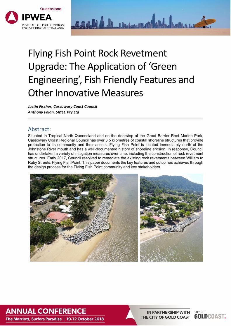
Flying Fish Point Rock Revetment Upgrade: The Application of ‘Green Engineering’, Fish Friendly Features and Other Innovative Measures Justin Fischer, Cassowary Coast Council
Anthony Folan, SMEC Pty Ltd
Abstract: Situated in Tropical North Queensland and on the doorstep of the Great Barrier Reef Marine Park, Cassowary Coast Regional Council has over 3.5 kilometres of coastal shoreline structures that provide protection to its community and their assets. Flying Fish Point is located immediately north of the Johnstone River mouth and has a well-documented history of shoreline erosion. In response, Council has undertaken a variety of mitigation measures over time, including the construction of rock revetment structures. Early 2017, Council resolved to remediate the existing rock revetments between William to Ruby Streets, Flying Fish Point. This paper documents the key features and outcomes achieved through the design process for the Flying Fish Point community and key stakeholders.
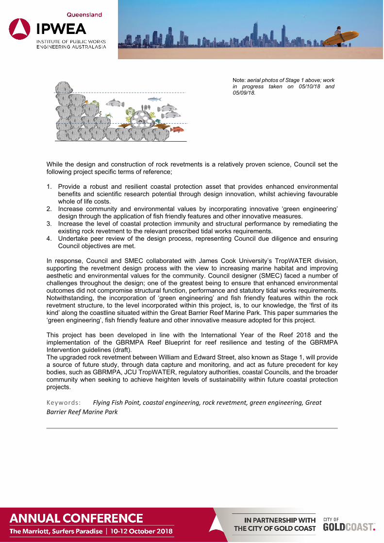
Note: aerial photos of Stage 1 above; work in progress taken on 05/10/18 and 05/09/18.
While the design and construction of rock revetments is a relatively proven science, Council set the following project specific terms of reference; 1. Provide a robust and resilient coastal protection asset that provides enhanced environmental
benefits and scientific research potential through design innovation, whilst achieving favourable whole of life costs.
2. Increase community and environmental values by incorporating innovative ‘green engineering’ design through the application of fish friendly features and other innovative measures.
3. Increase the level of coastal protection immunity and structural performance by remediating the existing rock revetment to the relevant prescribed tidal works requirements.
4. Undertake peer review of the design process, representing Council due diligence and ensuring Council objectives are met.
In response, Council and SMEC collaborated with James Cook University’s TropWATER division, supporting the revetment design process with the view to increasing marine habitat and improving aesthetic and environmental values for the community. Council designer (SMEC) faced a number of challenges throughout the design; one of the greatest being to ensure that enhanced environmental outcomes did not compromise structural function, performance and statutory tidal works requirements. Notwithstanding, the incorporation of ‘green engineering’ and fish friendly features within the rock revetment structure, to the level incorporated within this project, is, to our knowledge, the ‘first of its kind’ along the coastline situated within the Great Barrier Reef Marine Park. This paper summaries the ‘green engineering’, fish friendly feature and other innovative measure adopted for this project. This project has been developed in line with the International Year of the Reef 2018 and the implementation of the GBRMPA Reef Blueprint for reef resilience and testing of the GBRMPA Intervention guidelines (draft). The upgraded rock revetment between William and Edward Street, also known as Stage 1, will provide a source of future study, through data capture and monitoring, and act as future precedent for key bodies, such as GBRMPA, JCU TropWATER, regulatory authorities, coastal Councils, and the broader community when seeking to achieve heighten levels of sustainability within future coastal protection projects. Keywords: Flying Fish Point, coastal engineering, rock revetment, green engineering, Great
Barrier Reef Marine Park
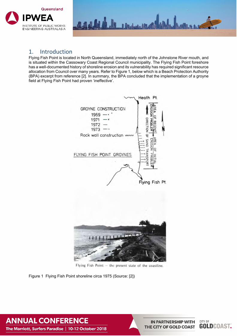
1. Introduction Flying Fish Point is located in North Queensland, immediately north of the Johnstone River mouth, and is situated within the Cassowary Coast Regional Council municipality. The Flying Fish Point foreshore has a well-documented history of shoreline erosion and its vulnerability has required significant resource allocation from Council over many years. Refer to Figure 1, below which is a Beach Protection Authority (BPA) excerpt from reference [2]. In summary, the BPA concluded that the implementation of a groyne field at Flying Fish Point had proven ‘ineffective’.
Figure 1 Flying Fish Point shoreline circa 1975 (Source: [2])
Council set the following terms of reference with respect to the upgrade of the existing rock revetment between William and Ruby Streets; 1. Provide a robust and resilient coastal protection asset that provides enhanced environmental
benefits and scientific research potential through design innovation, whilst still achieving favourable whole of life costs.
2. Increase community and environmental values by incorporating innovative ‘green engineering’ design through the application of fish friendly features and other innovative measures.
3. Increase the level of coastal protection immunity and structural performance by remediating the existing rock revetment to the relevant prescribed tidal works requirements.
4. Undertake peer review of the design process, representing Council due diligence and ensuring Council objectives are met.
This paper sets out to document the following;
1. Pre-existing condition of the Flying Fish Point rock revetment between William and Ruby Streets. 2. The function of a rock revetment and its impact on the local coastal processes. 3. Key measures adopted during design phase to meet Council’s terms of reference as set out above.
2. Pre‐existing condition The pre-existing condition of the Flying Fish Point rock revetment, between William and Ruby Streets, was generally in ‘poor’ condition, as detailed in [6], thereby exposing Council to safety risks, risk of revetment malfunction, poor performance in extreme events, all leading to a heightened level of shoreline asset vulnerability.
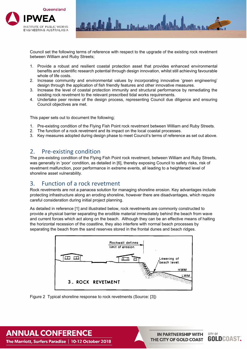
3. Function of a rock revetment Rock revetments are not a panacea solution for managing shoreline erosion. Key advantages include protecting infrastructure along an eroding shoreline, however there are disadvantages, which require careful consideration during initial project planning.
As detailed in reference [1] and illustrated below, rock revetments are commonly constructed to provide a physical barrier separating the erodible material immediately behind the beach from wave and current forces which act along on the beach. Although they can be an effective means of halting the horizontal recession of the coastline, they also interfere with normal beach processes by separating the beach from the sand reserves stored in the frontal dunes and beach ridges.
Figure 2 Typical shoreline response to rock revetments (Source: [3])
While rock revetments act to protect property behind the wall, they do not prevent erosion of the beach directly in front of the rock revetment. The usual effect of rock revetment construction in actively eroding areas is for the level of the beach to steadily drop until the beach reaches a new equilibrium shape in front of the rock revetment.
The above has been mentioned to the reader to highlight the fact that rock revetment structures are not always an appropriate solution to an eroding coastline. In the case of Flying Fish Point, pushing the upgraded rock revetment seaward had limited impact on the existing beach, as pre-construction levels were already low. Low tide access along the toe of the existing rock revetment was available, however due to low population density and the presence of crocodiles, beach amenity was considered low. Another key consideration was maintenance of the existing structure. Maintenance of the existing structure was not viable due to the close proximity of the rock revetment to freehold property boundaries. Taking all of the above into consideration, pushing the rock revetment seaward was considered acceptable and a sustainable outcome for Flying Fish Point.
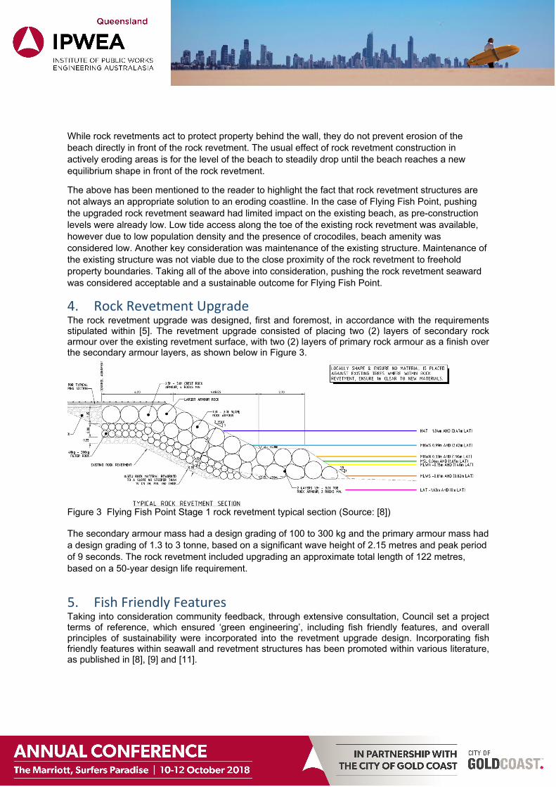
4. Rock Revetment Upgrade The rock revetment upgrade was designed, first and foremost, in accordance with the requirements stipulated within [5]. The revetment upgrade consisted of placing two (2) layers of secondary rock armour over the existing revetment surface, with two (2) layers of primary rock armour as a finish over the secondary armour layers, as shown below in Figure 3.
Figure 3 Flying Fish Point Stage 1 rock revetment typical section (Source: [8]) The secondary armour mass had a design grading of 100 to 300 kg and the primary armour mass had a design grading of 1.3 to 3 tonne, based on a significant wave height of 2.15 metres and peak period of 9 seconds. The rock revetment included upgrading an approximate total length of 122 metres, based on a 50-year design life requirement.
5. Fish Friendly Features Taking into consideration community feedback, through extensive consultation, Council set a project terms of reference, which ensured ‘green engineering’, including fish friendly features, and overall principles of sustainability were incorporated into the revetment upgrade design. Incorporating fish friendly features within seawall and revetment structures has been promoted within various literature, as published in [8], [9] and [11].
Council, James Cook University (JCU) TropWATER and SMEC workshopped incorporating fish friendly features and ‘green engineering’ elements into the revetment upgrade design. The project workshop took into consideration the following, which formed the basis of the rock revetment upgrade design.
Council’s terms of reference. Key literature references [8], [9] and [11]. The GBRMPA Reef Blueprint Active Localised Restoration priority activity areas, including:
o Testing, improving and scaling up local-scale reef restoration methods; based on the best available science, for potential application across the resilience network.
o Facilitating opportunities for community and industry participation in local scale restoration and research though partnering with Reef Guardian Schools and engagement with the Local Marine Advisory Committee.
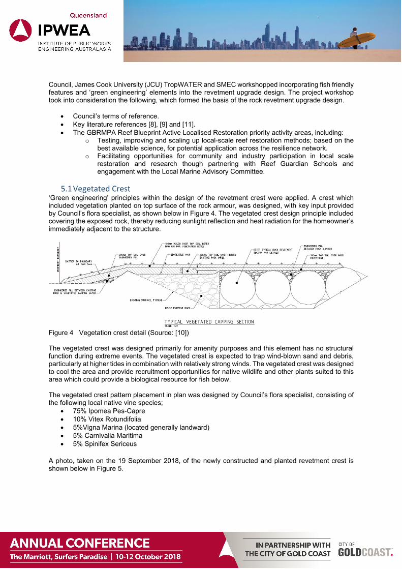
5.1 Vegetated Crest ‘Green engineering’ principles within the design of the revetment crest were applied. A crest which included vegetation planted on top surface of the rock armour, was designed, with key input provided by Council’s flora specialist, as shown below in Figure 4. The vegetated crest design principle included covering the exposed rock, thereby reducing sunlight reflection and heat radiation for the homeowner’s immediately adjacent to the structure.
Figure 4 Vegetation crest detail (Source: [10]) The vegetated crest was designed primarily for amenity purposes and this element has no structural function during extreme events. The vegetated crest is expected to trap wind-blown sand and debris, particularly at higher tides in combination with relatively strong winds. The vegetated crest was designed to cool the area and provide recruitment opportunities for native wildlife and other plants suited to this area which could provide a biological resource for fish below. The vegetated crest pattern placement in plan was designed by Council’s flora specialist, consisting of the following local native vine species;
75% Ipomea Pes-Capre 10% Vitex Rotundifolia 5%Vigna Marina (located generally landward) 5% Carnivalia Maritima 5% Spinifex Sericeus
A photo, taken on the 19 September 2018, of the newly constructed and planted revetment crest is shown below in Figure 5.
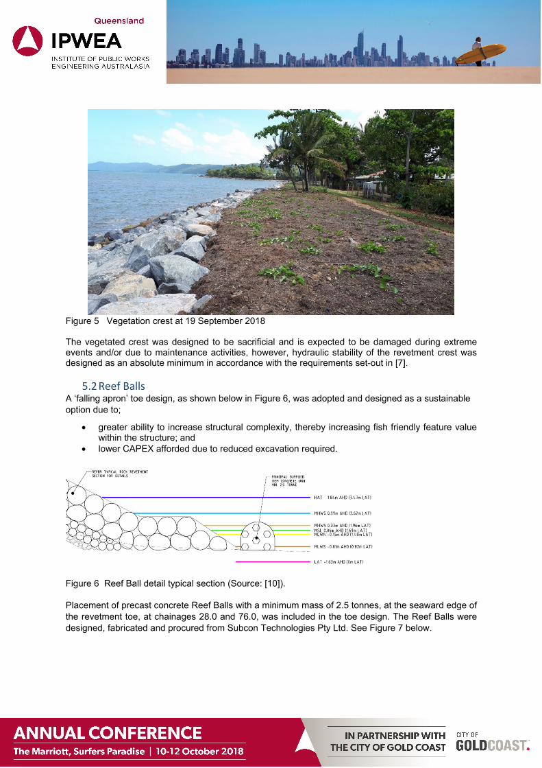
Figure 5 Vegetation crest at 19 September 2018 The vegetated crest was designed to be sacrificial and is expected to be damaged during extreme events and/or due to maintenance activities, however, hydraulic stability of the revetment crest was designed as an absolute minimum in accordance with the requirements set-out in [7].
5.2 Reef Balls A ‘falling apron’ toe design, as shown below in Figure 6, was adopted and designed as a sustainable option due to;
greater ability to increase structural complexity, thereby increasing fish friendly feature value within the structure; and
lower CAPEX afforded due to reduced excavation required.
Figure 6 Reef Ball detail typical section (Source: [10]). Placement of precast concrete Reef Balls with a minimum mass of 2.5 tonnes, at the seaward edge of the revetment toe, at chainages 28.0 and 76.0, was included in the toe design. The Reef Balls were designed, fabricated and procured from Subcon Technologies Pty Ltd. See Figure 7 below.
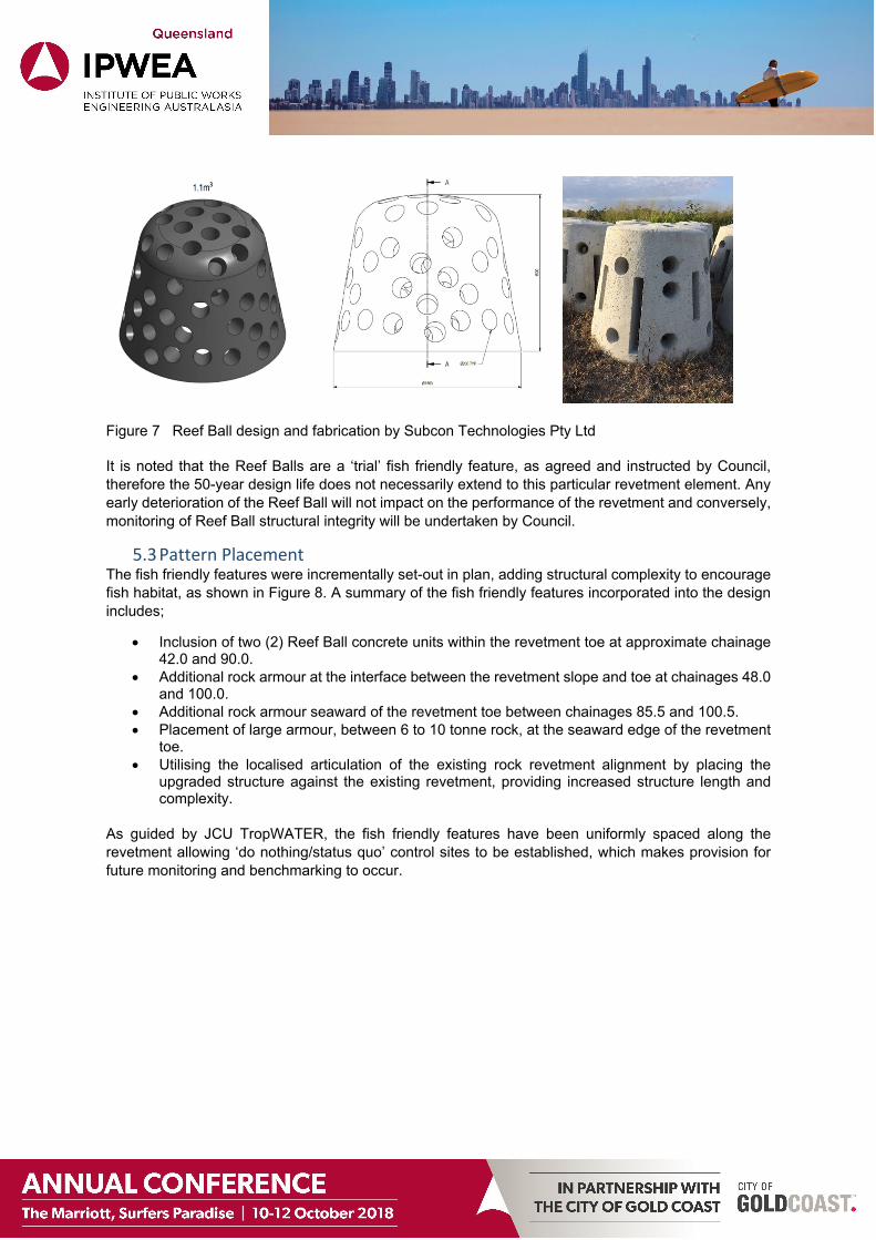
Figure 7 Reef Ball design and fabrication by Subcon Technologies Pty Ltd It is noted that the Reef Balls are a ‘trial’ fish friendly feature, as agreed and instructed by Council, therefore the 50-year design life does not necessarily extend to this particular revetment element. Any early deterioration of the Reef Ball will not impact on the performance of the revetment and conversely, monitoring of Reef Ball structural integrity will be undertaken by Council.
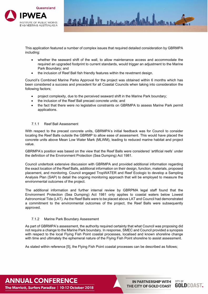
5.3 Pattern Placement The fish friendly features were incrementally set-out in plan, adding structural complexity to encourage fish habitat, as shown in Figure 8. A summary of the fish friendly features incorporated into the design includes;
Inclusion of two (2) Reef Ball concrete units within the revetment toe at approximate chainage 42.0 and 90.0.
Additional rock armour at the interface between the revetment slope and toe at chainages 48.0 and 100.0.
Additional rock armour seaward of the revetment toe between chainages 85.5 and 100.5. Placement of large armour, between 6 to 10 tonne rock, at the seaward edge of the revetment
toe. Utilising the localised articulation of the existing rock revetment alignment by placing the
upgraded structure against the existing revetment, providing increased structure length and complexity.
As guided by JCU TropWATER, the fish friendly features have been uniformly spaced along the revetment allowing ‘do nothing/status quo’ control sites to be established, which makes provision for future monitoring and benchmarking to occur.
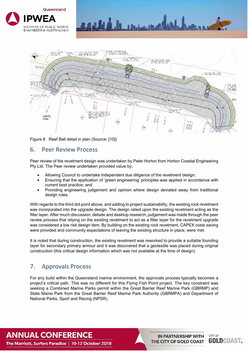
Figure 8 Reef Ball detail in plan (Source: [10])
6. Peer Review Process Peer review of the revetment design was undertaken by Peter Horton from Horton Coastal Engineering Pty Ltd. The Peer review undertaken provided value by;
Allowing Council to undertake independent due diligence of the revetment design; Ensuring that the application of ‘green engineering’ principles was applied in accordance with
current best practice; and Providing engineering judgement and opinion where design deviated away from traditional
design rules.
With regards to the third dot point above, and adding to project sustainability, the existing rock revetment was incorporated into the upgrade design. The design relied upon the existing revetment acting as the filter layer. After much discussion, debate and desktop research, judgement was made through the peer review process that relying on the existing revetment to act as a filter layer for the revetment upgrade was considered a low risk design item. By building on the existing rock revetment, CAPEX costs saving were provided and community expectations of leaving the existing structure in place, were met. It is noted that during construction, the existing revetment was reworked to provide a suitable founding layer for secondary primary armour and it was discovered that a geotextile was placed during original construction (this critical design information which was not available at the time of design).
7. Approvals Process For any build within the Queensland marine environment, the approvals process typically becomes a project’s critical path. This was no different for this Flying Fish Point project. The key constraint was seeking a Combined Marine Parks permit within the Great Barrier Reef Marine Park (GBRMP) and State Maine Park from the Great Barrier Reef Marine Park Authority (GBRMPA) and Department of National Parks, Sport and Racing (NPSR).
This application featured a number of complex issues that required detailed consideration by GBRMPA including:
whether the seaward shift of the wall, to allow maintenance access and accommodate the required an upgraded footprint to current standards, would trigger an adjustment to the Marine Park Boundary; and
the inclusion of Reef Ball fish friendly features within the revetment design.
Council’s Combined Marine Parks Approval for the project was obtained within 6 months which has been considered a success and precedent for all Coastal Councils when taking into consideration the following factors;
project complexity, due to the perceived seaward shift in the Marine Park boundary; the inclusion of the Reef Ball precast concrete units; and the fact that there were no legislative constraints on GBRMPA to assess Marine Park permit
applications.
7.1.1 Reef Ball Assessment
With respect to the precast concrete units, GBRMPA’s initial feedback was for Council to consider locating the Reef Balls outside the GBRMP to allow ease of assessment. This would have placed the concrete units above Mean Low Water Mark (MLWM), leading to reduced marine habitat and project value.
GBRMPA’s position was based on the view that the Reef Balls were considered ‘artificial reefs’ under the definition of the Environment Protection (Sea Dumping) Act 1981. Council undertook extensive discussion with GBRMPA and provided additional information regarding the exact location of the Reef Balls, additional information on their design, function, materials, proposed placement, and monitoring. Council engaged TropWATER and Reef Ecologic to develop a Sampling Analysis Plan (SAP) to detail the ongoing monitoring approach that will be employed to measure the environmental outcomes of the project. The additional information and further internal review by GBRPMA legal staff found that the Environment Protection (Sea Dumping) Act 1981 only applies to coastal waters below Lowest Astronomical Tide (LAT). As the Reef Balls were to be placed above LAT and Council had demonstrated a commitment to the environmental outcomes of the project, the Reef Balls were subsequently approved.
7.1.2 Marine Park Boundary Assessment
As part of GBRMPA’s assessment, the authority required certainty that what Council was proposing did not require a change to the Marine Park boundary. In response, SMEC and Council provided a synopsis with respect to the local Flying Fish Point coastal processes, localised and known shoreline change with time and ultimately the ephemeral nature of the Flying Fish Point shoreline to assist assessment. As stated within reference [5], the Flying Fish Point coastal processes can be described as follows;
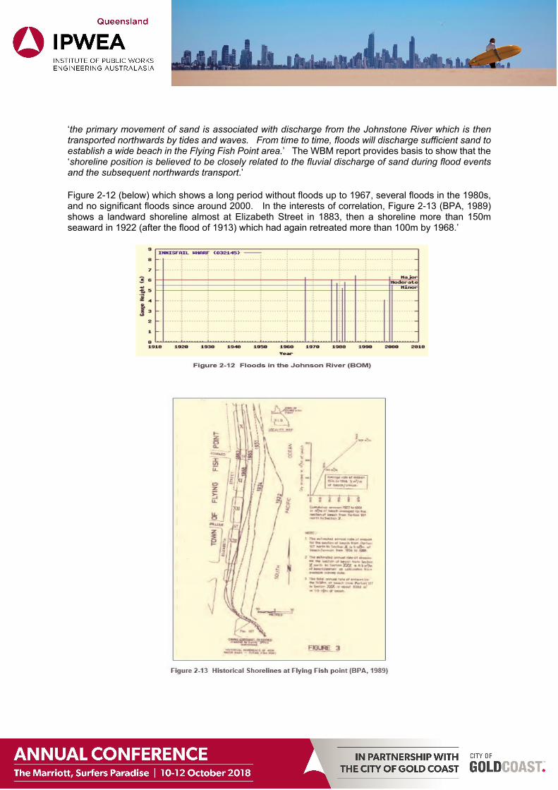
‘the primary movement of sand is associated with discharge from the Johnstone River which is then transported northwards by tides and waves. From time to time, floods will discharge sufficient sand to establish a wide beach in the Flying Fish Point area.’ The WBM report provides basis to show that the ‘shoreline position is believed to be closely related to the fluvial discharge of sand during flood events and the subsequent northwards transport.’
Figure 2-12 (below) which shows a long period without floods up to 1967, several floods in the 1980s, and no significant floods since around 2000. In the interests of correlation, Figure 2-13 (BPA, 1989) shows a landward shoreline almost at Elizabeth Street in 1883, then a shoreline more than 150m seaward in 1922 (after the flood of 1913) which had again retreated more than 100m by 1968.’
Reference [5] and supporting investigations by the Beach Protection Authority demonstrates the ephemeral nature of the Flying Fish Point shoreline over a period of time. The Flying Fish Point shoreline has been subject to relatively large changes in position, due to the almost sole reliance of sand supply from the Johnstone River and the disparate nature of flood events in terms of frequency and magnitude. We were able to demonstrate that the Marine Park boundary is not static, but rather ambulatory. Due to the ephemeral nature of the Flying Fish Point shoreline, any slight seaward migration in the revetment would be negligible, when taking into consideration the magnitude of potential shoreline change for Flying Fish Point.
7.1.3 Prescribed Tidal Work Assessment
The project required an Operational Works approval for Prescribed Tidal Work and Removal/destruction or damage of marine plants and Repair and upgrade of existing coastal protection infrastructure (rock revetment structures) under the Sustainable Planning Act 2009. A pre-lodgement meeting was held with the relevant referral agencies including; Department of Infrastructure, Local Government and Planning, Department of Environment and Heritage, Department of Main Roads – Marine Safety Queensland, Department of Agriculture and Fisheries. There was general support of the project and subject to supporting information being provided in Council’s application and one minor information request, approval was obtained within 3.5 months.
8. Future Monitoring To measure project success, future monitoring of the fish friendly features will be undertaken by TropWATER who have prepared a Sampling Analysis Plan (SAP) that details the ongoing monitoring and research approach for the project. The aim of the research is to gather scientific data and knowledge around the utility of revetment Reef Balls as productive fish and marine biodiversity habitat features in a tropical location. As this ‘green engineering’ and fish friendly features project is the first of its kind along the Great Barrier Reef coastline, it is expected that important data and knowledge will become available over time for other coastal Councils to use in achieving multiple benefits from similar coastal erosion protection engineering projects.
All research will be conducted using underwater video techniques, inspection surveys of species colonisation on the Reef Balls and rock revetment, in addition to specific mounted colonisation plates. No extractive research is to be undertaken as part of this research program. The results of these surveys will be uploaded to the Eye on the Reef database to contribute to on-going management and research.
The SAP covers two important key research areas:
1. what marine fauna settle on Reef Ball structures that is different to seawall boulders or control sites without any improved habitat complexity; and
2. what fish communities utilise the Reef Ball structures, that is different to the revetment boulders and control sites (Figure 2).
A technical report will be generated in 2021 which will present all the data collected, statistical analyses and general discussion of results in the context of broader seascape biodiversity and restoration.
It is anticipated that this project will also generate significant community and media interest, particularly at milestone stages of the project. The project and emerging results will be regularly promoted via social media through James Cook University, TropWATER, Reef Ecologic and Cassowary Coast Regional Council. Captured data will be also presented in scientific peer reviewed literature, to further disseminate the results and conclusions.
TropWATER and Council will engage with the local communities such as Cassowary Coast Local Marine Advisory Committee and Reef Guardian Schools to share knowledge and community support for the reef, science and management action.
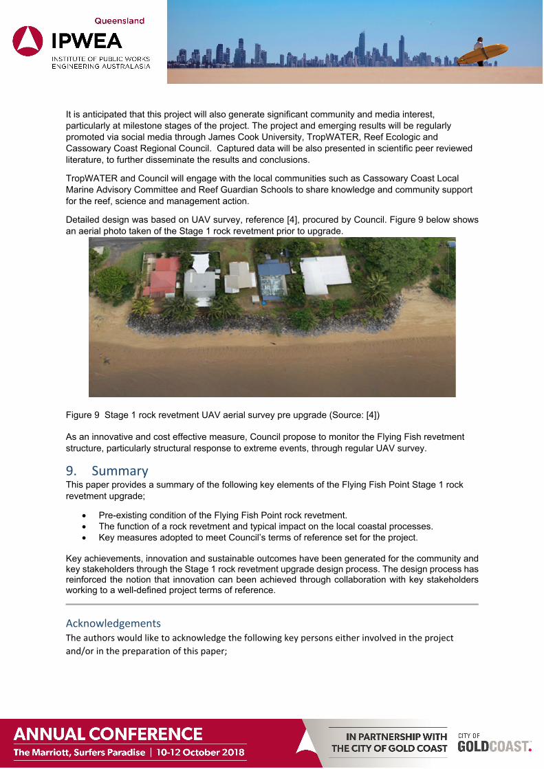
Detailed design was based on UAV survey, reference [4], procured by Council. Figure 9 below shows an aerial photo taken of the Stage 1 rock revetment prior to upgrade.
Figure 9 Stage 1 rock revetment UAV aerial survey pre upgrade (Source: [4]) As an innovative and cost effective measure, Council propose to monitor the Flying Fish revetment structure, particularly structural response to extreme events, through regular UAV survey.
9. Summary This paper provides a summary of the following key elements of the Flying Fish Point Stage 1 rock revetment upgrade;
Pre-existing condition of the Flying Fish Point rock revetment. The function of a rock revetment and typical impact on the local coastal processes. Key measures adopted to meet Council’s terms of reference set for the project.
Key achievements, innovation and sustainable outcomes have been generated for the community and key stakeholders through the Stage 1 rock revetment upgrade design process. The design process has reinforced the notion that innovation can been achieved through collaboration with key stakeholders working to a well-defined project terms of reference.
Acknowledgements The authors would like to acknowledge the following key persons either involved in the project
and/or in the preparation of this paper;
Damon Sydes, Cassowary Coast Regional Council
Dr Nathan Waltham, James Cook University, TropWATER, Australia
Dr Adam Smith, Reef Ecologic
Peter Horton, Horton Coastal Engineering Pty Ltd
Matthew Allen, Subcon Technologies Pty Ltd
Rean Gilbert, Great Barrier Reef Marine Park Authority
References [1] Beach Protection Authority (BPA) (1989), Hervey Bay Beaches.
[2] Beach Protection Authority (BPA), (1975), Beach Conservation Newsletter #22 for December.
[3] Beach Protection Authority (BPA), (1977), Beach Conservation Newsletter #29 for October.
[4] Benchmark Survey & Design, 4th March 2017, Site Survey Photogrammetry through UAV Methods.
[5] BMT WBM (2017), Flying Fish Point Seawall Upgrade Project – Final Report.
[6] Coastal Engineering Solutions Pty Ltd (2009), Planning & Environment Court Appeals No. 44, 45 and 46 of 2005, Joint Expert Advice – Seawalls at Flying Fish Point.
[7] Department of Environment and Heritage Protection (2013), (now known as Department of Environment and Science), Operational Policy, Building and Engineering Standards for Tidal Works, Queensland Government.
[8] Department of Environment and Climate Change (2009), Environmentally Friendly Seawalls, A Guide to Improving the Environmental Value of Seawalls and Seawall-lined Foreshores in Estuaries, NSW government.
[9] Derbyshire (2006), Fisheries Guidelines for Fish Friendly Structures, Fish Habitat Guideline FHG 006, Queensland Government Department of Primary Industries and Fisheries.
[10] SMEC | PDR (17/09/18). Upgraded Rock Revetment at Flying Fish Point, Innisfail Stage 1, Drawing No. 17316 – C00 to C07.
[11] TropWATER JCU (2016). Townsville City waterfront priority development area – green engineering guidelines, Report 16/26.