Embed Size (px)
Citation preview
Report
Floyd County Thoroughfare Plan Floyd County, IN July 2007
Report for Floyd County, Indiana Floyd County Thoroughfare Plan
Prepared by:
STRAND ASSOCIATES, INC.® 910 West Wingra Drive
Madison, WI 53715 www.strand.com
July 2007
TABLE OF CONTENTS
Page No. or Following
SECTION 1–INTRODUCTION AND EXECUTIVE SUMMARY 1.01 Introduction ................................................................................................ 1-1 1.02 Executive Summary ................................................................................... 1-2 SECTION 2–NEEDS IDENTIFICATION 2.01 Floyd County Overview.............................................................................. 2-1 2.02 Existing Transportation System ................................................................. 2-2 2.03 Existing Motor Vehicle Operations Analysis .............................................. 2-5 2.04 Future Land Use and Traffic Forecasting .................................................. 2-15 2.05 Future No-Build Motor Vehicle Operation Analysis.................................... 2-16 2.06 Motor Vehicle Needs Prioritization............................................................. 2-26 SECTION 3–ALTERNATIVES DEVELOPMENT 3.01 Traditional Motor Vehicle Capacity Expansion .......................................... 3-1 3.02 Alternative Capacity Expansion ................................................................. 3-4 3.03 Multimodal Improvements.......................................................................... 3-4 SECTION 4–ALTERNATIVES EVALUATION 4.01 Traditional Capacity Expansion ................................................................. 4-1 4.02 Alternative Capacity Expansion ................................................................. 4-43 4.03 Bicycle System Improvements................................................................... 4-44 4.04 Pedestrian System Improvements ............................................................. 4-47 4.05 Transit System Improvements ................................................................... 4-50 4.06 Motor Vehicle Operations Analysis ............................................................ 4-51 SECTION 5–IMPLEMENTATION AND NEXT STEPS 5.01 Public Involvement..................................................................................... 5-1 5.02 Opinions of Probable Construction Costs .................................................. 5-2 5.03 Funding Sources........................................................................................ 5-7 5.04 Project Implementation .............................................................................. 5-10
APPENDICES APPENDIX A–RAW DATA APPENDIX B–TRAFFIC MODELING RESULTS APPENDIX C–PROPOSED IMPROVEMENTS APPENDIX D–COST ANALYSIS RESULTS APPENDIX E–PUBLIC INVOLVEMENT
TABLE OF CONTENTS Continued
Page No. or following
TABLES 1.02-1 Probable Construction Costs ..................................................................... 1-6 2.03-1 Level of Service (LOS) Thresholds ............................................................ 2-5 2.03-2 Existing Corridor LOC from HCS ............................................................... 2-6 2.03-3 Existing Intersection Operations from Synchro/SimTraffic on US 150 .. 2-6 2.03-4 Existing Intersection Operations from Synchro/SimTraffic along Paoli Pike and Old Vincennes Road............................................................. 2-7 2.03-5 Critical Existing Intersection Queue Lengths in US 150 Study Area.......... 2-8 2.03-6 Existing Intersection Operations from Synchro/SimTraffic Along SR 62/64............................................................................................. 2-11 2.03-7 Critical Existing Intersection Queue Lengths in SR 62/64 Study Area....... 2-12 2.03-8 Existing Intersection Operations from Synchro/SimTraffic along County Line Road..................................................................................... 2-14 2.03-9 Corridor Crash Rates January 1, 2005 to January 23, 2007 ..................... 2-14 2.03-10 Intersection Crash Rates January 1, 2005 to January 23, 2007................ 2-15 2.05-1 Future No-Build Corridor LOS from HCS................................................... 2-17 2.05-2 Future No-Build Intersection Operations from Synchro/SimTraffic on US 150................................................................................................ 2-18 2.05-3 Future No-Build Intersection Operations from Synchro/SimTraffic Along Paoli Pike and Old Vincennes Road .................................................... 2-18 2.05-4 Critical Future No-Build Intersection Queue Lengths in US 150 Study Area 2-19 2.05-5 Future No-Build Intersection Operations from Synchro/SimTraffic Along SR 62/64 ................................................................................... 2-22 2.05-6 Critical Future No-Build Intersection Queue Lengths in SR 62/64 Study Area .......................................................................................................... 2-23 2.05-7 Future No-Build Intersection Operations from Synchro/SimTraffic Along County Line Road ..................................................................... 2-25 4.06-1 Final Corridor LOS from HCS .................................................................... 4-51 4.06-2 Final Intersection Operations from Synchro/SimTraffic on US 150....... 4-52 4.06-3 Final Intersection Operations from Synchro/SimTraffic along Paoli Pike and Old Vincennes Road .................................................... 4-52 4.06-4 Final Intersection Operations from Synchro/SimTraffic along SR 62/64 with the SPUI Alternative ..................................................... 4-55 4.06-5 Final Intersection Operations from Synchro/SimTraffic along County Line Road ............................................................................... 4-56 5.02-1 Estimated Cost of Proposed County Improvement Projects...................... 5-4 5.02-2 Estimated Costs of Proposed State and Federal Improvement Projects... 5-5 5.02-3 Estimated Costs for Proposed Multimodal Improvement Projects............. 5-6 5.04-1 Characteristics of Smart Growth and Sprawl Land Use Patterns .............. 5-13
TABLE OF CONTENTS Continued
Page No. or following
FIGURES 1.01-1 Diagram of Study Areas in Floyd County................................................... 1-1 1.02-1 Floyd County Functional Classification ...................................................... 1-3 1.02-2 Proposed Motor Vehicle Improvements..................................................... 1-5 2.01-1 Floyd County, Indiana ................................................................................ 2-1 2.01-2 Major Highways within Floyd County ......................................................... 2-1 2.02-1 US 150/Paoli Pike Study Area ................................................................... 2-2 2.02-2 State Route 62/64 Study Area ................................................................... 2-3 2.02-3 County Line Road Study Area ................................................................... 2-4 2.02-4 TARC Route Map....................................................................................... 2-4 2.03-1 US 150 Existing Conditions AM LOS......................................................... 2-9 2.03-2 US 150 Existing Conditions PM LOS......................................................... 2-10 2.03-3 SR 62/64 Existing Conditions AM LOS...................................................... 2-13 2.03-4 SR 62/64 Existing Conditions PM LOS...................................................... 2-13 2.05-1 INDOT and KIPDA Planned Improvements in Floyd County ..................... 2-16 2.05-2 US 150 Future No-Build AM LOS .............................................................. 2-20 2.05-3 US 150 Future No-Build PM LOS .............................................................. 2-21 2.05-4 SR 62/64 Future No-Build AM LOS ........................................................... 2-24 2.05-5 SR 62/64 Future No-Build PM LOS ........................................................... 2-24 2.06-1 Prioritized Improvements for Floyd County................................................ 2-26 3.01-1 Current County Functional Classifications ................................................. 3-2 3.01-2 Proposed County Functional Classifications.............................................. 3-2 4.01-1 US 150 Alternate Routes ........................................................................... 4-3 4.01-2 SR 62/64 Alternate Routes ........................................................................ 4-4 4.01-3 Proposed Corridor Improvements.............................................................. 4-6 4.01-4 US 150 and Old Vincennes Road Improvements ...................................... 4-7 4.01-5 US 150 and Lawrence Banet Road Improvements.................................... 4-8 4.01-6 US 150 and Paoli Pike Improvements ....................................................... 4-10 4.01-7 US 150 and Bruch College Road Improvements ....................................... 4-11 4.01-8 US 150 and Buck Creek Road Improvements ........................................... 4-11 4.01-9 US 150 and Stiller Road Improvements..................................................... 4-12 4.01-10 US 150 and Navillton Road Improvements................................................ 4-13 4.01-11 US 150 and Edwardsville-Galena Road Improvements............................. 4-14 4.01-12 Old Vincennes Road and Duffy Road Improvements ................................ 4-15 4.01-13 Old Vincennes Road and Schreiber Road Improvements ......................... 4-16 4.01-14 Old Vincennes Road and Luther Road Improvements .............................. 4-17 4.01-15 Summary of Projects in the US 150 Study Area ........................................ 4-19 4.01-16 Diamond Interchange Expansion............................................................... 4-20 4.01-17 SR 62 and Yenowine Lane Improvements ................................................ 4-21 4.01-18 SR 62 and Corydon Ridge Road Improvements........................................ 4-22 4.01-19 SR 62 and Corydon Pike Improvements.................................................... 4-23 4.01-20 SR 62 and I-64 Eastbound Ramps Improvements .................................... 4-24 4.01-21 SR 64 and Westbound I-64 Ramps Improvements ................................... 4-25 4.01-22 SR 64 and West Knable Road Improvements ........................................... 4-26 4.01-23 SR 64 and Tunnel Hill Road Improvements............................................... 4-27 4.01-24 SR 64 and Edwardsville-Galena Road Improvements............................... 4-28
TABLE OF CONTENTS Continued
Page No. or following
4.01-25 SR 64 and Oaks Road Improvements ....................................................... 4-29 4.01-26 SR 64 and Henriott/Baylor Wissman Road Improvements ........................ 4-30 4.01-27 Proposed Loop Ramp Layout .................................................................... 4-31 4.01-28 SR 62 and Corydon Pike ........................................................................... 4-32 4.01-29 SR 64 and Westbound I-64 Ramps Improvements ................................... 4-33 4.01-30 SR 64 and West Knable Road Improvements ........................................... 4-34 4.01-31 SR 64 and Edwardsville-Galena Road Improvements............................... 4-35 4.01-32 Proposed Single Point Urban Interchange Layout..................................... 4-36 4.01-33 SR 62 and Corydon Pike Improvements.................................................... 4-37 4.01-34 SR 62 and South SPUI Intersection Improv............................................... 4-38 4.01-35 SR 64 and New SPUI Intersection Improvements ..................................... 4-39 4.01-36 SR 64 and North SPUI Intersection Improvements ................................... 4-40 4.01-37 Summary of Projects for the SR 62/64 SPUI Alternative ........................... 4-41 4.01-38 Grant Line Road and Chapel Lane Improvements .................................... 4-42 4.03-1 Locations of Proposed Bike Routes........................................................... 4-45 4.03-2 Locations of Proposed Bike Lanes ............................................................ 4-46 4.04-1 Location of Proposed Sidewalk.................................................................. 4-48 4.04-2 Location of Proposed Multiuse Trails......................................................... 4-49 4.05-1 Proposed Future TARC Routes in Floyd County ....................................... 4-50 4.06-1 US 150 Final AM LOS................................................................................ 4-53 4.06-2 US 150 Final OM LOS ............................................................................... 4-54 4.06-3 SR 62/64 SPUI Final AM LOS ................................................................... 4-55 4.06-4 SR 62/64 SPUI Final PM LOS ................................................................... 4-56 5.04-1 Shared Access Examples .......................................................................... 5-11

SECTION 1 INTRODUCTION AND EXECUTIVE SUMMARY
Floyd County, Indiana Floyd County Thoroughfare Plan Section 1–Introduction and Executive Summary
Prepared by Strand Associates, Inc.® 1-1 KRH:pll\S:\@SIECO\001--050\046\008\Wrd\Thoroughfare Plan\Draft 07-19-07\S1-Introduction and Executive Summary 07-19-07.doc\072007
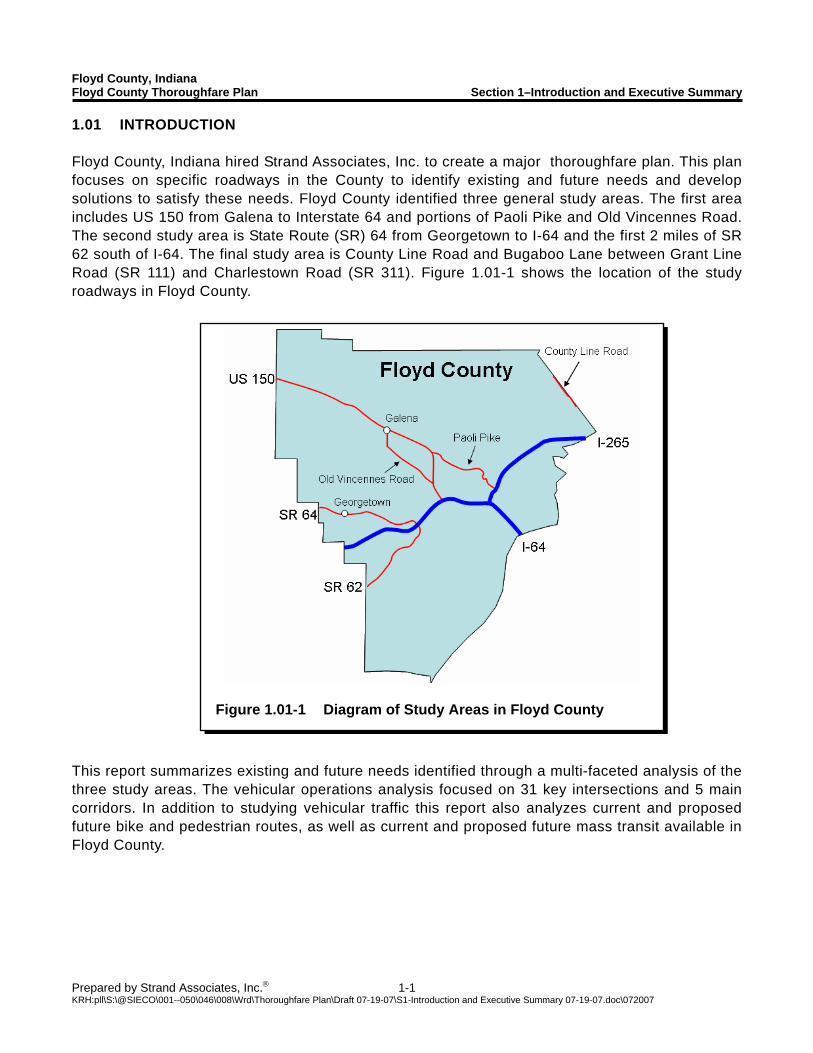
Figure 1.01-1 Diagram of Study Areas in Floyd County
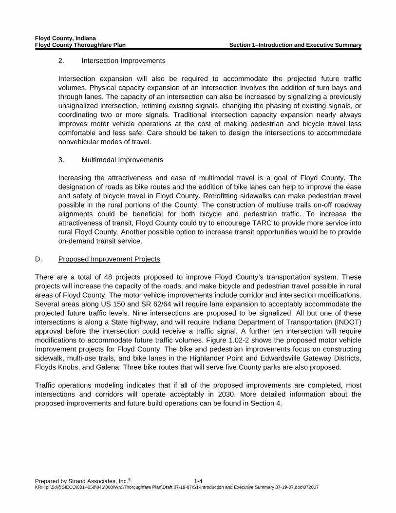
1.01 INTRODUCTION Floyd County, Indiana hired Strand Associates, Inc. to create a major thoroughfare plan. This plan focuses on specific roadways in the County to identify existing and future needs and develop solutions to satisfy these needs. Floyd County identified three general study areas. The first area includes US 150 from Galena to Interstate 64 and portions of Paoli Pike and Old Vincennes Road. The second study area is State Route (SR) 64 from Georgetown to I-64 and the first 2 miles of SR 62 south of I-64. The final study area is County Line Road and Bugaboo Lane between Grant Line Road (SR 111) and Charlestown Road (SR 311). Figure 1.01-1 shows the location of the study roadways in Floyd County.
This report summarizes existing and future needs identified through a multi-faceted analysis of the three study areas. The vehicular operations analysis focused on 31 key intersections and 5 main corridors. In addition to studying vehicular traffic this report also analyzes current and proposed future bike and pedestrian routes, as well as current and proposed future mass transit available in Floyd County.
Floyd County, Indiana Floyd County Thoroughfare Plan Section 1–Introduction and Executive Summary
Prepared by Strand Associates, Inc.® 1-2 KRH:pll\S:\@SIECO\001--050\046\008\Wrd\Thoroughfare Plan\Draft 07-19-07\S1-Introduction and Executive Summary 07-19-07.doc\072007
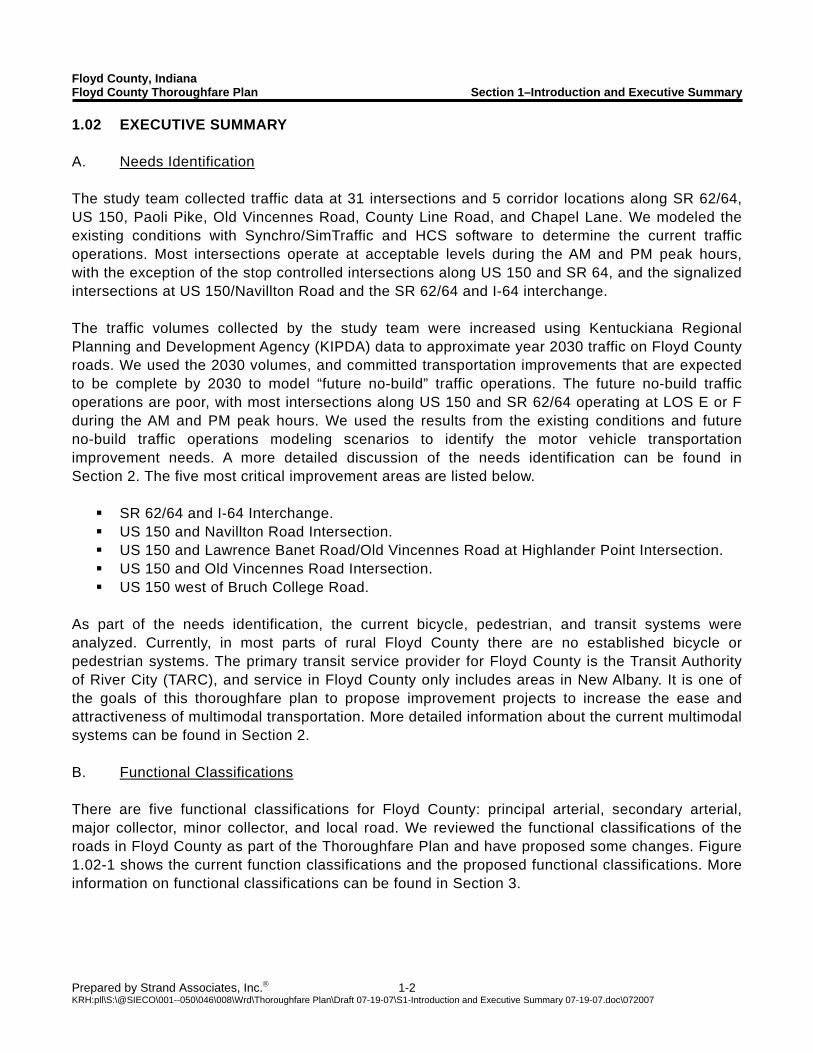
1.02 EXECUTIVE SUMMARY A. Needs Identification The study team collected traffic data at 31 intersections and 5 corridor locations along SR 62/64, US 150, Paoli Pike, Old Vincennes Road, County Line Road, and Chapel Lane. We modeled the existing conditions with Synchro/SimTraffic and HCS software to determine the current traffic operations. Most intersections operate at acceptable levels during the AM and PM peak hours, with the exception of the stop controlled intersections along US 150 and SR 64, and the signalized intersections at US 150/Navillton Road and the SR 62/64 and I-64 interchange. The traffic volumes collected by the study team were increased using Kentuckiana Regional Planning and Development Agency (KIPDA) data to approximate year 2030 traffic on Floyd County roads. We used the 2030 volumes, and committed transportation improvements that are expected to be complete by 2030 to model “future no-build” traffic operations. The future no-build traffic operations are poor, with most intersections along US 150 and SR 62/64 operating at LOS E or F during the AM and PM peak hours. We used the results from the existing conditions and future no-build traffic operations modeling scenarios to identify the motor vehicle transportation improvement needs. A more detailed discussion of the needs identification can be found in Section 2. The five most critical improvement areas are listed below.
SR 62/64 and I-64 Interchange. US 150 and Navillton Road Intersection. US 150 and Lawrence Banet Road/Old Vincennes Road at Highlander Point Intersection. US 150 and Old Vincennes Road Intersection. US 150 west of Bruch College Road.
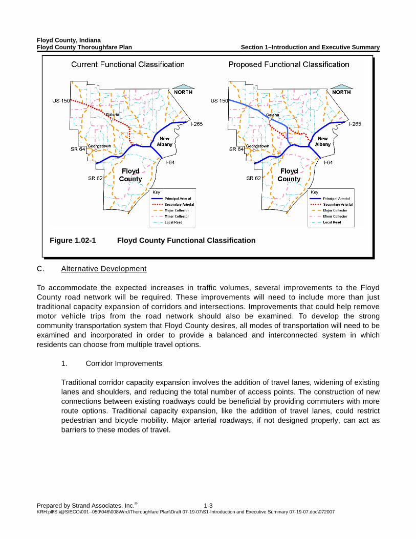
As part of the needs identification, the current bicycle, pedestrian, and transit systems were analyzed. Currently, in most parts of rural Floyd County there are no established bicycle or pedestrian systems. The primary transit service provider for Floyd County is the Transit Authority of River City (TARC), and service in Floyd County only includes areas in New Albany. It is one of the goals of this thoroughfare plan to propose improvement projects to increase the ease and attractiveness of multimodal transportation. More detailed information about the current multimodal systems can be found in Section 2. B. Functional Classifications There are five functional classifications for Floyd County: principal arterial, secondary arterial, major collector, minor collector, and local road. We reviewed the functional classifications of the roads in Floyd County as part of the Thoroughfare Plan and have proposed some changes. Figure 1.02-1 shows the current function classifications and the proposed functional classifications. More information on functional classifications can be found in Section 3.
Floyd County, Indiana Floyd County Thoroughfare Plan Section 1–Introduction and Executive Summary
Prepared by Strand Associates, Inc.® 1-3 KRH:pll\S:\@SIECO\001--050\046\008\Wrd\Thoroughfare Plan\Draft 07-19-07\S1-Introduction and Executive Summary 07-19-07.doc\072007
Figure 1.02-1 Floyd County Functional Classification
C. Alternative Development To accommodate the expected increases in traffic volumes, several improvements to the Floyd County road network will be required. These improvements will need to include more than just traditional capacity expansion of corridors and intersections. Improvements that could help remove motor vehicle trips from the road network should also be examined. To develop the strong community transportation system that Floyd County desires, all modes of transportation will need to be examined and incorporated in order to provide a balanced and interconnected system in which residents can choose from multiple travel options.
1. Corridor Improvements Traditional corridor capacity expansion involves the addition of travel lanes, widening of existing lanes and shoulders, and reducing the total number of access points. The construction of new connections between existing roadways could be beneficial by providing commuters with more route options. Traditional capacity expansion, like the addition of travel lanes, could restrict pedestrian and bicycle mobility. Major arterial roadways, if not designed properly, can act as barriers to these modes of travel.
Floyd County, Indiana Floyd County Thoroughfare Plan Section 1–Introduction and Executive Summary
Prepared by Strand Associates, Inc.® 1-4 KRH:pll\S:\@SIECO\001--050\046\008\Wrd\Thoroughfare Plan\Draft 07-19-07\S1-Introduction and Executive Summary 07-19-07.doc\072007
2. Intersection Improvements Intersection expansion will also be required to accommodate the projected future traffic volumes. Physical capacity expansion of an intersection involves the addition of turn bays and through lanes. The capacity of an intersection can also be increased by signalizing a previously unsignalized intersection, retiming existing signals, changing the phasing of existing signals, or coordinating two or more signals. Traditional intersection capacity expansion nearly always improves motor vehicle operations at the cost of making pedestrian and bicycle travel less comfortable and less safe. Care should be taken to design the intersections to accommodate nonvehicular modes of travel. 3. Multimodal Improvements Increasing the attractiveness and ease of multimodal travel is a goal of Floyd County. The designation of roads as bike routes and the addition of bike lanes can help to improve the ease and safety of bicycle travel in Floyd County. Retrofitting sidewalks can make pedestrian travel possible in the rural portions of the County. The construction of multiuse trails on-off roadway alignments could be beneficial for both bicycle and pedestrian traffic. To increase the attractiveness of transit, Floyd County could try to encourage TARC to provide more service into rural Floyd County. Another possible option to increase transit opportunities would be to provide on-demand transit service.
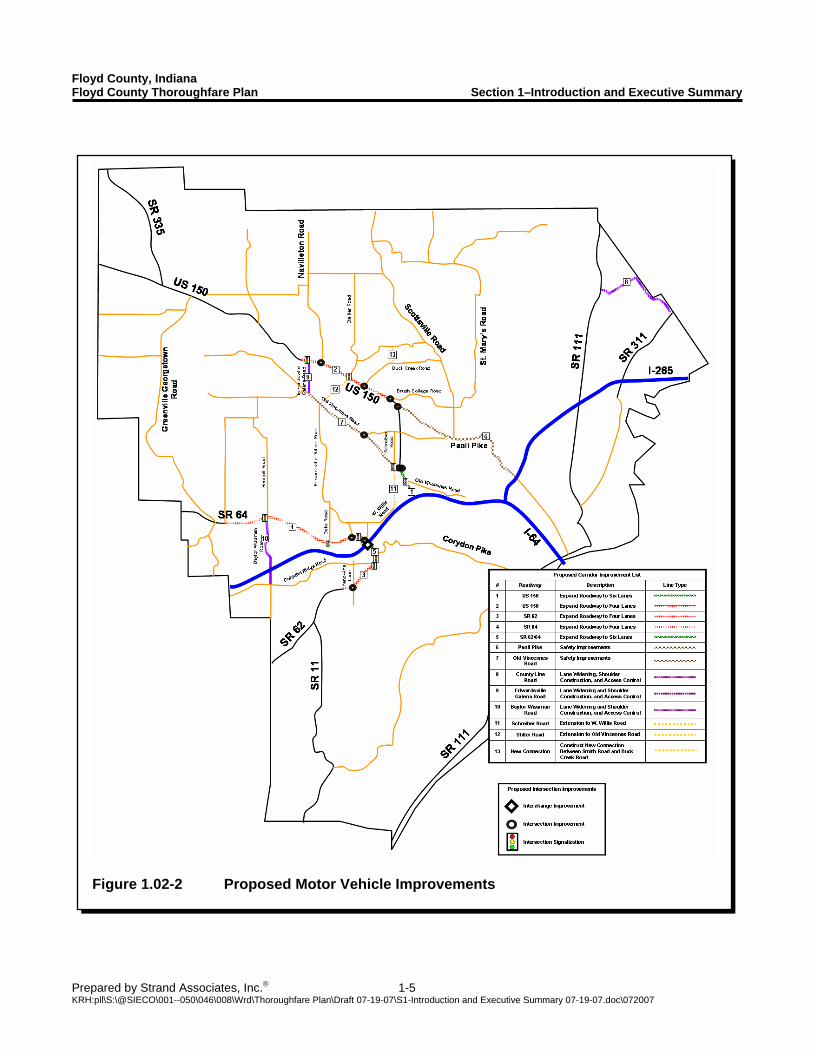
D. Proposed Improvement Projects There are a total of 48 projects proposed to improve Floyd County’s transportation system. These projects will increase the capacity of the roads, and make bicycle and pedestrian travel possible in rural areas of Floyd County. The motor vehicle improvements include corridor and intersection modifications. Several areas along US 150 and SR 62/64 will require lane expansion to acceptably accommodate the projected future traffic levels. Nine intersections are proposed to be signalized. All but one of these intersections is along a State highway, and will require Indiana Department of Transportation (INDOT) approval before the intersection could receive a traffic signal. A further ten intersection will require modifications to accommodate future traffic volumes. Figure 1.02-2 shows the proposed motor vehicle improvement projects for Floyd County. The bike and pedestrian improvements focus on constructing sidewalk, multi-use trails, and bike lanes in the Highlander Point and Edwardsville Gateway Districts, Floyds Knobs, and Galena. Three bike routes that will serve five County parks are also proposed. Traffic operations modeling indicates that if all of the proposed improvements are completed, most intersections and corridors will operate acceptably in 2030. More detailed information about the proposed improvements and future build operations can be found in Section 4.
Floyd County, Indiana Floyd County Thoroughfare Plan Section 1–Introduction and Executive Summary
Prepared by Strand Associates, Inc.® 1-5 KRH:pll\S:\@SIECO\001--050\046\008\Wrd\Thoroughfare Plan\Draft 07-19-07\S1-Introduction and Executive Summary 07-19-07.doc\072007
Figure 1.02-2 Proposed Motor Vehicle Improvements
Floyd County, Indiana Floyd County Thoroughfare Plan Section 1–Introduction and Executive Summary
Prepared by Strand Associates, Inc.® 1-6 KRH:pll\S:\@SIECO\001--050\046\008\Wrd\Thoroughfare Plan\Draft 07-19-07\S1-Introduction and Executive Summary 07-19-07.doc\072007
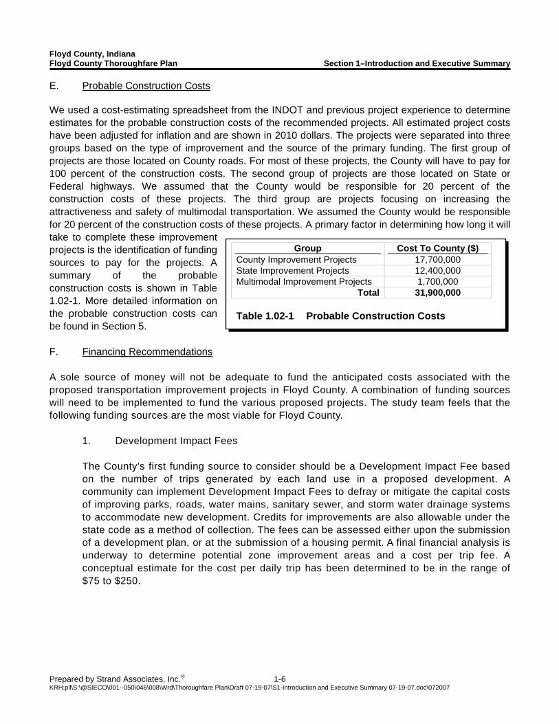
Group Cost To County ($) County Improvement Projects 17,700,000 State Improvement Projects 12,400,000 Multimodal Improvement Projects 1,700,000
Total 31,900,000 Table 1.02-1 Probable Construction Costs
E. Probable Construction Costs We used a cost-estimating spreadsheet from the INDOT and previous project experience to determine estimates for the probable construction costs of the recommended projects. All estimated project costs have been adjusted for inflation and are shown in 2010 dollars. The projects were separated into three groups based on the type of improvement and the source of the primary funding. The first group of projects are those located on County roads. For most of these projects, the County will have to pay for 100 percent of the construction costs. The second group of projects are those located on State or Federal highways. We assumed that the County would be responsible for 20 percent of the construction costs of these projects. The third group are projects focusing on increasing the attractiveness and safety of multimodal transportation. We assumed the County would be responsible for 20 percent of the construction costs of these projects. A primary factor in determining how long it will take to complete these improvement projects is the identification of funding sources to pay for the projects. A summary of the probable construction costs is shown in Table 1.02-1. More detailed information on the probable construction costs can be found in Section 5. F. Financing Recommendations A sole source of money will not be adequate to fund the anticipated costs associated with the proposed transportation improvement projects in Floyd County. A combination of funding sources will need to be implemented to fund the various proposed projects. The study team feels that the following funding sources are the most viable for Floyd County.
1. Development Impact Fees The County’s first funding source to consider should be a Development Impact Fee based on the number of trips generated by each land use in a proposed development. A community can implement Development Impact Fees to defray or mitigate the capital costs of improving parks, roads, water mains, sanitary sewer, and storm water drainage systems to accommodate new development. Credits for improvements are also allowable under the state code as a method of collection. The fees can be assessed either upon the submission of a development plan, or at the submission of a housing permit. A final financial analysis is underway to determine potential zone improvement areas and a cost per trip fee. A conceptual estimate for the cost per daily trip has been determined to be in the range of $75 to $250.
Floyd County, Indiana Floyd County Thoroughfare Plan Section 1–Introduction and Executive Summary
Prepared by Strand Associates, Inc.® 1-7 KRH:pll\S:\@SIECO\001--050\046\008\Wrd\Thoroughfare Plan\Draft 07-19-07\S1-Introduction and Executive Summary 07-19-07.doc\072007
2. Tax Incremental Financing The second funding source the County should consider is Tax Incremental Financing. The establishment of a Redevelopment Commission and the implementation of Tax Incremental Financing districts would provide additional funding for the Highlander Point and Edwardsville Gateway District. The additional revenue could be used either to pay for the improvements as they are made, or to pay off bonds issued for the development activities. Creating Tax Incremental Financing districts is attractive because it make the costs of infrastructure upgrades to support the development self-financed. The potential total funds available would be determined by the size of a proposed Tax Incremental Financing district. The funds generated by a Tax Incremental Financing district must be used to fund improvements within the district. 3. Cumulative Capital Development Fund The third funding source the County should consider is the creation of a Cumulative Capital Development Fund. The Cumulative Capital Development Fund is obtained through a property tax levy through Indiana Code IC 36-9-14-5. The creation of a Cumulative Capital Development Fund would require the County to create a Capital Improvement Plan. This fund would differ from the first two funding sources because of the ability to use the money generated by the property tax levy throughout the county for infrastructure improvement and maintenance projects.
G. Revise Subdivision Ordinance
1. Access Management Access management is a tool used to balance accessibility to local property owners with transportation system mobility. All land owners have a right to access the local transportation system but the degree of access can vary by the functional classification of the roadway that serves their property. An access management program seeks to limit the number of access points on arterial and collector streets and to promote the use of the local street system to access developments. The four major principals of access management are the same for all classes of streets.
Minimize the number of access points. Separate conflict zones. Minimize acceleration/deceleration requirements. Remove turning vehicles from the through-traffic lanes.
By establishing proper access management principals and enforcing them in new developments, the following positive outcomes may be achieved:
Reduced crashes. Increased existing street capacity. Reduced need to widen existing streets or build new ones.
Floyd County, Indiana Floyd County Thoroughfare Plan Section 1–Introduction and Executive Summary
Prepared by Strand Associates, Inc.® 1-8 KRH:pll\S:\@SIECO\001--050\046\008\Wrd\Thoroughfare Plan\Draft 07-19-07\S1-Introduction and Executive Summary 07-19-07.doc\072007
Controlling and limiting the number of driveways on arterial and collector roadways could help to achieve the objectives of access management. 2. Typical Sections Establishing standardized typical sections can help a community to provide consistency in addressing the mobility needs of different transportation system users. Street design can affect traffic volumes, roadway safety, noise, pedestrian conflicts, aesthetics, and connectivity. Typical sections are generally designed for each classification of road that a community has because different classes of roads have different intended uses. 3. Traffic Impact Analysis Guidelines The analysis of the possible future traffic operations caused by development up to the year 2030 contained in this thoroughfare plan should not be considered a replacement for a Traffic Impact Analysis (TIA) for specific developments. A set of TIA guidelines should be developed to outline the process by which the specific impacts that an individual development will have on the operations of the surrounding roadway network are assessed. TIA’s should address all elements of the transportation system as it relates to pedestrians, bicyclists, transit, vehicular traffic, and adjacent land development. The TIA guidelines could establish a system where the amount and scope of the analysis is determined by the relative impact the development would be expected to have on the transportation system. 4. Land Use Planning The location and intensity of various land uses can significantly effect travel choices. If not planned properly, the land uses of a community can hinder certain modes of travel, especially bicycling or walking. Encouraging mixed use developments that incorporate residential, commercial, and retail land uses can increase the attractiveness of these alternate modes. Encouraging the development of mixed-use employment centers along the US 150 and SR 62/64 corridors could help to decrease the motor vehicle travel demand throughout the County.

SECTION 2 NEEDS IDENTIFICATION
Floyd County, Indiana Floyd County Thoroughfare Plan Section 2–Needs Identification
Prepared by Strand Associates, Inc.® 2-1 KRH:pll\S:\@SIECO\001--050\046\008\Wrd\Thoroughfare Plan\Draft 07-19-07\S2-Needs Identification 07-19-07.doc\072007
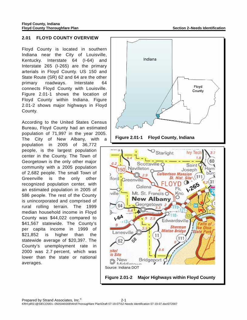
Figure 2.01-1 Floyd County, Indiana
I-64
I-265
I-64
I-265
Source: Indiana DOT Figure 2.01-2 Major Highways within Floyd County
2.01 FLOYD COUNTY OVERVIEW Floyd County is located in southern Indiana near the City of Louisville, Kentucky. Interstate 64 (I-64) and Interstate 265 (I-265) are the primary arterials in Floyd County. US 150 and State Route (SR) 62 and 64 are the other primary roadways. Interstate 64 connects Floyd County with Louisville. Figure 2.01-1 shows the location of Floyd County within Indiana. Figure 2.01-2 shows major highways in Floyd County. According to the United States Census Bureau, Floyd County had an estimated population of 71,997 in the year 2005. The City of New Albany, with a population in 2005 of 36,772 people, is the largest population center in the County. The Town of Georgetown is the only other major community with a 2005 population of 2,682 people. The small Town of Greenville is the only other recognized population center, with an estimated population in 2005 of 586 people. The rest of the County is unincorporated and comprised of rural rolling terrain. The 1999 median household income in Floyd County was $44,022 compared to $41,567 statewide. The County’s per capita income in 1999 of $21,852 is higher than the statewide average of $20,397. The County’s unemployment rate in 2000 was 2.7 percent, which was lower than the state or national averages.
Floyd County, Indiana Floyd County Thoroughfare Plan Section 2–Needs Identification
Prepared by Strand Associates, Inc.® 2-2 KRH:pll\S:\@SIECO\001--050\046\008\Wrd\Thoroughfare Plan\Draft 07-19-07\S2-Needs Identification 07-19-07.doc\072007
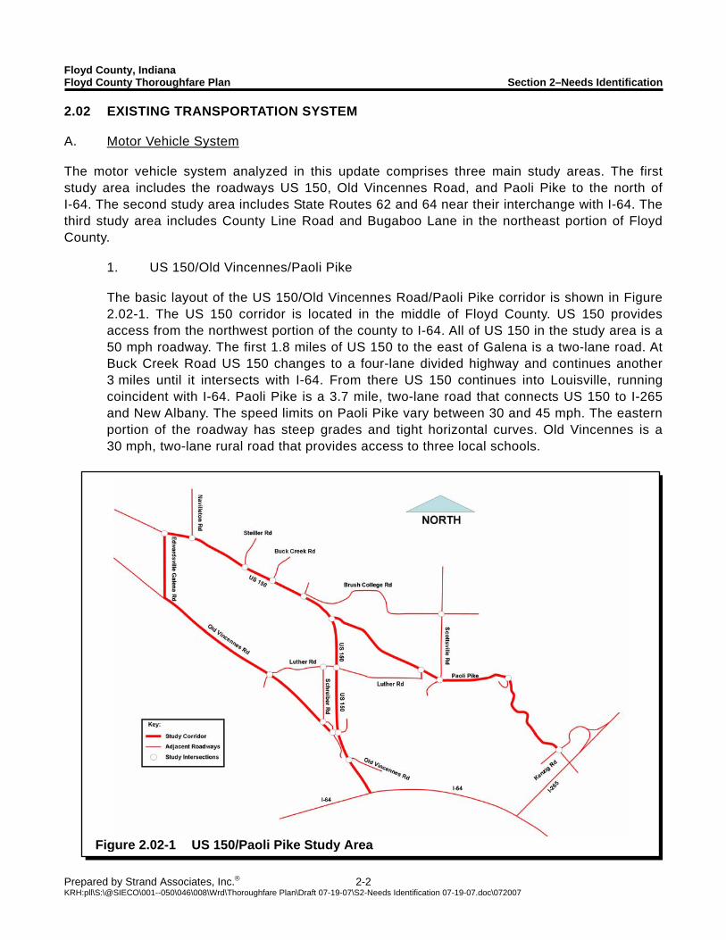
Figure 2.02-1 US 150/Paoli Pike Study Area
2.02 EXISTING TRANSPORTATION SYSTEM A. Motor Vehicle System The motor vehicle system analyzed in this update comprises three main study areas. The first study area includes the roadways US 150, Old Vincennes Road, and Paoli Pike to the north of I-64. The second study area includes State Routes 62 and 64 near their interchange with I-64. The third study area includes County Line Road and Bugaboo Lane in the northeast portion of Floyd County. 1. US 150/Old Vincennes/Paoli Pike The basic layout of the US 150/Old Vincennes Road/Paoli Pike corridor is shown in Figure
2.02-1. The US 150 corridor is located in the middle of Floyd County. US 150 provides access from the northwest portion of the county to I-64. All of US 150 in the study area is a 50 mph roadway. The first 1.8 miles of US 150 to the east of Galena is a two-lane road. At Buck Creek Road US 150 changes to a four-lane divided highway and continues another 3 miles until it intersects with I-64. From there US 150 continues into Louisville, running coincident with I-64. Paoli Pike is a 3.7 mile, two-lane road that connects US 150 to I-265 and New Albany. The speed limits on Paoli Pike vary between 30 and 45 mph. The eastern portion of the roadway has steep grades and tight horizontal curves. Old Vincennes is a 30 mph, two-lane rural road that provides access to three local schools.
Floyd County, Indiana Floyd County Thoroughfare Plan Section 2–Needs Identification
Prepared by Strand Associates, Inc.® 2-3 KRH:pll\S:\@SIECO\001--050\046\008\Wrd\Thoroughfare Plan\Draft 07-19-07\S2-Needs Identification 07-19-07.doc\072007
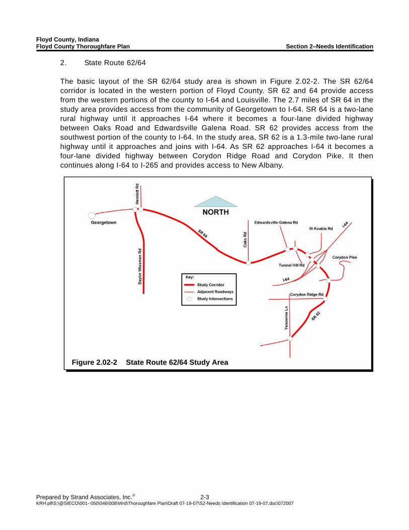
Figure 2.02-2 State Route 62/64 Study Area
2. State Route 62/64 The basic layout of the SR 62/64 study area is shown in Figure 2.02-2. The SR 62/64
corridor is located in the western portion of Floyd County. SR 62 and 64 provide access from the western portions of the county to I-64 and Louisville. The 2.7 miles of SR 64 in the study area provides access from the community of Georgetown to I-64. SR 64 is a two-lane rural highway until it approaches I-64 where it becomes a four-lane divided highway between Oaks Road and Edwardsville Galena Road. SR 62 provides access from the southwest portion of the county to I-64. In the study area, SR 62 is a 1.3-mile two-lane rural highway until it approaches and joins with I-64. As SR 62 approaches I-64 it becomes a four-lane divided highway between Corydon Ridge Road and Corydon Pike. It then continues along I-64 to I-265 and provides access to New Albany.
Floyd County, Indiana Floyd County Thoroughfare Plan Section 2–Needs Identification
Prepared by Strand Associates, Inc.® 2-4 KRH:pll\S:\@SIECO\001--050\046\008\Wrd\Thoroughfare Plan\Draft 07-19-07\S2-Needs Identification 07-19-07.doc\072007
Figure 2.02-3 County Line Road Study Area
Source: Transit Authority of River City
Figure 2.02-4 TARC Route Map
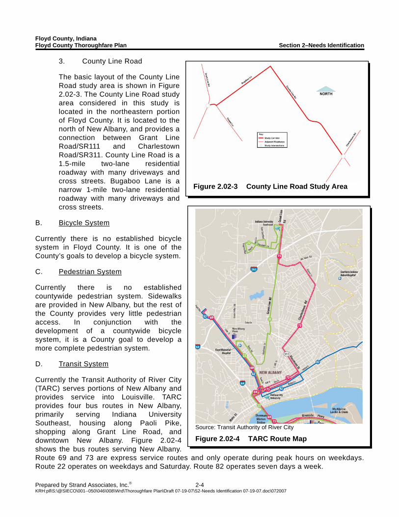
3. County Line Road
The basic layout of the County Line Road study area is shown in Figure 2.02-3. The County Line Road study area considered in this study is located in the northeastern portion of Floyd County. It is located to the north of New Albany, and provides a connection between Grant Line Road/SR111 and Charlestown Road/SR311. County Line Road is a 1.5-mile two-lane residential roadway with many driveways and cross streets. Bugaboo Lane is a narrow 1-mile two-lane residential roadway with many driveways and cross streets.
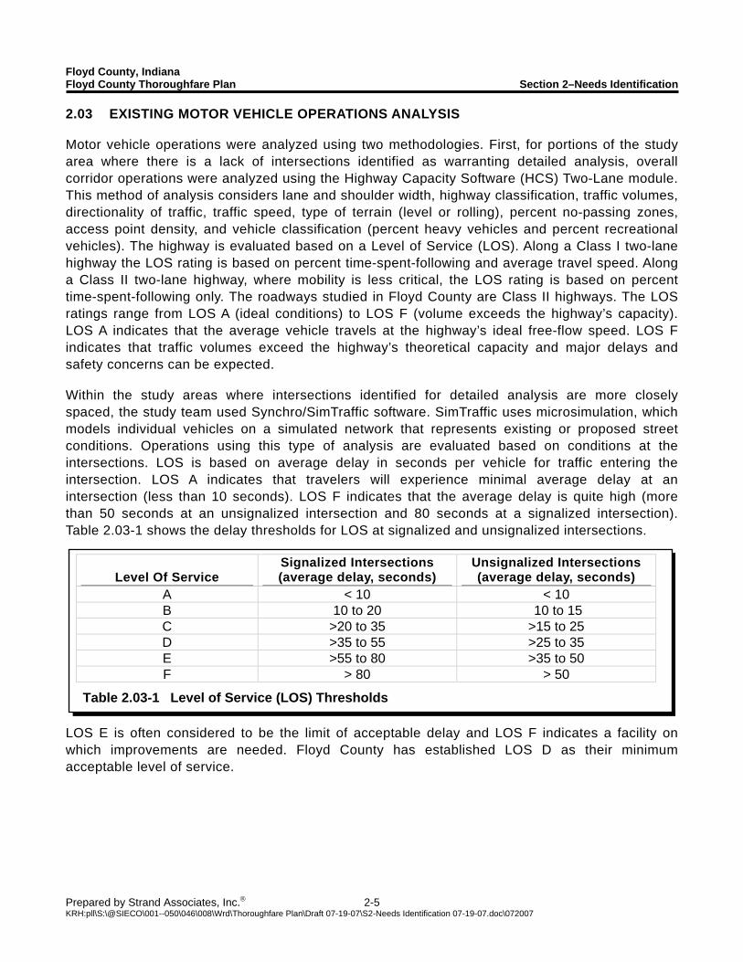
B. Bicycle System Currently there is no established bicycle system in Floyd County. It is one of the County’s goals to develop a bicycle system. C. Pedestrian System Currently there is no established countywide pedestrian system. Sidewalks are provided in New Albany, but the rest of the County provides very little pedestrian access. In conjunction with the development of a countywide bicycle system, it is a County goal to develop a more complete pedestrian system. D. Transit System Currently the Transit Authority of River City (TARC) serves portions of New Albany and provides service into Louisville. TARC provides four bus routes in New Albany, primarily serving Indiana University Southeast, housing along Paoli Pike, shopping along Grant Line Road, and downtown New Albany. Figure 2.02-4 shows the bus routes serving New Albany. Route 69 and 73 are express service routes and only operate during peak hours on weekdays. Route 22 operates on weekdays and Saturday. Route 82 operates seven days a week.
Floyd County, Indiana Floyd County Thoroughfare Plan Section 2–Needs Identification
Prepared by Strand Associates, Inc.® 2-5 KRH:pll\S:\@SIECO\001--050\046\008\Wrd\Thoroughfare Plan\Draft 07-19-07\S2-Needs Identification 07-19-07.doc\072007
Level Of Service Signalized Intersections (average delay, seconds)
Unsignalized Intersections (average delay, seconds)
A < 10 < 10 B 10 to 20 10 to 15 C >20 to 35 >15 to 25 D >35 to 55 >25 to 35 E >55 to 80 >35 to 50 F > 80 > 50
Table 2.03-1 Level of Service (LOS) Thresholds
2.03 EXISTING MOTOR VEHICLE OPERATIONS ANALYSIS Motor vehicle operations were analyzed using two methodologies. First, for portions of the study area where there is a lack of intersections identified as warranting detailed analysis, overall corridor operations were analyzed using the Highway Capacity Software (HCS) Two-Lane module. This method of analysis considers lane and shoulder width, highway classification, traffic volumes, directionality of traffic, traffic speed, type of terrain (level or rolling), percent no-passing zones, access point density, and vehicle classification (percent heavy vehicles and percent recreational vehicles). The highway is evaluated based on a Level of Service (LOS). Along a Class I two-lane highway the LOS rating is based on percent time-spent-following and average travel speed. Along a Class II two-lane highway, where mobility is less critical, the LOS rating is based on percent time-spent-following only. The roadways studied in Floyd County are Class II highways. The LOS ratings range from LOS A (ideal conditions) to LOS F (volume exceeds the highway’s capacity). LOS A indicates that the average vehicle travels at the highway’s ideal free-flow speed. LOS F indicates that traffic volumes exceed the highway’s theoretical capacity and major delays and safety concerns can be expected. Within the study areas where intersections identified for detailed analysis are more closely spaced, the study team used Synchro/SimTraffic software. SimTraffic uses microsimulation, which models individual vehicles on a simulated network that represents existing or proposed street conditions. Operations using this type of analysis are evaluated based on conditions at the intersections. LOS is based on average delay in seconds per vehicle for traffic entering the intersection. LOS A indicates that travelers will experience minimal average delay at an intersection (less than 10 seconds). LOS F indicates that the average delay is quite high (more than 50 seconds at an unsignalized intersection and 80 seconds at a signalized intersection). Table 2.03-1 shows the delay thresholds for LOS at signalized and unsignalized intersections.
LOS E is often considered to be the limit of acceptable delay and LOS F indicates a facility on which improvements are needed. Floyd County has established LOS D as their minimum acceptable level of service.
Floyd County, Indiana Floyd County Thoroughfare Plan Section 2–Needs Identification
Prepared by Strand Associates, Inc.® 2-6 KRH:pll\S:\@SIECO\001--050\046\008\Wrd\Thoroughfare Plan\Draft 07-19-07\S2-Needs Identification 07-19-07.doc\072007
Time Location AM Peak Hour PM Peak Hour
County Line Road LOS B LOS B Paoli Pike LOS D LOS D Old Vincennes Road LOS D LOS D Edwardsville Galena Road LOS C LOS C Baylor Wissman Road LOS A LOS A
Table 2.03-2 Existing Corridor LOS from HCS
Intersection Operations AM Peak Hour PM Peak Hour
Location Overall
Intersection OpsLOS F
Movement(s) Overall
Intersection Ops LOS F
Movement(s) US 150 and Old Vincennes Road LOS C LOS F SBL,
WBL, WBR US 150 and Lawrence Banet Road LOS B LOS D EBL
US 150 and Luther Road LOS A LOS B US 150 and Paoli Pike LOS D SBL LOS C US 150 and Brush College LOS F SBL, SBR LOS F SBL, SBR US 150 and Buck Creek LOS F SBL, SBR LOS F SBL, SBR US 150 and Stiller Road LOS F SBL, SBR LOS F SBL, SBR US 150 and Navilleton Road LOS F EBT LOS F WBT US 150 and Edwardsville–Galena Road LOS F NBL, NBR LOS F NBL, NBR Note: NBL = Northbound Left NBT = Northbound Through NBR = Northbound Right SBL = Southbound Left SBT = Southbound Through SBR = Southbound Right EBL = Eastbound Left EBT = Eastbound Through EBR = Eastbound Right WBL = Westbound Left WBT = Westbound Through WBR = Westbound Right
Table 2.03-3 Existing Intersection Operations from Synchro/SimTraffic on US 150
A. Corridor Operations Five corridor locations were analyzed. These were County Line Road and Bugaboo Lane, Paoli Pike, Old Vincennes Road, Edwardsville-Galena Road, and Baylor Wissman Road. All corridors operate at LOS D or better. Paoli Pike and Old Vincennes Road carry the largest amount of traffic of the five corridors analyzed and have the worst operation. Table 2.03-2 shows the results of the AM and PM corridor operations assessment.
B. Intersection Operations 1. US 150/Old Vincennes/Paoli Pike
Table 2.03-3 shows the results of the AM and PM intersection operations assessment for the intersections along US 150. Table 2.03-4 shows the results of the AM and PM intersection operations assessment for the intersections along Paoli Pike and Old Vincennes Road.
Floyd County, Indiana Floyd County Thoroughfare Plan Section 2–Needs Identification
Prepared by Strand Associates, Inc.® 2-7 KRH:pll\S:\@SIECO\001--050\046\008\Wrd\Thoroughfare Plan\Draft 07-19-07\S2-Needs Identification 07-19-07.doc\072007
Intersection Operations AM Peak Hour PM Peak Hour
Location Overall
Intersection Ops LOS F
Movement(s) Overall
Intersection Ops LOS F
Movement(s) Old Vincennes Road and Duffy Road LOS D LOS F SBL, SBT, SBR
Old Vincennes Road and Schreiber Road LOS B LOS C
Old Vincennes Road and Luther Road LOS F WBL, WBT,
WBR LOS B
Luther Road and Schreiber Road LOS A LOS A
Paoli Pike and Luther Road LOS C LOS B
Paoli Pike and Scottsville Road LOS C LOS C
Scottsville Road and St. Mary’s Road LOS C LOS C
Paoli Pike and Buffalo Trail LOS C LOS B
Paoli Pike and Kenzig Road LOS C LOS B
Note: NBL = Northbound Left NBT = Northbound Through NBR = Northbound Right SBL = Southbound Left SBT = Southbound Through SBR = Southbound Right EBL = Eastbound Left EBT = Eastbound Through EBR = Eastbound Right WBL = Westbound Left WBT = Westbound Through WBR = Westbound Right Table 2.03-4 Existing Intersection Operations from Synchro/SimTraffic along Paoli
Pike and Old Vincennes Road
Microsimulation modeling suggests, and field observation confirms, that significant congestion exists today along US 150, particularly between the intersections of Edwardsville-Galena Road and Paoli Pike. The intersection of Navilleton Road and US 150 experiences the worst congestion with long queues during both the morning and afternoon peak period, some approaching 1,200 feet or longer. The entire stop controlled side roads along US 150 experience long delays during both the morning and afternoon peak periods. Traffic moving from southbound US 150 to eastbound Paoli Pike in the morning also experiences long delays at the intersection. The reverse movement also experiences delays in the afternoon peak period. During the afternoon peak period the intersections of Lawrence Banet Road/US 150 and Old Vincennes Road/Duffy Road are very congested. The congestion is caused by the close proximity of the intersections and the delay that the eastbound traffic experiences at the intersection of Lawrence Banet Road and US 150.
Floyd County, Indiana Floyd County Thoroughfare Plan Section 2–Needs Identification
Prepared by Strand Associates, Inc.® 2-8 KRH:pll\S:\@SIECO\001--050\046\008\Wrd\Thoroughfare Plan\Draft 07-19-07\S2-Needs Identification 07-19-07.doc\072007
Intersection Queues AM Peak Hour PM Peak Hour
Location Approach Queue
Length (ft)
Blocks Upstream
Intersection Approach Queue
Length (ft)
Blocks Upstream
Intersection US 150 and Navilleton Road EBT 990 Yes WBT 1250 No
US 150 and Brush College Road
- - - SBL 500 No
US 150 and Paoli Pike EBL 790 No NBT 630 No
US 150 and Lawrence Banet Road
- - - EBL 360 Yes
Note: NBL = Northbound Left NBT = Northbound Through NBR = Northbound Right SBL = Southbound Left SBT = Southbound Through SBR = Southbound Right EBL = Eastbound Left EBT = Eastbound Through EBR = Eastbound Right WBL = Westbound Left WBT = Westbound Through WBR = Westbound Right Table 2.03-5 Critical Existing Intersection Queue Lengths in US 150 Study Area
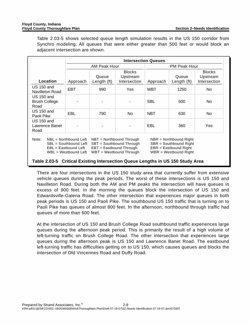
Table 2.03-5 shows selected queue length simulation results in the US 150 corridor from Synchro modeling. All queues that were either greater than 500 feet or would block an adjacent intersection are shown.
There are four intersections in the US 150 study area that currently suffer from extensive vehicle queues during the peak periods. The worst of these intersections is US 150 and Navilleton Road. During both the AM and PM peaks the intersection will have queues in excess of 900 feet. In the morning the queues block the intersection of US 150 and Edwardsville-Galena Road. The other intersection that experiences major queues in both peak periods is US 150 and Paoli Pike. The southbound US 150 traffic that is turning on to Paoli Pike has queues of almost 800 feet. In the afternoon, northbound through traffic had queues of more than 600 feet. At the intersection of US 150 and Brush College Road southbound traffic experiences large queues during the afternoon peak period. This is primarily the result of a high volume of left-turning traffic on Brush College Road. The other intersection that experiences large queues during the afternoon peak is US 150 and Lawrence Banet Road. The eastbound left-turning traffic has difficulties getting on to US 150, which causes queues and blocks the intersection of Old Vincennes Road and Duffy Road.

Floyd County, Indiana Floyd County Thoroughfare Plan Section 2–Needs Identification
Prepared by Strand Associates, Inc.® 2-9 KRH:pll\S:\@SIECO\001--050\046\008\Wrd\Thoroughfare Plan\Draft 07-19-07\S2-Needs Identification 07-19-07.doc\072007
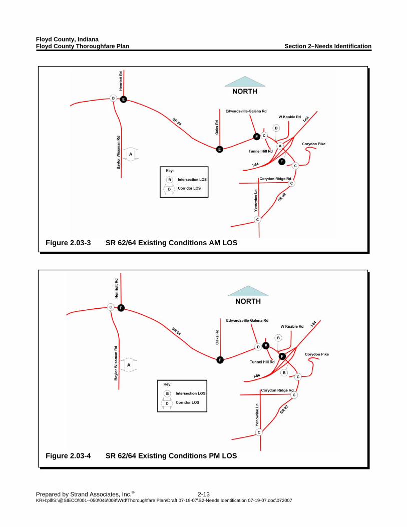
Figure 2.03-1 US 150 Existing Conditions AM LOS
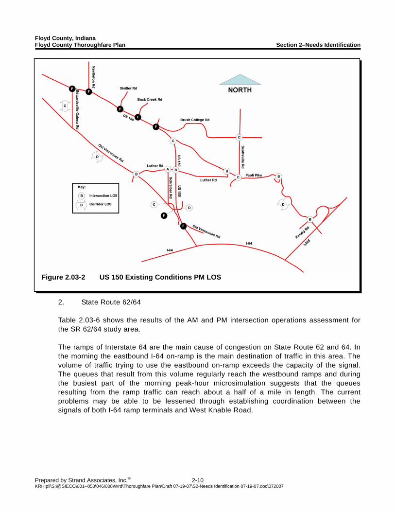
Figure 2.03-1 shows a summary of the AM existing conditions LOS. Figure 2.03-2 shows a summary of the PM existing conditions LOS.
Floyd County, Indiana Floyd County Thoroughfare Plan Section 2–Needs Identification
Prepared by Strand Associates, Inc.® 2-10 KRH:pll\S:\@SIECO\001--050\046\008\Wrd\Thoroughfare Plan\Draft 07-19-07\S2-Needs Identification 07-19-07.doc\072007
Figure 2.03-2 US 150 Existing Conditions PM LOS
2. State Route 62/64
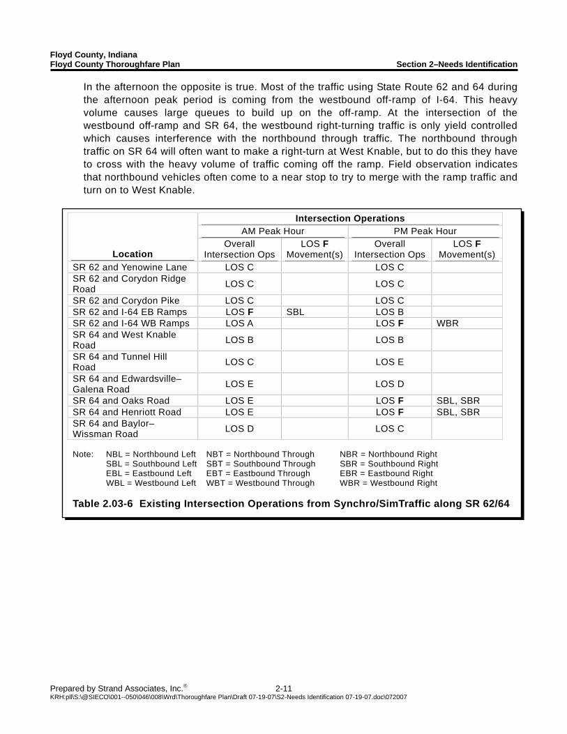
Table 2.03-6 shows the results of the AM and PM intersection operations assessment for the SR 62/64 study area. The ramps of Interstate 64 are the main cause of congestion on State Route 62 and 64. In the morning the eastbound I-64 on-ramp is the main destination of traffic in this area. The volume of traffic trying to use the eastbound on-ramp exceeds the capacity of the signal. The queues that result from this volume regularly reach the westbound ramps and during the busiest part of the morning peak-hour microsimulation suggests that the queues resulting from the ramp traffic can reach about a half of a mile in length. The current problems may be able to be lessened through establishing coordination between the signals of both I-64 ramp terminals and West Knable Road.
Floyd County, Indiana Floyd County Thoroughfare Plan Section 2–Needs Identification
Prepared by Strand Associates, Inc.® 2-11 KRH:pll\S:\@SIECO\001--050\046\008\Wrd\Thoroughfare Plan\Draft 07-19-07\S2-Needs Identification 07-19-07.doc\072007
Intersection Operations AM Peak Hour PM Peak Hour
Location Overall
Intersection Ops LOS F
Movement(s)Overall
Intersection Ops LOS F
Movement(s) SR 62 and Yenowine Lane LOS C LOS C SR 62 and Corydon Ridge Road LOS C LOS C
SR 62 and Corydon Pike LOS C LOS C SR 62 and I-64 EB Ramps LOS F SBL LOS B SR 62 and I-64 WB Ramps LOS A LOS F WBR SR 64 and West Knable Road LOS B LOS B
SR 64 and Tunnel Hill Road LOS C LOS E
SR 64 and Edwardsville–Galena Road LOS E LOS D
SR 64 and Oaks Road LOS E LOS F SBL, SBR SR 64 and Henriott Road LOS E LOS F SBL, SBR SR 64 and Baylor–Wissman Road LOS D LOS C
Note: NBL = Northbound Left NBT = Northbound Through NBR = Northbound Right SBL = Southbound Left SBT = Southbound Through SBR = Southbound Right EBL = Eastbound Left EBT = Eastbound Through EBR = Eastbound Right WBL = Westbound Left WBT = Westbound Through WBR = Westbound Right Table 2.03-6 Existing Intersection Operations from Synchro/SimTraffic along SR 62/64
In the afternoon the opposite is true. Most of the traffic using State Route 62 and 64 during the afternoon peak period is coming from the westbound off-ramp of I-64. This heavy volume causes large queues to build up on the off-ramp. At the intersection of the westbound off-ramp and SR 64, the westbound right-turning traffic is only yield controlled which causes interference with the northbound through traffic. The northbound through traffic on SR 64 will often want to make a right-turn at West Knable, but to do this they have to cross with the heavy volume of traffic coming off the ramp. Field observation indicates that northbound vehicles often come to a near stop to try to merge with the ramp traffic and turn on to West Knable.
Floyd County, Indiana Floyd County Thoroughfare Plan Section 2–Needs Identification
Prepared by Strand Associates, Inc.® 2-12 KRH:pll\S:\@SIECO\001--050\046\008\Wrd\Thoroughfare Plan\Draft 07-19-07\S2-Needs Identification 07-19-07.doc\072007
Intersection Queues AM Peak Hour PM Peak Hour
Location Approach Queue
Length (ft)
Blocks Upstream
Intersection Approach Queue
Length (ft)
Blocks Upstream
Intersection SBL 1430 Yes - - - SR 62 and I-64
EB Ramps NBR 500 No - - - SR 62 and I-64 WB Ramps - - - WBR 785 No
Note: NBL = Northbound Left NBT = Northbound Through NBR = Northbound Right SBL = Southbound Left SBT = Southbound Through SBR = Southbound Right EBL = Eastbound Left EBT = Eastbound Through EBR = Eastbound Right WBL = Westbound Left WBT = Westbound Through WBR = Westbound Right Table 2.03-7 Critical Existing Intersection Queue Lengths in SR 62/64 Study Area
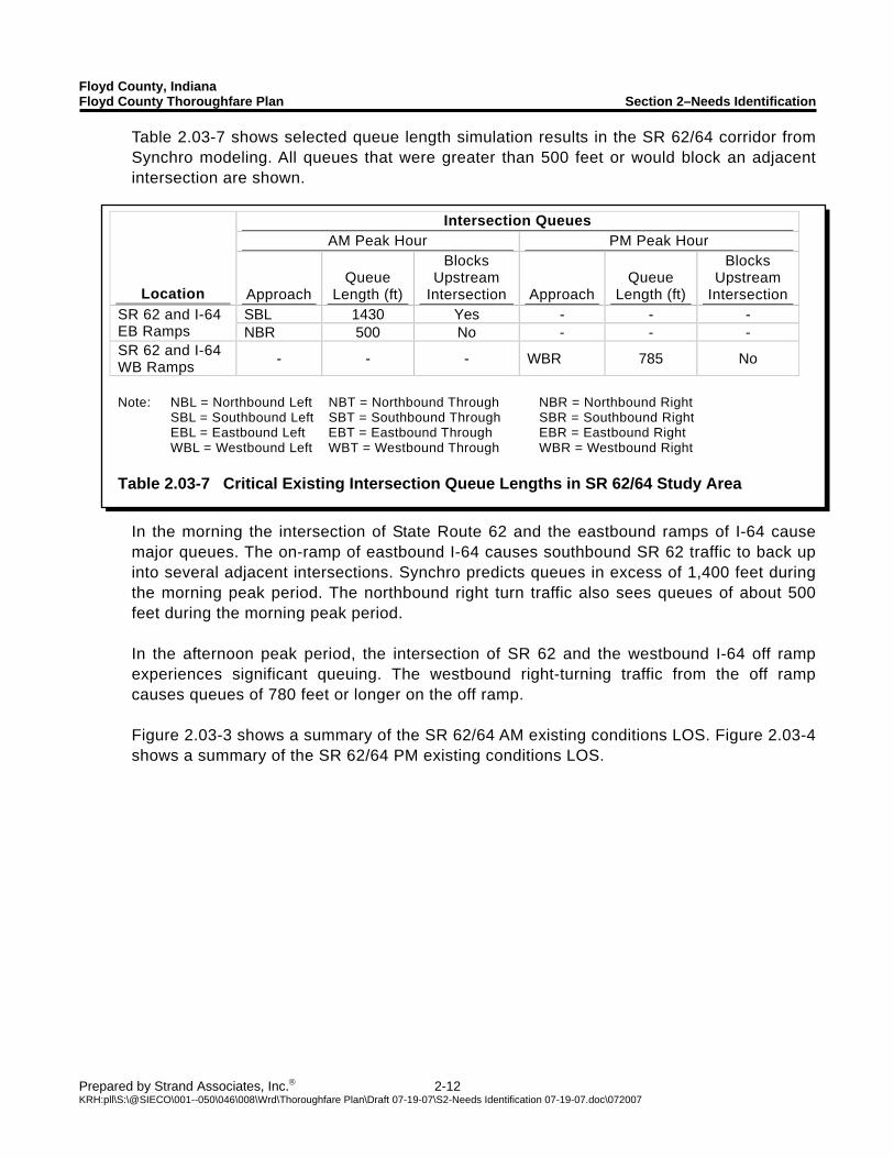
Table 2.03-7 shows selected queue length simulation results in the SR 62/64 corridor from Synchro modeling. All queues that were greater than 500 feet or would block an adjacent intersection are shown.
In the morning the intersection of State Route 62 and the eastbound ramps of I-64 cause major queues. The on-ramp of eastbound I-64 causes southbound SR 62 traffic to back up into several adjacent intersections. Synchro predicts queues in excess of 1,400 feet during the morning peak period. The northbound right turn traffic also sees queues of about 500 feet during the morning peak period.
In the afternoon peak period, the intersection of SR 62 and the westbound I-64 off ramp experiences significant queuing. The westbound right-turning traffic from the off ramp causes queues of 780 feet or longer on the off ramp. Figure 2.03-3 shows a summary of the SR 62/64 AM existing conditions LOS. Figure 2.03-4 shows a summary of the SR 62/64 PM existing conditions LOS.
Floyd County, Indiana Floyd County Thoroughfare Plan Section 2–Needs Identification
Prepared by Strand Associates, Inc.® 2-13 KRH:pll\S:\@SIECO\001--050\046\008\Wrd\Thoroughfare Plan\Draft 07-19-07\S2-Needs Identification 07-19-07.doc\072007
Figure 2.03-3 SR 62/64 Existing Conditions AM LOS
Figure 2.03-4 SR 62/64 Existing Conditions PM LOS
Floyd County, Indiana Floyd County Thoroughfare Plan Section 2–Needs Identification
Prepared by Strand Associates, Inc.® 2-14 KRH:pll\S:\@SIECO\001--050\046\008\Wrd\Thoroughfare Plan\Draft 07-19-07\S2-Needs Identification 07-19-07.doc\072007
Intersection Operations AM Peak Hour PM Peak Hour
Location Overall
Intersection Ops LOS F
Movement(s) Overall
Intersection Ops LOS F
Movement(s) County Line Road and Charlestown Road LOS A LOS A
Grant Line Road and Chapel Lane LOS C LOS C
Note: NBL = Northbound Left NBT = Northbound Through NBR = Northbound Right SBL = Southbound Left SBT = Southbound Through SBR = Southbound Right EBL = Eastbound Left EBT = Eastbound Through EBR = Eastbound Right WBL = Westbound Left WBT = Westbound Through WBR = Westbound Right Table 2.03-8 Existing Intersection Operations from Synchro/SimTraffic along County
Line Road
Location Daily VMT
Total Crashes
Injury Crashes
Fatal Crashes
Total Rate
Injury Rate
Fatal Rate
Paoli Pike 55,440 92 19 0 220 46 0 Old Vincennes Road–US 150 to Edwardsville Galena Road 26,600 81 11 0 404 55 0
Statewide Rates for Local Roads, 2003-05 -- 11,190 2,282 118 436 87 1.16
Crash Rates per 100 Million Vehicle Miles Table 2.03-9 Corridor Crash Rates January 1, 2005 to January 23, 2007
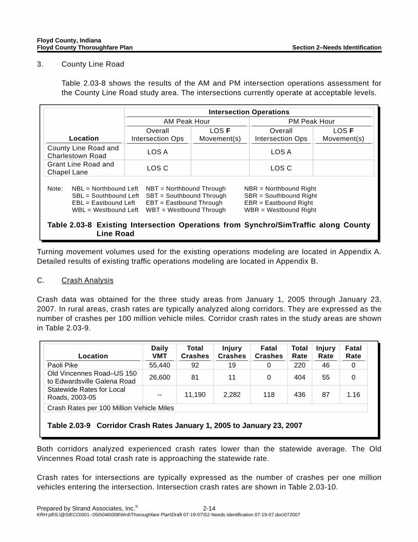
3. County Line Road Table 2.03-8 shows the results of the AM and PM intersection operations assessment for the County Line Road study area. The intersections currently operate at acceptable levels.
Turning movement volumes used for the existing operations modeling are located in Appendix A. Detailed results of existing traffic operations modeling are located in Appendix B. C. Crash Analysis Crash data was obtained for the three study areas from January 1, 2005 through January 23, 2007. In rural areas, crash rates are typically analyzed along corridors. They are expressed as the number of crashes per 100 million vehicle miles. Corridor crash rates in the study areas are shown in Table 2.03-9.
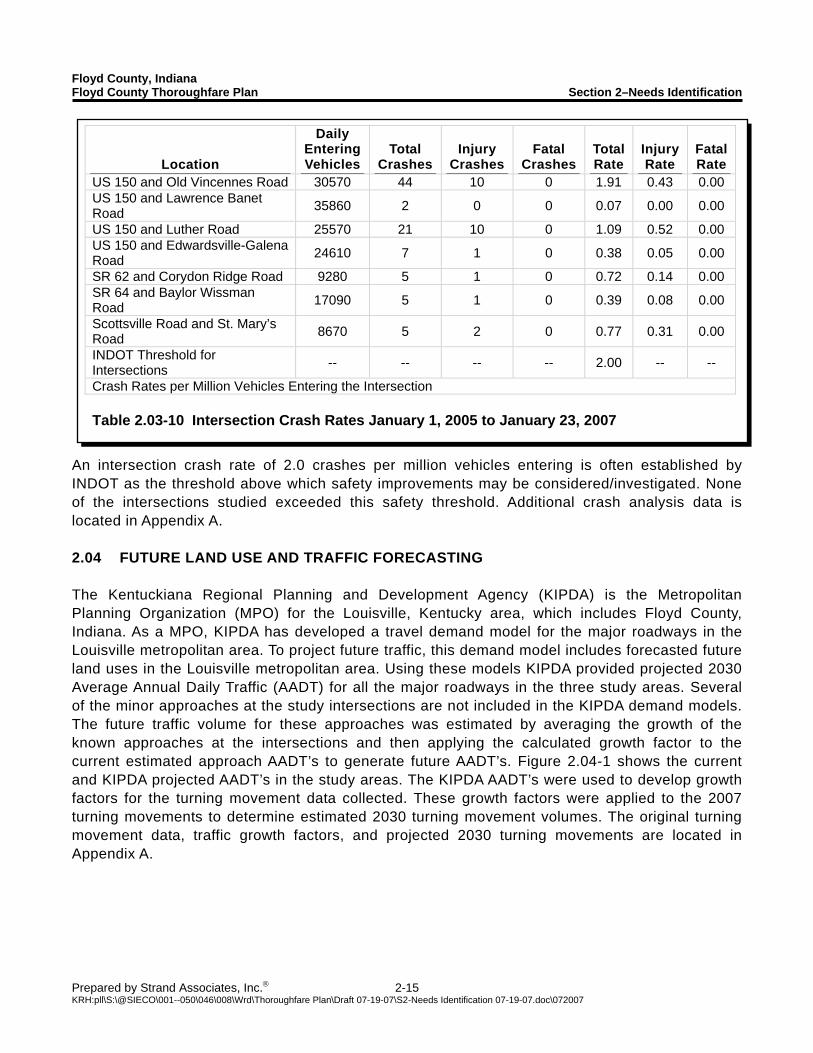
Both corridors analyzed experienced crash rates lower than the statewide average. The Old Vincennes Road total crash rate is approaching the statewide rate. Crash rates for intersections are typically expressed as the number of crashes per one million vehicles entering the intersection. Intersection crash rates are shown in Table 2.03-10.
Floyd County, Indiana Floyd County Thoroughfare Plan Section 2–Needs Identification
Prepared by Strand Associates, Inc.® 2-15 KRH:pll\S:\@SIECO\001--050\046\008\Wrd\Thoroughfare Plan\Draft 07-19-07\S2-Needs Identification 07-19-07.doc\072007
Location
Daily Entering Vehicles
Total Crashes
Injury Crashes
Fatal Crashes
Total Rate
Injury Rate
Fatal Rate
US 150 and Old Vincennes Road 30570 44 10 0 1.91 0.43 0.00 US 150 and Lawrence Banet Road 35860 2 0 0 0.07 0.00 0.00
US 150 and Luther Road 25570 21 10 0 1.09 0.52 0.00 US 150 and Edwardsville-Galena Road 24610 7 1 0 0.38 0.05 0.00
SR 62 and Corydon Ridge Road 9280 5 1 0 0.72 0.14 0.00 SR 64 and Baylor Wissman Road 17090 5 1 0 0.39 0.08 0.00
Scottsville Road and St. Mary’s Road 8670 5 2 0 0.77 0.31 0.00
INDOT Threshold for Intersections -- -- -- -- 2.00 -- --
Crash Rates per Million Vehicles Entering the Intersection Table 2.03-10 Intersection Crash Rates January 1, 2005 to January 23, 2007
An intersection crash rate of 2.0 crashes per million vehicles entering is often established by INDOT as the threshold above which safety improvements may be considered/investigated. None of the intersections studied exceeded this safety threshold. Additional crash analysis data is located in Appendix A. 2.04 FUTURE LAND USE AND TRAFFIC FORECASTING The Kentuckiana Regional Planning and Development Agency (KIPDA) is the Metropolitan Planning Organization (MPO) for the Louisville, Kentucky area, which includes Floyd County, Indiana. As a MPO, KIPDA has developed a travel demand model for the major roadways in the Louisville metropolitan area. To project future traffic, this demand model includes forecasted future land uses in the Louisville metropolitan area. Using these models KIPDA provided projected 2030 Average Annual Daily Traffic (AADT) for all the major roadways in the three study areas. Several of the minor approaches at the study intersections are not included in the KIPDA demand models. The future traffic volume for these approaches was estimated by averaging the growth of the known approaches at the intersections and then applying the calculated growth factor to the current estimated approach AADT’s to generate future AADT’s. Figure 2.04-1 shows the current and KIPDA projected AADT’s in the study areas. The KIPDA AADT’s were used to develop growth factors for the turning movement data collected. These growth factors were applied to the 2007 turning movements to determine estimated 2030 turning movement volumes. The original turning movement data, traffic growth factors, and projected 2030 turning movements are located in Appendix A.
Floyd County, Indiana Floyd County Thoroughfare Plan Section 2–Needs Identification
Prepared by Strand Associates, Inc.® 2-16 KRH:pll\S:\@SIECO\001--050\046\008\Wrd\Thoroughfare Plan\Draft 07-19-07\S2-Needs Identification 07-19-07.doc\072007
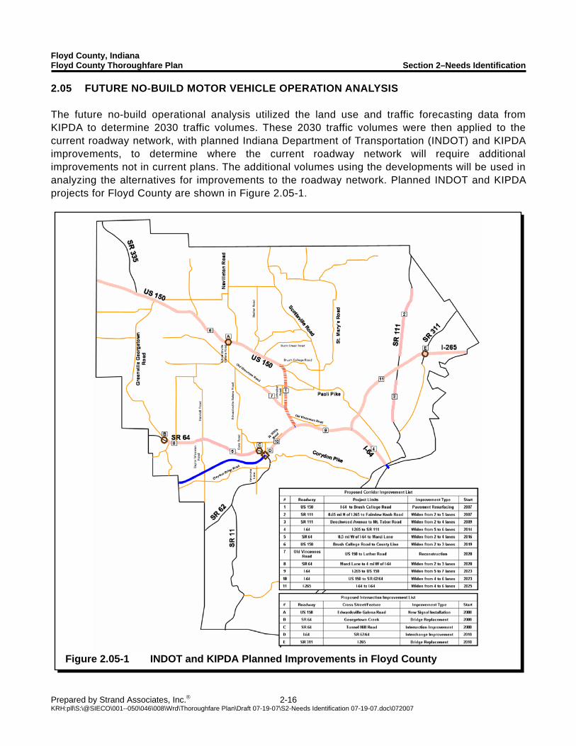
Figure 2.05-1 INDOT and KIPDA Planned Improvements in Floyd County
2.05 FUTURE NO-BUILD MOTOR VEHICLE OPERATION ANALYSIS The future no-build operational analysis utilized the land use and traffic forecasting data from KIPDA to determine 2030 traffic volumes. These 2030 traffic volumes were then applied to the current roadway network, with planned Indiana Department of Transportation (INDOT) and KIPDA improvements, to determine where the current roadway network will require additional improvements not in current plans. The additional volumes using the developments will be used in analyzing the alternatives for improvements to the roadway network. Planned INDOT and KIPDA projects for Floyd County are shown in Figure 2.05-1.
Floyd County, Indiana Floyd County Thoroughfare Plan Section 2–Needs Identification
Prepared by Strand Associates, Inc.® 2-17 KRH:pll\S:\@SIECO\001--050\046\008\Wrd\Thoroughfare Plan\Draft 07-19-07\S2-Needs Identification 07-19-07.doc\072007
Time Location AM Peak Hour PM Peak Hour
County Line Road LOS C LOS C Paoli Pike LOS D LOS D Old Vincennes Road LOS D LOS D Edwardsville Galena Road LOS C LOS C Baylor Wissman Road LOS B LOS B Table 2.05-1 Future No-Build Corridor LOS from HCS
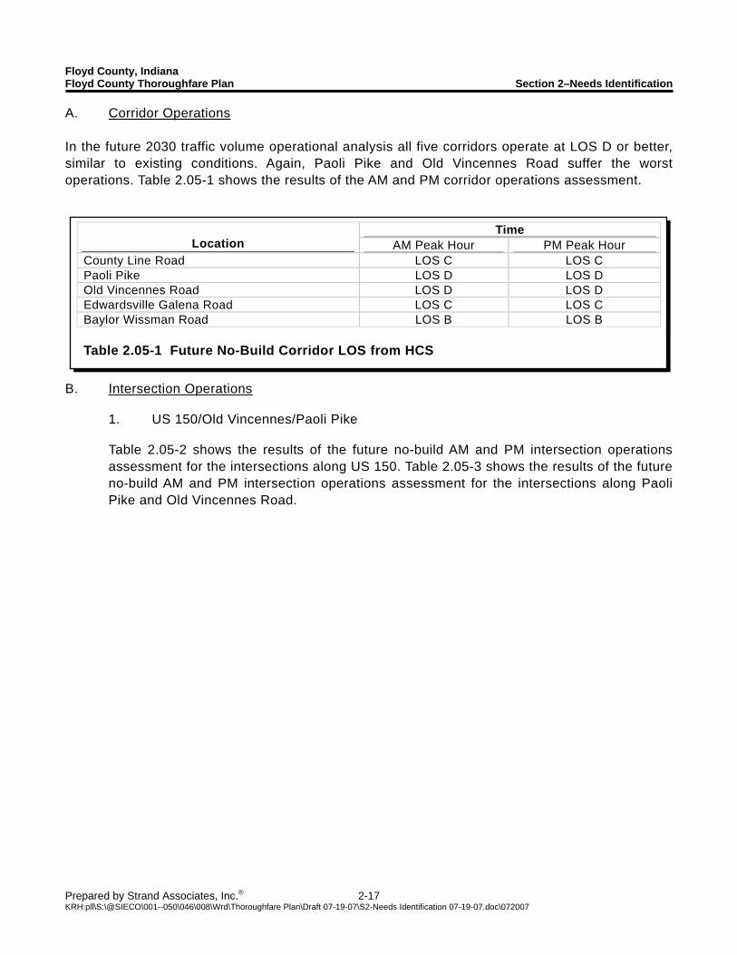
A. Corridor Operations In the future 2030 traffic volume operational analysis all five corridors operate at LOS D or better, similar to existing conditions. Again, Paoli Pike and Old Vincennes Road suffer the worst operations. Table 2.05-1 shows the results of the AM and PM corridor operations assessment.
B. Intersection Operations 1. US 150/Old Vincennes/Paoli Pike
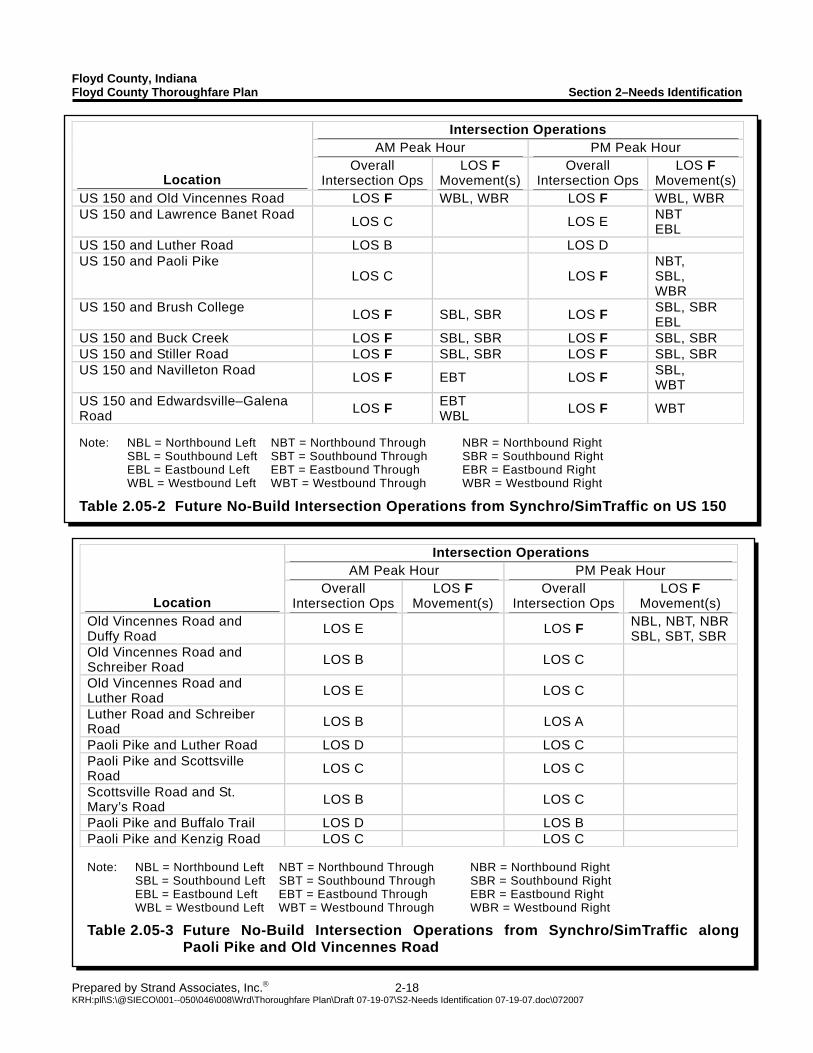
Table 2.05-2 shows the results of the future no-build AM and PM intersection operations assessment for the intersections along US 150. Table 2.05-3 shows the results of the future no-build AM and PM intersection operations assessment for the intersections along Paoli Pike and Old Vincennes Road.
Floyd County, Indiana Floyd County Thoroughfare Plan Section 2–Needs Identification
Prepared by Strand Associates, Inc.® 2-18 KRH:pll\S:\@SIECO\001--050\046\008\Wrd\Thoroughfare Plan\Draft 07-19-07\S2-Needs Identification 07-19-07.doc\072007
Intersection Operations AM Peak Hour PM Peak Hour
Location Overall
Intersection Ops LOS F
Movement(s)Overall
Intersection Ops LOS F
Movement(s)US 150 and Old Vincennes Road LOS F WBL, WBR LOS F WBL, WBR US 150 and Lawrence Banet Road LOS C LOS E NBT
EBL US 150 and Luther Road LOS B LOS D US 150 and Paoli Pike
LOS C LOS F NBT, SBL, WBR
US 150 and Brush College LOS F SBL, SBR LOS F SBL, SBR EBL
US 150 and Buck Creek LOS F SBL, SBR LOS F SBL, SBR US 150 and Stiller Road LOS F SBL, SBR LOS F SBL, SBR US 150 and Navilleton Road LOS F EBT LOS F SBL,
WBT US 150 and Edwardsville–Galena Road LOS F EBT
WBL LOS F WBT Note: NBL = Northbound Left NBT = Northbound Through NBR = Northbound Right SBL = Southbound Left SBT = Southbound Through SBR = Southbound Right EBL = Eastbound Left EBT = Eastbound Through EBR = Eastbound Right WBL = Westbound Left WBT = Westbound Through WBR = Westbound Right
Table 2.05-2 Future No-Build Intersection Operations from Synchro/SimTraffic on US 150
Intersection Operations AM Peak Hour PM Peak Hour
Location Overall
Intersection OpsLOS F
Movement(s) Overall
Intersection Ops LOS F
Movement(s) Old Vincennes Road and Duffy Road LOS E LOS F NBL, NBT, NBR
SBL, SBT, SBR Old Vincennes Road and Schreiber Road LOS B LOS C
Old Vincennes Road and Luther Road LOS E LOS C
Luther Road and Schreiber Road LOS B LOS A
Paoli Pike and Luther Road LOS D LOS C Paoli Pike and Scottsville Road LOS C LOS C
Scottsville Road and St. Mary’s Road LOS B LOS C
Paoli Pike and Buffalo Trail LOS D LOS B Paoli Pike and Kenzig Road LOS C LOS C Note: NBL = Northbound Left NBT = Northbound Through NBR = Northbound Right SBL = Southbound Left SBT = Southbound Through SBR = Southbound Right EBL = Eastbound Left EBT = Eastbound Through EBR = Eastbound Right WBL = Westbound Left WBT = Westbound Through WBR = Westbound Right
Table 2.05-3 Future No-Build Intersection Operations from Synchro/SimTraffic along Paoli Pike and Old Vincennes Road
Floyd County, Indiana Floyd County Thoroughfare Plan Section 2–Needs Identification
Prepared by Strand Associates, Inc.® 2-19 KRH:pll\S:\@SIECO\001--050\046\008\Wrd\Thoroughfare Plan\Draft 07-19-07\S2-Needs Identification 07-19-07.doc\072007
Intersection Queues AM Peak Hour PM Peak Hour
Location Approach Queue
Length (ft)
Blocks Upstream
Intersection Approach Queue
Length (ft)
Blocks Upstream
Intersection US 150 and Old Vincennes Road - - - WB >1500 No
US 150 and Lawrence Banet Road SBT 860 No NBT 1,180 No
US 150 and Luther Road SBT 800 No NBT 1,230 No
SBL 650 No NBT 1,250 No US 150 and Paoli Pike SBT 740 No WBR 800 No
US 150 and Brush College Road SB 730 Yes SB >1,500 Yes
US 150 and Navilleton Road EBT >1,500 Yes WBT >1,500 No
US 150 and Edwardsville – Galena Road
EBT >1,500 Yes WBT >1,500 Yes
Old Vincennes Road and Highlander Point - - - SB 830 Yes
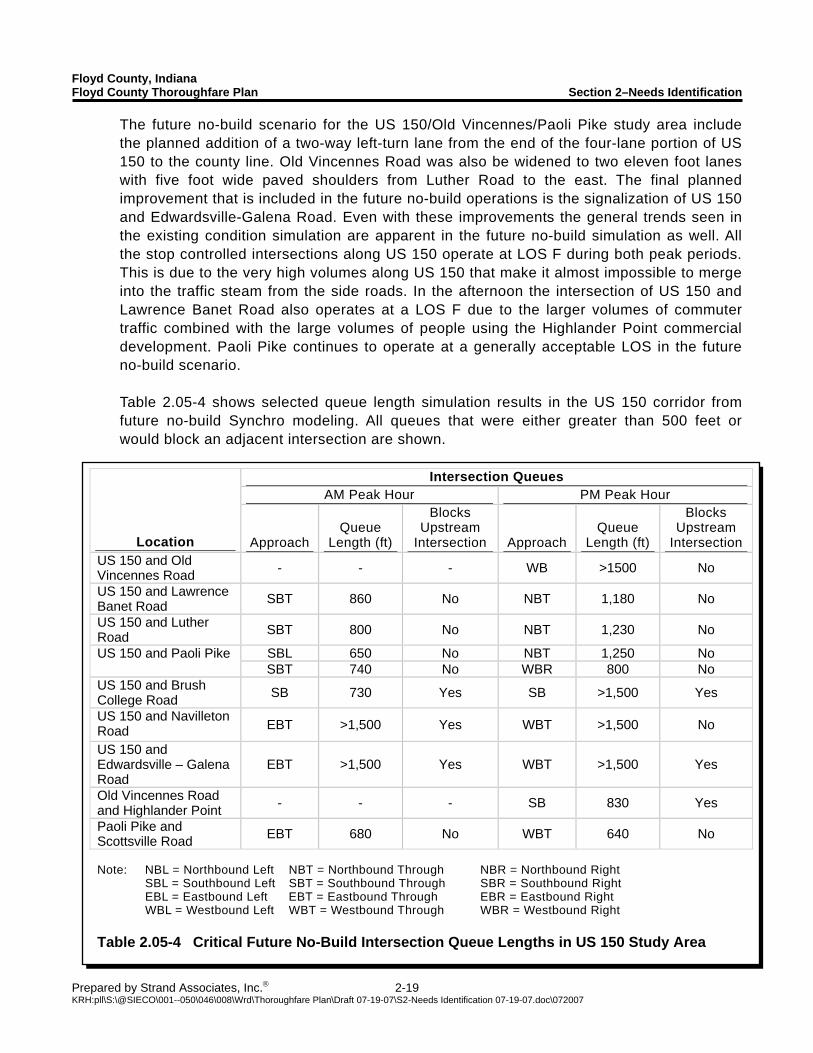
Paoli Pike and Scottsville Road EBT 680 No WBT 640 No Note: NBL = Northbound Left NBT = Northbound Through NBR = Northbound Right SBL = Southbound Left SBT = Southbound Through SBR = Southbound Right EBL = Eastbound Left EBT = Eastbound Through EBR = Eastbound Right WBL = Westbound Left WBT = Westbound Through WBR = Westbound Right Table 2.05-4 Critical Future No-Build Intersection Queue Lengths in US 150 Study Area
The future no-build scenario for the US 150/Old Vincennes/Paoli Pike study area include the planned addition of a two-way left-turn lane from the end of the four-lane portion of US 150 to the county line. Old Vincennes Road was also be widened to two eleven foot lanes with five foot wide paved shoulders from Luther Road to the east. The final planned improvement that is included in the future no-build operations is the signalization of US 150 and Edwardsville-Galena Road. Even with these improvements the general trends seen in the existing condition simulation are apparent in the future no-build simulation as well. All the stop controlled intersections along US 150 operate at LOS F during both peak periods. This is due to the very high volumes along US 150 that make it almost impossible to merge into the traffic steam from the side roads. In the afternoon the intersection of US 150 and Lawrence Banet Road also operates at a LOS F due to the larger volumes of commuter traffic combined with the large volumes of people using the Highlander Point commercial development. Paoli Pike continues to operate at a generally acceptable LOS in the future no-build scenario.
Table 2.05-4 shows selected queue length simulation results in the US 150 corridor from future no-build Synchro modeling. All queues that were either greater than 500 feet or would block an adjacent intersection are shown.
Floyd County, Indiana Floyd County Thoroughfare Plan Section 2–Needs Identification
Prepared by Strand Associates, Inc.® 2-20 KRH:pll\S:\@SIECO\001--050\046\008\Wrd\Thoroughfare Plan\Draft 07-19-07\S2-Needs Identification 07-19-07.doc\072007
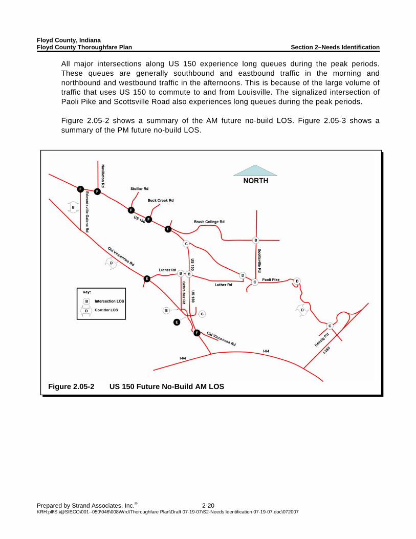
Figure 2.05-2 US 150 Future No-Build AM LOS
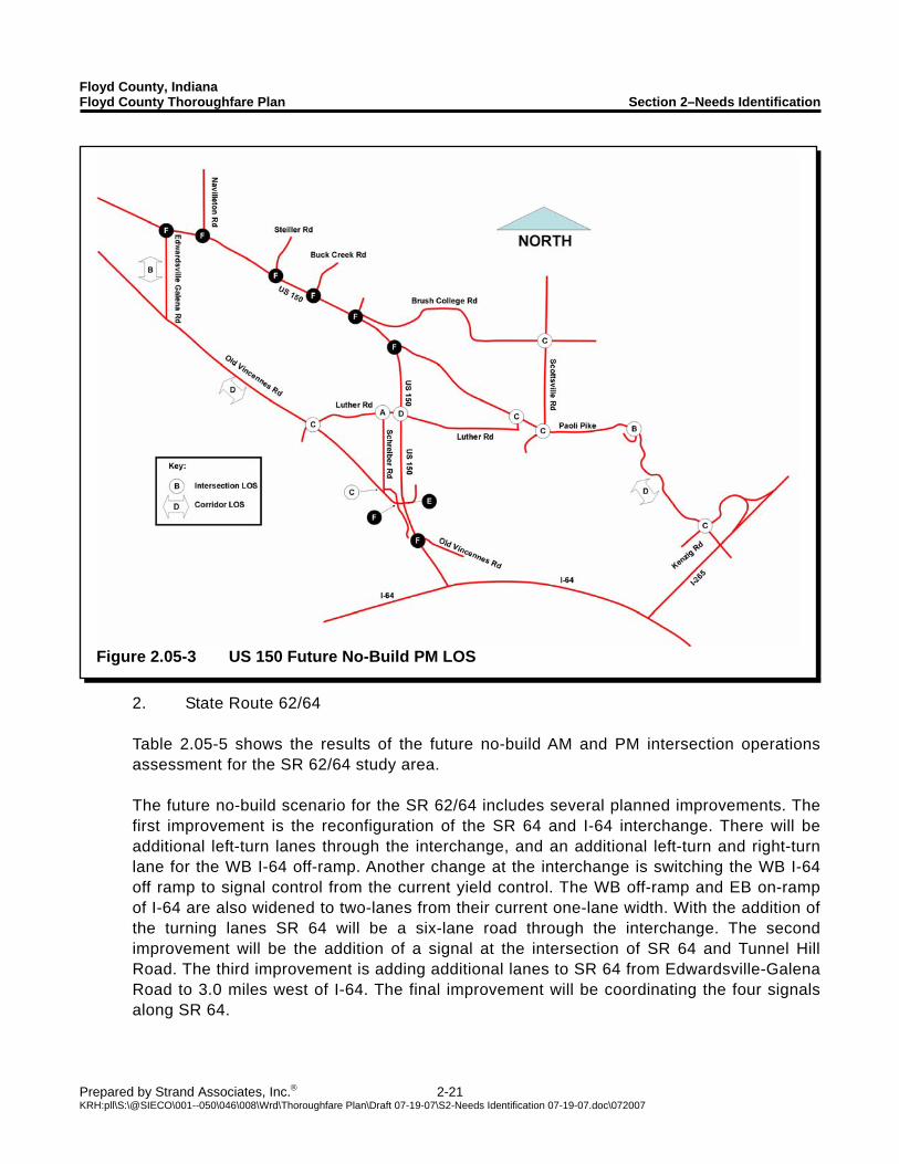
All major intersections along US 150 experience long queues during the peak periods. These queues are generally southbound and eastbound traffic in the morning and northbound and westbound traffic in the afternoons. This is because of the large volume of traffic that uses US 150 to commute to and from Louisville. The signalized intersection of Paoli Pike and Scottsville Road also experiences long queues during the peak periods. Figure 2.05-2 shows a summary of the AM future no-build LOS. Figure 2.05-3 shows a summary of the PM future no-build LOS.
Floyd County, Indiana Floyd County Thoroughfare Plan Section 2–Needs Identification
Prepared by Strand Associates, Inc.® 2-21 KRH:pll\S:\@SIECO\001--050\046\008\Wrd\Thoroughfare Plan\Draft 07-19-07\S2-Needs Identification 07-19-07.doc\072007
Figure 2.05-3 US 150 Future No-Build PM LOS
2. State Route 62/64
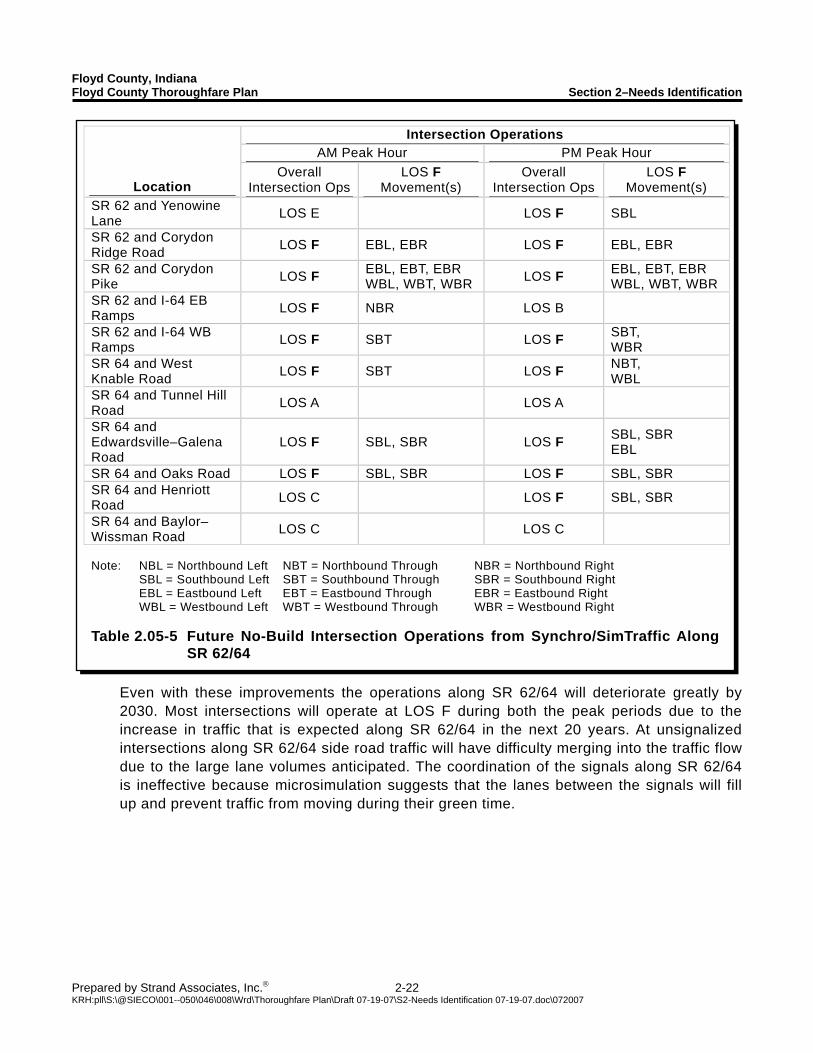
Table 2.05-5 shows the results of the future no-build AM and PM intersection operations assessment for the SR 62/64 study area.
The future no-build scenario for the SR 62/64 includes several planned improvements. The first improvement is the reconfiguration of the SR 64 and I-64 interchange. There will be additional left-turn lanes through the interchange, and an additional left-turn and right-turn lane for the WB I-64 off-ramp. Another change at the interchange is switching the WB I-64 off ramp to signal control from the current yield control. The WB off-ramp and EB on-ramp of I-64 are also widened to two-lanes from their current one-lane width. With the addition of the turning lanes SR 64 will be a six-lane road through the interchange. The second improvement will be the addition of a signal at the intersection of SR 64 and Tunnel Hill Road. The third improvement is adding additional lanes to SR 64 from Edwardsville-Galena Road to 3.0 miles west of I-64. The final improvement will be coordinating the four signals along SR 64.
Floyd County, Indiana Floyd County Thoroughfare Plan Section 2–Needs Identification
Prepared by Strand Associates, Inc.® 2-22 KRH:pll\S:\@SIECO\001--050\046\008\Wrd\Thoroughfare Plan\Draft 07-19-07\S2-Needs Identification 07-19-07.doc\072007
Intersection Operations AM Peak Hour PM Peak Hour
Location Overall
Intersection OpsLOS F
Movement(s) Overall
Intersection Ops LOS F
Movement(s) SR 62 and Yenowine Lane LOS E LOS F SBL
SR 62 and Corydon Ridge Road LOS F EBL, EBR LOS F EBL, EBR
SR 62 and Corydon Pike LOS F EBL, EBT, EBR
WBL, WBT, WBR LOS F EBL, EBT, EBR WBL, WBT, WBR
SR 62 and I-64 EB Ramps LOS F NBR LOS B
SR 62 and I-64 WB Ramps LOS F SBT LOS F SBT,
WBR SR 64 and West Knable Road LOS F SBT LOS F NBT,
WBL SR 64 and Tunnel Hill Road LOS A LOS A
SR 64 and Edwardsville–Galena Road
LOS F SBL, SBR LOS F SBL, SBR EBL
SR 64 and Oaks Road LOS F SBL, SBR LOS F SBL, SBR SR 64 and Henriott Road LOS C LOS F SBL, SBR
SR 64 and Baylor–Wissman Road LOS C LOS C
Note: NBL = Northbound Left NBT = Northbound Through NBR = Northbound Right SBL = Southbound Left SBT = Southbound Through SBR = Southbound Right EBL = Eastbound Left EBT = Eastbound Through EBR = Eastbound Right WBL = Westbound Left WBT = Westbound Through WBR = Westbound Right Table 2.05-5 Future No-Build Intersection Operations from Synchro/SimTraffic Along
SR 62/64
Even with these improvements the operations along SR 62/64 will deteriorate greatly by 2030. Most intersections will operate at LOS F during both the peak periods due to the increase in traffic that is expected along SR 62/64 in the next 20 years. At unsignalized intersections along SR 62/64 side road traffic will have difficulty merging into the traffic flow due to the large lane volumes anticipated. The coordination of the signals along SR 62/64 is ineffective because microsimulation suggests that the lanes between the signals will fill up and prevent traffic from moving during their green time.
Floyd County, Indiana Floyd County Thoroughfare Plan Section 2–Needs Identification
Prepared by Strand Associates, Inc.® 2-23 KRH:pll\S:\@SIECO\001--050\046\008\Wrd\Thoroughfare Plan\Draft 07-19-07\S2-Needs Identification 07-19-07.doc\072007
Intersection Queues AM Peak Hour PM Peak Hour
Location Approach Queue
Length (ft)
Blocks Upstream
Intersection Approach Queue
Length (ft)
Blocks Upstream
Intersection SR 62 and Corydon Ridge Road
EB 590 Yes - - -
SBL 830 Yes - - - EB >1,500 Yes - - -
SR 62 and Corydon Pike
WB >1,500 Yes WB 800 Yes SR 62 and I-64 EB Ramps NBR 1,130 Yes - - -
SR 62 and I-64 WB Ramps SBT 790 Yes WBR 1,370 No
SR 64 and West Knable Road
SBT 560 Yes WBL 530 Yes
SR 64 and Edwardsville - Galena Road
- - - SB 450 Yes
Note: NBL = Northbound Left NBT = Northbound Through NBR = Northbound Right SBL = Southbound Left SBT = Southbound Through SBR = Southbound Right EBL = Eastbound Left EBT = Eastbound Through EBR = Eastbound Right WBL = Westbound Left WBT = Westbound Through WBR = Westbound Right Table 2.05-6 Critical Future No-Build Intersection Queue Lengths in SR 62/64 Study Area
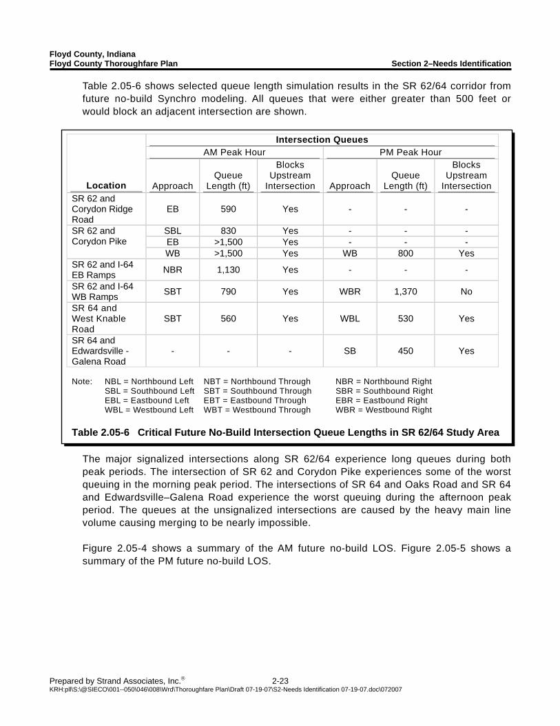
Table 2.05-6 shows selected queue length simulation results in the SR 62/64 corridor from future no-build Synchro modeling. All queues that were either greater than 500 feet or would block an adjacent intersection are shown.
The major signalized intersections along SR 62/64 experience long queues during both peak periods. The intersection of SR 62 and Corydon Pike experiences some of the worst queuing in the morning peak period. The intersections of SR 64 and Oaks Road and SR 64 and Edwardsville–Galena Road experience the worst queuing during the afternoon peak period. The queues at the unsignalized intersections are caused by the heavy main line volume causing merging to be nearly impossible.
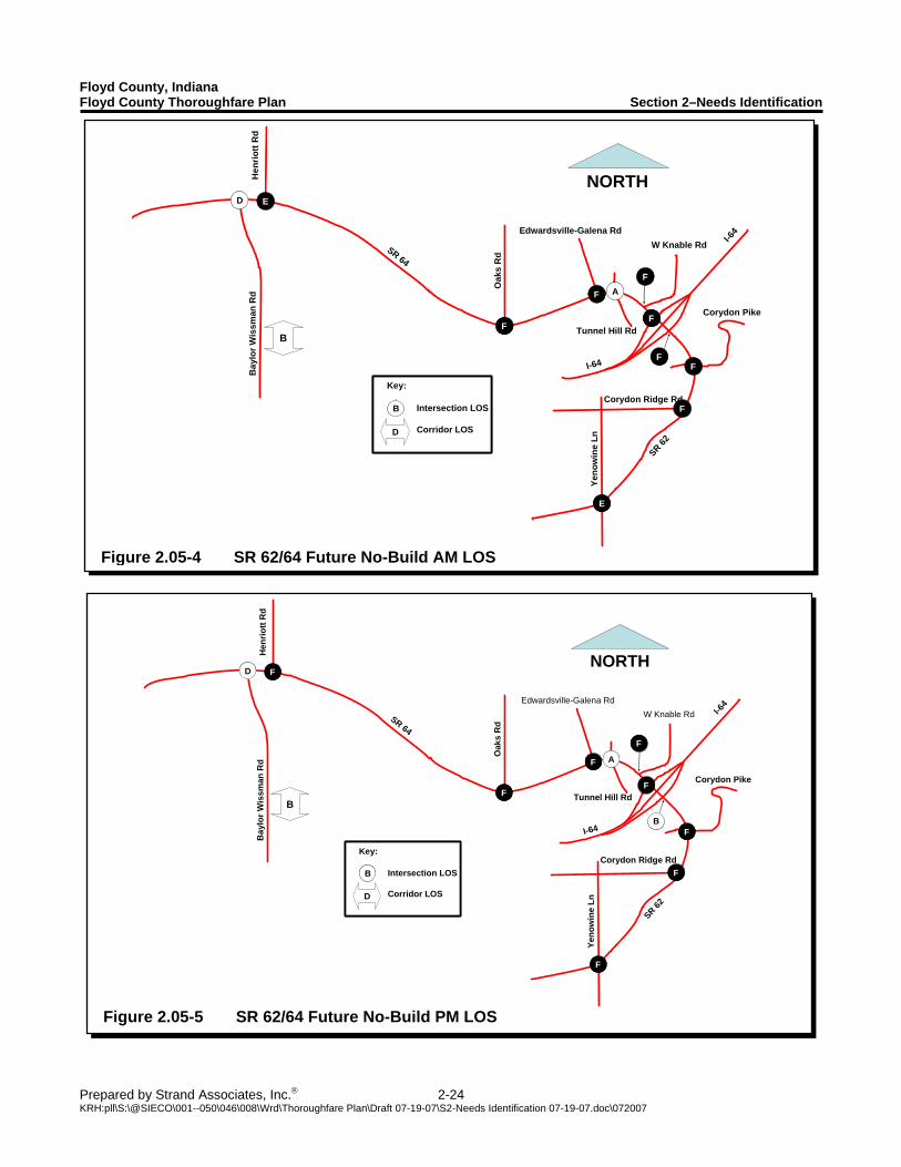
Figure 2.05-4 shows a summary of the AM future no-build LOS. Figure 2.05-5 shows a summary of the PM future no-build LOS.
Floyd County, Indiana Floyd County Thoroughfare Plan Section 2–Needs Identification
Prepared by Strand Associates, Inc.® 2-24 KRH:pll\S:\@SIECO\001--050\046\008\Wrd\Thoroughfare Plan\Draft 07-19-07\S2-Needs Identification 07-19-07.doc\072007
Corydon Pike
I-64
I-64
SR 64
SR 62
Yeno
win
e Ln
Corydon Ridge Rd
Oak
s R
d
Bay
lor W
issm
an R
d
NORTH
W Knable RdEdwardsville-Galena Rd
Tunnel Hill Rd
AAFF
FFB
FF
Hen
riott
Rd
DD
FF
FF
FF
FF
BB
FF
Key:
Intersection LOS
Corridor LOS
B
D
Key:
Intersection LOS
Corridor LOS
BB
D
Figure 2.05-5 SR 62/64 Future No-Build PM LOS
Corydon Pike
I-64
I-64
SR 64
SR 62
Yeno
win
e Ln
Corydon Ridge Rd
Oak
s R
d
Bay
lor W
issm
an R
d
NORTH
W Knable RdEdwardsville-Galena Rd
Tunnel Hill Rd
FF
AAFF
FFB
EE
Hen
riott
Rd
DD
FF
FF
FF
EE
FF
Key:
Intersection LOS
Corridor LOS
B
D
Key:
Intersection LOS
Corridor LOS
BB
D
Figure 2.05-4 SR 62/64 Future No-Build AM LOS
Floyd County, Indiana Floyd County Thoroughfare Plan Section 2–Needs Identification
Prepared by Strand Associates, Inc.® 2-25 KRH:pll\S:\@SIECO\001--050\046\008\Wrd\Thoroughfare Plan\Draft 07-19-07\S2-Needs Identification 07-19-07.doc\072007
Intersection Operations AM Peak Hour PM Peak Hour
Location Overall
Intersection Ops LOS F
Movement(s) Overall
Intersection Ops LOS F
Movement(s) County Line Road and Charlestown Road
LOS A LOS A
Grant Line Road and Chapel Lane LOS B LOS A
Note: NBL = Northbound Left NBT = Northbound Through NBR = Northbound Right SBL = Southbound Left SBT = Southbound Through SBR = Southbound Right EBL = Eastbound Left EBT = Eastbound Through EBR = Eastbound Right WBL = Westbound Left WBT = Westbound Through WBR = Westbound Right Table 2.05-7 Future No-Build Intersection Operations from Synchro/SimTraffic along
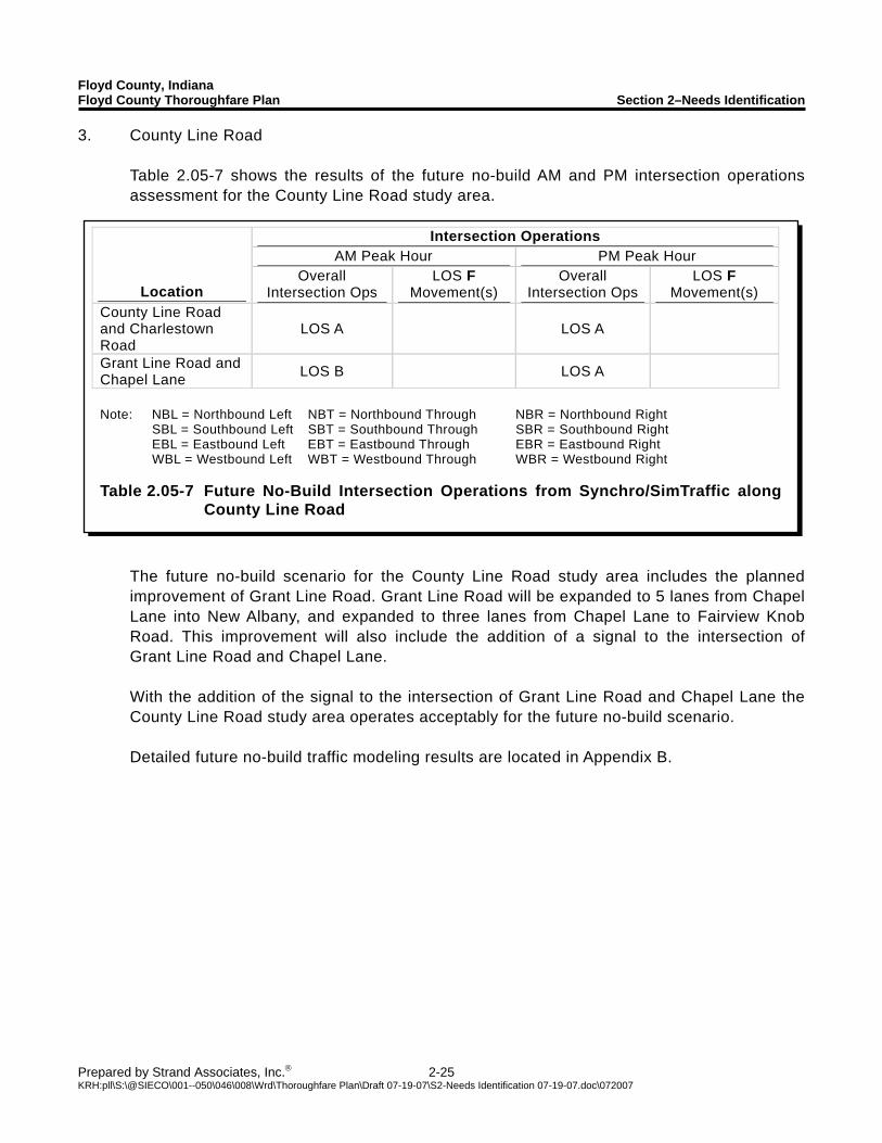
County Line Road
3. County Line Road Table 2.05-7 shows the results of the future no-build AM and PM intersection operations assessment for the County Line Road study area.
The future no-build scenario for the County Line Road study area includes the planned improvement of Grant Line Road. Grant Line Road will be expanded to 5 lanes from Chapel Lane into New Albany, and expanded to three lanes from Chapel Lane to Fairview Knob Road. This improvement will also include the addition of a signal to the intersection of Grant Line Road and Chapel Lane. With the addition of the signal to the intersection of Grant Line Road and Chapel Lane the County Line Road study area operates acceptably for the future no-build scenario. Detailed future no-build traffic modeling results are located in Appendix B.
Floyd County, Indiana Floyd County Thoroughfare Plan Section 2–Needs Identification
Prepared by Strand Associates, Inc.® 2-26 KRH:pll\S:\@SIECO\001--050\046\008\Wrd\Thoroughfare Plan\Draft 07-19-07\S2-Needs Identification 07-19-07.doc\072007
Figure 2.06-1 Prioritized Improvements for Floyd County
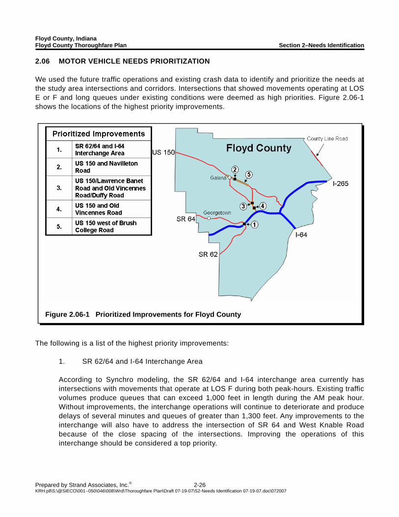
2.06 MOTOR VEHICLE NEEDS PRIORITIZATION We used the future traffic operations and existing crash data to identify and prioritize the needs at the study area intersections and corridors. Intersections that showed movements operating at LOS E or F and long queues under existing conditions were deemed as high priorities. Figure 2.06-1 shows the locations of the highest priority improvements.
The following is a list of the highest priority improvements: 1. SR 62/64 and I-64 Interchange Area According to Synchro modeling, the SR 62/64 and I-64 interchange area currently has
intersections with movements that operate at LOS F during both peak-hours. Existing traffic volumes produce queues that can exceed 1,000 feet in length during the AM peak hour. Without improvements, the interchange operations will continue to deteriorate and produce delays of several minutes and queues of greater than 1,300 feet. Any improvements to the interchange will also have to address the intersection of SR 64 and West Knable Road because of the close spacing of the intersections. Improving the operations of this interchange should be considered a top priority.
Floyd County, Indiana Floyd County Thoroughfare Plan Section 2–Needs Identification
Prepared by Strand Associates, Inc.® 2-27 KRH:pll\S:\@SIECO\001--050\046\008\Wrd\Thoroughfare Plan\Draft 07-19-07\S2-Needs Identification 07-19-07.doc\072007
2. US 150 and Navilleton Road According to Synchro modeling, US 150 and Navilleton Road currently has movements that
operate at LOS F during both peak-hours. Existing traffic volumes on US 150 are approaching the thresholds of a four-lane facility. Projected traffic volumes operating on the existing two-lane facility result in long delays and queues of 1,300 feet in length. Modeling indicates that the intersection will operate at LOS F overall in the near future. Improvements that increase the capacity of this intersection should be considered a priority.
3. US 150/Lawrence Banet Road/Old Vincennes Road and Old Vincennes Road/Duffy
Road According to Synchro modeling, these intersections currently experience poor operations
during the PM peak-hour. Because of the close proximity of these two intersections, any changes to one will directly affect the other. If the future growth of the Highland Point area is realized, these intersections will have failing operations. Improvements that would increase the capacity of these intersections should be considered a priority.
4. US 150 and Old Vincennes Road According to Synchro modeling, the intersection of US 150 and Old Vincennes Road
experiences poor operations during the PM peak hour. The heavy northbound traffic volumes on US 150 during the PM peak-hour cause long delays for southbound left-turning traffic and queues that completely fill the left-turn storage bay. Traffic on Old Vincennes Road also experiences long delays during the PM peak-hour. Improvements that would increase the capacity of this intersection should be considered a priority.
5. Two-lane portion of US 150 west of Brush College Road Traffic volumes on this portion of US 150 are approaching typical thresholds for a four-lane
facility during both peak hours. The major stop controlled side roads also experience failing operations during both peak periods. Improvements that increase the corridor’s capacity should be considered a priority.

SECTION 3 ALTERNATIVES DEVELOPMENT
Floyd County, Indiana Floyd County Thoroughfare Plan Section 3–Alternatives Development
Prepared by Strand Associates, Inc.® 3-1 KRH:pll\S:\@SIECO\001--050\046\008\Wrd\Thoroughfare Plan\Draft 07-19-07\S3-Alternatives Development 07-19-07.doc\072007
3.01 TRADITIONAL MOTOR VEHICLE CAPACITY EXPANSION A. Recommended Functional Classifications Functional classifications are used to categorize roads based on their intended primary functions, which include mobility and accessibility. The three basic classifications of roadways are arterials, collectors, and local roads. The functional classifications of Floyd County roadways are comprised of five main categories as explained below:
Principal Arterial–Principal arterials connect larger urban areas and provide statewide or interstate travel. The primary function of a primary arterial is mobility. To facilitate the mobility function, a principal arterial should provide high travel speeds with minimum interference to through movements. Principal arterials typically see traffic volumes greater than 15,000 vehicles per day (vpd).
Secondary Arterial–Secondary arterials connect cities, larger towns, and other traffic generators. These routes integrate interstate and intercounty service. The primary function of a secondary arterial is mobility. A secondary arterial should provide higher speed service and limit the interference to the through movements, but this is not as critical as with a primary arterial. Secondary arterials typically see traffic volumes of 10,000 to 15,000 vpd.
Major Collector–Major collectors connect towns and traffic generators not served by principal or secondary arterials, and serve intracounty routes. Schools, freight facilities, and county parks are typically served by major collectors. A major collector should provide for both the mobility of through traffic and access to the local land uses. Major collectors typically see traffic volumes of 5,000 to 10,000 vpd.
Minor Collector–Minor collectors accumulate traffic from the local roads and link smaller communities to the collector network. They link locally important traffic generators with rural areas. A minor collector should provide for both mobility of through traffic and access to the local land uses. Minor collectors typically see traffic volumes of 1,000 to 5,000 vpd.
Local Roads–Local roads primarily provide access to land adjacent to the collector network. This network constitutes all rural roads not classified as arterials or collectors. Local roads typically see traffic volumes of less than 1,000 vpd.
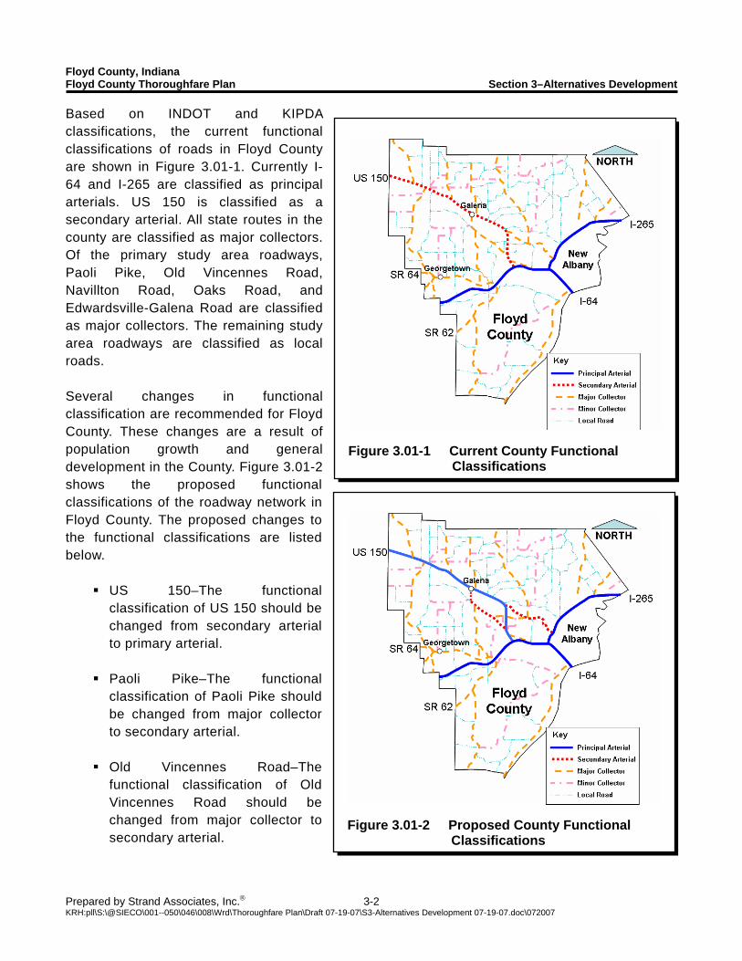
Floyd County, Indiana Floyd County Thoroughfare Plan Section 3–Alternatives Development
Prepared by Strand Associates, Inc.® 3-2 KRH:pll\S:\@SIECO\001--050\046\008\Wrd\Thoroughfare Plan\Draft 07-19-07\S3-Alternatives Development 07-19-07.doc\072007
Figure 3.01-1 Current County Functional
Classifications
Figure 3.01-2 Proposed County Functional
Classifications
Based on INDOT and KIPDA classifications, the current functional classifications of roads in Floyd County are shown in Figure 3.01-1. Currently I-64 and I-265 are classified as principal arterials. US 150 is classified as a secondary arterial. All state routes in the county are classified as major collectors. Of the primary study area roadways, Paoli Pike, Old Vincennes Road, Navillton Road, Oaks Road, and Edwardsville-Galena Road are classified as major collectors. The remaining study area roadways are classified as local roads. Several changes in functional classification are recommended for Floyd County. These changes are a result of population growth and general development in the County. Figure 3.01-2 shows the proposed functional classifications of the roadway network in Floyd County. The proposed changes to the functional classifications are listed below.
US 150–The functional classification of US 150 should be changed from secondary arterial to primary arterial.
Paoli Pike–The functional
classification of Paoli Pike should be changed from major collector to secondary arterial.
Old Vincennes Road–The
functional classification of Old Vincennes Road should be changed from major collector to secondary arterial.
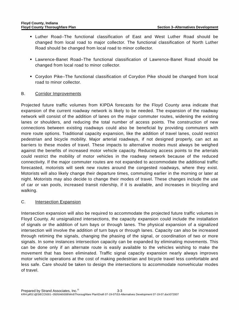
Floyd County, Indiana Floyd County Thoroughfare Plan Section 3–Alternatives Development
Prepared by Strand Associates, Inc.® 3-3 KRH:pll\S:\@SIECO\001--050\046\008\Wrd\Thoroughfare Plan\Draft 07-19-07\S3-Alternatives Development 07-19-07.doc\072007
Luther Road–The functional classification of East and West Luther Road should be changed from local road to major collector. The functional classification of North Luther Road should be changed from local road to minor collector.
Lawrence-Banet Road–The functional classification of Lawrence-Banet Road should be
changed from local road to minor collector. Corydon Pike–The functional classification of Corydon Pike should be changed from local
road to minor collector.
B. Corridor Improvements Projected future traffic volumes from KIPDA forecasts for the Floyd County area indicate that expansion of the current roadway network is likely to be needed. The expansion of the roadway network will consist of the addition of lanes on the major commuter routes, widening the existing lanes or shoulders, and reducing the total number of access points. The construction of new connections between existing roadways could also be beneficial by providing commuters with more route options. Traditional capacity expansion, like the addition of travel lanes, could restrict pedestrian and bicycle mobility. Major arterial roadways, if not designed properly, can act as barriers to these modes of travel. These impacts to alternative modes must always be weighed against the benefits of increased motor vehicle capacity. Reducing access points to the arterials could restrict the mobility of motor vehicles in the roadway network because of the reduced connectivity. If the major commuter routes are not expanded to accommodate the additional traffic forecasted, motorists will seek new routes around the congested roadways, where they exist. Motorists will also likely change their departure times, commuting earlier in the morning or later at night. Motorists may also decide to change their modes of travel. These changes include the use of car or van pools, increased transit ridership, if it is available, and increases in bicycling and walking. C. Intersection Expansion Intersection expansion will also be required to accommodate the projected future traffic volumes in Floyd County. At unsignalized intersections, the capacity expansion could include the installation of signals or the addition of turn bays or through lanes. The physical expansion of a signalized intersection will involve the addition of turn bays or through lanes. Capacity can also be increased through retiming the signals, changing the phasing of the signal, or coordination of two or more signals. In some instances intersection capacity can be expanded by eliminating movements. This can be done only if an alternate route is easily available to the vehicles wishing to make the movement that has been eliminated. Traffic signal capacity expansion nearly always improves motor vehicle operations at the cost of making pedestrian and bicycle travel less comfortable and less safe. Care should be taken to design the intersections to accommodate nonvehicular modes of travel.
Floyd County, Indiana Floyd County Thoroughfare Plan Section 3–Alternatives Development
Prepared by Strand Associates, Inc.® 3-4 KRH:pll\S:\@SIECO\001--050\046\008\Wrd\Thoroughfare Plan\Draft 07-19-07\S3-Alternatives Development 07-19-07.doc\072007
3.02 ALTERNATIVE CAPACITY EXPANSION Alternative capacity expansion involves increasing the capacity of corridors and intersections by nontraditional means. These types of expansion can effectively accommodate increased traffic, but often face public opposition to their implementation. Possible alternative capacity expansion of corridors could include grade-separated streets or reversible lanes. When at-grade intersections can not accommodate traffic volumes, grade-separated streets are sometimes a good option. Implementation of grade separated streets would require the construction of bridges and ramps at intersections with cross streets. The interchanges created often require additional right-of-way to be purchased because of the increased intersection footprint. Reversible lanes are used on corridors with highly directional flow to provide additional capacity in the dominant direction of travel. Specialized pavement marking, signage, and overhead signal indications are typically used to denote the direction of travel for the reversible lane throughout the day. During off-peak hours these lanes can be used as center left-turn lanes. There are several alternative intersection layouts that have been proposed to handle large volumes of traffic without having to use grade-separation. One possible solution for increasing capacity and safety is to covert an intersection to a modern roundabout. These intersections are typically safer than conventional signalized intersections. Also, traditional intersections have difficulties accommodating large volumes of left-turning traffic. There are several intersection layouts that have been developed to relocate the left-turn movements away from the major intersection or allow them to operate in conjunction with opposing traffic. Typically, the increase in intersection capacity is offset by increased right-of-way requirements, indirect minor movements, complex (and sometimes confusing or unfamiliar) layouts, and pedestrian and bicycle concerns regarding comfort and safety. 3.03 MULTIMODAL IMPROVEMENTS An important component of the Floyd County Thoroughfare Plan is the development of multimodal transportation options. The different multimodal elements within this plan are bicycle, pedestrian, and transit modes of travel. A strong community transportation system incorporates and examines all modes of transportation in order to provide a balanced and interconnected system in which residents can choose multiple travel options. Before an operational analysis of the different modes can occur, an overview of the current systems, community policies, and appropriate regulations is required. A. Bicycle and Pedestrian Travel In 1999, the County adopted a new Comprehensive Plan document that stressed the need for reservation of appropriate linkages for pedestrian and bicycle pathways. The plan also had a goal of developing “a balanced transportation system that promotes safe local and through access and provides for pedestrian and nonmotorized mobility.” The County implemented this land use policy within the 2004 Subdivision Control Ordinance. In this ordinance, internal sidewalks are mandated
Floyd County, Indiana Floyd County Thoroughfare Plan Section 3–Alternatives Development
Prepared by Strand Associates, Inc.® 3-5 KRH:pll\S:\@SIECO\001--050\046\008\Wrd\Thoroughfare Plan\Draft 07-19-07\S3-Alternatives Development 07-19-07.doc\072007
when subdivisions reach a density level of greater than one dwelling unit per acre. The new Floyd County Zoning Ordinance incorporates bicycle and pedestrian systems through requirements for commercial and higher density residential development to provide for pedestrian and bicycle connectivity. The United States Department of Transportation guidebook Accommodating Bicycle and Pedestrian Travel: A Recommended Approach, sets a policy statement regarding the integration of bicycling and pedestrian facilities into a community’s transportation system. The design guidebook incorporates three key principles. These principles are as follows:
Bicycling and walking facilities should be incorporated into all transportation projects unless exceptional circumstances exist.
Development of an approach to this policy that has been deemed successful in State and
local agencies. A series of action items that a community can take to achieve the overriding goal of
improving conditions for bicycling and walking. In relationship to these principles, the community should incorporate bicycle and pedestrian facilities in new construction and reconstruction whenever possible. Only in cases where the adoption of such multimodal paths are either prohibited by law from usage, the cost of establishing the pathway would be disproportionately high to the need or projected use, or when the population is sparse, should the inclusion of bicycle and pedestrian facilities not be required. Additionally, design consideration should be made to incorporate the safe crossing along main corridors, such as SR 62/64 and US 150. Design standards shall follow the guidelines and standards set forth in the AASHTO Guide for the Development of Bicycle Facilities and ITE Recommended Practice Design and Safety of Pedestrian Facilities.
1. Bicycle System An analysis of the County’s bicycle system can be summed up with the following statement, “There is no current infrastructure in place solely dedicated to the bicycle mode of transportation.” This is evident within the county’s municipalities and in the unincorporated areas of the county. Proposed bicycle infrastructure is being developed along the City of New Albany’s waterfront area as part of a multijurisdictional Ohio River Greenways project. However, there are no dedicated or designated bike routes within the community. Current residents using bicycles as modes of transportation either for personal or recreational activities, use existing streets and road infrastructure. Within the county, this poses a potential safety issue. Most county roads are minor collector or local roadways. Almost all of these roads do not have shoulders, and have total roadway widths that vary from 18 to 22 feet in most cases. Also, because of the topography of the community, safe options for traveling from the City of New Albany to the outlying rural areas are extremely limited.
Floyd County, Indiana Floyd County Thoroughfare Plan Section 3–Alternatives Development
Prepared by Strand Associates, Inc.® 3-6 KRH:pll\S:\@SIECO\001--050\046\008\Wrd\Thoroughfare Plan\Draft 07-19-07\S3-Alternatives Development 07-19-07.doc\072007
2. Pedestrian System An initial review of the pedestrian system indicates a system predicated on municipal boundaries. In Floyd County, there are three municipalities, the Town of Georgetown, the Town of Greenville, and the City of New Albany. The City of New Albany has an intricate pedestrian system within its borders. This is primarily due to the nature and size of the community. The City is the main economic, social, and governmental hub for the County, and is the largest municipality. The Town of Georgetown is the second largest municipality within the County. Its pedestrian system is primarily limited to the Town’s core. Georgetown is located along SR 64 west of I-64. There are limited opportunities within its system to navigate in a north-south direction, crossing SR 64, as a pedestrian. The Town of Greenville is located in the northwestern quadrant of the county. It is the smallest of the three municipalities and does not have a functioning pedestrian system. In terms of the unincorporated county, the pedestrian system historically had not been addressed in land use decisions. Elements of interconnectivity and walkability within commercial cores have been nonexistent in the past. However, recent community land use policies and regulatory documents have begun to address the pedestrian and bicycle systems. In the development of pedestrian systems within the unincorporated areas of the county, a tiered approach should be taken. This tiered system should address the pedestrian needs at three functional levels. These accessibility and mobility levels are: commercial, residential and recreational. Each of these levels should be part of an overall pedestrian system designed to link and accommodate pedestrian traffic throughout the County. The ideal pedestrian system will serve all three levels of need equally. 3. Pedestrian and Bicycle Focus Areas As it was previously stated, Floyd County’s new land use policies address the bicycle and pedestrian system within commercial and residential zoning districts. Internal and external connections are now required in new developments and a greater emphasis on this connectivity is a priority of the County’s Plan Commission during site development reviews. While this does address new development, the community is still dealing with the needs of retrofitting key corridors in the development of a truly integrated and functional pedestrian system. Each of these key corridors has been identified and the needs for each area are defined below.
a. Floyds Knobs The Floyds Knobs area is a unique place nested at the top of the knobs area. Paoli Pike, which was until the 1960s a section of US 150, provides the Floyd Knobs area with its own main street. Paoli Pike has an AADT of 13,500 vpd. While not considered a town by Indiana statute, this area has historically and currently functions as an unofficial town. The area’s proximity to Greater Louisville and the majestic views of the Greater Louisville that the area provides has created a demand for the development of Floyd Knobs proper.
Floyd County, Indiana Floyd County Thoroughfare Plan Section 3–Alternatives Development
Prepared by Strand Associates, Inc.® 3-7 KRH:pll\S:\@SIECO\001--050\046\008\Wrd\Thoroughfare Plan\Draft 07-19-07\S3-Alternatives Development 07-19-07.doc\072007
Development patterns have created a large increase in the population of the area. Three new housing developments have been recently approved that include high-rise condominiums, an assisted living facility, and a retail center. Presently, there is no bicycle or pedestrian system within the Floyds Knobs corridor. Providing off-street pedestrian and bicycle connectivity for Floyds Knobs is desirable. b. Highlander Point The Highlander Point area is located on US 150 and is one of the two premier gateways into the County. The first commercial development took place in the 1970s with the building of the Highlander Point Shopping Center. For the next thirty years commercial development was sporadic with a smaller commercial development taking place to the south of the Highlander Point complex. In 2003, LaFollette Station, a large scale commercial development was created. This commercial complex located to the east of US 150 is being developed as a contemporary to the Highlander Point complex located to the west of US 150. Internal connectivity is mixed in both developments and external connectivity is nonexistent. The 2005 Floyd County Comprehensive Plan has designated this area as a residential and commercial growth area. As future development takes place, development of integrated bicycle and pedestrian facilities is necessary to meet the plan policies. c. Edwardsville Located at the I-64 and SR 62/64 interchange, this area is similar in its sense of place to Floyds Knobs. A portion of the community was displaced by the construction of I-64 in the late 1960s. As with the Highlander Point area, Edwardsville has been designated as a residential and commercial growth area. It has a small but vibrant commercial mix of highway service and neighborhood commercial uses in the area. Higher density development is expected in the area, with a focus on patio homes. New commercial development has taken place recently in the building of a medical arts building. Recently, a 3-acre commercial development, which is incorporating one of thirteen National Historical Register home sites in the unincorporated County has been approved by the Plan Commission. Like the other mentioned development areas, there is no dedicated bicycle or pedestrian system present in this development area. A combination of retrofitting existing development and enforcing the requirements for new development will be necessary to provide for a fully functioning multimodal link.
Floyd County, Indiana Floyd County Thoroughfare Plan Section 3–Alternatives Development
Prepared by Strand Associates, Inc.® 3-8 KRH:pll\S:\@SIECO\001--050\046\008\Wrd\Thoroughfare Plan\Draft 07-19-07\S3-Alternatives Development 07-19-07.doc\072007
d. Galena Galena is located on US 150 approximately 5 miles west of the US 150 and I-64 interchange. Galena is a small town like area with development patterns presently being centered on the US Highway. New residential development has taken place adjacent to the highway. Presently, there is a limited amount of commercial development and several vacant commercial buildings. There is no present bicycle or pedestrian system. As part of the comprehensive plan, a creation of an area plan has been determined to be needed to assist in guiding future development.
B. Transit System Improvements The development of an efficient and effective transit component for the County is becoming a more prevalent policy discussion. Increasing fuel costs, projected traffic growth, and demonstrated lower levels of service for the county’s transportation system have propelled this transportation element forward. Providing on-demand or fixed-route systems, park and ride options, and high occupancy vehicle lanes are community transportation issues that need further planning activities. Improving the transit system in Floyd County could help lessen congestion on County roadways in the future. Currently there are no fixed route mass transit options for residents living in Georgetown, Greenville, and the unincorporated areas of Floyd County. TARC provides service only in the City of New Albany. The development of new routes serving higher-density activity centers along US 150 and SR 62/64 in Floyd County could greatly increase ridership on mass transit. Travelers will only use mass transit if it is able to get them to their destinations as quickly as if they used automobiles. To increase the attractiveness of mass transit and provide faster service, dedicated bus lanes should also be considered.

SECTION 4 ALTERNATIVES EVALUATION
Floyd County, Indiana Floyd County Thoroughfare Plan Section 4–Alternatives Evaluation
Prepared by Strand Associates, Inc.® 4-1 KRH:pll\S:\@SIECO\001--050\046\008\Wrd\Thoroughfare Plan\Draft 07-19-07\S4-Alternative Evaluation 07-19-07.doc\072007
4.01 TRADITIONAL CAPACITY EXPANSION A. Corridor Expansion The proposed corridor expansions are designed to allow for acceptable vehicular operations. A summary of the proposed improvements is shown in Figure 4.01-3 and the improvements are listed below. 1. County Line Road
County Line Road operates at LOS B in the future no-build scenario. County Line Road is not expected to experience any major congestion issues by the year 2030. Because of this acceptable operation, no capacity expansion improvements are suggested. County Line Road is currently a narrow roadway that does not have shoulders. As the amount of traffic on County Line Road increases, the addition of shoulders and the widening of the through lanes would be desirable. 2. Paoli Pike
Paoli Pike operates at LOS D in the future no-build scenario. The roadway operations are hurt by the rolling terrain that Paoli Pike passes through. The LOS D operating level is driven by the amount of time spent following other vehicles on the roadway. There are two primary options to improve operations for this corridor. The first option is to reconstruct the roadway. This would involve reducing the number of access points, softening vertical and horizontal curves, and widening the roadway and shoulders. The second option would be to construct wider shoulders along the length of the roadway. The reconstruction option would provide the greatest potential benefits, but at an increased cost of construction. Both options could be difficult to construct because of the limited right-of-way, particularly along the eastern portion of Paoli Pike. 3. Old Vincennes Road Planned improvements for Old Vincennes Road west of Luther Road will widen the roadway to two eleven foot lanes with five foot wide paved shoulders on each side. The corridor will still operate at LOS D in the future conditions. Old Vincennes Road has a total crash rate that is approaching the statewide averages. The main cause for these problems is the rolling terrain that the roadway passes through. There are two options that could improve the operations and safety of Old Vincennes Road. The first option is to reconstruct the roadway. This would involve reducing the number of access points, softening vertical and horizontal curves, and widening the roadway and shoulders. The second option would be to construct wider shoulders along the length of the roadway. The reconstruction option would provide the greatest safety benefits, but at an increased cost of construction.
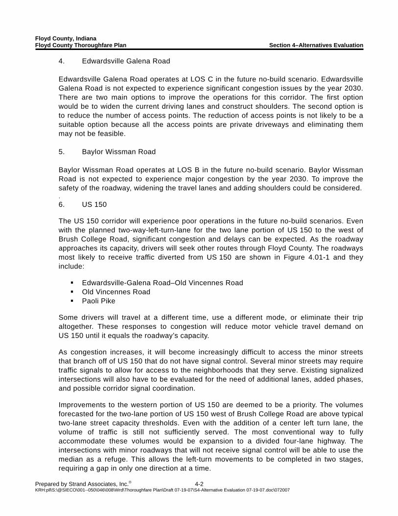
Floyd County, Indiana Floyd County Thoroughfare Plan Section 4–Alternatives Evaluation
Prepared by Strand Associates, Inc.® 4-2 KRH:pll\S:\@SIECO\001--050\046\008\Wrd\Thoroughfare Plan\Draft 07-19-07\S4-Alternative Evaluation 07-19-07.doc\072007
4. Edwardsville Galena Road Edwardsville Galena Road operates at LOS C in the future no-build scenario. Edwardsville Galena Road is not expected to experience significant congestion issues by the year 2030. There are two main options to improve the operations for this corridor. The first option would be to widen the current driving lanes and construct shoulders. The second option is to reduce the number of access points. The reduction of access points is not likely to be a suitable option because all the access points are private driveways and eliminating them may not be feasible. 5. Baylor Wissman Road Baylor Wissman Road operates at LOS B in the future no-build scenario. Baylor Wissman Road is not expected to experience major congestion by the year 2030. To improve the safety of the roadway, widening the travel lanes and adding shoulders could be considered. . 6. US 150 The US 150 corridor will experience poor operations in the future no-build scenarios. Even with the planned two-way-left-turn-lane for the two lane portion of US 150 to the west of Brush College Road, significant congestion and delays can be expected. As the roadway approaches its capacity, drivers will seek other routes through Floyd County. The roadways most likely to receive traffic diverted from US 150 are shown in Figure 4.01-1 and they include:
Edwardsville-Galena Road–Old Vincennes Road Old Vincennes Road Paoli Pike
Some drivers will travel at a different time, use a different mode, or eliminate their trip altogether. These responses to congestion will reduce motor vehicle travel demand on US 150 until it equals the roadway’s capacity. As congestion increases, it will become increasingly difficult to access the minor streets that branch off of US 150 that do not have signal control. Several minor streets may require traffic signals to allow for access to the neighborhoods that they serve. Existing signalized intersections will also have to be evaluated for the need of additional lanes, added phases, and possible corridor signal coordination. Improvements to the western portion of US 150 are deemed to be a priority. The volumes forecasted for the two-lane portion of US 150 west of Brush College Road are above typical two-lane street capacity thresholds. Even with the addition of a center left turn lane, the volume of traffic is still not sufficiently served. The most conventional way to fully accommodate these volumes would be expansion to a divided four-lane highway. The intersections with minor roadways that will not receive signal control will be able to use the median as a refuge. This allows the left-turn movements to be completed in two stages, requiring a gap in only one direction at a time.
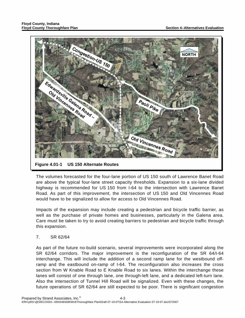
Floyd County, Indiana Floyd County Thoroughfare Plan Section 4–Alternatives Evaluation
Prepared by Strand Associates, Inc.® 4-3 KRH:pll\S:\@SIECO\001--050\046\008\Wrd\Thoroughfare Plan\Draft 07-19-07\S4-Alternative Evaluation 07-19-07.doc\072007
Figure 4.01-1 US 150 Alternate Routes
The volumes forecasted for the four-lane portion of US 150 south of Lawrence Banet Road are above the typical four-lane street capacity thresholds. Expansion to a six-lane divided highway is recommended for US 150 from I-64 to the intersection with Lawrence Banet Road. As part of this improvement, the intersection of US 150 and Old Vincennes Road would have to be signalized to allow for access to Old Vincennes Road. Impacts of the expansion may include creating a pedestrian and bicycle traffic barrier, as well as the purchase of private homes and businesses, particularly in the Galena area. Care must be taken to try to avoid creating barriers to pedestrian and bicycle traffic through this expansion. 7. SR 62/64 As part of the future no-build scenario, several improvements were incorporated along the SR 62/64 corridors. The major improvement is the reconfiguration of the SR 64/I-64 interchange. This will include the addition of a second ramp lane for the westbound off-ramp and the eastbound on-ramp of I-64. The reconfiguration also increases the cross section from W Knable Road to E Knable Road to six lanes. Within the interchange these lanes will consist of one through lane, one through-left lane, and a dedicated left-turn lane. Also the intersection of Tunnel Hill Road will be signalized. Even with these changes, the future operations of SR 62/64 are still expected to be poor. There is significant congestion
Floyd County, Indiana Floyd County Thoroughfare Plan Section 4–Alternatives Evaluation
Prepared by Strand Associates, Inc.® 4-4 KRH:pll\S:\@SIECO\001--050\046\008\Wrd\Thoroughfare Plan\Draft 07-19-07\S4-Alternative Evaluation 07-19-07.doc\072007
Figure 4.01-2 SR 62/64 Alternate Routes
and delays along the roadway in both the future AM and PM peak periods. As the roadway approaches its capacity, drivers will seek other routes through Floyd County. The roadways most likely to receive traffic diverted from SR 62/64 are shown in Figure 4.01-2 and they include:
Corydon Pike Lanesville Road (Harrison County)–I-64
Some drivers will travel at a different time, use a different mode, or eliminate their trip altogether. These responses to congestion will reduce motor vehicle travel demand on this section of SR 62/64 until it equals the roadways capacity. As the congestion increases, the unsignalized intersections will experience poor operations, and vehicles will have difficulty making left turns from the minor streets onto SR 62/64. Existing signalized intersections will have to be evaluated for the need of additional lanes, added phases, and possible corridor signal coordination.
Floyd County, Indiana Floyd County Thoroughfare Plan Section 4–Alternatives Evaluation
Prepared by Strand Associates, Inc.® 4-5 KRH:pll\S:\@SIECO\001--050\046\008\Wrd\Thoroughfare Plan\Draft 07-19-07\S4-Alternative Evaluation 07-19-07.doc\072007
The volumes forecasted for the two lane portion of SR 62/42 west of Edwardsville Galena Road and south of Corydon Pike are above typical two-lane street capacity thresholds. The most conventional way to fully accommodate these volumes would be expansion to a divided four-lane highway. The intersections with minor roadways that will not receive signal control will be able to use the median as a refuge. This allows the left turn movements to be completed in two stages, requiring a gap in only one direction at a time. The volumes forecasted for the four-lane portion of SR 62/64 east of Edwardsville Galena Road and North of Corydon Pike are above the typical four-lane street capacity thresholds. Expansion to a six-lane divided highway is recommended for SR 62/64 from Edwardsville Galena Road To Corydon Pike. As part of this improvement, the I-64 bridges over SR 62/64 may need to be reconstructed to accommodate the additional lanes on SR 62/64. Impacts of the corridor expansion may include creating a pedestrian and bicycle traffic barrier, as well as the purchase of private homes and businesses, particularly in the Village of Georgetown and the Edwardsville Gateway District. Care must be taken to try to avoid creating barriers to pedestrian and bicycle traffic through this expansion. 8. Schreiber Road As development of the Highlander Point and Edwardsville Gateway Districts continues, it may be desirable to construct a frontage roadway along US 150 to connect the two districts. The most feasible option would be to extend Schreiber Road from its current end point at Old Vincennes Road to West Willis Road. This roadway would provide a valuable connection between the business districts, and allow traffic to flow between them without needing to use US 150 and I-64. As part of this construction, pavement improvements on West Willis Road will likely be required. 9. Stiller Road Traffic volumes will continue to increase along the US 150 corridor throughout the study area. Currently, West Luther Road is the only direct connection between US 150 and Old Vincennes Road. To provide another direct connection, Stiller Road could be extended from US 150 to Old Vincennes Road. By providing more options to travelers, each individual intersection will operate better because the traffic is able to be diffused between multiple intersections. To improve the utilization of this connection by the subdivisions north of US 150, a street connection between Buck Creek Road and Smith Road should be considered. This connection could increase the utilization of the proposed traffic signal at Stiller Road by allowing more vehicles easy access to the intersection.
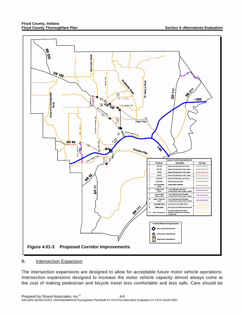
Floyd County, Indiana Floyd County Thoroughfare Plan Section 4–Alternatives Evaluation
Prepared by Strand Associates, Inc.® 4-6 KRH:pll\S:\@SIECO\001--050\046\008\Wrd\Thoroughfare Plan\Draft 07-19-07\S4-Alternative Evaluation 07-19-07.doc\072007
Figure 4.01-3 Proposed Corridor Improvements
B. Intersection Expansion The intersection expansions are designed to allow for acceptable future motor vehicle operations. Intersection expansions designed to increase the motor vehicle capacity almost always come at the cost of making pedestrian and bicycle travel less comfortable and less safe. Care should be
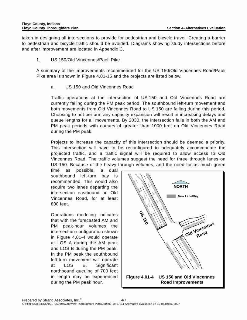
Floyd County, Indiana Floyd County Thoroughfare Plan Section 4–Alternatives Evaluation
Prepared by Strand Associates, Inc.® 4-7 KRH:pll\S:\@SIECO\001--050\046\008\Wrd\Thoroughfare Plan\Draft 07-19-07\S4-Alternative Evaluation 07-19-07.doc\072007
New Lane/Bay
NORTHNORTH
US 150
Old Vincennes
Road
Figure 4.01-4 US 150 and Old Vincennes
Road Improvements
taken in designing all intersections to provide for pedestrian and bicycle travel. Creating a barrier to pedestrian and bicycle traffic should be avoided. Diagrams showing study intersections before and after improvement are located in Appendix C.
1. US 150/Old Vincennes/Paoli Pike
A summary of the improvements recommended for the US 150/Old Vincennes Road/Paoli Pike area is shown in Figure 4.01-15 and the projects are listed below.
a. US 150 and Old Vincennes Road Traffic operations at the intersection of US 150 and Old Vincennes Road are currently failing during the PM peak period. The southbound left-turn movement and both movements from Old Vincennes Road to US 150 are failing during this period. Choosing to not perform any capacity expansion will result in increasing delays and queue lengths for all movements. By 2030, the intersection fails in both the AM and PM peak periods with queues of greater than 1000 feet on Old Vincennes Road during the PM peak. Projects to increase the capacity of this intersection should be deemed a priority. This intersection will have to be reconfigured to adequately accommodate the projected traffic, and a traffic signal will be required to allow access to Old Vincennes Road. The traffic volumes suggest the need for three through lanes on US 150. Because of the heavy through volumes, and the need for as much green time as possible, a dual southbound left-turn bay is recommended. This would also require two lanes departing the intersection eastbound on Old Vincennes Road, for at least 800 feet. Operations modeling indicates that with the forecasted AM and PM peak-hour volumes the intersection configuration shown in Figure 4.01-4 would operate at LOS A during the AM peak and LOS B during the PM peak. In the PM peak the southbound left-turn movement will operate at LOS E. Significant northbound queuing of 700 feet in length may be experienced during the PM peak hour.
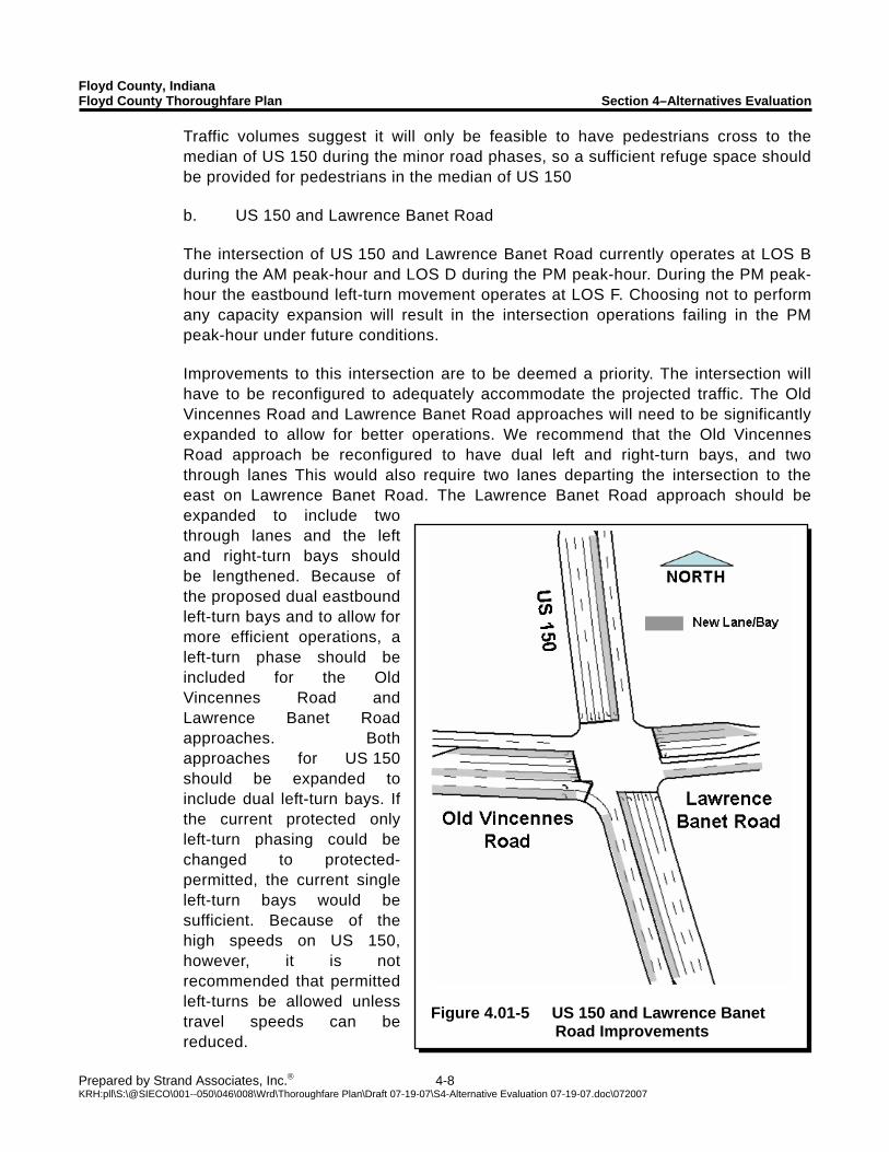
Floyd County, Indiana Floyd County Thoroughfare Plan Section 4–Alternatives Evaluation
Prepared by Strand Associates, Inc.® 4-8 KRH:pll\S:\@SIECO\001--050\046\008\Wrd\Thoroughfare Plan\Draft 07-19-07\S4-Alternative Evaluation 07-19-07.doc\072007
Figure 4.01-5 US 150 and Lawrence Banet
Road Improvements
Traffic volumes suggest it will only be feasible to have pedestrians cross to the median of US 150 during the minor road phases, so a sufficient refuge space should be provided for pedestrians in the median of US 150 b. US 150 and Lawrence Banet Road
The intersection of US 150 and Lawrence Banet Road currently operates at LOS B during the AM peak-hour and LOS D during the PM peak-hour. During the PM peak-hour the eastbound left-turn movement operates at LOS F. Choosing not to perform any capacity expansion will result in the intersection operations failing in the PM peak-hour under future conditions. Improvements to this intersection are to be deemed a priority. The intersection will have to be reconfigured to adequately accommodate the projected traffic. The Old Vincennes Road and Lawrence Banet Road approaches will need to be significantly expanded to allow for better operations. We recommend that the Old Vincennes Road approach be reconfigured to have dual left and right-turn bays, and two through lanes This would also require two lanes departing the intersection to the east on Lawrence Banet Road. The Lawrence Banet Road approach should be expanded to include two through lanes and the left and right-turn bays should be lengthened. Because of the proposed dual eastbound left-turn bays and to allow for more efficient operations, a left-turn phase should be included for the Old Vincennes Road and Lawrence Banet Road approaches. Both approaches for US 150 should be expanded to include dual left-turn bays. If the current protected only left-turn phasing could be changed to protected-permitted, the current single left-turn bays would be sufficient. Because of the high speeds on US 150, however, it is not recommended that permitted left-turns be allowed unless travel speeds can be reduced.
Floyd County, Indiana Floyd County Thoroughfare Plan Section 4–Alternatives Evaluation
Prepared by Strand Associates, Inc.® 4-9 KRH:pll\S:\@SIECO\001--050\046\008\Wrd\Thoroughfare Plan\Draft 07-19-07\S4-Alternative Evaluation 07-19-07.doc\072007
Operations modeling indicates that with the forecasted AM and PM peak-hour volumes the intersection configuration shown in Figure 4.01-5 would operate at LOS C during the AM peak hour and LOS D during the PM peak hour. In the PM peak hour all left-turn movements and the northbound through movement operate at LOS E. Significant queues can be expected southbound in the AM peak hour and northbound in the PM peak-hour on US 150 because of the high forecasted traffic volumes. Traffic volumes suggest it would only be feasible to have pedestrians cross to the median of US 150 during the minor road phases, so a sufficient refuge space should be provided for pedestrians in the median of US 150. A recently approved development will add a new access to US 150 between Lawrence Banet Road and Luther Road. The new access will be limited to left-in, right-in, and right-out only. There will be no cross traffic allowed at this access. There will be minimal impacts on US 150 and the intersections of US 150/Lawrence Banet Road and US 150/Luther Road from this new access. The new access could possibly improve operations at the existing intersections by providing traffic another location to enter and exit the highway. c. US 150 and Luther Road US 150 and Luther Road currently operates at acceptable levels. Choosing not to perform any capacity improvements will result in the intersection operating at LOS D during the AM and PM peak hour. The left-turn lanes operate at LOS E This intersection will not require any major improvements to operate at acceptable levels. If the current protected only left turn phasing could be changed to protected-permitted phasing the left-turn movements would operate at LOS A. Because of the high speed on US 150, however, it is not recommended that the left-turn phasing be changed unless travel speeds can be reduced. Traffic volumes suggest that to allow for acceptable vehicular operations, pedestrians should only cross to the median of US 150 during the minor road phases. To allow for this, sufficient refuge space should be provided for pedestrians in the median of US 150. d. US 150 and Paoli Pike US 150 and Paoli Pike currently operates at acceptable levels. Choosing not to perform any capacity improvements will result in the intersection operating at LOS F in the PM peak hour. Several movements operate at LOS F during the PM peak hour. The intersection will have to be reconfigured to adequately accommodate the projected traffic. The westbound Paoli Pike approach should be reconfigured to have
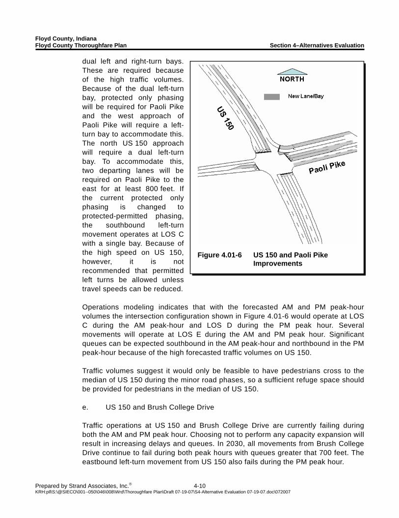
Floyd County, Indiana Floyd County Thoroughfare Plan Section 4–Alternatives Evaluation
Prepared by Strand Associates, Inc.® 4-10 KRH:pll\S:\@SIECO\001--050\046\008\Wrd\Thoroughfare Plan\Draft 07-19-07\S4-Alternative Evaluation 07-19-07.doc\072007
Figure 4.01-6 US 150 and Paoli Pike
Improvements
dual left and right-turn bays. These are required because of the high traffic volumes. Because of the dual left-turn bay, protected only phasing will be required for Paoli Pike and the west approach of Paoli Pike will require a left-turn bay to accommodate this. The north US 150 approach will require a dual left-turn bay. To accommodate this, two departing lanes will be required on Paoli Pike to the east for at least 800 feet. If the current protected only phasing is changed to protected-permitted phasing, the southbound left-turn movement operates at LOS C with a single bay. Because of the high speed on US 150, however, it is not recommended that permitted left turns be allowed unless travel speeds can be reduced. Operations modeling indicates that with the forecasted AM and PM peak-hour volumes the intersection configuration shown in Figure 4.01-6 would operate at LOS C during the AM peak-hour and LOS D during the PM peak hour. Several movements will operate at LOS E during the AM and PM peak hour. Significant queues can be expected southbound in the AM peak-hour and northbound in the PM peak-hour because of the high forecasted traffic volumes on US 150. Traffic volumes suggest it would only be feasible to have pedestrians cross to the median of US 150 during the minor road phases, so a sufficient refuge space should be provided for pedestrians in the median of US 150. e. US 150 and Brush College Drive Traffic operations at US 150 and Brush College Drive are currently failing during both the AM and PM peak hour. Choosing not to perform any capacity expansion will result in increasing delays and queues. In 2030, all movements from Brush College Drive continue to fail during both peak hours with queues greater that 700 feet. The eastbound left-turn movement from US 150 also fails during the PM peak hour.
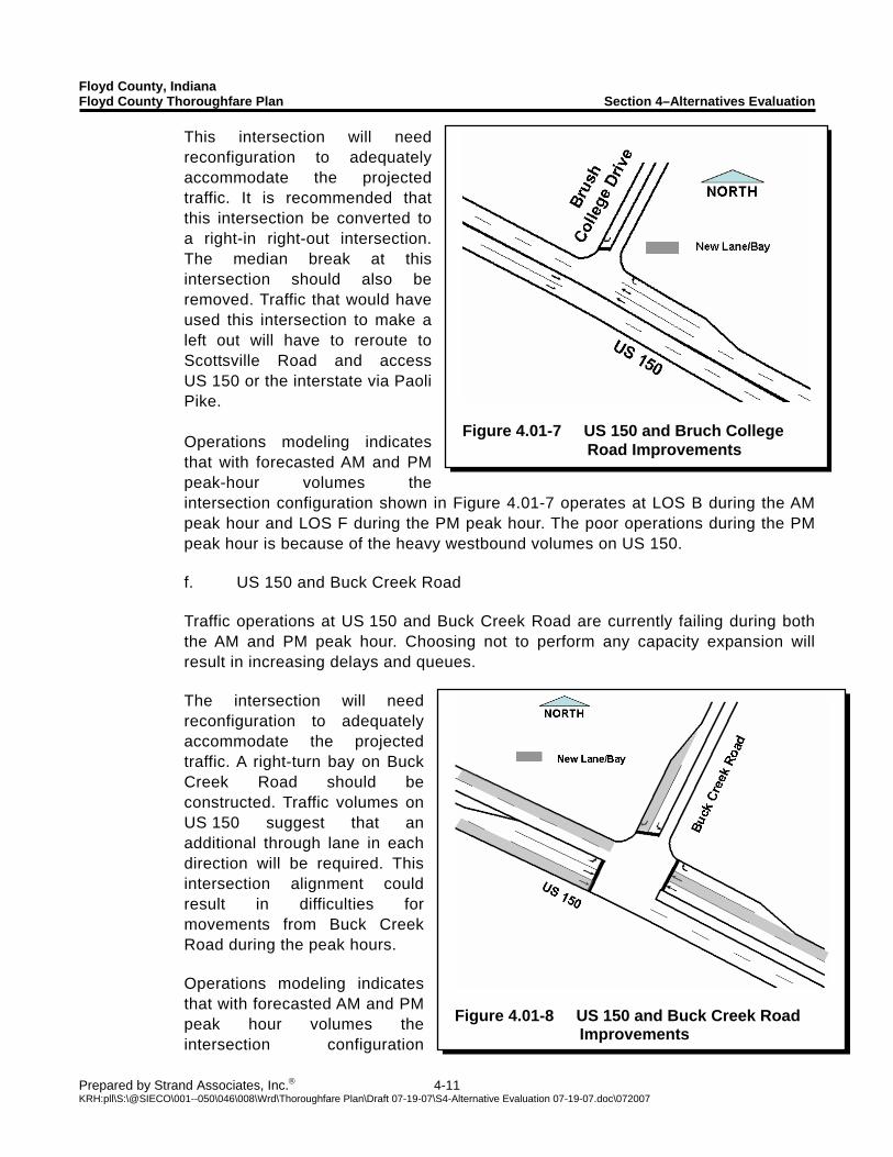
Floyd County, Indiana Floyd County Thoroughfare Plan Section 4–Alternatives Evaluation
Prepared by Strand Associates, Inc.® 4-11 KRH:pll\S:\@SIECO\001--050\046\008\Wrd\Thoroughfare Plan\Draft 07-19-07\S4-Alternative Evaluation 07-19-07.doc\072007
Figure 4.01-8 US 150 and Buck Creek Road
Improvements
Figure 4.01-7 US 150 and Bruch College
Road Improvements
This intersection will need reconfiguration to adequately accommodate the projected traffic. It is recommended that this intersection be converted to a right-in right-out intersection. The median break at this intersection should also be removed. Traffic that would have used this intersection to make a left out will have to reroute to Scottsville Road and access US 150 or the interstate via Paoli Pike. Operations modeling indicates that with forecasted AM and PM peak-hour volumes the intersection configuration shown in Figure 4.01-7 operates at LOS B during the AM peak hour and LOS F during the PM peak hour. The poor operations during the PM peak hour is because of the heavy westbound volumes on US 150. f. US 150 and Buck Creek Road Traffic operations at US 150 and Buck Creek Road are currently failing during both the AM and PM peak hour. Choosing not to perform any capacity expansion will result in increasing delays and queues. The intersection will need reconfiguration to adequately accommodate the projected traffic. A right-turn bay on Buck Creek Road should be constructed. Traffic volumes on US 150 suggest that an additional through lane in each direction will be required. This intersection alignment could result in difficulties for movements from Buck Creek Road during the peak hours. Operations modeling indicates that with forecasted AM and PM peak hour volumes the intersection configuration
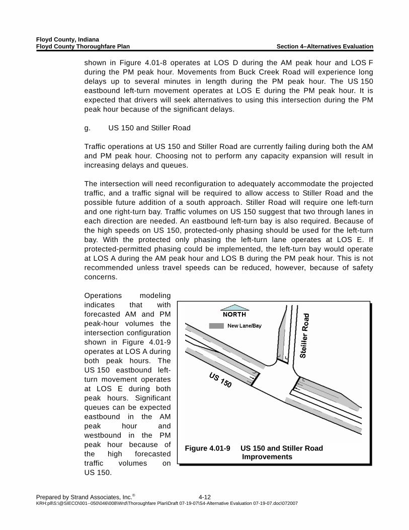
Floyd County, Indiana Floyd County Thoroughfare Plan Section 4–Alternatives Evaluation
Prepared by Strand Associates, Inc.® 4-12 KRH:pll\S:\@SIECO\001--050\046\008\Wrd\Thoroughfare Plan\Draft 07-19-07\S4-Alternative Evaluation 07-19-07.doc\072007
Figure 4.01-9 US 150 and Stiller Road
Improvements
shown in Figure 4.01-8 operates at LOS D during the AM peak hour and LOS F during the PM peak hour. Movements from Buck Creek Road will experience long delays up to several minutes in length during the PM peak hour. The US 150 eastbound left-turn movement operates at LOS E during the PM peak hour. It is expected that drivers will seek alternatives to using this intersection during the PM peak hour because of the significant delays. g. US 150 and Stiller Road Traffic operations at US 150 and Stiller Road are currently failing during both the AM and PM peak hour. Choosing not to perform any capacity expansion will result in increasing delays and queues. The intersection will need reconfiguration to adequately accommodate the projected traffic, and a traffic signal will be required to allow access to Stiller Road and the possible future addition of a south approach. Stiller Road will require one left-turn and one right-turn bay. Traffic volumes on US 150 suggest that two through lanes in each direction are needed. An eastbound left-turn bay is also required. Because of the high speeds on US 150, protected-only phasing should be used for the left-turn bay. With the protected only phasing the left-turn lane operates at LOS E. If protected-permitted phasing could be implemented, the left-turn bay would operate at LOS A during the AM peak hour and LOS B during the PM peak hour. This is not recommended unless travel speeds can be reduced, however, because of safety concerns. Operations modeling indicates that with forecasted AM and PM peak-hour volumes the intersection configuration shown in Figure 4.01-9 operates at LOS A during both peak hours. The US 150 eastbound left-turn movement operates at LOS E during both peak hours. Significant queues can be expected eastbound in the AM peak hour and westbound in the PM peak hour because of the high forecasted traffic volumes on US 150.
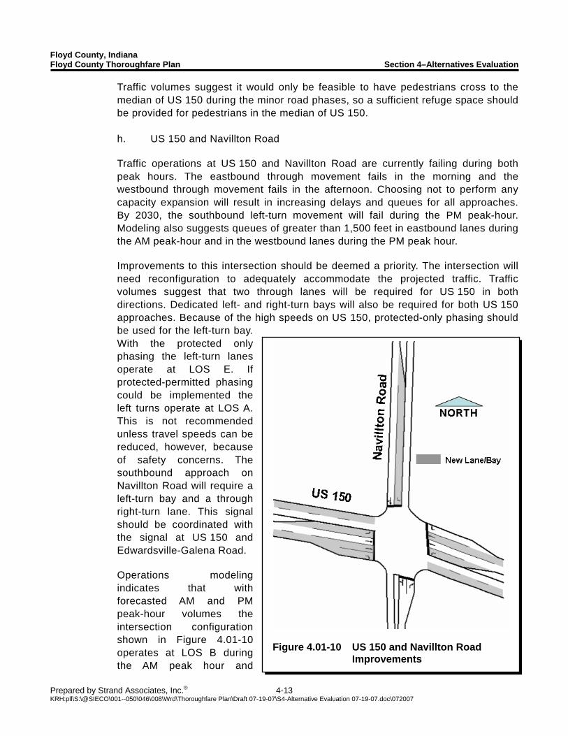
Floyd County, Indiana Floyd County Thoroughfare Plan Section 4–Alternatives Evaluation
Prepared by Strand Associates, Inc.® 4-13 KRH:pll\S:\@SIECO\001--050\046\008\Wrd\Thoroughfare Plan\Draft 07-19-07\S4-Alternative Evaluation 07-19-07.doc\072007
Figure 4.01-10 US 150 and Navillton Road
Improvements
Traffic volumes suggest it would only be feasible to have pedestrians cross to the median of US 150 during the minor road phases, so a sufficient refuge space should be provided for pedestrians in the median of US 150. h. US 150 and Navillton Road Traffic operations at US 150 and Navillton Road are currently failing during both peak hours. The eastbound through movement fails in the morning and the westbound through movement fails in the afternoon. Choosing not to perform any capacity expansion will result in increasing delays and queues for all approaches. By 2030, the southbound left-turn movement will fail during the PM peak-hour. Modeling also suggests queues of greater than 1,500 feet in eastbound lanes during the AM peak-hour and in the westbound lanes during the PM peak hour. Improvements to this intersection should be deemed a priority. The intersection will need reconfiguration to adequately accommodate the projected traffic. Traffic volumes suggest that two through lanes will be required for US 150 in both directions. Dedicated left- and right-turn bays will also be required for both US 150 approaches. Because of the high speeds on US 150, protected-only phasing should be used for the left-turn bay. With the protected only phasing the left-turn lanes operate at LOS E. If protected-permitted phasing could be implemented the left turns operate at LOS A. This is not recommended unless travel speeds can be reduced, however, because of safety concerns. The southbound approach on Navillton Road will require a left-turn bay and a through right-turn lane. This signal should be coordinated with the signal at US 150 and Edwardsville-Galena Road. Operations modeling indicates that with forecasted AM and PM peak-hour volumes the intersection configuration shown in Figure 4.01-10 operates at LOS B during the AM peak hour and
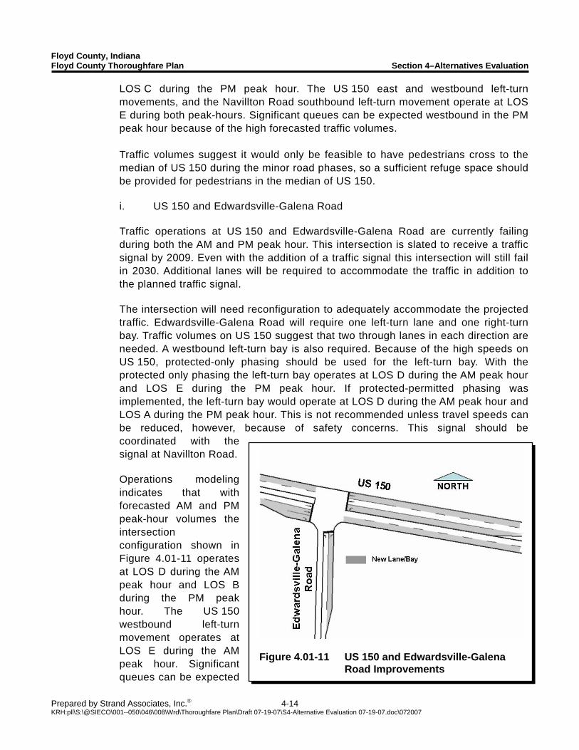
Floyd County, Indiana Floyd County Thoroughfare Plan Section 4–Alternatives Evaluation
Prepared by Strand Associates, Inc.® 4-14 KRH:pll\S:\@SIECO\001--050\046\008\Wrd\Thoroughfare Plan\Draft 07-19-07\S4-Alternative Evaluation 07-19-07.doc\072007
Figure 4.01-11 US 150 and Edwardsville-Galena
Road Improvements
LOS C during the PM peak hour. The US 150 east and westbound left-turn movements, and the Navillton Road southbound left-turn movement operate at LOS E during both peak-hours. Significant queues can be expected westbound in the PM peak hour because of the high forecasted traffic volumes. Traffic volumes suggest it would only be feasible to have pedestrians cross to the median of US 150 during the minor road phases, so a sufficient refuge space should be provided for pedestrians in the median of US 150. i. US 150 and Edwardsville-Galena Road Traffic operations at US 150 and Edwardsville-Galena Road are currently failing during both the AM and PM peak hour. This intersection is slated to receive a traffic signal by 2009. Even with the addition of a traffic signal this intersection will still fail in 2030. Additional lanes will be required to accommodate the traffic in addition to the planned traffic signal. The intersection will need reconfiguration to adequately accommodate the projected traffic. Edwardsville-Galena Road will require one left-turn lane and one right-turn bay. Traffic volumes on US 150 suggest that two through lanes in each direction are needed. A westbound left-turn bay is also required. Because of the high speeds on US 150, protected-only phasing should be used for the left-turn bay. With the protected only phasing the left-turn bay operates at LOS D during the AM peak hour and LOS E during the PM peak hour. If protected-permitted phasing was implemented, the left-turn bay would operate at LOS D during the AM peak hour and LOS A during the PM peak hour. This is not recommended unless travel speeds can be reduced, however, because of safety concerns. This signal should be coordinated with the signal at Navillton Road. Operations modeling indicates that with forecasted AM and PM peak-hour volumes the intersection configuration shown in Figure 4.01-11 operates at LOS D during the AM peak hour and LOS B during the PM peak hour. The US 150 westbound left-turn movement operates at LOS E during the AM peak hour. Significant queues can be expected
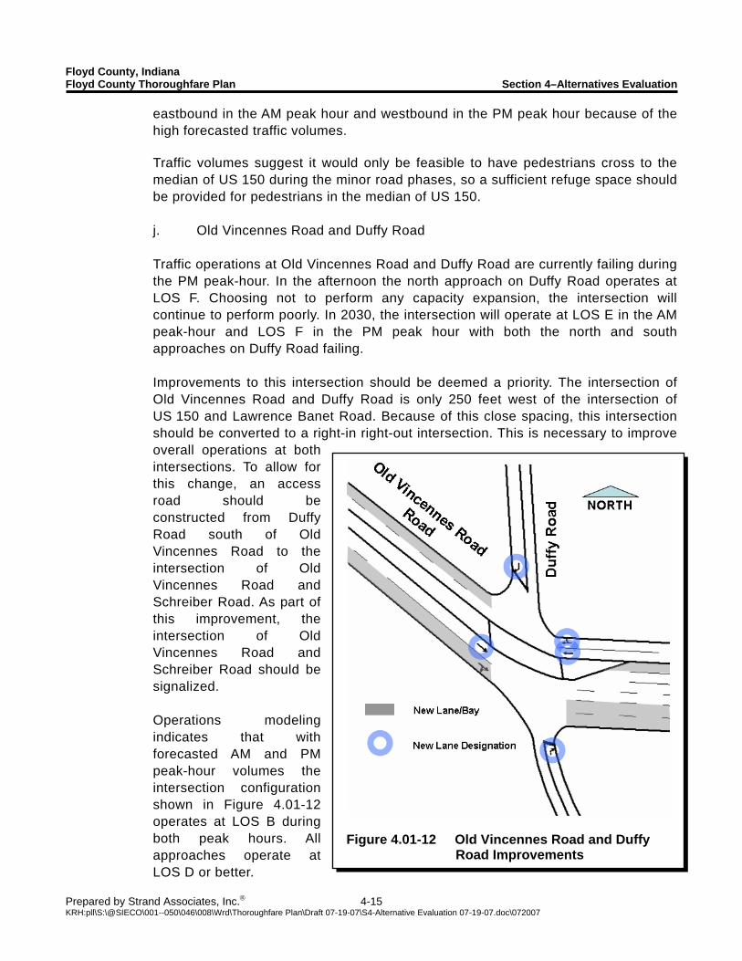
Floyd County, Indiana Floyd County Thoroughfare Plan Section 4–Alternatives Evaluation
Prepared by Strand Associates, Inc.® 4-15 KRH:pll\S:\@SIECO\001--050\046\008\Wrd\Thoroughfare Plan\Draft 07-19-07\S4-Alternative Evaluation 07-19-07.doc\072007
Figure 4.01-12 Old Vincennes Road and Duffy
Road Improvements
eastbound in the AM peak hour and westbound in the PM peak hour because of the high forecasted traffic volumes. Traffic volumes suggest it would only be feasible to have pedestrians cross to the median of US 150 during the minor road phases, so a sufficient refuge space should be provided for pedestrians in the median of US 150. j. Old Vincennes Road and Duffy Road Traffic operations at Old Vincennes Road and Duffy Road are currently failing during the PM peak-hour. In the afternoon the north approach on Duffy Road operates at LOS F. Choosing not to perform any capacity expansion, the intersection will continue to perform poorly. In 2030, the intersection will operate at LOS E in the AM peak-hour and LOS F in the PM peak hour with both the north and south approaches on Duffy Road failing. Improvements to this intersection should be deemed a priority. The intersection of Old Vincennes Road and Duffy Road is only 250 feet west of the intersection of US 150 and Lawrence Banet Road. Because of this close spacing, this intersection should be converted to a right-in right-out intersection. This is necessary to improve overall operations at both intersections. To allow for this change, an access road should be constructed from Duffy Road south of Old Vincennes Road to the intersection of Old Vincennes Road and Schreiber Road. As part of this improvement, the intersection of Old Vincennes Road and Schreiber Road should be signalized. Operations modeling indicates that with forecasted AM and PM peak-hour volumes the intersection configuration shown in Figure 4.01-12 operates at LOS B during both peak hours. All approaches operate at LOS D or better.
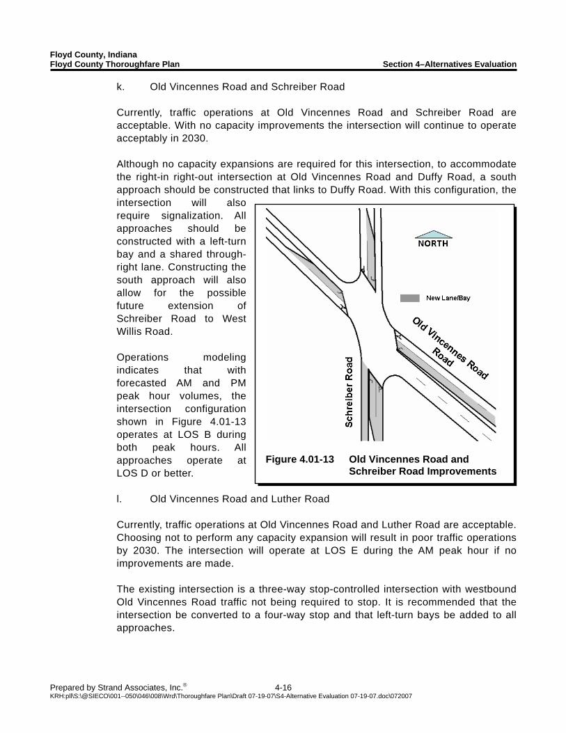
Floyd County, Indiana Floyd County Thoroughfare Plan Section 4–Alternatives Evaluation
Prepared by Strand Associates, Inc.® 4-16 KRH:pll\S:\@SIECO\001--050\046\008\Wrd\Thoroughfare Plan\Draft 07-19-07\S4-Alternative Evaluation 07-19-07.doc\072007
Figure 4.01-13 Old Vincennes Road and
Schreiber Road Improvements
k. Old Vincennes Road and Schreiber Road Currently, traffic operations at Old Vincennes Road and Schreiber Road are acceptable. With no capacity improvements the intersection will continue to operate acceptably in 2030. Although no capacity expansions are required for this intersection, to accommodate the right-in right-out intersection at Old Vincennes Road and Duffy Road, a south approach should be constructed that links to Duffy Road. With this configuration, the intersection will also require signalization. All approaches should be constructed with a left-turn bay and a shared through-right lane. Constructing the south approach will also allow for the possible future extension of Schreiber Road to West Willis Road. Operations modeling indicates that with forecasted AM and PM peak hour volumes, the intersection configuration shown in Figure 4.01-13 operates at LOS B during both peak hours. All approaches operate at LOS D or better. l. Old Vincennes Road and Luther Road Currently, traffic operations at Old Vincennes Road and Luther Road are acceptable. Choosing not to perform any capacity expansion will result in poor traffic operations by 2030. The intersection will operate at LOS E during the AM peak hour if no improvements are made. The existing intersection is a three-way stop-controlled intersection with westbound Old Vincennes Road traffic not being required to stop. It is recommended that the intersection be converted to a four-way stop and that left-turn bays be added to all approaches.
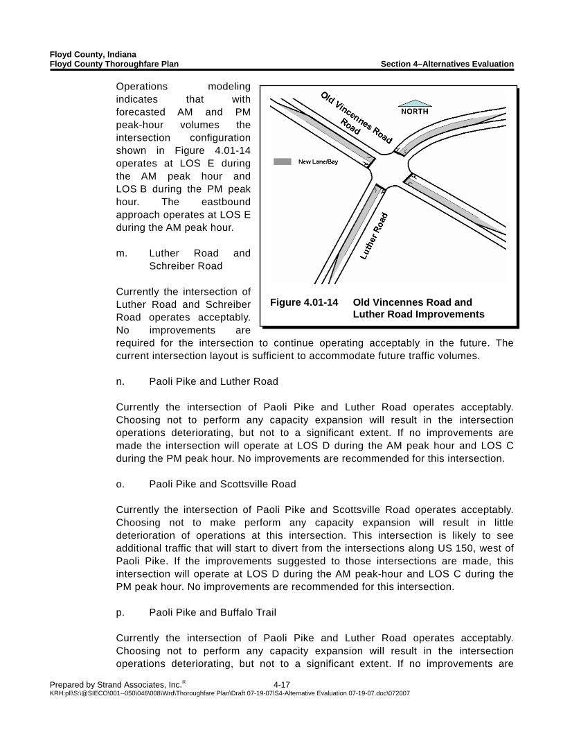
Floyd County, Indiana Floyd County Thoroughfare Plan Section 4–Alternatives Evaluation
Prepared by Strand Associates, Inc.® 4-17 KRH:pll\S:\@SIECO\001--050\046\008\Wrd\Thoroughfare Plan\Draft 07-19-07\S4-Alternative Evaluation 07-19-07.doc\072007
Figure 4.01-14 Old Vincennes Road and
Luther Road Improvements
Operations modeling indicates that with forecasted AM and PM peak-hour volumes the intersection configuration shown in Figure 4.01-14 operates at LOS E during the AM peak hour and LOS B during the PM peak hour. The eastbound approach operates at LOS E during the AM peak hour. m. Luther Road and
Schreiber Road Currently the intersection of Luther Road and Schreiber Road operates acceptably. No improvements are required for the intersection to continue operating acceptably in the future. The current intersection layout is sufficient to accommodate future traffic volumes. n. Paoli Pike and Luther Road Currently the intersection of Paoli Pike and Luther Road operates acceptably. Choosing not to perform any capacity expansion will result in the intersection operations deteriorating, but not to a significant extent. If no improvements are made the intersection will operate at LOS D during the AM peak hour and LOS C during the PM peak hour. No improvements are recommended for this intersection. o. Paoli Pike and Scottsville Road Currently the intersection of Paoli Pike and Scottsville Road operates acceptably. Choosing not to make perform any capacity expansion will result in little deterioration of operations at this intersection. This intersection is likely to see additional traffic that will start to divert from the intersections along US 150, west of Paoli Pike. If the improvements suggested to those intersections are made, this intersection will operate at LOS D during the AM peak-hour and LOS C during the PM peak hour. No improvements are recommended for this intersection. p. Paoli Pike and Buffalo Trail Currently the intersection of Paoli Pike and Luther Road operates acceptably. Choosing not to perform any capacity expansion will result in the intersection operations deteriorating, but not to a significant extent. If no improvements are
Floyd County, Indiana Floyd County Thoroughfare Plan Section 4–Alternatives Evaluation
Prepared by Strand Associates, Inc.® 4-18 KRH:pll\S:\@SIECO\001--050\046\008\Wrd\Thoroughfare Plan\Draft 07-19-07\S4-Alternative Evaluation 07-19-07.doc\072007
made the intersection will operate at LOS D during the AM peak hour and LOS B during the PM peak hour. No improvements are recommended for this intersection. The finding that this intersection does not require improvements to provide acceptable future traffic operations should not exclude it from improvements designed to improve its safety. The intersection is located in an area on Paoli Pike that has limited sight distance and there is local concern about the safety of the intersection. Bypass lanes have been proposed for Paoli Pike at this location to remedy some of the safety concerns. q. Paoli Pike and Kenzig Road/I-265 West Ramps Currently the intersection of Paoli Pike and Kenzig Road operates acceptably. Choosing not to perform any capacity expansion will result in the intersection operation deteriorating from LOS B to LOS C in both peak hours. No improvements are recommended for this intersection. r. Scottsville Road and St. Mary’s Road Currently the intersection of Scottsville Road and St. Mary’s Road operates acceptably. This intersection is likely to see additional traffic that will start to divert from the intersections along US 150 west of Paoli Pike. If the improvements suggested to those intersections are made, this intersection will operate at LOS E during the AM peak hour and LOS C during the PM peak hour. No improvements are recommended for this intersection.
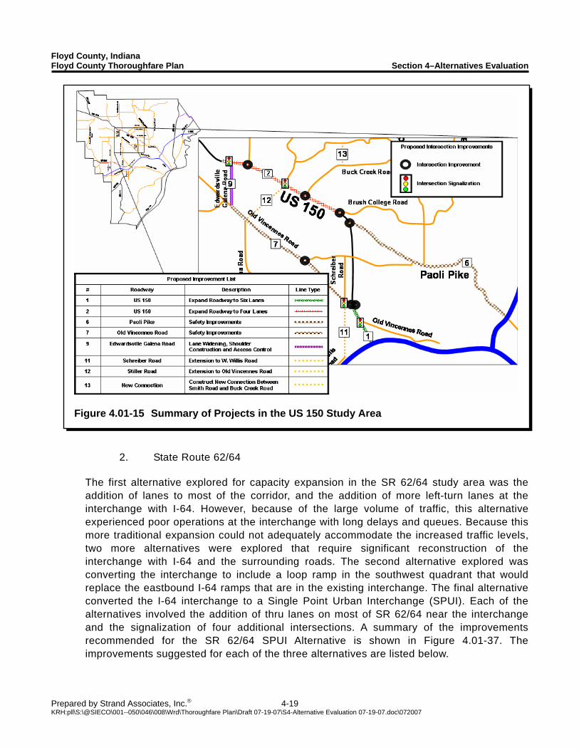
Floyd County, Indiana Floyd County Thoroughfare Plan Section 4–Alternatives Evaluation
Prepared by Strand Associates, Inc.® 4-19 KRH:pll\S:\@SIECO\001--050\046\008\Wrd\Thoroughfare Plan\Draft 07-19-07\S4-Alternative Evaluation 07-19-07.doc\072007
Figure 4.01-15 Summary of Projects in the US 150 Study Area
2. State Route 62/64
The first alternative explored for capacity expansion in the SR 62/64 study area was the addition of lanes to most of the corridor, and the addition of more left-turn lanes at the interchange with I-64. However, because of the large volume of traffic, this alternative experienced poor operations at the interchange with long delays and queues. Because this more traditional expansion could not adequately accommodate the increased traffic levels, two more alternatives were explored that require significant reconstruction of the interchange with I-64 and the surrounding roads. The second alternative explored was converting the interchange to include a loop ramp in the southwest quadrant that would replace the eastbound I-64 ramps that are in the existing interchange. The final alternative converted the I-64 interchange to a Single Point Urban Interchange (SPUI). Each of the alternatives involved the addition of thru lanes on most of SR 62/64 near the interchange and the signalization of four additional intersections. A summary of the improvements recommended for the SR 62/64 SPUI Alternative is shown in Figure 4.01-37. The improvements suggested for each of the three alternatives are listed below.
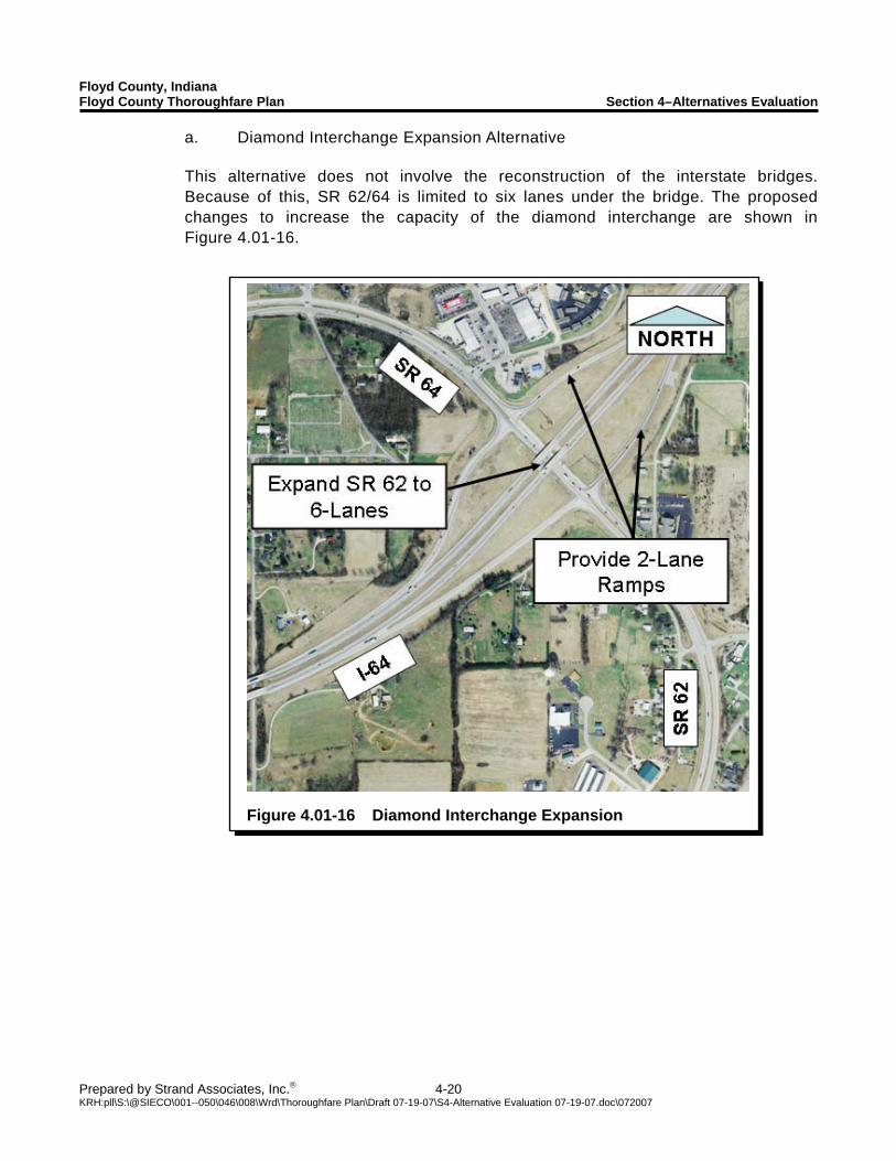
Floyd County, Indiana Floyd County Thoroughfare Plan Section 4–Alternatives Evaluation
Prepared by Strand Associates, Inc.® 4-20 KRH:pll\S:\@SIECO\001--050\046\008\Wrd\Thoroughfare Plan\Draft 07-19-07\S4-Alternative Evaluation 07-19-07.doc\072007
Figure 4.01-16 Diamond Interchange Expansion
a. Diamond Interchange Expansion Alternative This alternative does not involve the reconstruction of the interstate bridges. Because of this, SR 62/64 is limited to six lanes under the bridge. The proposed changes to increase the capacity of the diamond interchange are shown in Figure 4.01-16.
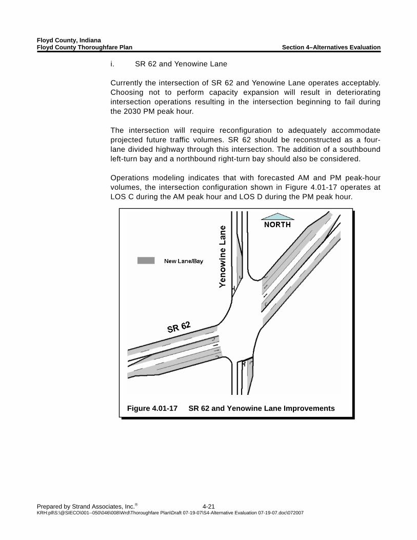
Floyd County, Indiana Floyd County Thoroughfare Plan Section 4–Alternatives Evaluation
Prepared by Strand Associates, Inc.® 4-21 KRH:pll\S:\@SIECO\001--050\046\008\Wrd\Thoroughfare Plan\Draft 07-19-07\S4-Alternative Evaluation 07-19-07.doc\072007
Figure 4.01-17 SR 62 and Yenowine Lane Improvements
i. SR 62 and Yenowine Lane Currently the intersection of SR 62 and Yenowine Lane operates acceptably. Choosing not to perform capacity expansion will result in deteriorating intersection operations resulting in the intersection beginning to fail during the 2030 PM peak hour. The intersection will require reconfiguration to adequately accommodate projected future traffic volumes. SR 62 should be reconstructed as a four-lane divided highway through this intersection. The addition of a southbound left-turn bay and a northbound right-turn bay should also be considered. Operations modeling indicates that with forecasted AM and PM peak-hour volumes, the intersection configuration shown in Figure 4.01-17 operates at LOS C during the AM peak hour and LOS D during the PM peak hour.
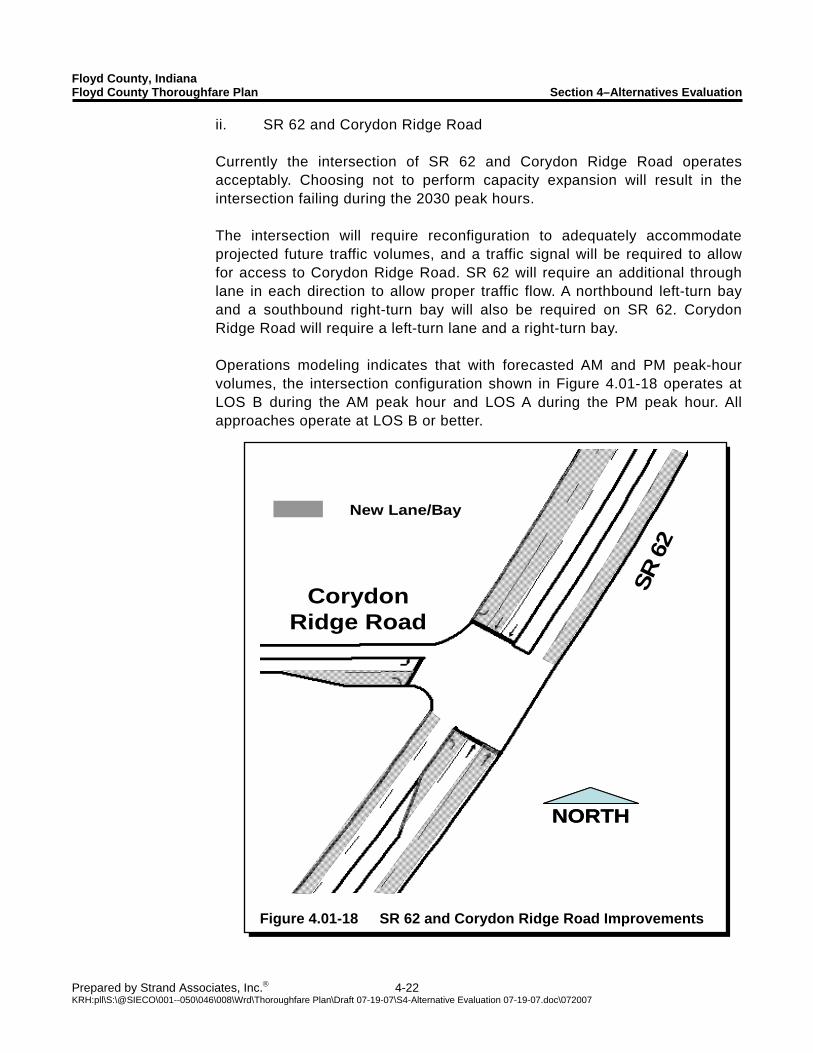
Floyd County, Indiana Floyd County Thoroughfare Plan Section 4–Alternatives Evaluation
Prepared by Strand Associates, Inc.® 4-22 KRH:pll\S:\@SIECO\001--050\046\008\Wrd\Thoroughfare Plan\Draft 07-19-07\S4-Alternative Evaluation 07-19-07.doc\072007
New Lane/Bay
Corydon Ridge Road
NORTHNORTH
SR 6
2
Figure 4.01-18 SR 62 and Corydon Ridge Road Improvements
ii. SR 62 and Corydon Ridge Road Currently the intersection of SR 62 and Corydon Ridge Road operates acceptably. Choosing not to perform capacity expansion will result in the intersection failing during the 2030 peak hours. The intersection will require reconfiguration to adequately accommodate projected future traffic volumes, and a traffic signal will be required to allow for access to Corydon Ridge Road. SR 62 will require an additional through lane in each direction to allow proper traffic flow. A northbound left-turn bay and a southbound right-turn bay will also be required on SR 62. Corydon Ridge Road will require a left-turn lane and a right-turn bay. Operations modeling indicates that with forecasted AM and PM peak-hour volumes, the intersection configuration shown in Figure 4.01-18 operates at LOS B during the AM peak hour and LOS A during the PM peak hour. All approaches operate at LOS B or better.
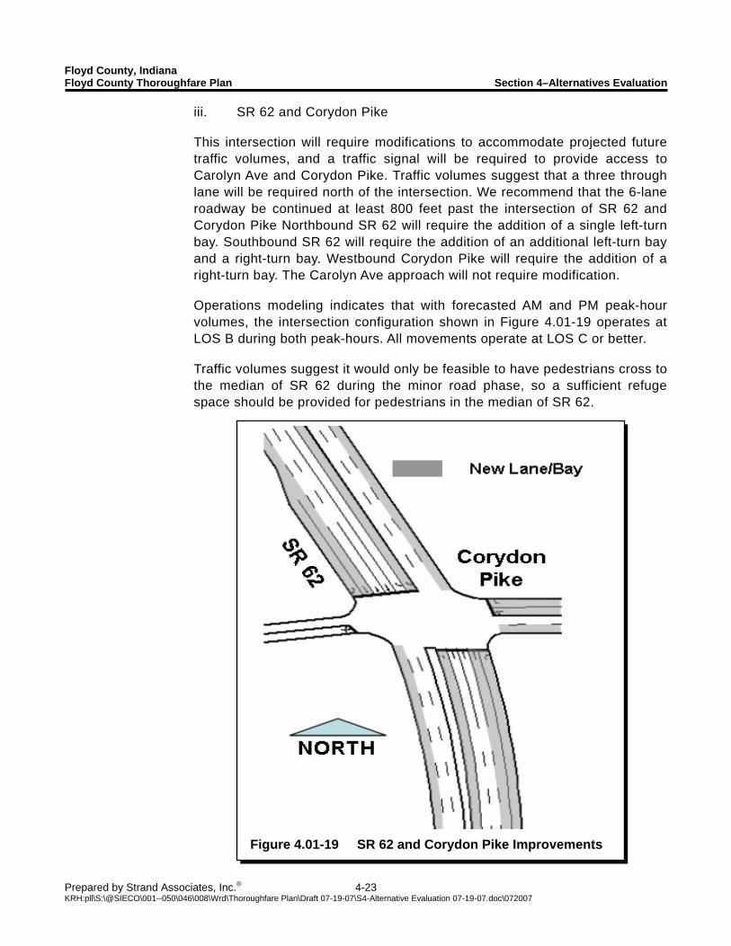
Floyd County, Indiana Floyd County Thoroughfare Plan Section 4–Alternatives Evaluation
Prepared by Strand Associates, Inc.® 4-23 KRH:pll\S:\@SIECO\001--050\046\008\Wrd\Thoroughfare Plan\Draft 07-19-07\S4-Alternative Evaluation 07-19-07.doc\072007
Figure 4.01-19 SR 62 and Corydon Pike Improvements
iii. SR 62 and Corydon Pike This intersection will require modifications to accommodate projected future traffic volumes, and a traffic signal will be required to provide access to Carolyn Ave and Corydon Pike. Traffic volumes suggest that a three through lane will be required north of the intersection. We recommend that the 6-lane roadway be continued at least 800 feet past the intersection of SR 62 and Corydon Pike Northbound SR 62 will require the addition of a single left-turn bay. Southbound SR 62 will require the addition of an additional left-turn bay and a right-turn bay. Westbound Corydon Pike will require the addition of a right-turn bay. The Carolyn Ave approach will not require modification. Operations modeling indicates that with forecasted AM and PM peak-hour volumes, the intersection configuration shown in Figure 4.01-19 operates at LOS B during both peak-hours. All movements operate at LOS C or better. Traffic volumes suggest it would only be feasible to have pedestrians cross to the median of SR 62 during the minor road phase, so a sufficient refuge space should be provided for pedestrians in the median of SR 62.
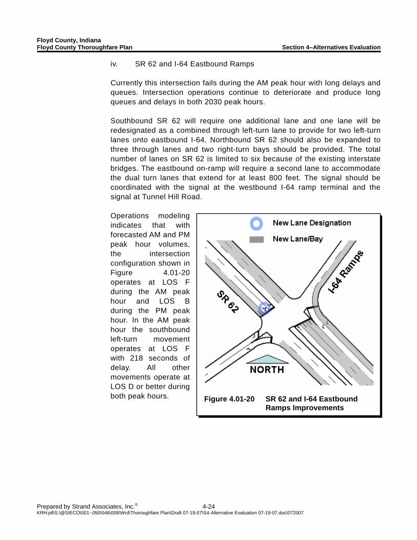
Floyd County, Indiana Floyd County Thoroughfare Plan Section 4–Alternatives Evaluation
Prepared by Strand Associates, Inc.® 4-24 KRH:pll\S:\@SIECO\001--050\046\008\Wrd\Thoroughfare Plan\Draft 07-19-07\S4-Alternative Evaluation 07-19-07.doc\072007
Figure 4.01-20 SR 62 and I-64 Eastbound
Ramps Improvements
iv. SR 62 and I-64 Eastbound Ramps Currently this intersection fails during the AM peak hour with long delays and queues. Intersection operations continue to deteriorate and produce long queues and delays in both 2030 peak hours. Southbound SR 62 will require one additional lane and one lane will be redesignated as a combined through left-turn lane to provide for two left-turn lanes onto eastbound I-64. Northbound SR 62 should also be expanded to three through lanes and two right-turn bays should be provided. The total number of lanes on SR 62 is limited to six because of the existing interstate bridges. The eastbound on-ramp will require a second lane to accommodate the dual turn lanes that extend for at least 800 feet. The signal should be coordinated with the signal at the westbound I-64 ramp terminal and the signal at Tunnel Hill Road. Operations modeling indicates that with forecasted AM and PM peak hour volumes, the intersection configuration shown in Figure 4.01-20 operates at LOS F during the AM peak hour and LOS B during the PM peak hour. In the AM peak hour the southbound left-turn movement operates at LOS F with 218 seconds of delay. All other movements operate at LOS D or better during both peak hours.
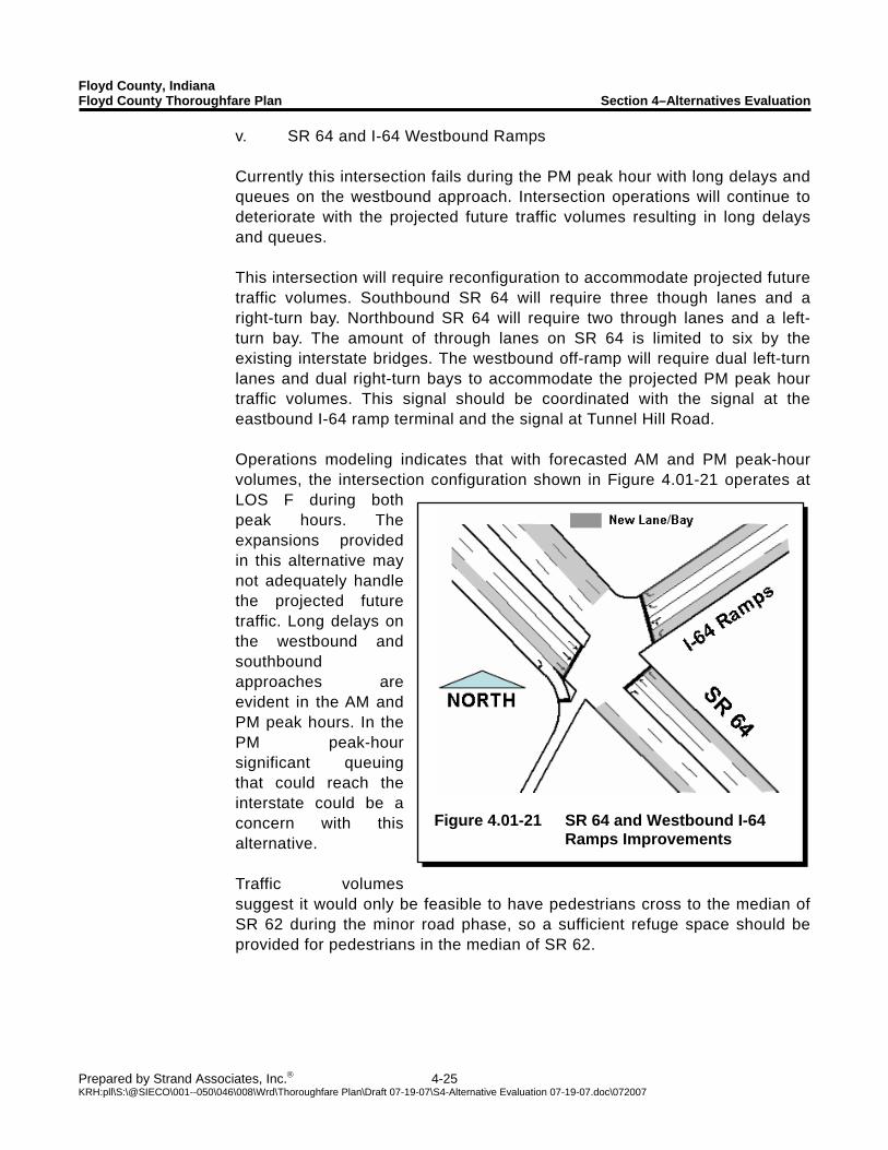
Floyd County, Indiana Floyd County Thoroughfare Plan Section 4–Alternatives Evaluation
Prepared by Strand Associates, Inc.® 4-25 KRH:pll\S:\@SIECO\001--050\046\008\Wrd\Thoroughfare Plan\Draft 07-19-07\S4-Alternative Evaluation 07-19-07.doc\072007
Figure 4.01-21 SR 64 and Westbound I-64
Ramps Improvements
v. SR 64 and I-64 Westbound Ramps Currently this intersection fails during the PM peak hour with long delays and queues on the westbound approach. Intersection operations will continue to deteriorate with the projected future traffic volumes resulting in long delays and queues. This intersection will require reconfiguration to accommodate projected future traffic volumes. Southbound SR 64 will require three though lanes and a right-turn bay. Northbound SR 64 will require two through lanes and a left-turn bay. The amount of through lanes on SR 64 is limited to six by the existing interstate bridges. The westbound off-ramp will require dual left-turn lanes and dual right-turn bays to accommodate the projected PM peak hour traffic volumes. This signal should be coordinated with the signal at the eastbound I-64 ramp terminal and the signal at Tunnel Hill Road. Operations modeling indicates that with forecasted AM and PM peak-hour volumes, the intersection configuration shown in Figure 4.01-21 operates at LOS F during both peak hours. The expansions provided in this alternative may not adequately handle the projected future traffic. Long delays on the westbound and southbound approaches are evident in the AM and PM peak hours. In the PM peak-hour significant queuing that could reach the interstate could be a concern with this alternative. Traffic volumes suggest it would only be feasible to have pedestrians cross to the median of SR 62 during the minor road phase, so a sufficient refuge space should be provided for pedestrians in the median of SR 62.
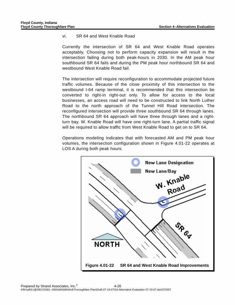
Floyd County, Indiana Floyd County Thoroughfare Plan Section 4–Alternatives Evaluation
Prepared by Strand Associates, Inc.® 4-26 KRH:pll\S:\@SIECO\001--050\046\008\Wrd\Thoroughfare Plan\Draft 07-19-07\S4-Alternative Evaluation 07-19-07.doc\072007
Figure 4.01-22 SR 64 and West Knable Road Improvements
vi. SR 64 and West Knable Road Currently the intersection of SR 64 and West Knable Road operates acceptably. Choosing not to perform capacity expansion will result in the intersection failing during both peak-hours in 2030. In the AM peak hour southbound SR 64 fails and during the PM peak hour northbound SR 64 and westbound West Knable Road fail. The intersection will require reconfiguration to accommodate projected future traffic volumes. Because of the close proximity of this intersection to the westbound I-64 ramp terminal, it is recommended that this intersection be converted to right-in right-out only. To allow for access to the local businesses, an access road will need to be constructed to link North Luther Road to the north approach of the Tunnel Hill Road intersection. The reconfigured intersection will provide three southbound SR 64 through lanes. The northbound SR 64 approach will have three through lanes and a right-turn bay. W. Knable Road will have one right-turn lane. A partial traffic signal will be required to allow traffic from West Knable Road to get on to SR 64. Operations modeling indicates that with forecasted AM and PM peak hour volumes, the intersection configuration shown in Figure 4.01-22 operates at LOS A during both peak hours.
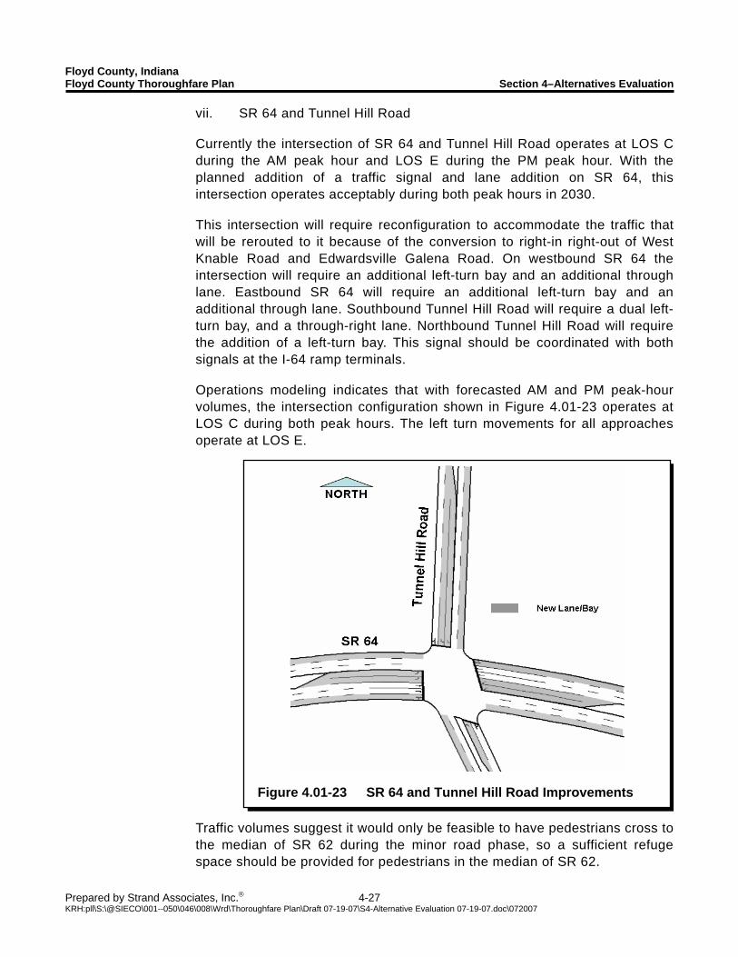
Floyd County, Indiana Floyd County Thoroughfare Plan Section 4–Alternatives Evaluation
Prepared by Strand Associates, Inc.® 4-27 KRH:pll\S:\@SIECO\001--050\046\008\Wrd\Thoroughfare Plan\Draft 07-19-07\S4-Alternative Evaluation 07-19-07.doc\072007
Figure 4.01-23 SR 64 and Tunnel Hill Road Improvements
vii. SR 64 and Tunnel Hill Road Currently the intersection of SR 64 and Tunnel Hill Road operates at LOS C during the AM peak hour and LOS E during the PM peak hour. With the planned addition of a traffic signal and lane addition on SR 64, this intersection operates acceptably during both peak hours in 2030. This intersection will require reconfiguration to accommodate the traffic that will be rerouted to it because of the conversion to right-in right-out of West Knable Road and Edwardsville Galena Road. On westbound SR 64 the intersection will require an additional left-turn bay and an additional through lane. Eastbound SR 64 will require an additional left-turn bay and an additional through lane. Southbound Tunnel Hill Road will require a dual left-turn bay, and a through-right lane. Northbound Tunnel Hill Road will require the addition of a left-turn bay. This signal should be coordinated with both signals at the I-64 ramp terminals. Operations modeling indicates that with forecasted AM and PM peak-hour volumes, the intersection configuration shown in Figure 4.01-23 operates at LOS C during both peak hours. The left turn movements for all approaches operate at LOS E.
Traffic volumes suggest it would only be feasible to have pedestrians cross to the median of SR 62 during the minor road phase, so a sufficient refuge space should be provided for pedestrians in the median of SR 62.
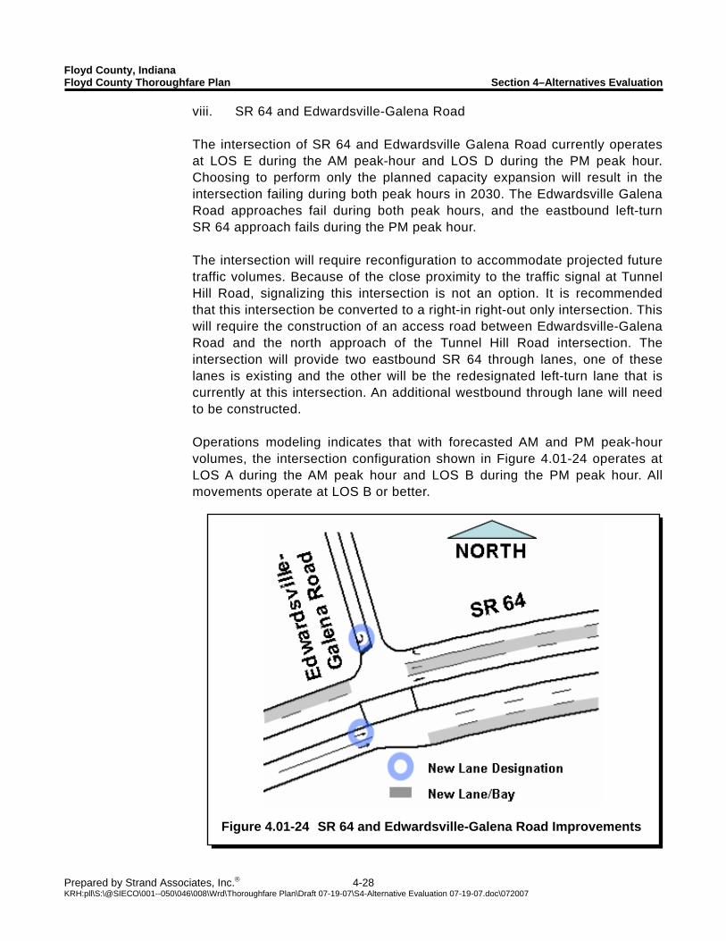
Floyd County, Indiana Floyd County Thoroughfare Plan Section 4–Alternatives Evaluation
Prepared by Strand Associates, Inc.® 4-28 KRH:pll\S:\@SIECO\001--050\046\008\Wrd\Thoroughfare Plan\Draft 07-19-07\S4-Alternative Evaluation 07-19-07.doc\072007
Figure 4.01-24 SR 64 and Edwardsville-Galena Road Improvements
viii. SR 64 and Edwardsville-Galena Road The intersection of SR 64 and Edwardsville Galena Road currently operates at LOS E during the AM peak-hour and LOS D during the PM peak hour. Choosing to perform only the planned capacity expansion will result in the intersection failing during both peak hours in 2030. The Edwardsville Galena Road approaches fail during both peak hours, and the eastbound left-turn SR 64 approach fails during the PM peak hour. The intersection will require reconfiguration to accommodate projected future traffic volumes. Because of the close proximity to the traffic signal at Tunnel Hill Road, signalizing this intersection is not an option. It is recommended that this intersection be converted to a right-in right-out only intersection. This will require the construction of an access road between Edwardsville-Galena Road and the north approach of the Tunnel Hill Road intersection. The intersection will provide two eastbound SR 64 through lanes, one of these lanes is existing and the other will be the redesignated left-turn lane that is currently at this intersection. An additional westbound through lane will need to be constructed. Operations modeling indicates that with forecasted AM and PM peak-hour volumes, the intersection configuration shown in Figure 4.01-24 operates at LOS A during the AM peak hour and LOS B during the PM peak hour. All movements operate at LOS B or better.
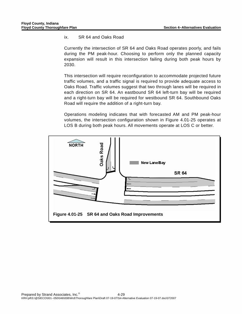
Floyd County, Indiana Floyd County Thoroughfare Plan Section 4–Alternatives Evaluation
Prepared by Strand Associates, Inc.® 4-29 KRH:pll\S:\@SIECO\001--050\046\008\Wrd\Thoroughfare Plan\Draft 07-19-07\S4-Alternative Evaluation 07-19-07.doc\072007
Figure 4.01-25 SR 64 and Oaks Road Improvements
ix. SR 64 and Oaks Road Currently the intersection of SR 64 and Oaks Road operates poorly, and fails during the PM peak-hour. Choosing to perform only the planned capacity expansion will result in this intersection failing during both peak hours by 2030. This intersection will require reconfiguration to accommodate projected future traffic volumes, and a traffic signal is required to provide adequate access to Oaks Road. Traffic volumes suggest that two through lanes will be required in each direction on SR 64. An eastbound SR 64 left-turn bay will be required and a right-turn bay will be required for westbound SR 64. Southbound Oaks Road will require the addition of a right-turn bay. Operations modeling indicates that with forecasted AM and PM peak-hour volumes, the intersection configuration shown in Figure 4.01-25 operates at LOS B during both peak hours. All movements operate at LOS C or better.
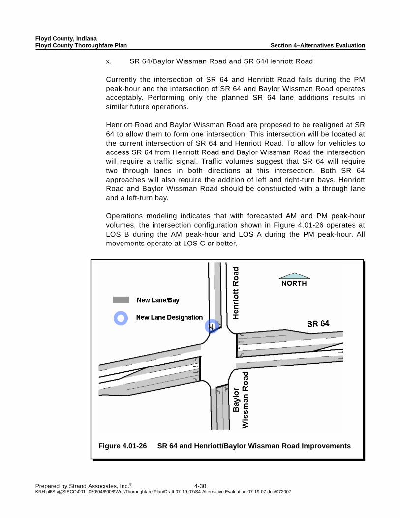
Floyd County, Indiana Floyd County Thoroughfare Plan Section 4–Alternatives Evaluation
Prepared by Strand Associates, Inc.® 4-30 KRH:pll\S:\@SIECO\001--050\046\008\Wrd\Thoroughfare Plan\Draft 07-19-07\S4-Alternative Evaluation 07-19-07.doc\072007
Figure 4.01-26 SR 64 and Henriott/Baylor Wissman Road Improvements
x. SR 64/Baylor Wissman Road and SR 64/Henriott Road Currently the intersection of SR 64 and Henriott Road fails during the PM peak-hour and the intersection of SR 64 and Baylor Wissman Road operates acceptably. Performing only the planned SR 64 lane additions results in similar future operations. Henriott Road and Baylor Wissman Road are proposed to be realigned at SR 64 to allow them to form one intersection. This intersection will be located at the current intersection of SR 64 and Henriott Road. To allow for vehicles to access SR 64 from Henriott Road and Baylor Wissman Road the intersection will require a traffic signal. Traffic volumes suggest that SR 64 will require two through lanes in both directions at this intersection. Both SR 64 approaches will also require the addition of left and right-turn bays. Henriott Road and Baylor Wissman Road should be constructed with a through lane and a left-turn bay. Operations modeling indicates that with forecasted AM and PM peak-hour volumes, the intersection configuration shown in Figure 4.01-26 operates at LOS B during the AM peak-hour and LOS A during the PM peak-hour. All movements operate at LOS C or better.
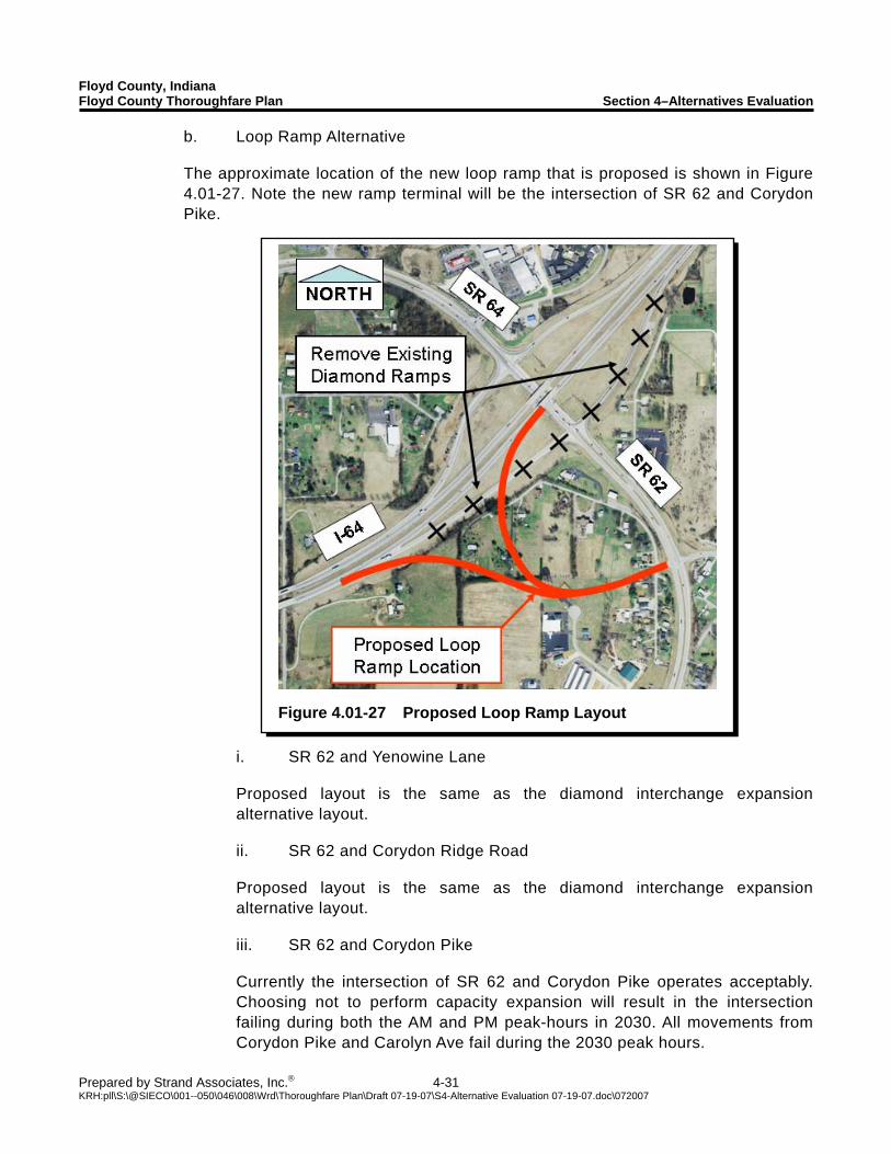
Floyd County, Indiana Floyd County Thoroughfare Plan Section 4–Alternatives Evaluation
Prepared by Strand Associates, Inc.® 4-31 KRH:pll\S:\@SIECO\001--050\046\008\Wrd\Thoroughfare Plan\Draft 07-19-07\S4-Alternative Evaluation 07-19-07.doc\072007
Figure 4.01-27 Proposed Loop Ramp Layout
b. Loop Ramp Alternative The approximate location of the new loop ramp that is proposed is shown in Figure 4.01-27. Note the new ramp terminal will be the intersection of SR 62 and Corydon Pike.
i. SR 62 and Yenowine Lane Proposed layout is the same as the diamond interchange expansion alternative layout. ii. SR 62 and Corydon Ridge Road Proposed layout is the same as the diamond interchange expansion alternative layout. iii. SR 62 and Corydon Pike Currently the intersection of SR 62 and Corydon Pike operates acceptably. Choosing not to perform capacity expansion will result in the intersection failing during both the AM and PM peak-hours in 2030. All movements from Corydon Pike and Carolyn Ave fail during the 2030 peak hours.
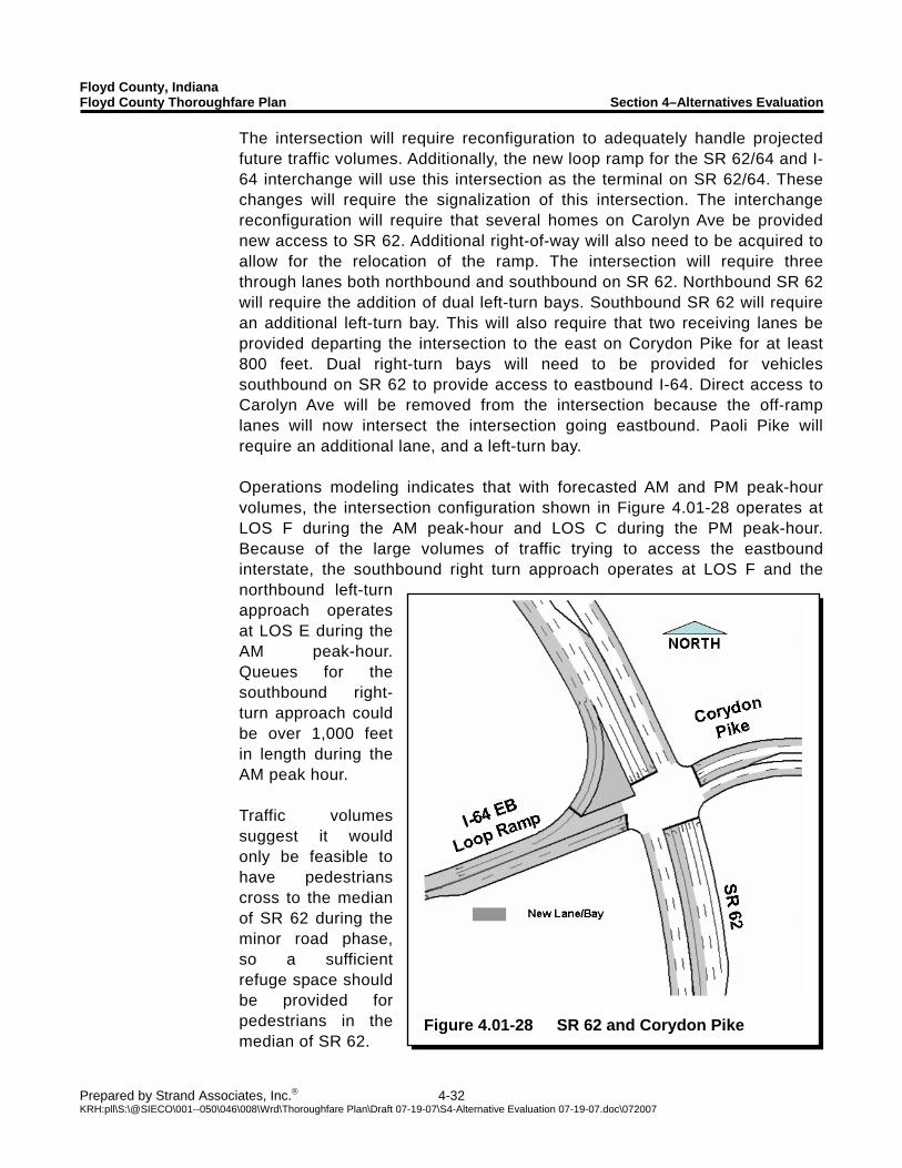
Floyd County, Indiana Floyd County Thoroughfare Plan Section 4–Alternatives Evaluation
Prepared by Strand Associates, Inc.® 4-32 KRH:pll\S:\@SIECO\001--050\046\008\Wrd\Thoroughfare Plan\Draft 07-19-07\S4-Alternative Evaluation 07-19-07.doc\072007
Figure 4.01-28 SR 62 and Corydon Pike
The intersection will require reconfiguration to adequately handle projected future traffic volumes. Additionally, the new loop ramp for the SR 62/64 and I-64 interchange will use this intersection as the terminal on SR 62/64. These changes will require the signalization of this intersection. The interchange reconfiguration will require that several homes on Carolyn Ave be provided new access to SR 62. Additional right-of-way will also need to be acquired to allow for the relocation of the ramp. The intersection will require three through lanes both northbound and southbound on SR 62. Northbound SR 62 will require the addition of dual left-turn bays. Southbound SR 62 will require an additional left-turn bay. This will also require that two receiving lanes be provided departing the intersection to the east on Corydon Pike for at least 800 feet. Dual right-turn bays will need to be provided for vehicles southbound on SR 62 to provide access to eastbound I-64. Direct access to Carolyn Ave will be removed from the intersection because the off-ramp lanes will now intersect the intersection going eastbound. Paoli Pike will require an additional lane, and a left-turn bay. Operations modeling indicates that with forecasted AM and PM peak-hour volumes, the intersection configuration shown in Figure 4.01-28 operates at LOS F during the AM peak-hour and LOS C during the PM peak-hour. Because of the large volumes of traffic trying to access the eastbound interstate, the southbound right turn approach operates at LOS F and the northbound left-turn approach operates at LOS E during the AM peak-hour. Queues for the southbound right-turn approach could be over 1,000 feet in length during the AM peak hour. Traffic volumes suggest it would only be feasible to have pedestrians cross to the median of SR 62 during the minor road phase, so a sufficient refuge space should be provided for pedestrians in the median of SR 62.
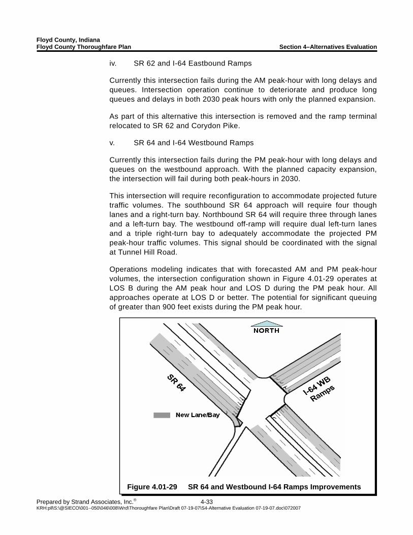
Floyd County, Indiana Floyd County Thoroughfare Plan Section 4–Alternatives Evaluation
Prepared by Strand Associates, Inc.® 4-33 KRH:pll\S:\@SIECO\001--050\046\008\Wrd\Thoroughfare Plan\Draft 07-19-07\S4-Alternative Evaluation 07-19-07.doc\072007
Figure 4.01-29 SR 64 and Westbound I-64 Ramps Improvements
iv. SR 62 and I-64 Eastbound Ramps Currently this intersection fails during the AM peak-hour with long delays and queues. Intersection operation continue to deteriorate and produce long queues and delays in both 2030 peak hours with only the planned expansion. As part of this alternative this intersection is removed and the ramp terminal relocated to SR 62 and Corydon Pike. v. SR 64 and I-64 Westbound Ramps Currently this intersection fails during the PM peak-hour with long delays and queues on the westbound approach. With the planned capacity expansion, the intersection will fail during both peak-hours in 2030. This intersection will require reconfiguration to accommodate projected future traffic volumes. The southbound SR 64 approach will require four though lanes and a right-turn bay. Northbound SR 64 will require three through lanes and a left-turn bay. The westbound off-ramp will require dual left-turn lanes and a triple right-turn bay to adequately accommodate the projected PM peak-hour traffic volumes. This signal should be coordinated with the signal at Tunnel Hill Road. Operations modeling indicates that with forecasted AM and PM peak-hour volumes, the intersection configuration shown in Figure 4.01-29 operates at LOS B during the AM peak hour and LOS D during the PM peak hour. All approaches operate at LOS D or better. The potential for significant queuing of greater than 900 feet exists during the PM peak hour.
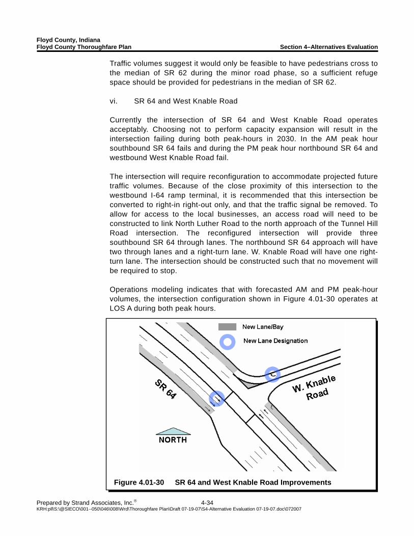
Floyd County, Indiana Floyd County Thoroughfare Plan Section 4–Alternatives Evaluation
Prepared by Strand Associates, Inc.® 4-34 KRH:pll\S:\@SIECO\001--050\046\008\Wrd\Thoroughfare Plan\Draft 07-19-07\S4-Alternative Evaluation 07-19-07.doc\072007
Figure 4.01-30 SR 64 and West Knable Road Improvements
Traffic volumes suggest it would only be feasible to have pedestrians cross to the median of SR 62 during the minor road phase, so a sufficient refuge space should be provided for pedestrians in the median of SR 62. vi. SR 64 and West Knable Road Currently the intersection of SR 64 and West Knable Road operates acceptably. Choosing not to perform capacity expansion will result in the intersection failing during both peak-hours in 2030. In the AM peak hour southbound SR 64 fails and during the PM peak hour northbound SR 64 and westbound West Knable Road fail. The intersection will require reconfiguration to accommodate projected future traffic volumes. Because of the close proximity of this intersection to the westbound I-64 ramp terminal, it is recommended that this intersection be converted to right-in right-out only, and that the traffic signal be removed. To allow for access to the local businesses, an access road will need to be constructed to link North Luther Road to the north approach of the Tunnel Hill Road intersection. The reconfigured intersection will provide three southbound SR 64 through lanes. The northbound SR 64 approach will have two through lanes and a right-turn lane. W. Knable Road will have one right-turn lane. The intersection should be constructed such that no movement will be required to stop. Operations modeling indicates that with forecasted AM and PM peak-hour volumes, the intersection configuration shown in Figure 4.01-30 operates at LOS A during both peak hours.
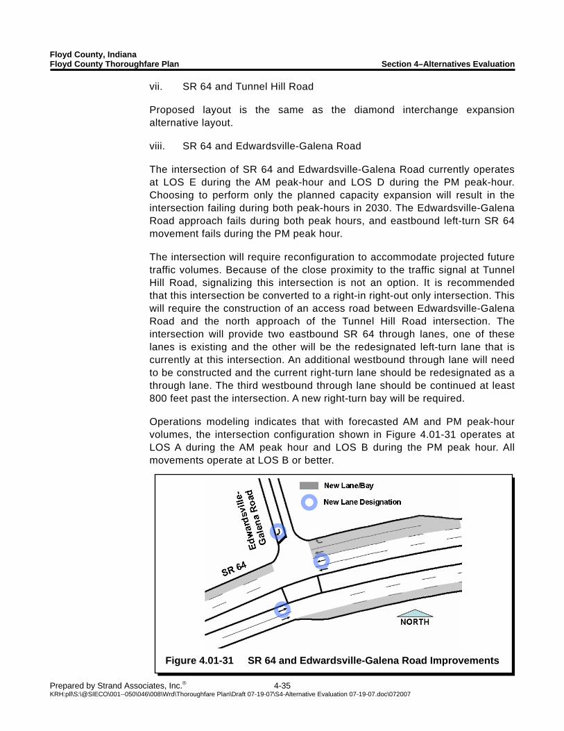
Floyd County, Indiana Floyd County Thoroughfare Plan Section 4–Alternatives Evaluation
Prepared by Strand Associates, Inc.® 4-35 KRH:pll\S:\@SIECO\001--050\046\008\Wrd\Thoroughfare Plan\Draft 07-19-07\S4-Alternative Evaluation 07-19-07.doc\072007
Figure 4.01-31 SR 64 and Edwardsville-Galena Road Improvements
vii. SR 64 and Tunnel Hill Road Proposed layout is the same as the diamond interchange expansion alternative layout. viii. SR 64 and Edwardsville-Galena Road The intersection of SR 64 and Edwardsville-Galena Road currently operates at LOS E during the AM peak-hour and LOS D during the PM peak-hour. Choosing to perform only the planned capacity expansion will result in the intersection failing during both peak-hours in 2030. The Edwardsville-Galena Road approach fails during both peak hours, and eastbound left-turn SR 64 movement fails during the PM peak hour. The intersection will require reconfiguration to accommodate projected future traffic volumes. Because of the close proximity to the traffic signal at Tunnel Hill Road, signalizing this intersection is not an option. It is recommended that this intersection be converted to a right-in right-out only intersection. This will require the construction of an access road between Edwardsville-Galena Road and the north approach of the Tunnel Hill Road intersection. The intersection will provide two eastbound SR 64 through lanes, one of these lanes is existing and the other will be the redesignated left-turn lane that is currently at this intersection. An additional westbound through lane will need to be constructed and the current right-turn lane should be redesignated as a through lane. The third westbound through lane should be continued at least 800 feet past the intersection. A new right-turn bay will be required. Operations modeling indicates that with forecasted AM and PM peak-hour volumes, the intersection configuration shown in Figure 4.01-31 operates at LOS A during the AM peak hour and LOS B during the PM peak hour. All movements operate at LOS B or better.
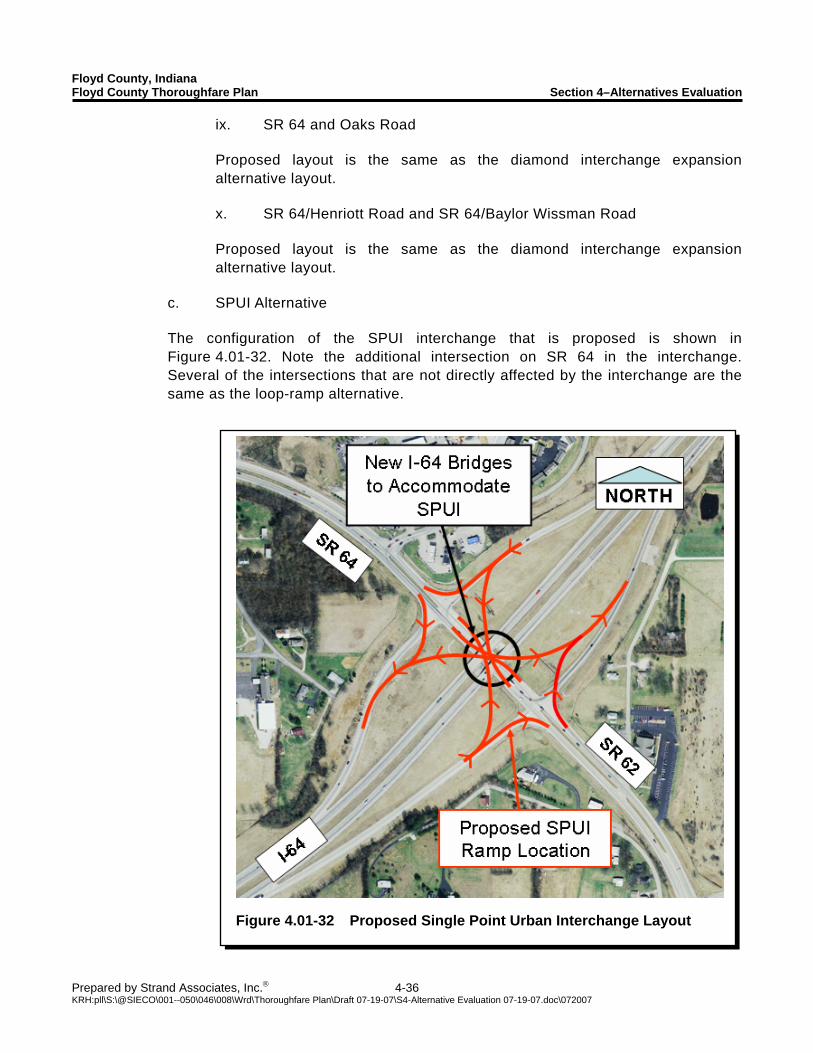
Floyd County, Indiana Floyd County Thoroughfare Plan Section 4–Alternatives Evaluation
Prepared by Strand Associates, Inc.® 4-36 KRH:pll\S:\@SIECO\001--050\046\008\Wrd\Thoroughfare Plan\Draft 07-19-07\S4-Alternative Evaluation 07-19-07.doc\072007
Figure 4.01-32 Proposed Single Point Urban Interchange Layout
ix. SR 64 and Oaks Road Proposed layout is the same as the diamond interchange expansion alternative layout. x. SR 64/Henriott Road and SR 64/Baylor Wissman Road Proposed layout is the same as the diamond interchange expansion alternative layout.
c. SPUI Alternative The configuration of the SPUI interchange that is proposed is shown in Figure 4.01-32. Note the additional intersection on SR 64 in the interchange. Several of the intersections that are not directly affected by the interchange are the same as the loop-ramp alternative.

Floyd County, Indiana Floyd County Thoroughfare Plan Section 4–Alternatives Evaluation
Prepared by Strand Associates, Inc.® 4-37 KRH:pll\S:\@SIECO\001--050\046\008\Wrd\Thoroughfare Plan\Draft 07-19-07\S4-Alternative Evaluation 07-19-07.doc\072007
Figure 4.01-33 SR 62 and Corydon Pike
Improvements
i. SR 62 and Yenowine Lane Proposed layout is the same as the diamond interchange expansion alternative layout. ii. SR 62 and Corydon Ridge Road Proposed layout is the same as the diamond interchange expansion alternative layout. iii. SR 62 and Corydon Pike This intersection will require modifications to accommodate projected future traffic volumes, and a traffic signal will be required to provide access to Carolyn Avenue and Corydon Pike. Northbound SR 62 will need to be reconfigured to have a single left-turn bay, three through lanes, and one right-turn bay. Southbound SR 62 will need to be reconfigured to have an additional left-turn bay, two through lanes, and a through right-turn lane. Westbound Corydon Pike will require the addition of a right-turn bay. A second lane departing the intersection to the east will be required for at least 800 feet. The Carolyn Ave approach will not require modification. Operations modeling indicates that with forecasted AM and PM peak-hour volumes, the intersection configuration shown in Figure 4.01-33 operates at LOS B during both peak-hours. All movements operate at LOS C or better.
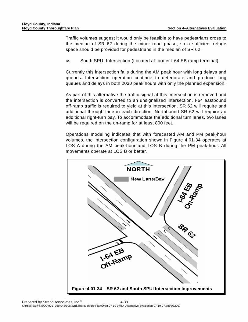
Floyd County, Indiana Floyd County Thoroughfare Plan Section 4–Alternatives Evaluation
Prepared by Strand Associates, Inc.® 4-38 KRH:pll\S:\@SIECO\001--050\046\008\Wrd\Thoroughfare Plan\Draft 07-19-07\S4-Alternative Evaluation 07-19-07.doc\072007
Figure 4.01-34 SR 62 and South SPUI Intersection Improvements
Traffic volumes suggest it would only be feasible to have pedestrians cross to the median of SR 62 during the minor road phase, so a sufficient refuge space should be provided for pedestrians in the median of SR 62. iv. South SPUI Intersection (Located at former I-64 EB ramp terminal) Currently this intersection fails during the AM peak hour with long delays and queues. Intersection operation continue to deteriorate and produce long queues and delays in both 2030 peak hours with only the planned expansion. As part of this alternative the traffic signal at this intersection is removed and the intersection is converted to an unsignalized intersection. I-64 eastbound off-ramp traffic is required to yield at this intersection. SR 62 will require and additional through lane in each direction. Northbound SR 62 will require an additional right-turn bay. To accommodate the additional turn lanes, two lanes will be required on the on-ramp for at least 800 feet.. Operations modeling indicates that with forecasted AM and PM peak-hour volumes, the intersection configuration shown in Figure 4.01-34 operates at LOS A during the AM peak-hour and LOS B during the PM peak-hour. All movements operate at LOS B or better.
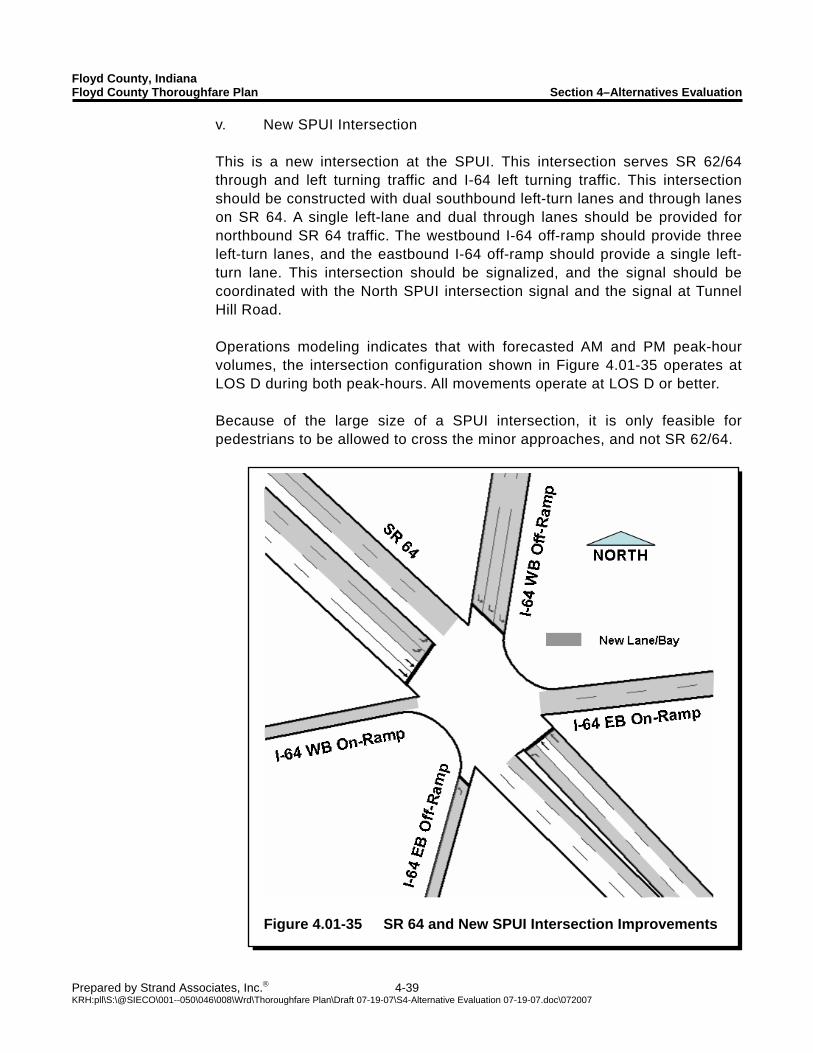
Floyd County, Indiana Floyd County Thoroughfare Plan Section 4–Alternatives Evaluation
Prepared by Strand Associates, Inc.® 4-39 KRH:pll\S:\@SIECO\001--050\046\008\Wrd\Thoroughfare Plan\Draft 07-19-07\S4-Alternative Evaluation 07-19-07.doc\072007
Figure 4.01-35 SR 64 and New SPUI Intersection Improvements
v. New SPUI Intersection This is a new intersection at the SPUI. This intersection serves SR 62/64 through and left turning traffic and I-64 left turning traffic. This intersection should be constructed with dual southbound left-turn lanes and through lanes on SR 64. A single left-lane and dual through lanes should be provided for northbound SR 64 traffic. The westbound I-64 off-ramp should provide three left-turn lanes, and the eastbound I-64 off-ramp should provide a single left-turn lane. This intersection should be signalized, and the signal should be coordinated with the North SPUI intersection signal and the signal at Tunnel Hill Road. Operations modeling indicates that with forecasted AM and PM peak-hour volumes, the intersection configuration shown in Figure 4.01-35 operates at LOS D during both peak-hours. All movements operate at LOS D or better. Because of the large size of a SPUI intersection, it is only feasible for pedestrians to be allowed to cross the minor approaches, and not SR 62/64.
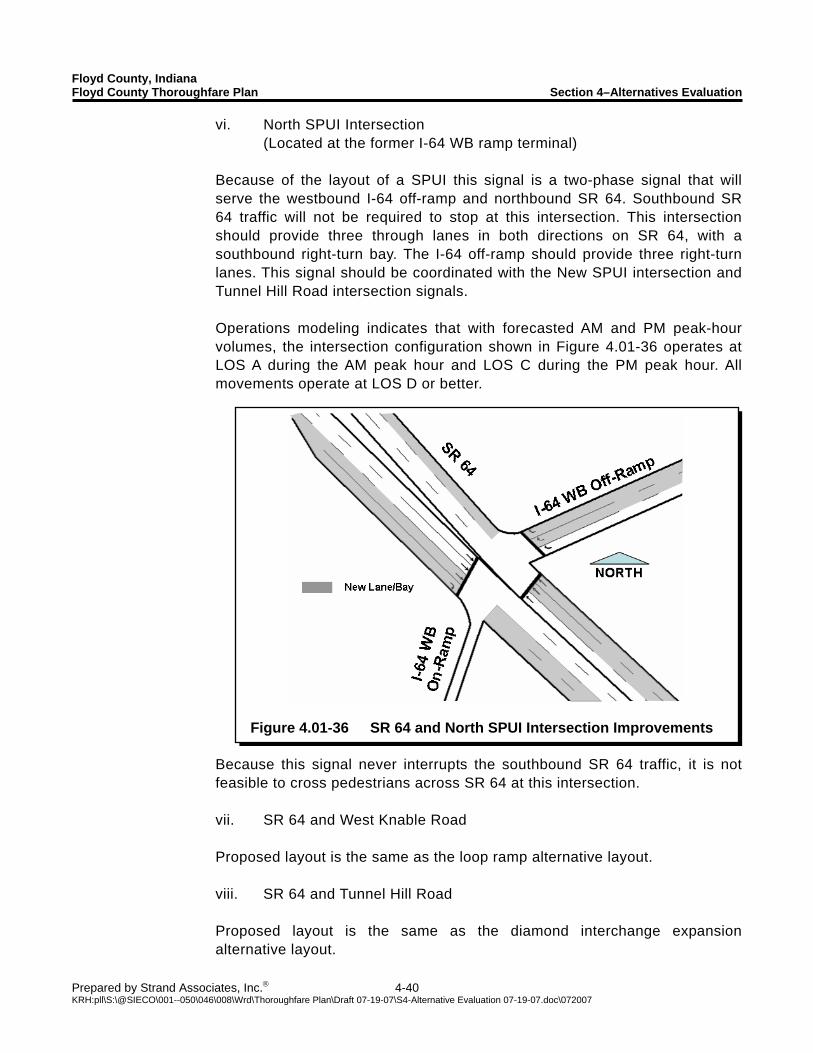
Floyd County, Indiana Floyd County Thoroughfare Plan Section 4–Alternatives Evaluation
Prepared by Strand Associates, Inc.® 4-40 KRH:pll\S:\@SIECO\001--050\046\008\Wrd\Thoroughfare Plan\Draft 07-19-07\S4-Alternative Evaluation 07-19-07.doc\072007
Figure 4.01-36 SR 64 and North SPUI Intersection Improvements
vi. North SPUI Intersection (Located at the former I-64 WB ramp terminal)
Because of the layout of a SPUI this signal is a two-phase signal that will serve the westbound I-64 off-ramp and northbound SR 64. Southbound SR 64 traffic will not be required to stop at this intersection. This intersection should provide three through lanes in both directions on SR 64, with a southbound right-turn bay. The I-64 off-ramp should provide three right-turn lanes. This signal should be coordinated with the New SPUI intersection and Tunnel Hill Road intersection signals. Operations modeling indicates that with forecasted AM and PM peak-hour volumes, the intersection configuration shown in Figure 4.01-36 operates at LOS A during the AM peak hour and LOS C during the PM peak hour. All movements operate at LOS D or better.
Because this signal never interrupts the southbound SR 64 traffic, it is not feasible to cross pedestrians across SR 64 at this intersection. vii. SR 64 and West Knable Road Proposed layout is the same as the loop ramp alternative layout. viii. SR 64 and Tunnel Hill Road Proposed layout is the same as the diamond interchange expansion alternative layout.
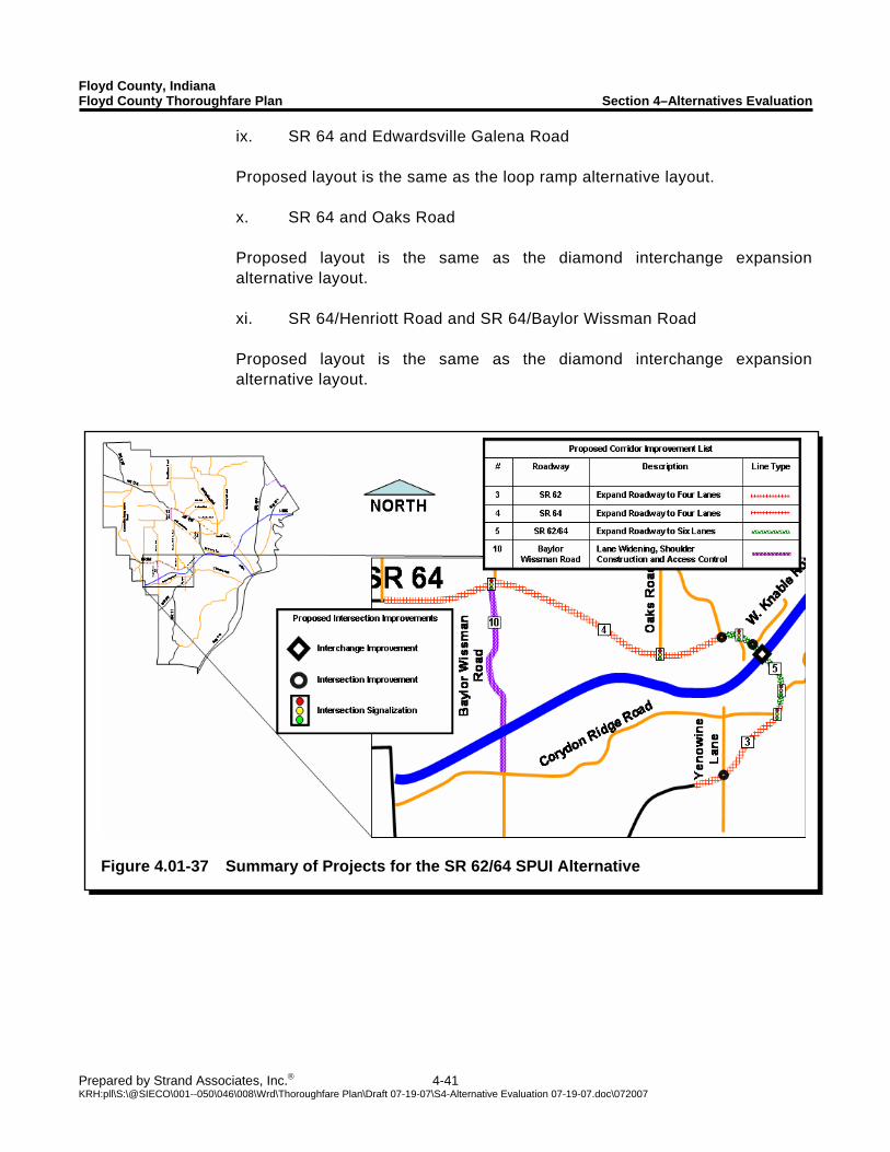
Floyd County, Indiana Floyd County Thoroughfare Plan Section 4–Alternatives Evaluation
Prepared by Strand Associates, Inc.® 4-41 KRH:pll\S:\@SIECO\001--050\046\008\Wrd\Thoroughfare Plan\Draft 07-19-07\S4-Alternative Evaluation 07-19-07.doc\072007
Figure 4.01-37 Summary of Projects for the SR 62/64 SPUI Alternative
ix. SR 64 and Edwardsville Galena Road Proposed layout is the same as the loop ramp alternative layout. x. SR 64 and Oaks Road Proposed layout is the same as the diamond interchange expansion alternative layout. xi. SR 64/Henriott Road and SR 64/Baylor Wissman Road Proposed layout is the same as the diamond interchange expansion alternative layout.
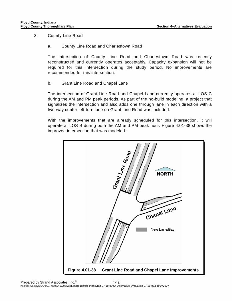
Floyd County, Indiana Floyd County Thoroughfare Plan Section 4–Alternatives Evaluation
Prepared by Strand Associates, Inc.® 4-42 KRH:pll\S:\@SIECO\001--050\046\008\Wrd\Thoroughfare Plan\Draft 07-19-07\S4-Alternative Evaluation 07-19-07.doc\072007
Figure 4.01-38 Grant Line Road and Chapel Lane Improvements
3. County Line Road a. County Line Road and Charlestown Road The intersection of County Line Road and Charlestown Road was recently reconstructed and currently operates acceptably. Capacity expansion will not be required for this intersection during the study period. No improvements are recommended for this intersection. b. Grant Line Road and Chapel Lane The intersection of Grant Line Road and Chapel Lane currently operates at LOS C during the AM and PM peak periods. As part of the no-build modeling, a project that signalizes the intersection and also adds one through lane in each direction with a two-way center left-turn lane on Grant Line Road was included. With the improvements that are already scheduled for this intersection, it will operate at LOS B during both the AM and PM peak hour. Figure 4.01-38 shows the improved intersection that was modeled.
Floyd County, Indiana Floyd County Thoroughfare Plan Section 4–Alternatives Evaluation
Prepared by Strand Associates, Inc.® 4-43 KRH:pll\S:\@SIECO\001--050\046\008\Wrd\Thoroughfare Plan\Draft 07-19-07\S4-Alternative Evaluation 07-19-07.doc\072007
4.02 ALTERNATIVE CAPACITY EXPANSION A. Corridor Expansion
A possible alternative to adding multiple though lanes to corridors is to create a reversible lane. As discussed in the previous section, a reversible lane is used to help accommodate increased directional travel during the AM and PM peak periods. The lanes are generally signed as center left-turn lanes during off peak hours. Extensive signing is required along the length of the reversible lane to indicate to motorists the direction of travel that is allowed in the lane. As a possible alternative to creating a four-lane corridor west of Brush College Road on US 150, a three-lane facility with a reversible center lane could be considered. There are several advantages to a reversible lane facility. The first advantage is the reduced construction costs compared with the recommended four-lane facility. These savings are from the reduced right-of-way required and because less materials would be required to construct a three-lane facility. A three-lane facility would also be easier to construct through Galena on the west end of the study area. A three-lane facility will also be quicker to construct than the full four-lane facility and could be used as an interim solution before the construction of a full four-lane facility is possible. Possible disadvantages include the cost of signing the reversible lane. Another possible disadvantage of a reversible lane is driver confusion when the lane is first opened to traffic. Significant signing is required to ensure that this is not a problem. A final disadvantage is that after the reversible lane is constructed, it may still be deemed necessary to convert the corridor to a full four-lane facility in the near future. A reversible lane could also be considered on the rest of US 150, as an alternative to traditional lane additions. An expanded highway facility with center reversible lanes could be considered along the SR 62/64 corridor as well. B. Intersection Expansion
Public opposition to the alternative intersection layouts referred to in the previous section is a major barrier to their implementation. The first alternative intersection in a geographical area is usually the hardest to implement. Intersections selected for alternative capacity expansion need to be selected carefully to ensure that they are appropriate and that the expansion will be able to convey the projected traffic volumes. No alternative intersection expansions are proposed for the intersections in Floyd County. The traditional expansions proposed for the intersections should be enough to improve traffic operations for the future conditions modeled. Another factor in the decision not to suggest any alternative intersection capacity expansions is the likely public opposition to their implementation.
Floyd County, Indiana Floyd County Thoroughfare Plan Section 4–Alternatives Evaluation
Prepared by Strand Associates, Inc.® 4-44 KRH:pll\S:\@SIECO\001--050\046\008\Wrd\Thoroughfare Plan\Draft 07-19-07\S4-Alternative Evaluation 07-19-07.doc\072007
4.03 BICYCLE SYSTEM IMPROVEMENTS The County should explore options to incorporate bicycle facilities either as designated bike routes, dedicated bike lanes on roads, or off-street multiuse trails. The creation of dedicated bicycle facilities could make bicycle travel a safe and attractive option to motor vehicle travel for short trips. A. Designated Bicycle Facilities Designated bicycle facilities include the creation of bicycle routes that are posted as designated bike routes throughout the County. The actual LOS of the facility is to be determined through the Bicycle Compatibility Index. Three color coded routes have been identified for the County that would serve as connectors to four County parks. A map of the proposed bike routes is shown in Figure 4.03-1, and the routes are described below.
1. Red Route–The Red Route is a 20.4 mile route that connects Cannon Acres Soccer Facility to Letty Walters Park on Saint Mary’s Road. The proposed route follow’s Quarry and Old Hill Road to Paoli Pike, and then proceeds for a short distance along Scottsville Road. The route then proceeds along Saint Mary’s Road to Letty Walters Park. Additional segments for the route have been suggested for the Skyline Drive area.
2. Blue Route–The Blue Route is a 23.4 mile route that connects Letty Walters Park,
Greenville Park, and Edwardsville Park. The route meander’s through the northern part of Lafayette and Greenville Township before traveling along Henriott and Baylor Wissman Road, in Georgetown Township.
3. Yellow Route–The Yellow Route is a 13.4 mile route that connects to the Blue Route.
This route proceeds south along Tandy Road to State Route 62. Then the route proceeds along State Route 11 to Blunk Knob Road. The route then proceeds east along Budd Road and ends at Cannon Acres. The Yellow Route is proposed to connect to the terminus point of the Ohio River Greenway on East 10th Street.
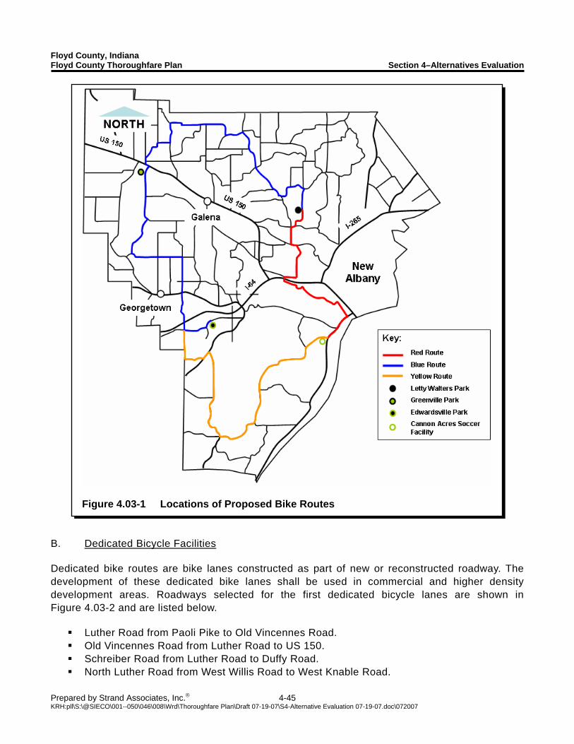
Floyd County, Indiana Floyd County Thoroughfare Plan Section 4–Alternatives Evaluation
Prepared by Strand Associates, Inc.® 4-45 KRH:pll\S:\@SIECO\001--050\046\008\Wrd\Thoroughfare Plan\Draft 07-19-07\S4-Alternative Evaluation 07-19-07.doc\072007
Figure 4.03-1 Locations of Proposed Bike Routes
B. Dedicated Bicycle Facilities Dedicated bike routes are bike lanes constructed as part of new or reconstructed roadway. The development of these dedicated bike lanes shall be used in commercial and higher density development areas. Roadways selected for the first dedicated bicycle lanes are shown in Figure 4.03-2 and are listed below.
Luther Road from Paoli Pike to Old Vincennes Road. Old Vincennes Road from Luther Road to US 150. Schreiber Road from Luther Road to Duffy Road. North Luther Road from West Willis Road to West Knable Road.
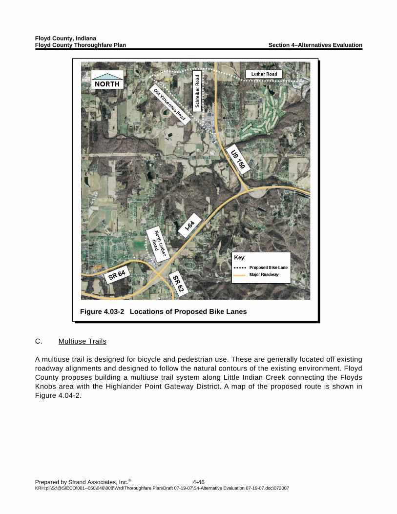
Floyd County, Indiana Floyd County Thoroughfare Plan Section 4–Alternatives Evaluation
Prepared by Strand Associates, Inc.® 4-46 KRH:pll\S:\@SIECO\001--050\046\008\Wrd\Thoroughfare Plan\Draft 07-19-07\S4-Alternative Evaluation 07-19-07.doc\072007
Figure 4.03-2 Locations of Proposed Bike Lanes
C. Multiuse Trails A multiuse trail is designed for bicycle and pedestrian use. These are generally located off existing roadway alignments and designed to follow the natural contours of the existing environment. Floyd County proposes building a multiuse trail system along Little Indian Creek connecting the Floyds Knobs area with the Highlander Point Gateway District. A map of the proposed route is shown in Figure 4.04-2.
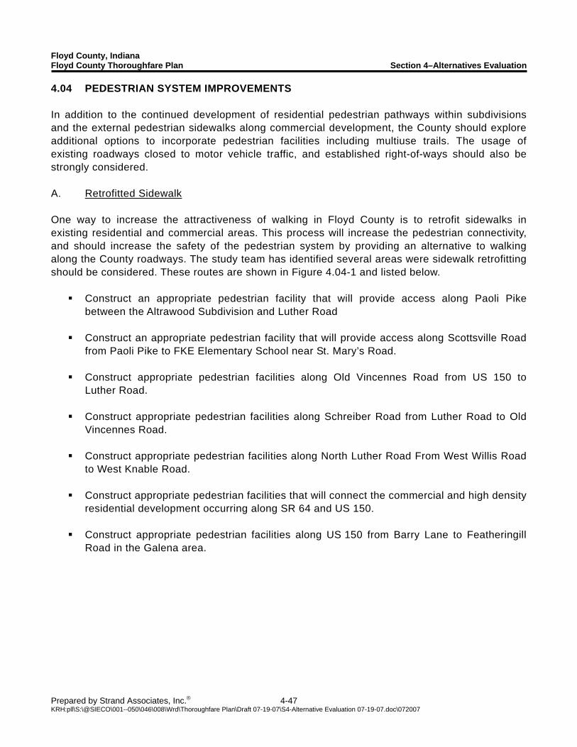
Floyd County, Indiana Floyd County Thoroughfare Plan Section 4–Alternatives Evaluation
Prepared by Strand Associates, Inc.® 4-47 KRH:pll\S:\@SIECO\001--050\046\008\Wrd\Thoroughfare Plan\Draft 07-19-07\S4-Alternative Evaluation 07-19-07.doc\072007
4.04 PEDESTRIAN SYSTEM IMPROVEMENTS In addition to the continued development of residential pedestrian pathways within subdivisions and the external pedestrian sidewalks along commercial development, the County should explore additional options to incorporate pedestrian facilities including multiuse trails. The usage of existing roadways closed to motor vehicle traffic, and established right-of-ways should also be strongly considered. A. Retrofitted Sidewalk One way to increase the attractiveness of walking in Floyd County is to retrofit sidewalks in existing residential and commercial areas. This process will increase the pedestrian connectivity, and should increase the safety of the pedestrian system by providing an alternative to walking along the County roadways. The study team has identified several areas were sidewalk retrofitting should be considered. These routes are shown in Figure 4.04-1 and listed below.
Construct an appropriate pedestrian facility that will provide access along Paoli Pike between the Altrawood Subdivision and Luther Road
Construct an appropriate pedestrian facility that will provide access along Scottsville Road from Paoli Pike to FKE Elementary School near St. Mary’s Road.
Construct appropriate pedestrian facilities along Old Vincennes Road from US 150 to Luther Road.
Construct appropriate pedestrian facilities along Schreiber Road from Luther Road to Old Vincennes Road.
Construct appropriate pedestrian facilities along North Luther Road From West Willis Road to West Knable Road.
Construct appropriate pedestrian facilities that will connect the commercial and high density residential development occurring along SR 64 and US 150.
Construct appropriate pedestrian facilities along US 150 from Barry Lane to Featheringill Road in the Galena area.
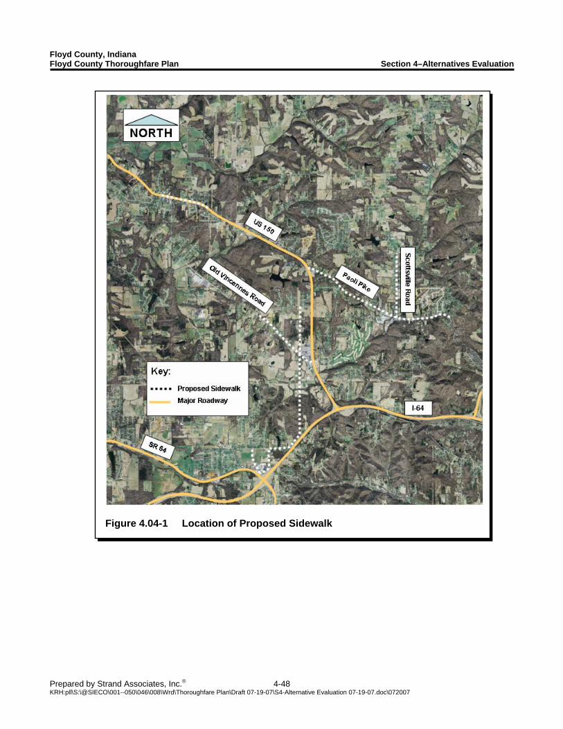
Floyd County, Indiana Floyd County Thoroughfare Plan Section 4–Alternatives Evaluation
Prepared by Strand Associates, Inc.® 4-48 KRH:pll\S:\@SIECO\001--050\046\008\Wrd\Thoroughfare Plan\Draft 07-19-07\S4-Alternative Evaluation 07-19-07.doc\072007
Figure 4.04-1 Location of Proposed Sidewalk
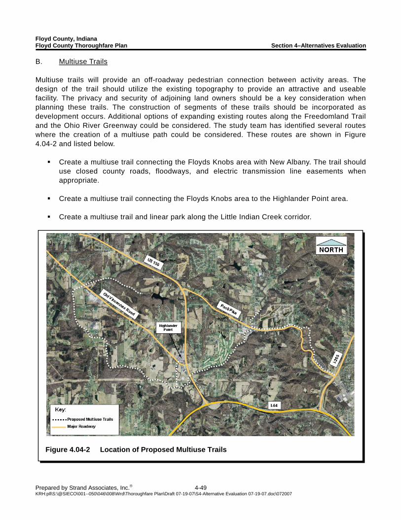
Floyd County, Indiana Floyd County Thoroughfare Plan Section 4–Alternatives Evaluation
Prepared by Strand Associates, Inc.® 4-49 KRH:pll\S:\@SIECO\001--050\046\008\Wrd\Thoroughfare Plan\Draft 07-19-07\S4-Alternative Evaluation 07-19-07.doc\072007
Figure 4.04-2 Location of Proposed Multiuse Trails
B. Multiuse Trails Multiuse trails will provide an off-roadway pedestrian connection between activity areas. The design of the trail should utilize the existing topography to provide an attractive and useable facility. The privacy and security of adjoining land owners should be a key consideration when planning these trails. The construction of segments of these trails should be incorporated as development occurs. Additional options of expanding existing routes along the Freedomland Trail and the Ohio River Greenway could be considered. The study team has identified several routes where the creation of a multiuse path could be considered. These routes are shown in Figure 4.04-2 and listed below.
Create a multiuse trail connecting the Floyds Knobs area with New Albany. The trail should use closed county roads, floodways, and electric transmission line easements when appropriate.
Create a multiuse trail connecting the Floyds Knobs area to the Highlander Point area.
Create a multiuse trail and linear park along the Little Indian Creek corridor.
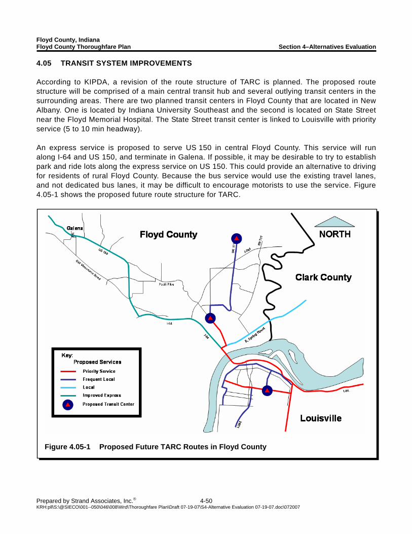
Floyd County, Indiana Floyd County Thoroughfare Plan Section 4–Alternatives Evaluation
Prepared by Strand Associates, Inc.® 4-50 KRH:pll\S:\@SIECO\001--050\046\008\Wrd\Thoroughfare Plan\Draft 07-19-07\S4-Alternative Evaluation 07-19-07.doc\072007
Figure 4.05-1 Proposed Future TARC Routes in Floyd County
4.05 TRANSIT SYSTEM IMPROVEMENTS According to KIPDA, a revision of the route structure of TARC is planned. The proposed route structure will be comprised of a main central transit hub and several outlying transit centers in the surrounding areas. There are two planned transit centers in Floyd County that are located in New Albany. One is located by Indiana University Southeast and the second is located on State Street near the Floyd Memorial Hospital. The State Street transit center is linked to Louisville with priority service (5 to 10 min headway). An express service is proposed to serve US 150 in central Floyd County. This service will run along I-64 and US 150, and terminate in Galena. If possible, it may be desirable to try to establish park and ride lots along the express service on US 150. This could provide an alternative to driving for residents of rural Floyd County. Because the bus service would use the existing travel lanes, and not dedicated bus lanes, it may be difficult to encourage motorists to use the service. Figure 4.05-1 shows the proposed future route structure for TARC.
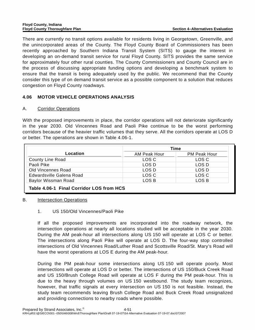
Floyd County, Indiana Floyd County Thoroughfare Plan Section 4–Alternatives Evaluation
Prepared by Strand Associates, Inc.® 4-51 KRH:pll\S:\@SIECO\001--050\046\008\Wrd\Thoroughfare Plan\Draft 07-19-07\S4-Alternative Evaluation 07-19-07.doc\072007
Time Location AM Peak Hour PM Peak Hour
County Line Road LOS C LOS C Paoli Pike LOS D LOS D Old Vincennes Road LOS D LOS D Edwardsville Galena Road LOS C LOS C Baylor Wissman Road LOS B LOS B
Table 4.06-1 Final Corridor LOS from HCS
There are currently no transit options available for residents living in Georgetown, Greenville, and the unincorporated areas of the County. The Floyd County Board of Commissioners has been recently approached by Southern Indiana Transit System (SITS) to gauge the interest in developing an on-demand transit service for rural Floyd County. SITS provides the same service for approximately four other rural counties. The County Commissioners and County Council are in the process of discussing appropriate funding options and developing a benchmark system to ensure that the transit is being adequately used by the public. We recommend that the County consider this type of on demand transit service as a possible component to a solution that reduces congestion on Floyd County roadways. 4.06 MOTOR VEHICLE OPERATIONS ANALYSIS A. Corridor Operations With the proposed improvements in place, the corridor operations will not deteriorate significantly in the year 2030. Old Vincennes Road and Paoli Pike continue to be the worst performing corridors because of the heavier traffic volumes that they serve. All the corridors operate at LOS D or better. The operations are shown in Table 4.06-1.
B. Intersection Operations 1. US 150/Old Vincennes/Paoli Pike If all the proposed improvements are incorporated into the roadway network, the intersection operations at nearly all locations studied will be acceptable in the year 2030. During the AM peak-hour all intersections along US 150 will operate at LOS C or better. The intersections along Paoli Pike will operate at LOS D. The four-way stop controlled intersections of Old Vincennes Road/Luther Road and Scottsville Road/St. Mary’s Road will have the worst operations at LOS E during the AM peak-hour. During the PM peak-hour some intersections along US 150 will operate poorly. Most intersections will operate at LOS D or better. The intersections of US 150/Buck Creek Road and US 150/Brush College Road will operate at LOS F during the PM peak-hour. This is due to the heavy through volumes on US 150 westbound. The study team recognizes, however, that traffic signals at every intersection on US 150 is not feasible. Instead, the study team recommends leaving Brush College Road and Buck Creek Road unsignalized and providing connections to nearby roads where possible.
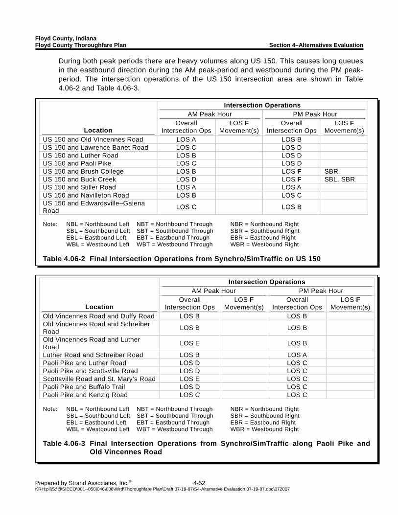
Floyd County, Indiana Floyd County Thoroughfare Plan Section 4–Alternatives Evaluation
Prepared by Strand Associates, Inc.® 4-52 KRH:pll\S:\@SIECO\001--050\046\008\Wrd\Thoroughfare Plan\Draft 07-19-07\S4-Alternative Evaluation 07-19-07.doc\072007
Intersection Operations AM Peak Hour PM Peak Hour
Location Overall
Intersection Ops LOS F
Movement(s)Overall
Intersection Ops LOS F
Movement(s)US 150 and Old Vincennes Road LOS A LOS B US 150 and Lawrence Banet Road LOS C LOS D US 150 and Luther Road LOS B LOS D US 150 and Paoli Pike LOS C LOS D US 150 and Brush College LOS B LOS F SBR US 150 and Buck Creek LOS D LOS F SBL, SBR US 150 and Stiller Road LOS A LOS A US 150 and Navilleton Road LOS B LOS C US 150 and Edwardsville–Galena Road LOS C LOS B Note: NBL = Northbound Left NBT = Northbound Through NBR = Northbound Right SBL = Southbound Left SBT = Southbound Through SBR = Southbound Right EBL = Eastbound Left EBT = Eastbound Through EBR = Eastbound Right WBL = Westbound Left WBT = Westbound Through WBR = Westbound Right Table 4.06-2 Final Intersection Operations from Synchro/SimTraffic on US 150
Intersection Operations AM Peak Hour PM Peak Hour
Location Overall
Intersection Ops LOS F
Movement(s) Overall
Intersection Ops LOS F
Movement(s) Old Vincennes Road and Duffy Road LOS B LOS B Old Vincennes Road and Schreiber Road LOS B LOS B
Old Vincennes Road and Luther Road LOS E LOS B
Luther Road and Schreiber Road LOS B LOS A Paoli Pike and Luther Road LOS D LOS C Paoli Pike and Scottsville Road LOS D LOS C Scottsville Road and St. Mary’s Road LOS E LOS C Paoli Pike and Buffalo Trail LOS D LOS C Paoli Pike and Kenzig Road LOS C LOS C Note: NBL = Northbound Left NBT = Northbound Through NBR = Northbound Right SBL = Southbound Left SBT = Southbound Through SBR = Southbound Right EBL = Eastbound Left EBT = Eastbound Through EBR = Eastbound Right WBL = Westbound Left WBT = Westbound Through WBR = Westbound Right Table 4.06-3 Final Intersection Operations from Synchro/SimTraffic along Paoli Pike and
Old Vincennes Road
During both peak periods there are heavy volumes along US 150. This causes long queues in the eastbound direction during the AM peak-period and westbound during the PM peak-period. The intersection operations of the US 150 intersection area are shown in Table 4.06-2 and Table 4.06-3.
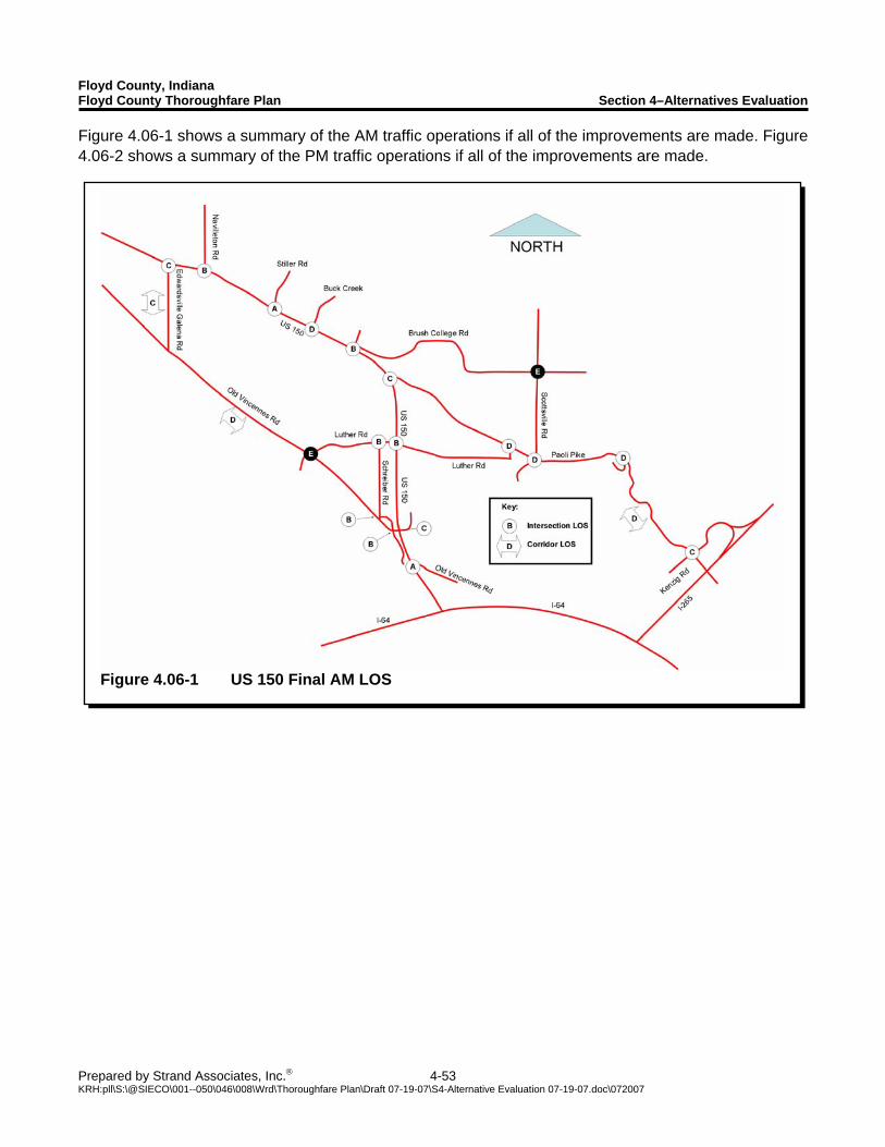
Floyd County, Indiana Floyd County Thoroughfare Plan Section 4–Alternatives Evaluation
Prepared by Strand Associates, Inc.® 4-53 KRH:pll\S:\@SIECO\001--050\046\008\Wrd\Thoroughfare Plan\Draft 07-19-07\S4-Alternative Evaluation 07-19-07.doc\072007
Figure 4.06-1 US 150 Final AM LOS
Figure 4.06-1 shows a summary of the AM traffic operations if all of the improvements are made. Figure 4.06-2 shows a summary of the PM traffic operations if all of the improvements are made.
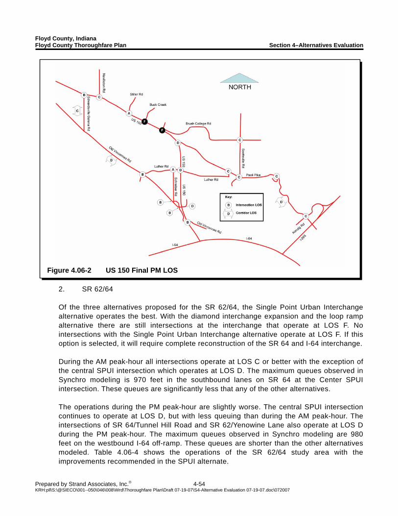
Floyd County, Indiana Floyd County Thoroughfare Plan Section 4–Alternatives Evaluation
Prepared by Strand Associates, Inc.® 4-54 KRH:pll\S:\@SIECO\001--050\046\008\Wrd\Thoroughfare Plan\Draft 07-19-07\S4-Alternative Evaluation 07-19-07.doc\072007
Figure 4.06-2 US 150 Final PM LOS
2. SR 62/64 Of the three alternatives proposed for the SR 62/64, the Single Point Urban Interchange alternative operates the best. With the diamond interchange expansion and the loop ramp alternative there are still intersections at the interchange that operate at LOS F. No intersections with the Single Point Urban Interchange alternative operate at LOS F. If this option is selected, it will require complete reconstruction of the SR 64 and I-64 interchange. During the AM peak-hour all intersections operate at LOS C or better with the exception of the central SPUI intersection which operates at LOS D. The maximum queues observed in Synchro modeling is 970 feet in the southbound lanes on SR 64 at the Center SPUI intersection. These queues are significantly less that any of the other alternatives. The operations during the PM peak-hour are slightly worse. The central SPUI intersection continues to operate at LOS D, but with less queuing than during the AM peak-hour. The intersections of SR 64/Tunnel Hill Road and SR 62/Yenowine Lane also operate at LOS D during the PM peak-hour. The maximum queues observed in Synchro modeling are 980 feet on the westbound I-64 off-ramp. These queues are shorter than the other alternatives modeled. Table 4.06-4 shows the operations of the SR 62/64 study area with the improvements recommended in the SPUI alternate.
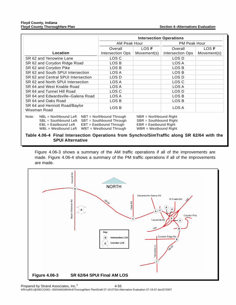
Floyd County, Indiana Floyd County Thoroughfare Plan Section 4–Alternatives Evaluation
Prepared by Strand Associates, Inc.® 4-55 KRH:pll\S:\@SIECO\001--050\046\008\Wrd\Thoroughfare Plan\Draft 07-19-07\S4-Alternative Evaluation 07-19-07.doc\072007
Intersection Operations AM Peak Hour PM Peak Hour
Location Overall
Intersection Ops LOS F
Movement(s)Overall
Intersection Ops LOS F
Movement(s)SR 62 and Yenowine Lane LOS C LOS D SR 62 and Corydon Ridge Road LOS B LOS A SR 62 and Corydon Pike LOS B LOS B SR 62 and South SPUI Intersection LOS A LOS B SR 62 and Central SPUI Intersection LOS D LOS D SR 62 and North SPUI Intersection LOS A LOS C SR 64 and West Knable Road LOS A LOS A SR 64 and Tunnel Hill Road LOS C LOS D SR 64 and Edwardsville–Galena Road LOS A LOS B SR 64 and Oaks Road LOS B LOS B SR 64 and Henriott Road/Baylor Wissman Road LOS B LOS A
Note: NBL = Northbound Left NBT = Northbound Through NBR = Northbound Right SBL = Southbound Left SBT = Southbound Through SBR = Southbound Right EBL = Eastbound Left EBT = Eastbound Through EBR = Eastbound Right WBL = Westbound Left WBT = Westbound Through WBR = Westbound Right
Table 4.06-4 Final Intersection Operations from Synchro/SimTraffic along SR 62/64 with the SPUI Alternative
Figure 4.06-3 SR 62/64 SPUI Final AM LOS
Figure 4.06-3 shows a summary of the AM traffic operations if all of the improvements are made. Figure 4.06-4 shows a summary of the PM traffic operations if all of the improvements are made.
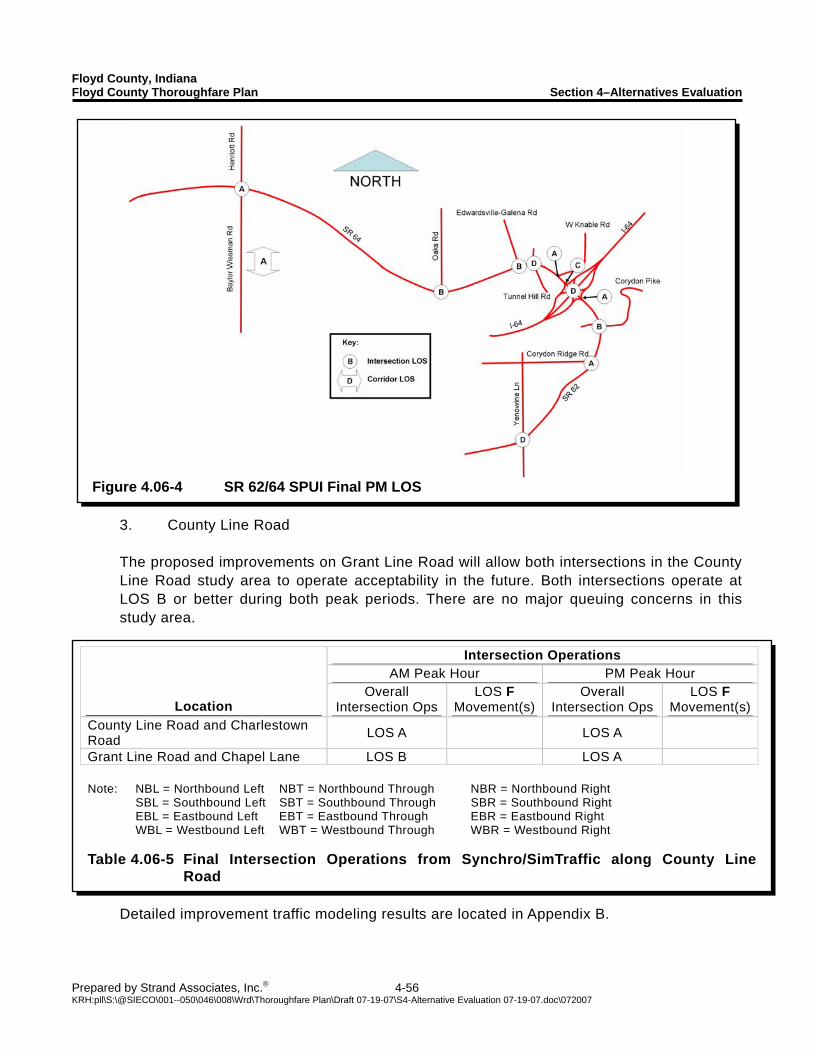
Floyd County, Indiana Floyd County Thoroughfare Plan Section 4–Alternatives Evaluation
Prepared by Strand Associates, Inc.® 4-56 KRH:pll\S:\@SIECO\001--050\046\008\Wrd\Thoroughfare Plan\Draft 07-19-07\S4-Alternative Evaluation 07-19-07.doc\072007
Figure 4.06-4 SR 62/64 SPUI Final PM LOS
Intersection Operations AM Peak Hour PM Peak Hour
Location Overall
Intersection Ops LOS F
Movement(s)Overall
Intersection Ops LOS F
Movement(s)County Line Road and Charlestown Road LOS A LOS A
Grant Line Road and Chapel Lane LOS B LOS A Note: NBL = Northbound Left NBT = Northbound Through NBR = Northbound Right SBL = Southbound Left SBT = Southbound Through SBR = Southbound Right EBL = Eastbound Left EBT = Eastbound Through EBR = Eastbound Right WBL = Westbound Left WBT = Westbound Through WBR = Westbound Right Table 4.06-5 Final Intersection Operations from Synchro/SimTraffic along County Line
Road
3. County Line Road The proposed improvements on Grant Line Road will allow both intersections in the County Line Road study area to operate acceptability in the future. Both intersections operate at LOS B or better during both peak periods. There are no major queuing concerns in this study area.
Detailed improvement traffic modeling results are located in Appendix B.

SECTION 5 IMPLEMENTATION AND NEXT STEPS
Floyd County, Indiana Floyd County Thoroughfare Plan Section 5–Implementation and Next Steps
Prepared by Strand Associates, Inc.® 5-1 KRH:pll\S:\@SIECO\001--050\046\008\Wrd\Thoroughfare Plan\Draft 07-19-07\S5-Implementation and Next Steps 07-19-07.doc\072007
5.01 PUBLIC INVOLVEMENT Three public information meetings were held during the development of the Floyd County Thoroughfare Plan. The meetings were held to inform the public about the status of the Thoroughfare Plan and to solicit public comment. Welcome sheets and public comment summaries for the three public information meetings are located in Appendix E. A. Public Information Meeting Held March 7, 2007 The first public information meeting was held on March 7, 2007. The goals of the first meeting were to define the thoroughfare plan, present an overview of the study process, show an anticipated timeline, and present the needs that were identified as part of this plan. To illustrate the needs, the results of the existing conditions and future no-build traffic operations modeling were presented. Public comments received at this meeting generally agreed that there are legitimate needs for improvement. One commenter pointed out that Floyd County is using a road system originally laid out in the early 1900’s, and that increasing the connectivity of the existing roadways may ultimately improve intersection operations at the busiest locations. B. Public Information Meeting Held May 1, 2007 The second public information meeting was held on May 1, 2007. The goals of the second meeting were to review the needs identified in the first meeting, present recommended improvements, and to discuss possible funding sources. The results of the existing, future no-build, and future build traffic operations modeling were presented. Possible funding sources for the proposed improvements were also presented. Public comment at this meeting indicated that the use of funding sources that have new developments bear the majority of the costs of new infrastructure improvements are preferred. It was also stated that though Development Impact Fees could be a good option, care should be taken to not make the fees so high that they discourage development. The comments also indicated that residents may be interested in increased public transit options as a method to reduce congestion. C. Public Information Meeting Held June 19, 2007 The third public information meeting was held on June 19, 2007. The meeting presented the draft report for public consideration. All results from the analysis for the Floyd County Thoroughfare Plan were presented in an open house format. The executive summary of the draft report was presented to the County Commissioners after the open house at the County Commissioners meeting. Public comment at the meeting included the mention of two improvement projects in the surrounding area. It was indicated to us that SR 135 in Harrison and Washington Counties is slated for major improvements in the near future. We were also informed that the intersection of Old Hill Road and Paoli Pike may receive a traffic signal. We do not feel that these two improvements will affect our analysis or
Floyd County, Indiana Floyd County Thoroughfare Plan Section 5–Implementation and Next Steps
Prepared by Strand Associates, Inc.® 5-2 KRH:pll\S:\@SIECO\001--050\046\008\Wrd\Thoroughfare Plan\Draft 07-19-07\S5-Implementation and Next Steps 07-19-07.doc\072007
recommendations. The public also expressed concern about the use of Lawrence Banet Road as a cut-through from Paoli Pike to US 150. A possible solution to this would be to include traffic calming devices in the proposed improvements to Lawrence Banet Road. Public comments also indicated the desire to have multi-modal transportation options that connect to the Floyd Central Middle and High Schools. The Little Indian Creek Multiuse Trail may pass close to these schools and inclusion of connections to the schools should be considered. At the commissioners meeting, the commissioners indicated that they would be concerned about the loss of taxes going to schools and libraries that could be caused by the implementation of TIF districts. D. Continuing Public Involvement As the recommended improvement projects and funding mechanisms move forward, additional public involvement effort will be critical. Any major investment of County resources will need to achieve buy-in from local residents and stakeholders. 5.02 OPINIONS OF PROBABLE CONSTRUCTION COSTS A. Anticipated Project Classifications The proposed improvement projects were classified into three groups. The first classification of projects is those located on County roadways. The second classification is those located on State or Federal highways. The third classification is projects focused on increasing the attractiveness and safety of multimodal transportation. Projects classified as County projects are arranged into three plans. There is a first 5-year plan, a second 5-year plan, and a long-range plan. Projects in the first and second 5-year plan are deemed to be of more immediate need than projects classified as long-range plan projects. The first 5-year plan includes safety improvements on Paoli Pike from Luther Road to Buffalo Trail and improvements to four intersections on Old Vincennes Road. The second 5-year plan includes safety improvements to Paoli Pike from Buffalo Trail to I-265 and Old Vincennes Road from US 150 to Luther Road. The long-range plan includes projects designed to improve the existing road network and to add new connections between existing County roadways to provide motorists with more commuting options. Several of the long-range projects are going to be built as the development of the County facilitates the need for the construction project. For development driven projects the County is assumed to contribute 10 percent of the total construction cost and the developer will contribute the other 90 percent. State and Federal projects are located on State or Federal highways. The State and Federal projects include the reconstruction of the SR 62/64 and I-64 interchange, the widening of several segments of US 150 and SR 62/64 and improvements to several intersections along US 150 and SR 62/64. These projects will compete for funding with other projects in the State. This funding will cover most of the project costs. For the purposes of this study, it is assumed the County will be responsible for 20 percent of the cost of construction for the State and Federal highway projects.
Floyd County, Indiana Floyd County Thoroughfare Plan Section 5–Implementation and Next Steps
Prepared by Strand Associates, Inc.® 5-3 KRH:pll\S:\@SIECO\001--050\046\008\Wrd\Thoroughfare Plan\Draft 07-19-07\S5-Implementation and Next Steps 07-19-07.doc\072007
Several improvement projects are focused on increasing the attractiveness and safety of alternate modes of transportation, particularly walking and bicycling. These projects include the retrofitting of sidewalks, the construction of multiuse trails, the designation of bicycle routes, and the construction of bicycle lanes. A significant portion of the construction costs of these projects will be federally funded. We assumed the County is responsible for 20 percent of the cost of construction for the multimodal improvements. B. Probable Construction Costs We used a cost-estimating spreadsheet from The Indiana Department of Transportation (INDOT) to determine estimates for the probable construction costs of the recommended projects. The INDOT spreadsheet requires the following information: area type, roadway functional classification, type of terrain, type of improvement, number of lanes, and type of interchanges (if applicable). After all the data is entered into the spreadsheet, it estimates anticipated construction costs based on several years of historical data from previous INDOT projects. This spreadsheet was used for most roadway improvements. Several projects could not be estimated by the INDOT spreadsheet, and the project costs were estimated using previous projects designed by Strand Associates, Inc. as a basis. We used projected costs of a project in the design phase on Old Vincennes Road to estimate the costs of the safety improvement projects. We also used previous project experience to determine the cost of a multiuse trail along Little Indian Creek. We used the bid tabs available from the Wisconsin Department of Transportation to estimate the cost of sidewalk along Paoli Pike. All estimated project costs have been adjusted for inflation and are shown in estimated 2010 dollars. Table 5.02-1 shows a breakdown of the costs for the County improvement projects. Table 5.02-2 shows a breakdown of the costs for the State and Federal improvement projects. Table 5.02-3 shows a breakdown of the costs for the multimodal improvement projects. There are 48 proposed improvement projects distributed among all three project classifications. A primary factor in determining how long it will take to complete these improvement projects is the identification of funding sources to pay for the projects. These projects have an estimated cost between $96.6 million and $105.1 million with the County’s estimated contribution being between $22.5 million and $31.0 million. Cost analysis results and INDOT cost spreadsheet results are located in Appendix D.
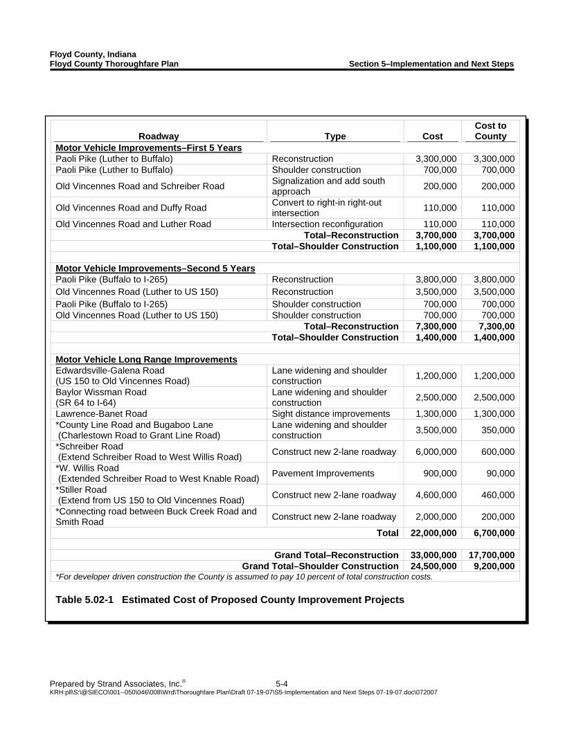
Floyd County, Indiana Floyd County Thoroughfare Plan Section 5–Implementation and Next Steps
Prepared by Strand Associates, Inc.® 5-4 KRH:pll\S:\@SIECO\001--050\046\008\Wrd\Thoroughfare Plan\Draft 07-19-07\S5-Implementation and Next Steps 07-19-07.doc\072007
Roadway Type Cost Cost to County
Motor Vehicle Improvements–First 5 Years Paoli Pike (Luther to Buffalo) Reconstruction 3,300,000 3,300,000Paoli Pike (Luther to Buffalo) Shoulder construction 700,000 700,000
Old Vincennes Road and Schreiber Road Signalization and add south approach 200,000 200,000
Old Vincennes Road and Duffy Road Convert to right-in right-out intersection 110,000 110,000
Old Vincennes Road and Luther Road Intersection reconfiguration 110,000 110,000Total–Reconstruction 3,700,000 3,700,000
Total–Shoulder Construction 1,100,000 1,100,000 Motor Vehicle Improvements–Second 5 Years Paoli Pike (Buffalo to I-265) Reconstruction 3,800,000 3,800,000Old Vincennes Road (Luther to US 150) Reconstruction 3,500,000 3,500,000Paoli Pike (Buffalo to I-265) Shoulder construction 700,000 700,000Old Vincennes Road (Luther to US 150) Shoulder construction 700,000 700,000
Total–Reconstruction 7,300,000 7,300,00Total–Shoulder Construction 1,400,000 1,400,000
Motor Vehicle Long Range Improvements Edwardsville-Galena Road (US 150 to Old Vincennes Road)
Lane widening and shoulder construction 1,200,000 1,200,000
Baylor Wissman Road (SR 64 to I-64)
Lane widening and shoulder construction 2,500,000 2,500,000
Lawrence-Banet Road Sight distance improvements 1,300,000 1,300,000*County Line Road and Bugaboo Lane (Charlestown Road to Grant Line Road)
Lane widening and shoulder construction 3,500,000 350,000
*Schreiber Road (Extend Schreiber Road to West Willis Road) Construct new 2-lane roadway 6,000,000 600,000
*W. Willis Road (Extended Schreiber Road to West Knable Road) Pavement Improvements 900,000 90,000
*Stiller Road (Extend from US 150 to Old Vincennes Road) Construct new 2-lane roadway 4,600,000 460,000
*Connecting road between Buck Creek Road and Smith Road Construct new 2-lane roadway 2,000,000 200,000
Total 22,000,000 6,700,000
Grand Total–Reconstruction 33,000,000 17,700,000Grand Total–Shoulder Construction 24,500,000 9,200,000
*For developer driven construction the County is assumed to pay 10 percent of total construction costs. Table 5.02-1 Estimated Cost of Proposed County Improvement Projects
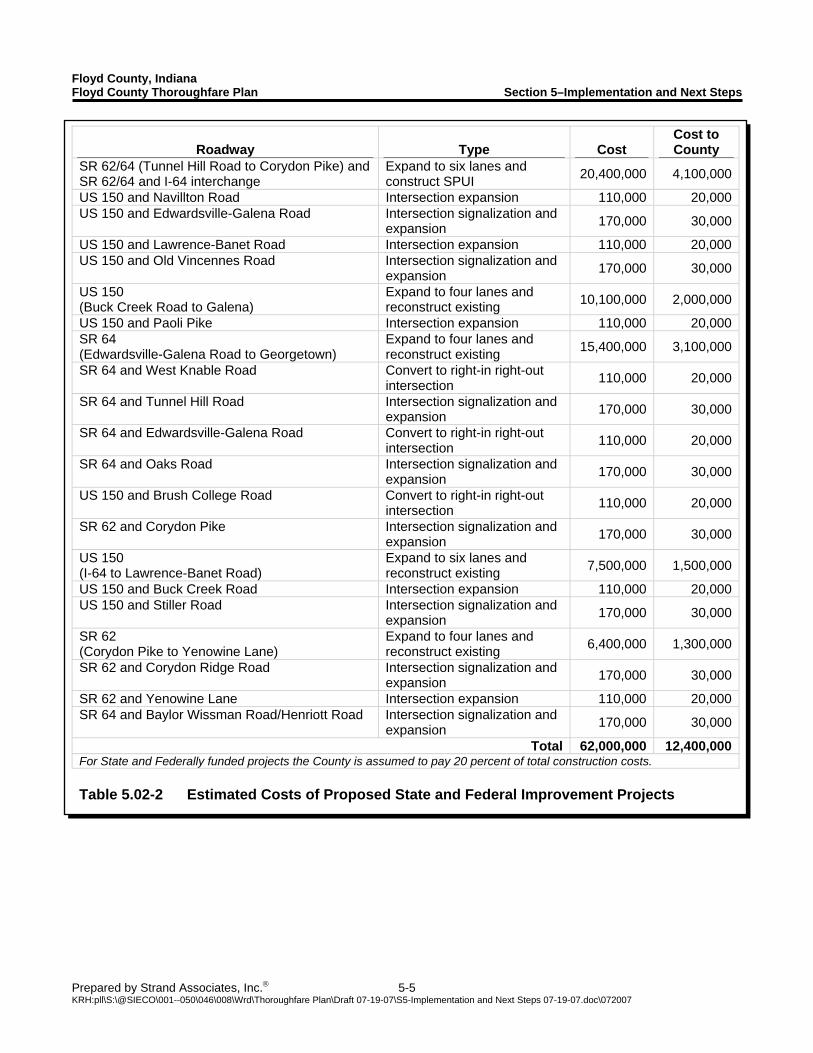
Floyd County, Indiana Floyd County Thoroughfare Plan Section 5–Implementation and Next Steps
Prepared by Strand Associates, Inc.® 5-5 KRH:pll\S:\@SIECO\001--050\046\008\Wrd\Thoroughfare Plan\Draft 07-19-07\S5-Implementation and Next Steps 07-19-07.doc\072007
Roadway Type Cost Cost to County
SR 62/64 (Tunnel Hill Road to Corydon Pike) and SR 62/64 and I-64 interchange
Expand to six lanes and construct SPUI 20,400,000 4,100,000
US 150 and Navillton Road Intersection expansion 110,000 20,000US 150 and Edwardsville-Galena Road Intersection signalization and
expansion 170,000 30,000
US 150 and Lawrence-Banet Road Intersection expansion 110,000 20,000US 150 and Old Vincennes Road Intersection signalization and
expansion 170,000 30,000
US 150 (Buck Creek Road to Galena)
Expand to four lanes and reconstruct existing 10,100,000 2,000,000
US 150 and Paoli Pike Intersection expansion 110,000 20,000SR 64 (Edwardsville-Galena Road to Georgetown)
Expand to four lanes and reconstruct existing 15,400,000 3,100,000
SR 64 and West Knable Road Convert to right-in right-out intersection 110,000 20,000
SR 64 and Tunnel Hill Road Intersection signalization and expansion 170,000 30,000
SR 64 and Edwardsville-Galena Road Convert to right-in right-out intersection 110,000 20,000
SR 64 and Oaks Road Intersection signalization and expansion 170,000 30,000
US 150 and Brush College Road Convert to right-in right-out intersection 110,000 20,000
SR 62 and Corydon Pike Intersection signalization and expansion 170,000 30,000
US 150 (I-64 to Lawrence-Banet Road)
Expand to six lanes and reconstruct existing 7,500,000 1,500,000
US 150 and Buck Creek Road Intersection expansion 110,000 20,000US 150 and Stiller Road Intersection signalization and
expansion 170,000 30,000
SR 62 (Corydon Pike to Yenowine Lane)
Expand to four lanes and reconstruct existing 6,400,000 1,300,000
SR 62 and Corydon Ridge Road Intersection signalization and expansion 170,000 30,000
SR 62 and Yenowine Lane Intersection expansion 110,000 20,000SR 64 and Baylor Wissman Road/Henriott Road Intersection signalization and
expansion 170,000 30,000
Total 62,000,000 12,400,000For State and Federally funded projects the County is assumed to pay 20 percent of total construction costs. Table 5.02-2 Estimated Costs of Proposed State and Federal Improvement Projects
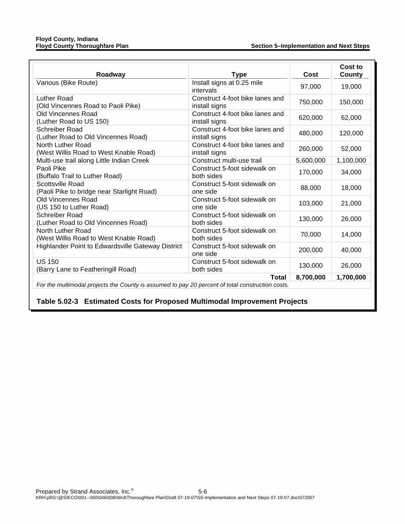
Floyd County, Indiana Floyd County Thoroughfare Plan Section 5–Implementation and Next Steps
Prepared by Strand Associates, Inc.® 5-6 KRH:pll\S:\@SIECO\001--050\046\008\Wrd\Thoroughfare Plan\Draft 07-19-07\S5-Implementation and Next Steps 07-19-07.doc\072007
Roadway Type Cost Cost to County
Various (Bike Route) Install signs at 0.25 mile intervals 97,000 19,000
Luther Road (Old Vincennes Road to Paoli Pike)
Construct 4-foot bike lanes and install signs 750,000 150,000
Old Vincennes Road (Luther Road to US 150)
Construct 4-foot bike lanes and install signs 620,000 62,000
Schreiber Road (Luther Road to Old Vincennes Road)
Construct 4-foot bike lanes and install signs 480,000 120,000
North Luther Road (West Willis Road to West Knable Road)
Construct 4-foot bike lanes and install signs 260,000 52,000
Multi-use trail along Little Indian Creek Construct multi-use trail 5,600,000 1,100,000 Paoli Pike (Buffalo Trail to Luther Road)
Construct 5-foot sidewalk on both sides 170,000 34,000
Scottsville Road (Paoli Pike to bridge near Starlight Road)
Construct 5-foot sidewalk on one side 88,000 18,000
Old Vincennes Road (US 150 to Luther Road)
Construct 5-foot sidewalk on one side 103,000 21,000
Schreiber Road (Luther Road to Old Vincennes Road)
Construct 5-foot sidewalk on both sides 130,000 26,000
North Luther Road (West Willis Road to West Knable Road)
Construct 5-foot sidewalk on both sides 70,000 14,000
Highlander Point to Edwardsville Gateway District Construct 5-foot sidewalk on one side 200,000 40,000
US 150 (Barry Lane to Featheringill Road)
Construct 5-foot sidewalk on both sides 130,000 26,000
Total 8,700,000 1,700,000 For the multimodal projects the County is assumed to pay 20 percent of total construction costs. Table 5.02-3 Estimated Costs for Proposed Multimodal Improvement Projects
Floyd County, Indiana Floyd County Thoroughfare Plan Section 5–Implementation and Next Steps
Prepared by Strand Associates, Inc.® 5-7 KRH:pll\S:\@SIECO\001--050\046\008\Wrd\Thoroughfare Plan\Draft 07-19-07\S5-Implementation and Next Steps 07-19-07.doc\072007
5.03 FUNDING SOURCES The implementation of the improvement projects proposed in this plan will depend on the identification and development of reliable, consistent, and viable local funding sources. There are several funding options available to Floyd County to create a financing package that will provide the needed funds. This plan seeks to identify several potential funding sources. Not all of the funding sources identified in this plan will be viable, either from a financial or political standpoint. A. Cumulative Capital Development Fund The legislative body of a county can impose a Cumulative Capital Development Fund under Indiana Code IC 36-9-14-5. The fund is obtained through a property tax levy and is viewed as a stand alone funding source. Counties, cities, and towns can use the money generated by the Cumulative Capital Development Fund for projects to improve or maintain the following:
Airports. Bridges. Waterway channel maintenance. Parks. Public buildings. Public ways and sidewalks. Regulated drains.
Additionally, counties can use these funds for voting machines, hospitals, county courthouses, and county jails. To establish a Cumulative Capital Development Fund, the legislative body is required to publish a notice describing the tax levy and hold a public hearing. After the public hearing, the proposal must be submitted to the Indiana Department of Local Government Finance for approval prior to August of that year. Fifty or more objecting petitioners may cause the State Board to hold a public hearing on the objections to the establishment of the fund. The property tax levy that may be imposed for a Cumulative Capital Development Fund is dependent upon whether the county is an “adopting” county, and the number of years that a particular unit has had a Cumulative Capital Fund in effect. A county is considered “adopting” if it has adopted either a County Adjusted Gross Income Tax (CAGIT) or a County Option Income Tax (COIT). For Floyd County, the property tax rate would be a maximum of 5 cents per $100 of assessed valuation. The advantages and disadvantages of a Cumulative Capital Development Fund are listed below.
Advantages
- It is a secure revenue source. - It will provide a stable revenue source to assist the community in meeting its capital facility
improvement needs. - It will provide the community with a sole source of capital improvement revenues which will
allow for other funding sources to be used for other purposes.
Floyd County, Indiana Floyd County Thoroughfare Plan Section 5–Implementation and Next Steps
Prepared by Strand Associates, Inc.® 5-8 KRH:pll\S:\@SIECO\001--050\046\008\Wrd\Thoroughfare Plan\Draft 07-19-07\S5-Implementation and Next Steps 07-19-07.doc\072007
Disadvantages
- It would require establishment of a Capital Improvement Plan for County Projects. - It would be an increase in property taxes for residents of the County.
B. Development Impact Fees An impact fee is most commonly assessed for the construction cost of new facilities within a community. Impact fees are generally implemented by local governments so that existing residents and businesses will not be forced to pay for improvements needed to accomodate new developments. In the State of Indiana, a community can impose Development Impact Fees under Indiana Code for the following infrastructure systems:
Water mains. Sanitary sewer. Storm sewer and storm water runoff control. Roads. Parks.
Impact fees may be imposed on new real estate development to defray or mitigate the capital costs of infrastructure needed to serve the new development. Revenue from an impact fee may be used directly to pay for the costs of infrastructure improvement or may be used to pay debt service on an obligation used to provide infrastructure. An advisory committee must be established consisting of five to ten members with at least 40% representing development, building, or real estate interests. An ordinance must establish one or more impact zones for each infrastructure type. A Zone Improvement Plan to justify Development Impact Fees must contain information relating to current infrastructure during the previous 5 years. The plan must provide for the completion of infrastructure within 10 years. Revenue sources must also be identified and the amount of revenue raised by the proposed infrastructure improvements must be identified. The fee is calculated to generate only the difference between costs and revenues. Impact fees may not be used for improving areas with respect to existing real estate improvements. The advantages and disadvantages of Development Impact Fees are listed below.
Advantages
- Assessing and implementing the impact fees allows for improved municipal service by permitting facility improvements to progress with development.
- Impact fees are equitable and efficient in that those that shoulder the costs are also the ones who directly benefit from the improvements.
- The adoption of fees are popular among taxpayers because the burden of the cost is shifted to those directly responsible for the need of improved infrastructure.
- Impact fees may reduce borrowing and debt costs.
Floyd County, Indiana Floyd County Thoroughfare Plan Section 5–Implementation and Next Steps
Prepared by Strand Associates, Inc.® 5-9 KRH:pll\S:\@SIECO\001--050\046\008\Wrd\Thoroughfare Plan\Draft 07-19-07\S5-Implementation and Next Steps 07-19-07.doc\072007
Disadvantages
- Fees may not cover the total infrastructure costs. - Improvement needs must be identified as well as the proposed solutions and
implementation costs. Continual long-term upkeep is required on various segregated accounts.
- Fee revenues depend on the rate of development, and the amount of revenues collected from year to year may fluctuate.
C. Tax Incremental Financing (TIF) As part of the procedure for implementation of a Tax Incremental Financing District, a Redevelopment Commission must be created. Any city, town, or county may establish a Department of Redevelopment controlled by a board of five members. The five members of a county Redevelopment Commission are appointed by the County Commissioners. The Redevelopment Commission must utilize county personnel and/or outside consultants in order to prepare a Redevelopment Plan. The plan will provide evidence to support the findings that the Redevelopment Commission must make by statute, describe the redevelopment or economic development activities to be undertaken, and provide other information required by the State Tax Board TIF regulations. After the Redevelopment Plan is completed, the Redevelopment Commission passes a Declaratory Resolution which describes the blighted or economic development area, makes this area an allocation area, adopts a plan of redevelopment for economic development, and makes required statutory findings. A “redevelopment area” must be a “blighted area”, which is defined as an area in which normal development and occupancy are undesirable or impossible because of any of a number of factors. The basic purpose of TIF is to provide for the allocation of increased tax proceeds generated by increases in assessed value resulting from redevelopment within the TIF boundaries. TIF permits cities to use increased tax revenues stimulated by redevelopment to pay for the capital improvements needed to induce the redevelopment. Redevelopment Commissions can exercise this power in “economic development areas,” the establishment of which does not require a finding of blight. Thus, TIF bonds can be issued to fund development activities in non-blighted areas the promote job opportunities. The advantages and disadvantages of Tax Incremental Financing are listed below.
Advantages
- TIF makes the costs of infrastructure upgrades because of redevelopment self-financed. - TIF is highly flexible because no petition approval is necessary (unless, in the case of units
other than Indianapolis, special taxes are to be levied in addition to the increment), there is local control, and no debt limitation applies.
- Shifts the risk of redevelopment from taxpayers to bondholders.
Floyd County, Indiana Floyd County Thoroughfare Plan Section 5–Implementation and Next Steps
Prepared by Strand Associates, Inc.® 5-10 KRH:pll\S:\@SIECO\001--050\046\008\Wrd\Thoroughfare Plan\Draft 07-19-07\S5-Implementation and Next Steps 07-19-07.doc\072007
Disadvantages
- “Pure” TIF bonds pose a greater risk to investors and, as such, bear higher interest rates than general obligation bonds.
- TIF assumes all increment is caused by redevelopment, to the detriment of overlapping tax districts.
- Freezing tax base overlooks increased services other taxing districts may be called on to provide and may limit the ability of other taxing units to raise additional needed taxes or cause tax rates to increase to provide needed revenues.
5.04 PROJECT IMPLEMENTATION A. Revise Subdivision Ordinance
1. Access Management
a. General Guidelines
Access management is a tool used to balance the needs of providing accessibility to local property owners and transportation system mobility. All land owners have a right to access the local transportation system but the degree of access can vary by the functional classification of the roadway that serves their property. An access management program seeks to limit the number of access points on arterial and collector streets and to promote the use of the local street system to access developments. The four major principals of access management are the same for all classes of streets.
Minimize the number of access points. Separate conflict zones. Minimize acceleration/deceleration requirements. Remove turning vehicles from the through-traffic lanes.
Minimizing the number of access points reduces traffic conflict locations along a roadway, improving safety and traffic operations. The separation of conflict zones also reduces the number of conflict points on the roadway. Reducing the need for vehicles to accelerate and decelerate within the main travel lanes reduces the severity of conflicts by allowing vehicles entering or exiting a roadway to more closely match through traffic speeds. The removal of turning vehicles from the through traffic lanes also reduces the severity of conflicts by providing storage areas and exclusive channelization for turning movements. By establishing proper access management principals and enforcing them in new developments, the following positive outcomes may be achieved:
Reduced crashes. Increased existing street capacity. Reduced need to widen existing streets or build new ones.
Floyd County, Indiana Floyd County Thoroughfare Plan Section 5–Implementation and Next Steps
Prepared by Strand Associates, Inc.® 5-11 KRH:pll\S:\@SIECO\001--050\046\008\Wrd\Thoroughfare Plan\Draft 07-19-07\S5-Implementation and Next Steps 07-19-07.doc\072007
Figure 5.04-1 Shared Access Examples Source: FHWA Access Management Manual
b. Limit Number of Property Access Points Controlling and limiting the number of driveways on arterial and collector roadways could help to achieve the objectives of access management. Driveways should be sufficiently spaced to minimize conflicts from adjacent driveway movements and from through traffic on the adjacent street system. Control of driveway spacing generally requires consideration of the following two criteria: (1) properties should be limited to the fewest possible access points and (2) access spacing should be controlled to minimize traffic conflicts. Each single-family residential property should be permitted only one driveway. These properties do not generate high traffic volumes and present minimal conflicts with local street traffic movements. For commercial properties, the number of access points that should be allowed depends on the length of property frontage along an arterial or collector street and the volume of traffic generated by the development. A general rule of thumb requires a property to generate more than 500 trips per hour (typically equivalent to 5,000 trips per day) to justify more than one driveway. Should a property generate this high volume of trips, a second driveway may be considered if its frontage exceeds 600 feet. Three driveways may be considered if the development’s frontage exceeds 1,300 feet. A second or third access driveway should only be granted if a traffic impact study for the property indicates a need for two or three access driveways to maintain traffic flow on the street. On a median-divided street, a second driveway can be approved but limited to right-turn entering and exiting movements. If more than one access driveway is required for a major traffic generating property, then the criteria for control of the access spacing should be applied. On some properties it may be possible to minimize the number of access points by sharing access between adjacent properties. This can be accomplished by encouraging cross easements
Floyd County, Indiana Floyd County Thoroughfare Plan Section 5–Implementation and Next Steps
Prepared by Strand Associates, Inc.® 5-12 KRH:pll\S:\@SIECO\001--050\046\008\Wrd\Thoroughfare Plan\Draft 07-19-07\S5-Implementation and Next Steps 07-19-07.doc\072007
between adjacent properties and parking circulation designs that accommodate ingress/egress traffic patterns to both properties. Figure 5.04-1 illustrates an example of shared access control between two adjacent properties and how access to four different properties can be reduced to two driveways through shared access. c. Functional Classification Requirements Access management policies should vary by the roadway’s functional classification. On arterials or collectors, the access provided to the adjacent land uses should be limited to a greater extent than on local roadways. If possible, local roadways should be used as the primary access for local landowners. Only in the case of property that has no option other than accessing the arterial or collector should a driveway onto the arterial be considered as the primary access.
2. Typical Sections Establishing standardized typical sections can help a community to provide consistency in addressing the mobility needs of different transportation system users, and to take advantage of the positive impacts that a transportation system can have on providing mobility and accessibility. Street design can affect traffic volumes, roadway safety, noise, pedestrian conflicts, aesthetics, and connectivity. Typical sections are generally designed for each classification of road that a community has because different classes of roads have different intended uses. The design criteria described in the American Association of State Highway and Transportation Officials (AASHTO) publication entitled A Policy on Geometric Design of Highways and Streets includes recommendations for many types of roadway and street facilities and can be used as the basis for designing the various typical sections required. 3. Traffic Impact Analysis Guidelines This document’s analysis of the possible future traffic operations caused by development up to the year 2030 should not be considered a replacement for a Traffic Impact Analysis (TIA) for specific developments. A set of TIA guidelines should be developed to outline the process by which the specific impacts that an individual development will have on the operations of the surrounding roadway network are assessed. TIA’s should address all elements of the transportation system as it relates to pedestrians, bicyclists, transit, vehicular traffic, and adjacent land development. The TIA guidelines could establish a system where the amount and scope of the analysis is determined by the relative impact the development would be expected to have on the transportation system.
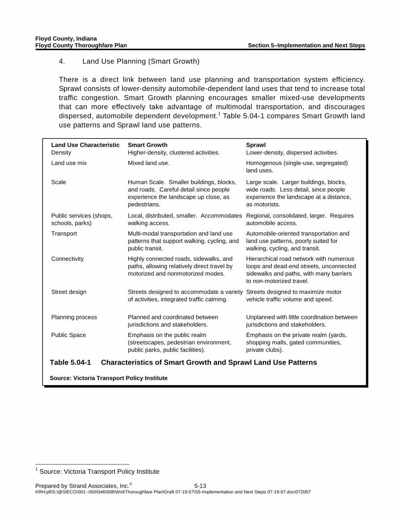
Floyd County, Indiana Floyd County Thoroughfare Plan Section 5–Implementation and Next Steps
Prepared by Strand Associates, Inc.® 5-13 KRH:pll\S:\@SIECO\001--050\046\008\Wrd\Thoroughfare Plan\Draft 07-19-07\S5-Implementation and Next Steps 07-19-07.doc\072007
Land Use Characteristic Smart Growth SprawlDensity Higher-density, clustered activities. Lower-density, dispersed activities.
Land use mix Mixed land use. Homogenous (single-use, segregated) land uses.
Scale Human Scale. Smaller buildings, blocks, and roads. Careful detail since people experience the landscape up close, as pedestrians.
Large scale. Larger buildings, blocks, wide roads. Less detail, since people experience the landscape at a distance, as motorists.
Public services (shops, schools, parks)
Local, distributed, smaller. Accommodates walking access.
Regional, consolidated, larger. Requires automobile access.
Transport Multi-modal transportation and land use patterns that support walking, cycling, and public transit.
Automobile-oriented transportation and land use patterns, poorly suited for walking, cycling, and transit.
Connectivity Highly connected roads, sidewalks, and paths, allowing relatively direct travel by motorized and nonmotorized modes.
Hierarchical road network with numerous loops and dead-end streets, unconnected sidewalks and paths, with many barriers to non-motorized travel.
Street design Streets designed to accommodate a variety of activities, integrated traffic calming.
Streets designed to maximize motor vehicle traffic volume and speed.
Planning process Planned and coordinated between jurisdictions and stakeholders.
Unplanned with little coordination between jurisdictions and stakeholders.
Public Space Emphasis on the public realm (streetscapes, pedestrian environment, public parks, public facilities).
Emphasis on the private realm (yards, shopping malls, gated communities, private clubs).
Table 5.04-1 Characteristics of Smart Growth and Sprawl Land Use Patterns Source: Victoria Transport Policy Institute
4. Land Use Planning (Smart Growth) There is a direct link between land use planning and transportation system efficiency. Sprawl consists of lower-density automobile-dependent land uses that tend to increase total traffic congestion. Smart Growth planning encourages smaller mixed-use developments that can more effectively take advantage of multimodal transportation, and discourages dispersed, automobile dependent development.1 Table 5.04-1 compares Smart Growth land use patterns and Sprawl land use patterns.
1 Source: Victoria Transport Policy Institute
Floyd County, Indiana Floyd County Thoroughfare Plan Section 5–Implementation and Next Steps
Prepared by Strand Associates, Inc.® 5-14 KRH:pll\S:\@SIECO\001--050\046\008\Wrd\Thoroughfare Plan\Draft 07-19-07\S5-Implementation and Next Steps 07-19-07.doc\072007
Planning for mixed use developments with office, commercial, and residential uses within one area can reduce travel demand and traffic congestion. Mixing land uses can help link trips (providing more than one destination within a development), increase transit service efficiency, and facilitate walking and bicycling. Following is a list of Smart Growth practices that could be beneficial for Floyd County.2
Develop comprehensive strategic community development plans. Take advantage of existing community assets. Mixed land uses. Create a range of housing opportunities and choices. Foster “walkable,” close-knit neighborhoods. Promote distinctive, attractive communities with a strong sense of place. Improve nonmotorized travel connections to encourage walking and cycling. Encourage citizen and stakeholder participation in development decisions. Insure that transportation and land use policies are coordinated.
Comprehensive implementation of Smart Growth planning initiatives can reduce total per capita automobile travel by 20 to 40 percent. It can increase economic productivity by reducing overhead costs associated with public services, such as water and sewer service, roads, and schools. Families in Smart Growth communities typically spend significantly less money on surface transportation costs, benefit from lower per capita traffic fatalities, and enjoy reduced crime rates because of increased community cohesion. Smart Growth communities balance service to motor vehicles and other modes of travel.
B. INDOT Signalization Process To install a traffic signal on a State or Federal highway an analysis of the intersection proposed for signalization must be submitted and approved by INDOT. To determine if a traffic signal is warranted at an individual intersection, INDOT uses the Manual on Uniform Traffic Control Devices millennium edition (MUTCD) guidelines for signal warrants as the basis for their determination. There are eight basic warrants that the MUTCD identifies as indicators that a particular intersection may require a traffic signal. The warrants are listed below.
Warrant 1, Eight-hour vehicular volume. Warrant 2, Four-hour vehicular volume. Warrant 3, Peak hour. Warrant 4, Pedestrian volume. Warrant 5, School Crossing. Warrant 6, Coordinated signal system. Warrant 7, Crash experience. Warrant 8, Roadway Network.
2 Source: Victoria Transport Policy Institute
Floyd County, Indiana Floyd County Thoroughfare Plan Section 5–Implementation and Next Steps
Prepared by Strand Associates, Inc.® 5-15 KRH:pll\S:\@SIECO\001--050\046\008\Wrd\Thoroughfare Plan\Draft 07-19-07\S5-Implementation and Next Steps 07-19-07.doc\072007
INDOT views Warrants 1 and 4 as the only signal warrants. All other warrants listed in the MUTCD are seen as guidelines by INDOT. To get an intersection approved for signalization an engineering study that incorporates at least a 12-hour traffic volume study or a pedestrian volume study would be required. The satisfaction of Warrant 1 or 4 does not in itself require INDOT to grant the instillation of a traffic signal at an intersection. Examining the other guidelines, performing a detailed analysis of the conditions at the intersection, and performing an analysis of how the addition of a signal could affect traffic flow in the vicinity of the intersection would also be helpful in getting an intersection approved for a traffic signal. A traffic signal may not be granted if it is shown that the traffic signal will not improve the overall safety or operations of an intersection. Typically, in the absence of a clear safety or traffic congestion issue, the burden for showing that a traffic signal is required is solely the responsibility of the party that whishes to install the traffic signal. C. Financing Recommendations A sole source of money will not be adequate to fund the anticipated costs associated with the proposed transportation improvement projects in Floyd County. A combination of funding sources will need to be implemented to fund the various proposed projects. The study team feels that the following funding sources are the most viable for Floyd County.
1. Cumulative Capital Development Fund The first funding source the County should consider is the creation of a Cumulative Capital Development Fund. The Cumulative Capital Development Fund is obtained through a property tax levy through Indiana Code IC 36-9-14-5. The creation of a Cumulative Capital Development Fund would require the County to create a Capital Improvement Plan. This fund would differ from the first two funding sources because of the ability to use the money generated by the property tax levy throughout the county for infrastructure improvement and maintenance projects. Both Development Impact Fees and Tax Incremental Financing funds must be used within the designated areas where the development is occurring. 2. Development Impact Fees The County’s second funding source to consider should be a Development Impact Fee based on the number of trips generated by each land use in a proposed development. A community can implement Development Impact Fees to defray or mitigate the capital costs of improving parks, roads, water mains, sanitary sewer, and storm water drainage systems to accommodate new development. Credits for improvements are also allowable under the state code as a method of collection. The fees can be assessed either upon the submission of a development plan, or at the submission of a housing permit. Any Development Impact Fee would be required to follow the state statutory requirements set forth in Indiana Code IC 36-7-4-1300. This state statute describes the primary structure of an ordinance to allow Development Impact Fees to be assessed and the steps a local government will need to follow to incorporate them. A final financial analysis is underway to determine potential zone improvement areas and a cost per trip fee. A conceptual estimate
Floyd County, Indiana Floyd County Thoroughfare Plan Section 5–Implementation and Next Steps
Prepared by Strand Associates, Inc.® 5-16 KRH:pll\S:\@SIECO\001--050\046\008\Wrd\Thoroughfare Plan\Draft 07-19-07\S5-Implementation and Next Steps 07-19-07.doc\072007
for the cost per daily trip has been determined to be in the range of $75 to $250. The Development Impact Fee is assessed to a new development based on the projected number of trips that the development will generate per day. Development Impact Fees must be used to improve the infrastructure for the new development, and may not be used for improving areas with respect to existing real estate. 3. Tax Incremental Financing The final funding source the County should consider is Tax Incremental Financing. The establishment of a Redevelopment Commission and the implementation of Tax Incremental Financing districts would provide additional funding for the Highlander Point and Edwardsville Gateway District. The additional revenue could be used either to pay for the improvements as they are made, or to pay off bonds issued for the development activities. Creating Tax Incremental Financing districts is attractive because it makes the costs of infrastructure upgrades to support the development self-financed. The potential total funds available would be determined by the size of a proposed Tax Incremental Financing district. The funds generated by a Tax Incremental Financing district must be used to fund improvements within the district.