Embed Size (px)
Citation preview
Florida Division of Emergency Management Statewide Coastal LiDAR
Overview and QA lessons learned
Bill Millinor
April 26, 2010

Presentation Overview
Project Overview– Governors’ Initiative (HB 7121)
Baseline Specifications & Statewide Coordination Existing LiDAR Inventory QA WorkflowCommon QA IssuesQA Lessons Learned QA ToolsBrief Terrain DiscussionQuestions

Jones Edmundswww.floridadisaster.org/gis/lidar

FDEM Project Scope
Terrestrial LiDAR ($22 million)
Update Storm Surge Models ($2
million)
Update 11 Regional Evacuation
Studies ($4 million)
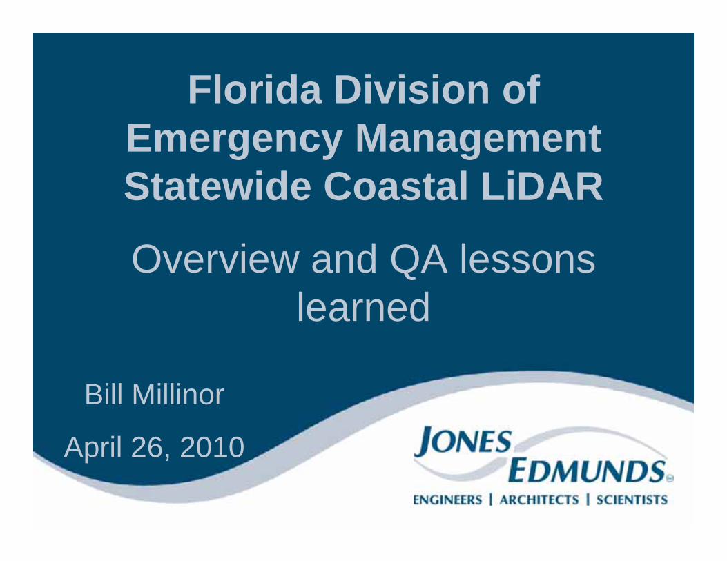
FDEM Project Roles
Program Management: FDEM & Jones EdmundsPrime Contractors:– Woolpert– Merrick– CH2MHill (3001)– Program Data Solutions
(Dewberry, PBS&J, URS)
http://www.floridadisaster.org/
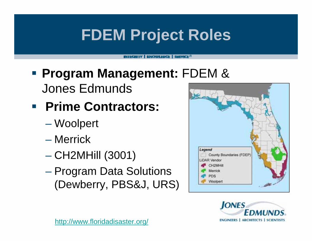
Project Management Responsibilities
Create Statewide baseline specifications
~15,000 sq. miles of new LiDAR mapping
Data management
Quality assurance
Manage Expectations – issues of scale, statewide
vs. watershed
Enforce consistency throughout the project areahttp://www.floridadisaster.org/gis/lidar/

Baseline Specifications LiDAR and Orthophotography
Intended to provide a dataset for use by the broadest number of stakeholders. LiDAR Specifications based on:– Input from stakeholders ranging from the
WMDs, FDEP, ACOE, Universities and private sector
– SWFWMD LiDAR and Orthophotography Specifications
– FEMA Appendix A– FGDC Geospatial Positioning Accuracy
Standards– National Standard for Spatial Data Accuracy
(NSSDA)– ASPRS Guidelines: Vertical Accuracy Reporting
for Lidar Data– LAS Specifications 1.1
http://www.floridadisaster.org/gis/lidar/
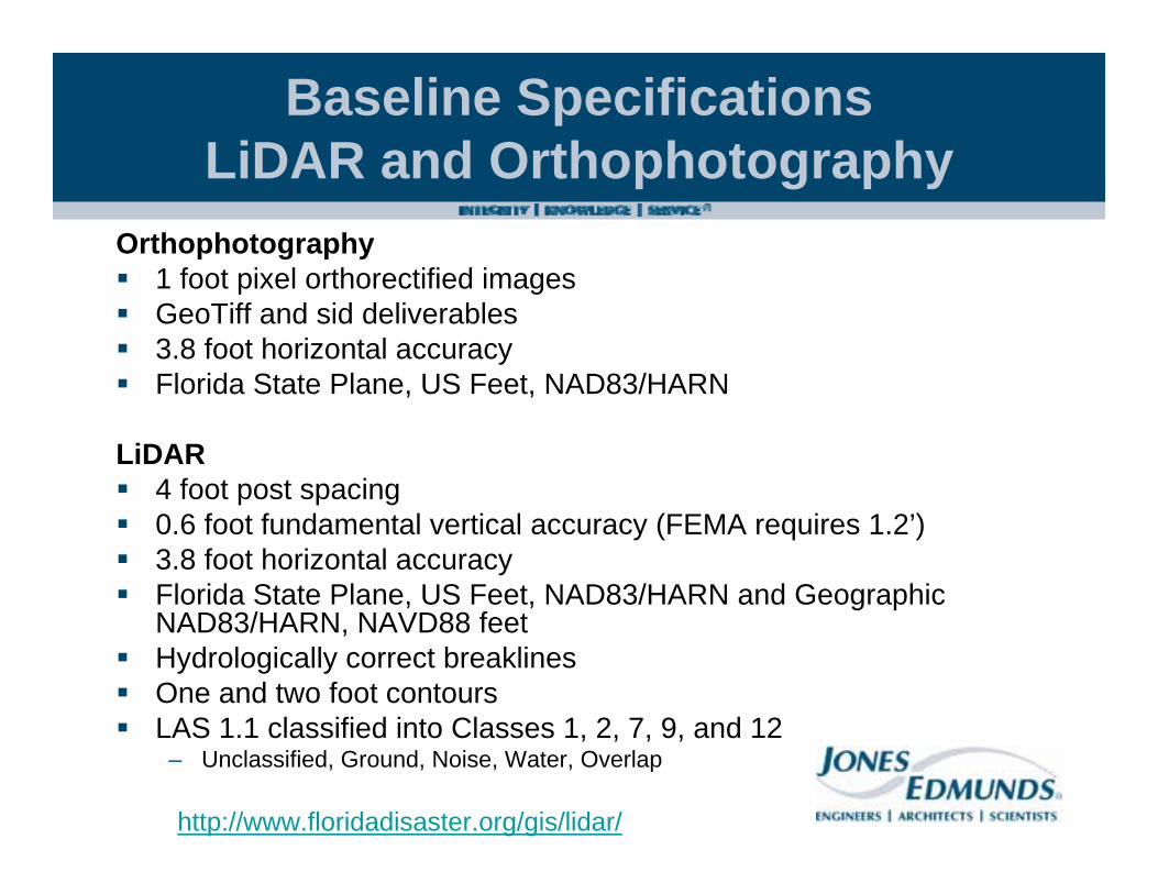
Baseline Specifications LiDAR and Orthophotography
Orthophotography1 foot pixel orthorectified imagesGeoTiff and sid deliverables3.8 foot horizontal accuracy Florida State Plane, US Feet, NAD83/HARN
LiDAR4 foot post spacing0.6 foot fundamental vertical accuracy (FEMA requires 1.2’)3.8 foot horizontal accuracyFlorida State Plane, US Feet, NAD83/HARN and Geographic NAD83/HARN, NAVD88 feetHydrologically correct breaklinesOne and two foot contoursLAS 1.1 classified into Classes 1, 2, 7, 9, and 12
– Unclassified, Ground, Noise, Water, Overlap
http://www.floridadisaster.org/gis/lidar/
Baseline Specifications LiDAR and Orthophotography
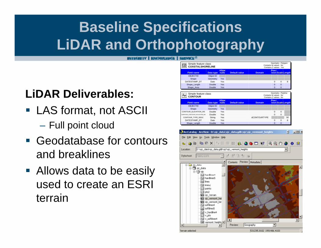
LiDAR Deliverables:LAS format, not ASCII– Full point cloud
Geodatabase for contours and breaklinesAllows data to be easily used to create an ESRI terrain
Simple feature classCOASTALSHORELINE Contains Z values
Contains M valuesGeometry Polygon
NoYes
Data typeField namePrec-ision Scale LengthDomainDefault value
Allow nulls
OBJECTID Object ID Shape Geometry Yes
DATESTAMP_DT Date Yes 0 0 8Shape_Length Double Yes 0 0 Shape_Area Double Yes 0 0
Simple feature classCONTOUR Contains Z values
Contains M valuesGeometry Polyline
NoNo
Data typeField namePrec-ision Scale LengthDomainDefault value
Allow nulls
OBJECTID Object ID Shape Geometry Yes
CONTOUR_ELEVATION_MS Double Yes 0 0 CARRYING_CONTOUR_ELEVATION_MS Double Yes 0 0
CONTOUR_TYPE_DESC String Yes dCONTOURTYPE 50DATESTAMP_DT Date Yes 0 0 8
Shape_Length Double Yes 0 0

Existing LiDAR Inventory
Inventoried existing LiDAR data, compiling:– Project Footprint– Scope of Work or
Specifications– Accuracy Assessment
Evaluated compatibility of LiDAR w/ Baseline SpecificationsData deemed compatible was not reflown as part of our LiDAR mapping efforts

QA Workflow Overview
Review geodatabase schemaCheck topologyRun LAS Statistics (MARS)Create a 20-ft DEM from Class 2 pointsRun vertical accuracy testsCheck LAS Header InformationReview MetadataComplete overview of LAS and breaklines Detail review of 10% of tilesReview QA Calls from previous deliverableCheck edge matching between adjacent deliverablesReview LiDAR Processing ReportsHydro feature 3D checks

QA WorkflowReview geodatabase schema– Created a custom
Schema Validation tool for the FDEM project
Class1 Rule Class2 ErrorsCONTOUR_1FT Must Not Intersect 0
CONTOUR_1FT Must Not Self-Overlap 0
CONTOUR_1FT Must Not Self-Intersect 0
CONTOUR_2FT Must Not Intersect 0
CONTOUR_2FT Must Not Self-Overlap 0
CONTOUR_2FT Must Not Self-Intersect 0
HYDROGRAPHICFEATURE Must Not Self-Overlap 0
HYDROGRAPHICFEATURE Must Not Self-Intersect 0
OVERPASS Must Not Intersect 0
OVERPASS Must Not Self-Overlap 0
OVERPASS Must Not Self-Intersect 0
ROADBREAKLINE Must Not Intersect 0
ROADBREAKLINE Must Not Self-Overlap 0
ROADBREAKLINE Must Not Self-Intersect 0
SOFTFEATURE Must Not Intersect 0
SOFTFEATURE Must Not Overlap With ROADBREAKLINE 0
SOFTFEATURE Must Not Overlap With HYDROGRAPHICFEATURE 0
SOFTFEATURE Must Not Self-Overlap 0
SOFTFEATURE Must Not Self-Intersect 0
Check topology

QA WorkflowCustom LAS Statistics Tool (Merrick)
Create a 20-ft DEM from Class 2 points (look for striping and anomalies)
QA Workflow
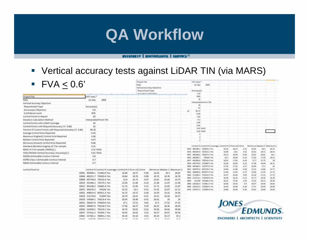
Vertical accuracy tests against LiDAR TIN (via MARS)FVA < 0.6’
QA Workflow
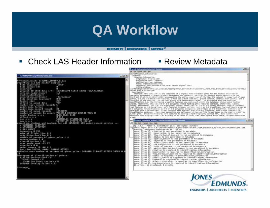
Check LAS Header Information Review Metadata
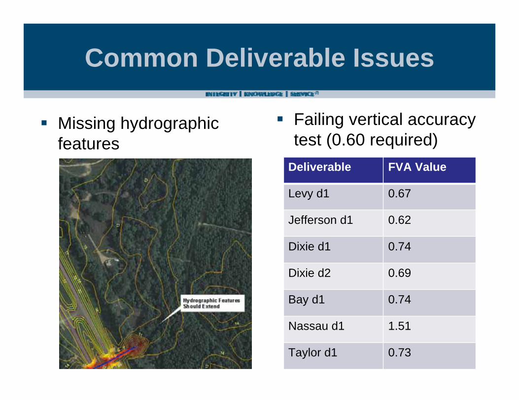
Common Deliverable Issues
Missing hydrographic features
Failing vertical accuracy test (0.60 required)
Deliverable FVA Value
Levy d1 0.67
Jefferson d1 0.62
Dixie d1 0.74
Dixie d2 0.69
Bay d1 0.74
Nassau d1 1.51
Taylor d1 0.73
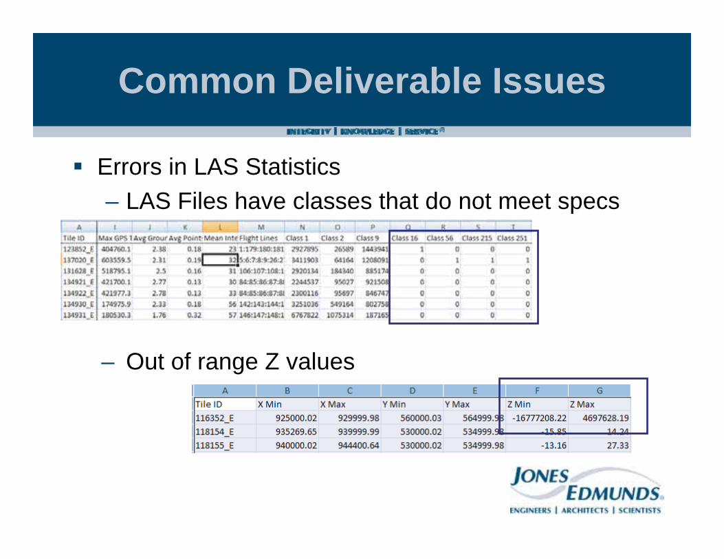
Common Deliverable Issues
Errors in LAS Statistics– LAS Files have classes that do not meet specs
– Out of range Z values
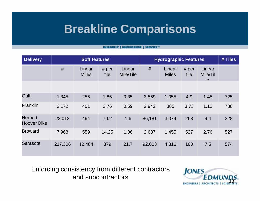
Breakline Comparisons
Delivery Soft features Hydrographic Features # Tiles
# Linear Miles
# per tile
Linear Mile/Tile
# Linear Miles
# per tile
Linear Mile/Til
e
Gulf 1,345 255 1.86 0.35 3,559 1,055 4.9 1.45 725
Franklin 2,172 401 2.76 0.59 2,942 885 3.73 1.12 788
Herbert Hoover Dike
23,013 494 70.2 1.6 86,181 3,074 263 9.4 328
Broward 7,968 559 14.25 1.06 2,687 1,455 527 2.76 527
Sarasota 217,306 12,484 379 21.7 92,003 4,316 160 7.5 574
18
Enforcing consistency from different contractors and subcontractors

Common Deliverable IssuesBreakline Comparison
Deliverable from Contractor A83 Linear Hydrographic Features
Deliverable from Contractor B340 Linear Hydrographic Features
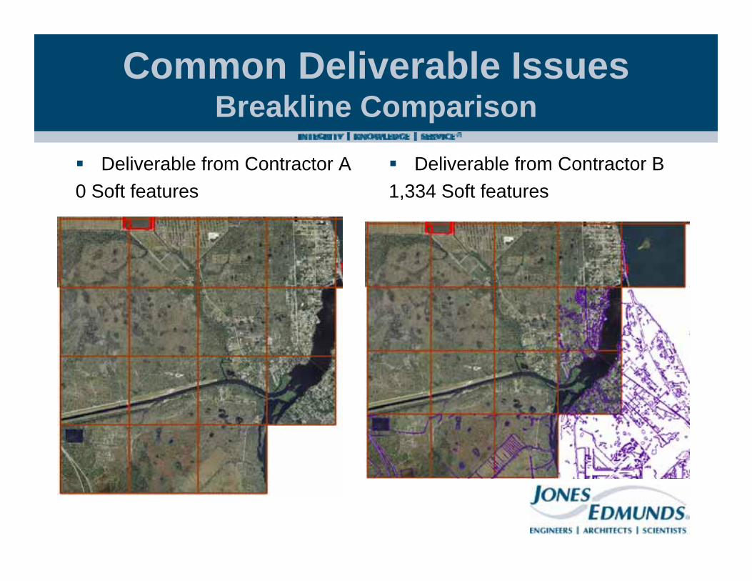
Common Deliverable IssuesBreakline Comparison
Deliverable from Contractor A0 Soft features
Deliverable from Contractor B1,334 Soft features

Common Deliverable Issues
Flight line calibration - DEM
Common Deliverable Issues
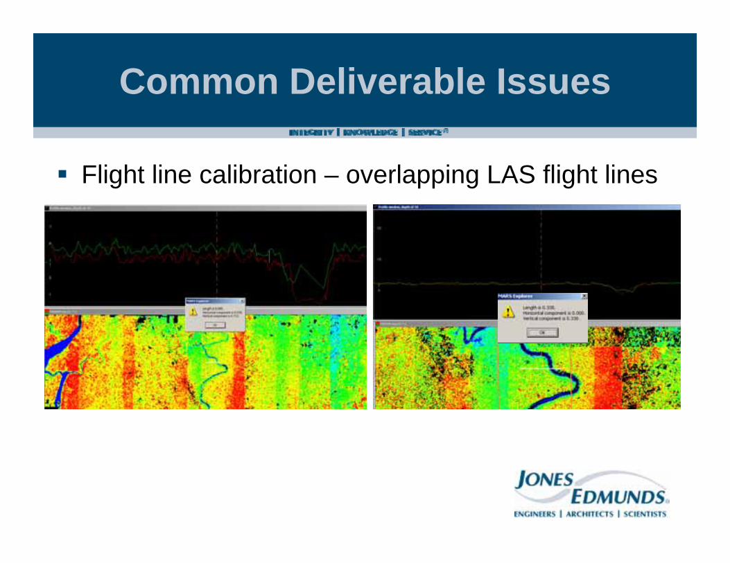
Flight line calibration – overlapping LAS flight lines
Common Deliverable Issues
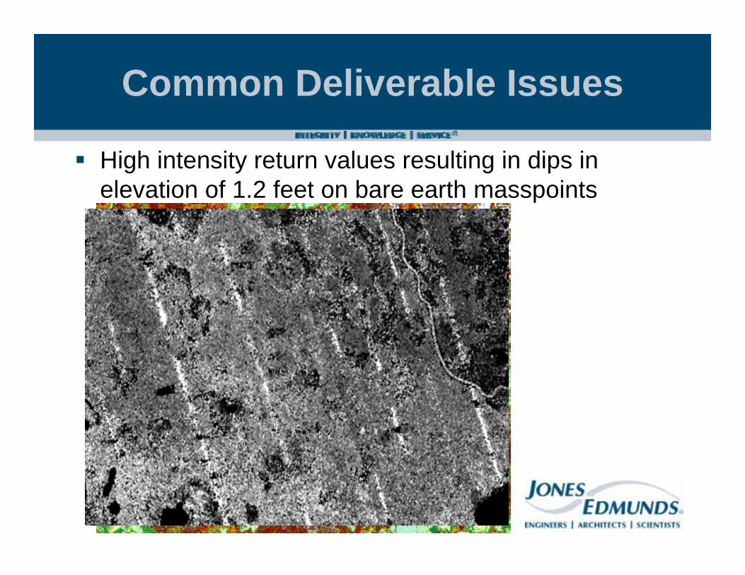
High intensity return values resulting in dips in elevation of 1.2 feet on bare earth masspoints

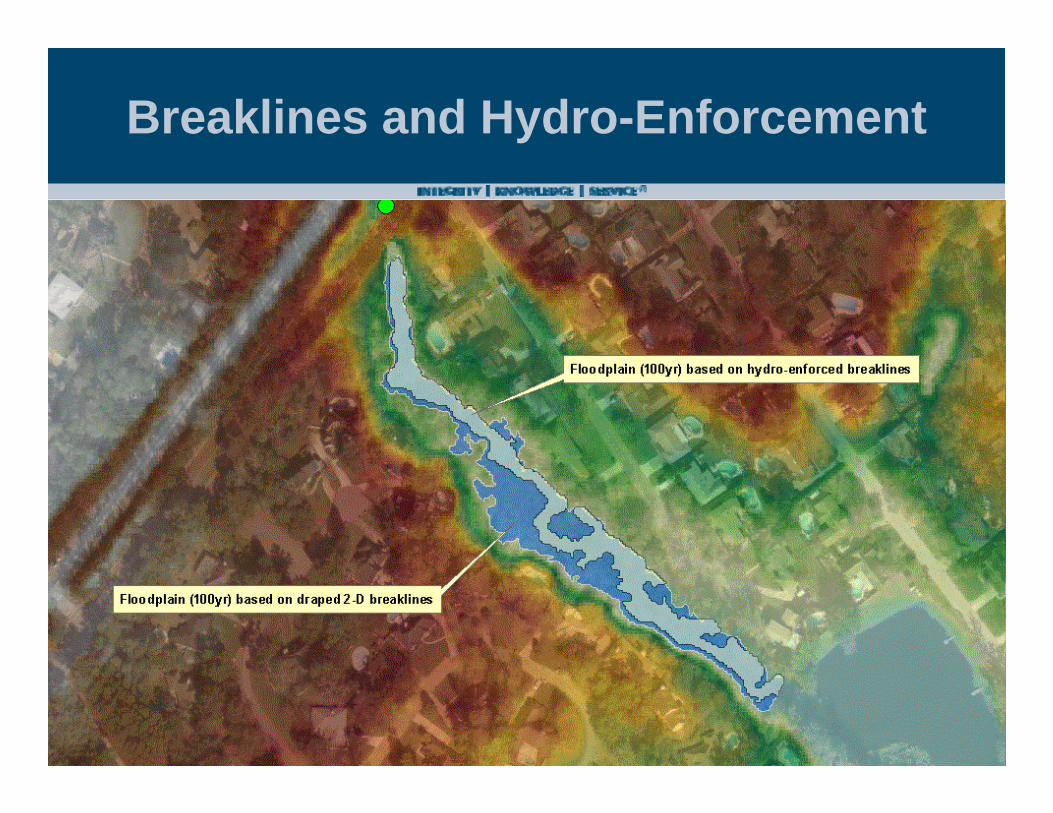
Breaklines and Hydro-Enforcement
Hydro-enforced breaklines critical to accurate representation of heavily vegetated channels
Minimizes subsequent ground survey x-sections for modeling
Better more-accurate floodplains

Breaklines and Hydro-Enforcement
2-D Draped Soft-hydro features with undulation in elevation values
Flow
Flow
Breaklines and Hydro-Enforcement
Lessons learned
More guidance examples in SpecificationsReceive pilot datasets earlyEnsure contractor follows pilotDocument everythingDifficult to enforce consistency across multiple primes with multiple subsProvide a good sample dataset if possiblePlan for schedule slipping…

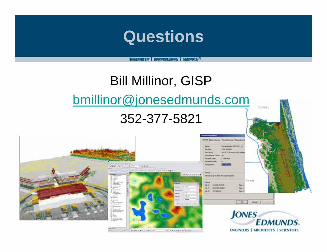
Tools Used in the FDEM Project
Plan to use multiple tools to review the data– ESRI’s ArcInfo – breakline review and terrain and
DEM generation– LP360 – viewing LAS within ArcMap– MARS – native LAS software suite– Lastools – command line LAS software, reads
header http://www.cs.unc.edu/~isenburg/lastools/– PointView – standalone LAS viewer, reads header– GlobalMapper – fast LAS and DEM viewer– MP (USGS) – metadata parser

Project Updates and What’s Next?
FDEM Website and Interactive Project Viewer – includes list of sites to download the data– http://www.floridadisaster.org/gis/LiDAR/– http://map.floridadisaster.org/lidar/
Ongoing Distribution to Partner AgenciesOngoing DEM uploads to USGS NEDFuture LiDAR data collection funding?
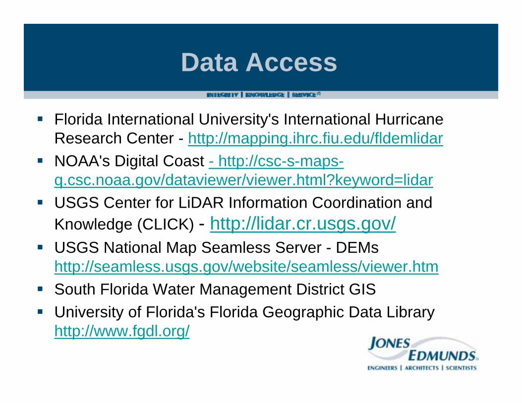
Data Access
Florida International University's International Hurricane Research Center - http://mapping.ihrc.fiu.edu/fldemlidarNOAA's Digital Coast - http://csc-s-maps-q.csc.noaa.gov/dataviewer/viewer.html?keyword=lidarUSGS Center for LiDAR Information Coordination and Knowledge (CLICK) - http://lidar.cr.usgs.gov/USGS National Map Seamless Server - DEMs http://seamless.usgs.gov/website/seamless/viewer.htmSouth Florida Water Management District GISUniversity of Florida's Florida Geographic Data Library http://www.fgdl.org/

Terrain Discussion
Data Sources– Surface Feature
Types
Pyramid Type– Window Size is faster– Bugs to be corrected in
9.3.1 sp2
Terrain Discussion
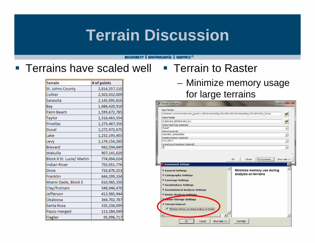
Terrains have scaled well Terrain to Raster– Minimize memory usage
for large terrains