Embed Size (px)
Citation preview

Flora and fauna: existing conditions CEUGP/SR4B
September 2007

Cra
nbou
rne
Eas
t Pre
cinc
t Stru
ctur
e P
lan
CRANBOURNE EAST PRECINCT STRUCTURE PLAN
FLORA AND FAUNA: EXISTING
CONDITIONS
077613074/001
September 2007
Prepared by:
Golder Associates Pty Ltd
Level 3, 50 Burwood Road
Hawthorn West, 3122
Tel: 8862 3500 Fax: 8862 3501
Lawrie Conole (Senior Ecologist, Golder Associates Pty Ltd)
John Kershaw (Botanist, Ecology Australia Pty Ltd)

Cranbourne East Precinct Structure Plan Flora and fauna: existing conditions 077613074/001 September 2007 074w001r.doc.doc 2
TABLE OF CONTENTS GLOSSARY OF TERMS................................................................................4
EXECUTIVE SUMMARY..............................................................................6
1 INTRODUCTION ....................................................................................9 1.1 PURPOSE OF REPORT ............................................................................9 1.2 CRANBOURNE EAST STUDY AREA ........................................................9
2 METHODS..............................................................................................11 2.1 FLORA .............................................................................................11 2.2 FAUNA.............................................................................................12
3 BIODIVERSITY VALUES ...................................................................13 3.1 FLORA................................................................................................13 3.2 NET GAIN ..........................................................................................18 3.3 FAUNA ...............................................................................................23
4 LEGISLATIVE AND POLICY IMPLICATIONS .............................27 4.1 FEDERAL ENVIRONMENT PROTECTION & BIODIVERSITY CONSERVATION ACT 1999 (EPBC) .........................................................................................27 4.2 VICTORIAN FLORA & FAUNA GUARANTEE ACT 1988 (FFG)................27 4.3 VICTORIAN CATCHMENT & LAND PROTECTION ACT 1994 (CALP) ......28 4.4 VICTORIA’S NATIVE VEGETATION MANAGEMENT FRAMEWORK.......28
5 DISCUSSION..........................................................................................30 5.1 POTENTIAL IMPACTS AND CONSTRAINTS TO DEVELOPMENT...............30 5.2 POTENTIAL OPPORTUNITIES TO ENHANCE BIODIVERSITY VALUES ......30
6 RECOMMENDATIONS .......................................................................31
7 REFERENCES .......................................................................................32
8 ACKNOWLEDGEMENTS ...................................................................35
APPENDIX 1: CRITERIA FOR ASSESSMENT OF CONSERVATION SIGNIFICANCE OF FLORA AND FAUNA VALUES.............................36
APPENDIX 2: FAUNA RECORDED FROM THE 5KM RADIUS DATA REVIEW AREA (SOURCE: ATLAS OF VICTORIAN WILDLIFE, DSE 2004B)..............................................................................................................41
APPENDIX 3: FLORA RECORDED FROM THE 5KM RADIUS DATA REVIEW AREA (SOURCE: FLORA INFORMATION SYSTEM, DSE 2004A) .............................................................................................................45

Cranbourne East Precinct Structure Plan Flora and fauna: existing conditions 077613074/001 September 2007 074w001r.doc.doc 3
FIGURES
FIGURE 1: UNDERLYING GEOLOGY, CRANBOURNE EAST PRECINCT (SOURCE: DSE 2007C) ............................................................................................. 10
FIGURE 2: EXTANT ECOLOGICAL VEGETATION CLASSES (EVCS) MAPPED FOR THE CRANBOURNE EAST PRECINCT AND SURROUNDS (SOURCE: DSE 2007B).. 15
FIGURE 3: NATIVE VEGETATION (EXCLUDING SCATTERED TREES) WITHIN THE CRANBOURNE EAST PRECINCT, JULY 2007. ........................................... 19
TABLES
TABLE 1: CONSERVATION STATUS OF ECOLOGICAL VEGETATION COMMUNITIES (EVCS) MAPPED FOR THE CRANBOURNE EAST PRECINCT, 2007 .............. 17
TABLE 2: SIGNIFICANT PLANT SPECIES RECORDED WITHIN A 5 KM RADIUS DATA REVIEW AREA (DRA) (SOURCE: FLORA INFORMATION SYSTEM, DSE 2004A), WITH THEIR LIKELIHOOD OF REGULAR OCCURRENCE (LRO). ....... 21
TABLE 3: HABITAT HECTARE SCORES FOR REMNANT PATCH VEGETATION WITHIN THE CRANBOURNE EAST PRECINCT.............................................................. 22
TABLE 4: FAUNA SPECIES RECORDED IN CRANBOURNE EAST PRECINCT DURING JULY 2007.......................................................................................... 23
TABLE 5: CONSERVATION SIGNIFICANT FAUNA RECORDED IN, OR REGARDED AS LIKELY TO OCCUR IN, THE CRANBOURNE EAST PRECINCT.......................... 24
PLATES
PLATE 1: HIGHLY DEGRADED EVC 48 HEATHY WOODLAND IN THE NORTH OF THE CRANBOURNE EAST PRECINCT, JULY 2007 ............................................ 13
PLATE 2: BLACKWOOD (ACACIA MELANOXYLON) DOMINATES THIS HIGHLY DEGRADED PATCH OF EVC 175 GRASSY WOODLAND, RAIL RESERVE, SOUTH-EAST CRANBOURNE EAST PRECINCT, JULY 2007........................... 14

Cranbourne East Precinct Structure Plan Flora and fauna: existing conditions 077613074/001 September 2007 074w001r.doc.doc 4
Glossary of terms AVW Atlas of Victorian Wildlife database, curated by DSE.
CaLP Victorian Catchment and Land Protection Act 1994
CD IUCN ‘Red List’ category of threat – Lower Risk (Conservation Dependant); usually abbreviated to Conservation Dependant. Used for taxa that are being intensively managed, and without such intervention would decline to a higher category of threat (VU, EN, CR).
CR IUCN ‘Red List’ category of threat – Critically Endangered. Used for taxa facing an extremely high risk of extinction in the wild in the near future.
DEWR Federal Department of the Environment and Water Resources (formerly DEH – Department of the Environment and Heritage)
DRA Data Review Area. A geographic area, usually 5km in radius, centred on the study site, within which all secondary data on species and community occurrence are reviewed.
DSE Victorian Department of Sustainability and Environment (formerly DNRE – Department of Natural Resources and Environment)
EBBC Federal Environment Protection and Biodiversity Conservation Act 1999
EN IUCN ‘Red List’ category of threat – Endangered. Used for taxa facing a very high risk of extinction in the wild in the near future.
EVC Ecological Vegetation Class
FFG Victorian Flora and Fauna Guarantee Act 1988
FIS Flora Information System database, curated by DSE.
HHa (or hha)
Habitat hectare. The unit used in describing habitat condition and extent in ‘Net Gain’ accounting.
IUCN The International Union for the Conservation of Nature; compiler of the ‘Red List’, and of the internationally accepted ‘Red List’ terminology, methodology and criteria used to classify the status of threatened species (see CR, EN, VU, NT, CD in this glossary).
LRO Likelihood of Regular Occurrence. An estimation based on expert opinion and supporting data that a taxon will be found in a given area on greater than 50% of occasions when targeted surveys are conducted.
MNES Matters of National Environmental Significance, refers to the seven areas of national environmental significance which define the coverage of the Federal EPBC Act 1999 (see EPBC). These matters are: (i) listed threatened species and ecological communities, (ii) migratory species protected under international agreements, (iii) Ramsar wetlands, (iv) the Commonwealth marine environment, (v) World Heritage properties, (vi) National Heritage places, and (vii) nuclear actions.
Net Gain
Shorthand for the Victorian government policy known as ‘Victoria’s Native Vegetation Management Framework’; also known as ‘the Framework’.
NT IUCN ‘Red List’ category of threat – Lower Risk (Near Threatened); usually abbreviated to Near Threatened. Used for taxa that are of conservation concern, and close to qualifying as Vulnerable.
NVPP Precinct Native Vegetation Management Plan
RBG Royal Botanic Gardens
s.s. sensu stricto; a latin term used to denote a taxon description ‘in the strict sense’ (cf. s.l. – senso lato – in the broad sense). Used where

Cranbourne East Precinct Structure Plan Flora and fauna: existing conditions 077613074/001 September 2007 074w001r.doc.doc 5
understandings of species boundaries have changed, and several forms have been recognised but not yet formally described.
ssp. Shorthand for sub-species (or subspecies).
sp. Shorthand for species. Often used to denote an undescribed species, e.g. Eucalyptus sp., meaning a recognised species of Eucalyptus, but one which has not yet been formally described and named.
Taxon Plural = taxa. A term used to describe recognisable taxonomic entities such as species and sub-species.
var. Used in botany to denote a low level taxon called a variety. Varieties can be named forms of species judged not distinct enough to call sub-species, or can even be named forms of sub-species. Not used in zoology.
VU IUCN ‘Red List’ category of threat – Vulnerable. Used for taxa facing a high risk of extinction in the wild in the medium term.
Cranbourne East Precinct Structure Plan Flora and fauna: existing conditions 077613074/001 September 2007 074w001r.doc.doc 6
Executive Summary INTRODUCTION The purpose of this technical report is to document the existing flora and fauna values of the Cranbourne East precinct. The report includes a review of existing data from State databases, the Federal EPBC Protected Matters database, and other consultants’ reports. Field site assessments conducted during the project provided further data enabling the distribution, abundance and condition of native vegetation, terrestrial fauna and fauna habitat to be documented and mapped. The synthesis of flora and fauna data review and field assessment forms the basis of a constraint mapping exercise, which will inform the consultant team during the design workshop, and will also provide geographic and ecological data for inclusion in the resulting Precinct Native Vegetation Management Plan (PNVMP).
LEGISLATIVE AND POLICY CONTEXT Federal Environment Protection & Biodiversity Conservation Act 1999 (EPBC)
No plant communities listed under the EBPC Act have been confirmed as occurring in the study area. One plant species, River Swamp Wallaby-grass, has been confirmed as occurring at one site within the precinct (Blue Hills); the development area has been assessed and referred under the EPBC Act, and the development deemed ‘not a controlled action’ under the Act.
Three EPBC-listed fauna species – Southern Brown Bandicoot, Growling Grass Frog and Dwarf Galaxias – are regarded as of negligible – low likelihood of regularly occurring in the study area. The Grey-headed Flying-fox is likely to pass through the area on larger movements throughout the district, but not sustain important populations in the precinct. The nature and extent of habitat within the precinct is not regarded as important or limiting for any EPBC-listed threatened or migratory fauna species.
The study area falls within the upper catchments of two Ramsar wetlands: (i) Western Port, and (ii) Edithvale Seaford Wetlands. It is not considered likely that there will be any significant downstream impacts arising from future urbanisation of the precinct, due to the long distance from source to receiving waters, and the numerous storm-water treatment facilities that fall between the two extremes.
Victorian Flora & Fauna Guarantee Act 1988 (FFG)
No threatened plants listed under the FFG were detected during fieldwork, or are regarded as at least moderately likely to occur in the precinct.
Two FFG-listed fauna species – Growling Grass Frog and Dwarf Galaxias – are regarded as of negligible – low likelihood of regularly occurring in the study area. The Grey-headed Flying-fox is only likely to pass through the area on larger movements throughout the district, but not sustain important populations in the precinct. The nature and extent of habitat within the precinct is not regarded as important or limiting for any FFG-listed threatened species.

Cranbourne East Precinct Structure Plan Flora and fauna: existing conditions 077613074/001 September 2007 074w001r.doc.doc 7
Net Gain
Specific requirements for the protection and removal of native vegetation within the study area are not addressed in this report. A Native Vegetation Precinct Plan (NVPP) is to be developed that will account for potential losses of native vegetation (remnant patch and scattered trees) within the Cranbourne East precinct. However, habitat hectare scores have been provided (Table 3) as an indication of the extent and condition of remnant vegetation and scattered trees within the study area.
EXISTING CONDITIONS Flora
Remnant indigenous vegetation occurs to varying degrees throughout the Cranbourne East precinct in the form of isolated, highly degraded remnant patches and scattered trees and shrubs. Remnant patches are comprised of three Ecological Vegetation Classes (EVCs): EVC 48 Heathy Woodland, EVC 175 Grassy Woodland and EVC 53 Swamp Scrub. EVC 48 Heathy Woodland has a conservation status of Least Concern within the Gippsland Plain Bioregion while EVC 175 Grassy Woodland and EVC 53 Swamp Scrub both have a conservation status of Endangered within the bioregion. Remnant scattered trees occur infrequently throughout the study area in roadsides, as isolated paddock trees or scattered amongst highly degraded patches of remnant vegetation.
A population of the nationally significant River Swamp Wallaby-grass was recorded from a farm dam within the study area in April 2006 (Biosis Research 2006).
Remnant vegetation in the region is considered to be of at least Local conservation significance.
Fauna
A total of 87 fauna species (11 exotic) were recorded within the fauna Data Review Area (DRA) prior to 2004. This total comprised 68 bird species, 11 mammal species, six reptile species, and two frog species (Appendix 2). An additional nine fauna species (eight birds, one mammal; of these two were exotic) were recorded during field work for this project.
The fauna habitats of the Cranbourne East precinct can be broadly defined as an agricultural landscape containing small, widely-separated pockets of degraded remnant vegetation. The area is highly modified and has undergone a substantial loss of habitat and biodiversity values. The rural and rural residential habitats of the precinct support a suite of abundant, generalist fauna species typical of urban fringe and rural areas.
Some of the remaining scattered old trees may develop hollows, and though these will to some extent be monopolised by aggressive, exotic hollow-nesting birds such as *Common Starlings and *Common Mynas, they are also likely to used by native hollow-nesting birds such as Galahs, cockatoos, parrots and owls, as well as hollow-dependent mammals such as possums and microbats.

Cranbourne East Precinct Structure Plan Flora and fauna: existing conditions 077613074/001 September 2007 074w001r.doc.doc 8
Biosites
DSE Sites of Biological Significance (BioSites) mapping (DSE 2005a) identifies ‘BioSite 8095 - Royal Botanic Gardens - Cranbourne Annexe’ as occurring adjacent to the southwest of the Cranbourne East Precinct. This BioSite is of State significance, and is only separated from the study area by the South Gippsland Highway. This is the only BioSite recorded by DSE (2005a) as occurring within or adjacent to the Cranbourne East precinct.
OPPORTUNITIES The greater proportion of this study area is situated in dryland areas in which the habitat values have been greatly reduced, principally due to land clearing and agricultural practices. Remnant vegetation along roadside corridors has therefore become valuable in terms of its value to biodiversity, and as a link (even if fragmented) to important habitat areas such as the Royal Botanic Gardens – Cranbourne Annexe.
There is an opportunity for development within the Cranbourne East precinct to take advantage of these existing native vegetation patches and linear fragments to
protect existing habitat values;
develop linkages that enhance habitat values and provide movement corridors for fauna (e.g. between the study area an the Cranbourne Botanic Gardens; and
these linkages could also provide amenity value to other user groups i.e. bike paths/walking trails.
CONSTRAINTS The vast majority of the study area contains no native vegetation. As the remaining native vegetation is overwhelmingly discrete and clustered (see Figure 3), the opportunity to retain most or all of it without constraining other opportunities is considerable. Development within the vicinity of extant remnant indigenous vegetation may negatively impact the vegetation which remains, but this can be minimised by appropriate buffering.
The most significant potential impacts to biodiversity values from development within the Cranbourne East precinct are associated with:
potential impacts to State and Nationally listed species (low); and
potential loss of scattered old trees in pasture and woodland vegetation on roadsides and the disused rail reserve (moderate).

Cranbourne East Precinct Structure Plan Flora and fauna: existing conditions 077613074/001 September 2007 074w001r.doc.doc 9
1 Introduction 1.1 Purpose of report The Growth Areas Authority commissioned a consultant team lead by David Lock and Associates to develop a Precinct Structure Plan for Cranbourne East. Golder Associates Pty Ltd (Golder) is the sub-consultant responsible for flora and fauna assessment, interpretation and advice, and preparation of the Native Vegetation Precinct Plan(NVPP). This existing conditions technical report for flora and fauna has been prepared by Golder, with botanical input from Ecology Australia Pty Ltd.
The purpose of this technical report is to document the existing flora and fauna values of the Cranbourne East precinct. The report includes a review of existing data from State databases, the Federal EPBC Protected Matters database, and other consultants’ reports. Field site assessments conducted during the project provided further data enabling the distribution, abundance and condition of native vegetation and terrestrial fauna to be documented and mapped. The synthesis of flora and fauna data review and field assessment will:
form the basis of a constraint mapping exercise;
inform the consultant team during the design workshop; and
will also provide geographic and ecological data for inclusion in the resulting Precinct Native Vegetation Management Plan.
1.2 Cranbourne East study area The Cranbourne East Precinct (see Figure 3, ‘study area’) is situated between the eastern edge of the current developed urban area of Cranbourne and the Clyde Road, City of Casey, Victoria. There are two polygons, connected at one corner, which make up the precinct. The eastern polygon (more or less a rectangle) is bounded by Clyde Road in the east, Thompson’s Road in the north, a line running north from the intersection of Berwick-Cranbourne Road and the rail line to Thompson’s Road in the west, and the disused Cranbourne East rail line in the south. The western polygon (an irregular shape) is bounded by Berwick-Cranbourne Road in the north, the South Gippsland Highway in the west, and a line running south from the intersection of Berwick-Cranbourne Road and the rail line to a point near the South Gippsland Highway; a section of Ballarto Road is contained within this polygon.
The study area is contained entirely within the Gippsland Plain Bioregion, but with several underlying geologies (Figure 1):
Older Volcanics straddling much of the western polygon;
Unnamed swamp and lake deposits along drainage lines through eastern polygon;
Cranbourne Sands – small area of deep sand along South Gippsland Highway edge of western polygon and several patches at the top of eastern polygon straddling Thompson’s Road; and

Cranbourne East Precinct Structure Plan Flora and fauna: existing conditions 077613074/001 September 2007 074w001r.doc.doc 10
Baxter (Sandstone) Formation, sandy and clay substrates, across most of the area; takes up much of the eastern polygon.
Figure 1: Underlying geology, Cranbourne East precinct (source: DSE 2007c)
The geologic diversity is reflected by the series of pre-1750 Ecological Vegetation Classes (EVCs) modelled for the area:
Plains Woodland/Plains Grassland Mosaic EVC693 (coinciding largely with the Baxter Formation and Older Volcanics);
Heathy Woodland EVC48 (coinciding largely with the Cranbourne Sands); and
Swamp Scrub EVC53 (coinciding with the swamp and lake deposits).
The vegetation has largely been cleared, and is highly modified. Remnant indigenous vegetation occurs largely as small, fragmented patches of trees and shrubs with isolated grasses and herbs on roadsides and the rail line reserve, with several patches in paddocks, and as scattered mature trees in pastures and roadsides.

Cranbourne East Precinct Structure Plan Flora and fauna: existing conditions 077613074/001 September 2007 074w001r.doc.doc 11
2 Methods 2.1 FLORA 2.1.1 Desktop review
Existing information was reviewed, including:
flora records within 5 km of the study area (referred to as the Data Review Area – DRA) held in the Victorian Flora Information System (FIS), a state-wide database maintained by the Department of Sustainability and Environment (DSE 2004a);
Department of Environment and Water Resources Protected Matters Database (DEWR 2007a), using a 5 km radius search area;
Ecological Vegetation Class modelling of the study area (both extant and pre-1750) (DSE 2007a);
Sites of Biological Significance (BioSites) mapping of the study area (DSE 2005a);
aerial imagery supplied to the consultant team; and
previous reports from the general study area (Ecology Australia 2002; Ecology Australia 2003; Ecology Australia 2004a; Ecology Australia 2004b; Biosis Research 2006).
2.1.2 Field survey
The study area was visited in the period 25 - 31 July 2007 to determine and document values and threats associated with indigenous and exotic vegetation.
2.1.3 Taxonomy and terminology
An asterisk (*) preceding plant names signifies non-indigenous (exotic) taxa, which are those that would not naturally occur in the particular habitat. A hash sign (#) is used to denote native plants that are not indigenous in the relevant vegetation types.
Plant taxonomy and the use of common names follow the accepted authorities – Ross and Walsh (2003) and DSE (2005b, 2004b).
2.1.4 Conservation significance
Categories of significance used in this report and how they are assessed are explained in Appendix 1.
2.1.5 Limitations
As for all flora surveys, the seasonality of some plant species may be a limitation. Some species will have been overlooked because they are inconspicuous in late winter when the survey was conducted, or have been identified to genus level only due to the absence of fertile material. These limitations are, however, unlikely to alter the findings regarding overall quality and conservation significance of the vegetation.

Cranbourne East Precinct Structure Plan Flora and fauna: existing conditions 077613074/001 September 2007 074w001r.doc.doc 12
2.2 FAUNA
2.2.1 Desktop review
Existing information was reviewed, including:
fauna records within 5 km of the study area (referred to as the Data Review Area – DRA) held in the Victorian Fauna Display, a CD-ROM interface to the Atlas of Victorian Wildlife (AVW) database maintained by the Department of Sustainability and Environment (DSE 2004b);
Department of Environment and Water Resources Protected Matters Database (DEWR 2007), using a 5 km radius search area; and
previous reports from the general study area (Ecology Australia 2002; Ecology Australia 2003; Ecology Australia 2004a; Ecology Australia 2004b; Biosis Research 2006; Brett Lane & Associates 2006a,b).
2.2.2 Field survey
The study area was visited in the period 25 - 31 July 2007 to assess and document values and threats associated with fauna and faunal habitat.
2.2.3 Limitations
This is a preliminary study, not all fauna species in the study area will have been detected. This limitation is overcome to some extent through the information on species recorded from the DRA, sourced from the AVW database (DSE 2004b), other consultant reports, and from discussions with individuals with relevant local knowledge.
2.2.4 Taxonomy and terminology
An asterisk (*) preceding the species’ name is used to signify non-indigenous taxa, which are those that would not naturally occur in the particular habitat. The scientific names, common names and systematic orders of vertebrates follow Christidis & Boles (1994) and Schodde & Mason (1999) for birds, and the ‘Atlas of Victorian Wildlife’ (DSE 2004b) for all other taxa.
2.2.5 Conservation significance
Species of State and/or National significance are determined by reference to DSE’s advisory list of threatened vertebrates for Victoria (DSE 2007a), listings under the Victorian Flora and Fauna Guarantee Act 1988 (FFG Act) and the Federal Environment Protection and Biodiversity Conservation Act 1999 (EPBC Act), and by reference to National Action Plans. Further information regarding significance criteria can be found in Appendix 1.
Cranbourne East Precinct Structure Plan Flora and fauna: existing conditions 077613074/001 September 2007 074w001r.doc.doc 13
3 Biodiversity values 3.1 Flora 3.1.1 Ecological Vegetation Class (EVC) mapping
Department of Sustainability and Environment Ecological Vegetation Class (EVC) modelling maps the pre – 1750 EVCs of the study area as predominantly EVC 693 Plains Woodland/Plains Grassland with small incursions of EVC 53 Swamp Scrub and EVC 48 Heathy Woodland (Figure 1).
Extant EVC modelling identifies no remnant patch vegetation within the study area (Figure 2), however field surveys undertaken for this study have identified several small patches of EVC 48 Heathy Woodland, EVC 175 Grassy Woodland and EVC 53 Swamp Scrub within the study area. These EVCs are discussed in Sections 4.1.3 and 5.1.1.
Remnant indigenous vegetation occurs to varying degrees throughout the study area in the form of isolated, highly degraded remnant patches and scattered trees and shrubs, and is discussed below.
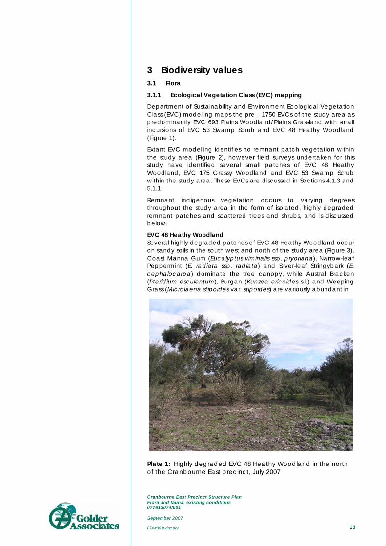
EVC 48 Heathy Woodland Several highly degraded patches of EVC 48 Heathy Woodland occur on sandy soils in the south west and north of the study area (Figure 3). Coast Manna Gum (Eucalyptus viminalis ssp. pryoriana), Narrow-leaf Peppermint (E. radiata ssp. radiata) and Silver-leaf Stringybark (E. cephalocarpa) dominate the tree canopy, while Austral Bracken (Pteridium esculentum), Burgan (Kunzea ericoides s.l.) and Weeping Grass (Microlaena stipoides var. stipoides) are variously abundant in
Plate 1: Highly degraded EVC 48 Heathy Woodland in the north of the Cranbourne East precinct, July 2007

Cranbourne East Precinct Structure Plan Flora and fauna: existing conditions 077613074/001 September 2007 074w001r.doc.doc 14
the understorey. A restricted diversity of indigenous herbaceous species and small shrubs occur sporadically throughout. Common weed species include Blackberry (*Rubus anglocandicans), Kikuyu (*Pennisetum clandestinum), Gorse (*Ulex europaeus), Radiata Pine (*Pinus radiata), Sallow Wattle (*Acacia longifolia ssp. longifolia) and Sweet Pittosporum (*Pittosporum undulatum). If not managed, ongoing degradation processes (weed invasion, grazing, and vegetation clearance) will further degrade EVC 48 Heathy Woodland within the study area.
EVC 175 Grassy Woodland Highly degraded, artefactual remnants of EVC 175 Grassy Woodland occur along the disused train-line in the east of the study area (Figure 3). This vegetation community has been reduced to stands of Blackwood (Acacia melanoxylon) and scattered Swamp Gum (Eucalyptus ovata var. ovata), with a few indigenous herbaceous species occurring infrequently. The exotic Bulbil Watsonia (*Watsonia meriana var. bulbillifera) is extremely abundant throughout, while Blackberry thickets are common (herbicide control of this species was evident).
Habitat zone 5 (see Section 5.1.1) displays characteristics of both EVC 175 Grassy Woodland and EVC 48 Heathy Woodland, and is likely an ecotone between these two communities. For the purpose of this study however, it has been dealt with as Heathy Woodland.
Plate 2: Blackwood (Acacia melanoxylon) dominates this highly degraded patch of EVC 175 Grassy Woodland, rail reserve, south-east Cranbourne East precinct, July 2007
EVC 53 Swamp Scrub One small patch of EVC Swamp Scrub occurs in the south-west of the study area on the northern side of Ballarto Road (Figure 3).

Cranbourne East Precinct Structure Plan Flora and fauna: existing conditions 077613074/001 September 2007 074w001r.doc.doc 15
Indigenous vegetation within this patch is comprised almost entirely of a mixed age-class of Swamp Paperbark (Melaleuca ericifolia). Scattered remnant Silver-leaf Stringybark (E. cephalocarpa) located in the vicinity indicates that this patch may be an artefact of a historical woodland community.
Figure 2: Extant Ecological Vegetation Classes (EVCs) mapped for the Cranbourne East precinct and surrounds (Source: DSE 2007b)

Cranbourne East Precinct Structure Plan Flora and fauna: existing conditions 077613074/001 September 2007 074w001r.doc.doc 16
Scattered trees Remnant indigenous trees occur throughout the study area in roadsides, as isolated paddock trees or scattered amongst highly degraded patches of remnant vegetation. Common overstorey species include Coast Manna Gum (Eucalyptus viminalis ssp. pryoriana), Swamp Gum (E. ovata var. ovata), Silver-leaf Stringybark and Narrow-leaf Peppermint (E. radiata ssp. radiata), while River Red-gum (E. camaldulensis) and White Sallee (E. pauciflora ssp. pauciflora) occur less frequently. Small trees consist of Blackwood (Acacia melanoxylon), Black Wattle (A. mearnsii), Cherry Ballart (Exocarpus cupressiformis) and Swamp Paperbark. The health of many of these trees is sub-optimal and there is often little chance for recruitment due to hostile processes (e.g. grazing, slashing and competition from exotic species).
Degraded native vegetation Occurring in small, highly degraded, linear patches along roadsides and train-lines, or as individual plants, this vegetation consists of remnant and regenerating indigenous species amongst a generally exotic ground flora. Common tree and shrub species include Swamp Gum, Blackwood, Hedge Wattle (Acacia paradoxa) and Swamp Paperbark, while Austral Bracken (Pteridium esculentum) is often present in the ground storey.
All patches of remnant indigenous vegetation that do not qualify as remnant patch vegetation under the Guide for Assessment of Referred Planning Permit Applications (DSE 2006) (due to their highly degraded nature) are considered ‘degraded roadside vegetation’ in this report. Similarly, scattered trees are not included in this category.
3.1.2 Flora significance
A search of the FIS and EPBC databases within an area of 5km radius centred on the Cranbourne East precinct (the flora DRA) was undertaken. The FIS database search returned 13 records of State or Nationally significant plant species within the DRA (Table 1), of which three were from within the study area. The inclusion of the Cranbourne Royal Botanic Gardens within the flora DRA is responsible for the large numbers of indigenous and significant taxa recorded on the FIS. A search of the EPBC database returned six species which may have a likelihood of occurrence within the DRA (Table 2), though this is negligible for all but one species (River- Swamp Wallaby-grass Amphibromus fluitans) due to a lack of suitable habitat.
A population of the nationally significant River- Swamp Wallaby-grass was recorded from the precinct by consultants in April 2006 (Biosis Research 2006). This population was found to occur around the perimeter of a farm dam within a proposed development area at 220–280 Berwick–Cranbourne Road, Cranbourne. In a targeted survey in May 2006, over 600 individuals of River- Swamp Wallaby-grass were recorded from the dam site (Biosis Research 2006; DEWR 2007b). An EPBC referral has been submitted for this population of River- Swamp Wallaby-grass, proposing to retain and manage the grass in situ; and the proposed action has been deemed to be ‘not a

Cranbourne East Precinct Structure Plan Flora and fauna: existing conditions 077613074/001 September 2007 074w001r.doc.doc 17
controlled action’ (DEWR 2007b). The location of this population of River- Swamp Wallaby-grass is mapped in Figure 3.
It should be noted that remnant vegetation in the region is considered to be of at least Local conservation significance. It is calculated that only circa 7% of former vegetation exists in the City of Casey, and that which remains is often severely degraded (Ecology Australia 2003).
Ecological Vegetation Classes (EVCs) are assigned a bioregional conservation status based on the level of depletion and rarity of occurrence, degree of threat and importance for supporting other significant features (DNRE 2002). Of the three extant EVCs occurring within the study area (Figure 3), EVC 48 Heathy Woodland has a conservation status of Least Concern within the Gippsland Plain Bioregion while EVC 175 Grassy Woodland and EVC 53 Swamp Scrub both have a conservation status of Endangered within the Gippsland Plain Bioregion (Table 1).
Table 1: Conservation status of Ecological Vegetation Communities (EVCs) mapped for the Cranbourne East precinct, 2007
EVC no.
EVC name Conservation Status
48 Heathy Woodland Least Concern 53 Swamp Scrub Endangered 175 Grassy Woodland Endangered
3.1.3 Biosites
The Department of Sustainability and Environment (DSE 2005a) define a BioSite (Site of Biological Significance) as an area of land or water containing biological assets with particular attributes, such as the presence of rare or threatened flora, fauna or habitat required for their survival, and/or rare or threatened vegetation communities. These sites are determined by DSE in liaison with Local Government Authorities, Melbourne Water, and community groups, and may be rated as being of International, National, State, Regional or Local significance. There are currently 939 BioSites recorded for the Port Phillip Region with circa 80% of these sites having been mapped (DSE 2005c).
DSE BioSite mapping (DSE 2005a) identifies ‘BioSite 8095 - Royal Botanic Gardens - Cranbourne Annexe’ as occurring adjacent to the southwest of the Cranbourne East Precinct. This BioSite is of State significance, and is only separated from the study area by the South Gippsland Highway. This is the only BioSite recorded by DSE (2005a) as occurring within or adjacent to the Cranbourne East precinct.

Cranbourne East Precinct Structure Plan Flora and fauna: existing conditions 077613074/001 September 2007 074w001r.doc.doc 18
3.1.4 Significant roadsides
Vegetation on roadsides is important for land protection, flora and fauna habitat and landscape character. Vegetated roadsides can provide important links between larger areas of native vegetation, and where larger remnants no longer exist, roadside vegetation may provide the only functional habitat for native flora and fauna.
In a report undertaken by Ecology Australia for the City of Casey (Ecology Australia 2002), rural roadside vegetation within the municipality was documented and mapped according to its Conservation Value (low, moderate or high). One roadside patch occurring within the Cranbourne East Precinct was identified as containing remnant vegetation of moderate Conservation Value. This patch accords with ‘habitat zone 1’ on the South Gippsland Highway (see Figure 3).
3.2 Net Gain The Net Gain approach to protection, enhancement and revegetation of native vegetation is presented in the DNRE (now DSE) publication: Victoria’s Native Vegetation Management: a framework for action (DNRE 2002) (hereafter referred to as the Framework). The Framework specifically focuses on achieving biodiversity goals on private land, in the context of modification and clearing of native vegetation, but is also applicable to Public Land.
The implementation of Net Gain is part of Victoria’s Biodiversity Strategy (DNRE 1997), and the Framework has been incorporated into the Victorian Planning Provisions. The Net Gain approach is summarised in the Framework as follows:
“Net Gain is the outcome for native vegetation and habitat where overall gains are greater than overall losses and where

Cranbourne East Precinct Structure Plan Flora and fauna: existing conditions 077613074/001 September 2007 074w001r.doc.doc 19
Figure 3: Native vegetation (excluding scattered trees) within the Cranbourne East precinct, July 2007.
Cranbourne East Precinct Structure Plan Flora and fauna: existing conditions 077613074/001 September 2007 074w001r.doc.doc 20
individual losses are avoided where possible. The losses and gains are determined by a combined quality-quantity measure and over a specified area and period of time. Gains may be either required offsets for permitted clearing actions or as a result of landholder and Government assisted efforts that are not associated with clearing” (DNRE 2002).
Fundamental to vegetation management is that remnant vegetation is of greater ecological value and inherently more important than revegetation. Therefore, emphasis is given in the Framework to avoiding or minimising losses, as reflected in the three step approach:
1. To avoid adverse impacts, particularly through vegetation clearance (AVOIDANCE)
2. If impacts cannot be avoided, to minimise impacts through appropriate consideration in planning processes and expert input to project design or management (MINIMISATION)
3. Identify appropriate offset options (OFFSETTING)
3.2.1 Potential native vegetation losses
Native vegetation occurs within the study area as ‘remnant patch’ vegetation and as ‘scattered trees’. DSE (2006) define a ‘remnant patch’ as “an area of vegetation, with or without trees, where less than 75% of the total understorey plant cover is weeds or non-native plants (bare ground is not included), or an are of treed vegetation where the density of the trees is such that canopy tree cover is at least at benchmark canopy cover”. DSE (2006) also define scattered trees as “(indigenous) trees that occur at densities below benchmark densities and are within areas where at least 75% of the total understorey plants are weeds or non-native plants”.
Specific requirements for the protection and removal of native vegetation within the study area are not dealt with in this report. A Native Vegetation Precinct Plan is to be developed that will account for potential losses of native vegetation (remnant patch and scattered trees) within the Cranbourne East precinct.
Habitat hectare (hha) scores have been provided (Section 5.1.1, Table 3) as an indication of the extent of remnant vegetation within the study area. Large-tree data for remnant patches and scattered tree data (e.g. diameter at breast-height) will be addressed in the Native Vegetation Precinct Plan.
3.2.2 Remnant patch vegetation
Nine habitat zones were identified within the Cranbourne East study area and a vegetation condition assessment was undertaken within each zone (Figure 3 and Table 3). A habitat zone is defined by DSE 2004 as:
‘… a discrete area of native vegetation consisting of a single vegetation type (EVC) with an assumed similar averaged quality (that) is the base spatial unit for conducting a habitat hectare assessment …’.

Cranbourne East Precinct Structure Plan Flora and fauna: existing conditions 077613074/001 September 2007 074w001r.doc.doc 21
EVC 48 Heathy Woodland vegetation comprises six of these habitat zones, two are EVC 175 Grassy Woodland, and one is EVC 53 Swamp Scrub.
A total of 1.94 hha (habitat hectares) of remnant patch vegetation occurs within the Cranbourne East precinct (Table 3).
Table 2: Significant plant species recorded within a 5 km radius Data Review Area (DRA) (source: Flora Information System, DSE 2004a), with their likelihood of regular occurrence (LRO).
Scientific Name Common Name Significance LRO Amphibromus fluitans
River Swamp Wallaby-grass
V H
Caladenia aurantiaca Orange-tip Finger-orchid r N Caladenia fragrantissima ssp. orientalis ♦ Eastern Spider-orchid E f e N Cardamine paucijuga s.s. Annual Bitter-cress v N Correa reflexa var. lobata Powelltown Correa r N Craspedia canens Grey Billy-buttons e N Dianella amoena ♦ Matted Flax-lily E e N Entolasia stricta Upright Panic k L Glycine latrobeana Clover Glycine V f v N Helichrysum aff. rutidolepis (Lowland Swamps)
Pale Swamp Everlasting v N
Lachnagrostis filiformis var. 2 Wetland Blown-grass k M Lachnagrostis punicea subsp. filifolia Purple Blown-grass f r L Microseris sp. 1 Plains Yam-daisy v N Prasophyllum frenchii Maroon Leek-orchid E f e N Thelymitra circumsepta Naked Sun-orchid v N Thelymitra epipactoides ♦ Metallic Sun-orchid E f e N Xerochrysum palustre ♦ Swamp Everlasting V f v N
Key: EPBC: National Environment Protection and Biodiversity Conservation Act 1999 FFG: Victorian Flora and Fauna Guarantee Act 1988 DSE: Department of Sustainability and Environment (Victoria) CR: Critically Endangered in Australia, listed under the EPBC Act EN: Endangered in Australia, listed under the EPBC Act VU: Vulnerable in Australia, listed under the EPBC Act f: Listed under the FFG Act e: Endangered in Victoria (DSE 2005b) v: Vulnerable in Victoria (DSE 2005b) r: Rare in Victoria (DSE 2005b) k: Poorly known in Victoria (DSE 2005b) LRO: Likelihood of regular occurrence R: Recorded H: High M: Moderate L: Low N: Negligible ♦: Species not recorded in FIS search, only from EPBC Protected Matters database

Cranbourne East Precinct Structure Plan Flora and fauna: existing conditions 077613074/001 September 2007 074w001r.doc.doc
22
Table 3: Habitat hectare scores for remnant patch vegetation within the Cranbourne East precinct
Habitat Zone HZ1 HZ2 HZ3 HZ4 HZ5 HZ6 HZ7 HZ8 HZ9
EVC Name (Initials) HW HW HW HW HW GW GW HW SS
EVC Number 48 48 48 48 48 175 175 48 53
Max Score Score Score Score Score Score Score Score Score Score
Site Large Old Trees 10 5 9 10 9 9 0 0 2 n/a
Condition Canopy Cover 5 4 4 5 4 4 3 0 2 5
Understorey 25 10 5 5 5 10 5 5 10 0
Lack of Weeds 15 0 0 2 0 4 0 0 4 0
Recruitment 10 1 0 1 0 0 3 1 3 5
Organic Matter 5 2 0 2 2 3 2 2 0 3
Logs 5 3 0 0 0 0 0 2 0 n/a
Total Site Score 75 25 18 25 20 30 13 10 21 13
*Multiplier n/a n/a n/a n/a n/a n/a n/a n/a 75/60
Adjusted Site Score 75 25 18 25 20 30 13 10 21 16.25
Landscape Patch Size 10 1 1 1 1 1 1 1 2 1
value Neighbourhood 10 0 0 0 0 0 0 0 0 0
Distance to core 5 4 4 4 4 4 2 2 2 4
Habitat Score 100 30 23 30 25 35 16 13 25 21.25
Habitat Score 1 0.30 0.23 0.30 0.25 0.35 0.16 0.13 0.25 0.21
Habitat Zone area (ha) (#.#) 0.63 0.37 0.04 0.06 0.4 0.89 0.75 5 0.024
Habitat hectares (#.#) 0.19 0.09 0.01 0.02 0.14 0.14 0.10 1.25 0.01
Bioregion GP GP GP GP GP GP GP GP GP
EVC Conservation Status LC LC LC LC LC E E LC E
Conservation Significance Low Low Low Low Low High High Low High
HW EVC 48 Heathy Woodland GP Gippsland Plain Bioregion
GW EVC 175 Grassy Woodland LC Least Concern
SS EVC 53 Swamp Scrub
E Endangered * Where certain site condition components are irrelevant (e.g. Large Old Trees in grassland communities)

Cranbourne East Precinct Structure Plan Flora and fauna: existing conditions 077613074/001 September 2007 074w001r.doc.doc 23
3.3 Fauna 3.3.1 Introduction
There were 87 fauna species (11 exotic) recorded within the fauna Data Review Area (DRA). This total consisted of 68 bird species, 11 mammal species, six reptile species, and two frog species (Appendix 2).
An additional 9 fauna species (eight birds, one mammal; of these two were exotic) were recorded during field work for this project (Table 4).
Table 4: Fauna species recorded in Cranbourne East precinct during July 2007
Common name Scientific name White-necked Heron Ardea pacifica White-faced Heron Egretta novaehollandiae Australian White Ibis Threskiornis molucca Straw-necked Ibis Threskiornis spinicollis Yellow-billed Spoonbill Platalea flavipes Australian Wood Duck Chenonetta jubata Pacific Black Duck Anas superciliosa Brown Goshawk Accipiter fasciatus Brown Falcon Falco berigora *Spotted Turtle-Dove Streptopelia chinensis Crested Pigeon Ocyphaps lophotes Galah Cacatua roseicapilla Long-billed Corella Cacatua tenuirostris Little Corella Cacatua sanguinea Eastern Rosella Platycercus eximius Red-rumped Parrot Psephotus haematonotus Musk Lorikeet Glossopsitta concinna *Skylark Alauda arvensis Welcome Swallow Hirundo neoxena Australasian Pipit Anthus novaeseelandiae *Common Blackbird Turdus merula Willie Wagtail Rhipidura leucophrys Superb Fairy-wren Malurus cyaneus Brown Thornbill Acanthiza pusilla Yellow-rumped Thornbill Acanthiza chrysorrhoa Yellow Thornbill Acanthiza nana Striated Pardalote Pardalotus striatus Silvereye Zosterops lateralis White-plumed Honeyeater Lichenostomus penicillatus Noisy Miner Manorina melanocephala Red Wattlebird Anthochaera carunculata Magpie-lark Grallina cyanoleuca Grey Butcherbird Cracticus torquatus Australian Magpie Gymnorhina tibicen
Cranbourne East Precinct Structure Plan Flora and fauna: existing conditions 077613074/001 September 2007 074w001r.doc.doc 24
Common name Scientific name Little Raven Corvus mellori *Common Myna Acridotheres tristis *Common Starling Sturnus vulgaris *House Sparrow Passer domesticus Red-browed Finch Neochmia temporalis *European Goldfinch Carduelis carduelis *Brown Hare Lepus capensis *Rabbit Oryctolagus cuniculus *Fox Vulpes vulpes Common Eastern Froglet Crinia signifera
3.3.2 Species of conservation significance
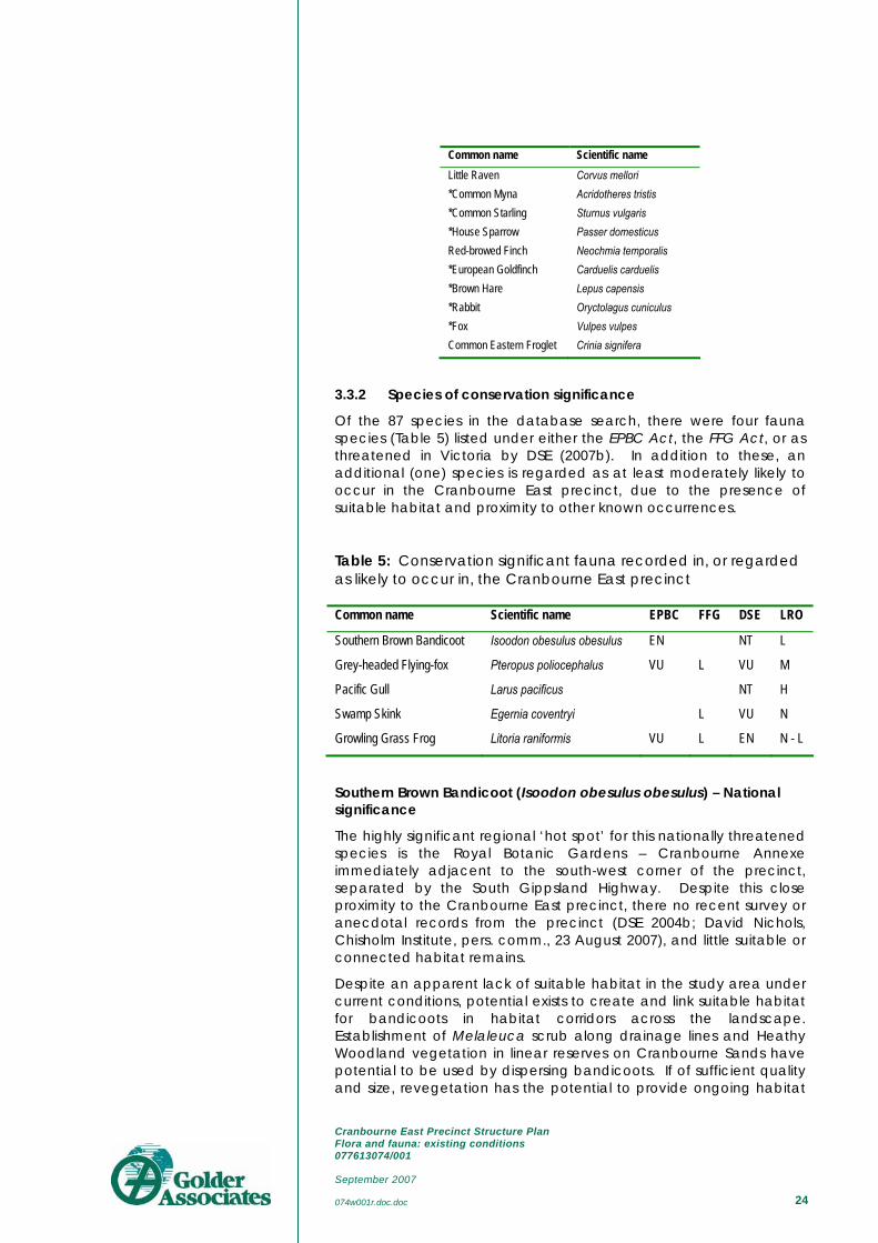
Of the 87 species in the database search, there were four fauna species (Table 5) listed under either the EPBC Act, the FFG Act, or as threatened in Victoria by DSE (2007b). In addition to these, an additional (one) species is regarded as at least moderately likely to occur in the Cranbourne East precinct, due to the presence of suitable habitat and proximity to other known occurrences.
Table 5: Conservation significant fauna recorded in, or regarded as likely to occur in, the Cranbourne East precinct
Common name Scientific name EPBC FFG DSE LRO
Southern Brown Bandicoot Isoodon obesulus obesulus EN NT L
Grey-headed Flying-fox Pteropus poliocephalus VU L VU M
Pacific Gull Larus pacificus NT H
Swamp Skink Egernia coventryi L VU N
Growling Grass Frog Litoria raniformis VU L EN N - L
Southern Brown Bandicoot (Isoodon obesulus obesulus) – National significance
The highly significant regional ‘hot spot’ for this nationally threatened species is the Royal Botanic Gardens – Cranbourne Annexe immediately adjacent to the south-west corner of the precinct, separated by the South Gippsland Highway. Despite this close proximity to the Cranbourne East precinct, there no recent survey or anecdotal records from the precinct (DSE 2004b; David Nichols, Chisholm Institute, pers. comm., 23 August 2007), and little suitable or connected habitat remains.
Despite an apparent lack of suitable habitat in the study area under current conditions, potential exists to create and link suitable habitat for bandicoots in habitat corridors across the landscape. Establishment of Melaleuca scrub along drainage lines and Heathy Woodland vegetation in linear reserves on Cranbourne Sands have potential to be used by dispersing bandicoots. If of sufficient quality and size, revegetation has the potential to provide ongoing habitat

Cranbourne East Precinct Structure Plan Flora and fauna: existing conditions 077613074/001 September 2007 074w001r.doc.doc 25
for the species, potentially contributing to an increase in the regional population size, and by dispersing animals over a wider area, lead to a slight diminution of the extinction risk to the local population.
Grey-headed Flying-fox (Pteropus poliocephalus) – National significance
The Grey-headed Flying-fox ranges widely throughout the Port Phillip – Western Port region from a large colony on the Yarra River at Kew. Though much of the species’ foraging occurs within parks, gardens and street trees of the metropolitan areas, individuals or small groups are known to regularly range as far away from Kew as Geelong to the west (where a large camp established temporarily after the bats were evicted from the Royal Botanic Gardens at South Yarra) (Grant Baverstock, City of Greater Geelong, unpubl. obs.), and parts of the Mornington and Bellarine Peninsulas to the south and east (DSE 2004b). The flying-fox camp at Kew is the only established one currently known from Victoria, since the colony was relocated from South Yarra. No other temporary or permanent camps of flying-foxes are known from the Cranbourne East precinct, or from the broader Port Phillip – Western Port region.
Grey-headed Flying-foxes feed primarily on nectar and fruit from Australian flowering trees (Eucalyptus, #Corymbia, Banksia, etc.) and exotic fruit trees (*Ficus, *Prunus, etc.). Mature, potential, flying-fox food tree species within the Cranbourne East precinct are relatively few, and clustered. Remnant indigenous trees such as Coast Manna Gums (E. viminalis ssp pryoriana), Silver-leaved Stringybarks (E. cephalocarpa) and River Red Gums (E. camaldulensis) are also not noted nectar-producing species; though Swamp Gums (E. ovata s.l.) can occasionally be important in larger stands.
The Grey-headed Flying-fox may be observed passing through the area regularly as part of wider movements through the region, but there are no food or roosting resources available for anything other than itinerant visits. It is unlikely that the small groups of non-indigenous flowering trees such as Sugar Gums (*Eucalyptus cladocalyx) and Spotted Gums (#Corymbia maculata) or back-yard fruit trees provide anything other than intermittent and ephemeral food resources. Most surviving indigenous trees are not suitable nectar-producing species, and do not occur in sufficient numbers to provide a useful foraging resource.
Growling Grass Frog (Litoria raniformis) – National significance
Though the most recent record from the area surrounding Cranbourne East precinct in the State database for this species is given as 1980 (DSE 2004b), indicating a relatively old record, there are more recent records from immediately outside the study area in the City of Casey (DSE 2004b; Aaron Organ, Ecology Partners Pty Ltd, pers. comm., 23 August 2007).
Although suitable habitat for this species exists within and immediately adjacent to the study area, the extent and connectivity of these habitats is considered too small and fragmented to support Growling Grass Frogs (Aaron Organ, pers. comm.). In agricultural landscapes intersected by linear waterways (creeks and irrigation channels) and with a network of vegetated dams separated by

Cranbourne East Precinct Structure Plan Flora and fauna: existing conditions 077613074/001 September 2007 074w001r.doc.doc 26
distances of no more than 500m, Growling Grass Frogs can sustain metapopulation structure, with numerous small habitat nodes in an otherwise hostile matrix (Ecology Australia 2006; A. Organ, pers. comm.).
As suitable habitat conditions are absent from the Cranbourne East precinct, the likelihood that the area sustains an important population of the Growling Grass Frog is considered negligible – low.
Dwarf Galaxias (Galaxiella pusilla) – National significance
Dwarf Galaxias typically occur in the slow-flowing waters of the middle and lower reaches of waterways. The precinct contains the headwaters of several minor waterways, including Clyde Creek, which are ephemeral and degraded in nature, and from which there are no known records of this fish (DSE 2004b). There is no evidence of suitable habitat for this species within the precinct, or immediately adjacent areas; and the precinct is unlikely to receive flood-borne fish from other areas due to its position at the head of the streams. Consistent with the assessment for Growling Grass Frogs (see above), the likelihood of important populations of the Dwarf Galaxias occurring in the Cranbourne East precinct is considered as negligible.
Swamp Skink (Egernia coventryi) – State significance
The records of this species from the DRA come from the Royal Botanic Gardens Cranbourne Annexe (DSE 2004b). The vegetated swamp and stream habitats that this species requires are not present in the precinct, and therefore the likelihood that Swamp Skinks occur there is negligible.
3.3.3 Fauna habitat values
The habitats of the Cranbourne East precinct can be broadly defined as a predominantly agricultural landscape containing small, widely-separated pockets of degraded remnant vegetation. The area is highly modified and has undergone a substantial loss of habitat and biodiversity values. The rural and rural residential habitats of the precinct support a suite of abundant, generalist fauna species typical of urban fringe and rural areas.
Some of the remaining scattered old trees may develop hollows, and though these will to some extent monopolised by aggressive, exotic hollow-nesting birds such as *Common Starlings and *Common Mynas, they are also likely to used by native hollow-nesting birds such as Galahs, cockatoos, parrots and owls, as well as hollow-dependent mammals such as Common Brushtail Possums and microbats.

Cranbourne East Precinct Structure Plan Flora and fauna: existing conditions 077613074/001 September 2007 074w001r.doc.doc 27
4 Legislative and policy implications
4.1 Federal Environment Protection & Biodiversity Conservation Act 1999 (EPBC)
The EPBC Act pertains to matters of national environmental significance including Ramsar Wetlands, listed threatened species and ecological communities, listed migratory species and commonwealth marine areas. It applies to public and private land and a referral is necessary whenever a proposed action is considered likely to significantly impact on any matters of national environmental significance (MNES) listed under the Act.
No plant communities listed under the EBPC Act have been confirmed as occurring in the study area.
One plant species, River Swamp Wallaby-grass, has been confirmed as occurring at one site within the precinct. This site in the Blue Hills development area has been assessed and referred under the EPBC Act, a management plan developed, and the development deemed ‘not a controlled action’ under the Act.
Three EPBC-listed fauna species – Southern Brown Bandicoot, Growling Grass Frog and Dwarf Galaxias – are regarded as of negligible – low likelihood of regularly occurring in the study area. The Grey-headed Flying-fox is likely to pass through the area on larger movements throughout the district, but not sustain important populations in the precinct.
The nature and extent of habitat within the precinct is not regarded as important or limiting for any EPBC-listed threatened or migratory species.
The study area falls within the upper catchments of two Ramsar wetlands: (i) Western Port, and (ii) Edithvale Seaford Wetlands. It is not considered likely that there will be any significant downstream impacts arising from future urbanisation of the precinct, due to the long distance from source to receiving waters, and the numerous storm-water treatment facilities that fall between the two extremes.
4.2 Victorian Flora & Fauna Guarantee Act 1988 (FFG)
The FFG Act lists species and ecological communities that are recognised to be rare or threatened in Victoria. It also identifies threatening process. The full extent of the FFG Act only applies to public land, but the intent of the Act also applies to other land tenures through action statements, Victoria’s biodiversity policy, and through the planning scheme referral process.
No threatened plants listed under the FFG were detected during fieldwork, or are regarded as at least moderately likely to occur in the precinct.
Two FFG-listed fauna species – Growling Grass Frog and Dwarf Galaxias – are regarded as of negligible – low likelihood of regularly occurring in the study area. The Grey-headed Flying-fox is only likely

Cranbourne East Precinct Structure Plan Flora and fauna: existing conditions 077613074/001 September 2007 074w001r.doc.doc 28
to pass through the area on larger movements throughout the district, but not sustain important populations in the precinct.
The nature and extent of habitat within the precinct is not regarded as important or limiting for any FFG-listed threatened species.
4.3 Victorian Catchment & Land Protection Act 1994 (CaLP)
The CALP Act provides a legislative framework for the management of land including the control of declared noxious weeds and pest animals.
The Act sets out the responsibilities of private and public land managers, stating that they must take all reasonable steps to:
avoid causing or contributing to land degradation which causes or may cause damage to land of another land owner;
conserve soil;
protect water resources;
eradicate regionally prohibited weeds;
prevent the growth and spread of regionally controlled weeds; and
prevent the spread of, and as far as possible eradicate, established pest animals.
For details on serious environmental weeds in the City of Casey refer to Ecology Australia (2005).
4.4 Victoria’s Native Vegetation Management Framework
In Victoria, where a permit is required for the removal of native vegetation, the proponent is required to offset the loss with appropriate ‘gains’ - as defined in Victoria’s Native Vegetation Management – A Framework for Action (DNRE 2002) (hereafter referred to as the Framework). After options for avoidance and minimisation of loss have been considered, the extent of vegetation loss is calculated based on an assessment of its condition (H) and area of loss (ha): the losses are thus expressed as habitat hectares (hha). The offsets required are determined by consideration of the vegetation lost (hha) and the conservation status of the Ecological Vegetation Class (EVC).
The Net Gain approach is summarised in the Framework document as follows:
“… Net Gain is the outcome for native vegetation and habitat where overall gains are greater than overall losses and where individual losses are avoided where possible. The losses and gains are determined by a combined quality-quantity measure and over a specified area and period of time …” (DNRE 2002)
Fundamental to vegetation management is the concept that remnant indigenous vegetation is of greater ecological value and inherently more important than that achieved through revegetation.

Cranbourne East Precinct Structure Plan Flora and fauna: existing conditions 077613074/001 September 2007 074w001r.doc.doc 29
Therefore, emphasis is given in the Framework to avoiding or minimising losses, as reflected in the three-step approach:
1. To avoid adverse impacts, particularly through vegetation clearance (Avoidance);
2. If impacts cannot be avoided, to minimise impacts through appropriate consideration in planning processes and expert input to project design or management (Minimisation); and
3. Identify appropriate offset options (Offsets).
Any loss of native vegetation in the Cranbourne East precinct will need to be assessed under the Net Gain framework, and offsets will ideally be met on-site or locally. The areas of native vegetation and scattered trees to be retained, lost and offset will be identified in the Native Vegetation Precinct Plan(NVPP).
Specific requirements for the protection and removal of native vegetation within the study area are not addressed in this report. A Native Vegetation Precinct Plan(NVPP) is to be developed that will account for potential losses of native vegetation (remnant patch and scattered trees) within the Cranbourne East precinct. However, habitat hectare scores have been provided (Table 3) as an indication of the extent and condition of remnant vegetation within the study area. Large-tree data for remnant patches and scattered tree data (e.g. diameter at breast-height) will be collected during additional planned field work, and documented in the final version of this technical report, as well as in the NVPP.

Cranbourne East Precinct Structure Plan Flora and fauna: existing conditions 077613074/001 September 2007 074w001r.doc.doc 30
5 Discussion 5.1 Potential impacts and constraints to development
The vast majority of the study area contains no native vegetation. As the remaining native vegetation is overwhelmingly discrete and clustered (see Figure 3), the opportunity to retain most or all of it without constraining other opportunities is considerable. Development within the vicinity of extant remnant indigenous vegetation may negatively impact the vegetation which remains, but this can be minimised by appropriate buffering.
The most significant potential impacts to biodiversity values from development within the Cranbourne East precinct are associated with:
potential impacts to State and Nationally listed species (low); and
potential loss of scattered old trees in pasture and woodland vegetation on roadsides and the disused rail reserve (moderate).
Recommendations are given in section 6 to ameliorate these impacts.
5.2 Potential opportunities to enhance biodiversity values
As discussed previously, the greater proportion of this study area is situated in dryland areas in which the habitat values have been greatly reduced, principally due to land clearing and agricultural practices. Remnant vegetation along roadside corridors has therefore become valuable in terms of its value to biodiversity, and as a link (even if fragmented) to important habitat areas such as the Cranbourne Botanic Gardens.
There is an opportunity for development within the Cranbourne East precinct to take advantage of these existing native vegetation patches and linear fragments to
protect existing habitat values;
develop linkages that enhance habitat values and provide movement corridors for fauna (e.g. between the study area an the Cranbourne Botanic Gardens; and
these linkages could also provide amenity value to other user groups i.e. bike paths/walking trails.

Cranbourne East Precinct Structure Plan Flora and fauna: existing conditions 077613074/001 September 2007 074w001r.doc.doc 31
6 Recommendations The following recommendations are made in regards to conserving and enhancing the flora and fauna values within the Cranbourne East precinct:
retain remnant native vegetation patches and scattered trees within the study area, and where feasible incorporate into reserves;
avoid woody native vegetation removal along roadsides, and of scattered old indigenous trees;
ensure ‘BioSite 8095 - Royal Botanic Gardens - Cranbourne Annexe’ is not negatively impacted by development within the Cranbourne East UGP study area;
undertake control of environmental weed species, particularly in and adjacent to remnant vegetation patches;
utilise locally indigenous plant species in landscaping and revegetation exercises.
undertake pest animal control programs;
undertake revegetation work along drains and roadsides to provide habitat corridors for local fauna;
any standing dead indigenous trees, with at least moderate structural integrity (subject to arboricultural safety standards), and which occur in or close to any proposed linear reserves or easements, should be prioritised for retention as fauna habitat (hollows, fissures and cracks used by hollow-dependant fauna); and
use principles from the construction and operation of the Evan’s Road wetland in Cranbourne West to guide similar developments within the Cranbourne East precinct.

Cranbourne East Precinct Structure Plan Flora and fauna: existing conditions 077613074/001 September 2007 074w001r.doc.doc 32
7 References Biosis Research (2006). ‘Flora, fauna and habitat quality assessment of
220 – 280 Berwick-Cranbourne Road, Cranbourne, Victoria’. Unpublished report prepared for Beveridge Williams and Co. (Biosis Research Pty Ltd: Port Melbourne).
Brett Lane & Associates (2006a). Letter to Nicole Attard, Stockland Pty Ltd. Re: Collins land, Clyde Five Ways Road Cranbourne Flora and Fauna Due Diligence Assessment. (Brett Lane & Associates: Carlton).
Brett Lane & Associates (2006b). Letter to Mr Guy Williamson, Villa Word Pty Ltd. Re: 545 Berwick – Cranbourne Road, Clyde – Independent Assessment of Flora and Fauna Due Diligence Report. (Brett Lane & Associates: Carlton).
Christidis, L. & Boles, W.E. (1995). ‘Taxonomy and Species of Birds of Australia and its Territories.’ (Royal Australasian Ornithologists Union, Melbourne.)
Cogger, H. G., Cameron, E. E., Sadlier, R. A. & Eggler, P. (1993). ‘The Action Plan for Australian Reptiles.’ (Australian Nature Conservation Agency: Canberra).
DEWR (2007a). ‘EPBC Act Protected Matters Search Tool’. Available on the Department of Environment and Water Resources website: http://www.environment.gov.au/erin/ert/epbc/index.html [Accessed 18/7/07]
DEWR (2007b). EPBC referral ‘Blue Hills Residences Pty Ltd/Tourism and recreation/Clyde/VIC/Blue Hills Rise Golf Course, Vic’, referral no. ‘2007/3510’. Available on the Department of Environment and Water Resources website: http://www.environment.gov.au/epbc/assessmentsapprovals/index.html [Accessed 20/8/07]
DNRE (1997). Victoria’s Biodiversity Strategy. (Department of Natural Resources and Environment: East Melbourne.)
DNRE (2002). ‘Victoria’s Native Vegetation Management: A Framework for Action’. (Department of Natural Resources and Environment: East Melbourne.)
DSE (2004a). ‘Flora Information System.’ Database. (Arthur Rylah Institute: Heidelberg.)
DSE (2004b). ‘Victorian Flora Species Index including vascular and non-vascular taxa.’ (Parks, Flora and Fauna Division of DSE: Melbourne.)
DSE (2004c). ‘Victorian Fauna Display.’ CD-ROM. (DSE/Viridians Biological Databases: Brighton East.)
DSE (2004d). ‘Standard criteria for sites of biological significance in Victoria.’ (Department of Sustainability and Environment: East Melbourne.)
DSE (2005a). ‘Sites of Biodiversity Significance (Biosites) and Ecological Vegetation Classes (EVCs): Port Phillip and Westernport Region.’

Cranbourne East Precinct Structure Plan Flora and fauna: existing conditions 077613074/001 September 2007 074w001r.doc.doc 33
Maps and reports on CD-ROM. (Department of Sustainability and Environment: East Melbourne.)
DSE (2005b). ‘Advisory list of rare or threatened plants in Victoria’. (Department of Sustainability and Environment: East Melbourne.)
DSE (2005c). ‘Biosites Update – Port Phillip Region’. (Brochure prepared by Department of Sustainability and Environment: East Melbourne).
DSE (2006). ‘Native Vegetation – Guide for assessment of referred planning permit applications’. (Department of Sustainability and Environment: East Melbourne).
DSE (2007a). ‘Advisory List of threatened Vertebrate Fauna in Victoria - 2007.’ (Department of Sustainability and Environment: East Melbourne).
DSE (2007b). ‘Biodiversity Interactive Map’.: [http://www.dse.vic.gov.au/dse/index.htm]. (Department of Sustainability and Environment: East Melbourne.) [Accessed 18/7/2007].
DSE (2007c). ‘Explore Victoria Online – Geovic.’ [http://nremap-sc.nre.vic.gov.au/MapShare.v2/imf.jsp?site=em]. (Department of Sustainability and Environment: East Melbourne.) [Accessed 18/7/2007].
DSE (2007d). ‘Melbourne 2030 Implementation Program - Project List’. [http://www.dse.vic.gov.au/dse/index.htm]. (Department of Sustainability and Environment: East Melbourne.) [Accessed 20/7/07]
Duncan, A., Baker, G. B. & Montgomery, N. (Eds) (1999). ‘The Action Plan for Australian Bats.’ (Environment Australia: Canberra.)
Ecology Australia (2002). ‘City of Casey Roadside Vegetation Management Plan – Volumes 1&2’ Unpublished report prepared for the City of Casey. (Ecology Australia Pty Ltd: Fairfield.)
Ecology Australia (2002). ‘Cranbourne – Frankston Road Flora and Fauna Assessment.’ Report prepared for VicRoads. (Ecology Australia Pty Ltd: Fairfield.)
Ecology Australia (2003). ‘City of Casey Biodiversity Enhancement Strategy – Volumes 1&2’. Report prepared for City of Casey. (Ecology Australia Pty Ltd: Fairfield.)
Ecology Australia (2004b). ‘City of Casey Roadside Vegetation Management.’ Report prepared for City of Casey. (Ecology Australia Pty Ltd: Fairfield.)
Ecology Australia (2006). ‘Melbourne Wholesale Markets Redevelopment: Conservation Strategy for the Growling Grass Frog – Epping, Victoria.’ Report prepared for the Victorian Department of Primary Industries by C. Renowden, L.E. Conole, G.W. Heard, & P. Robertson. (Ecology Australia Pty Ltd: Fairfield.)
Garnett, S.T. & Crowley, G.M. (2000). ‘The Action Plan for Australian Birds 2000.’ (Environment Australia: Canberra.)

Cranbourne East Precinct Structure Plan Flora and fauna: existing conditions 077613074/001 September 2007 074w001r.doc.doc 34
Lee, A.K. (1995). ‘The Action Plan for Australian Rodents.’ (Australian Nature Conservation Agency: Canberra.)
Maxwell, S., Burbidge, A. A. & Morris, K. (Eds) (1996). ‘The 1996 Action Plan for Australian Marsupials and Monotremes.’ (Wildlife Australia for the Australasian Marsupial and Monotreme Specialist Group and the IUCN Species Survival Commission: Switzerland.)
Renowden, C., Conole, L.E., Heard, G.W. & Robertson, P. (2006). Melbourne Wholesale Markets Redevelopment: Conservation Strategy for the Growling Grass Frog – Epping, Victoria. Report prepared for the Victorian Department of Primary Industries. (Ecology Australia Pty Ltd: Fairfield.)
Ross, J.H. & Walsh, N.G. (2003). ‘A Census of the Vascular Plants of Victoria – 7th Edition.’ (Royal Botanic Gardens: Melbourne.)
Schodde, R. & Mason, I.J. (1999). ‘The Directory of Australian Birds: Passerines.’ (CSIRO Publishing, Collingwood.)
Schulz, M., Beardsell, C. & Sandiford, K. (1991). ‘Sites of faunal significance in the western wetlands of Melbourne.’ (Department of Conservation and Environment: Melbourne.)
Tyler, M. (1997). ‘The Action Plan for Australian Frogs.’ (Environment Australia: Canberra.)
Wager, R. & Jackson, P. (1993). ‘The Action Plan for Australian Freshwater Fishes.’ (Australian Nature Conservation Agency: Canberra.)
Watkins, D. (1993). A National Plan for Shorebird Conservation in Australia. Australasian Wader Studies Group. RAOU Report No. 90.

Cranbourne East Precinct Structure Plan Flora and fauna: existing conditions 077613074/001 September 2007 074w001r.doc.doc 35
8 Acknowledgements The authors acknowledge assistance provided during the preparation of this report by:
Geoff Carr, Andrew McMahon and Jamie McMahon (Ecology Australia Pty Ltd)
Ric Bland (Golder Associates)
Nicole Dennison and Mark Sheppard (David Lock & Associates Pty Ltd)
Aaron Organ (Ecology Partners Pty Ltd)
David Nichols (Chisholm Institute, Cranbourne)
Travis Reid (City of Casey)
Michelle McHugh (DSE)
Cranbourne East Precinct Structure Plan Flora and fauna: existing conditions 077613074/001 September 2007 074w001r.doc.doc 36
Appendix 1: Criteria for assessment of conservation significance of flora and fauna values. Flora In the context of the present study the following areas apply to the scale of significance for indigenous plant species and biodiversity of a site:
Local: City of Casey
Regional: Gippsland Plain Bioregion
State: Victoria
National: Australia
Significance of plant species Species significance is generally an indication of rarity or population decline. The assessment of significance of plant species recorded during this study is assessed according to the following criteria for each geographic scale:
Local All indigenous flora is considered significant at a local level because of the massive decline in native vegetation since European settlement, and the continued incremental loss of habitat and reductions in abundance due to development and habitat degradation.
Regional In the context of the relevant Victorian bioregion, plant species are considered to be of regional significance when the species has a recording rate of less than 1%, as determined by interrogation of the Flora Information System database. However, this approach is influenced by sampling bias in particular vegetation types, so species may be included or excluded from the regional significance category where common sense and knowledge of the regional flora indicates.
State A taxon is considered significant at a State level if it is:
listed under the Victoria Flora and Fauna Guarantee Act 1988; or
considered to be rare, vulnerable, or endangered in Victoria by DSE (2005b), or Ross and Walsh (2003).
National A taxon is considered significant at a National level if it is:
listed as Vulnerable, Endangered, Critically Endangered, or Presumed Extinct under the Commonwealth Environment Protection and Biodiversity Conservation Act 1999; or
considered to be rare, vulnerable, or endangered in Australia by DSE (2005b) or Ross and Walsh (2003).
• endemic to Victoria and is considered to be rare, vulnerable, or endangered in Victoria by DSE (2005b), or Ross and Walsh (2003).

Cranbourne East Precinct Structure Plan Flora and fauna: existing conditions 077613074/001 September 2007 074w001r.doc.doc 37
Significance of Vegetation Communities and Ecological Vegetation Classes (EVCs) Significance of vegetation types has been determined in two ways in this report:
1. Significance of a remnant according to its condition and the status of the EVC within the Bioregion (the Net Gain approach to significance: explained further below)
2. Listing of a vegetation community as rare or threatened under the Victorian Flora and Fauna Guarantee Act 1988 or the Federal Environment Protection and Biodiversity Conservation Act 1999.
Determination of significance according to Net Gain Victoria is implementing a new approach to the assessment of remnant vegetation through the ‘habitat hectare’ system (a measure of size and condition), as set out in Victoria’s Native Vegetation Management – A Framework for Action (DNRE 2002b). Of particular relevance is Table 5 (Appendix 3) of that document which is largely summarised in Table A, below.
To assist in planning for biodiversity conservation, Victoria is divided into 27 ‘bioregions’ - geographic units based on a common suite of biophysical characteristics (DNRE 2002a). The Ecological Vegetation Classes occurring within each bioregion have been assessed, based on the degree of depletion / clearing that has occurred since European settlement and the area of extant vegetation secured in a conservation reserve, to determine their conservation status. Criteria for each conservation status are given in Table B.
The condition score (h) of a particular remnant is then combined with the bioregional conservation status of the relevant EVC to determine the conservation significance of the EVC at the site.
The relationship between EVC Conservation Status, Vegetation Condition, and Conservation Significance (Low – Very High).
Condition Score (h) Conservation Status*
0.1 0.2 0.3 0.4 0.5 0.6 0.7 0.8 0.9 1
Endangered HIGH VERY HIGH**
Vulnerable MEDIUM HIGH VERY HIGH
Rare MEDIUM HIGH VERY HIGH
Depleted LOW MEDIUM HIGH
Least Concern LOW MEDIUM
* As determined by reference to relevant bioregional plan / EVC database
** Other attributes (such as population size of a threatened taxon) may over-ride condition score alone.

Cranbourne East Precinct Structure Plan Flora and fauna: existing conditions 077613074/001 September 2007 074w001r.doc.doc 38
Table B. Criteria for the Bioregional Conservation Status categories of EVCs
Status Criteria
Presumed Extinct
X Probably no longer present in the bioregion
Endangered E1 Contracted to less than 10% of former range;or Less than 10% of the pre-European extent remains;
E2 Combination of depletion, degradation, current threats and rarity is comparable overall to E1:
• 10 to 30% pre-European extent remains and severe degradation over a majority of this area; or
• naturally restricted EVC reduced to 30% or less of former range and subject to moderate degradation and/or a threatening process over a majority of remaining area; or
• rare EVC cleared and / or subject to moderate degradation and/or a threatening process over a majority of former area.
Vulnerable V1 10 to 30% pre-European extent remains; V2 Combination of depletion, degradation, current threats and rarity is
comparable overall to V1:
• greater than 30% and up to 50% pre-European extent remains and subject to moderate degradation and/or a threatening process over a majority of this area;or
• greater than 50% pre-European extent remains and severely degraded over a majority of this area;or
• naturally restricted EVC where greater than 30% pre-European extent remains and subject to moderate degradation and/or a threatening process over majority of this area;or
• rare EVC cleared and/or subject to moderate degradation and/or a threatening process over a minority of former area.
Depleted D1 Greater than 30% and up to 50% pre-European extent remains; D2 Combination of depletion, degradation and current threats is comparable
overall to D1, and:
Greater than 50% pre-European extent remains moderately degraded over a majority of this area;
Rare R Rare EVC
Least Concern
LC Greater than 50% pre-European extent remains and subject to little to no degradation over a majority of this area

Cranbourne East Precinct Structure Plan Flora and fauna: existing conditions 077613074/001 September 2007 074w001r.doc.doc 39
Fauna In the context of the present study the following areas apply to the scale of significance for indigenous fauna species:
Local: City of Casey
Regional: Gippsland Plain Bioregion
State: Victoria
National: Australia
Significance of fauna species The criteria for assessing zoological significance of taxa (fauna species, subspecies, other recognised forms) in this study is determined according to the following criteria for each geographic scale:
Local
All indigenous fauna is considered significant at a Local level, because of the overall decline in the fauna since European settlement, and the continued incremental loss of habitat and reduction in abundance due to development. The exceptions to this are locally over-abundant native species which can pose a threat to local biodiversity values (e.g. Noisy Miner, Rainbow Lorikeet).
Regional
A taxon is considered significant at a Regional level if:
it has a disjunct distribution in the bioregion; or
it is represented in high concentrations in terms of colonial nesting, roosting or feeding sites; or
it is substantially depleted or restricted in the bioregion; or
it has an unusual ecological or biogeographical occurrence,
State
A taxon is considered significant at a State level if it is:
listed under Schedule 2 of the Victorian Flora and Fauna Guarantee Act 1988; or
listed under the Advisory List of Threatened Vertebrate Fauna in Victoria – 2007 (DSE 2007a); or
Listed as Data Deficient or Insufficiently Known under the following Australian Action Plans: Bannister et al. (1996), Cogger et al. (1993), Duncan et al. (1999), Garnett and Crowley (2000), Lee (1995), Maxwell et al. (1996), Pogonoski et al. (2002), Tyler (1997), Wager and Jackson (1993), or Sands and New (2003).
National
A taxon is considered significant at a National level if it is:
listed as Critically Endangered, Endangered, Vulnerable, Conservation Dependant or Presumed Extinct on the

Cranbourne East Precinct Structure Plan Flora and fauna: existing conditions 077613074/001 September 2007 074w001r.doc.doc 40
Commonwealth Environment Protection and Biodiversity Conservation Act 1999; or
listed as Extinct, Extinct in the Wild, Critically Endangered, Endangered, Vulnerable, Rare, Near Threatened) or Conservation Dependent under the following Australian Action Plans: Bannister et al. (1996), Cogger et al. (1993), Duncan et al. (1999), Garnett and Crowley (2000), Lee (1995), Maxwell et al. (1996), Pogonoski et al. (2002), Tyler (1997), Wager and Jackson (1993), or Sands and New (2003).
Zoological site significance We use as the basis for zoological site and faunal habitat significance the ‘Standard criteria for sites of biological significance in Victoria’ (DSE 2004d).

Cranbourne East Precinct Structure Plan Flora and fauna: existing conditions 077613074/001 September 2007 074w001r.doc.doc 41
Appendix 2: Fauna recorded from the 5km radius Data Review Area (source: Atlas of Victorian Wildlife, DSE 2004b)
FAMILY EPBC FFG/DSE FERAL COMMON NAME SCIENTIFIC NAME
Bovidae * Goat (feral) Capra hircus Canidae * Red Fox Vulpes vulpes Leporidae * European Rabbit Oryctolagus cuniculus Muridae * Black Rat Rattus rattus * House Mouse Mus musculus Swamp Rat Rattus lutreolus Water Rat Hydromys chrysogaster Peramelidae
E n Southern Brown Bandicoot Isoodon obesulus obesulus
Phalangeridae
Common Brushtail Possum
Trichosurus vulpecula
Phascolarctidae Koala Phascolarctos cinereus Pseudocheiridae
Common Ringtail Possum Pseudocheirus peregrinus
Accipitridae
Wedge-tailed Eagle Aquila audax
Anatidae
Australian Wood Duck Chenonetta jubata
Chestnut Teal Anas castanea Grey Teal Anas gracilis
Pacific Black Duck Anas superciliosa
Ardeidae Cattle Egret Ardea ibis
White-faced Heron Egretta novaehollandiae
Artamidae
Australian Magpie Gymnorhina tibicen
Dusky Woodswallow Artamus cyanopterus
Grey Butcherbird Cracticus torquatus Cacatuidae Galah Cacatua roseicapilla
Long-billed Corella Cacatua tenuirostris
Campephagidae
Black-faced Cuckoo-shrike Coracina novaehollandiae
Charadriidae

Cranbourne East Precinct Structure Plan Flora and fauna: existing conditions 077613074/001 September 2007 074w001r.doc.doc 42
FAMILY EPBC FFG/DSE FERAL COMMON NAME SCIENTIFIC NAME
Black-fronted Dotterel Elseyornis melanops
Masked Lapwing Vanellus miles Columbidae
Common Bronzewing Phaps chalcoptera
* Spotted Turtle-Dove Streptopelia chinensis
Corvidae Australian Raven Corvus coronoides Little Raven Corvus mellori Cuculidae
Fan-tailed Cuckoo Cacomantis flabelliformis
Horsfield's Bronze-Cuckoo Chrysococcyx basalis
Pallid Cuckoo Cuculus pallidus Dicaeidae Mistletoebird Dicaeum hirundinaceum Dicruridae Grey Fantail Rhipidura fuliginosa Magpie-lark Grallina cyanoleuca Willie Wagtail Rhipidura leucophrys Falconidae Brown Falcon Falco berigora Fringillidae
* European Goldfinch Carduelis carduelis
Halcyonidae
Laughing Kookaburra Dacelo novaeguineae
Hirundinidae
Welcome Swallow Hirundo neoxena
Laridae n Pacific Gull Larus pacificus Silver Gull Larus novaehollandiae Maluridae
Superb Fairy-wren Malurus cyaneus
Meliphagidae
New Holland Honeyeater Phylidonyris novaehollandiae
Noisy Miner Manorina melanocephala Red Wattlebird Anthochaera carunculata
Spiny-cheeked Honeyeater Acanthagenys rufogularis
White-eared Honeyeater Lichenostomus leucotis
White-naped Honeyeater Melithreptus lunatus
White-plumed Honeyeater Lichenostomus penicillatus
Motacillidae Richard's Pipit Anthus novaeseelandiae Muscicapidae
* Common Blackbird Turdus merula
Pachycephalidae

Cranbourne East Precinct Structure Plan Flora and fauna: existing conditions 077613074/001 September 2007 074w001r.doc.doc 43
FAMILY EPBC FFG/DSE FERAL COMMON NAME SCIENTIFIC NAME
Crested Shrike-tit Falcunculus frontatus Golden Whistler Pachycephala pectoralis
Grey Shrike-thrush Colluricincla harmonica
Pardalotidae Brown Thornbill Acanthiza pusilla
Spotted Pardalote Pardalotus punctatus
Striated Pardalote Pardalotus striatus
Striated Thornbill Acanthiza lineata
White-browed Scrubwren Sericornis frontalis
Yellow Thornbill Acanthiza nana Passeridae * House Sparrow Passer domesticus
Red-browed Finch Neochmia temporalis
Petroicidae
Eastern Yellow Robin Eopsaltria australis
Flame Robin Petroica phoenicea Scarlet Robin Petroica multicolor Phalacrocoracidae
Little Black Cormorant Phalacrocorax sulcirostris
Psittacidae Eastern Rosella Platycercus eximius Rainbow Lorikeet Trichoglossus haematodus
Red-rumped Parrot Psephotus haematonotus
Rallidae Dusky Moorhen Gallinula tenebrosa Eurasian Coot Fulica atra
Purple Swamphen Porphyrio porphyrio
Sturnidae * Common Myna Acridotheres tristis * Common Starling Sturnus vulgaris Threskiornithidae
Australian White Ibis Threskiornis molucca
Straw-necked Ibis Threskiornis spinicollis
Zosteropidae Silvereye Zosterops lateralis Elapidae
Lowland Copperhead Austrelaps superbus
Tiger Snake Notechis scutatus Scincidae Delicate Skink Lampropholis delicata Garden Skink Lampropholis guichenoti f v Swamp Skink Egernia coventryi Weasel Skink Saproscincus mustelinus Hylidae Whistling Tree Litoria verreauxii verreauxii

Cranbourne East Precinct Structure Plan Flora and fauna: existing conditions 077613074/001 September 2007 074w001r.doc.doc 44
FAMILY EPBC FFG/DSE FERAL COMMON NAME SCIENTIFIC NAME
Frog Myobatrachidae Common Froglet Crinia signifera Data From: Flora Information System, Biodiversity and Natural Resources, DSE - May 2005 - © Viridans Biological Databases

Cranbourne East Precinct Structure Plan Flora and fauna: existing conditions 077613074/001 September 2007 074w001r.doc.doc 45
Appendix 3: Flora recorded from the 5km radius Data Review Area (source: Flora Information System, DSE 2004a) FAMILY EPBC DSE/FFG Exotic Scientific name Common name Azollaceae Azolla filiculoides Pacific Azolla Blechnaceae Blechnum cartilagineum Gristle Fern Blechnum nudum Fishbone Water-
fern Culcitaceae Calochlaena dubia Common Ground-
fern Cyatheaceae Cyathea australis Rough Tree-fern Dennstaedtiaceae Pteridium esculentum Austral Bracken Gleicheniaceae Gleichenia microphylla Scrambling Coral-
fern Lindsaeaceae Lindsaea linearis Screw Fern Selaginellaceae Selaginella uliginosa Swamp Selaginella Cupressaceae * Cupressus macrocarpa Monterey Cypress Pinaceae * Pinus radiata Radiata Pine Alismataceae Alisma plantago-aquatica Water Plantain Alliaceae * Agapanthus praecox subsp.
orientalis Agapanthus
* Allium triquetrum Three-corner Garlic Asparagaceae * Asparagus asparagoides Bridal Creeper Cyperaceae Baumea acuta Pale Twig-sedge Baumea tetragona Square Twig-sedge Carex appressa Tall Sedge Carex breviculmis Common Grass-
sedge Carex gaudichaudiana Fen Sedge * Cyperus eragrostis Drain Flat-sedge * Cyperus tenellus Tiny Flat-sedge Eleocharis acuta Common Spike-
sedge Eleocharis sphacelata Tall Spike-sedge Gahnia radula Thatch Saw-sedge Gahnia sieberiana Red-fruit Saw-
sedge Isolepis fluitans Floating Club-
sedge
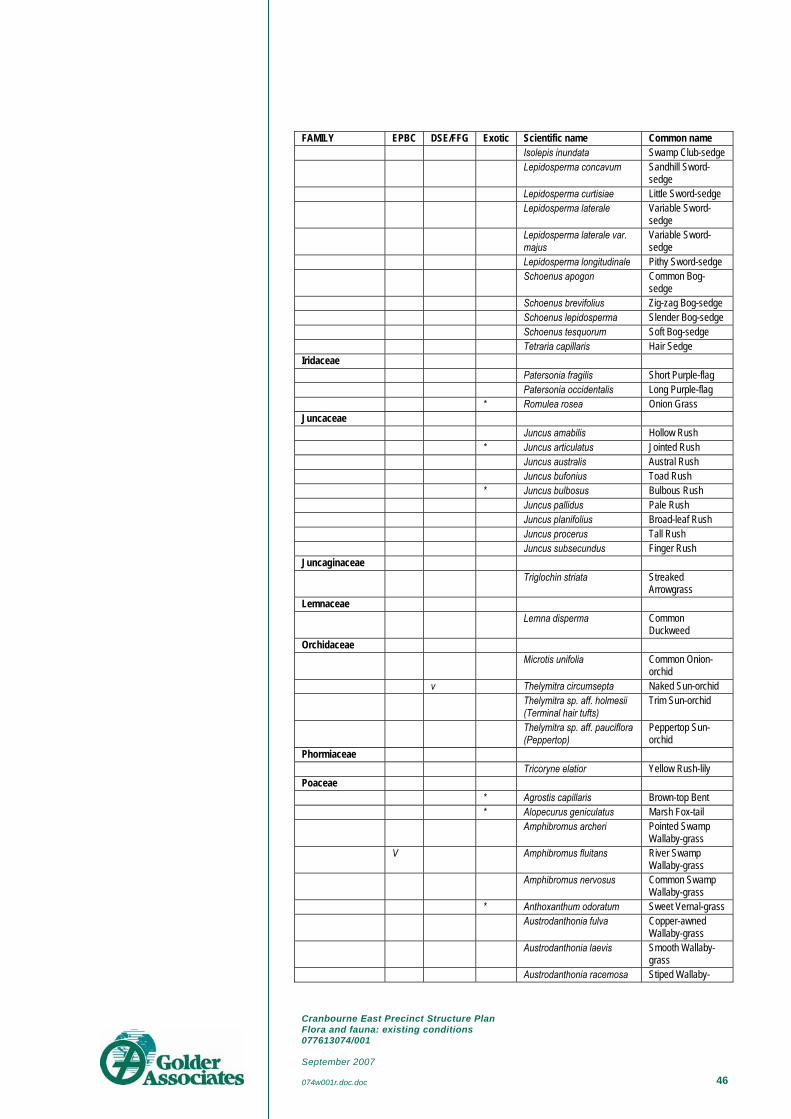
Cranbourne East Precinct Structure Plan Flora and fauna: existing conditions 077613074/001 September 2007 074w001r.doc.doc 46
FAMILY EPBC DSE/FFG Exotic Scientific name Common name Isolepis inundata Swamp Club-sedge Lepidosperma concavum Sandhill Sword-
sedge Lepidosperma curtisiae Little Sword-sedge Lepidosperma laterale Variable Sword-
sedge Lepidosperma laterale var.
majus Variable Sword-sedge
Lepidosperma longitudinale Pithy Sword-sedge Schoenus apogon Common Bog-
sedge Schoenus brevifolius Zig-zag Bog-sedge Schoenus lepidosperma Slender Bog-sedge Schoenus tesquorum Soft Bog-sedge Tetraria capillaris Hair Sedge Iridaceae Patersonia fragilis Short Purple-flag Patersonia occidentalis Long Purple-flag * Romulea rosea Onion Grass Juncaceae Juncus amabilis Hollow Rush * Juncus articulatus Jointed Rush Juncus australis Austral Rush Juncus bufonius Toad Rush * Juncus bulbosus Bulbous Rush Juncus pallidus Pale Rush Juncus planifolius Broad-leaf Rush Juncus procerus Tall Rush Juncus subsecundus Finger Rush Juncaginaceae Triglochin striata Streaked
Arrowgrass Lemnaceae Lemna disperma Common
Duckweed Orchidaceae Microtis unifolia Common Onion-
orchid v Thelymitra circumsepta Naked Sun-orchid Thelymitra sp. aff. holmesii
(Terminal hair tufts) Trim Sun-orchid
Thelymitra sp. aff. pauciflora (Peppertop)
Peppertop Sun-orchid
Phormiaceae Tricoryne elatior Yellow Rush-lily Poaceae * Agrostis capillaris Brown-top Bent * Alopecurus geniculatus Marsh Fox-tail Amphibromus archeri Pointed Swamp
Wallaby-grass V Amphibromus fluitans River Swamp
Wallaby-grass Amphibromus nervosus Common Swamp
Wallaby-grass * Anthoxanthum odoratum Sweet Vernal-grass Austrodanthonia fulva Copper-awned
Wallaby-grass Austrodanthonia laevis Smooth Wallaby-
grass Austrodanthonia racemosa Stiped Wallaby-
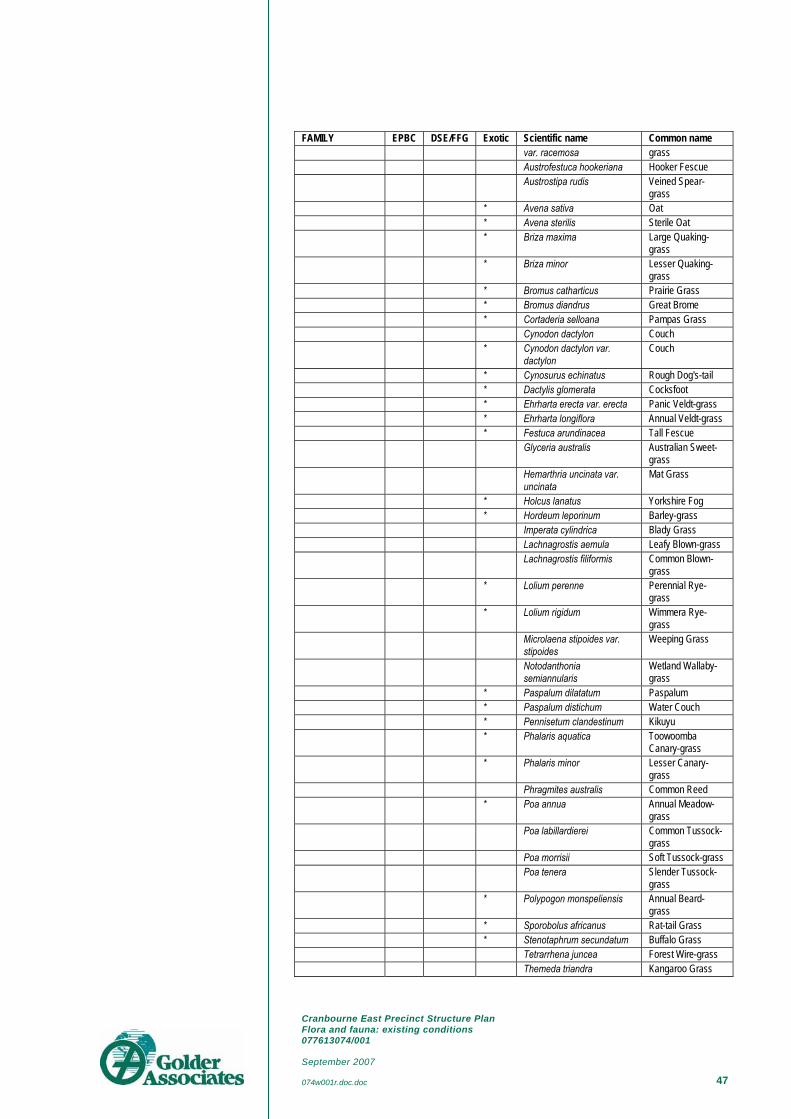
Cranbourne East Precinct Structure Plan Flora and fauna: existing conditions 077613074/001 September 2007 074w001r.doc.doc 47
FAMILY EPBC DSE/FFG Exotic Scientific name Common name var. racemosa grass
Austrofestuca hookeriana Hooker Fescue Austrostipa rudis Veined Spear-
grass * Avena sativa Oat * Avena sterilis Sterile Oat * Briza maxima Large Quaking-
grass * Briza minor Lesser Quaking-
grass * Bromus catharticus Prairie Grass * Bromus diandrus Great Brome * Cortaderia selloana Pampas Grass Cynodon dactylon Couch * Cynodon dactylon var.
dactylon Couch
* Cynosurus echinatus Rough Dog's-tail * Dactylis glomerata Cocksfoot * Ehrharta erecta var. erecta Panic Veldt-grass * Ehrharta longiflora Annual Veldt-grass * Festuca arundinacea Tall Fescue Glyceria australis Australian Sweet-
grass Hemarthria uncinata var.
uncinata Mat Grass
* Holcus lanatus Yorkshire Fog * Hordeum leporinum Barley-grass Imperata cylindrica Blady Grass Lachnagrostis aemula Leafy Blown-grass Lachnagrostis filiformis Common Blown-
grass * Lolium perenne Perennial Rye-
grass * Lolium rigidum Wimmera Rye-
grass Microlaena stipoides var.
stipoides Weeping Grass
Notodanthonia semiannularis
Wetland Wallaby-grass
* Paspalum dilatatum Paspalum * Paspalum distichum Water Couch * Pennisetum clandestinum Kikuyu * Phalaris aquatica Toowoomba
Canary-grass * Phalaris minor Lesser Canary-
grass Phragmites australis Common Reed * Poa annua Annual Meadow-
grass Poa labillardierei Common Tussock-
grass Poa morrisii Soft Tussock-grass Poa tenera Slender Tussock-
grass * Polypogon monspeliensis Annual Beard-
grass * Sporobolus africanus Rat-tail Grass * Stenotaphrum secundatum Buffalo Grass Tetrarrhena juncea Forest Wire-grass Themeda triandra Kangaroo Grass

Cranbourne East Precinct Structure Plan Flora and fauna: existing conditions 077613074/001 September 2007 074w001r.doc.doc 48
FAMILY EPBC DSE/FFG Exotic Scientific name Common name * Triticum aestivum Wheat Restionaceae Empodisma minus Spreading Rope-
rush Hypolaena fastigiata Tassel Rope-rush Lepyrodia muelleri Common Scale-
rush Typhaceae Typha domingensis Narrow-leaf
Cumbungi Typha orientalis Broad-leaf
Cumbungi Xanthorrhoeaceae
Lomandra filiformis Wattle Mat-rush Lomandra longifolia Spiny-headed Mat-
rush Lomandra longifolia subsp.
longifolia Spiny-headed Mat-rush
Xanthorrhoea minor subsp. lutea
Small Grass-tree
Amaranthaceae * Alternanthera pungens Khaki Weed * Amaranthus powellii Powell's Amaranth Apiaceae Centella cordifolia Centella * Daucus carota Carrot Eryngium vesiculosum Prickfoot * Foeniculum vulgare Fennel Hydrocotyle hirta Hairy Pennywort Platysace heterophylla var.
heterophylla Slender Platysace
Trachymene composita var. composita
Parsnip Trachymene
Asteraceae * Arctotheca calendula Cape Weed * Aster subulatus Aster-weed Cassinia aculeata Common Cassinia Cassinia arcuata Drooping Cassinia Centipeda cunninghamii Common
Sneezeweed * Chrysanthemoides
monilifera Boneseed
* Cirsium vulgare Spear Thistle * Conyza sumatrensis Tall Fleabane * Cotula coronopifolia Water Buttons * Delairea odorata Cape Ivy Euchiton collinus Creeping Cudweed * Gamochaeta purpurea Spiked Cudweed * Helminthotheca echioides Ox-tongue * Hypochoeris radicata Cat's Ear * Leontodon taraxacoides
subsp. taraxacoides Hairy Hawkbit
Olearia lirata Snowy Daisy-bush Ozothamnus ferrugineus Tree Everlasting Pseudognaphalium
luteoalbum Jersey Cudweed
Senecio biserratus Jagged Fireweed Senecio glomeratus Annual Fireweed

Cranbourne East Precinct Structure Plan Flora and fauna: existing conditions 077613074/001 September 2007 074w001r.doc.doc 49
FAMILY EPBC DSE/FFG Exotic Scientific name Common name Senecio quadridentatus Cotton Fireweed * Senecio vulgaris Common
Groundsel * Silybum marianum Variegated Thistle * Sonchus asper Rough Sow-thistle * Sonchus oleraceus Common Sow-
thistle * Taraxacum officinale spp.
agg. Garden Dandelion
* Tragopogon porrifolius Salsify * Vellereophyton dealbatum White Cudweed * Xanthium spinosum Bathurst Burr Brassicaceae * Capsella bursa-pastoris Shepherd's Purse * Lepidium africanum Common
Peppercress * Nasturtium officinale Watercress Callitrichaceae * Callitriche stagnalis Common Starwort Campanulaceae Lobelia anceps Angled Lobelia Lobelia pratioides Poison Lobelia Caryophyllaceae * Cerastium glomeratum Common Mouse-
ear Chickweed * Silene gallica var. gallica French Catchfly * Stellaria media Chickweed Casuarinaceae Allocasuarina littoralis Black Sheoak Chenopodiaceae * Atriplex prostrata Hastate Orache * Chenopodium album Fat Hen * Chenopodium murale Sowbane Clusiaceae Hypericum gramineum Small St John's
Wort Hypericum japonicum Matted St John's
Wort Convolvulaceae Dichondra repens Kidney-weed Dilleniaceae Hibbertia acicularis Prickly Guinea-
flower Droseraceae Drosera whittakeri subsp.
aberrans Scented Sundew
Epacridaceae Epacris impressa Common Heath Leucopogon ericoides Pink Beard-heath Leucopogon virgatus Common Beard-
heath Monotoca scoparia Prickly Broom-
heath Ericaceae * Erica arborea Tree Heath * Erica baccans Berry-flower Heath Euphorbiaceae Amperea xiphoclada var.
xiphoclada Broom Spurge
* Euphorbia peplus Petty Spurge

Cranbourne East Precinct Structure Plan Flora and fauna: existing conditions 077613074/001 September 2007 074w001r.doc.doc 50
FAMILY EPBC DSE/FFG Exotic Scientific name Common name Ricinocarpos pinifolius Wedding Bush Fabaceae Aotus ericoides Common Aotus Bossiaea cinerea Showy Bossiaea * Chamaecytisus palmensis Tree Lucerne * Genista linifolia Flax-leaf Broom * Genista monspessulana Montpellier Broom Kennedia prostrata Running Postman * Lotus subbiflorus Hairy Bird's-foot
Trefoil * Medicago arabica Spotted Medic * Medicago polymorpha Burr Medic * Psoralea pinnata Blue Psoralea Pultenaea stricta Rigid Bush-pea * Trifolium campestre var.
campestre Hop Clover
* Trifolium fragiferum var. fragiferum
Strawberry Clover
* Trifolium repens var. repens White Clover * Trifolium subterraneum Subterranean
Clover * Ulex europaeus Gorse * Vicia sativa Common Vetch * Vicia tetrasperma Slender Vetch Viminaria juncea Golden Spray Fumariaceae * Fumaria muralis subsp.
muralis Wall Fumitory
Gentianaceae * Centaurium erythraea Common Centaury Geraniaceae * Erodium moschatum Musky Heron's-bill * Geranium dissectum Cut-leaf Cranesbill * Geranium molle var. molle Dovesfoot Goodeniaceae Goodenia humilis Swamp Goodenia Goodenia ovata Hop Goodenia Haloragaceae Gonocarpus micranthus
subsp. micranthus Creeping Raspwort
Gonocarpus tetragynus Common Raspwort Myriophyllum crispatum Upright Water-
milfoil Myriophyllum pedunculatum Mat Water-milfoil Myriophyllum simulans Amphibious Water-
milfoil Lamiaceae * Prunella vulgaris Self-heal Lauraceae Cassytha glabella Slender Dodder-
laurel Loranthaceae Amyema pendula Drooping Mistletoe Lythraceae Lythrum hyssopifolia Small Loosestrife Malvaceae * Malva parviflora Small-flower
Mallow * Modiola caroliniana Red-flower Mallow

Cranbourne East Precinct Structure Plan Flora and fauna: existing conditions 077613074/001 September 2007 074w001r.doc.doc 51
FAMILY EPBC DSE/FFG Exotic Scientific name Common name Menyanthaceae Villarsia exaltata Erect Marsh-flower Villarsia reniformis Running Marsh-
flower Mimosaceae # Acacia longifolia subsp.
longifolia Sallow Wattle
# Acacia longifolia subsp. sophorae
Coast Wattle
Acacia mearnsii Black Wattle Acacia melanoxylon Blackwood Acacia oxycedrus Spike Wattle Acacia paradoxa Hedge Wattle Acacia pycnantha Golden Wattle Acacia verticillata Prickly Moses Myrtaceae # Eucalyptus botryoides Southern
Mahogany Eucalyptus camaldulensis River Red-gum Eucalyptus cephalocarpa Mealy Stringybark Eucalyptus obliqua Messmate
Stringybark Eucalyptus ovata Swamp Gum Eucalyptus radiata subsp.
radiata Narrow-leaf Peppermint
Eucalyptus viminalis Manna Gum Eucalyptus viminalis subsp.
pryoriana Coast Manna-gum
Leptospermum continentale Prickly Tea-tree Leptospermum myrsinoides Heath Tea-tree Melaleuca ericifolia Swamp Paperbark Melaleuca squarrosa Scented Paperbark Onagraceae Epilobium billardierianum Variable Willow-
herb Epilobium hirtigerum Hairy Willow-herb Oxalidaceae * Oxalis corniculata Creeping Wood-
sorrel Oxalis exilis Shady Wood-sorrel Oxalis perennans Grassland Wood-
sorrel * Oxalis pes-caprae Soursob * Oxalis purpurea Large-flower Wood-
sorrel Phytolaccaceae * Phytolacca octandra Red-ink Weed Pittosporaceae Billardiera scandens Common Apple-
berry # Pittosporum undulatum Sweet Pittosporum Plantaginaceae * Plantago coronopus Buck's-horn
Plantain * Plantago lanceolata Ribwort * Plantago major Greater Plantain Polygalaceae Comesperma calymega Blue-spike Milkwort Polygonaceae * Acetosella vulgaris Sheep Sorrel

Cranbourne East Precinct Structure Plan Flora and fauna: existing conditions 077613074/001 September 2007 074w001r.doc.doc 52
FAMILY EPBC DSE/FFG Exotic Scientific name Common name Persicaria decipiens Slender Knotweed * Rumex conglomeratus Clustered Dock * Rumex crispus Curled Dock Portulacaceae Neopaxia australasica White Purslane Portulaca oleracea Common Purslane Primulaceae * Anagallis arvensis Pimpernel Proteaceae Banksia marginata Silver Banksia Ranunculaceae Clematis aristata Mountain Clematis Ranunculus amphitrichus Small River
Buttercup * Ranunculus muricatus Sharp Buttercup * Ranunculus repens Creeping Buttercup Rhamnaceae Spyridium parvifolium Dusty Miller Rosaceae Acaena echinata Sheep's Burr Acaena novae-zelandiae Bidgee-widgee * Cotoneaster pannosus Velvet Cotoneaster * Crataegus monogyna Hawthorn * Prunus cerasifera Cherry Plum * Rosa rubiginosa Sweet Briar * Rubus anglocandicans Blackberry * Rubus fruticosus spp. agg. Blackberry Rubus parvifolius Small-leaf Bramble * Rubus ulmifolius Blackberry Rubiaceae Coprosma quadrifida Prickly Currant-
bush * Coprosma repens Mirror Bush * Galium aparine Cleavers Rutaceae Boronia parviflora Swamp Boronia Santalaceae Exocarpos cupressiformis Cherry Ballart Scrophulariaceae Gratiola pubescens Glandular
Brooklime * Veronica arvensis Wall Speedwell Solanaceae * Lycium ferocissimum African Box-thorn Solanum aviculare Kangaroo Apple Solanum laciniatum Large Kangaroo
Apple * Solanum nigrum Black Nightshade Solanum prinophyllum Forest Nightshade Urticaceae * Urtica urens Small Nettle Violaceae Viola hederacea Ivy-leaf Violet
Data From: Flora Information System, Biodiversity and Natural Resources, DSE - May 2005 - © Viridans Biological Databases