Embed Size (px)
Citation preview
Expert witness report – flora and fauna considerations
Camerons Road, Coimadai
Dr Melanie Birtchnell
19 January 2015
Appendix 2
ADDENDUM Preliminary Flora and Fauna Assessment – Camerons Road Coimadai
Oekologie i
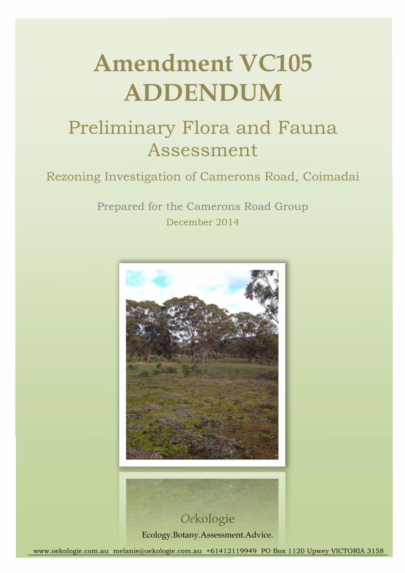
Amendment VC105 ADDENDUM
Preliminary Flora and Fauna
Assessment Rezoning Investigation of Camerons Road, Coimadai
Prepared for the Camerons Road Group
December 2014
Oekologie Ecology.Botany.Assessment.Advice.
www.oekologie.com.au [email protected] +61412119949 PO Box 1120 Upwey VICTORIA 3158
ADDENDUM Preliminary Flora and Fauna Assessment – Camerons Road Coimadai
Oekologie ii
! 2014 Oekologie
This publication is copyright. It may only be used in accordance with the agreed terms of the
commission. Except as provided for by the Copyright Act 1968, no part of this publication may
be reproduced, stored in a retrieval system, or transmitted in any form or by any means, without
prior written permission of Oekologie.
Document control
This is a controlled document. Details of the document ownership, status and revision are
provided below. All comments or requests for changes should be addressed to the document
owner.
Bioregion: Central Victorian Uplands
Owner Oekologie
Author Dr Melanie Birtchnell
Distributor David Merrett – Isis Planning
Document history:
Version Status Authored Date
Draft Draft M. Birtchnell 1 December 2014
Final Final M. Birtchnell 4 December 2014
ADDENDUM Preliminary Flora and Fauna Assessment – Camerons Road Coimadai
Oekologie iii
Contents
ACKNOWLEDGMENTS ......................................................................................................................IV
SUMMARY ................................................................................................................................................ 1
1. INTRODUCTION ............................................................................................................................. 2
1.1 PROJECT BACKGROUND ................................................................................................................. 2
1.2 SCOPE OF ASSESSMENT .................................................................................................................. 2
1.3 STUDY AREA................................................................................................................................... 2
2. METHOD............................................................................................................................................ 3
2.1 MAPPING ........................................................................................................................................ 3
3. RESULTS AND DISCUSSION ...................................................................................................... 3
3.1 SITE CONTEXT................................................................................................................................. 3
3.2 FLORA ............................................................................................................................................. 3
3.2.1 Definition of native vegetation ................................................................................................ 3
3.2.2 Location Risk............................................................................................................................ 3
3.2.3 Vegetation Quality Assessments and the Risk-based Pathway............................................... 5
4. LEGISLATIVE AND POLICY IMPLICATIONS ...................................................................... 11
4.1 STATE ............................................................................................................................................ 11
4.1.1 Planning and Environment Act 1987 ................................................................................... 11
5. POTENTIAL IMPACTS AND MITIGATION .......................................................................... 13
6. CONCLUSION ................................................................................................................................ 13
REFERENCES .......................................................................................................................................... 14
Tables and Figures
TABLE 1. RISK-BASED PATHWAYS FOR REMNANT PATCHES OF NATIVE VEGETATION (DEPI 2013, P. 19) ................ 5
FIGURE 1. LOCATION RISK MAP USED TO INFORM THE RISK-BASED PATHWAY OF APPLICATIONS TO REMOVE, LOP
OR DESTROY NATIVE VEGETATION UNDER CLAUSE 52.17 AS PER THE GUIDELINES (DEPI 2013). ................... 4
FIGURE 2. LOCATION CLASSIFICATION AND INDICATIVE BUILDING ENVELOPES FOR PROPERTIES G, L AND K. ....... 6
FIGURE 3. LOCATION CLASSIFICATION AND INDICATIVE BUILDING ENVELOPES FOR PROPERTIES I, M, H, Q & J..... 7
FIGURE 4. LOCATION CLASSIFICATION AND INDICATIVE BUILDING ENVELOPES FOR PROPERTIES A AND O. ........... 8
FIGURE 5. LOCATION CLASSIFICATION AND INDICATIVE BUILDING ENVELOPES FOR PROPERTIES C, P AND B. ........ 9
FIGURE 6. LOCATION CLASSIFICATION AND INDICATIVE BUILDING ENVELOPES FOR PROPERTIES D, E AND F. ...... 10
ADDENDUM Preliminary Flora and Fauna Assessment – Camerons Road Coimadai
Oekologie iv
Acknowledgments
Gratitude is extended to:
• the Camerons Road Group, particularly Bob Mundy, for providing contact details for
Camerons Road residents and access to properties.
• Moorabool Shire Council officers, namely: Gavin Alford, Lisa Gervasoni, Satwinder
Sandhu, Sean Greer and Justin Horne for providing clear expectations of what Council
require to assess the rezoning application.
• Hamish Allan (Program Manager – Bushfire Planning and Design), Terramatrix.
• John Eastwood (Analyst) Terramatrix for assistance with GIS mapping.
• David Merrett, Isis Planning.
ADDENDUM Preliminary Flora and Fauna Assessment – Camerons Road Coimadai
Oekologie 1
Summary
Oekologie was commissioned by Terramatrix Pty. Ltd. and the Camerons Road Group to
undertake a preliminary flora and fauna assessment of a number of properties along Camerons
Road, Darley - Coimadai to assist an investigation into potential rezoning of the land. Since the
preliminary report was submitted, the Victorian government introduced an amendment to the
Victoria Planning Provisions (Amendment VC105) relating to native vegetation and biodiversity.
The Amendment VC105 Addendum to the Preliminary Flora and Fauna Assessment –
Camerons Road Coimadai aimed to consider the proposed rezoning of the subject land in light of
the updated native vegetation and biodiversity provisions in accordance with amendment
VC105. The potential impacts and mitigation measures of the proposed rezoning have not
changed following the gazettal of Amendment VC105. The results of flora and fauna
assessments continue to be relevant in informing planning decisions notwithstanding the
introduction of the new, amended legislation. The proposed rezoning satisfies the requirements
and decision guidelines introduced in Amendment VC105.
ADDENDUM Preliminary Flora and Fauna Assessment – Camerons Road Coimadai
Oekologie 2
1. Introduction
1.1 Project background
Oekologie was commissioned by Terramatrix Pty. Ltd. and the Camerons Road Group to
undertake a preliminary flora and fauna assessment (Oekologie 2012) of a number of
properties along Camerons Road, Darley - Coimadai to assist an investigation into potential
rezoning of the land. The Amendment VC105 Addendum is to be read in conjunction with
the resultant report (Oekologie November 2012). The aim of the preliminary assessment was
to identify biodiversity values within the Study Area that could inform planning processes
and address concerns raised during historical assessments of the rezoning proposal.
Since the preliminary assessment was conducted, the Victorian Government amended the
Victoria Planning Provisions with Amendment VC105 that affected native vegetation and
biodiversity provisions in the State Planning Provisions. The aim of the current Addendum
was to review the proposed rezoning in the context of Amendment VC105 to ensure that the
requirements of the amendment were addressed by the rezoning application.
Amendment VC105 is implemented via the incorporated document Permitted clearing of
native vegetation – Biodiversity Assessment Guidelines (‘the Guidelines’) (DEPI 2013) and
refers to unincorporated maps based on models and/or datasets. The Guidelines apply if a
proposal triggers the need for a planning permit under Clause 52.16 Native Vegetation
Precinct Plan or (more commonly) Clause 52.17 Native Vegetation of the State Planning
Provisions. A permit to remove, lop or destroy Victorian native vegetation also may be
required under local planning controls, namely via planning overlays.
1.2 Scope of assessment
The objectives of the current Addendum were to:
- Review the Preliminary Flora and Fauna Assessment in the context of Amendment
VC105.
- Consider whether the proposed rezoning and potential future subdivision of the subject
land is consistent with Amendment VC105.
- Determine whether additional potential impacts arise or mitigation measures are required
in the context of Amendment VC105.
1.3 Study Area
The Study Area is located in the Central Victorian Uplands bioregion approximately 6km
north of Bacchus Marsh, Victoria. The Study Area is a corridor of land east and west of
Camerons Road between Darley and Coimadai encompassing approximately 470 hectares of
private property and adjacent road reserves. The Study Area is bound to the east by
Goodman Creek and an extractive industry area, to the north by Seereys Road and Camerons
Road, and to the south and west by the Lerderderg Gorge Road. The Lerderderg State Park is
located to the west of the Study Area; a sand mining area of State significance lies to the east
of the Study Area.
Camerons Road functions as a spine to the Study Area; the road follows the main ridge
between the Lerderderg River (west) and Goodman Creek (east). Properties on the east side
of Camerons Road are undulating to a generally sharp drop to the narrow valley of Goodman
Creek. Properties on the west side also are undulating; they support a north-south gully that
ADDENDUM Preliminary Flora and Fauna Assessment – Camerons Road Coimadai
Oekologie 3
intersects the properties before a sharp escarpment falls to the wide valley of the Lerderderg
River. Generally, properties east of Camerons Road are less timbered than those to the west
and support highly modified exotic vegetation over most of their area.
The study area is within the:
• Central Victorian Uplands bioregion;
• Werribee River Basin;
• Port Phillip and Westernport CMA; and
• Moorabool Shire.
2. Method
2.1 Mapping
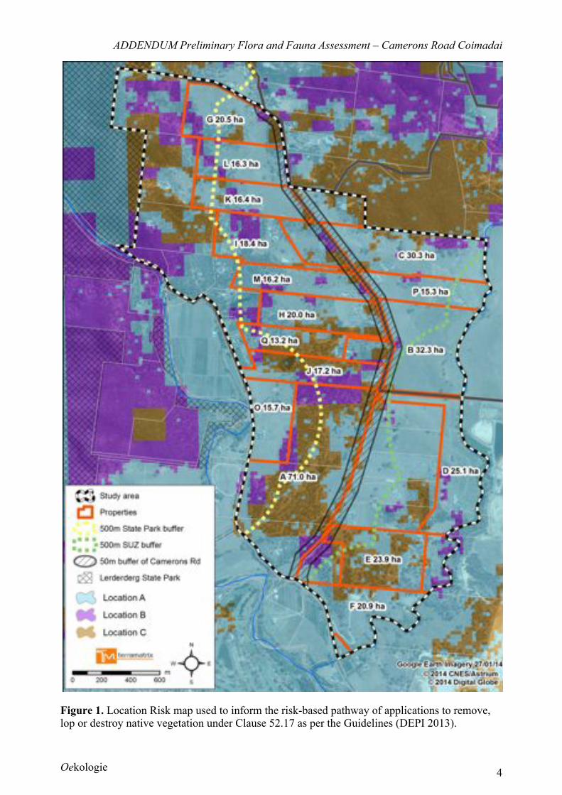
Mapping was provided by the Department of Environment and Primary Industries; the map
required to address the aim of the Addendum was the Native Vegetation Location Risk map
(NVR2013_LOCRISK_V2).
3. Results and Discussion
3.1 Site context
The Study Area was surrounded by a mix of landscapes: to the east, the Study Area was
bounded mostly by highly modified landscapes; to the west, the Area was bounded mostly by
relatively intact, native vegetation within the Lerderderg State Park, although disturbed
agricultural landscapes occur in the valley between the State Park and the Study Area. Areas
in the east of the Study Area primarily supported degraded vegetation whilst areas to the west
generally were more intact where woodland was extant.
3.2 Flora
3.2.1 Definition of native vegetation
The definition of native vegetation was altered under Amendment VC105. Vegetation that
was mapped as native vegetation in the Preliminary Flora and Fauna Assessment also
meets the new definition. Thus, patches of native vegetation in Oekologie (2012) also are
relevant to the Addendum and are in accordance with Amendment VC105.
3.2.2 Location Risk
If a rezoning of the subject land was approved, it is likely that a permit would be required
under Clause 52.17 (as well as any local planning controls) if it was considered necessary
or desirable to remove, lop or destroy native vegetation. In accordance with the Guidelines,
the first step would be to determine the risk-based pathway (Figure 1).
ADDENDUM Preliminary Flora and Fauna Assessment – Camerons Road Coimadai
Oekologie 4
Figure 1. Location Risk map used to inform the risk-based pathway of applications to remove, lop or destroy native vegetation under Clause 52.17 as per the Guidelines (DEPI 2013).
ADDENDUM Preliminary Flora and Fauna Assessment – Camerons Road Coimadai
Oekologie 5
Location Risk and the Risk-based Pathway
Sites are mapped by Victoria’s Department of Environment and Primary Industries (DEPI)
as Location A, B or C. These location classifications are applied to the area of native
vegetation proposed for removal, lopping or destruction in accordance with the Guidelines
to determine which risk-based pathway the application to remove, lop or destroy native
vegetation would require under Clause 52.17 (Table 1). Remnant patches of native
vegetation are assessed differently to applications to remove, lop or destroy scattered trees
(see DEPT 2013); within the study area, most applications that would trigger a permit
under Clause 52.17 would impact remnant patches of native vegetation (Table 1) rather
than scattered trees (see DEPI 2013, p. 19).
Table 1. Risk-based pathways for remnant patches of native vegetation (DEPI 2013, p. 19)
Location
Extent* Location A Location B Location C
< 0.5 hectares Low Low High
! 0.5 hectares and < 1 hectare Low Moderate High
! 1 hectare Moderate High High
* For the purpose of determining the risk-based pathway of an application to remove native vegetation the
extent includes any other native vegetation that was permitted to be removed on the same property with the
same ownership as the native vegetation to be removed, where the removal occurred in the five year period
before an application to remove native vegetation is lodged.
3.2.3 Vegetation Quality Assessments and the Risk-based Pathway
Oekologie (2012) provided Vegetation Quality Assessments that were required under the
(superseded) Victoria’s Native Vegetation Management: a Framework for Action (‘the
Framework’) (NRE 2002). The new Guidelines require Vegetation Quality Assessments
(also known as a Habitat Hectare assessments: an indexed calculation of vegetation
condition and extent of native vegetation) only for applications that are Moderate or High
risk-based pathway applications. However, the Habitat Hectare scores provided in
Oekologie (2012) may be useful if an applicant following the low risk-based pathway (that
uses modelled vegetation condition scores) would like to test the condition of native
vegetation provided in the modelled spatial data (DEPI 2013). In this way, the vegetation
condition scores provided in the report, or in subsequent Vegetation Quality/Habitat
Hectare assessments, would be considered when assessing the application to remove, lop
or destroy native vegetation, instead of the DEPI modelled vegetation condition score.
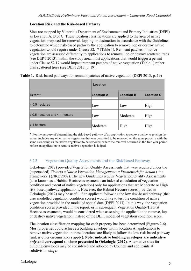
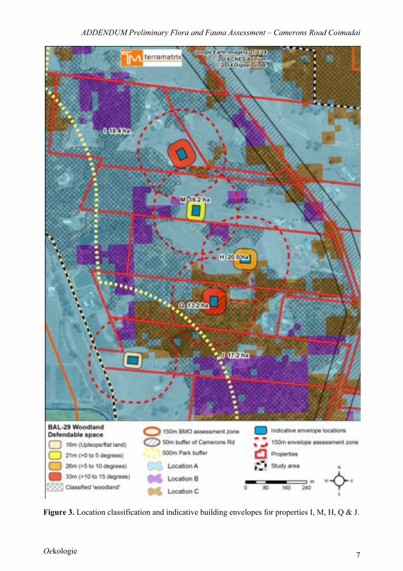
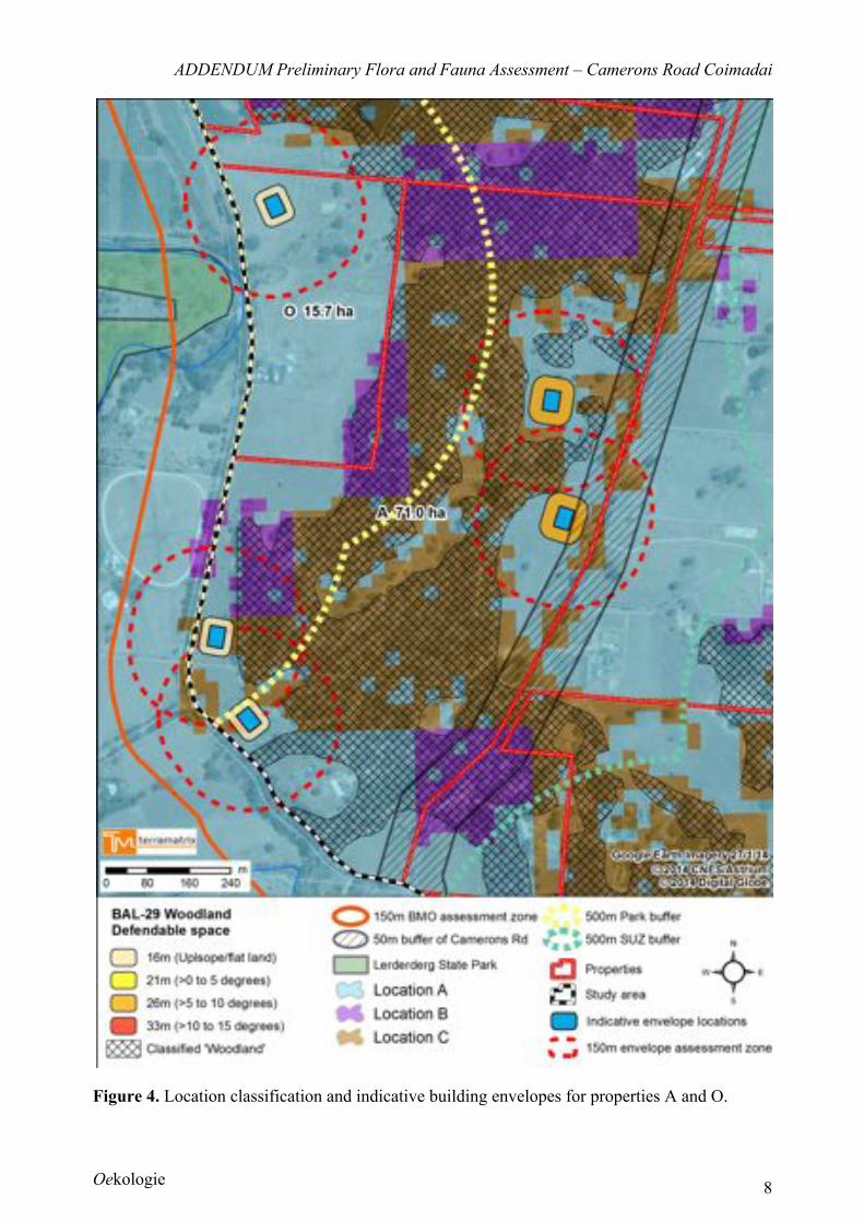
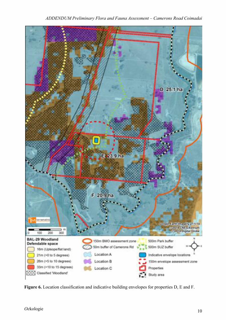
The location classification mapping for each property has been determined (Figures 2-6).
Most properties could achieve a building envelope within location A; applications to
remove native vegetation in these locations are likely to follow the low risk-based pathway
(unless other circumstances apply). Note: indicative building envelopes are indicative
only and correspond to those presented in Oekologie (2012). Alternative sites for
building envelopes may be considered and adopted by Council and applicants at
subdivision stage.

ADDENDUM Preliminary Flora and Fauna Assessment – Camerons Road Coimadai
Oekologie 6
Figure 2. Location classification and indicative building envelopes for properties G, L and K.
ADDENDUM Preliminary Flora and Fauna Assessment – Camerons Road Coimadai
Oekologie 7
Figure 3. Location classification and indicative building envelopes for properties I, M, H, Q & J.
ADDENDUM Preliminary Flora and Fauna Assessment – Camerons Road Coimadai
Oekologie 8
Figure 4. Location classification and indicative building envelopes for properties A and O.
ADDENDUM Preliminary Flora and Fauna Assessment – Camerons Road Coimadai
Oekologie 9
Figure 5. Location classification and indicative building envelopes for properties C, P and B.
ADDENDUM Preliminary Flora and Fauna Assessment – Camerons Road Coimadai
Oekologie 10
Figure 6. Location classification and indicative building envelopes for properties D, E and F.
ADDENDUM Preliminary Flora and Fauna Assessment – Camerons Road Coimadai
Oekologie 11
4. Legislative and Policy Implications
The following key pieces of biodiversity legislation and policy were reviewed to consider the
implications of Amendment VC105 on the rezoning application (see Oekologie 2012 for
consideration of broader legislative and policy implications of the proposal).
• Victoria Planning Provisions – specifically Clause 52.17, Overlays and Clause
66.02 in the relevant Planning Scheme.
4.1 State
4.1.1 Planning and Environment Act 1987
The Planning and Environment Act 1987 controls the planning and development of land in
Victoria, and provides for the development of planning schemes for all municipalities.
Standard sections are contained in all planning schemes - the Victoria Planning Provisions
(VPP). These State sections include the State Planning Policy Framework (SPPF Clauses
10 to 19), Particular Provisions (Clauses 51 to 56) and General Provisions (Clauses 60 to
67).
Of particular relevance to rezoning (and generally consequent) proposals are the native
vegetation provisions, which are contained in several sections of the State sections of all
Planning Schemes, and may also be included in the local section (zoning and overlays).
Clause 52.17 Native Vegetation (Amendment VC105) requires a planning permit to
remove, destroy or lop native vegetation including dead native vegetation, however certain
exemptions may apply. The Guidelines (DEPI 2013) form the modus operandi for
implementing Amendment VC105 through Clause 52.17. The need for a permit to remove
native vegetation may be also be triggered by local planning controls including planning
overlays.
Implications for the project
The proposed rezoning in its own right does not propose vegetation removal, however it
was prudent to assess the potential impacts of the implementation of the proposed rezoning
prior to approving the rezoning. In this way, all tiers of Government could assess fully the
proposal and what the long-term implications of the rezoning could be, if each property
was permitted to subdivide and develop additional dwellings in accordance with the
proposal. In the proposed rezoning, there was scope on most properties to achieve
additional lot(s) whilst avoiding impacting on significant biodiversity values (Oekologie
2012); where native vegetation cannot be avoided, it was determined most planning permit
applications are likely to follow the low risk-based pathway (see table 1 and figures 2-6) .
Indeed, the vegetation that may be removed is less significant than that being retained and,
if adequate controls are applied, vegetation that is retained may be more appropriately
managed. Native vegetation offsets would be required as part of a planning permit
application where Clause 52.17 applies and/or may be required under specific local
planning controls.
The impact of any future development on adjacent roadsides and road reserves must be
considered as these support patches of remnant vegetation and a number of significant
floral species: provision of access to most additional lots could be designed to avoid
removal of roadside native vegetation.
ADDENDUM Preliminary Flora and Fauna Assessment – Camerons Road Coimadai
Oekologie 12
It is proposed that a planning permit will be required for subdivision and new dwellings.
This would define more clearly the location of the building envelopes and any areas of
associated impacts. The planning permit application stage may require further surveys
(namely targeted surveys) be conducted. Overall, the potential for improving biodiversity
values exceeds the potential impacts of the proposed subdivisions if local planning controls
for the rezoned land are adequate. For example, on-title Land Management Plans would
provide Council and other Government Departments opportunities to see implementation
of appropriate management that otherwise may not exist. The proposed rezoning offers an
opportunity to enhance and achieve biodiversity conservation outcomes without placing
additional pressures on higher significance vegetation.
ADDENDUM Preliminary Flora and Fauna Assessment – Camerons Road Coimadai
Oekologie 13
5. Potential Impacts and Mitigation
Consideration of Amendment VC105 indicated that the proposed rezoning of the subject land
was consistent with the objectives of Clause 52.17 Native Vegetation. The potential impacts of
rezoning, and potential impacts of future applications to develop additional building envelopes
on the subject land, had not increased (nor altered) following the introduction of Amendment
VC105. Thus, potential impacts and mitigation of the proposed rezoning were consistent with
Oekologie (2012). Importantly, the rezoning continues to present an opportunity to realise
improved vegetation condition and biodiversity outcomes.
6. Conclusion
Field assessments identified that patches of remnant native vegetation were extant across the
Study Area (Oekologie 2012). Amendment VC105 redefined native vegetation, however patches
of remnant native vegetation mapped within the Study Area also met the new definition. The
Habitat Hectare values of these remnant patches may be useful in any future planning permit
application required under Clause 52.17 and/or local planning controls.
The introduction of the Guidelines (DEPI 2013) (and Amendment VC105) did not affect
(increase nor decrease) the potential impacts of the proposed rezoning or future sensitive
development of new lots. Indeed, it may be considered that the introduction Amendment VC105
has increased the ease with which future planning permit applications may be granted (although
local planning controls also may apply) compared to the application process associated with the
Framework (NRE 2002). Most properties could be subdivided and, with sensitive building
envelope siting, could support additional building envelope(s) that would be considered low risk
according to the Guidelines (DEPI 2013). Importantly, the proposed rezoning continues to offer
a unique opportunity to achieve improved condition of significant vegetation and biodiversity
outcomes.
ADDENDUM Preliminary Flora and Fauna Assessment – Camerons Road Coimadai
Oekologie 14
References
DEPI (2013). Permitted Clearing Regulations – Biodiversity Assessment Guidelines. The State
of Victoria Department of Environment and Primary Industries, Melbourne.
NRE (2002). Victoria's Native Vegetation Management: A Framework for Action. Department of
Natural Resources & Environment, Victoria.
Oekologie (2012). Preliminary Flora and Fauna Assessment - Rezoning Investigation of
Camerons Road, Coimadai. November 2012. Oekologie. Unpublished report.
Terramatrix (2012). Bushfire Development Report for the proposed rezoning of properties in
Camerons Road, Bacchus Marsh. November 2012. Terramatrix PL. Unpublished report.