Embed Size (px)
Citation preview
applied sciences
Article
Flooding Conceptual Review:Sustainability-Focalized Best Practices in Nigeria
Giuseppe T. Cirella 1,* ID and Felix O. Iyalomhe 2,3 ID
1 Chair of Transport Economics, Faculty of Economics, University of Gdansk, 81-824 Sopot, Poland2 Polo Centre of Sustainability, 18100 Imperia, Italy; [email protected] Department of Environmental Science and Natural Resource Management,
National Open University of Nigeria, Plot 91, Cadastral, Abuja 900001, Nigeria* Correspondence: [email protected]; Tel.: +48-585231258
Received: 13 July 2018; Accepted: 3 September 2018; Published: 5 September 2018�����������������
Abstract: Nigeria’s 196 million people is the third fastest growing population in the world;the interactions of this build up has left an indelible mark on the landscape and environment.Urbanization, deforestation, flooding, desertification, over population and all levels of pollutionare resultant effects of this interaction with the environment. These changes directly relate to aseemingly endless desire for food, shelter, recreation and infrastructural facilities and urbanization ingeneral. This has placed enormous pressure on ecosystem stability and environmentally sound livingconditions. Flooding has become an annual event for Nigerian cities—where it consistently causeseconomic problems in the rainy season. Effort made by the government and residents to forestallthis problem has produced sub-optimal results. There is a need to adopt more proactive, standardand reliable procedures that can offer sustainable outcomes and restore the socioeconomic growth ofurban areas. Frequency of flooding is due to a number of factors relating to differing climatologicalpatterns of precipitation, urban growth and increase in paved surfaces. The aim of this review is toutilize a conceptual framework to assess and identify areas within Nigeria prone to flooding andexamine possible means of alleviating damage and harm.
Keywords: flood risk awareness; disaster mitigation; preparedness; environmental sustainability;Nigeria
1. Introduction
Flooding is one of the most common natural environmental hazards in the developing world.In Nigeria, a wide range of natural and human induced flood events, often relating to communalviolence, continues to force displacement and fatalities [1]. Flooding is a general temporal state ofpartial or fully submersed inundation from overflows of inland or tidal waters or from infrequent andrapid accumulation of runoff [2,3]. It is one of the most widespread and destructive natural perils,affecting approximately 250 million people worldwide and causing US$ 40 billion in losses on anannual basis [4]. They affect all types of settlement, including: small villages, midsized market towns,service centers, cities and greater metropolitan areas. In many parts of the world, people moving fromrural areas to cities, or within cities, often settle in areas that are highly exposed to flood, thereby makingthem highly vulnerable if no flood defense mechanism is setup [5]. The pursuit for survival and controlover the environment has partially enabled human beings the capacity to grow in terms of urbanization,industrialization and development in general. This development, however, has not occurred withoutenvironmental backlash, that is, human activities that contribute to the continuous environmentaldeterioration and counter-response manifested in the form of nature-based resistance and resurgence.The result or implication of this development is a closer proximity, or encroachment, on natural
Appl. Sci. 2018, 8, 1558; doi:10.3390/app8091558 www.mdpi.com/journal/applsci
Appl. Sci. 2018, 8, 1558 2 of 14
climatic phenomenon, including: flooding, erosion, wildfires, hurricanes, tornadoes, volcanic eruptions,earthquakes, tsunamis and any other geologic process. In addition, examples of non-geologic processes,such as pollution, deforestation and cementification of urban areas play a major role in this reactivebacklash. In general, environmental problems have been better managed in developed countries andurban centers.
This review focuses on challenges and prospects of flooding within the nation of Nigeria. Acrossthe world, floodwaters pose immediate dangers to human health, causing about one third of all deaths,injuries and damage from natural disasters [6,7]. Records of these devastating flood impacts arebountiful throughout Africa, with a significant amount occurring in West and Central Africa.
2. Flood Impact in Nigeria
In Nigeria, flooding displaces more people than any other natural disaster with an estimated 20%of the population at risk [8,9]. This perennial problem consistently results in death and displacementof communities. The number of flood-related fatalities has varied significantly from flood-to-floodwith the percentage of displaced versus killed persons not conclusive in the literature. Groundworkinto verifying the correlative connection between the two would require an in-depth data miningcheck on fatalities and an analytical breakdown of each flood occurrence to date. Using this method,we performed a preliminary calculation of 34 floods and found results ranging from 0.0% to 2.8% forlarger-scaled floods versus 0.0% to 42.8% for smaller-scaled ones. In about half of the flood eventsno fatalities occurred. The higher smaller-scaled percentages related to examples like the event from7 August 2005 in Jigawa State in which 7 persons were displaced and 3 died. On the other hand, at thelarger-end of the scale, in 2012 for example, flooding caused more than two million to be displacedwith hundreds of fatalities—resulting in more deaths, but at a much lower percentage. In any case,flood fatalities warrant further research, beyond the scope of this review; they alarming pose a realthreat to citizenry and stress the continued need into best practices nation-wide.
Equally concerning, flooding has become increasingly severe and more frequent throughout thecountry. Unfortunately, impacts are felt more by the urban poor where recovery is unlikely withoutexternal aid [10]. As a result, the urban poor are most vulnerable since they often build homes alonga floodplain. Flooding in various parts of Nigeria have caused four notable problems: (1) forcedmillions to relocate, (2) destroyed businesses, (3) polluted water resources and (4) increased risk ofdisease [11,12]. In the last few decades, high annual seasonal rainfall prediction (SRP), conductedby the Nigerian Meteorological Agency, affirm irregular flooding and consequential suffering formany parts of the country. The national response to SRP has been anything but communicative orcomprehensive. Flood management, by in large, is a reactionary aftereffect with relief provided tounfortunate victims. Management is limited to waiting for an event to occur with limited SRP masscommunication, hazard prevention or associated risk reduction efforts [3,13]. The notion of flood riskreduction largely depends on the amount of available information and regional knowledge affectingongoing events. A lack of accurate hydrometeorological data affects the uncertainties associatedwith flash flooding and relating tidal wave hazards. There is, therefore, an urgent need to introducemitigation measures to ensure that these areas are protected so flooding can be minimized. Demandsfor the use of modern day techniques identify steps that will help government and relief agenciesidentify flood prone areas and help with future flood prevention.
Several researchers have examined the utilization of remote sensing and geographic informationsystem (GIS) data in regards to flood risk [7,13]. Ologunorisa and Abawua [14] applied GIS withina flood risk assessment analysis to a wide variety of countries around the world. Their researchformulated risk assessment into five categories: (1) meteorological parameters, (2) hydrologicalparameters, (3) socioeconomic factors, (4) combination of hydrometeorological and socioeconomicfactors and (5) GIS predictive testing. In reference to the latter, Okoduwa’s [15] research utilized andidentified specific GIS itemized variables (e.g., land use, land cover and soil strength) correlating withvarying areas of flood prone probability (i.e., low, medium and high levels). This predictive research
Appl. Sci. 2018, 8, 1558 3 of 14
overlay focalized urban flooding within Benin City, Nigeria and created a digital database for landrelief mapping. To date, for Nigeria as a whole, there are limited flood risk maps; two example mapsof flood prone areas in Nigeria built in GIS can be found in Figure 1.
Appl. Sci. 2018, 8, x FOR PEER REVIEW 3 of 14
relief mapping. To date, for Nigeria as a whole, there are limited flood risk maps; two example maps
of flood prone areas in Nigeria built in GIS can be found in Figure 1.
Figure 1. Examples of flood mapping within Nigeria. Left: 2001; Right: 2014 (Adapted from ESRI [16]).
3. Statement of Problem
In 2010, approximately 1550 people died and 258,000 displaced by 19 flood events [17]. Two
years later in 2012, floods claimed 361 lives and displaced 3.8 million inhabitants [18], recording a
monetary loss of approximately US$ 6.5 billion in damages despite an effort, the years before, to make
the environment more habitable [18,19]. Nigeria’s National Emergency Management Agency
(NEMA) stated the flooding events from 2012 caused an estimated loss equivalent to 4.1% gross
domestic product. This type of disaster has had a ripple effect on the livelihood and activities of
communities where people literally were washed away and drowned, properties destroyed and
socioeconomic activities suffered [20]. While this type of natural disaster could be avoided, or limited,
there seems to be a cause-and-effect to the kind of havoc citizenry face—especially in the southern parts
of the country.
Research and development are gathering nationwide information to aid with flood inundation,
encroachment and flood prone areas. Methodologies have not adequately assessed flood hazards, in
all of the flood prone areas, however, a lack of application within small urban watersheds, focused
on generating rainfall and runoff data in urban areas, often correlate where no major rivers exist. Two
reasons for this flood-complexity are development practices used in urban areas and a lack of
advanced technological methods for capturing geographical data [21,22]. As a consequent, the risk of
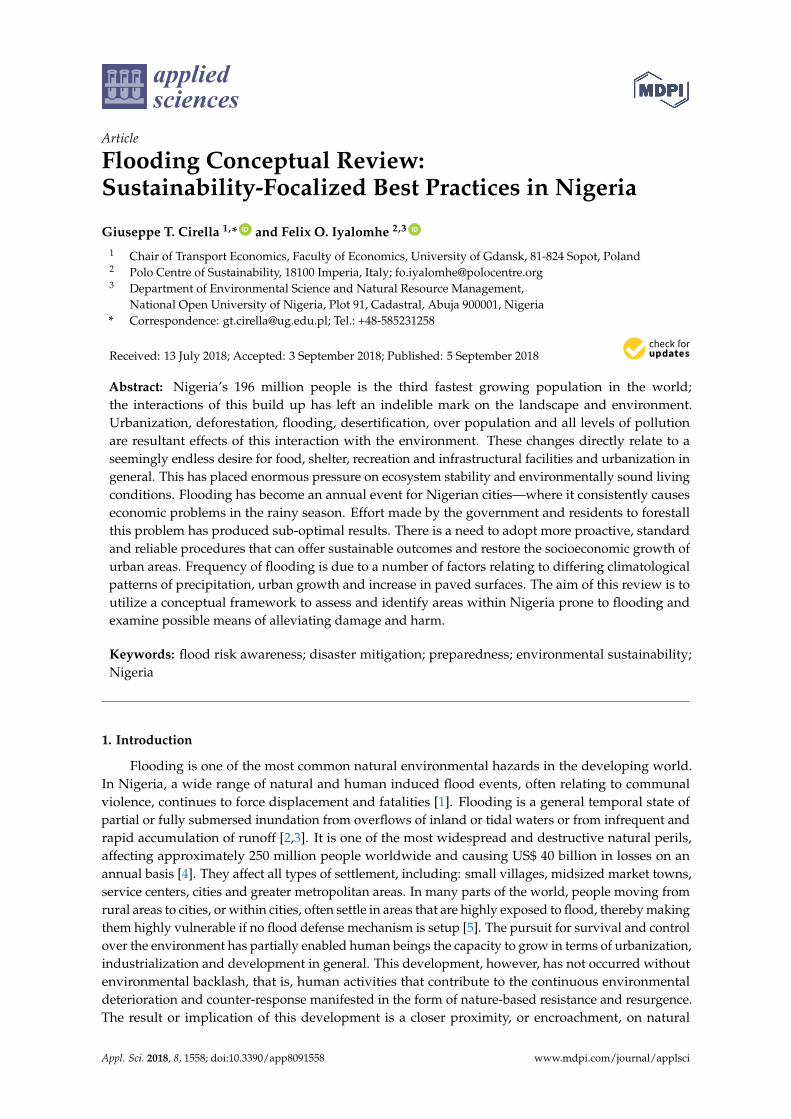
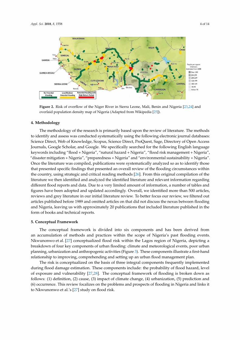
overflow from the Niger River, spanning much of West Africa, funnels via southern Nigeria and all
its minor tributaries (Figure 2). As a result, flood-complexity research must take this into account for
forward minded thinking, preparedness and economic, sound development.
The aim of assessing the nature and cause of floods, throughout Nigeria, relates to a provision
of reliable and sustainable solutions that connects ongoing problems with flood occurrences. Four
objectives need to be considered: (1) factors responsible for flooding; (2) identification of flood prone
areas; (3) assessment of significant impacts of flooding; and (4) control and management measures of
flood hazards. Typical areas of research that explore the physical geography of a region in relation to
flood occurrence and mapping can show various flood prone area records (i.e., their trends). Mapping
inputs include recorded past events and the use of predictive, future-based modelling.
Figure 1. Examples of flood mapping within Nigeria. (Left) 2001; (Right) 2014 (Adapted fromESRI [16]).
3. Statement of Problem
In 2010, approximately 1550 people died and 258,000 displaced by 19 flood events [17]. Two yearslater in 2012, floods claimed 361 lives and displaced 3.8 million inhabitants [18], recording a monetaryloss of approximately US$ 6.5 billion in damages despite an effort, the years before, to make theenvironment more habitable [18,19]. Nigeria’s National Emergency Management Agency (NEMA)stated the flooding events from 2012 caused an estimated loss equivalent to 4.1% gross domesticproduct. This type of disaster has had a ripple effect on the livelihood and activities of communitieswhere people literally were washed away and drowned, properties destroyed and socioeconomicactivities suffered [20]. While this type of natural disaster could be avoided, or limited, there seems tobe a cause-and-effect to the kind of havoc citizenry face—especially in the southern parts of the country.
Research and development are gathering nationwide information to aid with flood inundation,encroachment and flood prone areas. Methodologies have not adequately assessed flood hazards,in all of the flood prone areas, however, a lack of application within small urban watersheds, focusedon generating rainfall and runoff data in urban areas, often correlate where no major rivers exist.Two reasons for this flood-complexity are development practices used in urban areas and a lack ofadvanced technological methods for capturing geographical data [21,22]. As a consequent, the risk ofoverflow from the Niger River, spanning much of West Africa, funnels via southern Nigeria and allits minor tributaries (Figure 2). As a result, flood-complexity research must take this into account forforward minded thinking, preparedness and economic, sound development.
The aim of assessing the nature and cause of floods, throughout Nigeria, relates to a provisionof reliable and sustainable solutions that connects ongoing problems with flood occurrences.Four objectives need to be considered: (1) factors responsible for flooding; (2) identification of floodprone areas; (3) assessment of significant impacts of flooding; and (4) control and managementmeasures of flood hazards. Typical areas of research that explore the physical geography of a region inrelation to flood occurrence and mapping can show various flood prone area records (i.e., their trends).Mapping inputs include recorded past events and the use of predictive, future-based modelling.
Appl. Sci. 2018, 8, 1558 4 of 14
Appl. Sci. 2018, 8, x FOR PEER REVIEW 4 of 14
Figure 2. Risk of overflow of the Niger River in Sierra Leone, Mali, Benin and Nigeria [23,24] and
overlaid population density map of Nigeria (Adapted from Wikipedia [25]).
4. Methodology
The methodology of the research is primarily based upon the review of literature. The methods
to identify and assess was conducted systematically using the following electronic journal databases:
Science Direct, Web of Knowledge, Scopus, Science Direct, ProQuest, Sage, Directory of Open Access
Journals, Google Scholar, and Google. We specifically searched for the following English language
keywords including “flood + Nigeria”, “natural hazard + Nigeria”, “flood risk management +
Nigeria”, “disaster mitigation + Nigeria”, “preparedness + Nigeria” and “environmental
sustainability + Nigeria”. Once the literature was compiled, publications were systematically
analyzed so as to identify those that presented specific findings that presented an overall review of
the flooding circumstances within the country, using strategic and critical reading methods [26].
From this original compilation of the literature we then identified and analyzed the identified
literature and relevant information regarding different flood reports and data. Due to a very limited
amount of information, a number of tables and figures have been adopted and updated accordingly.
Overall, we identified more than 500 articles, reviews and grey literature in our initial literature
review. To better focus our review, we filtered out articles published before 1989 and omitted articles
on that did not discuss the nexus between flooding and Nigeria, leaving us with approximately 20
publications that included literature published in the form of books and technical reports.
5. Conceptual Framework
The conceptual framework is divided into six components and has been derived from an
accumulation of methods and practices within the scope of Nigeria’s past flooding events.
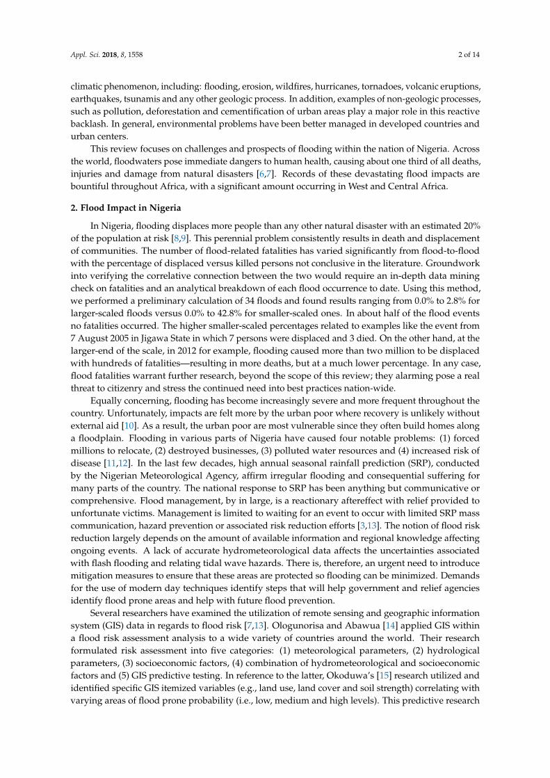
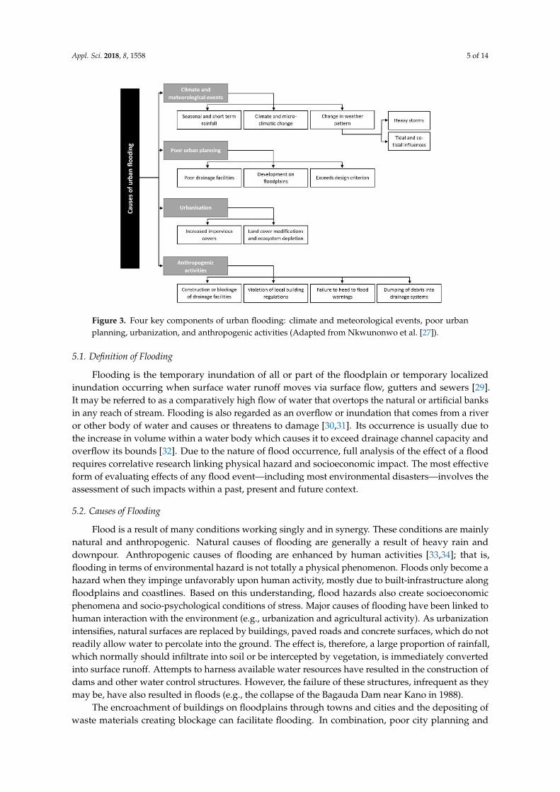
Nkwunonwo et al. [27] conceptualized flood risk within the Lagos region of Nigeria, depicting a
breakdown of four key components of urban flooding: climate and meteorological events, poor urban
planning, urbanization and anthropogenic activities (Figure 3). These components illustrate a first-
hand relationship to improving, comprehending and setting up an urban flood management plan.
The risk is conceptualized on the basis of three integral components frequently implemented
during flood damage estimation. These components include: the probability of flood hazard, level of
exposure and vulnerability [27,28]. The conceptual framework of flooding is broken down as follows:
(1) definition, (2) cause, (3) impact of climate change, (4) urbanization, (5) prediction and (6)
occurrence. This review focalizes on the problems and prospects of flooding in Nigeria and links it
to Nkwunonwo et al.’s [27] study on flood risk.
Figure 2. Risk of overflow of the Niger River in Sierra Leone, Mali, Benin and Nigeria [23,24] andoverlaid population density map of Nigeria (Adapted from Wikipedia [25]).
4. Methodology
The methodology of the research is primarily based upon the review of literature. The methodsto identify and assess was conducted systematically using the following electronic journal databases:Science Direct, Web of Knowledge, Scopus, Science Direct, ProQuest, Sage, Directory of Open AccessJournals, Google Scholar, and Google. We specifically searched for the following English languagekeywords including “flood + Nigeria”, “natural hazard + Nigeria”, “flood risk management + Nigeria”,“disaster mitigation + Nigeria”, “preparedness + Nigeria” and “environmental sustainability + Nigeria”.Once the literature was compiled, publications were systematically analyzed so as to identify thosethat presented specific findings that presented an overall review of the flooding circumstances withinthe country, using strategic and critical reading methods [26]. From this original compilation of theliterature we then identified and analyzed the identified literature and relevant information regardingdifferent flood reports and data. Due to a very limited amount of information, a number of tables andfigures have been adopted and updated accordingly. Overall, we identified more than 500 articles,reviews and grey literature in our initial literature review. To better focus our review, we filtered outarticles published before 1989 and omitted articles on that did not discuss the nexus between floodingand Nigeria, leaving us with approximately 20 publications that included literature published in theform of books and technical reports.
5. Conceptual Framework
The conceptual framework is divided into six components and has been derived froman accumulation of methods and practices within the scope of Nigeria’s past flooding events.Nkwunonwo et al. [27] conceptualized flood risk within the Lagos region of Nigeria, depicting abreakdown of four key components of urban flooding: climate and meteorological events, poor urbanplanning, urbanization and anthropogenic activities (Figure 3). These components illustrate a first-handrelationship to improving, comprehending and setting up an urban flood management plan.
The risk is conceptualized on the basis of three integral components frequently implementedduring flood damage estimation. These components include: the probability of flood hazard, levelof exposure and vulnerability [27,28]. The conceptual framework of flooding is broken down asfollows: (1) definition, (2) cause, (3) impact of climate change, (4) urbanization, (5) prediction and(6) occurrence. This review focalizes on the problems and prospects of flooding in Nigeria and links itto Nkwunonwo et al.’s [27] study on flood risk.
Appl. Sci. 2018, 8, 1558 5 of 14Appl. Sci. 2018, 8, x FOR PEER REVIEW 5 of 14
Figure 3. Four key components of urban flooding: climate and meteorological events, poor urban
planning, urbanization, and anthropogenic activities (Adapted from Nkwunonwo et al. [27]).
5.1. Definition of Flooding
Flooding is the temporary inundation of all or part of the floodplain or temporary localized
inundation occurring when surface water runoff moves via surface flow, gutters and sewers [29]. It
may be referred to as a comparatively high flow of water that overtops the natural or artificial banks
in any reach of stream. Flooding is also regarded as an overflow or inundation that comes from a
river or other body of water and causes or threatens to damage [30,31]. Its occurrence is usually due
to the increase in volume within a water body which causes it to exceed drainage channel capacity
and overflow its bounds [32]. Due to the nature of flood occurrence, full analysis of the effect of a
flood requires correlative research linking physical hazard and socioeconomic impact. The most
effective form of evaluating effects of any flood event—including most environmental disasters—
involves the assessment of such impacts within a past, present and future context.
5.2. Causes of Flooding
Flood is a result of many conditions working singly and in synergy. These conditions are mainly
natural and anthropogenic. Natural causes of flooding are generally a result of heavy rain and
downpour. Anthropogenic causes of flooding are enhanced by human activities [33,34]; that is,
flooding in terms of environmental hazard is not totally a physical phenomenon. Floods only become
a hazard when they impinge unfavorably upon human activity, mostly due to built-infrastructure
along floodplains and coastlines. Based on this understanding, flood hazards also create
socioeconomic phenomena and socio-psychological conditions of stress. Major causes of flooding
have been linked to human interaction with the environment (e.g., urbanization and agricultural
activity). As urbanization intensifies, natural surfaces are replaced by buildings, paved roads and
concrete surfaces, which do not readily allow water to percolate into the ground. The effect is,
therefore, a large proportion of rainfall, which normally should infiltrate into soil or be intercepted
by vegetation, is immediately converted into surface runoff. Attempts to harness available water
resources have resulted in the construction of dams and other water control structures. However, the
Figure 3. Four key components of urban flooding: climate and meteorological events, poor urbanplanning, urbanization, and anthropogenic activities (Adapted from Nkwunonwo et al. [27]).
5.1. Definition of Flooding
Flooding is the temporary inundation of all or part of the floodplain or temporary localizedinundation occurring when surface water runoff moves via surface flow, gutters and sewers [29].It may be referred to as a comparatively high flow of water that overtops the natural or artificial banksin any reach of stream. Flooding is also regarded as an overflow or inundation that comes from a riveror other body of water and causes or threatens to damage [30,31]. Its occurrence is usually due tothe increase in volume within a water body which causes it to exceed drainage channel capacity andoverflow its bounds [32]. Due to the nature of flood occurrence, full analysis of the effect of a floodrequires correlative research linking physical hazard and socioeconomic impact. The most effectiveform of evaluating effects of any flood event—including most environmental disasters—involves theassessment of such impacts within a past, present and future context.
5.2. Causes of Flooding
Flood is a result of many conditions working singly and in synergy. These conditions are mainlynatural and anthropogenic. Natural causes of flooding are generally a result of heavy rain anddownpour. Anthropogenic causes of flooding are enhanced by human activities [33,34]; that is,flooding in terms of environmental hazard is not totally a physical phenomenon. Floods only become ahazard when they impinge unfavorably upon human activity, mostly due to built-infrastructure alongfloodplains and coastlines. Based on this understanding, flood hazards also create socioeconomicphenomena and socio-psychological conditions of stress. Major causes of flooding have been linked tohuman interaction with the environment (e.g., urbanization and agricultural activity). As urbanizationintensifies, natural surfaces are replaced by buildings, paved roads and concrete surfaces, which do notreadily allow water to percolate into the ground. The effect is, therefore, a large proportion of rainfall,which normally should infiltrate into soil or be intercepted by vegetation, is immediately convertedinto surface runoff. Attempts to harness available water resources have resulted in the construction ofdams and other water control structures. However, the failure of these structures, infrequent as theymay be, have also resulted in floods (e.g., the collapse of the Bagauda Dam near Kano in 1988).
The encroachment of buildings on floodplains through towns and cities and the depositing ofwaste materials creating blockage can facilitate flooding. In combination, poor city planning and
Appl. Sci. 2018, 8, 1558 6 of 14
management, in addition to natural rain-induced causes, can be detrimental in an urban setting.Six general causes of flooding specific to Nigeria, include: (1) heavy rainfall (i.e., a tropical climatecombined with a relating wet season); (2) soil nature (i.e., poor infiltration of rainwater flow and soilpercolation); (3) deforestation (i.e., increased forest and vegetation removal, especially within lowlandsand valley beds); (4) climate change (i.e., attributed by NEMA, including the worst flood disaster in2012 and indirect aggravation of flood patterns in flood prone areas [27]); (5) poor waste disposal(i.e., blockage of drainage channels, especially in urban centers); and (6) poor land use policy planningand management (i.e., improper sitting of buildings, structures, road and drainage construction andland use ordering [35], as well as available control tools to oversee development standards). It isunfortunate Nigerian authorities lack proper planning and orderly conduct when it comes to soundpromotion of flood prevention [36].
5.3. Impact of Climate Change on Floods
Climate change refers to long term change in climate due to natural variability [37,38]. A majorfactor that influences flood is the climatic condition of a particular geographic location manifestedin the form of amount, duration and intensity of precipitation (i.e., rainfall). The combination ofprecipitation and high temperature affect soil moisture content (i.e., percentage saturation), liquid limitand infiltration rates. One of the consequences of climatic variability is when humid environmentsincrease and alter rainfall patterns [39]. There is no doubt the effects of climate change alter theprecipitation patterns of distribution, intensity and duration of extreme rainfall events and a higherfrequency of strong precipitation. In the case of Nigeria, due to higher temperatures and drought,land has become more susceptible to runoff, intensifying flood events. Changes in rainfall intensityand distribution influence river morphology (i.e., erosion of banks and fast sedimentation in riverbeds)introducing augmented dynamic flood shift patterns [40].
5.4. Urbanisation and Floods
A significant amount of research over the past two decades has shown a strong relationshipbetween urban areas and local micro-climate. The “urban heat island” (UHI) effect is nowwell-established, whereby urban areas have higher temperatures than surrounding regions [41].In many cases, UHI increases rainfall in the vicinity of cities. A number of studies have found anincrease in rainfall in regions downwind of urban areas, with some cases recording increases as high as25% [41,42]. In urbanized areas, huge amounts of anthropogenic waste heat is emitted due to humanactivities; the increase of energy consumption is causing environmental problems and temperature risein the urban atmosphere [43]. Hence even without long term climatic changes, urban extreme rainfallintensities may be increasing with severe impacts on society at large.
In Nigeria, the rehabilitation of rivers, channels and sewers lags far behind the development ofmunicipal construction. Consequently, the existing drainage capacities are insufficient in drainingrunoff discharge, increasing flood risk. Moreover, there is a lack of adequate infrastructural provision,especially within Edo State. Over the last decade, Benin City and other parts of Edo State havewitnessed rapid territorial expansion, in which successive administrations until recently have failedto match growth with infrastructural development—particularly in the expansion of its drainagenetwork [44]. Currently, with an annual urbanization rate of 5.5%, the highest in the world, Nigeriancities face numerous problems, including: deterioration of the environment, urban decay, un-clearedrefuse, flooding, erosion and pollution [45,46]. At present, it is easy to acknowledge casual factors ofurban flooding and gully erosion are multifarious.
5.5. Flood Prediction
The prediction and forecast of floods depend greatly on the consistency of availablemeteorological data. The development of the hydrological operational multipurpose sub-programs(HOMs) has been a top achievement in its field. Improvements on the HOMs forecasting and
Appl. Sci. 2018, 8, 1558 7 of 14
information dissemination is ongoing. The potential benefits are immense for communities underits management. The network of instruments, digital data and other meteorological flood predictiondevices can be employed, coupled with appropriate modelling to forecast real-time, onset and otherfeatures of phenomena in question [46,47]. Development of hydrological forecasting systems hasbeen installed in a number of countries and has resulted in a substantial saving of life and reductionof damage.
Installation of similar systems, throughout Nigeria, would also reduce vulnerability to some areasand promote early evacuation when needed. However, problems have been identified in relationto evacuation procedures due to a lax resistant population that is overly exposed to flood events.Pfister’s [48] research observed a significant factor in the lack of response to an evacuation order inNew South Wales, Australia, noting the effect of false alarms as a major factor that might make futureevacuation more difficult if not impossible. In two studies, Olowu and Sako [49] and Olowoyo andLion [50], looked at a number of developing countries including Nigeria, and found that limitation ofinfrastructure, absence of appropriate legal and policy framework and sometimes inadequate resourcesparticularly render areas more vulnerable to the consequences of flooding and other natural disasters.
5.6. Flood Occurrences
It is difficult to determine the extent of flood damage and to compare in a satisfactory manner oneflood with another, mostly due to the relative tendency to overestimate flood damage, particularlyat the time of the event [51]. Flooding in Nigeria occurs in three main forms: river flooding, urbanflooding and coastal flooding [52]. In Nigeria, flood occurrence can cause panic nationwide. Floodevents have caused astronomical price hikes in food crops, resulting to an estimated 2% rise in rate ofinflation [53]. By far, this is the worst environment-induced economic disaster Nigeria faces. Floodimpacts are often felt all over most parts of the country. In 2012, the government spent approximatelyUS$ 300 million on relief materials for flood victims [54]. In the face of flood disaster, predominatelyaffecting about one quarter of the country’s cities, many Nigerians are of the opinion flood eventswill not end, or get better anytime soon, leaving the general population with hope of governmentmitigation and adaptation resolve. Poor and unavailable flood prediction, flood control systems andtechniques are seen as major causes that aggravate flood disaster nationwide.
6. Discussion: Flood Control and Management
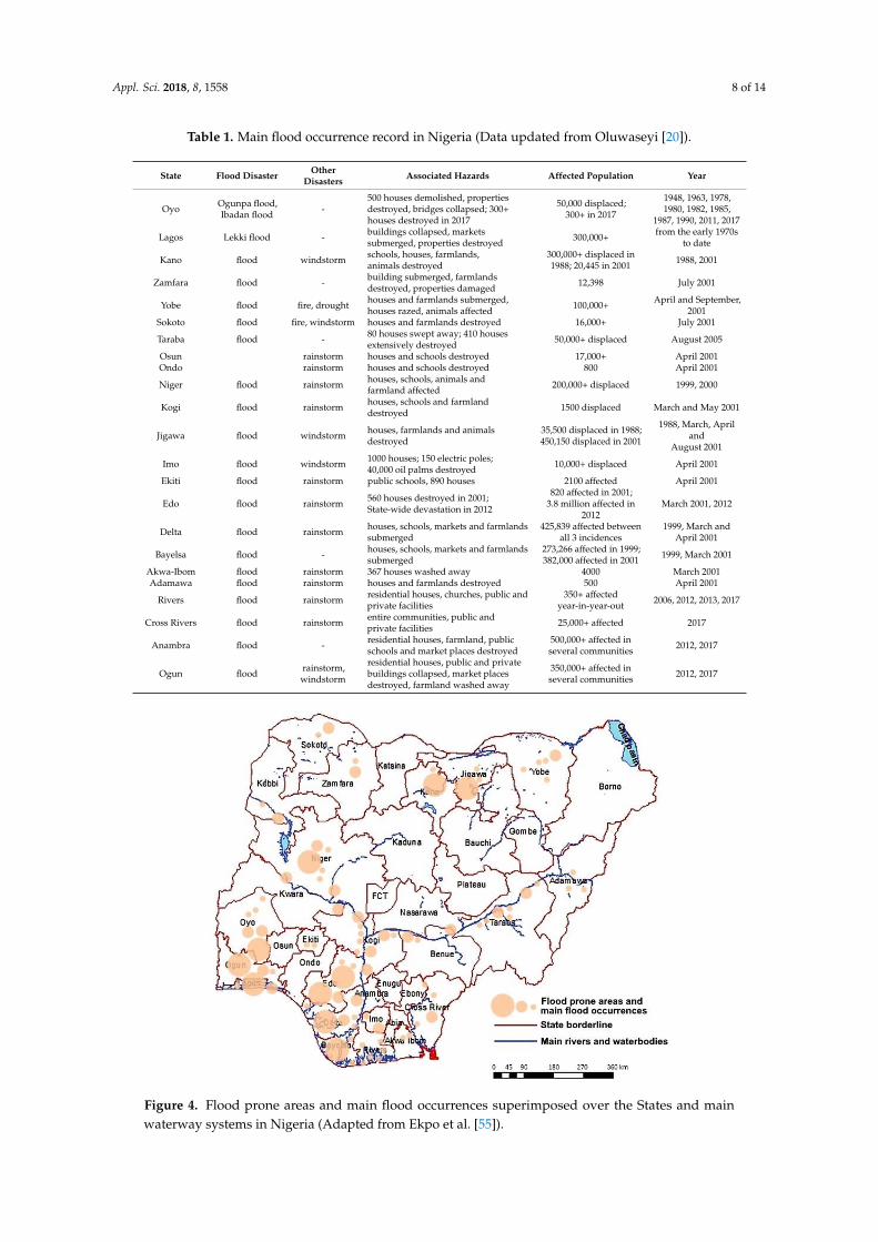
In Nigeria, flood control measures need to be better understood, complimented and harmoniouslymatched up with the forces of nature, instead of simply trying to eliminate them [53]. A compiled listof the main flood occurrences recorded in the country has been updated in Table 1.
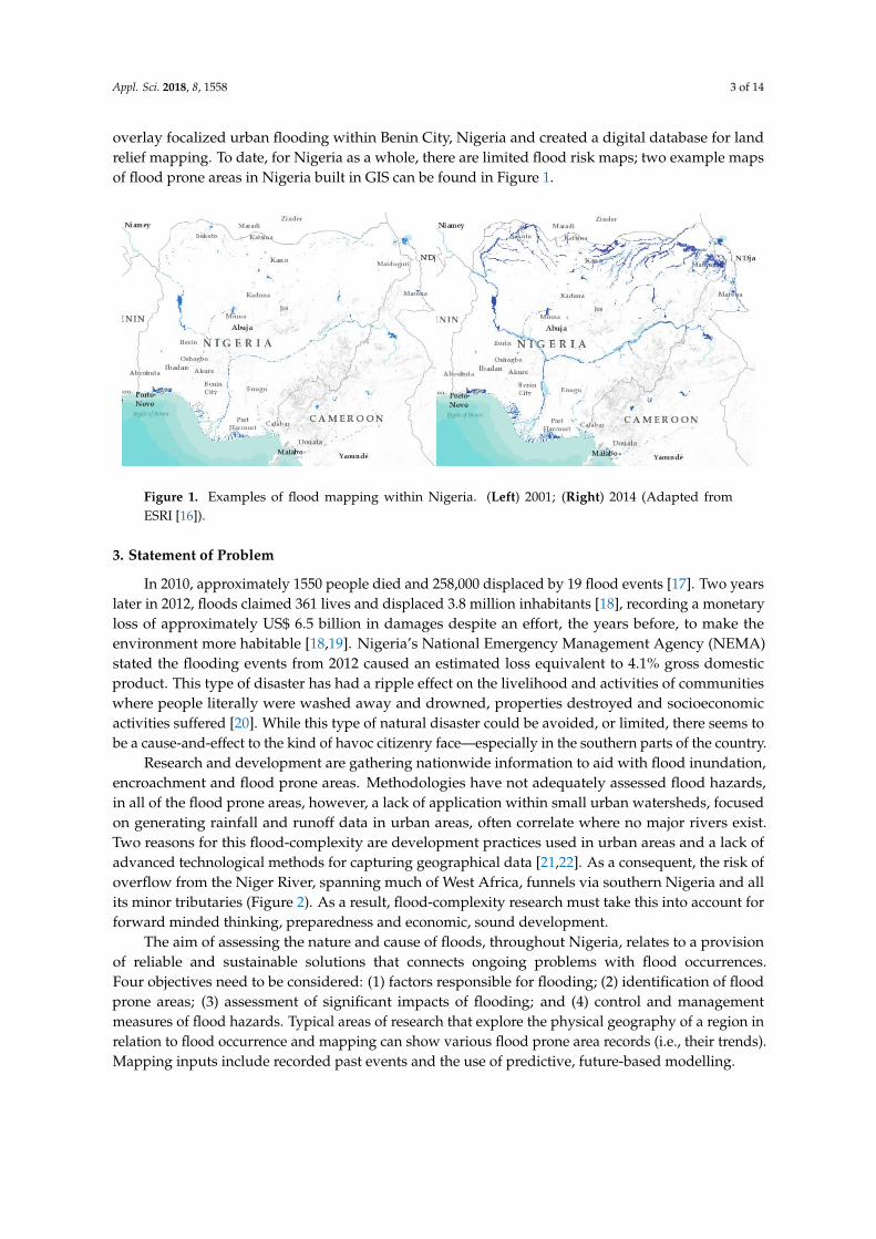
An examination of the flood record reveals Oyo, Lagos and Rivers—in that order—top the countryin terms of highest amount of flood occurrences per State; these three States, however, were dwarfedby Edo’s 2012 one-off event that halted the nation and semi-collapsed the economy. Correspondingly,the States of Kano, Niger, Delta, Bayelsa, Anambra and Ogun—which have had far fewer floodingoccurrences than the top three—have also had huge one-off events that surmount to or similarly totalthe top level of affected population. Contradictory to the top three, these other States have sufferedfar more damage and structural devastation which, most likely, is related to lack of preparedness,inexperience in flood management and mitigation practices and lack of knowledge and governance interms of flood relief. It would be fair to say the top three States, due to historical and seasonal flooding,have grown more accustom to flood events and arguably top the state-of-the-art when it comes tosustainability-focalized best practices in Nigeria. Flood prone areas and main flood occurrences whensuperimposed over the States and federal capital territory (FCT) of Abuja and main waterway systemsillustrates this correlation (Figure 4).
Appl. Sci. 2018, 8, 1558 8 of 14
Table 1. Main flood occurrence record in Nigeria (Data updated from Oluwaseyi [20]).
State Flood Disaster OtherDisasters Associated Hazards Affected Population Year
Oyo Ogunpa flood,Ibadan flood -
500 houses demolished, propertiesdestroyed, bridges collapsed; 300+houses destroyed in 2017
50,000 displaced;300+ in 2017
1948, 1963, 1978,1980, 1982, 1985,
1987, 1990, 2011, 2017
Lagos Lekki flood - buildings collapsed, marketssubmerged, properties destroyed 300,000+ from the early 1970s
to date
Kano flood windstorm schools, houses, farmlands,animals destroyed
300,000+ displaced in1988; 20,445 in 2001 1988, 2001
Zamfara flood - building submerged, farmlandsdestroyed, properties damaged 12,398 July 2001
Yobe flood fire, drought houses and farmlands submerged,houses razed, animals affected 100,000+ April and September,
2001Sokoto flood fire, windstorm houses and farmlands destroyed 16,000+ July 2001
Taraba flood - 80 houses swept away; 410 housesextensively destroyed 50,000+ displaced August 2005
Osun rainstorm houses and schools destroyed 17,000+ April 2001Ondo rainstorm houses and schools destroyed 800 April 2001
Niger flood rainstorm houses, schools, animals andfarmland affected 200,000+ displaced 1999, 2000
Kogi flood rainstorm houses, schools and farmlanddestroyed 1500 displaced March and May 2001
Jigawa flood windstorm houses, farmlands and animalsdestroyed
35,500 displaced in 1988;450,150 displaced in 2001
1988, March, Apriland
August 2001
Imo flood windstorm 1000 houses; 150 electric poles;40,000 oil palms destroyed 10,000+ displaced April 2001
Ekiti flood rainstorm public schools, 890 houses 2100 affected April 2001
Edo flood rainstorm 560 houses destroyed in 2001;State-wide devastation in 2012
820 affected in 2001;3.8 million affected in
2012March 2001, 2012
Delta flood rainstorm houses, schools, markets and farmlandssubmerged
425,839 affected betweenall 3 incidences
1999, March andApril 2001
Bayelsa flood - houses, schools, markets and farmlandssubmerged
273,266 affected in 1999;382,000 affected in 2001 1999, March 2001
Akwa-Ibom flood rainstorm 367 houses washed away 4000 March 2001Adamawa flood rainstorm houses and farmlands destroyed 500 April 2001
Rivers flood rainstorm residential houses, churches, public andprivate facilities
350+ affectedyear-in-year-out 2006, 2012, 2013, 2017
Cross Rivers flood rainstorm entire communities, public andprivate facilities 25,000+ affected 2017
Anambra flood - residential houses, farmland, publicschools and market places destroyed
500,000+ affected inseveral communities 2012, 2017
Ogun flood rainstorm,windstorm
residential houses, public and privatebuildings collapsed, market placesdestroyed, farmland washed away
350,000+ affected inseveral communities 2012, 2017
Appl. Sci. 2018, 8, x FOR PEER REVIEW 9 of 14
Figure 4. Flood prone areas and main flood occurrences superimposed over the States and main
waterway systems in Nigeria (Adapted from Ekpo et al. [55]).
It is important to note that a significant and crucial factor in saving lives includes trying to
control flood occurrence or, at the minimum, to minimize vulnerability within affected areas. It is
clearly known that control and management may not provide the ultimate panacea for flood hazards,
but it will provide a perspective to improve its impacts on human activities, lives and property.
Specific to Nigeria, Adekola and Lamond [22] and Olowu and Sako [49] state infrastructure and an
absence of appropriate legal controls is crucially needed. As a result, inadequate access to resources
particularly renders the country more vulnerable to the consequences of flooding and other large-
scale disasters. Recently, researchers have pointed out one method of studying and understanding
flood behaviors, by examining the extent of floods with flood risk mapping, since they use and
overlay spatial planning and land management information [13,56]. There is also research that looks
at integrated GIS-based assessment that integrates population and agricultural vulnerability with
flood events [57,58]. Comprehension geographic information can be very critical in making important
decisions due to the spatial coverage of most disasters. Flood risk mapping can also determine the
area at risk and can be the basis for flood damage reduction and subsequent action-based
management.
Spatial planning according to Nkwunonwo et al. [34] and Isma and Saanyol [13] suggest the
support of early warning systems, risk assessment and mapping as an optimal basis of flood
management. Burton [59] categorizes alternative measures of reducing flood loss into two groups: (1)
corrective measures and (2) preventive measures. The corrective measures are divided into two parts:
flood control and other methods. The preventive measures are: flood regulation and other preventive
methods. Flood control measures involve the construction of reservoirs, levees and walls, channeling
of streams and construction of drainage systems. The provision of flood insurance could also assist
with compensative efforts of affected occupants however insurance research is still tentative. We
believe these linkages between the six-point conceptual framework compliment Nkwunonwo et al.’s
[27] key components of flood risk (i.e., climate and meteorological events, poor urban planning,
urbanization and anthropogenic activities). This overlapping review affirms the need for further
Figure 4. Flood prone areas and main flood occurrences superimposed over the States and mainwaterway systems in Nigeria (Adapted from Ekpo et al. [55]).
Appl. Sci. 2018, 8, 1558 9 of 14
It is important to note that a significant and crucial factor in saving lives includes trying tocontrol flood occurrence or, at the minimum, to minimize vulnerability within affected areas. It isclearly known that control and management may not provide the ultimate panacea for flood hazards,but it will provide a perspective to improve its impacts on human activities, lives and property.Specific to Nigeria, Adekola and Lamond [22] and Olowu and Sako [49] state infrastructure and anabsence of appropriate legal controls is crucially needed. As a result, inadequate access to resourcesparticularly renders the country more vulnerable to the consequences of flooding and other large-scaledisasters. Recently, researchers have pointed out one method of studying and understanding floodbehaviors, by examining the extent of floods with flood risk mapping, since they use and overlayspatial planning and land management information [13,56]. There is also research that looks atintegrated GIS-based assessment that integrates population and agricultural vulnerability with floodevents [57,58]. Comprehension geographic information can be very critical in making importantdecisions due to the spatial coverage of most disasters. Flood risk mapping can also determine the areaat risk and can be the basis for flood damage reduction and subsequent action-based management.
Spatial planning according to Nkwunonwo et al. [34] and Isma and Saanyol [13] suggestthe support of early warning systems, risk assessment and mapping as an optimal basis of floodmanagement. Burton [59] categorizes alternative measures of reducing flood loss into two groups:(1) corrective measures and (2) preventive measures. The corrective measures are divided intotwo parts: flood control and other methods. The preventive measures are: flood regulation andother preventive methods. Flood control measures involve the construction of reservoirs, levees andwalls, channeling of streams and construction of drainage systems. The provision of flood insurancecould also assist with compensative efforts of affected occupants however insurance research isstill tentative. We believe these linkages between the six-point conceptual framework complimentNkwunonwo et al.’s [27] key components of flood risk (i.e., climate and meteorological events,poor urban planning, urbanization and anthropogenic activities). This overlapping review affirms theneed for further methodological research, expertise, government and community commitment as wellas social and economic knowhow.
International Flood Management Practices: Sustainable Flood Prevention, Protection and Mitigation
A number of principles and approaches from an international perspective reinforce the connectionbetween flood prevention, protection and mitigation. A brief internationalized state-of-the-art of floodmanagement practices puts into perspective flood strategies that integratively promotes coordinateddevelopment and management of actions regarding water, land and related resources. From thisviewpoint, such practices consider different kinds of flooding (i.e., hydrological circumstances) andenvironmentally-focalized conditions that contribute to the problem. Flood management practicesfrom around the world are briefly examined and commented upon from a Nigerian backdrop.
In accordance with the Water Directors of the European Union (EU), the EU Floods Directive2007/60/EC and the United Nations and Economic Commission for Europe (UN/ECE) Guidelineson Sustainable Flood Prevention eight notable practices are described: (1) integrated river basinapproach; (2) public awareness, public participation and insurance; (3) research, education andexchange of knowledge; (4) retention of water and non-structural measures; (5) land use, zoning andrisk assessment; (6) structural measures and their impact; (7) flood emergency; and (8) prevention ofpollution [60]. There has been a number of European-centric working groups which have expandedupon the Water Framework Directive 2000/60/EC and EU Floods Directive 2007/60/EC that focus onflood risk management information-based systems. Key deliverance has focused on securing basicresource needs for better integration and coherent management approaches for natural water retentionmethods, improved ecosystem quality and reduced, overall, continent-wide flooding [61]. At present,authorities throughout Nigeria significantly lack utility in all eight of these practices. From a Europeanstandpoint, the country insufficiently conducts background controls and has limited pathways forextensive implementation.
Appl. Sci. 2018, 8, 1558 10 of 14
In the USA, flood management practices are predominantly updated by the Federal EmergencyManagement Agency (FEMA); at present, FEMA has 56 legislative floodplain managementpublications, with its NFIP Floodplain Management Guidebook 5th Edition stating six practicesthat make up the management scheme: (1) floodplain management concepts; (2) mapping and maprevisions; (3) the National Flood Insurance Program (NFIP); (4) floodplain management at the locallevel; (5) NFIP floodplain development standards; and (6) flood hazard mitigation [62]. In addition,ongoing reports included FEMA’s National Flood Insurance Program Community Rating System:A Local Official’s Guide to Saving Lives, Preventing Property Damage, and Reducing the Cost ofFlood Insurance FEMA B 573/2018 highlight flood mapping and regulations, damage reduction andpreparedness [63]. Nigeria’s authorities have published a very limited number of government reportsand publications, with a very limited amount of conceptual management, mapping and, basically,no proper insurance-oriented program. American management practices within Nigeria would bebeneficial however not feasible due to the expensive nature of implementing such a scheme.
In Canada, recent flood management practices prioritized three flood risk management initiatives:(1) data and shared understanding; (2) homeowner and education awareness; and (3) proactive crosssector collaboration [64]. In Australia, the national publication entitled Managing the Floodplain:A Guide to Best Practices in Flood Risk Management in Australia extensively references 58 manuals andhandbooks specific to Australia’s environment [65]. Similarly, New Zealand has published Meetingthe challenges of future flooding in New Zealand stating four fundamental actions: (1) active andengaged risk management by central and local government collaboration; (2) risk reduction embeddedwithin the policy framework; (3) appropriate resources, including sufficient information, guidance andfunding, made available to promote good practice in the daily management of flood risk; and (4) centraland local government monitoring to understand the levels of flood risk and inform future policy andmanagement practices [66]. Additionally, coastal flooding attention looks at: storm, tides and sealevel preparedness; landform characteristics; and flood hazard preparedness [67]. Other countrieswith noteworthy flood management practices include: the United Kingdom, Japan, Singapore andChina. In retrospect of these management practices, Nigeria would benefit from Canadian-styleinitiatives that prioritize on community and societal level involvement. In both Australia andNew Zealand, the pure volume of research and development exemplify the extent of how floodmanagement practices are prioritized and integrated into high level governance interlacing academiaand institutions alike with government. Unfortunately, Nigeria, as in many developing countries,research and development in flood management practices is limited and lacks support from thetop-down. This briefing demonstrates well developed flood management practices that exist andoffers potential ideas for policymakers from Nigeria, and other lesser developed countries, a pathwayforward. The international perspective also sets a standard for sustainability-focalised best practicesand comparative development.
7. Conclusions
Flooding has become an annual event for Nigerian cities where it consistently causes economicproblems in the rainy season. Effort made by the government, community organizations and residentsto anticipate the problem has generated substandard outcomes, largely due to tremendous changes inbuilt environment. These changes to the urban landscape, without equal precautionary measures forflood, relate to seasonal effects on people and the environment itself. Hitherto, human activities haveexacerbated flood related problems by cutting down trees, digging up vegetation and exposing soil,thus increasing soil erosion and flooding. Cultivation has decreased water retention force of soil andincreased runoff. If deforestation could be controlled using stringent policy and regulation, then floodlevels along rivers, streams and even the ocean could be improved in cities and adjacent floodplains.Ongoing fieldwork conducted by the authors contest that flood throughout Nigeria continues tocause the federal government relief concerns for affected persons; it correlates with the interventionstrategies being put in place by the national emergency management agency and relating communities.
Appl. Sci. 2018, 8, 1558 11 of 14
The common understanding of flooding during the rainy season, which is from May to September,is especially concerning within the states that contain or run adjacent to the Niger or Benue riversystems. Our own flood prediction research tentatively points to a worsening situation as reoccurringflood phenomenon remains high. Rainfall patterns in the last 30 years also suggest that rainstorms aregetting more intense. This, in turn, means that there is a higher rate of downpour on the days that thereis rain, which indirectly correlates with an augmentation of rain storms in cities and increasing threatof flooding. Further flood research will be critical to bettering management practices. This shouldinclude local and international intervention as well as early warning and rapid response systems,proper urban and spatial planning, flood data gathering, modelling flood emergency preparednessand political will.
Land use planning and controlled sustainable development must be prioritized to better managerapid urban growth and infrastructural demands. In a swiftly urbanizing country, proper land usepolicy, regulation, construction and development by-laws are essential to keep developers in check.A stringent program to monitor landscape changes and urban development is a critical starting point.Key to best practices in the country will need to focalized efforts on the high flood prone States of Oyo,Lagos and Rivers with additional attention going to Edo, Kano, Niger, Delta, Bayelsa, Anambraand Ogun. Nigeria’s government agencies, authorities, planners, environmentalists, practitioners ofthe built environment, non-governmental organizations and communities alike must work in synergyto advance a comprehensive approach that would emphasize more on the means of reducing flooddamages over the long term. This process would rely on both indigenous and advanced techniques toabating flood problems throughout the country and, in particular, its urban centers.
Author Contributions: Conceptualization and Methodology, G.T.C. and F.O.I.; Validation, G.T.C. and F.O.I.;Formal Analysis, G.T.C.; Investigation, G.T.C. and F.O.I.; Resources, G.T.C. and F.O.I.; Data Curation, G.T.C. andF.O.I.; Writing—Original Draft Preparation, F.O.I.; Writing—Review and Editing, G.T.C. and F.O.I.; Visualization,Supervision, Project Administration and Funding Acquisition, G.T.C.
Funding: This research received no external funding.
Conflicts of Interest: The authors declare no conflict of interest.
References
1. UNOCHA. Nigeria: Humanitarian Response Plan; United Nations Office for the Coordination of HumanitarianAffairs: Abuja, Nigeria, 2018.
2. Onuigbo, I.C.; Ibrahim, P.O.; Agada, D.U.; Nwose, I.A.; Abimbola, I.I. Flood Vulnerability Mapping ofLokoja Metropolis Using Geographical Information System Techniques. J. Geosci. Geomatics 2017, 5, 229–242.[CrossRef]
3. Jeb, D.N.; Aggarwal, S.P. Flood Inundation Hazard Modelling of the River Kaduna Using Remote Sensingand Geographic Information Systems. J. Appl. Sci. 2008, 4, 1822–1833.
4. OECD. Financial Management of Flood Risk; OECD Publishing: Paris, France, 2016.5. Lin, B.B.; Philpott, S.M.; Jha, S. The Future of Urban Agriculture and Biodiversity-Ecosystem Services:
Challenges and Next Steps. Basic Appl. Ecol. 2015, 16, 189–201. [CrossRef]6. Paterson, D.L.; Wright, H.; Harris, P.N.A. Health Risks of Flood Disasters. Clin. Infect. Dis. 2018. [CrossRef]7. Komolafe, A.A.; Adegboyega, S.A.-A.A.; Akinluyi, F.O. A Review of Flood Risk Analysis in Nigeria. Am. J.
Environ. Sci. 2015, 11, 157–166. [CrossRef]8. UNOCHA. Humanitarian Bulletin Nigeria; United Nations Office for the Coordination of Humanitarian
Affairs: Abuja, Nigeria, 2015.9. Etuonovbe, A.K. The Devastating Effect of Flooding in Nigeria; UNOCHA: Marrakech, Morocco, 2011.10. Wisner, B.; Blaikie, P.; Cannon, T.; Davis, I. At Risk: Natural Hazards, People’s Vulnerability and Disasters, 2nd ed.;
Routledge-UNDP: London, UK, 2003; ISBN 0415084768.11. Brown, I.; Chikagbum, W. Planning Response to Water-Related Disasters in Nigeria: The Rivers State
Experience. Int. J. Sci. Eng. Res. 2015, 6, 32–44.12. Ade, M.A. The menace of Floods in the Benue Trough and Vulnerability Analysis: 2017 Flood. In Geophysical
Research Abstracts, 8–13 April 2018; European Geosciences Union: Vienna, Austria, 2018; Volume 20, p. 3.
Appl. Sci. 2018, 8, 1558 12 of 14
13. Isma, M.; Saanyol, I.O. Application of Remote Sensing (RS) and Geographic Information Systems (GIS) inFlood Vulnerability Mapping: Case Study of River Kaduna. Int. J. Geomatics Geosci. 2013, 3, 618–627.
14. Ologunorisa, T.E.E.; Abawua, M.J. Flood Risk Assessment: A Review. J. Appl. Sci. Environ. Manag. 2005, 9,57–63.
15. Okoduwa, A.I. An Application of GIS to Flood Prediction: A Case Study of Benin City, Nigeria. Bachelor’sThesis, Department of Geography and Planning, University of Benin, Benin, Nigeria, 1999.
16. International Water Management Institute. Flood Risk Mapping: Nigeria—IWMI. Available online: http://waterdata.iwmi.org/Applications/nigeria_Flood_Mapping/ (accessed on 31 July 2018).
17. Agbola, B.S.; Ajayi, O.; Taiwo, O.J.; Wahab, B.W. The August 2011 flood in Ibadan, Nigeria: AnthropogenicCauses and Consequences. Int. J. Disaster Risk Sci. 2012, 3, 207–217. [CrossRef]
18. Tokunbo, A.; Ezigbo, B. Floods Claims 363 Lives, Displace 2.1 People Says NEMA; All African: Ibadan,Nigeria, 2012.
19. Agbonkhese, O.; Aka, E.G.; Ocholi, J.; Adekunle, M. Flood Menace in Nigeria: Impacts, Remedial andManagement Strategies. Civ. Environ. Res. 2014, 6, 32–41.
20. Oluwaseyi, A.B. Plant Genetic Resources (PGR) in Nigeria and the Reality of Climate Change: A review.Asian J. Environ. Ecol. 2017, 2, 1–24. [CrossRef]
21. Jha, A.K.; Bloch, R.; Lamond, J. Cities and flooding: A Guide to Integrated Urban Flood Risk Management for the21st Century; The World Bank: Washington, DC, USA, 2012; ISBN 9780821388662.
22. Adekola, O.; Lamond, J. A Media Framing Analysis of Urban Flooding in Nigeria: Current narratives andImplications for Policy. Reg. Environ. Chang. 2018, 18, 1145–1159. [CrossRef]
23. UNOCHA. 2013 Rainy Season Overview West and Central Africa Rainfall Patterns; United Nations Office for theCoordination of Humanitarian Affairs: Abuja, Nigeria, 2013.
24. Dunning, C.M.; Black, E.C.L.; Allan, R.P. The Onset and Cessation of Seasonal Rainfall over Africa.J. Geophys. Res. 2016, 121, 11405–11424. [CrossRef]
25. Wikipedia Nigeria. Available online: https://en.wikipedia.org/wiki/Nigeria (accessed on 19 July 2018).26. Matarese, V. Using Strategic, Critical Reading of Research Papers to Teach Scientific Writing: The
reading–Research–Writing Continuum. In Supporting Research Writing; Elsevier: Oxford, UK, 2013; pp. 73–89.27. Nkwunonwo, U.C.; Whitworth, M.; Baily, B. Review article: A Review and Critical Analysis of the Efforts
towards Urban Flood Risk Management in the Lagos Region of Nigeria. Nat. Hazards Earth Syst. Sci. 2016,16, 349–369. [CrossRef]
28. FEMA. Flood Risk Assessment. In Hazard Identification and Risk Assessment; FEMA, Ed.; Department ofHomeland Security: Washington, DC, USA, 2012; p. 25.
29. Walesh, S.G. Urban Surface Water Management; John Wiley and Sons: Hoboken, NJ, USA, 1989;ISBN 9780470172810.
30. Ojo, A.O. The Climatic Dilemma; Lagos State University: Ojo, Nigeria, 2007.31. Rosenzweig, C.; Solecki, W.D.; Parshall, L.; Lynn, B.; Cox, J.; Goldberg, R.; Hodges, S.; Gaffin, S.; Slosberg, R.B.;
Savio, P.; et al. Mitigating New York City’s Heat Island: Integrating Stakeholder Perspectives and ScientificEvaluation. Bull. Am. Meteorol. Soc. 2009, 90, 1297–1312. [CrossRef]
32. Chow, V.T. Report of the Committee on Runoff, 1955–1956. Trans. Am. Geophys. Union 1957, 38, 379–384.[CrossRef]
33. Patra, K.C. Hydrology and Water Resources Engineering; Alpha Science International: Oxford, UK, 2001;ISBN 1842650238.
34. Whitworth Malcolm, N.U.; Malcolm, W.; Brian, B. Flooding and Flood Risk Reduction in Nigeria: CardinalGaps. J. Geogr. Nat. Disasters 2015, 5, 136. [CrossRef]
35. Adeloye, A.J.; Rustum, R. Lagos (Nigeria) Flooding and Influence of Urban Planning. Proc. Inst. Civ.Eng.—Urban Des. Plan. 2011, 164, 175–187. [CrossRef]
36. Aderogba, K.A. Qualitative Studies of Recent Floods and Sustainable Growth and Development of Citiesand Towns in Nigeria. Int. J. Acad. Res. Econ. Manag. Sci. 2012, 1, 1. [CrossRef]
37. IPCC. Climate Change 2014: Synthesis Report. Contribution of Working Groups I, II and III to the Fifth AssessmentReport of the Intergovernmental Panel on Climate Change; Intergovernmental Panel on Climate Change: Geneva,Switzerland, 2014; ISBN 9789291691432.
Appl. Sci. 2018, 8, 1558 13 of 14
38. Martel, J.-L.; Mailhot, A.; Brissette, F.; Caya, D.; Martel, J.-L.; Mailhot, A.; Brissette, F.; Caya, D. Role ofNatural Climate Variability in the Detection of Anthropogenic Climate Change Signal for Mean and ExtremePrecipitation at Local and Regional Scales. J. Clim. 2018, 31, 4241–4263. [CrossRef]
39. O’Hare, G. Climate Change and the Temple of Sustainable Development. Geography 2002, 87, 234–246.[CrossRef]
40. Ogbonna, D.; Okoro, B.C.; Osuagwu, J.C. Application of Flood Routing Model for Flood Mitigation in OrashiRiver, South-East Nigeria. J. Geosci. Environ. Prot. 2017, 5, 31–42. [CrossRef]
41. Seto, K.C.; Kaufmann, R.K. Urban Growth in South China and Impacts on Local Precipitation. In Proceedingsof the Fifth Urban Research Symposium, Marseille, France, 28–30 June 2009.
42. Bentley, M.L.; Ashley, W.S.; Anthony Stallins, J. Climatological Radar Delineation of Urban Convection forAtlanta, Georgia. Int. J. Climatol. 2010, 30, 1589–1594. [CrossRef]
43. Huong, H.T.L.; Pathirana, A. Urbanization and Climate Change Impacts on Future Urban Flood Risk in CanTho city, Vietnam. Hydrol. Earth Syst. Sci. Discuss. 2011, 8, 10781–10824. [CrossRef]
44. Ubani, O.; Obi, A.N.I. Analysis of Flood Risk Management in Nigerian Urban environment. J. Environ.Earth Sci. 2014, 4, 110–115.
45. Adekola, P.; Ogundipe, A. An Assessment of the State of Environmental Management in Nigerian CapitalCities. J. Geogr. Environ. Earth Sci. Int. 2017, 12, 1–13. [CrossRef]
46. Fohringer, J.; Dransch, D.; Kreibich, H.; Schröter, K. Social Media as an Information Source for Rapid FloodInundation Mapping. Nat. Hazards Earth Syst. Sci. 2015, 15, 2725–2738. [CrossRef]
47. Addor, N.; Jaun, S.; Fundel, F.; Zappa, M. An Operational Hydrological Ensemble Prediction System for theCity of Zurich (Switzerland): Assessing the Added Value of Probabilistic Forecasts. Hydrol. Earth Syst. Sci.2012, 14, 2327–2347.
48. Pfister, N. The Role of the New South Wales State Emergency Service in Flood Management; SES: Wollongong,Australia, 2005.
49. Olowu, D.; Sako, S. Better Governance and Public Policy: Capacity Building for Democratic Renewal in Africa;Kumarian Press: Bloomfield, CT, USA, 2002; ISBN 9781565491601.
50. Olowoyo, J.O.; Lion, G.N. Urban Farming as a Possible Source of Trace Metals in Human Diets. S. Afr. J. Sci.2016, 112, 1–6. [CrossRef]
51. Edmund, P.R. Flood and Coastal Erosion Risk Management: A Manual for Economic Appraisal; Routledge:Middlesex, UK, 2013; ISBN 0415815150.
52. Igbokwe, J.I.; Akinyede, J.O.; Dang, B.; Alaga, T.; Ono, M.N.; Nnodu, V.C.; Anike, L.O. Mapping andMonitoring the Impacts of Flood and Erosion in South Eastern Nigeria with Satellite Remote Sensing andGeographic Information System. Int. Arch. Photogramm. Remote Sens. Spat. Inf. Sci. 2008, 37, 865–872.
53. Onwuka, S.U.; Ikekpeazu, F.O.; Onuoha, D.C. Assessment of the Causes of 2012 Floods in Aguleri andUmuleri, Anambra East Local Government Area of Anambra State, Nigeria. Eff. Br. Mindfulness Interv. AcutePain Exp. An Exam. Individ. Differ. 2015, 1, 1689–1699. [CrossRef]
54. UNOCHA. Overview: Impact of Floods West and Central Africa; United Nations Office for the Coordination ofHumanitarian Affairs: Abuja, Nigeria, 2012.
55. Ekpo, U.F.; Hürlimann, E.; Schur, N.; Oluwole, A.S.; Abe, E.M.; Mafe, M.A.; Nebe, O.J.; Isiyaku, S.; Olamiju, F.;Kadiri, M.; et al. Mapping and Prediction of Schistosomiasis in Nigeria Using Compiled Survey Data andBayesian Geospatial Modelling. Geospat. Health 2013, 7, 355–366. [CrossRef] [PubMed]
56. Okoye, C.B.; Ojeh, V.N. Mapping of Flood Prone Areas in Surulere, Lagos, Nigeria: A. GIS Approach. J. Geogr.Inf. Syst. 2015, 7, 158–176. [CrossRef]
57. Ozkan, S.P.; Tarhan, C. Detection of Flood Hazard in Urban Areas Using GIS: Izmir Case. Procedia Technol.2016, 22, 373–381. [CrossRef]
58. Hezekiah, A.O. GIS Analysis of Flood Vulnerable Areas in Benin-Owena River Basin, Nigeria. Indones. J. Geogr.2017, 49, 27A. [CrossRef]
59. Burton, I. Types of Agricultural Occupance of Flood Plains in the United States; Geografía: Chicago, IL, USA, 1962.60. European Commission. Towards an EU Research and Innovation Policy Agenda for Nature-Based Solutions
& Re-Naturing Cities; Directorate-General for Research and Innovation, European Commission: Brussels,Belgium, 2015; ISBN 978-92-79-46051-7.
61. European Environment Agency. The European Environment State and Outlook 2015: Synthesis Report; EuropeanEnvironment Agency: Copenhagen, Denmark, 2015.
Appl. Sci. 2018, 8, 1558 14 of 14
62. FEMA NFIP. Floodplain Management Guidebook, 5th ed.; Federal Emergency Management Agency: Bothell,WA, USA, 2009.
63. FEMA. National Flood Insurance Program Community Rating System: A Local Official’s Guide to Saving Lives,Preventing Property Damage, and Reducing the Cost of Flood Insurance FEMA B 573/2018; Federal EmergencyManagement Agency: Indianapolis, IN, USA, 2018.
64. Partners for Action. Perspectives in Flood Risk Assessment and Management: Discussions andRecommendations on Flood Risk Management in Canada. In Proceedings of the CatIQ 2nd Annual CanadianCatastrophe Conference, Toronto, AB, Canada, 3 February 2017.
65. Australian Institute of Disaster Resilience. Managing the Floodplain: A Guide to Best Practices in FloodRisk Management in Australia: Handbook 7; Australian Government, Attorney-General’s Department:East Melbourne, Australia, 2017.
66. Ministry for the Environment. Meeting the Challenges of Future Flooding in New Zealand; Ministry for theEnvironment: Wellington, New Zealand, 2008.
67. Ministry of Environment. Fact Sheet 2: Coastal Flooding Due to Storms; Ministry for the Environment:Wellington, New Zealand, 2017.
© 2018 by the authors. Licensee MDPI, Basel, Switzerland. This article is an open accessarticle distributed under the terms and conditions of the Creative Commons Attribution(CC BY) license (http://creativecommons.org/licenses/by/4.0/).