Embed Size (px)
Citation preview

Flood Risk Management and Urban
Resilience in Bangladesh

Institutional Setup of DNCC
Institutional Setup of DNCC
1. Ministry of Local Government
2. Secretary of Local Government
3. Administrator
4. Chief Executive Officer
5. Chief Engineer
6. Additional Chief Engineer
7. Superintending Engineer
8. Executive Engineer
9. Assistant Engineer
10. Sub- Assistant Engineer
11. Road Inspector

Institutional Development
• Following the floods of 1987 & 88, the
Government has undertaken FAP studies
• National Water & Flood Management Strategy
• National Water Policy
• National Water Management Plan
• Guidelines for Participatory Water
Management

Meghna Basin
82,000 sq.km
Brahmaputra Basin
552,000 sq.km
Ganges Basin
1,087,000 sq.km
B A Y O F B E N G A L
BHUTAN
I N D I A
C H I N A
BANGLADESH
I N D I A
Bangladesh rivers receive runoff from a catchment of 1.72 million sq.
km, around 12 times its land area

Impacts on Land and Water Management
Water ~ Land Sector
Flooding Cyclonic
surge Drought
Salinity
intrusion
River
erosion
Climate Change
Temperature
change
Precipitation
change
Sea level
rise
Glacier
melt

FFWC produce monsoon flood
forecast with a lead time of 24, 48, and
72 hours
The center collects available
qualitative weather forecast, and
incorporate them in the mathematical
model called FFWC Super Model
The Super Model is based on data &
information of 1998 or earlier
Since, modeling technique as well as
Flood Forecasting is an evolving
technology, it needs continuous
upgrading & updating including
training of relevant professionals.
Introduction

0.0 200.0 400.0 600.0 800.0 1000.0 1200.0 1400.0 1600.0 1800.0 2000.0 2200.0 2400.0 [m]
0.0
5.0
10.0
15.0
20.0
25.0
30.0
P5-2 0 - 1963
1963
GANGES-EXT 7370 - 6820
6820
7370
[meter]
-5.0
-10.0
-15.0
Lowest point in cross section
Flood Map for 1-in-10 Year Return Period Flood in 2050 without any climate change
Flood Map for 1-in-10 Year Return Period Flood in 2050 under climate change conditions
Mathematical models have been used to identify drainage problems, plan and design an effective drainage
system for the pourashavas
Primary drain Secondary drain
Godagari
Dohar
Primary drain (7 nos): 9.3 km
Secondary drain (11 nos): 7.4 km
Primary drain (6 no): 18km
Secondary drain (39 no): 33km
D. Response Modeling A. Economic & Urban Growth Modeling
B. Flood Modeling C. Damage Modeling
FLOOD MANAGEMENT
STRATEGIES
Flood Map for 1-in-10 Year Return Period Flood in 2050 under climate change conditions after implementation of adaptation measures
A. Drivers of Flooding: Urbanization is changing the
natural drainage system. Economic growth model and
urban growth model helps us to formulate the future
scenarios better.
B. Flood Modeling: New state of the art technology can
simulate the depth, duration, velocity of flooding with high
accuracy for a complex urban system.
C. Flooding Impact: Damage in building structures due to
flooding can be determined using flood map, damage
curves and GIS.
D. Strategies for Flood Management: Different strategies
can be evaluated and Flood Resilience Index (FRI) can be
developed based on physical, social, institutional
dimensions.
IWM conducted a study to assess the impact of climate change on Khulna drainage system. Outputs from GCMs were applied on several models to determine the damage due to flooding for several climate and socioeconomic scenarios. Adaptation measures were proposed which would reduce flooding.
Field Survey
Stakeholder Consultation
Water Resources Planning Division

Flood Management Strategy
Economic & urban growth modeling.
Flood modeling.
Damage modeling.
Response modeling.
Flood management with advanced Analytical tools.
A. Drivers of Flooding : Urbanization is chinning the natural drainage system.
Economic growth model and urban growth model helps us to formulate the
future scenario better.
B. Flood Modeling : New state of the art technology can simulate the depth,
duration, velocity of the flooding with high accuracy for a complex urban
system.
C. Flooding Impact: Damage in building structures due to flooding can be
deterring using flood maps, damage, curves and GIS.
D. Strategies for Flood Management: Different strategies can be evaluated
from flood resilience Index (FRI) can be developed based on physical,
social, institutional dimensions.

Indian Data
WMO
JRC
WARPO
FFW C Radio Tower
FFWC Satellite dish
24, 48, 72 hr
forecasts
water level
flood extent
maps
thana
inundation
maps
Telephone
Fax
Fax Modem
ModemTelevision
Bulletine
GIS data layers
Radio
wire
less c
om
mu
nic
atio
n
via modem
manual entry
Te
lem
etry
/Da
ta b
ox / V
oic
e SPARRSO
Sattelite images
BMD
Weather forecast
Synoptic charts
Boundary estimation
Rainfal,
Water level
Data Entry & Processing Modelling & Mapping
River stage
Rainfall
R
e
a
l
T
i
m
e D a t a
Dissemination
to the public
Dissemination
to various agencies
Internet

Increase the Lead-time of Forecast
Present
Expected
10-day forecast
20-day forecast
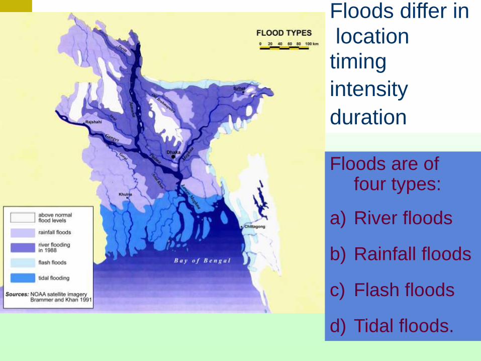
Floods differ in
location timing
intensity
duration
Floods are of four types:
a) River floods
b) Rainfall floods
c) Flash floods
d) Tidal floods.

Urban flood management using Flood Forecast
Pump operation
Structure operation
Detailed forecast inside
the city area
Emergency maintenance
of flood dyke

- Drainage Projects
- Flood Control
- Flood Control &
Drainage
- Flood Control,
Drainage & Irrigation
- Irrigation & Drainage
- Irrigation Projects
65% of flood prone
lands now under flood
management
Flood Management

Normal Flooding

Extreme Flooding

Depth Duration Mapping

Duration Mapping

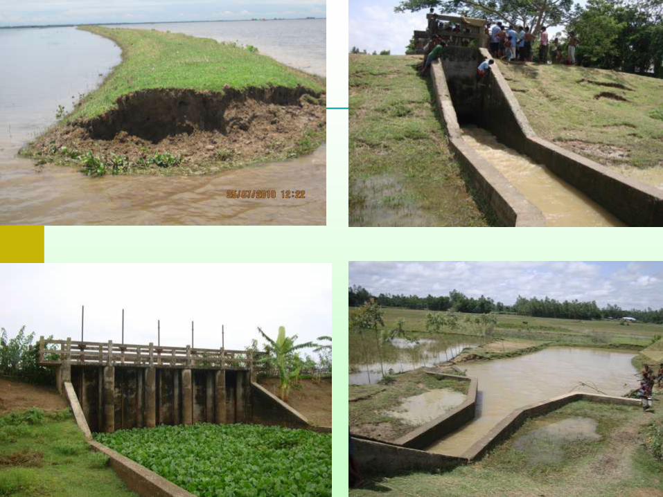
Flood Mitigation Structural measures
• Embankments
• Hydraulic Structures
Non-structural measures
• Flood forecasting and dissemination
• Flood preparedness, etc.
What has been done to reduce the huge losses of lives and properties?
The concept of mathematical modeling has been introduced for improved flood management through understanding the problems scientifically and to devise appropriate, efficient and cost effective mitigation measures.

Non Structural Measures
Flood Forecasting and Warning System
in Bangladesh

What has been achieved so far?
Non-structural measure
Established a Flood Forecasting and
Warning Centre
Dissemination of warning through
Government and NGO initiatives

Taking decisions regarding early harvesting to avoid major crop damage
Planning of transplanting of rice crops
Taking protective measures for saving assets and livestocks
Taking precaution for culture fisheries
Planning flood response activities
Taking precautionary measures to protect infrastructures (growth centres,
food silos, embankments, Roads etc.)
• Taking preventive measures against water borne diseases
What people wants?
Medium-range flood forecasts (4 – 14 days)

Flood Management – Non Structural Flood Forecasting with increased Lead-time
CFAN FFWC
Mode of Flood Forecasting in Future
Forecasting with 10-day Lead-time (CFAN, on-going)
Seasonal Forecasting
Low Flow Forecasting

• Flash flood occurred in April 2004 in the
northeastern region of Bangladesh is the ever
worst in the recorded history.
• Flood 2004 mainly occurred in the Brahmaputra
and the Meghna basins.
• FCD schemes could achieve its primary goal
• Increasing intensity of floods calls for changing
design criteria
Observations

Lessons Learnt
Safety could be provided for floods of even very high frequency
Concept of compartmentalization may be replicated with the community participation
Coastal embankments and drainage structures are very successful
Drainage congestion at some coastal polders due to siltation of the outfall channels.
Decision support systems for monitoring of flood management systems.
Decision support systems (DSS) would help in close monitoring of flood management systems

Lessons Learnt
The magnitude of this year’s flash flood could
have been reduced, if the conveyance
capacity of the river systems could have been
increased by taking up appropriate measures.
Bridges and culverts should have adequate
clearance for navigation.
Flood proofing measures, where feasible, may be
implemented to reduce the flood damage.

• Rationalising of Existing FCD Infrastructure” need to be taken
• Flood risks zones should be designated
• Safe conveyance of the large cross-boundary flows by channelising and stabilizing these rivers with appropriates measures
• Excavation and desilting of rivers, khals, offtakes of distributaries etc
• Rivers, khals and floodways may be kept free from encroachment for free flood flows.
• Full flood protection and proper drainage for the urban areas
Recommendations

• Required fund may be ensured for the maintenance
• Revolving fund for emergency flood fighting
• Coordinated planning, design and construction of all rural roads, highways and railway embankments
• Adequate on-the-spot security for the personnel engaged in flood fighting
• Legislation to regulate the community participation in O&M activities
• Water Act may be enacted to regulate all water management activities
• Improved flood forecasting system
Recommendations
Reassess and redesign of the flood embankments including submergible
embankments in NE region.
An integrated approach of river management covering dredging of the
navigational routes and river bank protection along with feasible
interventions can be undertaken.
Redesign the National Highways, Railways and other key infrastructures
etc.
Reassessment of SW and GW resources considering climate change
scenarios and formulation of plans and incorporation in NWMP
Way forward

Way forward
Development of early warning of storm surge inundation forecasting.
Reengineering of the coastal polders by phases for Sea level rise and
storm surge for the safety of life and livelihood of coastal community.
There are need of new cyclone shelters in the newly defined high risk
areas specially in the Barisal and Khulna division.
Development of GW modelling to understand and manage salinity
intrusion for water management in the coastal region.

There are knowledge gaps right from downscaling of the climate model to the
considerations of glacial melt or blending of meteorological science with the
hydrology. Capacity building in these areas will be of prime importance.
Regional cooperation at the basin level for prediction of climate change impacts
and adaptation measures, sharing of knowledge and development of resources
(conservation of water through upstream reservoirs, flood moderation and
forecasting, navigation, hydro-power etc.)
The existing Bay models are capable of forecasting storm surge induced flooding.
These models extend from Indian to Myanmar coast. These models can for the
basis for regional cooperation
Way forward

Thank You


![Differentiation for paper 2 part 2 [159 marks]kennethsokc.weebly.com/uploads/3/9/8/0/39809815/differentiation_for_paper_2_part_2.pdfDifferentiation for paper 2_part 2 [159 marks] 1a](https://img.pdfslide.us/doc/110x75/5e8a2475604bdb06ab033664/differentiation-for-paper-2-part-2-159-marks-differentiation-for-paper-2part.jpg)