Embed Size (px)
Citation preview
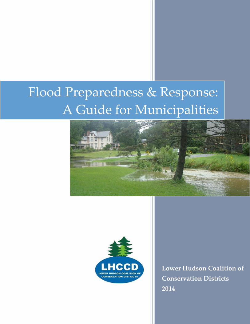
Lower Hudson Coalition of
Conservation Districts
2014
Flood Preparedness & Response:
A Guide for Municipalities
1
Contents
Introduction ........................................................................................................................................................ 2
Flood-smart strategies ....................................................................................................................................... 4
Preparing for a storm ........................................................................................................................................ 7
During a flood .................................................................................................................................................... 9
Recovery ............................................................................................................................................................ 10
Resources........................................................................................................................................................... 14
Contacts Directory ........................................................................................................................................... 15
This publication was prepared by the Lower Hudson Coalition of Conservation Districts for NYS
Water Resources Institute and the NYS Department of Environmental Conservation (NYSDEC)
Hudson River Estuary Program, with support from the NYS Environmental Protection Fund.
© 2014
2
Introduction
The purpose of this guide is specifically to address the flooding of streams and creeks that affects
bridges, roadways and other public infrastructure.
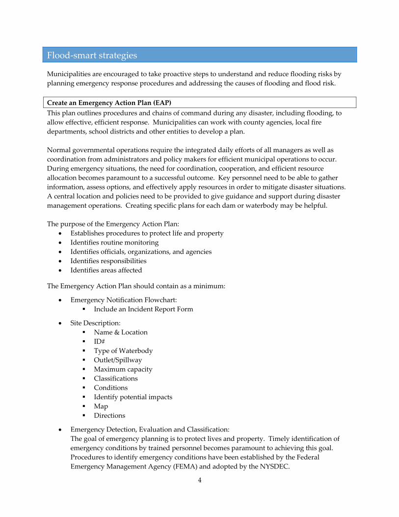
Flooding is a natural process. Streams and creeks form their banks based on normal flow patterns,
including higher levels during snow melt and light rain. However, streams also naturally have a
floodplain that they will occupy during high flow periods. Overflowing into the floodplain allows a
stream to spread out and slow down. This is normal and healthy – but it can be a problem if there
are roads or structures that are affected.
Floods are one of the most common hazards in our region and can result in significant damage.
Some floods develop slowly, while others can develop in just a few minutes. Floods can be local,
impacting a neighborhood or community, or very large, affecting entire river basins. The largest
single source of flood losses in the United States, both in terms of cost and number of people
affected, is damage to transportation infrastructure. Infrastructure damage also represents the
greatest public safety hazard.
Damage can be caused when streams overflow onto floodplains
and affect buildings, roads, bridges, septic systems and other
structures. Fast moving water can also cause erosion, move
large materials and damage structures.
Sometimes stream flooding can be worsened by factors upstream
or downstream. Upstream changes to the landscape can cause
water to fill streams more quickly. Downstream constrictions or
blockages can cause streams to back up. Failure of structures
like culverts and dams can also cause damage.
The following sections cover strategies municipalities can use to
reduce flooding risks, actions that can be taken immediately
before and during a storm, and recovery from flood damage
Typical stream cross-
section.
(From Post-Flood
Emergency Stream
Intervention Manual
by Delaware County
SWCD)
What about other types of “flooding”?
Sometimes localized flooding is caused
by backed-up storm drain systems or
drainage swales in neighborhoods. If
the storm drain or swale system is
managed by the municipality, the
highway or public works department
is responsible for maintenance and
repair. Regular inspection and
maintenance can reduce the risk of
failure. Note that many drainage
swales are on private property and are
the homeowners’ responsibility to
maintain.

3
Please note that this guide is intended to provide ideas and strategies for municipalities. It is not
intended to be a thorough guide to proper floodplain management. The NYSDEC Bureau of Flood
Protection and Dam Safety should be consulted with respect to dams, flood control projects, coastal
erosion, and floodplain management.
4
Flood-smart strategies
Municipalities are encouraged to take proactive steps to understand and reduce flooding risks by
planning emergency response procedures and addressing the causes of flooding and flood risk.
Create an Emergency Action Plan (EAP)
This plan outlines procedures and chains of command during any disaster, including flooding, to
allow effective, efficient response. Municipalities can work with county agencies, local fire
departments, school districts and other entities to develop a plan.
Normal governmental operations require the integrated daily efforts of all managers as well as
coordination from administrators and policy makers for efficient municipal operations to occur.
During emergency situations, the need for coordination, cooperation, and efficient resource
allocation becomes paramount to a successful outcome. Key personnel need to be able to gather
information, assess options, and effectively apply resources in order to mitigate disaster situations.
A central location and policies need to be provided to give guidance and support during disaster
management operations. Creating specific plans for each dam or waterbody may be helpful.
The purpose of the Emergency Action Plan:
Establishes procedures to protect life and property
Identifies routine monitoring
Identifies officials, organizations, and agencies
Identifies responsibilities
Identifies areas affected
The Emergency Action Plan should contain as a minimum:
Emergency Notification Flowchart:
Include an Incident Report Form
Site Description:
Name & Location
ID#
Type of Waterbody
Outlet/Spillway
Maximum capacity
Classifications
Conditions
Identify potential impacts
Map
Directions
Emergency Detection, Evaluation and Classification:
The goal of emergency planning is to protect lives and property. Timely identification of
emergency conditions by trained personnel becomes paramount to achieving this goal.
Procedures to identify emergency conditions have been established by the Federal
Emergency Management Agency (FEMA) and adopted by the NYSDEC.
5
Inundation Maps:
In order to analyze the impacts of a stream breach or dam failure, inundation mapping is
one of the most critical components of the EAP. Inundation maps can be found through
FEMA or your county Bureau of Emergency Services. Municipalities can also have an
engineer develop these maps using ACOE software. The inundation mapping is to be
reviewed and updated annually, and more frequently as necessary to reflect changes in the
waterbody.
Detailed guidance on developing a plan is provided by the New York State Office of Emergency
Management: http://www.dhses.ny.gov/planning/
Take Stock of Infrastructure
Assess dams: Dams are catalogued by New York State and classified according to risk. Learn about
dams in your community at: http://www.dec.ny.gov/lands/4991.html
Consider culvert upgrades: Culverts and other small stream crossings can present a risk if they are
undersized or in disrepair. Culverts can be examined proactively to determine if they need
replacement or upgrade. The preferred crossing method is to install open-bottom culverts and
crossings that are at least 1.25 times the width of the natural streambank. NYSDEC best
management practices can be found at: http://www.dec.ny.gov/permits/49066.html. Your county
conservation district or municipal engineer may be able to assist with advice on properly sizing
culverts for predicted flows and selecting structures that will be less prone to damage.
Create a Multi-Hazard Mitigation Plan
This long-range plan catalogues steps to be taken to reduce the risk of future damage from flooding
and other hazards. Developing a Multi-Hazard Mitigation Plan that is approved by FEMA is a
prerequisite to obtaining FEMA mitigation funding. Guidance is provided by the New York State
Office of Emergency Management: http://www.dhses.ny.gov/oem/mitigation/
Attend Post-Flood Emergency Stream Intervention Training
This training is being offered by some conservation districts to prepare local highway or public
works staff to respond to stream damage from storms. Having highway staff trained in advance
will provide smooth response when flooding strikes. See http://www.dec.ny.gov/lands/89755.html
Slow the Flow off the Land
If a stream is flooding frequently, consider whether development in the surrounding area might be a
cause. Hard surfaces like roads, parking lots and roofs can speed water flow into a stream. A
community can “re-plumb” upstream land areas to help water slow down and soak in, rather than
surging into streams.
Road Drainage: Look at road drainage systems, including ditches and storm drains, to see if
they can be disconnected from streams. Outletting drainage systems into an area where
6
water can infiltrate or pond can slow the flow and recharge groundwater, instead of
shunting water directly into streams.
Catching water on the land: Encourage the use of green infrastructure practices, such as rain
gardens and porous pavement, in the surrounding watershed (drainage area). Ensure the
planning board and other officials are carefully reviewing stormwater plans for new
development to minimize runoff that could affect those downstream.
Reconsider Land Use Within Floodplains
One way to reduce future flood damage is to avoid constructing new private property and public
infrastructure in floodplains, and to make sure that any development that does take place complies
with floodplain development standards.
Flood Insurance Rate Maps provide the legal designations of regulated flood hazard areas, and can
be found at www.msc.fema.gov. Most municipalities have already adopted recommended basic
Flood Damage Prevention regulations to stay in compliance with the National Flood Insurance
Program so that their residents can maintain access to federally guaranteed flood insurance from the
National Flood Insurance Program. Municipalities are responsible for keeping these regulations up
to date and enforced, and must legally adopt new maps when FEMA issues an updated Flood
Insurance Rate Map. Municipalities and residents can learn more about the National Flood
Insurance Program at http://www.floodsmart.gov/floodsmart/. Specific information on New York
State’s program is at: http://www.dec.ny.gov/lands/39341.html
The basic Flood Damage Prevention regulations govern construction in floodplains with the goal of
making sure new structures can withstand flooding with minimal damage. However, some
communities may wish to further restrict construction in floodplains to lessen risk and maintain the
natural functions of the floodplain to slow and store water. In New York, municipalities have the
ability to enact stronger controls on construction in floodplains, including zoning changes and
overlay districts. For more detail, the LHCCD recommends Westchester County’s guide, “Flooding
and Land Use Planning: A Guidance Document for Municipal Officials and Planners” (see
resources). Pace Land Use Law Center’s Gaining Ground database can also provide examples for
overlay zones and other floodplain protection techniques: http://www.landuse.law.pace.edu/
The Community Rating System is a FEMA financial incentive program to promote adoption of
stronger policies to reduce flood damage. If communities document that they have policies and
programs that reduce flood damage risk, they can be rewarded with a reduced flood insurance rate
for all landowners within the municipality. More information on this FEMA program is at:
http://www.fema.gov/national-flood-insurance-program-community-rating-system
Regulate Runoff that Could Worsen Flooding
On sites that are not within floodplains, attention to stormwater management can reduce the
potential to create future flooding problems. When a new subdivision or site plan is being
considered, municipalities can encourage the use of green infrastructure practices that manage and
absorb stormwater on site to reduce additional flow to flood prone areas.
7
Preparing for a storm
The best way to prepare for flooding is to develop a proactive plan for storm response so that
emergency personnel and citizens know where to look for coordination and assistance (see section
on Flood-smart Strategies). Advance planning will make preparation for an imminent storm easier
and more effective.
If a major storm is in the forecast, it is time to prepare to implement your Emergency Action Plan. If
you don’t have a plan, there are a few basic steps that can minimize damage:
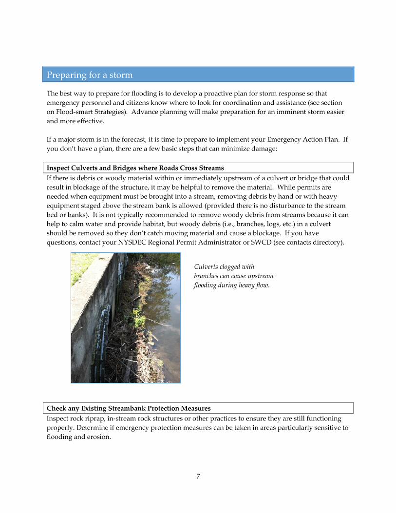
Inspect Culverts and Bridges where Roads Cross Streams
If there is debris or woody material within or immediately upstream of a culvert or bridge that could
result in blockage of the structure, it may be helpful to remove the material. While permits are
needed when equipment must be brought into a stream, removing debris by hand or with heavy
equipment staged above the stream bank is allowed (provided there is no disturbance to the stream
bed or banks). It is not typically recommended to remove woody debris from streams because it can
help to calm water and provide habitat, but woody debris (i.e., branches, logs, etc.) in a culvert
should be removed so they don’t catch moving material and cause a blockage. If you have
questions, contact your NYSDEC Regional Permit Administrator or SWCD (see contacts directory).
Check any Existing Streambank Protection Measures
Inspect rock riprap, in-stream rock structures or other practices to ensure they are still functioning
properly. Determine if emergency protection measures can be taken in areas particularly sensitive to
flooding and erosion.
Culverts clogged with
branches can cause upstream
flooding during heavy flow.
8
Make Contact with Emergency Response Personnel
To ensure a coordinated response, learn ahead of time about your county's emergency plans,
warning signals, evacuation routes, and locations of emergency shelters. Determine the most
appropriate method to inform your residents of any flood watches or warnings and how the public
should prepare. Ensure that your residents are prepared for an emergency – example
recommendations include keeping an emergency supply kit, knowing the municipality’s emergency
evacuation plan, keeping a list of valuables prone to flooding, and elevating furnace, water heater
and other utilities on basement or ground floors.
9
During a flood
During an emergency, the goals are to keep residents safe and maintain efficient, orderly
communication. If you have an Action Plan (see Flood-smart Strategies), now is the time to deploy
it.
Communication with Emergency Services and Residents
Coordinate with county emergency service agencies and local fire departments on a system for
keeping the public informed. Keeping the public informed of road closures and detours can be a
challenge – press releases to the media can help, as well as use of email or social media alert systems.
If you receive information about the possibility of flooding, be prepared to advise residents to move
to higher ground immediately.
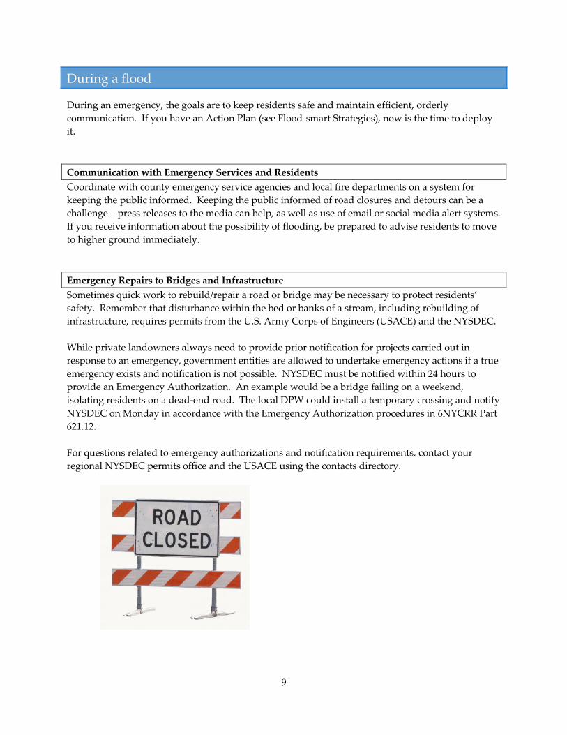
Emergency Repairs to Bridges and Infrastructure
Sometimes quick work to rebuild/repair a road or bridge may be necessary to protect residents’
safety. Remember that disturbance within the bed or banks of a stream, including rebuilding of
infrastructure, requires permits from the U.S. Army Corps of Engineers (USACE) and the NYSDEC.
While private landowners always need to provide prior notification for projects carried out in
response to an emergency, government entities are allowed to undertake emergency actions if a true
emergency exists and notification is not possible. NYSDEC must be notified within 24 hours to
provide an Emergency Authorization. An example would be a bridge failing on a weekend,
isolating residents on a dead-end road. The local DPW could install a temporary crossing and notify
NYSDEC on Monday in accordance with the Emergency Authorization procedures in 6NYCRR Part
621.12.
For questions related to emergency authorizations and notification requirements, contact your
regional NYSDEC permits office and the USACE using the contacts directory.
10
Recovery
After the emergency response to the storm event, municipalities and private land owners need to
address damage caused by the storm. Often this means removal of debris and repair of
infrastructure.
Working with FEMA
If you are anticipating FEMA reimbursement for repair or reconstruction, it is wise to contact FEMA
representatives before beginning work. Contact information is in the contacts directory.
Working In and Near Streams
When planning work in or near streams, the first rule is: Don’t do more than necessary. Streams
exist in a delicate balance, and when people make changes, often the stream will compensate with
unexpected reactions. Dredging out a section of stream may cause the stream to erode upstream or
downstream to regain equilibrium. Changing the curve of a stream may cause it to form a new
curve in an unpredicted location. Those who have worked in streams for many years often learn to
use a light touch and only do what is necessary.
If a stream has become clogged or damaged during a storm, contact your county conservation
district or other professional for guidance on planning your response. The Post-Flood Emergency
Stream Intervention manual has a wealth of information as well (see resources). Consult the
“Permits” section below for more on permitting requirements.
Rebuilding Infrastructure
When bridges or culverts wash out or roads alongside streams are damaged, it tempting to quickly
rebuild the same infrastructure to get traffic flowing again. However, sometimes it’s better to
upgrade to improve resilience and prevent problems in the future.
Where roads cross streams, crossings that accommodate the stream’s natural characteristics are
preferred. Culverts that are too small or poorly placed can cause problems down the line. Putting
two culverts side-by-side rather than installing a larger crossing can cause debris to snag and water
to back up. NYSDEC has developed best practices for stream crossings, which you can view here:
http://www.dec.ny.gov/permits/49066.html
Before designing new infrastructure, check with your regional NYSDEC permits office and the
USACE for guidance. Your county conservation district may be able to assist as well.
11
Permits
If you need to work in or near a stream, it’s likely you’ll need a permit. The purpose of permitting is
to ensure that actions undertaken with good intentions don’t unintentionally cause other problems.
The following is an overview of the types of permits that may be needed.
U.S. Army Corps of Engineers Permits
Permits are required from the U.S. Army Corps of Engineers for projects involving the discharge of
dredged or fill material into waters of the U.S. including culvert or bridge repair and stream
stabilization projects. The USACE has general permits known as Nationwide Permits and Regional
General Permits which authorize certain activities which have a minimal environmental impact such
as repair or replacement of existing structures. Nationwide permits and Regional General Permits
provide an expedited permit review process for routine actions or actions undertaken in response to
a storm event.
NYSDEC Permits
The following provides a brief overview of NYSDEC permits that may be needed for work in or near
a stream or wetland. More specific information can be found at the following link:
http://www.dec.ny.gov/63.html
Article 15 Protection of Waters Permits: These permits are necessary if projects will disturb the bed
or banks of protected streams (Class C(t) or higher – see explanation below), or if the project will
involve excavation or fill in a navigable waters of the state (i.e., streambank stabilization, repairs or
replacement of bridges or culverts, etc.). It is important to note that for some protected streams, the
actual regulated stream bank may extend 50 feet or more from the stream bed (refer to
http://www.dec.ny.gov/permits/70947.html for a Stream Bank Illustration and Definition).
Article 24 Freshwater Wetlands Permits: Wetlands that are 12.4 acres or greater, or have been
determined by the NYSDEC to have unusual local importance, are protected under the Freshwater
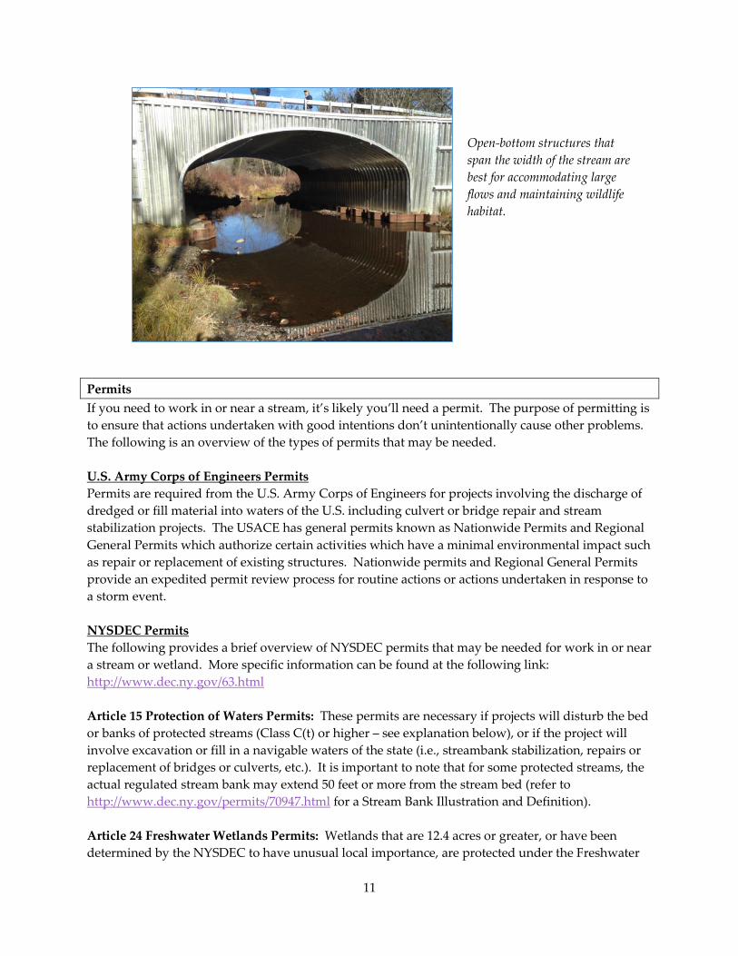
Open-bottom structures that
span the width of the stream are
best for accommodating large
flows and maintaining wildlife
habitat.
12
Wetlands Act and require a permit for most disturbances within the wetland and 100 ft. of the
wetland.
Article 25 Tidal Wetlands Permits: Tidal Wetlands are protected under the Tidal Wetlands Act and
the NYSDEC requires a permit for most activities within the wetlands or up to 300 feet adjacent to
the wetlands.
Section 401 Water Quality Certification: If work will occur within a federally regulated waters of
the U.S. (including wetlands and streams), and a USACE permit is required, the NYSDEC may need
to make a determination that discharges from the proposed activities will comply with the
applicable effluent limitations, water quality standards, and any other applicable conditions of the
State Law. A Water Quality Certification, pursuant to Section 401 of the Federal Clean Water Act,
may be required from the NYSDEC for impacts to federally regulated waters of the U.S. For routine
repairs and replacements of existing structures and for some stream bank stabilization projects,
work may be authorized under a Blanket 401 Water Quality Certification; more details on this can be
found at: http://www.dec.ny.gov/permits/81010.html.
Stormwater Permit for Construction Activities: Before commencing construction activities,
applicants need to obtain coverage under the State Pollutant Discharge Elimination System (SPDES)
General Permit for Stormwater Discharges from Construction Activities that will disturb more than
1 acre. The Permit requires the preparation of a Stormwater Pollution Prevention Plan and
submission of a Notice of Intent. Please see the following link for more information:
http://www.dec.ny.gov/chemical/43133.html.
Often after a storm event, the NYSDEC will provide for an expedited permitting process to address
storm related repairs such as issuance of General Permits. The following link provides additional
information on Storm Recovery Permits: http://www.dec.ny.gov/permits/89343.html. Additionally,
there are some activities that are exempt from permitting including the removal of debris and
woody material from streams that may be compromising existing infrastructure, provided that
removal does not result in the disturbance of the bed or banks of the stream (i.e., using chainsaws to
cut up woody material in the stream, hand removal of woody material, or picking up woody
material using heavy equipment provided that the equipment itself does not enter the water).
County/Town Permits
Floodplain Development Permit: Generally, local governments regulate construction and
development in floodplains, based on the National Flood Insurance Program. This involves
regulations not only in streams, but also in adjacent floodplains.
Local Land Use Laws: These regulations include any other legislation or ordinances your local
government may have for stream, wetlands, and floodplain development.
13
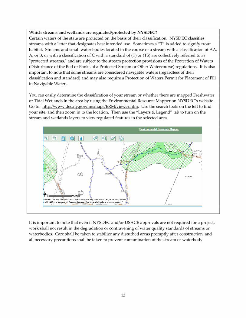
Which streams and wetlands are regulated/protected by NYSDEC?
Certain waters of the state are protected on the basis of their classification. NYSDEC classifies
streams with a letter that designates best intended use. Sometimes a “T” is added to signify trout
habitat. Streams and small water bodies located in the course of a stream with a classification of AA,
A, or B, or with a classification of C with a standard of (T) or (TS) are collectively referred to as
"protected streams," and are subject to the stream protection provisions of the Protection of Waters
(Disturbance of the Bed or Banks of a Protected Stream or Other Watercourse) regulations. It is also
important to note that some streams are considered navigable waters (regardless of their
classification and standard) and may also require a Protection of Waters Permit for Placement of Fill
in Navigable Waters.
You can easily determine the classification of your stream or whether there are mapped Freshwater
or Tidal Wetlands in the area by using the Environmental Resource Mapper on NYSDEC’s website.
Go to: http://www.dec.ny.gov/imsmaps/ERM/viewer.htm. Use the search tools on the left to find
your site, and then zoom in to the location. Then use the “Layers & Legend” tab to turn on the
stream and wetlands layers to view regulated features in the selected area.
It is important to note that even if NYSDEC and/or USACE approvals are not required for a project,
work shall not result in the degradation or contravening of water quality standards of streams or
waterbodies. Care shall be taken to stabilize any disturbed areas promptly after construction, and
all necessary precautions shall be taken to prevent contamination of the stream or waterbody.
14
Resources
Training
Cornell Local Roads Program: http://www.clrp.cornell.edu/
NYS Division of Homeland Security & Emergency Services: http://www.dhses.ny.gov/training/
Post Flood Emergency Stream Intervention: http://www.dec.ny.gov/lands/89755.html
Estuary Watershed Resiliency: http://blogs.cornell.edu/estuaryresilience/
Information
Westchester County’s guide, “Flooding and Land Use Planning”:
http://planning.westchestergov.com/images/stories/reports/FLOODGUIDE.pdf
NYSDEC “What to do after a Flood”:
http://www.dec.ny.gov/lands/80429.html
Post Flood Emergency Stream Intervention Manual:
http://www.dec.ny.gov/docs/administration_pdf/streammnll.pdf
Funding
Following a major flooding event, specific funding sources may become available for recovery.
Keep an eye out for announcements from state agencies. You can contact your regional Office of
Emergency Management using the contacts directory.
Funding for proactive flood mitigation measures may be available from:
NYSDEC’s Water Quality Improvement Program: http://www.dec.ny.gov/pubs/4774.html
Hudson River Estuary Program: http://www.dec.ny.gov/lands/5091.html
NYS Division of Homeland Security & Emergency Services:
http://www.dhses.ny.gov/grants/program.cfm
NYS Department of State – Local Waterfront Revitalization Program:
http://www.dos.ny.gov/opd/programs/lwrp.html
Hudson River Valley Greenway – Greenway Communities Grant Program:
http://hudsongreenway.ny.gov/GrantFunding/CommunityGrants.aspx
15
Contacts Directory
New York State Department of Environmental Conservation
http://www.dec.ny.gov/about/558.html
NYSDEC Region Counties covered Contact info:
Region 2 New York City Permits: (718) 482-4997
Information: (718) 482-4900
After Hours Emergencies: (800) 847-7332
Region 3 Ulster, Dutchess, Orange,
Putnam, Rockland, Westchester
Permits: (845) 256-3054
Information: (845) 256-3000
Region 4 Albany, Rensselaer, Columbia,
Greene
Permits: (518) 357-2069
Information: (518) 357-2068
NYSDEC Floodplain Management Section (statewide): 518-402-8185, [email protected]
NYS Office of Emergency Management (DHSES)
http://www.dhses.ny.gov/contact/
DHSES Region Counties covered Contact info:
Region I New York City (631) 952-6322
Region II Columbia, Dutchess, Greene,
Orange, Putnam, Rockland,
Sullivan, Ulster, Westchester
(845) 454-0430
Region III Albany, Rensselaer (518) 793-6646
Other NYS Agencies
Department of State – Office of Communities
& Waterfronts
(518) 474-6000
Office of Parks, Recreation & Historic
Preservation
NYC: (212) 866-2599
Mid-Hudson: (845) 889-3866
Capital Region: (518) 584-2000
Federal Agencies
U.S. Army Corps of Engineers – New York
District
(for NYSDEC Regions 2 and 3 area)
(917) 790-8007
http://www.nan.usace.army.mil/Contact.aspx
Upstate NY Section (for NYSDEC Region 4 area)
(518) 266-6350
16
FEMA Region II (212) 680-3600
http://www.fema.gov/region-ii-contact-us
Regional
In New York City water supply watersheds, contact NYC Department of Environmental Protection
at 212-639-9675. More information at:
http://www.nyc.gov/html/dep/html/watershed_protection/regulatory.shtml
County
Contact your County Soil & Water Conservation District for information on relevant agencies and
resources within your county.
Albany County SWCD
PO Box 497, 24 Martin Road
Voorheesville, NY 12186
Phone: (518) 765-7923
Joseph Slezak
Columbia County SWCD
1024 State Route 66
Ghent, NY 12075-3200
Phone: (518) 828-4386 Ext. 3
Laura Sager
Dutchess County SWCD
2715 Route 44, Suite 3
Millbrook, NY 12545
Phone: (845) 677-8011/8199 Ext. 3
Brian Scoralick
Greene County SWCD
907 County Office Building
Cairo, NY 12413-9502
Phone: (518) 622-3620
Jeff Flack
New York City SWCD
121 Sixth Avenue, Suite 501
New York, NY 10013
Phone: (212) 431-9676
Shino Tanikawa
Orange County SWCD
225 Dolson Avenue, Suite 103
Middletown, NY 10940
Phone: (845) 343-1873
Kevin Sumner
Putnam County SWCD
841 Fair Street
Carmel, NY 10512
Phone: (845) 878-7918
Lauri Taylor
Rensselaer County SWCD
61 State Street
Troy, NY 12180-3496
Phone: (518) 271-1740/1764
Tom Sanford
Rockland County SWCD
50 Sanatorium Road, Building P
Pomona, NY 10970
Phone: (845) 364-2670
Mary Hegarty
Ulster County SWCD
652 Route 299, Suite 103
Highland, NY 12528
Phone: (845) 883-7162 Ext. 5
Gary Capella
Westchester County SWCD
148 Martine Avenue, Room 432
White Plains, NY 10601
Phone: (914) 995-4407/4423
Robert Doscher