Embed Size (px)
Citation preview
Flood Mitigation and Management in Thailand
Flood Mitigation and Management in Thailand
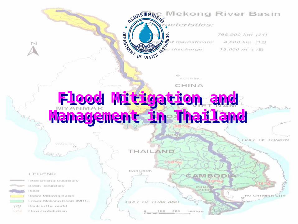
TopicsTopics
Nature and Extent of FloodingNature and Extent of Flooding Data Collection and ForecastingData Collection and Forecasting Flood Forecasting and WarningFlood Forecasting and Warning Communication of Flood-Communication of Flood-
Warning InformationWarning Information Other Relevant InformationOther Relevant Information
Nature and Extent of Nature and Extent of FloodingFlooding
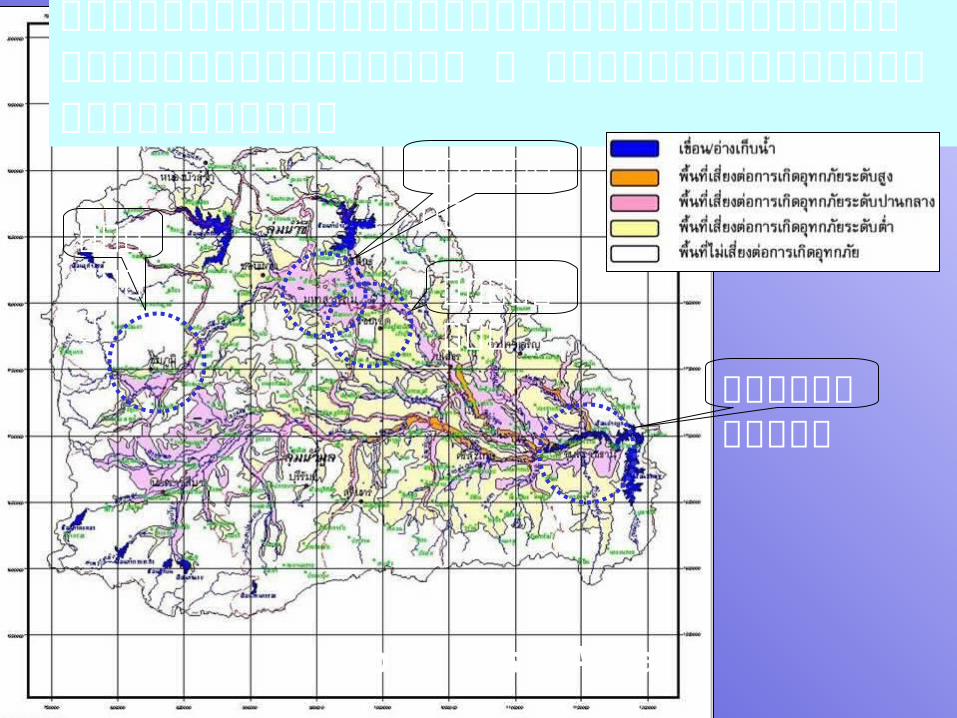
แผนที่��แสดงพื้��นที่��เส��ยงต่�อการเก�ดอ�ที่กภั�ยระด�บต่�าง ๆ ในลุ่��มน��าชี�แลุ่ะลุ่��มน��าม!ลุ่
ร้�อยเอ�ด
อบลร้าชธานี�
ช�ยภู�มิ�
มิหาสาร้คามิ
Flood Risk Area
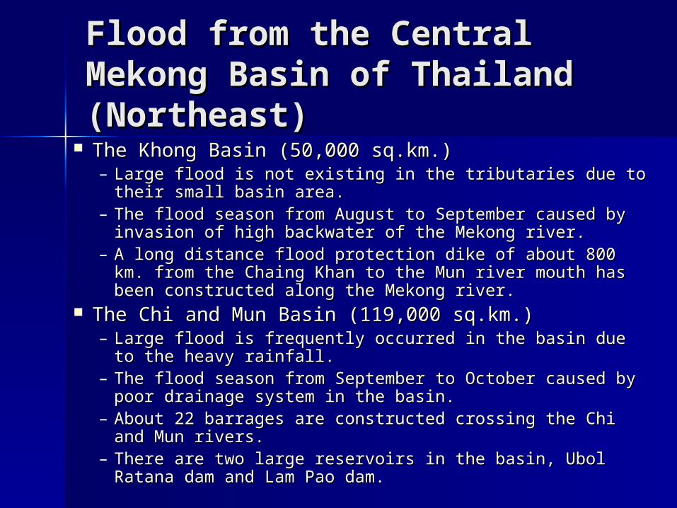
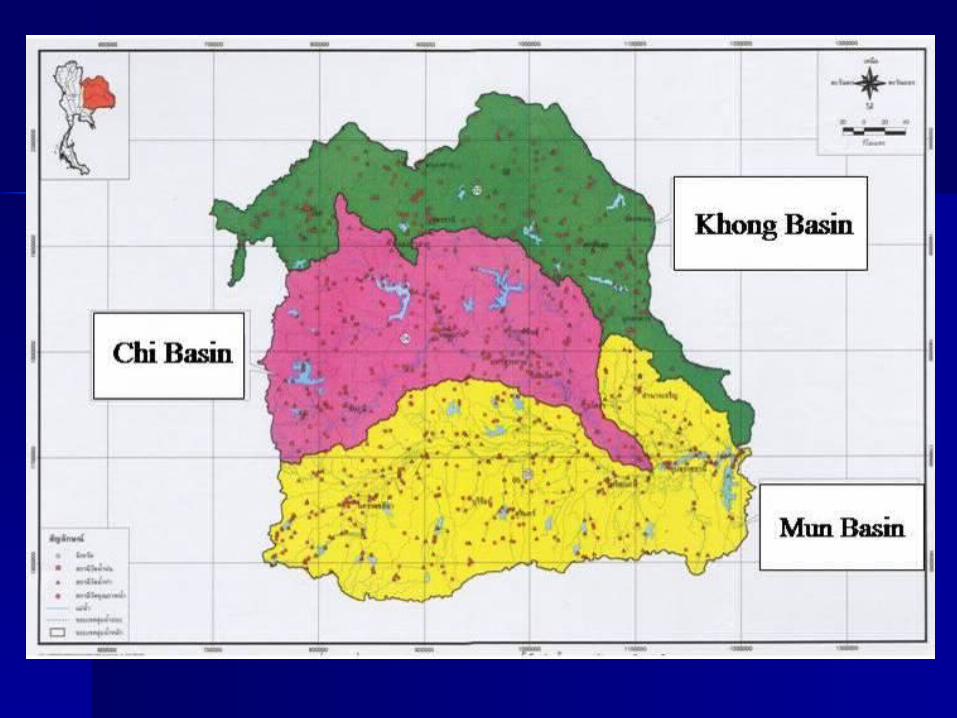
Flood from the Central Flood from the Central Mekong Basin of Thailand Mekong Basin of Thailand (Northeast)(Northeast)
The Khong Basin (50,000 sq.km.)The Khong Basin (50,000 sq.km.)– Large flood is not existing in the tributaries due to their small Large flood is not existing in the tributaries due to their small
basin area.basin area.– The flood season from August to September caused by The flood season from August to September caused by
invasion of high backwater of the Mekong river.invasion of high backwater of the Mekong river.– A long distance flood protection dike of about 800 km. from A long distance flood protection dike of about 800 km. from
the Chaing Khan to the Mun river mouth has been the Chaing Khan to the Mun river mouth has been constructed along the Mekong river.constructed along the Mekong river.
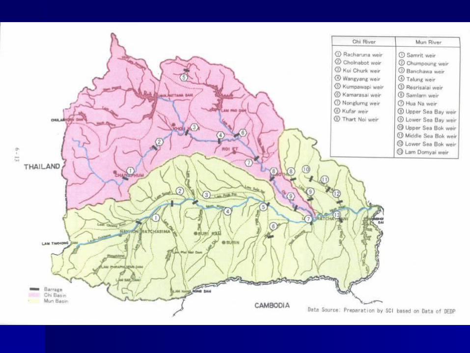
The Chi and Mun Basin (119,000 sq.km.)The Chi and Mun Basin (119,000 sq.km.)– Large flood is frequently occurred in the basin due to the Large flood is frequently occurred in the basin due to the
heavy rainfall. heavy rainfall. – The flood season from September to October caused by poor The flood season from September to October caused by poor
drainage system in the basin.drainage system in the basin.– About 22 barrages are constructed crossing the Chi and Mun About 22 barrages are constructed crossing the Chi and Mun
rivers.rivers.– There are two large reservoirs in the basin, Ubol Ratana dam There are two large reservoirs in the basin, Ubol Ratana dam
and Lam Pao dam.and Lam Pao dam.
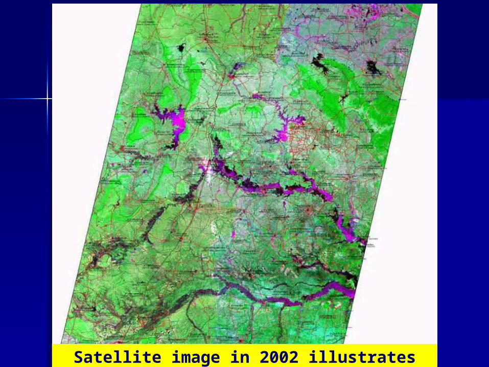
Satellite image in 2002 illustrates inundated area in the northeast of
Thailand

Data Collection and Data Collection and ForecastingForecasting
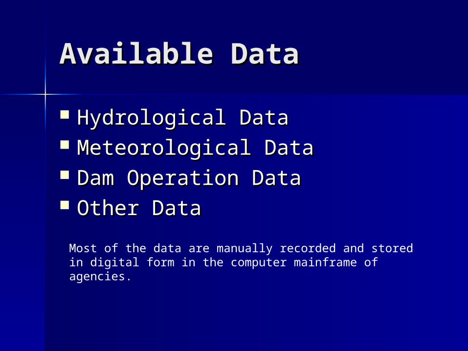
Available DataAvailable Data
Hydrological DataHydrological Data Meteorological DataMeteorological Data Dam Operation DataDam Operation Data Other DataOther Data
Most of the data are manually recorded and stored in digital form in the computer mainframe of agencies.
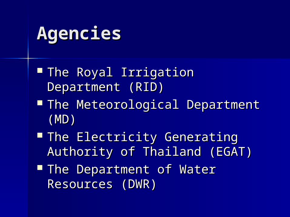
AgenciesAgencies
The Royal Irrigation Department The Royal Irrigation Department (RID)(RID)
The Meteorological Department The Meteorological Department (MD)(MD)
The Electricity Generating The Electricity Generating Authority of Thailand (EGAT)Authority of Thailand (EGAT)
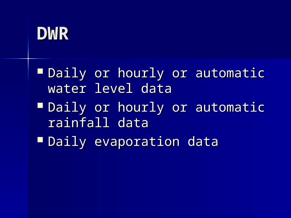
The Department of Water The Department of Water Resources (DWR)Resources (DWR)
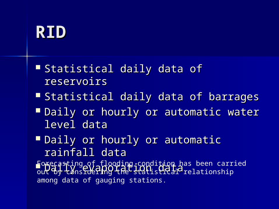
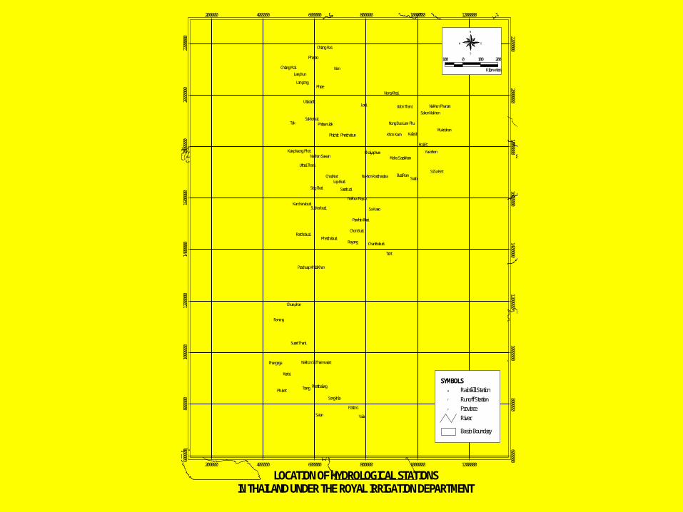
RIDRID
Statistical daily data of reservoirsStatistical daily data of reservoirs Statistical daily data of barragesStatistical daily data of barrages Daily or hourly or automatic water Daily or hourly or automatic water
level datalevel data Daily or hourly or automatic Daily or hourly or automatic
rainfall datarainfall data Daily evaporation dataDaily evaporation dataForecasting of flooding condition has been carried out by considering the statistical relationship among data of gauging stations.
%%%%%%%%%%%%%
%%%%
%%
%%%%
%
%
%
%
%
%
%
%
%%
%%%%%%
%%
%%
%
%%
%%%%%
%
%
%%%%%%%%%
%%%%
%%%%
%
%%%
%%
%
%
%
%%
%
%%
%
%%%%%
%
%
%%
%
%
%
%
%%%
%
%
%%
%%
%%%
%
%
%
%%%
%
%
%
%
%
%
%
%
%
%
%
%
%
%%% %
%
%%%%
%%
%%%%%
%
%
%
%
%
%%% %
%%
%
%
%
%
%%
%%
%
%
% %
%
%
%%
%
%
%%
%%
%%
%
%
%
%%
%
%
%
%
%
%
%
%
% %%
%
%
%
%
%%%%%%%%%
%
%%%%
%%
%%
%
%
%
%
%
%%%
%
%%%%
%
%
%
%%
%
%%
%
%
%
%
%
%%%%%%%%
%%%%%%%%%%%
%%%%%
%%
%%
%% %
%%
%%
%%%% %
%
%%%%
%%%
%%
%
%
%
%
%
%%%%%%% %%
%
%
%
%
%%
%
%
%
%
%
% %%
% %
%
%
%
%% %%
%
%
%
%
%
%%%%%%
%% %
%% % %
%
%%%%
%%
%%
%
%
%
%
%
%%
% %
%%%%%%%
%
%
%
%
%
%
%%%%
%%
%
%%%
%
%%%%%%%%%
%
%
%%
%
%
%%%
%
%
%
%
%%
%
%
%%%%%%%%%%
%
%
%%
%
%%
%
%%%%%%
%%
%%%%%%%%
%
%%%%%
%%%
%%%%%%%
%% %%%
%
%%
%%%%%
%%
%%%
%%
%
%%%
%% % %%
%
%
%
%
%
%
%%%%
%
% %
%
%
%%%%%
%
%%%%%%
%
%
% %%%%
%%
%%%%
%%
%%
%
%
%
%
%
%
%
%
%%% %%
%%%
%%
%
%%
%%%
%
%%%%%%
%
%%%
%%%%%% %%
%
%
%%
%%%%%
%%
%% %%%%%%%%%%
%%
%%
%
%
%
%
%
%
%
%
%%
%
%
%
%
%
%
%%%%
%%%%%%%%%
%%%%%%
%
%
%
%
%%
%%
%%
%
%
%%%% %%
%
%%%
%%%%%
%%%%
%
%
%%
% %
%%
%
%%
%
%
%
%% %
%
%
%%
%
%
%
%
%
%%
%%
%%%
%
%%%
%%
%%
% %
%%
%%
%
%
%
%
%%%
%
%
%
%
%
%
%%
%%%
$T$T$T
$T$T
$T
$T$T$T $T$T
$T
$T$T
$T
$T$T
$T
$T$T
$T
$T$T
$T
$T$T$T
$T$T
$T
$T
$T
$T
$T
$T
$T
$T
$T$T$T$T
$T
$T$T
$T
$T$T
$T$T
$T$T$T
$T$T$T$T $T
$T$T$T$T
$T$T
$T$T
$T
$T$T$T
$T
$T$T$T
$T$T$T
$T$T
$T$T
$T
$T $T
$T
$T
$T $T$T$T
$T$T$T
$T$T
$T$T$T$T$T
$T
$T$T$T
$T$T$T$T$T
$T
$T
$T
$T$T$T
$T $T
$T$T
$T
$T$T$T
$T
$T
$T
$T$T$T
$T
$T$T$T
$T$T
$T$T$T $T
$T
$T
$T$T
$T$T$T
$T
$T$T
$T$T
$T$T$T$T$T
$T
$T
$T$T$T$T
$T$T$T$T$T
$T
$T
$T$T
$T
$T
$T
$T
$T
$T$T$T
$T$T
$T
$T
$T $T$T$T$T
$T
$T$T$T
$T
$T
$T$T
$T$T
$T
$T
$T
$T$T$T
$T
$T
$T$T
$T
$T
$T$T
$T
$T
$T
$T$T$T$T
$T$T
$T$T
$T
$T$T
$T
$T
$T
$T
$T$T$T$T$T$T$T
$T
$T
$T
$T
$T$T
$T
$T
$T
$T
$T
$T
$T$T$T $T
$T
$T
$T$T $T
$T$T $T
$T$T
$T
$T
$T
$T
$T$T
$T
$T
$T
$T
$T
$T$T
$T
$T
$T$T
$T$T$T$T$T
$T$T$T
$T
$T$T
$T
$T
$T
$T$T
$T
$T$T
$T
$T
$T
$T
$T$T$T$T
$T$T$T
$T
$T
$T
$T
$T$T$T$T$T $T
$T
$T$T
$T$T
$T
$T
$T$T
$T
$T$T$T$T
$T
$T
$T$T$T
$T$T$T$T$T$T$T
$T
$T
$T$T
$T
$T
$T$T$T
$T
$T
$T
$T
$T
$T$T
$T
$T
$T
$T
$T$T
$T$T
$T
$T
$T$T
$T $T
$T
$T$T$T
$T $T$T$T$T
$T
$T
$T
$T $T $T
$T$T
$T
$T
$T$T$T
$T
$T
$T
$T$T
$T $T
$T
$T$T$T$T
$T$T
$T
$T $T
$T$T
$T
$T
$T
$T
$T
$T
$T
$T
$T
$T
$T
$T$T$T
$T
$T
$T$T$T$T$T$T$T
$T$T
$T
$T$T $T
$T$T$T
$T
$T
$T$T$T
$T
$T
$T$T
$T
$T
$T
$T
$T
$T
$T$T$T
$T$T
$T
$T$T
$T
$T
$T$T
$T$T$T
$T
$T
$T
$T$T
$T$T
$T$T$T
$T
$T
$T
$T
$T
$T $T $T $T$T $T
$T$T
$T$T$T$T
$T$T
$T
$T
$T
$T$T
$T
$T
$T$T
$T$T
$T
$T
$T$T
$T$T$T
$T$T
$T$T
$T$T
$T
$T
$T$T
$T
$T
$T
$T
$T
$T
$T$T
$T$T$T
$T
$T$T$T
$T
$T
$T
$T
$T
$T
$T
$T
$T $T
$T
$T
$T
$T$T$T$T
$T
$T
$T
$T
$T$T $T
$T$T
$T
$T
$T
$T$T
$T
$T
$T $T
$T
$T
$T
$T
$T
$T
$T
$T
$T
$T
$T$T$T
$T$T$T$T$T $T$T
$T
$T
$T$T$T$T$T
$T$T
$T$T
$T$T
$T
$T$T
$T$T$T$T
$T
$T
$T
$T$T
$T$T$T$T$T
$T
$T$T
$T$T
$T$T
$T
$T
$T
$T
$T
$T
$T
$T$T
$T
$T
$T$T
$T
$T
$T
$T
$T
$T
$T
$T$T$T
$T
$T$T$T
$T
$T$T$T
$T$T$T$T$T
$T$T$T
$T
$T
$T
$T
$T
$T
$T
$T
$T
$T
$T$T
$T
$T
$T
$T
$T
$T
$T
$T
$T
$T
$T
$T$T$T$T$T$T
$T
$T$T
$T
$T
$T
$T$T
$T$T
$T $T$T
$T
$T
$T
$T$T$T
$T$T
$T
$T
$T
$T
$T
$T $T
$T
$T
$T
$T
$T$T
$T
$T$T
$T$T
$T
$T$T
$T$T $T
$T$T
$T
$T$T$T
$T$T
$T
$T
$T
$T
$T
$T$T
$T
$T$T$T$T$T
$T
$T
$T$T$T
$T$T
$T$T$T$T
$T$T
$T
$T$T
$T$T
$T$T$T
$T
$T
$T$T$T$T
$T
$T
$T
$T$T
$T$T
$T$T
$T$T$T
$T
$T
$T
$T
$T$T
$T$T
$T
$T
$T
$T $T
$T$T
$T
$T$T$T
$T$T$T$T$T
$T$T$T
$T
$T$T
$T
$T
$T
$T
$T$T$T
$T
$T
$T
$T$T$T$T
$T$T
$T
$T
$T
$T
$T$T
$T
$T
$T
$T
$T
$T
$T
$T
$T
$T
$T
$T
$T$T$T
$T
$T
$T
$T
$T$T$T
$T
$T$T$T
$T
$T$T
$T
$T
$T
$T
$T
$T
$T
$T
$T$T
$T$T
$T
$T
$T
$T$T
$T$T$T
$T
$T
$T
$T$T$T$T$T$T$T
$T
$T$T
$T$T
$T
$T $T$T
$T
$T
$T$T $T$T
$T
$T$T
$T$T$T$T
$T
$T$T
$T
$T
$T
$T$T
$T$T$T$T
$T$T
$T
$T
$T
$T
$T$T
$T $T
$T
$T
$T$T
$T
$T
$T$T
$T$T
$T
$T$T$T $T$T$T $T$T
$T
$T
$T
$T
$T
$T
$T$T
$T$T
$T
$T$T$T
$T$T$T
$T$T
$T$T$T$T
$T
$T
$T$T$T$T
$T
$T
$T$T$T
$T
$T
$T
$T
$T
$T
$T $T$T$T$T
$T
$T
$T
$T
$T
$T$T$T
$T$T
$T
$T$T
$T
$T
$T
$T$T$T
$T$T
$T
$T$T
$T $T
$T
$T
$T
$T
$T
$T
$T
$T
$T
$T
$T
$T
$T
$T
$T
$T
$T$T
$T
$T
$T
$T
$T$T$T
$T $T
$T$T$T
$T$T
$T
$T
$T
$T$T$T$T
$T$T
$T
$T
$T
$T$T$T$T$T$T$T $T
$T$T
$T$T$T$T $T
$T
$T
$T$T$T$T$T
$T$T
#Y
#Y
#Y
#Y
#Y
#Y
#Y
#Y
#Y#Y
#Y
#Y
#Y
#Y
#Y
#Y
#Y
#Y
#Y
#Y
#Y
#Y
#Y
#Y
#Y
#Y
#Y
#Y
#Y
#Y
#Y
#Y
#Y
#Y
#Y
#Y
#Y
#Y
#Y
#Y
#Y
#Y
#Y
#Y#Y
#Y
#Y
#Y
#Y #Y
#Y
#Y
#Y
#Y
#Y
#Y
#Y
#Y
#Y
#Y
#Y
#Y#Y
#Y
#Y
#Y
#Y
#Y
#Y
#Y
#Y#Y
#Y
#Y
#Y
#Y
Nan
Tak
Loei
Trat
Yala
Krabi
Trang
Phrae
Surin
Satun
Phuket
Ranong
Phayao
Rayong
Roi Et
Phichit
Lampang
Lamphun
Sa Kaeo
Kalasin
Pattani
Phangnga
Songkhla
Lop Buri
Chumphon
Chai Nat
Saraburi
Buri Ram
Yasothon
Mukdahan
Sing Buri
Uttaradit
Sukhothai
Chon Buri
Nong Khai
Khon Kaen
Si Sa Ket
Suphanburi
Ratchaburi
Chiang Mai
Chiang Rai
Phetchabun
Udon Thani
Chaiyaphum
Surat Thani
Phatthalung
Phetchaburi
Uthai Thani
Phitsanulok
Chanthaburi
Kanchanaburi
Nakhon Sawan
Nakhon Nayok
Prachin Buri
Sakon Nakhon
Nakhon Phanom
Maha Sarakham
Kamphaeng Phet
Nong Bua Lam Phu
Nakhon Ratchasima
Nakhon Si Thammarat
Prachuap Khiri Khan
200000
200000
400000
400000
600000
600000
800000
800000
1000000
1000000
1200000
1200000
6000
00
600000
8000
00
800000
1000
000 1000000
1200
000 1200000
1400
000 1400000
1600
000 1600000
1800
000 1800000
2000
000 2000000
2200
000 2200000
River#Y Province
Basin Boundary
%U
$T
Rainfall StationSYMBOLS
Runoff Station
N
EW
S
100 0 100 200
Kilometers
LOCATION OF HYDROLOGICAL STATIONS IN THAILAND UNDER THE ROYAL IRRIGATION DEPARTMENT

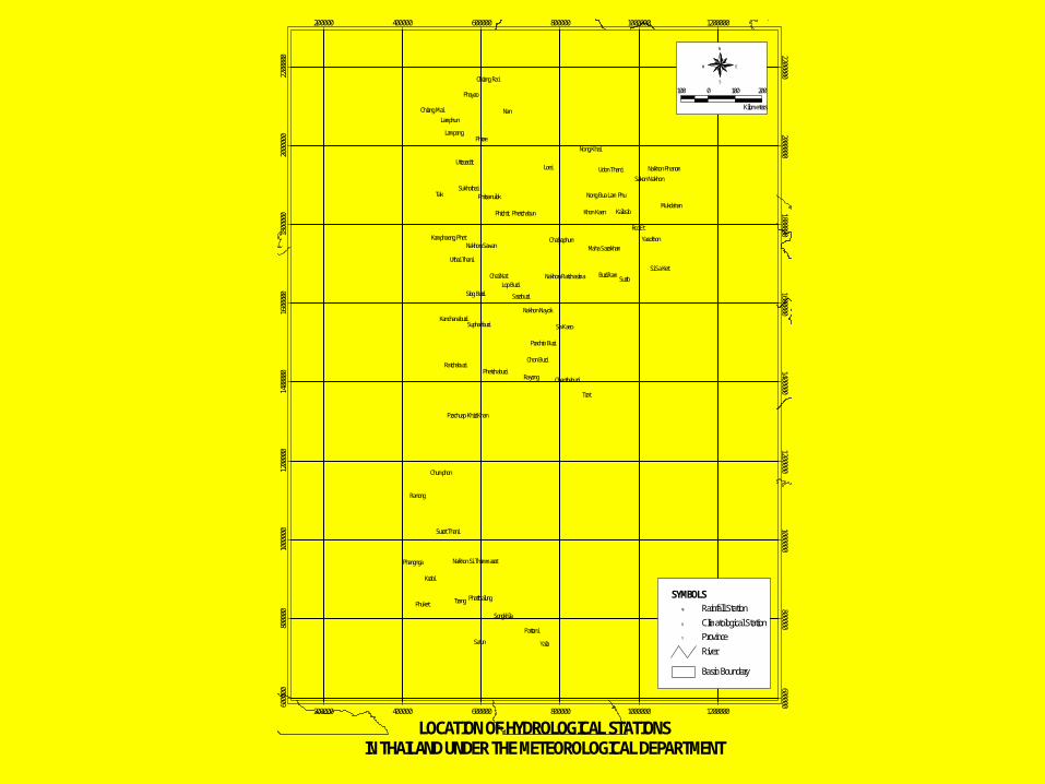
MDMD
Daily or hourly or automatic Daily or hourly or automatic rainfall datarainfall data
Daily meteorological dataDaily meteorological data Rainfall data by radarRainfall data by radarForecasting of the rainfall and weather condition has been carried out by super computer.
%%%
%%%
%
%%
%
%
%
%
%%
%
%
%
%%
%%%
%%
%
%%%
%%
%
%%
%%
%
%
%
%
%
%
%
%
%
%
%
%%
%%
%
%
%%
%%%%% %
%%
%
%
%
%%
%
%
%
%
%
%
%
%
%
%
%%
%
%
%
%
%
%
%
%%
%
%
%
%
%
%
%
%
%
%
%
%
%%%
%
%
%
%
%
%
%
%
%%
%%
%%
% %
%%
%
%
%
% %
%
%
%%%
%
%
%
%
%
%
%
%
%
%
%
%
%
%%
%
%
%
%
%
%
%
%
%
% %
%
%
%%%
%
%
%
% %
%
%%
%
%%
%
%
%
%
%
%
%
%
%
%
%
%%
%
%%
%
%
%
% %%
%
%
%%
% %
%
%
%%
%%
%
%
%
%%
%
%%
%%
%
%
% %
%
%
%
%
%
%
%
%
%
%%
%
% %%
%% %
%
%%%
%%
%%
%
%%
%
%%
%
%%
%
%
%
%
%%
%
%%
%
%
%
% %
%
%
%
%% %
%
%
%
%
%
%
%
%
%
%%%
%
%
%
%
%
%%
%
%
%
% %
%
%
%
%
% %%
%
%
%
%
%
%
% %
%
%
%
%
%
%
%
%
%%
%%
%
%
%%
%
%%
%%
%
%%
%
%
%
%
%%%
%%
%%%%
%
%
% %%% %%
%% %% %
%% %%%
%%% %
%
%%
%%%%
%
%
%
%
%
%
%
%
%
%%%
%
%
%%
%
%%
%
%
%%
%%%%
%
%%%%
%
%
%%%
%
%%
%
%% %
%%
%
%% %
%
%%
%%
%
%%
%
%
%%%%%
%%
%%%%%%
%
% %%
%%%
%
%%%%%
%
%
% %
%
%%
%% % %% %
%
%
%
%
%
%
%%
%
%
%%
%
%
%
%
%%
%%
%
%%%
%%%
%% %
%% %%
%% %
%%
%
% %
%
%
%
%%
%%
%
%
%
%
%
%
%%%
%
%
%
%
%%
%
%
%%
%
%%%%
%%% %%
%%%
%% %%
%%
% %%%%
%
%%
%
%
% %
%
%%%
%
%
%
%%
%
%
%
%
%
%
%%
%
%%
%
%%
%%
%
%
%
%
%
%
%
%
%
%%%
%
%%
%
%% %
%
%
%%%
%%
%
%
% %
%
% %
%
%
%
%
%%
%
%
%
%
%%
%
%%
%
%
%%
%
%
%
%
%
%
%
%
%
%
%
%%
%
%
%
%%
%
%
%
%%
%
%
%
%
%%%
%%
%
%
%
% %
%
%
%
%
%
%%
%%
% %%
%
%
%
%
%
%
%
%
%%
%
% %
%
%
%%%%
%
%%
%%
%
%
%
%
%
%
%
%
%% %
%
%%
% %
%%
%
%
%
%
%
%
%
%%
% %
%
%% %
%
%
%
%
%
%
%
%
%%
%
%
%%
%U
%U
%U %U
%U
%U
%U
%U
%U
%U
%U
%U
%U %U
%U
%U
%U%U
%U
%U
%U
%U%U
%U
%U
%U
%U %U
%U
%U
%U
%U%U
%U
%U
%U
%U
%U %U
%U
%U
%U%U
%U%U
%U
%U %U
%U
%U
%U
%U%U
%U%U %U %U
%U %U
%U
%U
%U
%U
%U
%U%U
%U %U
%U
%U
%U%U
%U
%U
#Y
#Y
#Y
#Y
#Y
#Y
#Y
#Y
#Y#Y
#Y
#Y
#Y
#Y
#Y
#Y
#Y
#Y
#Y
#Y
#Y
#Y#Y
#Y
#Y
#Y
#Y
#Y
#Y
#Y
#Y
#Y
#Y
#Y
#Y
#Y
#Y
#Y
#Y
#Y
#Y
#Y
#Y
#Y#Y
#Y
#Y
#Y
#Y #Y
#Y
#Y
#Y
#Y
#Y
#Y
#Y
#Y
#Y
#Y
#Y
#Y#Y
#Y
#Y
#Y
#Y
#Y
#Y
#Y
#Y#Y
#Y
#Y
#Y#Y
Nan
Tak
Loei
Trat
Yala
Krabi
Trang
Phrae
Surin
Satun
Phuket
Ranong
Phayao
Rayong
Roi Et
Phichit
Lampang
Lamphun
Sa Kaeo
Kalasin
Pattani
Phangnga
Songkhla
Lop Buri
Chumphon
Chai Nat
Saraburi
Buri Ram
Yasothon
Mukdahan
Sing Buri
Uttaradit
Sukhothai
Chon Buri
Nong Khai
Khon Kaen
Si Sa Ket
Suphanburi
Ratchaburi
Chiang Mai
Chiang Rai
Phetchabun
Udon Thani
Chaiyaphum
Surat Thani
Phatthalung
Phetchaburi
Uthai Thani
Phitsanulok
Chanthaburi
Kanchanaburi
Nakhon Sawan
Nakhon Nayok
Prachin Buri
Sakon Nakhon
Nakhon Phanom
Maha Sarakham
Kamphaeng Phet
Nong Bua Lam Phu
Nakhon Ratchasima
Nakhon Si Thammarat
Prachuap Khiri Khan
200000
200000
400000
400000
600000
600000
800000
800000
1000000
1000000
1200000
1200000
6000
00
600000
8000
00
800000
1000
000 1000000
1200
000 1200000
1400
000 1400000
1600
000 1600000
1800
000 1800000
2000
000 2000000
2200
000 2200000
River#Y Province
Basin Boundary
%U
%U
Rainfall StationSYMBOLS
Climatological Station
N
EW
S
100 0 100 200
Kilometers
LOCATION OF HYDROLOGICAL STATIONS IN THAILAND UNDER THE METEOROLOGICAL DEPARTMENT
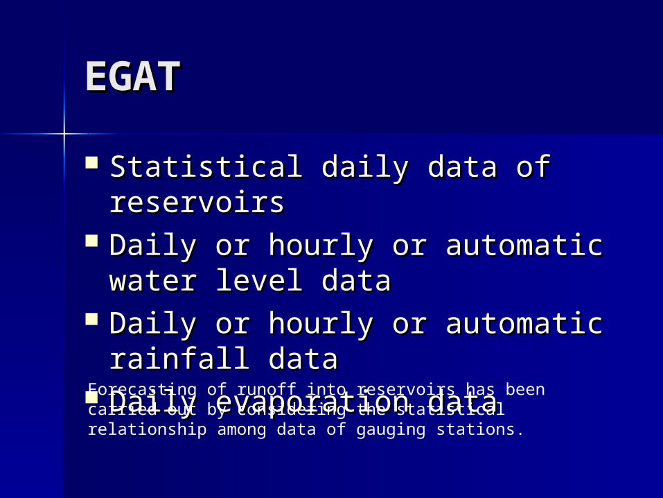
EGATEGAT
Statistical daily data of reservoirsStatistical daily data of reservoirs Daily or hourly or automatic water Daily or hourly or automatic water
level datalevel data Daily or hourly or automatic Daily or hourly or automatic
rainfall datarainfall data Daily evaporation dataDaily evaporation dataForecasting of runoff into reservoirs has been carried out by considering the statistical relationship among data of gauging stations.
%
%%
%
%%
%%
%
%%
%
%
%
%
%%
%
%%%%
%
%
%%
%
%
%
%
%
%
%%%
%%%
%%
%%
%
%
%
%
%%%
%
%
%
%
% %
%
%
%
%
%
%
%
% %
%
$T
$T$T
$T
$T$T
$T$T$T
$T$T
$T
$T$T$T
$T$T$T $T$T$T
$T
$T
$T $T
$T
$T
$T$T
$T
$T$T
$T
$T
$T
$T
$T$T
$T
$T
$T
$T$T
#Y
#Y
#Y
#Y
#Y
#Y
#Y
#Y
#Y#Y
#Y
#Y
#Y
#Y
#Y
#Y
#Y
#Y
#Y
#Y
#Y
#Y
#Y
#Y
#Y
#Y
#Y
#Y
#Y
#Y
#Y
#Y
#Y
#Y
#Y
#Y
#Y
#Y
#Y
#Y
#Y
#Y
#Y
#Y#Y
#Y
#Y
#Y
#Y #Y
#Y
#Y
#Y
#Y
#Y
#Y
#Y
#Y
#Y
#Y
#Y
#Y#Y
#Y
#Y
#Y
#Y
#Y
#Y
#Y
#Y#Y
#Y
#Y
#Y
#Y
Nan
Tak
Loei
Trat
Yala
Krabi
Trang
Phrae
Surin
Satun
Phuket
Ranong
Phayao
Rayong
Roi Et
Phichit
Lampang
Lamphun
Sa Kaeo
Kalasin
Pattani
Phangnga
Songkhla
Lop Buri
Chumphon
Chai Nat
Saraburi
Buri Ram
Yasothon
Mukdahan
Sing Buri
Uttaradit
Sukhothai
Chon Buri
Nong Khai
Khon Kaen
Si Sa Ket
Suphanburi
Ratchaburi
Chiang Mai
Chiang Rai
Phetchabun
Udon Thani
Chaiyaphum
Surat Thani
Phatthalung
Phetchaburi
Uthai Thani
Phitsanulok
Chanthaburi
Kanchanaburi
Nakhon Sawan
Nakhon Nayok
Prachin Buri
Sakon Nakhon
Nakhon Phanom
Maha Sarakham
Kamphaeng Phet
Nong Bua Lam Phu
Nakhon Ratchasima
Nakhon Si Thammarat
Prachuap Khiri Khan
200000
200000
400000
400000
600000
600000
800000
800000
1000000
1000000
1200000
1200000
6000
00
600000
8000
00
800000
1000
000 1000000
1200
000 1200000
1400
000 1400000
1600
000 1600000
1800
000 1800000
2000
000 2000000
2200
000 2200000
River#Y Province
Basin Boundary
%U
$T
Rainfall StationSYMBOLS
Runoff Station
N
EW
S
100 0 100 200
Kilometers
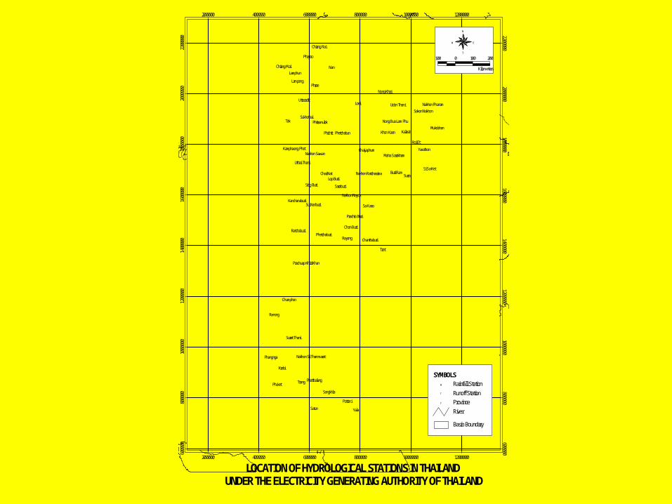
LOCATION OF HYDROLOGICAL STATIONS IN THAILANDUNDER THE ELECTRICITY GENERATING AUTHORITY OF THAILAND
DWRDWR
Daily or hourly or automatic water Daily or hourly or automatic water level datalevel data
Daily or hourly or automatic Daily or hourly or automatic rainfall datarainfall data
Daily evaporation dataDaily evaporation data
%
%%
%
%
%
%
%%%
%
%
%%
%%% %%
%%
%
%
%%
%%%%
%
%
%
%
%%
%%%
%
%
%%
%
%%%
%%
%%%
% %%
%
%
%
%
%
%%
%%% %%
%%
%
%
%
%%
%
%%%
%% %
%
%
%
%
%
%
%
%
%
%
%
%
%
%%
%
%%%%%
%
%
%
%
%%
%
%
%
%
%
%
%
%
%
%
%
%
%%
%
%
%
%
%
%
%%
% %
%
%%
%%
%
%%
% %
%
%
% %
%
%
%
%%
%
%
%
$T
$T$T$T$T$T$T
$T$T$T $T
$T$T$T$T$T
$T$T
$T$T$T$T
$T
$T
$T$T$T$T$T
$T
$T$T
$T
$T
$T$T
$T
$T$T$T $T
$T$T $T
$T$T$T$T
$T$T
$T $T
$T
$T
$T
$T
$T$T$T$T
$T$T
$T$T$T $T$T
$T$T
$T$T$T
$T$T
$T$T$T
$T$T$T
$T$T$T$T
$T
$T
$T
$T
$T
$T$T
$T
$T
$T$T
$T$T$T$T$T$T
$T
$T
$T$T
$T
$T$T
$T $T
$T$T
$T$T$T
$T$T$T
$T$T
$T
$T$T$T$T $T
$T
$T $T$T$T$T
$T$T$T$T
$T$T$T$T$T
$T
$T $T$T
$T
$T$T$T
$T
$T
$T
$T
$T
$T$T$T
$T
$T
$T$T$T
$T
$T$T $T
$T
$T$T
$T
$T$T $T
$T
$T
$T
$T$T$T
$T
$T$T
$T
$T
$T
$T $T $T$T$T $T $T$T
$T $T $T$T
$T $T$T$T$T$T$T$T$T
$T$T
$T
$T
$T
$T
$T
$T
$T
$T$T
$T$T$T$T$T
$T
$T
$T$T$T
$T$T
$T $T$T$T$T
$T$T$T
$T
$T$T$T$T
$T$T$T$T$T$T$T
$T
$T$T$T$T$T
$T$T$T$T $T$T
$T$T$T
$T$T$T$T$T $T
$T$T$T$T$T$T$T$T$T$T$T
$T
$T$T$T$T$T
$T$T
$T
$T
$T$T
$T
$T$T
$T$T
$T $T
$T$T
$T
$T
$T
$T
$T$T
$T
$T$T
$T$T $T$T$T$T$T
$T $T$T
$T
$T
$T$T$T$T$T
$T$T$T
$T
$T$T$T
$T
$T
$T$T
$T
$T$T$T
$T$T
$T$T
$T$T$T$T$T
$T$T
$T$T$T
$T
$T
$T$T
$T$T
$T
$T$T
$T
$T$T$T$T
$T$T$T
$T
$T$T
$T$T$T$T
$T$T$T$T
$T
$T$T$T
$T
$T$T
$T$T $T
$T$T
$T$T
$T
$T
#Y
#Y
#Y
#Y
#Y
#Y
#Y
#Y
#Y#Y
#Y
#Y
#Y
#Y
#Y
#Y
#Y
#Y
#Y
#Y
#Y
#Y
#Y
#Y
#Y
#Y
#Y
#Y
#Y
#Y
#Y
#Y
#Y
#Y
#Y
#Y
#Y
#Y
#Y
#Y
#Y
#Y
#Y
#Y#Y
#Y
#Y
#Y
#Y #Y
#Y
#Y
#Y
#Y
#Y
#Y
#Y
#Y
#Y
#Y
#Y
#Y#Y
#Y
#Y
#Y
#Y
#Y
#Y
#Y
#Y#Y
#Y
#Y
#Y
#Y
Nan
Tak
Loei
Trat
Yala
Krabi
Trang
Phrae
Surin
Satun
Phuket
Ranong
Phayao
Rayong
Roi Et
Phichit
Lampang
Lamphun
Sa Kaeo
Kalasin
Pattani
Phangnga
Songkhla
Lop Buri
Chumphon
Chai Nat
Saraburi
Buri Ram
Yasothon
Mukdahan
Sing Buri
Uttaradit
Sukhothai
Chon Buri
Nong Khai
Khon Kaen
Si Sa Ket
Suphanburi
Ratchaburi
Chiang Mai
Chiang Rai
Phetchabun
Udon Thani
Chaiyaphum
Surat Thani
Phatthalung
Phetchaburi
Uthai Thani
Phitsanulok
Chanthaburi
Kanchanaburi
Nakhon Sawan
Nakhon Nayok
Prachin Buri
Sakon Nakhon
Nakhon Phanom
Maha Sarakham
Kamphaeng Phet
Nong Bua Lam Phu
Nakhon Ratchasima
Nakhon Si Thammarat
Prachuap Khiri Khan
200000
200000
400000
400000
600000
600000
800000
800000
1000000
1000000
1200000
1200000
6000
00
600000
8000
00
800000
1000
000 1000000
1200
000 1200000
1400
000 1400000
1600
000 1600000
1800
000 1800000
2000
000 2000000
2200
000 2200000
River#Y Province
Basin Boundary
%U
$T
Rainfall StationSYMBOLS
Runoff Station
N
EW
S
100 0 100 200
Kilometers
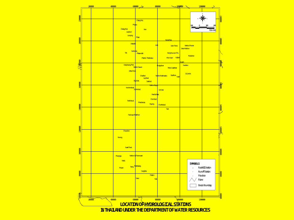
LOCATION OF HYDROLOGICAL STATIONSIN THAILAND UNDER THE DEPARTMENT OF WATER RESOURCES
Flood Forecasting and Flood Forecasting and WarningWarning
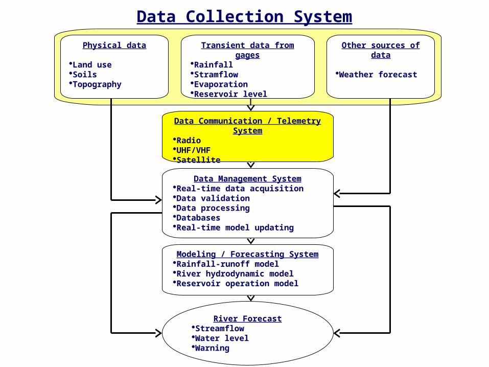
Physical data
Land useSoilsTopography
Transient data from gages
RainfallStramflowEvaporationReservoir level
Other sources of data
Weather forecast
Data Communication / Telemetry System
RadioUHF/VHFSatellite
Data Management SystemReal-time data acquisitionData validationData processingDatabasesReal-time model updating
Modeling / Forecasting SystemRainfall-runoff modelRiver hydrodynamic modelReservoir operation model
River ForecastStreamflowWater levelWarning
Data Collection System
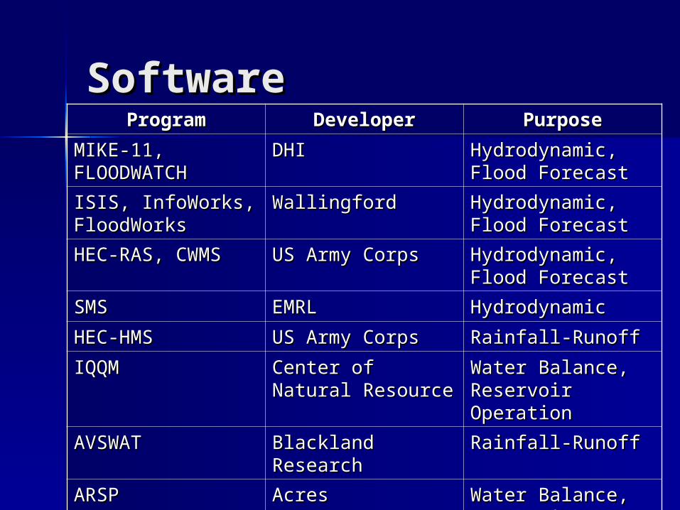
ProgramProgram DeveloperDeveloper PurposePurpose
MIKE-11, MIKE-11, FLOODWATCHFLOODWATCH
DHIDHI Hydrodynamic, Hydrodynamic, Flood ForecastFlood Forecast
ISIS, InfoWorks, ISIS, InfoWorks, FloodWorksFloodWorks
WallingfordWallingford Hydrodynamic, Hydrodynamic, Flood ForecastFlood Forecast
HEC-RAS, CWMSHEC-RAS, CWMS US Army CorpsUS Army Corps Hydrodynamic, Hydrodynamic, Flood ForecastFlood Forecast
SMSSMS EMRLEMRL HydrodynamicHydrodynamic
HEC-HMSHEC-HMS US Army CorpsUS Army Corps Rainfall-RunoffRainfall-Runoff
IQQMIQQM Center of Natural Center of Natural ResourceResource
Water Balance, Water Balance, Reservoir Reservoir OperationOperation
AVSWATAVSWAT Blackland Blackland ResearchResearch
Rainfall-Runoff Rainfall-Runoff
ARSPARSP AcresAcres Water Balance, Water Balance, Reservoir Reservoir Operation Operation
HEC-ResSimHEC-ResSim US Army CorpsUS Army Corps Water Balance, Water Balance, Reservoir Reservoir Operation Operation
NAMNAM DHIDHI Rainfall-Runoff Rainfall-Runoff
TANKTANK JapanJapan Rainfall-Runoff Rainfall-Runoff
SoftwareSoftware
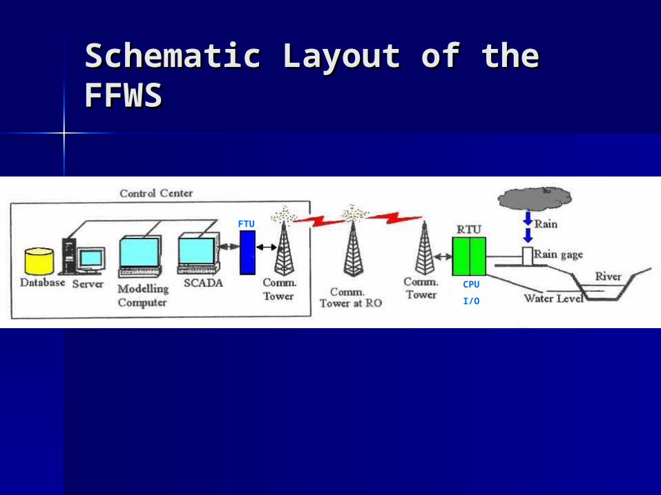
Schematic Layout of the Schematic Layout of the FFWSFFWS
FTU
CPU
I/O
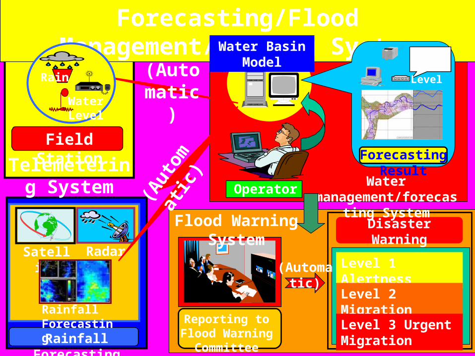
Forecasting/Flood Management/Warning System
Forecasting Result
RainWater Level
Rainfall Forecasting
System
RadarSatellite
Rainfall Forecasting
(Aut
om
atic
)
(Automatic
)
Reporting to Flood Warning
Committee
Disaster Warning
Announcement
Level 1 AlertnessLevel 2 MigrationLevel 3 Urgent Migration
(Automatic)
Operator
Field Station
Rain
Water Level
Telemetering System Water
management/forecasting SystemFlood Warning
System
Water Basin Model
Water Operation Center
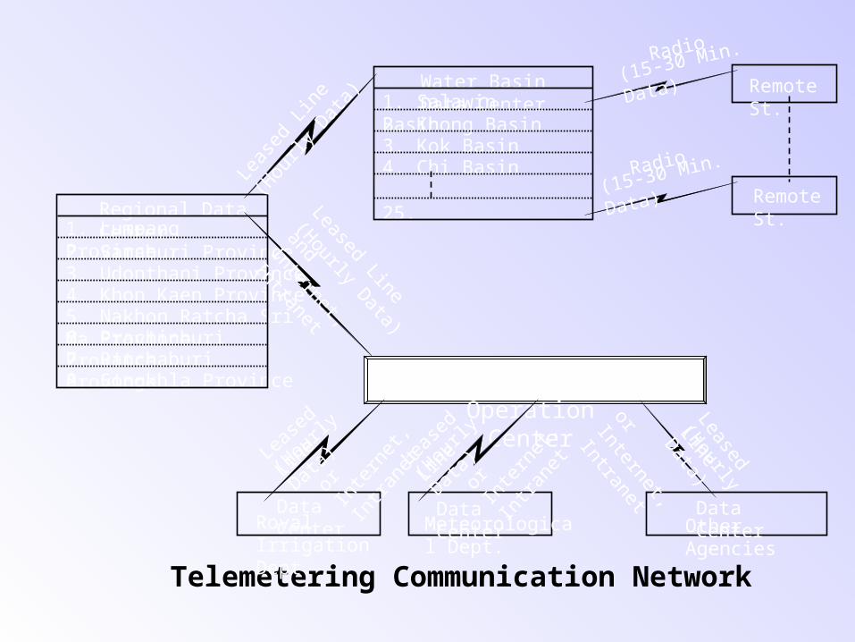
Telemetering Communication Network
5. Nakhon Ratcha Sri Ma Province
2. Saraburi Province3. Udonthani Province
7. Ratchaburi Province8. Songkhla Province
4. Khon Kaen Province
6. Prachinburi Province
Regional Data Center1. Lumpang
Province
2. Khong Basin3. Kok Basin4. Chi Basin
25.
Water Basin Data Center1. Salawin
Basin
Remote St.
Remote St.
Data CenterMeteorological Dept.
Data CenterRoyal Irrigation Dept.
Data CenterOther Agencies
Leas
ed L
ine
(Hou
rly D
ata)
Radio
(15-30 Min.
Data)
Radio(15-30 Min.
Data)Leased Line
(Hourly Data)
and Internet,
Intranet
Leased
Line(H
ourly
Data)
Leas
ed
Line
(Hou
rly
Data)
Leas
ed
Line
(Hou
rly
Data)
or In
tern
et,
Intran
et
or In
tern
et,
Intran
et
or Internet,
Intranet
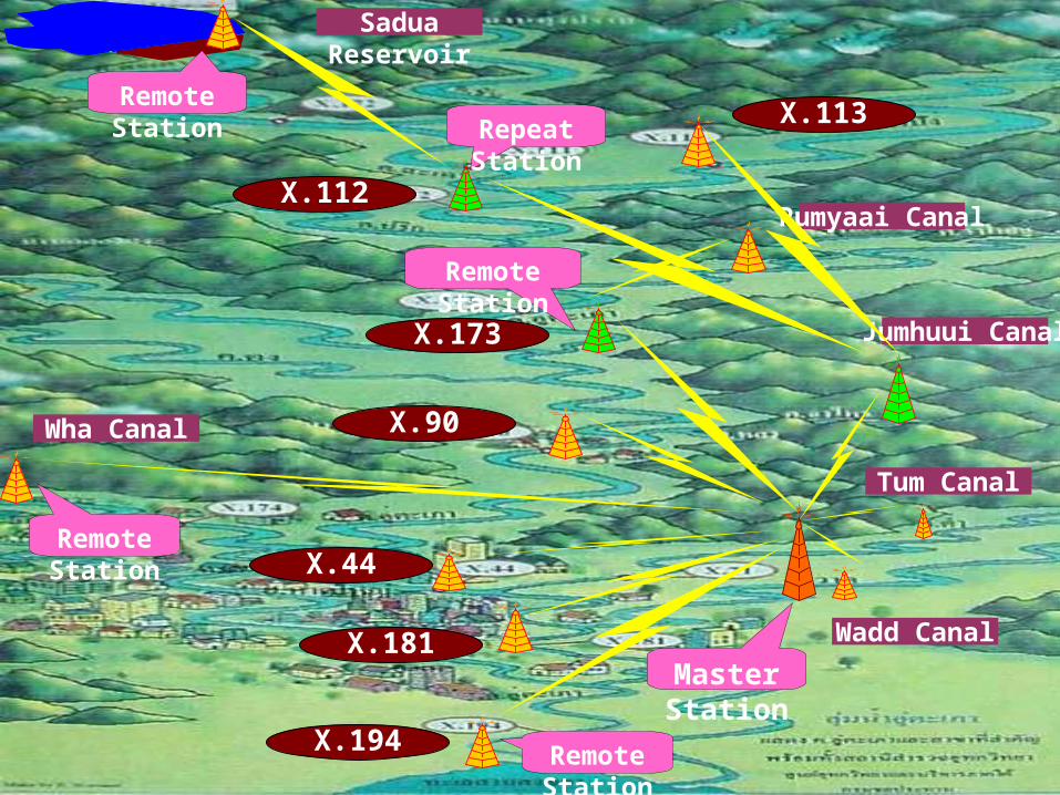
X.194
X.181
X.44
X.90
X.173
X.112
X.113
Sadua Reservoir
Rumyaai Canal
Jumhuui Canal
Tum Canal
Wadd Canal
Wha Canal
Repeat Station
Master Station
Remote Station
Remote Station
Remote Station
Remote Station
Project
Real- Time
Data by Telemet
ering System
Flood Forecast
ing by Math.Mo
del
Integrated Data
Base and
Math. Model,
Working as a
Network
Integrated Math.
Model and GIS
for Output
Presentation
Rainfall Forecasti
ng by Radar
Warning to the
Public via Communi
cation Media
Ubol Ratana Dam(1988)
Pak Mun Dam(1995)
Khao Lam Dam (1995)
Pasak Dam( ปี� 1999)
Banglang Dam(2002)
Thataphao Basin(2002)
U-Thaphao Basin(2004)
Chantaburi Basin(2004)
Chao Phraya Basin(2004)
Communication of Communication of Flood-Warning Flood-Warning
InformationInformation
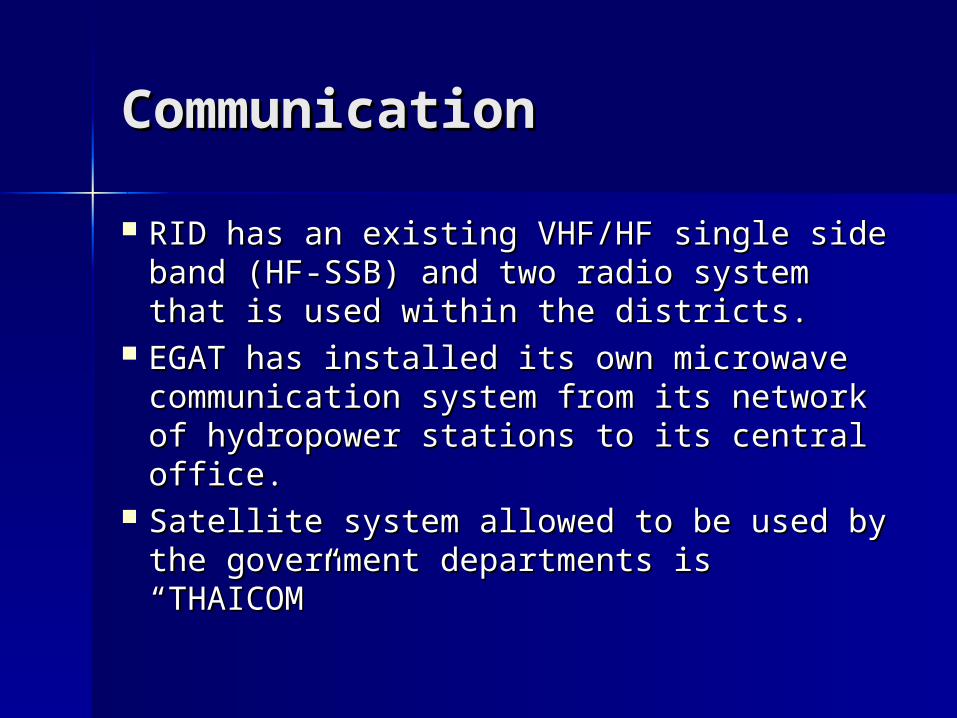
CommunicationCommunication
RID has an existing VHF/HF single side RID has an existing VHF/HF single side band (HF-SSB) and two radio system that band (HF-SSB) and two radio system that is used within the districts.is used within the districts.
EGAT has installed its own microwave EGAT has installed its own microwave communication system from its network communication system from its network of hydropower stations to its central of hydropower stations to its central office.office.
Satellite system allowed to be used by the Satellite system allowed to be used by the government departments is “THAICOM” government departments is “THAICOM”
Flood-Warning Flood-Warning InformationInformation There are existing flood preparedness plans and There are existing flood preparedness plans and
mitigation measures in the basin.mitigation measures in the basin. RID or EGAT’s regional office send the flooding RID or EGAT’s regional office send the flooding
information to the provincial officer who has information to the provincial officer who has responsibility in performing flood preparedness responsibility in performing flood preparedness plan via telephone or radio.plan via telephone or radio.
The local emergency teams make preparations The local emergency teams make preparations to carry out works in areas of likely to be to carry out works in areas of likely to be inundated by flooding.inundated by flooding.
The organization of the teams and their duties The organization of the teams and their duties are clearly indicated. are clearly indicated.

Other Relevant Other Relevant InformationInformation
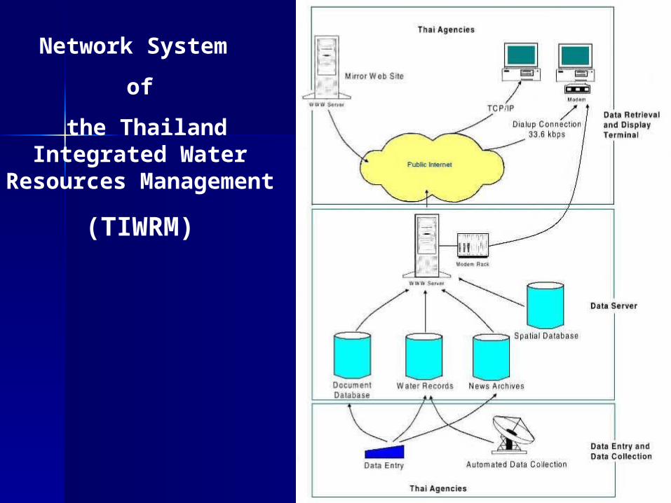
Network System
of
the Thailand Integrated Water Resources
Management
(TIWRM)


![NATURE AND EXTENT OF NONPROFIT ORGANIZATIONS IN … · Chapter 1: Nature and Extent of Nonprofit Organizations in American Society 5 Service].” To be officially recognized by the](https://img.pdfslide.us/doc/110x75/5fb12edca53f3b50f0541a16/nature-and-extent-of-nonprofit-organizations-in-chapter-1-nature-and-extent-of.jpg)