Embed Size (px)
Citation preview
35 36
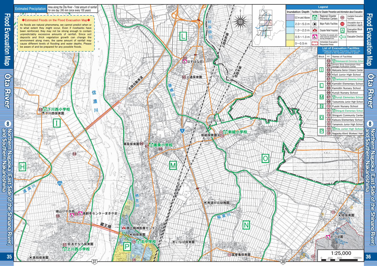
Flood Evacuation Map
Flood Evacuation Map
●❽
Ôta R
iverÔta R
iver
Ôta R
iverÔta R
iver
Ôta R
iver
Ôta R
iver
●❽Northern Nagaoka (East Side of the Shinano River) Northern Nagaoka (East Side of the Shinano River) and Southern Nakanoshim
aand Southern Nakanoshim
aNorthern Nagaoka (East Side of the Shinano River) and Southern Nakanoshim
a
Northern Nagaoka (East Side of the Shinano River) Northern Nagaoka (East Side of the Shinano River) and Southern Nakanoshim
aand Southern Nakanoshim
aNorthern Nagaoka (East Side of the Shinano River) and Southern Nakanoshim
a
Shimokawanishi Elementary School
Makiyama Senior Citizens’Center
Kôyô Junior High School
Kamikawanishi Elementary School
Kamidôri Elementary School
Kamidôri Nursery School
Kurojô Nursery School
Kurojô Elementary School
Tsutsumioka Junior High School
Fusoki Nursery School
Shingumi Elementary School
Shingumi Community Center
Katsura Elementary School
Yamamoto Junior High School
Kita Junior High School
Nagaoka Kinrô Workers, Hall
Shinano River
Nagaoka IC
Nagaoka Station
Shinano River Downstream AreaSewage Purification Center
Estimated Precipitation Area along the Ôta River - Total amount of rainfallfor one day: 245 mm (once every 100 years)
◆Estimated Floods on the Flood Evacuation Map◆As floods are natural phenomena, we cannot predict when or to what extent they might occur. Even if riverbanks have been reinforced, they may not be strong enough to contain unpredictably excessive amounts of rainfall. Since soil deposits and thick vegetation growth can change the environment along rivers, the same amount of rainfall may cause different levels of flooding and water depths. Please be aware of and be prepared for any possible floods. List of Evacuation Facilities
※Regional Disaster Prevention Centers are situated in the facilities printed in green.
Block Names of Facilities
Legend
Inundation Depth Facilities for Disaster Prevention and Information about EvacuationRegional DisasterPrevention Centers
Available EvacuationFacilities
Evacuation Direction
Major Public Facilities
Disaster Relief Hospitals
Immediate EvacuationRequested Areas
Facilities for people whoneed special assistanceduring emergencies
5.0 m and Above
Evacuation BlockBoundaries
Unusable due toinundation depth
37 38
37 38
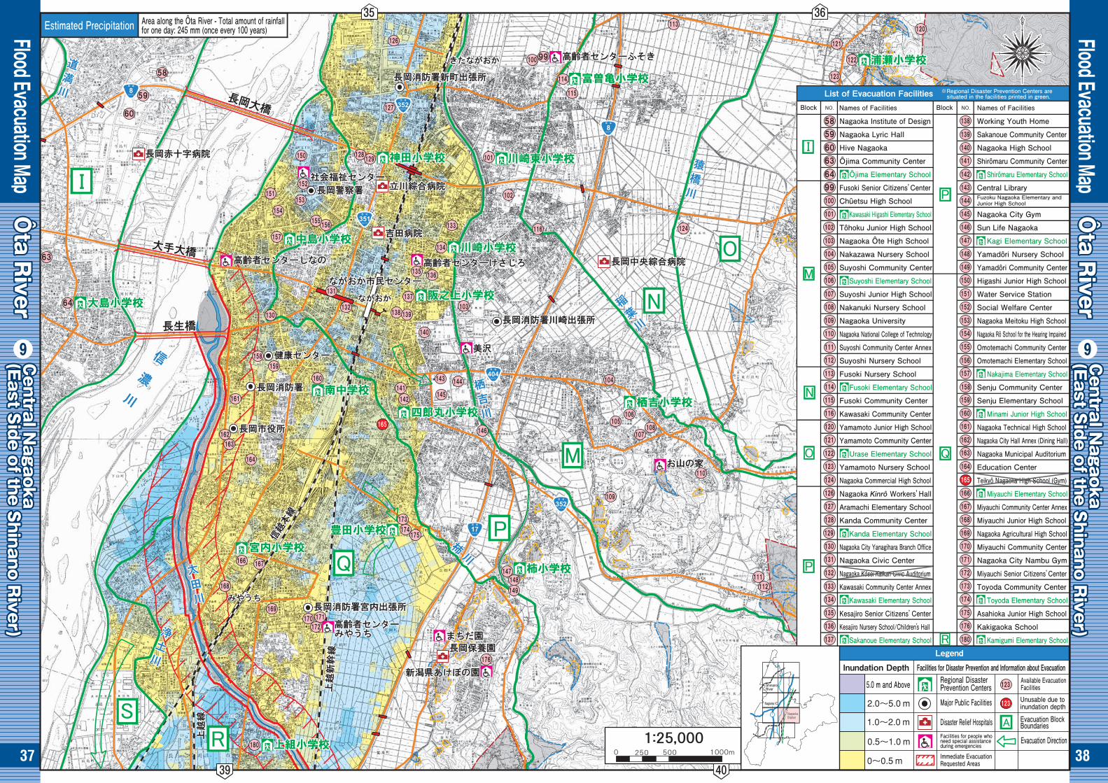
Flood Evacuation Map
Flood Evacuation Map
●❾Central N
agaokaCentral N
agaoka(East S
ide of the Shinano R
iver)(East S
ide of the Shinano R
iver)Central N
agaoka(East S
ide of the Shinano R
iver)
Central N
agaokaCentral N
agaoka(East S
ide of the Shinano R
iver)(East S
ide of the Shinano R
iver)Central N
agaoka(East S
ide of the Shinano R
iver)
Ôta R
iverÔta R
iverÔta R
iver
●❾
Ôta R
iverÔta R
iverÔta R
iverEstimated Precipitation Area along the Ôta River - Total amount of rainfall
for one day: 245 mm (once every 100 years)
※Regional Disaster Prevention Centers are situated in the facilities printed in green.List of Evacuation Facilities
Shinano River
Nagaoka IC
Nagaoka StationNagaoka Station
Nagaoka Institute of Design
Nagaoka Lyric Hall
Hive Nagaoka
Ôjima Community Center
Ôjima Elementary School
Fusoki Senior Citizens’Center
Chûetsu High School
Kawasaki Higashi Elementary School
Tôhoku Junior High School
Nagaoka Ôte High School
Nakazawa Nursery School
Suyoshi Community Center
Suyoshi Elementary School
Suyoshi Junior High School
Nakanuki Nursery School
Nagaoka University
Nagaoka National College of Technology
Suyoshi Community Center Annex
Suyoshi Nursery School
Fusoki Nursery School
Fusoki Elementary School
Fusoki Community Center
Kawasaki Community Center
Yamamoto Junior High School
Yamamoto Community Center
Urase Elementary School
Yamamoto Nursery School
Nagaoka Commercial High School
Nagaoka Kinrô Workers’Hall
Aramachi Elementary School
Kanda Community Center
Kanda Elementary School
Nagaoka City Yanagihara Branch Office
Nagaoka Civic Center
Nagaoka Kôsei Kaikan Civic Auditorium
Kawasaki Community Center Annex
Kawasaki Elementary School
Kesajiro Senior Citizens’Center
Kesajiro Nursery School/Children’s Hall
Sakanoue Elementary School
Working Youth Home
Sakanoue Community Center
Nagaoka High School
Shirômaru Community Center
Shirômaru Elementary School
Central Library
Nagaoka City Gym
Sun Life Nagaoka
Kagi Elementary School
Yamadôri Nursery School
Yamadôri Community Center
Higashi Junior High School
Water Service Station
Social Welfare Center
Nagaoka Meitoku High School
Nagaoka Rô School for the Hearing Impaired
Omotemachi Community Center
Omotemachi Elementary School
Nakajima Elementary School
Senju Community Center
Senju Elementary School
Minami Junior High School
Nagaoka Technical High School
Nagaoka City Hall Annex (Dining Hall)
Nagaoka Municipal Auditorium
Education Center
Teikyô Nagaoka High School (Gym)
Miyauchi Elementary School
Miyauchi Community Center Annex
Miyauchi Junior High School
Nagaoka Agricultural High School
Miyauchi Community Center
Nagaoka City Nambu Gym
Miyauchi Senior Citizens’Center
Toyoda Community Center
Toyoda Elementary School
Asahioka Junior High School
Kakigaoka School
Kamigumi Elementary School
Fuzoku Nagaoka Elementary andJunior High School
Block Names of Facilities Block Names of Facilities
Legend
Inundation Depth Facilities for Disaster Prevention and Information about EvacuationRegional DisasterPrevention Centers
Available EvacuationFacilities
Evacuation Direction
Major Public Facilities
Disaster Relief Hospitals
Immediate EvacuationRequested Areas
Facilities for people whoneed special assistanceduring emergencies
5.0 m and Above
Evacuation BlockBoundaries
Unusable due toinundation depth
35 36
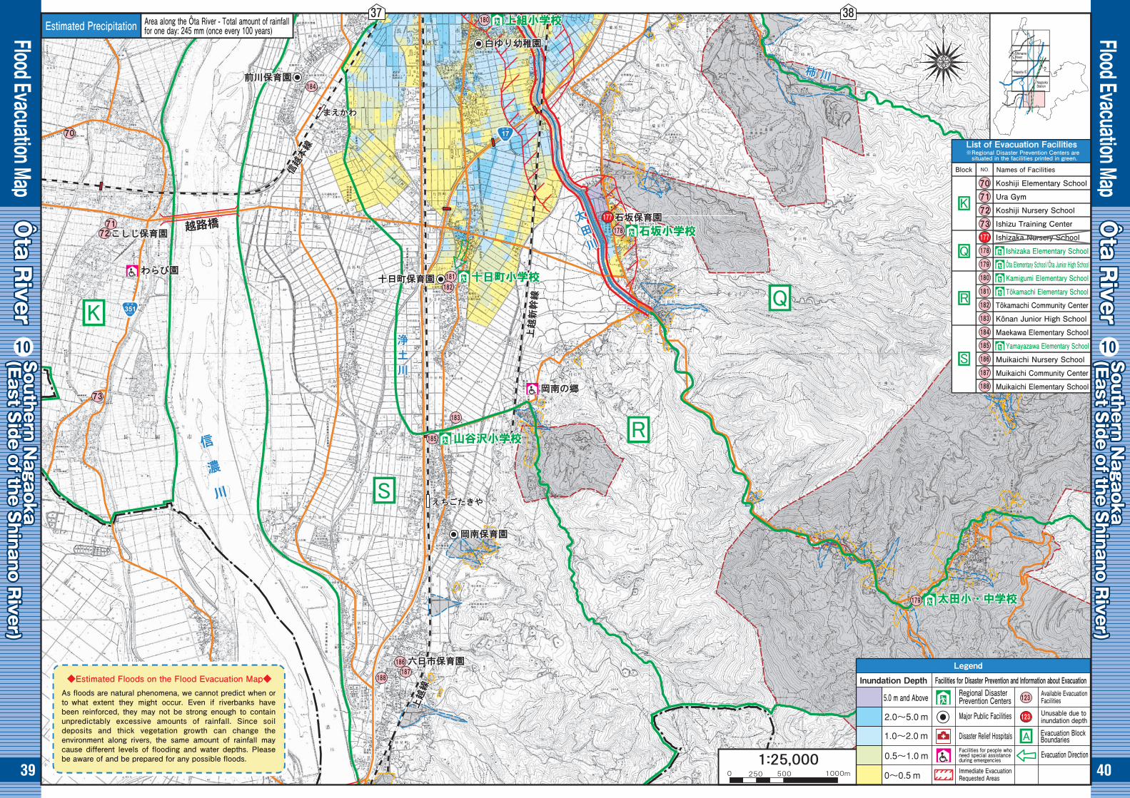
39 40
39 40
Flood Evacuation Map
Flood Evacuation Map
Ôta R
iverÔta R
iverÔta R
iver
● ●Southern N
agaokaSouthern N
agaoka(East S
ide of the Shinano R
iver) (East S
ide of the Shinano R
iver) Southern N
agaoka(East S
ide of the Shinano R
iver)
Ôta R
iverÔta R
iverÔta R
iverSouthern N
agaokaSouthern N
agaoka(East S
ide of the Shinano R
iver) (East S
ide of the Shinano R
iver) Southern N
agaoka(East S
ide of the Shinano R
iver)
Koshiji Elementary School
Ura Gym
Koshiji Nursery School
Ishizu Training Center
Ishizaka Nursery School
Ishizaka Elementary School
Ôta Elementary School/Ôta Junior High School
Kamigumi Elementary School
Tôkamachi Elementary School
Tôkamachi Community Center
Kônan Junior High School
Maekawa Elementary School
Yamayazawa Elementary School
Muikaichi Nursery School
Muikaichi Community Center
Muikaichi Elementary School
Shinano River
Nagaoka IC
Nagaoka Station
Estimated Precipitation Area along the Ôta River - Total amount of rainfallfor one day: 245 mm (once every 100 years)
Legend
Inundation Depth Facilities for Disaster Prevention and Information about EvacuationRegional DisasterPrevention Centers
Available EvacuationFacilities
Evacuation Direction
Major Public Facilities
Disaster Relief Hospitals
Immediate EvacuationRequested Areas
Facilities for people whoneed special assistanceduring emergencies
5.0 m and Above
Evacuation BlockBoundaries
List of Evacuation Facilities※Regional Disaster Prevention Centers are situated in the facilities printed in green.
Block Names of Facilities
◆Estimated Floods on the Flood Evacuation Map◆As floods are natural phenomena, we cannot predict when or to what extent they might occur. Even if riverbanks have been reinforced, they may not be strong enough to contain unpredictably excessive amounts of rainfall. Since soil deposits and thick vegetation growth can change the environment along rivers, the same amount of rainfall may cause different levels of flooding and water depths. Please be aware of and be prepared for any possible floods.
Unusable due toinundation depth
37 38