Embed Size (px)
Citation preview
Page 9
Page 7
Page 5
Page 3
Page 1
Page 10
Page 8
Page 6
Page 4
Page 2
IMC-2062
0 10 20 305 MilesI
Index to Aerial PhotographyPage Key
97531
108642
FLIGHT LOCATION
1:500,000Scale of this index:
Counties: Los Angeles, Orange, VenturaFlight date(s): 06-12-1952 to 06-13-1952Scale: 1: 24,000Overlap: 60%Complete Metadata:http://www.library.ucsb.edu/mil/aerial-photography-tools
Los AngelesCounty
!.
!.
!.
!.!.
!.
!.
!.
!.
!.
!.
!.
!.
!.
!.
!.
!.
!.
!.
!.
!.
!.
!.
!.
!.
!.
!.
!.
!.
!.
!.
!.
!.
!.
!.
!.
!.
!.
!.
!.
!.
!.
!.
!.
!.
!.
!.
!.
!.
!.
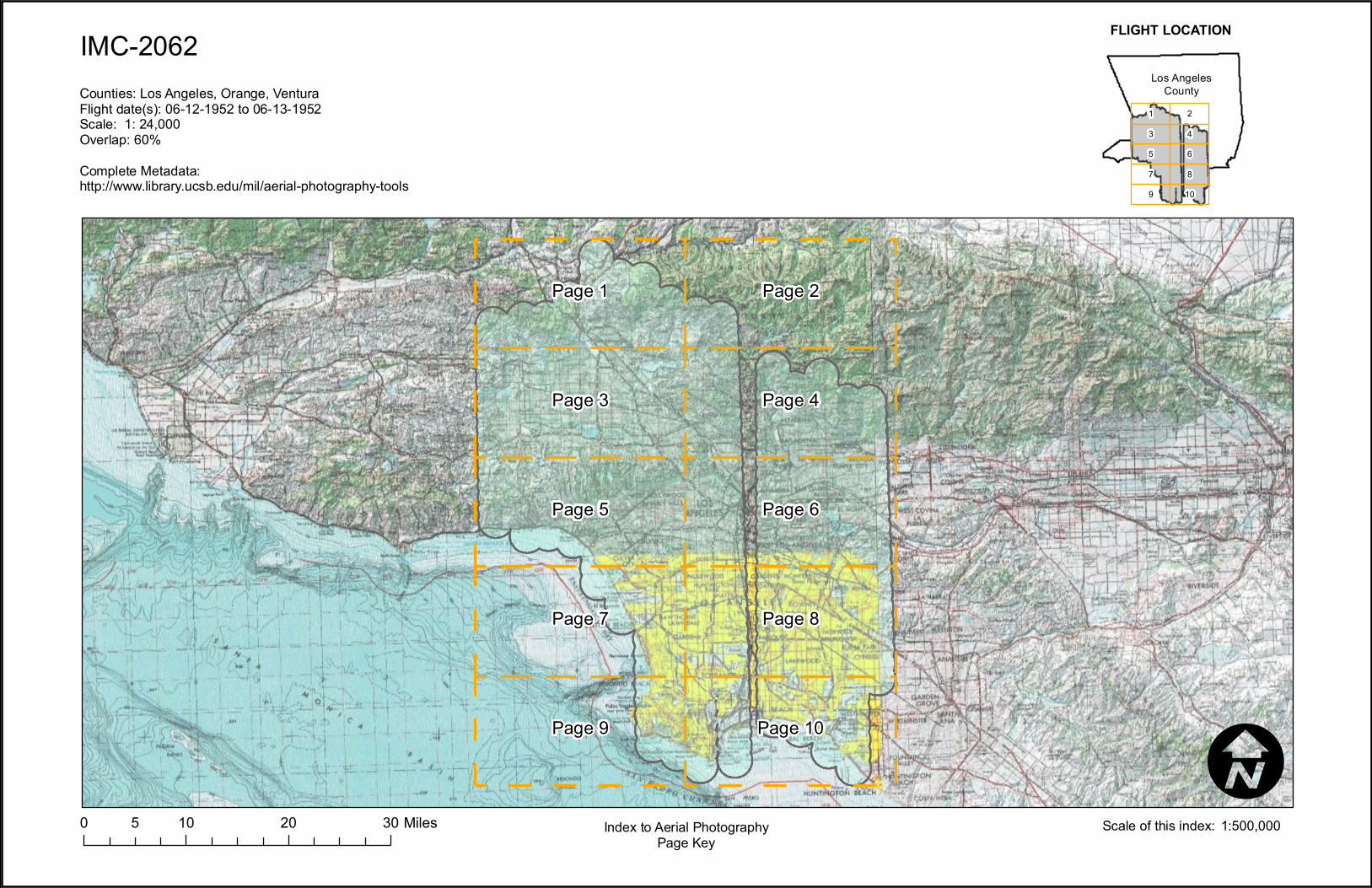
Page 3Page 1
Page
1Pa
ge 2
Page 4Page 2
2-1
2-2
2-32-33
2-34
2-35
2-36
2-37
2-38
1-1
1-2
1-3
1-4
1-5
1-37
1-38
1-39
1-40
1-41
1-42
1-43
1-44
1-45
1-46
1-47
1-48
1-49
1-50
1-51
2-54
2-55
2-56
2-57
2-58
2-59
2-60
2-120
2-121
2-122
2-123
2-1242-125
2-126
2-127
2-128
IMC-2062
0 4 82 MilesI
Index to Aerial PhotographyPage 1 of 8
97531
108642
FLIGHT LOCATION
1:100,000Scale of this index:
Counties: Los Angeles, Orange, VenturaFlight date(s): 06-12-1952 to 06-13-1952Scale: 1: 24,000Overlap: 60%Complete Metadata:http://www.library.ucsb.edu/mil/aerial-photography-tools
Los AngelesCounty
!.
!.
!.
!.
!.
!.
!.
!.
!.
!.
!.
!.
!.
!.
!.
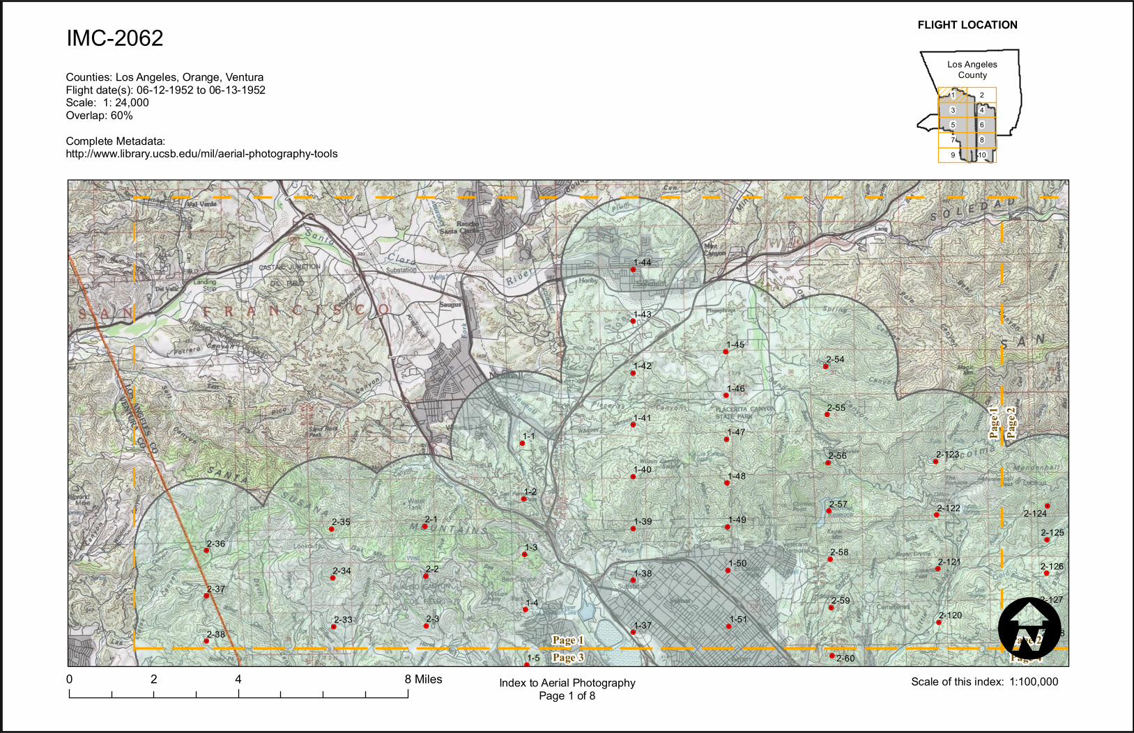
Page 3Page 1
Page
1Pa
ge 2
Page 4Page 2
2-120
2-121
2-122
2-123
2-124
2-125
2-126
2-127
2-1283-31
3-32
3-33
3-34
IMC-2062
0 4 82 MilesI
Index to Aerial PhotographyPage 2 of 8
97531
108642
FLIGHT LOCATION
1:100,000Scale of this index:
Counties: Los Angeles, Orange, VenturaFlight date(s): 06-12-1952 to 06-13-1952Scale: 1: 24,000Overlap: 60%Complete Metadata:http://www.library.ucsb.edu/mil/aerial-photography-tools
Los AngelesCounty
!.
!.
!.
!.
!.
!.
!.
!.
!.
!.!.
!.
!.
!.
!.
!.
!.
!.
!.
!.
!.
!.
!.
!.
!.
!.
!.
!.
!.
!.
!.
!.
!.
!.
!.
!.
!.
!.
!.
!.
!.
!.
!.
!.
!.
!.
!.
!.
!.
!.
!.!.
!.
!.
!.
!.
!.
!.
!.
!.
!.
!.
!.
!.
!.
!.
!.
!.
!.
!.
!.
!.
!.
!.
!.
!.
!.
!.
!.
!.
!.
!.
!.
!.
!.
!.
!.
!.
!.
!.
!.
!.
!.
Page 5Page 3
Page 3Page 1
Page
3Pa
ge 4
Page 6Page 4
Page 4Page 2
2-4
2-5
2-6
2-7
2-8
2-9
2-10
2-11
2-122-24
2-25
2-26
2-27
2-28
2-29
2-30
2-31
2-32
2-38
2-39
2-40
2-41
2-42
2-43
2-44
2-45
2-46
2-47
1-5
1-6
1-7
1-8
1-9
1-10
1-11
1-12
1-13
1-29
1-30
1-31
1-32
1-33
1-34
1-35
1-36
1-37
1-52
1-53
1-54
1-55
1-56
1-57
1-58
1-59
2-60
2-61
2-62
2-63
2-64
2-65
2-66
2-67
2-68
2-111
2-112
2-113
2-114
2-115
2-116
2-117
2-118
2-119
2-128
2-1292-130
2-131
2-132
2-133
2-134
2-135
2-136
2-137
2-138
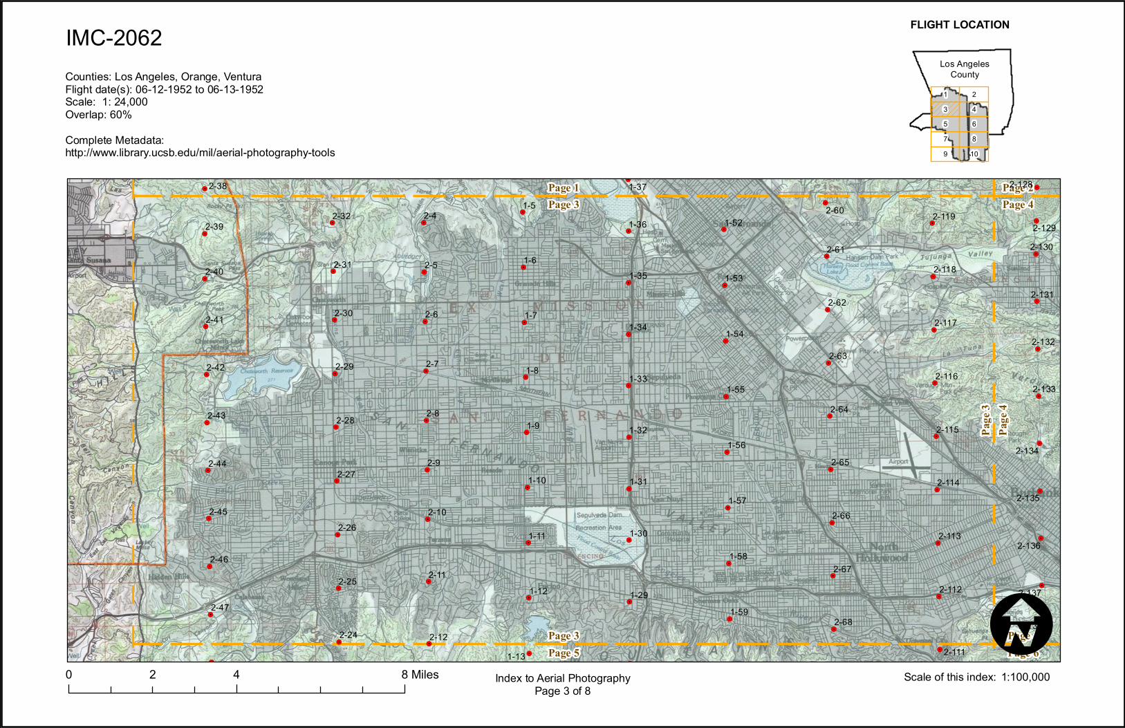
IMC-2062
0 4 82 MilesI
Index to Aerial PhotographyPage 3 of 8
97531
108642
FLIGHT LOCATION
1:100,000Scale of this index:
Counties: Los Angeles, Orange, VenturaFlight date(s): 06-12-1952 to 06-13-1952Scale: 1: 24,000Overlap: 60%Complete Metadata:http://www.library.ucsb.edu/mil/aerial-photography-tools
Los AngelesCounty
!.
!.
!.
!.
!.
!.
!.
!.
!.
!.
!.
!.
!.
!.
!.
!.
!.
!.
!.
!.
!.
!.
!.
!.
!.
!.
!.
!.
!.
!.
!.
!.
!.
!.
!.
!.
!.
!.
!.
!.
!.
!.
!.
!.
!.
!.
!.
!.
!.
!.
!.
!.
!.
!.
!.
!.
!.
!.
!.
!.
!.
!.
!.
!.
!.
!.Page 5Page 3
Page 3Page 1
Page
3Pa
ge 4
Page 6Page 4
Page 4Page 2
2-111
2-112
2-113
2-114
2-115
2-116
2-117
2-118
2-119
2-128
2-129
2-130
2-131
2-132
2-133
2-134
2-135
2-136
2-137
2-1383-23
3-24
3-25
3-26
3-27
3-28
3-29
3-30
3-31
3-35
3-36
3-37
3-38
3-39
3-403-79
3-80
3-81
3-82
3-83
3-84
3-85
3-86
3-87
3-88
3-89
3-903-131
3-132
3-133
3-134
3-135
3-136
3-137
3-138
3-139
3-140
3-141
3-142
3-143
3-144
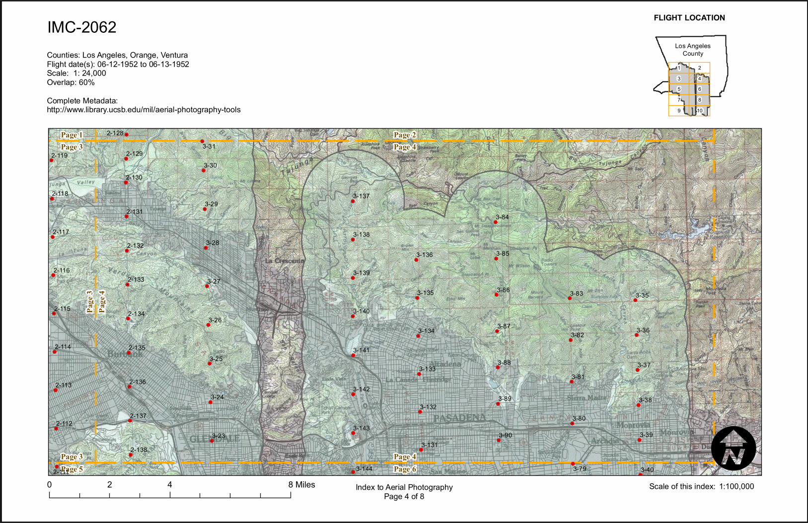
IMC-2062
0 4 82 MilesI
Index to Aerial PhotographyPage 4 of 8
97531
108642
FLIGHT LOCATION
1:100,000Scale of this index:
Counties: Los Angeles, Orange, VenturaFlight date(s): 06-12-1952 to 06-13-1952Scale: 1: 24,000Overlap: 60%Complete Metadata:http://www.library.ucsb.edu/mil/aerial-photography-tools
Los AngelesCounty
!.
!.
!.
!.
!.
!.
!.
!.
!.
!.
!.
!.
!.
!.
!.
!.
!.
!.
!.
!.
!.
!.
!.
!.
!.
!.
!.
!.
!.
!.
!.
!.
!.
!.
!.
!.
!.
!.
!.
!.
!.
!.
!.
!.
!.
!.
!.
!.
!.
!.
!.
!.
!.
!.
!.
!.
!.
!.
!.
!.
!.
!.
!.
!.
!.
!.
!.
!.
!.
!.
!.
!.
Page 7Page 5
Page 5Page 3
Page
5Pa
ge 6
Page 8Page 6
Page 6Page 42-12
2-13
2-14
2-15
2-16
2-172-18
2-19
2-20
2-21
2-22
2-23
2-242-48
2-49
2-50
2-51
2-52
2-53
1-13
1-14
1-15
1-16
1-17
1-18
1-19
1-21
1-22
1-23
1-24
1-25
1-26
1-27
1-281-60
1-61
1-62
1-63
1-64
1-65
1-66
1-67
2-68
2-69
2-70
2-71
2-72
2-73
2-74
2-75
2-76
2-77
2-104
2-105
2-106
2-107
2-108
2-109
2-110
2-1112-138
2-139
2-140
2-141
2-142
2-143
2-144
2-145
2-146
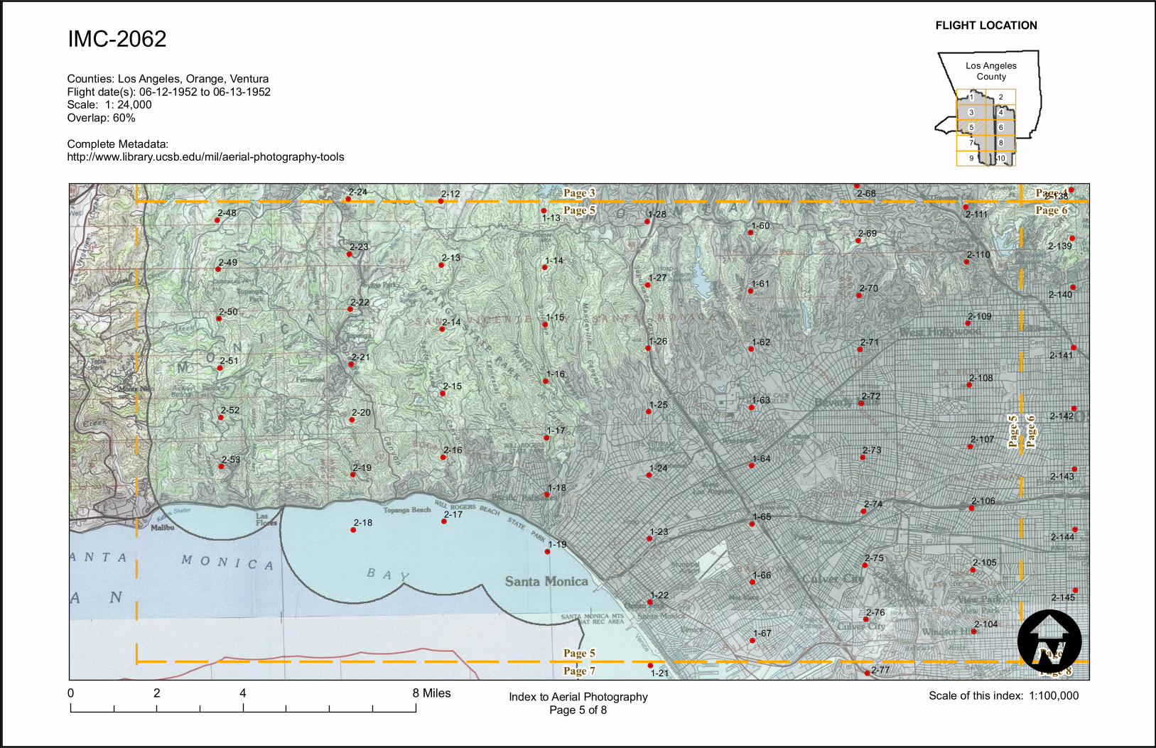
IMC-2062
0 4 82 MilesI
Index to Aerial PhotographyPage 5 of 8
97531
108642
FLIGHT LOCATION
1:100,000Scale of this index:
Counties: Los Angeles, Orange, VenturaFlight date(s): 06-12-1952 to 06-13-1952Scale: 1: 24,000Overlap: 60%Complete Metadata:http://www.library.ucsb.edu/mil/aerial-photography-tools
Los AngelesCounty
!.
!.
!.
!.
!.
!.
!.
!.
!.
!.
!.
!.
!.
!.
!.
!.
!.
!.
!.
!.
!.
!.
!.
!.
!.
!.
!.
!. !.
!.
!.
!.
!.
!.
!.
!.
!.
!.!.
!.
!.
!.
!.
!.
!.
!.
!.
!.
!.
!.
!.
!.
!.
!.
!.
!.
!.
!.
!.
!.
!.
!.
!.
!.
!.
!.
!.
!.
!.
!.
!.
!.
!.
!.
!.Page 7Page 5
Page 5Page 3
Page
5Pa
ge 6
Page 8Page 6
Page 6Page 4
2-104
2-105
2-106
2-107
2-108
2-109
2-110
2-1112-138
2-139
2-140
2-141
2-142
2-143
2-144
2-145
2-1463-15
3-16
3-17
3-18
3-19
3-20
3-21
3-22 3-40
3-41
3-42
3-43
3-44
3-45
3-46
3-47
3-483-71
3-72
3-73
3-74
3-75
3-76
3-77
3-78
3-793-91
3-92
3-93
3-94
3-95
3-96
3-97
3-98
3-123
3-124
3-125
3-126
3-127
3-128
3-129
3-1303-144
3-145
3-146
3-147
3-148
3-149
3-150
3-151
3-152
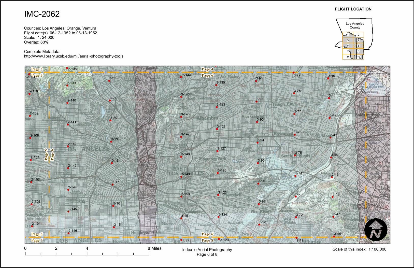
IMC-2062
0 4 82 MilesI
Index to Aerial PhotographyPage 6 of 8
97531
108642
FLIGHT LOCATION
1:100,000Scale of this index:
Counties: Los Angeles, Orange, VenturaFlight date(s): 06-12-1952 to 06-13-1952Scale: 1: 24,000Overlap: 60%Complete Metadata:http://www.library.ucsb.edu/mil/aerial-photography-tools
Los AngelesCounty
!.
!.
!.
!.
!.
!.
!.
!.
!.
!.
!.
!.
!.
!.
!.
!.
!.
!.
!.
!.
!.
!.
!.
!.
!.
!.
!.
!.
!.
!.
!.
!.
!.
!.Page 9Page 7
Page 7Page 5
Page
7Pa
ge 8
Page 10Page 8
Page 8Page 6
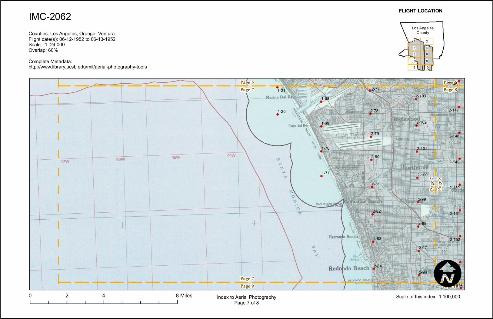
1-20
1-211-68
1-69
1-70
1-71
2-77
2-78
2-79
2-80
2-81
2-82
2-83
2-842-96
2-97
2-98
2-99
2-100
2-101
2-102
2-103
2-146
2-147
2-148
2-149
2-150
2-151
2-152
2-153
2-154
IMC-2062
0 4 82 MilesI
Index to Aerial PhotographyPage 7 of 8
97531
108642
FLIGHT LOCATION
1:100,000Scale of this index:
Counties: Los Angeles, Orange, VenturaFlight date(s): 06-12-1952 to 06-13-1952Scale: 1: 24,000Overlap: 60%Complete Metadata:http://www.library.ucsb.edu/mil/aerial-photography-tools
Los AngelesCounty
!.
!.
!.
!.
!.
!.
!.
!.
!.
!.
!.
!.
!.
!.
!.
!.
!.
!.
!.
!.
!.
!.
!.
!.
!.
!.
!.
!.
!.
!.
!.
!.
!.
!.
!.
!.
!.
!.
!.
!.
!.
!.
!.
!.
!.
!.
!.
!.
!.
!.
!.
!.
!.
!.
!.
!.
!.
!.
!.
!.
!.
!.
!.!.
!.
!.
!.
!.
!.
!.
!.
!.
Page 9Page 7
Page 7Page 5
Page
7Pa
ge 8
Page 10Page 8
Page 8Page 6
2-96
2-97
2-98
2-99
2-100
2-101
2-102
2-103
2-146
2-147
2-148
2-149
2-150
2-151
2-152
2-153
2-154
3-7
3-8
3-9
3-10
3-11
3-12
3-13
3-14
3-48
3-49
3-50
3-51
3-52
3-53
3-54
3-55
3-56
3-64
3-65
3-66
3-67
3-68
3-69
3-70
3-713-99
3-100
3-101
3-102
3-103
3-104
3-105
3-106
3-116
3-117
3-118
3-119
3-120
3-121
3-122
3-1233-152
3-153
3-154
3-155
3-156
3-157
3-158
3-159
IMC-2062
0 4 82 MilesI
Index to Aerial PhotographyPage 8 of 8
97531
108642
FLIGHT LOCATION
1:100,000Scale of this index:
Counties: Los Angeles, Orange, VenturaFlight date(s): 06-12-1952 to 06-13-1952Scale: 1: 24,000Overlap: 60%Complete Metadata:http://www.library.ucsb.edu/mil/aerial-photography-tools
Los AngelesCounty
!.
!.
!.
!.
!.
!.
!.
!.
!.
!.
!.
!.
!.
!.
!.
!.
!.
!.
!.
!.
Page 9Page 7
Page
9Pa
ge 10
Page 10Page 8
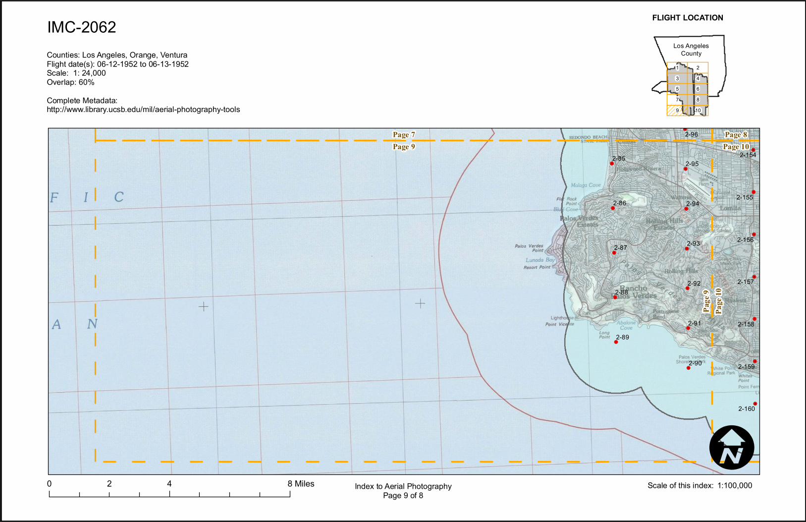
2-85
2-86
2-87
2-88
2-89
2-90
2-91
2-92
2-93
2-94
2-95
2-96
2-154
2-155
2-156
2-157
2-158
2-159
2-160
IMC-2062
0 4 82 MilesI
Index to Aerial PhotographyPage 9 of 8
97531
108642
FLIGHT LOCATION
1:100,000Scale of this index:
Counties: Los Angeles, Orange, VenturaFlight date(s): 06-12-1952 to 06-13-1952Scale: 1: 24,000Overlap: 60%Complete Metadata:http://www.library.ucsb.edu/mil/aerial-photography-tools
Los AngelesCounty
!.
!.
!.
!.
!.
!.
!.
!.
!.
!.
!.
!.
!.
!.
!.
!.
!.
!.
!.
!.
!.
!.
!.
!.
!.
!.
!.
!.
!.
!.
!.
!.
!.
!.
!.
!.
!.
!.
!.
!.!.
!.
!.
!.
!.
Page 9Page 7
Page
9Pa
ge 10
Page 10Page 8
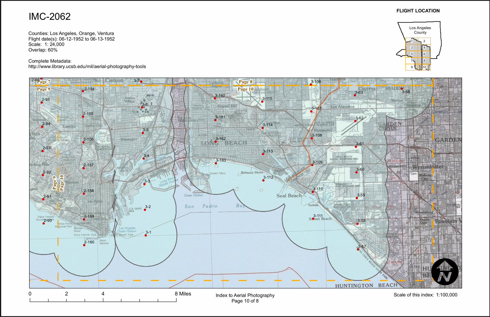
2-90
2-91
2-92
2-93
2-94
2-95
2-962-154
2-155
2-156
2-157
2-158
2-159
2-160
3-1
3-2
3-3
3-4
3-5
3-6
3-7
3-56
3-57
3-58
3-59
3-60
3-61
3-62
3-63
3-106
3-107
3-108
3-109
3-110
3-111
3-112
3-113
3-114
3-1153-160
3-161
3-162
3-163
IMC-2062
0 4 82 MilesI
Index to Aerial PhotographyPage 10 of 8
97531
108642
FLIGHT LOCATION
1:100,000Scale of this index:
Counties: Los Angeles, Orange, VenturaFlight date(s): 06-12-1952 to 06-13-1952Scale: 1: 24,000Overlap: 60%Complete Metadata:http://www.library.ucsb.edu/mil/aerial-photography-tools
Los AngelesCounty