Embed Size (px)
Citation preview

MOVING THE INDUSTRY FORWARD
FLIGHT DECK SOLUTIONS, TECHNOLOGIES AND SERVICES

From web-based flight planning, fleet scheduling and tracking services to integrated flight display technology, head-up displays, advanced RNP navigation, onboard weather radar, Data Comm datalinks and much more — Garmin offers an unrivaled range of options to help make flying as smooth, safe, seamless and reliable as it can possibly be. Whether you operate a business jet, turboprop or hard-working helicopter, you can look to Garmin for industry-leading solutions scaled to fit your needs and your cockpit. The fact is, no other leading avionics manufacturer offers such breadth of capability — or such versatile configurability — in its lineup of flight deck solutions for aircraft manufacturers and aftermarket upgrades. When it comes to bringing out the best in your aircraft, Garmin innovation makes all the difference.
GARMIN INNOVATION BRINGSFULL INTEGRATION TO BUSINESSFLIGHT OPERATIONS AND SUPPORT
By presenting key aircraft performance, navigation, weather, terrain and traffic information, in context, on large high-resolution color displays, today’s Garmin glass systems bring a whole new level of clarity and simplicity to flight. The screens offer wide viewing angles, advanced backlighting and crystal-sharp readability, even in bright sunlight. A graphical 3-axis flight display on the PFD synthesizes aircraft attitude, airspeed, climb rate, altimeter and horizontal course/heading information – as well as Flight Director command bar cues and mode information, when coupled with a Garmin digital automatic flight control system. The Garmin AFCS also supports such capabilities as coupled LPV approaches, vertical navigation, coupled go-arounds, electronic stability and protection, flight level change and other sophisticated autopilot features.
More and better information.Proven AHRS attitude/heading reference delivers high-precision spatial sensing for the system’s digital instrumentation, replacing old-style gyros. And for added situational awareness, Garmin SVT™ synthetic vision is available to provide a realistic 3-D “virtual reality” view of terrain, traffic, airports, pathways and obstacles on the pilot’s flight display. Alongside, a multitasking MFD screen can accommodate all essential engine status, crew alerting and fuel systems data – in addition to detailed moving-map graphics showing the aircraft’s current position in relation to ground features, chart data, navaids, airways, flight plan
routings and so on. The map function is designed to interface with a variety of sensor inputs, so it’s easy to overlay weather, lightning, traffic, terrain, towers, powerlines and other avoidance system advisories, as desired. These display inputs are selectable, allowing the pilot to add or deselect overlays to “build at will” the map view he or she prefers for any given segment of flight. What’s more, at the higher end of our Garmin flight deck lineup, large panoramic widescreen displays (accessed via touchscreen controllers) feature split-screen and multi-frame functionality – to vastly expand the amount of graphical information that pilots can reference at a glance.
Always looking ahead.Other display options include selectable inset windows to accommodate supplemental views of traffic, terrain/obstacles, flight path mapping, video inputs and more1. For even more viewing and interface flexibility, Garmin Flight Stream wireless gateway technology enables pilots to use their Apple iPad® (or other compatible Apple® or Android™) mobile digital devices to stream data to/from the flight deck avionics via a Garmin Connext® BLUETOOTH® link – making flight plan uploads easier and faster than ever. As you can see, Garmin flight deck solutions are clearly onboard with the future. They’re designed for pilots, by pilots. And they all work seamlessly to maximize efficiency, reduce complexity, enhance safety and simplify cockpit management in all phases of flight.
CREATING A VIRTUAL REVOLUTION IN GLASS FLIGHT DECK SOLUTIONS
¹Suggested applications may require optional equipment, sold separately.Specifications and descriptions are preliminary and subject to change without notice.
G5000Textron Aviation
Citation® Sovereign+®
When you fly behind a Garmin integrated flight deck, you’re not just trading mechanical gauges for glass. You’re also equipping your aircraft to be ready for the future – a future that will take aviation from today’s ground-controlled and radar-supported ATC system to a more space-based, satellite-derived NextGen air traffic management environment. As you’ll see, all Garmin integrated flight systems are designed with these evolving needs in mind. Whether it’s streamlining and automating routine tasks in the cockpit – or providing built-in growth provisions for new technologies on the horizon – the Garmin approach offers a clear path to software-driven evolution, not obsolescence. Here are a few system highlights that suggest what we’re envisioning:
GARMIN GLASS: PUTTING LEADING-EDGE TECHNOLOGIES RIGHT AT YOUR FINGERTIPS
The emergence of NextGen airspace represents a significant opportunity for pilots, owners and operators to embrace new technology that will allow them to fly with greater efficiency, safety, flexibility and situational awareness. Automatic dependent surveillance – broadcast, or ADS-B, is the enabling data link technology for NextGen traffic management. And as the industry leader in ADS-B, Garmin has tailored and certified an array of reliable ADS-B solutions covering a wide range of business aircraft. Our latest flight deck systems provide ADS-B “Out” capabilities to meet and exceed requirements for NextGen airspace. Plus, these systems are also provisioned for ADS-B “In” to support subscription-free weather and advanced traffic displays, including TargetTrend™ and TerminalTraffic™ monitoring. Further, via our Connext® wireless technology, all of this information can be wirelessly sent to your compatible Garmin portable or iPad®, using either Garmin Pilot™ or FltPlan Go apps, to integrate these devices with your flight deck.
Provisioned for FANS 1/A and Data Comm From basic transponder-derived ADS-B “Out” only solutions to dual-link products offering a variety of subscription-free ADS-B “In” traffic and weather display capabilities, Garmin has engineered a full range of options on the path to ADS-B compliance. Moreover, as NextGen evolves, our higher-end flight deck systems will be ready – and provisioned – for data comm and automatic controller/pilot data link communications (CPDLC) that enable aircraft surveillance reporting and digital two-way text messaging between ATC and flight crews, using satellite-based Future Air Navigation System (FANS 1/A) protocols and robust global data comm technology. Clearly, at every level, Garmin data link solutions are actively shaping the future of air traffic surveillance and management.
NEXTGEN AIRSPACE READINESS WITH ADS-B DATA LINKS
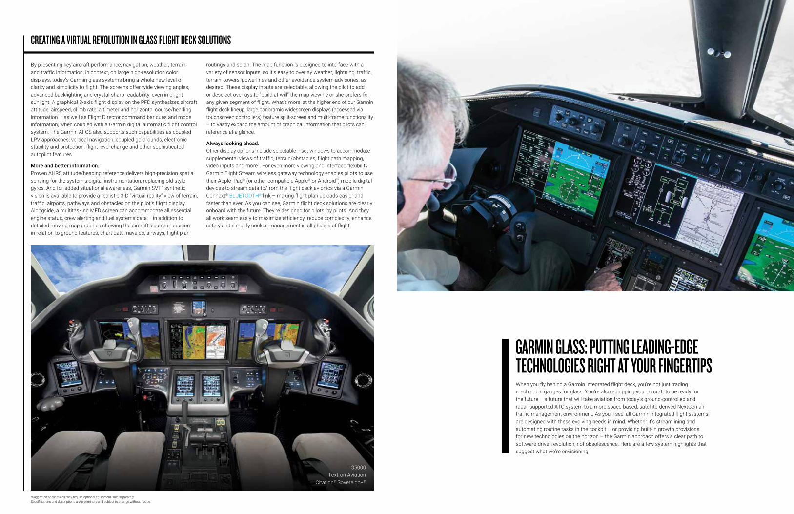
G5000® G5000H® G3000® G1000® NXi* G1000H® NXi* G950® NXi*
Jets X X X X
Turboprops X X X
Piston X X
Helicopters X X
A guide to what goes with what:
For virtually every class and model of aircraft in the business fleet, Garmin offers a choice of glass flight deck solutions tailored specifically to users’ operational and price point requirements. Here’s how the current package configurations match up:
*NOTE: Garmin G1000 NXi, G1000H NXi and G950 NXi are controlled using conventional knobs and bezel keys for data entry. The G950 NXi system uses identical displays as the G1000 NXi, but it does not provide the full level of autopilot compatibility that the G1000 NXi system does. Also, the G1000H NXi for helicopters does not provide full Garmin autopilot integration.
Please note that not every technology highlighted in this brochure may be approved and/or available on all makes and models of business aircraft. See your aircraft manufacturer for specifics on their system configurations.
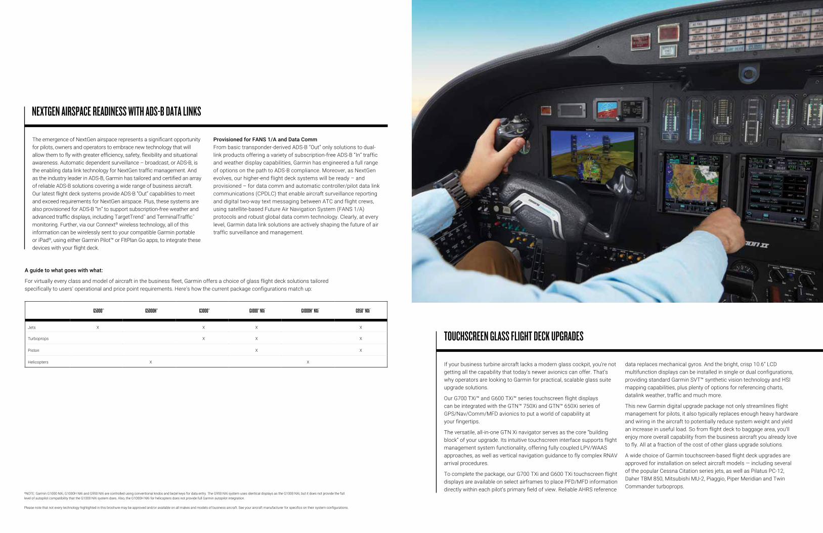
If your business turbine aircraft lacks a modern glass cockpit, you’re not getting all the capability that today’s newer avionics can offer. That’s why operators are looking to Garmin for practical, scalable glass suite upgrade solutions.
Our G700 TXi™ and G600 TXi™ series touchscreen flight displays can be integrated with the GTN™ 750Xi and GTN™ 650Xi series of GPS/Nav/Comm/MFD avionics to put a world of capability at your fingertips.
The versatile, all-in-one GTN Xi navigator serves as the core “building block” of your upgrade. Its intuitive touchscreen interface supports flight management system functionality, offering fully coupled LPV/WAAS approaches, as well as vertical navigation guidance to fly complex RNAV arrival procedures.
To complete the package, our G700 TXi and G600 TXi touchscreen flight displays are available on select airframes to place PFD/MFD information directly within each pilot’s primary field of view. Reliable AHRS reference
data replaces mechanical gyros. And the bright, crisp 10.6” LCD multifunction displays can be installed in single or dual configurations, providing standard Garmin SVT™ synthetic vision technology and HSI mapping capabilities, plus plenty of options for referencing charts, datalink weather, traffic and much more.
This new Garmin digital upgrade package not only streamlines flight management for pilots, it also typically replaces enough heavy hardware and wiring in the aircraft to potentially reduce system weight and yield an increase in useful load. So from flight deck to baggage area, you’ll enjoy more overall capability from the business aircraft you already love to fly. All at a fraction of the cost of other glass upgrade solutions.
A wide choice of Garmin touchscreen-based flight deck upgrades are approved for installation on select aircraft models — including several of the popular Cessna Citation series jets, as well as Pilatus PC-12, Daher TBM 850, Mitsubishi MU-2, Piaggio, Piper Meridian and Twin Commander turboprops.
TOUCHSCREEN GLASS FLIGHT DECK UPGRADES

As another glass upgrade option, the Garmin GI 275 electronic touchscreen display lets you replace those maintenance-intensive mechanical gyros in your panel with modern, reliable, solid state AHRS-based technology.
The high-resolution, edge-to-edge GI 275 display is sunlight-readable and configurable as either a primary reference for the attitude indicator/ADI, DG/HSI, CDI, MFD or standby flight instrument displays. There’s also an available hardware version with a built-in interface that equips the GI 275 to drive select autopilots and display flight director command bar cues. Fully coupled LPV/LNAV/ILS approach capability, including missed approach procedures, can be displayed when a GI 275 ADI is paired with an appropriate autopilot (our GFC™ 600, for example) and a compatible navigation source, such as the GTN Xi series.
This multifunction digital instrument is designed to flush mount in a standard 3-1/8” cutout — or it can be easily fitted with an adaptor plate for other sizes and formats — to keep installation time and expense to a minimum. The touchscreen instrument typically provides much more capability than the mechanical indicator it replaces. And on some aircraft models, the GI 275 is also approved for use as an integrated standby instrument for large-screen glass flight deck systems, including our G700 TXi and G600 TXi series displays.
Select business turbine aircraft approved for GI 275 installation include the Embraer Phenom 100/300, Cessna Citation CJ, CJ1, CJ2 and Mustang series, Pilatus PC-12, Daher TBM 850, Mitsubishi MU-2, Piaggio, Piper Meridian, Twin Commander and more1.
REPLACE ANALOG GAUGES WITH DIGITAL DISPLAYS
1Some functionality limitations may apply based on the specific make/model of aircraft. Please check with your dealer for complete details.
Projecting critical PFD information in the pilot’s forward field of view through the aircraft windscreen, Garmin HUD technology brings added safety and situational awareness to business aircraft flight decks. Especially useful during critical takeoff and approach transitions, the HUD display provides pilots with an “eyes out” reference that eliminates the need to continually transition from head-down instrument viewing to head-up scanning for traffic, terrain, towers, obstacles and other potential hazards. The HUD’s symbology and graphics are consistent with those used on the Garmin glass cockpit flight instrumentation. So visual transition between displays is virtually seamless. SVT integrated with the HUD uses sophisticated graphics modeling to create a 3-D “virtual reality” view with terrain, obstacles, flight plan routes, runways and other details similar to those displayed on our integrated
flight deck PFDs. And because the synthetic vision image replicates what’s visible through the aircraft windscreen on a clear day, a smooth transition from cockpit displays to outside visual reference is virtually assured – regardless of actual weather or visibility conditions. Flight path marker-based guidance shows the calculated effect of variables such as crosswind, angle of attack, airspeed, etc., to help pilots more easily establish precise alignment of aircraft maneuvers relative to terrain, obstacles, runway thresholds and other targeted points of reference. Plus, with the added operational capability provided by the HUD, operators can pursue Special Authorization Category I (Cat 1) or Category II (Cat 2) approvals for the more demanding (and lower) U.S. instrument landing system (ILS) approach minima.
HEAD-UP DISPLAY (HUD) SYSTEM

Flying is rewarding in so many ways. But it’s also a big responsibility. With friends, family or colleagues on board, a pilot’s top priority is keeping that precious cargo safe. Now there’s a way to provide even more protection: the revolutionary Garmin Autoland system. It’s designed to automatically take control and fly the aircraft from cruising altitude down to approach and landing at a suitable airport — totally hands-free — should the pilot ever become incapacitated or otherwise unable to continue flying1.
AUTOLAND TECHNOLOGY HERE’S HOW IT WORKS:
ACTIVATION
The pilot or passengers can manually activate Autoland with a simple press of a dedicated button to help land the aircraft. Based on a variety of scenarios, Autoland
can also be automatically activated if the system determines it’s necessary2.
FINDS DESTINATION
After activation, the system selects the most appropriate airport for landing, considering runway
length, distance, fuel range and other factors.
HAZARD AVOIDANCE
Garmin Autoland navigates around hazardous terrain, obstacles and weather as it flies to its destination. The Garmin autothrottle system manages aircraft speed,
engine performance and power to allow the aircraft to climb, descend or maintain altitude.
ATC COMMUNICATION
Autoland automatically communicates its intentions and routing to air traffic control and passengers on
appropriate frequencies. If they wish, passengers may also talk with ATC at any time by following simple
instructions on the display.
PASSENGER UPDATES
Garmin Autoland is in complete control of the flight, using autopilot and autothrottle technologies1.
Passengers receive plain language updates so they know what to expect. Flight displays show the aircraft’s
location on a map, as well as the destination airport, estimated time of arrival, distance remaining and more.

AUTOMATED APPROACHES
The system initiates a descent to the airport and automatically activates an approach to the selected runway. If the aircraft needs additional time to descend or slow down, Autoland will initiate a hold prior to the final approach fix.
LANDS THE AIRPLANE
At the destination, Autoland lands the aircraft3. Automatic braking brings the aircraft to a full stop while automatically shutting down the engine. The system provides instructions to passengers on how to safely exit the aircraft.
IT’S A BREAKTHROUGH IN FLIGHT PROTECTION
The Autoland system is now certified and available on select aircraft equipped with the Garmin G3000® integrated flight deck and autothrottles. As part of the broader Garmin Autonomí family of flight automation products — which also includes Electronic Stability and Protection and Emergency Descent
Mode — Autoland represents a significant safety-enhancing advance for aviation. It has the potential to save lives and bring added peace of mind to everyone who flies with it.
1See Garmin.com/ALuse for Autoland system requirements and limitations2Pilot can later deactivate Autoland at the pilot’s discretion3Aircraft may require maintenance after Autoland use
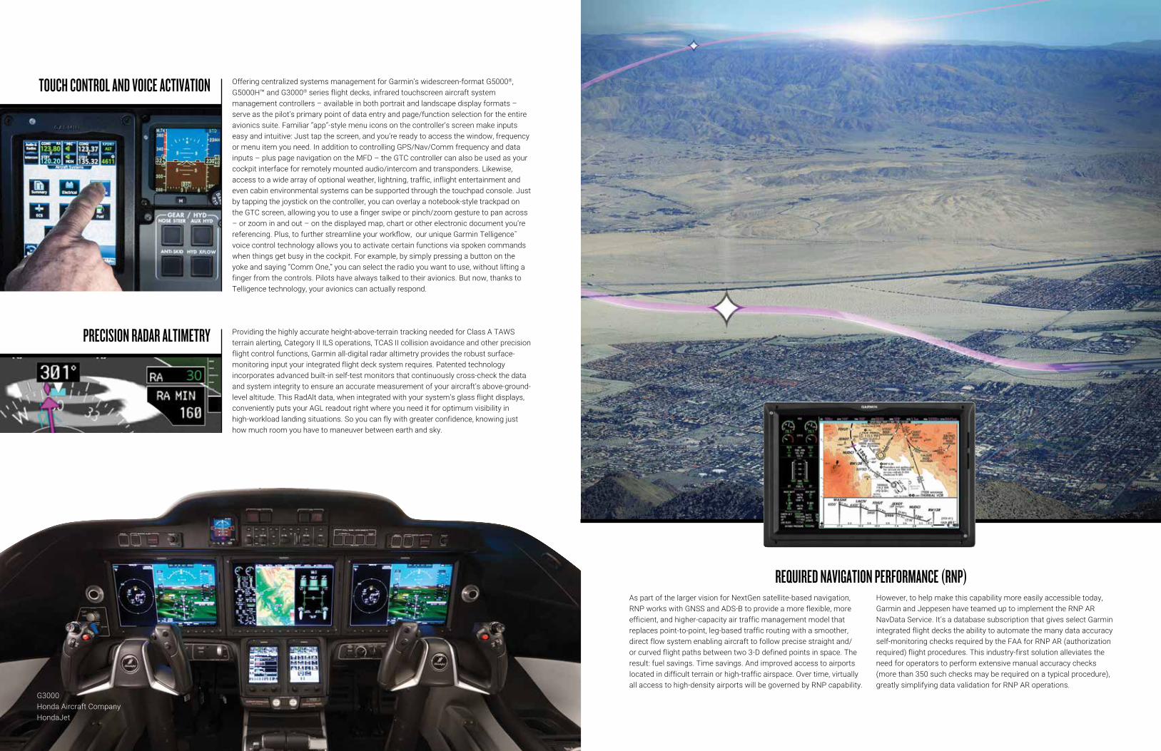
Providing the highly accurate height-above-terrain tracking needed for Class A TAWS terrain alerting, Category II ILS operations, TCAS II collision avoidance and other precision flight control functions, Garmin all-digital radar altimetry provides the robust surface-monitoring input your integrated flight deck system requires. Patented technology incorporates advanced built-in self-test monitors that continuously cross-check the data and system integrity to ensure an accurate measurement of your aircraft’s above-ground-level altitude. This RadAlt data, when integrated with your system’s glass flight displays, conveniently puts your AGL readout right where you need it for optimum visibility in high-workload landing situations. So you can fly with greater confidence, knowing just how much room you have to maneuver between earth and sky.
PRECISION RADAR ALTIMETRY
G3000Honda Aircraft CompanyHondaJet
Offering centralized systems management for Garmin’s widescreen-format G5000®, G5000H™ and G3000® series flight decks, infrared touchscreen aircraft system management controllers – available in both portrait and landscape display formats – serve as the pilot’s primary point of data entry and page/function selection for the entire avionics suite. Familiar “app”-style menu icons on the controller’s screen make inputs easy and intuitive: Just tap the screen, and you’re ready to access the window, frequency or menu item you need. In addition to controlling GPS/Nav/Comm frequency and data inputs – plus page navigation on the MFD – the GTC controller can also be used as your cockpit interface for remotely mounted audio/intercom and transponders. Likewise, access to a wide array of optional weather, lightning, traffic, inflight entertainment and even cabin environmental systems can be supported through the touchpad console. Just by tapping the joystick on the controller, you can overlay a notebook-style trackpad on the GTC screen, allowing you to use a finger swipe or pinch/zoom gesture to pan across – or zoom in and out – on the displayed map, chart or other electronic document you’re referencing. Plus, to further streamline your workflow, our unique Garmin Telligence™ voice control technology allows you to activate certain functions via spoken commands when things get busy in the cockpit. For example, by simply pressing a button on the yoke and saying “Comm One,” you can select the radio you want to use, without lifting a finger from the controls. Pilots have always talked to their avionics. But now, thanks to Telligence technology, your avionics can actually respond.
TOUCH CONTROL AND VOICE ACTIVATION
As part of the larger vision for NextGen satellite-based navigation, RNP works with GNSS and ADS-B to provide a more flexible, more efficient, and higher-capacity air traffic management model that replaces point-to-point, leg-based traffic routing with a smoother, direct flow system enabling aircraft to follow precise straight and/or curved flight paths between two 3-D defined points in space. The result: fuel savings. Time savings. And improved access to airports located in difficult terrain or high-traffic airspace. Over time, virtually all access to high-density airports will be governed by RNP capability.
However, to help make this capability more easily accessible today, Garmin and Jeppesen have teamed up to implement the RNP AR NavData Service. It’s a database subscription that gives select Garmin integrated flight decks the ability to automate the many data accuracy self-monitoring checks required by the FAA for RNP AR (authorization required) flight procedures. This industry-first solution alleviates the need for operators to perform extensive manual accuracy checks (more than 350 such checks may be required on a typical procedure), greatly simplifying data validation for RNP AR operations.
REQUIRED NAVIGATION PERFORMANCE (RNP)

Minimum
Opposing
Force
Maxim
umOpp
osing
Force
MinimumOpposingForce
Maximum
Opposing
Force
ESP™ Eng
aged
ESP
™ Engag
ed
ESP™ M
onito
ring
A key element in our Garmin Autonomí family of flight automation products, ESP is a safeguard that assists pilots to maintain safe, stable flight by monitoring the aircraft’s flight condition to help prevent loss of control. While the pilot is always in full control, Garmin ESP helps the pilot realize and react to potentially unsafe flight conditions with control inputs and alerts.
ESP detects when the pitch of the the aircraft’s nose rises too high or drops too low — or when the aircraft rolls left or right beyond preset limits. Then it gently applies pressure on the flight controls that guide the pilot back to recommended flight limits. ESP will then disengage when the aircraft returns to normal, stabilized flight. The ESP system is designed to augment, not overpower, the pilot’s control of the aircraft. Its inputs can be easily overridden manually with a press of a button. Yet, any pilot who’s ever been startled to attention by a stall warning horn in a busy cockpit will appreciate the compelling safety benefits of this “proactive prevention” technology from Garmin.
STABILITY ENHANCEMENT WITH ELECTRONIC STABILITY PROTECTION (GARMIN ESP™)
In the event of the loss of engine power in a single-engine airplane, a pilot faces the urgent, workload-intensive job of safely flying the aircraft. Our Smart Glide feature, available on GTN™ Xi series navigators paired with compatible flight displays, can provide time-saving assistance, help the pilot efficiently navigate to an airport in range and, with the pilot’s compatible autopilot, even fly the aircraft en route — allowing the pilot to focus more attention on other key tasks essential to this emergency operation.
The pilot can activate Smart Glide mode with the press of a dedicated panel-mounted button. The system considers the aircraft’s estimated glide range (including terrain and obstacles) and recommends a suitable airport for landing,
or it advises if no airport is estimated to be within glide range. If airports are in range, it also displays a list of alternates and creates a Direct-to route to the selected airport. It automatically engages a Garmin autopilot (if equipped) in IAS mode at best glide speed and displays flight director command bars on the primary flight display. Smart Glide also displays an emergency data window with destination airport information (if available), automatically loads the destination airport CTAF frequency in the primary Comm standby position and provides a shortcut to loading the emergency 7700 squawk code on a compatible transponder. And it provides aural alerts that advise the distance and bearing to the airport — so the pilot can prepare to take control and land the aircraft.
SMART GLIDE™
The moving map displays on all Garmin integrated flight decks feature a unique set of Terminal Safety Solutions that provide pilots with enhanced situational awareness throughout taxi, takeoff and landing. Geo-referenced SafeTaxi® airport diagrams show runways, taxiways, and hangar locations on hundreds of U.S., Canadian, and European airports. An even more advanced runway safety technology, called SurfaceWatch™, is optionally available to provide alerts, indications and visual cues that help prevent runway incursions and other field-position lapses during ground or air operations in the airport environment. Examples of such alerts include taking off or landing on the wrong runway. Or on a taxiway. Or on a runway that’s too short for safe takeoff or landing. In the event an aircraft is aligned to take off
on a runway that is too short, the flight crew is given a brief “runway too short” aural annunciation and a visual message on the PFD, based on the takeoff/landing distance (TOLD) performance data entered during preflight. While the aircraft is on takeoff roll, runway distance remaining information also is displayed on the PFD. Additionally, Garmin TerminalTraffic™ alerting offers pilots an all-inclusive display of ADS-B equipped aircraft and ground vehicles operating in the airport environment – using distinct colors and symbols to distinguish between aircraft that are taxiing or airborne. Audible traffic alerts may also be provided to ensure that pilots are made aware of potential traffic conflicts during critical operations such as takeoff and landing.
TERMINAL SAFETY SOLUTIONS
To fully leverage the performance and capability of your aircraft, most factory-installed Garmin glass flight deck systems offer seamless integration with an advanced, AHRS-based AFCS engineered to provide the latest in flight director, autopilot, yaw damper and automatic/manual electric trim functionality. The system’s all-digital, dual-channel, fail-passive design ensures superior stability and control – delivering precise lateral and vertical navigation guidance for all phases of flight. Airspeed holds, VNAV profiles, automatic nav-to-nav captures, coupled holding patterns, procedure turns, go-arounds and more – the list of capabilities is unprecedented in this class of autopilot. You’ll appreciate
the positive, consistent response afforded by airspeed-scheduled trim – as well as the silky smooth roundouts and vertical intercepts that the system’s advanced software modeling provides on climbs and descents. What’s more, the system is fully enabled for satellite-based WAAS/SBAS guidance capability – supporting fully coupled GPS-only LPV approaches into runways that may not be served by ILS or other ground-based electronic approach aids. With WAAS/SBAS guidance, your Garmin AFCS can automatically fly any procedure published in the navigation database. So you’ll have access to more all-weather landing options at more airports throughout the world.
ADVANCED AUTOPILOT INTEGRATION
Another vital safety-enhancing technology in the Garmin Autonomí family of flight automation products is our Emergency Descent Mode. At high altitudes, pilots and passengers need supplemental oxygen or a pressurized cabin to survive. If those systems fail, EDM seeks to protect occupants by descending to lower altitudes where these devices aren’t required. Sensors in the Garmin suite monitor cabin pressurization
and/or pilot interactions with the aircraft and avionics. If there’s a problem with those essential systems, and if the pilot doesn’t respond to repeated queries, EDM will engage — driving the autopilot to quickly and automatically descend the aircraft. Upon reaching a lower altitude where supplemental oxygen isn’t required, the autopilot will level off, allowing the pilot to recover and resume flying the aircraft to a safe landing.
EMERGENCY DESCENT MODE (EDM)

To help pilots reduce the risk of accidents involving controlled flight into terrain, Garmin integrated flight deck systems are provisioned for “forward-looking” terrain avoidance capability with Class A or Class B terrain awareness and warning systems (TAWS). Both classes of equipment use current position information from the aircraft’s WAAS/SBAS GPS system, comparing this with the navigation system’s internal terrain/obstacles/airport databases to determine where conflict scenarios may exist. If the aircraft doesn’t have adequate terrain and/or obstacle clearance ahead, based on the system’s projected flight path, TAWS caution and warning alerts are issued to the pilot. Accompanying voice alerts also indicate the relative threat level, with messages such as “Caution, Obstacle, Obstacle” or “Warning, Terrain, Terrain.” In addition to terrain and
obstacle alerting (with color-keyed terrain proximity display), Garmin TAWS systems also feature voice callouts, or VCOs, which audibly announce the aircraft’s height above terrain when descending below 500 feet. VCO altitude callouts operate in all TAWS modes, and Garmin technology allows the pilot to select multiple callout menus, in 100' intervals, descending from 500 down to 100 feet. In addition to these capabilities, the Class B TAWS equipment offers standard indications of excessive rates of descent, as well as negative climb rate or altitude loss after takeoff. The Class A version offers all these functions, plus additional pilot notifications for excessive closure rate to terrain, excessive downward deviations from a glideslope approach and the impending potential for flight into terrain when the aircraft is not set up in landing configuration.
CLASS A OR CLASS B TAWS TERRAIN ALERTINGIn busy, high-density airspace, pilots need every possible advantage when it comes to “seeing and avoiding” traffic conflicts. That’s why Garmin developed its GTS™ family of ADS-B enhanced traffic collision avoidance (TCAS II and TCAS I) systems. Featuring exclusive Garmin CLEAR CAS™ (correlated location enhanced ADS-B receiver collision avoidance system) technology, these systems combine both active and passive surveillance, including 1090 MHz ADS-B “In”, to correlate target data and pinpoint traffic threats. With TCAS I, expanded audio alerts in an ATC-like spoken format (“Traffic. Two o’clock. High. Two miles.”) help pilots maintain “eyes out” scanning for reported targets. (Note: Expanded audio alerts not applicable with TCAS II, which uses
standardized callouts). With approved transponder and radar altimeter inputs, the Garmin TCAS II package becomes a fully Change 7.1 compliant system that not only indicates potential traffic threats, but also issues resolution advisories (RAs) to provide both visual and aural instructions on how best to avoid a collision – by initiating a climb, descent or level-off maneuver. As a Change 7.1 compliant solution, our Garmin TCAS II system meets the NextGen (or equivalent) standardization requirements now being implemented in most countries’ airspace systems. In the future, the system will also provide enhanced target information, including aircraft ID, altitude, velocity and direction of flight.
INTEGRATED TCAS/ACAS TRAFFIC ALERTING WITH ADS-B

In addition to a wide range of integrated autopilot/flight guidance capabilities, our Garmin top-level AFCS for the G5000® suite offers the latest in database-referenced performance planning and management functions. Using inputs from the onboard aircraft systems – as well as airframe-specific data from the aircraft flight manual – these optional performance and TOLD functions can be used to optimize pilot decision-making for all phases of flight. Targeted airspeeds, cruise altitudes, winds aloft, fuel flows, payloads, climb/descent profiles and more can all be factored into the equation. Plus, various “what if” scenarios can be entered to help pilots assess the best outcomes for specific range, time, fuel, payload and weather parameters. To further simplify the math, our Garmin TOLD function automatically computes required runway lengths, V-speeds, climb/approach gradients, maximum takeoff weight, etc., thus enhancing operational safety while significantly reducing crew workload.
TAKEOFF/LANDING DISTANCE AND PERFORMANCE MANAGEMENT
G3000Textron AviationCitation® M2®

All Garmin integrated flight deck systems are designed to interface with our Doppler-capable series of GWX™ radars for the best in onboard weather surveillance. Combining excellent range and solid-state reliability with precision target definition, altitude compensated tilt and up to four times as many colors as traditional weather displays, these fully stabilized radar systems feature pilot-adjustable horizontal scan angles of up to 120 degrees. Plus, they offer a useful vertical scanning mode to help analyze storm tops, gradients and cell buildup activity at various altitudes. Other optional advanced functions include turbulence detection and ground clutter suppression, as well as predictive hail, lightning and windshear alerting. Also, advanced 3-D volumetric scanning technology works to reduce your cockpit workload by helping you quickly identify the most potentially hazardous threats and then choose the best avoidance solution. There’s no need to manually adjust the radar for multiple scan/sweep angles or target intensities. You simply select the range to display, and the radar is programmed to do the rest automatically — filtering out ground returns, adjusting the tilt and more. So you can focus on flying the aircraft while getting detailed, real-time storm cell profile analysis at a glance.
ADVANCED DOPPLER WEATHER RADAR WITH AUTOMATIC THREAT ANALYSIS
G1000® NXi UpgradeKing Air Family
In addition to the subscription-free U.S. weather and traffic available through your aircraft’s ADS-B “In” data link, Garmin flight deck systems will also support a variety of commercial data link options. For example, NEXRAD weather, METARs, TAFs, TFRs, winds aloft, echo tops, surface precipitation, lightning strikes, storm cell data and more can be received and displayed throughout North America with the addition of a SiriusXM® onboard satellite receiver (subscription required). You can also enjoy 100+ channels of music, sports, news, talk and entertainment by adding SiriusXM satellite radio service to your package. If you want to access weather data and graphics on a more global basis, the addition of an Iridium® satellite transceiver and Garmin Connext®
wireless connectivity can bring worldwide weather access to your flight deck – plus you can add voice calling, text messaging, position reporting and more – to help you stay connected from virtually anywhere on the planet. Likewise, as the evolution of NextGen airspace continues to shift more emphasis from radio voice communications to data link messaging, optional ACARS (aircraft communications addressing and reporting system) capability is provisioned for the higher-end Garmin flight deck systems. Using an in-place network of ground station and satellite links, ACARS enables high-speed digital data communications, clearances, confirmations and messaging between flight crews, ATC and ground support operations on a global, seamless, automated basis.
DATA LINKS FOR WEATHER, TRAFFIC, COMMUNICATIONS AND MORE

Using Garmin Connext onboard link enabled with BLUETOOTH® technology — via one of our Flight Stream series of wireless gateways in the aircraft — pilots can now enjoy more freedom and flexibility in everything from preflight planning and database management to inflight decision-making. With the appropriate data link installed, Garmin Connext lets you access quality on-demand weather updates, text/voice communications and more. Plus, you can stream information in real time between your avionics and compatible mobile devices running the Garmin Pilot™ or ForeFlight mobile apps — turning your tablet, smartphone or compatible aviation portable into a true cockpit interface. You can also use your mobile device to create flight
plans whenever and wherever it’s convenient and then easily transfer the data to your avionics once you get to the airport. Database Concierge capability further allows Garmin Pilot to wirelessly update the aviation databases of your compatible avionics. At home, you simply select the individual databases on Garmin Pilot, download them and store them to your mobile device. Then at the airport, once your device establishes a wireless connection in the airplane, Garmin Pilot will transfer your up-to-date databases directly to the compatible avionics in minutes, where they’ll wait in standby until their effective dates. This app-to-avionics interface saves you valuable time and tedious data entry, so you can complete your checklist items quicker and get airborne sooner.
GARMIN CONNEXT® WIRELESS ECOSYSTEM
Meeting the tough environmental and vibration criteria for rotorcraft operations, Garmin helicopter-optimized glass flight deck systems offer unprecedented levels of capability and configurability. Safety-enhancing Garmin HSVT™ 3-D synthetic vision technology is available to aid in pilot situational awareness when weather and outside visibility are less than ideal. Brownouts, whiteouts, haze, darkness, you name it: Garmin HSVT helps minimize visual impairment by providing a “virtual reality“ landscape on the pilot’s flight display, showing a database-generated view of ground and water features, airports, obstacles, traffic and more. Along with this, available HTAWS helicopter terrain alerting is supported – providing crisp, five-color topographic shading on the display, as well
as voice callouts (or VCOs) that audibly announce a pilot’s height above the ground when descending below 500 feet. Available single-limit power indicators offer simplified monitoring of turbine engine output levels. And other heli-oriented system features include night vision goggle (NVG) compatibility, ADS-B enhanced traffic alerting, Cat. A and hover altitude performance calculation, radar altimeter, helicopter-robust onboard digital radar, data link weather, video cams, FLIR, phone/messaging links and more. Garmin also offers a unique hover display that provides a combination of location, heading and vector references to help guide and orient pilots during hovering maneuvers.
ROBUST GLASS SOLUTIONS TAILORED FOR HELICOPTER OPERATIONS

G5000Textron AviaitonCessna Citation XLS
G5000Textron AviationCessna Citation XLS
For missions that require extra-ruggedized avionics to operate reliably in extreme environmental conditions, Garmin can deliver the system options and engineering expertise to meet those requirements. We offer a wide range of commercial off-the-shelf solutions, as well as customized technologies to meet the needs of government, military, air transport and aerospace flight systems applications. Industry-standard connectors and ARINC data bus formats make for easy interface with existing aircraft avionics. Plus, to counter extremes in temperature, shock, vibration, humidity, dust or electronic interference, Garmin provides robustly shielded and reinforced products that incorporate such design elements as ruggedized cases and displays, high-reliability round connectors, sealed components, high-efficiency cooling and other protective technologies. Whether we’re called on to serve as a contractor, supplier or development partner for these specialized systems, we’re known for offering solutions that help reduce program costs and implementation risks — with far shorter time-to-delivery intervals than those typically experienced under military or commercially funded contracts. Whether the spec calls for equipage on current or NextGen platforms — including fixed wing, rotorcraft and unmanned aircraft systems — Garmin has the relevant program experience to support your agency’s mission criteria.
RUGGEDIZED SOLUTIONS FOR DEMANDING ENVIRONMENTS
Bringing new levels of automation to aircraft servicing and support, Garmin integrated flight deck systems offer on-board central maintenance computer and flight logging technologies designed to help maximize your aircraft’s availability and productivity. Engine data, system parameters, autopilot status, wind speed/direction and more can all be tracked on a removable SD card for post-flight analysis. Plus, with an optional GSR 56 Iridium® satellite network transceiver, you can even relay the information ahead while you’re still en route — so service technicians can have an immediate head start on diagnosing or troubleshooting any operational issue and be ready with the right parts as soon as you arrive. Once you’ve landed, the system’s GDL™ 59 wireless gateway uses a high-speed Wi-Fi® transceiver to sync with “hotspots” on the airport, transmitting essential fault advisories and engine data from the CMC to your service team as soon as you’re within Wi-Fi range. The result: better, faster, more reliable communication that can help reduce your downtime and costs for unscheduled repairs or service events.
INTEGRATED AND AUTOMATED FLIGHT DATA LOGGING

With aviation support services from the industry-leading FltPlan.com team at Garmin, pilots and fleet owners can streamline their operations with a full suite of web-based logistics solutions. These offerings range from flight planning, filing and predeparture clearances to advanced trip support, flight tracking, airport and FBO information, weather briefings, runway analysis, navigation logs, eAPIS and international handling, safety/risk management tools and more.
As one of the largest and most trusted electronic flight planning services in North America, FltPlan.com files more flight plans per year than any other provider. It provides service coverage throughout the U.S., Canada, Mexico, the Caribbean, Central America, Panama and parts of Venezuela and Colombia. The FltPlan Go and Garmin Pilot™ apps seamlessly support the FltPlan.com website, providing electronic flight bag features and data syncing that allows users to access, edit and file flight plan data from their mobile devices.
With the FltPlan Go app, NavLogs are automatically synced to users’ smartphones or tablets — along with weight and balance profiles, e-logbook profiles and checklists for offline and inflight use. The Garmin Pilot app provides additional features and connectivity, allowing users to create flight plans and routings — then wirelessly transfer the data from their mobile device to their avionics, saving valuable time prior to any flight. To save even more time between filing and takeoff, pilots can also take advantage of FltPlan’s FAA approved pre-departure clearances, which allow them to skip clearance delivery entirely — and receive their ATC clearance wirelessly via text or email, approximately 20-30 minutes prior to the filed departure time.
Other premium support services include FltPlan Manager for fleet management and flight tracking data, and FltSafety, the FltPlan safety management system. These options provide the tools and documentation to help managers stay ahead of complex planning and record-keeping requirements, so they can run their operations more efficiently.
TRIP SUPPORT WITH FLTPLAN.COM

Because many countries require advance notification for entry into their airspace, typically referred to as eAPIS, the FltPlan team offers full logistics support to help you comply with these requirements. Our experts in international handling can manage your flights with predictable pricing — to ensure smooth, confident operations while flying between the U.S., Mexico, Canada and the Caribbean.
To help pilots optimize takeoff performance from the airports they’re accessing, a useful runway analysis program, offered from ASAP and APG, factors current airfield and obstacle data with aircraft flight manual specifications to accurately determine field length and climb limitations as well as obstacle clearance requirements. Offering vital margin-of-safety advantages, both the runway analysis and flight-specific weight and balance calculations can be accessed via FltPlan.com and made available as part of the crew’s regular preflight briefing materials.
When mission confidentiality and security are essential, there’s also a privacy dot-com service that provides a randomly generated call sign for each flight as part of the normal flight planning and filing process — so your aircraft shows up on public flight tracking websites with a generic FltPlan identifier, instead of your registered tail number or company name. This service gives you an extra measure of control over who’s able to view and follow your aircraft’s flight information.
To add a further level of privacy and conveninece to your operations, an affordable FltPlan.com flight tracking solution allows support personnel to continuously monitor, in real time, your aircraft’s progress en route. The site gives a clear overview of airport departure and arrival times, aircraft type, flight altitude, groundspeed and current aircraft position — all displayed on a map with weather radar graphics overlaid.
This integrated fleet management tool enables users to gain insight and control of their fleet operations from a single administrative account. The web-based program lets you view upcoming and past flights. You can add, delete or modify flight plans in real time for your crews, as well as post messages, upload documents, and monitor aircraft performance, ICAO data, weight and balance profiles, and more for each aircraft.
FLTPLAN MANAGER
Using the FltPlan safety management system (SMS), operators are given the tools to implement a formal SMS program for their flight department, charter company or other commercial operation. This system provides a top-down, organization-wide approach to managing flight-related risks and monitoring the effectiveness of risk controls and safety policies. The SMS integrates with FltPlan.com, allowing you create multiple custom flight risk assessment (FRAT) forms and access the FRAT entries that have been completed. Records and documents are safely stored on FltPlan.com’s secure servers for easy review and compliance verification.
RISK MITIGATION WITH FLTSAFETY
ADDITIONAL SERVICES

1200 East 151st Street, Olathe, KS 66062 p: 866.739.5687 f: 913.397.8282
GARMIN (EUROPE) LTD. Liberty House, Hounsdown Business Park Southampton, Hampshire, SO40 9LR, U.K. p: +44 (0)87.0850.1243 f: +44 (0)23.8052.4004
GARMIN SINGAPORE PTE. LTD. 80, Marine Parade Road, #17-01 Parkway Parade,Singapore 449269 p: 65.63480378 f: 65.63480278e: [email protected]
Garmin.com
©2020 Garmin Ltd. or its subsidiaries. All rights reserved.Specifications and descriptions are preliminary and subject to change without notice.iPad, iPhone and Apple are trademarks of Apple Inc., registered in the U.S. and other countries.Android is a trademark of Google LLC.The Bluetooth word mark and logos are registered trademarks owned by Bluetooth SIG, Inc. and any use of such marks by Garmin is under license.Wi-Fi is a registered trademark of the Wi-Fi Alliance.
GARMIN INTERNATIONAL, INC.
M00-00354-00 0721