Embed Size (px)
Citation preview
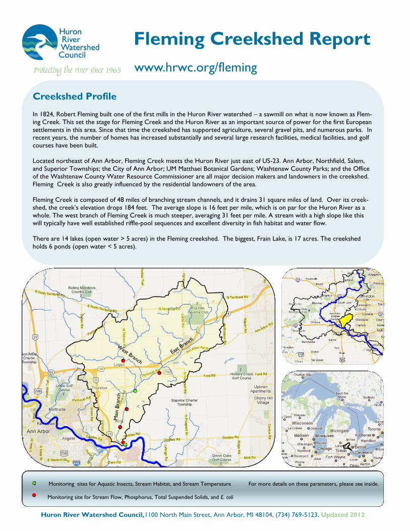
Monitoring sites for Aquatic Insects, Stream Habitat, and Stream Temperature For more details on these parameters, please see inside.
Monitoring site for Stream Flow, Phosphorus, Total Suspended Solids, and E. coli
Fleming Creekshed Report
www.hrwc.org/fleming
Creekshed Profile
In 1824, Robert Fleming built one of the first mills in the Huron River watershed – a sawmill on what is now known as Flem-
ing Creek. This set the stage for Fleming Creek and the Huron River as an important source of power for the first European
settlements in this area. Since that time the creekshed has supported agriculture, several gravel pits, and numerous parks. In
recent years, the number of homes has increased substantially and several large research facilities, medical facilities, and golf
courses have been built.
Located northeast of Ann Arbor, Fleming Creek meets the Huron River just east of US-23. Ann Arbor, Northfield, Salem,
and Superior Townships; the City of Ann Arbor; UM Matthaei Botanical Gardens; Washtenaw County Parks; and the Office
of the Washtenaw County Water Resource Commissioner are all major decision makers and landowners in the creekshed.
Fleming Creek is also greatly influenced by the residential landowners of the area.
Fleming Creek is composed of 48 miles of branching stream channels, and it drains 31 square miles of land. Over its creek-
shed, the creek’s elevation drops 184 feet. The average slope is 16 feet per mile, which is on par for the Huron River as a
whole. The west branch of Fleming Creek is much steeper, averaging 31 feet per mile. A stream with a high slope like this
will typically have well established riffle-pool sequences and excellent diversity in fish habitat and water flow.
There are 14 lakes (open water > 5 acres) in the Fleming creekshed. The biggest, Frain Lake, is 17 acres. The creekshed
holds 6 ponds (open water < 5 acres).
Google Maps
Huron River Watershed Council,1100 North Main Street, Ann Arbor, MI 48104, (734) 769-5123, Updated 2012
Mai
n B
ranch
East Bran
ch
West Branch
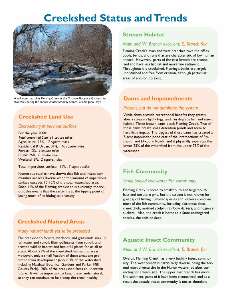
A volunteer searches Fleming Creek at the Matthaei Botanical Gardens for
stoneflies during the annual Winter Stonefly Search. Credit: John Lloyd
Creekshed Land Use
Encroaching impervious surface
For the year 2000:
Total creekshed Size: 31 square miles
Agriculture: 23%, 7 square miles
Residential & Urban: 31%, 10 square miles
Forest: 12%, 4 square miles
Open: 26%, 8 square mile
Wetland: 8%, 2 square miles
Total Impervious surface: 11% , 3 square miles
Numerous studies have shown that fish and insect com-
munities are less diverse when the amount of impervious
surface exceeds 10-12% of the total watershed area.
Since 11% of the Fleming creekshed is currently impervi-
ous, this means that the system is at the tipping point of
losing much of its biological diversity.
Creekshed Status and Trends
Creekshed Natural Areas
Many natural lands yet to be protected
The creekshed’s forests, wetlands, and grasslands soak up
rainwater and runoff, filter pollutants from runoff, and
provide wildlife habitat and beautiful places for us all to
enjoy. About 23% of the creekshed has natural areas.
However, only a small fraction of these areas are pro-
tected from development (about 3% of the watershed,
including Matthaei Botanical Gardens and Parker Mill
County Park). 20% of the creekshed faces an uncertain
future. It will be important to keep these lands natural,
so they can continue to help keep the creek healthy.
Dams and Impoundments
Present, but do not dominate the system
While dams provide recreational benefits they greatly
alter a stream’s hydrology, and can degrade fish and insect
habitat. Three known dams block Fleming Creek. Two of
these dams create small detention ponds and seem to
have little impact. The biggest of these dams has created a
7-acre impounded pond east of the intersections of Ply-
mouth and Dixboro Roads, and it physically separates the
lower 25% of the watershed from the upper 75% of the
watershed.
Stream Habitat
Main and W. Branch excellent; E. Branch fair
Fleming Creek’s main and west branches have the riffles,
pools, bends, and runs that are characteristic of low human
impact. However, parts of the east branch are channel-
ized and have less habitat and more fine sediment.
Throughout the creekshed, Fleming’s banks are largely
undisturbed and free from erosion, although particular
areas of erosion do exist.
Fish Community
Small bodied cool-water fish community
Fleming Creek is home to smallmouth and largemouth
bass and northern pike, but the stream is not known for
great sport fishing. Smaller species and suckers compose
most of the fish community, including blacknose dace,
creek chub, mottled sculpin, rainbow darters, and hognose
suckers. Also, the creek is home to a State endangered
species, the redside dace.
Aquatic Insect Community
Main and W. Branch excellent; E. Branch fair
Overall, Fleming Creek has a very healthy insect commu-
nity. The west branch is particularly diverse, being the sec-
ond most diverse site in the Huron watershed after cor-
recting for stream size. The upper east branch has more
fine sediment, parts of it have been channelized, and as a
result the aquatic insect community is not as abundant.
Stream Water Temperature
Cool water
Fleming Creek receives a mix of cold ground water and
warmer surface runoff. Much of the stream is shaded by
natural riparian areas. Temperature measurements show
that the water temperature of Fleming Creek rarely gets
above 71°F and rarely drops below 60 °F during July and
August. This is a normal water temperature for a creek
with these properties and in this area of Michigan.
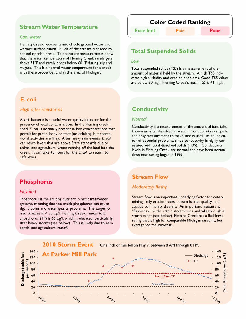
Phosphorus
Elevated
Phosphorus is the limiting nutrient in most freshwater
systems, meaning that too much phosphorus can cause
algal blooms and water quality problems. The target for
area streams is < 50 g/l. Fleming Creek’s mean total
phosphorus (TP) is 66 g/l, which is elevated, particularly
after heavy storms (see below). This is likely due to resi-
dential and agricultural runoff.
E. coli
High after rainstorms
E. coli bacteria is a useful water quality indicator for the
presence of fecal contamination. In the Fleming creek-
shed, E. coli is normally present in low concentrations that
permit for partial body contact (no drinking, but recrea-
tional activities are fine). After heavy rain events, E. coli
can reach levels that are above State standards due to
animal and agricultural waste running off the land into the
creek. It can take 48 hours for the E. coli to return to
safe levels.
Stream Flow
Moderately flashy
Stream flow is an important underlying factor for deter-
mining likely erosion rates, stream habitat quality, and
aquatic community diversity. An important measure is
“flashiness” or the rate a stream rises and falls through a
storm event (see below). Fleming Creek has a flashiness
rating that is high for comparable Michigan streams, but
average for the Midwest.
Conductivity
Normal
Conductivity is a measurement of the amount of ions (also
known as salts) dissolved in water. Conductivity is a quick
and easy measurement to make, and is useful as an indica-
tor of potential problems, since conductivity is highly cor-
related with total dissolved solids (TDS). Conductivity
levels in Fleming Creek are normal and have been normal
since monitoring began in 1993.
Total Suspended Solids
Low
Total suspended solids (TSS) is a measurement of the
amount of material held by the stream. A high TSS indi-
cates high turbidity and erosion problems. Good TSS values
are below 80 mg/l. Fleming Creek’s mean TSS is 41 mg/l.
Color Coded Ranking
Poor Fair Excellent
0
20
40
60
80
100
120
140
0
20
40
60
80
100
120
140
To
tal P
ho
sph
oru
s (
g/L
)
Dis
ch
arg
e (
cu
bic
feet
per
seco
nd
)
Discharge
TP
Annual Mean Flow
Annual Mean TP
2010 Storm Event One inch of rain fell on May 7, between 8 AM through 8 PM.
At Parker Mill Park
Successes & Challenges
Successes
The Fleming Creek Advisory Council (FCAC) advises
Superior and Ann Arbor townships’ Planning Commis-
sions. These townships require FCAC review all pro-
posed developments on their impact on the Creek.
Superior and Ann Arbor townships have wetlands
ordinances (for wetlands of ALL sizes) that provide a
variety of protections to wetlands including develop-
ment setbacks.
At Parker Mill County Park, students and local busi-
nesses have participated in native riparian vegetation
improvement projects and learned about the relation-
ship between invasive species and water quality.
UM Matthaei Botanical Gardens has installed “rock
vanes” in a small section of the stream to stabilize the
streambank and is working to restore American elms
within the floodplain.
UM has also worked to protect and restore critical
habitat for the endangered Eastern Massasauga Rattle-
snake within the Botanical Gardens.
Challenges
Fleming creekshed’s communities and residents must
promote compact development and preserve natural
areas and open spaces. It is extremely important to
prevent the creation of more impervious surface in or-
der to maintain the creek’s integrity.
Residential development, agriculture, and historical
channelization of many stretches on the East Branch of
Fleming Creek have taken their toll on the creek. Re-
storing natural streambanks and returning the creek to
more natural flows will increase habitat diversity and
make the creek more inviting to a wider variety of
aquatic wildlife.
We need to reduce phosphorus runoff to Fleming
Creek. Likely sources of phosphorus are excessive fer-
tilizers in residential areas and agricultural application.
While erosion is not a major systematic problem
throughout the creekshed, after storms we have ob-
served erosion of streambanks and channel beds in
some areas. These areas need to be stabilized.
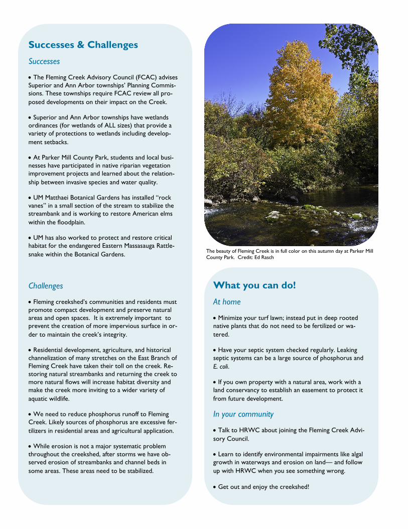
The beauty of Fleming Creek is in full color on this autumn day at Parker Mill
County Park. Credit: Ed Rasch
What you can do!
At home
Minimize your turf lawn; instead put in deep rooted
native plants that do not need to be fertilized or wa-
tered.
Have your septic system checked regularly. Leaking
septic systems can be a large source of phosphorus and
E. coli.
If you own property with a natural area, work with a
land conservancy to establish an easement to protect it
from future development.
In your community
Talk to HRWC about joining the Fleming Creek Advi-
sory Council.
Learn to identify environmental impairments like algal
growth in waterways and erosion on land— and follow
up with HRWC when you see something wrong.
Get out and enjoy the creekshed!