Embed Size (px)
Citation preview
1
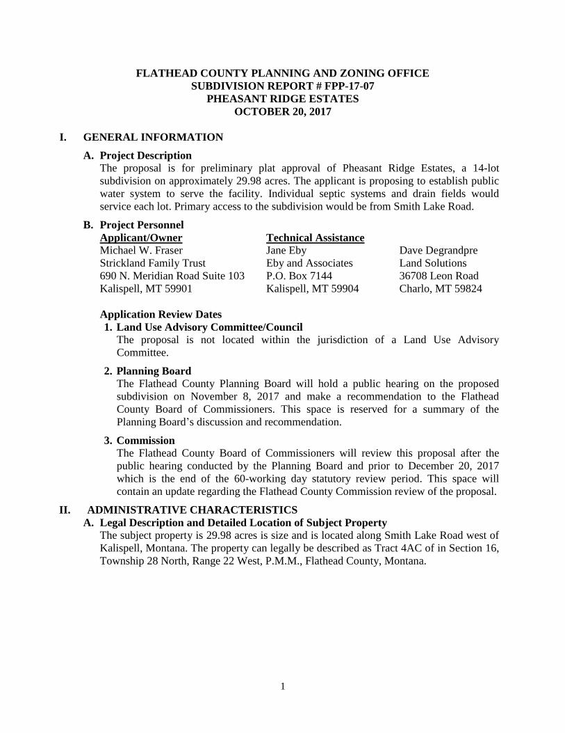
FLATHEAD COUNTY PLANNING AND ZONING OFFICE
SUBDIVISION REPORT # FPP-17-07
PHEASANT RIDGE ESTATES
OCTOBER 20, 2017
I. GENERAL INFORMATION
A. Project Description The proposal is for preliminary plat approval of Pheasant Ridge Estates, a 14-lot
subdivision on approximately 29.98 acres. The applicant is proposing to establish public
water system to serve the facility. Individual septic systems and drain fields would
service each lot. Primary access to the subdivision would be from Smith Lake Road.
B. Project Personnel
Applicant/Owner Technical Assistance
Michael W. Fraser Jane Eby Dave Degrandpre
Strickland Family Trust Eby and Associates Land Solutions
690 N. Meridian Road Suite 103 P.O. Box 7144 36708 Leon Road
Kalispell, MT 59901 Kalispell, MT 59904 Charlo, MT 59824
Application Review Dates
1. Land Use Advisory Committee/Council
The proposal is not located within the jurisdiction of a Land Use Advisory
Committee.
2. Planning Board
The Flathead County Planning Board will hold a public hearing on the proposed
subdivision on November 8, 2017 and make a recommendation to the Flathead
County Board of Commissioners. This space is reserved for a summary of the
Planning Board’s discussion and recommendation.
3. Commission
The Flathead County Board of Commissioners will review this proposal after the
public hearing conducted by the Planning Board and prior to December 20, 2017
which is the end of the 60-working day statutory review period. This space will
contain an update regarding the Flathead County Commission review of the proposal.
II. ADMINISTRATIVE CHARACTERISTICS
A. Legal Description and Detailed Location of Subject Property
The subject property is 29.98 acres is size and is located along Smith Lake Road west of
Kalispell, Montana. The property can legally be described as Tract 4AC of in Section 16,
Township 28 North, Range 22 West, P.M.M., Flathead County, Montana.
2
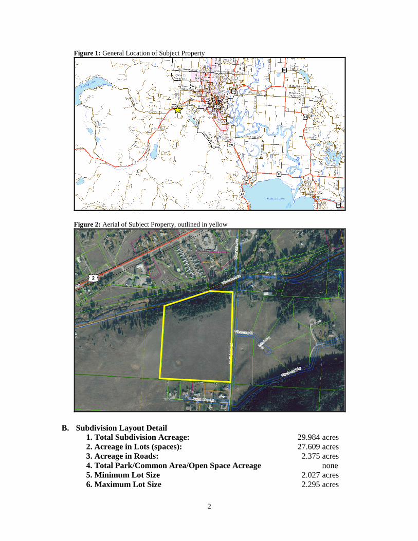
Figure 1: General Location of Subject Property
Figure 2: Aerial of Subject Property, outlined in yellow
B. Subdivision Layout Detail
1. Total Subdivision Acreage: 29.984 acres
2. Acreage in Lots (spaces): 27.609 acres
3. Acreage in Roads: 2.375 acres
4. Total Park/Common Area/Open Space Acreage none
5. Minimum Lot Size 2.027 acres
6. Maximum Lot Size 2.295 acres

3
7. Density: 0.46 DU per acre
8. Easements none
C. Current Land Use and Zoning
Located approximately three miles west of the City of Kalispell, the subject property is
currently undeveloped. The property is open with a strip of forest along the northern
edge. The northern portion of the subject property is zoned Scenic Corridor. Scenic
Corridor is a zoning ‘overlay’ and only regulates off premise signs and cellular
communication towers.
Figure 3 - Existing Zoning around Subject Property, outlined in red
D. Previously Considered Subdivisions in Area
Figure 4 - Area Subdivisions, subject property shown in red
4
As shown in Figure 4 above, multiple subdivisions are located within the vicinity of the
proposal including a number of the smaller lots in the area that were created by deed or
exemptions by certificate of survey (COS).
E. Utilities and Services
1. Water - New onsite public water system proposed
2. Wastewater – Individual septic systems proposed
3. Electricity - Flathead Electric Cooperative
4. Natural Gas - Northwestern Energy
5. Solid Waste - Contract Haul- Evergreen Disposal
6. Telephone Service - CenturyLink
7. School District(s) – Smith Valley School District, Flathead High School
8. Fire District(s) – Smith Valley Fire District
9. Police - Flathead County Sheriff’s Department
III. COMMENTS RECEIVED
A. Agency Comments
Referrals were sent to the following agencies on September 22, 2017:
Flathead County Sheriff
Flathead County Road and Bridge Department
Flathead County Solid Waste
Flathead City-County Environmental Health Department
Flathead County Weeds and Parks Department
Bonneville Power Administration
Flathead County Address Coordinator/GIS Department
Montana Department of Fish, Wildlife and Parks
US Forest Service
US Fish and Wildlife Service
Montana Department of Natural Resources and Conservation
Montana Department of Environmental Quality
Smith Valley Fire District
Smith Valley School District
Flathead High School District
The following is a summarized list of agency comment received as of the date of the
completion of this staff report:
Dave Prunty, Flathead County Road and Bridge Department
o “After completing the review, we are acceptable to the applicant’s
proposal. However, we would like to bring one issue to your attention
regarding the intersection of Smith Lake Road and Whalebone Drive.
This intersection to the northeast of the proposed subdivision does
pose safety concerns to our Department. It is highly likely that
residents in the subdivision would use this intersection in their travels
to Kalispell. The roads intersect at a skewed angle (less than the 75
required for new subdivision roads), have poor sight distance due to

5
the horizontal and vertical curves present and has a steep slope on
Smith Lake Road coming into the intersection that during winter poses
potential traction issues. Topography at this location makes it very
difficult for improvements and is likely why the road was built this
way in the first place back in the late 1800’s to early 1900’s.” Letter
received October 5, 2017
Amy Beick, Smith Valley Fire Chief
o “Smith Valley Fire District is a combination fire department. We are
currently staffed at an Advanced Life Support level 24/7 with a
minimum of a Firefighter/EMT and a Firefighter/Paramedic. We also
have 12 active volunteer firefighters and EMS providers to support the
on duty crews with both fire and EMS emergencies.
We currently have two Type II fire engines, one Type IV fire
engine, two Type VI engines, two Type II water tenders, one
Rescue unit (with extrication, low angle, ice rescue, and
medical equipment), one command unit, as well as two ALS
transport ambulances.
Our response time from our main fire station at 3496 Highway 2 W is
approximately 7-10 minutes depending on road conditions. Response
time from our substation will vary depending on volunteer availability.
Currently there is no water supply available for this area. The proposal
for each lot to have an individual well does not meet fire suppression
requirements. The following is what will be required to meet adequate
water supply for fire suppression efforts as well as meet ISO fire flow
requirements:
The water system will be located within the subdivision.
The water system shall consist of a minimum holding tank of
30,000 gallons that refills with an electric pump at a standard
rate of 8-10 gpm.
The fill connection may be a standard hydrant or a stand pipe
with a 2.5 inch fire connection a minimum of a 500 GPM
pump.
o The stand pipe must be no less than 36 inches and no
more than 48 inches off of the ground.
o The stand pipe must be a 3 inch pipe with a 2.5 inch
fire thread coupler with a cap.
o All fire apparatus must be able to get within 10 feet of
the hydrant or stand pipe.
o A dry hydrant draft stand pipe, with a 5 inch piep and a
5 inch female fire thread coupler with a cap is also
required in the case of power or pump failure.
The water system should be placed in a centrally locate area,
preferably between lots 13 and 14.
Additional comments:
All subdivisions within the Wildland Urban Interface (WUI)
need to follow the Flathead County Development Code
6
4.7.27.
All residential structures should be clearly identified prior to
occupancy with address numbers that are plainly visible and
legible from the street. Numbers should be a minimum of
four inches in height and reflective.”
Neda Nelson, Bonneville Power Administration
o “At this time BPA does not object to this request as it does not
interfere with any BPA transmission lines or structures.” Email
received September 25, 2017
Marc Pitman, Montana Department of Natural Resources and Conservation,
Water Resources Division (MT DNRC)
o “Water rights: There are no existing water rights appurtenant to the
property being subdivided.
10 acre feet/year is available for filings under the water right permit
exceptions under MCA 85-2-306 3(iii) on this property. The applicant
proposes 2.5 people per lot with a daily use of 100 GPD per person on
14 lots or 3.92 AF/year for domestic household use. This leaves 6.08
AF/year available for lawn and garden uses or about 0.43 AF/year per
lot. About 0.17 acres or 7,566 square feet of lawn and garden per lot
could be irrigated at the DNRS standard annual application rate of 2.5
AF/year for the period running from April 1 to October 31.
The Applicant plans of 17,500 square feet per lot with an application
rate of 1” per week. To stay within the 6.08 AF/year limit for lawn and
garden irrigation, each lot can be irrigated no more than 1” per week
for 13 weeks a season. The Applicant needs to specify this restriction
and have it included in the COSA. This is a considerable restriction,
which will be difficult to enforce without having each lot individually
metered. The Department recommends that each lot be metered and
water use recorded in order to enforce this restriction. A supervisory
control and data acquisition (SCADA) system, typically used on much
larger PWSs, may be a way to accurately monitor water use and warn
users when the 10 AF/year limit is being reached.
As homes are constructed, the owner of the PWS, HOA, WUA, or
CWSD is required to file a DNRC Form 602 within 60 days of a home
being connected to the PWS. This could mean that as many as 14
individual DNRC Form 602s will be filed as homes are being
constructed and connected to the PWS.
Prior to DEQ approval of this project, the Applicant will be required to
request a DNRC review of water rights for the proposed PWS.
Floodplain: The Approximate Zone A floodplain boundary of Ashley
Creek is adjacent to the subject property. No issue.”
Ben Conard, US Fish and Wildlife Service
7
o “The U.S. Fish and Wildlife Service has no substantive comments at
this time. If the project requires another federal agency to authorize,
fund, or carry out any aspect of the project, we will engage that agency
in Section 7 Endangered Species Act consultation, if appropriate. But,
we have no concerns at this time.”
Jessy Coltrane, Montana Fish Wildlife and Parks
o “We appreciate the opportunity to comment on the proposed
subdivision Pheasant Ridge Estates. The proposed subdivision
includes a riparian zone associated with Ashley Creek, as well as an
ephemeral wetland surrounded by historical agricultural fields,
primarily used for hay production. These areas provide importanat
habitat for local wildlife and migratory birds. The proximity to the
Batavia Waterfowl Production Area further enhances the wildlife
value of this property. Development of 14 residential lots on this
parcel will result in cumulative impacts to wildlife, as well as
increased human-wildlife conflicts associated with resulting
residences.
The forested area at the northern end of the parcel provides habitat for
white-tailed deer, black bear, and numerous small to mid-sized
mammals. While the northern portion of the ;property is proposed as a
‘no build zone, ‘ it is encamped in parcels that will be sold as single
family residential parcels. If the ‘no build zone’ is adopted, no
structures would be built on this steep, sloped, forested area, but there
is assurance that these areas will remain in a natural states. We
recommend that the developers set this area aside as open space, to
ensure the persistence of this habitat.
The National Wetlands Inventory identified a freshwater emergent
wetland on the southern end of the property. While the contractor
found the area to be mostly dry, the site visit was conducted in late
July of 2017 during a drought. Regardless, in spring this freshwater
emergent wetland on the property provides habitat for migratory birds,
which most likely nest in the adjacent hay fields. The destruction of
this wetland will result in the loss of such habitat for migratory birds,
which utilize the larger surrounding area, as well. The continued
development of the area and subsequent degradation of habitat will
have cumulative negative impacts on migratory birds and other
wildlife. We recommend that the developer consult with the Army
Corp of Engineers concerning this wetland and its value to the
surrounding area. At a minimum, we recommend that the developer
maintain Lots 7 and 8 as habitat for migratory birds, free of
development.
In addition, the development of a subdivision in this area will result in
increased conflicts with black bears and white-tailed deer. Future
residents need to be aware that FWP cannot respond to all wildlife
8
problems, and it is the landowner’s responsibility to avoid such
problems.
We recommend that the owners adhere to the following
recommendations to mitigate conflicts with wildlife:
Fruit-producing trees and shrubs should not be allowed because
they attract bears. If present, they must be fenced with electric
fencing to deter bears. Keep produce and any fruit picked off
the ground. Ripe or rotting fruit or vegetable material attracts
bears, deer, skunks, and other wildlife, To help keep wildlife
such as deer out of gardens, fences should be 8 feet or taller.
Electric fencing for deer should be at a minimum of 8 feet as
well.
Garbage and food must be stored either in secure, bear-resistant
containers or indoors, preferably bothe, to avoid attracting
wildlife such as bears and raccoons.
Do not feed wildlife or offer supplements such as salt or
mineral blocks, attractants, or bait for deer or other wildlife.
Feeding wildlife results in unnatural concentrations of animals
that can lead to overuse of vegetation, disease transmission,
and other adverse effects to wildlife (such as foundering of
deer). Such actions unnecessarily accustom wild animals to
humans, which can be dangerous for both. It is against state
law (MCA 87-3-130) to purposely or knowingly attract
ungulates, bears, or mountain lions with supplemental food
attractants (any food, garbage, salt block, hay, grain, or other
attractant for game animals) or to provide supplemental feed
attractants in a manner that results in ‘an artificial
concentration of game animalsthat may potentially contribute
to the transmission of disease or that constitutes a threat to
public safety.’
Birdseed is an attractant to bears, deer, and turkeys. Use of bird
feeders is not recommended from April 1 through November
30.
Pets at large, particularly dogs and cats, are a real threat to
wildlife. Pets must be confined to the house, a fenced yard, or
an outdoor kennel, when not under the immediate control of
the owner, and not allowed to roam. Under state law, it is
illegal for dogs to chase hoofed game animals (MCA 87-3-
124). Keeping pets confined also helps protect them from
predatory wildlife. We recommend the FWP brochure Living
with Dogs and Cats.
Fencing of lot boundaries is discouraged. If used, rail or
smooth wire fences will be erected that are no higher than 40”
at the top rail/wire and no lower than 18” at the bottom
rail/wire in order to facilitate wildlife movement and help
avoid animmals becoming ensnared and killed by the fence or
9
injuring themselves when trying to jump the fence. Please reger
to the helpful booklet on wildlife –friendly fences available
from FWP and online at
http://fwp.mt.gov/fishAndWildlife/landowners/.
Compost piles and beehives can attract bears and must be
fenced with electric fencing to prevent access to them or not
allowed in the subdivision.
Wendee Jacobs, Flathead City-County Environmental Health Department
o “The proposed subdivision is subject to review under the Sanitation in
Subdivisions Act (MCA Title 76-4-1). The review will address potable
water supply, wastewater treatment, stormwater drainage, and solid
waste disposal.”
B. Public Comments
In accordance with Section 4.0.14, adjacent property notification was mailed to
neighboring property owners within 150 feet of the proposed subdivision on October
18, 2017. Legal notice of the public hearing on this application was published in the
October 22, 2017 edition of the Daily Inter Lake. Additional written public comment
will be received until 5:00 PM on November 8, 2017 and will be summarized
verbally and entered into the public record during the Planning Board hearing.
Anyone wishing to provide public comment may do so in person at the Planning
Board hearing on November 8, 2017 and the Board of Commissioners public hearing
on a date not yet determined.
IV. LOCAL GOVERNMENT REVIEW
A. Review Criteria and Staff Findings
Findings in this portion of the report are applicable to the impacts of the proposed
subdivision on the review criteria listed in Section 76-3-608(3) MCA and the review
procedure outlined in Section 4.1 of the Flathead County Subdivision Regulations (FCSR),
effective December 1, 2014.
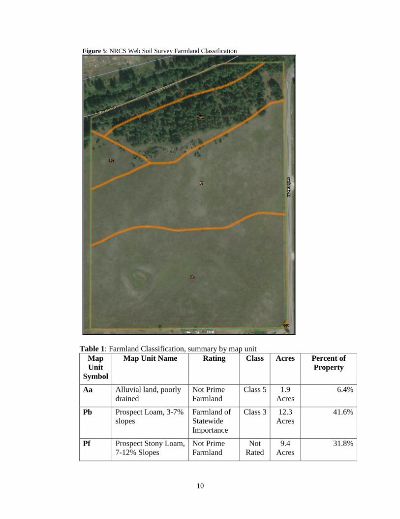
1. Agriculture and Agricultural Water User Facilities
The subject property is currently used for hay production. The applicant has indicated
six to eight tons of hay are produced, annually. The property immediately to the west
of the subject property is also used for hay production. The NRCS Web Soil Survey
indicates 12.3 acres of the subject property is identified as Prospect Loam and
‘farmland of statewide importance.’ The remaining acreage is identified on the survey
as ‘not prime farmland.’ Because of the soil classification on the subject property, it is
reasonable to assume approximately 12 acres of farmland will be taken out of
production because the small, two-acre lots will not have sufficient room or water
availability for continued agricultural use. There are no agricultural water user
facilities on the subject property. The division of the subject property and removal of
land from agricultural production will not likely affect the surrounding properties
from being used for agricultural purposes.
10
Figure 5: NRCS Web Soil Survey Farmland Classification
Table 1: Farmland Classification, summary by map unit
Map
Unit
Symbol
Map Unit Name Rating Class Acres Percent of
Property
Aa Alluvial land, poorly
drained
Not Prime
Farmland
Class 5 1.9
Acres
6.4%
Pb Prospect Loam, 3-7%
slopes
Farmland of
Statewide
Importance
Class 3 12.3
Acres
41.6%
Pf Prospect Stony Loam,
7-12% Slopes
Not Prime
Farmland
Not
Rated
9.4
Acres
31.8%
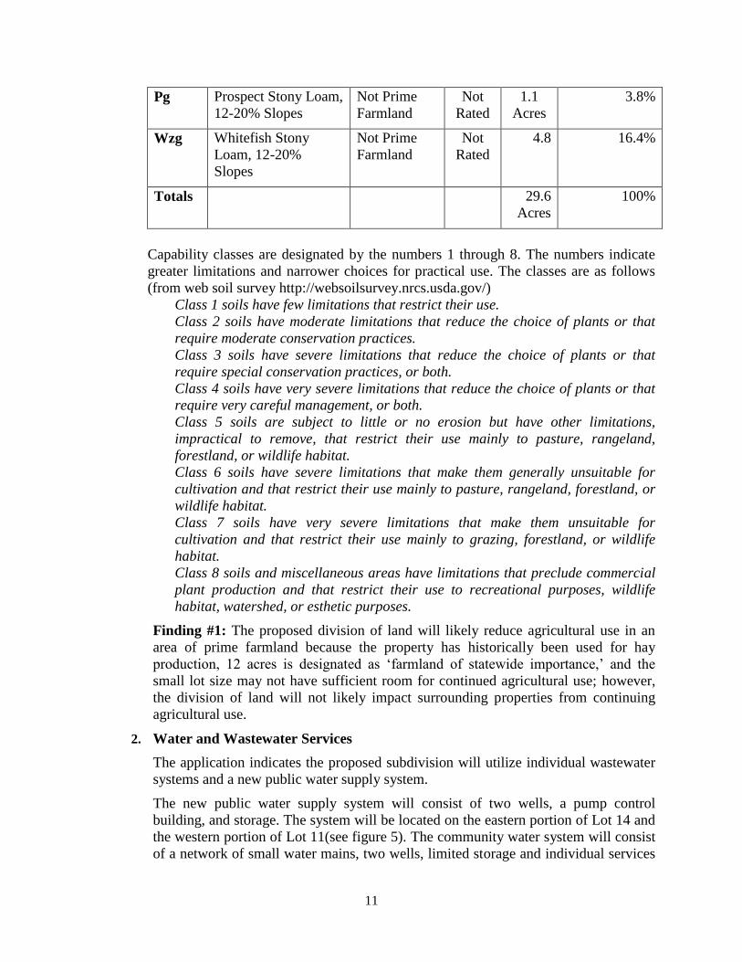
11
Pg Prospect Stony Loam,
12-20% Slopes
Not Prime
Farmland
Not
Rated
1.1
Acres
3.8%
Wzg Whitefish Stony
Loam, 12-20%
Slopes
Not Prime
Farmland
Not
Rated
4.8 16.4%
Totals 29.6
Acres
100%
Capability classes are designated by the numbers 1 through 8. The numbers indicate
greater limitations and narrower choices for practical use. The classes are as follows
(from web soil survey http://websoilsurvey.nrcs.usda.gov/)
Class 1 soils have few limitations that restrict their use.
Class 2 soils have moderate limitations that reduce the choice of plants or that
require moderate conservation practices.
Class 3 soils have severe limitations that reduce the choice of plants or that
require special conservation practices, or both.
Class 4 soils have very severe limitations that reduce the choice of plants or that
require very careful management, or both.
Class 5 soils are subject to little or no erosion but have other limitations,
impractical to remove, that restrict their use mainly to pasture, rangeland,
forestland, or wildlife habitat.
Class 6 soils have severe limitations that make them generally unsuitable for
cultivation and that restrict their use mainly to pasture, rangeland, forestland, or
wildlife habitat.
Class 7 soils have very severe limitations that make them unsuitable for
cultivation and that restrict their use mainly to grazing, forestland, or wildlife
habitat.
Class 8 soils and miscellaneous areas have limitations that preclude commercial
plant production and that restrict their use to recreational purposes, wildlife
habitat, watershed, or esthetic purposes.
Finding #1: The proposed division of land will likely reduce agricultural use in an
area of prime farmland because the property has historically been used for hay
production, 12 acres is designated as ‘farmland of statewide importance,’ and the
small lot size may not have sufficient room for continued agricultural use; however,
the division of land will not likely impact surrounding properties from continuing
agricultural use.
2. Water and Wastewater Services
The application indicates the proposed subdivision will utilize individual wastewater
systems and a new public water supply system.
The new public water supply system will consist of two wells, a pump control
building, and storage. The system will be located on the eastern portion of Lot 14 and
the western portion of Lot 11(see figure 5). The community water system will consist
of a network of small water mains, two wells, limited storage and individual services
12
with meters. The Environmental Assessment indicates the community water system is
expected to serve approximately 35 people or 2.5 people per residence. Montana
Department of Environmental Quality (MT DEQ) suggests a water use of 100 gallons
per person per day as an average day use. This is equivalent to 3.92-acre feet per year.
Marc Pitman of MT DNRC indicated lawn and garden use will be considerably
restricted and suggests metering each lot to ensure compliance and enforce the
restricted water usage. The application indicates each lot will be monitored and the
developer will operate the system until over 50% of the lots are developed with
residences constructed at which time the community water system will be delegated
to the homeowners association. The Smith Valley Fire Department has requested a
minimum holding tank of 30,000 gallons be located within the subdivision. A letter
from the Smith Valley Fire Department indicating the reasonable requests have been
met will be required at the time of final plat.
Each lot will be served by individual septic systems and drain fields. The application
indicates six test holes were dug on the subject property in 2008 and indicated all test
holes were dry through the monitoring period. The groundwater monitoring done on
the site indicates the site is suitable for sewage treatment systems.
The new public water supply system will be required to obtain the appropriate
permits from the Environmental Health Services Division of the Flathead City-
County Health Department, the Montana Department of Environmental Quality
(DEQ), and Montana Department of Natural Resources and Conservation (MT
DNRC).
Wendee Jacobs of the Flathead City-County Environmental Health Department
commented on the proposal and indicated wastewater treatment; potable water
supply, solid waste and storm water drainage must be addressed through subdivision
review. This is a separate subdivision review process through the Flathead City-
County Environmental Health Department.
Comment provided by Marc Pitman of the MT DNRC indicates the developer would
need to request a DNRC review of water rights for the proposed Public Water
System. The comment also indicates 10 acre feet/year is available for filings under
the water right permit exceptions under MCA 85-2-306 3(iii) on this property. About
0.17 acres or 7,566 square feet of lawn and garden per lot could be irrigated at the
DNRS standard annual application rate of 2.5 AF/year for the period running from
April 1 to October 31. The Applicant needs to specify this restriction and have it
included in the COSA. This is a considerable restriction, which will be difficult to
enforce without having each lot individually metered. The Department recommends
that each lot be metered and water use recorded in order to enforce this restriction. As
homes are constructed, the owner of the PWS, HOA, WUA, or CWSD is required to
file a DNRC Form 602 within 60 days of a home being connected to the PWS. This
could mean that as many as 14 individual DNRC Form 602s will be filed as homes
are being constructed and connected to the PWS. The applicant will be required to
meet the requirements of MT DNRC. The draft CC&Rs addresses the public water
system
13
The proposed subdivision will be conditioned to go through subdivision review, a
separate process, through the Flathead City-County Environmental Health
Department and Montana Department of Environmental Quality. The Montana
Department of Resources and Conservation will review the project in terms of water
availability.
Finding #2: Water availability appears to be adequate because the developer
proposes to install two wells, the lots will be metered, and the public water system
will be required to be reviewed by Montana Department of Natural Resources and
Conservation for water rights.
Finding #3: The proposal for public water and individual wastewater treatment
systems for the proposed subdivision appear to be reasonable because they are subject
to permitting and monitoring approval by the Flathead County Environmental Health
Department and the Montana Department of Environmental Quality.
3. Solid Waste Disposal
The developer is proposing contract haul as a mechanism for solid waste disposal as
requested of all subdivisions by the Flathead County Solid Waste Department. The
applicants have indicated that the contract hauler for the area is Evergreen Disposal.
A letter from Evergreen Disposal will be required at the time of final plat.
4. Roads
As shown on the preliminary plat, primary access to the subdivision would be from
Smith Lake Road. Smith Lake Road is a paved county-maintained road.
Dave Prunty, of the Flathead County Road and Bridge Department noted a concern
regarding the intersection of Whalebone Drive and Smith Lake Road and the potential
hazard during winter months because of the lack of visibility and steep slope. The
applicant will be required to obtain two approach permits from the Flathead County
Road and Bridge Department.
Finding #4: Impacts to the existing transportation network are anticipated but appear
to be acceptable because the proposed subdivision will be accessed by a paved public
road, approach permits access will be required from Flathead County Road and
Bridge, and the internal road network will be constructed to applicable standards
outlined in 4.5.7 of FCSR.
5. Schools
The proposal is located in the Smith Valley School District and Kalispell High School
District. Based on an average of .31 school age children per dwelling, the
development would add an additional 4 school-aged children once the 14 lot
residential subdivision is fully developed.
6. Mail Delivery
The application indicates mail service is proposed. Written approval from the local
postmaster will be required as a condition of preliminary plat approval.
7. Recreation
The subdivision offers many recreation opportunities given its proximity to public
lands for hiking, camping, and hunting, and area lakes and rivers for swimming,
14
fishing, and boating. The applicants have indicated they will utilize the cash-in-lieu
option for parkland. A parkland cash donation to the equivalent of 1.499 acres of the
fair market value will be required at final plat. The subdivider shall provide a current
appraisal from a Certified General Appraiser (CGA), dated no more than six months
prior to final plat application to set the baseline value of the parkland cash donation.
Finding #5: Adverse impacts related to recreation are not anticipated as a result of
the proposed subdivision as the subdivider will be required to make a parkland cash-
in-lieu donation and the site is located in close proximity to public lands, and area
lakes and rivers offering a wide array of recreational opportunities to residents.
8. Fire/Emergency Medical Services The site is located within the Smith Valley Fire District and a fire station is located
approximately 3 driving miles from the proposed subdivision. The Smith Valley Fire
Station is currently staffed at an Advanced Life Support level 24/7 with a minimum
of a Firefighter/EMT and a Firefighter/Paramedic. They have 12 active volunteer
firefighters and EMS providers to support the on duty crews with both fire and EMS
emergencies. The department has two Type II fire engines, one Type IV fire engine,
two Type VI engines, two Type II water tenders, one Rescue unit (with extrication,
low angle, ice rescue, and medical equipment), one command unit, as well as two
ALS transport ambulances.
The fire chief estimates response time from the main fire station at 3496 Highway 2
W is approximately 7-10 minutes depending on road conditions. Response time from
our substation will vary depending on volunteer availability.
Amy Beick, Fire Chief of the Smith Valley Fire Department requested a 30,000-
gallon holding tank with an electric pump. The developer will be required to meet
reasonable requests made by the Smith Valley Fire Department.
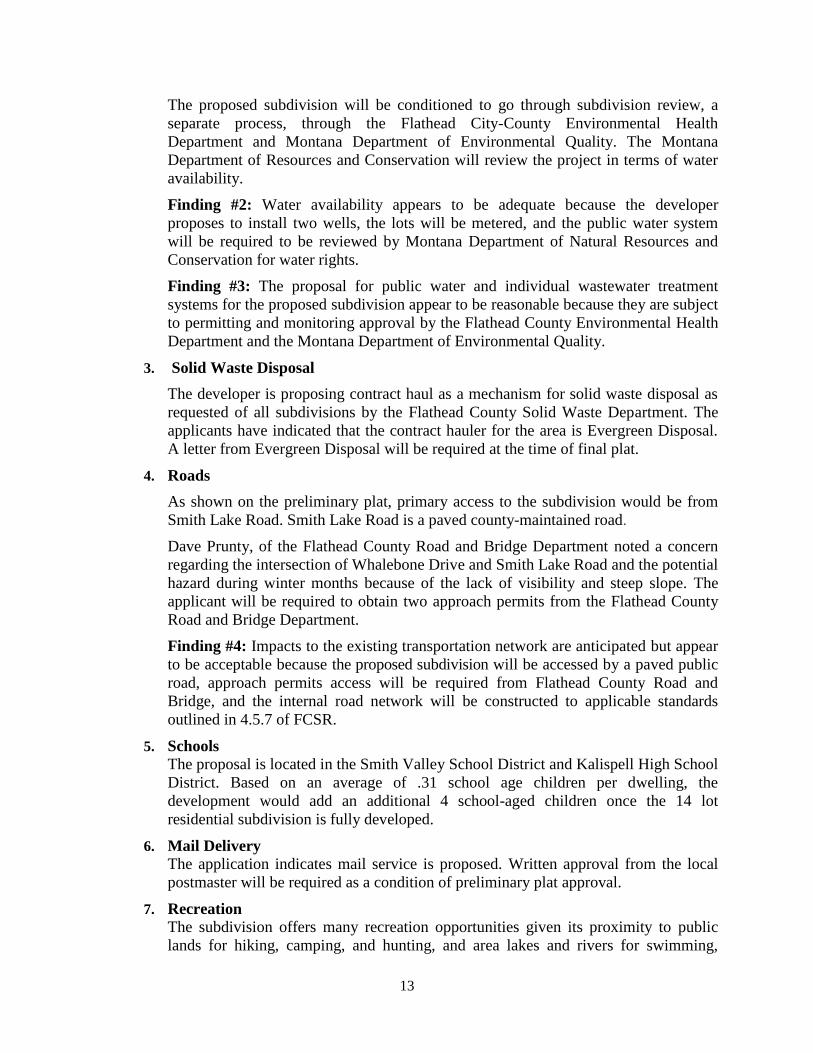
There is a small corner off the subject property located within the Wildland Urban
Interface (WUI) it appears it is more of an arbitrary line rather than a true WUI line
based on the presence of a field on the portion of the property that is designated WUI.
Figure 6: Subject property outlined in yellow, WUI shaded green
15
Finding #6: The fire and emergency medical services appear to be adequate because
the proposed subdivision will be served by Smith Valley Fire Department and the
subdivider will be required to meet reasonable requests by the fire department.
9. Police Services
The proposed subdivision is located in a rural area of Flathead County and will be
served by the Flathead County Sheriff’s Department. The combination of existing
staff levels, shift rotations, size of the county, the dispersed nature of the population,
and the property’s relative distance from the Flathead County Sheriff’s Office in
Kalispell may lead to delayed response times in the event of an emergency.
10. Impact of Noise
Development of residences on the subdivision lots would likely generate minimal
noise during construction, and it is not likely they all would be built simultaneously.
The proposed residential use is not anticipated to generate continuous noise that
would affect residents or wildlife.
11. Air Quality Impacts to air quality are expected to be minimal and are also mitigated because the
subdivision is accessed by a paved local road and the internal subdivision road
network will be paved. Because all lots will be accessed by a paved roadway and
activities on site will be limited to single family residential use, it is not anticipated
that air quality will be negatively impacted by the development. The applicant has
submitted a Dust Control Plan compliant with Section 4.7.14 FCSR. In order to
ensure all lot owners follow the plan, a note to be placed on the face of the final plat
requiring the owners of all lots to abide by the guidelines in the plan during and after
site construction and development activities will be required.
Finding #7: Adverse impacts to air quality and of noise are anticipated to be minimal
and acceptable with the imposition of conditions as all roads accessing the
subdivision will be paved and short-term construction related noise is the only
anticipated noise to be generated by the subdivision development.
12. Soils
As indicated above, the soils on the property are well-drained loams of gentle slopes.
It is anticipated soils onsite would not pose a risk to public health and safety. Six test
pits were observed on the subject property indicating no significant constraints of the
proposed wastewater treatment system in regards to soils.
Finding #8: The soils on the subject property appear to be acceptable because the
soils are generally classified as well drained and the proposal for water, sanitation,
and stormwater will be required to be reviewed and approved prior to installation of
the proposed new facilities.
13. Geologic/Avalanche Hazards
As shown on the preliminary plat, the proposed subdivision is located on gentle
terrain. There is a slope on the northern portion of the property but is a designated ‘no
build zone’ and is not expected to cause or result in rock falls, landslides, or
avalanches. The subject property is not located on any mapped fault lines according
16
to geologic fault data prepared and maintained by the Flathead County GIS
Department.
14. Flora
The subject property is primarily in hay production with mature coniferous trees
along the northern property line. Pursuant to Section 4.7.25 FCSR the applicant is
required to establish and follow an approved Soil Disturbance and Weed
Management Plan. The applicants have submitted a weed control plan to eliminate
noxious weeds from proposed lots. The noxious weeds present on the subject
property include Canadian Thistle and Spotted Knapweed, which were identified
onsite by Land Solutions. The potential noxious weeds on the property include but are
not limited to Spotted Knapweed, Diffuse Knapweed, Russian Knapweed, Canada
Thistle, Field Bindweed, Whitetip, Leafy Spurge, Dalmatian Toadflax, Yellow or
Common Toadflax, St. Johnswort, Sulfur Cinquefoil, Common Tansy, Ox-Eye Daisy,
Houndstongue, Dyer Woad, Purple Loosestrife, Tansy Ragwort, Meadow Hawkweed,
Orange Hawkweed, Tall Buttercup, Tamarisk, Perennial Pepperweed, Yellow
Starthistle, Rush Skeltonweed, Eurasian Watermilfoil, Yellow Flag Iris, Hoary
Alyssum, Blueweed, Flowing Rush, Japanese Knotweed, Scotch Broom, Common
Crupina, Baby’s Breath, Tumble Mustard, Russian Thistle, White Campion, Scentless
Chamomile, Absinth Wormwood, Common Yarrow, and Creeping Bellflower. The
weed control plan indicates property owners will inspect their property annually and
effect control measures.
There are some flora ‘species of concern’ included in the Montana Natural Heritage
Program Report for the Township 28N and Range 22W. None of these species have
been observed on the site. The Environmental Assessment indicates the area that will
be disturbed is currently used to grow hay. Any native species that did exist on the
site have already been removed.
Finding #9: The impacts to flora are expected to be minimal as no species of concern
have been observed on the site and the forested area on the northern border of the
property will designated a ‘no build zone’ and will likely remain forested.
15. Riparian/Wetland Areas
There are mapped wetlands on the southwestern portion of the property as indicated
in Figure 7. The applicants have indicated there was no surface water on the site
during July of 2017. This site visit occurred during the driest part of the year, during a
drought in Northwest Montana. The applicants were informed at the Subdivision Pre-
application meeting on June 26, 2017 that documentation showing areas designated
on the Flathead County Interactive Mapping System, are not wetlands was required.
The applicants will be required to either perform a wetland delineation study showing
no wetlands on site or designate the area a ‘no build zone’ per section 4.7.10 of
FCSR. Comment from MT Fish Wildlife and Parks noted the mapped wetland in their
agency comment and the drought that occurred during the summer of 2017.
Ashley Creek is located north of the subject property across Whalebone Drive and
comments from Montana Fish Wildlife and Parks indicate the wooded area on the
northern portion of the property is likely used by wildlife because of the proximity to
17
Ashley Creek. The subdivider has designated this area as a ‘no build zone’ and it is
expected the wildlife will still use the area.
Figure 7: National Wetland Inventory Map, subject property outlined in yellow
Finding #10: The impact to the wetland and riparian areas on the property will be
minimal because the subdivider as indicated the riparian area as a ‘no build zone’ and
the areas designated as wetlands will be required to designated as ‘no build zones’ or
shown to not exist through an acceptable wetland delineation study.
16. Floodplain
The subject property is not located in a special flood hazard area and is outside of the
0.2% annual chance flood area as depicted on FEMA FIRM Panel 1800J.
Finding #11: No impact to floodplain are anticipated as a result of the proposed
subdivision because no floodplain is identified on the subject property.
17. Wildlife and Wildlife Habitat
The subject property is in a rural area and although it does not contain surface waters,
it does contain riparian vegetation associated with Ashley Creek. The submitted
Environmental Assessment indicates Ashley Creek has the following native fish
species: largescale sucker, mountain whitefish, northern pike minnow, peamouth,
redside shiner, sculpin, and slimy sculpin. Introduced fish include brook trout,
northern pike, rainbow trout, westslope-rainbow hybrids, and yellow perch. The
Montana Natural Heritage Program identifies the following animals as frequenting
the area: bobcat, hoary bat, northern river otter, and red squirrel. White tail deer,
18
black bear, a variety of birds, and other small non-game mammals use the property,
especially the forested portion on the northern border. The construction activities and
subsequent residences have the potential to impact wildlife but the ‘no build zone’ on
the northern edge of the subject property will continue to provide wildlife habitat.
The subject property is located approximately 0.75 miles from the Batavia Waterfowl
Production Area (WPA), managed by the U.S. Fish and Wildlife Service. The
applicant contacted Kevin Shinn, Refuge Manager for the U.S. Fish and Wildlife
Service Northwest Montana Wetland Management District to discuss the potential
impact of the subdivision on the waterfowl production area. The potential impacts
indicated by Kevin Shinn were potential surface water runoff to wetlands on Batavia
WPA, water table drawdown from individual wells, increased garbage, increased
domestic animal trespass on nesting areas within Batavia WPA. To mitigate the
negative impacts on Batavia WPA, the subdivider is proposing on-site storm water
retention areas, public metered water system, contract hauled solid waste removal,
and covenants requiring domestic animals to stay on their lot. The planning office
also contacted the U.S. Fish and Wildlife Service and issued no substantive comments
on the proposed subdivision.
Finding #12: Minimal impacts to wildlife and wildlife habitat as a result of the
proposed subdivision are anticipated but can be minimized by the imposition of ‘no
build zones on sensitive habitat such as wetlands and riparian areas.
18. Historical Features
The Environmental Assessment indicates there are no known historic, archeological,
or cultural sites on the subject property. A letter from Damon Murdo of the State
Historic Preservation Office was submitted with the application indicating no
previously recorded sites exist on the property and a low likelihood of impacting
cultural properties.
19. High Voltage Electric Lines/High Pressure Gas Lines
There are no exposed high voltage electric lines or high-pressure gas lines on the
subject property.
20. Airport Influence Areas
The subject property is not within an airport influence area.
B. Compliance with Survey Requirements of 76-3-401 through 76-3-406 M.C.A.
Finding #13: The preliminary plat would conform to all provisions of the Montana
Subdivision and Platting Act if it contains all elements required to meet state survey
requirements, which would be determined when it is reviewed by the Flathead County
Examining Land Surveyor prior to final plat approval.
C. Compliance with the Flathead County Subdivision Regulations and Review
Procedure
1. Requested Variances
No variances have been requested with this application.
2. Flathead County Subdivision Review Procedure
i. Pre-application Conference Date
June 26, 2017

19
ii. Application Deadline Date (6 months from pre-application)
December 26, 2017
iii. Application Submittal Date
September 5, 2017
iv. Completeness Date
September 5, 2017
v. Sufficiency Date
September 22, 2017
vi. Agency Referral Requests Mailing Date
September 22, 2017
vii. Adjacent Property Notification Mailing Date
October 18, 2017
viii. Legal Notice Publication Date
October 22, 2017 Daily Inter Lake
ix. On-site Posting of Public Hearing Date
October 25, 2017
Finding #14: The proposal has been reviewed as a major subdivision in accordance
with statutory criteria and standards outlined in Section 4.4 of the Flathead County
Subdivision Regulations effective December 1, 2014.
D. Provision of Easements for the Location and Installation of Planned Utilities
Finding #15: The preliminary plat identifies adequate easements for utilities to serve
the proposed subdivision. All other easements associated with this subdivision and the
subdivided property shall be clearly located on the Final Plat to satisfy applicable
requirements of the Montana Subdivision and Platting Act and the Flathead County
Subdivision Regulations.
E. Provision of Legal and Physical Access to Each Parcel
Smith Lake Road and the unnamed internal subdivision road would provide the primary
legal and physical access to the proposed subdivision and all lots within it. The
applicants will be required to name the internal subdivision road and obtain appropriate
approach permits from the Flathead County Road and Bridge Department.
Finding #16: The preliminary plat includes adequate provisions for legal and physical
access to the proposed subdivision and all spaces and structures within it because the
ingress approach from Smith Lake Road is able to meet applicable requirements of an
approved Flathead County approach permit.
F. Review of Applicable Plans
76-1-605(2)(b) M.C.A states that A governing body may not withhold, deny, or impose
conditions on any land use approval or other authority to act based solely on
compliance with a growth policy adopted pursuant to this chapter. Furthermore, 76-3-
608(3) M.C.A. does not contain compliance with the growth policy as a primary criteria by
which an individual subdivision proposal must undergo local government review or on
which findings of fact are to be based. Review of general conformance with applicable
plans is provided as an acknowledgement and consideration of the guidance offered by the
information contained in the document(s).
20
i. Neighborhood Plan
The proposed subdivision is not located in a neighborhood plan area.
ii. Flathead County Growth Policy
The Flathead County Growth Policy is a general policy document that meets the
requirements of M.C.A. 76-1-601, and was adopted on October 12, 2012. Regulations
adopted by Flathead County used in the review of subdivisions are an implementation
of the goals and policies established in the Growth Policy (M.C.A.76-1-606). This
proposal conforms to the regulations used in the review of subdivision in Flathead
County and is therefore in general compliance with the Flathead County Growth
Policy.
G. Compliance with Local Zoning
The proposed subdivision is located in an area of Flathead County that is presently
zoned Scenic Corridor. The Scenic Corridor zoning designation regulates cellular
communication towers and off-premise signs.
V. SUMMARY OF FINDINGS
Finding #1: The proposed division of land will likely reduce agricultural use in an area
of prime farmland because the property has historically been used for hay production, 12
acres is designated as ‘farmland of statewide importance,’ and the small lot size may not
have sufficient room for continued agricultural use; however, the division of land will not
likely impact surrounding properties from continuing agricultural use.
Finding #2: Water availability appears to be adequate because the developer proposes to
install two wells, the lots will be metered, and the public water system will be required to
be reviewed by Montana Department of Natural Resources and Conservation for water
rights.
Finding #3: The proposal for public water and individual wastewater treatment systems
for the proposed subdivision appear to be reasonable because they are subject to
permitting and monitoring approval by the Flathead County Environmental Health
Department and the Montana Department of Environmental Quality.
Finding #4: Impacts to the existing transportation network are anticipated but appear to
be acceptable because the proposed subdivision will be accessed by a paved public road,
approach permits access will be required from Flathead County Road and Bridge, and the
internal road network will be constructed to applicable standards outlined in 4.5.7 of
FCSR.
Finding #5: Adverse impacts related to recreation are not anticipated as a result of the
proposed subdivision as the subdivider will be required to make a parkland cash-in-lieu
donation and the site is located in close proximity to public lands, and area lakes and
rivers offering a wide array of recreational opportunities to residents.
Finding #6: The fire and emergency medical services appear to be adequate because the
proposed subdivision will be served by Smith Valley Fire Department and the subdivider
will be required to meet reasonable requests by the fire department.
21
Finding #7: Adverse impacts to air quality and of noise are anticipated to be minimal and
acceptable with the imposition of conditions as all roads accessing the subdivision will be
paved and short-term construction related noise is the only anticipated noise to be
generated by the subdivision development.
Finding #8: The soils on the subject property appear to be acceptable because the soils
are generally classified as well drained and the proposal for water, sanitation, and
stormwater will be required to be reviewed and approved prior to installation of the
proposed new facilities.
Finding #9: The impacts to flora are expected to be minimal as no species of concern
have been observed on the site and the forested area on the northern border of the
property will designated a ‘no build zone’ and will likely remain forested.
Finding #10: The impact to the wetland and riparian areas on the property will be
minimal because the subdivider as indicated the riparian area as a ‘no build zone’ and the
areas designated as wetlands will be required to designated as ‘no build zones’ or shown
to not exist through an acceptable wetland delineation study.
Finding #11: No impact to floodplain are anticipated as a result of the proposed
subdivision because no floodplain is identified on the subject property.
Finding #12: Minimal impacts to wildlife and wildlife habitat as a result of the proposed
subdivision are anticipated but can be minimized by the imposition of ‘no build zones on
sensitive habitat such as wetlands and riparian areas.
Finding #13: The preliminary plat would conform to all provisions of the Montana
Subdivision and Platting Act if it contains all elements required to meet state survey
requirements, which would be determined when it is reviewed by the Flathead County
Examining Land Surveyor prior to final plat approval.
Finding #14: The proposal has been reviewed as a major subdivision in accordance with
statutory criteria and standards outlined in Section 4.4 of the Flathead County
Subdivision Regulations effective December 1, 2014.
Finding #15: The preliminary plat identifies adequate easements for utilities to serve the
proposed subdivision. All other easements associated with this subdivision and the
subdivided property shall be clearly located on the Final Plat to satisfy applicable
requirements of the Montana Subdivision and Platting Act and the Flathead County
Subdivision Regulations.
Finding #16: The preliminary plat includes adequate provisions for legal and physical
access to the proposed subdivision and all spaces and structures within it because the
ingress approach from Smith Lake Road is able to meet applicable requirements of an
approved Flathead County approach permit.
VI. CONCLUSION
In accordance with the provisions of Section 4.5.7 of the Flathead County Subdivision
Regulations, a review and evaluation of the preliminary plat application has been completed by
the staff of the Flathead County Planning and Zoning Office. The proposed subdivision appears
to generally comply with the subdivision review criteria, pursuant to the 16 Findings of Fact
stated above. Should the Planning Board forward a recommendation of approval of this
22
subdivision to the Flathead County Commissioners, Findings of Fact and Conditions of Approval
attached as Exhibit A and B, respectively, should be adopted.
VII. CONDITIONS
A. Standard Conditions
1. The applicant shall receive physical addresses in accordance with Flathead County
Resolution #1626C. All road names shall appear on the final plat. Street addressing shall be
approved by Flathead County. [Section 4.7.16(g)(iv), 4.7.26(c) Flathead County
Subdivision Regulations (FCSR)]
2. All areas disturbed during development of the subdivision shall be re-vegetated in
accordance with an approved Weed Control Plan and a letter from the County Weed
Supervisor stating that the Weed Control Plan has been approved and implemented shall be
submitted with the final plat. [Section 4.7.13(g) and 4.7.25, FCSR]
3. All utilities shall be extended underground to abut and be available to each lot, in
accordance with a plan approved by the applicable utility providers. [Section 4.7.23, FCSR]
4. The proposed water, wastewater treatment, and stormwater drainage systems for the
subdivision shall be reviewed as applicable by the Flathead City-County Health
Department and approved by the Montana Department of Environmental Quality. [Section
4.7.13, 4.7.20, 4.7.22 FCSR]
5. The mail delivery site shall be provided with the design and location approved by the local
postmaster of USPS. A letter from the postmaster stating that the applicant has met their
requirements shall be included with the application for final plat. [Section 4.7.28, FCSR]
6. In order to assure the provisions for collection and disposal of solid waste, the developer
shall submit a letter from the applicable solid waste contract hauler stating that the hauler is
able to provide service to the proposed subdivision. [Section 4.7.22, FCSR]
7. The owners shall abide by the guidelines set forth in the approved Dust and Air Pollution
Control and Mitigation Plan during and after site construction and development activities.
[Section 4.7.14, FCSR]
8. With the application for final plat, the developer shall provide a compliant Road Users’
Agreement or CC&R document, which requires each property owner to bear his or her pro-
rata share for maintenance of the roads within the subdivision and for any integral access
roads lying outside the subdivision. [Section 4.7.15(e), FCSR]
9. The following statements shall be placed on the face of the final plat applicable to all lots:
a. All road names shall be assigned by the Flathead County Address Coordinator and
clearly identified and house numbers will be clearly visible from the road, either at
the driveway entrance or on the house. House numbers shall be at least four inches in
length per number. [Section 4.7.26(c), FCSR]
b. All utilities shall be placed underground. [Section 4.7.23, FCSR]
c. The owners shall abide by the guidelines set forth in the approved Dust and Air
Pollution Control and Mitigation Plan during and after site construction and
development activities. [Section 4.7.14, FCSR]

23
d. Solid Waste removal for all lots shall be provided by a contracted solid waste hauler.
[Section 4.7.22, FCSR]
e. Lot owners are bound by the Weed Control Plan to which the developer and the
Flathead County Weed Department agreed. [4.7.25, FCSR]
10. The final plat shall comply with state surveying requirements. [Section 76-3-608(b)(i),
M.C.A.]
11. All required improvements shall be completed in place or a Subdivision Improvement
Agreement shall be provided by the subdivider prior to final approval by the County
Commissioners. [Section 4.0.16 FCSR]
12. The final plat shall be in substantial compliance with the plat and plans submitted for
preliminary plat review, except as modified by these conditions. [Section 4.1.13 FCSR]
13. Preliminary plat approval is valid for three years. The final plat shall be filed prior to the
expiration of the three years. Extension requests to the preliminary plat approval shall be
made in accordance with the applicable regulations and following associated timeline(s).
[Section 4.1.11 FCSR]
B. Project-Specific Conditions
14. The area classified in the National Wetlands Database shall be shown and labeled as a ‘No
Build Zone’ on the face of the final plat unless a wetland delineation study can show the
area was mapped incorrectly. [Section 4.7.10 FCSR]
15. Either cash-in-lieu or a total of 1.499 gross acres (minimum) of land shall be dedicated as
parkland and maintained by a Homeowner’s Association in accordance with the provisions
of Section 4.7.24(d)(ii) FCSR, and shall be designated on the face of the final plat.
16. The proposed water supply for fire suppression and hydrants onsite shall meet all
applicable requirements set forth in Section 4.7.26(e) of the Flathead County Subdivision
Regulations.
17. The applicant shall comply with all reasonable fire suppression and access requirements of
the Smith Valley Fire District. A letter from the fire chief stating the plat meets the
applicable requirements of the district shall be submitted with the application for final plat.
[Section 4.7.26(b), FCSR] These reasonable requirements include:
a. The water system shall be located within the subdivision.
b. The water system shall consist of a minimum holding tank of 30,000 gallons that
refills with an electric pump at a standard rate of 8-10 gpm.
c. The fill connection shall be either a standard hydrant or a stand pipe with a 2.5 inch
fire connection a minimum of a 500 GPM pump.
d. The stand pipe must be no less than 36 inches and no more than 48 inches off of the
ground.
e. The stand pipe must be a 3 inch pipe with a 2.5 inch fire thread coupler with a cap.
f. All fire apparatus must be able to get within 10 feet of the hydrant or stand pipe.

24
g. A dry hydrant draft stand pipe, with a 5 inch piep and a 5 inch female fire thread
coupler with a cap is also required in the case of power or pump failure.
Planner: kn