Embed Size (px)
Citation preview
Flamingo Road Bus Rapid Transit Categorical Exclusion Documentation
- 1 -
FLAMINGO ROAD BUS RAPID TRANSIT
CATEGORICAL EXCLUSION DOCUMENTATION June 29, 2010
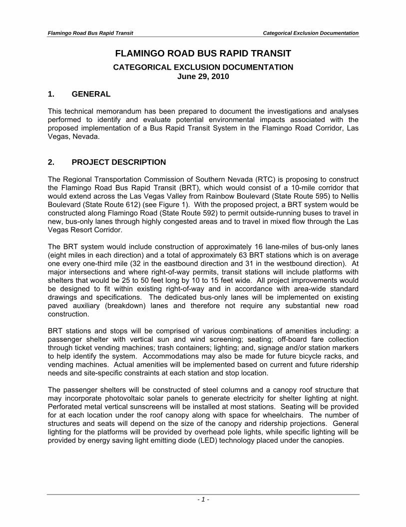
1. GENERAL This technical memorandum has been prepared to document the investigations and analyses performed to identify and evaluate potential environmental impacts associated with the proposed implementation of a Bus Rapid Transit System in the Flamingo Road Corridor, Las Vegas, Nevada. 2. PROJECT DESCRIPTION The Regional Transportation Commission of Southern Nevada (RTC) is proposing to construct the Flamingo Road Bus Rapid Transit (BRT), which would consist of a 10-mile corridor that would extend across the Las Vegas Valley from Rainbow Boulevard (State Route 595) to Nellis Boulevard (State Route 612) (see Figure 1). With the proposed project, a BRT system would be constructed along Flamingo Road (State Route 592) to permit outside-running buses to travel in new, bus-only lanes through highly congested areas and to travel in mixed flow through the Las Vegas Resort Corridor. The BRT system would include construction of approximately 16 lane-miles of bus-only lanes (eight miles in each direction) and a total of approximately 63 BRT stations which is on average one every one-third mile (32 in the eastbound direction and 31 in the westbound direction). At major intersections and where right-of-way permits, transit stations will include platforms with shelters that would be 25 to 50 feet long by 10 to 15 feet wide. All project improvements would be designed to fit within existing right-of-way and in accordance with area-wide standard drawings and specifications. The dedicated bus-only lanes will be implemented on existing paved auxiliary (breakdown) lanes and therefore not require any substantial new road construction. BRT stations and stops will be comprised of various combinations of amenities including: a passenger shelter with vertical sun and wind screening; seating; off-board fare collection through ticket vending machines; trash containers; lighting; and, signage and/or station markers to help identify the system. Accommodations may also be made for future bicycle racks, and vending machines. Actual amenities will be implemented based on current and future ridership needs and site-specific constraints at each station and stop location. The passenger shelters will be constructed of steel columns and a canopy roof structure that may incorporate photovoltaic solar panels to generate electricity for shelter lighting at night. Perforated metal vertical sunscreens will be installed at most stations. Seating will be provided for at each location under the roof canopy along with space for wheelchairs. The number of structures and seats will depend on the size of the canopy and ridership projections. General lighting for the platforms will be provided by overhead pole lights, while specific lighting will be provided by energy saving light emitting diode (LED) technology placed under the canopies.
SAHARA
RA
INB
OW
NEL
LIS
EAST
ERN
FLAMINGO
LAM
B
TROPICANA
CHEYENNE
OWENS
CHARLESTON
WASHINGTON
MAI
N
IND
UST
RIA
L
RA
NC
HO
BONANZA
VEGAS
STEWART
BOULDER
PAR
AD
ISE
LOSE
E
SPRING MOUNTAIN
STEP
HA
NIE
BER
MU
DA
LAKE M
5TH
MA
RYL
AN
D
BLUE DIAMOND
MA
RTI
N L
KIN
G
VALL
EY V
IEW
SIM
MO
NS
FREMONT
JON
ES
TWAIN
CIV
IC C
ENTE
R
MO
UN
TAIN
VIS
TA
SWEN
SON
MC
LEO
D
GOMER
PATRICK
CACTUS
CAREY
SUNSET
LAS
VEGA
S
PEBBLE
WARM SPRINGS
PAR
AD
ISE
RUSSELL
DESERT INN
BU
FFA
LO
WINDMILL
DEC
ATU
R
PEC
OS
DU
RA
NG
O
LAKE MEAD
NEL
LIS
®
2,500 0 2,500 5,000 7,500 10,0001,250
Feet
Flamingo Road Bus Rapid TransitProject Location Map Figure 1
Las Vegas Blvd. DEUCELas Vegas Blvd. Gold LineBoulder Highway Green Line
Sahara BRT LineExpress C LineExpress W Line
Existing and Proposed RTC Rapid Transit Lines
Rapid Transit Transfer Locations Bonneville Transit CenterFlamingo BRT Line
215
215
15
515
95
93
UNLV
595
592
612
McCARRANINTERNATIONAL
AIRPORT
Flamingo Road BRTFlamingo Road BRT
Flamingo Road Bus Rapid Transit Categorical Exclusion Documentation
- 3 -
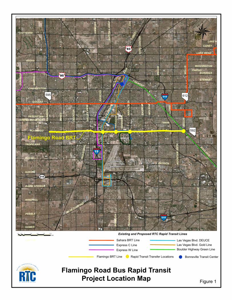
The BRT system will include 16 lane-miles of bus-only lanes. The dedicated bus-only lanes will extend from Rainbow Boulevard to Arville Street for a distance of 2.5 miles in each direction west of the Las Vegas Resort Corridor and from Koval lane to Boulder Highway for a distance of approximately 5.5 miles in each direction east of the Las Vegas Resort Corridor (see Figure 2). Figure 2 Locations of Proposed Dedicated Bus-Only Lanes along Flamingo Road
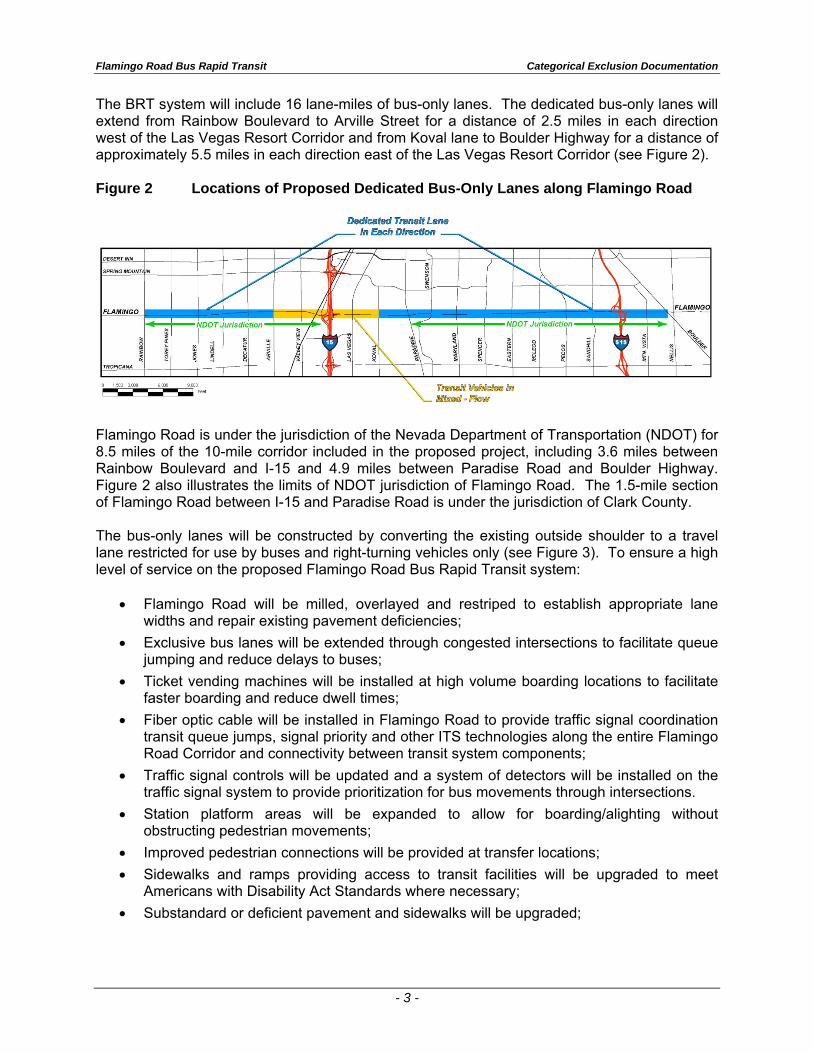
Flamingo Road is under the jurisdiction of the Nevada Department of Transportation (NDOT) for 8.5 miles of the 10-mile corridor included in the proposed project, including 3.6 miles between Rainbow Boulevard and I-15 and 4.9 miles between Paradise Road and Boulder Highway. Figure 2 also illustrates the limits of NDOT jurisdiction of Flamingo Road. The 1.5-mile section of Flamingo Road between I-15 and Paradise Road is under the jurisdiction of Clark County. The bus-only lanes will be constructed by converting the existing outside shoulder to a travel lane restricted for use by buses and right-turning vehicles only (see Figure 3). To ensure a high level of service on the proposed Flamingo Road Bus Rapid Transit system:
Flamingo Road will be milled, overlayed and restriped to establish appropriate lane widths and repair existing pavement deficiencies;
Exclusive bus lanes will be extended through congested intersections to facilitate queue jumping and reduce delays to buses;
Ticket vending machines will be installed at high volume boarding locations to facilitate faster boarding and reduce dwell times;
Fiber optic cable will be installed in Flamingo Road to provide traffic signal coordination transit queue jumps, signal priority and other ITS technologies along the entire Flamingo Road Corridor and connectivity between transit system components;
Traffic signal controls will be updated and a system of detectors will be installed on the traffic signal system to provide prioritization for bus movements through intersections.
Station platform areas will be expanded to allow for boarding/alighting without obstructing pedestrian movements;
Improved pedestrian connections will be provided at transfer locations;
Sidewalks and ramps providing access to transit facilities will be upgraded to meet Americans with Disability Act Standards where necessary;
Substandard or deficient pavement and sidewalks will be upgraded;
Flam
ingo
Roa
dC
onve
rsio
n of
Out
side
Sho
ulde
r to
a D
edic
ated
Bus
Lan
e
Pre
limin
ary-
Con
cept
ual O
nly-
Sub
ject
to C
hang
e
Lane
11.0
' La
ne11
.0'
11.0
'La
ne
"N"
Lane
11.0
'La
ne11
.0'
11.0
'La
ne
54.0
'2.
0'2.
0'M
inTr
ansi
tS
top
12.0
'B
us L
ane
5.0'
12.0
'B
us L
ane
54.0
'
R /
WR
/ W
14.0
'R
aise
d M
edia
n
Varie
s 12
3.0'
- 14
8.0'
5.0'
SW
5.0'
SW
Flam
ingo
Roa
dEx
istin
g C
ross
-Sec
tion
Pre
limin
ary-
Con
cept
ual O
nly-
Sub
ject
to C
hang
e
Lane
12.0
'La
ne12
.0'
12.0
'La
ne
"N"
Lane
12.0
'La
ne12
.0'
12.0
'La
ne
54.0
'2.
0'2.
0'9.
0'S
houl
der
9.0'
Sho
ulde
r
54.0
'
R /
WR
/ W
14.0
'R
aise
d M
edia
n
Varie
s 12
3.0'
- 14
8.0'
5.0'
SW
5.0'
SW
Figu
re 3
Flamingo Road Bus Rapid Transit Categorical Exclusion Documentation
- 5 -
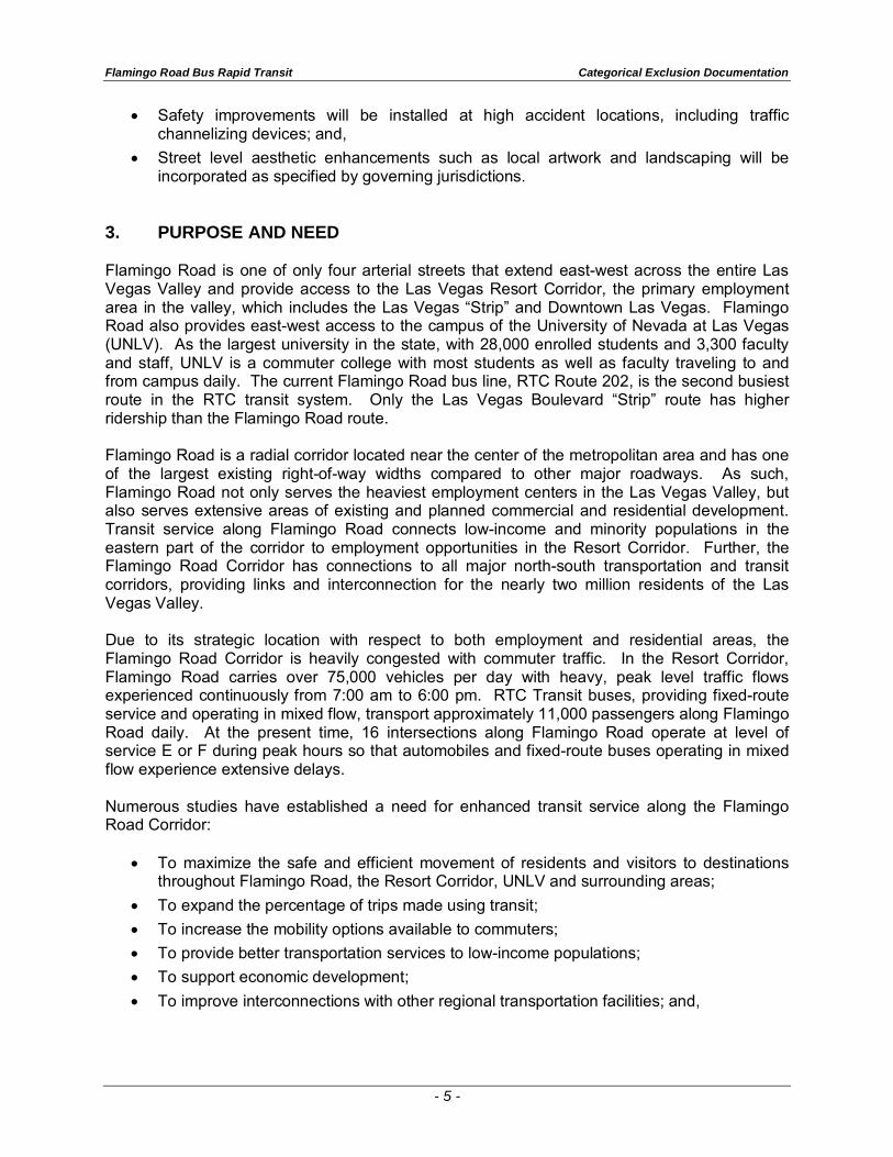
• Safety improvements will be installed at high accident locations, including traffic channelizing devices; and,
• Street level aesthetic enhancements such as local artwork and landscaping will be incorporated as specified by governing jurisdictions.
3. PURPOSE AND NEED Flamingo Road is one of only four arterial streets that extend east-west across the entire Las Vegas Valley and provide access to the Las Vegas Resort Corridor, the primary employment area in the valley, which includes the Las Vegas “Strip” and Downtown Las Vegas. Flamingo Road also provides east-west access to the campus of the University of Nevada at Las Vegas (UNLV). As the largest university in the state, with 28,000 enrolled students and 3,300 faculty and staff, UNLV is a commuter college with most students as well as faculty traveling to and from campus daily. The current Flamingo Road bus line, RTC Route 202, is the second busiest route in the RTC transit system. Only the Las Vegas Boulevard “Strip” route has higher ridership than the Flamingo Road route. Flamingo Road is a radial corridor located near the center of the metropolitan area and has one of the largest existing right-of-way widths compared to other major roadways. As such, Flamingo Road not only serves the heaviest employment centers in the Las Vegas Valley, but also serves extensive areas of existing and planned commercial and residential development. Transit service along Flamingo Road connects low-income and minority populations in the eastern part of the corridor to employment opportunities in the Resort Corridor. Further, the Flamingo Road Corridor has connections to all major north-south transportation and transit corridors, providing links and interconnection for the nearly two million residents of the Las Vegas Valley. Due to its strategic location with respect to both employment and residential areas, the Flamingo Road Corridor is heavily congested with commuter traffic. In the Resort Corridor, Flamingo Road carries over 75,000 vehicles per day with heavy, peak level traffic flows experienced continuously from 7:00 am to 6:00 pm. RTC Transit buses, providing fixed-route service and operating in mixed flow, transport approximately 11,000 passengers along Flamingo Road daily. At the present time, 16 intersections along Flamingo Road operate at level of service E or F during peak hours so that automobiles and fixed-route buses operating in mixed flow experience extensive delays. Numerous studies have established a need for enhanced transit service along the Flamingo Road Corridor:
• To maximize the safe and efficient movement of residents and visitors to destinations throughout Flamingo Road, the Resort Corridor, UNLV and surrounding areas;
• To expand the percentage of trips made using transit;
• To increase the mobility options available to commuters;
• To provide better transportation services to low-income populations;
• To support economic development;
• To improve interconnections with other regional transportation facilities; and,
Flamingo Road Bus Rapid Transit Categorical Exclusion Documentation
- 6 -
To augment and support multi-jurisdictional efforts to meet regional transportation and air quality objectives.
The purpose of the proposed project is to increase the person-carrying capacity of Flamingo Road to serve the needs of transit users along a congested urban arterial by enhancing the transit characteristics of the Flamingo Road Corridor. The proposed project will achieve these goals by:
Providing dedicated bus-only lanes through most of the congested portions of the Flamingo Road Corridor;
Providing traffic signal prioritization and by-pass lanes for buses at the most congested intersections;
Providing ticket vending machines at bus stations to speed boardings;
Interconnecting with future and existing bus rapid transit routes;
Providing safety enhancements for pedestrians and transit vehicles; and,
Providing street level aesthetic enhancements such as local artwork and landscaping. According to the Flamingo Road Corridor Study, prepared in January 2008, the combination of higher transit speeds and improved service is expected to increase transit ridership along Flamingo Road from four million to over six million passengers per year in 2030; to increase the person-carrying capacity of Flamingo Road by approximately eight percent; and to give commuters a reasonable and realistic alternative to single-occupant vehicles. 4. BACKGROUND The development of Bus Rapid Transit along the Flamingo Road is a multi-jurisdictional collaborative effort of the Regional Transportation Commission of Southern Nevada, the Nevada Department of Transportation, Clark County, and the University of Nevada at Las Vegas (UNLV). The proposed project to establish BRT service on Flamingo Road using bus-only lanes has evolved through the cooperative approach these agencies have taken to provide an integrated transportation strategy to solve regional transportation problems. In 2002, the RTC prepared the Las Vegas Valley Transit System Development Plan which developed corridor specific transit investment strategies. The Plan identified and recommended Flamingo Road as a corridor where bus rapid transit could be implemented:
To serve nearly 50,000 households;
To provide access to over 118,000 jobs;
To avoid adverse environmental impacts; and,
To avoid disruption of neighborhoods. The Flamingo Road Corridor Study provided an in-depth analysis of bus rapid transit alternatives for the Flamingo Road Corridor. The Flamingo Road Corridor Study, prepared under the auspices of the RTC as the MPO, with the collaboration and cooperation of NDOT, Clark County and UNLV, developed the program of transit improvements for Flamingo Road which comprises the proposed project.
Flamingo Road Bus Rapid Transit Categorical Exclusion Documentation
- 7 -
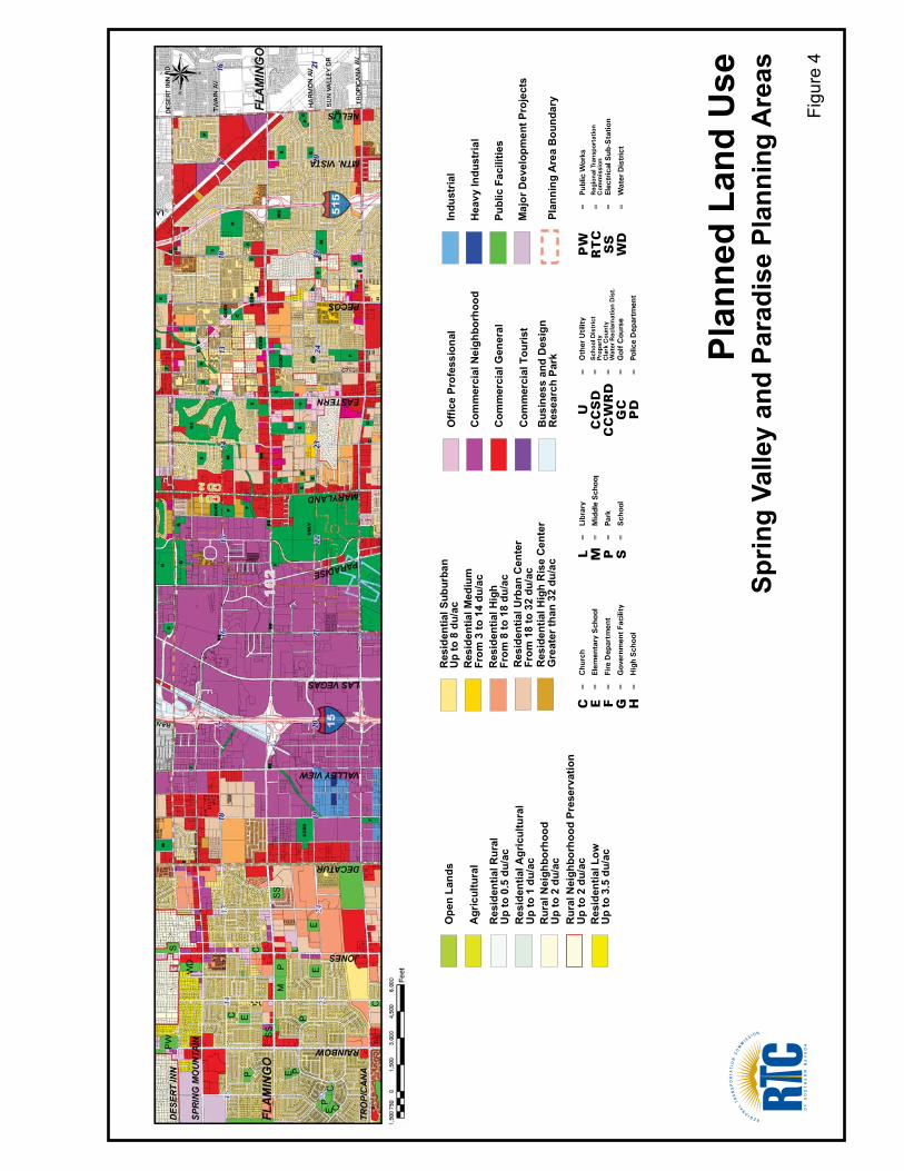
The Las Vegas Valley Arterial Development Study, April 2009, prepared by the RTC, identified the Flamingo Road Corridor as having the highest priority for eliminating conflicts between transit and non-transit vehicles. 5. EXISTING CONDITIONS, IMPACTS AND MITIGATION Environmental investigation and analysis was conducted covering the entire 10-mile corridor of the proposed project along Flamingo Road. The findings are described below. Land Use and Socioeconomics Land Use and Zoning Flamingo Road is under the jurisdiction of the Nevada Department of Transportation from Rainbow Boulevard to I-15 and also from Paradise Road to Boulder Highway. The entire length of the corridor is located in unincorporated Clark County; west of Decatur Boulevard, Flamingo Road is located in the Spring Valley Planning Area and east of Decatur Boulevard, Flamingo Road is located in the Paradise Planning Area. The Flamingo Road corridor is completely developed along its entire length from Rainbow Boulevard to Nellis Boulevard. The western end of the corridor, between Rainbow Boulevard and Arville Street, is predominantly residential and commercial. Several apartment and condominium complexes are within ¼ mile of Flamingo Road. The residential neighborhoods are supported by schools, park and recreation facilities, and neighborhood commercial/retail businesses. The central section of the Flamingo Road Corridor is located within the Resort Corridor and is comprised primarily of hotel/casino developments, including the Palms, Rio, Gold Coast, Bellagio, Caesar’s Palace, Flamingo, Bill’s Gambling Hall, and Bally’s. Newly opened and planned mixed-use and high-density developments, such as City Center (located approximately ¼ mile south of Flamingo Road), Hunter High-rise Condos and The Tower, are also prominent in the Resort Corridor section of Flamingo Road. The University of Nevada at Las Vegas is located south of Flamingo Road between Swenson Street and Maryland Parkway. The urban campus of this primarily commuter college serves 28,000 enrolled students and 3,300 faculty and staff. The predominant land uses in the eastern section of the Flamingo Road Corridor, east of Swenson Street, are similar to those in the western section – residential with supporting public and community facilities and commercial/retail establishments. Higher density residential land uses give way to medium density single-family suburban homes as the corridor extends east. In addition, several medical facilities are located along Flamingo Road between Eastern Avenue and Mojave Road, including Desert Springs Hospital. Figure 4 illustrates Clark County’s planned land uses along the Flamingo Road Corridor, based on the most recently approved Spring Valley and Paradise/Winchester Land Use Plans, dated September 2009 and August 2005, respectively. Paradise/Winchester is in the process of updating its Land Use Plan, which is expected to be adopted in the summer of 2010.
Plan
ned
Land
Use
Sprin
g Va
lley
and
Para
dise
Pla
nnin
g A
reas
Figu
re 4
Ope
n La
nds
Res
iden
tial R
ural
Up
to 0
.5 d
u/ac
Res
iden
tial A
gric
ultu
ral
Up
to 1
du/
ac
Res
iden
tial S
ubur
ban
Up
to 8
du/
ac
Res
iden
tial L
owU
p to
3.5
du/
ac
Rur
al N
eigh
borh
ood
Pres
erva
tion
Up
to 2
du/
ac
Rur
al N
eigh
borh
ood
Up
to 2
du/
ac
Res
iden
tial M
ediu
mFr
om 3
to 1
4 du
/ac
Res
iden
tial H
igh
From
8 to
18
du/a
c
Agr
icul
tura
l
Res
iden
tial U
rban
Cen
ter
From
18
to 3
2 du
/ac
Res
iden
tial H
igh
Ris
e C
ente
rG
reat
er th
an 3
2 du
/ac
Offi
ce P
rofe
ssio
nal
Com
mer
cial
Nei
ghbo
rhoo
d
Com
mer
cial
Gen
eral
Com
mer
cial
Tou
rist
Bus
ines
s an
d D
esig
nR
esea
rch
Park
Indu
stria
l
Hea
vy In
dust
rial
Publ
ic F
acili
ties
Maj
or D
evel
opm
ent P
roje
cts
Plan
ning
Are
a B
ound
ary
Flamingo Road Bus Rapid Transit Categorical Exclusion Documentation
- 9 -
As the figure shows, planned land uses in the corridor are generally consistent with existing land uses, with commercial and supporting land uses (parks, schools, and other public land uses) lining Flamingo Road, and residential land uses behind the commercial corridor. Planned residential densities are higher in the center core of the Flamingo Road Corridor. In addition, the Paradise Planning Area has planned for a Commercial Tourist area within the Resort Corridor, consistent with existing land uses. Clark County adopted a Mixed-Use District (MUD) Overlay in 2005 to accommodate the demand for high-density commercial and residential development, focus this development in appropriate corridors, and promote a built environment that supports community goals. The ordinance facilitates the integration of residential, commercial, employment, and recreational uses that are typical of a high activity urban center. MUD development requirements provide for a pedestrian oriented urban form, promote integration of transit with land use planning, and encourage the emergence of public spaces that will be an asset for the Las Vegas Valley. There are four types of mixed use district zones, which vary in development scale and intensity of use (see Table 1). As Figure 5 shows, Flamingo Road has a MUD 1 designation between Arville Street and Paradise Road, which supports the most intense urban form. The MUD zones are increasingly less intense as the corridor extends eastward, stepping down to a MUD 4 at Eastern Avenue. The Boulder Highway intersection is surrounded by a MUD 3 zone. Table 1 Mixed-Use District Overlay Sub-Districts
Sub-District/Zone MUD 1 MUD 2 MUD 3 MUD 4
Most Intense Urban Form
Most Intense Suburban Form
Moderately Intense Suburban
Form
Least Intense Suburban Form
Density (du/acre) As approved Up to 50 Up to 32 Up to 18 Max Height Up to 100’ Up to 100’ Up to 50’ Up to 35’ Max Height with Special Use Permit As approved Up to 200’ Up to 100’ Up to 50’ Minimum Pedestrian Realm Width 15’ 15’ 10’ 10’ Minimum Pedestrian Realm Adjacent to Building 35’ High or Greater
15’ 15’ 15’ 15’
Minimum Pedestrian Realm Adjacent to Buildings 50’ High or Greater
20’ 20’ 20’ 20’
Source: Clark Count 2005 / PB 2008 Figure 5 Clark County Mixed-Use District Overlay
Flamingo Road Bus Rapid Transit Categorical Exclusion Documentation
- 10 -
The proposed project would have no impacts on land use in the corridor. A BRT system would support the efforts of the County in its plans for mixed-use development within the Resort Corridor and at Boulder Highway. In mixed-use development areas, Clark County encourages higher density transit-oriented development. In addition, the BRT system would support the existing and planned commercial and residential land uses to the east and to the west of the Resort Corridor. Community Facilities There are 63 community and public facilities within one-half mile of the Flamingo Road Corridor between Rainbow Boulevard and Nellis Boulevard, as shown in Figure 6. These facilities include schools, parks and recreation facilities, hospitals and medical centers, churches and religious facilities, libraries, and other public and community facilities. The proposed project will have no adverse impact on community facilities. More importantly, by providing an efficient, low-cost mobility option in the Flamingo Road Corridor, a BRT system would provide benefits by improving access to public and community facilities, especially for low income populations. Social and Economic Conditions Table 2 provides a demographic profile of the Flamingo Road Corridor. Based on year 2000 U.S. Census Bureau information, a total population of 97,370 lives within the census tract block groups which include or extend to within one-half mile of Flamingo Road between rainbow Boulevard and Nellis Boulevard. Table 2 Demographic Profile of the Flamingo Road Corridor
Flamingo Road Corridor
Clark County State of Nevada
Total Population 97,370 1,375,765 1,998,257
Race and Ethnicity
White only, non-Hispanic 55,566 57.1% 828,669 60.2% 1,303,001 65.2%
Black only, non-Hispanic 6,854 7.0% 121,401 8.8% 131,509 6.6%
Asian only, non-Hispanic 6,307 6.5% 71,225 5.2% 88,593 4.4%
Other, non-Hispanic 4,141 4.3% 52,326 3.8% 81,184 4.1%
Hispanic, any race 24,502 25.2% 302,143 22.0% 393,970 19.7%
Income and Poverty
Median Household Income $36,314 $44,616 $44,581 Percentage of Persons below the Poverty Level
13.8% 10.8% 10.5%
Source: 2000 U.S. Census Bureau of Population and Housing Note: Population, race, and income data determined from the census tract block groups within one-half mile
of Flamingo Road between Rainbow Boulevard and Nellis Boulevard.
VALLEY VIEW
DECATUR
JONES
RAINBOW
LAS VEGAS
PARADISE
MARYLAND
EASTERN
PECOS
NELLIS
MTN. VISTA
FLA
MIN
GO
FLA
MIN
GO
SPR
ING
MO
UN
TAIN
DES
ERT
INN
TRO
PIC
AN
A
®
1,50
00
1,50
03,
000
4,50
06,
000
750
Feet
1551
5
1
2
34 5
67
91011
1213
1415
16
1819
17
20
21
8
1. D
iski
n E
lem
enta
ry S
choo
l2.
Dec
ker E
lem
enta
ry S
choo
l3.
Gui
nn M
iddl
e S
choo
l4.
SW
Beh
avio
r5.
Don
dero
Ele
men
tary
Sch
ool
6. T
hirio
t Ele
men
tary
Sch
ool
7. B
urk
Hor
izon
/SW
Sun
set
8. E
vere
st C
olle
ge -
Las
Vega
s9.
Par
adis
e E
lem
enta
ry S
choo
l10
. UN
LV11
. Pet
erse
n E
lem
enta
ry S
choo
l12
. Orr
Ele
men
tary
Sch
ool
13. S
tew
art S
choo
l14
. Row
e E
lem
enta
ry S
choo
l15
. St.
Viat
or C
atho
lic S
choo
l16
. Virt
ual H
igh
Sch
ool
17. M
t. O
live
Bap
tist S
choo
l18
. Har
ris E
lem
enta
ry S
choo
l19
. Cha
parr
al H
igh
Sch
ool
20. W
oodb
ury
Mid
dle
Sch
ool
21. F
erro
n E
lem
enta
ry S
choo
l
Scho
ols
1. P
rosp
erity
Par
k 2
. Pau
l Mey
er P
ark
and
Rec
reat
ion
Cen
ter
3. L
aure
lwoo
d P
ark
4. G
uinn
Sch
ool P
ark
5. W
est F
lam
ingo
Par
k an
d R
ecre
atio
n
Cen
ter
6. L
as V
egas
Nat
iona
l Gol
f Cou
rse
7. P
arad
ise
Par
k an
d R
ecre
atio
nal C
ente
r 8
. Des
ert I
nn P
ark
9. F
erro
n S
choo
l Par
k10
. Mas
low
Cou
nty
Par
k
Park
s an
d R
ecre
atio
n Fa
cilit
ies
Hos
pita
ls a
nd M
edic
al C
ente
rs
1. M
onte
vist
a H
ospi
tal
2. R
ed R
ock
Beh
avio
ral H
ealth
3. D
eser
t Spr
ings
Hos
pita
l4.
Kin
dred
Hos
pita
l5.
Com
preh
ensi
ve C
ance
r Car
e
Cen
ter
6. P
rogr
essi
ve H
ospi
tal
7. H
arm
on M
edic
al a
nd
R
ehab
ilita
tion
Hos
pita
l
Libr
arie
s
1. S
prin
g Va
lley
2. C
lark
Cou
nty
Oth
er P
ublic
and
Com
mun
ity
Faci
litie
s
1. F
ire S
tatio
n 22
2. N
evad
a S
yste
m o
f Hig
her E
duca
tion
3. F
ire S
tatio
n 15
4. F
ire S
tatio
n 32
5. F
ire S
tatio
n 18
6. C
CS
D O
ffice
s7.
Com
mun
ity M
ulti
Cul
tura
l Cen
ter
8. M
ETR
O P
olic
e-S
E A
rea
Com
man
d
Chu
rche
s an
d R
elig
ious
Fac
ilitie
s
1. In
tern
atio
nal C
hurc
h of
Las
Veg
as2.
Chu
rch
of J
esus
Chr
ist o
f LD
S3.
So-
Min
g P
resb
yter
ian
Chu
rch
4. S
t. S
imeo
n S
erbi
an O
rthod
ox C
hurc
h5.
Firs
t Chu
rch
of R
elig
ious
Sci
ence
6. G
eths
eman
i Mis
sion
ay B
aptis
t Chu
rch
7. In
tern
atio
nal B
ible
Bap
tist C
hurc
h8.
St V
iato
r Cat
holic
Chu
rch
9. F
our S
easo
ns C
omm
unity
Chu
rch
10. F
irst K
orea
n P
resb
yter
ian
Chu
rch
11. L
as V
egas
Chu
rch
of th
e N
azar
ene
12. M
t. O
live
Chu
rch
13. C
hurc
h of
Jes
us C
hris
t of L
DS
14. H
oly
Fam
ily C
atho
lic C
hurc
h15
. Des
ert H
ills
Bap
tist C
hurc
h
Com
mun
ity F
acili
ties
with
in 1
/2 M
ile o
f Fla
min
go R
oad
Figu
re 6
13
46
25
71
21
2
3
4
56
87
1
23
45
6
9 10
2
1
10
7
65
43
8
9
1112
13
1415
Flamingo Road Bus Rapid Transit Categorical Exclusion Documentation
- 12 -
According to the Flamingo Road Corridor Study, in 2006 the population within one mile of the Flamingo Road Corridor extending from Town Center Drive to Nellis Boulevard was 228,467. This population, located approximately one mile on either side of Flamingo Road, comprised 12 percent of the total population and 14 percent of the dwelling units in the Las Vegas Valley. In addition, the one-mile radius corridor included 25 percent of all regional jobs. Population projections by the RTC in 2006 indicated that the corridor will experience a 32.8 percent increase in population and a 44.4 percent increase in employment between 2006 and 2030. Although the Las Vegas Valley experienced its first decline in population in 2008, from 1,925,261 persons in 2007 to 1,916,436 persons in 2008, and unemployment rates have been among the lowest in the U.S., population again grew in 2009 and is expected to continue to grow as the economy improves. Redevelopment of underutilized sites, particularly in the Resort Corridor and MUD zones, and higher-intensity land uses are expected to drive this growth and development. Environmental Justice The proposed project will have no adverse impact on socioeconomic factors such as land use and community facilities. According to Table 2, the Flamingo Road Corridor has higher percentages of minority and low-income populations than Clark County. Since the proposed project will not displace or adversely affect low-income populations, environmental justice is not a factor. Moreover, low-income populations who may tend to be more transit-dependent will benefit from the provision of a high quality rapid transit system that improves access to employment centers and community facilities along Flamingo Road and other corridors with which the Flamingo Road BRT route will intersect. Noise and Air Quality With the proposed project, double-decker Deuce buses will continue to operate on Flamingo Road. Existing traffic patterns are not expected to change. As more passengers use the BRT system, a reduction in the number of automobiles would be expected. Accordingly, the proposed project would not be expected to cause an increase in noise levels or an increase in vehicular pollutant emissions. The RTC requires that contractors comply with all relevant local, state and federal air quality regulations, particularly the County Fugitive Dust Control Regulations and the Nevada State Air Quality Regulations. To limit the potential for adverse particulate emissions, mitigation will include best management practices. The proposed project is located in the Las Vegas Valley, which is classified by the EPA as a non-attainment area for Carbon Monoxide (CO) and Particulate Matter (PM10). As the proposed project is located in a nonattainment area, a conformity determination is required. The Regional Transportation Plan 2009 - 2030 has been found to be in conformity with the requirements of the Clean Air Act Amendments of 1990, the relevant sections of the Final Conformity Rule 40 CFR Part 93, and the procedures set forth in the Clark County Transpor-tation Conformity State Implementation Plan. The RTC-approved Regional Transportation Plan 2009-2030, and the Transportation Improvement Program 2009-2012 are currently being amended to include the proposed project. As a project coming from a conforming TIP and RTP, the proposed project conforms to the Nevada CO and PM10 SIP and emission budget requirements, pursuant to 40 CFR 93.
Flamingo Road Bus Rapid Transit Categorical Exclusion Documentation
- 13 -
Water Resources and Hydrology The Tropicana Wash crosses Flamingo Road just south of Swenson Street and is conveyed under Flamingo Road via three existing 12-foot by 5-foot reinforced concrete box culverts. It is anticipated that construction associated with Flamingo Road BRT in this area will be within the existing right-of-way and consist of sidewalk widening, mill and overlay paving, and restriping. These activities will not impact the existing box culverts or the Tropicana Wash. FEMA Flood Insurance Rate Map (FIRM) Panels 32003C2145E, 32003C2164D, 32003C2170E, and 32003C2190E were reviewed. These FIRMs indicate that there are two sections of the corridor that fall within the FEMA 1% Chance Annual Flood (100-year Flood Zone). The first section is from Las Vegas Boulevard to approximately 500’ east of Koval Lane and the second section is from Swenson Street to Claymont Street. It is anticipated that construction associated with the Flamingo Road BRT in these areas will be within the existing right-of-way and consist of bus pad construction, mill and overlay paving, and restriping. These activities will not alter or affect 100-year floodplain. The Clark County Regional Flood Control District (CCRFCD) has existing flood control facilities along the project’s corridor, ranging in size from 27-inch RCP storm drains to 10-foot by 5-foot RCB storm drains. There are two proposed facilities that are parallel to Flamingo Road between Valley View Boulevard and the Union Pacific Railroad and between Boulder Highway and Nellis Boulevard. Neither of these facilities is included in the current 10-year plan and will not affect the Flamingo Road BRT. In addition there are three proposed facilities that cross Flamingo Road at the Union Pacific Railroad, Maryland Parkway and Eastern Avenue. Flamingo Road passes over the railroad via a bridge and will not be affected by the channel improvements along the railroad. The proposed facilities along Maryland Parkway and Eastern Avenue are not included in the current 10-year plan and will not affect the Flamingo Road BRT. Because the proposed project will disturb more than one acre of land, the contractor will be required to file a Notice of Intent (NOI) for coverage with the Nevada Division Environmental Protection’s Bureau of Water Pollution Control. This provides coverage under the General Permit for Storm Water Discharges Associated with Construction Activity (NVR 100000) required by the National Pollutant Discharge Elimination System (NPDES) program pursuant to the Clean Water Act. Since the dedicated bus-only lanes will be constructed within existing shoulders along Flamingo Road, there will be no increase in impervious roadway surfaces. The construction of platforms and bus shelters will minimally increase the amount of impervious sidewalk surfaces, resulting in negligible impacts to storm water runoff along the Flamingo Road Corridor. Ground water will not be affected by the proposed project. Biological Resources The areas where roadway improvements and BRT Stations will be constructed with the proposed project have been previously disturbed by urban development. No areas of native vegetation will be disturbed with the proposed project. Accordingly, no sensitive, threatened or endangered species and no suitable habitat for special status species will be affected by the proposed project.
Flamingo Road Bus Rapid Transit Categorical Exclusion Documentation
- 14 -
Cultural Resources Professional staff from the Cultural Resource Division of the Louis Berger Group, Inc. undertook an initial Class I cultural resource assessment of a 16-mile long corridor of Flamingo Road extending from Rainbow Boulevard to Nellis Boulevard. Such assessment work included a review of site files and records documented on NVCRIS plus a review of standing structures and architectural features as listed in the Clark County Assessor’s Office. No new right-of-way will be acquired and all project work will occur within the existing Flamingo Road right-of-way; however, 3,411 parcels situated immediately adjacent to the project corridor were reviewed for their historic potential and the potential adverse effects of the proposed project on any adjacent historic properties or archaeological sites. Research demonstrated that all structures present within these parcels date between 1962 and 2009. Building types observed included single-family residences, residential apartments, townhouses, condominiums, commercial buildings, industrial warehouses, retail shops/stores, hotels/motels, utilities facilities, and vacant lots. There are no historic properties or features located immediately adjacent to the project corridor. This initial Class I assessment found only one historic archaeological site (Site CK 5685) located within this project corridor. This is the historic alignment of the Union Pacific Railroad. The railroad was originally built as the San Pedro, Los Angeles, and Salt Lake Railroad – constructed between 1903 and 1905 – with full operations beginning in 1905 and running until 1921. In 1921, the Union Pacific Railroad acquired this line/route. Since that time, the Union Pacific has continuously operated, maintained, retrofitted, and upgraded this railroad line and right-of-way. At this time, the proposed undertaking would have no direct or indirect impacts or effects to the UPRR alignment. In summary, no standing historic structures or features are present within or surrounding the current project corridor. As the project corridor is currently defined, no adverse effects to historic properties will occur. Hazardous Waste A review of hazardous waste databases was conducted for the Flamingo Road Corridor with the following findings:
There are five Underground Storage Tanks (USTs) registered in the Corridor;
There are two Leaking Underground Storage Tanks (LUSTs) recorded in the Corridor, all closed;
There are nine Resource Conservation and Recovery Act (RCRA) sites in the Corridor. In addition, there are eight RCRA sites in the Corridor which are no longer regulated;
There are eight Emergency Response Notification System (ENS) sites in the Corridor, all fixed; and,
The Nevada State database lists two sites in the Corridor, all closed. Accordingly, there are no hazardous waste sites which would be affected by the proposed project.
Flamingo Road Bus Rapid Transit Categorical Exclusion Documentation
- 15 -
Transportation and Infrastructure The proposed project is proposed as a backbone element of the Valley-wide multi-jurisdictional transportation system. It will be constructed with the cooperation and collaboration of NDOT, and Clark County. By connecting to three existing and planned rapid transit routes the Las Vegas Boulevard DEUCE line, and 15 RTC fixed-routes, it will increase the efficiency and effectiveness of the regional transit network. The proposed Flamingo Road BRT will transfer directly to the currently operational Express C Line to provide access to and from the northwestern part of the Las Vegas Valley. A direct transfer is also available to the Las Vegas Boulevard Gold Line to provide access to and from the South Strip Transfer Terminal and Downtown Las Vegas. Planned BRT service along Boulder Highway, the Green Line, will connect directly to the Flamingo Road BRT to provide access to and from Henderson and Downtown Las Vegas. The proposed Flamingo Road BRT will also indirectly connect to two additional planned rapid transit lines – the Sahara Avenue BRT and the Express W Line. The proposed project will not adversely affect any existing transportation facilities. Conversion of the shoulder to a dedicated bus-only lane throughout the corridor will not reduce the number of lanes available for automobiles and will not adversely affect the roadway configuration or capacity of Sahara Avenue and therefore is not expected to impact traffic operations. At the present time, curbside parking is permitted along approximately one-half mile of shoulder in each direction in a residential area between I-515 and Mountain Vista Street. No adverse impacts will result from the elimination of curbside parking since adequate parking is available on the side streets. Cumulative Impacts Redevelopment in the Flamingo Road Corridor is expected to proceed in accordance with County land use plans (see Figure 3). Clark County land use plans include the designation of mixed-use districts in the Flamingo Road Corridor which encourage higher density transit oriented development. The proposed project is compatible with and would support County land use planning efforts. However, since no adverse impacts are expected to result from the proposed project, the proposed BRT system will not contribute in a cumulative manner to potential impacts from planned development in the Flamingo Road Corridor. 6. AGENCY AND PUBLIC INVOLVEMENT The Flamingo Road Corridor Study planning process was guided by a Technical Advisory Committee (TAC) comprised of local and state government entities. Monthly project meetings were held to review project status, discuss issues, and obtain input from participating agencies. A planning workshop was held during February 2007, which provided an opportunity for TAC members to participate in the development and refinement of alternatives. The alternatives recommended during the workshop form the basis for the alternatives carried forward through the analysis in this report. TAC members reviewed alternatives throughout the planning process and provided input into the final study recommendations. The organizations participating in the TAC are as follows: Regional Transportation Commission of Southern Nevada
Flamingo Road Bus Rapid Transit Categorical Exclusion Documentation
- 16 -
Clark County Comprehensive Planning and Public Works Departments
Nevada Department of Transportation (NDOT)
University of Nevada Las Vegas
Nevada Resorts Association
Nevada Power 7. REFERENCES
− Clark County Comprehensive Master Plan (November, 2005) − Winchester and Paradise Land Use and Development Guide (August, 2005) − Spring Valley Land Use Plan (September, 2009) − Clark County Redevelopment Plan (December, 2003) − Regional Transportation Plan 2009 – 2030 (November, 2008) − Flamingo Road Corridor Study (January, 2008) − Las Vegas Valley Arterial Development Study (April, 2009) − Environmental FirstSearch Report, Track Info Services (June, 2010) − Nevada Cultural Resources Information System (August, 2009)