Embed Size (px)
Citation preview

University of Iceland School of Engineering and Natural Science Earth Science
Fláajökull Field trip and Excursion Report Glacial geology (JAR407)
Students in group 8: Björg Jónsdóttir Einar Ragnar Sigurðsson James Alexander Clayton Lenka Vejrostová Stacy Lee Ann Picard Supervisors: Ólafur Ingólfsson Anders Schomacker Sverrir Aðalsteinn Jónsson Minney Sigurðardóttir Ívar Örn Benediktsson
22nd May 2012 revised on 31st of May

Page 2 of 15
Contents Abstract ............................................................................................................................................ 3
Introduction ...................................................................................................................................... 3
Objectives ..................................................................................................................................... 3
Glacial History and Activity of Mýrdalsjökull and Vatnajökull ......................................................... 3
Glacial activity and recessional history of Fláajökull ....................................................................... 4
Diary of the Excursion ........................................................................................................................ 5
First day – 11/05/2012 .................................................................................................................. 5
Second day – 12/05/2012 .............................................................................................................. 6
Last day of excursion – 15/05/2012 ............................................................................................... 7
Fagurhólsmýri ............................................................................................................................ 7
Stokkalækur ............................................................................................................................... 8
Observations and Fieldwork ............................................................................................................ 10
Station 8 – Glacial landsystem ..................................................................................................... 10
Description of points taken ...................................................................................................... 11
Station 1 - Glacial stratigraphy and history ................................................................................... 12
Description of the log .............................................................................................................. 12
Fabric measurements of station 1 ............................................................................................ 13
Results and Concluding Remarks ..................................................................................................... 13
Station 8– Glacial landsystem ...................................................................................................... 13
Analysis of organic material 450 m behind (proximal) the 1995 end moraine ........................... 14
Station 1 - Glacial stratigraphy and history ................................................................................... 15
References ...................................................................................................................................... 15
Page 3 of 15
Abstract This report gives an overview of Glacial Geology fieldtrip. First there is an introduction to the report. Then
visits to various glacial environments in south Iceland are described in a diary, followed by observations made
at Fláajökull pro-glacial area.
The main results in Fláajökull field work include that the 1995 moraine at Fláajökull was made on a
stationary period of the glacier. An organic layer observed shows a place that was exposed some centuries
ago. Research done on a section distal to 1995 moraine showed glacial till made by former glacier advances
and also a small recessional moraine above.
Introduction
Objectives
The objective of this study and field trip is to experience glacial landsystems first hand. This is accomplished
through a number of stops along the south coast, to analyze various glaciers and their geology, as well as the
main body of research carried out at Fláajökull. It is important to investigate glaciers in the field as geology is a
practical profession; there is only so much which can be learnt from text, diagrams and images.
Glacial History and Activity of Mýrdalsjökull and Vatnajökull
The glacial history of this area is much the same and follows the same trends as many other glaciers. Most of
Iceland, including the current day Mýrdalsjökull, was under ice until about 10,000 years ago, the end of the last
glaciation of the ice age. Since this time most of the ice melted away and now are just a few areas glaciated. At
Sólheimajökull, an outlet glacier of Mýrdalsjökull, there was a moraine indicating a local glacial maximum of
3000-4000 years ago. After this period the maximum extent of Mýrdalsjökull was during the Little Ice Age, at
about 1890. Nowadays the present day ice margin is over 2km from the moraines formed in 1890, showing
how rapid the retreat has been, especially over the last 17 years. There was an advance from the 1960’s until
about 1995, but now the glacier retreats further each year. Mýrdalsjökull is very active, as it lies on top of the
Katla volcano. An eruption that produced more than 10km³ of tephra 12,000BP probably contributed to the
formation of Katla and therefore Mýrdalsjökull (Lacasse et al., 1995). Since the Settlement, over 1100 years
ago, there have been 20 eruptions from Katla, all causing jökulhlaups. The largest eruption took place in 1755,
on a several kilometres long fissure trending east from Goðabunga. Eruptions in 1823 and 1918 took place on a
northerly striking ridge from the eastern rim of Háabunga. At present meltwater drains southeastward, down
to Mýrdalssandur, from an area of 60km² in the caldera. Eighteen out of the twenty jökulhlaups have taken
this path (Björnsson, Pálsson & Guðmundsson, 2000). An area of 20km² drains to the southwest, down to
Sólheimasandur, where the other two jökulhlaups have flowed. A third route, northwestward into Fremri
Emstruá and the Markarfljót river was used by a jökulhlaup 1600 BP. Geothermal activity in sever 0.5-1km
diameter cauldrons causes frequent small jökulhlaups currently, such as that in 1999 which cut a gulley into
the 1995 moraine at Sólheimajökull. There was also a jökulhlaup in July 2011 which destroyed the bridge on
the ring road over the river Múlakvísl.
The glacial history of Vatnajökull is fairly similar to that of Mýrdalsjökull, but on a larger scale. One
example of this scale is Skeiðarársandur, the largest active sandur plain in the world. Like Mýrdalsjökull,
jökulhlaups also flow from Vatnajökull, forming the sandur which could not exist from the braided rivers alone
(Björnsson, 1988). The 1996 Gjálp jökulhlaup had a discharge of 30-40 000m3/s, and cut through the 1890
Little Ice Age moraine, exposing the dead ice. This shows that despite the present day glacier existing many
kilometres away, ice can survive in the pro-glacial area, and therefore this must be considered when discussing
glacial history and activity. Grímsvötn is a highly active geothermal area, and has a long history of sudden
drainage, with about one flood per decade occurring from 1600 to 1934, and although the discharges of some
of the previous centuries jökulhlaups did reach the same rates as the Gjálp event, but since the late 1930’s
most flood peaks have been smaller partly due to more frequent flooding and partly as a result of increased
geothermal activity (Björnsson, 1988).

Page 4 of 15
Glacial activity and recessional history of Fláajökull
Figure 1: Fláajökull, May 2012. First there is area influenced by dead ice, then some recessional moraines and further on close to the glacier is a small rather flat drumlin, see explanations in chapter about results and concluding remarks, page 13-14. Photo: Einar Ragnar
Fláajökull is an outlet glacier of Vatnajökull and has
been retreating since the last decade of 20th
century, as evidenced by a dated end moraine.
However the extent of glacier was higher in the
Little Ice Age. There was doubt over the exact
Little Ice Age maximum for Fláajökull, with esti-
mates of between the late eighteenth the late
nineteenth centuries. Studies on lichenometrical
data Chenet et al (2010) argue the glacial maximum
on Little Ice Age at 1821 but however Dabski (2010)
argue the glacial maximum to be close to the end
of the 19th century, also based on studies on
lichenometrical data from the area. The difference
might be due to different use of statistical
methods. Historical data more or less agree with
the conclusion of Dabski (Dabski, 2010). However
the study of Chenet et al (2010) was quite
interesting because she did find a relation between
the year of Little Ice Age maximum for each outlet
glacier and the altitude of the highest part of each
outlet glacier, see figure 2.
However, there is more information available from last century measurements of the position of the
glacier snout, made by The Iceland Glaciological Society. The data is available from year 1930 (Sigurðsson,
2012) and shows fast retreating the first decades after 1930 but slowing down and according to the data, the
glacier was more or less stationary from year 1965 to year 1996. The measurements were not made from year
1973 to 1990 but according to an interview with local people (Fláajökull er hættur að hopa, 2001, 18th of
November) the glacier was also stationary during that time. The position of the glacial snout from 1930 to
2011 is showed on figure 3.
Figure 2: Lichenometric dating of the LIA glacial maximum using the Bayesiona approach (Chenet et al., 2010).

Page 5 of 15
Diary of the Excursion Information in the diary of Excursion was given on the
place and is from the supervisors in the excursion: Ólafur
Ingólfsson, Anders Schomacker, Sverrir Aðalsteinn
Jónsson and Minney Sigurðardóttir.
First day – 11/05/2012 The first stop was made in Vestur-Landeyjar area at
Drumbabót, a birch forest, which was drowned by
jökulhlaup before the Settlement. The short tree stumps,
were measured up to 20 cm in diameter, stand up from
the sand and gravel around them. The birch stumps are
quite well preserved, the bark still exists because the
stump is buried in the sand. Jökulhlaups usually flow
southeast to Múlajökull or Sólheimajökull, the last time it
went to Entujökull was 1200 years ago, when the forest
of Drumbabót was drowned; this is assumed to happen
once every one thousand years. The valley, which was
former fjord in the Holocene, was filled by sediments
with thickness of up to 200 metres.
On our way to Gígjökull we could see alluvial fans
made by small rivers carrying material down from Eyjafja-
llajökull. We could see how the
river channels had moved from one
side of alluvial fan to the other.
Along the braided channels of
Markarfljót we reached Gígjökull
where we took a short walk and
observed the glacial environment.
Gígjökull’s lateral moraines are
among the biggest in Iceland (we
attempted to estimate its height by
using the GPS device – ap-
proximately 100 m from the
parking lot). These are two possible
explanations as to why the
moraines are so high, and the
reason could reasonably be a
combination of both:
High rates of erosion. Soft
bedrock from the stratovolcano combined with the fast flowing glacier leads to a massive amount of
material being eroded.
Dead ice in the moraines. The large amount of material already mentioned provides plenty of
sediment to cover and protect this ice from melting.
The annual mean temperature is approximately 2°C so the ice cannot be melted easily and it is also well
isolated by the debris. The glacier is retreating rapidly because it has been cut off from its ice source since the
Eyjafjallajökull eruption in 2010. The glacier is heavily crevassed and due to the icefall. In front of the glacier,
where a lake used to preside prior to 2010 eruption there are two fans. The larger one was probably made by
the jökulhlaup. The river coming out of the glacier seems to have eroded part of this fan away and it is now
building its own smaller fan. It has changed its channel at least once since that time and the old channel can be
Figure 4: Gígjökull Proglacial area, May 2012. Clear evidence of dead ice is visible. The area marked as “alluvial fan made from the jökulhlaup in 2010” could also have been made partly by came processes. The lagoon was in this area before 2010 eruption. Photo: Einar Ragnar
Figure 3: Postition of the glacier snout at Fláajökull from year 1930 to 2011 according to Sigurðsson (2011) and info recieved by email from Oddur Sigurðsson, Meterological Office of Iceland, 21
st of
May 2012.

Page 6 of 15
seen closer to the lateral moraine. Closer to the front part of the moraine there is a hummocky surface,
indicating the appearance of dead ice, in past or at present. Fresh sink holes that are also present, evidence of
the dead ice which exists there. We saw chatter marks on one of the bigger boulders on the top of the mo-
raine. The moraine observed was probably created in 19th
century during the Little Ice Age period and it is
double crested perhaps due to a small break during the glacier advance at the end of the last glaciation. The
proglacial ara at Gigjökull is showed on figure 4.
On Skógasandur we could see few megaripples that are clear evidence of a jökulhlaup since ripples of this
size can only be formed by catastrophic event like jökulhlaup.
On our way to Sólheimajökull we crossed the moraine indicating a local glacial maximum 3000-4000 years
ago. The Little Ice Age moraine is approximately 2 km from the current ice margin. We were walking on a
ridge, a dump moraine; the path of the ridge was saw-tooth-like just as is now found at the front of the
present glacier snout. We observed drumlins, some of them overridden by younger formations. Not all the
drumlins were of the same orientation due to the spreading of the glacier after leaving the valley where it had
been confined. We were given the description of the opening in one of the moraine formations. The top of it
was a till (diamict), below that was subglacial till. Under that we had layer made of sand followed by the dated
layer of organic material (1536 A.D.). The layer at the bottom of the opening was made of deformed fine
grained lake deposits. Other sediment we observed was a pitted sandur surface, which is evidence of dead ice.
We saw the 1995 moraine and the scar (eroded channel) from the 1999 small jökulhlaup. Much closer to the
today’s ice margin we saw ice-cored eskers in front of the glacier.
Second day – 12/05/2012
The first stop of the day was at Kötlubjarg. There was a boulder transported here by a jökulhlaup from
Kötlujökull in 1918, despite the distance being 17-18 km. The estimated weight of Kötlubjarg is approximately
1000 t. This jökulhlaup that came through a narrow pass along Hafursey was high in density and a high
viscosity fluid, therefore its maximum velocity is estimated to be 8-10 m/s. The discharge of sediments was to
2 km3 and the coastline was extended by 4 km. We observed megaripples that were created due to the
decrease in flow of the jökulhlaup because of Hjörleifshöfði, which decreased the carrying capacity of the
water. No kettle holes can be found because of the high viscosity and density of the flow, this also meant that
icebergs were carried on the top and therefore were not buried.
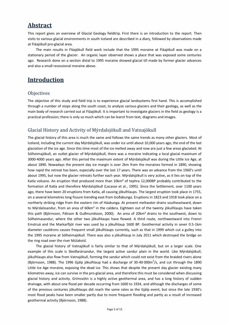
The next stop we made at Skeiðarársandur, where we were looking at the end moraine from Little Ice
Age maximum in 1890. The moraine was cross-bedded at the distal side due to fluvial sedimentation. The
proximal part was characterized by hummocky terrain and we could see an ice core in this part of the moraine.
Due to bad visibility we were not able to see clearly if the there was a fold in the core of the moraine but
according to figure 5, it looks like it is folded with an anticline in the middle. We also saw very big boulders (at
least 2m in diameter) that have most likely been dumped on the glacier while advancing. Because of this
dumped material and the folding we would describe the moraine as a combination of a push moraine and a
dump moraine.
The crust uplift is about 1 mm per year, hence the terraces created by the river digging down to the base
level. The area in front of the moraine was influenced by 1996 jökulhlaup, which eroded away older sediments
and led to new sedimentation with icebergs that caused the dead ice and hummocky surface. This jökulhlaup
was produced by an eruption of Gjálp, the peak discharge was 30-40 000 m3/s.
We also observed Kvíárjökull lateral moraine. The moraine is rather sizeable, the biggest lateral moraine in
Iceland. It is made of very coarse material. The glacier is very steep and could be categorized as an icefall,
coming down from the stratovolcano Öræfajökull, which can be easily eroded. The moraine could also be ice-
cored. It is possible that the glacier was on one place for a long period of time acting as a “conveyor belt”,
bringing the material slowly but constantly. It is also possible that it was made by many glacial advances; the
age of moraine is not well defined. We observed an abundance of glacial landforms such as eskers, kettle
holes, hummocky terrain and a pro-glacial lake. We saw active processes such as downwasting and
backwasting, as well as the main sedimentation process in dead ice environment, re-sedimentation. This was
very good example of glaciated valley landsystem.
Page 7 of 15
Figure 5: The Little Ice Age moraine at Skeidarárjökull, seen over the river Gígjukvísl as seen in field trip in May 2012. Photos: Einar Ragnar
We made a short stop at Jökulsárlón, which is a pro-glacial lake of Breiðamerkurjökull. It is also the
deepest lake in Iceland. Lastly we headed to the forefield of Fláajökull to observe the stations where we were
going to work in next three days.
Last day of excursion – 15/05/2012
Due to bad weather at Fláajökull the last day was changed to an excursion.
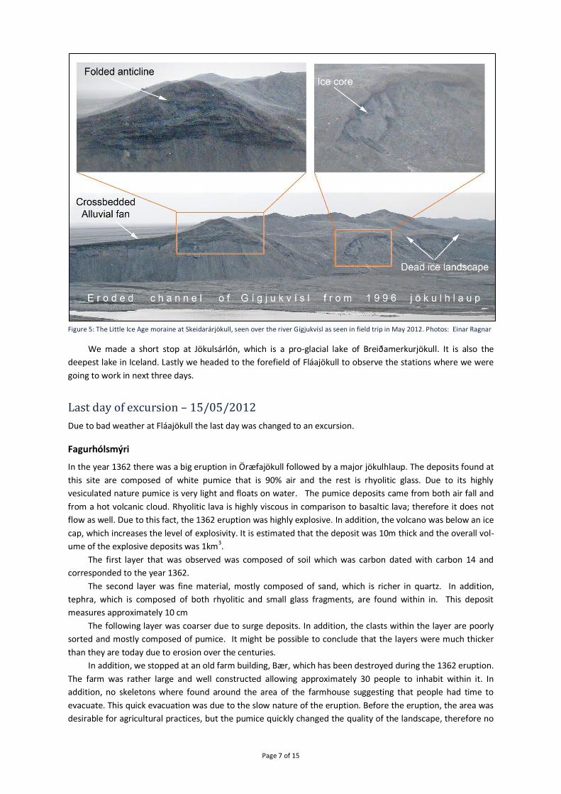
Fagurhólsmýri
In the year 1362 there was a big eruption in Öræfajökull followed by a major jökulhlaup. The deposits found at
this site are composed of white pumice that is 90% air and the rest is rhyolitic glass. Due to its highly
vesiculated nature pumice is very light and floats on water. The pumice deposits came from both air fall and
from a hot volcanic cloud. Rhyolitic lava is highly viscous in comparison to basaltic lava; therefore it does not
flow as well. Due to this fact, the 1362 eruption was highly explosive. In addition, the volcano was below an ice
cap, which increases the level of explosivity. It is estimated that the deposit was 10m thick and the overall vol-
ume of the explosive deposits was 1km3.
The first layer that was observed was composed of soil which was carbon dated with carbon 14 and
corresponded to the year 1362.
The second layer was fine material, mostly composed of sand, which is richer in quartz. In addition,
tephra, which is composed of both rhyolitic and small glass fragments, are found within in. This deposit
measures approximately 10 cm
The following layer was coarser due to surge deposits. In addition, the clasts within the layer are poorly
sorted and mostly composed of pumice. It might be possible to conclude that the layers were much thicker
than they are today due to erosion over the centuries.
In addition, we stopped at an old farm building, Bær, which has been destroyed during the 1362 eruption.
The farm was rather large and well constructed allowing approximately 30 people to inhabit within it. In
addition, no skeletons where found around the area of the farmhouse suggesting that people had time to
evacuate. This quick evacuation was due to the slow nature of the eruption. Before the eruption, the area was
desirable for agricultural practices, but the pumice quickly changed the quality of the landscape, therefore no

Page 8 of 15
agricultural activities have been carried since then. The cliffs around this area used to be sea cliffs. It is evident
that these cliffs where once sea cliffs due to the vast amounts of caves found within them.
Close to Bær we as well looked at a huge kettle hole in sediment area from the jökulhlaup from 1727
eruption in Öræfajökull. We estimated the diameter of that kettle hole to be at least 50m.
There was also a short stop at bridge over the river Hólmsá to look at 8.4 ka ash layers history. Most of
the ash layers were dark layers from Katla but there were also some white layers from Hekla.
Stokkalækur
The last stop was at Stokkalækur
(N63.81255 W20.09840) where an
area was formed during the
Younger-Dryas 11.8 ka BP. On the
place we looked at, the small river
Stokkalækur had eroded a channel
on an edge of lava making a very
good transection on the opposite
side of the river.
The transection at
Stokkalækur showed a layer of
diamict on the top. Under the
diamict was a thick unit of lami-
nated sediment layered in layers
that seemed to be couple of cm
thick. The layers were obviously
folded, showing a clear Anticline,
see fig. 8. Under the laminated unit
was a diamict forming a talus apron most likely lying on more sedimentary rock as were visible on some places
under the apron. In the laminated unit were several small stones one could describe as dropstones. At least in
one place we did see diamict under the lamination, see fig 7A.
Figure 7: (A) Diamict in transection under the laminated unit. (B) Dead ice landscape (hummocky and/or kettle holes) above the lavafield on the north-east of Stokkalækur. The photo is also showing a hill that could be a top of a moraine ridge. Photos: Einar Ragnar
Interpretation of Stokkalækur area
Since there was a diamict under the laminated unit, we assume that to be some kind of a glacial till, made by a
glacier advancing over the area some time during Weichsel glaciation. The laminated unit cannot be made by
advancing glacier but looked more like lacustrine sediment. Since there were pebbles in the lamina we expect
the lake to be a glacial lake with melting icebergs transporting the pebbles. Since the laminated unit is clearly
folded we expect it could be folded due to an advancing ice advancing over the lake. The ridge on the south-
west side of Stokkalækur (see figure 7B) could be a moraine related to that glacier advance and also the dead
ice landscape on the north-east side of Stokkalækur. One could describe the whole area as a larger version of
the 1995 moraine of Skeiðarárjökull, see figure 5. Later on we saw (several km south of Stokkalækur)
laminated surface without folding, similar to what was on distal side of the Skeiðarárjökull 1995 moraine.
Figure 6: Stokkalækur area, Google map image

Page 9 of 15
Perhaps the main difference is that the anticline was clearer at Stokkalækur and also we did not see any huge
boulders as we saw at the Skeiðarárjökull moraine but that is explainable with the difference of advancing
icestream of Weichslen from Younger-Dryas and an advancing outlet glacier from Holocene as Skeiðarárjökull
is. So this moraine is more clear push moraine since we did not see any signs of dumped material (huge
boulders) as expected on a dump moraine.
The above interpretation is in
accordance with research of Geirsdóttir
et al (2000), showing part of the Búði-
Moraine at Stokkalækur as well as the
sea level. But Búði morainal complex is
assumed to be the end moraines from
the glacial maximum at Younger-Dryas
period. Note the NE-SW direction of
glacial flow at Stokkalækur (see figure 9),
perpendicular to the direction of moraine
observed at Stokkalækur.
Figure 8 (left): Transection at Stokkalækur. Photos: Einar Ragnar
Figure 9 (below): Location of Budi-moraine and Stokkalækur Dark arrows showing ice flow direction. Based in a map from Geirsdóttir, Harðardóttir & Sveinbjörnsdóttir (2000).

Page 10 of 15
Observations and Fieldwork Field work was done on 14th of May. The weather conditions were bad. Heavy wind was in the area and the air
full of sediment transported by the wind. Because of bad weather we were only able to work for one day in
the field and even not finish the work at the two stations that was planned for that day.
Station 8 – Glacial landsystem
Figure 10: Satellite image of the proglacial area of Fláajökull from year 2010. The red line shows the transection for station 8. The mark for P11 is the location of the 1995 end moraine on the section. Station 1 is also shown and the location of the moraine on top of it as well as the moraine leading from that station – measured with GPS. The scale is made roughly from handheld Garmin GPS60 equipment and is for indication only. The length of transect is close to 1200m.
Figure 11: Shows an altitude transaction of the route travelled for station 8. The annotations describe what landforms existed at each point. Altitude is for indication only since it was taken with handheld Garmin GPS60 not accurate enough to be reliable for altitude. Accu-racy is not assumed to be more than +/- 5m. That could be the reason for highest altitude in 18
th point (GPS39).
40
45
50
55
60
65
70
75
80
0 200 400 600 800 1000 1200 1400
Alt
itu
de
[m]
Distance [m]
P.2: Organic material
P.3: Hummocky terrain cut by a rive channel
P.4&5&6: Annual moraines
P.7: River channel
P.16: Old riover channel, no fine particles
P.20: Fairly large moraine
P.17: sorted material due to frostlifting
P.19: River channel
GPS21
GPS23 GPS26
GPS28
GPS30
GPS32
GPS34
GPS33
GPS37
GPS38
GPS39
GPS40
GPS41
P.11: 1995 moraine
P.10 : Hummocky are on proximal siede of 1995 moraine
P.12: Small moraineridge on the distal part of 1995 moraine
P.13 to 15: River channel. Diamict in cross section.Channel the same as station 1
Page 11 of 15
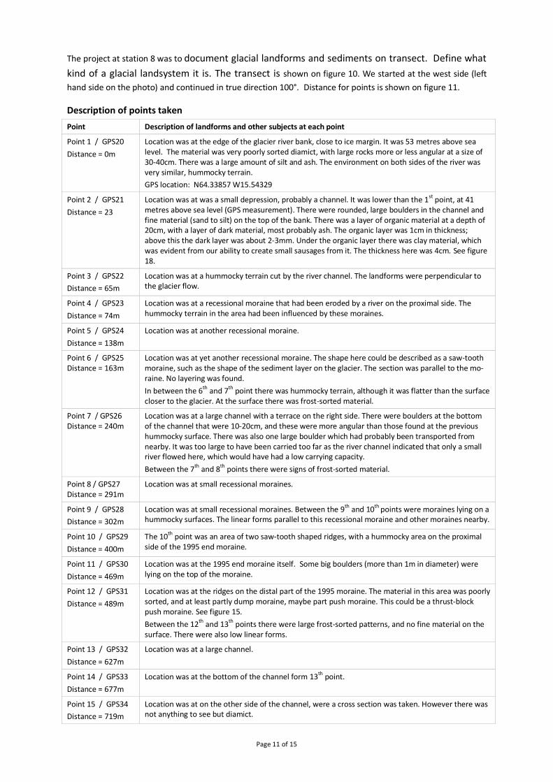
The project at station 8 was to document glacial landforms and sediments on transect. Define what
kind of a glacial landsystem it is. The transect is shown on figure 10. We started at the west side (left
hand side on the photo) and continued in true direction 100°. Distance for points is shown on figure 11.
Description of points taken
Point Description of landforms and other subjects at each point
Point 1 / GPS20
Distance = 0m
Location was at the edge of the glacier river bank, close to ice margin. It was 53 metres above sea level. The material was very poorly sorted diamict, with large rocks more or less angular at a size of 30-40cm. There was a large amount of silt and ash. The environment on both sides of the river was very similar, hummocky terrain.
GPS location: N64.33857 W15.54329
Point 2 / GPS21
Distance = 23
Location was at was a small depression, probably a channel. It was lower than the 1st
point, at 41 metres above sea level (GPS measurement). There were rounded, large boulders in the channel and fine material (sand to silt) on the top of the bank. There was a layer of organic material at a depth of 20cm, with a layer of dark material, most probably ash. The organic layer was 1cm in thickness; above this the dark layer was about 2-3mm. Under the organic layer there was clay material, which was evident from our ability to create small sausages from it. The thickness here was 4cm. See figure 18.
Point 3 / GPS22
Distance = 65m
Location was at a hummocky terrain cut by the river channel. The landforms were perpendicular to the glacier flow.
Point 4 / GPS23
Distance = 74m
Location was at a recessional moraine that had been eroded by a river on the proximal side. The hummocky terrain in the area had been influenced by these moraines.
Point 5 / GPS24
Distance = 138m
Location was at another recessional moraine.
Point 6 / GPS25 Distance = 163m
Location was at yet another recessional moraine. The shape here could be described as a saw-tooth moraine, such as the shape of the sediment layer on the glacier. The section was parallel to the mo-raine. No layering was found.
In between the 6th and 7th point there was hummocky terrain, although it was flatter than the surface closer to the glacier. At the surface there was frost-sorted material.
Point 7 / GPS26 Distance = 240m
Location was at a large channel with a terrace on the right side. There were boulders at the bottom of the channel that were 10-20cm, and these were more angular than those found at the previous hummocky surface. There was also one large boulder which had probably been transported from nearby. It was too large to have been carried too far as the river channel indicated that only a small river flowed here, which would have had a low carrying capacity.
Between the 7th and 8th points there were signs of frost-sorted material.
Point 8 / GPS27 Distance = 291m
Location was at small recessional moraines.
Point 9 / GPS28
Distance = 302m
Location was at small recessional moraines. Between the 9th and 10th points were moraines lying on a hummocky surfaces. The linear forms parallel to this recessional moraine and other moraines nearby.
Point 10 / GPS29
Distance = 400m
The 10th point was an area of two saw-tooth shaped ridges, with a hummocky area on the proximal side of the 1995 end moraine.
Point 11 / GPS30
Distance = 469m
Location was at the 1995 end moraine itself. Some big boulders (more than 1m in diameter) were lying on the top of the moraine.
Point 12 / GPS31
Distance = 489m
Location was at the ridges on the distal part of the 1995 moraine. The material in this area was poorly sorted, and at least partly dump moraine, maybe part push moraine. This could be a thrust-block push moraine. See figure 15.
Between the 12th and 13th points there were large frost-sorted patterns, and no fine material on the surface. There were also low linear forms.
Point 13 / GPS32
Distance = 627m
Location was at a large channel.
Point 14 / GPS33
Distance = 677m
Location was at the bottom of the channel form 13th point.
Point 15 / GPS34
Distance = 719m
Location was at on the other side of the channel, were a cross section was taken. However there was not anything to see but diamict.

Page 12 of 15
Point Description of landforms and other subjects at each point
Point 16 / GPS37
Distance = 799m
Location was at an old river channel; there were no fine material as they had probably been washed away in the past.
Point 17 / GPS38
Distance = 969m
Between the 16th and 17th points there were large lichens, up to 16cm in diameter. These are noteworthy as they indicated that ice had not been in this area for a long time.
Point 18 / GPS39
Distance = 1076m
Location was at a channel on the flat plain, while the 19th point was on the other side of the channel.
Point 19 / GPS 40
Distance = 1173m
River channel
Point 20 / GPS41
Distance = 1232m
Location was at a fairly large moraine between Fláajökull and what looks like a glacier that may have previously been flowing from the adjacent valley. According to satellite image (Fig. 10) this was not the case but the moraine was one of the recessional moraines from the retreat after little ice age. Moraine was in hummocky area.
GPS location: N64.33664 W15.51873
Station 1 - Glacial stratigraphy and history
The project on station 1 was to describe and interpret sediments in a section in a vertical sediment log
reconstruct the recent glacial history and the relative sequence of events. The location of the station is shown
on figure 10.
Description of the log
Figure 12: Log of profile in station 1. Due to the bad weather conditions we were not able to define any units properly in the sectio n, so they are not marked in the log. Photo on the right hand side of the log shows the upper part of the section. Photo: Lenka Vejrostová
The first layer that was observed was 10 cm and didn’t contain
much silt or gravel. In this layer roots were found and there was
some moss above the layer. The second layer was coarser than
the previous one. The clasts were sub-angular to sub-rounded.
More silt could be found at the bottom of this layer. A 42 cm
thick lens was found at a depth of 170 cm, see figure 13. This
lens contained coarser material and the clasts were well-
rounded to rounded. Above the lens the material was diamict
with sand to silt as a groundmass. On the other hand, the mate-
rial under the lens contained more silt. At depth of 4 m there
was a fine layer that was composed mostly of silt and some
clay. The layer was wet at the bottom. At depth of 6 m there
was also a finer material in the groundmass, mostly silt and
0m
1m
2m
3m
4m
5m
6m
Diamict
Clay Silt
Sand
cmf
Gra
vel
Dia
mic
t
cf
Boulders
Dmm
Lens of boulders at 170cm depth, thickness of lens 42cmSee figure 13
Groundmass in diamict fining downward.Grainsize in groundmass: silt
Diamict looked coarse grained with very little siltDiamict, massive and matrix supported
At 4m, finer material in groundmass of diamictWater in the groundmass.Grain size of groundmass: silt to clay
At 6m, much water in the material, Groundmass almost mud with bigger clast, still diamict
Organic structure
Clast subangular to subrounded
Organic layer 0-10cm
Figure 13: Lens of boulders at 170cm depth. Photo: Lenka Verirostová

Page 13 of 15
some clay. This layer was wetter than the previously examined wet layer. No exact grain analysis was done but
all material is assumed to be diamict.
There was clear evidence of a recessional moraine corresponding with the current day end of the glacier.
What’s more, this moraine is similar to the end of the glacier from 1995. The distance of this observed moraine
from the 1995 moraine is approximately 250-300m, see figure 10.
Fabric measurements of station 1
We tried to measure the fabric in the section, approximately 1,5m below the
surface. Due to difficult weather conditions we were only able to measure fabric
of 10 clasts so it is not statistically reliable. The trend directions have been
corrected due to magnetic declination.
The rose diagram and scatter are shown on figure 14 and as one can easily
see that the trend direction is too distributed and we assume that to be because of
too few measurements. It is necessary to have 25 clasts to have statistically
reliable fabric measurement.
Results and Concluding Remarks
Station 8– Glacial landsystem
From a satellite image, see figure 10 it’s quite easy to see a drumlin forms distributed in front of the glacier
and the section is over one of them. Anyhow we were not able identify them when we were there, but since
they are quite obvious from the satellite image we would describe the first part of the section as a small
drumlin field in the foreland of a retreating glacier.
On the way to the 1995 moraine there were plenty of recessional moraines that should all have been
formed from 1995 to 2012. Since we did not find a moraine for each year we cannot describe them as annual
moraines. The surface was all more or less hummocky type and some eroded channels were as well in the
area. That should be due to dead ice buried under supraglacial sediment. The slope was upwards in direction
to the 1995 moraine. As a description of landsystem it could be described as a proximal side hummocky area
of an end moraine.
Since some big boulders were lying on top of the moraine it could be described as a dump moraine and
the big boulders were dumped material. If we look at information about the rate of glacier retreat and rate of
the advance (figure 3) it should be clear that the glacier was not advancing to the position of 1995 moraine
since it was retreating to that position from the Little Ice Age maximum and relatively stable in the 1995
position for approximately 3 decades. At that time the glacier was most likely working as a “conveyor belt”
and bringing more material to the moraine. That should also mean the moraine could be classified as a dump
moraine since the glacier was bringing material to the moraine supraglacial but also a thrust moraine because
the glacier was likely thrusting subglacial material from below the glacial snout.
We were not able to look at any proper transection of the moraine but on the distal side of it were some
small limited ridges (see figure 16). Those ridges could be explained as a result of distal thrusting as shown on
Figure 16: Some small bulges or limited ridges on the distal part of the 1995 end moraine. Photo: Einar Ragnar
Figure 14 Measurement of fabric
Figure 15: Description of how distal thrusting can be made from enhanced loading and continued advance (Bennett 2001).

Page 14 of 15
figure 15. They could also be described
as a result of a small advance in year
1968 (40m) see figure 3 that was few
years before the glacier was more
stable in the 1995 position. Most likely
the glacier has been advancing for few
metres each winter and retreating
again next summer (on the period
when the glacier was more stationary
in 1995 moraine position) leading to stacking of annual/seasonal moraines as shown on figure 17. According to
Benn and Evans (2010) the 1995 moraine is a “composite push moraine, comprising several stacked till layers”.
Since those considerations are mostly made on investigation of data of other source it would be interesting to
be able to do more research on the 1995 moraine before making any serious assumptions about the origin of
those distal ridges.
Further on, east of the 1995 end moraine we identified some channels and fluvial planes and some larger
moraines of unknown age but most likely from the retreating period after Little Ice Age in the 20th century.
The landsystem would be described as glacial fluvial area with some recessional moraines.
In the end of the transection we recognized a rather large recessional moraine. If looking at the position
of glacier snout (figure 3) it is clear that the glacier was advancing and retreating again in years 1956 to 1959
and the position of the glacier at that time was 900m from the present position. Also there was a stationary
time period around 1950 in more distant position. Our transection line was about 1200m. The moraine we
found there could be from that time but we don’t have information about the exact position of measurement
line from the glacial measurements.
We found several ridges that could have been flutes but since they looked rather irregular we did not
figure out their orientation with a compass so we cannot decide if they were flutes or not. Next time we would
measure direction of all landforms we want to describe.
Analysis of organic material 450 m behind (proximal) the 1995 end moraine
The location of the place the organic material (figure 18) found was 23m from the beginning of the section and
about 150 m from the present position of the glacier. It was under approximately 30cm thick layer of diamict –
glacial till, most likely lodgment till. The place is about 450m from the 1995 moraine.
Perhaps the most interesting
question here is when that layer was
formed and most likely there was an
eruption somewhere not far away while
the place was not covered by a glacier
during a warm period. The argument
could be if it was from the time after
Little Ice Age (after that area was de-
glaciated) and before it was glaciated
again.
According to the retreating history
of the glacier (figure 3) and the lateral
position of the layer (proximal to the
1995 moraine) it is clear that the area
have not until now been exposed since
the time before the little ice age. So we
are looking at eruptions from some centuries ago. The volcanoes that come to mind are Grímsvötn and Katla.
According to Guðmundsson (2005) and Thordarson&Hoskuldsson (2002) the eruptions in Katla from year 1625
and 1755 can come into consideration. They both had much ash fall in direction of Fláajökull. But the ash
layers could as well be from Grímsvötn or even older eruptions in Katla.
Figure 18: The organic layer and ash layer in station 8, located 450 metres behind (proximal) the 1995 end moraine. Photo: Einar Ragnar
Figure 17 Moraines formed by winter advances and summer retreat (Krüger 1994).

Page 15 of 15
If looking at the layers (figure 18) one could describe the area from that time as there have been a lake
there making the rather fine material (not diamict) lying under the ash layer. Then there was an eruption
(possibly Katla 1625 or 1755) and after that the area was drying up and some plants were growing, forming the
organic layer. Later on the glacier came advancing over the place during little ice age.
Station 1 - Glacial stratigraphy and history
Due to bad weather condition we were not able to finish the analysis on station 1. We had to finish the work
in the middle of fabric clast measurements and we only have the brief description of facies as is in the chapter
for Observations and Fieldwork. The sediment is all diamict and it was fining downward. Close to the surface
was sand grain size most common but in the lowest part it was more silt or even clay grain size.
Looking at the area behind and above the section it was easy to find a small moraine ridge and follow
that ridge in a line approximately parallel to the end of the glacier. From a GPS track of the ridge it was also
easy to find most likely two parallel ridges on a satellite photo, see figure 10.
Since we were not able to make any fabric or clast analysis we can only make rather raw suggestion
about the recent glacial history and the relative sequence of events. But from the visible small moraine above
the station that was more or less parallel to the end of the glacier it is most likely a recessional moraine from
the glacier retreat after 1995. The finer grained material is a glacial till but it is very difficult to guess if it is
more likely lodgment till, flow till or melt out till since we don’t have any data of important factors such as
fabric, angularity/roundness and sphericity.
The water in the lower part of the section is most likely due to impermeable layer under the soaking
material. The impermeable layer is most likely due to frozen water and if that is true, then the area is still with
dead ice.
To describe glaciological events, then the till in the lower area of the section has been made with former
glacial advances from little ice age, the late 20th century advance as well as former advances on Holocene
colder periods as well as Weichselian advances. The ridge on top of that is most likely a recessional moraine
from a winter advance. That has most likely happened during the glacial retreat after the end of the Little Ice
Age but many years before the beginning of the glacier advance that made 1995 end moraine.
References Benn, D.I & Evans, D.J.A. (2010). Glacier & Glaciation. United Kingdom. Hodder Education.
Bennett, R. M. (2001). The morphology, structural evolution and significance of push moraines. Earth-Science Reviews (53), 197–236.
Björnsson, H. (1998). Hydrology of Ice Caps in Volcanic Regions, Visindafélag ĺslendinga, Societas Scientarium Islandica Rit. XLV, 139pp.
Björnsson, H. Pálsson, F and Guðmundsson, T., M. (n.d.) Surface and bedrock topography of the Mýrdalsjökull ice cap, Iceland: The Katla caldera, eruption sites and route of jökulhlaups. Jökull No. 49, 29-49.
Chenet, M., Roussel, E., Jomelli, V., and Grancher, D. (2010). Asynchronous Little Ice Age glacial maximum extent in southeast Iceland. Geomorphology 114, 253-260Dąbski, M. (2010) A commentary to ‘Asynchronous Little Ice Age glacial maximum extent in southeast Iceland’ by Chenet et al.; a case of Fláajökull. Geomorphology 120, 365-367.
Fláajökull er hættur að hopa (2001, 18th of November). Morgunblaðið.
Geirsdóttir, Á., Harðardóttir, J & Sveinbjörnsdóttir, Á.E. (2000). Glacial extent and catastrophic meltwater events during the deglatiation og Southern Iceland. Quaternary Science Reviews 19 (2000), 1749-1761.
Guðmundsson, A. T. (2005). Íslenskar eldstöðvar. Reykjavík: Vaka Helgafell
Krüger, J. (1994) Glacial Processes, Sediments, Landforms, and Stratigraphy in the Terminus Region of Mýrdalsjökull, Iceland.
Lacasse, C., H. Sigurdsson, H. Jóhannesson, M. Paterne and S. Carey (1995) Source of Ash Zone 1 in the North Atlantic. Bull. Volcanol. 57, 18-32.
McKinzey, K.M., Ólafsdóttir, R. and Dugmore, A.J. (2005) Perception, history and science: coherence or disparity in the timing of the Little Ice Age maximum in southeast Iceland? Polar Record 41, 319-334.
Sigurðsson, O. (2011). Jöklabreytingar 1930-1970, 1970-1995, 1995-2009 og 2009-2010. Jökull 61, 87-92.
Thordarson, T. & Hoskuldsson, A. (2002). Iceland – Classical geology in Europe 3. Hertfordshire: Terra Publishing.


![Remarks on features Sigurðsson, Halldor Armann · Remarks on features [final version] Halldór Ármann Sigurðsson ... interpretable to both the interfaces, that is, semantic form](https://img.pdfslide.us/doc/110x75/5f0c77f77e708231d4358e21/remarks-on-features-sigursson-halldor-armann-remarks-on-features-final-version.jpg)