Embed Size (px)
Citation preview
Five Case Studies on the Effects of the SWANCC and Rapanos Supreme Court Rulings on Colorado Wetlands
and Streams
Author: Dennis Buechler February 2010

Colorado Case Studies
Page 2 of 32
Table of Contents Table of Contents ............................................................................................................ 2 Introduction ..................................................................................................................... 3 Fen Site, Fairplay, Colorado ............................................................................................ 5 Hidden Lake and Associated Wetlands, Westminster, Colorado .................................... 9 Playa Wetland, Washington County, Colorado ............................................................. 15 Little Dry Creek, Broomfield County, Colorado .............................................................. 19 Black Shack Creek, Aurora, Colorado ........................................................................... 23 References .................................................................................................................... 31

Colorado Case Studies
Page 3 of 32
Introduction In July 2009, the National Wildlife Federation, Ducks Unlimited, and Trout Unlimited awarded a grant to the author of this report to conduct research and field investigations on cases involving wetlands and streams in Colorado. The Turner Foundation was the original generous donor. The focus was on waters where the U.S. Army Corps of Engineers declared such waters to be non-jurisdictional for regulatory purposes under the Clean Water Act. The
from the dumping of pollutants, including dredged and fill material, without a permit protecting water quality. The Corps, with oversight from EPA, is responsible for administering the permit program (Section 404 of the Act) and regulating discharge of dredged and fill material into wetlands, streams, rivers, and other waters.
Court decisions in Solid Waste Agency of Northern Cook County (SWANCC) v. U.S. Army Corps of Engineers in 2001 and Rapanos v. United States in 2006, both of which cast doubt over the scope of waters protected by the Act, and the subsequent issuance of related agency policies and regulations. The result was the effective removal of regulatory oversight and protection of the fish and wildlife habitat and other important functions on 20 million acres of so-called geographically isolated wetlands in the lower 48 states.
benefits to more than 75% of the wildlife species in the state (Sullivan, 2008). Of the approximately 483 vertebrates that occur in Colorado, 125 (26%) depend on wetlands for some portion of their life cycle. About 78% of these are migratory birds (e.g., waterfowl) (Chappell, 2000). A significant 48% of the Colorado Division of Wildlife Tier 1 vertebrate species depend on wetland and aquatic habitats. Those species are described in their 2006 State Wildlife Action Plan as Species of Greatest Conservation Need. (CNHP and TNC, 2009). Colorado lost 50% of its wetland1991). SWANCC and Rapanos wetlands. For instance, as a result of these two cases and ensuing agency directives, Colorado has seen a major loss of protection of the playa wetlands once found in abundance in northeastern Colorado. These vital wetlands, many of which are geographically isolated
shorebirds and songbirds. They also provide important sources of species biodiversity in the grasslands and agricultural grounds in the semi-arid plains of the state, and they recharge groundwater aquifers and provide water and forage for livestock and many species of wildlife. Additionally, countless miles of streams have also been placed at risk. EPA estimates
Colorado Case Studies
Page 4 of 32
Act protections because they only flow intermittently or ephemerally. Approximately one-third of the population of the country depends in part on these streams for their drinking water supply. In Colorado, over 3.7 million people receive their drinking water from public drinking water supplies that rely in whole or in part on intermittent, ephemeral, or headwater streams at risk of losing CWA protections in the wake of the SWANCC and Rapanos Supreme Court decisions (USEPA, 2009). In Adams, Arapahoe, Broomfield, and Park Counties alone where these case studies are situated, over 725,000 Coloradans receive their drinking water from public drinking water supplies that rely on these smaller at risk streams. In those counties, 40-60% of the stream miles feeding these drinking water supplies are at risk of losing Clean Water Act protections from pollution (USEPA, 2009). Colorado has 95,537 miles of streams and rivers (WQCD), and only about 28,000 miles, less than 30%, of them flow perennially (CWCB). Many of the functions performed by so-called isolated wetlands are also performed by ephemeral and intermittent streams. Like geographically isolated wetlands, these water bodies provide islands of moisture in dry uplands, creating habitat for plant and animal species, and providing critical corridors between otherwise geographically isolated wetlands. Ephemeral and intermittent streams are vital for wildlife in Colorado as is the case in the semi-arid landscapes of the eastern plains in Montana (Vance, 2009). Furthermore, headwater streams, which are especially at risk, support nearly all cutthroat trout (Nickum, TU, 2009). Those populations already have been seriously affected by non-native fish and habitat loss.
We all live downstream. Watersheds are connected systems, and if degradation of wetlands and discharge of pollutants and fill material are allowed in headwater areas, those impacts will over time migrate downstream to mainstream reaches and effect drinking water as well as fish and wildlife habitat. Climate change and the stresses it will bring to our aquatic ecosystems with increased temperatures, more severe storms and droughts, decrease in and rapid melting of snow pack, and myriad disruptions will make the flood storage, recharge, cooling and other functions of headwaters and geographically isolated waters crucial to how well species and communities are able to adapt. Thus, it is vital to protect these vulnerable and invaluable habitats. This report describes just a few examples of the many cases where wetlands and streams in Colorado were left without protection as a result of the Supreme Court cases and the ensuing regulatory confusion. During his career in the U.S. Fish & Wildlife Service, and since he retired, the author has worked cooperatively with the wetland
regulatory offices of the Corps and EPA that have purview over the locations used as examples in this report. His experience has
been that they typically conduct themselves in a professional, conscientious and diligent manner with regard to their responsibilities
under Section 404 of the Clean Water Act. Therefore, this report is not intended as a critique of their efforts but rather provides
examples of the regulatory jurisdictional confusion and potential resource losses resulting from the Supreme Court decisions
described above.
Colorado Case Studies
Page 5 of 32
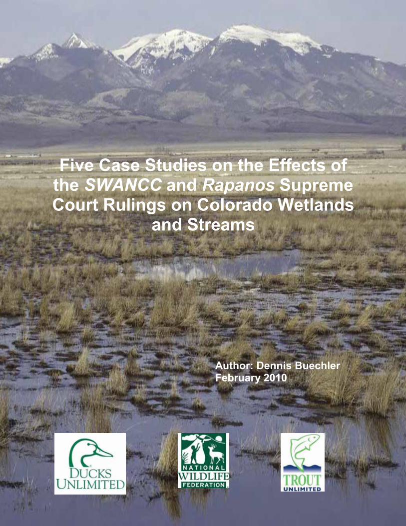
Fen Site, Fairplay, Colorado The author inspected this site on August 17, 2009. It is located in Park County about 6 miles northwest of Fairplay, CO. The Corps jurisdictional form (NOW-2008-2554-DEN) notes thpeat fen wetland (12
One of the Fish and
priorities in Region 6 (the Mountain-Prairie Region) is the protection and conservation of fens (USFWS, 1999). Fens are wetlands that are primarily made up of organic soil material (i.e., peat or muck) and are ground water driven. Organic soils are formed by slow accumulation of plant debris in waterlogged situations where growth exceeds decomposition and decomposition progresses very slowly. Fens in the Rocky Mountains have particularly slow decomposition rates because of the cold climate. Many of the fens of Colorado are over 10,000 years old with organic soil accumulation rates ranging from 4.3 to 16.2 inches per thousand years. Therefore, onsite or in-kind replacement of peat wetlands is not thought to be possible. Furthermore, at present there are no known reliable methods to create a new fully functional fen or to restore a severely degraded fen. In Colorado, the conditions required for formation of peat are restricted to alpine, subalpine and upper montane regions (Cooper, 1990). It is estimated that wetlands
peatlands. Although fens only occupy a minor portion of the landscape, they perform important hydrological, and water quality functions. For example, rare native cutthroat trout often benefit from the water cleansing action of fens in headwaters of streams. They also possess unique plant species assemblages, especially fens that are high in pH and calcium. Subalpine peatlands dominated by willows (carrs) are much more heavily used by breeding birds relative to the surrounding upland habitats (Stevens, 1990). In Colorado, white-tailed ptarmigans are dependent on willow-dominated peatlands as a food source (Braun et al., 1976). Subalpine fens have been designated an Aquatic Resource of National Importance (http://www.epa.gov/owow/wetlands/pdf/404q.pdf) because of their rarity, uniqueness,
Threats to Colorado peatlands include peat mining, ski and real estate development projects (see map of subdivision),

Colorado Case Studies
Page 6 of 32
designates the location of the fen, which was labeled on a National Wetland Inventory map as a palustrine scrub-shrub saturated wetland. The Forest Service soils map for the area identifies the soils as being a cyrofluvent-cryaquolls-histosols complex.
The Corps decided it was a non-jurisdictional isolated wetland because it is about 18,000 feet upgradient from the Middle South Platte River, which is the nearest Relatively Permanent Water (RPW), or the closest jurisdictional water according to the Corps. The fen site is flagged on the topo map.

Colorado Case Studies
Page 7 of 32
The ordinary high water mark (OHWM) dissipates, turns into an upland swale, and is disconnected from the Middle Fork South Platte River by approximately 2,750 feet of upland. At approximately 550 feet from Middle South Platte River, the swale is intercepted by an abandoned irrigation ditch that terminates at County Road 14. Thus, the Corps determined that this unnamed drainage and wetland do not have a significant
-jurisdictional. However, Region 8 of EPA noted on the Corps forum:
This upland swale area is considered an outwash terrace, with well drained outwash parent material (NRCS Web Soil Survey), thus it is likely that surface water has only been conveyed across this terrace historically during infrequent high flow events. Evidence of these surface hydrologic flow paths is distinguishable in aerial images of the area; however, these flow paths do not exhibit continuous OHWM features. A culvert bisects the abandoned ditch that crosses this outwash terrace and swales are visible both upstream and downstream of this culvert indicating that historically, waters in the ditch and/or upland swales were sufficient enough to pass through the culvert and reach the Middle Fork. There was no evidence of recent ponding upstream of the culvert, and it is possible that flows through the culvert only occurred historically while the ditch was in operation.
Thus, although the upland swale/outwash terrace area does not exhibit a continuous OHWM, there is a discernable but diffuse historical surface hydrologic pathway. Additionally, it is likely that surface flows from the upstream drainage infiltrate into the well-drained soils at the upstream end of the outwash terrace/upland swale and movement of this water to the Middle Fork South Platte River occurs via shallow sub-surface flow paths. Although historical flow paths are evident and subsurface flows are likely reaching the Middle Fork South Platte, the hydrologic/physical connection is not substantial enough to create a
As Kennedy stated in the Rapanos/Carabell decision,
e wetlands play in pollutant filtering, flood control, and runoff storage, it may well be the absence of a hydrologic connection (in the sense of interchange of waters) that shows the
capacity of the peat soils within the 12-acre fen, as well as the wetland features downstream,
Colorado Case Studies
Page 8 of 32
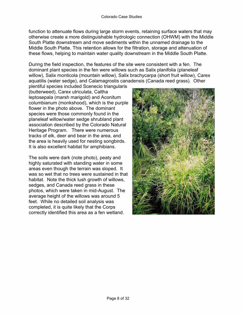
function to attenuate flows during large storm events, retaining surface waters that may otherwise create a more distinguishable hydrologic connection (OHWM) with the Middle South Platte downstream and move sediments within the unnamed drainage to the Middle South Platte. This retention allows for the filtration, storage and attenuation of these flows, helping to maintain water quality downstream in the Middle South Platte. During the field inspection, the features of the site were consistent with a fen. The dominant plant species in the fen were willows such as Salix planifolia (planeleaf willow), Salix monticola (mountain willow), Salix brachycarpa (short fruit willow), Carex aquatilis (water sedge), and Calamagrostis canadensis (Canada reed grass). Other plentiful species included Scenecio triangularis (butterweed), Carex utriculata, Caltha leptosepala (marsh marigold) and Aconitum columbianum (monkshood), which is the purple flower in the photo above. The dominant species were those commonly found in the planeleaf willow/water sedge shrubland plant association described by the Colorado Natural Heritage Program. There were numerous tracks of elk, deer and bear in the area, and the area is heavily used for nesting songbirds. It is also excellent habitat for amphibians. The soils were dark (note photo), peaty and highly saturated with standing water in some areas even though the terrain was sloped. It was so wet that no trees were sustained in that habitat. Note the thick lush growth of willows, sedges, and Canada reed grass in these photos, which were taken in mid-August. The average height of the willows was around 5 feet. While no detailed soil analysis was completed, it is quite likely that the Corps correctly identified this area as a fen wetland.

Colorado Case Studies
Page 9 of 32
Hidden Lake and Associated Wetlands, Westminster, Colorado This case is an excellent example of the confusion caused by the Supreme Court cases described in the introduction because the Corps changed its position on jurisdictional calls at least twice, thus affecting the protection of these important aquatic resources.
Hidden Lake is 88 acres in size and is located near the intersection of 69th Avenue and Sheridan Boulevard. It is beautiful, has swimmable water quality, and is a valuable and highly utilized recreational resource. It is surrounded for the most part by residential neighborhoods. There are wetlands adjacent to the western shore, and there is a public park on one portion the lake edge. The fishing is restricted to use by local residents, but they often bring guests to fish, including friends and family from out of state.
Colorado Case Studies
Page 10 of 32
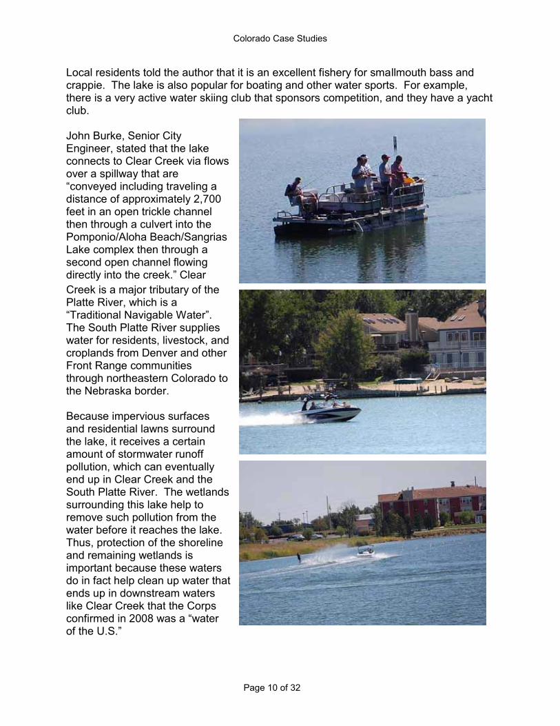
Local residents told the author that it is an excellent fishery for smallmouth bass and crappie. The lake is also popular for boating and other water sports. For example, there is a very active water skiing club that sponsors competition, and they have a yacht club. John Burke, Senior City Engineer, stated that the lake connects to Clear Creek via flows over a spillway that are
distance of approximately 2,700 feet in an open trickle channel then through a culvert into the Pomponio/Aloha Beach/Sangrias Lake complex then through a second open channel flowing
Creek is a major tributary of the Platte River, which is a
The South Platte River supplies water for residents, livestock, and croplands from Denver and other Front Range communities through northeastern Colorado to the Nebraska border. Because impervious surfaces and residential lawns surround the lake, it receives a certain amount of stormwater runoff pollution, which can eventually end up in Clear Creek and the South Platte River. The wetlands surrounding this lake help to remove such pollution from the water before it reaches the lake. Thus, protection of the shoreline and remaining wetlands is important because these waters do in fact help clean up water that ends up in downstream waters like Clear Creek that the Corps

Colorado Case Studies
Page 11 of 32
However, on May 1, 2002, the Corps determined that the Clean Water Act did not protect the lake and its wetlands. It is almost certain that prior to the Supreme Court decisions the Corps would have taken jurisdiction in this area because the Corps noted that migratory birds use the area. It is also worth noting that the lake is both navigable by watercraft and is used for recreational purposes by out-of-state travelers.
Lake. Hidden Lake outlet goes underground. Hidden Lake is neither adjacent to nor ded this was a
geographically isolated wetland and non-jurisdictional. Picture on right: unnamed wetland drainage as it appeared in 2009. Picture on right shows flows from the wetlands in the above photo to the lake taken in May of 2005, but nothing was changed when observed in 2009.
Colorado Case Studies
Page 12 of 32
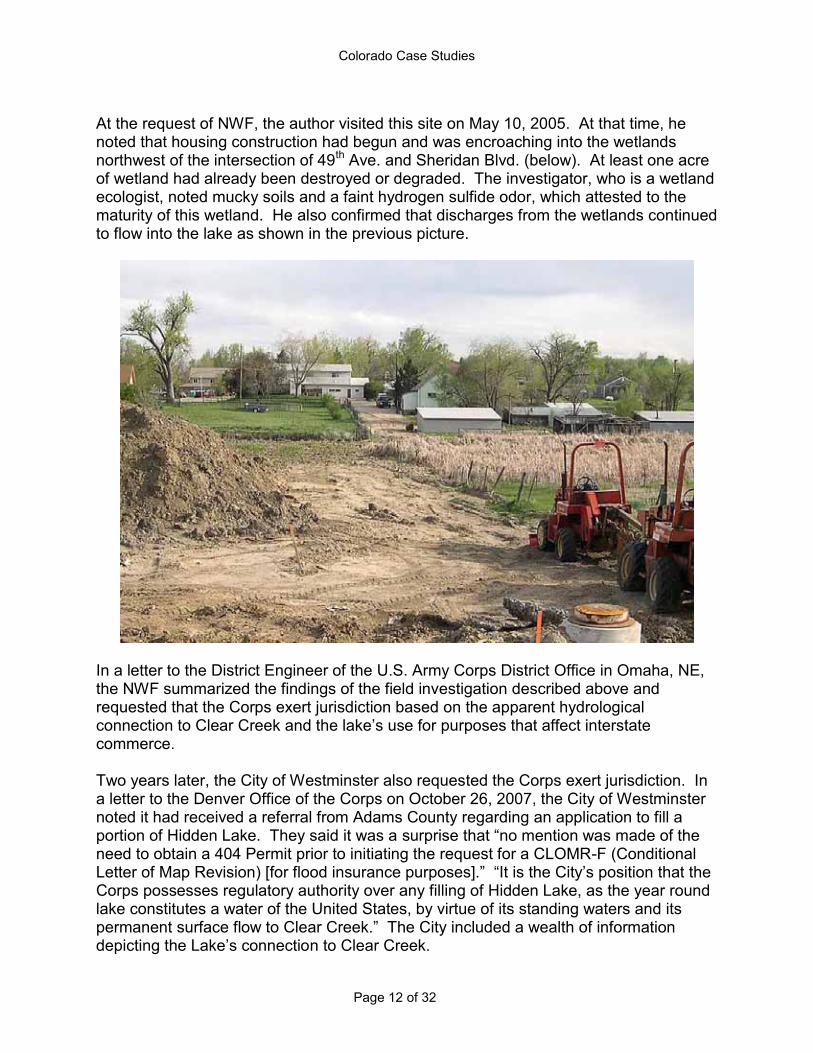
At the request of NWF, the author visited this site on May 10, 2005. At that time, he noted that housing construction had begun and was encroaching into the wetlands northwest of the intersection of 49th Ave. and Sheridan Blvd. (below). At least one acre of wetland had already been destroyed or degraded. The investigator, who is a wetland ecologist, noted mucky soils and a faint hydrogen sulfide odor, which attested to the maturity of this wetland. He also confirmed that discharges from the wetlands continued to flow into the lake as shown in the previous picture.
In a letter to the District Engineer of the U.S. Army Corps District Office in Omaha, NE, the NWF summarized the findings of the field investigation described above and requested that the Corps exert jurisdiction based on the apparent hydrological
commerce. Two years later, the City of Westminster also requested the Corps exert jurisdiction. In a letter to the Denver Office of the Corps on October 26, 2007, the City of Westminster noted it had received a referral from Adams County regarding an application to fill a portion of Hidden Lake. They said it was a need to obtain a 404 Permit prior to initiating the request for a CLOMR-F (Conditional
Corps possesses regulatory authority over any filling of Hidden Lake, as the year round lake constitutes a water of the United States, by virtue of its standing waters and its
n to Clear Creek.
Colorado Case Studies
Page 13 of 32
In an affidavit he signed on March 7, 2008, Dave Downing, City Engineer, stated he had discussions with the employee from the Corps from whom the City had requested a
was built around
speculated that water actually overtops the spillway three or four times a year during high precipitation events. At no time did I indicate that the water flowing out of the Lake occurred only 2 to 5 times per year in June. It is my opinion, from years of familiarity with and observation of the lake and dam structure, that some amount of water flows continuously from Hidden Lake during all seasons and Based on this information, on March 10, 2008, Westminster again sent a letter to the Corps requesting reconsideration of its no jurisdiction determination. In response to the
ts previous call and provided the
waters (RPWs) that flow directly or indirectly into TN
Lake does not appear to be on a natural tributary, outflow from Hidden Lake is relatively The Corps acknowledged that water was
released from the dam and water seeped from the dam flowing through an open trickle
under/through the dam and into the concrete channel, and eventually to Clear Creek.
In another JD, dated June 11, 2008 (NOW-2008-1541-DEN), the JD form notes that subsequent to the March 17, 2008 JD, the owners of the dam submitted a request for another determination because seepage from the dam had been eliminated. The author assumes the purpose of the request was to get the Corps to agree that as a result the hydrological connection between the lake and downstream waters had been severed and thus the lake was no longer jurisdictional. The form notes that when Corps staff visited the site on June 4, 2008, they found that a pit was excavated and water that seeped under/through the dam was being pumped back into the reservoir. The conclusion of the staff was that, if the pumping stopped or if the pump failed to operate,
-made change has not resulted in a permanent change to the limits o Since the June 11 decision, there has not been a new jurisdictional determination posted on the Corps web site. Therefore, jurisdiction remains the status quo for now. However, the historical background attests to the legal confusion of the jurisdictional status of this obviously navigable lake with a documented connection to other navigable waters that has been subjected to doubt for almost 5 years. Because of the aforementioned Supreme Court decisions, the confusion continues, which makes management and protection of this lake and its adjacent wetlands and similar waters that would have unquestionably been protected prior to 2001 unnecessarily complicated.

Colorado Case Studies
Page 14 of 32
The author visited the site on September 7. Most of the wetlands that were present in 2005 were still there except for that portion that had been eliminated by construction of the lower parking lots (photo below). The dense cattails are important for absorbing nitrogen and phosphorus coming from residences with horse corrals that lie to the west and upslope in the drainage.
The author also inspected the spillway. The water was only a few inches below the top of the spillway, which seemed to confirm the statement by the City Engineer that overflows are not uncommon. Also, note the aquatic vegetation below the spillway overflow and the water that continues to leak into the channel. Therefore it can be assumed that a connection to Clear Creek still exists.

Colorado Case Studies
Page 15 of 32
Playa Wetland, Washington County, Colorado The author conducted an inspection of this 8-acre playa on September 17, 2009, but did not have landowner permission to fully access the property. Therefore, the photo of the site was taken from about ¼ mile away.1 The State Biologist for Ducks Unlimited accompanied the author and described the importance of playa wetlands to shorebirds and waterfowl in eastern Colorado. (Additional explanation of the biological importance of playas is provided later in this report.) The Corps filed its non-jurisdictional decision for this playa on October 5, 2007. The activity that triggered the jurisdictional call was a proposal by USGS to check the area for a fault line, but they did not find one. They dug a trench 15-20' deep. However, they may not have refilled it, perhaps to promote drainage of the wetland, because it can be seen on the aerial photo below, which was copied from the Corps file NOW-2007-2709-DEN.
-playa wetland in question is isolated and completely surrounded by upland. It is located approximately 4000 5800 feet from any potentially jurisdictional tributary. There is no
not SWANCC
1 The playa is located at latitude 39.8202º and longitude 103.1363º.
Colorado Case Studies
Page 16 of 32
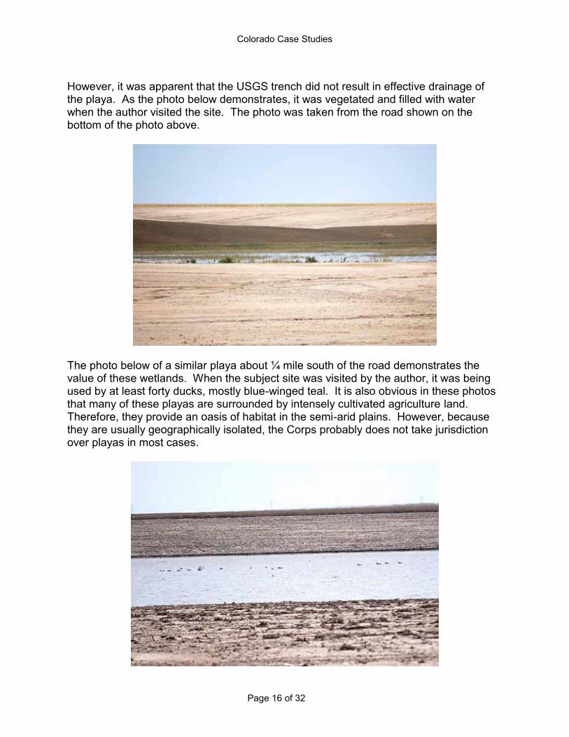
However, it was apparent that the USGS trench did not result in effective drainage of the playa. As the photo below demonstrates, it was vegetated and filled with water when the author visited the site. The photo was taken from the road shown on the bottom of the photo above.
The photo below of a similar playa about ¼ mile south of the road demonstrates the value of these wetlands. When the subject site was visited by the author, it was being used by at least forty ducks, mostly blue-winged teal. It is also obvious in these photos that many of these playas are surrounded by intensely cultivated agriculture land. Therefore, they provide an oasis of habitat in the semi-arid plains. However, because they are usually geographically isolated, the Corps probably does not take jurisdiction over playas in most cases.

Colorado Case Studies
Page 17 of 32
As can be seen in the following photo, some playas also provide hay and forage benefits to farmers and ranchers in the area. The landowner was able to harvest several large bales of hay from this playa.
As mentioned above, playas are very important biologically and hydrologically. The Rocky Mountain Bird Observatory released a report in December of 2008 entitled,
2008). It was prepared for the Colorado Division of Wildlife, Playa Lakes Joint Venture (North American Waterfowl Management Plan), U.S. EPA, and U.S. Fish and Wildlife Service. Below are some excerpts from that report:2
and are found throughout much of the Great Plains. These wetlands are vital to biodiversity in this ecoregion, but are threatened by agriculture and development. While attention has been focused on playas in other regions, such as the High Plains of Texas (Haukos and Smith 2003), prior to this study, playa wetlands in Colorado were relatively unknown. Including all sizes of playas, our model estimated a range of approximately 14,000 23,000 playas within the study area. In this study, we documented within Colorado playas 245 species of plants including 85 wetland species, 148 species of birds including 27 Colorado Species of Greatest Conservation Need, as well as other species of wildlife including black-tailed jack rabbit (Lepus californicus), coyote (Canis latrans), horned lizards (Phrynosoma spp.), spadefoot toad (Spea hammondii), Woodhouse's toad (Bufo woodhousii), lesser earless lizard (Holbrookia maculate), snakes, damselflies,
2 The report can be found at http://www.rmbo.org/v2/web/Publications/scientificReports.aspx. That site also has a mapping tool that can be used to locate playas.

Colorado Case Studies
Page 18 of 32
butterflies, and clams. We also documented vegetation and soils on playa restoration projects. We documented 48,830 bird detections for 148 species using the playas. This included 22 species of waterfowl, 27 species of shorebird, 12 species of other waterbirds (e.g., cranes, gulls, herons), 6 other species of wetland dependent birds (e.g., Yellow-headed Blackbird, Marsh Wren) and 81
When one considers the large number of playas and their high habitat value for wildlife and their aquifer recharge function (Gurdak and Roe 2009), the potentially significant cumulative impact of these wetlands not being protected by the Clean Water Act is a significant ecological concern. Furthermore, clay soils are typically dominant in playas. Therefore, if climate change brings more droughts and intense thunderstorms as is predicted, the water storage and recharge function of playas will become even more important.
Colorado Case Studies
Page 19 of 32
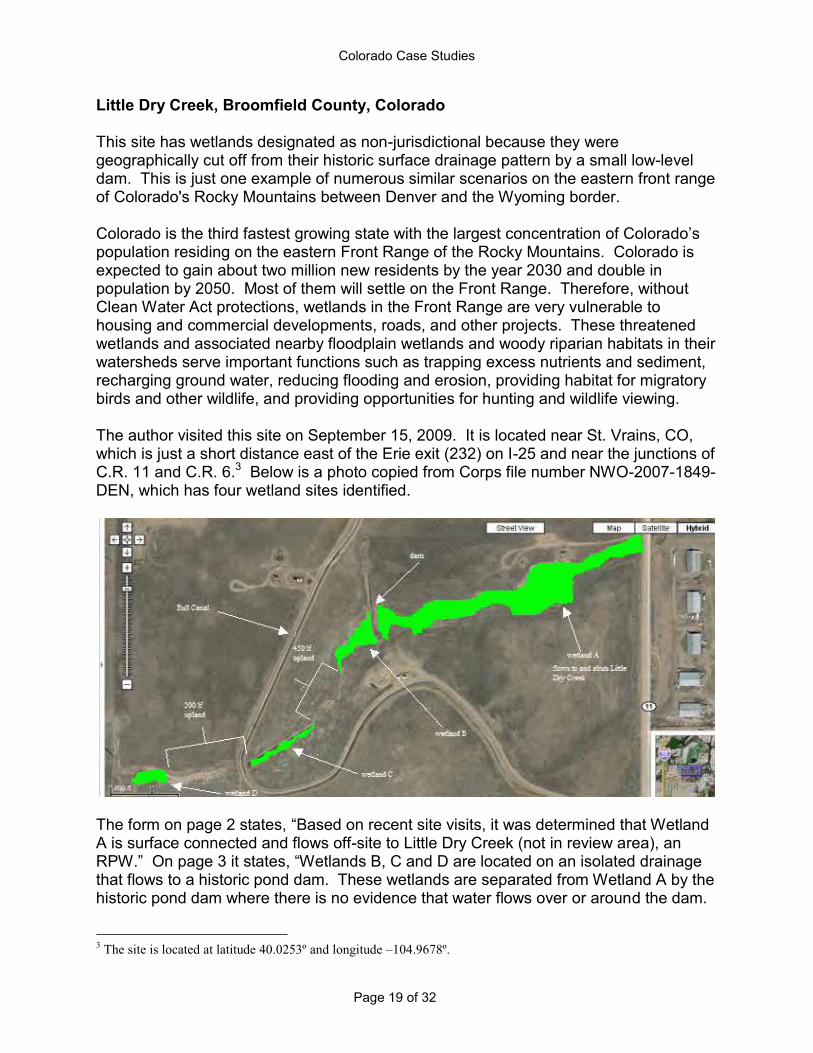
Little Dry Creek, Broomfield County, Colorado This site has wetlands designated as non-jurisdictional because they were geographically cut off from their historic surface drainage pattern by a small low-level dam. This is just one example of numerous similar scenarios on the eastern front range of Colorado's Rocky Mountains between Denver and the Wyoming border. Colorado is the third fastest growing state with the largest concentration of Colorapopulation residing on the eastern Front Range of the Rocky Mountains. Colorado is expected to gain about two million new residents by the year 2030 and double in population by 2050. Most of them will settle on the Front Range. Therefore, without Clean Water Act protections, wetlands in the Front Range are very vulnerable to housing and commercial developments, roads, and other projects. These threatened wetlands and associated nearby floodplain wetlands and woody riparian habitats in their watersheds serve important functions such as trapping excess nutrients and sediment, recharging ground water, reducing flooding and erosion, providing habitat for migratory birds and other wildlife, and providing opportunities for hunting and wildlife viewing. The author visited this site on September 15, 2009. It is located near St. Vrains, CO, which is just a short distance east of the Erie exit (232) on I-25 and near the junctions of C.R. 11 and C.R. 6.3 Below is a photo copied from Corps file number NWO-2007-1849-DEN, which has four wetland sites identified.
The form on page 2 states, Based on recent site visits, it was determined that Wetland A is surface connected and flows off-site to Little Dry Creek (not in review area), an
that flows to a historic pond dam. These wetlands are separated from Wetland A by the historic pond dam where there is no evidence that water flows over or around the dam.
3 The site is located at latitude 40.0253º and longitude 104.9678º.
Colorado Case Studies
Page 20 of 32
There is no evidence of a link between Wetlands B, C & D and interstate or foreign
When the author visited the site, there did not appear to be any ponded water upslope from the dam or vegetative characteristics that would indicate frequent ponding or ponding of any duration.
Bull Canal, a jurisdictional canal reviewed as Reach 2 of 2, flows through the review area between Wetlands D and C. The drainage connecting Wetlands D and C is culverted under the concrete channel of Bull Canal. There is no exchange of flows between the Bull Canal and the isolated drainage in which Wetlands
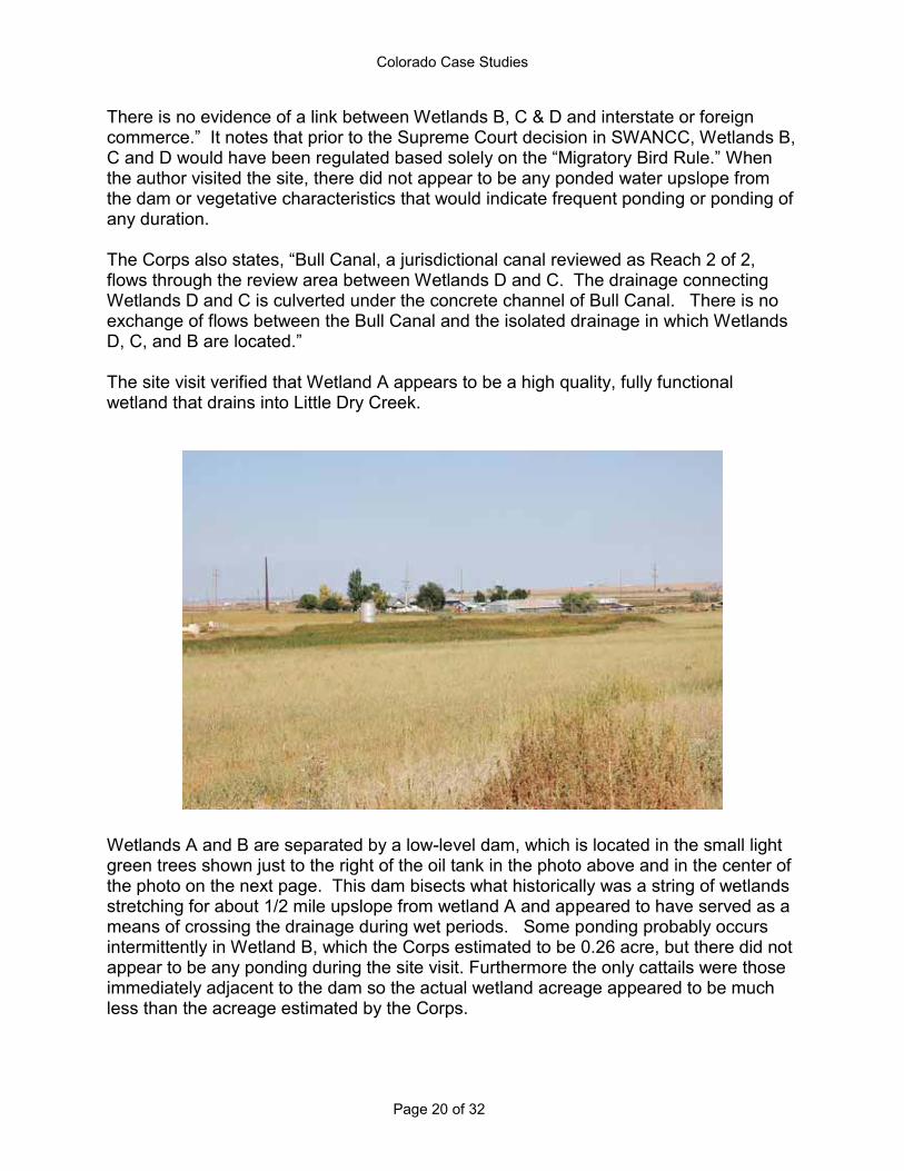
The site visit verified that Wetland A appears to be a high quality, fully functional wetland that drains into Little Dry Creek.
Wetlands A and B are separated by a low-level dam, which is located in the small light green trees shown just to the right of the oil tank in the photo above and in the center of the photo on the next page. This dam bisects what historically was a string of wetlands stretching for about 1/2 mile upslope from wetland A and appeared to have served as a means of crossing the drainage during wet periods. Some ponding probably occurs intermittently in Wetland B, which the Corps estimated to be 0.26 acre, but there did not appear to be any ponding during the site visit. Furthermore the only cattails were those immediately adjacent to the dam so the actual wetland acreage appeared to be much less than the acreage estimated by the Corps.
Colorado Case Studies
Page 21 of 32
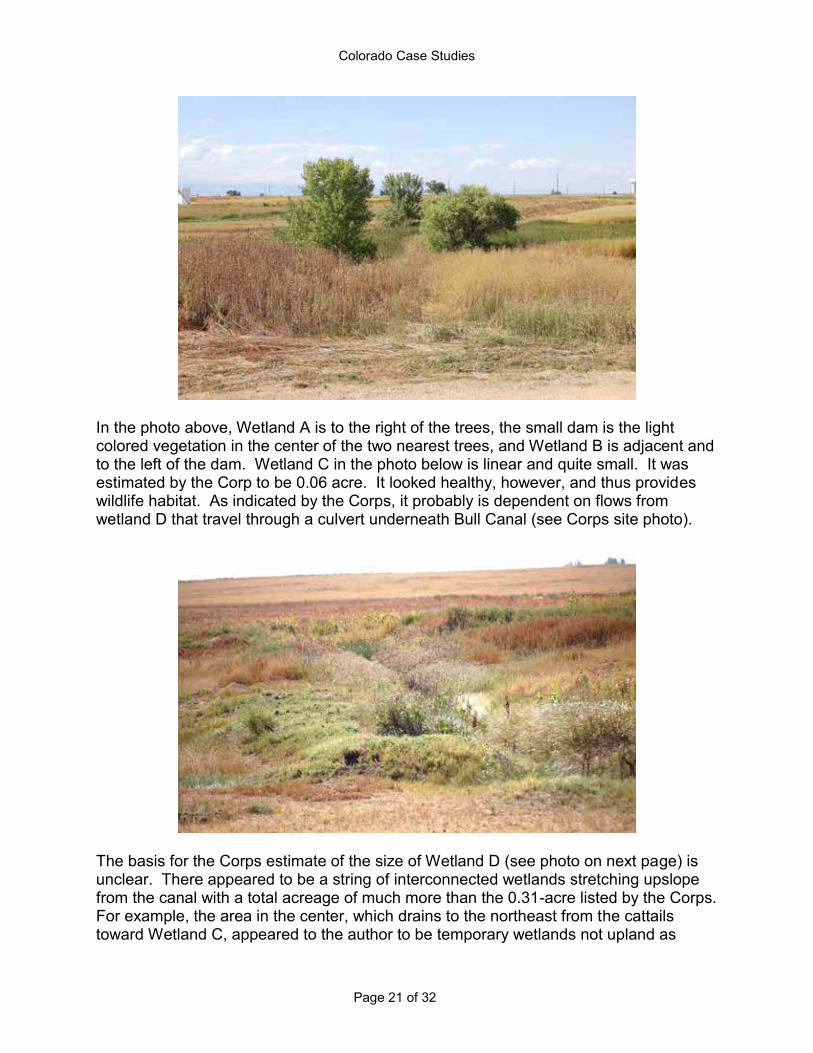
In the photo above, Wetland A is to the right of the trees, the small dam is the light colored vegetation in the center of the two nearest trees, and Wetland B is adjacent and to the left of the dam. Wetland C in the photo below is linear and quite small. It was estimated by the Corp to be 0.06 acre. It looked healthy, however, and thus provides wildlife habitat. As indicated by the Corps, it probably is dependent on flows from wetland D that travel through a culvert underneath Bull Canal (see Corps site photo).
The basis for the Corps estimate of the size of Wetland D (see photo on next page) is unclear. There appeared to be a string of interconnected wetlands stretching upslope from the canal with a total acreage of much more than the 0.31-acre listed by the Corps. For example, the area in the center, which drains to the northeast from the cattails toward Wetland C, appeared to the author to be temporary wetlands not upland as

Colorado Case Studies
Page 22 of 32
labeled in the Corps site photo. The dark plants in the middle of the photo are veiny dock (Rumex venosus), which is a hydrophytic plant. Therefore, without other data such as soils reports and vegetation sampling, the author concluded that the acreage estimate was only based upon the cattails. Wetland D and the other adjacent upslope wetlands also appeared to be functional and to provide good quality habitat for migratory birds, small mammals, and perhaps fawning deer. While their water quality functions probably no longer provide benefits to Little Dry Creek, they likely have retained other wetland functions with regard to ground water recharge and retention of flood flows during precipitation events.
In this example, a bisecting low-level dam made the difference between calling upslope wetlands jurisdictional and non-jurisdictional. Unfortunately, this is a common situation in this part of Colorado. The Corps website lists a number of combination JD and NJD calls in similar scenarios, and often the difference between wetlands receiving CWA protection or not depends on whether they abut a RPW or a TNW. If they do not, under
kely will be designated non-jurisdictional regardless of whether they may be in the same floodplain or drainage and providing many if not all of the same functions.

Colorado Case Studies
Page 23 of 32
Black Shack Creek, Aurora, Colorado The site is just a few miles east of Aurora, which is one of the cities in the Denver Metropolitan District.4 The Corps posted its non-jurisdictional decision (NJD) for the creek on February 19, 2008 (NWO-2007-3071-DEN).
tic features of Black Shack Creek are located approximately 1 mile up-gradient from the non-RPW [relatively permanent water] and closest waters of the U.S., Coal Creek. The OHWM [ordinary high water mark] of Black Shack Creek is disconnected from Coal Creek by approximately 1 mile of upland. Black Shack Creek does not have a
are no indications the normal flows (or even high flows) in Black Shack Creek make their way to Web Soil Survey (see below) show this creek, located at the yellow-a solid blue line with no breaks from the creek to its junction with Coal Creek.
-frequent, high precipitation storms would flows gather and negotiate long with
the absence of normal aquatic resource characteristics at the lower end of the drainage
4 For the site, the latitude is 39.6261 and the longitude is 104.6352.
Colorado Case Studies
Page 24 of 32
Therefore, one could interpret these statements as implying that flows to Coal Creek probably do occur on occasion, and the author notes that this area had several thunderstorms in the months prior to the site visit. In addition, there is a note on page 6
are be
the Corps determined it was geographically isolated and non-jurisdictional because it supposedly does not have flows that reach protected downstream water, i.e., Coal
composed of native and non-native grasses, weeds cactus and yucca. This area promotes habitat for coyotes, foxes, pronghorn, small mammals, birds, snakes, and
-arid plains in Colorado. All streams in such dry upland habitats have important value for wildlife. Furthermore, based on a site inspection on September 14, 2009, there were strong indications that flows from Black Creek are at least occasionally reaching protected downstream waters. While these flow patterns are clearly demonstrated in the photos below, hydrological studies would be needed to make that decision. This speaks to the potential time and difficulty involved under the current legal confusion in properly determining the hydrological flows, functions and connections of many of non-perennial streams.
composition of both the drainage basin and stream substrates is highly porous sand and gravel and any accumulated flows quickly disa
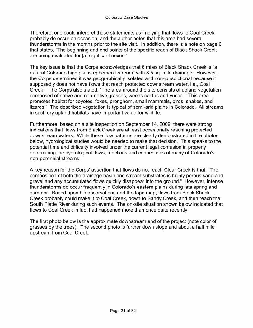
summer. Based upon his observations and the topo map, flows from Black Shack Creek probably could make it to Coal Creek, down to Sandy Creek, and then reach the South Platte River during such events. The on-site situation shown below indicated that flows to Coal Creek in fact had happened more than once quite recently. The first photo below is the approximate downstream end of the project (note color of grasses by the trees). The second photo is further down slope and about a half mile upstream from Coal Creek.
Colorado Case Studies
Page 25 of 32
Colorado Case Studies
Page 26 of 32
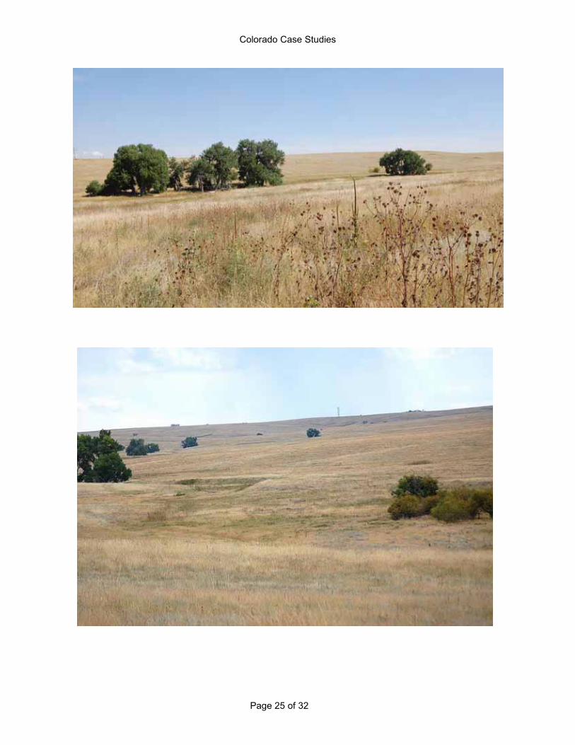
Whenever flows do reach Coal Creek, it is via the grassed waterway, which can be readily seen as the curved greener section in the middle of the above photo. Unless they otherwise demonstrate wetland characteristics or demonstrate characteristics of a
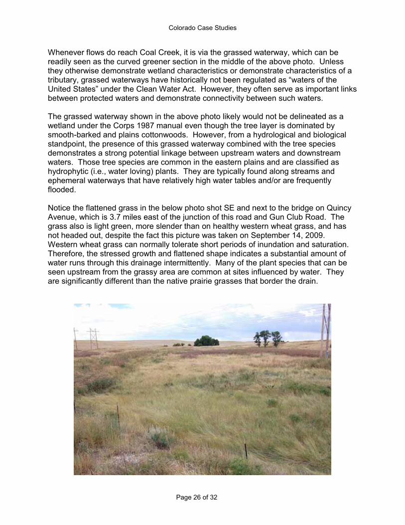
ean Water Act. However, they often serve as important links between protected waters and demonstrate connectivity between such waters. The grassed waterway shown in the above photo likely would not be delineated as a wetland under the Corps 1987 manual even though the tree layer is dominated by smooth-barked and plains cottonwoods. However, from a hydrological and biological standpoint, the presence of this grassed waterway combined with the tree species demonstrates a strong potential linkage between upstream waters and downstream waters. Those tree species are common in the eastern plains and are classified as hydrophytic (i.e., water loving) plants. They are typically found along streams and ephemeral waterways that have relatively high water tables and/or are frequently flooded. Notice the flattened grass in the below photo shot SE and next to the bridge on Quincy Avenue, which is 3.7 miles east of the junction of this road and Gun Club Road. The grass also is light green, more slender than on healthy western wheat grass, and has not headed out, despite the fact this picture was taken on September 14, 2009. Western wheat grass can normally tolerate short periods of inundation and saturation. Therefore, the stressed growth and flattened shape indicates a substantial amount of water runs through this drainage intermittently. Many of the plant species that can be seen upstream from the grassy area are common at sites influenced by water. They are significantly different than the native prairie grasses that border the drain.

Colorado Case Studies
Page 27 of 32
Recent high flow activity also was reflected in the area under the bridge because it was highly scoured and muddy on September 14, 2009 (see photo on next page).
The following photo was shot NW from the bridge. At the tree line, the waterway turns right (north) toward the junction with Coal Creek. Note the defined waterway and how green the vegetation is compared to the surrounding area.

Colorado Case Studies
Page 28 of 32
Below is a photo of the junction of the Black Shack drainage and Coal Creek. The second photo is of Coal Creek upstream from this junction. The riparian woody habitat along these draws is extremely important for songbirds, raptors, fox squirrels, whitetail deer, northern bobwhite quail, mourning dove, turkey, and many other species. Drainages with ephemeral flows like these two creeks are where native trees are typically found in the semi-arid plains.

Colorado Case Studies
Page 29 of 32
The section of Coal Creek shown in the photo above is less than ½ mile upstream from the junction. It was taken shooting north from the bridge over Coal Creek that is about ¼ mile east of the bridge over Black Shack Creek. Note the bed is dry sand, which would enable the moisture from regular rain events to drain easily. However, the bed and bank are very established, and there is little or no vegetation in the channel because of scouring from high flows. Furthermore, the Corps identified this stream as being protected water because it has an Ordinary High Water Mark. The author is not aware of any dam that blocks this creek upstream. Therefore, he believes one can safely assume that significant flows have occurred in the past and still occur when larger precipitation events occur (e.g., thunderstorms). This type of stream morphology and ecology is typical of almost all of the larger ephemeral streams in the sandy plains east of Denver. The last photo shows an industrial site (e.g., sand mining) located in the floodplain of Coal Creek drainage just ½ mile upstream from the bridge on Quincy Avenue. Furthermore, a new subdivision is being built just a couple of miles to the southwest. These important ephemeral streams are threatened by development and should be protected.
As a final note, the Natural Resources and Conservation Service (NRCS), other resource agencies, and the agriculture community deem grassed waterways important. Therefore, they have been one of the types of projects developed and enhanced through landowner cost sharing with funds from the Environmental Quality Incentives Program under the Farm Bill. The Conservation Reserve Program also is used to plant and protect grassed waterways, and it is one of the designated "continuous signup" practices (under CRP) that are reserved for high value practices, indicating the value USDA places on these waterways. The NRCS, which is under the Department of Agriculture, has a

Colorado Case Studies
Page 30 of 32
Conservation Practice Standard for a grassed waterway because of their importance for soil and water conservation. NRCS notes that these systems can support one or more of the following purposes:
To convey runoff from terraces, diversions, or other water concentrations without causing erosion or flooding;
To reduce gully erosion, or; To protect/improve water quality.
Because of the porous soils and dense grass growth on the grassed waterway on this site, it is valuable for ground water recharge as well as functions noted in the three bullet statements above. Grassed waterways are also indicative of the signficant connectivity between ephemeral headwaters and downstream waters. However, the Corps is not recognizing the significance of such connections in their jurisdictional decision-making in certain instances and leaving waters unprotected when implementing their internal guidance that was issued during the current legal confusion. Conclusion This report details just a sample of the many types of waters in Colorado that have lost
or are at risk of losing basic Clean Water Act protections due to the recent legal confusion. When it passed the Clean Water Act with strong bi-partisan support, Congress recognized that, in order to protect water quality, all not just some important waters must be protected. For a generation, the Act succeeded in making great strides in cleaning up waters in Colorado and across the nation. However, the broad scope of protections the Act was intended to provide is now significantly hampered. Without the restoration of comprehensive Clean Water Act protections, it is almost certain that the number of prairie and mountain wetlands and streams in Colorado that will be polluted, degraded or destroyed without federal safeguards will increase. Failure
rivers, streams and lakes; potentially threaten the health of certain waters that comprise portions of the drinking and agricultural water supply for many Coloradans; and pose unnecessary risk to wetlands, streams, and other aquatic resources that Coloradans use for hunting, fishing, wildlife viewing and other outdoor recreation. We should not allow this to occur.
Colorado Case Studies
Page 31 of 32
References Braun, C.E., R.W. Hoffman, and G.E. Rogers. 1976. Wintering areas and winter ecology of White-
tailed Ptarmagin in Colorado. Colorado Division of Wildlife Spec.Rep.No.38. 38p. Cariveau, A.B. and D.Pavlacky.2008.Assessment and Conservation of Playas in Eastern Colorado:
Final Report to the Colorado Division of Wildlife, Playa Lakes Joint Venture, United States Environmental Protection Agency, and United States fish and Wildlife Service. Rocky Mountain Bird Observatory, Brighton, CO, 117 p.
Chappell, A.F. 2000. Colorado Wetlands Initiative 1997-2000 Resource. Wetlands Program Coordinator, Colorado Division of Wildlife.
Ciruli Associates. December 1995. Public Opinion Survey on Colorado Conservation and Outdoor Recreation. Colorado Outdoors 2000. Colorado Division of Wildlife.
Colorado Natural Heritage Program and The Nature Conservancy. In prep. Colorado Species of Conservation Concern Scorecard. Unpublished report, Colorado State University.
Colorado Water Conservation Board. 2002. Memo from ISF Section to Board. Cooper, D.J. 1986. Community structure and classification of Rocky Mountain wetland ecosystems.
In J.T. Windell et al. An Ecological characterization of Rocky Mountain Montane and subalpine wetlands. U.S. Fish and Wild. Serv., Biol.Rep.86(11).
Cooper, D.J. 1990. Ecological studies of wetlands in South Park, Colorado. Classification, functional analysis, rare species inventory and the effects of removing irrigation. Report Prepared for Park County, CO
Dahl, TE. and C.E. Johnson. 1991. Status and Trends of Wetlands in the Conterminous United States, Mid-1970's to Mid-1980's [updated in 1991]. U.S. Department of the Interior, Fish and Wildlife Service, Washington, D.C. 28 p.
Gurdak, J.J. and Roe, C.D., 2009, Recharge rates and chemistry beneath playas of the High Plains aquifer A literature review and synthesis: U.S. Geological Survey Circular 1333, 39 p.
Rogers K. et al. 2006. Conservation Strategy for Colorado Cutthroat Trout in the states of Colorado, Utah, and Wyoming. Fishery biologists of the fish and game agencies of these states, USFS, and BLM.
Stevens, J.E., J.T.Dorfer, and B. Humphries. 1990. A Characterization of the Status and Impacts of Peat Excavation in the State of Colorado. Colorado Mined Land Reclamation Division, Department of Natural Resources, Denver, CO.
Sullivan, B. December 2008. Strategic Plan for the Wetland Wildlife Conservation Program. Wetlands Program Coordinator, Colorado Division of Wildlife.
U.S. Army Corps of Engineers, Sacramento District. Website: navigable waters in the Sacramento District Colorado. http://www.spk.usace.army.mil//organizations/cespk-co/regulatory/co_waterways.html
U.S. EPA. 2009. Analysis of Surface Drinking Water Provided By Intermittent, Ephemeral, and Headwater Streams in the U.S (State-by-State) and (County-by-County). http://www.epa.gov/wetlands/science/surface_drinking_water/index.html
U.S. Fish and Wildlife Service. 1999. Region 6 Peatland Mitigation Policy Considerations. Denver, CO. 33 p.
Vance, L. 2009. Geographically Isolated Wetlands and Intermittent/Ephemeral Streams in Montana: Extent, Distribution, and Function. Montana Natural Heritage Program. Helena, MT. 33 pages.
Water Quality Control Division. 2008. Status of Water Quality in Colorado 2008. Colorado Department of Public Health and Environment. Denver, CO. 161 p.

Colorado Case Studies
Page 32 of 32
National Wildlife Federation
Ducks Unlimited
Trout Unlimited
Cover photo courtesy of U.S. Fish & Wildlife Service. Back cover photo by Gary E. Nichols.
![KM 364e-20180502105019leon.floridahealth.gov/...nutrition-services/school-health/_documents/2018shmedconppk.pdf[ ] Tallahassee Memorial Hospital Diabetes Center [ ] Children's Medical](https://img.pdfslide.us/doc/110x75/5e302914267ca519c45a6202/km-364e-tallahassee-memorial-hospital-diabetes-center-childrens-medical.jpg)


![IN THE UNITED STATES DISTRICT COURT FOR THE DISTRICT …...waters[]’ . . . in a manner consistent with the opinion of Justice Antonin Scalia in [Rapanos].” Id. § 3. 8. In response](https://img.pdfslide.us/doc/110x75/5f06551e7e708231d41776cc/in-the-united-states-district-court-for-the-district-watersa-in-a.jpg)