Embed Size (px)
Citation preview
Fishing Regulations Summary 2020116
!(
!(
!(
!(
!(
!!
!!
!!
!!
!!
!!
!!
!!
!!
!!
!!
!!
!!
!!
!!
!!
!!
!!
!!
!!
!!!!
!!
!!
!!
!!
!!
!!
!!
!!
!!
!!
!!
!!
!!
!!
!!!!
!!
!!
!!
!!
!!
!!
!!
!!
!!
!!
!!
!!
!!
!!
!!
!!
!!
!!
!!
!!
!!
!!
!!
!!
!!
!!
!!
!!
!!
!!
!!!!
!!
!!
!!
!!
!!
!!
!!
!!
!!!!
!!
!!
!!
!!
!!
!!
!!
!!
!!
!!
!!
!!
!!
!!
!!
!!
!!
!!
!!
!!
!!
.
Maitland R.
Saugeen R.
Gran
dR.
Thames R
.
Sain
t Cla
ir R.
Detriot R.
SevernR.
Lake Erie
Georgian Bay
Lake Huron
LakeSimcoe
Lake St.Clair
L. Ontario16
10
1314
15
17
19
19
19
20
20
CABOTHEAD
Aurora
Midhurst
PortBurwell
PortDover
Ridgetown
Pointeau Baril
Wheatley
Bracebridge
Tillsonburg
Gravenhurst
Sebright
Windsor
Woodstock
Sarnia
Newbury
Parkhill
PetroliaSt. Thomas
Alliston
Barrie
Waterloo
NiagaraFalls
St. CatharinesParis
Flesherton
Exeter
Brantford
Mitchell
FortErie
Kitchener
St.Marys
Cambridge
Smithville
Grimsby
PortColborne
Guelph
Hamilton
Harriston
ListowelGoderich
MountForest
Meaford
Walkerton
WasagaBeach
Orangeville
Owen Sound
Aylmer
Stratford
Tobermory
Orillia
Amherstburg
Midland
Lion'sHead
Southampton
Chatham
Brampton
Burlington
Forest
Comber
GrandBend
Pickering
Ajax
SouthBaymouth
Sunderland
Georgetown
Georgina
Toronto
Oakville
OshawaMarkham
PortPerry
Uxbridge
Whitby
Mississauga
Jarvis
Ingersoll
Newmarket
Milton
Chatsworth
Collingwood
Kingsville Leamington
London
Hagersville
Huntsville
Lucan
PortSevern
PortStanley
Simcoe
Vaughan
Wiarton
Woodville
Shelburne
ParrySound
Blenheim
Kincardine
Minden
Clinton
Stayner
Utterson
Welland
Dunnville
CARDEN
DALTON
ELDONM
ARIPOSA
BROCKTHORAH
MARA
RAMA
893
8911
8912
8910
899
8935
8926
8924
8923
896
8921
899
896
8940
:;141
:;118
:;401
:;404
:;400
:;401
:;403
:;402
<=QEW
NO407
.
Maitland R.
Saugeen R.
Gran
dR.
Thames R
.
Sain
t Cla
ir R.
Detriot R.
SevernR.
Lake Erie
Georgian Bay
Lake Huron
LakeSimcoe
Lake St.Clair
L. Ontario16
10
1314
15
17
19
19
19
20
20
DE47
DE30
897
DE2
CABOTHEAD
Aurora
Midhurst
PortBurwell
PortDover
Ridgetown
Pointeau Baril
Wheatley
Bracebridge
Tillsonburg
Gravenhurst
Sebright
Windsor
Woodstock
Sarnia
Newbury
Parkhill
PetroliaSt. Thomas
Alliston
Barrie
Waterloo
NiagaraFalls
St. CatharinesParis
Flesherton
Exeter
Brantford
Mitchell
FortErie
Kitchener
St.Marys
Cambridge
Smithville
Grimsby
PortColborne
Guelph
Hamilton
Harriston
ListowelGoderich
MountForest
Meaford
Walkerton
WasagaBeach
Orangeville
Owen Sound
Aylmer
Stratford
Tobermory
Orillia
Amherstburg
Midland
Lion'sHead
Southampton
Chatham
Brampton
Burlington
Forest
Comber
GrandBend
Pickering
Ajax
SouthBaymouth
Sunderland
Georgetown
Georgina
Toronto
Oakville
OshawaMarkham
PortPerry
Uxbridge
Whitby
Mississauga
Jarvis
Ingersoll
Newmarket
Milton
Chatsworth
Collingwood
Kingsville Leamington
London
Hagersville
Huntsville
Lucan
PortSevern
PortStanley
Simcoe
Vaughan
Wiarton
Woodville
Shelburne
ParrySound
Blenheim
Kincardine
Minden
Clinton
Stayner
Utterson
Welland
Dunnville
CARDEN
DALTON
ELDONM
ARIPOSA
BROCKTHORAH
MARA
RAMA
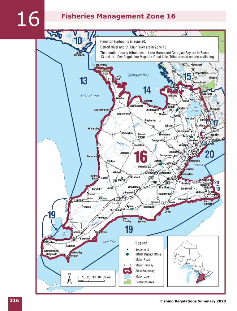
Hamilton Harbour is in Zone 20.
Detroit River and St. Clair River are in Zone 19.
The mouth of many tributaries to Lake Huron and Georgian Bay are in Zones 13 and 14. See Regulation Maps for Great Lake Tributaries at ontario.ca/fishing
0 10 20 30 40 50 km±
Legend!! Settlement!( MNRF District Office
Major Road
Major Railway
Zone Boundary
Major Lake
Protected Area
Fisheries Management Zone 1616
Zone 16
Fishing Regulations Summary 2020 117
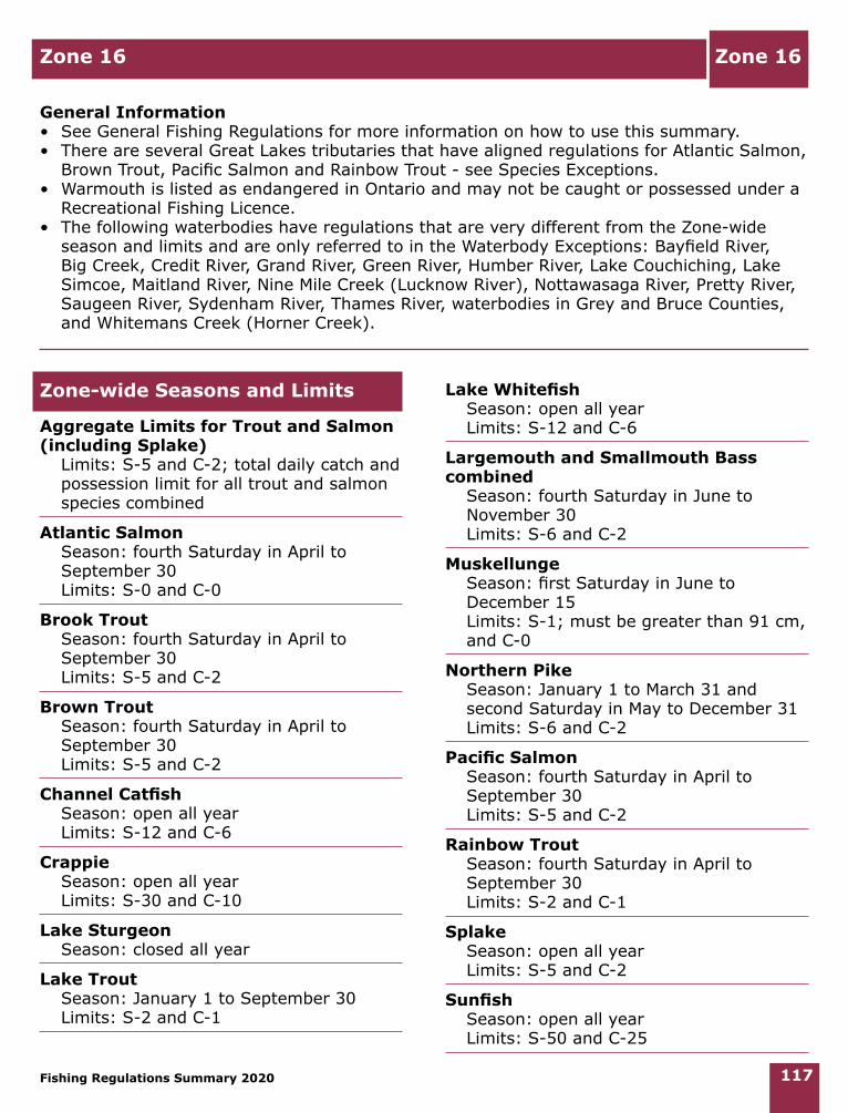
Zone 16
General Information• See General Fishing Regulations for more information on how to use this summary. • There are several Great Lakes tributaries that have aligned regulations for Atlantic Salmon,
Brown Trout, Pacific Salmon and Rainbow Trout - see Species Exceptions. • Warmouth is listed as endangered in Ontario and may not be caught or possessed under a
Recreational Fishing Licence. • The following waterbodies have regulations that are very different from the Zone-wide
season and limits and are only referred to in the Waterbody Exceptions: Bayfield River, Big Creek, Credit River, Grand River, Green River, Humber River, Lake Couchiching, Lake Simcoe, Maitland River, Nine Mile Creek (Lucknow River), Nottawasaga River, Pretty River, Saugeen River, Sydenham River, Thames River, waterbodies in Grey and Bruce Counties, and Whitemans Creek (Horner Creek).
Zone-wide Seasons and Limits
Aggregate Limits for Trout and Salmon (including Splake) Limits: S-5 and C-2; total daily catch and
possession limit for all trout and salmon species combined
Atlantic Salmon Season: fourth Saturday in April to
September 30 Limits: S-0 and C-0
Brook Trout Season: fourth Saturday in April to
September 30 Limits: S-5 and C-2
Brown Trout Season: fourth Saturday in April to
September 30 Limits: S-5 and C-2
Channel Catfish Season: open all year Limits: S-12 and C-6
Crappie Season: open all year Limits: S-30 and C-10
Lake Sturgeon Season: closed all year
Lake Trout Season: January 1 to September 30 Limits: S-2 and C-1
Lake Whitefish Season: open all year Limits: S-12 and C-6
Largemouth and Smallmouth Bass combined Season: fourth Saturday in June to
November 30 Limits: S-6 and C-2
Muskellunge Season: first Saturday in June to
December 15 Limits: S-1; must be greater than 91 cm,
and C-0
Northern Pike Season: January 1 to March 31 and
second Saturday in May to December 31 Limits: S-6 and C-2
Pacific Salmon Season: fourth Saturday in April to
September 30 Limits: S-5 and C-2
Rainbow Trout Season: fourth Saturday in April to
September 30 Limits: S-2 and C-1
Splake Season: open all year Limits: S-5 and C-2
Sunfish Season: open all year Limits: S-50 and C-25
Zone 16
Fishing Regulations Summary 2020118
Walleye and Sauger combined Season: January 1 to March 15 and
second Saturday in May to December 31 Limits: S-4 and C-2; not more than 1
greater than 46 cm
Yellow Perch Season: open all year Limits: S-50 and C-25
Species Exceptions
Brook Trout
Additional Fishing OpportunitiesSeason: open all year• Bells Lake (44°19’15”N., 80°44’09”W.) -
Glenelg Township
Brown Trout and Rainbow Trout
Additional Fishing OpportunitiesSeason: open all yearLimits: S-5 and C-2• Big Creek - Walsingham Township,
downstream from Regional Road 21 to Long Point Bay of Lake Erie
• North Thames River (main branch only) - Middlesex County
Atlantic Salmon, Brown Trout, Pacific Salmon and Rainbow Trout
Additional Fishing OpportunitiesSeason: open all year Limits: Zone-wide limits apply• Black Creek - City of Nanticoke, from
Highway 3 to the junction with the Lynn River
• Bronte Creek - Town of Oakville, from Highway 2 (Lakeshore Road West) to Lake Ontario
• Credit River and tributaries - City of Mississauga, from the south side of Highway 403 bridge downstream to Lake Ontario
• Don River and tributaries - City of Toronto, from Lake Ontario upstream to Eglinton Avenue
• Fifteen Mile Creek - City of St. Catharines and Town of Lincoln, between the Queen Elizabeth Way and Lake Ontario
• Forty Mile Creek - Town of Grimsby, between the Queen Elizabeth Way and Lake Ontario
• Grindstone Creek - City of Burlington, from Highway 2 (Plains Road) to Hamilton Harbour of Lake Ontario (City of Hamilton in the Region of Halton)
• Highland Creek - City of Toronto from the downstream edge of the Highway 2 (Kingston Road) bridge to Lake Ontario
• Humber River - City of Toronto, between Eglinton Avenue and Lake Ontario
• Nottawasaga River - from the Boyne River downstream (north) to Georgian Bay
• Rouge River - City of Toronto, between Highway 2 (Kingston Road) and Lake Ontario
• Sixteen Mile Creek (Oakville Creek) - Town of Oakville, from Highway 2 (Lakeshore Road) to Lake Ontario
• Sixteen Mile Creek - Town of Lincoln, between the Queen Elizabeth Way and Lake Ontario
• Spencer Creek - City of Hamilton, from Highway 102 (Cootes Drive) to Lake Ontario
• Thames River - Elgin County and Middlesex County and the Municipality of Chatham-Kent, main branch only
• Trout Pond of Waterford Ponds - City of Nanticoke
• Twelve Mile Creek (Zone 20) - City of St. Catharines, between Lakeport Road and Lake Ontario
• Twenty Mile Creek - Town of Lincoln, between the Queen Elizabeth Way and Lake Ontario
• Young’s Creek (Ryerse Creek) - Woodhouse Township, from the downstream side of the Front Road bridge to Lake Erie at Port Ryerse
Zone 16
Fishing Regulations Summary 2020 119
Additional Fishing OpportunitiesSeason: open from fourth Saturday in
April to December 31 (extended fall season)
Limits: Zone-wide limits apply• Bayfield River - Goderich and Stanley
Townships, from Highway 4 to the downstream side of the Highway 21 bridge (Huron County)
• Beaver River - Collingwood Township, from the Thornbury Dam to Georgian Bay (Grey County)
• Big Creek - Walsingham Township, south of the Quance Dam to Regional Road 21 at Lynedoch
• Big Otter Creek - Bayham Township (Elgin County)
• Bighead River - St. Vincent Township (Grey County)
• Bronte Creek - Town of Oakville from Highway 2 (Lakeshore Road West) upstream to the south side of Highway 407
• Credit River and tributaries - from the south side of Britannia Road in the City of Mississauga upstream to the south side of the Highway 407 Bridge in the City of Brampton
• Don River and tributaries - upstream from Eglinton Avenue in the City of Toronto to the south side of Highway 407 in the Regional Municipality of York
• Grand River - from a line across the Grand River in Paris at 100 m downstream of the Highway 2 (Dundas Street West) bridge to the edge of Lake Erie (see Waterbody Exceptions for catch and possession limits)
• Hog Creek - Tay Township from the C.P.R. bridge (Lot 10, Concession 6) downstream (north) to Georgian Bay (Simcoe County)
• Humber River and tributaries - upstream from Eglinton Avenue in the City of Toronto to the south side of the Highway 407 bridge in the Regional Municipality of York
• Little Otter Creek - Bayham Township, East branch of Big Otter Creek
• Little Sauble River - Bruce Township, from Highway 21 to Lake Huron (Bruce County)
• Maitland River - Colborne, Goderich, Hullett, East and West Wawanosh and Turnberry Townships, between County Road 4 and the downstream side of the Highway 21 bridge (Huron County)
• Nine Mile River (Lucknow River) - Ashfield and West Wawanosh Townships, between County Road 86 and Lake Huron
• North Creek - Middleton Township, downstream of Highway 3
• Rouge River - from Highway 2 (Kingston Road) in the City of Toronto upstream to the south side of Highway 407 in the Town of Markham
• Sauble River - Amabel Township, from the lowest ledge of Sauble Falls 440 m downstream to a line drawn perpendicular to the river’s current
• Saugeen River - Arran, Amabel, Brant, Elderslie and Saugeen Townships and in the Town of Walkerton and the Village of Paisley, between the Truax Dam (Walkerton) and the westerly edge of the concrete abutments downstream of Denny’s Dam
• Sixteen Mile Creek (Oakville Creek) and tributaries - Town of Oakville from Highway 2 (Lakeshore Road) upstream to the south side of Highway 407
• Sturgeon River and tributaries - Tay and Oro-Medonte Townships (Simcoe County), including the mouth of the Sturgeon River at Georgian Bay
• Young’s Creek - from the dam on Lot 23, Concession 3 to the downstream side of the Front Road bridge
Zone 16
Fishing Regulations Summary 2020120
Walleye
Additional Fishing Opportunities Season: open all year Limits: S-6 and C-2; no size limits • Chenail Ecarte - from the mouth of the
Chenail Ecarte at Lake St. Clair to the mouth of the Sydenham River
• Sydenham River - from the mouth of the Sydenham River at the Chenail Ecarte to the downstream side of the St. George Street Bridge in the Town of Dresden
• Thames River - from the mouth of the Thames River at Lake St. Clair to the downstream side of the Keil Street Bridge in the Municipality of Chatham
Waterbody Exceptions
Bayfield River - on upstream side of Highway 21 bridge in Huron County
• Fish Sanctuary - no fishing from January 1 to Friday before fourth Saturday in April
Bayfield River Tributaries - Huron County• Fish Sanctuary - no fishing from January
1 to Friday before fourth Saturday in April and October 1 to December 31
Big Creek - Walsingham Township, south of the Quance Dam to Regional Road 21 at Lynedoch
• Fish Sanctuary - no fishing from January 1 to Friday before fourth Saturday in April
Big Creek - Walsingham Township, lying southerly of the dam in the Hamlet of Teeterville to the Quance Dam in the Town of Delhi
• Fish Sanctuary - no fishing from January 1 to Friday before fourth Saturday in April and October 1 to December 31
Bruce and Grey Counties inland rivers and streams only, excluding those waters identified for this area in Zone 16 Additional Fishing Opportunities
• All species (except Largemouth and Smallmouth Bass, Muskellunge and Lake Sturgeon, Northern Pike, Walleye and Sauger) - open from fourth Saturday in April to September 30
• Largemouth and Smallmouth Bass - open from fourth Saturday in June to September 30
• Muskellunge - open from first Saturday in June to September 30
• Northern Pike - open from second Saturday in May to September 30
• Walleye and Sauger - open from second Saturday in May to September 30
Credit River and its tributaries - Town of Caledon in Regional Municipality of Peel, Upstream of Old Baseline Road
• Only artificial lures may be used• Only one single-pointed barbless hook
may be used• Brook Trout, Brown Trout and Rainbow
Trout - S-0 and C-0Credit River and tributaries - from the
south side of the Britannia Road bridge in the Village of Streetsville, upstream to the south side of the Old Baseline Road bridge in the Town of Caledon, Regional Municipalities of Peel and Halton, excluding Levi’s Creek (43°37’N., 79°44’W.) and Fletchers Creek (43°37’N., 79°43’W.)
• Fish Sanctuary - no fishing from January 1 to Friday before fourth Saturday in April
Credit River and tributaries - from the south side of the Highway 403 bridge in the City of Mississauga, upstream to the south side of the Britannia Road bridge in the Village of Streetsville
• Fish Sanctuary - no fishing from January 1 to Friday before fourth Saturday in April and August 15 to December 31
Credit River and tributaries - from the south side of the Old Baseline Road bridge in the Town of Caledon, Regional Municipality of Peel, upstream to Highway 9
• Fish Sanctuary - no fishing from January 1 to Friday before fourth Saturday in April and October 1 to December 31
Zone 16
Fishing Regulations Summary 2020 121
Grand River - between the West Garafraxa second Line and Scotland Street in the Town of Fergus; between Tower Street in the Town of Fergus and the Bissell Dam in Nichol Township; between 100 m downstream of a bridge located at the southern boundary of the Elora Gorge Conservation Area and a point 100 m upstream of Pilkington 8th Line in Pilkington Township; between 100 m downstream of Pilkington 8th Line bridge and 100 m upstream of Pilkington Township and Woolwich Township boundary line; and between 100 m downstream of Pilkington Township and Woolwich Township boundary line and 100 m upstream of Highway 86 bridge
• Only artificial lures may be used• Only one barbless hook may be used• Brook Trout, Brown Trout and Rainbow
Trout - S-0 and C-0Grand River - between the former Town of
Paris (City of Brant) and Brantford from a line across the Grand River in Paris at 100 m downstream of the Highway 2 (Dundas Street West) bridge downstream to the pedestrian and service bridge that crosses the Grand River on an angle upstream (west) of the Brant Conservation Area in the City of Brantford
• Only artificial lures may be used• Only one barbless hook may be used• Fish Sanctuary - no fishing from March 1
to Friday before fourth Saturday in April • Brown Trout, Northern Pike, Rainbow
Trout, Smallmouth Bass and Walleye - S-0 and C-0
Grand River - from the pedestrian and service bridge that crosses the Grand River on an angle upstream (west) of the Brant Conservation Area in the City of Brantford to the edge of Lake Erie
• Brown Trout and Rainbow Trout (combined) - S-1 and C-0; from October 1 to December 31
Grand River - from the Penman Dam downstream to the William Street Bridge in the former town of Paris (City of Brant)
• Fish Sanctuary - no fishing from October 1 to November 30
Grand River - Haldimand County, from the water’s edge of Lake Erie upstream to the dam in the Town of Caledonia
• Walleye - S-4 and C-2; any sizeGrand River and its tributaries -
downstream of the Onondaga and Tuscarora Townships line to Lake Erie
• Walleye and Northern Pike - open from January 1 to last day in February and second Saturday in May to December 31
Humber River and its tributaries - upstream from Eglinton Avenue
• Brook Trout, Brown Trout and Rainbow Trout, combined - S-2 and C-1
Humber River and tributaries - Regional Municipalities of York and Peel and Counties of Dufferin and Simcoe, upstream of Highway 407
• Fish Sanctuary - no fishing from January 1 to Friday before fourth Saturday in April and October 1 to December 31
Lake Simcoe, Lake Couchiching, Green River, Trent Canal System and their tributaries - downstream from Lake Couchiching to Lock 42, the Trent Canal System in Brock and Ramara Townships, and the Severn River and its tributaries (excluding the Black River) downstream from Lake Couchiching to Wasdell Falls, all within the Regional Municipalities of York, Durham and Simcoe County and the District of Muskoka
• Lake Herring (cisco) - open from January 1 to March 15 and second Saturday in May to September 30
• Lake Herring (cisco) - S-2 and C-1• Lake Trout - open from January 1 to
March 15 and second Saturday in May to September 30
• Lake Whitefish - open from January 1 to March 15 and second Saturday in May to September 30
• Lake Whitefish - S-2 and C-1• Muskellunge - closed all year• Yellow Perch - S-50; in one day,
possession limit of 100, and C-25; in one day, possession limit of 50
Zone 16
Fishing Regulations Summary 2020122
Maitland River - Colborne and Goderich Townships, extending 550 m downstream from Falls Reserve Waterfall to the first natural waterfall
• Fish Sanctuary - closed to night fishing from September 15 to October 31 (one-half hour after sunset to one-half hour before sunrise)
Maitland River - Huron County, between the bridge on Highway 21 and the bridge on County Road 4
• Fish Sanctuary - no fishing from January 1 to Friday before fourth Saturday in April
Maitland River tributaries - County of Huron, extending upstream from the upstream side of the bridge on Highway 21 to the downstream side of the bridge on Highway 4
• Fish Sanctuary - no fishing from January 1 to Friday before fourth Saturday in April and October 1 to December 31
Nine Mile River - Ashfield Township, from the Port Albert Fishway to 100 m upstream
• Fish Sanctuary - no fishing from fourth Saturday in April to May 15 and September 1 to November 30
Nine Mile River (Lucknow River) - Ashfield and West Wawanosh Townships, between County Road 86 and Lake Huron
• Fish Sanctuary - no fishing from January 1 to Friday before fourth Saturday in April
Nine Mile River tributaries - Huron County, Highway 86 downstream to Lake Huron
• Fish Sanctuary - no fishing from January 1 to Friday before fourth Saturday in April and October 1 to December 31
Nottawasaga River - Essa Township, waters lying within Lot 1, Concession 5, from Highway 89 above Nicholson Dam downstream to near the confluence of the Boyne River
• Fish Sanctuary - no fishing from January 1 to Friday before second Saturday in May and October 1 to December 31
Nottawasaga River - from the Boyne River downstream (north) to the Pine River
• Rainbow Trout - S-0 and C-0
Pretty River and tributaries - Collingwood and Osprey Townships
• Fish Sanctuary - no fishing from fourth Saturday in April to May 31
Pretty River and tributaries - Town of Collingwood and Nottawasaga Township
• Fish Sanctuary - no fishing from January 1 to Friday before fourth Saturday in April and October 1 to December 31
Saugeen River - Amabel and Saugeen Townships, Denny’s Dam to the concrete abutments downstream
• Fish Sanctuary - closed to night fishing from October 1 to October 31 (one-half hour after sunset to one-half hour before sunrise)
Saugeen River - Township of Brant in the County of Bruce, from the dam face of the Maple Hill Dam to a point 300 m downstream and including the hydro-electric power channel
• Fish Sanctuary - closed all year
Sydenham River - Derby Township, Artificial Spawning Channels Numbers 1 and 2
Sydenham River - City of Owen Sound, from the Mill Dam to a point 177 m downstream
• Fish Sanctuary - closed all yearSydenham River - City of Owen Sound
and Derby Township, from Inglis Falls to Mill Dam, excluding Artificial Spawning Channels Numbers 1 and 2
• Fish Sanctuary - no fishing from fourth Saturday in April to May 31
Sydenham River and tributaries - City of Owen Sound and Derby Township, from the base of Inglis Falls downstream to a line drawn due east from the north end of the bridge known locally as either Chinese or Rainbow Bridge to the permanent steel post marker affixed to the shore of the Sydenham River in Harrison Park
Fishing Regulations Summary 2020 123
• Fish Sanctuary - no fishing from September 1 to September 30
Thames River - between the dam at Gordon Pittock Reservoir and the bridge at Highway 59
• Fish Sanctuary - no fishing from March 15 to Friday before second Saturday in May
Thames River - from the mouth of the Thames River at Lake St. Clair to the downstream side of the Keil Street Bridge (Municipality of Chatham)
• Muskellunge - S-1; must be greater than 112 cm, and C-0
Whitemans Creek (Horner Creek) - Brantford Township, between Robinson Road and Cleaver Sideroad
• Only artificial lures may be used• Only one barbless hook may be used• Brown Trout or Rainbow Trout - S-1 and
C-1; must be greater than 50 cm Whitemans Creek (Horner Creek) and
tributaries - from the East Quarter Town Line Road downstream to the edge of the Grand River
• Fish Sanctuary - no fishing from January 1 to Friday before fourth Saturday in April and October 1 to December 31
Fish Sanctuaries
No fishing - closed all year• Colpoy’s Creek - Albemarle Township,
from the upper bridge on County Road 9 downstream to the mouth
• Gleason Brook - Keppel Township, from the bridge on County Road 26 to the mouth
• Saugeen River - see Waterbody Exceptions
• Sydenham River - see Waterbody Exceptions
No fishing - January 1 to Friday before the fourth Saturday in April• Bayfield River - see Waterbody
Exceptions • Big Creek - see Waterbody Exceptions
• Big Otter Creek - Town of Tillsonburg, from Black’s Dam to the north side of the bridge at Oxford Street
• Bradleys Creek - Yarmouth Township, from the Elgin County Road 35 dam to Catfish Creek
• Credit River - see Waterbody Exceptions• Lafontaine Creek and its tributaries
- Township of Tiny in the County of Simcoe, at 44º43’15.167”N., 80º01’48.461”W.
• Maitland River - see Waterbody Exceptions
• Nine Mile River - see Waterbody Exceptions
• North Creek - Walsingham Township, south of Highway 3
• Stoney Creek - Walsingham Township, south of Highway 3 to Big Creek
• Sturgeon River and tributaries - Tay and Oro-Medonte Townships, upstream (south) from the lamprey barrier
• Young’s Creek (Ryerse Creek) - Woodhouse Township and the City of Nanticoke, between the dam on Lot 23, Concession 3 (former Township of Charlotteville) and the downstream side of the bridge on the Lakeshore Road at Port Ryerse
No fishing - January 1 to Friday before the fourth Saturday in April and August 15 to December 31• Credit River - see Waterbody ExceptionsNo fishing - January 1 to Friday before the fourth Saturday in April and October 1 to December 31• Bayfield River tributaries - see Waterbody
Exceptions• Big Creek - see Waterbody Exceptions • Bronte Creek - City of Burlington and
Flamborough Township, from the C.P.R. track in the Village of Progreston downstream to the south side of Highway 407, including part of Limestone Creek upstream to Steeles Avenue in the Town of Milton
• Credit River - see Waterbody Exceptions• Fisher’s Creek - Walsingham Township
Zone 16
Zone 16
Fishing Regulations Summary 2020124
• Galt Creek (Mill Creek) - upstream from the boundary of North Dumfries and Puslinch Townships, including Aberfoyle Creek
• Grindstone Creek - Flamborough Township and City of Burlington, from Waterdown Road to Highway 2 (Plains Road)
• Gully Creek and tributaries - Goderich Township
• Humber River - see Waterbody Exceptions
• Maitland River - see Waterbody Exceptions
• Naftel’s Creek and tributaries - Huron County
• Nine Mile River - see Waterbody Exceptions
• Normandale Creek (Potters Creek) - Walsingham Township
• Pretty River and tributaries - see Waterbody Exceptions
• Whitemans Creek - see Waterbody Exceptions
No fishing - January 1 to Friday before the second Saturday in May and October 1 to December 31• Boyne River - Tosorontio Township, from
the dam in Earl Rowe Provincial Park downstream (east) to the park boundary
• Nottawasaga River - see Waterbody Exceptions
No fishing - January 1 to May 31 and October 1 to December 31• Silver Creek and tributaries - Town
of Collingwood, Collingwood and Nottawasaga Townships
No fishing - March 1 to Friday before the fourth Saturday in April• Grand River - see Waterbody ExceptionsNo fishing - March 1 to Friday before second Saturday in May• Beaver River - Thorah Township, from
the CNR railway bridge in the town of Beaverton upstream to Highway 12/48
• Pefferlaw Brook - Town of Georgina, from Highway 48 upstream to the dam in the village of Pefferlaw
• Severn River - Morrison Township, between Coopers Falls Road bridge, downstream to a line extending southerly across the river from the westerly limit of Lot 17, Concession A
• Talbot River and tributaries excluding the Trent Canal system - Thorah and Mara Townships, the area between the eastern side of Highway 12 upstream to the dam in Lot 6, Concession 11
No fishing - March 15 to Friday before second Saturday in May• Thames River - see Waterbody
Exceptions No fishing - fourth Saturday in April to May 31• Beatty Saugeen River and tributaries -
Normanby and Bentinck Townships and that part of Egremont Township from Highway 6 upstream to the dams at Orchard Park
• Bighead River tributaries - Sydenham, St. Vincent and Holland Townships
• Indian Brook and tributaries - Collingwood Township
• Indian River - Sarawak Township, from Georgian Bay to Indian Falls
• Judges Creek - Eastnor Township, from the first falls above County Road 9 to Georgian Bay
• Keefer’s Creek - Sydenham Township, between the water’s edge of Owen Sound and Slattery Mills Falls
• Little Sauble River and tributaries - Bruce Township, all waters upstream of a line drawn across the river at a point 180 m upstream from the foot bridge in Inverhuron Provincial Park
• Meux Creek - Neustadt Village in Normanby Township, from dam face to South Saugeen River
• Mill Creek and tributaries - Euphrasia and Collingwood Townships, downstream of Mitchell’s Falls to the Euphrasia and Collingwood Townline
• Orchard Creek (Centreville Creek) and tributaries - St. Vincent Township
Zone 16
Fishing Regulations Summary 2020 125
• Park Head Creek - Amabel Township, from the confluence of Park Head Creek with the Sauble River upstream to Bruce County Road 10
• Pretty River and tributaries - see Waterbody Exceptions
• Sangs Creek and tributaries - Arran Township
• Sydenham River - see Waterbody Exceptions
• Telfer Creek (Bothwell’s Creek) - Sydenham Township, Grey County
• Willow Creek - St. Edmunds Township No fishing - fourth Saturday in April to May 15 and September 1 to November 30• Nine Mile River - see Waterbody
Exceptions
No fishing - fourth Saturday in April to May 31 and September 1 to September 30• Pottawatomi River and Maxwell Creek -
City of Owen Sound and Derby Township, from the fourth Avenue West Bridge upstream to the base of the escarpment
No fishing - September 1 to September 30• Sydenham River - see Waterbody
Exceptions No fishing - September 15 to October 31 (No night fishing)• Maitland River - see Waterbody
ExceptionsNo fishing - October 1 to October 31 (No night fishing)• Saugeen River - see Waterbody
ExceptionsNo fishing - October 1 to November 30• Grand River - see Waterbody Exceptions
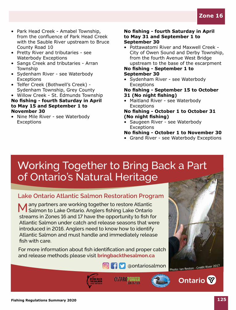
Working Together to Bring Back a Part of Ontario’s Natural Heritage
For more information about fish identification and proper catch and release methods please visit bringbackthesalmon.ca
Photo: Ian Reston - Credit River 2017
any partners are working together to restore Atlantic Salmon to Lake Ontario. Anglers fishing Lake Ontario
streams in Zones 16 and 17 have the opportunity to fish for Atlantic Salmon under catch and release seasons that were introduced in 2016. Anglers need to know how to identify Atlantic Salmon and must handle and immediately release fish with care.
Lake Ontario Atlantic Salmon Restoration Program
@ontariosalmon