Embed Size (px)
Citation preview
PRD
P
T1V P
13K
Project numbRevision: 1 Date: Novem
RA
SELE
Prepared fo
Taseko Mine020 – 800 W
Vancouver, B
Prepared b
326 McGill RKamloops, BC
ber: 4436
ber 15, 2011
AINBO
ECTED
or:
s Limited West Pender B.C. V6C 2V
by:
Rd. C V2C 6N6
1
OW TR
D FISH
TR
J
Street V6
ROUT
H CRE
RIBUT
JULY
DISTR
EEK A
TARIE
2011
RIBUT
AND FI
ES
TION I
ISH LA
IN
AKE

Disclaimer
This report is rendered solely for the use of Taseko Mines Limited in connection with the Prosperity Gold-Copper Mine project, and no person may rely on it for any other purpose without Triton Environmental Consultants Ltd.’s prior written approval. Should a third party use this report without Triton’s approval, they may not rely upon it. Triton accepts no responsibility for loss or damages suffered by any third party as a result of decisions made or actions taken based on this report. The objective of this report is is to present, discuss and interpret the results of the July 2011 fish distribution study in several tributaries to Fish Creek and Fish Lake. This report is based on facts and opinions contained within the referenced documents and Project background information. We have attempted to identify and consider relevant facts and documents pertaining to the scope of work, as of the time period during which we conducted this analysis. However, our opinions may change if new information is available or if information we have relied on is altered. We applied accepted professional practices and standards in developing and interpreting data obtained by our field measurement, sampling and observation. While we used accepted professional practices in interpreting data provided by third party sources we did not verify the accuracy of data provided by third party sources. This report should be considered as a whole and selecting only portions of the report for reliance may create a misleading view of our opinions.
4436 Prosperity Gold-Copper Project November 2011
Rainbow Trout Distribution in Select Fish Creek and Fish Lake Tributaries Page i Prepared by Triton Environmental Consultants Ltd.
Executive Summary
This purpose of this report is to summarize work undertaken on behalf of Taseko Mines Limited (Taseko) as part of a series of studies to gather baseline data for the Prosperity Gold-Copper Mine project (The Project). The Project, located within Fish Lake watershed, includes among other aspects, the construction of a tailings storage facility (TSF) upstream from Fish Lake. The design of the TSF and location of the main embankment was recently revised to exclude Fish Lake, but will continue to intercept most of the discharge from the lake’s inlet tributaries. The reduction of the Fish Lake catchment area will also reduce discharge in Fish Creek, the outlet to Fish Lake. Consequently, further data regarding rainbow trout distribution and location of fish migration barriers in tributaries to Fish Lake are required to determine fish bearing status of stream reaches potentially affected by the revised TSF alignment. This information is required to complete the environmental effects assessment of the Project on fish and fish habitat. In addition, Notice of Work (NoW) tributary crossings associated with the revised TSF design and main embankment alignment within Upper Fish Creek watershed also require fish bearing status assessments. A secondary objective of this study was to collect preliminary data for the rainbow trout habitat suitability index (HSI) study component in Upper Fish Creek (Reach 8). Data were collected during a summer high flow period to assess habitat and discharge conditions roughly equal to that which is typically available during the May-June rainbow trout spawning period. These preliminary data are intended to supplement/support the September 2011 companion study that assessed rainbow trout spawning habitat suitability in Reach 8 of Upper Fish Creek. Rainbow Trout Distribution in Fish Lake Tributaries Numerous fish and fish habitat studies of the Fish Lake watershed have been completed during the past two decades and are referenced in this report. Those studies determined that Fish Lake supports a mono-culture population of about 85,000 rainbow trout. Other studies also characterized tributary and reach-specific habitats and fish use, biophysical and water quality parameters. The current field program was completed during a high flow period in July to determine the maximum possible extent of fish distribution in selected tributaries to Fish Lake. Fish presence sampling (backpack electrofisher) was conducted in the study tributaries upstream and downstream from known or suspected barriers to fish passage. Electrofishing upstream from a barrier continued until fish were not captured during a minimum of two consecutive sampling events. Juvenile rainbow trout (30 mm – 125 mm) were captured downstream from known and suspected fish barriers during this assessment. Fish Lake Tributary 1 and Tributary 3 are fish bearing for 2.1 km and 400 m respectively, upstream from Fish Lake. Fish Lake Tributary 2 is non-fish bearing as it comprises isolated marsh areas only and electrofishing effort did not produce any fish. As Middle Fish Creek Tributary 1 drains into a swamp, with no surface flow connectivity to Fish Creek, and fish were neither captured nor observed during previous studies
or in upstream habitats during the current study, this tributary is classified as non-fish bearing, at a minimum, upstream from Fish Lake road. Due to the lack of surface flow in Fish Lake Tributary 1 upstream from Tributary B2D confluence during the high water period, the Notice of Work (NoW) 200 access road crossing(1) which is located about 2.7 km upstream from the confluence, is considered non-fish bearing. The NoW 200 access road crossing(2) of an unnamed tributary to Upper Fish Creek was not sampled during this study but is interfered fish bearing due to its close proximity (100 m) and probable connectivity (during moderate-high flow) to the mainstem, which is fish bearing. The NoW 200 access road crossing(3) in the uppermost reach of a small unnamed tributary to Upper Fish Creek was also not sampled but is considered non-fish bearing due to the small, likely ephemeral, catchment area when compared to the larger drainage of other non-fish bearing reaches in Fish Lake watershed. With the exception of rainbow trout presence in Tributary B2D, identified in 2010 and confirmed during the current study, all other fish bearing status determinations and migration barrier locations are consistent with previous studies. Upper Fish Creek (Reach 8) Preliminary Discharge Estimates Upper Fish Creek (reach 8) has suitable substrate for rainbow trout spawning and several redds were observed during the July study. Discharge was roughly calculated at 0.23 m3/s based on channel width, depth and water velocity measurements taken at three locations.

4436 Prosperity Gold-Copper Project November 2011
Rainbow Trout Distribution in Select Fish Creek and Fish Lake Tributaries Page iii Prepared by Triton Environmental Consultants Ltd.
TABLE OF CONTENTS
Disclaimer ....................................................................................................................................... i
Executive Summary ....................................................................................................................... i
1.0 Introduction ....................................................................................................................... 1 1.1 Background ..................................................................................................................... 1 1.2 Previous Studies .............................................................................................................. 1 1.3 Objectives and Approach ................................................................................................ 2 1.4 Study Area ...................................................................................................................... 2
2.0 Methods .............................................................................................................................. 5 2.1 Methods Used to Confirm Barriers and Determine Fish Distribution in Selected Tributaries ................................................................................................................................... 5 2.2 Habitat Suitability for Rainbow Trout Spawning in Upper Fish Creek (Reach 8) ......... 5
3.0 Results and Discussion ...................................................................................................... 6 3.1 Rainbow Trout Distribution in Selected Fish Lake Tributaries ...................................... 6
3.1.1 Fish Lake Tributary 1 .................................................................................................. 6 3.1.2 Fish Lake Tributary 2 .................................................................................................. 6 3.1.3 Fish Lake Tributary 3 .................................................................................................. 6 3.1.4 Middle Fish Creek Tributary 1 ................................................................................... 7 3.1.5 Notice of Work 200 Access Road Crossings .............................................................. 7
3.2 Habitat Suitability for Rainbow Trout Spawning in Upper Fish Creek.......................... 7
4.0 Summary ............................................................................................................................ 9
5.0 References ........................................................................................................................ 10
LIST OF FIGURES Figure 1. Overview and Site Location Map ................................................................................... 4
LIST OF TABLES Table 1. Summary of Habitat Type and Estimated Discharge in Upper Fish Creek ..................... 8
LIST OF APPENDICES
Appendix 1. Fish Habitat Comments and Rainbow Trout Captures/Observations, Fish Lake Tributaries, July 2011 Appendix 2. Site Photographs
4436 Prosperity Gold-Copper Project November 2011
Rainbow Trout Distribution in Select Fish Creek and Fish Lake Tributaries Page 1 Prepared by Triton Environmental Consultants Ltd.
1.0 Introduction
1.1 Background
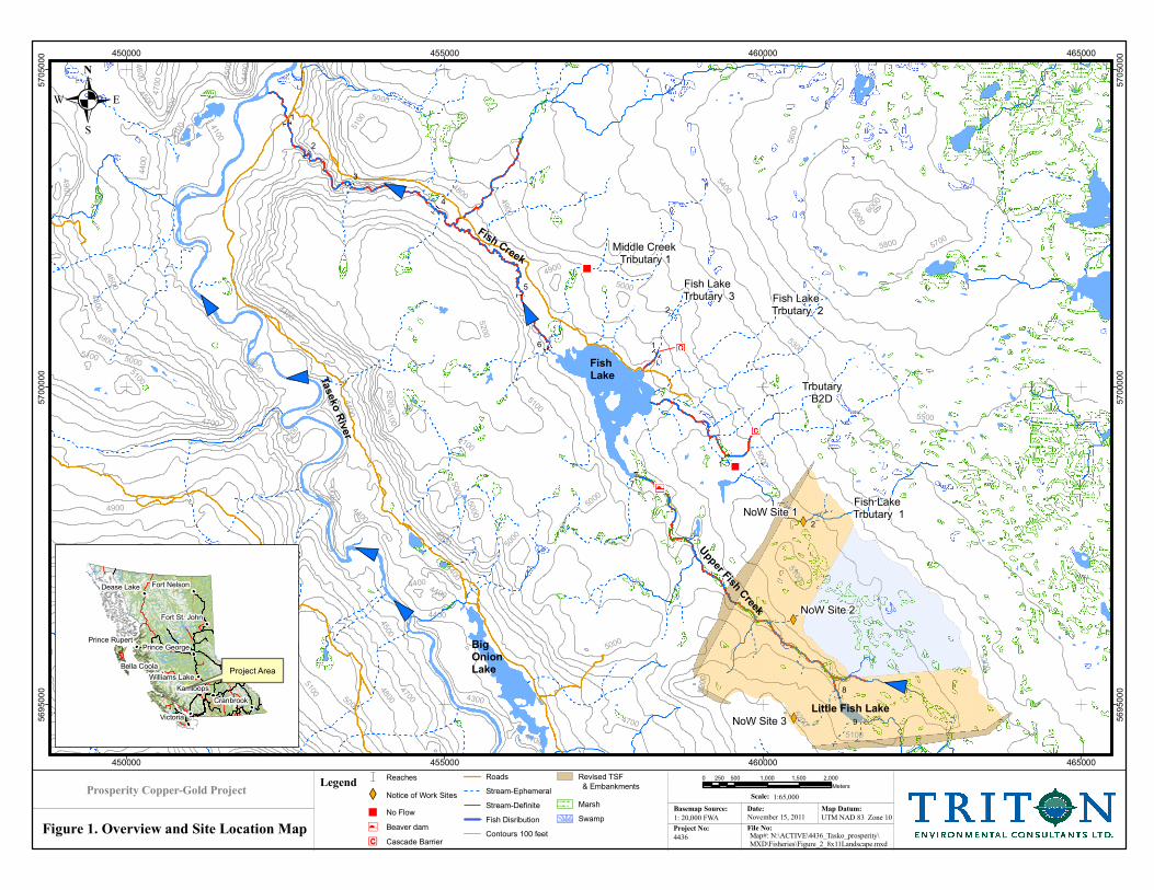
Taseko Mines Limited (Taseko) intends to develop its Prosperity Gold-Copper property about 125 kilometers southwest from Williams Lake (Figure 1). The mine site, tailings storage (TSF) and ancillary facilities will be located within Fish Lake watershed. Between 2008 and 2011, Taseko re-designed and revised the capacity, alignment and location of the TSF within the watershed to exclude Fish Lake. The main (western) embankment of the TSF, now located approximately 2.5 km upstream from Fish Lake, is predicted to intercept about 86% and 45% of discharge from Tributary 1 and Upper Fish Creek respectively. The reduction of the effective Fish Lake catchment area from 68 km2 to 28.6 km2 will also reduce discharge from Fish Creek (outlet to Fish Lake) by 58% (Knight Piesold 2010). As a result of the revised TSF main embankment alignment and associated, predicted decrease in discharge, rainbow trout distribution and migration barrier confirmation is required in Fish Lake tributaries 1, 2 and 3, and in Middle Fish Creek Tributary 1. This report presents, discusses and interprets the results of a mid-summer rainbow trout distribution study conducted in selected Upper Fish Lake drainage tributaries, as these data relate to environmental effects of the revised Project Description on fish and fish habitat.
1.2 Previous Studies
Fish Lake supports a mono-culture population of rainbow trout (Oncorhynchus mykiss) estimated at about 85,000 individual fish. (Triton Environmental Consultants Ltd. 1999). Between 1993 and 1998, ten baseline fish and fish habitat studies were completed in Fish Creek watershed as part of the initial environmental impact statement/application submitted in March 2009 (Table 3-4; EIS Volume 5 – Biotic Environment; BC EAO website):
Rainbow Trout Mark–Recapture Study, (Triton Environmental Consultants Ltd. 1999); Fish Creek Fish and Fish Habitat Survey, (Triton Environmental Consultants Ltd.
1999b); Lakes Physical Habitat, (Triton Environmental Consultants Ltd. 1999c; Fish Creek Spawner Enumeration Report, (Triton Environmental Consultants Ltd. 1996
and 1997); Aquatic Resources of Fish Lake, Fish Creek and Related Fish Habitat Compensation
Sites (Part 1); Aquatic Resources of Fish Lake, Fish Creek and Related Fish Habitat Compensation
Sites (Part 2); Sport Fishery Statistics from Fish Lake 1995 Report; Sport Fishery Statistics from Fish Lake 1995/1996; Fisheries Data from the Prosperity Project Area 1996 Data Report; Visitor and Creel Survey Fish Lake, 1997.

4436 Prosperity Gold-Copper Project November 2011
Rainbow Trout Distribution in Select Fish Creek and Fish Lake Tributaries Page 2 Prepared by Triton Environmental Consultants Ltd.
Further studies were also completed in 2006 and 2007 (Jacques Whitford-AXYS Ltd.) to determine: fish use/habitat quality at watercourse crossings along the Taseko Lake and 4500 roads, and the new proposed 2.8 km mine access road, Fish Lake rainbow trout size-at-age, water quality, recreational angler effort and catch rate. In 2010, a preliminary stream classification assessment was completed (KenTree Enterprises Ltd., November 2010) to confirm fish barriers and reach breaks established during earlier studies of Fish Lake Tributary 1 watershed. As Taseko Mines Ltd. revised (2011) Project Description proposes a re-alignment and re-location of the TSF final main embankment (among other changes), and does not require destruction of Fish Lake, additional information to confirm the location of fish migration barriers in tributaries to Fish Lake was required. This is one of three studies completed during 2011:
Fish distribution and barrier confirmation in selected tributaries to Fish Lake and Fish Creek (present study);
Rainbow trout spawning habitat suitability (depth/velocity/substrate) in reach 8 of Upper Fish Creek; and,
Fish Lake Water Quality and Limnology.
1.3 Objectives and Approach
The primary objectives of this study were to confirm known and suspected fish migration barriers and therefore rainbow trout distribution in selected tributaries to Fish Lake and Fish Creek as well as at three Notice of Work (NoW) tributary-200 access road crossings. Data were collected in July during high water levels to determine the maximum possible extent of rainbow trout distribution. A second objective of this study was to collect data for a rainbow trout habitat suitability index (HSI) study in Upper Fish Creek (Reach 8). These data are intended to supplement/support the September 2011 companion study that assessed rainbow trout spawning habitat suitability in Reach 8 of Upper Fish Creek.
1.4 Study Area
Fish Creek watershed is located on the Fraser Plateau about 246 km north of Vancouver and 127 km southwest of Williams Lake, B.C. (Figure 1). The watershed encompasses 95.4 km2 of rolling uplands with an average elevation of 1540 m. The basin is bounded by Tête Hill on the east (elevation 1829 m), and an unnamed ridge to the west (elevation 1585 m). Little Fish and Wolf Trap lakes are at the southern end of the basin, however the headwaters of the basin are indistinct because the land is a complex of marshes and hummocks created from morainal deposition (Holland 1976). The basin is drained by Fish Creek which flows approximately 14 km in a northerly direction to its confluence with Taseko River. An 8 m high waterfall

4436 Prosperity Gold-Copper Project November 2011
Rainbow Trout Distribution in Select Fish Creek and Fish Lake Tributaries Page 3 Prepared by Triton Environmental Consultants Ltd.
approximately 3.2 km upstream from the confluence creates a barrier to fish migration isolating the resident rainbow trout from anadromous fish in the Taseko River (Triton 1999). Fish Lake (Watershed code 150-335700-13400-47700) is located in the middle reaches (Reach 7) of the Fish Creek basin and is above the barrier. The lake is 121 ha with a maximum depth of 11 m (FISS 2011). Rainbow trout are the only species present in the lake, and are known to use several tributaries for spawning and rearing (Triton 1999).
Fish Lake
BigOnion Lake
Taseko River
Middle Creek Tributary 1
Fish Lake Trbutary 3 Fish Lake
Trbutary 2
Fish Lake Trbutary 1
Fish Creek
Upper Fish C
reekTrbutaryB2D
Little Fish Lake
NoW Site 3
NoW Site 2
NoW Site 12
2
1
1
5
9
8
1
2
7
6
4
3
5300
5200
4500
5000
5100
4900
4800
4700
4600
4400
4300
5400
4200
5500
5600
5700
5800
5900
6000
4100
6100
6200
6300
6400
6500
6600
5100
5100
4400
4500
4400
5000
4600
4400
4400
5000
5400
5700
5000
5200
5900
4400
5200
5200
5100
4200
4400
4100
6000
5000
5200
4400
5100
4700
4900
4500
4900
5800
5500
4900
5100
5300
5200
5000
5300
5100
5000
4800
4400
4900
4800 4300
5000
5000
5100
5100
4700
4400
5000
4700
5100
4400
4500
5600
450000
450000
455000
455000
460000
460000
465000
465000
5695000
5695000
5700000
5700000
5705000
5705000
.
LegendScale:
Basemap Source: Map Datum:
UTM NAD 83 Zone 101: 20,000 FWA November 15, 2011
Date:
Project No: File No:
4436 Map#: N:\ACTIVE\4436_Tasko_prosperity\
MXD\Fisheries\Figure_2_8x11Landscape.mxd
0 500 1,000 1,500 2,000250
Meters
1:65,000Prosperity Copper-Gold Project
Figure 1. Overview and Site Location Map
& Reaches
XW Notice of Work Sites
� No Flow
- Beaver dam
. Cascade Barrier
Roads
Stream-Ephemeral
Stream-Definite
Fish Disribution
Contours 100 feet
Revised TSF
Marsh
Swamp
!!
Victoria
Kamloops
Cranbrook
Dease Lake
Bella Coola
Fort Nelson
Williams Lake
Fort St. John
Prince GeorgePrince Rupert
Project Area
& Embankments
4436 Prosperity Gold-Copper Project November 2011
Rainbow Trout Distribution in Select Fish Creek and Fish Lake Tributaries Page 5 Prepared by Triton Environmental Consultants Ltd.
2.0 Methods
2.1 Methods Used to Confirm Barriers and Determine Fish Distribution in Selected Tributaries
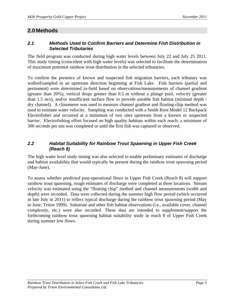
The field program was conducted during high water levels between July 22 and July 25 2011. This study timing (coincident with high water levels) was selected to facilitate the determination of maximum potential rainbow trout distribution in the selected tributaries. To confirm the presence of known and suspected fish migration barriers, each tributary was walked/sampled in an upstream direction beginning at Fish Lake. Fish barriers (partial and permanent) were determined in-field based on observations/measurements of channel gradient (greater than 20%), vertical drops greater than 0.5 m without a plunge pool, velocity (greater than 1.5 m/s), and/or insufficient surface flow to provide useable fish habitat (minimal depth / dry channel). A clinometer was used to measure channel gradient and floating-chip method was used to estimate water velocity. Sampling was conducted with a Smith Root Model 12 Backpack Electrofisher and occurred at a minimum of two sites upstream from a known or suspected barrier. Electrofishing effort focused on high quality habitats within each reach; a minimum of 300 seconds per site was completed or until the first fish was captured or observed.
2.2 Habitat Suitability for Rainbow Trout Spawning in Upper Fish Creek (Reach 8)
The high water level study timing was also selected to enable preliminary estimates of discharge and habitat availability that would typically be present during the rainbow trout spawning period (May-June). To assess whether predicted post-operational flows in Upper Fish Creek (Reach 8) will support rainbow trout spawning, rough estimates of discharge were completed at three locations. Stream velocity was estimated using the “floating chip” method and channel measurements (width and depth) were recorded. Data were collected during the summer high flow period (which occurred in late July in 2011) to reflect typical discharge during the rainbow trout spawning period (May to June; Triton 1999). Substrate and other fish habitat observations (i.e., available cover, channel complexity, etc.) were also recorded. These data are intended to supplement/support the forthcoming rainbow trout spawning habitat suitability study in reach 8 of Upper Fish Creek during summer low flows.
4436 Prosperity Gold-Copper Project November 2011
Rainbow Trout Distribution in Select Fish Creek and Fish Lake Tributaries Page 6 Prepared by Triton Environmental Consultants Ltd.
3.0 Results and Discussion
3.1 Rainbow Trout Distribution in Selected Fish Lake Tributaries
3.1.1 Fish Lake Tributary 1
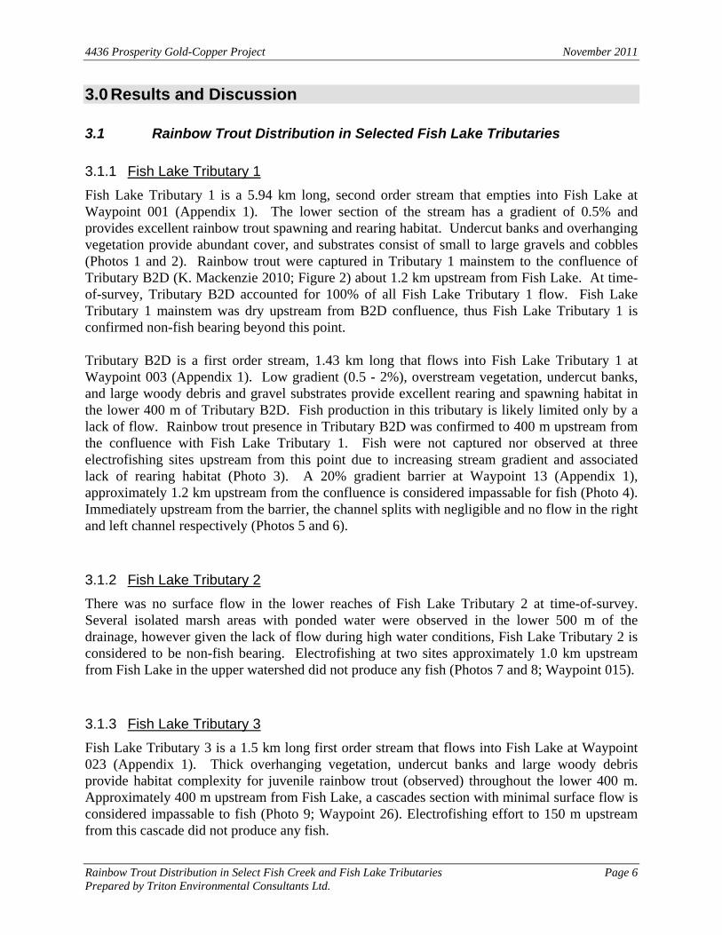
Fish Lake Tributary 1 is a 5.94 km long, second order stream that empties into Fish Lake at Waypoint 001 (Appendix 1). The lower section of the stream has a gradient of 0.5% and provides excellent rainbow trout spawning and rearing habitat. Undercut banks and overhanging vegetation provide abundant cover, and substrates consist of small to large gravels and cobbles (Photos 1 and 2). Rainbow trout were captured in Tributary 1 mainstem to the confluence of Tributary B2D (K. Mackenzie 2010; Figure 2) about 1.2 km upstream from Fish Lake. At time-of-survey, Tributary B2D accounted for 100% of all Fish Lake Tributary 1 flow. Fish Lake Tributary 1 mainstem was dry upstream from B2D confluence, thus Fish Lake Tributary 1 is confirmed non-fish bearing beyond this point. Tributary B2D is a first order stream, 1.43 km long that flows into Fish Lake Tributary 1 at Waypoint 003 (Appendix 1). Low gradient (0.5 - 2%), overstream vegetation, undercut banks, and large woody debris and gravel substrates provide excellent rearing and spawning habitat in the lower 400 m of Tributary B2D. Fish production in this tributary is likely limited only by a lack of flow. Rainbow trout presence in Tributary B2D was confirmed to 400 m upstream from the confluence with Fish Lake Tributary 1. Fish were not captured nor observed at three electrofishing sites upstream from this point due to increasing stream gradient and associated lack of rearing habitat (Photo 3). A 20% gradient barrier at Waypoint 13 (Appendix 1), approximately 1.2 km upstream from the confluence is considered impassable for fish (Photo 4). Immediately upstream from the barrier, the channel splits with negligible and no flow in the right and left channel respectively (Photos 5 and 6).
3.1.2 Fish Lake Tributary 2
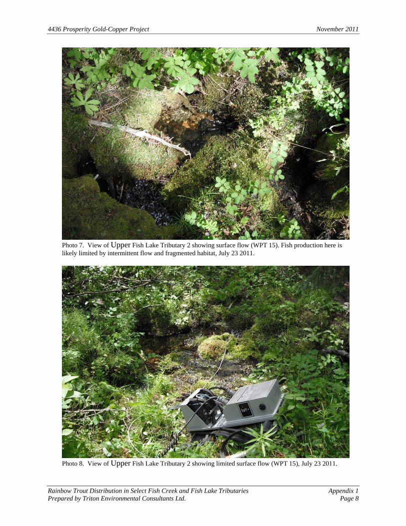
There was no surface flow in the lower reaches of Fish Lake Tributary 2 at time-of-survey. Several isolated marsh areas with ponded water were observed in the lower 500 m of the drainage, however given the lack of flow during high water conditions, Fish Lake Tributary 2 is considered to be non-fish bearing. Electrofishing at two sites approximately 1.0 km upstream from Fish Lake in the upper watershed did not produce any fish (Photos 7 and 8; Waypoint 015).
3.1.3 Fish Lake Tributary 3
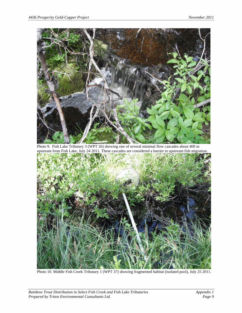
Fish Lake Tributary 3 is a 1.5 km long first order stream that flows into Fish Lake at Waypoint 023 (Appendix 1). Thick overhanging vegetation, undercut banks and large woody debris provide habitat complexity for juvenile rainbow trout (observed) throughout the lower 400 m. Approximately 400 m upstream from Fish Lake, a cascades section with minimal surface flow is considered impassable to fish (Photo 9; Waypoint 26). Electrofishing effort to 150 m upstream from this cascade did not produce any fish.
4436 Prosperity Gold-Copper Project November 2011
Rainbow Trout Distribution in Select Fish Creek and Fish Lake Tributaries Page 7 Prepared by Triton Environmental Consultants Ltd.
3.1.4 Middle Fish Creek Tributary 1
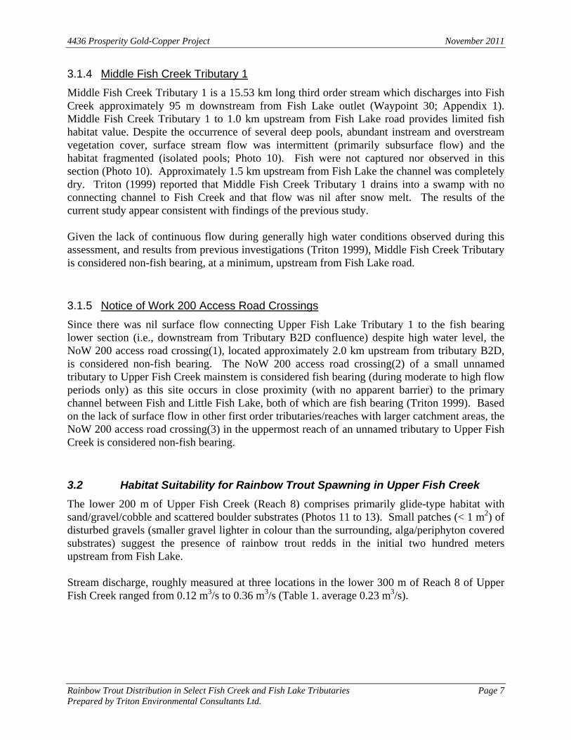
Middle Fish Creek Tributary 1 is a 15.53 km long third order stream which discharges into Fish Creek approximately 95 m downstream from Fish Lake outlet (Waypoint 30; Appendix 1). Middle Fish Creek Tributary 1 to 1.0 km upstream from Fish Lake road provides limited fish habitat value. Despite the occurrence of several deep pools, abundant instream and overstream vegetation cover, surface stream flow was intermittent (primarily subsurface flow) and the habitat fragmented (isolated pools; Photo 10). Fish were not captured nor observed in this section (Photo 10). Approximately 1.5 km upstream from Fish Lake the channel was completely dry. Triton (1999) reported that Middle Fish Creek Tributary 1 drains into a swamp with no connecting channel to Fish Creek and that flow was nil after snow melt. The results of the current study appear consistent with findings of the previous study. Given the lack of continuous flow during generally high water conditions observed during this assessment, and results from previous investigations (Triton 1999), Middle Fish Creek Tributary is considered non-fish bearing, at a minimum, upstream from Fish Lake road.
3.1.5 Notice of Work 200 Access Road Crossings
Since there was nil surface flow connecting Upper Fish Lake Tributary 1 to the fish bearing lower section (i.e., downstream from Tributary B2D confluence) despite high water level, the NoW 200 access road crossing(1), located approximately 2.0 km upstream from tributary B2D, is considered non-fish bearing. The NoW 200 access road crossing(2) of a small unnamed tributary to Upper Fish Creek mainstem is considered fish bearing (during moderate to high flow periods only) as this site occurs in close proximity (with no apparent barrier) to the primary channel between Fish and Little Fish Lake, both of which are fish bearing (Triton 1999). Based on the lack of surface flow in other first order tributaries/reaches with larger catchment areas, the NoW 200 access road crossing(3) in the uppermost reach of an unnamed tributary to Upper Fish Creek is considered non-fish bearing.
3.2 Habitat Suitability for Rainbow Trout Spawning in Upper Fish Creek
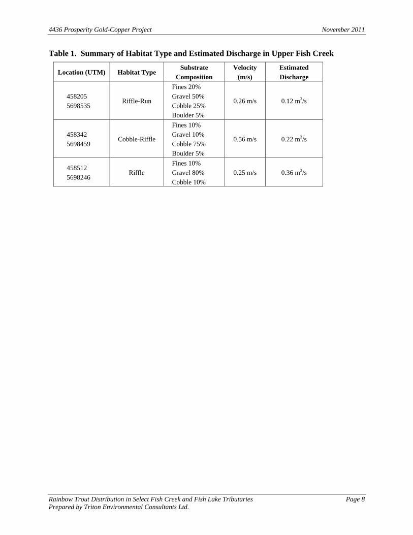
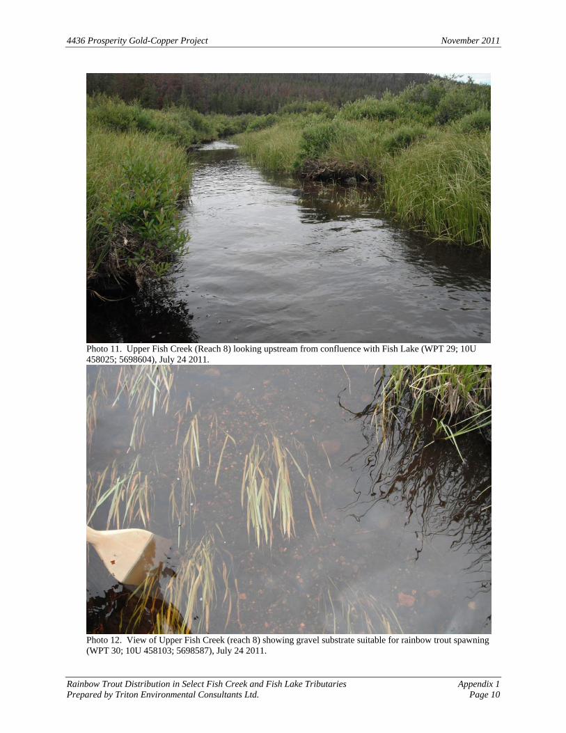
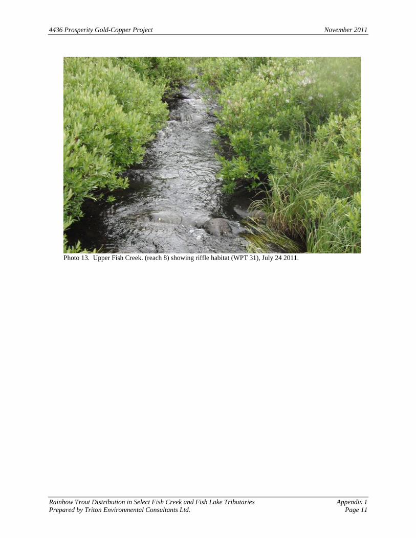
The lower 200 m of Upper Fish Creek (Reach 8) comprises primarily glide-type habitat with sand/gravel/cobble and scattered boulder substrates (Photos 11 to 13). Small patches (< 1 m2) of disturbed gravels (smaller gravel lighter in colour than the surrounding, alga/periphyton covered substrates) suggest the presence of rainbow trout redds in the initial two hundred meters upstream from Fish Lake. Stream discharge, roughly measured at three locations in the lower 300 m of Reach 8 of Upper Fish Creek ranged from 0.12 m3/s to 0.36 m3/s (Table 1. average 0.23 m3/s).
4436 Prosperity Gold-Copper Project November 2011
Rainbow Trout Distribution in Select Fish Creek and Fish Lake Tributaries Page 8 Prepared by Triton Environmental Consultants Ltd.
Table 1. Summary of Habitat Type and Estimated Discharge in Upper Fish Creek
Location (UTM) Habitat Type Substrate
Composition
Velocity
(m/s)
Estimated
Discharge
458205
5698535 Riffle-Run
Fines 20%
Gravel 50%
Cobble 25%
Boulder 5%
0.26 m/s 0.12 m3/s
458342
5698459 Cobble-Riffle
Fines 10%
Gravel 10%
Cobble 75%
Boulder 5%
0.56 m/s 0.22 m3/s
458512
5698246 Riffle
Fines 10%
Gravel 80%
Cobble 10%
0.25 m/s 0.36 m3/s
4436 Prosperity Gold-Copper Project November 2011
Rainbow Trout Distribution in Select Fish Creek and Fish Lake Tributaries Page 9 Prepared by Triton Environmental Consultants Ltd.
4.0 Summary
Downstream sections of Fish Lake tributaries 1 and 3, and Upper Fish Creek provide suitable spawning and rearing habitat for rainbow trout. Rainbow trout presence was confirmed to 2.1 km upstream from Fish Lake in Tributary 1 and to 400 m in Tributary 3. The general the lack of surface flow during high water conditions and narrow channel widths (< 1 m), commensurate with multiple velocity barriers (i.e. cascades), prevent fish from utilizing the upper reaches of Fish Lake tributaries 1 and 3. Fish Lake Tributary 2 is overgrown with dense scrub willow and was not flowing at time-of-survey. The lower to middle reaches of this tributary comprise several poorly defined, isolated marsh areas with ponded water connected by trickle flows. Fish were not captured during electrofishing effort at the only location with surface flow (upper watershed); as such this tributary is non-fish bearing. Middle Fish Creek Tributary 1 drains into a wetland with no apparent connecting channel to Fish Creek (Triton 1999). Surface flow was intermittent and sampling efforts did not produce any fish upstream to about 1.0 km upstream from the road crossing. Between 1.0 and 1.5 km upstream from Fish Lake road, the channel becomes completely dry. Given the intermittent flow regime and fragmented habitats observed during the current study, during generally high water conditions, and results from previous investigations (Triton 1999), Middle Fish Creek Tributary 1 is considered non-fish bearing, at a minimum, upstream from Fish Lake road. Due to an absence of surface flow during high water level conditions and lack of connectivity to fish bearing reaches in Fish Lake Tributary 1, NoW 200 access road crossing(1) is considered non-fish bearing. The NoW 200 access road crossing(2) is likely fish bearing during high flows only given its close proximity (100 m) to Upper Fish Creek. NoW 200 access road crossing(3) is considered non-fish bearing based on its location in the extreme upper watershed of a small, ephemeral tributary to Upper Fish Creek. Upper Fish Creek discharge was roughly estimated at 0.23 m3/s, and several potential rainbow trout redds were observed within the first 200 m upstream from Fish Lake.
4436 Prosperity Gold-Copper Project November 2011
Rainbow Trout Distribution in Select Fish Creek and Fish Lake Tributaries Page 10 Prepared by Triton Environmental Consultants Ltd.
5.0 References
BC Ministry of Environment. 2011. Fisheries Information Summary System (FISS). Available at: http://www.env.gov.bc.ca/habwiz/ Accessed October, 2011. Holland, S.S. 1976. Landforms of Birtish Columbia – a physiographic outline. B.C. Department of Mines and Petroleum Resources, Bulletin No.48. KenTree Enterprises Ltd. 2010. Preliminary Stream Classification Assessementm Letter. Prepared by Ken Mckenzie for Taseko Mines Limited. November, 2010. Knight Piésold Consulting. 2010. Prosperity Project – Fish Lake South TSF Alternatives, Water Balance and Flow Estimates. Prepared for Taseko Mines Limited. December, 2010. Triton Environmental Consultants Ltd. 1999. Fish Creek Fish and Fish Habitat Surveys. Prepared for Taseko Mines Limited. Richmond, B.C.

4436 Prosperity Gold-Copper Project November 2011
Rainbow Trout Distribution in Select Fish Creek and Fish Lake Tributaries Appendix 1Prepared by Triton Environmental Consultants Ltd. Page 1
Appendix 1
Fish Habitat Comments and Rainbow Trout Captures/Observations, Fish Lake Tributaries, July 2011
4436 Prosperity Gold-Copper Project November 2011
Rainbow Trout Distribution in Select Fish Creek and Fish Lake Tributaries Appendix 1Prepared by Triton Environmental Consultants Ltd. Page 2
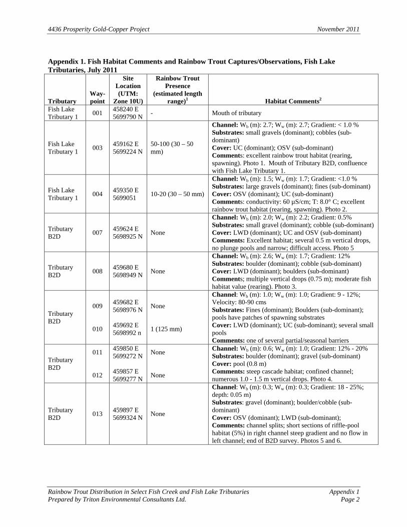
Appendix 1. Fish Habitat Comments and Rainbow Trout Captures/Observations, Fish Lake Tributaries, July 2011
Tributary Way-point
Site Location (UTM:
Zone 10U)
Rainbow Trout Presence
(estimated length range)1 Habitat Comments2
Fish Lake Tributary 1
001 458240 E 5699790 N
- Mouth of tributary
Fish Lake Tributary 1
003 459162 E 5699224 N
50-100 (30 – 50 mm)
Channel: Wb (m): 2.7; Ww (m): 2.7; Gradient: < 1.0 % Substrates: small gravels (dominant); cobbles (sub-dominant) Cover: UC (dominant); OSV (sub-dominant) Comments: excellent rainbow trout habitat (rearing, spawning). Photo 1. Mouth of Tributary B2D, confluence with Fish Lake Tributary 1.
Fish Lake Tributary 1
004 459350 E 5699051
10-20 (30 – 50 mm)
Channel: Wb (m): 1.5; Ww (m): 1.7; Gradient: <1.0 % Substrates: large gravels (dominant); fines (sub-dominant) Cover: OSV (dominant); UC (sub-dominant) Comments: conductivity: 60 µS/cm; T: 8.0° C; excellent rainbow trout habitat (rearing, spawning). Photo 2.
Tributary B2D
007 459624 E 5698925 N
None
Channel: Wb (m): 2.0; Ww (m): 2.2; Gradient: 0.5% Substrates: small gravel (dominant); cobble (sub-dominant) Cover: LWD (dominant); UC and OSV (sub-dominant) Comments: Excellent habitat; several 0.5 m vertical drops, no plunge pools and narrow; difficult access. Photo 5
Tributary B2D
008 459680 E 5698949 N
None
Channel: Wb (m): 2.6; Ww (m): 1.7; Gradient: 12% Substrates: boulder (dominant); cobble (sub-dominant) Cover: LWD (dominant); boulders (sub-dominant) Comments; multiple vertical drops (0.75 m); moderate fish habitat value (rearing). Photo 3.
Tributary B2D
009
010
459682 E 5698976 N 459692 E 5698992 n
None 1 (125 mm)
Channel: Wb (m): 1.0; Ww (m): 1.0; Gradient: 9 - 12%; Velocity: 80-90 cms Substrates: Fines (dominant); Boulders (sub-dominant); pools have patches of spawning substrates Cover: LWD (dominant); UC (sub-dominant); several small pools Comments: one of several partial/seasonal barriers
Tributary B2D
011
012
459850 E 5699272 N 459857 E 5699277 N
None None
Channel: Wb (m): 0.6; Ww (m): 1.0; Gradient: 12% - 20% Substrates: boulder (dominant); gravel (sub-dominant) Cover: pool (0.8 m) Comments: steep cascade habitat; confined channel; numerous 1.0 - 1.5 m vertical drops. Photo 4.
Tributary B2D
013 459897 E 5699324 N
None
Channel: Wb (m): 0.3; Ww (m): 0.3; Gradient: 18 - 25%; depth: 0.05 m) Substrates: gravel (dominant); boulder/cobble (sub-dominant) Cover: OSV (dominant); LWD (sub-dominant); Comments: channel splits; short sections of riffle-pool habitat (5%) in right channel steep gradient and no flow in left channel; end of B2D survey. Photos 5 and 6.
4436 Prosperity Gold-Copper Project November 2011
Rainbow Trout Distribution in Select Fish Creek and Fish Lake Tributaries Appendix 1Prepared by Triton Environmental Consultants Ltd. Page 3
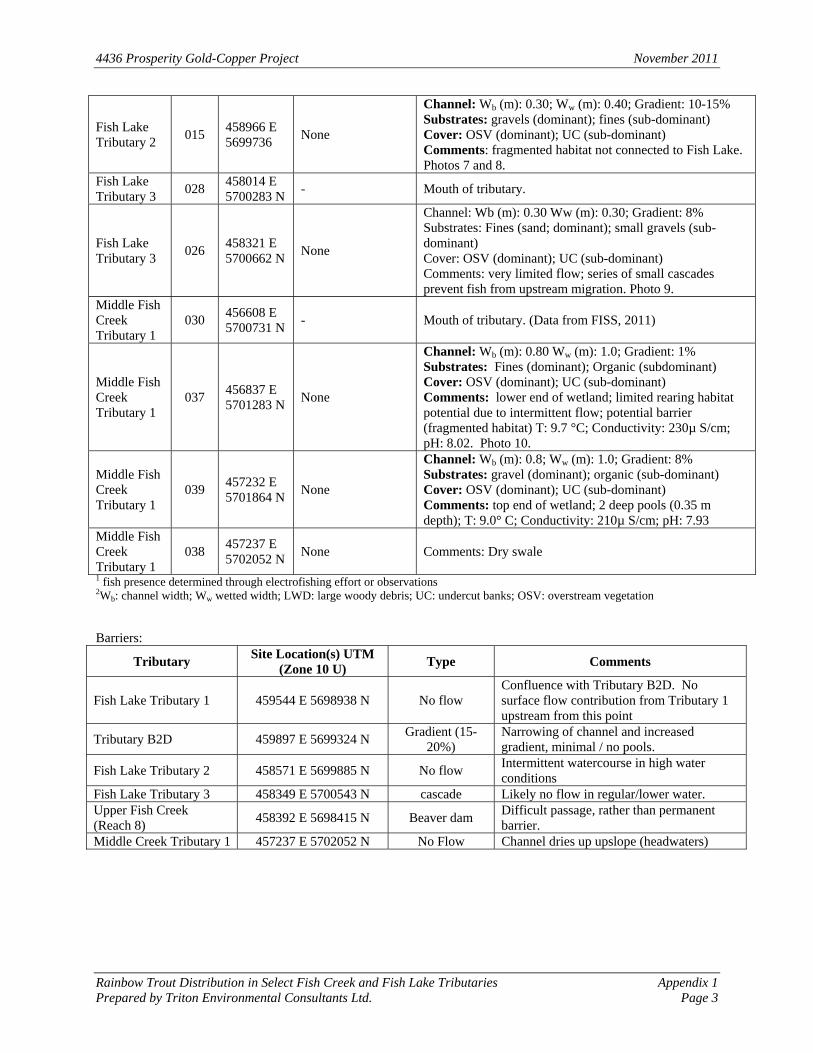
Fish Lake Tributary 2
015 458966 E 5699736
None
Channel: Wb (m): 0.30; Ww (m): 0.40; Gradient: 10-15% Substrates: gravels (dominant); fines (sub-dominant) Cover: OSV (dominant); UC (sub-dominant) Comments: fragmented habitat not connected to Fish Lake. Photos 7 and 8.
Fish Lake Tributary 3
028 458014 E 5700283 N
- Mouth of tributary.
Fish Lake Tributary 3
026 458321 E 5700662 N
None
Channel: Wb (m): 0.30 Ww (m): 0.30; Gradient: 8% Substrates: Fines (sand; dominant); small gravels (sub-dominant) Cover: OSV (dominant); UC (sub-dominant) Comments: very limited flow; series of small cascades prevent fish from upstream migration. Photo 9.
Middle Fish Creek Tributary 1
030 456608 E 5700731 N
- Mouth of tributary. (Data from FISS, 2011)
Middle Fish Creek Tributary 1
037 456837 E 5701283 N
None
Channel: Wb (m): 0.80 Ww (m): 1.0; Gradient: 1% Substrates: Fines (dominant); Organic (subdominant) Cover: OSV (dominant); UC (sub-dominant) Comments: lower end of wetland; limited rearing habitat potential due to intermittent flow; potential barrier (fragmented habitat) T: 9.7 °C; Conductivity: 230µ S/cm; pH: 8.02. Photo 10.
Middle Fish Creek Tributary 1
039 457232 E 5701864 N
None
Channel: Wb (m): 0.8; Ww (m): 1.0; Gradient: 8% Substrates: gravel (dominant); organic (sub-dominant) Cover: OSV (dominant); UC (sub-dominant) Comments: top end of wetland; 2 deep pools (0.35 m depth); T: 9.0° C; Conductivity: 210µ S/cm; pH: 7.93
Middle Fish Creek Tributary 1
038 457237 E 5702052 N
None Comments: Dry swale
1 fish presence determined through electrofishing effort or observations 2Wb: channel width; Ww wetted width; LWD: large woody debris; UC: undercut banks; OSV: overstream vegetation Barriers:
Tributary Site Location(s) UTM
(Zone 10 U) Type Comments
Fish Lake Tributary 1 459544 E 5698938 N No flow Confluence with Tributary B2D. No surface flow contribution from Tributary 1 upstream from this point
Tributary B2D 459897 E 5699324 N Gradient (15-
20%) Narrowing of channel and increased gradient, minimal / no pools.
Fish Lake Tributary 2 458571 E 5699885 N No flow Intermittent watercourse in high water conditions
Fish Lake Tributary 3 458349 E 5700543 N cascade Likely no flow in regular/lower water. Upper Fish Creek (Reach 8)
458392 E 5698415 N Beaver dam Difficult passage, rather than permanent barrier.
Middle Creek Tributary 1 457237 E 5702052 N No Flow Channel dries up upslope (headwaters)

4436 Prosperity Gold-Copper Project November 2011
Rainbow Trout Distribution in Select Fish Creek and Fish Lake Tributaries Appendix 1Prepared by Triton Environmental Consultants Ltd. Page 4
Appendix 2
Site Photographs
4436 Prosperity Gold-Copper Project November 2011
Rainbow Trout Distribution in Select Fish Creek and Fish Lake Tributaries Appendix 1Prepared by Triton Environmental Consultants Ltd. Page 5
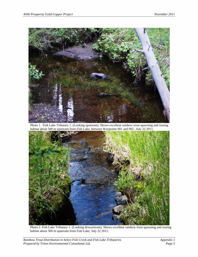
Photo 1. Fish Lake Tributary 1. (Looking upstream). Shows excellent rainbow trout spawning and rearing habitat about 500 m upstream from Fish Lake, between Waypoints 001 and 002 , July 22 2011.
Photo 2. Fish Lake Tributary 1. (Looking downstream). Shows excellent rainbow trout spawning and rearing habitat about 500 m upstream from Fish Lake; July 22 2011.
4436 Prosperity Gold-Copper Project November 2011
Rainbow Trout Distribution in Select Fish Creek and Fish Lake Tributaries Appendix 1Prepared by Triton Environmental Consultants Ltd. Page 6
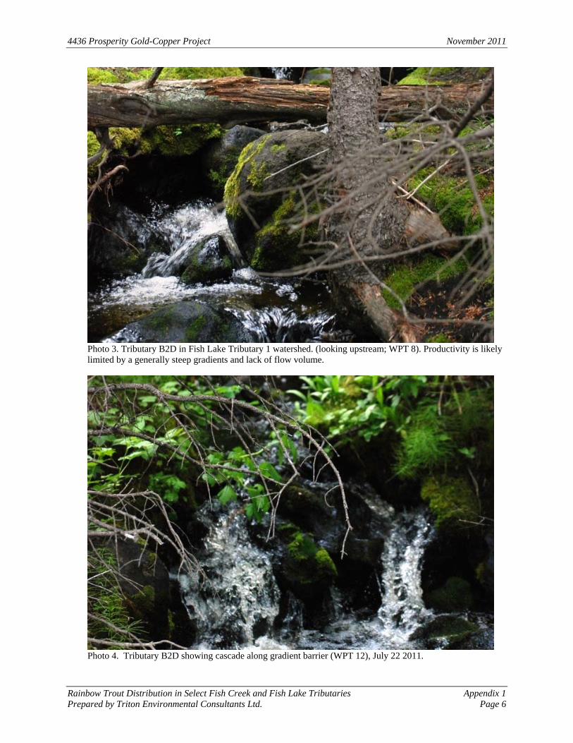
Photo 3. Tributary B2D in Fish Lake Tributary 1 watershed. (looking upstream; WPT 8). Productivity is likely limited by a generally steep gradients and lack of flow volume.
Photo 4. Tributary B2D showing cascade along gradient barrier (WPT 12), July 22 2011.
4436 Prosperity Gold-Copper Project November 2011
Rainbow Trout Distribution in Select Fish Creek and Fish Lake Tributaries Appendix 1Prepared by Triton Environmental Consultants Ltd. Page 7
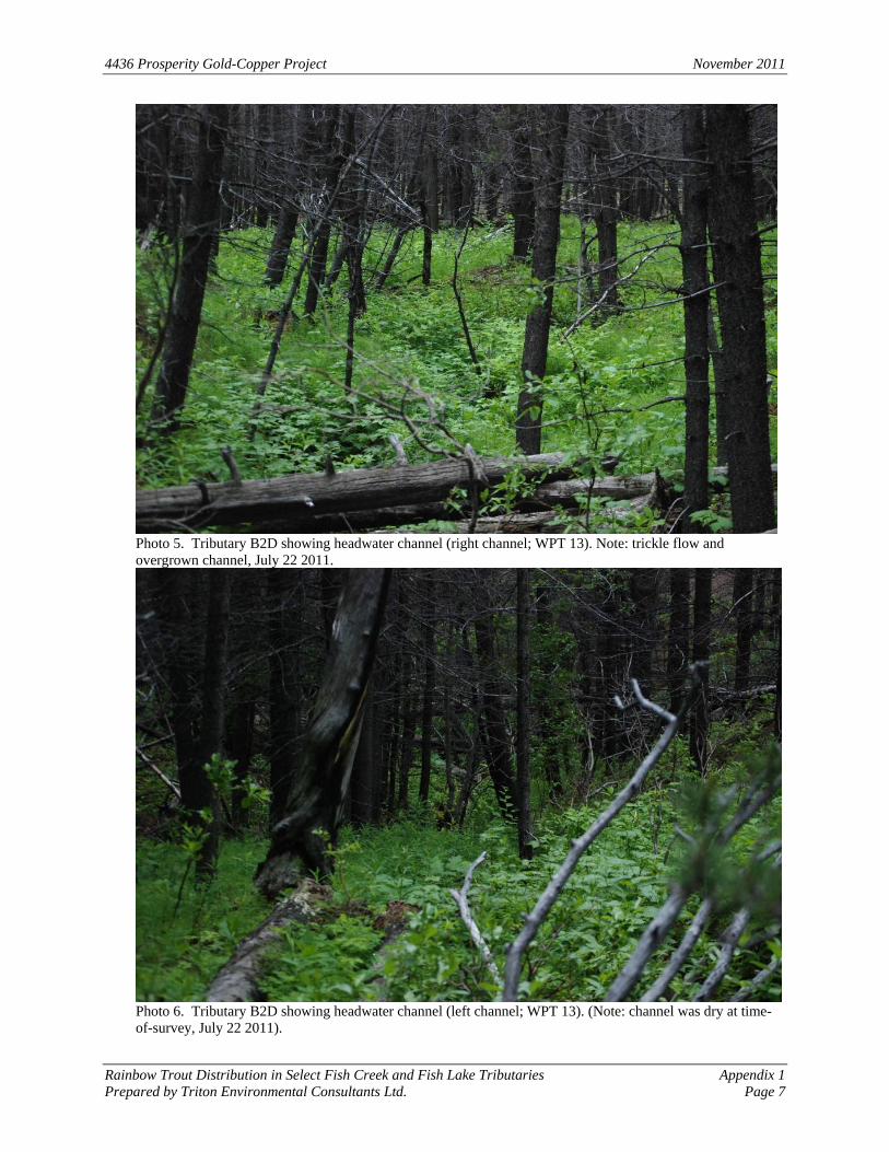
Photo 5. Tributary B2D showing headwater channel (right channel; WPT 13). Note: trickle flow and overgrown channel, July 22 2011.
Photo 6. Tributary B2D showing headwater channel (left channel; WPT 13). (Note: channel was dry at time-of-survey, July 22 2011).
4436 Prosperity Gold-Copper Project November 2011
Rainbow Trout Distribution in Select Fish Creek and Fish Lake Tributaries Appendix 1Prepared by Triton Environmental Consultants Ltd. Page 8
Photo 7. View of Upper Fish Lake Tributary 2 showing surface flow (WPT 15). Fish production here is likely limited by intermittent flow and fragmented habitat, July 23 2011.
Photo 8. View of Upper Fish Lake Tributary 2 showing limited surface flow (WPT 15), July 23 2011.
4436 Prosperity Gold-Copper Project November 2011
Rainbow Trout Distribution in Select Fish Creek and Fish Lake Tributaries Appendix 1Prepared by Triton Environmental Consultants Ltd. Page 9
Photo 9. Fish Lake Tributary 3 (WPT 26) showing one of several minimal flow cascades about 400 m upstream from Fish Lake, July 24 2011. These cascades are considered a barrier to upstream fish migration.
Photo 10. Middle Fish Creek Tributary 1 (WPT 37) showing fragmented habitat (isolated pool), July 25 2011.
4436 Prosperity Gold-Copper Project November 2011
Rainbow Trout Distribution in Select Fish Creek and Fish Lake Tributaries Appendix 1Prepared by Triton Environmental Consultants Ltd. Page 10
Photo 11. Upper Fish Creek (Reach 8) looking upstream from confluence with Fish Lake (WPT 29; 10U 458025; 5698604), July 24 2011.
Photo 12. View of Upper Fish Creek (reach 8) showing gravel substrate suitable for rainbow trout spawning (WPT 30; 10U 458103; 5698587), July 24 2011.
4436 Prosperity Gold-Copper Project November 2011
Rainbow Trout Distribution in Select Fish Creek and Fish Lake Tributaries Appendix 1Prepared by Triton Environmental Consultants Ltd. Page 11
Photo 13. Upper Fish Creek. (reach 8) showing riffle habitat (WPT 31), July 24 2011.