Embed Size (px)
Citation preview

Haglund, T.R., and J.N. Baskin, "Fish and Wildlife Survey and Habitat Assessment of the Santa Clara River at Interstate 5" (October 2000)

5
w
California State Pol-technic University, Pomona 3801West ~ e r n ~ l eAvenue Pomona, California 91768 (RECEIVED(
JUL 0 8 2002
INT.
VALENCIA COMPANY INFRASlRUCTURE
Fish and Wildlife Survey and Habitat Assessment of the Santa Clara River at Interstate 5
Prepared for: Paul Caron Environmental Planning Branch California State Department of Transportation 120 South Spring Street Los Angeles, California 90012
Prepared by: Thomas R. Haghnd, Ph.D. JonathanN. Baskin, m.D.
October 2000

Introduction
Dr. Jonathan N. Baskin and Dr. Thomas R. Haglund were contracted by the California Department of Transportation through California State Polytechnic Unversity, Pomona to perform fish and wildlife surveys and a habitat assessment of the Santa Clara River and its riparian corridor at Interstate 5 0-5). The work is being conducted in anticipation of the replacement of the 1-5 bridge over the Santa Clara River.
Four federally listed species are known to occur or are presumed to have the potential to occur at this site.
Federally Endangered: Unarmored Threespine Stickleback, Gasterosteus acdeatus williamsoni
' Least Bell's Vireo, Vireo bellii pusillus Southwestern Willow Flycatcher, Epidonax traillii extimus
Federally Threatened: Santa Ana Sucker, Catostomus santaanae
Additionally, six federal species of concern are known to occur or are presumed to have the potential to occur at this site.
Federal Species of Concern (State Species of Concern) - Animals: Arroyo Chub,Gila orcum' San Diego Horned Lizard, Phrynosoma coronatum blainvillei
Federal Species of Concern - Plants: Palmer's Grapphghwk, Harpagonella palmeri Short-joint Beavertail, Opuntia basilaris var. brachyclada Pierson's Morning Glory, Calystegiapiersonii Slender Mariposa Lily, Calochortus clavatus var. gracilis
Surveys for the above species were conducted with the exception of the San Diego horned lizaid. Surveys for this species were conducted by Paul Caron of CalTrans and are not part of this report. The USFWS protocols were used for the two bird species, least Bell's vireo and southwestern flycatcher. The contract required a fish survey to be conducted twice. A survey of riparian habitats and riverine habitat was also performed under this agreement. The project area for all work was considered to be 500 meters upstream and downstream of the bridge. The downstream end of the survey area was at the retaining wall for the Valencia Water Reclamation Plant (GPS coordinates 0353969E, 3810615N see Photo I),and the upstream end of the survey area was at the railroad bridge (GPS coordinates 0354427E, 3810303N,see Photo 2)
Page 1

Photo 1. Downstream limit of surveys, adjacent to the retaining wall of the Valencia 1 'ater Reclamation Plant

Natural History of the Fish and Wildlife speciesAddressed in this Report
Unarmored Threespine Stickleback, Threespine sticklebacks are small, laterally compressed fish. They have three sharp spines on the back in front of the soft dorsal fin. The pelvic fin is reduced to a single stout spine and a small ray. Their eyes are large and the mouth terminal, but slanting slightly upward. The caudal peduncle is narrow. They lack spines but may possess a variable number of bony plates on their sides.
The anadromous holarctic threespine stickleback, Gasterosteus muleaus Linnaeus, occurs along the western coast of North America from Alaska south to northern Baja California. G. aculeatus is best known for its morphologic and emlogic variation. This variation has been enhanced by the species' propensity to establish nonanadromous freshwater populations. As a consequence of this ability, Gasterosteus muleaus occurs as remnant freshwater populations along the southern edge of its eastern Pacific distribution in areas where marine anadromous populations no longer exist. These southern freshwater populations were presumably founded during Quaternary glacial periods when cooler ocean temperatures would have allowed marine populations to penetrate more southerly waters.
In California, the presence of Gasternstews aculew in most coastal drainages has been well documented beginning in the mid-1800s. Recent texts and field guides still list Gasterosteus aculeatus as present in virtually aIl coastal streams of California, but recent surveys have shown a drastic decline in sticklebacks in southern California. Miller and Hubbs recognized three subspecies in California: (1) Gasterosteus aculeahrs actdeafus, a typically anadromous form with a complete row of lateral plates extending from the anterior portion of the body to the caudal peduncle; (2) Gasterosteur aculeutus rnicrocephalus, a freshwater resident with the lateral plates restricted to the anterior portion of the body; and (3) GQstemsteus aculeatus williumsoni, a subspecies that lacks lateral phtes and has a limited distribution within southern California (this subspecies is listed as federally endangered).
Sticklebacks may occur throughout streams depending on the hydrology but tend to gather in areas of slow flow or standing water. In fast flowing stream sections they are found in eddies behind obstructions or along the edge of the stream where vegetation slows the flow.
During breeding season male sticklebacks develop a distinctive nuptial coloration (red throat, blue sides and a blue eye). Males defend territories adjacent to vegetation where they construct a nest. The nest is constructed by excavating a depression in the substrate, placing a mound of algal strands and other plant material in the depression, and gluing the material together with a sticky kidney secretion. Once the nest is formed, the male creates a tunnel in the nest by wriggling his way through the mound. Once the nest has been completed the male performs an elaborate courtship which entices females to lay their eggs in the nest. Males attract several females to the nest, each of which will lay from 50-300 eggs. After the courtship phase haspassed males defend the eggs and care for them while they develop.
Page 3

One activity during this period is "fanning". "Fanning" males use their pectoral fins to create water currents that flow over the eggs. This activity is apparently necessary for normal development of the eggs. The eggs take approximately 6-8 days to hatch at 18-20 "C. The fry remain in the nest for the first couple days during which time the male continues to guard them.
Two features of the stickleback's habitat appear to be essential for the survival of the young. First a slow flow of clear water is necessary for the proper development of the eggs. Anyform of pollution or even small amounts of turbidity may interfere with normal development. Second, once the fry emerge, aquatic vegetation must be present along the shoreline to supply cover and abundant microscopic food organisms.
Based on size-frequency curves, gonadal examination and field observations, in southern California there is some reproduction in most months if stream flows remain low, There is however, a peak reproductive time in the spring, beginning in about March. This reproductive peak continues into the early summer then attenuates through late summer and fall. Minimum reproduction occurs in the winter months. The species apparently lives for only one year. Thus stickleback populations tend to decline in the winter due to natural mortality and low recruitment.
Sticklebacks are opportunistic feeders relying upon a wide variety of foods. They appear to prefer insects but at times snails may be important while flatworms and nematodes comprise only a small percentage of the diet.
Sticklebacks are preyed upon by a wide variety of organisms. Wading birds such as herons have been observed feedingon sticklebacks. Other native predators include the two-striped garter snake, Thamnophis hammondii, and belostomatid water bugs, Belostoma sp. The southwestern pond turtle (Clemmys mamorata pallida) may occasionally feed on stickleback eggs. Introduced organisms also prey upon the stickleback. These include fishes, such as bullheads (Ictalurws) and sunfishes (Lepomis), and the African clawed frog (Xenopus Isrevus).
Santa Ana Sucker. Santa Ana suckers are small catostomids with adults commonly less than 175mm SL (standard length). Their gross morphoIogy is generaIIy similar to that of mountain suckers (Catustomusplaryrhynchus) and they possess notches at the junctions of the lower and upper lips as do mountain suckers. Large papillae are found on the anterior of the lower lip but papillae are poorly developed on the upper lip. The jaws have cartilaginous scraping edges inside the lips. There are 21-28 gill rakers on the external row of the first arch and 27-36 on the internal row. This species has 67-86 lateral line scales; 9-1 1 dorsal fin rays, usually 10; and 8-10 pelvic fin rays. The axillary process at the base of the pelvic fins is represented only as a simple fold. They possess a short dorsal fin and a deep caudal peduncle. The fish . are silver ventrally while the dorsal surface is darker with irregular blotching. The degree of dorsal darkening and blotching is variable. Breeding males develop breeding tubercles over most of the body, but the tubercles are most dense on the caudal and anal fins and the caudal
Page 4

peduncle. Reproductive females possess tubercles only on the caudal fin and peduncle,
Catostomus santaanae was originally described as Panrosteus santa-awe by Snyder in 1908 based on specimens collected from the Santa Ana River, Riverside, California. The hyphen was dropped from the specific name and the species was assigned to the genus Catostomus by Smith in 1966. Smith considers Pamsteus to be a subgenus of Catostomus. The older literature uses the name assigned by Snyder.
Santa Ana suckers are endemic to the Los Angeles basin. Their original range included only the Los Angeles, Santa Ana and San Gabriel river systems. Today small populations are still found in the Santa Ana River; Tujunga Wash in the Los Angeles River system; and in the upper San Gabriel River system. Large populations are found only in the San Gabriel River. For this reason it has been suggested that the East, West and North Forks of the San Gabriel River be considered for status as a Native Fish Management Area for this species. A potentially introduced pupulation exists in the Santa Clara River, however, this population is in decline and throughout the lower portion of the drainage has hybridized with another introduced sucker, the Owens River sucker, Catostomusjbneivennis.
The Santa Ana sucker is threatened by elimination or alteration of its stream habitats, reduction or alteration of stream flows, poUution, and introduced species. The fact that this fish is in such trouble is indicative of the poor state of the streams in the Los Angeles basin, which suffer from multiple and cumulative effects of many agents.
In lowland areas, virtually all of the habitats once used by this species have been channelized, dewatered, or otherwise altered. In upland areas, most streams have been either dammed or diverted, or are continually threatened by mass erosion of destabilized hillsides, by gold dredging (suction dredging) and other mining activities, and by grazing or other heavy uses of the riparian area. For example, mining activity has increased in recent years on Cattle Canyon, a tributary of the East Fork of the San Gabriel River, resulting in the apparent elimination of sucker populations in Cattle Canyon. .
A number of the remaining populations of the Santa Ana sucker live below dams or in river reaches dependent on wastewater from sewage treatment plants. The flows of Big Tujunga Creek below Big Tujunga Dam vary so greatly that an artificially enhance trout population cannot mainbin itself and all the native fish are subject to extirpation. The population in the West Fork of the San Gabriel River is constantly threatened by high releases of sediment laden water from Cogswell Reservoir, which have devastated the stream in the past. In the Santa Ana River, one subpopulation depends on adequate releases of water from Prado Dam. In earlier years, water diversions for power generation probably often dried up the lower reaches of the Santa Ana River during the summer. Today the constant manipulation of virtually all stream segments precludes the development of stable habitat.
Introduced species are a constant threat to the Santa Ana sucker populations. For example, the sucker formerly inhabited the upper Santa Ana River in the San Bernardino Mountains,
Page 5

but seems to have been eliminated by introduced predatory brown trout. The introduced suckers of the Santa Clara River are potentially threatened by introgression with Owens suckers introduced into the lower Santa Clara River. Other populations are threatened by the red shiner (potential competitor and egg predator), green sunfish (potential predator), and smdlmouth bass (potential predator).
Santa Ana suckers are found in small to medium sized streams, usually less than 7 meters in width, with depths ranging from a few centimeters to over a meter. Flow must be present but it can range from slight to swift. The native streams were all subject to severe periodic flooding, thus suckers prefer clear water but can tolerate seasonal turbidity. The preferred substrates are gravel and cobble but may also include sand. Santa Ana suckers are associated with algae but not macrophytes. Although the sucker seems to be quite generalized in its habitat requirements, they are intolerant of polluted or highly modified streams.
The only substantial life history study done on this species studied the Santa Clara River population. Spawning in this species occurs from April vntil early July but peaks in late May/early June. The eggs are demersal and are spawned over gravel. Fecundity is high for such a small sucker species, ranging from 4,423 eggs in a'78mm SL (standard length) female to 16,151 in a 158mm SL female. The Santa Ana sucker is relatively short-lived, few individuals survive beyond their second year and none beyond the third year. They are reproductively mature in their first year and thus will typically spawn for two years. The species is more fecund than most other catostomids. Growth rates suggest first year individuals reach 61mm, second years 77-83mm and by the third year 141-153mm SL. Development of the eggs and larvae has been described by Greenfield.
Detritus, algae and diatoms comprised 97% of the stomach contents while aquatic insect larvae, fish scales and fish eggs accounted for the remaining 3% in the only natural history study. Larger specimens usually had an increased amount of insect material in their stomachs. The herbivorous trophic status of the Santa Ana sucker is substantiated by it's long intestine with up to 8 coils.
Arroyo Chub. The arroyo chub is a small fish that averages 120mrnTL (total length) although occasionally large individuals may reach 300mm TL. They possess a "chubby" body, moderately large eyes and small mouths. The dorsal color is silvery or grayish to olive green, ventrally they are white and there is usually a dull gray lateral band. They have 7 anal fin rays, 8 dorsal rays, 5-9 gill rakers and 48-62 lateral line scales. The dorsal fin origin is placed behind the origin of the pelvic fins. The pharyngeal teeth (2,5-4,2; variable) are closely spaced and strongly hooked.
Both Gila orcutti and the closely related Gila purpurea in the subgenus terneculina. The arroyo chub hybridizes with the Mohave tui chub (Gilabicolor mohavemis) and the California roach (Lrzvinfasymmetricus).
Page 6

Arroyo chubs are native to the Los Angeles basin (Los Angeles, Santa Ana and San Gabriel Rivers); Maiibu and San Juan Creeks and the Santa Margarita River drainage. Although once common and widespread, its distribution has been significantly reduced. The reduction has been considered severe enough to suggest that this species deserves close monitoring and that attempts should be made to improve the status of existing populations. It has been suggested East, West and North Forks of the San Gabriel River should be considered for status as a Native Fish Management Area for this species. Populations of arroyo chub presently exist to the north, outside the native range, in the Santa Clara, Santa Ynez, Santa Maria, Cuyama and Mojave river systems.
Arroyo chubs are adapted to survive in the warm fluctuating streams of the Los Angeles basin. These streams, prior to channelization, were often turbid torrents in the winter and clear interrnittent,creeks in the summer. The chub preferentially inhabits low gradient but flowing water, however, it is also found in slow water areas within high gradient streams. The association with low flow areas means that this species is usually found over sand or mud substrates. Laboratory studies demonstrate that the arroyo chub is physiologically adapted to survive hypoxic conditions and large temperature fluctuations.
The only extensive studies on the biology of the arroyo chub were done on the introduced population inhabiting the Cuyama River in Santa Ehrbara County, and more recently on the Santa Clara River population. Arroyo chubs bred primarily during March and April although some reproduction may occur into Jdy. Spawning typically occurs in pools in association with aquatic vegetation. The eggs are demersal and adhesive; hatching occurs in 4 days at 24.2 "C.
The oldest chubs found in the Santa Clara RIver were 4+ years, but breeding apparently begins after the first year. After year 2, females are larger than males.
This species is omnivorous, feeding on algae, insects and small crustaceans. When examined 60-80% of the stomach contents consists of algae. However, they are believed to derive most of their nutrition from the aquatic organisms associated with the plants. They have also been shown to feed on the nematode infested roots of the floating water fern, AzolZa. Invertebrates increase in number and variety in the diet during the spring and are least abundant during the winter.
Because they evolved in a community of fish (Santa Ana suckers, Santa Ana speckled dace and threespine sticklebacks) lacking major predators, they appear to be susceptible to predation by introduced predatory fishes, particularly centrarchids.
Least Bell's Vireo. The least Bell's vireo, Vireo bellii pwillus, was listed as state endangered by the California Fish and Game Commission on 27 June 1980 due to population declines correlated with habitat destruction. The U.S. Fish and Wildlife published a final rule listing least Bell's vireo as federally endangered on 2 May 1986.
Page 7
The least Bell's vireo is one of four subspecies of Bell's vireo currently recognized. All subspecies are apparently isolated from one another throughout the year. The least Bell's vireo breeds in California and northwestern Baja California and winters in southern Baja California, Mexico. Historically, least Bell's vireo's breeding range extended from the interior of northern California to northwestern Baja California, Mexico. In the last decades it has been extirpated from the Sacramento and San Joaquin valleys and is now primarily distributed in coastal nverine systems in southern California and northwestern Baja California, Mexico.
Males arrive several days ahead of females and appear on the breeding range from mid- March to early April. Male least Bell's vireos establish and defend a temtory within which all reproductive activities are conducted, from pair formation to fledging of the young. Temtory size has been measured at several localities: Gibalter Reservoir, 0.4-1.6 hectares (ha); Prado Basin on the Santa Ana River, 0.58+0.26 ha with a range of 0.15-1.31 ha; and Sweetwater River, 0.76k0.30 ha with a range of 0.20-1.66 ha. Studies of banded and color marked least Bell's vireos indicate that they are quite site tenacious as adults, with males returning to the territory used the previous year. Juveniles are considerably more likely to disperse. In one area in 1983, for example, 31 of 50 birds banded the previous year returned to the same nesting vicinity, given normal mortality of most passerine birds, a return of 31 out of SO birds may likely represent a return of all surviving birds. Once a pair bond is established, both members of the.pair construct the nest, which usually takes 4-5 days. Mean nest height above the ground has been measured at several sites, Sweetwater River, 0.93k0.40 m; San Diego River, 1.3 1k0.63 m; San Luis Rey River, 1.06k0.33 m; and the average height on the Santa Margarita River was 1.01 m. The nests are usually placed near the edge of the thicket. The compact nest is a cupshaped structure composed of leaves, bark, willow catkins, spider webs, and other material. Egg laying begins 1-2 days after nest completion. Three to five eggs are laid with a mean of four. Incubation requires about 14 days and both adults participate. Young are fed by both parents and fledge in 10-12 days. Young may remain in the territory and are cared for by the adults perhaps as long as 40 days. Most least Bell's vireos migrate from the breeding area from late July to late September.
It is believed that a dense shrubby layer near the ground is a critical component of breeding habitat. Vireo nests are most frequently located in stands between S and 10 years of age. When a mature woodland is selected, the vireos choose areas with a substantial robust understory. The ecosystem dynamics of vegetation scouring by flooding and river course meandering rejuvenates the system, otherwise old age stands would persist and the tall canopy would shade the understory. Therefore it is apparent that riparian plant succession is an important influence on vireo habitat.
Southwestern Willow Flycatcher. The southwestern willow flycatcher is a small passerine bird. It is one of four species of the willow flycatcher recognized in North America. The southwestern willow flycatcher's breeding range includes southern California, Arizona, New Mexico, western Texas,
Page 8

southwestern Colorado, southern portions of Nevada and Utah. During the breeding season, the species occurs in riparian habitats along rivers,streams, open water, cienegas, marshy seeps, or saturated soil where dense growths of willows (Salix spp), Baccharis, arrowweed (Pluchea sp.), tamarisk (Tamarix sp.) or other plants are present, sometimes with a scattered overstory of cottonwood (Populws sp). These riparian communities which tend to be rare and widely separated, provide nesting, foraging, and migratory habitat for the southwestern willow flycatcher. The flycatcher is an insectivore that forages within and sometimes above dense riparian vegetation,taking insects on the wing and gleaning them from foliage.
The willow flycatcher nests in dense riparian vegetation approximately 4-7 meters (13-23 feet) tall, often with a high percentage of canopy cover. Historically, the southwestern willow flycatcher nested primarily in willows, with a scattered overstory of cottonwood. In addition to nesting in riparian woodland vegetation consisting of willows, arrowweed, tamarisk, or other species; southwestern willow flycatchers nest almost exclusively in coast live oaks (Quercus agwolia) on the upper San Luis Rey River in San Diego County, which may be classified as an oak riparian woodland. Following modem changes in riparian plant communities in the southwest, the southwestern willow flycatcher still nests in willows when they are available, but is also known to nest in areas dominated by tamarisk and Russian olive. Sites selected as song perches by male willow flycatchers exhibit a greater variability in shrub size than do nest sites, and often include large central shrubs. Habitats not selected for either nesting or singing were narrower riparian zones, with greater distances between willow patches and individual willow plants.
Results
Fish Surveys. Fish surveys were conducted on 3 June and 14 July 2000, Surveys were conducted using a 118 inch mesh, 10 foot by 6 foot nylon minnow seine. Only one side of the stream was seined, the north side. The data provide the distribution of the fishes within the area, a semi-quantitative evaluation of numbers, and information about the population structure.
All three species were found throughout the area seined, 500 meters upstream and downstream of the Interstate 5 bridge over the Santa Clara River. Not only were all three species collected but the generalized life stages, fry, juvenile, and adult, of all three species were collected. During the surveys, particularly the first survey on 3 June, large numbers of fry of all three species were collected in the study area. The numbers of fry occupying some particularly favorable habitat areas was so great that these areas were not seined in order to avoid the risk of mortality, but it was verified that fry of all three species were present. This suggests all three species bred in or near the study reach in 2000. Stickleback and chubs do not immediately disperse from their hatching area. The behavior of the sucker fry following emergence from the gravel is unknown. Fry of all three s@es congregate in shallow water with sticklebacks and chubs, particularly, also favoring areas with emergent vegetation and/or algae.
Page 9

On 3 June, 168 sticklebacks were collected in 340 meters downstream of the 1-5 bridge. This is 0.49 sticklebackslmeter seined. On 3 June, 296 suckers were collected in the same 340 meters, as were 414 chubs. Which means there were 0.87 suckerslmeter seined and 1.22 chubslrneter seined. On 14 July, 152 sticklebacks were collected in 450 meters of stream, which is 0.34 sticklebackslrneter seined. During the 14 July survey 561 suckers and 699 chubs were collected i n the same 450 meters. Thus, there were 1.25 suckerslmeter seined and 1.55 chubs/meter seined. All three species were common in the study area.
During both surveys sticlclebacks were more common downstream of the bridge than upstream. The same pattern was true for suckers and chubs, but it was much less pronounced. Although the upstream reach contained fry, juveniles, and adults just as did the downstream reach; the upstream reach had fewer fry and juveniles resulting in overall lower numbers of individuals captured. .
Fish were captured directly under the bridge during both surveys. On 3 June there were 2 sticklebacks, 4 suckers, and 2 chubs, while on 14 July, 23 sticklebacks, 70 suckers, and 100 chubs were captured.
Table 1 contains size distribution data for the 3 June survey and Table 2 contains the size distribution data from 14 July. The standard lengths were measured on a subsample of fish collected during each survey. Fish to be measured were not selected from a seine haul, all fish in any seine haul were measured, thus these data provide an indication of the population structure in this stream reach at the time of the surveys.
Page 10

Table 1. Size distributions (standard length in millimeters) of 168 sticklebacks, 213 suckers, and 226 chubs captured during the 3 June 2000 fish survey.
45.1 - 50.0 50.1 - 55.0 32
55.1 - 60.0 81
60.1 - 65.0 35
65.1 - 70.0 26
70.1 - 75.0 23
75.1 - 80.0 2 2
80.1 - 85.0 1
85.1 - 90.0 2 3
90.1 - 95.0 6
95.1 - 100.0 15
100.1 - 105.0 6
105.1 - 130.0 5
110.1 - 115.0 9
115.1 - 120.0 1
120.1 - 125.0 5
larger 128,132,136,140,140, 142,145,'145,149mmSL
Page 11

Table 2. Size distributions (standard length in millimeters) of 154 sticklebacks, 88 suckers, and 113 chubs captured during the 14 July 2000 fish survey.
- ..
Standard Threespine Arroyo Santa Ana Length Stickleback Chub Sucker
0.0 - 5.0
5.1 - 10.0
10.1 - 15.0 1
15.1 - 20.0 5 8
Page 12

Even a cursory comparison of the two data tables shows differences. The stickleback data demonstrate growth between the two surveys. The sucker data also show growth of the small fish but the large size classes present during the 3 June survey were not present during the 14 July survey. These data suggest that the adults have migrated out of this stream reach. The movements of suckers in this river are poorly understood. Haglund and Baskin have other non-systematic observations that suggest suckers migrate to and through the study reach. The 3 June sucker data suggest the presence of three year classesThe chub data show growth of the smaller size classes collected, but the presence of the fry indicate some level of continued reproduction during the interval between the surveys. The 14 July chub data show a bimodd size distribution.
Plate counts were made on 25 sticklebacks, 30mm SL or greater. Those data are displayed below in Table 3.
Table 3. Standard length and plate counts on a sample of sticklebacks collected from the study site on 3 June 2000.
34 0 0
41 0 0
39 0 0
39 0 0
Page 13

The preceding data yield a value of 0.20 plaks/fish. The Revised Recovery Plan criteria for recognition of the unarmored threespine stickleback says that average plate counts for populations of the unarmored threespine stickleback range from 0.06 platedfish to 0.55 platedfish. Thus, these data, as expected, confirm the identity of the sticklebacks at this location to be the unarmored form. This is consistent with data collected by Haglund and Baskin in other years, and with an 1989 allozyme study (unpublished) conducted by Haglund using fish collected.just upstream of the study area.
Blrd Surveys. The U.S.Fish and Wildlife protocol surveys for least Bell's vireo and southwestern willow flycatcher and an overall riparian bird survey were conducted by Zev Labinger. The following report on the bird surveys was written by Zev Labinger and edited by the authors of this report.
A riparian breeding bird survey was conducted during 6 visits between May and July. The main emphasis of these surveys was to determine the possible presence of any endangered species, most notably the Least Bell's Vireo Vireo bellii pusillus, and Southwestern Willow Flycatcher Empidonax traillii extimus). No Least Bell's Vireos, Willow Flycatchers or any other threatened or endangered species were found,
The project area consists of an approximak~y one-mile stretch of the Santa Clara River ,
centered at the Interstate 5 Overpass (Figure 1). The river bottom here is more typical of inland riparian habitat with meandering low-flow channels, bordered by upper-shelf mature willow-cottonwood forest. A variety of riparian wetland habitat types ranging in successional
Page 14

Adaptedfrom USGS Topographic map, Newhall, CA, 1995
Page 15

stages are present at the site. The low-flow channel consists of open sand and gravel bars interspersed with early successional riparian vegetation such as willow (Salix sp.) and mulefat (Bacchris salicifolia). Freshwater marsh habitat occurs along portions of the low-flow channel, and consists of small pools surrounded by bulrush (Juncussp.) and cattail (7'yphus sp.). Mature riparian forest exists along both sides of the river and forms relatively broad areas along the northeast portion of the site. These mature forests are dominated by Fremont and Black Cottonwoods (PopJw sp.) and willows. In addition, upland, dry scrub habitat is found along the southcentral, upper bank and is dominated by atriplex and mulefat.
Overall, the project area supports relatively high quality riparian habitat. Habitat impacts stem mostly from human disturbance in the form of commercial land use, noise from Interstate 5 and frontage roads and railroad, and off road vehicle (ORV) use. Non-native giant reed (Amdo dona) and Tamarisk (Tamurix sp.) occur sparsely throughout the site and does not appear to be a significant problem,
The project area was surveyed during six visits between 16 May and 26 July 2000. Survey dates, timing and weather conditions are presented in Appendix A. Surveys consisted of slowly walking along the riparian corridor and recording all species of birds detected by sight and sound. Other species of wildlife were also recorded when detected either by sight, sound or signs such as scat, tracks and dens. All surveys were conducted during morning hours between 0600 and 1200, which corresponds to the peak activity period of most birds. Given the large size of the area, the order of surveying different areas was varied to insure an even temporal coverage of the whole study area.
Specific surveys were conducted for Least Bell's Vireo (Vireo bellii puscillus), and Southwestern Willow Flycatcher (Empidonax traillii extimus} following methodology of the specific U.S. Fish and Wildlife Service Protocols (Fish and Wildlife Service 1998b; Tibbitts et al. 1994; Endangered Species Permit TE812739-1). Both of these survey protocols involve the use of tape-recorded playback songs to elicit responses from wild birds. The tapes are played at a Frequency and duration that will ensure complete coverage of appropriate habitat within a site. When an individual of one of these species was detected, tapes were no longer used. These individuals were observed and subsequently monitored to determine breeding status and productivity. All three of the required Willow Flycatcher surveys were completed; however, only six of the required eight vireo surveys were conducted for this study. Tom Haglund of San Marino Environmental Associates conducted two vireo surveys earlier in the season.
Bird species and number of individuals per survey date detected during the riparian surveys are presented in Table 4. All other wildlife species detected during the surveys are presented in Table 5.
The project area supports a relatively rich diversity and abundance of wildlife species. A total of 53 species of birds, 4 herpetofauna, and 11 mammals were detected during the survey period. No listed (endangered, threatened or species of special concern) or even
Page 16

locally sensitive species were found. This result is particularly interesting given that several sensitive species occur both upstream and downstream of the project area. Least Bell's Vireos breed annually at a location just 500 meters downstream of the site (Labinger and Greaves 1999). In addition, sensitive species are found within a one kilometer radius of the project site such as White-tailed Kite, Cooper's Hawk, Swainson's Thrush, Yellow-breasted Chat and Blue Grosbeak.
Understanding and identifying the underlying factors that determine bird distribution is difficult at best. As mentioned above, habitat does appear to be impacted in this area by the close proximity of commercial land use, noise from Interstate 5 and frontage roads and railroad, and off road vehicle (ORV) use. Non-native species such as Arundo and Tamarisk are actually less extensive within the project reach.
Brown-headed Cowbirds were found on site and can be a significant factor in reducing songbird populations. Brown-headed Cowbirds are a brood parasite that lay their eggs in the nests of other species (host). Several cowbird traps were present approximately one mile upstream of the project site but may have been to far to affect the project area (Trap operation unknown).
Literature cited in the bird report. Fish and Wildlife Service. 1998. Draft Recovery Plan for the Least Bell's Vireo. U.S.Fish
and Wildlife Service, Carlsbad Field Office, California. Fish and Wildlife Service. 1998. Draft Least Bell's Vireo Survey Guidelines. U. S. Fish and
Wildlife Service, Carlsbad Field Office, California. Labinger, Z. and J. Greaves. 1999. (Draft) Results of 1998 avian surveys and Least Bell's
Vireo monitoring: Restoration phase of ARCOtFour Comers January 17, 1994 oil spill on the Santa Clara River, California. Prepared for U.S, Fish and Wildlife Service, Ventura Field office, California.
Tibbitts, T.J., M.K.Sogge, and S.J. Sferra. 1994. A survey protocol for the Southwestern Willow Flycatcher (Empidinax traillii extimud. Tech. Rep. NPSINAUCPRFINRTR- 94/04. U. S. Dept. Interior. Nat. Park Service, Colorodo Platue, Res. Stat., Flagstaff, AZ.
Page 17

Table 4. Totaf number of individual birds detected during ZOO0Spring Avian Suweys within the Interstate 5 Overpass Project Area, Los Angeles County, California.
\6 E\ 9 %0 E\q fp
SPECIES +& ,a+?' ,ae ,& . ,& ,$ Comments
Green Hemn 1 1 Adult and Juvenile
Mallard 1 1 1 2 Breed in area
Turkey Vulture 1 3 Breed in area
Red-shouldered Hawk 1 1 1 2 Breed in area
Red-tailed Hawk 1 1 1 Breed in area
California Quail 3 2 2 2 2 3 Bred on site
Killdeer 2 2 1 1. Probable breedmg
Rock Dove 1 2 resident
Moummg Dove 2 3 2 2 3 Bred on site
Chirnney/Vaux's Swift vagrant/migrant
White-throatedSwift 2 1 Breed in atea
Costa's Hummingbird 1 Breed in area
Anna's Hummingbird 1 1 1 2 2 Bred on site
Hummingbird sp 2 1 1 1
Downy Woodpecker Hairy Woodpecker Nuttall's Woodpecker
Northern Flicker
1 2
1
2 1 . 3 1
Breed in area Breed in area
Bred on site Breed in area
Black Phoebe 2 1 1 1 4 2Juveniles
Ash -throated Flycatcher 3 3 . 3 2 2 Bred on site
Page 18

\! \ @ c, 0 @ +& ,# ,.Q* . 4 ,$ ,$SPECIES
Rngbird sp. Tree Swallow Violet-green Swallow Northern R o u g h - w e d Swdow Cliff swallow Barn Swllow Western ScrubJay American Crow Common Raven
Oak Titmouse Bushtit Bewick's Wren House Wren Western Bluebird Wrentit California Thrasher Phainopepla European Starling Otange-crowned Warbler Yellow Warbler Common Yellowthroat Black-headed Grosbeak Blue Grosbeak Lazuli Bunting Spotted Towhee California Towhee Song Sparrow
Comments
Breed in area
Breed in area Bred on site 5-10 nests at bridge Breed in area Bred on site Breed in area Breed in area
Bred on site .
Breed in area Bred on site
nest found Juvenile Breed in area Bred o n site Breed in area Bred on site Probable breeding Possible migrants Bred on site Bred on site Breed in area
Breed in atea Bred on site Bred on site Bred on site
Page 19

46 4 @ a 4% + SPECIES
Lark Sparmw Red-winged Blackbird Brewer's Blackbird Brown-headed Cowbird Bullock's Oriole House Finch Lesser Goldfinch American Goldfinch Goldfinch sp.
+$A ,#@,+Qe ,$ ,$ 5 .$9 Comments
2 Breed in area
4 2 3 1 Breed inarea 2 2 Breed in area
2 2 2 1 1 Min. 2 maie/l female
1 1 1 Breed in area 3 4 4 6 6 8 Bred on site
2 2 2 3 3 Bred on site
4 3 Breed in area 1
Page 20

Table 5. Wildlife species detected during 2000 avian surveys of the Interstate 5 Overpass Project area, Los Angeles County, California. (0= species observed, S = species' detected by signs of tracks, scat or dens).
SPECIES
Hemetofauna
Pacific Tree Frog Western Toad Western Fence Lizard Side-blotched Lizard
Opossum Deer Mause Dusky-footed Woodrat ValIey Pocket Gopher California Ground Squitrel Desermrush Cottontail Striped Skunk Raccoon Coyote Bobcat Mule Deer
Pse~(dam'sreg-& Bufo boreas Scekpomoca'dntalis Utask3mburiana
D&4& ~ffmmppic~
Peroystlumm-culat~~ Neofmnafu@s Td0momy.sb o w Cite1h.s beechyi Sylvalagus auduboni/ba&mani Mephitis mephitis P m y n hior Canus latrans Felis + Oabcoile~~bemiom
DETECTION COhlMENTs
0 Common 0 Several Individuals 0 Comman 0 Common
Common Common Common Common along upland Common along upland Common Observed on 2 visits 3 observed together Common Several individuals Minimm4-6
Page 21

Appendix A. Survey times and weather for start and finish of each survey Interstate 5 Overpass Project, Los Angeles County, California,
Survey Date Time 16 May Start 06:20
Finish 07:45
1 June Start 06:30 Finish 07:45
26 June Start 07:OO Finish 08:30
5 July Start 07: 10 Finish 08:00
12 July Start 0950 Finish 11:OO
26 July Start 06:15 Finish 07: 15
Weather
Temp (F) 55 60
60 65
68 70
65 70
80 80
70 75
Cloud (%) 20 20
0 0
0 0
0 0
0 0
0 0
Wind 0 0
0 0
0 0
0 0
5-10 5-10
0 0
Page 22

As stated earlier two avian surveys were conducted by Thomas R. Haglund, Ph.D. prior to the initiation of surveys by Labinger. These surveys were conducted on 22 April and 7 May 2000. The times and the conditions under which the surveys were conducted is shown below.
The vireo surveys were conducted without the use of tape recordings because vireos tend to be active and vocaI on their territories, even at the nest. Considerable time was spent sitting and listening throughout the study area. No vireos were heard or seen during either survey.
Table 4 contains the list of birds recorded by Labinger. The following birds were recorded during the surveys conducted by Haglund but not during the surveys conducted by Labinger. A11 other birds recorded by Haglund were also recorded by Labinger, so they have not been listed.
Great Blue Heron, Ardea herodias, 7 May Great Egret, Carmerodius albus, 22 April Cooper's Hawk, Accipiter cooperii, 7 May Barn Owl, Qto alba, 22 April Black-chinned Hummingbird, Archilochus alaandri, 22 April White-breasted Nuthatch, Sitta carolinemis, 22 April Yellow-ru mped Warbler, Dendroica coronata, 22 April Western Tanager, Piranga ludoviciana, 22 April
The above birds, plus the 53 species listed in Table 4 yield a total bird list of 61 species recorded from the study area during these bird surveys.
Table 5 provides ancillary observations of other vertebrates seen or recorded at the study site by Labinger. Haglund observed two snake species at the site not recorded by Labinger: gopher snake, Pituophis melanoleucus; and ringneck snake, Diahphis punctatus. Additionally, Haglund saw both a striped skunk and a bobcat within the study area. Labinger only reported signs of these two species. During the winter of 1997/8, the El Nino year, a dead young mountain lion was found in the current study area.
Page 23

Plants. Vegetation mapping and an evaluation of the presence of the sensitive plants was done by Curtis Clarke, Ph.D. His field evaluation of the four sensitive plants species and mapping of the plant communities was conducted on 15 September 2000.
Four Federal species of concern might be expected in the region: Slender Mariposa Lily (Calochortus clavancs var. gracilis) is a spring-flowering geophyte,
and would not be visible above-ground during the site visit. It would not be expected in the flood plain of the river, and would not persist, but it could occur on the upper terraces,
Palmer's Grapplingbook (HapagoneNapalmen' var. palrneri) is a spring-flowering annual and would not have been present during the site visit. Documented localities are almost exclusively in heavy clay soils, so it would not be expected in the flood plain of the river.
Short-Joint Beavertail (Opuntia basilaris var. brachyclada) would be easily seen at the time of the site visit. None were observed in the floodplain of the river, and the habitat is such that plants growing in the floodplain could not persist. Plants could possibly occur in especidly open but undisturbed sites on the upper terraces. These were surveyed only in the vicinity of the 1-5 bridge, and no plants were observed.
Peirson's morning-glory (Calysteginpeirsonii) would have been visible during the site visit. It would not be expected in the floodplain or in the cottonwood woodlands of the terraces, and none were seen.
It should be noted that surveys for these same four plants were conducted in this area in 1994 (Haglund and Baskin, unpublished data), and they were not found at that time.
Page 24

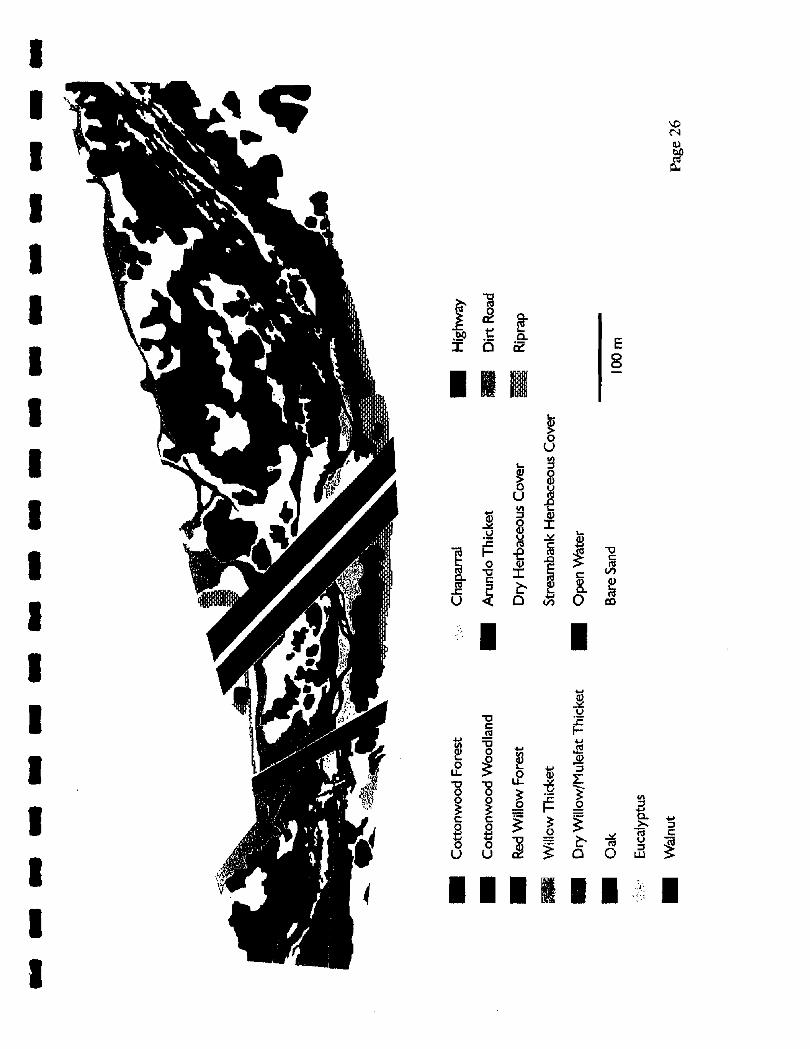
The accompanying map is based on aerial photographs of July 27, 2000, and a site visit on September 15, 2000. Three human-created zones occurred in the site: highway, dirt road, and riprap. The remaining area was characterized in fourteen vegetation types: Cottonwood Forest. Dense canopy, dominated by Populia fremontii with occasional Salix
laevigata. Cottonwood Woodland. Open canopy, dominated by Populus frernontii with occasional
Salk laevigata, most of which are in poor condition, being elevated above the current river level too high to receive an effective water supply.
Red Willow Forest. Dense canopy, dominated by Salk laevigara with a few Populzu fremontii and Salix lasiolepis,
Willow Thicket. Saplings of Salk laevigara, Salix lasiolepis, and Populusfremontii, occasional Atundo dona,
Dry WUlow/Mulefat Thicket. Baccharis salicifolia and Salix'exiguu; occasional Salix laevigata and Populus fremonbii saplings and Arundo donax.
Oak. A few Quercus agrifolia overlap the south boundary of the mapped area. Walnut. A single walnut tree (probably Juglans califomica) occurs on the north
boundary of [he mapped area. Eucalyptus. A single eucalyptus (species not determined) occurs beside I-5.on the south
boundary of the mapped area. Chaparral. A small patch of chaparral is found on the south boundary of the mapped area. Arundo Thicket. IsoIatecl patches completely dominated by Arundo donax. Dry Herbaceous Cover. Weedy grasses and forbs, occasional shrubs. Streambank Herbaceous Cover. Veronica anagallis-quatica, Rorippa nasturtium-
aquaticum, Lemna sp., and Azolla sp. adjacent to the open water, Polygonwn spp., v p h a spp., C'yperus spp., grasses on adjacent drier areas.
Open Water. Cladophora sp. growing attached to the stream bed, Bare Sand. Sparse vegetation,
The white regions on the map are the shadows of the highway bridges in the aerial photographs. The adjacent vegetation zones continue into the shadows, but it was not possible to map them accurately. The zones also continue beneath the bridges, except that under the 1-5 bridge there are many fewer species in each zone, and lower and less dense vegetation, because of shading, and because the bridges intercept rain water.
Page 25

Water Quality and Stream Description
Water Quality. Water quality was measured on 14 July and 15 September 2000 at the downstream (west) edge of the 1-5 bridge. The data are shown below.
Criteria 1 14 July I 15 September 11 PH Conductivity
Turbidity
Dissolved Oxygen .
Temperature
Salinity I
7.65
0.916
0
4.13
23.6
0
7.54
1.30
10
3.80
25.7
Stream Description. The Santa Clara River throughout its length shows a distinct seasonal variation. Typically, winter high flows remove emergent vegetation and increase the bedload (primarily sand, except at "flood" flows). The increased flows which broaden the river, coupled with the increased bedload results in the river becoming braided in many areas. As flows decrease a primary channel develops which becomes the low flow channel. Coincident with the restriction of flow to the low flow channel there is development of emergent vegetation dominated by Rorippa, Veronica, and Polygonwn. The vegetation development further defines the channel so that by summer the river is confined to a single channel in most areas. Additionally, the channel restriction increases flows sufficiently to move sand, and gravel becomes exposed where present. The stream reach downstream of 1-5 fits the above description very well (see Photos 3 and 4). In this downstream reach, the breadth of the open water ranged from 1.5-3.2 meters although in some areas water penetrated the emergent vegetation as much as 5 meters, In the broader shallower areas, such as those in Photo 4, the average depth was approximately 12-15 cm. Some narrow deeper runs such as the one below the armorflex were 26-32 cm deep. The deepest areas located were 50 cm deep. The preceding data were collected on 15 September.
Upstream of 1-5, for most of the study area, the riparian vegetation has grown to the stream edge, and the stream is slightly incised. Because of the encroachment of the riparian vegetation the stream is canopied or shaded in many areas, and there is less develpment of emergent vegetation. The gradient in this area is also slightly steeper, and this combined with the incised channel causes the water to flow more rapidly. Because of the channel conformation and the development of the riparian, this stream reach does not undergo the degree of seasonal variation described above. However, the nature of the stream changes again near the upstream end of the study area. About 150 meters downstream of the railroad
Page 27

Note the emergent vegetation, the coarser substrate in the higher flow, and the algae attach to the coarser substrate.
Photo 4. Typical habitat of a broader channel area downstream of the Interstate 5 brid Note the emergent vegetation, the coarser substrate in the higher flow, and the mix of -
moving sand and gravel in the shallower areas.
Page

bridge, the canopy ends although the riparian still encroaches and shades the stream until about 80 meters below the bridge when the channel opens up again. Although the channel remains slightly incised, the lack of the riparian canopy or edge allows the development of the emergent vegetation (see Photo 2). The incision of the channel maintains a relatively narrow channel of 1.5-2.0 meters in breadth. However, this also results in a greater average depth, approximately 30-35 cm, but the deepest areas were still only 50-55cm deep
Conclusions
The avian surveys, plant survey, and incidental observations on amphibians, reptiles, and mammals failed to identify the presence of any federally listed species within the project area. The aquatic survey however, detefrnined that three sensitive species are present in the project area, both upstream and downstream of the 1-5 bridge: unarmored threespine stickleback (federally endangered), Santa Ana sucker (federally threatened), and arroyo chub (federal species of concern). Therefore, provisions must be made to reduce the impact of the bridge replacement on these species.
Standard practices, such as the development of a pollution control plan, installation of runoff barriers, and installation of instream structures to reduce downstream sedimentation, should be employed during construction. Every effort should be made to minimize the use of equipment in flowing water. Based on the details of the construction approach, a detailed aquatic protection plan should be designed and implemented. Such a plan should include, but not be limited to removal and exclusion of these fishes during stream diversion or other stream related activities that could result in a take of these species. If appropriate controls are instituted and maintained during the project, there should be no need for any type of aquatic restoration, although annual monitoring of the fishes for several years following the project should be done to document the recovery of the fishes following completion of the project. Failure of the fish populations to recover could trigger aquatic restoration,
Because of the magnitude of the project it will be important to designate "staging" areas away from the river, in areas that will also minimize the damage to the riparian community. Depending on the magnitude of the riparian disturbance some limited revegetation may be necessary.
Page 29