Embed Size (px)
Citation preview
1
First Thoughts for the Orchestration of Generalisation Methods on Heterogeneous Landscapes
Guillaume Touya COGIT Laboratory, Institut Géographique National, 2 av. Pasteur, 94160 St-Mandé, France
1. Introduction Cartographic generalisation is a process that seeks to summarise and characterise
geographical information from a geo-database in order to produce a less detailed and readable
map. First, research on generalisation dealt with algorithms and measures that are small bricks
necessary to build an automatic generalisation process. Then, research in generalisation
focused on generalisation models that aim at knowing when, where and how [McMaster &
Shea 1988] to automatically trigger the generalisation algorithms. Such models are able to
produce correct automatic results on given relevance domains i.e. on particular data, target
scales or landscapes. Nevertheless, the existing models all have limitations that prevent them
from being the solution to provide complete automatic cartographic generalisation. No model
has been able yet to automatically generalise all themes of a map jointly, particularly with
heterogeneous landscapes. It seems unlikely that a new generalisation model may be
developed in order to solve this problem. However, the existing generalisation models and
processes seem sufficient to locally solve the different issues raised by generalisation. Hence,
we believe that it is interesting to find a way to automatically orchestrate some of the existing
models in order to apply them on the relevant situations. The core issue of our work is the
design of a generic model that would orchestrate generalisation models on relevant
geographic spaces. It should be able to integrate any model in its orchestration process.
The aim of the paper is to present first thoughts about the issue of orchestrating different
generalisation models. The next part briefly describes different examples of generalisation
models in order to highlight our premise: models exist with relevance domains and we should
orchestrate them rather than designing a new one. Then, the third section deals with the frame
of this work and the first hypotheses. The fourth section details our first thoughts about
generalisation models orchestration and space partitioning. Finally, the last part draws some
conclusions and announces further work.
2. Examples of generalisation models Years of research in generalisation have yielded many different generalisation models or
processes. The following section describes some of the available generalisation models along
with the ideal use configurations and the limitations or difficulty of use of each model, in
relation to the problem of generalisation models orchestration.
2.1 The AGENT Model The AGENT project that originates in [Ruas 1999], is a European project that aimed at
developing on a commercial GIS (LAMPS2 by 1Spatial) a generalisation platform based on
constraints, a step-by-step approach and multi-agent technologies [Barrault et al 2001]. The
principle is the modelling of geographical objects as agents that can be defined as autonomous

2
entities able to perceive their environment and willing to achieve their personal goals. In the
AGENT model, agents are able to perceive their cartographic context and choose and apply
on themselves generalisation algorithms with the appropriate parameters.
The agents are guided by their own cartographic constraints: for instance, a building agent is
guided by a granularity constraint (its parts should be bigger than a given threshold) and a
shape conservation constraint (the building shape should be similar to initial). The agent's
goal is to satisfy as much as possible its constraints by applying algorithms (enlargement and
simplification in this case).
(a) (b)
Figure 1. (a): Results of the AGENT model: above, initial data symbolised (an urban area and a sinuous road)
for 1:50 k and below the corresponding generalised data. (b): A rural area without clear hierarchical
organisation: the AGENT model is not adapted to deal with the situation [Duchêne 2004a].
The AGENT model appears to be a relevant method with roads, in zones with well defined
hierarchies like urban areas (Figure 1a) as it is used in production in some NMAs or for
polygonal maps [Galanda 2003]. Nonetheless, in situations without clear hierarchical
organisation like rural areas (Figure 1b), no meaningful and efficient meso agent (group of
agents) can be created and the AGENT model is not able to produce optimal results.
2.2 The CartACom Model The CartACom model designed by Cécile Duchêne [Duchêne 2004a] follows the step by step
approach to generalisation [Brassel & Weibel 1988], [McMaster & Shea 1988] such as the
AGENT model. Moreover, it fits to the multi-agent paradigm in a constraint-based modelling.
CartACom means "cartography with communicating agents" as the model relies on
transversal interactions between agents.
As well as classical constraints on an object, the model takes into account constraints on a
relationship between two geographical objects (Figure 2) namely relational constraints
[Duchêne 2004b]. In order to satisfy both the internal (micro) and relational constraints, the
agents communicate by dialog with their neighbours and choose the appropriate
generalisation algorithms like displacement or rotation.

3
Symbol overlapsNear alignmentNear parallelism
Legibility
Symbol overlapsNear alignmentNear parallelism
LegibilityRelations
preservation
Alignmentrelative position (at the end, right)
Relations preservation
Alignmentrelative position (at the end, right)
Geographic coherence
Service road
Geographic coherence
Service road
Figure 2. Examples of the different types of relational constraints [Duchêne 2004a].
CartACom is relevant for the generalisation of topographic rural data (Figure 3). The
highlighted situations 1, 2 and 3 in the figure show how the model allows the satisfaction of
relational constraints by a dialog communication of agents. The situation 4 of the figure
shows the main limitation of the CartACom model when used alone: in some over-
constrained situations, it is not able to solve the conflict properly.
11
22
33
44
Figure 3. Results of CartACom at 1:50k scale [Duchêne 2004a]. (1) shows a preservation of relative position.
(2) shows a corrected near parallelism. (3) shows a case where a dialog was necessary to generalise the two
buildings. (4) shows a situation where the model did not find a correct solution.
2.3 Collaborative filtering in a workflow [Burghardt & Neun 2006] address the constraint based approach in a slightly different way:
generalisation is seen as a workflow of (possibly web) services [Petzold et al 2006] that can
analyse the situation, apply an operator or evaluate the situation. In this particular workflow,
the sequencing of generalisation operations is guided by the machine learning technique of
collaborative filtering. This technique allows for instance some website to propose services
according to one's tastes that were learnt by previous navigation. Applied to generalisation,
the system learns knowledge during the process on what service succeeded in a particular
situation. The relevance domain of the approach is a geographic space where many situations
are to be generalised the same way.
2.4 Global generalisation methods The global generalisation methods do not follow the step-by-step approach but try to solve all
generalisation at one stroke. Inspired from physical models, such method consists in
expressing the cartographic constraints with simultaneous equations on geographical object
coordinates. Then, a mathematical method is used to solve the simultaneous equations.
Different resolution methods have been tried in generalisation research: least square
adjustment [Sester 2000; Harrie & Sarjakoski 2002] or the finite elements method [Burghardt
& Meier 1997; Højholt 2000]. The global methods are very effective for generalisation that
mainly need small displacements and deformations of objects (Figure 4). The major
limitations of such methods are the impossibility to take into account during the process the
discrete transformations like typification or elimination operators that are required in most
generalisations.
4
Figure 4. Example of results coming from a least square adjustment [Harrie & Sarjakoski 2002]. The original
shapes are displayed in grey and pale blue.
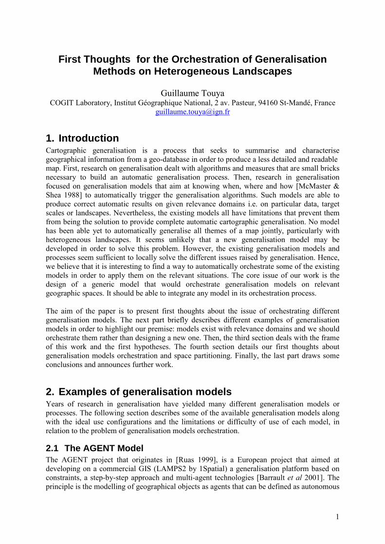
2.5 The Elastic Beams model The "Elastic Beams" model is a specialised global generalisation method (§ 2.4) with a finite
elements method resolution [Bader 2001]. The method consists in defining internal and
external forces on each vertex of the lines in conflict and in finding the minimum energy by
the finite element technique. The line segments, modelled as beams, are assigned values of
stiffness and modulus [Bader & Barrault 2001]. Stiffness represents the rigidity of the beam: a
rigid beam will be rather stretched than twisted by the deformation. Modulus corresponds to
the resistance of beams to stretching or compression. Both parameters allow a major road to
remain straight after deformation while a river will be more distorted. Figure 5 shows the
results obtained on a symbolised road network with many overlap conflicts. The difficulty is
to know exactly on which objects it is necessary to use the elastic beams [Lemarié 2003].
Figure 5. On the left, a road network with many symbol overlaps. On the right, the overlaps are solved by the
elastic beams [Bader & Barrault 2001].
2.6 The GAEL Model The GAEL model deals with the particular relations that the major themes (roads , buildings)
share with the background themes (relief or land use) which are very important in a map and
help its understanding. The relations between a river and its talweg represented by contour
lines or the one between a building and a summit or a glade should all be preserved by
generalisation (Figure 6a). In order to preserve the relations between micro objects (using the
AGENT terminology) and the fields, the GAEL model [Gaffuri 2006] translates constraints
on such relations into elastic constraints that concern the geometric atomic parts of the field
(points, segments, angles or triangles, Figure 6b) and cause deformations of the field to be
satisfied.

5
(a)(a) (b)
Figure 6. (a) Different kind of relations between fields and micro objects : a building on a summit or in a glade,
a road along a forest or in mountain, a river flows in a talweg. (b) The parts of a field (here triangulated) that
are constrained by elastic constraints.[Gaffuri 2006]
The dynamic deformation of the GAEL model is based once again on a multi-agent system.
The agents have to find a balance position between the elastic constraints violated by a
generalisation operation and the field shape conservation constraints (a point should keep its
initial position, an angle should keep its initial value etc...). The GAEL model is relevant to
maintain the relations between objects and fields like a river and its talweg represented by
contour lines [Gaffuri 2007]. (Figure 7) shows some results of the application. One difficulty
to use the model is to know exactly when to launch the deformation to maintain the relations
in order to limit the time-consuming calls during a generalisation process.
a.
Initial Final
0
1
Q
Figure 7. A generalisation makes the river not flow correctly (the part in red highlighted by the arrow). After
GAEL deformation, the relation is re-established [Gaffuri 2007].
2.7 Ad-hoc generalisation processes There are likewise generalisation processes designed for particular generalisation application
that are not generic enough to be considered as models. However, the effectiveness of such
ad-hoc processes on their relevance spaces makes us consider them as generic models. For
instance, network selection processes (Figure 8) [Touya 2007] can be noticed as well as land
use generalisation methods [Haunert 2007]. In this case, the relevant space is often thematic
and the processes can simply not be applied on other spaces.
Figure 8. A road network selection: the initial network on the left and the selected one on the right.

6
3. Frame of research
3.1 The issue of heterogeneity of spaces
In most generalisation applications such as [Lemarié 2003; Lecordix et al 2007], there is a
significant heterogeneity of situations or spaces i.e. different themes (relief, roads,
buildings...) and different landscapes (urban, rural, coastal areas). This work focuses on the
derivation of topographic Digital Cartographic Models (DCMs) i.e. geographic data
symbolised for cartographic output [Brassel & Weibel 1988], wherein roads and buildings are
essential information but that also contain hydrographical, land use, relief or tourism data that
require specific concern during generalisation. The goal is to tackle some of the problems
raised by the issue of heterogeneity of geographic spaces, caused by thematic diversity and
landscape heterogeneity. In order to face thematic diversity, our process should be able to
manage the geographic relations between objects of different themes, for instance by
maintaining a building on a summit, an embankment along a road or to aggregate land use
areas taking roads and buildings into account.
The heterogeneity of the landscapes to derive is a key issue as some geographic landscapes
raise specific generalisation problems. For instance, mountainous landscapes require specific
focus on road generalisation, as roads contain large series of bends causing major coalescence
conflicts (Figure 9a). Mountainous landscapes also require a model to deal with relief issues.
Urban areas require methods to contextually optimise space between streets and buildings
(Figure 9b) while rural areas require to solve relational conflicts between geographic objects
(roads and buildings or roads and rivers in Figure 9c).
(a)
(c)
(b)
Figure 9. Examples of generalisation problems in different geographic landscapes: mountainous, urban and
rural areas.
3.2 A constraint-based approach The first working choice is the use of a constraint-based approach to model the generalisation
output specifications. Indeed, [Beard 1991] showed that it was more interesting and efficient
for cartographic conflicts to be described by cartographic constraints. For instance, a
cartographic constraint can be: "a building should be bigger than 0.16 map mm2". The
cartographic output and its specifications will be described by a set of constraints that follow
the guidelines defined during the EuroSDR Generalisation State-of-the-art project [Burghardt
et al 2007]. The defined constraints belong to four different categories:
− single object constraints (a granularity constraint on buildings).
7
− group constraints: constraint on a structure and its components (a constraint to
maintain the building alignments).
− relational constraints (a distance legibility constraint between roads and rivers or a
constraint to maintain relationship between rivers and relief) [Duchêne 2004b].
− macro constraints on populations [Ruas 1999] (a constraint to reduce the total length
of the road network).
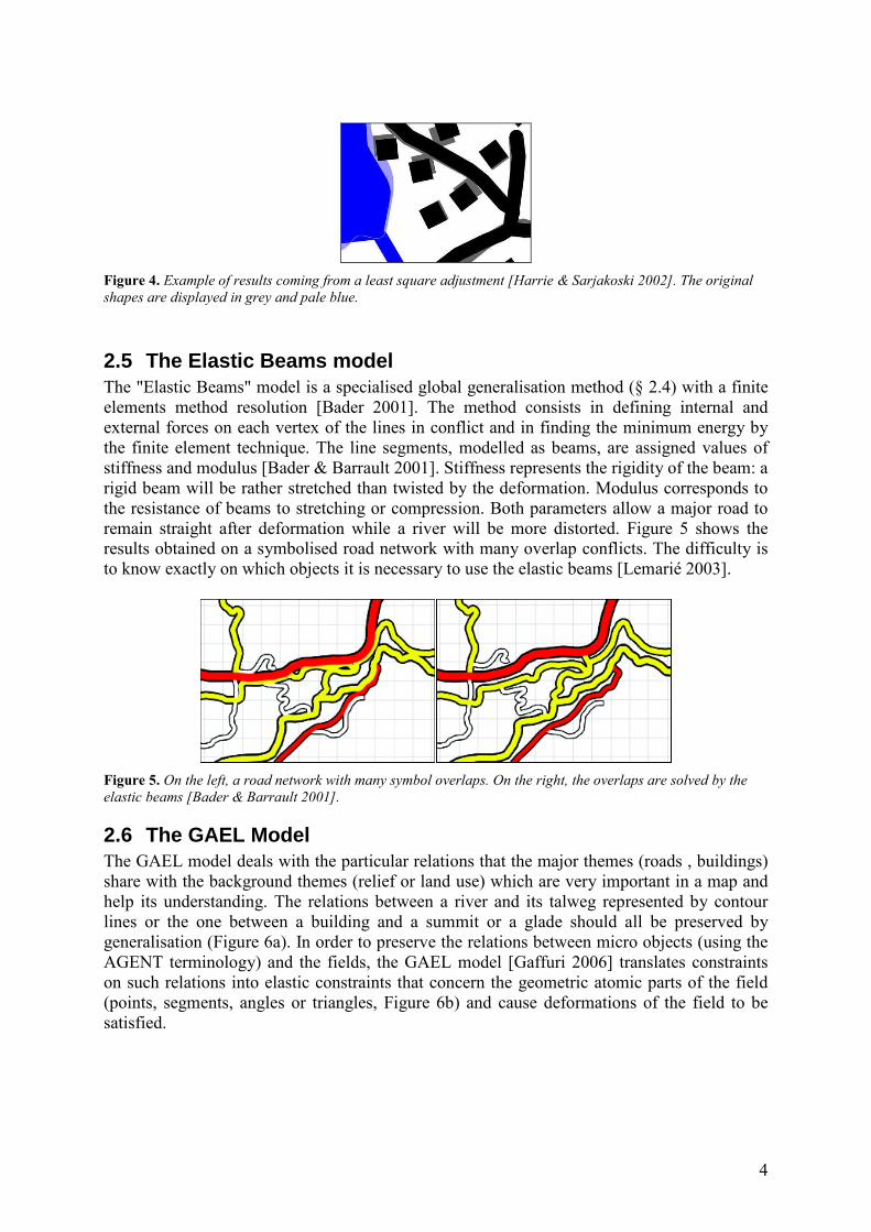
The second initial choice concerns the modelling of constraints in the process. We choose to
represent the constraints by database classes and objects (Figure 10). We follow the same
approach as in AGENT, CartaCom and GAEL models and enunciated in [Ruas 1999]. Indeed,
orchestrating different generalisation models on relevant spaces is a distributed approach and
representing constraints as objects is often a convenient and effective way to represent and
localise the cartographic conflicts.
priority : integer
compute_proposals()
current_value : realgoal_value : realsatisfaction : integerimportance : integer
Size Constraint1 1Agent BuildingAgent Building
Figure 10. UML data schema of building agents associated with a size constraint in the AGENT model [Ruas
1999].
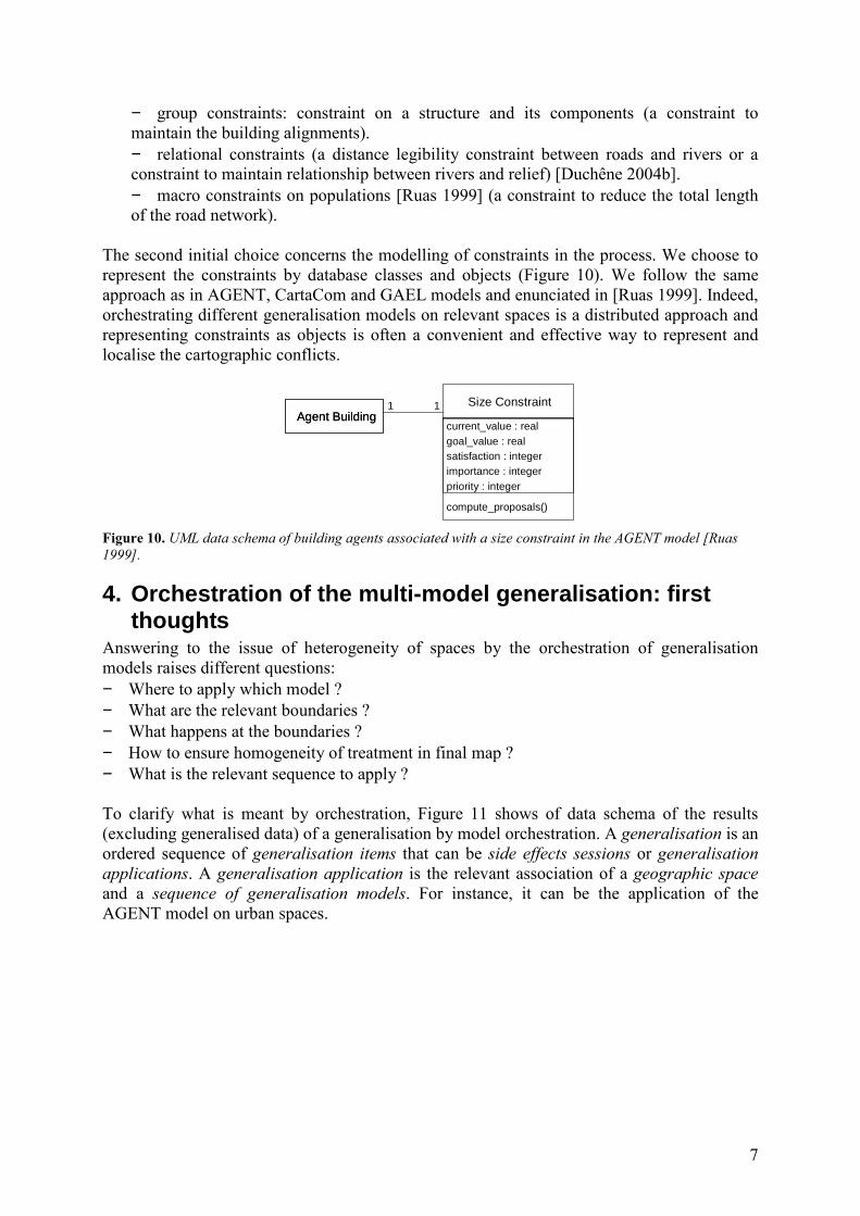
4. Orchestration of the multi-model generalisation: first thoughts
Answering to the issue of heterogeneity of spaces by the orchestration of generalisation
models raises different questions:
− Where to apply which model ?
− What are the relevant boundaries ?
− What happens at the boundaries ?
− How to ensure homogeneity of treatment in final map ?
− What is the relevant sequence to apply ?
To clarify what is meant by orchestration, Figure 11 shows of data schema of the results
(excluding generalised data) of a generalisation by model orchestration. A generalisation is an
ordered sequence of generalisation items that can be side effects sessions or generalisation
applications. A generalisation application is the relevant association of a geographic space
and a sequence of generalisation models. For instance, it can be the application of the
AGENT model on urban spaces.

8
Figure 11. Data schema of the output of one orchestration of generalisation models.
This section deals with the first propositions to answer to these questions. The first part
addresses the search for relevant spaces upon which generalisation models are applied (first
question, where...?). The second part introduces first thoughts about the orchestration
techniques. Then, the third part deals with homogeneity and interoperability issues. The fourth
part outlines the management of side effects between spaces. Finally, the last part summarises
these points describing a first version of our orchestration model.
4.1 The relevant spaces for generalisation The proposed approach that aims at orchestrating the existing generalisation models and
processes by using them on their relevant geographic space (both thematic and spatial), needs
to partition space into the different relevant spaces. Partitioning is not only a way to find
relevant spaces for each model but also a technique to manage the generalisation of large
amounts of data. The first step is to better determine the relevant spaces for each existing
generalisation model that could be used. Another issue is to characterise the discovered
relevant spaces to optimise the chosen generalisation model results and performances. Indeed,
[Steiniger 2007] claims that a precise characterisation of groups of geographic objects makes
the choice of generalisation operations easier. We think it would be interesting to adapt the
approach to generalisation models and their relevant spaces. Then, a final step is the
development of spatial analysis algorithms to build the chosen relevant spaces. The steps 1
and 3 are discussed more in detail in the following paragraphs.
The proposed methodology to achieve the first step (determination of the relevant spaces) is a
combination of an inductive reasoning and a deductive reasoning [Ruas 1999, p.153]: some
spaces are deduced from the experience of the use of some generalisation models; some
spaces are induced from map generalisation tests. For instance, by deductive reasoning, urban
areas are deduced to be the relevant space for AGENT, rural areas are deduced to be the
relevant space for CartACom, and mountainous areas are deduced to be the relevant space for
GAEL. On the other hand, for instance, by inductive reasoning, forested regions will be tried
as candidate to be a relevant space of some generalisation models. If it appears that a
generalisation model or process suits for the forested regions of the tests, it will be induced
that forested regions are in general a relevant space for the model. Generalisation experiments
will be carried out on chosen test areas, using the different existing models. The experiments

9
will allow to validate the deduced relevant spaces and to induce some new relevant spaces
among the tested ones.
For both ways of reasoning, some literature partitioning or clustering methods are
implemented to test the recognition of the geographically meaningful spaces on which the
generalisation tests are carried out. [Anders 2003] describes a proximity graph clustering
method for set of points that takes local densities into account (Figure 12d). The clusters
obtained by the method on building centroïds or on road junctions are interesting spaces to
test maybe to induce relevant rural areas for CartACom model. Furthermore, in order to use
the elastic beams on large amounts of data (§ 2.4), flexibility graphs were developed [Lemarié
2003]. Flexibility graphs are part of the networks grouping the conflicting sections (overlaps
between network sections) and all the sections that make a good resolution by the elastic
beams possible. [Ruas 1995] hierarchically partitions geographic space in order to ease the
generalisation process. Major roads are used to create 1st level partition and then secondary
roads and railways. It allows to partition space in order to manage the large amounts of data
resulting from the completeness of the generalisation process. Furthermore, it would be
necessary to test generalisation models on spaces that abstract geographic phenomena. For
instance, cities created from buildings using [Boffet 2000] or [Chaudhry & Mackaness 2006]
are ideal areas to test the AGENT model (Figure 12c). [Mackaness et al 2007] proposes a
method to recognise forested regions at small scales (i.e. large forests). Such spaces (Figure
12a) that are poor in roads and buildings should be tested as particular areas to induce which
model would be more relevant. Finally, determining the extent of hill ranges and mountain
chains as [Chaudhry & Mackaness 2007] could be an interesting way to delimit the use of the
GAEL model (Figure 12b).
(a) (c)(b)
(d)
Figure 12. (a) Forests derived from the vegetation coverage. (b) A mountainous area manually selected. (c) City
extents obtained from buildings with [Boffet 2000] technique. (d) Implementation of [Anders 2003] on a random
point set.
Added to the deductive and inductive reasoning, a third way to discover spaces is based on
conflicts detection, namely emerging spaces. Emerging spaces are situations that a priori do
not require a particular application of a model. But during the generalisation process, it is
possible that conflicts remain unsolved and the aggregation of unsolved conflicts should lead
to the dynamic creation of an emerging space that will be treated with a different model or
process. An analogy can be made with the concept of emergence in multi-agent systems.
[Beni & Hackwood 1992] define emergence as the apparition of a global phenomenon that
10
was not explicitly coded in the behaviour of the agents. Such emergence can be caused by a
particular configuration of constraint violation, highlighted by a machine learning technique
like the case based reasoning or collaborative filtering [Burghardt & Neun 2006]. Or it can be
caused by the impossibility to solve a conflict using the default model for the space the
situation is part of. Such a situation refers to the third type of meso objects from [Ruas 1999,
p.111].
4.2 Orchestration techniques The orchestration of some generalisation models deals with the sequence of generalisation
model applications and the communication between them. The experiments described in the
previous section, that will be carried out on the existing models and the different spaces will
also help to venture hypotheses about the correct orchestration of the models. The existence of
a pre-defined sequence of models applied on defined spaces seems very unlikely and it would
have to be changed each time a new model is introduced in the process. Thus, different
orchestration scenarios have to be considered amongst which two are addressed here: the use
of multi-agent systems or of a predefined workflow. The scenarios are not exclusive and
could also be combined.
The first possible approach is to stay in the multi-agent paradigm. As in [Bonneaud et al
2007] space-agents and model-agents would be defined for each space and generalisation
model. A model-agent would be an autonomous entity that guides a particular generalisation
model by registering it in "Yellow Pages". The registration would concern the functionality of
the model and a list of relevant spaces for the model. Then, a space-agent would be a kind of
meso-agent [Ruas 1999] that would seek to generalise its components as a Legislator and a
Controller by consulting the Yellow Pages and applying the appropriate model.
Another possible approach is to call upon a predefined workflow of actions. Workflows are
sequencing graphs that allow conditional jumps, loops and concurrent processes. Such as
workflow application in generalisation [Petzold et al 2006; Burghardt & Neun 2006], it could
be possible to produce complex sequences of generalisation model calls with this approach
like the Global Master Plan of [Ruas & Plazanet 1996] or the Strategies of [Weibel & Dutton
1998].
4.3 Homogeneity and interoperability issues Homogeneity of treatment and interoperability are different obstacles to orchestration grouped
in this paragraph as they can both be overcome the same way. On the one hand, a relative
homogeneity of treatment between the different geographic spaces, which is a criterion for
cartographic generalisation evaluation, has to be maintained. On the other hand, the different
existing generalisation models have different inputs and outputs but they have to be chained
in an orchestration sequence. For instance, sequencing a multi-agent system based model like
AGENT with a simultaneous equations based system like the least square adjustment requires
a common language to translate the inputs and outputs.
Both issues can be solved using an ontological base of generalisation constraints. Thus, by
analogy with the research domain of data heterogeneity, making different processes
interoperable often relies on ontologies [Lemmens 2006] and/or a common standard language.
Concerning homogeneity of treatment, if all generalisation models calls are driven by the
satisfaction of such base of constraints, a relative homogeneity of generalisation is guaranteed
although the way of generalising is not the same. As a consequence, we will have to model
11
this ontological base of constraints according to different taxonomies of the literature [Beard
1991; Weibel & Dutton 1998; Ruas 1999; Burghardt et al 2007].
4.4 Side effects and networks Whether the different relevant spaces are adjacent (they form a partition) or intersect,
applying a generalisation model on a particular space can lead to side effects on the
neighbouring or intersecting spaces. Such a problem has to be a key issue of the proposed
orchestration model. The side effects could be corrected afterwards and/or foreseen using data
matching techniques as for the integration of heterogeneous data (data coming from different
countries at a frontier). Another interesting approach is to adapt an incremental update method
like rubber sheeting [Anders et al 2007] to propagate the modifications caused by a model.
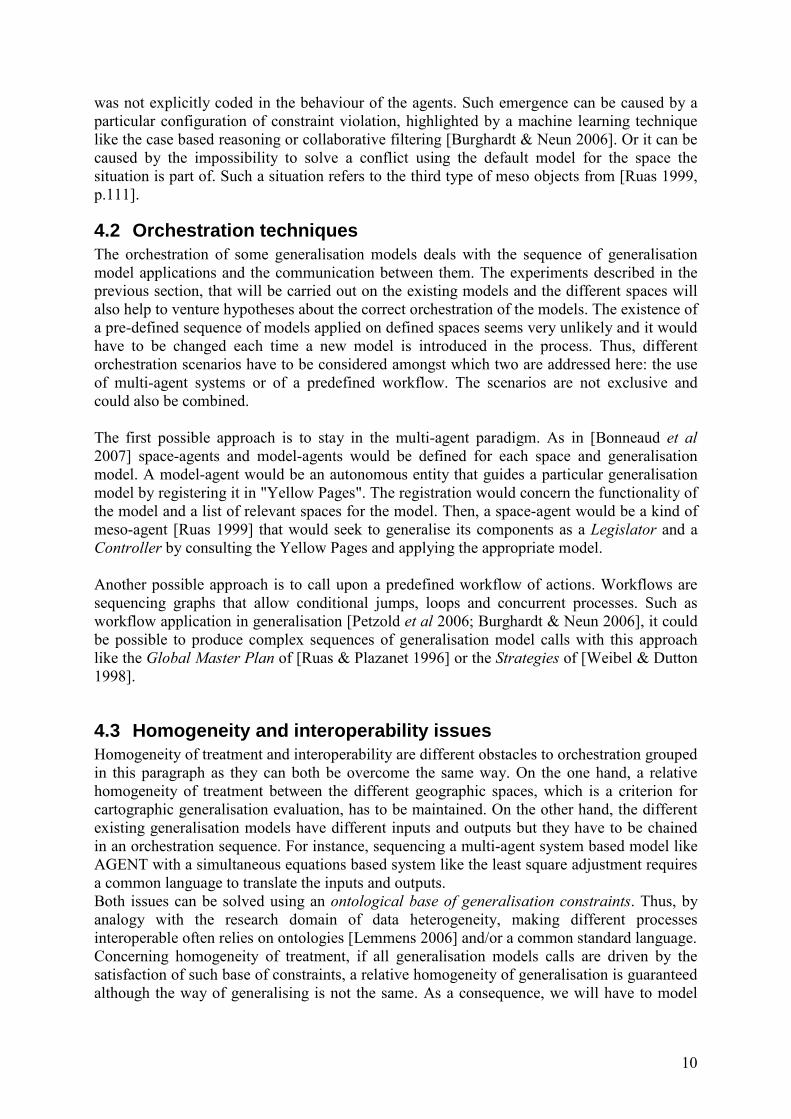
The management of networks all along the process is also a challenging task as networks have
the particularity to cross over or delimit the different chosen spaces (Figure 13). Thus, the
networks will have to be assigned a specific behaviour to avoid multiple and useless
modifications and checking.
GAEL
AGENT
CartACom
LandUse Process
Figure 13. A simplistic view of a heterogeneous geographical area with different relevant spaces. The networks
cross or delimit the spaces instead of being contained.
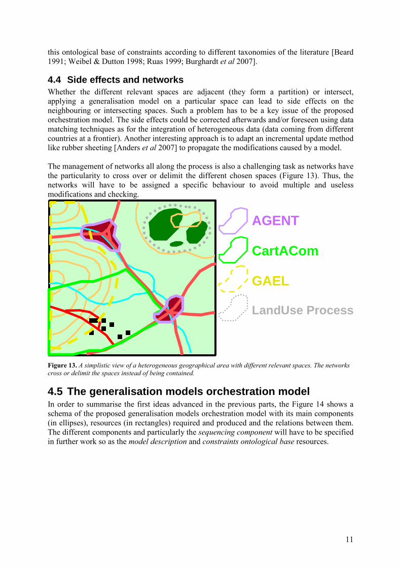
4.5 The generalisation models orchestration model In order to summarise the first ideas advanced in the previous parts, the Figure 14 shows a
schema of the proposed generalisation models orchestration model with its main components
(in ellipses), resources (in rectangles) required and produced and the relations between them.
The different components and particularly the sequencing component will have to be specified
in further work so as the model description and constraints ontological base resources.
12
Figure 14. The components (in ellipses) and resources (in rectangles) of the proposed orchestration model.
5. Conclusion and further work To conclude, this paper has presented the issue of a beginning PhD about the orchestration of
a multi-model generalisation process on heterogeneous landscapes. The a priori application
relevance domain for different existing generalisation models has been detailed to justify the
relevance of our approach. Some of the problems raised by the design of a complete
generalisation process have been exposed, particularly the management of the heterogeneity
of thematic data and landscapes. First thoughts about the methodology to propose have been
discussed with four research key issues: find out the relevant geographic spaces, find out an
orchestration technique, tackle homogeneity of treatment and interoperability and manage the
side effect.
Different tasks will now be undertaken to tackle the key issues: carry out tests with some
existing models to acquire knowledge on the relevant spaces, on the sequencing of
generalisation models and on side effects; model the ontological base of constraints; design a
generic model for orchestrating generalisation models on geographic spaces; apply this model
with different available generalisation models.
References Anders K.H. (2003), A Hierarchical Graph-Clustering Approach to Find Groups of Objects.
In proceedings of 2003 ICA Workshop on Generalization and multiple representation, Paris.
Anders K.H., Sester M., Bobrich J. (2007), Incremental Update in a MRDB. In proceedings
of ICC2007, the International Cartography Association Conference, Moscow (Russia).
Bader M. (2001), Energy minimization methods for feature displacement in map
generalization, Ph.D Thesis. Department of Geography, University of Zurich. Online:
http://www.geo.uzh.ch/gis/services/downloads/phd/mbader/index.html (22/01/08)
GeneralisationModels
Side EffectManagement
SequencingComponent
Orchestration model
Constraints Ontological Base
Geographic Spaces
ModelDescription
Geographic Spaces Detection andCharacterisation
DB
operate on
operate on
contains
analyses
describesconsults
consults
triggers
triggerstriggers
chooses
createscharacterise

13
Bader M., Barrault M. (2001), Cartographic Displacement in Generalization: Introducing
Elastic Beams. In proceedings of 4th workshop on progress in automated map generalisation,
commission on map generalisation ICA, Beijing.
Barrault M., Regnauld N., Duchêne C., Haire K., Baeijs C., Demazeau Y., Hardy P.l, Mackaness W., Ruas A., Weibel R. (2001), Integrating multi-agent, object-oriented, and
algorithmic techniques for improved automated map generalisation, 20th international
conference of cartography, ICA, Beijing, volume 3, pp 2110-2116.
Beni G., Hackwood S. (1992), The Maximum Entropy Principle and Sensing in Swarm
Intelligence. Toward a Practice of Autonomous Systems, MIT Press, Cambridge, pp. 153-160.
Boffet A. (2000), Creating urban information for cartographic generalisation, In proceedings
of the 10th International Symposium on Spatial Data Handling, (SDH'00), China, Beijing.
Bonneaud S., Redou P., Thébault D., Chevaillier P. (2007), Multi-modélisation agent
orientée patterns : Application aux éosystèmes exploités. Journées Francophones sur les
Systèmes Multi-Agents JFSMA 2007, Carcassonne, France. pp. 119-128.
Brassel K., Weibel R. (1988), A review and conceptual framework of automated map
generalisation. International Journal of Geographic Information Systems, 1988, vol.2, n°3,
pp.229-244.
Burghardt D., Meier S. (1997), Cartographic Displacement using the Snakes Concept.
Semantic Modelling for the Acquisition of Topographic Information from Images and Maps,
W. Foerstner nad L. Pluemer eds, Birkhauser, Basel, Suisse, 1997.
Burghardt D., Neun M. (2006), Automated Sequencing of Generalisation Services Based on
Collaborative Filtering. In Proceedings of the 4th International Conference on Geogrpahic
Information Science (GIScience’2006) – Extended Abstracts. Raubal, Miller, Frank and
Goodchild (eds), IFGI Prints, vol.28, pp.41-46.
Burghardt D., Schmid S., Stoter J. (2007), Investigations on Cartographic Constraints
Formalisation. In proceedings of 10th ICA Workshop on Generalisation and Multiple
Representation. Moscow (Russia).
Chaudhry O., Mackaness W. (2006), Creation of Fiat Boundaries in Higher order
Phenomenon. In proceedings of 9th ICA Workshop on Generalisation and Multiple
Representation. Portland (USA).
Chaudhry O., Mackaness W. , Automated scale dependent views of hills and ranges via
morphometric analysis. in proceedings of ICC2007, the International Cartography
Association Conference, Moscow (Russia).
Duchêne C. (2004a), Généralisation cartographique par agents communicants: le modèle
CartACom. thèse de doctorat en informatique université Pierre et Marie Curie Paris VI,
laboratoire COGIT, juin 2004. ftp://ftp.ign.fr/ign/COGIT/THESES/
Duchene C. (2004b), The CartACom model: a generalisation model for taking relational
constraints into account, 6th ICA Workshop on progress in automated map generalisation,
Leicester, UK.
Gaffuri J. (2006). Deformation using agents for map generalization - Application to the
preservation of relationships between fields and objects. AutoCarto'06, Vancouver, United-
States.
Gaffuri J. (2007), Outflow preservation of the hydrographic network on the relief in map
generalisation. In proceedings of 23rd International Cartographic Conference, Moscow,
Russia.
Galanda M. (2003), Automated Polygon Generalization in a Multi Agent System.
Dissertation zur Erlangung der Doktorwürde, Mathematisch-naturwissenschaftliche Fakültat,
Universität Zurich.
Harrie L. E., Sarjakoski T. (2002), Simultaneous Graphic Generalization of Vector Data
Sets. GeoInformatica, Vol. 6, No. 3, sept 2002, pp. 233-261.

14
Haunert J. (2007), Efficient area aggregation by combination of different techniques. In
proceedings of 10th ICA Workshop on Generalisation and Multiple Representation. Moscow
(Russia).
Højholt P. (2000), Solving Space Conflicts in Map Generalization: Using a Finite Element
Method. Cartography and Geographic Information Science, vol.27, n°1, 2000, pp.65-73.
Lecordix F., Le Gallic J-M., Gondol L. (2007), Development of a new generalisation flow
line for topographic maps. In proceedings of 10th ICA Workshop on Generalisation and
Multiple Representation. Moscow (Russia).
Lemarié C. (2003), Generalisation process for top100: research in generalisation brought to
fruition. In proceedings of fifth workshop on progress in automated map generalisation,
commission on map generalisation (ICA), Paris, France, april 2003.
Lemmens R. (2006), Semantic Interoperability of Distributed Geo-Services. PhD thesis, ITC,
Netherlands, 2006.
W. Mackaness, S. Perikleous, O. Chaudhry (2007), Representing Forested Regions at
Small Scales : Automatic Derivation from the Very Large Scale. In proceedings of ICC2007,
the International Cartography Association Conference, Moscow (Russia),.
MacMaster, R.B., Shea, K.S. (1988), Cartographic Generalization in Digital Environment:
A Framework for implementation in a GIS.. GIS/LIS'88 San Antonio, Texas, USA, pp.240-
249.
Petzold I., Burghardt D., Bobzien M. (2006), Workflow Management and Generalisation
Services. In proceedings of 9th ICA Workshop on Generalisation and Multiple Representation.
Portland (USA).
Ruas, A. (1995), Multiple paradigms for automating map generalization: geometry, topology,
hierarchical partitioning and local triangulation. In proceedings of Autocarto 12, Charlotte,
USA, 1995, pp.69-78.
Ruas, A. (1999), Modèle de généralisation de données géographiques à base de contraintes
et d'autonomie. PhD Thesis (1999).
Ruas A., Plazanet C. (1996), Strategies for automated generalization. In: Advances in GIS
Research II, M.J. Kraak and M. Molenaar (eds.), Proceedings of 7th International Symposium
on Spatial Data Handling (London: Taylor & Francis), pp.319-336.
Steiniger S. (2007), Enabling Pattern-Aware Automated Map Generalization. PhD thesis,
University of Zurich. Online:
http://www.geo.uzh.ch/gis/services/downloads/phd/sstein/thesis_stefan_steiniger.pdf
Touya G. 2007. A Road Network Selection Process Based on Data Enrichment and Structure
Detection. In proceedings of 10th ICA Workshop on Generalisation and Multiple
Representation. Moscow (Russia).
Weibel R., Dutton G. (1998): Constraint-Based Automated Map Generalization. In
proceedings of the 8th International Symposium on Spatial Data Handling, 1998, pp.214-224.