Embed Size (px)
Citation preview
327
First Steps Towards an Integrated Decision Support System for Water Management
Serge Shumilov1, Thomas Erdenberger1, Armin B. Cremers1, Luna Bharati2, Maria Plotnikova2, Charles Rodgers2
Abstract
The ultimate objective of the Glowa-Volta Project (GVP) is to develop a Decision Support System (DSS) for the management of Volta Basin water resources that is scientifically sound and relevant to the needs and interests of diverse water sector stakeholders. An integrated economic-hydrologic model has been developed at catchment and basin scale, and preliminary output demonstrates the value of integrated analysis in evaluating water-energy sector interactions. This paper presents our first efforts to link GAMS and WaSiM models and the first prototype of the DSS.
1. Introduction Sustainable management of water resources is a complex and difficult task. This is due to the very complex socio-economic systems with different interest groups pursuing multiple and conflicting objectives. The intrinsic complexity of conflicting human systems is reinforced by the natural non-triviality and spatial diversity of the ecological systems. In such a context, an increasing role is played by computerized systems that have proven useful tools for assisting the authorities. By simulating and evaluating huge amounts of different policy interventions, these systems allow decision-makers to select the most efficient solutions that are difficult or impossible to find in a traditional way. The above-mentioned systems are generally called Decision Support Systems (DSS) and encompass a very large range of different scientific simulation tools based on various methodological approaches and technologies. There are many examples of DSS tools for water resource management and the use of DSS technology is broadly acknowledged in the scientific and technical literature. However, only few of them have been successfully deployed, which makes the development of DSS tools quite difficult (McBridge 1997).
In this paper, we present a description of the development of a DSS which was designed to evaluate the conjuctive use of surface and groundwater in small reservoir-based irrigation systems characteristic of the upper Volta Basin. We focus on a representative small reservoir-irrigation system located in the Atankwidi catchment within the Upper East Region of Ghana. The model ensemble consists of the physical hydrology model WaSiM-ETH and an economic optimization model coded in GAMS. The first section of this paper consists of a description of the study area, a discussion of the objectives of coupled simulation-optimization modeling and a description of the modeling tools employed. The following section focuses on the technical details of achieving model interoperability. The emphasis of this paper is on the methodology enabling model coupling. A companion paper will focus on the results of coupled simulation-optimization and the implications for the planning, design and management of small reservoir-based irrigation systems.
1 Department of Computer Science III, Bonn University, Römerstr. 164, 53117 Bonn, Germany, email: {shumilov, erdenber, abc}@cs.uni-bonn.de 2 Center for Development Research (ZEF), Bonn University, Walter-Flex-Str. 3, 53113 Bonn, Germany, email: {lbharati, mplotnik, crodgers}@uni-bonn.de.
EnviroInfo 2006 (Graz)Managing Environmental Knowledge
Copyright © Shaker Verlag 2006. ISBN: 978-3-8322-5321-9
328
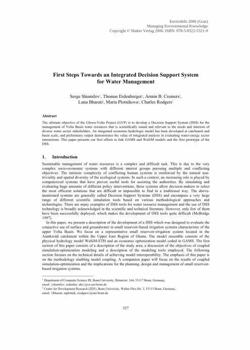
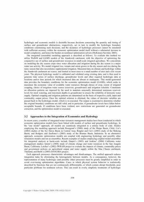
Fig. 1: Volta Basin (left, source: Andah/Gichuki 2003) and
Atankwidi Catchment (right, source: screenshot of the DSS interface)
2. Study area: The Volta Basin and Atankwidi catchment The potential regional impacts of global environmental change present extraordinary challenges for users and managers of water resources. This is particularly the case in regions already subject to water stress, regions possessing weak or inadequate water management infrastructure, and regions anticipated to exhibit high local sensitivity to broad scale changes in climate. The Volta River Basin (Figure 1, left), occupying over 400,000 km2 within the sub-humid to semi-arid West African savanna zone, is characterized by these and other vulnerabilities, including low incomes and rapidly expanding population. With annual population growth rates around 2.5%, national planning studies predict that water demand for irrigation within the basin will increase considerably in the near future (Andah/Gichuki 2003).
One response to the problems associated with inadequate irrigation and rural domestic water supplies has been the utilization of small reservoirs in Northern Ghana and Burkina Faso, several hundred of which have been constructed over the last 4 decades by government agencies and NGOs. However, many questions arise concerning the relative benefits of this irrigation development strategy. Low-relief terrain settings dictate that these reservoirs typically possess high surface area-to-volume ratios. Large open water areas are exposed to steep humidity gradients during several months of the year, leading to high evaporation rates. Numerical simulation suggests that evaporative losses (roughly 30% of annual water budget) can easily exceed potential withdrawals for irrigation (around 10%). Additionally, reservoir siltation can lead to significant reductions in storage capacity over relatively short time spans, necessitating premature rehabilitation. Additional questions can be raised concerning the optimal density
Copyright © Shaker Verlag 2006. ISBN: 978-3-8322-5321-9
329
of small dam development, specifically the impacts of small dam ensembles on downstream flows, and the potential for negative health and environmental externalities (van de Giesen 2004).
Groundwater can be utilized as a substitute for stored surface water, and potentially as a complementary source of irrigation water at suitable locations within the Volta Basin, and the conjunctive use of surface and groundwater is an important area of irrigation research. Annual groundwater extraction via boreholes, hand dug wells, and piped systems has increased substantially over past decades, although present levels of groundwater utilization are estimated to remain within sustainable limits throughout much of the basin (Martin/van de Giesen 2004). Groundwater is, however, used preferentially for rural water supply, so that strategies promoting groundwater irrigation must be evaluated carefully to eliminate the possibility of conflict with critical domestic uses.
To study all these questions arising around the use of water we have taken a representative small reservoir-irrigation system, 276 km2 in area, located in the Atankwidi catchment within the Upper East Region of Ghana (Figure 1, right). There are two small reservoirs in the catchment, one of which is used for irrigation purposes (Reservoir 1, left blue triangle in Figure 1). The surface area of the irrigation reservoir is 8 ha when full. Reservoir 2 has a surface area of 7 ha and is used mainly to provide drinking water for the Kandiga village (pop. 6,000). The Kandiga reservoir is in most respects typical of the small reservoirs distributed throughout the mid and upper regions of the Volta Basin.
3. Modeling objectives and approach The task of achieving efficient, sustainable water management within the Atankwidi catchment reflects, in microcosm, the broader challenges of integrated water resources management within the Volta Basin. While water is not absolutely scarce in a climatic sense (at least in most years), the spatial and temporal variability of rainfall and runoff result in a situation in which water supply represents the binding constraint to improved agricultural productivity, household income, health and well-being in many regions. During the dry season, irrigated agriculture competes with domestic, livestock, aquiculture and occasionally other sources of demand for available water resources. The water management challenge involves the strategic allocation of stored surface- and groundwater to meet these competing objectives in a manner that is sustainable, and which reflects the hierarchy of value of water in its respective uses.
Therefore, the development of a DSS is intended to support the following activities, among others: 1. Optimization of cropping strategies and associated irrigation schedules at existing reservoir locations 2. Cost-benefit analysis of small multipurpose reservoirs 3. Ex ante analysis of proposed structures; evaluation of location suitability 4. Analysis of the economic value of water in competing uses 5. Evaluation of the optimal (maximum) density of small reservoir development 6. Prototyping of model linkage techniques
3.1 Conceptual DSS architecture A core capability demanded of the integrated system is the ability to rigorously apply optimization, or goal-oriented criteria to water resources decision-making. It can be achieved by the integrated economic-hydrologic optimization approach, which has been broadened through utilization of GAMS (General Algebraic Modeling System; Brooke 1998) and WaSiM-ETH (Schulla 1997). GAMS is a high-level mathematical programming language providing seamless linkages between numerical models and a suite of powerful, large scale optimization algorithms such as CONOPT and MINOS. WaSiM-ETH simulates physical hydrology of the catchment and generates GAMS boundary conditions. The dynamic linkage of
Copyright © Shaker Verlag 2006. ISBN: 978-3-8322-5321-9
330
hydrologic and economic models is desirable because decisions concerning the quantity and timing of surface and groundwater abstractions, respectively, act in turn to modify the hydrologic boundary conditions constraining such decisions, and the dynamics of hydrologic processes cannot be simulated with sufficient accuracy within the economic optimization model itself without a substantial increase in model complexity, and hence the burden on nonlinear optimization solvers (McKinney/Savitsky 2003).
The integrated (ensemble) modeling approach is described as follows. To evaluate this method we utilize WaSiM and GAMS models of the Atankwidi catchment, with the objective of optimizing the conjunctive use of surface and groundwater resources in small-scale irrigated agriculture. We concentrate on modeling the dry season crops since water allocation and irrigation during the dry season is a major water use activity. We model irrigated rice, tomato and onion grown in the dry season and rice during the rainy season that also necessitates supplemental irrigation. Measured data on climate and hydrology within the Atankwidi catchment are scarce, and limited in most cases to a small number of sites and a few recent years. The physical hydrology model is calibrated and validated using existing data, and is then used to generate time series of surface discharge, groundwater levels and other required hydrologic data at locations and/or time periods for which measured data are absent or inadequate. This model-generated data provides the boundary conditions for the economic optimization model (GAMS), which seeks to maximize the economic value of available water resources through choice of crop, extent of irrigated cropping, choice of irrigation water source (reservoir, groundwater) and irrigation schedule. Constraints on allocation patterns are imposed by the need to maintain seasonally determined minimum reservoir levels for stock watering, and maximum depths to groundwater to ensure the reliability of domestic water supply. Optimal cropping and irrigation patterns are determined on the basis of respective yield, input and commodity output prices. Once the optimal solution is obtained, the values of decision variables are passed back to the hydrologic model, which is re-executed. The output is examined to determine whether the original boundary conditions are still valid, and in particular, if groundwater levels have fallen below acceptable bounds. If conditions have been violated, new restrictions are generated on groundwater extraction, and the optimization model re-executed.
3.2 Approaches to the Integration of Economics and Hydrology In recent years, a number of integrated water resources management studies have been conducted in which economic optimization models have been linked with models of surface and groundwater hydrology. In the “one model” approach, all models are seamlessly integrated in a unitary body of code. Studies employing this modeling approach include Rosegrant’s (2000) study of the Maipo Basin, Chile; Cai’s (2003) studies of the Syr Darya Basin in Central Asia; Ringler and Cai’s (2003) study of the Mekong Basin; and Rodgers and Zaafrano’s (2003) study of the Brantas Basin, Indonesia. In an alternative approach, economic optimization models are coupled with engineering hydrology and possibly other simulation models and run as ensembles. Recent examples of studies employing coupled model ensembles for integrated analysis at basin-scale include Draper’s (2003) and Jenkins’ (2004) California water management studies; Quinn’s (2004) study of climate change and water resources in the San Joaquin Basin, California; Letcher’s (2002) IWRAM project to evaluate the impacts of climate, commodity prices and government policies on agricultural output and water supply within the Mae Chaem catchment, Thailand; and Barth’s (2005) DANUBIA project.
Each approach possesses characteristic advantages and disadvantages. The unified approach reduces integration tasks by eliminating the heterogeneity between models. As a consequence, however, the representation of many hydrologic (and possibly other) processes must be greatly simplified in order to avoid over-taxing optimization algorithms. Cases in which physical system behavior is realistically described by functions that are not continuously differentiable, or which contain abrupt thresholds, pose particular problems for nonlinear solvers. This can result in overly simplistic treatments of hydrologic
Copyright © Shaker Verlag 2006. ISBN: 978-3-8322-5321-9
331
processes such as groundwater flow and soil moisture storage. The unified modeling approach in any event requires an external source of hydrologic data in order to provide boundary conditions such as the time series of inflows to each river reach, since land surface hydrologic processes, including rainfall-runoff dynamics, cannot realistically be incorporated within the optimization framework itself. The use of coupled model ensembles greatly enhances the modelers’ ability to simulate hydrologic, terrestrial and socioeconomic processes at finer levels of detail, and likely with enhanced accuracy, but model coupling introduces the need for significant software engineering tasks required to enable interoperability.
3.3 Using a component-based approach to model integration Having selected the coupled approach, our primary research task is to develop the interface between the physical hydrology and economic optimization models in a manner that minimizes redundancy, allowing GAMS to take full advantage of WaSiM’s simulation capabilities. As discussed in the previous section, the complexity of the interaction between particular simulation systems depends on the complexity and heterogeneity of their data models. Apart from its specialized functionality, each simulation system uses a distinct and unique way of exporting and storing its data, i.e. different formats, along with different scales and units (mm vs. hectare-meters, etc.). To link the systems into one ensemble requires this discrepancy between different representations of interchanged data to be solved.
One way to achieve this consolidation would be the development of a common data model that will include data types of both, hydrologic and socio-economic models. It must be noted that such a “tight coupling” between the models results in a number of disadvantages. Not only does it require a complete non-conflict unification of types from both models, which is unlikely in the case of real models. As suggested by the term, the tightly coupled system is rather inflexible, since every change to one of the incorporated models will result in the uncontrolled spreading of changes around the whole system. Consequently, the integration of any new model would require a complete modification of the entire existing ensemble, which can be rather challenging. Furthermore, due to the nature of research, the whole realm of new data will never be known. Expressions and analysis methods will inevitably change over time, and newly discovered information has to be structured and included in the models. Thus, extensibility is one of the main requirements we have identified, having two aspects. One is a common data model that supports addition of new types as well as the seamless integration of new modeling concepts. The second aspect is the ability to integrate and assimilate new pieces of software from different operational environments that may also be written in different programming languages.
To address these issues, in (Bergmann 2000, Bode 2002) we have outlined a vision of an architecture for an extensible generic infrastructure to enable rapid development of such data-intensive applications for different domains. According to this view the system should be composed of loosely coupled and easily maintainable units - components, controlled by a common infrastructure that provides mechanisms to enable communication between them. Here we pursue the idea of a “component-based coupling” strategy, which seeks to identify the minimum degree of coupling required to address each specific, well-posed research or policy question. Following this approach, components or minimal parts of original data models to be integrated are identified and consolidated. Consolidation of the components and corresponding data exchange between them is achieved with the help of so-called mediators (Wiederhold 1999). The mediators are custom-programmed interchangeable software parts that perform conversions to transform data from one representation into another. Complex transformations can be achieved by grouping several mediators together (Radetzki 2005).
Copyright © Shaker Verlag 2006. ISBN: 978-3-8322-5321-9
332
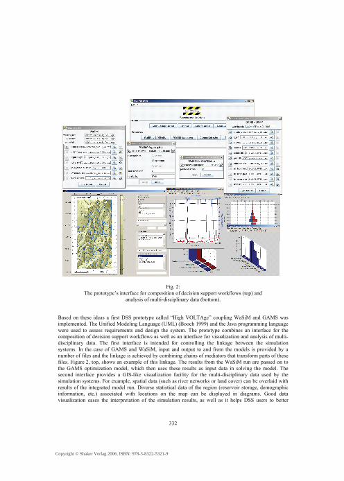
Fig. 2: The prototype’s interface for composition of decision support workflows (top) and
analysis of multi-disciplinary data (bottom).
Based on these ideas a first DSS prototype called “High VOLTAge” coupling WaSiM and GAMS was implemented. The Unified Modeling Language (UML) (Booch 1999) and the Java programming language were used to assess requirements and design the system. The prototype combines an interface for the composition of decision support workflows as well as an interface for visualization and analysis of multi-disciplinary data. The first interface is intended for controlling the linkage between the simulation systems. In the case of GAMS and WaSiM, input and output to and from the models is provided by a number of files and the linkage is achieved by combining chains of mediators that transform parts of these files. Figure 2, top, shows an example of this linkage. The results from the WaSiM run are passed on to the GAMS optimization model, which then uses these results as input data in solving the model. The second interface provides a GIS-like visualization facility for the multi-disciplinary data used by the simulation systems. For example, spatial data (such as river networks or land cover) can be overlaid with results of the integrated model run. Diverse statistical data of the region (reservoir storage, demographic information, etc.) associated with locations on the map can be displayed in diagrams. Good data visualization eases the interpretation of the simulation results, as well as it helps DSS users to better
Copyright © Shaker Verlag 2006. ISBN: 978-3-8322-5321-9
333
understand their needs. Many data exploratory analysis tasks are significantly facilitated by the ability to see data in an appropriate visual presentation. Figure 2, bottom illustrates an example of a geographic map with projected water flow directions and additional diagrams with demographic and statistical data showing precipitation and river runoff.
5. Conclusions and Future Work The broader justification for this study is the need to develop and to test a more general approach to integrated analysis based on the coupling of climate, hydrology, land use and economic optimization models and associated databases at the scale of the entire Volta Basin and important tributaries. The objective of basin-scale integrated analysis in turn is to provide a means by which the impacts of global climate change, overlaid on land use/land cover change within the basin, can be simulated, and appropriate pre-emptive and adaptive strategies identified and evaluated. The research described in this paper is intended to yield a prototype model ensemble, useful in proving key integration concepts.
The purpose of the Decision Support System is to be able to address research questions of interest to policymakers and stakeholders. In order to address all these questions we need to extend our models to full basin scale. Since at the Volta basin scale, agriculture is linked to other economic sectors as well as to the world economy through trade, more detailed economic structure will be modeled. The effects of land use change in the basin will also be integrated through extensive work with remote sensing techniques. Remote sensing and surface energy balance studies are being carried out in the basin with aims to provide surface energy balances at various scales. Calculations from these studies will be assimilated into the modeling process. Following this approach our DSS becomes a suite of simulation systems, a toolbox from which the appropriate tools are selected as dictated by task. Some of the issues at hand include the further investigation of ways to handle different time steps and all the other challenges of a bidirectional, integrated model run with multiple iterations.
The Decision Support System as the ultimate goal of the GLOWA-Volta project requires a solid and scalable framework as its back-bone enabling the full integration of a number of different simulation systems. Although only intended to serve as a first proof-of-concept, the prototype was designed with common software design principles in mind to ensure flexibility and extensibility. New simulation systems with a priori unknown data models can be integrated in the system by writing corresponding interface components and mediators. If a new simulation system uses similar data types as an existing one, then already existing mediators for these data types can be reused in new compositions. The framework already provides the functionality needed to chain the mediators and models together. Thus, the approach of component-based integration allowed us to keep the DSS architecture flexible and extensible. Furthermore, the DSS is not limited to run only within one operating system, but can be used on different platforms.
Bibliography Andah, W., Gichuki, F. (2003): Volta Basin Profile: Strategic research for enhancing agri-cultural water
productivity, Accra: International Water Management Institute Barth, M. (et. al.) (2004): DANUBIA: An Integrative Simulation System for Global Change Research in
the Upper Danube Basin, in: Cybernetics and Systems, Vol. 35, No. 7-8, pp. 639-666 Bergmann, A., Breunig, M., Cremers, A.B., Shumilov, S. (2000): A Component Based, Extensible
Software Platform Supporting Interoperability of GIS Applications, Proc. of the 12th Int. Symposium “Computer Science for Environmental Protection”, Bonn, pp. 90-102
Copyright © Shaker Verlag 2006. ISBN: 978-3-8322-5321-9
334
Bode, T., Radetzki, U., Shumilov, S., Cremers, A.B. (2002): COBIDS: A component-based framework for the integration of geo-applications in a distributed spatial data infrastructure, Annual Conference of the Int. Association for Mathematical Geology (IAMG), Berlin, Germany
Booch, G., Rumbaugh, J., Jacobson, I. (1999): The Unified Modeling Language, User Guide, Addison-Wesley, Object Technology Series
Brooke, A. (et al.) (1998): GAMS: A User’s Guide, Washington, D.C.: GAMS Development Corp. Cai, X. (et al.) (2003): A Framework for Sustainability Analysis in Water Resources Management and
Application to the Syr Darya Basin, Water Resources Research 38 (6), Washington, D.C. Draper, A. J. (et al.) (2003): Economic-Engineering Optimization for California Water Management,
Journal of Water Resources Planning and Management, 129(3), Austin, TX Jenkins, M. W. (et al.) (2004): Optimization of California’s Water Supply System: Results and Insights,
Journal of Water Resources Planning and Management, July/August 2004, pp. 271-280 Letcher, R. A. (et al.) (2002): Integrated Water Resources Assessment and Mangement (IWRAM) Project,
Integrated Toolboox, Integrated Catchment, Assessment and Management Centre (iCAM), iCAM working paper 2002/2, Canberra
Martin, N., van de Giesen, N. (2004): Spatial Distribution of Groundwater Production and Development Potential in the Volta River basin of Ghana and Burkina Faso, Water International 30(2)
McBride, N. (1997): The rise and fall of an executive information system: a case study, Information Sys-tems Journal 7(4):277-288
McKinney, D., Savitsky, A. (2003): Basic Optimization Models for Water and Energy Management, Prepared under USAID Contract, Washington D.C.
Quinn, N.W.T. (et al.) (2004): Model Integration for Assessing Future Hydroclimatic Impacts on Water Resources, Agricultural Production and Environmental Quality in the San Joaquin Basin, California. Environmental Modelling & Software 19, pp. 305-316
Radetzki, U. (2005): Service-Interoperabilität für naturwissenschaftliche Anwendungen: Identifikation und Anpassung von komponentenbasierten Service-Mediatoren, PhD thesis, Institut für Informatik III, Rheinische Friedrich-Wilhelms-Universität Bonn
Ringler, C., Cai, X. (2003): Addressing Environmental Water Values in an Integrated Economic-Hydrologic River Basin Modeling Framework. Workshop on “Integrating Environmental Impacts into Water Allocation Models of the Mekong River Basin”. Ho Chi Minh City
Rodgers, C., Arendt, B., Ahrends, H., Bharati, L., Erdenberger, T., Intsiful, J., Kunstmann, H., Mast, M., Obeng-Asiedu, P., Plotnikova, M., Shumilov, S. (2005): Technical Integration And Decision Support, in: GLOWA: Global Change in the Hydrological Cycle – Status Report 2005, pp. 150-153, ed. by PT-DLR Environmental Research and Technology, Bonn
Rodgers, C., Zaafrano, R. (2003): A Water Resources Management Policy Simulation Model of the Brantas Basin, East Java, Indonesia, Paper prepared for the Panel on Water Policy and Agricultural Production at the Global and River Basin Levels, IAAE Meetings, August 16-23, Durban
Rosegrant, M. (et al.) (2000): Integrated Economic-Hydrologic Water Modeling at the Basin Scale: The Maipo River Basin, Journal of Agricultural Economics (IAEA), 24 (1), Nottingham
Schulla, J. (1997): Hydrologische Modellierung von Flussgebieten zur Abschätzung der Folgen von Klimaänderungen, PhD thesis, Geographisches Institut, ETH Zürich
van de Giesen, N. (et al.) (2004): Use of small reservoirs in West Africa as remotely-sensed cumulative runoff gauges, in: Proceedings of the 2nd International CAH-MDA workshop on The Terrestrial Water Cycle: Modeling and Data Assimilation Across Catchment Scales, eds.: A. J. Tueling, H. Liejnse, P. A. Troch, J. Sheffield and E. F. Wood, pp. 32-35
Wiederhold, G. (1999): Mediation to Deal with Heterogeneous Data Sources, In: A. Vckovski, K.E. Brassel, H.-J. Schek (eds.): Interoperating Geographic Infor-mation Systems, Proc. of the 2nd Int. Conf., Zurich, Switzerland, Lecture Notes in Computer Science, no. 1580, Springer, pp. 1-16
Copyright © Shaker Verlag 2006. ISBN: 978-3-8322-5321-9