Embed Size (px)
Citation preview
FIVE-YEAR REVIEW REPORT
TEX TIN CORPORATION SUPERFUND SITE OPERABLE UNIT No. 2
TEXAS CITY, TEXAS GALVESTON COUNTY
REGION 6 SEPTEMBER 2003
698647 I
FIRST FIVE-YEAR REVIEW
FOR
TEX TIN CORPORATION SUPERFUND SITE OPERABLE UNIT NO. 2
TEXAS CITY, TEXAS GALVESTON COUNTY
SEPTEMBER 2003
PREPARED BY: U.S. EPA REGION 6 DALLAS, TEXAS
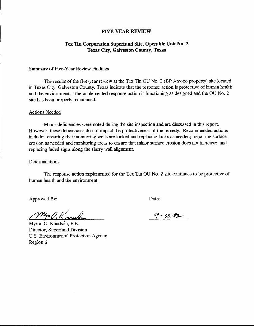
FIVE-YEAR REVIEW
Tex Tin Corporation Superfimd Site, Operable Unit No. 2 Texas City, Galveston County, Texas
Summary of Five-Year Review Findings
The results of the five-year review at the Tex Tin OU No. 2 (BP Amoco property) site located in Texas City, Galveston Comity, Texas indicate that the response action is protective of human health and the environment. The implemented response action is functioning as designed and the OU No. 2 site has been properly maintained.
Actions Needed
Minor deficiencies were noted during the site inspection and are discussed in this report. However, these deficiencies do not in^jact the protectiveness of the remedy. Recommended actions include: ensuring that monitoring wells are locked and replacing locks as needed; repairing surface erosion as needed and monitoring areas to ensme that minor surface erosion does not increase; and replacing faded signs along the slurry wall alignment.
Determinations
The response action implemented for the Tex Tin OU No. 2 site continues to be protective of human health and the environment.
Approved By: Date:
Myron O. Knudsdn, P.E. Director, Superfimd Division U.S. Environmental Protection Agency Region 6
CONCURRENCES
FIVE-YEAR REVIEW Tex Tin Corporation Superfimd Site, Operable Unit No. 2
Texas City, Galveston County, Texas
By; Carlos Sanchez Remedial Project Manager
By:'
Date: '3
Da.e:^hl/^ Gustavo T. Chavania, Chief AR/TX Project Management Section
By: JolmHepola, Chief AR/TX Branch
Date: o2>
By: Pamela J. Tr,!^is, Site Attomey Superfund-Branch, Office of Regional Counsel
Date:
Date: (Pihohl Mark Peycke, Superfund Branch, Office of Regional Counsel
By: Ql.AAOyi:k(/ff£^ Jwie BuzzeU, Writer/Editor
Date:
Superfund Division
By: \.K Rebecca We^r, Acting Deputy Director
Date: 02.
Superfund Division
First Five-Year Review Report Tex Tin Corporation Superfimd Site
Operable Unit No. 2
TABLE OF CONTENTS
List of Acronyms Executive Summary Five-Year Review Summary Form
I. INTRODUCTION II. SITE CHRONOLOGY III. BACKGROUND IV. RESPONSE ACTION V. FIVE-YEAR REVIEW PROCESS VI. TECHNICAL ASSESSMENT VH. ISSUES VHI. RECOMMENDATIONS and FOLLOW-UP ACTIONS IX. PROTECTIVENESS STATEMENT X. NEXT REVIEW
FIGURES;
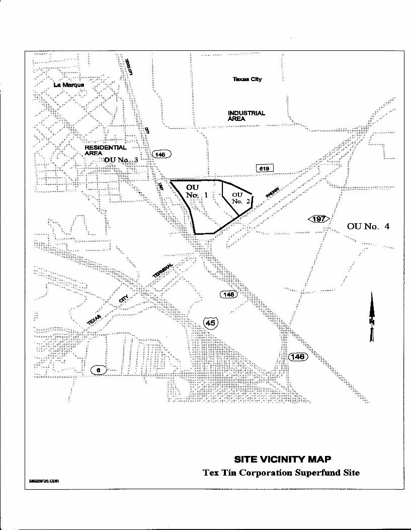
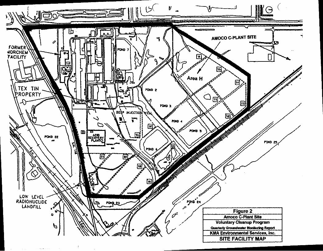
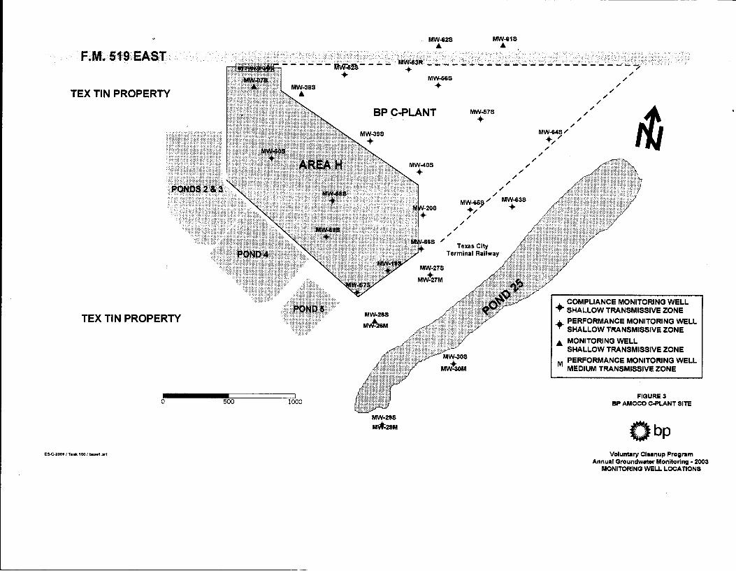
Figure 1: Site Vicinity Map - Tex Tin Superfund Site Figiue 2: Amoco C-Plant Site Figure 3: Monitoring Well Locations
ATTACHMENTS:
Site Inspection Checklist Site Inspection Team Roster Documents Reviewed Copies of Deed Restrictions
LIST OF ACRONYMS
ACL Alternate Concentraticai Limit AMMC Associated Metals and Minerals CorporaticHi AOC Administrative Order on Consent ARARs applicable or relevant and appropriate reqtiirements ATSDR Agency for Toxic Substances and Disease Registry CERCLA Comprehensive Environmental Response, Compensation, and Liability Act of 1980 CFR Code of Federal Regulations cm/sec centimeters per second COPC Chemicals of Potential Concem CWA Clean Water Act EPA U.S. Environmental Protection Agency ERA Ecological Risk Assessment FM Earm-to-Market FS Feasibility Study GCMC Gulf Chemical and Metallurgical Company HHRA human health risk assessment HI Hazard Index HRS Hazard Ranking System MCL Maximum Contaminant Levels mg/kg milligrams per kilogram mg/L milligrams per liter NCP National Oil and Hazardous Substances Pollution Contingency Plan NPL National Priorities List O&M operation and maintenance OSWER The Office of Solid Waste and Emergency Response OU Operable Unit PRGs Preliminary Remediation Goals PRPs potentially responsible parties QASP quality assurance sampling program RAO remedial action objectives RCRA Resource Conservation and Recovery Act RI Remedial Investigation ROD Record of Decision SARA Superfund Amendments and Reauthorization Act SPLP Synthetic Precipitation Leaching Procedure TAL Target Analyte List TCLP Toxicity Characteristic Leaching Procedure Tex Tin Tex Tin Corporation Superfund Site TCEQ Texas Commission on Environmental Quality TWC Texas Water Commission /tg/L micrograms per liter use United States Code VCP Texas Voluntary Cleanup Program VOC volatile organic compound yds Cubic yards
EXECUTIVE SUMMARY
This is the first five-year review for the response action conducted at the Tex Tin OU No. 2 (BP Amoco property) site located in Texas City, Galveston County, Texas. This review was completed in September 2003. The results of the five-year review indicate that the response action is protective of human health and the environment. The implemented response action is functioning as designed and the OU No. 2 site has been properly maintained. Minor deficiencies were noted during the site inspection and are discussed in this report. However, these deficiencies do not impact the protectiveness of the remedy.
Tex Tin OU No. 2 consists of approximately 27 acres now owned by BP Amoco immediately adjacent to Tex Tin OU No. 1 (approximately 140 acres). Beginning in the 1940s, both parcels were part of Tin Processing Corporation, a tin smelter constructed by the U.S. Government to supply tin, a strategic metal during World War II. The process area (warehouses, smelter buildings and stacks, laboratory, offices etc.) was located on OU No. 1. Historically, unlined pits constructed across both parcels of property were used for disposal of large quantities of waste acid from the smelting process. As facility processes were changed to decrease the quantities of waste acid generated, some of the pits were backfilled. In 1969, Amoco purchased an area (OU No. 2) of the smelter property on which acid pits had been backfilled.
The response action for the Tex Tin OU No. 2 was implemented by BP Amoco under the Texas Voluntary Cleanup Program (Texas VCP) prior to the Tex Tin site being listed on the National Priorities List (NPL). The U.S. Environmental Protection Agency (EPA) participated by reviewing and commenting on the design plans and conducting periodic field oversight during the construction phase. The EPA also participated in the final construction inspection.
After the Tex Tin site was listed on the NPL on September 18, 1998, EPA reviewed the completed response action for the Tex Tin OU No. 2 site. The EPA determined that the remedy for the Tex Tin OU No. 2 site was consistent with the remedy that EPA selected in the Record of Decision (ROD) for the Tex Tin OU No. 1 (former smelter facility). The remedy implemented by BP Amoco included placement of a two-foot soil cover over areas where contaminants in surface soil exceeded human health-based action levels. The remedy also included a ground water monitoring program to ensure that the contaminated shallow ground water plume was not migrating off-site. Based on complete review of the remedy as selected and implemented by BP Amoco, EPA issued a no further remedial action ROD for the Tex Tin OU No. 2 site.
The response action implemented at the Tex Tin OU No. 2 site continues to be protective of human health and the environment. Because hazardous substances remain on-site above health-based levels that allow unlimited use and unrestricted exposure, EPA wiU continue to conduct five-year reviews of the site.
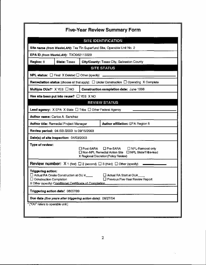
Five-Year Review Summary Form
* ["OU" refers to operable unit.]
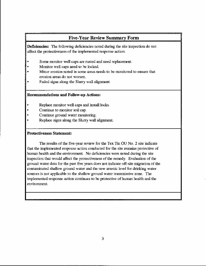
Five-Year Review Summary Form
Deficiencies: The following deficiencies noted during the site inspection do not affect the protectiveness of the implemented response action:
• Some monitor well caps are rusted and need replacement. • Monitor well caps need to he locked. • Minor erosion noted in some areas needs to be monitored to ensure that
erosion areas do not worsen. • Faded signs along the Slurry wall alignment.
Recommendations and Follow-up Actions:
• Replace monitor well caps and install locks. • Continue to monitor soil cap. • Continue ground water monitoring. • Replace signs along the Slurry wall alignment.
Protectiveness Statement:
The results of the five-year review for the Tex Tin OU No. 2 site indicate that the implemented response action conducted for the site remains protective of human health and the environment. No deficiencies were noted during the site inspection that would affect the protectiveness of the remedy. Evaluation of the ground water data for the past five years does not indicate off-site migration of the contaminated shallow groimd water and the new arsenic level for drinking water sources is not applicable to the shallow ground water transmissive zone. The implemented response action continues to be protective of human health and the environment.
TEX TIN CORPORATION SUPERFUND SITE OPERABLE UNIT NO. 2
FIRST FIVE YEAR REVIEW REPORT
I. INTRODUCTION
The United States Environmental Protection Agency (EPA) Region 6 and the Texas Commission on Environmental Quality (TCEQ) conducted this first five-year review for the response action implemented at Operable Unit (OU) No. 2 of the Tex Tin Corporation Superfimd Site. Also participating in the five-year inspection were representatives of the Potentially Responsible Parties (BP Amoco) and their contractor. The purpose of the first five-year review for OU No. 2 is to determine whether the response action implemented by BP Amoco at the site remains protective of human health and the environment.
This first five-year review for the Tex Tin OU No. 2 site is a policy review because the response action was conducted under the Texas Voluntary Cleanup Program (Texas VCP). The response action resulted in hazardous substances, pollutants, or contaminants to remain on site above levels that allow for unlimited use and unrestricted exposure. This report documents the results of the first five-year review conducted for the Tex Tin OU No. 2 site. This five-year review report wiU identify issues found during the review, if any, and reconamendations to address them
The EPA Region 6 is preparing this first five-year review for the Tex Tin OU No. 2 site pursuant to the Comprehensive Environmental Response, Compensation and Liability Act (CERCLA) Section 121, the National Contingency Plan (NCP), and OSWER No. 9355.7-03B-P (June 2001), Comprehensive Five-Year Review Guidance. CERCLA Section 121 states:
If the President selects a remedial action that results in any hazardous substances, pollutants, or contaminants remaining at the site, the President shall review such remedial action no less often than each five years after the initiation of such remedial action to assure that human health and the environment are being protected by the remedial action being implemented. In addition, if upon such review it is the judgment of the President that action is appropriate at such site in accordance with section [104] or [106], the President shall take or require such action. The President shall report to the Congress a list of facilities for which such review is required, the results of all such reviews, and any actions taken as a result of such reviews.
The Agency interpreted this requirement further in the National Contingency Plan (NCP); 40 CFR Section 300.430(f)(4)(ii) states:
If a remedial action is selected that results in hazardous substances, pollutants, or
contaminants remaining at the site above levels that allow for unlimited use and unrestricted exposure, the lead agency shall review such action no less than every five years after the initiation of the selected remedial action.
The U.S. EPA Region 6 has conducted the first five-year review of the response action implemented by contractors for BP Amoco at the Tex Tin OU No. 2 site located in Texas City, Galveston County, Texas. This review was conducted from April 2003 through September 2003. This report documents the results of the five-year review. KMA Environmental Services, BP Amoco's (PRP) contractor, provided ground water monitoring data and other information used in preparing this report.
This first five-year policy review for the Tex Tin Superfimd site was triggered by the issuance on August 27, 1999, of the Conditional Certificate of Completion for the response action conducted under state authority at OU No. 2. The entire site Tex Tin site was placed on the National Priorities List on September 18, 1998. This review focuses on OU No. 2. Other operable units that are part of the Tex Tin Superfimd site include Operable Units 1, 3, and 4. OU No. 1 is the former smelter facility, where remedial action activities are currently underway and are scheduled to be completed in October 2003. The EPA-lead removal action conducted from March 1999 through June 1999 at OU No. 3, the La Marque residential area downwind from the smelter, did not leave hazardous substances, pollutants, or contaminants on-site above levels that allow for unlimited use and imrestricted exposure. Therefore, five-year review for OU No. 3 is not warranted. The remedial action for OU No. 4, the Swan Lake Salt Marsh area, has not been implemented at this time. Plans are to start the remedial action for OU No. 4 in September 2003. The second five-year review for the Tex Tin Superfimd site is expected to include OUs 1,2, and 4.
II. SITE CHRONOLOGY
|| EVENT DATE
First Proposed NFL Listing for Tex Tin Site June 1988
RI/FS Consent Order Issued for Tex Tin Site (OUs 1 and 2)
March 30, 1990
Tex Tin Site Removed from NPL by Court Order May 11, 1993
OU No. 2 (Amoco) accepted in the Texas VCP May 2, 1996 |
Proposed NPL Listing June 17, 1996
Response Action Started October 1997
Response Action Completed June 1998 |
Final NPL Listing September 18, 1998 |
1 EVENT DATE
Conditional Certificate of Completion August 27, 1999
ROD Signature September 27, 2001
NPL Deletion October 15, 2002
Ready for Reuse Determination July 1, 2003
III. BACKGROUND
The tin smelter at Texas City was constructed by a corporation under contract to the United States Government as an emergency tin supply plant for World War II, and operated under a Government contract from 1941 to 1956 as the Tin Processing Corporation. The facility was sold to private industry in 1957 and was operated by a succession of companies until it ceased operations in 1991.
From 1941 through 1989, the facility primarily produced tin. Waste products generated by the operation included iron-rich hquid acid (ferrous chloride) and tin slag. The liquids were transferred to holding ponds to the south and east of the smelting facility. Various other production operations were reportedly carried out on site, including an ammonia-based copper washing process, which started in 1972 and continued for an undetermined number of years, and a secondary copper smelting process, which replaced the tin smelting operations in 1989 and continued through 1991. Until the late 1960s, the Wah Chang Ditch, an industrial canal running through the smelter site, drained wastes from it and other industrial facilities in Texas City. The Wah Chang Ditch drainage flowed through the Swan Lake Salt Marsh area and into Swan Lake.
In 1969, Amoco Chemical Conpany purchased approximately 27 acres of land from Wah Chang Corporation, owner of the smelter facility at that time.
The EPA first proposed the Site for inclusion on the National Priorities List (NPL) in 1988. In 1990, Tex Tin Corporation and Amoco Chemical Company entered into an Administrative Order on Consent (AOC) with EPA to conduct a Remedial Investigation and Feasibihty Study (Rl/FS) of the site. Tex Tin Corporation challenged the NPL hsting and, after a remand order in 1991, ceased performance of the Rl/FS work required by the AOC; Amoco Chemical Company continued the Rl/FS work alone. The U.S. Court of Appeals for the D.C. Circuit ordered the site removed from the NPL in 1993. By that time, Amoco Chemical Company had completed the Remedial Investigation and was in the process of conducting the risk assessment and Feasibihty Study.
In April 1996, Amoco apphed to the Texas VCP to perform response activities on its OU No. 2 property. After consultation between EPA and TNRCC (now TCEQ), Amoco was accepted into the VCP. The EPA agreed to provide technical assistance to TNRCC in overseeing the Amoco
project.
On June 17, 1996, EPA again proposed to add the Tex Tin Corporation Site to the National Priorities List (NPL) of Superfund sites. 61 FR 30575 (June 17, 1996). The Tex Tin NPL listing became final on September 18, 1998. 63 FR 49855.
IV. RESPONSE ACTION
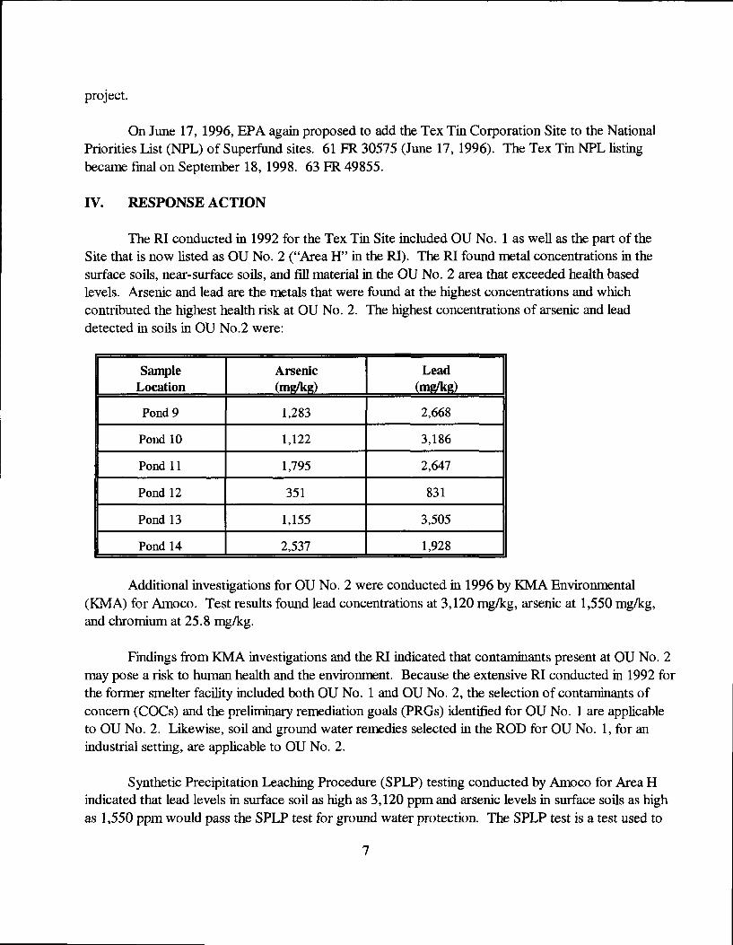
The RI conducted in 1992 for the Tex Tin Site included OU No. 1 as well as the part of the Site that is now listed as OU No. 2 ("Area H" in the RI). The RI found metal concentrations in the surface soils, near-surface soils, and fill material in the OU No. 2 area that exceeded health based levels. Arsenic and lead are the metals that were found at the highest concentrations and which contributed the highest health risk at OU No. 2. The highest concentrations of arsenic and lead detected in soils in OU No.2 were;
Sample Arsenic Lead Location (mgdcg) (mgdig)
Pond 9 1,283 2,668
Pond 10 1,122 3,186
Pond 11 1,795 2,647
Pond 12 351 831 1 Pond 13 1,155 3,505
Pond 14 2,537 1,928
Additional investigations for OU No. 2 were conducted in 1996 by KMA Environmental (KMA) for Amoco. Test results found lead concentrations at 3,120 mg/kg, arsenic at 1,550 mg/kg, and chromium at 25.8 mg/kg.
Findings Irom KMA investigations and the RI indicated that contaminants present at OU No. 2 may pose a risk to human health and the environment. Because the extensive RI conducted in 1992 for the former smelter facility included both OU No. 1 and OU No. 2, the selection of contaminants of concem (COCs) and the preliminary remediation goals (PRCs) identified for OU No. 1 are applicable to OU No. 2. Likewise, soil and ground water remedies selected in the ROD for OU No. 1, for an industrial setting, are applicable to OU No. 2.
Synthetic Precipitation Leaching Procedure (SPLP) testing conducted by Amoco for Area H indicated that lead levels in surface soil as high as 3,120 ppm and arsenic levels in surface soils as high as 1,550 ppm would pass the SPLP test for ground water protection. The SPLP test is a test used to
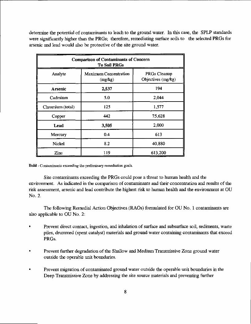
determine the potential of contaminants to leach to the ground water. In this case, the SPLP standards were significantly higher than the PRGs; therefore, remediating surface soils to the selected PRGs for arsenic and lead would also be protective of the site ground water.
Comparison of Contaniinants of Concern To Soil PRGs
Analyte Maximum Concentration (mg/kg)
PRGs Cleanup Objectives (mg/kg)
Arsenic 2,537 194
Cadmium 5.0 2,044
Chromium (total) 125 1,577
Copper 442 75,628
Lead 3,505 2,000
Mercury 0.4 613
Nickel 8.2 40,880
i Zinc 119 613,200
Bold - Contaniinants exceeding the preliminary remediation goals.
Site contaminants exceeding the PRGs could pose a threat to human health and the environment. As indicated in the comparison of contaminants and their concentration and results of the risk assessment, arsenic and lead contribute the highest risk to human health and the environment at OU No. 2.
The following Remedial Action Objectives (RAOs) formulated for OU No. 1 contaminants are also applicable to OU No. 2:
• Prevent direct contact, ingestion, and inhalation of surface and subsurface soil, sediments, waste piles, drummed (spent catalyst) materials and ground water containing contaminants that exceed PRGs.
• Prevent further degradation of the Shallow and Medium Transmissive Zone ground water outside the operable unit boundaries.
Prevent migration of contaminated ground water outside the operable unit boundaries in the Deep Transmissive Zone by addressing the site source materials and preventing further
degradation of the shallow and medirun transmissive zones.
The Tex Tin OU No. 2 response action, conducted under the authority of the Texas VCP, met the RAOs for OU No. 1 which are also applicable to OU No. 2. The implenoented remedy for OU No. 2 included the following elements:
• Placement of a minimum 2-foot soil/vegetative cover over the entire OU No. 2 area (to prevent exposure to surface soil contaminants above health-based action levels found on portions of the property);
• Construction of a bentonite/soU (slurry) cutoff wall located along the Amoco - Tex Tin property boxmdary (to prevent further movement of the contaminated shallow ground water from OU No. 1 to OU No. 2);
• Initiation of a long-term ground water monitoring program and placement of deed restrictions on the property to prevent use of the ground water for purposes other than monitoring and remediation;
• Piling deed restrictions (to restrict site use for industrial purposes only and to notify potential users of the remaining site contaminants. Concentrations of all detected constituents were recorded on the property deed).
In addition, O&M requirements will include regular inspections of the soil cover to ensure its effectiveness and integrity.
The long-term ground water monitoring program consists of:
• Sampling twenty-four (24) shallow and seven (7) medium transmissive zone weUs on a quarterly basis for the first two years after completion of the response action, semi-annually for the next three years, and yearly thereafter.
• Estabhshing a conpUance monitoring program at the limit of the contaminant pliune boundary to ensure that no further migration of the contaminated shallow ground water is occurring. Samples wiU be collected from shallow groimd water wells quarterly for a minimum of two years. If no migration is indicated during the first two years, sampling wiU be conducted semiannually for the next three years, and annually thereafter. If migration of the contaminated shallow ground water is indicated at the compliance monitoring locations, a proposed response action will be submitted to TCEQ and EPA in a Groundwater Monitoring Response Action Report.
The RAOs were met by the OU No. 2 response action by construction of the slurry wall to
prevent further movement of contaminated shallow ground water from OU No. 1 to OU No. 2 and initiation of long-term ground water monitoring to ensure that the contaminated ground water plume underlying OU No. 2 does not extend or migrate beyond the property boundaries.
The environmental contaminants and risks to human health and the environment at OU No. 2 are similar to the contaminants and risks identified at certain areas of OU No. 1, although much more limited in size and scope. The response action taken at OU No. 2 has eliminated the exposure pathway between hiiman or environmental receptors and surface or subsurface contaminants by creating a permanent clean cover over the entire OU No. 2 property.
Unacceptable levels of risk to industrial workers caused by exposure to hazardous substances at OU No. 2 have been abated by the Texas VCP response action. The implemented remedy for the Tex Tin OU No. 2 site is consistent with the remedy selected for OU No. 1 which met the nine criteria evaluation used in selecting remedies for Superfund sites.
Operation and maintenance (O&M) activities for the Tex Tin OU No.2 site consist of ground water monitoring and maintaining the soil cover over the entire site. O&M costs average $100,873 per year during the first five years. It is estimated that future ground water monitoring O&M costs will be approximately $80,000 per year.
V. FIVE- YEAR REVIEW PROCESS
This first five-year review for the Tex Tin OU No. 2 site has been conducted in accordance with the current EPA guidance titled. Comprehensive Five-Year Review Guidance, dated June 2001. A site inspection was conducted on April 3, 2003, as part of the five-year review and applicable reports and documents covering the review period were evaluated. A newspaper notice was published in the Texas City Sun and Galveston County Daily News newspapers on April 6, 2003, to notify the community that EPA had started the five-year review for the Tex Tin OU No. 2 site. Once the Five-Year Review Report has been signed by EPA, a copy wiU be placed in the three site repositories which include: the Moore Memorial Public Library, located at 1701 Ninth Avenue North, in Texas City, Texas 77590; the U.S. Environmental Protection Agency, Seventh Floor Reception Area, 1445 Ross Avenue, Ste. 12D13, Dallas, Texas 75202-2733; and the Texas Commission on Environmental Quality, Building E, Records Management, First Floor, 12100 Park 35 Circle, Austin, Texas 78753.
In addition, on July 1, 2003, the EPA, the TCEQ, and the City of Texas City signed a Ready for Reuse Determination (RfR) for the Tex Tin OU No. 2 site. The RfR was presented to BP Amoco at a ceremony conducted at the Texas City City HaU. The RfR states that EPA has made a technical determination that OU No. 2 is ready for industrial use and is protective of human health and the environment.
The findings of the Five-Year Review inspection and review process are described in the
10
following sections.
VI. TECHNICAL ASSESSMENT
Site Inspection
A site inspection was conducted by EPA, TCEQ, and Texas VCP personnel. Also participating in the site inspection were representatives for BP Amoco and its response action contractor. The inspection was conducted on April 3, 2003, and consisted of evaluating the soil cover, monitoring weUs, slurry wall surface area, and site fence.
During the inspection, the following action items were identified:
• Continue ground water monitoring on an annual basis except for weUs MW-67S and MW-57S. Performance Monitoring Well MW-67S was installed in 2002 and has been sanpled only two times. Quarterly sanpling should be conducted to develop a trend analysis for this well. Inconsistent trends in Compliance Monitoring Well MW-57S indicate a need to monitor this well on a quarterly basis to determine if the contamiuant plume is migrating.
• Protective well covers should be repaired or replaced as needed and locks placed on aU weUs.
• Several low spots and erosion areas were noted around the toe of the soil cover. These areas should be backfilled with soil and/or monitored to ensure that low spots and erosion areas do not worsen.
• Slurry wall marker signs have faded and can no longer be read. New markers should be installed and missing marker posts replaced.
Standards Review
The five-year review included evaluation of the Applicable or Relevant and Appropriate Requirements (ARARs) identified for the Tex Tin site. The most recent change involves the drinking water standard for arsenic. On January 21, 2001, the EPA lowered the maximum contaminant level (MCL) for arsenic from 50 ppb to 10 ppb for drinking water sources. However, the new drinking water standard is not applicable to the shallow ground water transmissive zone. The shallow and medium transmissive zones at the Tex Tin OU No. 2 site are not considered viable drinking water sources in part because background ground water concentrations iu the shallow groimd water transmissive zone exceed MCLs for antimony, beryllium, chromium, and lead. The drinking source for this area would more likely be the deep transmissive zone which is located approximately 130 feet below ground siuface. There are no drinking water or industrial ground water weUs in the shallow, medium, or deep transmissive zone located down gradient from the site. Based on ground water
11
moDitoring results for the past five years, the plume of contaminants in the shallow transmissive zone has not migrated off-site. The new arsenic drinking water standard will not impact the protectiveness of the site remedy since the shallow transmissive zone is not currently and will not likely be used in the future as a drinking water source. This determination regarding the viability of the shallow ground water zone does not affect the classification of the unit as a "useable" ground water bearing unit for the TCEQ. No other changes have occurred to the ARARs identified for the site that would affect the protectiveness of the implemented response action.
Data Review
Data review for this Five-Year Review Report included the Record of Decision, Remedial Investigation, and the Response Action Reports submitted since completion of the response action for the site. BP Amoco has conducted nineteen (19) ground water sampling events since 1997, and thirteen (13) Response Action Reports have been submitted since completion of construction activities. There are three ground water transmissive zones at the Tex Tin site. The shallow transmissive zone is located at an average depth of seventeen (17) feet below ground surface. The medium transmissive zone is located at an average depth of fifty (50) feet below ground surface. The deep transmissive zone is located approximately 120 feet below ground surface. Background ground water concentrations in the shallow ground water exceed MCLs for antimony, beryllium, chromium, and lead. Contaminant levels related to the site were identified in the shallow transmissive zone during the remedial investigation. Therefore, the ground water monitoring program was designed primarily to monitor the shallow ground water zone.
VII. ISSUES
During the five year review, the following issues were identified:
Issue Cxirrently Affects Protectiveness (Y/N)
Affects Future Protectiveness (Y/N)
AH monitor weUs need locks and some need new caps.
NO NO
A few minor surface erosion areas were noted.
NO NO
Signs along slurry wall need replacement
NO NO
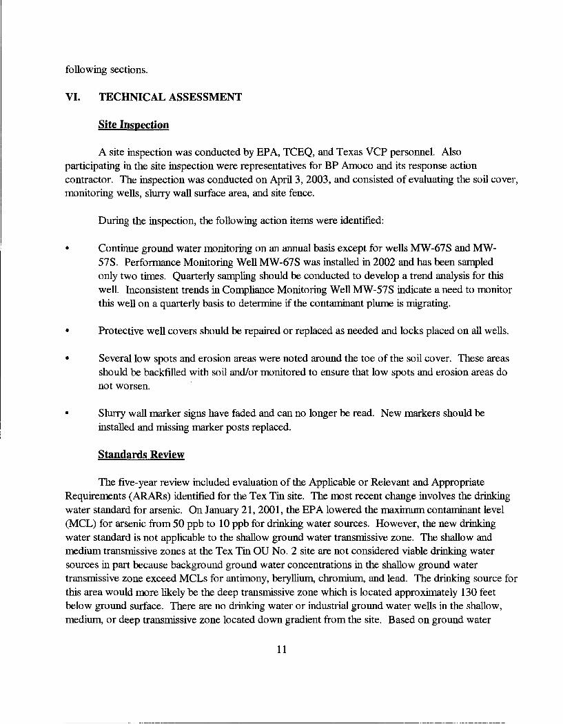
Annual ground water monitoring results presented in the 2003 Response Action Report for the Compliance WeUs are in the following table.
12
Annual Ground Water Monitoring Report for 2003 Compliance Wells for Shallow Transmissive Zone
Well No.
Antimony /ig/L
Arsenic gg/L
Barium /ig/L
Beryllium /tg/L
Cadmium gg/L
Chromium Copper T,ead gg/L
Mercury gg/L
Nickel gg/L
Selenium gg/L
TDS mg/L
MCLs 6 10 2,000 4 5 100 NA 15 2 100 50
MW-27S 60U lOU 210 5U 5U 3.2J 3.5J 13 0.2UJ 40U 16 6,500
MW-52S 60U 6.7 38J 5U 5U 2.1 J 25U 4.2 0.2UJ 94 5U 3,200
MW-53R 60U lOU 20J 5U 5U lOU 4.3J 12 0.2UJ 120 5U 3,900
MW-56S 60U 4.6J 26J 5U 5U 2.2J 6.4J 9.2 0.2UJ 120 5U 4,000
MW-57S 60U 19 840 3.2 5.2 2.3J 4.8J 26 0.2UJ 20J 13 36,000
1 MW-63S 60U lOU 85J 5U 5U 6.7J 4J 6.6 0.2UJ 5.5J 5U 5,300
1 MW-64S 60U 32 220 5U 5U 2.2J 4.8J 9.1 0.2UJ 7.3J 5U 5,800
U- Constituent was not detected at or above the reported detection limit. UJ- Cmcentration was not detected at the estimated reported detection limit. J- The reported value was estimated due to quality control requirements. MCLs- Maximum Contaminant Levels TDS- Total Dissolved Solids
13

Five Year Review guidance requires EPA to evaluate each site using the following questions:
Question A: Is the remedy fimetiomng as intended by the dedsion documents?
The response action performed at Tex Tin OU No. 2 is functioning as intended. The plume of contaminants in the shallow ground water is being effectively contained by the slurry wall and monitored by the ground water well system The surface soU cap is performing as designed. Deed restrictions specified by the State and approved by EPA have been filed by the site owner and remain on file in the Galveston County property records. The site is fenced and access properly restricted. The site owner is performing consistent maintenance on the site overall, as well as the required operation and maintenance of the response measures. The site owner is continuing the ground water monitoring for the site as directed by the TCEQ under the Texas VCP and EPA.
Question B: Are the assumptions used at the time of remedy selection still valid?
The assumptions used at the time of response selection are still valid. EPA noted that the MCL for arsenic changed between completion of the response action and initiation of the five year review. After further evaluation, EPA determined that the change to the arsenic MCL was not applicable or relevant and appropriate to address arsenic contamination in the shallow transmissive zone beneath OU No. 2. The predominant land use in the area of the site remains industrial. No new human health or ecological exposure pathways have been identified, nor have any new contaminants or sources of contaminants.
Question C: Has any other information come to light tiiat could call into question the protectiveness of the remedy?
No other information has come to light that could call into question the protectiveness of the prior response action.
VIII. RECOMMENDATIONS and FOLLOW-UP ACTIONS
1 Deficiencies Recommendations and FoUow-up Actions
Party Responsible
Oversight Agency
II Follow-up Actions || Affect
Protectiveness
Unlocked Monitoring wells
Ensure that monitoring wells are locked. Replace locks as needed.
BP Amoco EPA and TCEQ
NO
14
1 Deficiencies Recommendations and Follow-up Actions
Party Responsible
Overs^ht Agency
Follow-up Actions Affect
Protectiveness
Minor surface erosion.
Repair surface erosion as needed and monitor areas to ensure that minor erosion does not increase.
BP Amoco EPA and TCEQ
NO
Faded Slurry Wall signs
Replace signs along the Slurry Wall aligrunent.
BP Amoco EPA and TCEQ
NO
Ground water monitoring should continue on an annual basis until information indicates that a longer monitoring frequency is acceptable.
IX. PROTECTIVENESS STATEMENT
The remedy conducted through a response action under the Texas Volvmtary Cleanup Program for OU No. 2 of the Tex Tin Superfimd site is and remains protective of human health and the environment. Soils exceeding industrial cleanup levels for the contaminants of concem identified for the site were covered with two feet of soil to prevent exposure of site workers to those contaminants. Construction of a slurry barrier wall between the OU No. 2 Amoco property and the former smelter facility, OU No. 1, wiU prevent eastem migration of the contaminated shallow ground water. Ground water monitoring conducted during the past five years does not indicate that contaminants in the shallow ground water are migrating off-site. Ground water monitoring wiU continue for the next 25 years imless conditions indicate that ground water monitoring is no longer warranted. At a iiiinimuiii, the site ground water will be monitored on an annual basis for the next five years to verify that contaminants in the shallow transmissive zone are not migrating to the deep transmissive ground water zone that can potentially be used as a drinking water source. Site conditions and the ground water monitoring program wiU again be evaluated during the second five-year review and a decision wiU be made regarding future monitoring requirements. The Tex Tin OU No. 2 site will continue to be monitored imder the Texas Voluntary Cleanup Program to ensure compUance with the Conditional Certificate of Completion and as part of the long term grormd water monitoriug requirement specified in the ROD.
X. NEXT REVIEW
Because contaminants remain on site above health based levels, the next (second) Five-Year Review for the Tex Tin OU No. 2 site wiU he planned for no later than September 2008, five years from the signing of the first Five-Year Review.
15

FIGURES
%
.."LaManue ' ..y"'"' y.-;y" ..yi- '•'iiy yi-iyi- X;.'::.
1 Itoas City
...y''' xP'Ib.: 'N? 1 11 INDUSTRIAL AREA
. -r -r-' • ^ ....r.y.y.v;;;-: •
RESIDENTIAL -•••I AREA
OUNQ. 3 ¥•••••• •'if •• •• V. y'"' .yf -- i;s- -••
1(146 )
1 519 1
% % IT
ou yfpljl 1 -
lil ^
-.yy'-
\NO. 21 ,/'•
<i9r> OUNo. 4
j#| liljyji;;:,, ,1
'''•(111..
®dLLl.
W
111046)'%,.
38023F20.CDR
SITE VICINITY MAP Tex Tin Corporation Superfund Site
i-OW LEVEL RADIONUCLiDE ^
UNDHLL
o
Voluntary Cleanup Program Quarteriy Groundwater Monitoring Report KMA Environmental Services, Inc.
SITE FACILITY MAP
F.M. 619 EAST
TEX TIN PROPERTY
MW-62S A
MW-61S A
TEX TIN PROPERTY
, COMPLIANCE MONITORING WELL SHALLOW TRANSMISSIVE ZONE
A PERFORMANCE MONITORING WELL ^ SHALLOW TRANSMISSIVE ZONE
^ MONITORING WELL SHALLOW TRANSMISSIVE ZONE PERFORMANCE MONITORING WELL MEDIUM TRANSMISSIVE ZONE
FIGURE 3 BP AMOCO C-PLANT SITE
MW-29S
M«^29M
ESC-2001 / Task 100! basal .art Voluntary Claanup Program Annual Groundwater Monitoring - 2003
MONITORING WELL LOCATIONS

ATTACHMENTS
Site Inspection Checklist
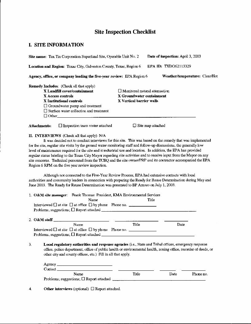
I. SITE INFORMATION
Site name: Tex Tin Corporation Superfund Site, Operable Unit No. 2 Date of inspection: April 3, 2003
Location and Region: Texas City, Gralveston County, Texas, Region 6 EPA ID: TXD062113329
Agency, office, or company leading the five-year review: EPA Region 6 Weather/temperature: Clear/Hot
Remedy Includes: (Check all that apply) X Landfill cover/containment • Monitored natural attenuation X Access controls X Groundwater containment X Institutional controls X Vertical barrier waUs • Groundwater pump and treatment • Surface water collection and treatment • Other
Attachments: • Inspection team roster attached • Site map attached
II. INTERVIEWS (Check all that apply) N/A It was decided not to conduct interviews for this site. This was based on the remedy that was implemented
for the site, regular site visits by the ground water monitoring staff and follow-up discussions, the generally low level of maintenance required for the site and it industrial use and location. In addition, the EPA has provided regular status briefing to the Texas City Mayor regarding site activities and to receive input from the Mayor on any site concems. Technical persoimel from the TCEQ and the site owner/PRP and its contractor accompanied the EPA Region 6 RPM on the five year review inspection.
Although not connected to the Five-Year Review Process, EPA had extensive contacts with local authorities and community leaders in cormection with preparing the Ready for Reuse Determination during May and June 2003. The Ready for Reuse Determination was presented to BP Amoco on July 1, 2003.
1. O&M site manager: Frank Thomas President, KMA Environmental Services Name Title
Interviewed • at site • at office • by phone Phone no. Problems, suggestions; D Report attached
2 O&M staff. Name Title Date
Interviewed • at site • at office • by phone Phone no. Problems, suggestions; • Report attached
3. Local regulatory authorities and response agencies (i.e.. State and Tribal offices, emergency response office, police department, office of public health or enviranmental health, zoning office, recorder of deeds, or other city and county offices, etc.) Fill in all that apply.
Agency Contact
Name Title Date Phone no. Problems; suggestions; • Report attached
4. Other interviews (optional) • Report attached.
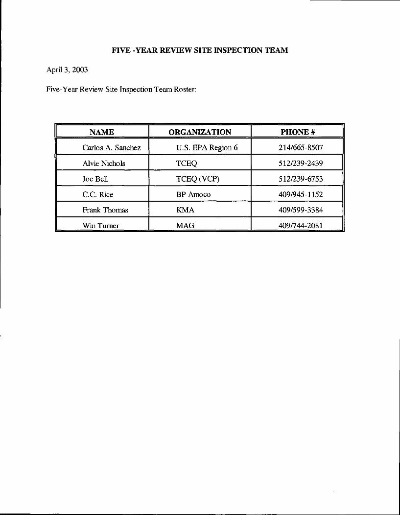
FIVE -YEAR REVIEW SITE INSPECTION TEAM
April 3, 2003
Five-Year Review Site Inspection Team Roster:
NAME ORGANIZATION PHONE #
Carlos A. Sanchez U.S. EPA Region 6 214/665-8507
Alvie Nichols TCBQ 512/239-2439
Joe Bell TCEQ (VCP) 512/239-6753
C.C. Rice BP Amoco 409/945-1152
Frank Thomas KMA 409/599-3384
Win Turner MAG 409/744-2081
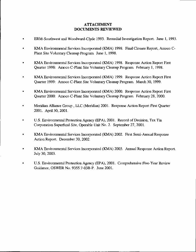
ATTACHMENT DOCUMENTS REVIEWED
ERM-Southwest and Woodward-Clyde 1993. RemediallnvestigationReport. June 1, 1993.
KMA Environmental Services Incorporated (KMA) 1998. Final Closure Report, Amoco C-Plant Site Voluntary Cleanup Program June 1, 1998.
KMA Environmental Services Incorporated (KMA) 1998. Response Action Report First Quarter 1998: Amoco C-Plant Site Voluntary Cleanup Program February 1, 1998.
KMA Environmental Services Incorporated (KMA) 1999. Response Action Report First Quarter 1999: Amoco C-Plant Site Voluntary Cleanup Program March 30, 1999.
KMA Environmental Services Incorporated (KMA) 2000. Response Action Report First (Quarter 2000: Amoco C-Plant Site Volxmtary Cleanup Program February 28, 2000.
Meridian Alliance Group , LLC (Meridian) 2001. Response Action Report First Quarter 2001. April 30, 2001.
U.S. Environmental Protection Agency (EPA), 2001. Record of Decision, Tex Tin Corporation Superfund Site, Operable Unit No. 2. September 27, 2001.
KMA Environmental Services Incorporated (KMA) 2002. First Semi-Annual Response Action Report. December 30, 2002.
KMA Environmental Services Incorporated (KMA) 2003. Annual Response Action Report. July 30, 2003.
U.S. Environmental Protection Agency (EPA), 2001. Comprehensive Five-Year Review Guidance, OSWER No. 9355.7-03B-P. June 2001.
DEED RESTRICTIONS
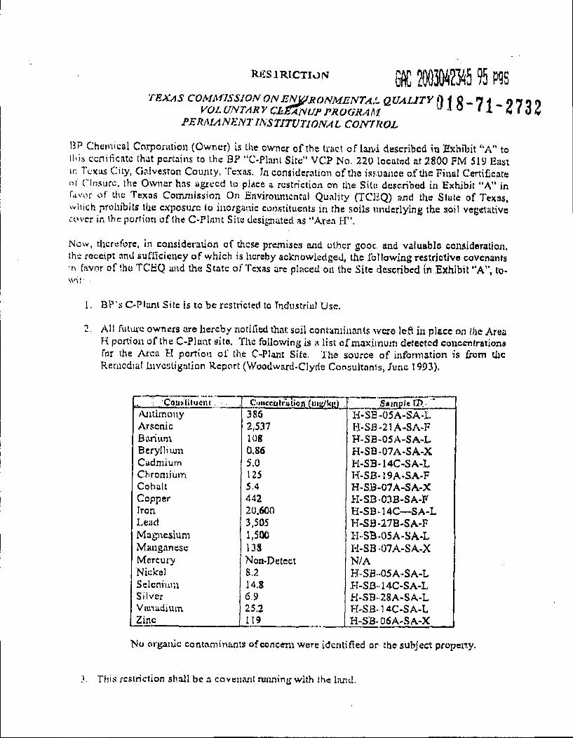
RJiSlRICTIONf efiC IMS 95 P9S TEXAS COMMISSION ONEN^RONMENTAL QUALITY f)i Q ^14 019^1
VOL UNTARY CESANUF PROORAM. PERMANENT INSTITUTIONAL COmiiOL
BP Chemical Co.rponition (Owner) is Lhe owner of the tract of laiid described in Exhibit "A" to liiis ccrirficatc that pertains to the BP "C-Plnnt Site" VCP No, 220 located at 2800 FM' 519 East ir. I cxus City, Galveston County, Texas, In consideration of the issuance of tire Final Certificate of cin.surc. the Owner has agiecd to place a restriction on the Site described in Exhibit "A" in favor of the Texas Coinniission On Envirounicntai Quality (TCliQ) and the Slate of Texas, which prohibits the exposure to inorganic constituents in the soils underlying the soil vegetiitivc cover in the pcirlion of the C-Planc Site designated as "Area 1-1".
Nosv, therefore, in consideration of these premises and other gooc. and valuable consideration, the receipt and sufficiency of which is hereby acknowledged, the following restrictive covenants in f.'ivor of the TCEQ and the State of Texas arc placed on the Site described in Exhibit "A", town I:
1. BP'.s C-Plonl Site is to be restricted to Industrial Use.
2. All futwe owners cire hereby notified that soil contaminants ^vcro left iu place on the Area H portion of the C-Plant silo. The following is a list of maxi,muin detected concentrations For the Area H portion of the C-Piant Site. The source of information i.s from the Remedial investigation Report (Woodward-Clyde Congultnnia, June 1993).
CoiisiiiluciK Caiiecialration fiiiKfUi;) .Sample II) >\ntimouy 386 i-l-SE-05A-SA-.L Arsenic 2,537 H-Si3-2IA-SA-F Barium 108 H-SB-05A-SA-L Beryllium 0.86 H.SQ-07A-SA-X Cadmium 5.0 H-SB-14C-SA-L CKroniium 125 H-SB-19A.SA-F Cobalt 5.4 H-S.B-07A-SA-X Copper 442 PI-SB-03B-SA-F Iron 20.600 H-SB-14C--SA-L Lead 3,505 PI-SB-27B-SA-F Magitesium 1,500 H-SB-05A-SA-L Manganese 13S H-SB07A-SA.X Mercut7 Non-Detect N/A Nickel 8,2 H-SB-05A-SA-L SeicniiLin 14.8 .H-SB-.14C-SA-L Silver 6.9 Pl-vSB-28A-SA-L Vttviadium 25.2 H-SB-14C-SA-L Zinc 119 H-SB- 06A-SA-X
No organic contaminants of concent were identified or the subject property.
Tlii.s i-c.$lriction .shall be a covenant running with the land,
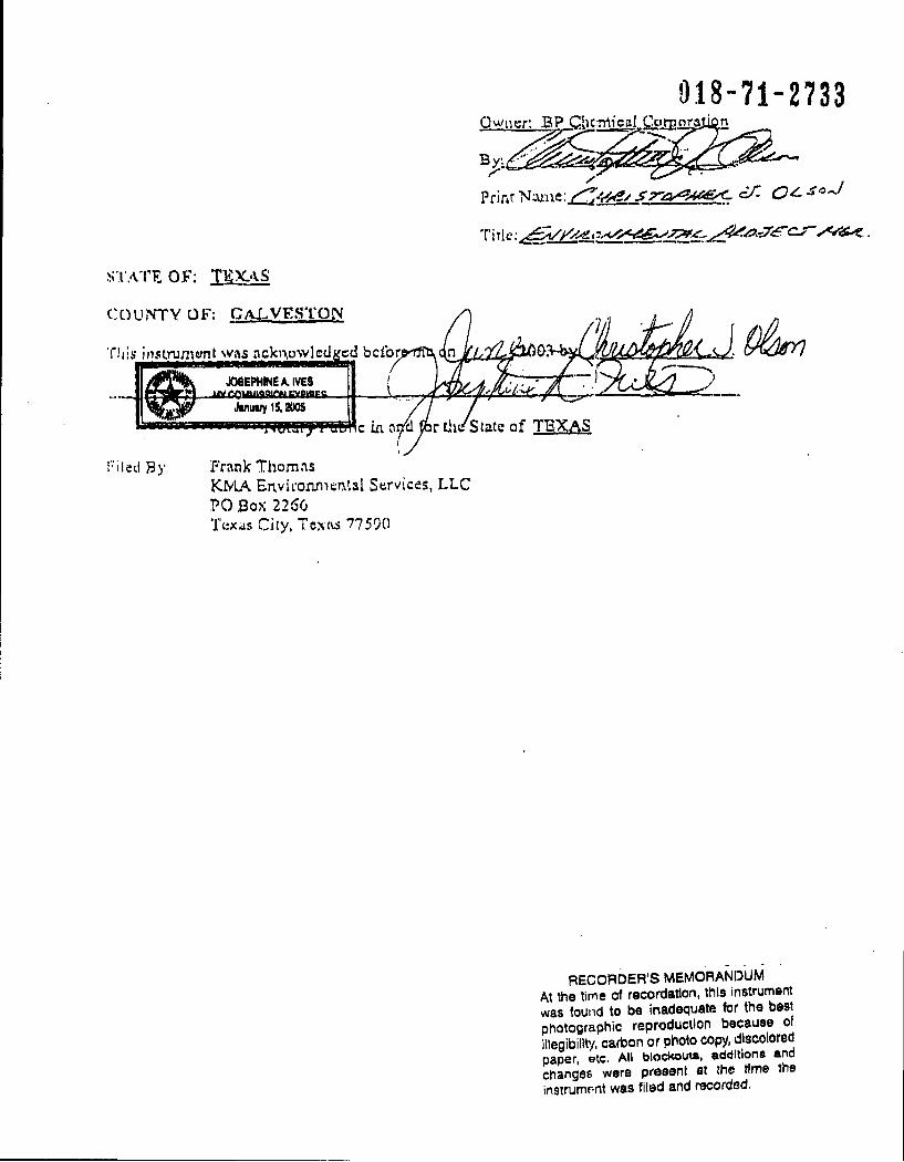
STATE OF; TKX.>KS
COUNTY OF: GAJ..VE.ST'01\
Tliisbclbr
JOeEPHINEA.IVES £ia£&
Jinusiy IS. 200S I'lill
0.18-71-2733 OwncrBP Chcrriigal CorooratK
Prinf Nairie: S7rz:^A<iG<.
'State of TBXAS
[••'iletl By: Frank Thomas KYIA Environmental Services, LLC PC .Box 2266 Tuxas City, Tcxfrs 77590
RECORDER'S MEMORANDUM At the time of recordation, this instrument was found to be inadequate for the best photosraphic reproduction because of illegibility, carbon or photo copy, discolored paper, etc. All blockout*, additions and changes were present at the time the instrumr-nt was filed and recorded.
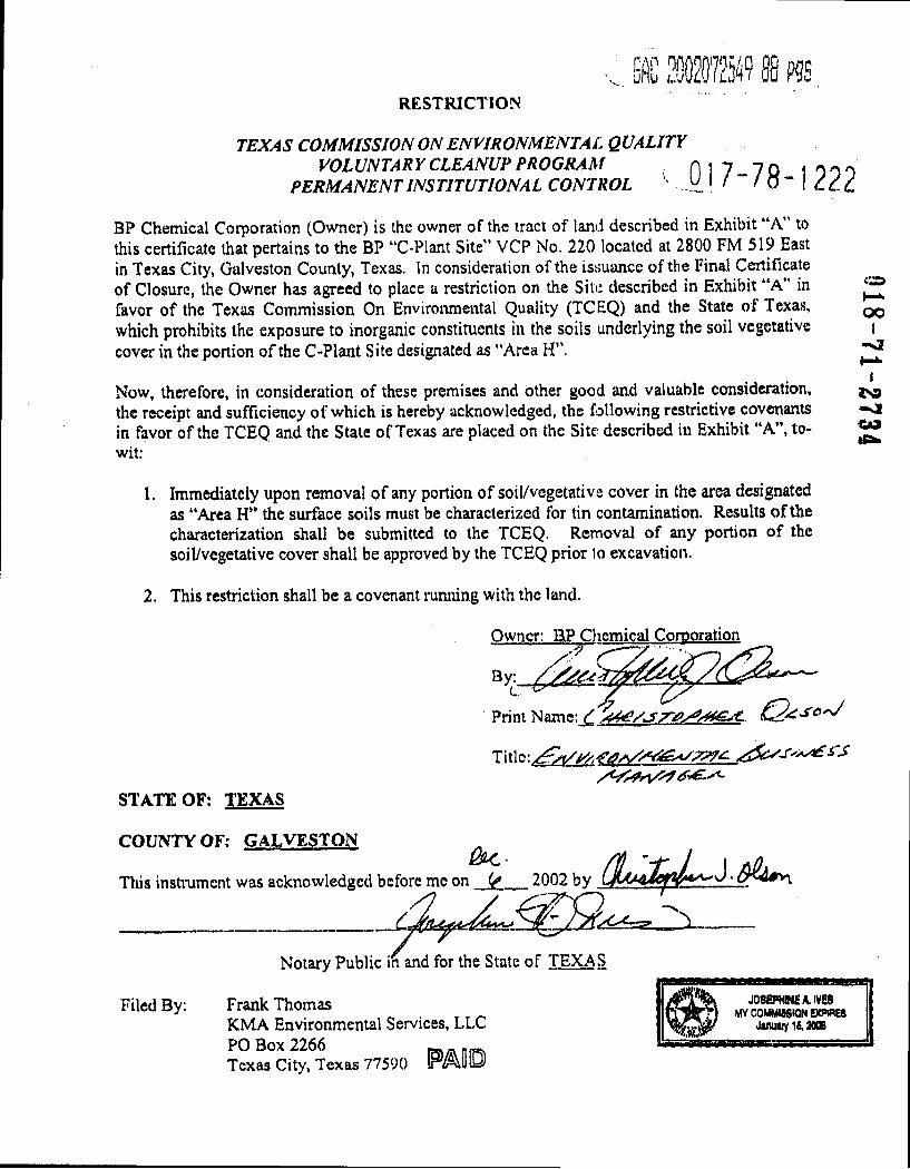
afiC 20020725^? 88 P5S RESTRICTION
TEXAS COMMISSION ON ENVIRONMENTAL QUALITY VOLUNTAR Y CLEANUP PROGRAM , ni7-7Q 100 0
PERMANENT INSTITUTION A L CONTROL . ' O - dcc
BP Chemical Corporation (Owner) is ihe owner of the tract of land described in Exhibit "A" to this certificate that pertains to the BP "C-Plant Site" VCP No. 220 located at 2800 FM 519 East in Texas City, Galveston County, Texas. In consideration of the is.suance of the Final Certificate of Closure, the Owner has agreed to place a restriction on the Site described in Exhibit "A" in favor of the Texas Commission On Environmental Quality (TCEQ) and the State of Texas, which prohibits the exposure to inorganic constituents in the soils underlying the soil vegetative cover in the portion of the C-Plant Site designated as "Area H".
Now, therefore, in consideration of these premises and other good and valuable consideration, the receipt and sufficiency of which is hereby acknowledged, the following restrictive covenants in favor of the TCEQ and the State of Texas are placed on the Site described in Exhibit "A", to-wit:
K* 00
I
1 <S9 -si Ota
1. Immediately upon removal of any portion of soil/vegetative cover in the area designated as "Area H" the surface soils must be characterized for tin contamination. Results of the characterization shall be submitted to the TCEQ. Removal of any portion of the soil/vegetative cover shall be approved by the TCEQ prior 1o excavation.
2. This restriction shall be a covenant rumiing with the land.
Owner: BP Cliemical Corporation
Print Name: ^
STATE OF: TEXAS
COUNTY OF: GALVESTON
This insti'umcnt was acknowledged before me on 2002
Notary Public in and for the State of TEXAS
Filed By: Frank Thomas KMA Environmental Services, LLC PC Box 2266 ^ Texas City, Texas 77590 IP/^UO
J08B>HINEA.IVE8 MVCOMMiaSKlN EXPIRES
J«uiuyl6,20a6
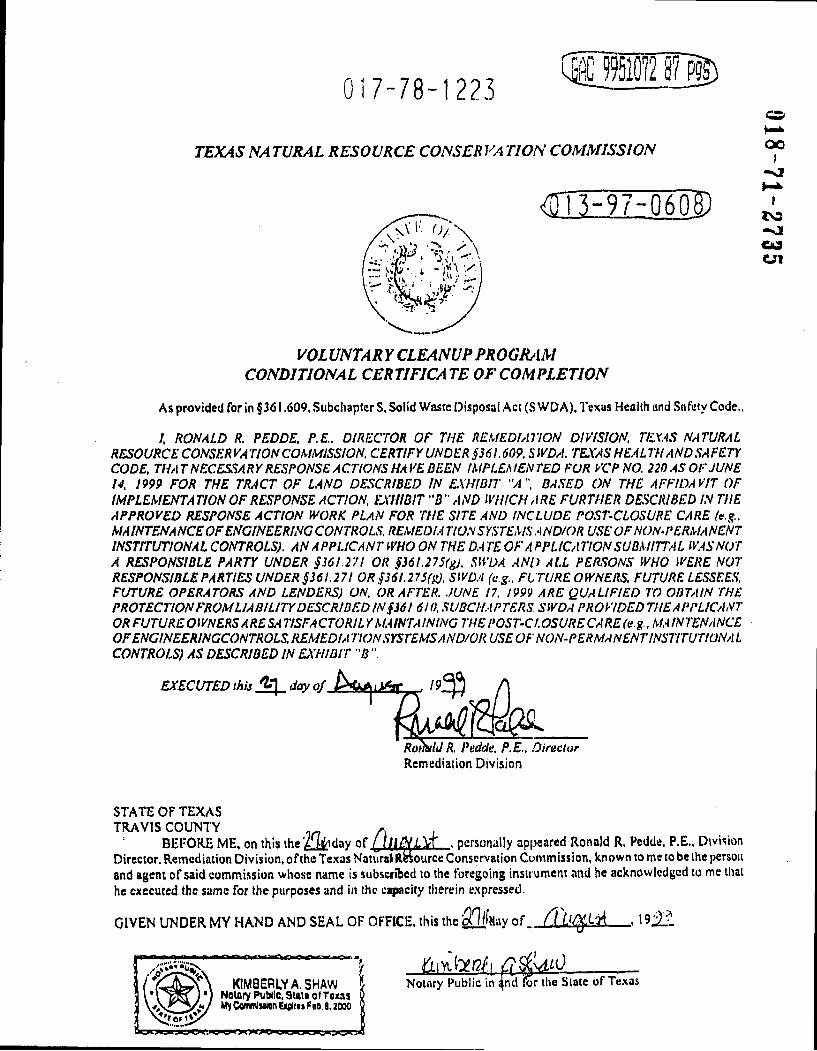
017-78-1223 lie 9951072 eM)
TEXAS m rURAL RESOURCE CONSER VA TION COMMISSION
<nTEi7-06S)
EXECUTED this day of.
RoiittU R. Pedde, P.E., Director Remediation Division
OO I
-si
I IS3 -si <U9 Cri
VOL UNTAR Y CLEANUP PROGIUIM CONDITIONAL CERTIFICATE OF COMPLETION
As provided for in §361.609, Subchapters, Solid Waste Disposal Act (SWDA). Texas Health and .Safety Code.,
/, RONALD R. PEDDE. P.E.. DIRECTOR OF THE REMEDIATION DIVISION. TE.X.AS NATURAL RESOURCE CONSERVATION COMMISSION. CERTIFY UNDER §361.609, SWDA, TEXAS HEALTH AND SAFETY CODE, THAT NECESSARY RESPONSE ACTIONS HAVE BEEN IMPLEMENTED FOR VCP NO. 220 AS OF JUNE N. 1999 FOR THE TRACT OF LAND DESCRIBED IN EXHIBIT "A". BASED ON THE AFFIDAVIT OF IMPLEMENTA TION OF RESPONSE ACTION. EXHIBIT "B " AND WHICH ARE FURTHER DESCRIBED IN THE APPROVED RESPONSE ACTION WORK PLAN FOR THE SITE AND INCLUDE POST-CLOSURE CARE (e.g.. MAINTENANCEOFENGINEERINCCONTROLS. REiMEDI.-iTION SYSTEMS.-iND/OR USE OF NON-PERMANENT INSTITUTION A L CONTROLS). ANA PPLICANT WHO ON THE DA TE OF A P PLICA TION SUBMITTA L NOT A RESPONSIBLE PARTY UNDER §361.271 OR §36l.27S(gj. SUVA .AND ALL PERSONS WHO WERE NOT RESPONSIBLE PARTIES UNDER §361.271 OR §36l.275(g). SWDA (e.g., FUTURE OWNERS. FUTURE LESSEES. FUTURE OPERATORS AND LENDERS) ON. OR AFTER. .JUNE 17. 1999 ARE QUALIFIED TO OBTAIN THE PROTECTION FROMLIABILITY DESCRIBED IN §36! 6l().SUBCHAPTERS SWDA PROVIDEDTHEAPPLICANT OR FUTURE OWNERS ARESA TISFA CTORIL Y MA INT AINING THE POST-Ct. OSURE CA RE (e. g.. MA IN TENANCE OFENCINEERINCCONTROLS. REMEDIA TION SYSTEMS AND/OR USE OF NON-PERMANENT INSTITUTIONA L CONTROLS) AS DESCRIBED IN EXHIBIT "B "
STATE OF TEXAS TRAVIS COUMTY ,
BEFORE ME, on this the'/ Wdav of . personally appeared Ronald R. Pedde, P.E., Division Director, Remediation Division, ofthc Texas Natural Rfeiource Conservation Commission, known to me to be the person and agent of said commission whose name is subscribed to the foregoing instrument and he acknowledged to me that he executed the same for the purposes and in the capacity tlierein expressed.
GIVEN UNDER MY HAND AND SEAL OF OFFICE, this the OTsay of / I , 19:21:1
KIMBERIYA. SHAW Neuiry Public, Stait o( Tous MyCenwIiMnEipidtFaD/
TBMS i fj r Notarv Public in and 1 Notary Public in ^nd lor the Slate of Texas
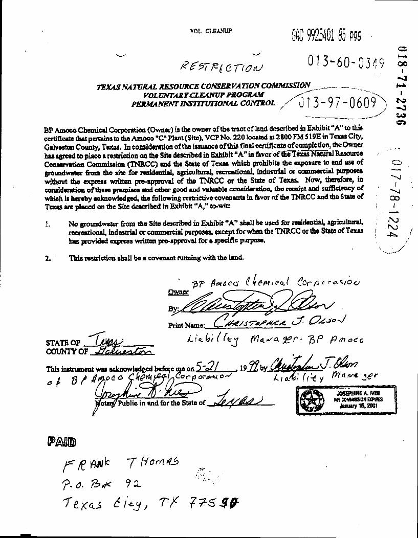
VOL CLEANUP iC raol 35 p?s o
0'3-60- 0349 TEXASNAIVRAL RESOURCE CONSERVATION COMMISSION ^
VOLUNTARr CLEANUP PROGRAM n/n>\ TL PERMANENT INSTITUnONAL CONTROL y Ulj-VZ-UoU/l ^ «<!
OS
BP Amoco Cbemictl Corporation (Owner) is the owner of the trtiot of lend deecnbed in Exhibit "A" to this certificete that pertains to the Amoco "C" Plant (Site), VCP No. 220 located at 2800 FM 519E in Texas City, Celveeton Coun^, Texas. In coaiideretion of the iaauance ofthis final certificatt of eviction, the Owner has agreed to place a restriction on the Site described in Exhibit "A" in favor offfieTexasTTatural Resource Conservation Commission (TNRCC) and the State of Texaa which prohibits the exposure to and use of o groundwater from the site for rasidential, ^ricultuxal, recreational, mdusixial or commercial pmpoacB widmut the express written pre-approval of the INRCC or the State of Texaa. Now, therefore, in consideraticn of daeae premiMS and other good and valuable consideration, the receipt and sufficiency of which la hereby eoknowtedged, the following leatrictive covenenta in favor of the INRCC and the State of Tejott are placed on the Site described In Exhibit "A," tO"Wlt;
1. No groundwater from the She described in Exhibit "A" shall be used for rBaidantial,agricullaral,
I
QO I
11U y VUUUW4MVI UKMU au« vswiswaawrvHae ass ASASSSVSW w- — » "cr- »
recreational, industrial or commercial purposes, except for when the TNRCC or the Stete of Texas has provided express written pre-approval for a specific purpose.
This ressriction shall be a covenant running with the land.
/
Qssm. .CTZ
Print Name:
STATE OP / ^f <1. 4 ' trjj C ' P fimaCQ COUNTY
This instrument was acknowledged before me a&S'Ql 19.2^by, ^ / d ^ ^ /. IAAS>] (r'-i y
^ J0eB>HINEA~IVE8
Public in and for the State
f.6. Th^ 9x
3-60-0350 EXUIBIT''A**
TEXAS NATVXAL RESOURCE CONSERVATION COMMISSION VOLUNTARY CLEANUPPROCRAM
LEGAL DESCRIFTION OF THE AMOCO C-PLANTSITE VCPNo.220
The site is a 66.924 acre tract, mere or less, located at 2500 FMS19E in the H.B. LhtlefieW SurvQf, AbstraciNo. 143, recorded ia the t)ocd of Reoocds Ooiveston County, Texas, said 66.924 acre response aeatoo area is more porticulflfty depicted as shown in (he ateaohed aoached Boundary Survey:
c::
I so
1 CO OS
CD
017-78-1225 oo I
I tN9
CO
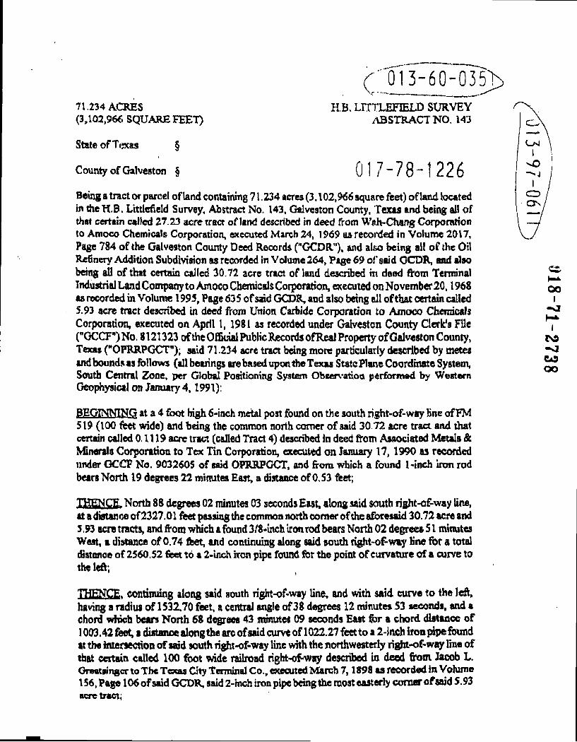
71,234 ACRES (3,102,966 SQUARE FEET)
State of Texas §
County of Galveston §
(;;'0l3-60-"035> H.B. LITTLEFIELD SURVEY
/VBSTRACTNO. 143
017-78-1226 Being a tract or parcel ofknd containing 71.234 acres (3.102,966 square feet) of land located in theH.B. Littlcfield Survey, Abstract No. 143, Galveston County, Texas and being all of that certain called 27.23 acre traa of land described in deed from W»h-Chang Corporation to Amoco Chemicals Corporation, executed March 24, 1S>69 as recorded in Volume 2017, Page 784 of the Galveston County Deed Records ("GCDR"), and also being all of the Oil Refinery Addition Subdiviaion aa recorded in Volume 264, Page 69 of' said OCDR, and alao being ^ of that certain called 30.72 acre tract of land described m dead from Terminal Industrial Land Company to Amoco Chemicals Corporation, executed on November20,1968 aa recorded in Volume 199S, Page 635 of said GCDR, being ail of that certain called 5.93 acre tract described in deed from Union Carbide Corporation to Amoco Chemicals Corporation, executed on April I, 1981 as recorded under Galveston County Clerk's File ("GCCF'')No. 8121323 oftheOEBcial Public Records ofReal Property ofGalveston County, Texas ("OPRRPGCT"); said 71.234 acre tract bang more particularly described by metes andboundsas follows (all bearings are based upon the Texas State Plane Coordinate System, South Central Zone, per Global Positioning System Obcervatioo performad by Western Geophysical on January 4,1991);
BEGINNING at a 4 foot high 6-inch metal post found on the south right-of-way Hne of FM 519 (100 feet vwde) and being the common north comer of said 30 72 acre tract and that certain called 0.1119 acre tract (called Tract 4) described in deed from Asaociated Metala & Minerals Corporatiotx to Tex Tin Corporation, executed on January 17,1990 as recorded under GCCF No. 9032605 of said OPRRFGCT, and from which a found 1 -inch iron rod bears North 19 degrees 22 minutea East, a distance of 0.53 feet;
THENCE- North 88 degrees 02 minutes 03 sosonda East, along said south right-of-way line, at a distance of2327.01 feet passing the common north comer of the aforesaid 30.72 acre and s .93 acre tracts, and from which a found 3/S-inch iron rod bears North 02 degrees S1 minutes Weat, a distance of 0.74 feet, and continuing along said south right-of-way Hne for a total (Hstimce of 2560.52 feet to a 2-iiich iron pipe found for the point of curvature of a curve to the left;
THENCE, continuing along said south right-of-way line, and with said curve to the left, having a radius of 153Z70 feet, a central angle of 38 degrees 12 minutes S3 seconds, and a chord wtuch bears North 68 degrees 43 minutes 09 seconds But for a chord distance of 1003.42 feet, a distance along tha arc of said curve of 1022.27 feet to a 2-inch iron pipe found at the intersection of said south right-of-way line with the northwesterly right-of-way Irae of that ceitain called 100 foot vride railroad right-of-way described in deed from Jacob L. Oreatringcr to The Texas D'ty Tenninal Co., executed March 7,1898 aa recorded in Volume 156, Page 106 of sud GCDR, said 2-lnch iron bong the most easterly comer of said 5.93 acre tract;
OM I
vO
I CD OS,
Ci. h-* oo I
I ro •o to OO
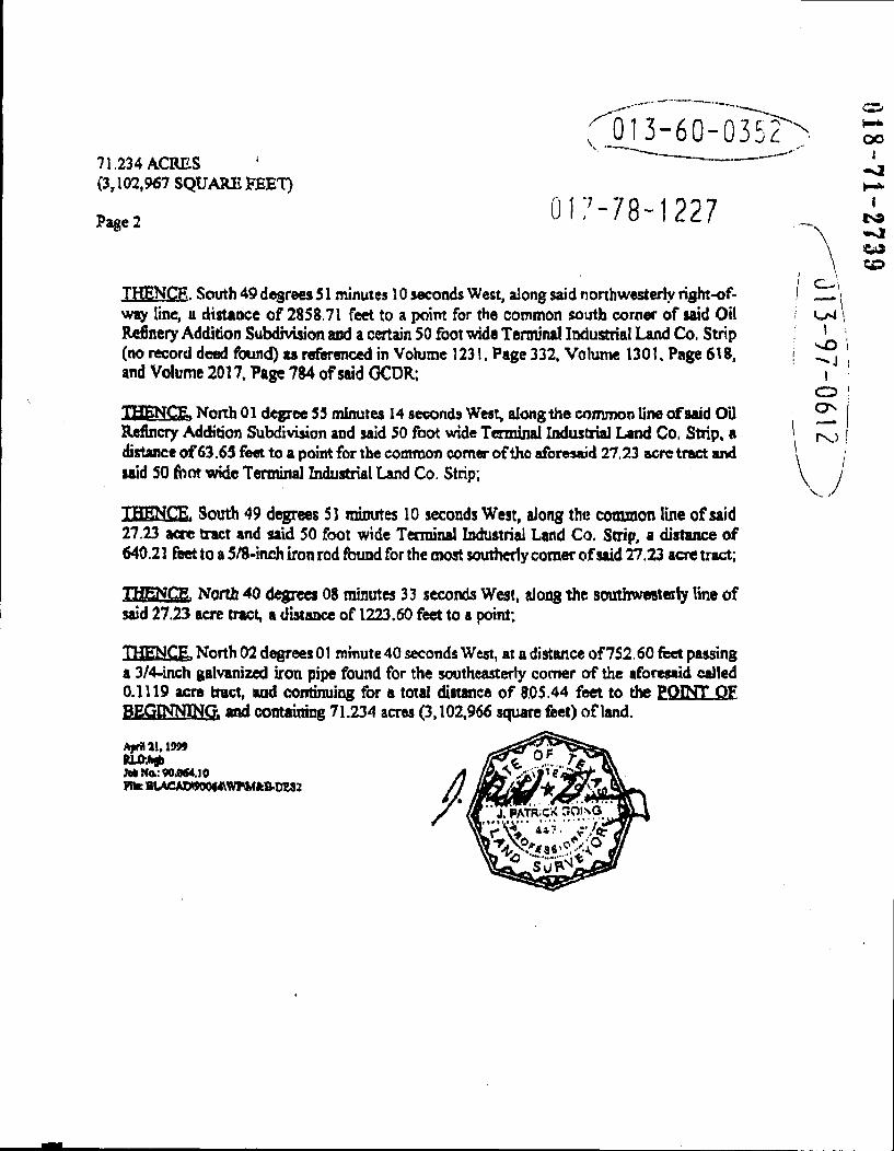
71,234 ACRES (3,102,967 SQUARE FEET)
Page 2
f01 3-60-035?
317-78-1227
THENCR. South 49 degrees 51 minutes 10 seconds West, along said northwesterly right-of-way line, a distance of 285S.71 feet to a point for the common south corner of said Oil Refinery Addition Subdivision and a certain 50 foot wide Terminal Iixiustrial Land Co. Strip (no record deed found) as referenced in Volume 1231. Page 332, Volume 1301. Page 618, and Volume 2017. Page 784 of said OCDR;
g, North 01 degree 55 minutes 14 seconds West, alongthe comnxsn line of said Oil Refinery Addition Subdivision and said 50 foot wide Terminal Industrial Land Co, Strip, a distance of63.65 feet to a point for the common comer of the aforesaid 27.23 acre tract and laid SO (hot wide Terminal Industrial Land Co. Strip;
THENrT" South 49 degrees SI mmutes 10 seconds West, along the cotxunon line of said 27.23 acre tract and said 50 foot wide Terminal Industri^ Land Co, Strip, a distance of 640.21 feet to a 578-inch iron rod found for the most southerly comer of said 27.23 acre tract;
E, North 40 degrcci 08 minutes 33 seconds West, along the southweeteriy line of said 27.23 acre tract, a distance of 1223.60 feet to a point;
IfC^C ICE, North 02 degrees 01 minute 40 seconds West, at a distance of752.60 feet passing a 3/4-inch galvanized iron pipe found for the southeasterly comer of the aforeaatd called 0.1119 acre tract, and continuing for a total ^stance of 8.05.44 feet to the POINT OF BEGINNING, and containing 71.234 acres (3,102,966 square feet) of land.
A]v»ai, 1999 in JMNQL:90.0M.IO niK BLACAiy900<4\WrM«:B-OES2