Embed Size (px)
Citation preview
Thanks, Tina, for coordinating this.
LAND REGULATION AT FIRE ISLAND NATIONAL SEASHORE
A HISTORY AND ANALYSIS, 1964-2004
National Park Service U.S. Department of the Interior Planning, Construction and Facility Management Northeast Region
FIRE ISLAND NATIONAL SEASHORE
SPECIAL HISTORY STUDY
LAND REGULATION AT FIRE ISLAND NATIONAL SEASHORE
A HISTORY AND ANALYSIS, 1964-2004
NED KAUFMAN &
CHARLES STARKS
PREPARED UNDER COOPERATIVE AGREEMENT WITH
THE UNIVERSITY OF MASSACHUSETTS
NORTHEAST REGION NATIONAL PARK SERVICE
U.S. DEPARTMENT OF THE INTERIOR
SEPTEMBER 2008

iii
Table of Contents
List of Figures .................................................................................................................................v List of Tables……………………………………………………………………………………...v Executive Summary and Research Findings (Kaufman & Starks) .......................................... vii Introduction (Kaufman) ………………………………………………………………………….1
Study Methodology………………………………………………………………………….2
Chapter One: Origins, Goals, and Methods of Land Use Regulation at Fire Island………...5 (Kaufman) Fire Island in 1964…………………………………………………………………………….……5 Changing Concepts of Parks…………………………………………………………………..……...…….9 Fire Island Is Established…………………………………………………………………………….……......11 Defining the Seashore’s Public Purpose: Conservation or Recreation………………………….……......12 Public Support for the Seashore…………...………………………………………..…………………..27 Private Property within the Seashore.………………………………………………………………………..45 Figures to Chapter One...…………………………………………………………….…………72 Chapter Two: The Regulatory System Evolves, 1964-1991 (Kaufman) ……………………75
Launching the Seashore….………………………………………………………….....……..….........75 Criticism of the Seashore Begins…………………………………………………………………….. 82 Solving the Regulatory Problems.……………………………………………………………………. 89 Environmental Management and Wilderness on Fire Island………...………………….….….……109 Changing Views on Private Property and Public Purposes………………………………………….111 Looking Forward and Backward: the Situation in 1991……………………………………………..142 Figures to Chapter Two.............................................................................................................144 Chapter Three: The System in Action, 1991-2004 (Starks) ....................................................147
Introduction…………………………………………………………………………………………. 147 Description and Analysis of the Land Use Regulatory System on Fire Island……………………...153 Figures to Chapter Three…………………………………………………………………......180 Conclusions and Recommendations (Starks & Kaufman)…………………………………….…183 Summary of Findings…………………………………………………………………………..........183 Recommendations…...……………………………………………………………………………… 185 Bibliography…………………………………………………………………………….……...189
Major Sources and Collections for Chapters One and Two…..………………………………….….189 Major Sources and Collections for Chapter Three ...…………..………….……………………..….194

iv
v
List of Figures
Figures to Chapter One 1-1. Location map of Fire Island (Proposal, 1964)……………………………………….72 1-2. Map of proposed Seashore boundaries (Newsday, December 12, 1963)…………….73 1-3. Map of Seashore showing proposed developments (Proposal, 1964)……………….73 1-4. Dunes on Fire Island (Proposal, 1964)……………………………………………....74 1-5. Beach in Fire Island pines (Proposal, 1964)………………………………………....74 Figures to Chapter Two 2-1. Map of Seashore (USGAO Report, 1981)…………………………………….……..144 2-2. “Storm eats dunes” (Long Island Advance, January 12, 1978)………………….…...145 2-3. Storm damage in Ocean Beach (unidentified newspaper clipping, February, 1978)…………………………………145 2-4. Storm-destroyed house in Point O’Woods (Diane Abell, November 1, 1991)……...146 2-5. “New Views of Doomed House” (Fire Island News, September 2, 1978)……….….146 Figures to Chapter Three 3-1. Undeveloped dunes (Charles Starks, 2005)………………………………..…….……180 3-2. Oceanfront houses on Fire Island (Charles Starks, 2005)……….…………..………...180 3-3. Nonconforming house on dune line (Charles Starks, 2005)………….……...………...180 3-4. House with expanded roof deck (Charles Starks, 2005)……………………….……..181 3-5. House with swimming pool on dune line (Charles Starks, 2005)…………….……....181
List of Tables
Tables to Chapter Three 3-1. Comparison of Bulk Requirements…………………………………………………164 3-2. Summary of Applications in the NPS Files by Zone, 1991-2006…………………. 165 3-3. Summary of Applications in the NPS Files by Municipality, 1991-2006…………..166 3-4. Sample of Objection Applications in NPS Files, 1991-2006 ……………………….168 3-5. Sample of Non-Objection Applications in NPS Files, 1991-2006………………….168 3-6. Approvals Located in Local Government Files From Sample ……….…...………....172

vi
vii
Executive Summary and Research Findings Narrative Summary
Fire Island is a long, narrow barrier island lying off the south shore of Long Island
within a short driving distance of New York City and the dense population centers of
suburban Nassau and Suffolk Counties. As late as the beginning of the 1960s, much of Fire
Island remained undeveloped. There was a state park, however, at its western end, and a
number of small communities consisting of lightly built seasonal vacation homes connected
by wooden walkways and a few narrow lanes. A new bridge connected the public to the state
park; otherwise, the only access to the island was by ferry.
In 1964, Congress established the Fire Island National Seashore, largely in response
to pressure to protect the island from the real estate development and population growth
which was engulfing Long Island. For the national park system, this was a period of
expansion and experimentation. Public recreation was intended to play a more substantial
role than in the classic national parks of the west which resulted in the establishment of new
areas such as national seashores. The subsequent decision to leave substantial amounts of
land within the Seashore in the hands of homeowners prompted the development of a
complex system of land use regulation which was intended to achieve federal land
management objectives through the medium of local zoning ordinances. There were two
legislative objectives: first, to protect the Seashore’s natural environment; and second, to
make its natural beauty available to the visiting public for recreational uses in harmony with
the first.
The National Park Service (NPS) quickly began to implement these goals, as the
enabling legislation, Public Law 88-587, September 11, 1964 codified at 16 U.S.C. & 459e
(the Act) directed, by promulgating federal zoning standards for the localities and launching
a land acquisition program. By 1967, it was clear that the system was failing to produce the
results intended by Congress, the Department of the Interior (DOI), and many of the
Seashore’s proponents. Local authorities were not adopting appropriate ordinances; instead,
they were granting inappropriate variances to homeowners, allowing them to build structures
which violated federal zoning standards. Enforcement was nonexistent or ineffective. The
government had failed to acquire the primary dune line and forestall further construction
viii
there. NPS policy, as implemented in day-today decisions by on-site and regional managers,
was drifting away from the goals set by Congress and the NPS itself towards something
amounting to tacit acceptance of the situation.
From the middle of the 1970s until 1991, DOI, NPS, and Congress studied, proposed,
and implemented measures intended to fix the problems. The NPS sponsored consultant
studies of the Island’s environment and its zoning problems; proposed model zoning
ordinances; drafted a general management plan, a land acquisition plan, and a land protection
plan; and on two occasions issued new zoning standards. Congress amended the Seashore’s
establishing Act in 1976, 1978 and 1984. Congress’s fact-finding arm, the General
Accounting Office, issued a report on land acquisition and management on Fire Island.
Throughout this period, the NPS continued its normal operations on Fire Island,
which included pressing local authorities to bring their zoning ordinances into conformance
with federal standards, reviewing and commenting on countless requests for variances and
special permits, and occasionally initiating condemnation proceedings. Yet despite these
activities, and despite the new measures, the number and size of structures within the
Seashore continued to rise, as did the resident population, density, and developed land area.
With these changes came increasingly severe environmental impacts, including water usage,
effluents from septic tanks and swimming pools, foot and vehicle traffic, and taller and more
visible buildings. Meanwhile, storms continued to batter the island, pushing the primary dune
line northward in many places. Longstanding worries about the Seashore’s environmental
health and natural beauty, focusing especially on the ocean beach and primary dune,
continued to be raised, but were joined now by new concerns focusing on the island’s less
visible ecosystem elements, such as its shallow fresh water aquifer.
Measures adopted in Washington had relatively little effect on any of these trends.
One reason lay in the design of the regulatory system itself. The legislators had made it clear
that they wanted to preserve Fire Island much the way it was in 1964. In the future, as they
envisioned it, the Seashore’s ecosystems and natural beauty would remain largely
untramelled, the balance between private development and public land roughly the same.
Local officials and public witnesses generally supported these goals; yet by leaving a large
number of lots open to development, in the face of strong population and real estate pressure,
Congress almost ensured that they would not be met. The lack of adequate enforcement tools
ix
only exacerbated this fundamental flaw; so did peculiarities of local politics, especially the
fact that while Fire Island owners paid property taxes to the local jurisdictions, very few of
them voted there. None of the remedies proposed between 1975 and 1991 effectively
addressed any of these underlying problems.
A second reason for failure was the fact that the political climate was changing.
During the second half of the 1970s, distrust of federal land ownership and regulation was
becoming increasingly evident among the public and politicians. By 1991 the climate of
opinion had diverged dramatically from that of 1964. Where the debate over the Seashore’s
establishment had been marked by broad support for public goals and general acceptance of
regulatory restrictions imposed in order to meet them, later debates over proposals to
establish a special dune district or issue new zoning standards were dominated by support for
private property rights and objections to their infringement through regulation. This was true
both on Fire Island and in Washington. The changing political climate narrowed the range of
policy options available to Congress and the NPS. It left little support for the kind of tough
regulatory and enforcement measures which might have mitigated the flaws in the Seashore’s
original design. At the same time, it led legislators and agency officials to gradually redefine
the problem which they were trying to solve: rather than fixing the failure to meet
Congressional or public objectives, reform measures were increasingly designed to lighten
the regulatory burden on private property owners.
Moreover, the land use regulatory system established under the auspices of the Act
was woefully inadequate to the task at hand: see Chapter Three of this report for an analysis
of development records from 1991 to the present. The federal zoning standards established
on Fire Island espoused an unsophisticated view of land use regulation in a highly complex
environment dominated by extreme weather and extreme real estate pressures. The reliance
on a single, outdated zoning tool—lot occupancy—coupled with reluctance to prohibit
development that stepped over the dune line, either by regulatory measures or by acquisition,
virtually guaranteed that the system would not fulfill the bill drafters’ intent to maintain the
island as it was in 1964, nor would the island’s ecosystem be protected.
x
Synopsis of Major Research Finding
The Seashore’s major public purpose was to protect the environment of Fire Island.
Its secondary purpose was to provide natural recreation for the visiting public, insofar as that
was compatible with environmental protection and distinct from the kinds of mass recreation
available at state parks and beach resorts elsewhere in the region.
While many legislators and witnesses expressed support for the rights of existing
property owners within the Seashore, it was broadly accepted that the attainment of public
(i.e., legislative) objectives was the primary consideration and that the accommodation of
private property rights should be compatible with those objectives.
The proposal to establish the Seashore enjoyed remarkably broad support from the
public, including Fire Island property owners, because the Seashore was seen as the only way
to protect the island’s still largely undeveloped natural quality from real estate development.
While opposition to a roadway proposed earlier by Robert Moses contributed to residents’
interest in a Seashore, this proposal had been defeated before serious debate on the Seashore
began and played little role in the development of legislation. Similarly, local interest in
obtaining federal funding to control shore erosion was not a major cause for public support.
Although the Moses highway had already been defeated, the concept of a roadless
Seashore was fundamental to Fire Island’s establishment. Legislators and many local
interests fought hard to ensure the absence not only of roads but indeed of vehicles,
especially on the beach. This conception of the Seashore was nurtured not only by recent
opposition to the roadway proposed by Robert Moses but also by the contemporary
movement in Congress to define and protect wilderness.
While concern over erosion was widespread, few supporters saw the establishment of
a Seashore as a route to dramatic federal erosion control measures. Such measures were
incurring growing opposition because of the environmental damage they caused, as well as
their expense, and many legislators and witnesses sought to ensure the adoption of methods
of erosion control more in harmony with natural systems. It was widely agreed that the goal
of such measures within the Seashore should be to protect public beaches and public
investment in recreational development, not to protect private homes; many witnesses
xi
pointed to the island’s houses as a factor exacerbating erosion and called for federal
condemnation of those located on the dunes and most vulnerable to storms.
In establishing the Seashore, legislators generally felt that the existing balance
between public land and private development was acceptable. It could be characterized as a
balance between broad stretches of natural land, on the one hand, and a moderate number of
modest seasonal vacation homes grouped in clusters near the Seashore’s western end, on the
other. The legislators made it clear that their intent was to preserve this balance, and to do so,
prompted by DOI, they created a complex regulatory system which would let many private
landholdings continue to exist while ensuring that federal objectives were met. Washington
officials referred to this regulatory system as “the Cape Cod formula.”
Despite its name, the so-called Cape Cod formula differed in important ways from the
system previously adopted at Cape Cod. In particular, it exempted all of the land within the
Seashore’s most heavily developed areas from condemnation and opened all vacant land
within these delineated areas to future development. The system thus promoted or at least
accommodated significant growth and was in fundamental conflict with Congress’s own
vision of a stable and lasting balance between public land and private development. As the
environmental effects of growth became clearer, it became increasingly evident that the
system was also in conflict with Congress’s mandate to protect the Island’s fragile
environment.
By 1967, the failure of land management on Fire Island was already becoming
apparent. Criticism came from the Seashore’s local supporters and from the highest levels of
DOI. Critics alleged that there was too much development on the NPS’s own land and that
there was not enough regulation on private land. By 1975, the NPS had satisfied its critics on
the first count by dropping most of its recreational development schemes. By contrast, the
failings of the regulatory system have persisted to the present.
By the mid-1970s, efforts were underway to study and reform the regulatory system.
These efforts, culminating in the issuance of new zoning standards in 1991, were promoted
by the NPS, DOI, and Congress. Largely unsuccessful, they may be summarized as follows:
• Improving zoning. The Act made local zoning enforce federal restraints on
private property, but the system proved ineffective. The most far-reaching proposals
to solve the problem, direct federal zoning and federal issuance of a model ordinance
xii
were not adopted by the localities. Limits on height, number of bathrooms, or other
building elements were sometimes considered, but just as often, new regulations
became more rather than less permissive. A major change came with the shift of
federal zoning standards from a focus on acreage, frontage, and setback requirements
to one based on controlling the size of structures and the density of population. This
was legislatively mandated in 1984 and implemented through new federal standards
in 1991. However, density was never clearly defined and the trend to lighten the
impact of federal regulation on property regulation largely vitiated the effort to make
it more effective by redefining its basis.
• Protecting the dunes. The primary dune line was early identified as a major
scenic feature and a critically important element in the island’s defense against the
ocean. Consultants and NPS planners proposed federal purchase of dune property and
several houses; however, this proposal met stiff homeowner opposition, and the
administration and DOI opposed Congressional efforts to fund it. Less far-reaching
proposals were hardly more successful. Plans to limit homeowners’ rights to rebuild
severely damaged houses after major storms were defeated. Although a dune district
was established, it brought little new federal authority. Moreover, with a fixed inland
boundary the northward recession of the dunes caused by coastal storms often
rendered the boundary meaningless.
• Improving enforcement. The only enforcement tool provided by Congress was
the federal power to condemn property on which zoning violations had been
committed. This was considered excessively punitive for many violations and was too
expensive to use where most needed. Consultants and some agency officials and
legislators argued for authorizing DOI to seek injunctions to block violations. This
proposal was adopted, but with such stringent restrictions as to severely limit its
usefulness. Instead, NPS officials proposed other remedies without specifically
mentioning them, such as tax incentives or cooperative agreements. Condemnation
remained the only enforcement tool but was politically unpopular and inadequately
funded; at times, DOI actually opposed Congressional funding for land acquisition.
As zoning violations accumulated, the response of NPS staff was to forgive them, a
policy which was confirmed by a Congressional amnesty in 1984.
xiii
• Supporting federal land acquisition. Within a few years of establishment, land
acquisition had become limited to infrequent condemnations used to enforce
violations. Meanwhile, important federal land acquisition goals, largely focusing on
protecting the dunes, remained unmet. Consultants also proposed that the federal
government acquire undeveloped property within the communities in order to control
density, a major goal of the 1984 amendments. Proposals to facilitate federal land
acquisition were not implemented and DOI opposed moves to increase acquisition
funding. A revolving fund, drawing on the profits from resale of condemned
properties, was authorized by Congress in 1984 but had little impact as it required
resale of the property. This concept might have been workable to prevent excessive
density, but was unworkable to prevent inappropriate development, such as on the
dunes.
• Enhancing procedural requirements. In discussions shortly after the
Seashore’s establishment, NPS officials decided the park would monitor local zoning
permit applications and would testify whenever permit requests failed to meet federal
standards. This placed a substantial and growing procedural burden on Seashore staff.
In addition, the frequent expressions of opposition created local friction without
significantly advancing federal land management objectives. The amendments of
1984 increased the monitoring burden on Seashore staff and made the superintendent
responsible for determining whether variances would make the subject properties
potentially liable to federal condemnation.
Two major reasons for the failure of reform efforts may be identified. First, they did
not address the underlying problems of the system, the built-in conflict between the
legislative goal of stasis and the permission to develop property, and the political insulation
of local governments from the island’s non-resident property owners. Second, because they
were crafted within a political climate increasingly hostile to federal regulation, they did not
forcefully seek to secure the Seashore’s congressionally legislated objectives but often
focused on lightening the regulatory burden and making the federal presence more palatable
to property owners.
xiv
Quite apart from the lack of success of attempts at reform, the zoning standards
adopted for the island’s developed communities were never remotely adequate to the task of
preservation. The following problems and possible solutions have been identified:
• Traditional zoning, which is designed to separate uses from each other, is
poorly suited to manage the problems of development on a dynamic barrier island
where the dominant land use problems are erosion and impacts on natural resources.
In particular, the federal standards’ single-minded focus on lot occupancy misses
other measures that have significant impacts on the ecosystem of the islands, such as
enclosed floor area, number of bathrooms, and density of septic systems. Instead, the
adoption of performance-based measures that would better address the interlocking
problems of development on Fire Island should be considered. These measures could
include maximum lot coverage by buildings, walks and other structures; maximum
floor area ratio for buildings alone; maximum floor area ratio for buildings plus
decks; and the location, installation, or expansion of septic systems.
• The concern of the federal zoning standards, lot occupancy, is only a minor
piece of the myriad local and state rules that actually shape development on Fire
Island. The federal dune district line, delimiting the area most in need of protection
from development, has never been re-mapped, with the consequence that it has
literally drifted out to sea as the island has shifted over time. At the same time, the
state government has mapped a Coastal Erosion Hazard Area (CEHA) line which is
aimed at protecting the same resource feature as the dune district. Rather than
maintaining two separate lines, the CEHA line should be adopted as a single line to
delimit the dune area, and it should be regularly remapped to ensure that it remains
relevant.
• NPS is not able to enforce the federal standards effectively because it lacks a
usable enforcement mechanism. Additionally, the local governments’ zoning regimes
do not encourage strict enforcement of the local standards; instead, there is a strong
bias toward granting variances. Therefore, it is suggested that the State constitute a
commission for Fire Island which would be fully responsible for land use planning,
zoning, permitting and enforcement on the island, with the possible exception of the
two incorporated villages of Ocean Beach and Saltaire.
1
Introduction Fire Island National Seashore recently passed its fortieth anniversary. It remains a
marvelous expanse of sun-drenched, wind-swept ocean beach complete with impressive
dunes, remarkable and unique tracts of forest, and a bay shore that offers its own array of
vistas, wetlands, fishing, and shellfish beds. Fire Island also remains a fabled summer
community whose special quality of life is symbolized for arriving visitors by the tumble of
small, hand-pulled carts that wait patiently for their owners to disembark from the ferry – the
only means of access for most visitors to the island. That all of this has somehow survived
within a short drive of the nation’s largest metropolitan area (New York City) is a small
miracle.
Yet all is not well at the Seashore. Established in 1964 in a flush of Congressional
enthusiasm for national seashores, Fire Island was given an unusual and largely untested
regimen of land use control that legislators and officials of the Department of the Interior
(DOI) called the “Cape Cod formula,” after the Cape Cod Seashore where they had
previously introduced something similar. The Cape Cod formula, or system, allowed
privately owned property to survive within the designated boundaries of the Seashore and
delegated land use control to local authorities and zoning ordinances. The formula worked
reasonably well at Cape Cod, and Interior Secretary Stewart L. Udall predicted to Congress
that it would “work even better” at Fire Island.1
At Fire Island, however, major changes to
the formula were made: most importantly, new development was permitted. The result has
been problematic at best, entangling park and National Park Service (NPS) staff in
controversies with local authorities and property owners over issues that neither are central to
nor protect the public’s interest in the National Seashore. There have been some
improvements since the mid-1970s, yet many problems remain unsolved. Meanwhile, the
original intent that led to the Seashore’s creation – and the public benefits that the Seashore’s
land use regulation system was designed to bring about – have become obscured.
1 House Hearings, p. 132
2
This paper seeks to describe what the Cape Cod formula was intended to accomplish
at Fire Island and how it has actually worked in practice. The goal is to provide a basis for
assessing and fixing its shortcomings. Chapter One reviews the intent of Congress and DOI
in establishing the Seashore and sets the design of its land use system within the historical
context of aspirations and concerns expressed by legislators, agency officials, local elected
officials, landowners, civic groups, and other members of the public at the time. Chapter Two
traces the subsequent efforts to correct the system’s increasingly evident failures through
1991: the critiques, policy proposals, administrative rules, and legislative amendments.
Chapter Three analyzes the system’s actual performance, focusing on the period since the
implementation of the current federal zoning standards in 1991.
Study Methodology
It is important for the reader to understand what this study is and what it is not. The
central question is whether Fire Island’s land management system has succeeded in achieving
the public purposes laid out by Congress and the policies of DOI and NPS itself. This study
is an exploration of the policy questions and not a complete history of the Fire Island
Seashore. The available time and funds did not permit the extensive interviews,
comprehensive search of local and national press, analysis of aerial and satellite photography,
and so forth, which a full history of land use within the Seashore would have required. More
importantly, the specific nature of the policy questions which prompted the report called for a
more focused approach.
To answer these questions, the first task was to establish the public purposes and
policy goals of the Seashore’s creators. Because the Seashore was established more than
forty years ago, and because decades of argument and criticism have obscured its original
purposes, it was important to do this with care. Fortunately, the legislative record is ample,
extending to well over four hundred pages of hearing transcripts, debates, mark-ups, reports,
alternate bills, and documents prepared by DOI. Presenting and analyzing them is the burden
of Chapter One.
3
Chapter Two traces the evolution of federal policy from 1964 to 1991. It shows how
Congress and DOI developed new policy tools as they realized that the existing system was
not achieving the Seashore’s original purposes. It also shows how Congressional and NPS
goals gradually diverged from those of the Seashore’s founders. As in Chapter One, the focus
is on policy goals, assumptions, and tools, and again, the sources are mainly official
documents: draft and final regulations, NPS plans, policy reports, and internal memos.
Chapter Two shows that within a few years of the Seashore’s establishment, officials and
many residents believed the system was not working. The results continued to diverge ever
more widely from those envisioned by the Seashore’s founders.
Chapter Three approaches the question from a different perspective. It studies the
performance of the regulatory system itself, based on an analysis of a sample taken from 877
land use application records on file at the Seashore from 1991 through 2004, plus municipal
planning, zoning, and permitting records corresponding to the sample. Based on these
records, the chapter analyzes the planning and zoning approval procedures used by the local
governments, traces the production and impact of the objection letters which form the park’s
only method for seeking to block permits that violate the Seashore’s zoning standards, and
assesses the results in light of federal land management goals. Again, it finds wide
divergences between goals and performance.
This research began with records from 1991, the date when the most recent federal
zoning standards were released. Layered on top of the establishing Act and subsequent
amendments, those zoning standards have provided the framework for land use regulation for
the last seventeen years, or a little less than forty percent of the Seashore’s history. They are
still in place today, so that understanding how the system has worked since 1991 has direct
implications for the continuing evolution of the Seashore. While a comparable analysis of
results before 1991 would have historical interest, it would not have been directly relevant to
policy makers.

4
5
Chapter One
Origins, Goals, and Methods of Land Use Regulation at Fire Island
by Ned Kaufman
Fire Island in 1964
What kind of place was Fire Island in 1964? One answer is that it was an eroding
barrier island of extraordinary beauty and natural interest. Another is that it was a public park
and a well-established place for summer homes. The story of how these strands came
together in the 1960s begins about seventy years earlier.2
In 1892, the state of New York bought Sammis’s Surf Hotel, together with a large
tract of land around it, as a quarantine center for passenger ships suspected of carrying
cholera. In 1908, with the cholera threat over, Governor Charles Evans Hughes authorized its
use as a state park – the first on Long Island – and created the Fire Island State Park
Commission to manage it. The land was the nucleus of what would eventually become
Robert Moses State Park. In the 1890s, the Fire Island Chautauqua Association founded
Point O’Woods as a summer colony associated with the kind of high-minded cultural
recreation pioneered by the Chautauqua Association in upstate New York. Other
communities began to appear between the late 1890s and the 1930s; a few more in the late
1940s and 1950s. In 1963, DOI estimated that there were about 2,500 houses within the
boundaries of the proposed Seashore; about 100 of these occupied year-round, the rest only
during the summer months.
3 In addition, there were 17 churches and about 30 commercial
properties, including 12 apartments or hotels, 2 yacht clubs, 10 restaurants, and 6 stores.4
As the 1960s opened, all was not well on Fire Island. Two forces in particular worried
residents: weather and development. As a barrier beach, Fire Island is exposed to the full
force of Atlantic Ocean weather, which continually remolds the island, sometimes with
severe and sudden effect. The gradual appearance of houses on the island had not deterred
2 The discussion of Fire Island’s development is drawn from Koppelman and Forman, p. 6 ff. 3 Crafts, Senate Hearing, Dec 63, p. 35. 4 NPS Regional Director Ronald Lee, Senate Hearing, Dec 63, p. 36-37.
6
the hurricanes and nor’easters that regularly lash the island. In 1931, a series of storms
reopened the Moriches Inlet. A particularly severe hurricane struck in 1938. An eyewitness
described it:
Shortly before four the dunes gave way before the terrible force of the roaring surf, houses collapsed, cars were tumbled like leaves; some of the stauncher houses were floated intact and whirled crazily in the core of the hurricane. Geography changed as new inlets were pushed through by the angry sea demanding an outlet for its force. For over two hours there was no difference between the Atlantic Ocean at its worst and the usually placid Moriches Bay, as the latter was swollen by the inrush of lashing water.5
Of 1,219 houses on Fire Island, the 1938 hurricane destroyed 265 and damaged 32 others.
More storms followed in 1944, 1950, 1953, 1954, 1960, and, the most recent (before 2004),
in 1962, destroyed 100 houses and damaged 30.
6
While these storms did not endanger Fire Island’s existence as a geological entity,
they were a constant threat to property owners. They also threatened public investment in
parks and beaches. The storm threat itself provoked a series of responses that eventually
became equally worrisome.
7
More ambitious erosion control measures were already under study, and in 1959 the
U.S. Corps of Engineers released a plan that called for moving tens of millions of cubic yards
The federal government built the first stone jetty on Fire Island
between 1939 and 1941 at Fire Island Inlet. According to Koppelman and Forman, it trapped
the sand that longshore currents moved westward along the island, building up a deep new
beach along the state park. But in 1948, the ever-drifting sand finally overwhelmed the jetty’s
capacity to impound it and, flowing around the jetty, began to clog the inlet. The following
year, the Long Island State Park Commission proposed to dredge it. In the meantime, shifting
tidal currents caused by the jetty were also scouring sand from Oak Beach, on the north side
of the inlet, and from 1946 to 1959 vast quantities of sand were pumped onto the beach in
order to save it. In 1959, the inlet was dredged, but the results were not entirely successful:
boatmen, supported by the U.S. Coast Guard observed that the currents had become
dangerously strong. The course of the inlet would be shifted.
5 Ernest S. Clowes, The Hurricane of 1938 on Eastern Long Island (Bridgehampton, NY, 1939), pp. 9-10, quoted in Koppelman and Forman, p. 19-20. 6 Koppelman and Foreman, p. 20. 7 Description of erosion control measures drawn from Koppelman and Forman, p. 23 ff.
7
of sand, increasing the depth of the beach, building up and planting vegetation on the dunes,
and constructing as many as fifty groins between Fire Island Inlet and Montauk Point. The
federal government would pay 51 percent of the cost, while New York State and Suffolk
County would share the remaining 49 percent. This ambitious construction program would
generate very high annual maintenance costs, which local, state, and federal governments
would share. Some Fire Island property owners were pleased, but few of them lived or voted
in Suffolk County. The County’s Board of Supervisors, most of whose constituents lived not
on the barrier island but on the mainland of Long Island, balked at the high cost of
maintaining beach houses for a small number of non-resident owners.
The situation was complicated by the existence of another ambitious plan for Fire
Island. In 1924, wishing to develop a network of parks and parkways, the state of New York
established the Long Island State Park Commission and picked Robert Moses to run it. The
new commission absorbed the responsibilities of the Fire Island State Park Commission.
Moses brought expansive visions of new parks equipped with public facilities and reached by
highways and bridges capable of serving tens of thousands of people. In 1926 he built a new
bathhouse that could accommodate 350 people at the park on Fire Island. The following year
he proposed building a bridge over Fire Island Inlet, linking the park to the newly developed
Jones Beach just to the west. On Fire Island itself, the bridge would mark the start of a new
highway stretching eastward along the entire length of the island. Moses soon elaborated the
plan: the highway, connecting three new parks, would be built atop a spine of hydraulic fill
twelve feet high, for which sand would be dredged from a new boat channel extending along
the island. Pedestrian underpasses would tunnel under the roadway.
Moses built and demolished many things during the ensuing decades: parks, bridges,
highways, tunnels; however his Fire Island proposal went nowhere. After the hurricane of
1944, Moses tried to resuscitate it. Again in the 1950s, with Fire Islanders and the Corps of
Engineers studying proposals for erosion control, he and his allies argued for the roadway as
the best solution; it would provide the hard frosting, as it were, that would stabilize a vast
man-made dune extending along the spine of the island. Although it would protect the houses
in its lee, its construction would require the demolition of those that stood in its path, while
8
the impetus towards new parks along its length might threaten others. Fire Islanders favored
erosion control, they opposed the highway.
Meanwhile, the NPS’s shoreline surveys as well as emerging federal policy-making
on outdoor recreation identified Fire Island as a high priority for a new National Seashore. In
1957 Congressman Stuyvesant Wainwright floated the idea at a meeting with local residents
and representatives of the Corps of Engineers. Residents did not at first support it, while
some county officials let it be known that they preferred a solution that kept control closer to
home; nevertheless, the idea was now on the table. The first of what would eventually total
seven distinct bills was introduced in Congress in 1958.
After the 1962 storm, Interior Secretary Udall visited Fire Island to study the
Seashore proposal. Later he would recall meeting Robert Moses, who told him he was “20
years too late.”8 This was bluster. Moses himself was aging and under increasing attack. His
reputation had been hurt in 1956 when he had bulldozed trees and a playground in Central
Park in order to build a parking lot for an expensive restaurant. It had been further damaged
in 1959 when he attempted to throw Joseph Papp’s popular summer Shakespeare festival out
of the park. By 1960, tension was building with New York State’s Governor Nelson
Rockefeller, who had his own expansive visions of parks and public transportation.
Rockefeller wanted his brother Laurance to take Moses’s place as chairman of the State
Council of Parks, one of the five state agencies Moses ran. Laurance was a well-known and
experienced conservationist, who since 1958 had been chairman of the President’s Outdoor
Recreation Resources Review Commission (the Commission’s final report, issued in 1962,
would have a direct impact on Fire Island). Moses told Rockefeller that if this was what the
governor wanted, he would resign from all of his state posts – including the Long Island
State Park Commission. In the past, offers like this had always been rejected, frequently
accompanied by augmentations of his power and influence, but at the end of 1962,
Rockefeller called his bluff and accepted Moses’ resignations.9
8 House Hearings, p. 129.
Meeting shortly afterwards,
the New York State Council of Parks (which Moses had led since its foundation almost forty
years earlier) voted to rename the park on Fire Island Robert Moses State Park. This was a
9 The story of Moses’s fall from power is told in Part VII of Robert A. Caro, The Power Broker: Robert Moses and the Fall of New York (New York, 1974).
9
tribute to the vanquished. Early in 1963, Rockefeller announced that the state lacked the
money to build Moses’s road. The highway was dead.
Changing Concepts of Parks
The national park system was expanding. NPS was experimenting with new kinds of
areas (national seashores, national rivers), a new emphasis on outdoor recreation, and a new
dedication to serve the nation’s rapidly growing eastern cities. All of these factors came to
bear on the emerging idea of a Fire Island National Seashore.
The interest in public recreation was hardly new. As early as the 1930s, the NPS had
begun to develop areas designed primarily for public recreation: the Blue Ridge and Natchez
Trace Parkways, a large recreation area adjacent to the new Hoover Dam (later called Lake
Mead National Recreation Area), Cape Hatteras National Seashore. During the 1950s, with
the automobile, interest in outdoor recreation became acute, at the same time that an
expanding and suburbanizing postwar population was making the acquisition of public land
urgent. Nowhere was this more true than around New York City. In 1958, an influential local
planning group, the Regional Plan Association, launched a program to secure park,
recreation, and open space for the city; its final report, issued in 1960, was tellingly called
“The Race for Open Space.” Emphasizing the need for recreational opportunities along the
seashore, it called the shoreline a “rare and precious thing in this mushrooming New York
region,” which “must be kept in as natural a state as possible and yet be available to all.” The
report pointed to Fire Island as a rare stretch of undeveloped seashore that was facing
“terrific pressure to build summer residences.” The island was “too valuable a resort” to be
limited to a few property owners; its development would be “catastrophic.”10
Within NPS, planning was moving in a parallel direction. In the mid-1950s, the NPS
surveyed the Atlantic and Gulf coasts for potential seashore recreation areas; out of 126 areas
identified, Fire Island was one of 16 whose acquisition was given the highest priority.
Three years later, Congress established an Outdoor Recreation Resources Review
10 Quoted by Stanley Tankel, House Hearings, p. 9310 House Report, p. 5.
10
Commission to assess and plan for the “outdoor recreation wants and needs of the American
people.” Under the chairmanship of Laurance Rockefeller, the Commission released its
report, Outdoor Recreation for America, in 1962. The report, a milestone in the history of the
park system, confirmed that the demand for outdoor recreation was growing at the very time
that development and population growth were closing off access to it. Indeed the greatest
need for recreational land was near the rapidly growing urban areas – exactly where it was
hardest and most expensive to procure. New blocks of well-managed public land were
needed, close enough to major cities to support weekend or Sunday visits. It was up to the
federal government to lead the way, and so the report urged the administration to establish a
new Bureau of Outdoor Recreation within DOI, as well as a Recreation Advisory Council
which would bring together the heads of all relevant agencies under the chairmanship of the
Secretary of the Interior.11
After John F. Kennedy became president in 1961, the executive branch became an
avid proponent of both outdoor recreation and federal land acquisition. Kennedy’s 1962
message to Congress, entitled “Our Conservation Program,” called Congress’s recent
approval of the Cape Cod National Seashore Area as a “pathbreaker” for other important
proposals then before the legislature. He urged Congress to approve the Point Reyes and
Padre Island National Seashores and Sleeping Bear Dunes National Lakeshore, as well as the
Ozark Rivers National Monument.
12
That year, the new Recreation Advisory Council issued a very influential circular
laying out the executive branch’s policies on national recreation areas. With a number of new
areas either recently approved or moving forward in Congress, this was as much an attempt
to regularize the situation as to chart a new direction. The circular sought to modify rather
than supplant traditional park values. On the one hand, it called for a system of national
In April 1962, following the commission’s
recommendation, the president established a Recreation Advisory Council, and Interior
Secretary Udall set up a Bureau of Outdoor Recreation, to which Congress gave legislative
recognition in 1963 with passage of the National Outdoor Recreation Act.
11 House Report, p. 5 ; “Outdoor Recreation for America – ORRRC Report,” 1962, reprinted in Dilsaver, pp. 224-236. 12 President John F. Kennedy, “Our Conservation Program: Message from the President of the United States Relative to Our Conservation Program,” March 1, 1962, House of Representatives, 87th Congress, 2nd Session, Document No. 348: quote, p. 4.
11
recreation areas “more clearly responsive to recreation demand” than the existing units,
which were primarily intended to preserve “unique natural or historic resources.” Yet on the
other, it emphasized that the “natural endowments” of these new areas should, like those of
the national parks, be “well above the ordinary....” Though “strategically located within easy
driving distance...from urban population centers...,” they should resemble national parks in
being “spacious” and “nonurban in character.”13
Meanwhile, the national park system was growing and becoming more diverse. The
“conservation-minded 87th Congress” established new national seashores at Cape Cod, Point
Reyes, and Padre Island. In 1964, with the Ozark National Scenic Riverway, Congress
authorized a new type of park unit which the Wild and Scenic Rivers Act would extend in
1968.14
Congress created yet another new class of public land, the officially designated
wilderness, with the Wilderness Act of 1964, and in 1966 it established the first national
lakeshores, at Pictures Rocks and Indiana Dunes on the Great Lakes. The National Trail
System Act of 1968 gave the NPS responsibility for the 2000-mile Appalachian Trail. In
1972, Congress authorized new national recreation areas at Gateway in New York City and
Golden Gate in San Francisco. The national park system had not only been dramatically
expanded but also transformed with new areas that served a far wider range of needs, and
called for a far wider range of management policies, than ever before.
Fire Island Is Established
It was in the context of this transformation that Fire Island entered the arena of
Congressional debate. Congressman Stuyvesant Wainwright introduced the first bill; in 1962
Rep. John V. Lindsay introduced a second in the 87th Congress; another by Rep. William F.
Ryan soon followed.15
13 Recreation Advisory Council, “Federal Executive Branch Policy Governing the Selection, Establishment, and Administration of National Recreation Areas: Circular No. 1,” March 26, 1963; reprinted in Dilsaver, pp. 263-268.
The issue heated up during the 88th Congress. Ryan reintroduced his
bill as H.R. 4999. On June 10, 1963, DOI reported favorably on the Lindsay bill, and also
14 Rep. William F. Ryan, House Hearings p. 18. 15 For the Wainwright bill, see Pike, in House Hearings, p. 22; Keating called Lindsay’s the first bill: see House Hearings, p. 14. For Ryan, H.R. 13028 of 87th Congress, summer of 1962.

12
brought forward a much more detailed alternative proposal. Meanwhile, Rep. Grover had
submitted yet another bill, while Senators Javits and Keating had submitted S. 1365 in the
Senate. Rep. Pike (Wainwright’s successor) introduced his own bill on June 18, 1963,
whereupon O’Brien and Ryan formally introduced DOI’s proposal as H.R. 6936.16 There
were now a total of ten Fire Island bills in play,17 representing seven distinct proposals, and
the House Subcommittee on National Parks held two hearings to consider them: one in Islip,
Long Island, on September 30, 1963, and a second in Washington, DC, on April 10, 1964.
On December 11, 1963, the Senate Subcommittee on Public Lands held its own hearing.
Finally, the House Subcommittee held two executive sessions to mark up the bill (the Pike
bill, H.R. 7107 was now considered the basic text) before sending it to the full Committee on
Interior and Insular Affairs for two more mark-up sessions. By July 1964, the committee
report recommended enactment. The House passed the bill on August 20, the Senate the
following day. Though the bills differed slightly, a way was found to avoid the need for a
conference committee.18
President Johnson signed the bill into law on September 11, 1964.
Defining the Seashore’s Public Purpose: Conservation or Recreation?
Like many parks, Fire Island National Seashore represented not a single vision so
much as the resolution of several visions of what the park should be. To understand how Fire
Island’s land use system arose and what end it was designed to achieve it is essential to
revisit the texture of congressional debate. The debate was organized along two distinct lines
of discussion. One sought to define the balance between the public’s interest in the Seashore
and the interests of the private landowners. This discussion, which continued long after the
Seashore’s creation, has received a great deal of attention and is discussed in detail below.
The main focus of congressional debate was the effort to define the Seashore’s public
purpose: would it be primarily a place for public recreation or for environmental protection?
16 House Hearings, p. 145, 148, et.al. 17 H.R. 3693 (Lindsay); H.R. 4999 (Ryan); H.R. 6111 (Grover); H.R. 6213 (Wydler); H.R. 6934 (O’Brien); H.R. 6936 (Ryan); H.R. 7107 (Pike); H.R. 7297 (Kelly); H.R. 7359 (Keogh); and H.R. 7512 (Carey). 18 “Senate Whisks Fire Island Bill to LBJ,” Newsday, August 22, 1964.
13
The NPS was established in 1916 with the dual mission of protecting the parks’
natural features and developing them for public use,19 and efforts to shift the emphasis one
way or the other were unabating; these issues were mirrored at Fire Island. Although a strong
policy current was flowing towards public recreation, another, exemplified by the Wilderness
Act of 1964, was flowing towards natural conservation. The case for Fire Island pointed to
either or perhaps both positions. The “urgent reason” for the Seashore bill, Interior Secretary
Udall told Congress, was the “unique combination of factors” that placed “some of the
Nation’s finest beaches in close proximity to the largest concentration of people in the entire
United States.” In a similar vein, Senator Javits pointed out in one and the same breath that
Fire Island was “one of the last unspoiled stretches of natural beach on the east coast” and
that it “provides perhaps one of the opportunities for the establishment of public recreational
facilities, easily accessible to almost 20 percent of the population of the United States....and
especially for the 11 million people of the New York metropolitan area.”20 What did
statements like these (and there were many) mean? Was the beach a natural asset to be
cherished in its own right, or was it merely an absence of private development – a template
upon which to erect facilities for public recreation? The legislators believed that one did not
have to choose between these extremes; the purpose of areas like Fire Island was “neither
merely that of providing present opportunities for outdoor recreation...nor merely that of
preserving for the enjoyment of future generations the natural conditions and scenery which
such areas now afford, but a blend of the two.”21
After many compromises and much ambiguity, natural conservation emerged as the
dominant principle, with public recreation a close second. Still, everyone agreed on three
points: defining the Seashore’s public purpose was the most important question, the public
purpose lay somewhere along an axis between public recreation and natural conservation,
and third, the question of private property had to be solved in such a way as to support that
public purpose. Legislators, DOI/NPS officials, and even most public participants thus
agreed to place the issue of property rights second to the interests of the broader public. As
The question was how to blend them, and it
was not an easy question to answer.
19 Organic Act of 1916. 20 Udall: House Report, p. 9; Senate Hearing, Dec 63, p. 2; Javits: Senate Hearing, Dec. 63, p. 9.
21 House Report, p. 6.
14
Senator Javits put it, the problem of private property rights “must be worked out without
losing sight of the overall concern for the protection of the natural features of the seashore
and its public outdoor recreational potential.”22
To understand how that question was addressed, it is necessary to carefully consider
the arguments for recreation and conservation.
The Argument for Recreation
The Seashore proposal received a great boost from the growing enthusiasm of both
the executive branch and Congress for providing public recreation for the urban masses. New
broad public recreation policies, apropos to Fire Island, also supported the argument for a
recreation area. The Recreation Advisory Council announced that these policies were
“binding” upon its member agencies (which included DOI/NPS) and listed “National
Seashore” as one of the names typically used for areas designed “predominantly for
recreation use”; within these areas “outdoor recreation shall be recognized as the dominant or
primary resource management purpose.” These areas might include scenic resources, but
only if their “preservation and enjoyment” was “compatible with the recreation mission.”
Furthermore, the areas should be “designed to achieve a comparatively high recreation
carrying capacity” for whatever kinds of recreation were chosen (they might of course be
low-impact activities like hiking or boating). In these areas, then, recreation was clearly to be
the first priority, conservation secondary. 23
In 1964, Interior Secretary Udall released a letter on national park management to
NPS Director Conrad Wirth, implementing the policy circular. The letter called for separate
and specific management concepts for natural, historical, and recreational areas. Udall
declared that outdoor recreation was to be “recognized as the dominant or primary resource
management objective” for recreational areas. Natural resources could be “utilized and
managed for additional purposes” as long as these uses were “compatible with fulfilling the
recreation mission of the area. Scenic, historical, scientific, scarce, or disappearing resources
22 Senate Hearing, Dec. 63, p. 10. 23 Circular, 1963, pp. 263-268.
15
within recreational areas shall be managed compatible with the primary recreation mission of
the area.” Additionally, “physical developments shall promote the realization of the
management and use objectives.”24
This proclamation came three months after NPS had completed its formal proposal to
establish a national seashore at Fire Island. Jointly authored by the Bureau of Outdoor
Recreation and the National Park Service (in that order), the proposal showed how Fire
Island complied with the new recreational area standards. Both bureaus were represented at
the congressional hearings: the testimony presented by DOI emphasized the recreational
aspects of the proposal. As Assistant Interior Secretary Carr said, Fire Island was among
DOI’s “highest priorities,” representing “an opportunity to provide for the future welfare of
millions....”
25
Though these policies were intended to benefit recreation-starved city-dwellers, few
organizations testified specifically in support of public recreational development at Fire
Island. The Hempstead Town Lands Resources Council listed recreation among four reasons
for supporting the legislation, yet placed it last, stressing instead the attractions of “naturally
wild areas which will be preserved”- the “true recreation, i.e. ‘Refreshment of the strength
and spirits after toil.”
26 The Babylon Tuna Club asked for a new inlet to eliminate pollution
in the bay, and the Long Island Beach Buggy Association sought assurances that surf
fisherman would have access to a certain stretch of beach in beach cars, while simultaneously
calling for the strengthening of other conservation measures, such as a ban on roads and a
preference for less-invasive erosion control methods.27
Officially, the policy direction behind the Fire Island proposal was mainly to provide
public recreation for a growing urban population. Congress endorsed this position in many
statements, and in the final expression of its views, the House Interior Committee appended
the Recreation Advisory Council’s policy circular to its report. Yet by then, the content of
Congress’s hearings and debates had in fact shifted far from this initial position.
24 Udall letter, June 10, 1964, in Dilsaver, p. 274. 25 Senate Hearing, Dec 63, p. 26. 26 House Hearings, p. 44. 27 House Hearings, p. 99.
16
The Argument for Environmental Protection
Despite endorsing the new public recreation policies, legislators and agency officials
showed that they also recognized Fire Island’s unique natural qualities and responded to its
wild beauty. “I know of no other place,” said Senator Javits, “– and I have been to Nantucket
and many others, and they are all very beautiful – where one has a feeling of being at sea
while on land, having the touch of the ocean and actually living at sea....”28 Javits had lived
on Fire Island for four seasons and knew its moods. Senator Keating, addressing the House
committee, called for the “preservation in its natural state of as large a portion of Fire Island
as possible.”29 Congressman Hugh L. Carey emphasized the need for “preservation and
maintenance” of migratory waterfowl and showed a sportsman’s familiarity with the island’s
birds, game fish, and shellfish.30 Congressman James R. Grover, whose district lay close to
Fire Island, spoke eloquently of the “priceless treasure of sand and water, flora and fauna,
which God and nature have created in this great barrier beach” and cautioned DOI that
“encouraging or permitting oversaturation or overpatronage of the area will destroy the
‘forever wild’ aspects so desirable to retain to whatever extent possible.”31
Recapitulating these themes, the House committee report devoted relatively little
space to Fire Island’s recreational potential but dwelt lovingly on its natural resources, noting
the dunes, marshy areas, the sunken forest, a variety of common and rare plants, breeding
and wintering grounds for various bird species, and both bay and ocean fish. The report also
approvingly quoted naturalist Robert Cushman Murphy’s 1933 description of Fire Island –
‘mostly roadless, trackless, isolated, and alluring,’ existing ‘as if in an unworldly trance,’ a
place whose beach offered ‘infinite solace for body and soul,’ displaying ‘not only the usual
charms of an unspoiled seashore’ but also an assemblage of plants and animals ‘so rare in our
northern latitudes that they are in the nature of wonders.’ Warning of the “danger of overuse”
by visitors, the report noted that the existence of intensive recreational facilities at Robert
Moses State Park and Smith Point County Park would “help to assure the carrying out of the
quieter mission of the Fire Island National Seashore.” The committee endorsed, and even
28 Senate Hearing, Dec. 63, p. 9. 29 House Hearings, p. 14. 30 House Hearings, p. 86. 31 House Hearings, p. 119.
17
added its own emphasis to, DOI’s pledge to develop and manage the island’s recreation
resources “for maximum public use, consistent with the protection objectives.”32
The committee’s emphasis has to be understood in light of the NPS’s reputation at
that time for overdeveloping its natural treasures. This was partly a result of Mission 66, the
ambitious ten-year program which the NPS launched in 1956 to improve the condition and
quality of visitor services in its parks by restoring and developing them. By 1963, with public
and congressional interest in protecting disappearing wilderness growing, concerns about
NPS’s tendency to overdevelop that wilderness were also rising. They were not assuaged
when NPS Director Wirth, the author of Mission 66, sought to exempt the national parks
from the provisions of the Wilderness Act the following year.
In other
words, while supporting the recreation policies of DOI and the Recreation Advisory Council,
the committee inverted one of their central points: recreation would be adjusted to the needs
of conservation, rather than the other way around.
At Fire Island, Congress had particular reason to fear NPS overdevelopment. To
begin with, NPS’s proposal was jointly sponsored by the new Bureau of Outdoor Recreation,
which was presumably even more devoted to recreational development; then there was the
proposal itself. A prominent component of Mission 66 was the provision of visitor contact
stations, many of them substantial structures equipped with bookstores, exhibitions, and even
small theaters. At Fire Island, the NPS envisioned no less than nine visitor contact stations,
plus a larger visitor center.33 There was more. Testifying before the House, NPS Director
George Hartzog pointed to a map with ten circles representing possible locations for public
service facilities. At Smith Point, a major point of entry, the NPS would provide a “parking
area, visitor center, boat and tent rental, marina, ferry terminal, and entrances to bicycle and
walking trails.” There would be four “developed areas” to the east, and four to the west of
Smith Point, each providing facilities like “beach access, boat docking, picnic and swimming
areas, bicycle and foot trails....”34
32 House report, pp. 5-7; for Murphy’s testimony, see also House Hearings, pp. 75 ff.
33 Map, “Proposed Fire Island National Seashore,” included in Senate Hearing, Dec. 63. The map illustrates Interior’s proposal for a 52-mile-long Seashore: however, all but two of the proposed visitor contact stations were located within the 33-mile proposal eventually adopted. 34 House Hearings, p. 129.
18
All of this suggested an approach inconsistent with Congress’s appreciation of Fire
Island’s natural values. The legislative language sought to cap the risk of inappropriate
recreational development. The Senate bill, S. 1365, prohibited any “development or plan for
the convenience of visitors” that would be “incompatible with the preservation of the unique
flora and fauna or the physiographic conditions now prevailing.” Senator Keating particularly
favored this language, which resembled stipulations made previously at Cape Cod National
Seashore, and it was also included in Rep. Pike’s House bill.35
At Fire Island, there were other reasons why both Congress and perhaps even the
NPS itself might wish to limit recreational development. The proposed Seashore was
bracketed by Robert Moses State Park to the west and Smith Point County Park to the east.
Moses State Park (originally called Fire Island State Park) had existed since 1908. But in
1963, as the Fire Island hearings got underway, the Long Island State Park Commission was
completing a causeway and bridge that would bring cars there for the first time, as well as
new parking fields and a second bathhouse. State park officials, the NPS told the Senate,
expected annual visitation to climb from 175,000 to about 3 million.
36 Even so, these crowds
represented little more than the overflow predicted from Jones Beach, the even more
intensively developed park which lay only fifteen miles to the west and could accommodate
28,000 cars at a time.37 In the hearings, both legislative bodies, and seemingly the NPS too,
sought to draw a bright line between the developed public recreation offered by Jones Beach
and Moses State Park and the quieter, more nature-oriented atmosphere they envisioned for
the Seashore. The House report drew the contrast explicitly, endorsing the recommendations
in NPS’s development plan restricting travel within the Seashore to foot trails and bicycle
paths and limiting parking lots to the existing state and county parks.38
At the hearings, the public espoused natural conservation even more enthusiastically
than Congress, and public testimony on the Seashore’s natural values far outweighed
statements on its recreational potential. The list of conservation groups registering their
support was impressive and included the New York State Council of Parks, Garden Club of
35 House Hearings, p. 14. 36 Regional Director Ronald Lee, Senate Hearing, Dec. 63, p. 34. 37 According to Lee: Senate Hearing, Dec. 63, p. 3437 House Report, p. 7. 38 House Report, p. 7.
19
America Conservation Committee, Wilderness Society, Izaak Walton League, National
Wildlife Federation, Sierra Club, Sport Fishing Institute, New York Chapter of the
Appalachian Mountain Club, and National Parks Association. Excerpts suggest the flavor of
this testimony.
Dr. Robert Cushman Murphy was curator emeritus of the American Museum of
Natural History and (according to another witness) an “internationally known naturalist.” A
Long Island resident, he said he was “authorized to speak for conservationists united for
Long Island on the advisory committee...” Emphasizing the rarity of Fire Island’s
environment, Murphy observed that, of the “11 distinct types of country” that Long Island
once boasted, Fire Island preserved the only substantial undisturbed remnant. Murphy spoke
authoritatively of the interdune swales with their mature trees and described the island as
“one of the great waterfowl flyways of the continent.” He believed the Seashore proposal
offered “the only certainty that the barrier beach can be kept forever in its unspoiled state.”
The Sierra Club’s William Zimmerman concluded more dramatically, “This wild bit of
coastline, its flora and fauna largely undisturbed by man, cries out to be preserved, to be set
aside for the refreshment and recreation of men, women, and children of today, and of
mankind for generations to come.” The Garden Club of America described the island’s
unique sunken forest, its remarkable mixture of northern and Gulf Stream fish species, and
the way in which a great variety of migratory song birds shared space with ducks and other
waterfowl. The National Parks Association emphasized the distinction between parks like
Jones Beach, or Coney Island, developed for “mass recreation purposes,” and a “park-type
preserve in which the protection of nature is the dominant theme.”39
Perhaps the most personal statement came from Michael Nadel, Assistant Executive
Director of the Wilderness Society, recalling a visit to Fire Island around 1926. After finding
a private boat owner to ferry him across the bay, Nadel recalled, he wandered across the
dunes and salt marshes. “I remember at one point, as I stood remote and alone atop one of the
higher dunes, the waters of the bay chopped away almost at my feet, on one side. On the
other below me, the sea rolled up with blue in its eye and a white froth on its lips. It was
terribly beautiful, and terribly awesome.” There were more intimate charms, especially the
39 Senate Hearing, Dec 63, pp. 56-57, 73, 77; House Hearings, p. 120.
20
sunken forest, “dark mysterious, damp, dense.” Nadel alluded to a lifetime spent wandering
the Yukon, McKinley National Park, the boundary waters, the Rockies and Cascades, the
Tetons, the Adirondacks, and concluded: “But I have never forgotten over the years and
many experiences of grand and majestic and lonely scenery, the magic of Fire Island. I would
like my daughter, and some day, her daughter, to see what I saw.”40
The conservation groups were not alone in calling for conservation. The Regional
Plan Association (RPA), a group as committed to development as to conservation, had
published an influential study, “The Race for Open Space,” in 1962. Summarizing the
statistics on Suffolk County’s explosive growth, the RPA testified that “it is imperative to
preserve all our remaining open beach.” It was not public recreation primarily that the RPA
had in mind: “What the New York region needs,” argued its director, “is a place for people to
sit on a mountain top and commune with Mr. Maker.” He sought to present Fire Island in
terms that western senators like Bible or Simpson, familiar with the glories of the Rocky
Mountains, might understand: much of the island, he assured them, was “still virgin and
possesses natural growth and wildlife that should be conserved as part of the country’s
heritage.”
41 The managing editor of the Babylon Town Leader made a similar point. He
contrasted Fire Island with the rest of the Long Island’s barrier beaches, “developed” with
everything from private houses to “mass recreation parks.” Fire Island, he urged, should be
“left relatively untouched – for passive recreation, for camping, and for research by
naturalists, oceanographers, and marine biologists.”42
A persuasive and detailed conservation statement came from the Suffolk County
League of Women Voters, which described Fire Island and Great South Bay as “one
geographic and ecological entity” – an unusual use of a word only then gaining currency –
and argued for “inclusion of the entire island and much of the contiguous bay bottom.”
43
“preservation of natural features in as nearly their present condition as possible...” The
Though confident that the NPS would succeed in balancing recreation and conservation
needs, the League urged Congress to delineate the Seashore’s “primary purposes,” especially
40 Senate Hearing, Dec 63, p. 74. 41 Senate Hearing, Dec 63, p. 69. 42 John A. Meyer, House Hearings, p. 42. 43 Mrs. Donald Larson, Senate Hearing, Dec 63, p. 59.
21
League believed that S. 1365 (Javits-Keating) embodied the “primary conservation purpose
of the seashore” but urged the NPS to accommodate “only those recreational activities that
are compatible with this principle” and that did not duplicate those offered at the state and
county parks. Specifically, that meant “low-density recreational uses” like “fishing and
boating, hiking, camping, picnicking, painting, photography, beachcombing, nature study in
many forms and simply the quiet and solitary enjoyment of wild, natural surroundings...,” all
of which required “space” and the “dispersal of people.” To this end, the League
recommended locating support functions outside the Seashore.
The League’s analysis of recreational land use encapsulated its overall views on Fire
Island. The group endorsed the system of recreational zoning developed by the Outdoor
Recreation Resources Commission’s report. This system encompassed five categories of
recreational land (plus a sixth for historic sites), ranging from “high-density” to “primitive
areas.” The League believed that only the three lowest-density zones should be
accommodated within the Seashore: “primitive areas” (essentially wilderness areas without
any manmade facilities), “unique natural areas,” and “natural environment areas.”
Throughout, the League urged DOI to place the emphasis on “enjoyment of resources ‘as is’
for ‘close to nature’ outdoor experiences, rather than on manmade facilities.”44
The testimony of groups with a strong stake in public recreation was particularly
interesting. Not surprisingly, groups like the Suffolk County Fish & Game Association or the
Appalachian Mountain Club stressed natural conservation, since their kinds of recreation
called for large expanses of undisturbed natural environment. But even local recreation
groups emphasized conservation over recreational development. The Babylon Rod and Gun
Club stated simply that it was vital to consider “maintaining the natural environment for
posterity.”
45
In general, public testimony emphasized the glories of the ocean front, beach, and
dunes. But expert witnesses and public officials also laid out a thorough case for the
environmental values of the bay front. The NPS’s Ronald Lee, director of the Northeast
region, told the Senate that the Great South Bay was a “very important area for migratory
44 Senate Hearing, Dec 63, pp. 61-63. 45 House Hearings, p. 125.
22
waterfowl...important for shellfishing...important for other kinds of fishing...a nature study.”
Lee explained why it was important to include some of the islands and much of the bay
bottom in the Seashore. At Cape Hatteras, he noted, the Seashore boundaries had been
pushed offshore to enable the NPS to administer the places where people swam and fished: in
other words, in order to manage recreation. But at Fire Island, he thought it “would be
desirable to consider” the offshore extension “as a part of the conservation project.”46
The League of Women Voters also testified extensively on the importance of the bay
front, arguing that protection of the wetlands, offshore islands, and bay bottom was essential
if they were to “continue to provide the essential conditions of life for all the marine and
wildfowl populations they now support.” With this concern in mind, the League also
emphasized the need for restraint in fighting beach erosion on the ocean side, since the bay
bottom was being severely damaged by dredging for sand. In addition to the scientific and
esthetic values of the bay front, the League noted that multi-million-dollar economic
activities including commercial and sport fisheries, boating, and even hunting depended on
the health of the wetlands and bay bottom.
47 Even more forceful was the testimony of the
Hempstead Town Lands Resources Council, whose primary reason for supporting the
Seashore proposal was to ensure protection of the marsh islands, wetlands, and mud flats in
the bay, which formed an important “ecological unit” as well as a rich shellfish habitat.
Calling the shallow waters of the bay the “great ‘Greenhouse,’” the Suffolk County Fish &
Game Association told Congress, “If you do not protect this shallow area, you have lost it
all.” The association urged Congress to incorporate the shallow waters of the bay within the
Seashore and to prohibit development and bulkheading along its margins.48
Property owners and local officials were also committed to conservation. Their views
came up during a discussion of a local advisory commission. Many legislators feared that the
existence of such a group would “handicap the Secretary of the Interior” in administering the
Seashore, because they believed it could become an uncompromising and obstructive voice
for environmentalism. Though legislators acknowledged and indeed shared concern over
NPS overdevelopment, it was not, as Rep. O’Brien put it, as if DOI was “going to run hog
46 Senate Hearing, Dec 63, p. 38. 47 Senate Hearing, Dec 63, pp. 61, 64; House Hearings, pp. 64-65. 48 House Hearings, p. 85.
23
wild and put a lot of commercial or industrial things in a national seashore park.” The
department needed its hands free to manage the Seashore: “there may be certain things
required that are essential to the orderly development of the seashore, and I would rather
leave it to the Secretary than to 15 people....” After much debate, the commission was
eventually adopted as a concession to local interests, but Congress gave it a purely advisory
role and limited its life span in order to prevent it from becoming a “perpetual guardian of the
seashore.”49
The subcommittee’s view of local residents as potential environmental extremists
appeared to be confirmed when a representative of a local citizens’ group handed one of the
members of the full committee a proposed amendment extending to the entire Seashore
environmental protections which had been designed for a particularly fragile portion of it, the
eight-mile stretch from Davis Park to Smith Point County Park. This measure would have
prohibited all road access to the Seashore as well as any form of visitor-oriented planning or
development “incompatible with the preservation of the flora and fauna or the physiographic
conditions now prevailing” anywhere in the Seashore; it would also have required
government to exert “every effort...to maintain and preserve the seashore [i.e., the entire
Seashore] in as nearly its present state and condition as possible.”
50 Rep. Udall initially
supported the amendment, but Rep. Kyl pointed out that “we are naming this area a seashore
to differentiate from the national park because some of the use contemplated is different from
that of a national park....” Besides, the restrictions were simply unreasonable: “As a matter of
cold hard fact, anything in the way of a visitor convenience that is erected – and they are
going to have to have some – is going to be a detraction from the physiographic features, and
they are going to have to destroy a few plants and perhaps even chase a rabbit or something
down the island a ways to build a building to take care of the visitors.” The NPS would “do
as good a job as possible”; but they had to be allowed to do it.51
When they felt pushed by residents, legislators stood up for DOI, staking out a middle
position between environmental extremism and recreational overdevelopment. But at other
49 Handicap: Aspinall, House Subcommittee Transcript, June 30, 1964, p. 81; the rest, O’Brien, ibid., p. 83, House Committee Transcript, July 28, 1994, p. 11; see also ibid., pp. 9 ff., and House Subcommittee Transcript, March 12, 1964, pp. 64-69. 50 House Committee Transcript, July 22, 1964, p. 20-21; cf PL. 88-587 Sec. 7(b). 51 House Committee Transcript, July 22, 1964, p. 24-25.
24
times, the legislators expressed a firmer environmental position than Interior’s. In fact, Con-
gress’s environmental position gradually hardened as legislators distinguished their views
from DOI’s and defined their own intent. The process can be traced in the statements of
purpose contained in the various bills. Lindsay’s statement of purpose (H.R. 3693) was
unspecific, as befitted a bill which was essentially a placeholder: “preserving certain
unspoiled shoreline areas for the enjoyment and inspiration of the people of the United
States.” The same words appeared in the Senate bill, S. 1365.52 The statement of purpose in
O’Brien’s bill (H.R. 6934) was weighted towards recreation, as one might expect since this
was really DOI’s bill: it called for “preserving public outdoor recreation purposes certain
relatively unspoiled and undeveloped beaches, dunes, and other natural features...which
possess high recreation values to the Nation....”53 With the Pike bill, which committee
leaders and many witnesses identified as the basis for legislation, momentum swung towards
natural protection: its public purpose was “conserving and preserving for the use of future
generations certain relatively unspoiled and undeveloped beaches, dunes, and other natural
features...which possess high values to the Nation as examples of unspoiled areas of great
natural beauty in close proximity to large concentrations of urban population.”54 Rep. Wydler
was “personally disturbed by references to its [i.e. Fire Island’s] becoming a public seashore
recreation area with all this can imply.” Fire Island, he said, was “in the main, an unspoiled
part of Americana,” and “the purpose of this bill, as I see it, is to maintain Fire Island in a
state of wilderness.”55
Wydler had recently introduced one of the bills that would lead, in less than five
months, to passage of the landmark Wilderness Act. In an interview, he “emphasized the
Park Service must spell out how it intends to keep the bulk of Fire Island a wilderness” and
said he was “skeptical” that the plan put forward in the department’s prospectus would do
so.
56
52 House Hearings, p. 1, Senate Hearings, Dec 1963, p. 1.
Wydler was not the only legislator to pick up the language of the wilderness movement
in speaking about Fire Island. When Grover expressed anxiety over the Island’s “forever
53 House Hearings, p. 2; and House Committee Report, p. 12. 54 House Hearings, p. 4. 55 House Hearings, p. 149. 56 Edwin J. Safford, “Opposition Fades to Udall Fire Island National Park Plan,” Long Island Press, April 11, 1964.
25
wild” quality, he was adopting one of its key phrases. The words “forever wild” were taken
from the clause in the New York State Constitution which had created the Adirondack Forest
Preserve, one source of inspiration for the wilderness bill. Others used the phrase as well.
The Suffolk County Fish & Game Association testified that it was “essential that the ‘forever
wild’ concept be accepted” within the 4 ½ mile stretch east of Smith Point Park. Suffolk
County Executive Dennison, though distrusting the motives of many park supporters,
nonetheless favored acquisition of a four-mile stretch by Suffolk County and “urged that it
should be kept ‘forever wild.’”57
The evolving statements of purpose contained in the bills were accompanied by
increasingly detailed instructions to DOI on how to manage the Seashore. The Lindsey bill
offered none; DOI’s (as introduced by O’Brien) gave the Secretary a free hand to pursue the
“conservation and development of natural resources” in support of the bill’s purposes; but the
Pike bill explicitly directed the Secretary to “administer and protect” the Seashore “with the
primary aim of conserving the superb and fragile natural resources located there,” and it
provided quite specific instructions on how to do so.
The discussion of roadways within the Seashore,
summarized below, contained other strong echoes of the wilderness movement. Such verbal
appeals did not make Fire Island a wilderness area, but they did give voice and direction to
the shift in focus from recreation to natural conservation.
58 The League of Women Voters
advocated an even more explicitly conservation-oriented statement of purpose with three
goals: first, “preservation of natural features in as nearly their present condition as possible”;
second, “accommodation of only those recreational activities that are compatible with this
principle”; and third, “the increase and dissemination of scientific knowledge and
understanding....”59 Maurice Barbash, representing the Citizens Committee for a Fire Island
National Seashore, asked for more stringent conservation provisions, including tighter zoning
standards to preserve the dunes and other natural features.60
Though some legislators might have wished for more, the statement of purpose in the
final Act was unequivocal: “conserving and preserving for the use of future generations
57 Harry G. Kilthau: House Hearings, p. 86; Art Bergmann, “Dennison Hits Motives In Seashore Park Plan” (unidentified press clipping, March, 1963). 58 O’Brien: Sec. 7, House Hearings p. 4; Pike: Sec. 7(a) - Sec. 7 (b), House Hearings p. 6. 59 House Hearings, p. 67. 60 House Hearings, p. 159.
26
certain relatively unspoiled and undeveloped beaches, dunes, and other natural
features...which possess high values to the Nation as examples of unspoiled areas of great
natural beauty in close proximity to large concentrations of urban populations....”61 Equally
clear were the Act’s instructions to DOI to “administer and protect the Fire Island National
Seashore with the primary aim of conserving the natural resources located there.”62 This
sentence prompted a revealing discussion during the mark-up. Originally it had been
followed by another which began, “To this end, the area known as the Sunken Forest shall be
preserved....” The committee stripped out the words “to this end,” thereby removing a
potential source of misunderstanding; the direction to conserve Fire Island’s natural
resources pertained to the entire Seashore, not merely to the Sunken Forest.63
While embracing conservation as a primary purpose, the legislators did not entirely
reject recreation,
64 however, their emphasis on conservation was clear and DOI seemed to
share the vision. DOI had started out with a strong orientation towards recreation; while ex-
tolling Fire Island’s “outstanding recreation potential,” Secretary Udall simultaneously
remarked that the Seashore would give the public “an opportunity to enjoy the natural values
associated with the seashore and which are lost in the intensive use areas that are available
elsewhere.”65 In March 1964, NPS and the Bureau of Outdoor of Recreation, formally
proposed and promised that “most” of the island would be restricted to “activities compatible
with the maintenance of the natural scene,” with the undeveloped portions “set aside for
protection of natural values and activities compatible with this preservation objective....”66
Recreation Advisory Council’s policy on its head; whereas the Council had called for making
natural protection compatible with public recreation, DOI now proposed the opposite.
Though less forthright than Congress’s position, the assurance effectively stood the
61 Proposed amendment to H.R. 7107, House Committee Report, p. 1, and P.L. 88-587, Sec. 1 (a). 62 Amended bill, Sec. 7, House report, p. 3; and P.L. 88-587, Sec. 7 (a). 63 House Subcommittee Transcript, March 12, p. 52-3. 64 Late in the process, for example, Rep. Kyl described the Seashore as a “pure recreation area.” Similarly, Rep. Morris emphasized the need for recreation near New York City. But these remarks were made to advance specific political goals, Kyl’s to buttress the case against earmarking monies from the not-yet-approved Land and Water Conservation Fund for Fire Island, Morris’s to link the Fire Island bill to former President Kennedy’s conservation initiatives, especially his call for federal acquisition of land. See House Subcommittee Transcript, March 12, p. 29; and House Committee Transcript, July 22, p. 2. 65 House Hearings, p. 125. 66 Report, pp. 3, 4, 21.
27
The NPS continued to signal its commitment to natural conservation in numerous
ways as it began to manage the park. Planner Donald Humphrey explained to the Advisory
Commission that NPS’s congressional mandate was “to preserve the natural environment of
this Seashore” and to provide “in an intelligent manner” for its use then and in the future. The
Seashore hired a Chief Park Naturalist. Humphrey promised that development would be
“sensitive,” limiting cars to Smith Point County Park, protecting the ambiance of the beach;
“developments will be behind the beach so that, from the beach, you should be able to see
practically no development. The beach will be left in its natural condition.”67
The Seashore
projected by the NPS would include public recreation as an important focus alongside natural
conservation, but it would be recreation of a type different from what the state and county
parks offered and compatible with the natural environment. The Seashore would offer the
kinds of nature experiences that were becoming increasingly rare along the eastern seaboard.
Public Support for the Seashore
While residents in general clearly supported, and at times led, the movement to
establish environmental conservation as the Seashore’s primary purpose, the bases for local
support deserve closer attention because they bear directly on the private property question.
What benefits did local residents, property owners, and government officials hope to gain
from the new Seashore? What harms did they hope to avert?
Unanimity of Support
Rep. O’Brien reported how broad local support for the Seashore was to his
colleagues in the House: the “extraordinary degree of unanimity among the people in the area
affected,” calling it “most unusual....when we get involved in matters of this sort.”68
67 “Minutes of the Organization Meeting of the Fire Island National Seashore Advisory Commission, Washington, D.C., August 26, 1965: Park History files, fol FINS Correspondence 1965-74.
Senator
Javits also called attention to the strong local support, pointing to the Suffolk County Board
of Supervisors, the administrations of both Islip and Brookhaven townships, and the local
chambers of commerce. Members of the public noted the same phenomenon. Mrs. Donald
68 House Committee Transcript, July 22, 1964, p. 3.
28
Larson, speaking for the local council of the League of Women Voters, commented that
support came from “civic and sportsmen’s groups, scientists, educators, commercial interests,
professional planners, and conservationists alike,” as well as “public officials on all levels of
government.” Suffolk County Executive Dennison said “the opposition is so minute as to be
almost indistinguishable....” Charles Lowry, President of the Fire Island Association – a
homeowners’ group, commented to Senator Bible that the Fire Island hearing might well be
the first time in the senator’s experience that “an association of property owners has appeared
before you to give enthusiastic and almost unanimous support for a national park proposal.”69
The Fire Island Association represented all 18 communities on the island, including some
3,000 property owners and 1,500 renters. Lowry explained the reasons for this unusual show
of support; most of the residents, he explained, had been attracted to Fire Island because it
offered “the only relatively unspoiled natural beach area” in the New York metropolitan
area.70
“We want to keep it that way, even if it means giving up some of our rights to private
beaches and exclusivity.”
Controversies over Boundaries
For Keating, the Seashore’s boundaries was the “major controversy,” and O’Brien,
observed that the boundaries was the “only serious area of disagreement” that remained
unsolved as the end drew towards a conclusion.71 There was a proposal to extend the park
boundary eastward from Moriches Inlet to a point 20 miles into the town of Southampton,
thereby expanding the Seashore from the initial 32-mile proposal to more than 52 miles of
shoreline. “The Kennedy administration…sprang a surprise on Republican sponsors…,”
reported one newspaper after Secretary Udall revealed the proposal at a press conference in
June 1963. Senator Javits noted “strong local opposition” to the move,72
69 Senate Hearing, Dec 63, pp. 10, 61, 48-49, 51.
and by the time the
House subcommittee held its first hearing in April 1963, it had attracted so much controversy
that it was effectively withdrawn, removing the only source of opposition to the Seashore.
70 House Hearings, p. 81; Senate Hearing, Dec 63, p. 51. 71 House Hearings, p. 13; House Committee Transcript, July 22, 1964, p. 3. 72 Kennedy: James E. Warner, “Fire Island – and Then Some,” New York Herald Tribune, June 12, 1963; Javits: House Committee Transcript, July 22, 1964, p. 3.
29
The principle that the boundaries of the Seashore would incorporate some private
property and eliminate others was never in doubt, although which properties to include were
controversial. Southampton Town Supervisor Stephen F. Meschutt opposed the eastward
extension to Southampton because it would have included within the Seashore 674 houses
whose maintenance and upkeep formed an important part of the town’s year-round economy.
Suffolk County Executive H. Lee Dennison agreed that the Southampton segment was
“already greatly built up” and, as “an important part of our county’s general economy,”
should be excluded. Yet he applauded the Pike bill because it would “enable the elimination”
of houses throughout the eight-mile stretch of Seashore west of Smith Point. Similarly, the
Commissioner of the Long Island State Park Commission, Perry B. Duryea, Jr., called the
inclusion of the “substantially developed beach” in Southampton “not feasible,” yet urged the
inclusion of “uninhabited” land on Fire Island and indeed argued that it should be “acquired
by a governmental agency as soon as possible.”73
The objections to the inclusion of private property that roiled Southampton were not
significant elsewhere on Fire Island. Quite the contrary, Charles S. Lowry, speaking for the
Fire Island Association, told the House that several members had offered to donate their
property to the Seashore - “that’s how strongly they feel.” He was underlining the difference
between Southampton, where the inclusion and federal acquisition of private property were
opposed, and Fire Island proper, where they were welcomed.
Both Dennison and Duryea, in other words,
balanced calls to exclude one area with calls to include others.
74
The Seashore’s boundaries remained uncertain until late in the legislative process. In
the spring and summer of 1964, the House committee was still considering three possible
boundaries: that proposed by Rep. Pike, a somewhat reduced proposal submitted by DOI that
drew the boundary at the Brookhaven/Southampton Town line, and Representative Hugh
Carey’s which extended it about a mile and a half eastward from the town line to Moriches
Inlet. They chose to “take the middle course,” the Carey boundary, but they also included
73 House Hearings, pp. 45, 32, 36. 74 House Hearings, p. 80.
30
some islands that DOI had overlooked.75
It is not exactly accurate to say that there was no opposition to the Seashore within
Fire Island proper, but it was “minute,” in the view of County Executive Dennison. The “one
dissent, in a hearing filled with enthusiasm…”
76 came from William B. Hoffman; Hoffman’s
testimony, and the reception it received in Islip and in Washington, served to underline the
general unanimity of support. Claiming to represent the Fire Island National Seashore
Community Committee, Hoffman urged Congress to exclude the developed communities at
the island’s western end (Kismet, Saltaire, Fair Harbor, Ocean Beach, Seaview, Point
O’Woods, and Cherry Grove). He revealed a deep fear of the powers which he thought the
bills gave to DOI, especially the “dictatorial and practically limitless powers to take any
property” for the purpose of beach access and the power to “veto” the Army Corps of
Engineers’ erosion control measures. He opposed the taking of private property to create
public beaches in part because he believed that Long Island already had a “superabundance”
of public beaches. He was combative and evidently irritated the congressmen. They in turn
established through questioning and other testimony on the record that his fears of dictatorial
powers were exaggerated or ill-informed, that his organization was of doubtful legitimacy,
and that his claim of widespread opposition was unfounded. When it emerged that Hoffman
simply did not want the public anywhere near his house, his credibility declined even
further.77
The Highway Threat and Support for a Roadless Seashore
Why did Fire Island property owners support the Seashore’s creation? In their study
of the island, Koppelman and Forman argue that they believed the Seashore offered the best
hope of protecting their homes against two great threats: the Moses highway and erosion.
The legislative record, however, requires modifying this claim.
75 House Subcommittee Transcript, May 12, p. 3 ff.; June 30, 1964, p. 85 ff.; House Committee Transcript, July 22, 1964, p. 4 et. seq.; and July 28, 1964, p. 1 ff. 76 Edwin J. Safford, “Opposition Fades to Udall Fire Island National Park Plan,” Long Island Press, April 11, 1964. 77 House Hearings, pp. 53-62, 81-82; see also p. 149 ff. One other written statement, from John W. Scherger, “a taxpayer of the Village of Saltaire,” requested specifically the excision of Saltaire from the Seashore: House Hearings, pp. 98-99, 155.
31
Koppelman and Forman note that residents did not generally support the Seashore
when it was first proposed in 1957. However, when the highway threat reemerged, “the local
citizens protested as one man.” The Sierra Club’s representative at the hearings implied that
Barbash’s group, the Citizens’ Committee for the Fire Island National Seashore, arose as a
vehicle to fight the highway.78 Barbash himself was more circumspect. He explained that
there was “no real active stimulus for a national park before” March or April 1962, implying
that the great storm had catalyzed the group’s formation. In his account, the Citizens’
Committee was not precisely an anti-road group but was formed rather to settle the question
of “the ultimate disposition of Fire Island, whether it should be subdivided, whether a four-
lane highway would be the best answer for it.”79 The League of Women Voters saw the
situation differently: the “recent threat” of the highway had “alerted people as nothing else
might have done to the various forms of manmade encroachments endangering the total
character of Fire Island as we presently still know it.”80
The League’s choice of wording is significant. Testifying in the fall of 1963, the
group characterized the highway proposal as a “recent” threat because by then – indeed well
before Congress began to consider the Seashore seriously – the highway issue was dead.
There had once been a connection between highway opposition and Seashore support:
Lindsay’s 1962 Seashore bill had quickly won “heavy popular support,” with one newspaper
describing it as “Lindsay’s alternative” to the highway. The same article had hinted at the
complexity of the situation when it also characterized the highway as “a means of controlling
erosion.”
81 In any case, Moses resigned from both the State Council on Parks and the Fire
Island State Park Commission. Governor Rockefeller, to Moses’s surprise, refused to
reinstate Moses and named his brother Laurance to replace him at the State Council, thus
withdrawing the highway funding. “Seems Fire Island Road Is About Washed Up,” reported
one newspaper in mid-January 1963. Barbash commented that “with Mr. Moses’ departure,
the road no longer stands a chance of approval….It is now a race against time to preserve the
area against erosion or further subdivision.”82
78 William Zimmerman, Jr., speaking for the Sierra Club: House Hearings, p. 120.
79 House Hearings, pp. 50, 53. 80 House Hearings, p. 69. 81 “Fire Island National Park,” New York World-Telegram and Sun, September 12, 1962. 82 “Seems Fire Island Road Is About Washed Up,” New York Standard, January 14, 1963.
32
References to the Moses highway virtually disappeared from the newspapers, only
reappearing briefly when Moses himself opened the new bridge to the newly renamed Robert
Moses State Park.83 From then on, erosion and development, the threats named by Barbash,
dominated accounts of Fire Island. It was in this post-highway climate that O’Brien, Ryan,
Grover, Javits, Keating, Pike, and DOI introduced their bills, Congress ultimately passed the
Seashore Act and President Johnson signed it. When legislators occasionally discussed
Moses or the highway most references to the highway threat in the congressional debate were
phrased in the past tense. John Bucalo, Chairman of the Long Island Division of the United
Taxpayers Party, as well as several other civic organizations, alluded to the “four-lane
highway which was proposed by Robert Moses,” adding “we seriously objected to that at the
time.” Bucalo knew well that the highway was dead and he publicly took credit for having
persuaded the governor to strike it from the budget.84
There are other reasons to question the connection between the highway and the Sea-
shore. Some participants believed that, far from the Seashore having been devised to defeat
the roadway, the defeat of the roadway was actually a precondition for the Seashore’s suc-
cess. “Udall Aide Asserts Fire Island Road Will Bar Park Plan,” reported the New York
Times in the fall of 1962; that did not sound like the pronouncement of an agency girding up
for battle with Robert Moses. DOI’s view at that time, when the highway was still viable,
was that the island was simply too narrow for both a roadway and a park: a choice would
have to be made.
85 As late as March 1963, it was reported that Udall rejected the proposal on
the grounds that the island lacked (in Pike’s words) “adequate land.”86 Udall changed his
mind and in June DOI brought out its own bill and the secretary scheduled a press conference
to “Tell Why U.S. Should Acquire Fire Island.”87
83 See, e.g., Walt Bregi and Bob Weiss, “Moses Bridge, Park Open; 35,000 Visit Over Weekend,” Newsday, June 15, 1964.
Why Udall changed his mind was never
entirely clear, but by June, enough time had passed to be certain that the roadway was really
84 Discussions of Moses: see, e.g., House Subcommittee Transcript, June 30, 1964, p. 97; Bucalo: House Hearings, p. 101, 103; exceptions to past tense, see Lindsay, Ryan, and Robert E. Young (president, New York State Conservation Council), House Hearings, pp. 141, 147, and 171. 85 Byron Porterfield, New York Times, October 23, 1962. The aide was Ronald F. Lee, northeast regional director of the NPS. 86 Art Bergmann and Ed Smith, “Pike Says Udall Rejects U.S. Fire Island Park,” Newsday, March 27, 1963. 87 “Udall to Tell Why U.S. Should Acquire Fire Island,” Long Island Press, June 11, 1963.
33
dead. The New York Times now reported that Suffolk residents were confident of the
Seashore’s eventual success and the reason was not only that they had gained Udall’s
support, but that “Their optimism was based in part on the fact that Robert Moses…was no
longer the ruling force in the state’s park system.”88
Between 1962 and the Seashore’s establishment in 1964, something else had
changed. The Sierra Club’s spokesman claimed that local citizens had “protested as one
man” against the Moses highway. That is roughly how highway opponents would later
remember it; but it is not what observers thought they saw at the time. Not only was the
Suffolk County Board of Supervisors pushing strongly for the roadway, but Secretary Udall
later recalled that in 1962 “…there seemed to be almost unanimous support” for the highway.
Commenting on the progress that the Seashore proposal had made by the spring of 1964, he
remarked to the House committee that “it is almost miraculous that public opinion has swung
around this way.” This was no more than a month after DOI brought forth its prospectus. The
implication was that not only Moses’s defeat but also a significant shift in public opinion had
been necessary for the Seashore to move forward.
89
Though not established to block the highway, the Seashore was strongly shaped by
the roadway fears that Moses had elicited. As late as the summer of 1964, Rep. O’Brien
commented on the existence of an “overwhelming fear of the construction of a huge
highway, as favored by Mr. Moses at one time.”
90 That fear permeated the development of
the legislation. The Lindsay bill was the first to specify that access would be provided only
by ferries. The Pike bill went further. It stipulated that within the Sunken Forest no roads
would be developed but that access would continue to be provided “by those trails already
existing” plus “similar trails limited in number to those necessary to allow visitors to explore
and appreciate the beauty and tranquility of this section of the seashore.” Additionally it
directed that, within the eight-mile stretch west of Smith Point County Park, access “shall be
provided by ferries and footpaths only, and no roads shall be constructed in this section
except such minimum roads as may be necessary for park maintenance vehicles.”91
88 Warren Weaver, Jr., “Fire Island Bill Appears Stalled,” New York Times, June 5, 1963.
During
89 “‘Miraculous Turn Around,’ Says Udall,” Long Island Commercial Daily Review, April 14, 1964. 90 House Committee Transcript, July 28, 1964, p. 2. 91 House Hearings, pp. 2 and 6.
34
the hearings, nervous inquiries about the kind, number, and scale of access points to the
Seashore came up again and again; witnesses and legislators repeatedly expressed their
preference for relying as much as possible on ferries. James N. Dunlop, President of Sunken
Forest Preserve, Inc., reminded Congress that when the Preserve’s directors decided (in
1962) to offer this unique piece of Fire Island to the federal government, it was on the
express condition that Congress “provide guarantees against such encroachments as a motor
highway.” Many speakers stressed provisions to keep all or part of the Seashore roadless; in
September 1963, for instance, Maurice Barbash urged Congress to extend the roadless
provision of the Pike bill “to the maximum extent feasible throughout the entire seashore.”
The following April, Rep. Carey quizzed Secretary Udall as to whether DOI would favor
“clear and definite language” such as that contained in the Pike bill “to preclude at any time
anything but necessary access roads, bicycle paths, and so on?” Udall assured him it would.92
DOI staked out its position on access to, and travel within, the Seashore in its legisla-
tive report in 1963 and later elaborated it in its formal proposal. It began by acknowledging
the two existing road bridges to the island, one already in operation at Smith Point County
Park and the other under construction at Robert Moses State Park. DOI’s plan was to restrict
automobile access to these two intensively developed portions of the park and, beyond them,
to provide “supplemental ferry service,” with shuttle stops along the Bay Shore, plus “a
system of trails for bicycles, hikers, and other recreationists connecting points of interest on
the island.”
93 DOI emphasized that roads were “not envisioned as a means of circulation”
and that none would be built “along the length” of the island. As for the trail, it was intended
to be “stabilized” for “foot and bicycle” use as well as interpretive tours – aided by wayside
exhibits or interpretive signs – and was to “meander generally on the bayside.” The proposal
made clear that the trail system was intended as a means to enjoy the island’s natural scenery
rather than to travel among communities or even to gain access to the beach.94
A notable feature of the access and roadway discussion was that its emphasis seemed
to broaden from blocking a specific highway to creating a roadless preserve. In this, Seashore
advocates were clearly motivated by something beyond fear of Robert Moses. Their language
92 House Hearings, pp. 115, 49, 50, 134. 93 House Hearings, p. 127. 94 Proposal, pp. 4, 16-17.
35
was merging with that of the wilderness movement, which regarded the absence of roads as a
defining characteristic of wilderness and indeed enshrined it as such in the 1964 Wilderness
Act. Borrowing a key phrase of the wilderness movement to summarize the essence of the
Seashore proposal, Newsday emphasized its “forever-wild concept,” pointing particularly to
the ban on roads in some areas.95 Similarly, when Maurice Barbash asked Congress to
expand the “concept of a roadless national seashore” from the areas identified in the Pike bill
to the entire Seashore – or when he called for keeping the entire park “in its roadless natural
state” – he was echoing the language of the wilderness movement.96 Making the ban on roads
as extensive and unbreakable as possible was a goal of many advocates, and as late as July
1964, a group of citizens handed Rep. Morris a proposed amendment that would have
extended it throughout the Seashore. Though this was not adopted, the committee agreed to
explain in its report that it “opposed the creation of any superhighway as such but only roads
which would be in conformity with service to the area as a seashore would be acceptable to
the Committee.”97 The report did not mention the highway, but it quoted and strongly
endorsed DOI’s recommendations on access: to rely on foot trails and bicycle paths as the
“major means of travel,” not to build a road “the length of Fire Island,” and to restrict
automobile access to the existing bridgeheads and to parking areas within the state and
county parks.98
Legislation not only could ban roadways, but it was generally agreed, that it should.
Driving on the beach was a separate concern. Not surprisingly, the Long Island Beach Buggy
Association asked Congress to strike the ferry-and-footpath limitation from the Pike bill in
order to allow surf fishermen to drive their beach cars onto the beach. While urging
consideration of “a completely roadless park” the League of Women Voters also wondered
whether the ferry-and-footpath language was “too restrictive,” noting that “sand vehicles, if
their use is properly and carefully controlled,” would be helpful to surf fishermen.
99
95 Leonard Baker, “House Unit OK’s Fire Island Seashore,” Newsday, July 1, 1964.
However, other witnesses failed to take up this theme; many supported the Pike language.
The Appalachian Mountain Club’s representative especially praised the idea of ferry access
96 House Hearings, pp. 49-50. 97 House Committee Transcript, July 22, p. 23, and July 28, 1964, pp. 2-3. 98 House Report p. 7. 99 House Hearings, pp. 99, 71.
36
to “scattered bathing and camping facilities,” with the undeveloped areas between them
“accessible by trails only” – a formulation which implied that these areas would not be
accessible by vehicles over the beach. DOI addressed the question more explicitly in its
discussion of shore fishing: a boat rental service would provide access for bay fishing, while
the interpretive walking-bicycle trail and ferries would provide access to Moriches Inlet for
jetty fishing and “to the more remote stretches of the ocean beaches for surf fishing.”100
The legislators were even less enthusiastic about driving on the beach than DOI.
None spoke out explicitly in favor of sand or beach cars, and the House committee discussed
how to ban driving on the beach. The difficulty, as Rep. Haley explained, was that federal
regulation did not apply to land between the low tide and high tide marks, a strip of beach
which could be several hundred feet wide. At first the rest of the committee did not appear to
understand the nature of the threat but simply reiterated that no road ever would be built
there. Haley, who had experience with the problem in his own state of Florida, explained that
people drove on the sand without a road: what, he asked, would keep them from doing so on
Fire Island? Rep. Carey had an answer:
I might observe that Fire Island is not Daytona. The sands are not hard packed; they are just not that type sand. I do not think you would get anything but a huge flotation vehicle over them.101
Saylor of Pennsylvania agreed: “If anyone tries to put an automobile on this area, he will end
up real deep in sand.” Haley was evidently not convinced that this would deter drivers, but
lacking his direct experience of the problem, the rest of the committee appeared to accept this
logic. In any case, the committee’s report made clear that it was opposed to driving on the
beach by endorsing DOI’s recommendations on access in its report, especially the
requirement, which it quoted approvingly, that ‘automobile access to the island be restricted
to the existing bridgeheads and parking areas at the State and county parks and such
additional parking areas as may be developed therein.’102
100 Proposal, p. 19. 101 House Committee Transcript, July 28, 1964, pp. 5-6. 102 House Report, p. 7.
37
From beginning to end, then, the legislative record shows that opposition to a specific
highway – which as O’Brien commented would never “be permitted under any circumstances
that I can foresee”103 – blended with an increasingly dominant, wilderness-inspired, vision of
a seashore which was not only roadless but carless. However, experience would prove that
Haley’s concern about the beach was justified.104 Within a few years, George Biderman was
complaining that “the beach which the National Seashore was established to preserve has be-
come the highway the National Seashore was established to prevent.” Despite restrictions on
driving, a study in 1977 found that vehicles had driven no less than 289,000 miles on Fire
Island’s beaches during the previous year. The vehicles belonged mostly to utility companies,
contractors, and residents, both year-round and summer.105
Although Congress’s intent to
ban vehicles was clear enough, the legislators’ faith in the softness of the sand was evidently
misplaced.
The Role of Erosion and Erosion Control
With the highway threat at an end, it was indeed a race against time and erosion was a
daily fear that could never be put aside. The 1962 storm provided a vivid reminder of the
island’s fragility, and the defeat of the roadway only exacerbated fears of erosion; after all,
the road was intended to be merely the top layer of a massive, miles-long artificial dune or
dike which had been sold as an erosion control measure of gigantic proportions. The
roadway’s defeat, then, simultaneously made the search for a solution more urgent and the
Seashore proposal more attractive. In March 1963, Brookhaven Town Supervisor Charles R.
Dominy said he considered the road “dead, but was convinced that the erosion control work
that would have come with the road is necessary”: the Seashore offered the best way to get it
done.106 Evans K. Griffing, Chairman of the Suffolk County Board of Supervisors, agreed,
with the road “apparently a dead issue,” a Seashore “would help rid the county of costly
beach maintenance.”107
103 House Committee Transcript, July 28, 1964, p. 3.
The Board, in fact, became an early and strong Seashore backer,
104 Letter, Biderman to Hartzog, December 4, 1967: Park History files, fol FINS Correspondence 1965-74. 105 Don Smith, “Fire Island Ban of Driving Asked,” Newsday, April 15, 1977. 106 “Best Plan for Fire Island Is U.S. Seashore: Dominy” (unidentified newspaper clipping, March 7, 1963). 107 Don Smith, “Suffolk board to Back Fire Island Park,” Newsday, April 3, 1963.
38
citing that it “would save Suffolk residents many millions of dollars by relieving them of a
‘heavy and continuing tax burden’ for stabilizing and maintaining the shore line.”108
Controlling erosion was a much more complex problem than defeating a highway and
the influence of erosion control (as efforts to resist the natural processes of the seashore were
generally known) on the Seashore was more complex too. Koppelman and Forman show
that, prior to 1963, the Suffolk Board of Supervisors opposed erosion control measures,
largely for financial reasons. Local government was responsible for 49 percent of the cost of
such measures, and the supervisors balked at assuming such large financial burdens on behalf
of non-resident owners. These considerations are evident in the statements made by local
officials, and it is reasonable to argue, as Koppelman and Forman do, that they supported the
Seashore primarily because it promised to break the long financial stalemate on erosion
control. This is what they told the newspapers; it was not, however, what they told Congress
and even their own official actions suggest more complex considerations. In any case, the
stalemate was not merely financial. Difficult technical issues had been argued for years
without resolution and (as Koppelman and Forman show) steep bureaucratic hurdles
remained to be cleared before erosion control could be implemented according to any plan.
The legislative record makes clear that erosion control was a major concern for many
Seashore supporters. According to the Commissioner of the Long Island State Park
Commission, this was “…the major problem to be solved on Fire Island, the problem that
brought this whole situation into sharp focus.” Referring especially to the storm of March
1962, he called on the NPS to develop a plan for “adequate shore protection.”109 The New
York State Council of Parks, led by Laurance Rockefeller, held that “shoreline and storm
damage protection should be a major management objective of the seashore.”110 Some
speakers hoped that establishing the Seashore would encourage action on the problem, others
that at least it would not impede efforts currently being planned.111
108 “U.S. Park Is Urged for Fire Island,” New York Times, April 9, 1963.
The linkage between
erosion control and support for the Seashore was complex: efficiency and federal assumption
of responsibility were only two of many conflicting expectations; another was of the work
109 Perry Duryea, Jr., House Hearings, p. 36. 110 Henry Diamond, representing Laurance Rockefeller, Senate Hearing, p. 39. 111 See, e.g., House Hearings, pp. 36, 37, 39, and 47.
39
and how it was to be done in a manner consistent with the Seashore’s public purpose. This
was the thrust of the RPA’s position; while endorsing the “plea for a plan for erosion
prevention…,” the organization argued that the subject had not yet been “dealt
comprehensively with” – and this despite the many studies and plans which had been
prepared. One of the “great advantages of a national seashore,” for the RPA, was that it
would lead to a “comprehensive view of the implications of beach erosion control and so
on.”112
It was clear as early as the spring of 1963 that a National Seashore, while holding out
the possibility of federal payments, was anything but a prescription for rapid and sweeping
action. Secretary Udall told the press that “a national seashore would not need as much
protection as developed land,” and that adoption would allow the Army Corps’s $44,500,000
program to be “scaled down” to $10,500,000.
113 At that time there were several erosion
control plans theoretically on the table, and the Seashore proposal was the least aggressive of
them. The Moses roadway plan had called for expenditure of $100,000,000 and construction
of a massive, twenty-mile long hard-topped artificial dune. The Army’s plan called for
something over $40 million, and that figure (unlike the Moses plan) did not include land
acquisition but would go entirely to beach stabilization.114 Yet the National Seashore plan
won adherents within local government. “Supervisors Back Fire Island Park, Delay Erosion
Plan,” reported a local paper in April. In voting unanimously for the Seashore, the Suffolk
County Board of Supervisors might, in fact, have set back erosion control measures “by at
least two years,” because in doing so they had indicated they would not appropriate the
county’s $3 million share of the $12 million Army Corps project. Although the NPS was
expected to eventually pay the full cost of maintaining its own park area, it would have to
acquire the land first, and that could “take years.”115
Perhaps the prospect of full federal payment for a portion of Fire Island’s erosion
control outweighed the disadvantages of the Seashore measure. With increased public
awareness of the environmental impact of storms on the beach, aggressive erosion control
112 House Hearings, pp. 95-96. 113 Leonard Baker, “Key Dem Predicts OK For Fire Island Park,” Newsday, June 19, 1963. 114 Francis Wood, “Fire Island: Lots of Plans,” Newsday, April 8, 1963. 115 Long Island Press, April 9, 1963.
40
was seen as simply throwing money away. The Suffolk County Board of Supervisors, having
once backed the Moses plan, now wanted the federal government to “assume responsibility
for the undeveloped Fire Island areas.”116 By January 1964, they had persuaded state
engineers to drop their demand for extensive erosion control and, at least temporarily, to cut
back the $76 million federal erosion program for Long Island’s south shore to “a $4,000,000
pilot project of jetty construction.” This would be limited to the Westhampton-East Hampton
area to the east of the proposed Seashore. The supervisors argued that this approach would
permit the beach to repair itself, bypass the shellfish beds on the bay side, save the county a
substantial sum of money, and keep houses on the tax rolls which the Corps would otherwise
condemn.117
As the legislative process wore on, the emphasis in Washington shifted from getting
erosion control done to ensuring that it was done properly. Early bills authorized the Army
Corps of Engineers to develop shore erosion or beach protection measures (subject to
congressional approval and consistency with the Act), while directing DOI to “undertake and
contribute to” them.
118 Since the Corps had previously (1960), been authorized to develop an
erosion plan for 83 miles of the Long Island shoreline (including Fire Island) this provision
effectively amended the existing authorization. Rep. Kyl objected to the open-ended
commitment imposed on DOI, and with Pike’s support, an amendment was adopted requiring
the Corps’s erosion control or beach protection measures to be “acceptable to the Secretary
of the Interior.” This limited the Corps’ authority to “undertake” or “contribute to” such
programs, leaving the Corps with responsibility for carrying them out while giving DOI a
decisive voice in setting policy.119 The League of Women Voters approved of the provision
and, concerned with the damage done both to the dunes and to the bay bottom from which
hydraulic fill was removed, called for “less catastrophic techniques of erosion control”
wherever possible.120
116 Francis Wood, “Fire Island: Lots of Plans,” Newsday, April 8, 1963.
117 Art Bergmann, “NY to Back Suffolk Plan On Erosion,” Newsday, January 23, 1964; [houses on tax rolls] “Supervisors Hold Firm on Erosion,” Suffolk [name illeg], January 30, 1964. 118 House Subcommittee Transcript, March 12, 1964, p. 54. 119 House Subcommittee Transcript, March 12, 1964, p. 55-56; and P.L. 88-587, Sec. 8 (a). 120 House Hearings, p. 70.
41
The goals which erosion control should serve within a National Seashore received
some attention. Whereas previous erosion control measures on Fire Island had been
“primarily for the protection of private property,” Rep. Kyl asked the committee counsel
whether the “purpose of the protection would be somewhat altered by this bill.” “Yes and
no,” Witmer answered. Most of the private property was in the western part of the island, and
the counsel did not “expect that there would be very much change in that work. But such
work as is carried out in the eastern half....would have to be consistent with the existence of
the seashore and its purposes.”121 The kind of distinction he had in mind was perhaps what
the Long Island Beach Buggy Association meant when it remarked that “in many of the
uninhabited areas of Fire Island,” the pumping of fill might be replaced by less intrusive
measures like “snow fencing and the planting of beachgrass” which would “more naturally
preserve the beauty of the seashore.”122
A distinction was made between public and private property, and most discussions
emphasized that the purpose of erosion control was to protect the former. Secretary Udall
used the terms “shore erosion control” and “beach protection plan” interchangeably,
However, there is little basis in the legislative record
(and none in the Act itself), for making distinctions in erosion control among sectors of the
Seashore; it all had to be consistent with the Act’s public purposes of conservation and
(secondarily) recreation.
123
reflecting an approach which the NPS had developed within a broader context. In the wake of
the 1962 storm, Udall called for dedicating shoreline areas for public use. A task force of
state and federal officials under his direction reconnoitered the shoreline from Virginia to
eastern Long Island and recommended that Fire Island “be protected for public recreation
purposes.”124 The comments of legislators during the Fire Island hearings were generally
consistent with this understanding – and with Senator Javits’ caution that private property
rights need to be addressed “without losing sight of the overall concern for the protection of
the natural features of the seashore and its public outdoor recreational potential.”125
121 House Committee Transcript, July 28, 1964, p. 7-8.
Rep.
Ryan placed erosion control in a different framework. He saw the entire barrier island as a
122 House Hearings, p. 99. 123 House Hearings, p. 127. 124 Report, p. [1]. 125 Senate Hearing, Dec. 63, p. 10.
42
vast bulwark whose ability to withstand hurricanes needed to be strengthened. For Ryan, too,
however, the point of erosion control was not to protect houses on Fire Island, but it was to
shield the mainland of Long Island.126
The reason for this distinction was not that legislators failed to see a connection
between Fire Island’s private houses and the subject of erosion control. Rather, legislators
and witnesses stressed a different connection, observing that the presence of houses
exacerbated the problem of erosion and led to demands for costly and destructive measures.
Dr. Murphy, the naturalist, claimed that it was “human occupancy, and the erection of homes
intended to be permanent, that continue to create the hazards” which erosion control was then
called upon to remedy. Arguing that the “erosion problem” was aggravated if not partly
created” by houses and footpaths which compromised the dunes’ ability to function as “storm
buffers,” the League of Women Voters pointed out that prohibiting construction on large
sections of the island would allow “less catastrophic techniques of erosion control” to be em-
ployed. Murphy went further, calling the “ultimate liquidation” of much private property on
the dunes one of the best arguments for federal sovereignty on Fire Island. Local officials did
not disagree. Rather than demanding federal erosion control for private houses, Dennison
urged Congress to authorize federal acquisition of houses outside the main communities, in
part because removing them would reduce the cost of “beach protection or erosion
structures.”
Even those who, like Commissioner Duryea of the
Long Island State Park Commission, called most urgently for erosion control on Fire Island,
did not ask for protection of private houses.
127
While it is true, then, that erosion control received considerable attention during the
Congressional hearings; its role in generating support for the Seashore was complex. While
federalizing the problem presented clear advantages to local governments, the Act’s
requirement that work meet DOI’s approval, plus the strong emphasis placed on avoiding
environmental damage, dampened any hope of speedy and decisive action. In any case,
legislators and witnesses generally agreed that the intended beneficiaries of such erosion
126 House Hearings, p. 19. 127 House Hearings, pp. 66, 76, 70, 64; Senate Hearing, Dec 63, p. 48.
43
control as might be carried out were not be the island’s private houses but rather the public
beach and public investments in the island. The Major Reason for Public Support: Protecting Fire Island from Real Estate Development
If the highway was no longer a threat and the bills provided little assurance of erosion
protection for their houses, why did homeowners and local officials support the Seashore?
Maurice Barbash, chairman of the Citizen’s Committee for a Fire Island National Seashore
and the developer of Dunewood just a few years earlier, provided one explanation. In his
extensive testimony, he never mentioned erosion control or the highway, but he did dwell on
the development pressure that was threatening the island. Charles Lowry – whom Barbash
described as the voice of Fire Island’s property owners – went farther. Emphasizing once
again the remarkable unanimity of Fire Island property owners behind the Seashore, Lowry
explained: “Most of us came to Fire Island because it offers the only relatively unspoiled
natural beach area” near New York. “We want to keep it that way, even if it means giving up
some of our rights to private beaches and exclusivity.” Though he mentioned the island’s
houses, he did not ask Congress to protect them; quite the contrary, he assured the legislators
that “Several of our members have...offered to donate their acreage and property to the
national seashore – that’s how strongly we feel.” It was exactly what Barbash emphasized:
“...nowhere else in America,” he told the Senate, “can one unspoiled seashore mean so much
to so many people.” Its miraculous “roadless isolation” made it truly “the wilderness within
the city.” “Perhaps,” he told the House, “it is this paradox, the wilderness within the city,”
that lay behind the broad support for the Seashore.128
Many witnesses offered frightening statistics on the development threat to the island,
which were recapitulated in both DOI’s proposal and the House report. The problem was not
If Barbash and Lowry were right, it was
not the fear of a highway or of erosion, but rather of real estate development that propelled
local enthusiasm for the Seashore.
simply that Fire Island lay close to New York City; Brookhaven itself, according to its town
supervisor, was the third largest township in New York, with about 130,000 people and
128 Senate Hearing, Dec 63, pp. 41, 51-52; House Hearings, p. 48.
44
rapidly growing; Suffolk County, as County Executive Dennison pointed out, was the fastest
growing area in the United States; with about 825,000 residents, it was adding another
50,000 each year, or at that rate two million by 1980. Lacking the resources needed to
acquire open space, the county needed federal help. Every inch of Fire Island’s shorefront,
Dennison urged, “should be in public hands in anticipation of this tremendous growth....”
Charles Lowry pointed out that six new developments were currently planned for the island.
Asked about the effect on Fire Island of a ten-year delay in establishing the
Seashore, Dr. Robert Cushman Murphy replied simply, “I think it would be gone” -
“residential development” would overwhelm it.129
The subject of development pressure came up frequently and predictably triggered
expressions of extreme anxiety as well as urgent calls for government action. While waiting
for that action, some took personal or professional risks to do what they could. In May 1963,
Brookhaven town officials began moving towards a moratorium “halting further private
development…until Congress acts on the proposed national seashore plan.”
130 Newsday,
Long Island’s leading newspaper, strongly supported the ban and unsuccessfully urged Islip
to do the same.131 Maurice Barbash, a builder by trade, “voluntarily stopped building” on the
island in the same year “to cooperate with the Interior Department in preserving the
seashore.”132
129 Brookhaven: Senate Hearing, Dec 63, p. 49; Dennison: Senate Hearing, Dec 63, p. 47; Lowry: Senate Hearing, Dec 63, p. 52; Murphy: House Hearings, p. 78.
Even so, such measures could not hold back the flood and urgent calls for
government action continued. Brookhaven Town Supervisor Dominy, fearing he would be
unable to sustain the town’s moratorium in court, addressed Congress “with a sense of
urgency.” The Managing Editor of the Babylon Town Leader worried that Fire Island would
be “covered with cottages, road houses and hotdog stands unless the Congress acts soon.”
John Bucalo, the head of several local taxpayers’ organizations, asked for government action
before the “great influx of population” permanently changed the “sparsely developed” island.
“Time is of the essence,” argued the Bellport Bay Yacht Club, “demands for permission to
subdivide and build will be deluging the location authorities.” County Executive Dennison
130 Don Smith, “One Town Would Halt Building on Fire Island,” Newsday, May 8, 1963. 131 “Stop Sign,” Newsday, May 9, 1963. 132 Edwin J. Safford, “Opposition Fades to Udall Fire Island National Park Plan,” Long Island Press, April 11, 1964.
45
summarized, “the urgency here against our exploding population is to get it in public hands
and get in conservation all that may be feasible.”133
To Maurice Barbash, the choice was stark: either a National Seashore or “further
subdivision.” Maintaining the status quo was not an option: “Tomorrow or the day after
tomorrow will certainly be too late. Fire Island is on the brink of development today. It will
be engulfed tomorrow and the opportunity lost forever.” While the threat of irrevocable loss
made rapid action essential, swiftly rising land values made it prudent. A few weeks after the
hearing, Barbash wrote to the Senate committee, again urging speed and asking the Senate to
forego the Long Island hearing it had planned to hold the following spring (it was not in fact
held).
134
DOI and Congress shared the sense of urgency. “Unless this beach is protected soon
for public purposes,” said Interior Secretary Udall, “we are convinced that it will be
developed for limited private use....” If so, the opportunity to establish the Seashore would be
lost forever. To Udall, the “trend of rising prices and rising development” made the present
moment a “last chance opportunity”: “the urgency becomes clear.”
135 Javits quoted Udall
approvingly at the Senate hearing.136 Rep. Grover (co-sponsor of a bill with Keating)
addressed his colleagues in the House, “There is, gentlemen, a sense of urgency....”137
colleagues to action: “[B]ecause of the high density of population surrounding that
area....there will not be anything left to preserve if we do not act right away.”
Months later, as the House subcommittee was marking up the bill, Rep. Rivers urged his
138
Private Property within the Seashore
According to E.C. Crafts, director of the Bureau of Outdoor Recreation, there were
about 2,500 homes within the proposed Seashore, only about 100 of which were occupied
during the summers.139
133 House Hearings: Barbash, p. 39; Town Leader (John A. Meyer), p. 43; Bucalo, p. 101; Bellport, p. 113; Dennison, p. 31.
Of this total, about 1,197 were in the town of Brookhaven and about
134 Senate Hearing, Dec 63, pp. 41, 80. 135 House Hearings, pp. 126, 130. 136 Senate Hearing, Dec. 63, p. 8. 137 House Hearings, p. 29. 138 House Subcommittee Transcript, May 12, 1964, p. 13-14. 139 Senate Hearing, Dec 63, p. 35.
46
1,575 in the town of Islip. In addition to houses, there were 17 churches and about 30
commercial properties, including 12 apartments or hotels, 2 yacht clubs, 10 restaurants, and 6
stores. Finally, there were a substantial number of undeveloped or vacant lots. Most of Fire
Island’s private properties, whether developed or not, were small, and ownership was widely
dispersed. Ronald Lee, director of the NPS’s Northeast Regional Office, thought there were
about 6,000 individual owners.140
The fact that the federal government had the right to condemn some or even all of the
island’s properties to create a National Seashore was not in doubt. The government had done
it many times before. As Rep. Burton remarked, “national parks are always including
somebody’s property” – by which he meant taking it.
These, then, were the private properties whose rights and
future Congress and DOI agreed to consider.
141 At Fire Island, moreover, the
government always intended to acquire a number of privately owned lots, through
condemnation if necessary, nor was this in itself controversial. The novelty at Fire Island was
the government’s decision not to condemn a large number of properties, and indeed to
formally give up the right to condemn them in the future. In exchange for this gift of secure
future tenure, Congress and DOI designed a system to regulate the use and development of
private property within the Seashore. No definitive explanation was ever given for why this
course was adopted, but Senator Javits suggested one when he remarked that he was “deeply
concerned with the protection of the rights of those presently owning property” within the
proposed Seashore. Politics were obviously a factor too. Javits said that the problem of
private property rights “must be worked out without losing sight of the overall concern for
the protection of the natural features of the seashore and its public outdoor recreational
potential.”142
140 According to NPS Regional Director Ronald Lee, Senate Hearing, Dec 63, p. 36-37.
Together, these two statements frame fundamental questions. What were the
rights of those presently owning property? How did Congress intend to balance them with the
public purposes of environmental conservation and public recreation? What results was this
regulatory system intended to achieve?
141 House Subcommittee Transcript, May 12, 1964, p. 6. 142 Senate Hearing, Dec. 63, p. 10.
47
The Cape Cod Formula
Secretary Udall explained that DOI proposed to “apply the Cape Cod formula” as the
regulatory system adopted at Fire Island. Senator Bible defined it as “the formula whereby
we say if you own a home on Cape Cod or Fire Island Seashore, as long as you conform with
the zoning ordinances of the local authority, whatever that authority may be, then you are
permitted to maintain your residence there.” Or, as the counsel to the House subcommittee
stated, “Within the zoned areas, you cannot condemn, period, as long as they [properties]
conform to the approved zoning ordinances.”143
The Cape Cod formula was so called because it was modeled on the regulatory
framework adopted at Cape Cod National Seashore a few years earlier. The Cape Cod
legislation suspended the Secretary of the Interior’s authority to condemn any private
property during the Seashore’s initial year of existence. During that year, the Secretary was
supposed to issue zoning standards that would prohibit commercial or industrial uses (except
with the Secretary’s express permission), promote the preservation and development of the
Seashore in accordance with the Act (by means of such provisions as “acreage, frontage, and
setback requirements”), and ensure that the Secretary was notified of all variances or
exceptions issued by the local authorities. The standards could not, however, accomplish
these goals by themselves; they simply set the conditions which local zoning ordinances
would have to meet in order to remain legally valid within the Seashore. In other words, the
local government’s right to continue regulating private property within the Seashore was
conditioned on its passing a zoning law which met the new federal standards. Congress
directed the Secretary to approve any law which did so and to disapprove any which did not.
The idea sounded straight-forward, but
putting it in practice was not. There were subtleties, ambiguities, exceptions, and even
exceptions to the exceptions; moreover, the name itself was misleading.
It was at this point in the process, after a local zoning law had been approved, that the
Cape Cod formula’s central feature took effect: the suspension of DOI’s power to condemn
property. This suspension would remain in effect as long as the property continued to
conform to the approved zoning bylaw and did not receive any variances or exceptions
143 House Hearings, p. 13; Senate Hearing, Dec. 63, p. 12; House Subcommittee Transcript, May 12, 1964, p. 25.
48
inconsistent with the Secretary’s regulations. The law exempted private property from
condemnation, however it also placed this protection at the end of a chain of conditions:
• The Secretary had to pass standards that conformed to Congress’s instructions;
• The local authority had to pass a zoning law that conformed to the standards;
• The property in question had to conform to the zoning law.
There were further conditions. Suspension from condemnation was limited to “improved
property,” which was specifically defined as “a detached, one-family dwelling whose
construction had been begun before September 1, 1959,” together with such land as the
Secretary (within certain limits) deemed “reasonably necessary” for its enjoyment.144 If the
Secretary did condemn such a property for non-compliance with zoning, the Cape Cod
formula allowed its owner to retain a twenty-five-year residency or even a life interest in
it.145
The decision to apply the Cape Cod formula to Fire Island was not automatic. The
Javits-Keating bill (S. 1365) contained no such provision. Later, Javits said he thought it was
implicit, and he “expressly endorsed” the Cape Cod formula. Yet he also pointed to the
Oregon Dunes Bill, just reported out of the Interior Committee at the time of the Senate
hearing, as a “valuable precedent for acceptable language....” Other legislators cited Point
Reyes and Sleeping Bear. David Brower, writing for the Sierra Club, supported “legislative
pioneering” such as that contemplated for Sleeping Bear Dunes and Oregon Dunes.
Commercial and industrial property, by contrast, was safe from condemnation only
insofar as the Secretary might approve its use or as long as an initial application to continue
that use was under review.
146
144 P.L. 87-126, 87th Congress, S. 857, August 7, 1961, Sec. 4(b)-(e) and Sec. 5; reprinted in Burling, Birth of the Cape Cod National Seashore, p. 61-62.
Nevertheless, once DOI had introduced the Cape Cod formula to the Fire Island debate it
quickly became the basis for discussion. Bible thought some such provision was essential.
Noting that the issue of “tak[ing] care of people who already have homes in this area” had
been raised at every previous national seashore, he remarked that the Cape Cod Formula had
“worked out reasonably well” there. Keating, who had recently visited Cape Cod, agreed that
it had “worked out with comparatively little friction” and enjoyed “universal support” among
145 P.L. 87-126, 87th Congress, S. 857, August 7, 1961, Sec. 4(a); reprinted in Burling, Birth of the Cape Cod National Seashore, p. 60-61. 146 Senate Hearing, Dec 63, pp. 13, 10, 29-30, 44, 78.
49
residents.147
DOI’s bill for Fire Island was, as Under Secretary Carr put, “broader” than the Cape
Cod model, “more generous” to owners of improved property; it was “the Cape Cod formula
on a more generous basis.” The difference was that at Fire Island commercial property was
protected from condemnation along with single-family detached houses.
148
A different view began to emerge during the House hearing in the fall of 1963. While
Brookhaven Town Supervisor Charles Dominy urged the taking of all “sparsely settled or va-
cant” land, he thought that “heavily populated areas, such as Point O’ Woods, Ocean Bay
Park, Ocean Beach, and Fire Island Pines, et cetera,” should be exempted.
Far more
significant changes lay ahead. Pike’s bill swung the balance to federal ownership by
permitting condemnation of any property within the eight-mile stretch. Outside that area,
however, the momentum was in the opposite direction. None of the three bills under
discussion at this time – DOI’s, O’Brien’s version, or Pike’s – distinguished between the
settled communities in the western part of the Seashore and the less developed areas outside
them; nor did they make any allowance for the future development of any unimproved
property. They said simply that unimproved property would remain subject to condemnation,
while improved property (outside the eight-mile stretch) would be protected.
149 The League of
Women Voters suggested that the densely settled communities towards the west should be
treated “as autonomous enclaves to be governed by the local authorities.” Though these areas
should be included within the “general boundaries authorized for the seashore,” all property
within them should be protected from condemnation.150 Speaking to the Senate a few months
later, Maurice Barbash expanded on the idea, arguing that areas not administrable for park
purposes (especially those located towards the western end) should be delineated and placed
within a “zone which permits their continued development subject to a building and zoning
ordinance approved by the Secretary of Interior.”151
The following April, Secretary Udall returned to Congress with a map delineating a
series of communities within the western portion of the Seashore, presenting DOI’s support
147 Senate Hearing, Dec 63, pp 12-13, 30. 148 Senate Hearing, Dec. 63, pp. 20, 26. 149 House Hearings, p. 38. 150 House Hearings, p. 66; virtually identical language in Senate Hearing, p. 60. 151 Senate Hearing, p. 43.
50
to exempt all property within them from condemnation. Given appropriate zoning
regulations, this would assure their “orderly development” and would “complement, and not
detract from, the national seashore, at the same time allowing the owners of property to
improve their property.”152
By this point, the system had diverged quite far from the Cape Cod model. According
to Udall’s own figures, the change removed from the threat of condemnation a further 2,257
parcels, totaling 479 acres of undeveloped land, resulting in the complete exemption of one
fourth of the Seashore from the Secretary’s condemnation authority.
153 Yet the rhetoric
adopted by Udall and the legislators obscured the magnitude of the change. Udall remarked
that “there are these little communities on Fire Island and we propose to apply the Cape Cod
formula to them.” Rep. Carey assured William B. Hoffman, the sole hostile witness, “You
are getting the same treatment and the same protection as was accorded to the villages and
hamlets on Cape Cod. Definitely this follows the Cape Cod plan.”154
By April of 1964, the Cape Cod formula had been significantly breached, amidst
great confusion as to its actual provisions and intent. While exempting the settled
communities, the new bills proposed to exempt from the exemption “any beach or waters,” as
These statements are
confusing. Perhaps they were meant to reassure environmental advocates by downplaying the
differences from Cape Cod; or they may have been meant to reassure nervous property
owners. Although the exemption for settled communities did not follow the Cape Cod
formula, it did arguably follow the Cape Cod plan, which had excluded some of the
peninsula’s settled villages from the Seashore. Carey’s statement was not incorrect, then, if
what he meant was that the settled communities, though included within the Seashore, would
be treated like the excluded villages of Cape Cod. At best, the result was ambiguous.
Discussions of the Seashore’s public purposes, access, erosion control, and so forth, did not
distinguish among zones within the Seashore; neither did discussions about the Seashore’s
future. The implications and likely impacts of allowing continued development within the
settled communities never fully squared with the decision to include them within the
Seashore.
152 House Hearings, p. 126. 153 House Hearings, p. 126. 154 House Hearings, p. 130 and 153.
51
well as adjacent land “necessary for public access.”155 They made another exception, as
already noted, for the roughly eight-mile stretch from Davis Park to Smith Point County
Park, where all property would remain open to condemnation. This exception, too, was
modified by a further qualification that within the eight-mile stretch, owners of condemned
properties that were not in violation of zoning were given the right to retain a life interest or a
twenty-five year interest in the property, at their election.156
The Cape Cod formula as adopted on Fire Island, the Cape Cod/Fire Island formula,
was a complex system which attempted to achieve federal goals of environmental protection
and public recreation while deferring to the interests of local property owners. The impact of
political compromises can be clearly traced in the ultimate solution, with its complicated
machinery for balancing greater emphasis on conservation or public access in some areas
with greater permissiveness towards property owners in others. Whether located inside the
settled communities or throughout the Seashore, exemption from condemnation was
predicated on two specific conditions which were emphasized again and again: local
authorities had to pass “approved zoning ordinances” and they and the property owners
within their jurisdictions had to “conform” to those ordinances. The system’s success
depended on meeting these conditions.
Achieving Federal Goals through Local Laws
American law assigns the power to regulate land use and development to the states,
which normally assign it in turn to counties or municipalities, so that in practice land
regulation is a local matter. At Fire Island, however, federal authorities tried to achieve
federal land management goals using local laws. The theoretical question of how this might
affect the balance between federal and local power was publicly explored. Rep. Kyl alluded
to it when he described the proposed Advisory Commission as “obviously an attempt, and I
think a useless attempt, to try to make the people there think they are retaining local control
of this area, and they are not.”157
155 Secretary Udall, House Hearings, p. 126.
The implication was that the federal government was really
in charge. Certainly Congress intended the federal government to be able to meet its land
156 P.L. 88-587, Sec. 2(e).
157 House Subcommittee Transcript, March 12, 1964, p. 69.
52
management goals, which called for some control over private land. The question of how to
achieve federal goals without dictating to the local jurisdictions was a difficult one; the
answer was the process whereby Congress legislated general requirements, DOI translated
them into zoning standards, and the localities adopted zoning codes which conformed to
them. It was an indirect process, and because the federal government could not or would not
coerce the localities to do their part, it resorted instead to carrots and sticks. By passing a
conforming ordinance and thereby lifting the threat of condemnation, local officials could
make their voters happy and by failing to do so, they would presumably expose themselves to
angry voters.
The federal goals for local zoning were anchored in the intentions which Congress
laid down for DOI’s zoning standards: first, to prohibit commercial and industrial uses which
the Secretary deemed inconsistent with the purposes of the Act; and second, to promote the
“protection and development for purposes of this Act” of land within the Seashore through
“acreage, frontage, and setback requirements.” As a further safeguard, Congress forbade the
Secretary from approving any local ordinance containing provisions which he considered
adverse to such “protection and development,” or failing to ensure that he would receive
notice of all zoning variances or exceptions granted by the local authority.158
The phrase “protection and development for purposes of this Act” is crucial and calls
for explanation. Since the context appears to be the regulation of real estate, one is tempted to
assume that by “development” Congress meant constructing or enlarging buildings in order
to “improve” property or bring it closer to its “highest and best use,” as defined by a real
estate developer or zoning board. In the context of national parks, development had another
meaning. Both can be detected in Rep. Pike’s remark that his bill kept certain tracts “in an
undeveloped condition.”
159
158 P.L. 88-587, Sec. 3.
On the one hand, Pike urged the condemnation of private
property to forestall the development of houses in the almost pristine eight-mile stretch just
west of Smith Point County Park - development in its real estate sense. In relation to the
Sunken Forest, another undeveloped area, he cannot have meant this. The area was being
donated to the federal government as a roadless forest preserve, so the question of building
159 House Hearings, p. 24.
53
houses there did not arise. Instead, Pike was saying that the NPS should not build
recreational or public facilities there. This was the governmental or park sense of the term,
and it was very common in government circles. Under this meaning, development denoted
the process of making a park hospitable to visitors, including construction of visitor centers,
parking lots, beaches, marinas, boardwalks, and trails – not private houses.
Considering that national park legislation had dealt for nearly a century with public
lands and that the inclusion of private land as a permanent park feature was relatively novel
to the Fire Island bill drafters, it seems likely that the governmental meaning was the one
intended by the phrase “protection and development for purposes of this Act.” Instead of
denoting two seemingly opposite activities, the phrase would then encompass the official
actions needed to carry out the Act’s public purposes of protecting the Seashore’s natural
resources and developing them for public recreation. Though the ambiguity is unfortunate, it
is clear that the phrase “protection and development” was not an invitation to real estate
development.
The Cape Cod/Fire Island formula was like a highly engineered machine that would
run smoothly as long as each part and connection worked perfectly – as long as DOI
produced acceptable standards, each locality produced acceptable zoning regulations, each
local government applied the regulations meticulously, and every landowner followed them
to the letter. Conversely, the failure of any single part along this chain might make it very
difficult for the federal government to meet its land management objectives. The place where
failures were most likely to occur was also where the federal government would be most
helpless to repair them: at the local level of the improper variance or the defiant homeowner.
Congress and DOI recognized that such failures might occur, but they devoted little
attention to the possibility. The House subcommittee considered it in the context of the
burden that the condemnation threat might impose on some property owners. They feared
that owners of undeveloped properties within the eight-mile stretch would be unable either to
sell or develop their lots; not so, countered the committee counsel:
“You certainly can develop it if you want to take the risks involved. It is still private property and you can do anything with that property – I am now speaking law-wise. I
54
may not be speaking practical-wise, but speaking law-wise, you can do anything with it you want to until the Government acquires it.”160
Although Witmer knew this was not a reasonable plan for building a family vacation house,
as his comment revealed, the legislation gave federal authorities no power to prevent an
owner from building a house which flouted the federal standards. The best the government
could do was condemn it after the fact.
The possibility that owners might abuse this situation was considered. Rep. Kyl noted
that at Point Reyes, “people are building property figuring they are going to get more money
back for it than they put into it, knowing the government is going to take the land.”161 The
same thing could happen at Fire Island and if it did, it would compromise federal land
management goals and exhaust land acquisition funds. Maurice Barbash, as a builder, saw
the weakness in the system and urged Congress to provide for “remedies other than
condemnation”; the Secretary, he reasoned, “should have the power and should be required
to seek injunction and other enforcement remedies.” At the same time, errant owners should
be given an opportunity to cure violations before suffering the “ultimate remedy of
condemnation.”162
The legislators did not act on Barbash’s advice. Condemnation - blunt, unwieldy,
politically controversial and, for minor infractions, manifestly unfair – was the only
enforcement tool provided within the law. If used on a large scale, condemnation would also
become unaffordable. The legislators created a conundrum which has bedeviled Seashore
administrators to this day: the federal government is unable either to forestall major
infractions before they require condemnation or to respond flexibly to the many minor
infractions which may not justify condemnation yet are typical of small-scale private
development, e.g., improper decks, swimming pools, building additions. Sometimes it is
easier for DOI to ignore than to prevent or punish violations. Understanding this,
homeowners are tempted to violate rather than obey the law. These would not have been
disastrous problems if local zoning authorities had been perfect partners; they have not been,
160 House Subcommittee Transcript, March 12, p. 42. 161 House Subcommittee Transcript, March 12, p. 43. 162 House Hearings, p. 49.
55
and the federal government’s lack of enforcement mechanisms has frustrated the
achievement of its land management goals.
Balancing Public Interests and Private Rights
The Cape Cod/Fire Island formula could equally well be seen as a mechanism to
protect private property rights or as a mechanism to protect the public interest by limiting
those rights. What private interests or rights did Congress, DOI, and the public mean to
protect or to limit? How did these interests or rights relate to the public interest in the
Seashore?
Numerous public statements promised deference to the rights of property owners.
Senator Javits, as we have seen, assured the House that he was “deeply concerned with the
protection of the rights of those presently owning property...,” and he asked the committee to
“work out a satisfactory solution between the conflicting needs of the Secretary of the
Interior to protect the natural features of the seashore and the very important rights of those
owning property in the area.” Representing the Fire Island homeowners’ association, Charles
Lowry said he favored the Pike bill because it “contains the most thorough provisions for the
protection of the public interest and the private interests involved.”163
163 Javits: House Hearings, p. 118, 119; Lowry: House Hearings, p. 81.
These statements came
as close as anyone ever did to placing the protection of private property rights on an equal
plane with the public’s interest. Javits, as we have seen, also said that the problem of private
property rights “must be worked out without losing sight of the overall concern for the
protection of the natural features of the seashore and its public outdoor recreational
potential.” In the same statement, Lowry promised the legislators that local organizations
would “work in close cooperation with the National Park Service to create the kind of
national seashore which will preserve the natural resource of this unspoiled beach and which
will reconcile our private interests with the public interest to the benefit of all.” Both men
conceded that private property rights were not absolute; they had to be reconciled or balanced
with the public interest.
56
Interior Secretary Udall suggested a policy framework to strike a balance between
private property rights and the public interest. In his letter on national park management of
July 1964, Udall reaffirmed the principles first enunciated in 1918 by, Franklin K. Lane, a
predecessor, in a letter to the NPS’s first director, Stephen T. Mather. One of these principles
was that “the national interest must dictate all decisions affecting public or private enterprise
in the parks.”164
DOI’s proposal argued that the pressure of real estate development, though intense,
had not yet made the establishment of a Seashore impossible, since private development
remained “limited primarily to several small but rather intensively developed communities in
the western half of Fire Island,” and that “[o]utside these communities, large sections of Fire
Island still are relatively undeveloped and possess outstanding recreation resources.” The
implication was that further real estate development, if allowed to continue, would
compromise the Seashore’s public purposes of conservation and recreation, and that it could
and should be blocked.
Since Udall’s Interior Department had brought the Cape Cod formula to
Congress, it seems safe to say that DOI, at least, was prepared to defend the proposition that
it would serve the “national interest.” Since no one – not legislators, public witnesses, or
agency officials – ever proposed that protecting private property at Fire Island was in itself a
national interest, it is reasonable to conclude that the “national interest” to be served by the
Cape Cod/Fire Island formula was that contained in the Act’s public purpose, namely
environmental protection and outdoor recreation.
165
Given the tremendous emphasis that all parties placed on protecting the island’s
environment from development, legislators as well as local politicians expressed a similar
determination. Rep. Pike told the House subcommittee he believed “there is a general
uniformity of opinion that as much of this 4,450 acres as can be preserved should be
preserved,” and that “there is a general consensus of opinion that as much of it should be
preserved in its natural state as is possible.” County Executive Dennison assured the subcom-
mittee, “I fully support any program which will insure the public acquisition of the entire
For DOI, then, the balancing act appeared to involve securing as
much advantage for the public as was still possible, at least outside the settled communities.
164 Udall, letter of July 10, 1964, in Dilsaver, p. 273. 165 Proposal, pp. 3, 15.
57
shore front that is possible and conserve all of the area that is feasible for conservation.”166 It
was consistent with this position that no bill entirely relinquished the government’s power of
condemnation but only to limit its application. Thus when Rep. Grover was asked whether
his bill (co-sponsored with Keating and Javits) allowed condemnation, he replied, “My bill I
think generally would permit that....” Nor did members of the public urge Congress to give
up condemnation entirely; to the contrary, many called on government to use it. Dr. Robert
Cushman Murphy argued that the prospect of the “ultimate liquidation” of some part of the
island’s private holdings was in fact the Seashore’s most important benefit.167
A discussion during the House subcommittee mark-up sheds more light on the
condemnation issue, and on the question of balancing private rights and public interest. Rep.
Kyl worried that the threat of condemnation had created problems for owners of unimproved
properties at Cape Cod. They found their “capital tied up,” as the lots could neither be
developed nor easily sold. Kyl told of one owner who, unable to build a house for his family
and wishing to go elsewhere, could not sell his property because the government was not
ready to buy it.
168
“...I think everybody was fully aware that, when you create a national seashore or a national park and there are lands that are going to be taken, and they are going to betaken under certain conditions, then unless the Government is in a position right then and there to put down cash, people are taking risks, and that is just inescapable….
The legislators admitted that something similar could happen within the
eight-mile stretch of Fire Island where DOI would retain condemnation authority. They
agreed that mortgage bankers would probably not be swayed by promises of eventual
government purchase. The committee counsel pointed out that Congress could alleviate the
problem by not conditioning DOI’s condemnation authority on the availability of
Congressional funds, but, as he also pointed out, the committee had already rejected this
unusual step. In sum:
169
Discussions like these made it clear that Congress’s primary goal – strongly
supported by the public – was to curb real estate development, not to encourage it, and that
Congress was willing to inflict some pain on individual property owners in order to do this.
166 House Hearings, pp. 23, 31. 167 House Hearings, pp. 30, 76. 168 House Subcommittee markup, p. 39-44; quotes, Witmer p. 42, Kyl p. 40. 169 House Subcommittee Transcript, March 12, p. 44.
58
In fact, all participants in the debate were willing to restrict the right to develop property; no
one argued for protecting it in its entirety.
The rights of existing homeowners presented a somewhat different question.
Testifying to the House, Sen. Keating referred to the question of “balancing the interests of
the existing landholders” with that of the visiting public and asked “what kind of protection
should be offered to owners of improved property that will be consistent with full public
access and enjoyment of the beaches.”170 Evidently Keating believed the preeminent public
right was that of visitors to enjoy the beach; at the same time, his statement underscores the
general understanding that the property right which especially required protection was that of
homeowners to enjoy their property. Congressman Carey seemed to agree. At the Islip
hearing, William B. Hoffman (the Seashore’s sole opponent) stated that, in addition to his
house, he owned several vacant lots which he wished to pass on to his children. Carey
assured him that Congress did not intend to “disturb the present owners in the developed
areas....” and promised that the final bill would protect the “present interests of the owners of
developed areas.”171 Yet he gave Hoffman no reassurance that he would be able to develop
the vacant lots. In a similar vein, Congressman O’Brien suggested that the central goal was
“to protect the occupancy of a person who has made his home there and for a substantial
period of time so perhaps his children can occupy it.....”172
The Cape Cod/Fire Island system was complex and in some cases ambiguous. Yet its
operation rested on four sharp and fundamental oppositions:
Evidently the protected right here
was occupancy, which belonged to those who were not merely owners but also residents.
• Developed versus undeveloped property; • Property inside versus outside the settled communities; • Ocean frontage versus the rest of the island; • Current versus future conditions.
Reviewing the Congressional record on these four basic oppositions can clarify Congress’s
intentions for Fire Island.
170 House Hearings, p. 14. 171 House Hearings, p. 58. 172 House Hearings, p. 60.
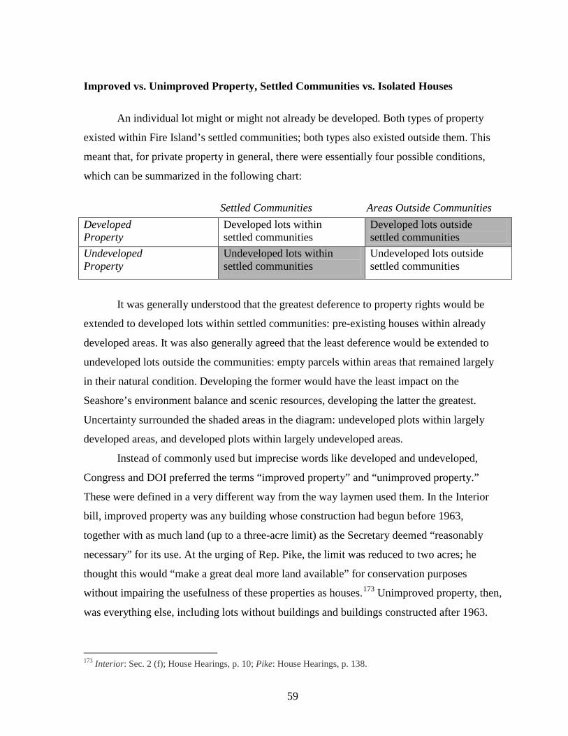
59
Improved vs. Unimproved Property, Settled Communities vs. Isolated Houses
An individual lot might or might not already be developed. Both types of property
existed within Fire Island’s settled communities; both types also existed outside them. This
meant that, for private property in general, there were essentially four possible conditions,
which can be summarized in the following chart:
Settled Communities Areas Outside Communities
It was generally understood that the greatest deference to property rights would be
extended to developed lots within settled communities: pre-existing houses within already
developed areas. It was also generally agreed that the least deference would be extended to
undeveloped lots outside the communities: empty parcels within areas that remained largely
in their natural condition. Developing the former would have the least impact on the
Seashore’s environment balance and scenic resources, developing the latter the greatest.
Uncertainty surrounded the shaded areas in the diagram: undeveloped plots within largely
developed areas, and developed plots within largely undeveloped areas.
Instead of commonly used but imprecise words like developed and undeveloped,
Congress and DOI preferred the terms “improved property” and “unimproved property.”
These were defined in a very different way from the way laymen used them. In the Interior
bill, improved property was any building whose construction had begun before 1963,
together with as much land (up to a three-acre limit) as the Secretary deemed “reasonably
necessary” for its use. At the urging of Rep. Pike, the limit was reduced to two acres; he
thought this would “make a great deal more land available” for conservation purposes
without impairing the usefulness of these properties as houses.173
173 Interior: Sec. 2 (f); House Hearings, p. 10; Pike: House Hearings, p. 138.
Unimproved property, then,
was everything else, including lots without buildings and buildings constructed after 1963.
Developed Property
Developed lots within settled communities
Developed lots outside settled communities
Undeveloped Property
Undeveloped lots within settled communities
Undeveloped lots outside settled communities
60
The Cape Cod/Fire Island formula accorded greater respect to improved than to unim-
proved property. At the House hearing in April 1963, Senator Keating said that if the
Secretary of Interior were given condemnation authority, “it should be within restrictions and
I would be inclined to be opposed to condemnation of improved property.” “When it comes
to unimproved property, that is a different matter and which is something I do not know.”
(Keating, incidentally, thought DOI agreed with this position.) The public had differing
views on the distinction between improved and unimproved property. John Bucalo,
representing several taxpayers’ associations, thought the government should not condemn
“privately owned dwellings.” But the Bellport Bay Yacht Club, which urged preservation of
the island “in its present natural condition,” assumed that it would be “possible over the years
to return those areas presently developed back to nature if it is thought desirable” – implying
that houses might be condemned and removed.174
By the time Congress held the first hearing in the fall of 1963, the distinction between
the columns in the chart – between what Secretary Udall called “small but rather intensively
developed communities” and the isolated parcels of property that lay outside them
175 – was
eclipsing that between the rows. At the hearing, Rep. Pike walked his colleagues through a
map of the Seashore, pointing out the distinctions. According to Pike, the “first parcel of
undeveloped land which truly merits preservation,” was east of Point O’Woods, a tract that
included the Sunken Forest; next came the community of Cherry Grove. Proceeding
eastward, “the communities become less frequent, and more open land is available for park
purposes.” Fire Island Pines, Water Island, and Davis Park were “interspersed with
undeveloped areas.” Finally, from Ocean Ridge (east of Davis Park) to Smith Point County
Park lay a “relatively undeveloped” eight-mile stretch with about 100 houses.176 County
Executive Dennison argued that there was “a great deal of difference” between the
communities and the isolated properties. Of approximately 2,600 houses, he said, about
2,400 were in the “concentrated communities.”177
174 House Hearings: Keating, pp. 15-16; Bucalo, p. 103; Bellport, p. 112.
By contrast, he noted, the eight-mile
stretch of Seashore between Davis Park and Smith Point contained some 116 “scattered
175 Senate Hearing, Dec. 63, p. 3; House report, p. 11. 176 House Hearings p. 21. 177 Senate Hearing, Dec 63, p. 48.
61
homes”; another 2 ½ mile stretch (now called the Talisman/Barrett Beach parcel and
including Blue Point) had 56 more “scattered homes.”
A consensus was emerging that the settled communities should be handled differently
from the rest of the Seashore. Brookhaven Town Supervisor Charles Dominy urged the
taking of all “sparsely settled or vacant” land but thought that “heavily populated areas, such
as Point O’ Woods, Ocean Bay Park, Ocean Beach, and Fire Island Pines, et cetera,” should
be exempted.178 Mrs. Donald Larson, for the League of Women Voters, thought the
incorporated villages and “densely settled communities” should be included within the
Seashore’s boundaries but “treated as autonomous enclaves to be governed by existing local
authorities.” Within them, condemnation power should be waived as long as “certain
minimum zoning and land-use standards” are agreed upon with the Secretary. Small,
undeveloped parcels within the communities should be left in private ownership, although
the communities should be encouraged to acquire them for “local park purposes,” and
certainly “incompatible commercial, industrial, or residential uses” such as “high-rise
apartment houses or hotels”179
where the Park Service has really nothing to gain by taking over existing houses and they state they do not want the houses, it would be proper to delineate these areas and allow the single, little property owner to build a house there, because allowing a 60 by 100 plot to lie there fallow serves nobody’s interest.
should be disallowed. Maurice Barbash agreed that, within the
“highly developed areas,”
180
Senator Bible agreed that “it does not make good commonsense to prevent something being
done with a vacant lot that lies between two improved pieces of property.”
181
DOI’s position on improved versus unimproved property evolved in concert with its
position on the communities. The department’s draft bill and report, prepared in June 1963,
exempted all improved property (wherever it might lie) from condemnation but contained no
special recognition of the settled communities and indeed permitted acquisition of
undeveloped properties within them. At the final hearing in April 1964, Udall testified that
178 House Hearings, p. 38. 179 Senate Hearing, Dec 63, pp. 60, 61; House, p. 66. 180 Senate Hearing, Dec 63, p. 43. 181 Senate Hearing, Dec. 63, p. 44.
62
the department now wished to amend its proposal to protect from condemnation “private
property, both improved and unimproved...within certain designated communities,” provided
that it was maintained in accord with acceptable zoning standards. Thus, he told the House,
“We do not propose to acquire undeveloped land inside the communities if it is controlled by
satisfactory zoning”: instead, the department would focus its acquisition program on
“substantial tracts” outside the communities.182 DOI’s proposal made this distinction visible
with a map which clearly delineated the communities which would “remain undisturbed” –
that is, where land was “not to be acquired.” Still, DOI did not intend to remove all checks on
development within the communities. The proposal envisioned that both improved and
vacant property there could be “retained and developed” in accordance with the anticipated
zoning standards. In the department’s report on the legislation, Udall wrote that “these
communities...could retain their present state of development as long as adequate zoning,”
approved by the Secretary, was in place “and the development remains compatible with the
purposes of a national seashore.”183
By April 1964, the principle was generally accepted that all property within the devel-
oped communities would be exempt from condemnation. As Rep. Carey put it, “the excluded
communities are definitely defined in the legislation. There will be no taking of the internal
holdings in these communities,”
184 or, as the House report later explained, the legislation
“exempts from condemnation most of the land within a number of small communities on the
western part of the Island as long as the owners conform to approved and valid local zoning
ordinances.” 185
Outside the settled communities, however, the distinction between improved and
unimproved properties remained important and problematic. The House report quoted with
approval the NPS’s recommendation that “‘the undeveloped portions of Fire Island be set
aside for the protection of natural values and [for] activities compatible with this preservation
objective.”
186
182 House Hearings, p. 126, 129; see also p. 130.
Within an eight-mile stretch of Seashore, this was accomplished by retaining
183 Proposal, p. [12-13], i; House Report, p. 11. 184 House Hearings, p. 154; see also Senator Javits’s testimony, House Hearings, p. 118. 185 House Report, p. 8. 186 House Report, p. 7.
63
condemnation power over all property, improved or not. This left the remainder of the
Seashore to be resolved.
There was general agreement that, within these broad areas, unimproved property
should be condemned, especially where this would consolidate a large area of public land.
Local officials were united in favor of this policy. Suffolk County Executive Dennison had
already condemned a four-mile stretch of “undeveloped shore front,” and Perry B. Duryea,
Commissioner of the Long Island State Park Commission, urged public acquisition of the
“uninhabited” four-mile stretch of beach between Moriches Inlet County Park and Smith
Point County Park “in order to forestall subdivision and private development.”187 DOI
cautiously agreed. Under-Secretary Carr testified “that the power of eminent domain may be
used if necessary to acquire unimproved private property” within the “underdeveloped
stretches.” These would be maintained “largely in their natural state,” providing “stretches of
undeveloped land and natural beach.” Crafts, of the Bureau of Outdoor Recreation, explained
that the power to condemn undeveloped property was “a permissive power” which the
Secretary would not automatically invoke but would use mainly to acquire property “in the
areas which have the minimum of development.” The department’s proposal, however,
recommended more boldly that “all unimproved private lands” outside the communities be
acquired.188 Public voices also supported this position. The Sierra Club’s David Brower
urged that “undeveloped beaches, dunes, forest, and marsh remain in as nearly pristine
condition as possible consistent with erosion control, that they be brought under public
ownership for the common enjoyment.”189
The question of improved property prompted more disagreement. DOI recommended
that the government “not acquire improved property” outside the settled communities (and
behind the beach) as long as zoning standards were met.
190
187 House Hearings, pp. 33, 36.
But local officials favored public
acquisition, by condemnation if necessary. Brookhaven Town Supervisor Charles Dominy
urged the “taking of all Fire Island lands in Brookhaven Town which are sparsely settled or
vacant,” though he would allow residents to continue enjoying their houses for some
188 Senate hearing, Dec. 63, pp. 25, 35; Proposal, p. 22. 189 Senate Hearing, Dec 63, p. 77. 190 Proposal, p. 22.
64
period.191 County Executive Dennison pleaded for public acquisition of the “160-some
homes” in the sparsely developed stretches. In his view they were “separate, isolated islands
of private ownership within a national park” which would compromise the public’s interest
in the Seashore while burdening local government with problems of “police, welfare, health
and safety.” They also exacerbated erosion; removing them would reduce the cost of beach
protection or erosion control. Moreover, doing so “would give us more than 20 miles which
can be considered natural conservation areas.” Essentially, then, Dennison wanted a clear
separation between inhabited communities and conservation areas, and while insulating
county government from the administrative problems posed by “private isolated islands,” he
also wanted to maximize the latter, “if we are going to have a conservation area, let’s have all
we can get that is feasible.”192
Within the legislature, views on developed properties outside the communities varied.
Senator Bible’s initial reaction to the prospect of condemnation was to remark that owners
would “look a little unkindly at this treatment.”
193 The House was generally more supportive
of condemnation. Rep. Lindsay’s bill allowed the Secretary to condemn any property east of
Fire Island State Park. Pike’s limited the “condemnation of homes” (i.e., improved property)
to the eight-mile stretch of “sparsely inhabited property” west of Smith Point County Park.
Still, as Pike pointed out, his bill was more permissive than DOI’s proposal, which flatly
prohibited condemnation of improved property. Pike believed that the House would
eventually find the additional condemnation authority which he sought to give DOI “a
worthwhile addition,” for like Dennison he foresaw “continual problems with isolated private
holdings.” His bill would have the effect of creating “an uninterrupted stretch of some 15
miles without residences.” Pike predicted that some people would be “outraged because I
have said take any homes, but I think if you are going to have a viable national park you are
going to have to take the homes in the sparsely settled areas so that you have got enough land
which is undeveloped and in public ownership to make it worth while.”194
191 House Hearings, p. 38.
Not surprisingly,
County Executive Dennison supported the Pike bill.
192 Senate Hearing, Dec 63, p. 48; House Hearings, p. 32. 193 Senate Hearing, Dec 63, p. 48. 194 House Hearings, p. 23, 137, 28.
65
Public voices were split on the question of improved property outside the
communities. An analysis requested by the Senate from the National Parks Association
concluded that:
Developed residential properties already in existence should be allowed to remain. The best way to do this is to obtain easements, by eminent domain if need be, against further development incompatible with protection of natural conditions. Other than this, eminent domain should not be used: many properties will come onto the market and can be acquired that way.195
The Sierra Club’s David Brower similarly wanted government to defer to the rights of
owners as long as they “respect the natural scene and the public interest,” and to win them
over to the idea of federal stewardship, so that the NPS would eventually acquire the
inholdings from willing sellers. By contrast, Dr. Robert Cushman Murphy, naturalist and
Long Island resident urged the use of condemnation “when necessary.” His main concern
was the damage they did to the dune system and the calls they provoked for destructive
erosion control measures: “…no responsible Government organization,” he declared, “can
assume the protection of scattered homes, particularly along areas of the beach which would
make a part of the natural nearly primitive wilderness of the seashore.” The League of
Women Voters was equally decisive in calling for public acquisition of “all remaining
undeveloped or sparsely developed land.” These parcels had great potential for establishing
“bay-to-ocean sections of open land” and, beyond their environmental value, would add
amenity to the adjacent developed areas. Certainly the “growth of an unbroken, densely
settled strip, stretching for miles along the beach” would be very undesirable and would
isolate residents from any natural areas other than the waterfronts.
196
The Beach and the Dunes
Notwithstanding the protections extended to private property, it was always
understood that (in Javits’ words) “the entire dune and ocean front should be preserved for
the public.”197
195 Senate Hearing, Dec 63, p. 77.
Generally the word beach was used to describe this sector of the island, but it
was ambiguous. Sometimes the term clearly referred to the ocean beach: the strip of sand
196 Senate Hearing, Dec 63, pp. 54-55, 61, 78; House Hearings, p. 63. 197 Senate Hearing, Dec. 63, p. 11.
66
fronting the water; at other times it included the dunes behind it. Sometimes, particularly
when Long Islanders spoke, it was shorthand for “barrier beach,” meaning the entire island,
as when naturalist Dr. Murphy called on the NPS to keep the “barrier beach...forever in its
unspoiled state.”198
Legislators, officials, and public witnesses all emphasized the distinction between the
beach and the land behind it. Though Javits supported exempting the developed communities
from condemnation, he called on the Secretary of Interior to “acquire beach or water areas as
he deems necessary for public access.”
In the following discussion, the word beach, except where otherwise
indicated, refers to the ocean frontage, including at least some portion of the dunes behind
the actual sand beach.
199 Similarly Brookhaven’s Charles Dominy opposed
government acquisition of land within the “heavily populated areas” but thought “the actual
beach frontage in these areas should be taken and preserved.” Here, DOI was in full and
unwavering agreement. Secretary Udall told Congress that DOI would “acquire the beach
front” in front of the communities; DOI’s proposal recommended that the federal government
“acquire the beach area along the Atlantic Ocean in front of all the communities to assure
unrestricted public access to the beach”; and the department’s report on the legislation
promised that the federal government would acquire the entire beach, together with enough
land above the mean high tide to ensure “continuous free public access to and along the
beach at all times.” At the NPS, George Hartzog reaffirmed that the Seashore would provide
“continuous public ownership of the beach from one end of Fire Island to the other,”
including acquisition of 6.6 miles of “beach strip,” averaging 175 feet in depth, in front of the
communities.200
One goal of this policy was to serve the public’s interest in enjoying the Seashore.
Another was to control erosion by forestalling the construction of houses. Noting the damage
inflicted by houses and pathways on the dunes, Mrs. Larson of the League of Women Voters
198 House Hearings, p. 76. See also Hempstead Town Lands Resources Council Chairman Rob Vandivert (“...the marshes and bays on the north side of the barrier beaches all along Long Island’s south shore...”), Babylon Town Leader’s Managing Editor John A. Meyer (“the barrier beaches on the south shore of Long Island run from Coney Island in Brooklyn to Montauk on the island’s easterly tip”), and Islip Town Supervisor Harwood (favors a “national park being established on Fire Island or the Barrier Beach, as it was known some time ago.” (House Hearings, pp. 43, 42, 112. 199 House Hearings, p. 118. 200 House Hearings, pp. 38, 130, 128, 129; Proposal, p. 21; House Report, p. 11.
67
noted that “as manmade structures multiply along the beach, more and more erosion
protection measures are required or demanded.” One of the “most urgent reasons” for
bringing the entire barrier beach into public ownership was “to forestall the further increase
of this demand.”201 Noting that the Army Corps of Engineers had made a “major investment”
in erosion control so that Fire Island could serve “as a barrier beach” to protect the mainland,
Javits pointed out that guarding this investment was yet another reason why “the entire dune
and ocean front should be preserved for the public instead of having these public funds
already expended benefit commercial developers.”202
The NPS understood well the implications of this policy for regulating development.
In 1965, master planner Donald Humphrey told the newly established Advisory Commission
that:
Developments will be behind the beach so that, from the beach you should be able to see practically no development. The beach will be left in its natural condition. The entire south shore of Long Island from Coney Island to Montauk Point is used for recreation in one form or another and we feel we want to have a type of recreation that cannot be found along that shore or perhaps anywhere else.
Regional Director Ronald Lee commented that this was a “very fine statement.” The
Commission chairman, George Biderman, remarked that “for many of the Commission
members who have had this dream for so many years, this was one of the most eloquent
statements he had ever heard on this subject.”203
Current and Future Conditions
Neither the legislators nor the public spent much time discussing the future conditions
they hoped the Cape Cod/Fire Island formula would produce within the Seashore, although
the issue was a central one and often in their minds.
In its simplest form, the issue was whether the island would continue to look as it did
in 1964, or whether development would significantly change it. It was easy to say what kinds
of change were not wanted. No one wanted Fire Island to turn into the kind of seaside resort
201 Senate Hearing, Dec 63, p. 64; House Hearings, p. 66. 202 Senate Hearing, Dec. 63, p. 12. 203 “Minutes of the Organization Meeting of the Fire Island National Seashore Advisory Commission, Washington, D.C., August 26, 1965”: Park History files, fol FINS Correspondence 1965-74.
68
that was common from Cape Cod to Cape May. No one wanted high-rises, dense
development, amusement parks, or clusters of motels and restaurants; but it was harder to say
how much development, and of what kind, was acceptable. Maurice Barbash, builder, argued
that areas whose “limited size” or “proximity to intensive development” made them not
“efficiently administrable for park purposes” should be zoned for “continued development,”
subject to approved zoning ordinances. He called for a survey to identify areas where
development might be carried on, and he asked Congress to permit “further development or
improvement of properties located within those areas not intended to be acquired...in
accordance with standards prescribed by the secretary, which shall take into consideration
present land use patterns.”204
This was about as strong a statement as anyone ever made in favor of continued
development. Among the public, there was also evidence of support for capping or
controlling growth. Dominy called on the federal government to take all “sparsely settled or
vacant” lands outside the settled communities “on a basis where present inhabitants could be
allowed use of present facilities, but would not be permitted to enlarge or develop their lands
further.” In its analysis carried out at the Senate’s request, the National Parks Association
urged DOI to obtain easements, using condemnation if necessary, to prevent “further
development incompatible with protection of natural conditions.”
205
For most of the island DOI’s goal was basically stasis. Udall told the Senate that
DOI’s bill would allow the “communities, as well as the owners of more scattered improved
properties,” to “retain their present state of development,” as long as there was adequate
zoning and “the development remains compatible with the purposes of a national seashore.”
This was consistent with the general understanding that the Cape Cod/Fire Island formula
would allow property owners to continue enjoying things as they were without
All of these statements,
including those in favor of development, must be read in the context of the universal fear that
development would ruin the island if not controlled. Though few attempted to say exactly
where the limit on growth should be placed, almost everyone begged Congress to impose
one, and quickly.
204 Senate Hearing, Dec 63, p. 42; House Hearings, pp. 49, 159. 205 Dominy: House Hearings, p. 38; National Park Association: Senate Hearing, Dec 63, p. 77.
69
necessarily being able to develop their property. Other provisions supported the idea of
stasis; thus even where eminent domain was exercised, owners were allowed to continue
enjoying the use and occupancy of their homes for 25 years or life. Similarly, Under-
Secretary Carr assured the Senate that DOI did not wish the island to “revert to its natural
state,” even though it did plan to use eminent domain to keep “undeveloped areas largely in
their natural state”; elsewhere, owners could “maintain and continue to use the homes that
are established.” In the future as Carr envisioned it, both developed and undeveloped areas
would remain much as they were. Government would use its powers to perpetuate this
condition of stasis, which would benefit everyone – not least the property owners themselves,
for Udall pointed out that the Seashore’s restrictions would protect them from undesirable
neighboring uses.206
At the final hearing, Udall appeared to have adopted a somewhat more development-
oriented position. Explaining that DOI now planned to exempt all property within the
communities from condemnation, he noted that this would assure their “orderly development,
under appropriate zoning regulations. This would complement, and not detract from, the
National Seashore, at the same time allowing the owners of property to improve their
property.”
207 Outside the communities, however, DOI’s position remained unchanged.
Whereas properties within the communities could be both retained and “developed,” outside
the improved properties could only be “retained”;208
Congress held more tightly to stasis than did DOI or the public. Javits believed it was
possible to accommodate private property rights only because the communities on Fire Island
already “very much conform to a park idea.” Stressing the rusticity of development there,
in short, modest development or
improvement within the communities, stasis leaning toward natural reversion outside them,
and in broad terms a continuation of the current balance between developed and undeveloped
areas.
209
206 Carr: Senate Hearing, Dec 63, p. 26; Udall: ibid., pp. 3-4; House Report, p. 11.
207 Udall’s statement, House Hearings p. 126. 208 Report, p. 15. 209 “Some parts of Fire Island, for example, do not have electricity, and by design. People want it that way. The architecture, the fencing, the fact that most places on Fire Island don’t have gardens and no desire to have them.” “There are no plush affairs, with the exception of one or two, on Fire Island. The whole character is seashore.... [E]ssentially it is a very substantial but essentially beach cottage area.” (Senate Hearing, Dec 63, pp. 16-17).
70
Javits urged Congress to “commit itself to the policy of allowing the enjoyment of the homes
and private places as they exist at the time of the establishment of the park.” Questioned by
Senator Allott, he developed the point at length; indeed, he argued, the only reason zoning
could “take the place” of condemnation power was “because the character of the residences
now there is entirely compatible right now.” Moreover, this condition was “what the people
want.” They had “fought many battles...to maintain that character.”210
During the hearing, Allott and Javits found themselves unintentionally at cross-
purposes. Allott asked Javits whether the houses on Fire Island were “permanent homes” or
“just a summer type of residence.” Javits replied that they were “permanent summer homes,”
meaning that Fire Island was no “transient summer residence as you would think of in some
very populous beach” but a place to which people “return constantly” and feel a long-term
connection. However, Allott was driving towards something else: “This is the point I want to
make. It is not an annual year-around residential type.” Javits agreed that it was not.
For Javits, the Cape
Cod/Fire Island formula was not a blueprint for change so much as a way for residents to
perpetuate the conditions they loved so much.
211
The consistent emphasis on the right of residents to continue enjoying things as they
were may help to explain an otherwise puzzling oversight. Discussions of growth tended to
focus on development of vacant parcels. Even the proponents of modest growth never
clarified whether the benign growth they envisioned was intended to include increases in the
bulk or density of existing houses. It does not appear, in fact, that the likelihood of this kind
of growth was ever considered. The statements of Javits and others on the character of the
In
effect, Allott had confirmed Javits’s own point: the modest, seasonal character of the houses
made them compatible with the Seashore, while the character of the residents made them
good stewards of it.
residents and their devotion to the existing houses suggest a faith that residents would
discourage such intensification of use, even if zoning were to permit it.
In the face of intense development pressure, emphasized by speaker after speaker,
legislators appeared to believe that, by drawing a line around Fire Island, they could protect it
210 Senate hearing, Dec 63, pp. 16-17. 211 Senate hearing, Dec 63, p.18.
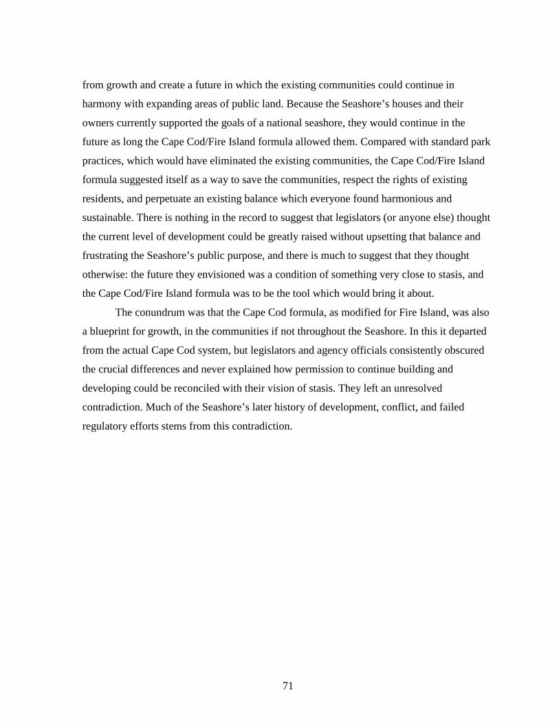
71
from growth and create a future in which the existing communities could continue in
harmony with expanding areas of public land. Because the Seashore’s houses and their
owners currently supported the goals of a national seashore, they would continue in the
future as long the Cape Cod/Fire Island formula allowed them. Compared with standard park
practices, which would have eliminated the existing communities, the Cape Cod/Fire Island
formula suggested itself as a way to save the communities, respect the rights of existing
residents, and perpetuate an existing balance which everyone found harmonious and
sustainable. There is nothing in the record to suggest that legislators (or anyone else) thought
the current level of development could be greatly raised without upsetting that balance and
frustrating the Seashore’s public purpose, and there is much to suggest that they thought
otherwise: the future they envisioned was a condition of something very close to stasis, and
the Cape Cod/Fire Island formula was to be the tool which would bring it about.
The conundrum was that the Cape Cod formula, as modified for Fire Island, was also
a blueprint for growth, in the communities if not throughout the Seashore. In this it departed
from the actual Cape Cod system, but legislators and agency officials consistently obscured
the crucial differences and never explained how permission to continue building and
developing could be reconciled with their vision of stasis. They left an unresolved
contradiction. Much of the Seashore’s later history of development, conflict, and failed
regulatory efforts stems from this contradiction.
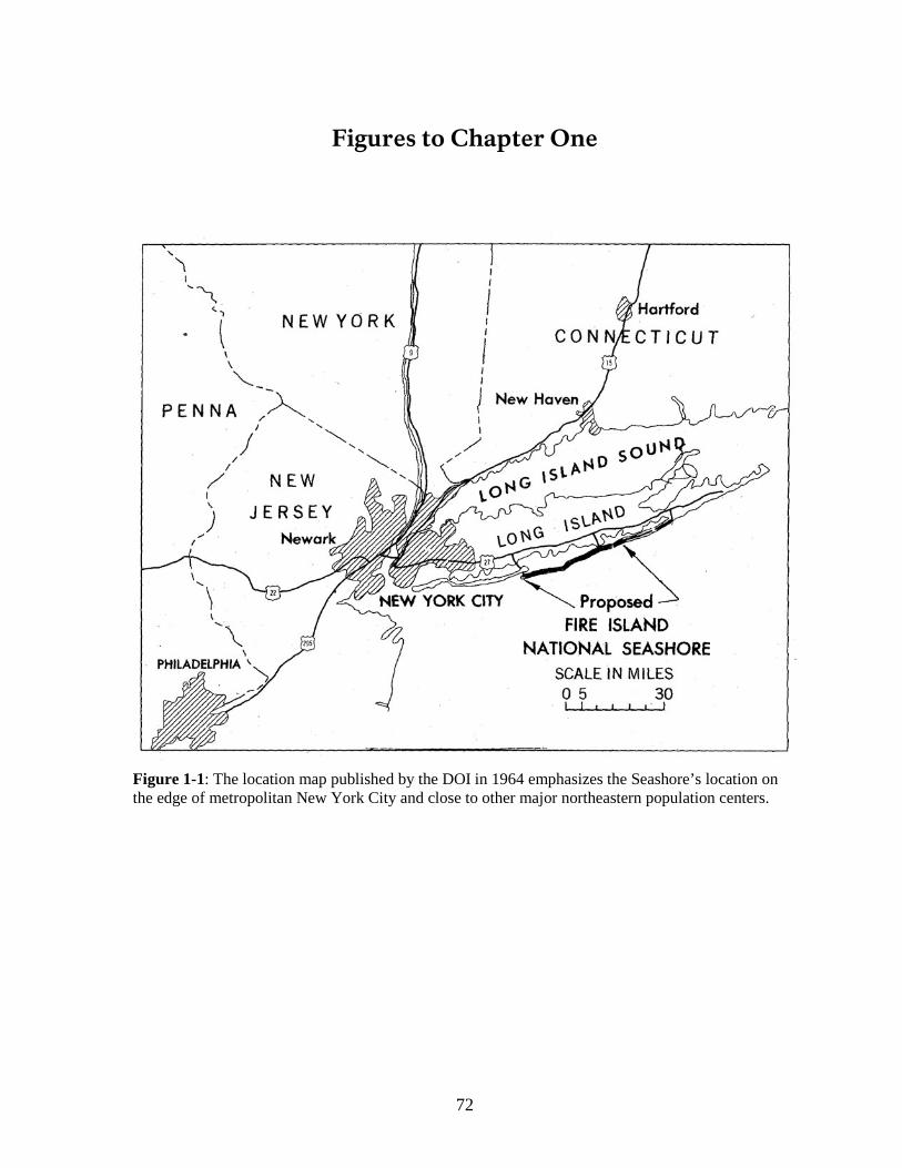
72
Figures to Chapter One
Figure 1-1: The location map published by the DOI in 1964 emphasizes the Seashore’s location on the edge of metropolitan New York City and close to other major northeastern population centers.
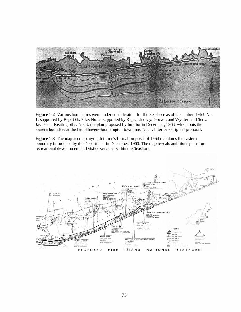
73
Figure 1-2: Various boundaries were under consideration for the Seashore as of December, 1963. No. 1: supported by Rep. Otis Pike. No. 2: supported by Reps. Lindsay, Grover, and Wydler, and Sens. Javits and Keating bills. No. 3: the plan proposed by Interior in December, 1963, which puts the eastern boundary at the Brookhaven-Southampton town line. No. 4: Interior’s original proposal. Figure 1-3: The map accompanying Interior’s formal proposal of 1964 maintains the eastern boundary introduced by the Department in December, 1963. The map reveals ambitious plans for recreational development and visitor services within the Seashore.
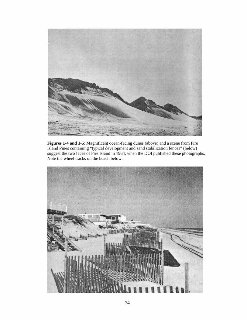
74
Figures 1-4 and 1-5: Magnificent ocean-facing dunes (above) and a scene from Fire Island Pines containing “typical development and sand stabilization fences” (below) suggest the two faces of Fire Island in 1964, when the DOI published these photographs. Note the wheel tracks on the beach below.
75
Chapter Two
The Regulatory System Evolves, 1964-1991
by Ned Kaufman
Launching the Seashore
Once the Act was signed, NPS quickly got to work organizing the new Seashore. The
success of its regulatory system depended on the rapid issuance of federal zoning standards,
and these were published in draft in October 1965, and finalized the following April.212
This chapter traces the evolution of the Seashore’s efforts to regulate private land
through three phases: in the first, the basics mechanisms are put in place; in the second, their
failure to produce the desired results becomes clear and leads to criticism; and, in the third,
NPS, DOI and Congress seek to address the problems through reports and consultant studies,
amendments to the establishing Act, and new policies, culminating in the new zoning
standards of 1991.
Although it would take years to persuade the localities to adopt conforming ordinances, other
federal actions closely followed the Act’s adoption: DOI established an advisory
commission, NPS began work on a master plan, and the agency launched an energetic
program of land acquisition. The Seashore was off to a lively start.
The Master Plan and the Advisory Commission According to Koppelman and Forman, the NPS prepared a draft master plan as early
as the spring of 1965.213
212 Koppelman and Forman, p. 80. The authors do not reference their source for the zoning standards. NPS personnel familiar with Fire Island and consulted in connection with this study had never seen the document, and research failed to find a copy of it in the files. A copy of the draft standards (see below) was located just as the study was being finalized, too late to allow a continued search for the final version.
From later comments, it seems to have reverted to the agency’s
213 No copy was located in preparing this report. However, Koppelman and Forman cite it as The Master Plan: Fire Island National Seashore, U.S. Department of Interior, National Park Service, Fire Island National Seashore, New York, May 1965, and discuss it on pp. 68-69. Officials also made reference to its contents in the context of criticism during the following decade: see following.
76
original emphasis on recreational development. According to Koppelman and Form, the plan
spoke of achieving “protection through development” and presented natural conservation as a
means by which to provide “distinct and unique recreational, interpretive and educational
opportunities” to the urbanized masses of the northeast. It designated at least ten areas for
major recreational development and two more for secondary development. Envisioned were
ferry terminals, campgrounds, marinas, bicycle trails, picnic areas, first aid facilities,
bathhouses, orientation facilities, maintenance facilities, employee stations, and more, all
adding up to increased “visitor use capacity.”214
The Commission was established under the requisites of the Act, and convened on
August 26, 1965, with George Biderman as Chair. There were fourteen other members,
including Maurice Barbash (Citizen’s Committee for a Fire Island National Seashore),
Charles Dominy (Brookhaven Town Supervisor), and naturalist Robert Cushman Murphy, as
well as five NPS representatives, including Regional Director Ronald F. Lee and Fire
Island’s Superintendent, Henry G. Schmidt. At the first meeting, the NPS presented its plans
for preserving the Seashore’s natural environment, including the ambience of the beach and
the dune front, and promised to push forward with the required zoning standards. The
Commission warmly endorsed all of this and, stressing the pressure of a hot real estate
market, Biderman emphasized the importance of quickly issuing the zoning standards.
All of this put NPS on a potential collision
course with Congress and the public, which had distrusted NPS’s propensity to over-
development and, after exhaustive discussion, opted for natural protection free of intensive
development. It was an entirely different vision – one more in tune with Congress and the
public – that NPS presented to the new Fire Island National Seashore Advisory Commission
in the fall of 1965.
215
The Zoning Standards and Local Regulations
By October 1965, the draft zoning standards were ready for publication in the Federal
Register. They stayed close to the text of the Act and strongly enunciated the public goals: to
214 Quoted by Koppelman and Forman, pp. 68-69. 215 “Minutes of the Organization Meeting of the Fire Island National Seashore Advisory Commission, Washington, D.C., August 26, 1965: Park History files, fol FINS Correspondence 1965-74.
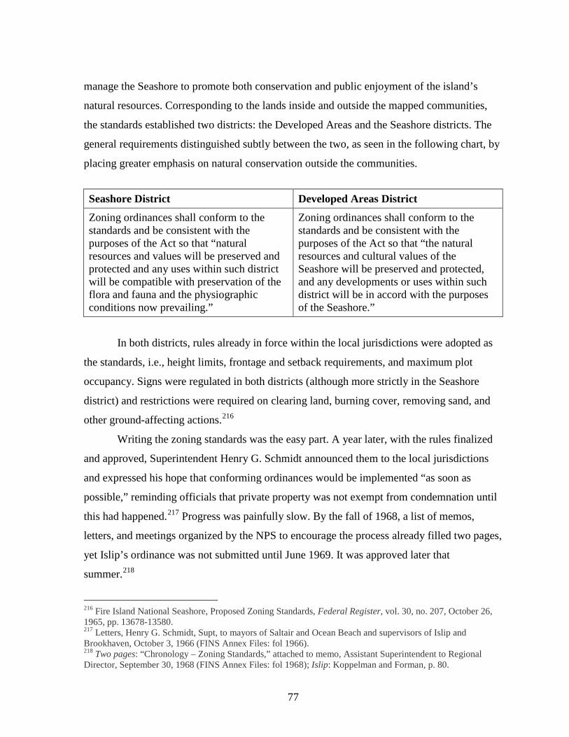
77
manage the Seashore to promote both conservation and public enjoyment of the island’s
natural resources. Corresponding to the lands inside and outside the mapped communities,
the standards established two districts: the Developed Areas and the Seashore districts. The
general requirements distinguished subtly between the two, as seen in the following chart, by
placing greater emphasis on natural conservation outside the communities.
Seashore District Developed Areas District
Zoning ordinances shall conform to the standards and be consistent with the purposes of the Act so that “natural resources and values will be preserved and protected and any uses within such district will be compatible with preservation of the flora and fauna and the physiographic conditions now prevailing.”
Zoning ordinances shall conform to the standards and be consistent with the purposes of the Act so that “the natural resources and cultural values of the Seashore will be preserved and protected, and any developments or uses within such district will be in accord with the purposes of the Seashore.”
In both districts, rules already in force within the local jurisdictions were adopted as
the standards, i.e., height limits, frontage and setback requirements, and maximum plot
occupancy. Signs were regulated in both districts (although more strictly in the Seashore
district) and restrictions were required on clearing land, burning cover, removing sand, and
other ground-affecting actions.216
Writing the zoning standards was the easy part. A year later, with the rules finalized
and approved, Superintendent Henry G. Schmidt announced them to the local jurisdictions
and expressed his hope that conforming ordinances would be implemented “as soon as
possible,” reminding officials that private property was not exempt from condemnation until
this had happened.
217 Progress was painfully slow. By the fall of 1968, a list of memos,
letters, and meetings organized by the NPS to encourage the process already filled two pages,
yet Islip’s ordinance was not submitted until June 1969. It was approved later that
summer.218
216 Fire Island National Seashore, Proposed Zoning Standards, Federal Register, vol. 30, no. 207, October 26, 1965, pp. 13678-13580.
217 Letters, Henry G. Schmidt, Supt, to mayors of Saltair and Ocean Beach and supervisors of Islip and Brookhaven, October 3, 1966 (FINS Annex Files: fol 1966). 218 Two pages: “Chronology – Zoning Standards,” attached to memo, Assistant Superintendent to Regional Director, September 30, 1968 (FINS Annex Files: fol 1968); Islip: Koppelman and Forman, p. 80.
78
The other three jurisdictions would not have approved ordinances for another 16 years, by
which time the zoning standards were in the process of being replaced for a second time.
The process of implementing the standards raised new and challenging policy
questions that reverberated all the way to Washington. The law required local zoning boards
to notify NPS of requests for variances, but it did not tell NPS how to respond to them. The
Director’s office asked for guidance. Park leadership answered that NPS should present its
view to the local boards. Regional leadership agreed.219
These were cogent considerations, but another argument was more debatable: by ex-
empting communities with approved zoning from condemnation, Congress had “expressed a
general policy against acquisition of these properties.” Though perhaps inconsistent with the
intent of the Act, this argument lent force both to NPS’s growing unwillingness to acquire
property and to its desire to shift enforcement responsibility to the communities. The
director’s office called on the localities to take more “responsibility for more rigid adherence
to their zoning ordinances” and, in particular, to “take all possible measures to protect the
dune line in its natural state, as a safeguard against hurricane damage.” Seashore staff agreed;
acquiring parcels within the community “would not be in the public interest.” Local zoning
boards should determine if a variance would “destroy existing dune protection to the
community and this responsibility should not be assumed by the United States.” Though the
A second question had bigger
implications. What should NPS do if a locality approved construction in violation of federal
standards? On one level, the answer was clear: Congress had prescribed condemnation, and
NPS’s own zoning standards had confirmed the penalty. The realities of park management
prompted a more lenient answer: though the Director’s office favored forceful action “when
the deviation may result in developments on or near the crest of the dune,” within the
communities it seemed “doubtful that we should acquire scattered properties that promise
little recreational use…simply to preclude their development;” doing so would encourage
owners to violate the standards simply in order to trigger condemnation and thereby garner
funds with which to buy other property.
219 Memos, Deputy Assistant Director (Harthon L. Bill) to Regional Director, Northeast Region, November 25, 1966; Acting Superintendent (Robert J. Branges) to Regional Director, November 29, 1966; and Regional Director to Director, December 6, 1966 (FINS Annex Files: fol 1966)
79
NPS Northeast Regional Office reiterated its concern for ensuring the integrity of the dune
line, it agreed that local agencies should “acquire the foredune within the communities.”220
Land Acquisition
Coming at the end of 1966, these reservations signaled a change in what had started
out as a vigorous program of federal land acquisition which was specifically included within
the “intent of Congress” as stated by the Act.221 Rep. Aspinall stressed this point and, to
support it, even proposed channeling acquisition funds directly from the Land and Water
Conservation Fund then under consideration. Though political considerations regarding the
Fund legislation prevented this proposal from being adopted, no one in Congress questioned
the wisdom of a vigorous land acquisition program,222 and the Act authorized $16 million for
it. “This is a lot of money,” said Udall, equal to the ceiling at Cape Cod and greater than the
$14 million ceiling at Point Reyes.223 The amount was less than DOI had initially requested;
the department had first proposed a Seashore of 55 miles, whereas by 1964 the boundaries
were capped at 33 miles. At about that time, NPS appraisers estimated the land to be acquired
at $15,700,000,224 with about $8,230,000 needed to purchase 2,732 acres of privately owned
land.225 Congress authorized an additional $1.1 million in October 1964, bringing the total to
$17.1 million, which the park’s land acquisition officer thought would “come very close” to
covering NPS’s needs.226
The NPS took Congress’s authorization to acquire land as a broad mandate. The
zoning standards declared that it was the “clear intention of the act” that DOI should acquire
220 Memos, Deputy Assistant Director (Harthon L. Bill) to Regional Director, Northeast Region, November 25, 1966; Acting Superintendent (Robert J. Branges) to Regional Director, November 29, 1966; and Regional Director to Director, December 6, 1966 (FINS Annex Files: fol 1966). 221 P.L. 88-587, Sec. 2(a). 222 House Subcommittee Transcript, May 12, 1964, pp. 28-29. 223 House Hearings, p. 130. 224 Memo, Staff Appraisers to Chief, Division of Land and Water Rights, April 2, 1964 (Desk Book: Fire Island, under Tab (8), Land Costs. 225 “Proposed Fire Island National Seashore: Estimated Cost of Real Estate,” Desk Book: Fire Island: under Tab (8), Land Costs. Other sums included privately owned improvements (such as docks, motels, swimming pools, and 82 houses and summer cottages: $385,000), 2,800 acres of privately owned submerged lands ($230,000), about 89 squatter shacks ($178,000), publicly owned lands (above and below water), public improvements, and acquisition costs ($319,000). 226 Leslie W. Piel, “Minutes of the Organization Meeting of the Fire Island National Seashore Advisory Commission, Washington, D.C., August 26, 1965”: Park History files, fol FINS Correspondence 1965-74.
80
“all land” within the Seashore boundaries “except certain ‘improved property’ and property
within delineated communities.” NPS set out to acquire everything except what had been
specifically excluded from purchase, and NPS quickly laid out a sequence for land
acquisition, starting with the Sunken Forest-Sailor’s Haven area and the stretch from Smith
Point County Park to Moriches Inlet. 227 NPS also made it clear that it intended to enforce the
standards with condemnation, warning that if the Secretary determined that a variance
violated the standards, he would not simply lift its immunity but would affirmatively “subject
the property to acquisition by condemnation.”228
In October 1964, DOI put in place the necessary process of buying land. Secretary
Udall announced the opening of a land office in Patchogue.
229 DOI had already been
appraising properties and had met with the Justice Department “concerning the
commencement of condemnation proceedings immediately.” It was poised to open
negotiations within a week with property owners “bent on development that would conflict
with the plan legislated by the Congress” and to file condemnation suits on essential and
threatened tracts.230 By the summer of 1965, the land acquisition office boasted five
permanent employees, and by fall, realty officer Leslie W. Piel announced that the NPS had
already acquired almost 200 acres: 12 acres (in 7 tracts) through direct purchase and 186
acres (in 23 tracts) by condemnation, at a total cost of just under $1,375,000. Piel estimated
that the NPS still had to acquire a little over 2,700 acres, and further negotiations were
underway.231 A couple of years later, George Biderman praised the “speedy land acquisition
program which cut short some cut-throat speculators.”232
227 In the master plan, according to Koppelman and Forman, pp. 68-69 (see below).
228 Proposed Zoning Standards, p. 13579. See also GMP, 1977, p. 106: the law’s “clear intention” was that “all lands within the seashore district [i.e. outside the mapped communities], except certain improved properties as of July 1, 1963, be acquired.” 229 Department of the Interior, news release, “Udall Promises Immediate Action to Acquire Fire Island National Seashore” (for release October 21, 1964), Park History files, FINS Correspondence 1965-74. 230 Department of the Interior, news release, “Remarks by Secretary of the Interior Stewart L. Udall on the Fire Island National Seashore, Garden City, Long Island, October 21, 1964” (for release October 21, 1964), Park History files, fol FINS Correspondence 1965-74. 231 Minutes of the Organization Meeting of the Fire Island National Seashore Advisory Commission, Washington, D.C., August 26, 1965: Park History files, fol FINS Correspondence 1965-74. Piel estimated the Seashore’s total acreage at a little over 4,500, in 1,500 individual tracts, then subtracted about 1,600 acres (representing the 17 established communities plus town- and county-owned lands), leaving a total of about 2,900 acres to be acquired by the federal government. 232 George Biderman, “Prefatory Remarks, Meeting of the Fire Island National Seashore Advisory Commission, Smithtown, NY, Nissequogue Golf Club, Dec. 1, 1967”: Park History files, fol FINS Correspondence 1965-74.
81
The reservations which had become apparent by the end of 1966 marked the
beginning of a broader policy shift. “Land acquisition as a major objective ended in 1969,” as
NPS officials put it some years later, 233 and the Land Acquisition Office was disbanded that
year. How had the program succeeded in meeting the goals of Congress and DOI? At first
glance, the figures suggest it had been successful. In 1977, the NPS calculated that the
federal government owned 2,792 acres in fee, comprising four large bay-to-ocean strips
(1,639 acres), six smaller bay-to-ocean strips (183 acres), all of East Fire Island and its
satellite islands (156 acres) and most of West Fire Island (102 acres). In addition, the NPS
managed 3,151 acres of New York State beachfront and ocean – an area extending from the
mean high water line 1,000 feet into the ocean – through an easement. The federal
government could be said to control 5,943 acres, but the basis used for calculating land area
was different from that used in 1965. The gap between what had been acquired and what
remained was therefore larger than it appeared. More importantly, as agency officials noted,
the federal government did not own the beach, the primary dune line, or the marshlands; and
except for a small tract at Sunken Forest, it owned none of the bay bottom.234
Judged against the goals of Congress or NPS itself, the land acquisition program had
not succeeded; nor was there much hope of reviving it. The late 1970s saw discussions about
the need for an acquisition program focused on the primary dune, but money and political
will were both in short supply. As an agency official explained in 1979, “Land acquisition at
this time is primarily for the purpose of squelching the most flagrant violations involving use
and development of lands within the 17 identified communities.”
235
Within a few years of the Seashore’s establishment, there were mixed results. In some
ways, the Seashore was progressing well. Early benchmarks had been met: the issuance of
zoning standards, the launching of an aggressive land acquisition effort, the convening of the
advisory commission, the creation of a master plan. However, troubling problems were
The NPS was no longer
mounting an energetic effort to build out the blocks of public land envisioned in 1964.
233 Draft Staff Report, 1979, p. 1. 234 GMP, 1977, pp 11-12. The plan put the area within the Seashore’s original boundary (i.e. excluding the 611-acre William Floyd Estate on the mainland, added to the Seashore by legislation in 1965) at 19,356 acres of land and water, instead of the 4,500 acres calculated in 1965. The calculation also did not include the Lighthouse tract, originally owned by the U.S. Coast Guard and eventually transferred to the NPS. 235 Draft Staff Report, 1979, p. 1.

82
emerging. Agency policy had decisively departed from the intent of the Congress and of
Secretary Udall to acquire the beach and dune line and to enforce violations through
condemnation. The land acquisition program had been abandoned. The struggle continued
urging localities to adopt conforming ordinances. Even with ordinances in place, there was
neither money nor will to enforce them, and “without authority to condemn, or funds to do
so,” the zoning regulations were “meaningless.”236
Public support was beginning to erode, which was the most damaging symptom of all
to the livelihood of the Seashore.
Criticism of the Seashore Begins
In 1967, George Biderman and the Advisory Commission, which had so recently
praised NPS’s work, became harsh public critics. This attack began an avalanche of
criticisms. Biderman first expressed his dissatisfaction in a letter to NPS Director Hartzog
and in remarks to the Advisory Commission, which the Commission then unanimously
adopted as a statement of its own views. Admitting that there had been successes (especially
in land acquisition), Biderman nonetheless charged that the “balance sheet...is on the
negative side. We’re not making it. We are not making the goals as they were established
five years ago.”237 Quoting and upholding the Act, Biderman called Fire Island a “vest-
pocket wilderness” and he reminded policy makers that all uses had to be consistent with the
Seashore’s “conservation and preservation.” Although the Secretary and on-site staff
honored these concepts, Biderman charged that staff-level policy was contravening the intent
of Congress and the administration.238
Threats to the Seashore came from both the private and public sectors. Within the
middle levels of NPS, Biderman saw “entirely too much of the ‘public works’ kind of
thinking,” exemplified by a 150-boat marina and plans for a 6,000-car parking facility.
Private development posed an equally serious threat. The pristine ocean front envisioned by
236 Memo, Assistant Superintendent, Fire Island (Thomas F. Norris, Jr.) to Regional Director, Northeast Region, September 30, 1968 (FINS Annex Files: fol 1968). 237 George Biderman, “Prefatory Remarks, Meeting of the Fire Island National Seashore Advisory Commission, Smithtown, N.Y., Nissequogue Golf Club, Dec. 1, 1967” Park History files, fol FINS Correspondence 1965-74. 238 Letter, Biderman to Hartzog, December 4, 1967: Park History files, fol FINS Correspondence 1965-74.
83
master planner Humphrey and endorsed by the Commission was being lost. The beach had
become a highway, and from Davis Park to Kismet, “building on and even in front of the
ocean front dunes is permitted to continue.” The bay front, too, was under attack from
dredging and commercialization. Unless these trends were stopped, Biderman envisioned
“not one ‘vest-pocket wilderness area’ but an eight-mile stretch supplemented by a series of
‘vest-pocket parks.’ These, in turn, will be punctuated by ‘saturation resort development.’”239
Biderman offered a solution: the “National Seashore must prevent destruction,
commercialization and befouling of the water frontage.” First, the NPS should acquire more
land to protect both the bay and ocean fronts. Second, the town should adopt zoning to stop
“over-commercialization, over-crowding and honky-tonk development within the
communities.” Third, the NPS was “mandated – both by the Act and by the fundamental
purpose of the Seashore – to step into the vacuum” created by the towns’ propensity to grant
variances and exceptions. In the face of this “clear abdication of local responsibility,” NPS
was mandated “to use the power of eminent domain to prevent non-conforming uses of any
land within its boundaries.”
Biderman was not the Seashore’s only critic. Superintendent Henry Schmidt noted
that his complaints were “basically a repetition” of criticisms made by Secretary Udall in the
summer of 1967. Udall’s complaints fell under the following headings:
a. The “failure of middle management...to assume a positive and inflexible role based on laws in matters related to preservation of Fire Island.”
b. NPS’s failure to establish meaningful vehicle regulations. c. NPS’s failure to provide public access to the developed areas at a rea-
sonable cost. d. The failure of land acquisition officials to use the Secretary’s authority to
enforce the zoning standards. e. Park planners’ “inadequate concept” of the Act’s “basic purposes,” revealed
by their “elaborate plans for development within the natural zone.” 240
These criticisms were indeed very close to Biderman’s. From their different vantage
points, Biderman and Udall had converged in attributing many of the problems to middle
239 Ibid. 240 Letter, Superintendent, Fire Island & New York City Group (Henry G. Schmidt) to Regional Director, December 28, 1967 (FINS Annex Files: fol 1967). Schmidt references two documents for Udall’s views, neither of which have been located for this study: a letter to the NPS director of June 16 and (as the specific source for the five headings) a memo of June 14, 1967.
84
management and agency planners who were not supporting the intent of Congress and the
Secretary. This divergence between operational policy and legislative goals was now
compromising three fundamental areas of the Seashore’s mission: the preservation of federal
land, the regulations of private land, and the protection of the beach and dunes.
During the next two years, Biderman pressed forward with his criticisms, again
focusing on the very points which had puzzled NPS late in 1966. How, he asked, could the
acquisition of the “entire ocean beach,” or of non-conforming properties, be “still in
controversy”? “I see no reason,” he declared, “why either of these should be in question,”
and he backed up his charges by quoting what Udall and NPS Director Hartzog had promised
to Congress: Udall stated that the federal government “would acquire the beach front for
public access all along the area including these communities.” “If the Congress and the
public can not rely on the stated intent of the Secretary of the Interior and the Director of the
National Park Service,” asked Biderman, “what can we rely on?”241
The issue of enforcement was almost as clearcut. Biderman described a conversation
in which Hartzog had conceded the need to use condemnation for enforcement yet expressed
“practical and cost reservations.” Hartzog assured him that if Congress were to allow the
resale or lease of condemned properties, he would put the policy into effect. By 1969,
Congress had authorized resales and leases, yet the NPS was still not condemning properties
in violation.
242
Biderman again offered solutions: sell or lease back properties with covenants or
other restrictions. Dismayed by the opinion of government lawyers that the NPS lacked
authority to protect the dunes without a legislative amendment, Biderman proposed a
solution to this problem as well: amend the zoning standards to prohibit construction within
thirty feet of the dune crest. Again quoting from the public record, he reminded NPS of
Congress’s intent to protect the dune.
243
241 Letter, Biderman to Lemuel A. Garrison (Regional Director), March 5, 1969 (FINS Annex Files: fol 1969).
He might have added that NPS’s own zoning
standards had placed its mandate to protect the environment front and center. But nothing
happened. Soon the Advisory Commission (with which Biderman was still associated,
242 Ibid. The conversation took place in 1968. The authorization for sale or lease-back, according to Biderman, was contained in S. 1401. 243 Letter, Biderman to Thomas F. Norris, Jr. (Asst Supt), October 29, 1968 (FINS Annex Files: fol 1968).
85
although no longer chair) was recommending not a 30-foot but a 100-foot setback from the
dune crest. By 1969, Biderman urged the NPS to ask Congress for more money to acquire the
dune and beach; if not, NPS would end by “deviating from the legislative intent.”244
Critics and criticisms multiplied. In 1969, Senators Javits and Goodell (who had
replaced Keating) called publicly on Interior Secretary Walter Hickel (Udall’s successor) to
take “immediate steps” to protect the Seashore. Their main concern was protecting the
beaches and dunes from erosion, yet, they also sought to clarify the NPS’s authority to
control development.
245 In 1970, the Advisory Commission adopted a resolution urging the
NPS to acquire, as quickly as possible, the “remaining ocean front and as much of the
adjoining dune as may be necessary,” plus the rest of the islands and marshlands in the bay.
The Advisory Commission asked Congress for additional funding, fully recognizing that lack
of money was not the only problem.246 Criticizing NPS’s reluctance to enforce the zoning
standards, the group called on the NPS to quickly condemn non-conforming properties,
believing (in Biderman’s words) that “it would take only a few such condemnations at
minimal cost to the Government to deter future developers” from exploiting the Seashore Act
as an “empty shell.”247
In 1970, the NPS returned the previously condemned Tract 2203, a bay-to-ocean strip
in Ivy Beach, to owners who planned to build 60 houses on it.
248 Biderman believed that this
property could not legally be developed. Lying outside the mapped communities it was not
exempt from condemnation, and he pointed to the stipulation in the zoning standards that
“unimproved property...will be subject to condemnation in the event it is developed by the
owner for any purpose.” To Biderman, DOI was legally obligated to condemn Tract 2203 the
moment development began.249
244 Letter, Biderman to Lemuel A. Garrison, NPS, May 8, 1969 (FINS Annex Files: fol 1969).
245 Press release: “Goodell and Javits call for Immediate Steps to Protect Fire Island National Seashore,” from the Offices of Senators Charles E. Goodell and Jacob K. Javits, April 29, 1969: copy included in “Legislative History” compiled for FINS superintendent. 246 Letter and attachment, George Biderman to Charles Warren (Office of Senator Javits), June 17, 1970 (copy in park files; from Dept of Special Collections, SUNY Library, Stony Brook). 247 Letter, Biderman to Javits, September 20, 1973: copies in park files; originals – SUNY. 248 Letter, orig-SUNY, Biderman to Charles Warren (Office of Sen Javits), March 24, 1973: copies in park files. 249 Letters, Biderman to Edward A. Hummel (NPS), and Biderman to Joe Shapiro, February 2, 1971: copies in park files; originals – SUNY.
86
Plans proceeded, however, and the following October, Biderman warned Javits that
the matter was reaching a crisis - heading toward the courts. He accused NPS not merely of
being “laggard in its land acquisition program” but of actually breaking the law in revesting
title to the property.250
The lawsuit charged that DOI not only failed to acquire and protect the ocean beach,
but, by not adequately regulating development, had effectively repealed sections of the Act.
Compounding its transgressions, while DOI permitted development to proceed, it failed to
prepare the environmental impact statement required under the National Environmental
Protection Act (NEPA), nor did it prepare an acceptable master plan. The central problem,
alleged the plaintiffs, was DOI’s policy of “concentrating on the undeveloped areas and
neglecting to control use and development in the private communities within the Seashore.”
DOI had irreparably harmed the island’s environmental and ecological resources, including
the “beach, dunes, water supply, wetlands and vegetation” and was bringing increased
population pressure to bear on a “fragile resource.”
A lawsuit was filed by the Natural Resources Defense Council, a
leading national environmental group, together with Biderman and Charles Lowry (then
chairman of the Advisory Commission). The complaint alleged that Interior Secretary Rogers
C. B. Morton and the NPS were causing “irreparable injury” to the “scenic, environmental
and ecological resources” which Congress had directed them to preserve and protect. Since
the Seashore’s establishment, the lawsuit claimed, there had been a 40 percent increase in
residential buildings, a substantial rise in use of motor vehicles on the supposedly roadless
island, continued construction on the ocean dunes, and a stream of zoning variances for
swimming pools, new construction, and fill on wetlands.
The plaintiffs sought various remedies. From DOI, they demanded an environmental
impact statement, regulation of motor vehicle traffic in accordance with it, and acquisition of
the beach in front of the developed communities. At the same time, they sought to enjoin the
local communities from permitting any new or expanded commercial structures, approving
any variances or zoning changes, or issuing any new motor vehicle permits to Seashore
residents until the environmental impact statement was completed.251
250 Letter, SUNY, Biderman to Charles Warren (office of Senator Javits), October 7, 1971: copy in park files.
251 Press release, “Federal Suite Charges U.S. Violates Own Laws; Seeks Fire Isl. Development Curbs,” Fire Island Association, Inc., August 9, 1972: - copies in park files; originals – SUNY.
87
The court decided in favor of the government, but this was hardly a victory to savor.
Though DOI had broken no laws, the court confirmed the depressing facts presented by the
plaintiffs. They had “demonstrated beyond peradventure” that the settled communities had
experienced significant development since 1964, and that this intensification of use, together
with the commercial expansion which accompanied it, had “materially increased the
ecological effect” on the island’s water supply and increased the risk of contamination or sea
water intrusion. Development might already have exceeded the island’s environmental
capacity to absorb its impacts. The plaintiffs were also correct in asserting that the
government had “not exerted its power to temper or to prevent the development.” Since only
one zoning ordinance had been approved, DOI, evidently, was not even receiving all of the
notices of changes and variances which the law required. Finally, the government had never
once used its only power – condemnation – to block a disapproved variance.
Despite these disturbing facts, the court’s job was to judge the legality, not the
wisdom, of the government’s actions. While the government had “not moved forward,” the
Act did not “of its own terms require the Government to do so.” True, DOI had failed to
protect the Seashore’s natural resources, but since the Act did not specifically require the
department to take any action which it had failed to take, it had not violated the Seashore
Act; nor had it violated NEPA, because failing to block development was not a major
governmental action as the law defined it. As to condemnation, “that power is manifestly a
discretionary one the exercise of which cannot be coerced.” In sum, though Congress had
directed DOI to protect the natural environment at Fire Island, it appeared that nobody could
compel the department to actually carry out Congress’s intent.252
After the lawsuit was settled, NPS announced that it would finally commission a
study of the environmental impacts of private development, but that this would take at least
another year.
253
the ocean beach in front of the developed communities, and various planned developments
Meanwhile, Biderman informed Javits that NPS would need about $1 million
to block immediate development threats to about 200 acres within the Seashore. These
threats included the development plans for Tract 2203, continuing encroachments on
252 Biderman v. Secretary of the Interior. 253 Letter, Biderman to Javits, September 20, 1973: copies in park files; originals – SUNY.
88
within the communities that conflicted with the zoning standards.254
Following the lawsuit, the NPS’s own development plans also came under attack.
Early in 1976, six congressmen, including Otis Pike, author of one of the early bills, wrote to
DOI protesting a recently circulated proposal for recreational development within the eight-
mile zone east of Davis Park. Alluding to a long history of “grandiose plans” from the NPS,
Assistant Secretary Nathaniel P. Reed commented to NPS Director Gary Everhardt, “I don’t
disagree with the concepts” expressed by the angry legislators.
255
By 1976, the Seashore had weathered nearly a decade of severe criticism. Detractors,
including professionals at NPS and DOI, principally alleged two kinds of failing: over-
development of public property and under-regulation of private property. The latter was the
more complex problem, since it implied multiple causes and kinds of failure. The lawsuit had
made it clear that the Act, while giving DOI authority to protect the island, did not compel it
to do so. Nor did the Act give DOI authority over local governments; approved zoning
ordinances had not been adopted and variances were being granted. There was neither cash
nor political will for condemnation. The federal government had not gained control of the all-
important primary dune. In practice, agency policy was diverging from congressional intent.
Though the problems which plagued the NPS’s management of public and private
land appeared quite different, Biderman and his associates saw both essentially as failures to
carry out the park’s legislative mission to protect the Seashore’s environment. Groups like
the Fire Island Association and the Advisory Commission regarded the Act as a pledge which
had been broken. In 1973, in a bitter denunciation of DOI addressed to Senator Javits,
Biderman quoted Udall’s own promise that the Act’s development restrictions would not
only promote the Seashore’s objectives but also “benefit the owners of improved properties”
by protecting their surroundings. Washington had “made a commitment to the Fire Island
communities” and, in exchange, property owners had offered their strong support – even, as
Biderman reminded Javits - “in the expectation that our tenancy would be limited.”256
254 Letter, Biderman to Charles Warren (Office of Senator Javits), March 24, 1973: copies in park files; originals – SUNY.
By not
protecting the island, the government had broken its commitment to the property owners.
255 Memo, Assistant Secretary for Fish and Wildlife and Parks, to Director, NPS, March 3, 1976: NPS-WASO, Planning Files, fol: FINS 1965-75. 256 Letter, Biderman to Javits, September 20, 1973: copies in park files; originals – SUNY.
89
After this point, criticism of the Seashore changed; NPS abandoned its development
plans. Following the attacks of 1976, one official wrote that most of the proposals in the 1965
master plan had never been built and were “now regarded as infeasible and incompatible”
with legislation. He assured the director that the new management plan would “reflect
substantial deemphasis of development and reinforcement of our intention to preserve the 8-
Mile Zone in its natural state.”257 NPS’s new direction won widespread appreciation. Suffolk
legislator John Foley praised the “very basic change from heavy federal development to
resource preservation.”258
Criticisms of the regulatory system, however, continued unabated. The next 15 years
or so would produce a series of technical fixes or tune-ups, offered at times by the NPS, DOI,
or Congress, in an ongoing effort to solve the problem – though without ever altering the
essential outlines of the regulatory system that was responsible for them.
Solving the Regulatory Problems A Proposed Boundary Change
DOI’s first reaction to mounting criticism exacerbated the problem. NPS planners,
working on the new master plan, believed they had found “almost universal” public support
for “increased federal involvement in land use control, particularly in the wetlands and dune
areas,” and they had promised that NPS would be responsive. Then in 1975, the department’s
“top management” suddenly announced the “complete deletion of all federal lands and
communities west of Point O’Woods from the national seashore.” All federal lands and
responsibilities within a six-mile stretch of Seashore, including thirteen of the island’s
seventeen communities, would simply be turned over to local ownership and management.259
257 Memo, Assistant Director, Development, to Director, March 10, 1976: NPS-WASO, Planning Files, fol FINS 1965-75.
The proposal “created severe public controversy,” not only because of its sudden appearance
but because it ran counter to public opinion. The public now viewed the government’s about-
face as a “betrayal of the spirit of cooperation” and an “abdication of legislatively-mandated
258 Karl Grossman, “Seashore Plan: Winner in 2d Try,” LI Press, July 28, 1976. 259 GMP, 1977, p. 104. For NPS frustration, see memo, Assistant Director, Development, to Associate Director, Park System Management, March 10, 1976: NPS-WASO, Planning Files, fol. FINS 1965-75.
90
responsibility.”260
The proposal was eventually withdrawn, but not without a severe loss of public trust.
In its place, Assistant Secretary Reed asked for a “major revision to the current zoning
standards.”
261 In particular, planners argued that the 1966 standards did not “effectively focus
on the two resource areas most crucial to achieving the Service’s resource management
objectives – namely, the dunes and the wetlands.”262 To present the new policies, NPS
commissioned a series of studies, including an analysis of options for land use controls.
Carried out by lawyers Richard Babcock and Richard Roddewig and submitted at the end of
1975, this effort became known as the Babcock report.263
The Babcock Report and the Model Zoning Ordinance
The conclusion reached by Babcock and Roddewig was stark: the “Cape Cod
Formula does not appear to work on Fire Island.”264
• First, the granting by local authorities of more than 300 variances during the previous decade, which had allowed residential buildings to be constructed “despite violations of acreage, frontage, set back, sideyard or maximum plot occupancy requirements.”
Worse, the authors argued that it
“cannot work on Fire Island because of the geographic and political isolation of the island
from the sources of local power.” They identified three major problems:
• Second, the establishment of new commercial uses despite the Act’s requirement that federal zoning standards prohibit such uses.
• Third, the increase in “‘groupers’ (large non-family related groups)” and “‘midnight conversions’,” both of which led to the multiplication of kitchens and bathrooms which simultaneously drew down the island’s limited supply of fresh water and increased the load of wastewater that went back into the
260 Memo, Acting Assistant Director, Planning and Development (James W. Stewart), to Deputy Director, nd [but shortly after January 3, 1977]: NPS-WASO, Planning Files, fol. FINS 1965-75. 261 Memo, Director to Regional Director, North Atlantic Region, July 8, 1975: NPS-WASO, Planning Files, fol. FINS 1965-75. 262 Memo, Acting Assistant Director, Planning and Development (James W. Stewart), to Deputy Director, nd [but shortly after January 3, 1977]: NPS-WASO, Planning Files, fol. FINS 1965-75. 263 Richard F. Babcock, Esq., and Richard J. Roddewig, Esq. (for Ross, Hardies, O’Keefe, Babcock & Parsons), “Report to National Park Service on Fire Island National Seashore,” December 1, 1975. The ecological consulting firm of Jack McCormick and Associates produced an environmental resource study which “reinforced the need for strict prohibition of development” in these areas. See memo, Acting Assistant Director, Planning and Development (James W. Stewart), to Deputy Director, nd [but shortly after January 3, 1977]: NPS-WASO, Planning Files, fol. FINS 1965-75. 264 Babcock, p. ii.
91
ground.265
In the authors’ view, the rapid development of vacant lots posed a serious
environmental danger. Their fear was not that this would by itself “tip the ecological scales.”
Although Babcock and Roddewig found evidence that development had already affected the
quality of the island’s aquifer, they found “no conclusive evidence” that development since
the Seashore’s establishment was responsible, as opposed to what had taken place
previously. What they feared instead was that the disappearance of vacant lots would
increase the pressure to raise density and intensity of use on already-developed lots to the
point where this pressure would become irresistible. In this scenario, it would eventually
become legal to replace single-family houses with “higher density uses such as multiple-
family dwellings, town houses and condominiums.” The result would be the growth of
something like an “Atlantic City” within the Seashore, putting “severe overuse pressures” on
conservation lands.
266
The authors considered three sweeping reform proposals: preempt local zoning
regulation by drafting and enforcing federal land use controls; establish a revolving fund for
purchasing substandard lots; or acquire and hold all undeveloped lots. They rejected all three.
Despite their harsh criticism, the report’s authors argued that the system could be fixed. The
federal government, they said, “must be more precise in its standards and must have available
more flexible sanctions.”
267
NPS incorporated this recommendation into its draft master plan, released in June
1976, then turned to the same Chicago firm to develop a model ordinance.
The first step was for DOI to promulgate a Model Zoning
Ordinance, implement it as a federal regulation, and require the local authorities to adopt it as
a special district within their jurisdictions.
268
authors proposed to divide the dune system into three parallel bands or “hazard zones.”
Within Zone A, extending seaward from the seaward base of the dune, no permanent
Their proposal,
elaborating on the Babcock report, focused both on protecting the dunes and wetlands and on
regulating property within the developed communities. To accomplish the former, the
265 Babcock, p. 23. 266 Babcock, pp. 44, 36, 37. 267 Babcock, p. 23. 268 Ross, Hardies, O’Keefe, Babcock & Parsons (Chicago), “Report to the National Park Service: Outline of Key Standards for Model Zoning Ordinance for Fire Island Communities,” November 29, 1976.
92
construction would be allowed. Within Zone B, boardwalks would be permitted, while in
hazard Zone C, extending landward from the dune crest or a point slightly below it,
construction would be permitted as long as the pilings met performance standards for
“stability and coverage.” A similar system of zones would protect the island’s wetlands; in
the most restrictive, all construction (other than piers and related uses) would be prohibited.
With regard to the communities, the authors argued that the NPS had two distinct
interests. The first was to discourage uses of land that “adversely affect the management...of
federal property” by detracting from the “enjoyment of the natural areas,” or that overburden
local recreation facilities, compromise drinking water, or harm native vegetation. The second
was to “maintain neighborly relations with the fellow occupants of a small and fragile
island.” From a management perspective, this distinction was helpful because it showed
officials how to separate federal from purely local interests in zoning. It also pointed to two
quite different strategies. To achieve the first objective, regulation was required. For the
second, the authors counseled NPS to stay out of zoning issues like “setbacks, number and
kind of shops, building design, etc.,” which dragged NPS into “time-consuming squabbles”
without achieving any real benefit.269
The first level standards suggested by the authors covered issues such as the
installation of below-ground swimming pools, site grading, clearing and planting of
vegetation, noise and air pollution, signage, land uses likely to attract day visitors (e.g.,
amusement parks), and population density. This last was critically important, and especially
difficult to regulate because of the “grouper” problem, which threatened to create densities
much higher than those typical of single-family zoning. Confronted with large numbers of
shared houses, the zoning controls specified in the 1964 Act – “acreage, frontage, and
setback requirements”– had proven to be largely useless in regulating density. Instead, the
report recommended floor area ratios: that is, limits on the size of buildings expressed as a
multiple of lot size. Even this was at best an indirect way of controlling density, and it was
hoped that the towns themselves would adopt more direct controls, such as limits on the
To achieve both goals, then, NPS should limit its
intervention to “First Level Standards” designed to serve NPS’s “property management
interest.”
269 Model Zoning, p. 9-10.
93
number of bathrooms, kitchens, or entrances, or a stricter definition of family. Even without
this, floor area ratios would give NPS some influence on density and environmental impacts.
Density could be enforced on the basis of building plans, saving NPS from becoming mired
in “sticky inquiries into interpersonal relationships.”270
Zoning standards would have little value without the ability to enforce them, and both
the 1975 and 1976 reports noted the inadequacy of condemnation to provide either real
enforcement, or a credible threat. The consultants believed that injunctive relief – the power
to go to court to block an action inconsistent with federal guidelines – was “the essential
lever compelling the four Fire Island local authorities to adopt the model ordinance”
271
Land acquisition was important in other ways. Protecting the dunes was a key NPS
goal, and as the consultants pointed out, “The barrier dunes of Fire Island are part of one
system – disruptions in any one point can affect the stability of the entire system.” The
damage caused by construction could extend beyond the site itself, ultimately compromising
the environmental performance of the entire dune system. For this reason, the authors
forcefully urged NPS to acquire dune lots within the communities, arguing that to permit
“further development on beaches or dunes or in wetlands” would violate “the congressional
mandate to conserve and protect.” NPS might even need to acquire improved properties, for
if the dunes were to perform their “natural protective role,” it would be necessary to remove
structures which interfered with their stability. Fortunately, acquisition was not always
necessary: where the dune district boundary cut across zoning lots, owners might retain them
as long as building was limited to the portions outside the district. But one way or another, it
was crucial that NPS establish ownership within the dune and beach zone. A final
as
well as an essential tool for enforcing it. They also urged NPS to acquire conservation
easements within the communities, by condemnation if necessary, in part because such
property interests would strengthen NPS’s standing in state court when it sought injunctions
and might even make it possible to prosecute zoning violators in criminal court for trespass.
advantage of doing so, urged the authors, was that it would allow NPS to go to court
protecting its interests as a landowner: it could sue for special damages arising from the
270 Model Zoning, p. 12. 271 Babcock, p. 58.
94
development of neighboring properties.272
While emphasizing the beach and dunes, the authors also called attention to the
special environmental importance of the wetlands, noting that submerged land constituted
about 75% of the Seashore’s total acreage and that tidal wetlands fronting Great South Bay
played an important role in the Bay’s ecology. They quoted with approval a court decision
that stated that “the bay is the most valuable single natural resource of the entire region.” In
recognizing the susceptibility of the entire system to local changes, they urged NPS to
acquire all unimproved wetland areas, whether in the settled communities or not, totaling
several hundred lots.
273
While all of these actions could be undertaken by administrative decision, Babcock
and Roddewig also advised the Secretary of the Interior to seek two amendments to the Act:
first, to clarify the park’s conservation and preservation purposes and NPS’s obligation to
acquire land; and second, to authorize annual grants to local zoning authorities to offset the
additional costs of adopting and administering the proposed model zoning ordinance.
274
The General Management Plan
As the Babcock report and the model ordinance study were being written, NPS was
preparing a general management plan. The first draft completed and withdrawn in 1975 was
roundly criticized for over-emphasizing recreational development and for proposing to
eliminate the western communities from the Seashore. A new version in 1976 was better
received, although the proposal to create a dune district attracted criticism. Amended and
completed in 1977, the final plan was generally praised. Between first and final versions, the
work evolved along two broad and opposing trajectories: regulation of private property
decreased while respect for nature on federal lands increased.
The 1975 draft was the last expression of the penchant for intensive recreation
development which NPS had inherited from the 1950s and from Mission 66. The final plan
of 1977 presented a heightened awareness of environmental issues. Reaffirming that the
Seashore’s “primary management concern” was to preserve and enhance the island’s
272 Babcock, pp. 48, 46, 49, 51; see also pp. v, 62. 273 Babcock, pp. 61, 48-49. 274 Babcock, pp. 77-78.
95
“serenity and natural beauty,” it argued that the visitor’s ability to appreciate the “sounds,
sights, smells, and sensations” of natural environments as distinct as the beach, tidal marsh,
and holly forest “without interference from development” was “integral” to the “Fire Island
recreational experience.” It went beyond mere appreciation of natural features to concern for
the systems that produced them. While acknowledging that the island’s environment had
been “culturally manipulated,” it maintained that those systems were still critically important.
Rather than merely protecting the dunes as scenery, the plan sought to protect the natural
processes that continuously shaped and reshaped them. Thus it rejected erosion control
measures “devised exclusively to protect private property values” and, instead, sought to
“restore and maintain the dune and beach system by environmentally compatible methods”
and to reinstate “natural geomorphic processes.” While promising to study the prospects for
sand nourishment, the plan explicitly ruled out new groins, bulkheads, revetments, or other
“artificial beach-stabilization devices” other than snow fences in areas of sparse vegetation
and rapid erosion.275
The central problem identified by the planners was the “ill-defined” relationship
between the communities and NPS. They found that both local and federal authorities had
“failed to exercise proper responsibility.”
276
commercial development. All of this would “threaten,” and indeed “would be in
contradiction to the conservation and preservation mandate” of the Seashore.
Only two of the four local governments (Islip
and Saltaire) had submitted zoning ordinances, of which only Islip’s had been acted on.
Local zoning boards had granted over 300 variances, with significant impact on the island’s
character. New commercial uses as well as high-density residential uses had become
established. The increase in groupers – unrelated vacationers sharing houses, often in large
numbers – made it futile to try to control density by limiting buildings to single-family
houses. As for enforcement - condemnation - the only available sanction had “not been
utilized.” The future looked bleak: development of “nearly all lots, including substandard
ones, dune properties and wetlands,” plus steady increases in density on already developed
lots, illegal conversions of single-family houses to multiple dwellings, and additional
277
275 GMP, 1977, pp. 23, 16, 105, 32-33.
276 GMP, 1977, pp. 1, 11. 277 GMP, 1977, pp. 100, 102.
96
Why had the Cape Cod formula failed so badly? The island’s political situation,
argued the plan, was “dramatically different” from that of Cape Cod. At Fire Island, almost
all property owners were absentees who did not vote in the towns, or even in the county.
Thus local governments had little political incentive to solve the land-use problem. (The
authors might have added that, although the owners did not vote, they did pay substantial
property taxes to the towns and county, which gave them another incentive to leave things
alone.) Federal authority was compromised by Washington’s “undetermined legal authority
to enjoin local governments from granting variances,” the lack of acquisition funds, and
DOI’s reluctance to get involved. Compounding the problems was a feature of New York
state law which appeared to allow property owners to build houses on substandard zoning
lots as long as they were held in single and separate ownership before the local code’s
enactment.278
A more succinct diagnosis was offered by an NPS official. John Debo believed that
three problems explained the difference between NPS’s experience on Fire Island and Cape
Cod. First, Fire Island’s local governments were unwilling to accept the “premise of a
federal/local land use control partnership,” which was that they bore some responsibility in
exchange for exemption from condemnation. Second, even when they accepted the premise,
some were unwilling to enforce zoning standards. Third, NPS was just as unwilling to
exercise its “sole sanction,” condemnation.
279
Unfortunately, the plan’s proposed remedy was vague: “To establish direct federal
involvement with local governmental jurisdictions in a cooperative effort to provide
appropriate land uses within the exempted communities of the national seashore.” It did not
specify what “direct federal involvement” meant, nor what uses were “appropriate.” Nor did
it spell out exactly what results NPS sought to achieve; it left the federal role in regulating
private land somewhat unclear, asserting on the one hand that the Act gave the federal
government “considerable authority to regulate land use and development,” yet conceded that
Neither diagnosis acknowledged that the so-
called Cape Cod formula at Fire Island was not the same as the system practiced on Cape
Cod, and that most of the failures at Fire Island stemmed from the differences.
278 GMP, 1977, pp. 101-102. 279 Memo, John Debo to Charles Clapper, August 15, 1977 (FINS Annex Files: fol Zoning – Legal Material).
97
“federal control” was “limited by existing legislation to certain zoning standards,” and that
the communities were largely “exempted from direct federal control.”280
Federal control was strongest, of course, over federal lands, and here the plan
proposed a complex system of land management in which the Seashore was divided into four
areas, confusingly called zones: Natural, Historic, General Outdoor Recreation, and Special-
Use. Each zone was further partitioned into sub-zones. All of the dunes, for example, were
included within either the Dune District (a sub-zone of the Special-Use zone) or the
environmental protection/primitive subzone of the Natural zone.
Within the communities, land use was controlled by local zoning, which NPS
proposed to bring into consistency and conformance with federal standards by issuing a
model zoning ordinance. This would establish a minimum lot size (half-acre) for new
subdivisions; prohibit high-density residential uses and conversion of single-family to
multiple-family dwellings; set limits on lot coverage, height, population density, and number
of bathrooms; and establish rules for grading and clearing of sites, introduction of exotic
vegetation, and signage. It might also (depending on an analysis of future commercial and
industrial needs) down-zone property currently zoned for those uses. The model ordinance
would be adopted by the localities in one of two ways. In Islip and Brookhaven, it would
“comprise the basis” of a special Fire Island zone to be incorporated into the townships’
zoning ordinances. In the incorporated villages of Saltaire and Ocean Beach, which lay
entirely inside the Seashore, new local regulations would “essentially be composed” of the
model ordinance’s standards.281
To address critical conservation needs, the planners proposed to map two special
zones within each community, one to protect the wetlands on the bay side and the other to
protect the dunes on the ocean side. Safeguarding the dunes had long been a major goal of
the Seashore’s critics, including both Biderman and Udall. The Advisory Commission had
urged a setback of 30 or (later) 100 feet from the dune crest for new construction, and the
dune district now promised to accomplish something similar. It would extend from the mean
high water mark landward to a line 40 feet inland of the crest of the primary dune, as mapped
280 GMP, 1977, pp. 28, 8, 48. 281 GMP, 1977, pp. 48, 102-103.
98
in 1976. The regulations would permit “limited construction” along the landward edge of the
district but would “prohibit additional structural development and stabilization devices other
than snow fences” and would tightly regulate dune crossings.282
The area proposed for inclusion in the new district included about 250 unimproved
properties plus 257 structures. These too would be affected by the new zoning, especially the
48 houses which were situated on or seaward of the dune crest. An internal memo of 1976
recommended that “any structures on the ocean side of the dune be acquired either by the
United States or by the local municipalities.”
283 In fact, the success of the dune district
proposal was predicated on broad federal acquisition of private property, and the earliest
version seems to have called for removing as many as “several hundred houses.”284 The
number being discussed in the summer of 1976 was “more than 300,” and this prompted a
storm of criticism. Nearly 400 people attended a public hearing in July 1976 and “were
unified in their opposition.”285 Though Biderman’s group, the Fire Island Association,
supported “a limited amount of removal on a very selective basis,” even Biderman called the
NPS proposal “crazy.” The region reported back to the director in Washington that, while
most people found the plan “basically acceptable” (even complimenting NPS on its
decreased emphasis on recreational development) the proposal to remove structures in the
dune district had drawn “fervent opposition.” 286
The planners went back to work and the following year brought forth a modified plan,
which still called for “direct federal acquisition” of private property but on a more modest
basis. It proposed the “eventual elimination” of any structure that damaged the dune system
and prompted demands for erosion control measures. The 48 structures on or seaward of the
dune crest were the biggest problem, and the plan promised that the government would
acquire many of them, as long as their removal would not cause long-term harm to the dune.
The government would also acquire all unimproved properties within the dune district in
282 GMP, 1977, pp.103, 104-105. 283 Memo, Chief, Division of Land Acquisition, NAR (Thomas R. Coleman) to Files, August 4, 1976 (FINS Annex Files: fol Dune District). 284 Letter, Biderman to Director [NPS], September 19, 1977 (FINS Annex Files: fol Dune District). 285 Mitchell Freedman and Dallas Gatewood, “Plan to Destroy Homes is Opposed,” Newsday, July 25, 1976. 286 Limited removal, region reported: memo, Acting Regional Director to Director, August 30, 1976: NPS - WASO, Planning Files, fol. 1965-75; “crazy”: Mitchell Freedman and Dallas Gatewood, “Plan to Destroy Homes is Opposed,” Newsday, July 25, 1976.
99
order “to prevent additional development.” Any developed property which was not
condemned could remain, but if storm damage reduced its market value by more than 50%,
NPS would consider acquiring it.287
The new plan greatly reduced the threat to existing houses and pushed it off into an
indefinite future, however, it did not end the controversy. When Biderman asked three
members of the Fire Island Association to form a committee to look into the new plan, they
broke away and formed a new group called Guardians of the Dunes with the motto “Don’t
Tread on Me,” and issued what Biderman – charging that they had not even seen the NPS’s
proposal – called an “incendiary leaflet.”
288 Not only did they object to the “probable
condemnation” of up to 48 houses, but they charged that the dune district would prevent the
Army Corps from nourishing or protecting the beach. They claimed that it would become a
“permanent cutting edge which could well cut house after house away from our
communities.”289 In another broadsheet on the “Dune District Emergency,” the group labeled
the taking of houses “impractical, high-handed, wasteful of taxpayer money, dangerous to the
dunes themselves, punitive to those who had fought the hardest to protect the dunes....”290
The planners nevertheless moved forward, and local press treated the signing of the
master plan in 1978 as a joyous occasion. One reason was NPS’s renunciation of its
recreational development schemes. But “chief among the modifications” approvingly cited
by Newsday was “the announcement that the proposal to remove 48 houses within the dune
district boundary has been dropped.” Actually, NPS retained the intention of condemning
these houses, but it had relegated it to the future and had not proposed to fund it. In the
meantime, explained Regional Director Jack Stark, the dune district would prevent all future
construction in the dune district as well as the rebuilding of homes which met the criteria of
the “fifty/ninety rule.”
291
287 GMP, 1977, p. 105.
The fifty/ninety rule would allow NPS to acquire the sites of
structures destroyed by storms, provided that “major storm activity destroys 90 percent or
288 Letter, Biderman to Director [NPS], September 19, 1977 (FINS Annex Files: fol Dune District). 289 Leaflet, “An Urgent Message To Those Who Own Houses Along the Ocean on Fire Island,” September, 1977 (FINS Annex Files: fol Dune District). 290 Memo, David Ash (Property Owners Association, Inc., Fire Island) to OBP Association Membership, September 12, 1977 (FINS Annex Files: fol Dune Districts). See also Robert H. Spencer, Letter, Newsday, (date removed from clipping but evidently late August, 1978). 291 “After 14 years, FINS Plan is Signed,” Newsday, March 16, 1978.
100
more of all structures within a community, and damage to each structure is in excess of 50
percent or more of its fair market value.”292
Though the General Management Plan (GMP) presented a bold initiative,
enforcement took a step back from the Babcock report. The planners believed that “local
enforcement,” through the model zoning ordinance, was the best option. If it failed, they
promised only that injunctive relief “may be sought” and direct federal regulation
“considered.” Meanwhile, condemnation remained not only the “final alternative” but, in
reality, the only alternative, and an unsatisfactory one. With no new enforcement tools, DOI
would remain unable to prevent illegal construction before its progress triggered the need for
condemnation. Even within the dunes, the Seashore’s acquisition program would continue to
be driven by enforcement, rather than by planning; and if Congress failed to provide
adequate funding, illegal construction would continue to harm the dunes, impair the
ambiance of the public beach, incite calls for publicly funded erosion control, and drive up
the cost of eventual acquisition – the very outcomes the dune district was designed to
prevent.
The GMP’s position on land acquisition outside the dune district was hard to pin
down. Some signs pointed towards restitution of an energetic program based on planning
rather than enforcement. The plan reaffirmed the federal commitment to acquire land outside
the communities and proposed implementing the “fifty/ninety rule” through a legislative
amendment. This standard would only arise after a catastrophic storm. No community has
ever lost 90% of their structures; even in the 1938 hurricane, only about 20% of the houses
on the island were lost.
Other signs pointed away from an energetic acquisition program. In fact, the plan
proposed to transfer 41 acres of land in Davis Park back into the community development
zone where it would be exempt from acquisition. This land included 115 improved and 3
unimproved properties and was deemed “not essential to the management of the seashore
district.” Moreover, the fifty/ninety rule set the bar so high that little short of a terrific storm
would trigger it. NPS officials admitted to Congress that many experts thought it was too
permissive, but that NPS wanted to provide a “fair and equitable solution” by giving
292 GMP, 1977, p. 107.
101
homeowners “an even chance at continued occupancy” after a severe storm. When the House
later approved the rule, as part of the National Parks and Recreation Act of 1978, Rep.
Downey’s assistant told two local reporters that it had been included simply to comply with
President Carter’s executive order on flood plain management and recent legislation on flood
insurance, which reflected a “national intention to discourage any development in dangerous
flood plains.” Downplaying its practical significance, he assured them that even the famous
storm of 1938 would not have activated the rule.293
In sum, then, the plan’s actual proposal for land acquisition was limited to about 53
acres in 80 parcels, most to be acquired from willing sellers as opportunities arose. Included
in this total was tract 2203, to be acquired “to prevent imminent development in this area.”
In any case, the provision provoked so
much opposition that it was removed from the final legislation.
294
The plan made clear that – apart from the dune district – federal land acquisition would be
limited and would continue to be guided by enforcement needs.
The Acts of 1976 and 1978 and the New Zoning Standards of 1980
More confusing than the plan were the events which accompanied it leading to the
passage of legislation in 1976 and 1978. On February 27, 1975, S. 687 was introduced,
containing important new funding and enforcement measures for the Seashore. The funding
provision, a $10 million authorization for land acquisition, was included at the behest of
Senator Javits, who was angry at the laxity of local authorities in granting variances.295 Given
the NPS’s increasing focus on the problem of the dunes, and the fact that the original
authorization had been almost entirely spent, one might have thought DOI would welcome
this proposal. However, the department opposed it, explaining that it could not assess its
acquisition needs until the master plan was complete, but that “virtually all” privately owned
land not exempted from condemnation had already been acquired.296
The enforcement provision authorized DOI to seek injunctions in federal court
against actions deemed “inconsistent with the purposes of the act or...adverse to the
293 Michael Gross and Steve Bedney, “Seashore Passes House,” Fire Island News, July 22, 1978. 294 GMP, 1977, pp. 107-108. 295 According to George Biderman in “Draft Staff Report,” (compilation of comments), np. 296 Statement for Witness, p.2. The only exception noted was tract 2203, acquired but revested and determined to be “not needed for management or public use.”
102
protection and development of the area” – in other words, improper variances and other
zoning violations. This was exactly the alternative to condemnation urged by the Babcock
report (which would be submitted in less than a month), and again one might have expected
DOI support. However, even while acknowledging the problems with condemnation, the
department told Congress it did not want injunctive authority. This stance hinted at an
aversion to enforcement, for without injunctive relief, condemnation would remain the
department’s only enforcement tool. Without acquisition funds it could not be used and DOI
had just rejected Congress’s offer of funding.
Congress did not pass the legislation. But in 1976 an omnibus parks bill containing
measures on Fire Island was adopted. It did not include injunctive relief, and instead of the
$10 million sought by Javits, it authorized a more modest $2 million in acquisition funding.
This was provided against the wishes of the White House’s Office of Management and
Budget, which ordered DOI to testify against any increase in acquisition funding. However,
Assistant Secretary Reed privately asked George Biderman to “get him one million.”
Biderman asked Congress for two, and that is what went into the bill.297
Publicly, NPS supported the scaled-down authorization, explaining that the planning
process had progressed far enough to justify it. But NPS’s explanation revealed its
ambivalence about acquiring land. An internal memo approving support for the bill noted
that the draft general management plan had identified “49.15 acres of fastland in 79 parcels
for acquisition to prevent adverse development and to forestall the granting of variances from
local zoning regulations.” It reasoned that “the $2 million authorized in these bills will be
adequate to begin acquisition of these properties on a priority basis.”
298
Actually, the funding shortfall was worse than this estimate suggested. NPS’s hopes
for protecting the dunes hinged on creating a dune district, and “direct federal acquisition”
In other words,
having turned down injunctive authority, thereby ensuring that land acquisition would
continue to be driven by enforcement, and having turned down $10 million to fund land
acquisition, NPS now asked for $2 million to “begin” that program.
297 Biderman, in “Draft Staff Report...” (Compilation of comments), np. See also Stewart and Ritenour, p. 24. 298 Memo, Associate Director (Richard C. Curry) to Legislative Counsel (DoI), July 21, 1976: NPS-WASO, Planning Files, fol. FINS 1965-75, and Memo, Associate Director (Richard C. Curry) to Legislative Counsel (DoI), July 21, 1976: NPS-WASO, Planning Files, fol. FINS 1965-75.
103
was central to the proposal. In fact, in January 1977, a high-ranking planning official advised
that “eventual outright Federal ownership of the dune system” was both the right and indeed
the only strategy that had “any chance of public acceptance.”299 NPS staff estimated it would
cost $4 to $6 million to acquire the 250 unimproved properties within the proposed district,
and that the incremental purchase of storm-damaged houses would eventually incur a
“similar cost.”300
The twists and turns continued. During the summer of 1976, the Solicitor’s Office at
Interior criticized NPS for not fully considering the alternatives, disagreed with the Babcock
report’s opinion that “direct federal zoning” was unconstitutional, urged further study of
federal authority to protect its own land under the Constitution’s property clause (as well as
the implications of the commerce, general welfare, and treaty power clauses), and offered to
help solve the problem.
Thus NPS foresaw the need for as much as $12 million – in 1976 dollars,
with inflation rising steeply – simply to protect the primary dune line.
301 NPS Director Everhardt told his staff that “…we do not desire to
obtain legislative authority to impose direct federal zoning on these private lands, and we
reach this conclusion as a matter of management policy.”302 Since DOI had already rejected
injunctive authority, that seemed to narrow the options, but a few months later, the near-final
plan promised that NPS “would seek a legislative amendment” authorizing injunctive relief
against local authorities, which could be used to block illegal conversions, variances in
conflict with the model zoning ordinance, and construction within the dune and wetlands
districts.303 NPS officials reported that this proposal “met with general public acceptance.”304
Later that year, however, the solicitor’s office at DOI returned to the theme of “direct
federal zoning.” The department’s lawyers spotted two “major weaknesses” in the NPS’s
concept of model zoning backed up by injunctive relief. First, the success of model zoning
Evidently injunctive relief was back on the table.
299 Memo, Acting Assistant Director, Planning and Development (James W. Stewart), to Deputy Director, nd [but shortly after January 3, 1977]: NPS-WASO, Planning Files, fol. FINS 1965-75. 300 Summary, p. 7. 301 Memo, Assistant Solicitor, Parks and Recreation, to Director, NPS, July 20, 1976: NPS-WASO, Planning Files, fol. FINS 1965-75. 302 Memo, Director to Regional Director, North Atlantic Region, [date unclear, but shortly after July 20, 1976: NPS-WASO, Planning Files, fol. FINS 1965-75. 303 Summary, p. 4. 304 Memo, Acting Assistant Director, Planning and Development (James W. Stewart), to Deputy Director, nd [but shortly after January 3, 1977]: NPS-WASO, Planning Files, fol. FINS 1965-75.
104
was predicated on local cooperation, “which has not worked in the past.” Second, it was not
clear how injunctive relief could be used “to force a local jurisdiction to adopt the model
zoning standards against its will.” Charging that NPS had not “fully considered” the “direct
regulation of private land use concept,” and citing recent court decisions to support its
position, DOI once again offered legal help to develop the “direct zoning concept.”305
NPS officials responded to half of this message. In light of DOI’s concerns, planners
now advised the director against “reliance on injunctive relief as the sole enforcement tool”
and instead proposed local enforcement. If that failed (and history strongly suggested that it
would), they promised to explore “other options and alternatives,”
306
The dune district proposal moved forward, but there were technical problems to
solve. The biggest was to define a reference line from which to establish the landward
boundary. After considering at least five different methods, it was decided to use the dune
crest. Yet even this presented difficulties, particularly where destruction or significant
damage to the dunes made interpolation necessary.
which might (according
to the GMP) include injunctive relief, direct federal regulation, or neither. There was no clear
strategy. Nor was direct federal zoning, the proposal favored by DOI (though incompletely
explained in the record), ever explored in any depth.
307
305 Memo, Assistant Solicitor, Parks and Recreation (s. Charles P. Raynor for David A. Watts) to Director, NPS, August 19, 1977 (FINS Annex Files: fol Zoning – Legal Material).
There were political problems too. The
proposal to allow the removal of houses within the dune district had encountered “fervent
opposition,” and as Congress prepared to amend the Act in 1978, NPS believed that the
proposed dune district would continue to “draw the greatest negative commentary.” The
department nonetheless proceeded, perhaps because other ways of protecting the dunes, such
as simply prohibiting owners from developing their property, seemed likely to prove even
more unpopular. Moreover, NPS staff believed that area Congressmen would provide “strong
306 Memo, Acting Assistant Director, Planning and Development (Gerald D. Patten), to Director, September 2, 1977: NPS-WASO, Planning Files, fol. FINS 1965-75. 307 Memo, Bill Gregg (WASO) to Paul Buckley (North Atlantic Regional Office), September 29, 1976: NPS - WASO, Planning Files, fol. 1965-75. For alternatives, see Norbert P. Psuty, “Final Report on the Establishment of a Dune Crest Line within Fire Island National Shoreline [sic],” nd (FINS Annex Files: fol Dune District).
105
support” and funding for the proposal.308
As Rep. Downey’s assistant suggested, policy initiatives outside Fire Island supported
the notion of a dune district. In 1977, President Carter called for a sweeping plan to preserve
the nation’s barrier islands, stretching along the Atlantic coast and around the Gulf of
Mexico; the threat came not only from storms but also from inappropriate construction.
Meanwhile, the storms continued to batter Fire Island. “Surf Chews Beaches and Tumbles
Houses,” reported a local newspaper in January 1978. The article focused on the case of five
houses left standing “on stilts, now about 50 feet out in the ocean. The porches have
collapsed. The whitecapped waves thunder in from the Atlantic, surge under the buildings
and crash onto what little is left of Westhampton Beach.”
309 The Army Corps of Engineers
chose this moment to reintroduce its sweeping plan for beach stabilization along Long Island,
devised in 1958 and authorized in 1960. It called for widening the beach to a minimum depth
of 100 feet, constructing 50 groins, and raising an artificial dune 20 feet high and many miles
long. Still, although many homeowners called for action, the plan provoked “sharp
controversy,” and Suffolk County Executive John V. N. Klein strongly opposed it.310
Despite its evident advantages, the NPS anticipated that it would have to defend the
proposal. Park superintendent Richard W. Marks prepared an exhaustive, indeed urgent,
justification for controlling construction and renovation in the dune district. “It has been
collectively determined,” he wrote, “that development contributes to, and is directly
responsible for, weakening the dune structure in addition to altering the systemic pattern of
shore dynamics.” Following the ecological line of argument that now characterized agency
thinking on Fire Island, Marks emphasized the need to assure the integral functioning of
environmental systems and natural processes. “It is the contention of the National Park
Service,” he wrote, “that what affects part of this system will in fact affect the whole.”
By
contrast, the dune district was both less expensive and more in tune with Carter’s
environmentalist policy.
308 Memo, Acting Assistant Director, Planning and Development (James W. Stewart), to Deputy Director, nd [but shortly after January 3, 1977]: NPS-WASO, Planning Files, fol. FINS 1965-75. 309 “Surf Chews Beaches and Tumbles Houses,” (clipping from unidentified newspaper, January, 1978, in clipping binders at FINS office, Patchogue, Long Island). 310 Karl Grossman, “F.I. Plan Called ‘a Waste of Money’...But Vacation Homeowners Plea for Army Corps Erosion Control,” LI Advance, February 23, 1978.
106
Instead of adopting “short term immediate remedies,” NPS wanted to “manage the dune
system as one unit free of manipulation.” Essential to this effort was that construction on the
fore dunes be “halted and eventually reversed,” if not, the island’s forests could be
overwhelmed by migrating dunes.
Marks brought forth a battery of studies and expert recommendations supporting
NPS’s argument for acquiring property on the dunes. One was an environmental inventory
carried out by Jack McCormick and Associates, which recommended purchase of all
federally insured storm-damaged houses, reasoning that to rebuild these structures with
taxpayer dollars was tantamount to the government harming its own property. Marks also
cited federal policies, noting that the condemnations urged by McCormick were consistent
with President Carter’s environmental initiatives. In light of all the scientific and policy
reasons for acquiring the dunes, Marks characterized the NPS’s own proposals as deferential
to property owners, as for example in the fifty/ninety rule.311
Like the master plan, the final legislation – the National Parks and Recreation Act of
1978 – represented the last stage of a retreat. Early versions had contained not only the basic
dune district provision but also a construction ban, acquisition funding, and provisions for
purchasing storm-damaged houses. Newsday called these “contained substantial benefits for
Fire Island,” but they had proven “so controversial that they threatened passage of the entire
bill,” an omnibus parks bill, and were dropped.
312 Though Newsday nonetheless hailed the
final bill as a victory, it was problematic, for the dune district it approved was so weakened
as to cast its success in doubt. The bill authorized only $5 million for land acquisition,
withheld the authority which DOI had sought to condemn improved properties, and even
“said ‘no’ to storm damage taking.”313 The solution it offered for unimproved property was
no more satisfactory. It allowed owners to maintain property “in its natural state” but
subjected it to condemnation as soon as development began.314
311 Memo, “Justification for Establishment of Dune District,” from Superintendent (Richard W. Marks) to Regional Director, July 17, 1978: NPS - WASO, Planning Files, fol. 1965-75.
This was exactly what agency
312 Editorial, “More Protection for Fire Island,” Newsday, October 7, 1978. Marks offered a similar explanation: “Saving Fire Island for Future Generations,” Newsday, November 5, 1978. 313 Stewart and Ritenour, p. 23. 314 Public Law 95-625, 95th Congress, November 10, 1978 (short title: “National Parks and Recreation Act of 1978”) [excerpt reprinted in Fire Island National Seashore, “Legislative History of Fire Island National Seashore,” nd], Title III, Section 322b and d.
107
planners had feared would be more unpopular than outright acquisition, since it left owners
paying taxes on their properties without being able to develop or sell them. Moreover, it left
one of the Seashore’s biggest problems unsolved: NPS still could not acquire property
according to a plan but only in response to a violation of zoning, and then most likely at a
price inflated by the very construction that triggered the condemnation.
Perhaps most damaging to the dune district’s prospects was the decision to
permanently fix its northern or landward boundary at the line mapped in 1978. Was this an
oversight? Were the legislators and agency officials unaware that the dunes were gradually
migrating northward and might eventually overrun the boundary? To the contrary, evidence
suggests the decision was intentional, part of the political price for approving the dune
district. Agency officials as well as property owners understood that the dune line would
gradually migrate northward. This is why early opponents warned that any move to allow
condemnation within the dune district would “establish a ‘cutting edge’ that must march
northward so long as the dunes remain unprotected and without nourishment.”315 Since NPS
was already under attack in some quarters for opposing the kinds of dune nourishment or
beach replenishment that some owners believed would stabilize the dunes, it was possible to
conclude that NPS’s intent was to do just that. Replying to these attacks, Superintendent
Marks assured critics that, without making commitments for Congress, “my expectation is
that the Dune District boundary would remain stationary for the life of this plan
(approximately ten years).”316 Later that year, the Guardians of the Dunes Committee of
Davis Park announced that a dune district might be acceptable as long it had “permanent
boundaries.”317
Following the Act’s passage, the NPS began to draft new zoning standards.
Completed in 1980, they continued the retreat.
That is what Congress provided.
318
315 Memo, David Ash (Property Owners Association, Inc., Fire Island) to OBP Association Membership, September 12, 1977 (FINS Annex Files: fol Dune Districts).
Of the comprehensive environmental
zoning proposed by the GMP, they retained only the dune district, mapped now as an overlay
316 Letter, Richard W. Marks (Superintendent) to Robert H. Spencer, January 13, 1978 (FINS Annex Files: fol Dune District). 317 Robert Spencer, chairman, quoted in Steve Bedney, “Seashore Update: Protests Continue,” Fire Island News, July 15, 1978. 318 Final Rule, Jan. 1980, p. 3261-3270, and (with additional public comments and revisions) Final Rule, Jan. 1980, p. 59569 ff.
108
across the existing Seashore and Community Development Districts. Although the standards
prohibited new construction within the district, they did not provide any mechanism for
acquiring the structures that were already compromising the dune system. The regulations
did not mention wetlands at all.
Further, instead of the fifty/ninety rule, which would have allowed condemnation of
severely storm-damaged houses but which had been dropped from the final legislation, the
new standards allowed owners to reconstruct “improved properties” (as defined by the
original law) as long as they had been legally built in the first place and the reconstruction
met current zoning standards. This provision increased the likelihood that even severely
storm-damaged houses, located in the most harmful places, would be rebuilt. Moreover, this
provision applied not only to the Community Development but also the Seashore districts.
Within the Community Development district the law was even more generous, allowing
owners to rebuild even houses built after 1963, as long as they had not been built under a
variance or exception. These rebuilt houses would remain permanently exempt from
condemnation. Even owners of houses initially constructed under variances were permitted to
rebuild; though such houses would not enjoy exemption from condemnation, the rules
instructed their owners to apply to local zoning authorities for special permits to rebuild
them.319
There remained, in theory, one way in which the federal government could remove an
existing house from the dune district. The beach and water, as the rules noted, had always
been subject to DOI’s condemnation authority.
The rules, in short, guaranteed that the primary dune would not soon be returned to
its natural condition, if ever.
320 As the sea washed away the dune, some
houses would find themselves standing on the beach, or even in the water, and logic
suggested they would then be liable to condemnation. At least one NPS staff member
considered this possibility.321
The new standards covered other issues besides the dune district. They contained new
But the standards did not. Nor, of course, did they allow for
remapping the district as the battering of the Atlantic reshaped the shoreline.
319 Final Rule, Jan. 1980, p. 3268, 28.5. 320 Final Rule, Jan. 1980, p. 3269, 28.21(a)(2). 321 Memo, Park Manager, Fire Island (Warner M. Forsell) to Superintendent, Fire Island, February 5, 1976 (FINS Annex Files: fol Dune District).
109
controls on private development throughout the Seashore, and in some regards these
tightened the old standards. They prohibited in-ground swimming pools, which compromised
the island’s shallow fresh-water aquifer, and imposed a 28-foot height limit on all structures.
They also provided an explicit standard for assessing applications for new commercial or
industrial uses: “provision of ‘a service to the community in support of community
living.’”322 Yet the final rules gave evidence of a retreat in other areas: between the proposed
and final rules, NPS raised the limits on lot coverage for accessory structures and on number
of bathrooms and relaxed the deadline on rebuilding nonconforming structures following
storm damage or destruction.323
Enforcement of the new standards remained unchanged. Much of the Seashore
continued to lack approved local ordinances, and condemnation, hampered as it was by
political risks and lack of funding, remained the only federal enforcement tool. The new
standards implied that DOI was unlikely to use it except perhaps in the most egregious
situations. Thus, as already noted, the rules actually directed owners of houses within the
dune district to seek local permission to rebuild them, even though they remained nominally
subject to condemnation; apparently the federal government was prepared to accept their
continued existence. Rather than a swift sword of justice, condemnation had become an
uncertainty, a calculated risk, with which owners might choose to live. Like floods or
erosion, it was one of the hazards of living in an extraordinarily beautiful and desirable place.
Environmental Management and Wilderness on Fire Island
In December of 1980, Congress designated over 1,300 acres of the Seashore as the
Otis Pike Fire Island High Dune Wilderness and authorized $500,000 for its establishment.324
322 Final Rule, Jan. 1980, p. 3263.
From one perspective, this marked a high point of environmental stewardship on Fire Island;
from another, it signaled the growing divergence between the management of the Seashore’s
public and private lands. As regulatory fervor had diminished, ecological understanding had
grown.
323 Instead of rebuilding, owners would only have to begin reconstruction within a year. 324 Public Law 96-585.
110
From the outset, environmental fervor had strongly shaped aspirations for Fire Island.
The legislative campaign to establish the Seashore unrolled alongside that for the Wilderness
Act, the law which created a new category of federally protected wild land. References to the
island as a “vestpocket wilderness” and calls to protect its “forever wild” and roadless
character revealed the influence of the wilderness movement. The wilderness movement was
only one manifestation of broader changes in environmental management, which
increasingly emphasized ecological systems and the need to minimize human interference
with them. At Fire Island, NPS came under growing pressure from Congress and public
critics to temper its emphasis on recreational development and adopt a more ecologically
oriented management approach. In 1973, for example, Biderman protested Assistant
Secretary Reed’s “assumption that Fire Island can be treated as anything other than an
ecological whole and that maximum development of one segment will not have serious
impact upon the natural resources of the whole area.” The court case then in process
presented evidence that the Seashore “must be treated as a unit,” which Biderman alleged
DOI had not yet begun to do.325 Further pressure to think in terms of natural systems came
from the Babcock report in 1975, which described the dynamic systems that were constantly
reshaping the “beach and dune system” and warned that “development on beaches and dunes
interferes with these natural processes.”326
By the middle of the 1970s, it seemed that the NPS was coming around to such views.
Reaffirming the Seashore’s primary commitment to natural conservation, the new GMP
asserted intent not only to preserve “natural features” and “natural plant and animal
communities” but also to manage the island “in ways that will enhance natural processes and
mitigate the impacts of human interference with these processes.”
In discussing water quality, the Babcock report
also showed a heightened awareness of the limits of natural systems.
327 Reflecting this attitude,
the Regional Director pledged in 1977 not to undertake “artificial erosion control measures
devised exclusively to protect private property values”; instead, NPS’s “resource
management efforts” would “complement the natural dynamics of the system.”328
325 Letter, Biderman to Javits, September 20, 1973: copies in park files; originals – SUNY.
326 Babcock, p. 46-47. 327 GMP, 1977, p. 24. 328 Memo, Regional Director (Jack E. Stark) to Director, February 1, 1977. Stark sought to have these commitments written into the legislation authorizing acquisition of the dunes.
111
Among the Plan’s conservation measures was a promise to ascertain whether the
eight-mile zone between Davis Park and Smith Point County Park met the standards for
designation under the Wilderness Act of 1964. NPS soon proposed an area of about 1330
acres for immediate wilderness designation and pointed out that an additional 17 acres could
be added by 1993, as the use rights to 20 private houses now owned by the government
expired.329 In 1980, Congress designated an area slightly larger than what NPS had proposed
as wilderness, simultaneously reassuring the public that the designation would not stop NPS
from repairing breaches in the dunes when necessary “to prevent loss of life, flooding, and
other severe economic and physical damage to the Great South Bay and surrounding
areas.”330
The proposal which NPS submitted to Congress called the wilderness designation a
“continuation of the general management planning process.” It could even be seen as the
culmination of the plan’s environmental management initiatives. Yet it also intensified what
the proposal itself called the “sharp juxtaposition” between the Seashore’s best-preserved
natural areas and the “other, more manipulated areas of Fire Island,” tacitly acknowledging
that this contrast had grown sharply and was probably now irreducible.
331
As the least
trammeled of the Seashore’s natural features received heightened protection, the
communities themselves – even the dunes and wetlands within them – were increasingly
opened to development.
Changing Views on Private Property and Public Purposes
Over the course of the next decade the balance of policy on the competing interests of
private land owners versus public owners and regulators shifted in favor of private owners. A
reaction developed against what some perceived as fiscally wasteful and intrusive efforts by
government to regulate and tax private property. One early conflict, dubbed the Sagebrush
Rebellion, began in the 1970s as a protest by some property owners and state and local
policy-makers against federal ownership and management of public lands in 11 western
329 Wilderness Study, pp. 2, 18. 330 P.L. 96-585, Sec. 1(d). 331 Wilderness Study, p. 5.
112
states. Other protests were launched by the National Parks Inholders Association, a group
founded by Charles Cushman in 1977 to represent the demands of those who owned private
lands within the legislatively authorized boundaries of the national parks.
The growing discontent with public land policies reached the national level during the
Reagan administration, which was much less sympathetic to regulatory actions in general
than preceding administrations. The 1980 appointment of James Watt (closely associated
with the Sagebrush rebels) as Secretary of the Interior, symbolized and solidified these
changes. Other branches of government were also beginning to show skepticism about public
land acquisition. By 1978, motivated as much by cost-cutting as by respect for property
rights, the General Accounting Office (Congress’s investigative and fact-finding arm) had
begun issuing critical reports on DOI’s land acquisition policies. In response, DOI promised
to work more closely with state and local governments to “minimize land acquisition and
river protection costs.” In 1979, a new NPS policy tightened up the acquisition process by
requiring each park to prepare a plan affirmatively justifying the need to acquire land as
opposed to other alternatives.332
Fire Island was not immune to these trends. In 1979 Charles Cushman made a well-
publicized visit to Fire Island. In a front-page interview in a local publication he accused
NPS of an “‘overall pattern of intimidation’” and attacked the very basis of the Seashore’s
regulatory framework:
The Park Service is trying to prohibit building through zoning. That is wrong... and it’s illegal. The proposed zoning laws are unworkable and over-restrictive. On an island inhabited essentially by sun-worshippers it is unreasonable to allow such a small percentage of land space for decking and pools. This just fits in with the plan to make Fire Island unliveable.333
When the Senate announced, later that summer, that it would investigate DOI’s land
acquisition policies, Cushman commented to the same local publication that the hearings had
arisen from “a flurry of complaints...from people who have had their land taken from them
332 USGAO Report, pp. 6, 3. 333 “F.I. Interview: Charles Cushman – Executive Director, National Parks Inholders Association,” Fire Island Newsmagazine, May 22-June 5, 1979.
113
by the Park Service.”334 When he accused Superintendent Marks of abusing federal authority
to condemn property, the New York Times covered the story.335
Cushman attracted media attention and gave visibility to Fire Island property owners
who resented NPS, but the threat of condemnations associated with the dune district had
already stirred up furious opposition. Biderman accused the ringleaders of paranoia,
reminding islanders that “… we have been given more protection of property rights than we
sought” and arguing (as he had for years) that the real problem was not the NPS’s eagerness
to condemn but rather its reluctance to enforce the zoning standards.
336 His became an
increasingly isolated argument. Where residents at the Seashore’s foundation had stressed
their common interest in preserving the island’s environment and securing the public good,
Seashore owners and their advocates now asserted their right to improve and enjoy their own
property as they wished. Attacks on the legitimacy of regulation came from many directions.
Called as an expert witness before the Brookhaven Town Council in 1978, a swimming pool
engineer called the denial of a permit “an unusual restriction to the property owner” because
pools were “an acceptable item on Fire Island.”337 Attacking the ban on driving, the Fire
Island National Seashore Advisory Board accused NPS of wrongly allowing the needs of
“the casual transient summer visitor” to shape policy: “The two-month visitor may appreciate
the beauty of the island but is innocent of and not concerned with the local resident who may
be deprived of his livelihood by the visitor’s uninformed conclusion.”338
It seemed that many residents had rejected or perhaps forgotten that a key premise for
the Seashore had been created to protect the island’s environment, not their houses. At the
original hearings, Senator Javits had promised to respect private property rights, but only
insofar as they were consistent with the Seashore’s public purpose. Residents had accepted
the consequent limitation of their property rights as part of a deal which allowed them to
retain property within a National Seashore; and they had welcomed the Seashore because it
saved the island (including their property) from the real estate development they feared. Now
334 “N.P.S. Acquisition Policies Prompt Senate Hearing,” Fire Island Newsmagazine, July 3, 1979. 335 Irvin Molotsky, “Fire I. Supervisor Defends His Policies,” NY Times, August 29, 1979. 336 Steve Bedney, “Seashore Update: Protests Continue,” Fire Island News, July 15, 1978. See also Biderman, letter to Director [NPS or Regional], September 19, 1977 (FINS Annex Files: fol Dune District). 337 Memo, Staff Park Ranger to Supt, April 25, 1978 (FINS Annex Files: fol Model Zoning – Comments). 338 Fletcher Bedsall, “Criticizes F.I.N.S,” Long Island Advance, December 8, 1977.
114
they appeared less grateful for government’s intervention and more ready to resent its
interference.
A second important fact had become obscured: the Seashore was established to
provide recreation for the public rather than privacy for residents’ homes. It was created, in
short, for the benefit of those very summer visitors whose influence many residents now
resented, and above all for day trippers from the city. In 1964, inspired by the vision of
DOI’s Seashore prospectus, Newsday had looked forward to the day when Fire Island would
“provide recreation facilities for 6,000,000 persons a year.”339 President Johnson’s advisers
urged him to make a political visit to the proposed Seashore because it was “essentially
designed to serve the people of New York City and its immediate suburbs.”340
Jubilant over the bill’s passage, Newsday had again editorialized: “The point is that the last
great barrier beach in the Northeast not already built upon is to be saved for the people of the
United States.”
341
A decade and a half later, these original understandings continued to guide NPS
language. The new zoning standards reaffirmed that the goal of managing the Seashore
(including regulating private property) was “to assure the conservation of its natural
resources and the widest possible public use, understanding and enjoyment of its natural and
scientific features.”
342 “’What is Fire Island all about?’ asked Superintendent Marks. ‘It
presents an opportunity to be in a resource that is perhaps unique in the world, to live on the
oceanfront in such harmony that the structures are in harmony with the environment.’”343 In
answer to residents who wished to loosen the ban on driving, Marks countered, “‘why should
the citizenry of this country – which is paying for the seashore – have to put up with vehicles
running up and down the beach?’” 344
These questions suggest that Marks’ view of the public/private balance was still
roughly that of 1964; but Marks, like Biderman, was embattled. Among many residents by
the end of the 1970s, it seemed that the memory of Fire Island as a National Seashore had
339 Leonard Baker, “U.S. Details Vast Fire Island Plans,” Newsday, April 8, 1964. 340 “Johnson Studies Fire Island Visit,” New York Times, February 8, 1964. 341 “At Last, a Fire Island Bill,” Newsday, August 22, 1964. 342 Fire Island National Seashore, Proposed Zoning Standards, Federal Register, vol. 30, no. 207, October 26, 1965, pp. 13678- 13580; quote p. 13578. 343 Irvin Molotsky, “Fire I. Supervisor Defends His Policies,” NY Times, August 29, 1979. 344 Irvin Molotsky, “Federal Aide Urges Banning of Vehicles From Fire Island,” NY Times, July 12, 1977.
115
faded, to be replaced by a more uncompromising assertion of private property rights and a
greater readiness to criticize government.
NPS itself had contributed to the changes. Fifteen years of Seashore management
might have reconciled property owners to the federal presence; instead, it had provoked deep
resentment. The problem was not that NPS had been consistently imperialistic but that it was
perceived to be inconsistent. An example of this was taking place just as the dune district
condemnations were being discussed: squatters were being evicted from the eight-mile
stretch at the eastern end of the Seashore. While the evictions themselves did not deeply
trouble many Fire Island property owners – lacking proper title, the cottage residents were
not true owners and, moreover, were not perceived to belong to the same social class – a
local reporter nonetheless noted the “irony” of the situation: if the cottages were truly such
blight on the wilderness that NPS had to condemn them, then why were NPS staff and their
families now occupying them? NPS’s public facilities, products of its initial period of
overdevelopment, seemed even more hypocritical to some; for while the NPS objected to
modest cottages, it allowed its own “mammoth boardwalk, dubbed ‘the monster’ by nearby
residents,” to remain. Public showers and information booths, the same reporter commented
sarcastically, were also apparently “part of the natural state.”345
The dune district proposal brought deep differences of opinion to the surface. One
source of resentment was the inconsistency of NPS’s eagerness to condemn houses that it had
allowed to be built in the first place; it seemed intent on penalizing homeowners for its own
record of lax or nonexistent enforcement. Another source of friction was just as fundamental.
Saltaire owner (and veteran CBS reporter) Charles Collingwood claimed, “We dune dwellers
have done a better job of protecting the dunes than the National Park Service.”
346 An exam-
ple came from the owner of a dune-facing house in Cherry Grove, who assured
Superintendent Marks he had “spent approximately $7,000 with a local contractor, to provide
and install a row of concrete cistern collars along the dune as an erosion barrier, put in snow
fencing, sand bagging and beach grass, to maintain and build up the dune in front of the
property, and 30-foot foundation poles under the house.”347
345 Aaron Biller, “Bayberry Dunes Revisited,” Fire Island News, July 1, 1979.
346 Mitchell Freedman and Dallas Gatewood, “Plan to Destroy Homes is Opposed,” Newsday, July 25, 1976. 347 Letter, William L. Drexler to Richard Marks, December 21, 1977 (FINS Annex Files: fol General 1978).
116
The problem was that NPS officials not only did not regard this as genuine
stewardship, but some owners felt that the NPS regarded them as “some species of
predators.”348 Stewardship for NPS involved letting the natural processes of dune formation
unroll according to their own rhythms, free of human intervention. To property owners, on
the other hand, energetically tending the dunes constituted stewardship, and owners who had
invested time and money in doing so found NPS’s stance puzzling. “If any human beings
have a profound respect for the preservation and conservation of the dunes,” proclaimed the
Guardians of the Dunes, “it is the owners of the dunes themselves…It has been the owners
who have spent tens of thousands of dollars of their own money erecting sand fencing
…[and] planting grass and other vegetation on the dunes. They have been the true Guardians
of the Dunes.”349 If the NPS demanded a dune district, argued one Guardian, at least NPS
should allow homeowners to accomplish “erosion control and dune restoration” in their own
way.350
There was another factor aggravating resentment against the dune district: the lack of
a fixed boundary. “They wish to take the dune district out of the previously ‘exempt
communities’ and then tie the hands of the communities to protect the dunes,” wrote
Spencer.
351
This, then, was the situation that confronted Seashore managers at the end of the
1970s. On the one hand, private property owners felt that they, not NPS, were the real
stewards of Fire Island. On the other, they were increasingly interested in securing their own
rights as property owners, leading to positions which sometimes conflicted both with NPS’s
conservation mandate and with the interests of the visiting public which Congress had
designated as the Seashore’s major beneficiary. As for the NPS itself, it had not established
its legitimacy as steward or regulator on the island, in part because its policies had changed
If NPS blocked both private investment and federal erosion control, reasoned
some property owners, then of course the dunes were going to erode, and a moveable
boundary would become an ever-advancing line of condemnation; accordingly they called
for a fixed boundary.
348 Freedman and Gatewood, op. cit. 349 Freedman and Gatewood, op. cit. 350 Steve Bedney, “Seashore Update: Protests Continue,” Fire Island News, July 15, 1978. 351 Robert H. Spencer, Letter, Newsday, late August 1978.
117
over time and had not always been adequately explained or carried out. Meanwhile, a new
political climate was dramatically shifting the balance between the claims of private property
and public purposes as expressed through government regulation. It was within this
increasingly difficult climate that future attempts to fix the land regulation problem at Fire
Island would be introduced.
The Staff Report on Land Acquisition and a Summary of the Situation
In the fall of 1979, NPS conducted a study of land acquisition policies on Fire Island.
Part of an agency-wide review, the study offered one of the first clear manifestations of this
new political climate. The study’s authors were asked to consider whether NPS’s approach
was “too aggressive” and they concluded it was not: land acquisition on Fire Island was “in
line” with the authorizing law and legislative history. They also pointed out that during the
decade since the Seashore’s land acquisition program had been shut down public mistrust
and confusion had become pervasive. By 1979, NPS was acquiring land mainly to block
violations, yet many islanders nonetheless believed that the federal government intended to
acquire the entire island and return the land to its “natural state.”
The study found other problems. The “single most controversial” action of
government, according to the authors, was the use of declarations of taking to block building
within the dune district or construction not in accord with the zoning standards. The problem,
again, was inconsistency. The power was exercised “in a few selected cases” while many
violations went unchallenged, resulting with some residents angry at federal action, and
others critical of NPS for not being “aggressive enough in pursuing violations.” Public
confusion was exacerbated by recent policy changes. From 1964 to 1976, the Seashore’s
management had not been “actively involved” in local zoning hearings, and there had been a
long hiatus in use of the condemnation power. Then, in 1978, when $2 million became
available, NPS had begun acquiring property in response to variances. The authors found that
condemnation of violations had “only occurred recently and then only in selected cases,” and
that while the acquisitions made with the original $16 million had “gone well,” those
involving the $2 million appropriated in 1976 had “created opposition.”
118
The problem was compounded by other misunderstandings. Some residents saw
measures like the establishment of the dune district, or the tightening of driving regulations,
as evidence of an “aggressive plan to destroy the viability” of the communities.352
Beneath these symptoms lay fundamental policy problems which had originated with
the Seashore itself. Some legislators had worried about the implications of preventing
homeowners from developing their property while withholding the relief of federal purchase.
The dune district now did precisely that. The owner of a vacant parcel could neither develop
nor sell it, for without development potential it had little market value. As for NPS, lacking
funds to pursue a genuine land acquisition policy, the agency had to target its resources at
“flagrant violation of zoning.” Thus it was neither able to act according to a plan nor to buy
land from willing sellers. The only way for an owner to dispose of a piece of property was to
build on it, thereby forcing NPS to buy it. This in turn meant that the agency had to buy land
which it did not want and at artificially inflated prices. The system hurt both the government
and the public. Meanwhile, NPS’s apparent refusal to buy desirable property from willing
sellers fed the perception that its acquisitions were motivated by harassment rather than by
policy. “Congress has trapped us,” the authors concluded.
In fact, the
original Act had been ambiguously drafted and at many points was open to misreading and
even manipulation. Thus, the study authors commented, while some property owners were
genuinely confused by the regulations and surprised to learn that their property might be
taken from them, others played the system.
353
As the political frictions of the late 1970s suggested, the Cape Cod formula had
created an even deeper management problem: the problem of managing relations with a large
group of established property owners within the boundaries of the Seashore. Over the years,
NPS staff across the country had developed elaborate ways of consulting with stakeholders,
such as public meetings, the distribution of draft documents, and hearings to collect public
This was arguably true in ways
that went beyond the problem of condemnation. Congress had given the Seashore an
expansive environmental mission, yet with the blessing of the executive branch it had failed
to provide sufficient land acquisition funds to carry it out.
352 Stewart and Ritenour, pp. 2, 3, 5, 7, 17, 25, 23. 353 Stewart and Ritenour, pp. 12, 19.
119
responses. NPS regularly considered the interests of a wide range of stakeholders, including
neighboring landowners, owners of businesses serving park visitors, nearby municipal and
county governments, and elected officials in Washington. The agency rarely had to consider
the opinions of residents within a park. Some parks indeed had inholders, but they were
generally viewed as temporary obstacles to park management who would eventually
disappear, rather than as long-term stakeholders, and their views were generally given less
weight than those of other park users perceived to be more in tune with the park’s public
purposes, such as hikers, outfitters, Civil War history buffs, and concessionaires.
At Fire Island the situation was different. Technically, as the report pointed out, Fire
Island did not have an inholder problem: the law not only acknowledged the right of
residents to remain but explicitly renounced any intention to acquire their property. They
were thus permanent residents, with far more legitimacy in the consultative process than
mere inholders or neighbors. At Fire Island, moreover, park managers had to consider not
only their interests but also those of the civic groups, advocacy organizations, and local,
county, state, and federal officials who represented them. The Cape Cod/Fire Island formula,
in short, created several powerful classes of stakeholders and advocates who saw themselves
as permanent co-owners and co-administrators; this simultaneously enhanced residents’
leverage in park management while complicating planning and policy-making and
heightening the emotional intensity of the political process.
One casualty of this situation, ironically, was public discourse about the Seashore’s
future. The report reveals that it had become politically impossible for NPS officials to
express views about park management that could be construed as threatening the rights of
property owners. When NPS Deputy Director Hutchinson remarked that the island should
eventually be returned to a natural condition, some residents took his comments as proof that
the NPS intended to “force residents off the Island.”354
In sum, the report advised:
NPS must be very careful before submitting proposed legislation that would increase NPS authority to take land. Recommend we be neutral – truly neutral – until requested to testify and then attempt to remain neutral.355
354 Stewart and Ritenour, p. 4.
355 Stewart and Ritenour, p. 30.
120
This policy tied the hands of Seashore managers as they sought ways of carrying out
Congress’s intent, effectively silencing one of its most important stakeholders.
The General Accounting Office Report of 1981: “The NPS Should Improve its Land Acquisition and Management at Fire Island”
While acknowledging growing skepticism about federal land acquisition policies, the
1979 study concluded forcefully that land protection practices at the Seashore were
consistent with law and policy. After 1980, such affirmations would become rare. The
increasingly adverse political climate became starkly evident in a report prepared in 1981 by
the U. S. General Accounting Office (GAO) at the request of New York Senator Daniel P.
Moynihan and former Senator Javits. The report’s title signaled its findings: “The National
Park Service Should Improve Its Land Acquisition and Management at the Fire Island
National Seashore.”356
The GAO found fault with the Seashore at many points. Some of the report’s
recommendations addressed problems of inconsistent policy and public misunderstanding
which were widely recognized. For example, the authors urged NPS to justify its requests to
Congress for condemnation actions, to develop a clear plan for land acquisition, and to divest
parcels it did not need for management or conservation purposes. All of these suggestions
might have helped to improve relationships between residents and park managers.
Moynihan and Javits asked the GAO specifically to determine whether the Seashore’s
new zoning standards were “more restrictive than necessary” to meet the requirements of the
act, and whether NPS was “exceeding its condemnation authority.”357
• First, by requiring community-district houses rebuilt after storm damage to meet current zoning regulations even if the original house had been built under a variance. The GAO said this allowed the NPS to “condemn properties
The GAO faulted NPS
on both counts, finding that the standards improperly restricted the rights of owners in four
distinct ways:
356 U.S. General Accounting Office, “Report To The Honorable Daniel P. Moynihan, United States Senate: The National Park Service Should Improve Its Land Acquisition and Management at the Fire Island National Seashore,” U.S. General Accounting Office, May 8, 1981 (copy in NPS-WASO, Planning Files). 357 USGAO Report, p. i, 1.
121
in the exempt communities even when planned development would not have harmed natural resources.”
• Second, by prohibiting seashore district owners from increasing the lot coverage of their houses “even if it would not violate local zoning ordinances.” The GAO reasoned that since the Act had not distinguished between the rights of improved property within the community and seashore districts, “owners of improved property in the seashore district should be allowed full use of their property if the use complies with local zoning ordinances.”
• Third, by requiring pre-1963 dune district houses built under variances and rebuilt after storm damage to meet the more restrictive current regulations. Again, the problem was the difference in treatment; since the Act did not distinguish between pre-1963 dune district and non-dune district homes, the standards “should not distinguish between dune district homes and homes in the exempt communities and the seashore district. Dune district homes should be permitted to be rebuilt to previous dimensions, even if the homes were originally built with approved variances.”
• Finally, by not shielding non-conforming post-1963 dune district houses rebuilt under special permits to full size from possible condemnation, “even though the Park Service may not be able to show how the reconstruction harms Fire Island’s natural resources.”358
These criticisms were based on assumptions about the Seashore’s purpose and about
the appropriate balance of private and public interests that were consistent with the ascendant
property rights movements and correspondingly different from those of Congress in 1964.
They amounted to a fundamental attack on the NPS’s authority to set restrictive standards on
private property within the Seashore. One index of the change was the report’s description of
the exempt communities as “zoned for development.”
359
The report suggested a shift in views on an even more basic question: could the
Seashore curtail property rights previously enjoyed by owners in order to achieve its
Congressionally-mandated public purpose? The Congress of 1964 had strongly implied that
it could, and the public agreed at that time. The GAO report implied just as forcefully that it
could not. In fact, it questioned the legitimacy of any infringement on the rights of private
While technically true, this
misrepresented the spirit of the Act, which had created the Seashore largely to oppose
development and, within that broad assumption, had zoned the communities for continued
use and occupancy.
358 Quotations from USGAO Report, pp 7, 11, 12-13, 11, 12. 359 USGAO Report, p. 14.
122
owners that stemmed from being located within the Seashore. Where the government’s
pursuit of the public interest clashed with a private citizen’s pursuit of his property interest,
the GAO report generally resolved the conflict in favor of the property owner. An example
was the government’s requirement that houses rebuilt following storm damage meet current
zoning standards. In the GAO view, the owner’s prior receipt of a local variance established
a right that could not be over-ruled by federal regulators, and the report accordingly cited the
rule as an example of unfair regulation.
Similar reasoning was behind the GAO’s objection to the stiffer rules which the
standards sought to apply to seashore district property. The GAO report argued that the
differential treatment was unfair to property owners in the seashore district. The report
reflects no awareness that the seashore district’s standards carried forward the Cape Cod
formula of development stasis and that the standards for the communities represented the
exception. To meet this objection, it proposed relaxing the seashore district requirements to
match those of the communities. Another alternative, tightening the community requirements
to match those of the seashore district, which was not considered, suggested that a restriction
on property owners, rather than differential treatment, was the real issue for the GAO. The
report’s criticism of the stricter rules within the dune district followed the same pattern,
ignoring the environmental issues that led NPS to favor a dune district in the first place. By
calling into question the government’s authority to establish stricter standards where
environmental conservation required them, the GAO appeared to undercut a basic policy tool
devised to achieve the Seashore’s legislative purpose. At least this was the case in theory; in
practice, NPS officials admitted that their rulings made no distinction between houses inside
and outside the dune district. The report correctly pointed out that this practice “conflicts
with the zoning standards.”360
The report’s elevation of private interests against those of the public was
accompanied by a second and equally important shift: the demotion of federal authority vis a
vis the localities. Like the emphasis on individual rights, this was a central theme of the
property rights movement in the western states. In reality, Congress and NPS had always
Instead of asking NPS to tighten up its practices to conform to
the standards, the report called for loosening the standards to conform to NPS’s lax practice.
360 USGAO Report, p. 11.
123
been careful to respect the authority of local governments on Fire Island; indeed it was this
consideration as much as deference to property owners which had recommended the Cape
Cod formula. Congress had been forthright in asserting a federal interest – what the
legislature later called DOI’s “trust responsibility... to protect park resources.”361
The effect of this shift was to negate federal authority in important areas. Under the
Cape Cod plan, local authorities were expected to issue zoning codes which conformed to the
federal standards; exemption from condemnation was predicated on this, and although the
federal government could not compel local authorities to bring their ordinances into
compliance, the Act assumed that the promise of exemption from condemnation would
motivate them to do so. GAO proposed to resolve remaining discrepancies between local and
federal requirements by simply relaxing federal standards to meet those of the non-compliant
local codes.
Both
Congress and NPS recognized that the relationship between federal and local power
amounted to a balancing act. The GAO expected NPS to defer to local authorities virtually
wherever conflicts arose. Thus the report argued that NPS had no right to prevent owners
from increasing the lot coverage of seashore district houses if the local zoning code permitted
such an enlargement. Faced with such a discrepancy between federal and local rules, GAO
wanted to revise the federal standards downward to match the local code.
A similar deference to local authority marked the report’s discussion of variances
granted by the town of Brookhaven. NPS believed that Brookhaven – which still lacked an
approved zoning ordinance – was granting these improperly and without considering their
environmental consequences. The GAO report proposed to resolve the disagreement with the
simple observation that “The assistant town attorney disagrees. He claims that variance
applications are not ‘rubber stamped’ and are considered in light of the act’s purpose.” It also
claimed (without offering any evidence) that “local communities generally consider Fire
Island’s natural resources when granting variances and therefore the Park Service’s practice
of objecting to most variances is unwarranted.”362
361 Report 1984, p. 3.
The implication was that the federal
government should surrender its stewardship responsibilities to the judgment of local zoning
362 USGAO Report, pp. 13, 18.
124
authorities, a view which would have surprised the legislators, and probably also the local
officials of 1964.
Perhaps the greatest change in the federal government’s ability to protect the
Seashore’s natural resources lay in the report’s discussion of environmental harms. The
federal standards required that to retain their exemption from condemnation, houses rebuilt
following storm damage had to comply with current zoning standards, even where (in GAO’s
words) they “would not have harmed natural resources.”363
Under GAO’s view, NPS would either have to defer to the discretion of local zoning boards
or affirmatively defend each individual objection to a variance by demonstrating the specific
harm that it would inflict.
GAO found this requirement
unfairly burdensome. Challenging the government’s right to establish a uniform rule, GAO
instead demanded that NPS individually assess the environmental impact of each
development proposal. GAO argued that the property rights of individuals overrode the
federal government’s effort to establish a standard that could be uniformly enforced.
GAO’s objection to the dune district took this line of thought further. The report’s
authors believed that NPS should have to “show how the reconstruction harms Fire Island’s
natural resources” before disapproving the reconstruction of a post-1963 house. Arguing
once again that individual property rights outweighed broad environmental concerns, GAO
called on NPS to show affirmatively how any specific house caused specific harm to the
island’s natural resources. The problem was that the nature of a barrier island’s environment
did not lend itself to this kind of analysis. The Babcock report had established that any house,
located anywhere within the dune district, threatened the island’s natural resources, because
“the barrier dunes of Fire Island are part of one system”: “disruptions in any one point can
affect the stability of the entire system.”364
363 USGAO Report, p. 7, 11.
In some cases, it might be possible to show –
before construction began – that a house would inhibit the growth of dune grass or alter wind
patterns adversely. But quite often, specific harm caused by a particular project could not be
demonstrated, since the problem was disruption of the system as a whole rather than harm to
a particular dune. It was in the nature of a dynamic system that although a probability of
364 Babcock, p. 48; see also p. 62.
125
future harm could be reasonably predicted, no specific and immediate harm could be
definitely identified.
Moreover, the real threat to Fire Island’s resources was not any specific project but
rather the steady accumulation of projects; it was the problem of incremental growth. The
harm caused by any single project might be inconsequential, or at least invisible, yet
cumulatively, the impacts of many small interventions would be catastrophic. This could be
demonstrated; it could be shown that heavily built-up areas of the dunes fared far worse than
unbuilt areas, that the cumulative impact of houses, pilings, walls, bulkheads, dune crossings,
decks, and even simple foot traffic was harmful. To require proof that any single proposal
could, by itself, cause unacceptable harm would make it extremely difficult to slow broad-
scale development. To protect a fragile and dynamic environment such as Fire Island, a line
had to be drawn somewhere, and a broadly defensible line, albeit imperfect in spots, was
better than none. To require NPS to weigh the environmental harm of each application
individually would open the gates even wider to the incremental growth that experts feared
would eventually overwhelm everything from the beachfront scenery to the underground
aquifer.
Beyond criticizing specific practices of the NPS, then, the GAO report represented a
broad attack on federal authority over land use at Fire Island. Throughout, it emphasized the
rights of property owners and advised NPS to be “more reasonable” to them.365
It made it
harder for NPS to justify federal actions from issuing zoning standards to condemning
property. It discouraged land acquisition and regulation. It questioned the basic assumption
that the federal government, having defined a public interest in the Seashore, had both the
power and responsibility to advance it through regulation.
The Land Protection Plan of 1984
By 1984, both the Reagan administration’s hostility to federal land acquisition and its
deference to private property rights were becoming strongly evident in the NPS’s own
planning for Fire Island. Since 1979, NPS policy had called for each park to produce a land
protection plan by the following year, setting forth its goals for acquiring land or otherwise
365 USGAO Report, p. 7.
126
achieving its legislative purpose. In the case of Fire Island, this planning exercise was
unusually demanding, since it included not only the standard question of what land (if any)
the federal government should acquire for public purposes but also how to regulate the
private land within park boundaries. The Fire Island land acquisition study of 1979 had
emphasized the need for such a plan; the GAO study had criticized NPS for lacking it.
Completed in August 1984 and approved that fall, Fire Island’s land protection plan clearly
showed the influence of the property rights movement.
The approved plan was not, in fact, the first such plan for Fire Island, and it bears
comparison with a “Draft Land Acquisition Plan” submitted for approval by Superintendent
Richard Marks in August 1979. The tone of the earlier document was matter-of-fact. It
summarized the Act’s public purposes, the provisions of the zoning standards, and the
mechanics of federal land acquisition. It made clear that the federal government preferred to
purchase from willing sellers but left no doubt that, “if no agreement can be reached, then we
proceed to institute proceeding through U.S. Federal Court.” The document was essentially a
manual on how to enforce the law through condemnation.366
The 1979 plan was not approved; instead came investigations and reports, and when
the Land Protection Plan was finally approved in 1984, it revealed a significant shift in
attitude. The differences began with the change in name, from Land Acquisition to Land
Protection Plan. This was part of an agency-wide change which had been initiated during
James Watt’s tenure at DOI as a way to shift agency thinking away from acquisition to other
forms of land management. The new plan declared that “major federal land acquisition”
within the Seashore was “about complete”; in the future, federal acquisition would “be used
only where other methods of protecting land are found insufficient to accomplish the
Seashore’s mandate” – that is, as a last resort. Beyond that, it argued that the earlier emphasis
on federal purchase needed to be “rethought in light of Congressional intent, cost effective
management and emerging federal budget limitations.” The land protection plan provided
scant encouragement for the goals of the dune district and little support for land acquisition
through condemnation, stressing instead, the “guarantee of federal protection” that the law
366 Land Acquisition Plan, passim.
127
and regulations offered to exempt communities.367
With major land acquisition off the table, and condemnation relegated to a last resort,
the central question became how to regulate the park’s private land and enforce compliance
with federal standards. The plan proposed three interrelating tools: regulation, tax policy, and
“cooperation,” and addressed them in varying degrees.
Regulation’s failure to work in the past went unexplained, but the plan promised to
use “alternatives to acquisition” to “encourage compliance.” Although no new policies were
proposed, the plan exhorted local interests to use existing tax laws to benefit the Seashore:
municipalities by lowering tax rates on undeveloped property and property owners by
donating land to lower their tax payments. “Cooperation,” which meant the execution of
cooperative agreements, would be “voluntary,” and therefore “by their very nature palatable
to private property owners as a means of federal involvement in land use control.” The plan’s
authors imagined that cooperative agreements throughout the Seashore would create “good
will and a sense of community commitment to its land protection responsibilities.” However,
apart from a proposal to negotiate agreements with municipalities or community
organizations to manage four specific and quite atypical tracts of land,368
Though not explicitly put forward as a land protection tool, the plan did offer one
further proposal to “support municipal enforcement” by providing “substantive and strategic
support services” to municipalities when landowners or developers challenged their zoning
ordinances. In this vein, the plan called on NPS to provide “the most up-to-date
environmental data available concerning barrier ecology in support of municipal
ordinances.”
the plan offered no
suggestions on how cooperative agreements could be used to encourage zoning compliance.
369
Since the high cost of defending the denial of a variance forms a significant
incentive for many municipalities to allow rather than deny them, this suggestion had some
merit. The plan did not explain, however, how NPS was to “support” municipalities whose
ordinances themselves were out of step with the latest environmental data, or which
continued to grant improper variances despite the offer of strategic support.
367 Land Protection Plan, pp. 1, 7. 368 Land Protection Plan, pp. 2, 17, 18, 27. 369 Land Protection Plan, pp.23-24.
128
The plan’s recommendations on enforcement depended heavily on good will and
cooperation and did not clarify what was to be done in their absence. Injunctive relief was
never mentioned. Tax policies and cooperative agreements, perhaps helpful to the Seashore,
could not serve as enforcement mechanisms since they did not address the problem of what
to do when a property owner broke the law or a municipality granted an improper variance.
Condemnation remained the only enforcement tool. The plan counseled agency officials not
to condemn the property of offending owners within the communities but, rather to “use the
appropriate court system to prohibit such violations, enforcing the law and keeping the
property in private ownership.”370
An even more striking policy reversal concerned the dunes. The general management
plan had pointed to the continuing erosion of the primary dune as a compelling justification
for putting it in public hands. The dynamics of a barrier island, its authors argued, made it
both dangerous and harmful to build houses there; the failure of the primary dune would
endanger the entire island. The Land Protection Plan reached an opposite conclusion: the
“dynamics of the barrier beach constitute another reason why acquisition is an inappropriate
enforcement mechanism.” Why? “The purchase of a potentially never-ending succession of
properties exposed by a migrating dune line represents a potentially staggering cost to the
taxpayer.” The plan acknowledged that the dune constituted the island’s “basic line of
defense,” and that its ability to defend the island depended on its being “maintained in a
natural condition with native vegetation,” yet promised that condemnation would be used
only in “extraordinary conditions.” In its place, the Seashore would “rely on and support
local zoning ordinances, which recognize the dynamic nature of the dunes to protect dune
ecology.”
The problem was that, in general, the court system offered
no way to prohibit violations other than condemnation, so this recommendation seemed
designed to leave property in private hands even if it meant turning a blind eye to violations.
At times, the plan seemed to elevate the goal of keeping property in private hands above the
protection of natural resources, a shift which was contrary to previous NPS policy and
appeared inconsistent with the intent of the Act.
371
370 Land Protection Plan, p. 19.
371 Land Protection Plan, pp. 18, 21, 22.
129
Within the seashore district, the Land Protection Plan was only slightly less averse to
federal acquisition. Here, most land was already in federal ownership, so one might
contemplate acquiring land useful for conservation or public recreation. Yet the plan argued
that “continued private ownership of improved property in the Seashore District” did not
interfere with agency objectives because the houses in question were neither in “visitor
service areas” nor on the sites of proposed public facilities.372 This was to define the issue in
the narrowest possible way. Certainly it had been framed much more broadly in 1964 when
County Executive Dennison and others had urged NPS to acquire these isolated houses – not
because they interfered with specific plans for public facilities but in order to consolidate an
uninterrupted sweep of natural land. Now, the Land Protection Plan not only renounced the
intention of acquiring the 45 houses in question but also declared that owners could maintain,
rebuild, or even enlarge pre-1963 houses,373
effectively precluding the reversion of these
parts of the seashore district to natural conditions.
Federal Stewardship for the Communities
The Land Protection Plan continued the relaxation of enforcement that had occurred
over the previous decade and took another significant step in reducing federal authority over
the Seashore. In place of the active pursuit of environmental goals through federal oversight
and management, it pictured a more advisory role for the federal government. The
government would encourage, advise, and offer technical and perhaps legal assistance, but
only rarely would it act.
It was within this context of retrenchment that a new sense of stewardship
responsibility for the settled communities began to appear. The communities had figured
importantly in the creation of the Seashore. Their prominence had grown during the
legislative process, to the point where they were mapped and explicitly distinguished from
the rest of the Seashore. Yet as historical or social entities with distinctive characters and
traditions, they had hardly figured. It was not that the communities lacked definable
characters, or even that they were unrecognized. Writing in a slightly facetious vein, one
372 Land Protection Plan, pp. 20-21. 373 Land Protection Plan, p. 26, 27.
130
reporter commented in 1978, “Island folklore insists the community of Kismet is for lusty
singles; Saltaire is for Irish Catholics, Fair Harbor for the middle class; Point O’Woods for
millionaire Christians; and Cherry Grove for homosexuals.”374
But characteristics such as these were never part of the official or public discussion,
nor was the notion such qualities might have heritage value to the nation. Instead, legislators,
agency officials, and even residents spoke of the communities mainly as aggregates of
privately owned land parcels. They emphasized the seasonal quality of the houses, the long-
term attachment of their owners, and the broad support of Fire Island residents for natural
protection. They showed no further interest in any special character the communities might
have as social organisms: that is, in distinctive lifeways, traditions, shared experiences, or
common understandings. Far less did anyone propose that the federal government bore any
responsibility for protecting their character.
As the property rights movement gathered momentum, these ideas began to emerge.
The 1980 zoning regulations introduced them, claiming “that respect for diversity and
uniqueness of the character of Fire Island communities is in the public interest.”375 The Land
Protection Plan went much further, calling the communities a “cultural resource important to
the identity and appearance of Fire Island.” The Seashore was now estimated to house over
20,000 people during the summer (surely far more than when it had been established), and
the plan showed a new interest in their wealth, family structures, and habits. If there was one
thing on which all of the communities could agree, asserted the plan, it was “their
determination to retain individual community lifestyles.”376
What was novel was not merely the recognition of community character as a positive
attribute but also the sense that the federal government was somehow responsible for
protecting it. Although the Seashore’s protective mandate, as established by Congress, was
How different was this assertion
from the congressional record of 1963-64 when the consensus which struck legislators and
witnesses was the determination to protect the island’s natural environment and block
development.
374 Richard R. Growald, “Fire Island: Send Me Your Richer Huddled Masses,” The Record – Bergen/Passaic/Hudson Counties, August 29, 1978. 375 Federal Register, vol. 45, no. 12, January 17, 1980, 28.1(a)(3). 376 Land Protection Plan, p. 7.
131
strictly limited to natural resources, consciousness of the communities as entities whose
cultural values deserved protection now began to appear alongside it. Thus agency staff
justified the sign controls in the new zoning standards as measures to “preserve the
aesthetically pleasing, non-commercial appearance of Fire Island’s residential communities,”
and characterized restrictions on commercial and industrial uses as efforts to “preserve the
traditional character of Fire Island.”377
One of the most striking claims was advanced in the Land Protection Plan, which
called the federal zoning standards the “basis for natural and cultural resource protection and
the continuation of the lifestyle within the Developed Communities District.” The plan went
further, asserting that the “primary objective” of NPS management within the developed
communities was “to allow continued prosperity while seeking a balance between inevitable
change and retention of an historic lifestyle,” and that “the purpose of the Federal Standards
and the local zoning ordinances is to meet these community objectives while protecting
national and municipal interests.”
378
The Act defined the purpose of the zoning standards much more narrowly: to prohibit
most new commercial or industrial uses and to promote the “protection and development [in
the ambiguous sense already noted] for purposes of this Act of the land within the national
seashore.” It sought through the mechanism of federal zoning standards to define and protect
a federal interest in the Seashore, and hundreds of pages of congressional transcripts, reports,
and agency plans offer no evidence that protecting community character was recognized as
part of that federal interest. Indeed the Act did not even permit the Secretary to consider
“continuation of the lifestyle” as a factor in deciding whether to approve a local zoning
ordinance; his discretion was strictly limited to the factors stated in the law, prohibiting
These assertions represented a substantial departure
from the Act, the legislative history, and previous agency policy, none of which contained
any suggestion that the zoning standards (or the federal government) should be responsible
for assuring the “continuation of the lifestyle” of the island’s communities, much less that
they were intended to achieve “community objectives.”
377 “Draft Zoning Standards for Communities Within Fire Island National Seashore,” May 2, 1978,, p. [4] and [2] (FINS Annex Files: fol Zoning – Legal Material). 378 Land Protection Plan, pp. p. 17 (emphasis added), 18-19.
132
commercial and industrial uses and promoting the Seashore’s “protection and development”
as defined by the Act’s purposes.
Neither the Act nor previous policy recognized the communities’ social character or
“lifestyle” as a federal concern, yet the Land Protection Plan now made its protection a
centerpiece of agency policy, placing it on a par with the legislatively mandated goals of
environmental protection and public recreation. While new trends in environmental
management within some other parks and heritage areas would soon begin to recognize
traditional “lifestyle” as a cultural resource, at Fire Island the new view of the communities
was not only novel but also potentially in conflict with the Seashore’s legislative purpose.
The Amendments of 1984: Interior and Congress Diverge
The GAO report was not the only factor prompting NPS to rethink private property
rights. The new Secretary of the Interior, James G. Watt, had founded the Mountain States
Legal Foundation a few years earlier to work for the preservation of property rights for
private owners and tenants of public land in the west. He brought to DOI a general
skepticism about the need for federal land ownership or regulation of private enterprise. In
the fall of 1983, Watt resigned and was succeeded by William P. Clark, who shared many of
Watt’s views. Meanwhile, up to 1984, NPS was led by Russell Dickenson, who had been
appointed during the Carter administration, and then by another respected parks professional,
William Penn Mott. However, cuts in the discretionary funds appropriated for domestic
programs during these years substantially reduced the funds available for managing natural
resources. The effect of these developments was that DOI now appeared more ready than
Congress to compromise on carrying out the Seashore’s original public mandate. The
difference became apparent; amendments to the Fire Island Act were being debated just as
NPS was developing its Land Protection Plan.
Congress was not disrespectful of local interests. Both Senator Moynihan, a sponsor,
and the House committee stressed that the legislation responded to the criticisms of residents
and GAO. Like DOI, Congress was quite willing to criticize government’s performance at
Fire Island; thus the House committee faulted DOI’s zoning guidelines for failing to meet the
“special zoning needs of the Fire Island Communities.” The legislators seemed less perturbed
133
by local disagreements than DOI. Testifying to Congress, the department seemed willing to
paper over the conflicts, calling its relationship with the towns a “successful partnership,”
reiterating that the 1964 Act had largely been “successful,” and attributing this to the
“cooperative efforts of both the towns and the National Park Service.” By contrast, the House
at least frankly acknowledged the controversies embroiling the Seashore.379
According to the House committee, the amendments were intended to answer three
specific requests made by residents: first, that NPS be allowed to use injunctions as an
alternative or precursor to condemnation; second, that NPS avoid “automatic condemnation”
for “minor zoning violations” by establishing a process to assess whether a non-conforming
structure “might harm” Seashore resources; and third, that NPS sell condemned property into
the real estate market, with covenants to prevent future abuse.
380
While the amendments appeared to give DOI the long-desired injunctive authority,
the bill narrowly limited its use to cases where the intended construction was determined to
be “inconsistent” with the Seashore’s legislative purpose or “likely to cause significant harm
to [its] natural resources.”
The legislation met all three
demands, yet it attempted to balance them with federal management needs. The result was a
pragmatic compromise that maintained protection for the Seashore’s natural resources
although less than under the original Act. The amendments gave DOI limited authority to
seek injunctions, directed the department to re-sell some condemned properties, authorized a
revolving fund for future acquisitions based on the proceeds from property sales, amended
the basis for federal zoning standards (and local zoning ordinances), forgave most previous
zoning variances (thus freeing many houses from the threat of condemnation), and defined
and narrowed the scope of DOI’s future condemnation authority.
381
379 Moynihan: Congressional Record - Senate, July 28, 1983, S 11087; House: Report 1984, p. 8.
Procedural limits further narrowed its use to cases where the
government had already initiated condemnation proceedings. In fact, the measure may have
been prompted as much by budget issues as by the need for stronger enforcement measures.
Explaining the problems of relying on condemnation for enforcement, Rep. Thomas J.
Downey, the bill’s sponsor, alluded to cases where owners had pursued non-conforming
380 Report 1984, pp. 3-4. 381 Congressional Record, House, July 28, 1983, E3828. Rep. Downey, the bill’s sponsor, wanted its use even more narrowly restricted to “cases of gross violations which degrade the character of the communities or which threaten the natural resources....”.
134
construction even after condemnation had begun, thereby artificially inflating the price of the
land. As a result, NPS had “either backed away from the whole situation or expended
hundreds of thousands of dollars needlessly.”382 The injunctive authority as defined by the
new bill would end this problem. Environmental protection was not the legislators’ primary
goal as suggested by the instructions Congress gave DOI to renegotiate with property owners
following issuance of an injunction; while DOI should seek to have inconsistent uses
“abated,” significant harms to natural resources could be merely “mitigated.”383
If federal budget concerns shaped the injunction provision, Congress evidently
considered NPS’s mandate at Fire Island when it authorized the agency to resell condemned
property. Like injunctive authority, this new power was carefully limited in scope; it applied
only to land acquired after 1982 and located outside the dune district, the beach, or the eight-
mile zone. Moreover, resold land had to be placed under covenants or similar restrictions to
prevent future abuses. Just as important, the Act directed that the proceeds from sales be
placed in what Senators Moynihan and D’Amato called a “revolving fund” for future land
acquisitions within the Seashore. These provisions proved to have different interpretations:
Moynihan emphasized that they implemented GAO’s recommendation to sell unneeded land,
and Rep. Downey explained that they provided funds “for future enforcement action.”
384
Potentially more far-reaching were the provisions in the bill relating to the federal
zoning standards. In place of the existing ineffective 1964 standards, which were based on
“acreage, frontage, and setback requirements,” the amendments called for new standards
based on “limitations or restrictions on the size, location or use of any commercial, resi-
dential, and other structures.” Representing a belated acceptance of the Babcock report’s
warning that rising population density posed as great a threat to natural resources as building
bulk, the bill also required that the new standards “seek to reconcile the population density of
the seashore at the time of enactment ...with the protection of the natural resources of the
Seashore…” as called for in the Act.385
382 Congressional Record, House, July 28, 1983, E 3828.
383 P. L. 98-482, Sec. 5 384 Cong. Record, July 28, 1983; Senate, S 11087-8; House, E 3828; P. L. 98-482, Sec. 2 385 P. L. 98-482, Sec. 4.
135
Admirable in theory, measures to restrict the growth in population density were
problematic in practice. DOI’s report pointed out that as applied to the Seashore in 1964, the
goal of the Cape Cod formula had been “to preserve the status quo in terms of development
density.”386 Rep. Downey told the House that, as of 1984, the settled communities contained
about 4,500 structures, compared with fewer than 3,000 when the Seashore was established;
the number of buildings had grown by more than 50 percent. Some of this increase had been
foreseen, for even while describing the future in terms of stasis, Congress had provided for
the development of vacant lots within the communities. Of concern, however, was that one
third of the more than 1,500 new structures, according to Downey, had been built under
variances387
It was still well worth trying to hold to the 1984 density level, if NPS could, since
Downey estimated that future growth would add another 1,000 structures. A policy of
hortatory admonitions could not, by itself, stop legal construction on buildable lots. It was
not even clear that the amendments would significantly cap the granting of variances. The
first step in Congress’s new approach was to declare an amnesty, forgiving all previous
variances except for those within the dune district. This had the immediate effect of
removing a major irritant from NPS’s relationship with property owners, lifting the threat of
condemnation from a twenty-year backlog of violations, and giving the Seashore
management a clean slate. DOI’s condemnation authority could focus on violations of the
new standards. However, the Act simultaneously narrowed the scope of that authority. No
longer would the granting of a variance automatically expose a property to the threat of
condemnation; from now on, condemnation would be limited to cases where a variance
would lead to the property’s use “in a manner that fails to conform to any applicable
standard” contained in the new zoning regulations.
and unquestionably exceeded what Congress had intended in establishing the
Seashore. The amendments accepted the 1984 density level as a starting place thereby
acknowledging that it was too late to return to the density envisioned by Congress twenty
years earlier and abandoning the original levels of resource protection as specified in the
1964 act.
388
386 Report 1984, p. 9, 7.
This not only limited its scope but
387 Congressional Record, House, July 28, 1983, E 3828. 388 P. L. 98-482, Sec. 3.
136
placed the burden of proof on the government. While the effects of this measure on future
construction would be likely to depend on enforcement issues, shifting the burden of proof
could make it harder for NPS to sustain condemnation proceedings. This in turn could make
it hard to hold the line against the incremental development that was changing the face of the
Seashore and threatening its natural resources.
DOI neither strongly supported nor opposed the bill as a whole. DOI supported the
call for zoning standards based on limiting “development density,” seeing new standards as a
preferable alternative to condemnation for assuring the “retention of existing density.” DOI
also favored the amnesty on past variances, which promised not only to clear up the
troublesome backlog but also to relieve NPS of the burden of opposing every new variance
regardless of its impact on the public interest. NPS had already informally declared its own
amnesty: “As a rule,” wrote Superintendent Marks in 1979, “we are not going to proceed
against properties which were developed prior to January 1975” unless the violations were
especially serious.389
DOI opposed the revolving acquisition fund, asserting a “clear need to minimize and
control the magnitude of future Federal land acquisition” within the Seashore.
The amnesty declared by Congress was not only broader but official.
390
DOI’s position on injunctive relief was ambivalent. On the one hand, the department
wanted authority to issue injunctions whether or not condemnation proceedings had already
been started. On the other, DOI sought to apply even tighter substantive restrictions on the
use of injunctions. Whereas amendments allowed injunctions wherever the proposed use or
construction would not conform to zoning standards, DOI wanted to require that the new use
or construction would likely cause “significant damage to the natural resources....”
Interior’s
position was reminiscent of 1976, when the department had rejected Congress’s offer of
dedicated acquisition funds. Now, as then, DOI’s rationale focused on its aversion to large-
scale or planned land acquisition. Again, as in 1976, the direct result of rejecting funding
would be to limit DOI’s enforcement capacity, which continued to be based on
condemnation.
391
389 Land Acquisition Plan, p. 7. The criteria which Marks believed pre-1975 variances would have to meet were a little unclear but appeared to include change to commercial use and additions to structures.
390 Report 1984, p. 7-8, 9.
391 Report 1984, p. 10.
137
Congress declined to make the requested change.
Interior Issues New Zoning Standards
In 1985, DOI was finally able to approve zoning ordinances for all four jurisdictions
within the Seashore, certifying that they meet the federal zoning standards. In fact, two of the
ordinances did not quite meet the standards and were approved with exceptions. A more
serious problem was that the standards they did meet were those of 1980, which Congress
had ordered the department to replace. A draft of the new standards was published in 1987
and finalized, with almost no changes, in 1991. Meanwhile, the Reagan administration was
continuing to readjust the balance between federal regulation and private property. Reagan’s
Executive Order 12630, titled “Governmental Actions and Interference with Civil
Constitutionally Protected Property Rights” and issued on March 15, 1988, reflected the
political climate in which DOI was now working.
The Executive Order focused on the impact of government regulation on the value of
private property. Under the constitution and existing law it was well established that the
government could not take away (or condemn) a person’s property without just
compensation. It was also generally accepted that government could take actions that
decreased the value of private property in the course of pursuing other legitimate public
policy goals. Such diminution of value was not seen as an unconstitutional taking, and the
government therefore did not need to compensate the property owner for the reduction in
value. The Executive Order, however, asserted that governmental actions – including
regulations – which merely reduced the value of a property might be unconstitutional and
require compensation. The Order directed agencies to determine whether any of their actions,
especially “regulations imposed on private property that substantially affect its value or use,”
had “takings implications.” 392
The draft standards were written a few months before the Executive Order. Their
“goal,” according to NPS, was “to permit the landowner greater flexibility in determining
If so, NPS would have to provide a lengthy justification for
taking the action, or continuing the regulation, in question.
392 Executive Order 12630, Sec. 1, 3 (a). Actions “abolishing regulations” or modifying them in a way which “lessens interference with the use of private property” were exempted from the need for departmental review.
138
siting, configuration, interior arrangement, and design.”393 In 1991, promulgating the final
standards, NPS certified that they were free of takings implications and, indeed, “lessen[ed]
interference with the use of private property.”394
The new regulations changed the 1980 standards in several important ways. They:
These claims were clearly in the spirit of the
Reagan administration and in that of George H.W. Bush, his Vice President and successor.
However, they raised a question concerning the intent of Congress. While altering the basis
of zoning regulation, the 1984 amendments had not expressly called for loosening the
restrictions on private property, but, this is what they did.
• replaced the old rules on lot size, frontage, and setback with a single rule setting a minimum lot size;
• removed the limit on bathrooms; • loosened the limits on height and lot coverage; • lifted the ban on in-ground swimming pools; and • removed all controls on commercial signs except for the prohibition against self-
illuminated signs.
All of these changes had the effect of “lessening…interference” with private property, but
only the decision to permit in-ground pools represented an explicit loosening of existing
standards. The old rule prohibited in-ground pools because they could contaminate the fresh
water aquifer which lay just beneath the surface. In lifting the ban, NPS contended that “in-
ground” had never been clearly defined, and that the “impact of swimming pools on a barrier
island” had never been determined.395
In other areas, the new rules implied a de facto loosening of standards, if not an
explicit one. Rules on lot size, coverage, and height were examples of this. The new rule for
existing lots to be a minimum of 4,000 square feet, allowed greater flexibility in siting and
design, while capping development at ten units per acre. Technically this met Congress’s
demand for density-based regulation, but it would not lead to notably low densities within the
Seashore. The GMP of 1977 had recommended a density cap of two units per acre; even by
ordinary suburban standards, a density of ten units per acre was fairly high.
The problem of groundwater contamination, a central
motivation for density-based regulation, was relegated to future discussion.
393 Proposed Rule, Oct. 1987, p. 37586. 394 Final Rule, Aug. 1991, p.42790. 395 Final Rule, Jan. 1980, p. 3263; and Final Rule, Aug. 1991, p. 42789.
139
The impact of the new lot occupancy rules was ambiguous. The old rule capped lot
occupancy at 25 percent for the main house plus 10 percent for auxiliary structures. The new
rule set a single maximum of 35 percent for all structures on the lot. This did not necessarily
produce actual increases in bulk or density, but there were other adjustments. Within the Sea-
shore District, the old rule had prohibited increases to the lot coverage of existing improved
property. Explaining that this had led “to the anomalous result that a homeowner can add a
complete second story on a house but cannot put on a deck,”396 the new rule allowed
homeowners to expand up to 35 percent on lots up to 7,500 square feet and up to 2,625
square feet on larger lots. Now owners would be able to add both a deck and a second floor.
Moreover, the second floor might be taller under the new rule, as a result of the new way of
calculating the height limit. The 1980 rule set a height limit of 28 feet above average ground
level. The new rule allowed owners to calculate the height limit from the minimum datum set
by FEMA, which might be higher. “The Service,” it said, “acknowledges the fact that this
change may result in taller structures along the shore” but asserted that it was nevertheless
“consistent with the Congressional goal of using population density as the guiding
criterion.”397
Under the new rule, NPS would more often leave the job of setting limits to local
authorities, and this too could have the effect of loosening regulations. The removal of the
limit on the number of bathrooms (the old rules had permitted no more than one kitchen and
two and a half bathrooms per house) left the county rules on septic capacity as the only cap
on water use and disposal. In general, the new rule justified laxer federal regulations on the
grounds that the localities might be stricter if they wished. Thus the relatively high density
ceiling was justified partly by pointing out that the local jurisdictions could set lower limits.
Similarly, the restrictions on commercial signage were lifted on the grounds that local
regulations were sufficient, though this left the federal government no recourse should a
municipality subsequently relax its rules.
In lessening interference with private property, these changes did not necessarily
endanger the federal interest in the Seashore. Arguably, signage, for example, did not affect
396 Proposed Rule, Oct. 1987, p. 37587. 397 Final Rule, Aug. 1991, p. 42789; Proposed Rule, Oct. 1987, p. 37586.
140
the federal interest one way or another, yet some of the rule changes almost certainly made it
harder for NPS to limit density and protect natural resources. The loosening of the height and
lot occupancy restrictions could result in higher density and impair the Seashore’s scenic
resources, while the removal of restrictions on swimming pools and bathrooms might harm
the ecological systems which density-based regulation was intended to protect. Whether in
practice these changes actually weakened the federal ability to regulate density or reconcile it
with resource protection, as mandated by Congress, could be debated. However, few features
of the new regulations clearly enhanced that ability.
One critic of what NPS frankly described as a “reduction of regulatory controls” was
New York State, which called instead for a “reduction of development on the island;” only
this, argued the state, would both reduce hazards and protect the natural environment. In
response, NPS promised to “vigorously enforce prohibitions on multiple-family homes,
excessive lot coverage, and inconsistent commercial and dune-front development.”398
The 1984 amendments had directed DOI to “seek to reconcile the population density
of the seashore at the time of enactment ...with the protection of the natural resources of the
Seashore.”
Unfortunately, without any new powers of enforcement NPS was unlikely to achieve greater
success in this area than it had in the years before 1984.
399
these were overlooked and the new standards measured only the building’s height and
footprint on the lot, a more indirect way to regulate density. Overall, there were many ways
to interpret this mandate, such as development caps within parts of the island or an island-
wide cap on the size and number of buildings, and no clear direction to administrators.
However, there were several ways to define and measure density and the
standards did not indicate which was to be used. The result was continuing ambiguity about
how to meet the congressional mandate. If population density meant the total number of
people on the island, NPS might well choose to regulate the direct impacts of population,
such as water and septic system use. The new rule left it up to local authorities to set limits in
these areas. Another approach, suggested by the Babcock report, recommended floor area
ratios as a way to cap the number of people who could be accommodated on each lot, but
398 Final Rule, Aug. 1991, pp. 42789-90. 399 P. L. 98-482, Sec. 4.
141
The new rule did, however, considerably increase the obligations of Seashore staff,
adding to the existing avalanche of paperwork. Under the prior rule, the park was already
supposed to receive copies of all applications for variances, exceptions, special permits, and
certificates of occupancy; notice of dates and times of public hearings concerning such
applications; notices of approval or disapproval of all applications for variances, exceptions,
special permits, or certificates of occupancy; and copies of all variances, exceptions, special
permits, or certificates granted. To this list the new rule added applications, hearing notices,
and permits for all commercial and industrial uses.
More important in terms of staff burden, the new rule increased the Superintendent’s
responsibilities with regard to this dune-sized accumulation of paperwork. The old rules
directed the Superintendent to inform the applicants and zoning authorities whether the
action at issue would violate the zoning standards and render the property liable to
condemnation.400
The 1991 rules further taxed the Superintendent. Upon approval of a local zoning
ordinance, each property owner could request a Certificate of Suspension of Authority for
Acquisition by Condemnation (the very name suggests the convoluted nature of the entire
system). The applications, directed to the Superintendent, were to contain:
The new rule required the Superintendent to provide “written comments on
the application.” That was only prudent, and the substance of the written comments – a
judgment as to whether the permit would bring the property’s use out of line with the zoning
standards – was essentially the same as the judgment which the Superintendent was already
making. Under the old rules this was an administrative convenience: the law decreed that any
variance or exception would lead to loss of immunity from condemnation, and the
superintendent’s notice amounted to little more than a policy judgment as to whether the
offending variance was likely to trigger condemnation or be ignored. The 1984 amendments
sought to end the uncertainty created by this system by legislating a hard and fast standard
under which condemnation would be limited to cases in which the government judged that
the property would otherwise be used “in a manner that fails to conform to any applicable
standard.” Under the new rules, then, the Superintendent’s judgment was substantively the
same as before, but now it had the force of law.
400 Final Rule, Jan. 1980, p. 3269.
142
• a current survey of the lot showing the dimensions of all buildings, accessory structures, garbage and bicycle racks, access walks, any extensions of upper floors beyond the structures beneath, the line of mean high water, the toe of the dune, and the crest of the dune if any of these lines traversed the lot;
• plans, elevations, and sections of each structure showing ground level, building height, and the plan of each floor including all rooms and cooking facilities;
• copies of the original and all subsequent building permit applications and permits, certificates of occupancy, certified-as-completed surveys, variances, special use permits, certificates of pre-existing use, and “other documents relating to local authorization to develop or use the property”; and finally
• for commercial or industrial uses, “further information describing the type, mode, and manner of operation,” as well as all local, county, state, or federal licenses or permits required for construction, occupancy, and operation of the commercial activity.
Upon receipt of this mass of material, the Superintendent was expected to conduct an interior
and exterior site inspection. Finally, after considering all of this evidence plus “other
pertinent information,” he or she was to decide whether or not to suspend the Secretary’s
condemnation authority.
In effect, these rules turned the Superintendent’s office into zoning inspectors and
examiners for four municipalities with four separate ordinances, over 4,500 structures, and as
many as 1,000 buildable lots. Had the municipalities themselves decided to create such an
office they would most likely have hired staff with specialized training and experience. The
park, however, was neither authorized nor funded to staff such an office. Its zoning
responsibilities had to be carried out, as best the staff could manage them, along with all of
the other duties involved in running a national park, and this during a period of system-wide
budget cuts.
Looking Forward and Backward: the Situation in 1991
The zoning standards of 1991 represented the culmination of more than 25 years of
efforts to fix the system of land regulation at Fire Island. Since their adoption, almost 17
more years have passed without any significant modifications. These new rules did not solve
the problem of land management within the Seashore; rather, they are a reminder of how far
the Seashore evolved from the goals and assumptions prevalent at its establishment. In 1964,
legislators imagined that the Seashore’s communities would persist in a kind of stasis. By
143
1991, a significant increase in density had not only taken place but been accepted, and efforts
to hold the line against further increases had ambiguous prospects of success. There had been
other changes too. In 1964, many residents had criticized NPS for promoting over-
development and under-regulation; now the loudest voices clamored for more development
and less regulation. In 1964, the vision of a sweeping stretch of beach and dune unmarred by
evidence of human occupation had inspired park planners and property owners alike; now
houses crowned the dunes and stood out on pilings over the beach.
While the regulatory system took the Seashore farther from its origins, NPS’s own
environmental management efforts followed an arc. At first, NPS officials were criticized for
not protecting the island’s ecology. A decade later, NPS planners had learned to see the
Seashore from an ecosystem perspective. By the mid-1980s, the efforts of agency planners to
clear the dunes were being blocked, while the regulations had been relaxed to allow large
houses, in-ground pools, and unlimited bathrooms. By 1991, environmental management had
effectively fallen to a standard comparable to that of 1964. The Fire Island of 1991, with its
higher population density and higher levels of development, was no longer the Fire Island of
1964. If its environmental systems and scenic beauty had been in danger then, their survival
was far more uncertain in 1991.
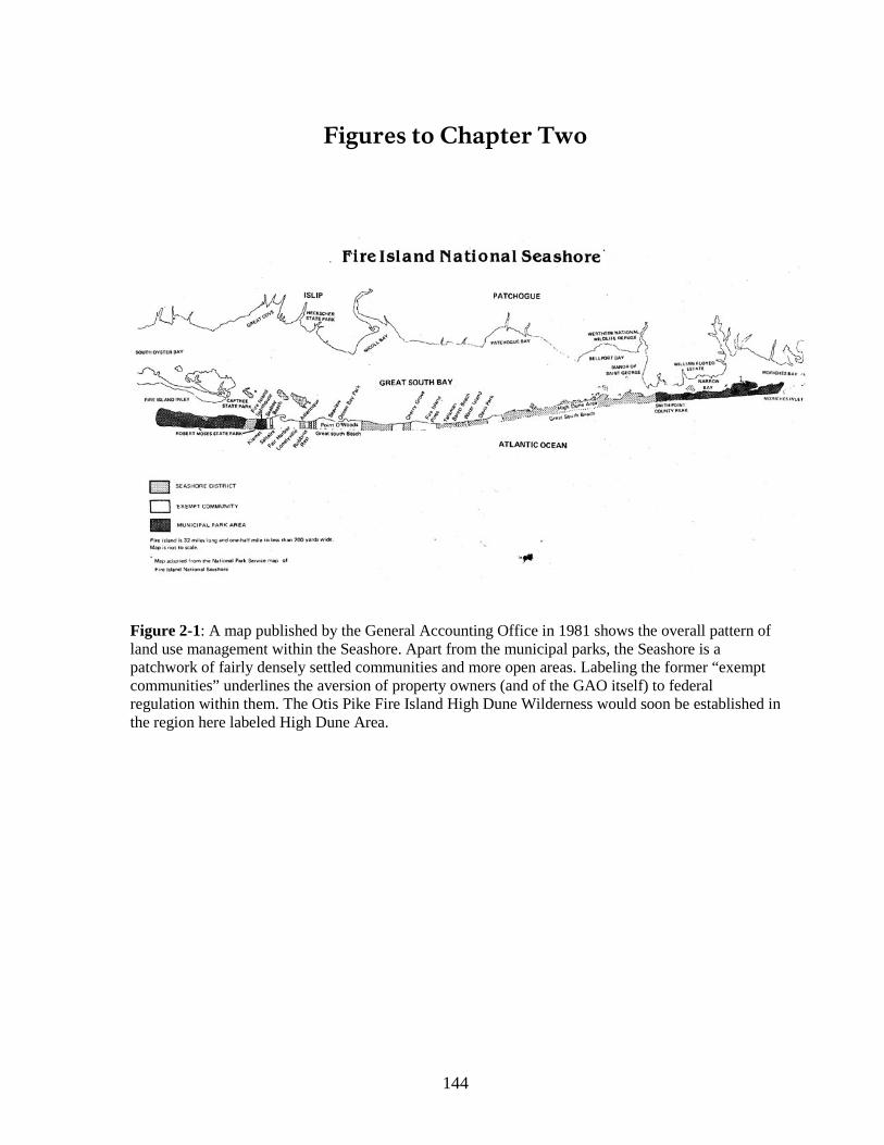
144
Figures to Chapter Two
Figure 2-1: A map published by the General Accounting Office in 1981 shows the overall pattern of land use management within the Seashore. Apart from the municipal parks, the Seashore is a patchwork of fairly densely settled communities and more open areas. Labeling the former “exempt communities” underlines the aversion of property owners (and of the GAO itself) to federal regulation within them. The Otis Pike Fire Island High Dune Wilderness would soon be established in the region here labeled High Dune Area.
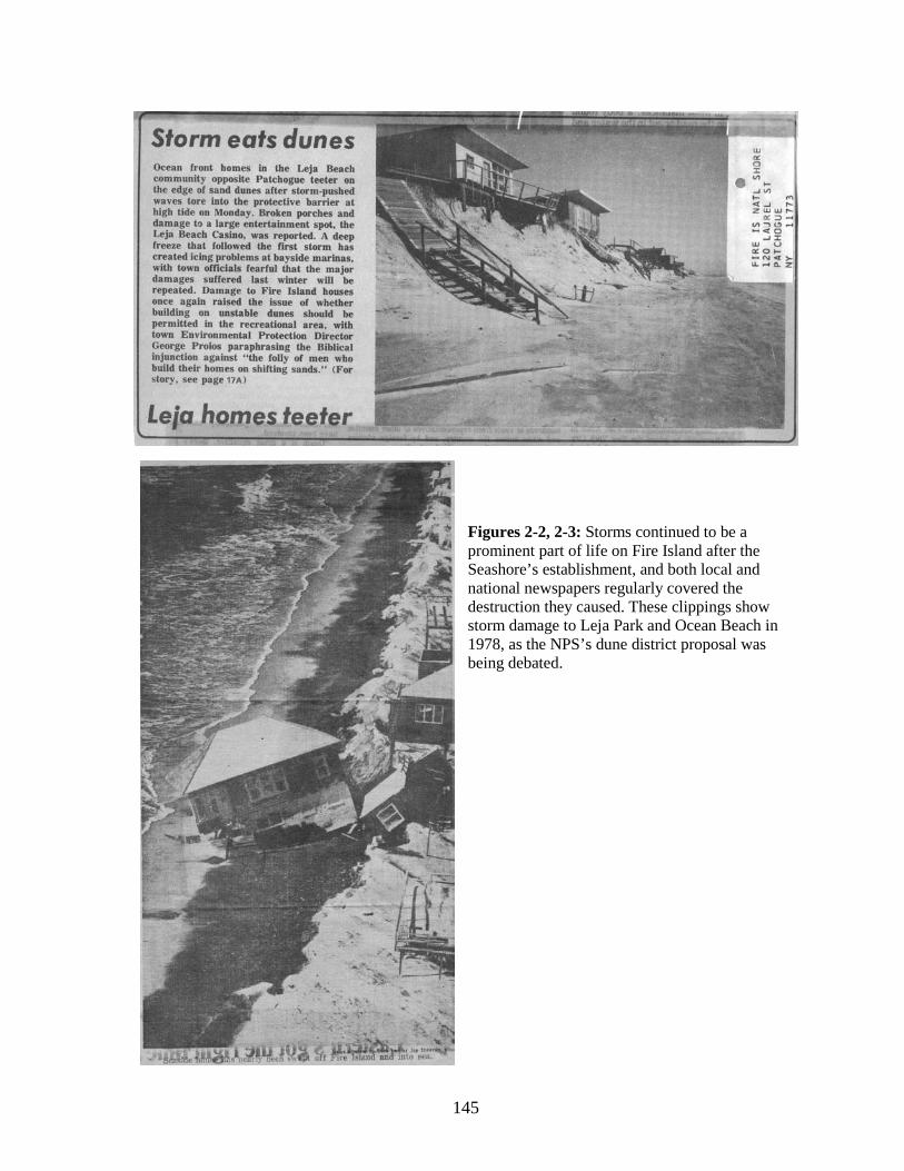
145
Figures 2-2, 2-3: Storms continued to be a prominent part of life on Fire Island after the Seashore’s establishment, and both local and national newspapers regularly covered the destruction they caused. These clippings show storm damage to Leja Park and Ocean Beach in 1978, as the NPS’s dune district proposal was being debated.
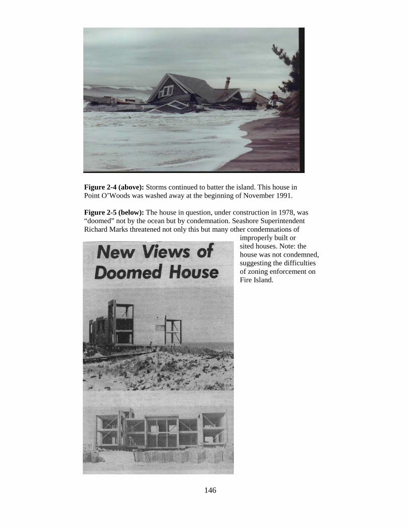
146
Figure 2-4 (above): Storms continued to batter the island. This house in Point O’Woods was washed away at the beginning of November 1991.
Figure 2-5 (below): The house in question, under construction in 1978, was “doomed” not by the ocean but by condemnation. Seashore Superintendent Richard Marks threatened not only this but many other condemnations of
improperly built or sited houses. Note: the
house was not condemned, suggesting the difficulties of zoning enforcement on Fire Island.
147
Chapter Three
The System in Action, 1991-2004
By Charles Starks Introduction
The previous chapters have been devoted to a detailed examination of the historical
record of the origin of Fire Island National Seashore (FINS) and the evolution of its
regulatory scheme for private land within park boundaries during the period between 1964,
when the Seashore was established, to 1991, when the federal land use standards in their
current form were adopted. These chapters have made it abundantly clear that, since the
establishment of the park, both the developed communities and the ideas that informed the
regulatory scheme adopted for them diverged sharply from the intent of the legislation that
created FINS.
This chapter is designed to show how the regulatory scheme in place since 1991
works on the ground to consistently produce outcomes that are at odds with the legislation. It
will examine two central procedures of the current scheme and three ancillary procedures.
From the perspective of the park, the following procedures are central:
1. The planning and zoning approval procedure used by the local governments with
jurisdiction over private lands in the park, which, consistent with New York State law,
essentially follows the model promulgated in the Standard State Zoning Enabling Act,401
2. The Park’s procedure for objecting to applications that do not meet the federal zoning
standards, which involves the issuance of an “objection letter,” detailing the specific item
or items of non-compliance with the federal standards at a point during the local planning
and zoning process.
published by the U.S. Department of Commerce in 1924.
To examine both the objection letters and the planning and zoning approvals, a
database was created consisting of all 877 land use application records the Seashore had on
401 Reprinted in Mandelker, Cunningham and Payne, Planning and Control of Land Development, Fourth Edition, Charlottesville, VA.: Michie, 1995, pp. 197-201. The concepts in this model legislation form the basis for most state and local zoning laws in the United States, even in states that did not adopt the model.
148
file from late 1991, when the current federal zoning standards were enacted, to early 2006
(when the Seashore’s files stopped). A sample of these records was then extracted from the
database using a method which will be detailed later in this chapter, and municipal planning,
zoning and permitting records in Brookhaven and Islip corresponding to the records in the
sample were examined.
As discussed extensively in Chapter Two, the FINS’s objection letters, in most cases,
constitute empty threats because the only enforcement mechanism available to FINS is land
acquisition by eminent domain, and that mechanism is deemed politically too draconian to
use in all but the most egregious of circumstances. Moreover, as will be documented in this
chapter, many development applications result in objection letters so that acquiring all the
lands subject to objectionable building would very quickly begin to fundamentally change
the relationship of FINS to the developed communities.
In addition to these two procedures, the following four ancillary procedures are also
of interest and will be discussed as well, albeit in more cursory fashion:
• Suffolk County’s rules governing the location of septic systems, which serve as a de
facto limit on summer population density in the developed communities on Fire
Island.
• State-imposed land use regulations, namely the Coastal Erosion Hazard Act and the
Tidal Wetlands Act, which were implemented in the decades following the
establishment of FINS and have come to influence development to varying degrees.
Note that the federal zoning standards have never been coordinated with these
regulations, continuing to focus exclusively on local zoning.
• The State Environmental Quality Review Act (SEQRA), which imposes an environ-
mental impact process analogous to that of the National Environmental Protection
Act (NEPA) on all but the most minor aspects of land use in New York State,
including many public and private development activities and new plans and
regulations at local and state levels of government.
• The granting of building permits and certificates of occupancy by local governments
following planning and zoning approval.
149
Because these procedures are not central to the land use process established by the
federal regulations, they will not be examined in a systematic way like the zoning and
approval processes. Rather, the treatment of these procedures will supplement the evaluation
of land use and highlight the ways in which they interact with, counteract and complicate the
federal-local zoning scheme.
Before examining the above-listed processes and their effects on the Seashore, it will
be useful to consider in more detail the reasons they were chosen as objects of study, their
strengths and limitations, and why other methods of evaluating the effects of land use change
on Fire Island were not used in this study.
The Jurisdictions
This chapter will focus mainly on the developed communities under the direct zoning
jurisdiction of Brookhaven and Islip. It is a peculiarity of government in New York State that
there are three possible layers of local government: county, city or town, and village. While
cities are independent of towns and cannot have a lower-order layer of government within
them, it is not only possible but common for towns to be partly subdivided into incorporated
villages. The villages remain within the town’s jurisdiction for certain purposes, but the
planning and zoning functions are assigned to the village government. In Islip, four
incorporated villages have been formed within town boundaries, two of which are on Fire
Island—Ocean Beach and Saltaire. Brookhaven has eight incorporated villages within its
boundaries, but none are on the island.
In contrast to Brookhaven and Islip, Ocean Beach and Saltaire have developed a
reputation for taking care of their own land use matters without either involving NPS or
allowing egregious variances. Both have their own zoning regimes, and during the period
studied, only 15 of the 877 development applications in FINS files were in these villages.
Moreover, only one of those applications resulted in an objection letter from NPS.
Because the overwhelming majority of the applications, objectionable and not, were
filed under the zoning regimes of Brookhaven and Islip, it was decided for purposes of
simplicity within this study to focus exclusively on the two large municipalities. This chapter
will return briefly to Ocean Beach and Saltaire in considering alternative ways of organizing
the control of land use within the park.
150
The Local Planning and Zoning Approval Process
Later, this chapter will explore some of the animating ideas behind traditional local
zoning, principally to show how poorly suited they are to Fire Island, but the chapter begins
with the procedures involved in obtaining a development approval. It is noteworthy that these
procedures were not modified in any way, or even addressed by the federal zoning standards;
with the exception of the issuance of objection letters by NPS, those standards are concerned
solely with the substantive content of the regulations.
The federal zoning standards, therefore, were to be implemented using the approval
processes that were in place prior to the establishment of the Seashore; there was no
requirement that the framework in which decisions about individual properties were made be
changed in response to the establishment of the Seashore, other than the addition of a referral
to NPS for a determination of compliance with federal standards. The procedure by which
planning and zoning approvals are sought remains, in broad outline, as follows:
1. The prospective applicant designs a project, such as the expansion of an existing dwelling or the construction of a new building.
2. The applicant, his agent, or the local government building inspector (if the plans have already been submitted) examines the local zoning laws to determine which approvals will be needed and whether any variances are required.
3. The applicant is determined to require one or more approvals, such as site plan review (granted by the Planning Board, and typically required for uses other than one- and two-family homes), or a zoning variance (granted by the Zoning Board of Appeals, and required when the application does not comply with one or more zoning standards).
4. The applicant makes application to the required board or boards (in some cases, approval of both the Planning and Zoning boards is required). It is at this stage that the application is supposed to be referred to NPS for its review, although, as we shall see, this does not always happen.
5. At a public hearing, the applicant makes a case based on the requirements in local law and in statutory and case law. Objectors, such as NPS or other interested parties, may also make their case against the application, again based on legal standards.
6. Approval is granted or denied by vote of the Board at the conclusion of the hearing.
While this process may be familiar, it is worth examining for two reasons. First, it is
well known in the planning and development community that applicants proposing small
projects, at least in areas which are perceived to have lax zoning regimes, almost always
design their projects before examining local zoning laws to determine whether their
151
proposals are in conformity. Thus, from the beginning, applicants view the zoning law not as
a guide for private development—if that were the case, they would examine the law before
designing their proposals—but rather as a set of hurdles which must be jumped in order to
use their property as they desire. The number and nature of the variances requested and
granted on Fire Island suggests that this is the case there.
Second, discretion to approve or deny the project is vested exclusively in the local
planning and/or zoning boards, bodies which are made up of volunteers appointed by the
municipal governing body, which itself is an elected body. The standards for granting those
approvals are highly subjective.
Additionally, in both Brookhaven and Islip, as in most communities, there is no
requirement that the majority of the members of these boards have any particular
expertise.402 The nature and interests of the membership therefore can vary greatly depending
on the priorities of the governing body. A peculiarity unique to Fire Island is that the island
has very few permanent residents and is not even accessible by car, while the remainder of
Brookhaven and Islip are very populous, sprawling suburbs.403
From the perspective of applicants seeking to construct small projects, the local
planning and zoning approval process is usually the paramount consideration in obtaining the
necessary permission to build. If other approvals are required, they are seen as adjunct to this
process, and they almost always involve application to an agency with less discretion than
the municipal boards (or in the case of NPS, referral to an agency with essentially no
enforcement power). For example, approval for septic systems is granted by the Suffolk
County Health Department. Its approvals are, for the most part, not discretionary or
subjective, but rather are based on formulas. If an application is denied, the applicant can try
To ask a board of lay
volunteers, whatever their motivations and level of engagement, to give the same
consideration to applications on a remote island they rarely, if ever, visit, as to those in places
they know well and drive by on a regular basis, is a tall order, and it would not be surprising
if decisions on these applications were made with less than full information.
402 New York State has recently imposed a minimal education requirement for planning and zoning board members. 403 According to U.S. Census data, the population of Brookhaven in 2000 outside incorporated villages was 412,708. Its land area was 246 square miles. The population of Islip in 2000 outside incorporated villages was 316,126. Its land area was 102 square miles.
152
to re-engineer the plans so that the numbers fit the department’s standards, but there is less
opportunity to appeal to subjective standards than is the case with zoning approvals simply
because septic systems are much more highly engineered than zoning plans. Therefore, it is
the zoning approval process in which the applicant has the greatest chance of getting the
rules bent to allow the project contrary to the federal and local zoning standards.
This chapter focuses on the zoning process precisely for this reason—it is the most
democratic stage in the construction process, where, ideally, the community’s values and
interests are weighed in the decision making process. The other approval processes, which
rely more on formulas and numbers, do not lend themselves to these considerations.
Currently, this means that it gives projects that otherwise might never get built a good chance
of slipping through.404
The use of the zoning process as the basis for this study has posed difficulties.
Archival recordkeeping in Islip and Brookhaven has been quite poor until very recently, and
many records are inaccessible. In Brookhaven, they take the form of paper files which are
organized by an archaic and almost unusable system of street intersections, while in Islip
they were scanned into microfilm files which are not easily accessible or readable, and as a
result, unable to be fully investigated. Fortunately, some of the records from both
jurisdictions had been put in electronic form and were available for this study. Additionally,
NPS files, although they exclude the most recent years in the study period, are relatively
thorough and extend all the way back to 1991. The records at FINS offices do not indicate
the final decision on the applications—for this, the Town records had to be used—but they
do show the nature of the applications, which variances were requested, and whether an
objection letter was issued.
Precisely because of the democratic nature of the zoning regime,
however, it is also where a significant opportunity exists to change the rules so that the
values of environmental stewardship of FINS become more prominent, thereby creating
better outcomes for the island.
Thus, the records are not as complete as might be preferred, yet it was still possible to
use available records to paint a picture of ongoing change on the island and to show how the
404 It should be acknowledged here that the federal flood insurance program contributes significantly to property owners’ ability to build projects for which they might otherwise not be able to obtain financing; this problem is beyond the scope of this study, but we will examine it briefly at the end of this chapter.
153
zoning process repeatedly and systematically subverts the values expressed in the legislation
that established FINS. Only by examining the records of development approvals, incomplete
though they may be, was it possible to tease out the relationships between the flawed
approval process and the flawed results in the ground. This could not be done using proxies,
such as documentation of changes in land use or land cover over the years, because such
proxies cannot show the actual relationship between those changes and the processes that are
creating the problems.
The intent of this chapter is not to show that the communities have grown and that this
growth has caused impacts from 1964 to the present—that much is certainly known without
the need for a study—but rather to show that the rules that are supposed to protect the island
from the impacts of development are in fact arranged to facilitate inappropriate development.
There are several specific problems with the zoning regime that this chapter will document:
• Traditional zoning, which is designed to separate uses from each other, is poorly suited to manage the problems of development on a dynamic barrier island where the dominant land use problems are erosion and impacts on natural resources.
• The concern of the federal zoning standards, lot occupancy, is only a minor piece of the myriad local and state rules that actually shape development on Fire Island.
• The federal standards’ single-minded focus on lot occupancy misses other measures that have significant impacts on the ecosystem of the islands, such as enclosed floor area, number of bathrooms, and density of septic systems.
• NPS is not able to enforce the federal standards effectively because it lacks a usable enforcement mechanism.
• The local governments’ zoning regimes do not encourage strict enforcement of the local standards; instead, there is a strong bias toward granting variances.
Following the analysis in the next section, this chapter recommends changes, both procedural
and substantive, that would address these problems and create better land use outcomes on
the island in the future.
Description and Analysis of the Land Use Regulatory System on Fire Island
The Basis of Local Zoning
Local zoning gradually came into being beginning in the late 1800s as an attempt to
create districts that would isolate those industrial land uses that were seen as public nuisances
154
in locations that were physically separate from residential areas.405
The American “city beautiful” movement, which is conventionally believed to date
approximately from the 1893 Columbian Exhibition in Chicago, was inspired by that
exhibition’s neoclassical vision of what a city could be: clean, ordered, and beautiful.
Under the common-law
doctrine of nuisance law, those who are subject to incidental injury caused by the activities of
others may seek remedies from those who cause the injury, and industrial uses created odors,
sights and sounds that made them obvious targets of nuisance lawsuits. Early zoning can thus
be seen as an attempt to rationalize land uses so as to allow industrial uses to exist without
constantly being subject to legal action by injured neighbors, and to protect the health of the
public from threats posed by industrial activity. However, in the 1910s and 1920s, under the
influence of the planning movement, the concept of nuisance was significantly extended to
create the concept of zoning that we know today.
406 The
practitioners of the movement drafted numerous plans for the redevelopment and extension
of American cities and towns in the first decades of the 20th century along these precepts,
usually under the auspices of development interests or civic organizations.407 At the same
time, the urban reform, or “city practical,” movement was busy making institutional reforms
to local governments themselves, and it was this movement that first suggested that zoning
be implemented in cities in the United States.408 It was the uneasy combination of these two
ideologies that led to the notion that the police power, through zoning, could be used to
implement plans.409
On a national level, this took the form of the Standard City Planning Enabling Act,
published in 1928,
410
405 Larry Gerckens, “American Zoning and the Physical Isolation of Uses,” Planning Commissioners Journal Reprint Article #573.
and the Standard State Zoning Enabling Act, published in 1926. These
acts formed the basis for most state legislation authorizing local governments to plan and
zone. The New York State zoning legislation does not derive specifically from the model act,
406 John Reps, The Making of Urban America, Princeton, N.J.: Princeton University Press, 1955, p. 497-8. 407 William H. Wilson, The City Beautiful Movement, Baltimore: Johns Hopkins University Press, 1989. 408 Jon A. Petersen, The Birth of City Planning in the United States, 1840-1917, Baltimore: Johns Hopkins University Press, 2003, p. 240. 409 The process by which zoning became a tool of planners is described in Petersen, pp. 308-15. 410 Mandelker, Cunningham and Payne, p. 20.
155
having first been adopted in 1917,411 but the current zoning enabling legislation in New
York, which has been amended extensively over the decades, largely conforms to principles
in the act, and shares its faults. The planning enabling legislation in use in New York State
today is a patchwork, having elements that date back to the era of the model acts but with
much of its substantive language dating only to 1993,412
To say that the marriage of zoning and planning has been imperfect, either nationally
or in New York State, would be an understatement. From the beginning, there was an
underlying tension between the ideals of the “city beautiful” planning advocates and those of
the “city practical” urban reformers who advocated zoning, and the model enabling
legislation did not resolve this tension. Planning is inherently an ambitious and long-range
undertaking which involves controls on private land use, investments in public infrastructure
(including the protection of natural infrastructure), and the coordination of both. The major
tools provided to control private land use are zoning, subdivision and site plan regulations,
while the tool to control public infrastructure is capital budgeting. In New York as
throughout most of the United States, however, the enabling legislation does not require any
significant linkage between planning and/or land use regulations and capital budgeting, with
the result that strict adherence to plans is rarely if ever achieved.
but it too shares the model statute’s
conceptual basis.
413
planning has the advantage of providing flexibility for the local government as circumstances
change, but the lack of rigor in plans can easily lead them to be ignored when decisions are
made.
This characteristic of
Because there is no link between planning and budgeting, plans take on the character
of a flexible statement of preferences, or a wish-list of desired initiatives, rather than rational
programs of improvement, and it is difficult to evaluate the extent to which an adopted plan
411 State of New York Local Government Handbook, Fifth Edition, New York State Department of State, Division of Local Government Resources, 2000, p. 76. 412 “Zoning and the Comprehensive Plan,” New York State Department of State, Division of Local Government Resources, 1999, p. 8. 413 It is noteworthy that the standard zoning enabling act was published two years before the planning act, and there was no requirement in the zoning act that the zoning be in accordance with a plan. Many states still do not have such a requirement.
156
is being used by the local government in setting its priorities.414 The link between planning
and zoning is better established, though still highly subject to interpretation,415
Conversely, land use changes not envisioned in the plan and not allowed by zoning
can be, and often are, supported by applicants who argue that the infrastructure is adequate,
and that the changes are “reasonable” considering the circumstances. Because local plans are
flexible, and plans and zoning are not well integrated, the door is always open to variances
that benefit an applicant at the expense of the public interest. The zoning approval process on
Fire Island has provided ample opportunity for applicants to make these arguments before a
sympathetic audience. Additionally, in both Brookhaven and Islip there is significant
evidence to indicate that corruption has played a part in the granting of approvals and
building permits.
but in the
absence of an infrastructure capital program tied to the plan, almost any land use change,
even one endorsed by the plan and the zoning, could be opposed on the basis that the public
infrastructure cannot support it.
416
After planning became established in the 1910s, zoning quickly evolved into the
familiar hierarchical model known as Euclidean zoning, named for the city of Euclid, Ohio,
which was the defendant in a landmark Supreme Court case. At its root, the Euclidean model
has three categories—residential, commercial and industrial land uses—with residential at
the top, meriting the most protection, and industrial at the bottom. Much of the history of
zoning for the next few decades consists of the expansion of that hierarchy to an intricate
level of detail, with different uses, densities, and intensities within the three main categories
separated from one another just as strictly as the three categories are separated. From the
414 New York law allows local governments to prepare capital plans, but the statute enabling this does not mention comprehensive planning. 415 New York State’s zoning laws contain a statement that requires that zoning be in accordance with a comprehensive plan, but courts have interpreted this requirement very loosely—so much so that the “comprehensive plan” itself may take the form of little more than scraps of evidence that the governing board gave “some thought to the community’s land use problems,” in the words of New York’s highest court (Town of Bedford v. Village of Mt. Kisco). By contrast, in some states, such as Connecticut, the legislated link between planning and zoning is so tight that any change in zoning regulations usually cannot be undertaken unless the specific document known as the comprehensive plan or master plan is revised first. 416 See, for example, Alfonso A. Castillo, “Town inspector gets probation, short jail stay,” Newsday, March 6, 2007, and “Previous Coverage of Brookhaven Corruption,” retrieved from www.newsday.com/news/local/longisland/ny-brookhaven-sg,0,1391648.storygallery on November 21, 2007; Julia C. Mead and Vivian S. Toy, “A G.O.P. Stalwart Quits Islip Post, Then Pleads Guilty,” The New York Times, March 10, 2006.
157
beginning, zoning also included bulk requirements. These took the form of building height
requirements, minimum lot widths and depths, and minimum front, side and rear yards. The
purpose of these had nothing to do with environmental protection, but rather was to ensure
that residents had adequate access to light and air, the lack of which was suspected to cause
disease.417
By the time FINS came on the scene, the unsophisticated Euclidean model of land
regulation had reached the end of its practical development, and zoning practitioners were
turning to more holistic and flexible models variously known as planned development or
performance zoning. These new types of zoning typically set baseline targets for the
development of sites—for example, maximum coverage of the site by buildings or paved sur-
faces, minimum separation of buildings, minimum open space preservation, and maximum
residential density—but allowed considerably more flexibility in the details of site planning
as long as the performance targets were met. While the performance-based models are not
without problems, it is surprising that there was no attempt at the time of the park’s creation
or over the years of studies and controversy which followed to adapt them for the developed
communities, especially since this time period was the heyday of performance zoning.
Many of the subdivisions platted at the time of the popularization of zoning had
lots that were quite small, even in rural areas. Fire Island was typical in this regard, with
many of the subdivisions platted to a standard of only 40 feet by 100 feet. This platting
standard produces 8 lots per acre once an allowance is made for streets, a development
intensity exceeded by only the most urbanized areas. By contrast, planners today in rural
areas where conservation values are paramount often advocate a minimum lot size of 10
acres—sometimes much more.
418
417 Richard Babcock in The Zoning Game: Municipal Practices and Policies (Madison: University of Wisconsin Press, 1966) identified these types of bulk regulations as part of zoning’s “pantheon of myths” (p. 17) and “legal fictions” (p. 116) and suggested that even at the time of their invention, they had no legitimate basis.
By
emphasizing the attainment of development and preservation targets which, theoretically, can
be linked to the ability of the natural and manmade infrastructure to support development, the
performance models of zoning offer a way to directly address through land use regulation the
418 One aspect of performance zoning—lot coverage, or “lot occupancy”—was grafted onto the Euclidean zoning in place on the island, but the performance approach as a whole was not considered even in the Babcock report of 1975.
158
problems of erosion and environmental conservation that are central to the land use dilemma
on Fire Island.
Performance zoning was not adopted and the Seashore has been left with a set of
remarkably crude zoning regulations as the main regulatory bulwark against the combined
effects of man and sea on its fragile environment. Indeed, considering how exceptionally ill-
suited Fire Island is to the application of traditional zoning, it is ironic that the island is one
of the very few places in the United States where local zoning is a matter of federal law.
The Federal Standards and the Local Regulations
As has been described earlier in this report, local governments were expected to tune
their zoning regulations to those set by the federal government in the 1960s. These standards,
generally recognized as unworkable, were the subject of a lengthy review process in the
1970s and 1980s, resulting, on August 29, 1991, in the publication of the revised standards in
the Code of Federal Regulations.
In form, the standards resemble a stripped-down version of a conventional local
zoning ordinance. The first subpart of the zoning standards divides the entire area within
FINS jurisdiction into two base districts and one overlay district (that is, a district which is
applied atop portions of the base districts and modifies or supersedes the regulations in the
base districts). The second subpart of the regulations provides a list of permitted and
prohibited uses and a short list of bulk regulations that apply to all development.
The districts can be described in brief as follows:
1. The Community Development District is a base district which includes the areas
the regulations describe as the “developed communities.”419
uses are permitted “with the approval of the local zoning authority and review by the
Superintendent [of the Seashore].” Additionally, commercial or industrial uses may only be
located within a local zoning district in which such uses are allowed.
In this district, single-family
homes, community facilities, churches, and schools are permitted. Commercial and industrial
420
419 36 CFR 28.3(b).
Multiple family
dwellings and guest houses are prohibited, although these uses that were in existence before
420 36 CFR 28.12(b).
159
1964 may continue as nonconforming uses.421 Local zoning districts which are residential in
nature must not allow uses other than single family homes.422
2. The Seashore District is a base district which includes all areas not in the
Community Development District.
423 Most development in this area is prohibited, except the
“alteration, expansion, movement, and maintenance,” and in certain cases reconstruction, of
existing single-family homes and accessory structures. As well, this district permits “any use
consistent with the purposes of this Act, which is not likely to cause significant harm to the
natural resources of the Seashore,” below mean high water level in the Atlantic Ocean and
Great South Bay.424
3. The Dune District is an overlay district which includes all those areas in the
Community Development and Seashore districts that lie between from the mean high water
line to 40 feet landward of the primary natural high dune crest—mapped in 1976.
425 This
district permits only dune crossings, dune protection measures and the maintenance and
reconstruction of existing structures.426
The bulk regulations include the following provisions:
The regulations include provisions allowing the
remapping of the Dune District, but this has never been done, with the result that it is now
located well seaward of the actual dune line due to erosion.
• The minimum lot area is 4,000 square feet.427
• The maximum lot occupancy, including all buildings, swimming pools and accessory structures, as well as upper-story portions of buildings that overhang beyond the ground-story limits of the building, is 35 percent.
428
• The maximum height above mean sea level, or above the minimum elevation necessary to qualify for federal flood insurance, is 28 feet.
429
• Internally lighted signs are prohibited.
Additionally, the standards include provisions allowing nonconforming uses to continue,
and even be reconstructed within a year after being destroyed, provided they are not
421 36 CFR 28.10(a). 422 36 CFR 28.12(a). 423 36 CFR 28.3(c). 424 36 CFR 28.10(b). 425 36 CFR 28.3(d). 426 36 CFR 28.10(c). 427 36 CFR 28.12(c). 428 36 CFR 28.12(d) et seq. There is an additional restriction on properties in the Seashore District which limits lot occupancy to 2,625 square feet on lots over 7,500 square feet in area. 429 36 CFR 28.12(f).
160
expanded. This allowance for the continuation and rebuilding of nonconforming uses is a
huge obstacle to environmental management on the island because it virtually insures that the
dune line cannot reestablish itself once it reaches the line of buildings. It is commonly
understood that barrier islands on the U.S. east coast are retreating landward due to rising sea
levels, while Fire Island itself has a number of complex processes working on it that interact
with, and sometimes mask, this long-term trend.430
The federal standards are simple as zoning standards go. The local regulations which
are supposed to implement these standards are significantly more complex—perhaps
arbitrarily so, at least as they apply to Fire Island.
Dunes do stabilize the island in the short
term, but they move in response to the general retreat and the local processes that shape the
island’s development. When the dune line retreats sufficiently to reach the oceanfront row of
buildings, usually in a large storm that causes property damage, the buildings inhibit the
reformation of the dune, and if the houses are maintained or reconstructed, the dunes fail to
adequately reestablish themselves. This is exactly what has happened on parts of the island
such as Fair Harbor (see Figures 3-1 through 3-5).
On the Islip portion of the island, there are six zoning districts, described below.
Within these districts, some uses are permitted by right, while others are permitted only by
special permit or exception, which requires enhanced scrutiny by the Town Board, Planning
Board or Zoning Board of Adjustment. An asterisk (*) is used to denote permitted uses which
are clearly contrary to the federal standards. In addition to the principal uses described below,
these districts also permit accessory uses.
• The Ocean Front Dune District (AAAB District) is a district which corresponds to some extent with the Park’s dune district, but includes some additional properties north of the dune district. The district permits single-family dwellings (*) and municipal park and recreation facilities (*). Private membership clubs (*), public utilities (*), churches (*) and community facilities (*) are permitted by special permit from the Town Board.431
• The Residence BAA District, which applies to the vast majority of Islip’s Fire Island lands outside the AAAB District, permits single-family dwellings, parks and public schools. Private membership clubs, public utilities, community buildings, churches,
430 The mechanisms alluded to here are explained in Leatherman, Stephen P., Barrier Island Handbook, College Park: University of Maryland Laboratory for Coastal Research, 1988, and in Norbert P. Psuty, Michele Grace and Jeffery P. Pace, “The Coastal Geomorphology of Fire Island: A Portrait of Continuity and Change,” Boston: U.S. Department of the Interior, National Park Service, 2005. 431 Islip Code § 68-59.1 et seq.
161
private schools, boathouses, bathhouses, historical or memorial monuments, stores (*) and offices (*) are permitted by special permit from the Planning Board. Child care centers (*) are permitted by special exception from the Zoning Board of Appeals. 432
• The Residence CAA District, applicable only to one large property on the Great South Bay in Kismet (as well as other properties on the mainland), permits one-family and two-family (*) dwellings.
433 Private club mooring wharfs, automobile parking fields (*), private membership clubs, cemeteries and private schools are permitted by special permit from the Planning Board.434 Public utilities, community buildings, boathouses, bathhouses, historical or memorial monuments, model houses, boat berths, child care centers (*) and school bus parking (*) are permitted by special exception from the Zoning Board of Appeals.435
• The Business District (BD), applicable only to a few properties in Kismet and other properties on the mainland, permits single-family dwellings; two-family dwellings (*); stores; offices; banks; broadcasting studios; community buildings; places of business of bakers, confectioners, decorators, dressmakers, artists, florists, furriers, milliners, opticians, artisans, photographers, printers, tailors, needle trades, hands-craftsmen and “businesses of a similar and no more objectionable nature”; nonprofit fraternities or lodges; historical or memorial monuments; churches; automobile parking fields; funeral parlors; child day care centers; veterinarians; public schools; and private schools. Dormitories and bars are permitted by special permit from the Town Board. Restaurants, outdoor displays, billiard halls, health clubs, convenience markets, universities, mixed use buildings, private parking garages, and bank drive-in windows are permitted by special permit from the Planning Board. Public utilities are permitted by special exception from the Zoning Board of Appeals.
436
• The Business 1 District (B1), applicable to some scattered properties near the Great South Bay in Kismet, Fair Harbor, and Seaview, and other properties on the mainland, permits single-family dwellings, two-family dwellings (*), public schools, banks, broadcasting studios, laundromats, community buildings, private schools, personal service establishments, dry cleaners, retail businesses, nonprofit fraternities or lodges, historical or memorial monuments, churches, holiday tree sales, child day care centers, funeral parlors, health clubs and veterinarians. Dormitories (*), bars, psychiatric clinics (*) and nursing homes (*) are permitted by special permit from the Town Board. Restaurants, billiard halls, outside seating, assembly halls, walk-up counters, taxi offices, stores, offices, bank drive-in windows, and spray booths are permitted by special permit from the Planning Board. Public utilities and wholesale food distribution facilities are permitted by special exception from the Zoning Board of Adjustment.
437
• The Business 3 District (B3), applicable only to a few properties in Kismet near the Great South Bay, and other properties on the mainland, permits single-family
432 Islip Code § 68-135 et seq. 433 Islip Code § 68-150 et seq. 434 Islip Code § 68-46.1. 435 Islip Code § 68-47. 436 Islip Code § 68-256 et seq. 437 Islip Code § 68-271 et seq.
162
detached dwellings, two family detached dwellings (*), stores, offices, banks, retail businesses, child day care centers, broadcasting studios, nonprofit fraternity lodges, historical or memorial monuments, churches, automobile parking fields, health clubs, veterinarians, public schools and private schools. Outdoor storage, gasoline service stations, car washes, dormitories (*), motor vehicle dealerships, fast-food restaurants, commercial animal exhibits, regional theatres, public transportation terminals, airports, lumberyards or building material establishments, taxi stations, racetracks or exhibition tracks, commercial boat storage, commercial shipyards or boat repair yards, ferry terminals, boardinghouses (*), lodging houses (*), marinas, marine wharfs, farmers’ markets, psychiatric clinics, kennels, and bars are permitted by special permit from the Town Board. Billiard halls, vehicle repair shops, convenience markets, outdoor seating, restaurants other than fast-food restaurants, game rooms, universities, assembly halls, dance halls, walk-up counters, taxi offices, bank drive-through windows and spray booths are permitted by special permit from the Planning Board. Gambling vessels are permitted by special exception from the Zoning Board of Appeals.438
Additionally, Islip has a wetlands management overlay district, which applies to all lands
designated as wetlands by the New York State Department of Environmental Conservation,
plus a 100-foot buffer around such lands. This district applies to some lands on Fire Island
and also to properties on the mainland. It does not have use regulations but does apply far
more restrictive bulk standards than the underlying zoning.
In Brookhaven, all of the districts applicable to the area within the Seashore are
mapped only on Fire Island and not anywhere on the mainland, and are more clearly parallel
with the federal regulations than the Islip districts. The Brookhaven zones follow (again, an
asterisk (*) denotes uses that are clearly contrary to the federal standards). In addition to the
principal uses described below, these districts also permit accessory uses.
• The Residential District (RD) includes most of the lands within the developed communities. This district permits single-family detached dwellings and municipal parks and recreation facilities. Public utilities, community buildings, places of worship and historical or memorial monuments are permitted by special permit.439
• The Commercial District (CD) includes scattered properties in Seaview, Ocean Bay Park, Point O’ Woods, Cherry Grove, Fire Island Pines, and Davis Park. The district permits any use allowed in the Residential District, stores, professional offices, churches, schools, libraries, community buildings, utilities, offices, banks, theatres, restaurants, dance halls, discotheques, workshops, ferry slips, boat docks, transportation terminals, art galleries, exhibit halls, artists’ and photographers’
438 Islip Code § 68-301 et seq. 439 Brookhaven Code § 85-167.

163
studios, and historical or memorial monuments. Two-family dwellings, apartments, multiple dwellings, condominiums, showers, lockers, changing rooms, bathhouses, guesthouses, boardinghouses, lodging houses, hotels, stores above the ground floor, and manufacturing or industrial uses are explicitly prohibited.440
• The Oceanfront Dune District (OFD) is an overlay district that corresponds precisely to the federal dune district. It permits only dune crossings, vehicular crossings (*), snow fences, and reconstruction and repair of existing dwellings.
441
A comparison of the bulk requirements in each of the districts, both in Islip and
Brookhaven, is provided in Table 3.1 (below). The bulk requirements in the federal standards
are repeated in the table for comparison.
As is apparent from the table, the primary residential zones in both Islip (AAAB and
BAA) and Brookhaven (RD and OFD) meet the federal standards in terms of bulk regulation.
However, the other zones do not. In Islip, the CAA, BD, B1 and B3 zones allow buildings to
be higher than the federal zoning standards, and they do not include any restrictions on lot
occupancy despite the reliance of the federal standards on precisely this measure. In Islip, the
CD zone allows lot occupancy 15 percentage points higher than permitted by the federal
standards. These discrepancies are less important than they might seem, primarily because
applications in the CAA, BD, B1, B3 and CD districts are relatively rare.
The Islip wetlands overlay district, not included in the table, has a minimum lot area
of 80,000 square feet, but the other bulk requirements are the same as the underlying zoning.
440 Brookhaven Code § 85-169. 441 Brookhaven Code § 85-168.
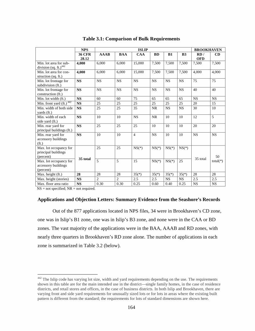
164
Table 3.1: Comparison of Bulk Requirements
NPS ISLIP BROOKHAVEN 36 CFR
28.12 AAAB BAA CAA BD B1 B3 RD /
OFD CD
Min. lot area for sub-division (sq. ft.)442
4,000
6,000 6,000 15,000 7,500 7,500 7,500 7,500 7,500
Min. lot area for con-struction (sq. ft.)
4,000 6,000 6,000 15,000 7,500 7,500 7,500 4,000 4,000
Min. lot frontage for subdivision (ft.)
NS NS NS NS NS NS NS 75 75
Min. lot frontage for construction (ft.)
NS NS NS NS NS NS NS 40 40
Min. lot width (ft.) NS 60 60 75 65 65 65 NS NS Min. front yard (ft.) NS 442 25 25 25 25 25 25 20 15 Min. width of both side yards (ft.)
NS 25 25 35 NR NS NS 30 10
Min. width of each side yard (ft.)
NS 10 10 NS NR 10 10 12 5
Min. rear yard for principal buildings (ft.)
NS 25 25 25 10 10 10 20 20
Min. rear yard for accessory buildings (ft.)
NS 10 10 4 NS 10 10 NS NS
Max. lot occupancy for principal buildings (percent) 35 total
25 25 NS(*) NS(*) NS(*) NS(*)
35 total 50 total(*) Max. lot occupancy for
accessory buildings (percent)
5 5 15 NS(*) NS(*) 25
Max. height (ft.) 28 28 28 35(*) 35(*) 35(*) 35(*) 28 28 Max. height (stories) NS 2 2 2.5 2.5 NS NS 2.5 2.5 Max. floor area ratio NS 0.30 0.30 0.25 0.60 0.40 0.25 NS NS NS = not specified; NR = not required. Applications and Objection Letters: Summary Evidence from the Seashore’s Records
Out of the 877 applications located in NPS files, 34 were in Brookhaven’s CD zone,
one was in Islip’s B1 zone, one was in Islip’s B3 zone, and none were in the CAA or BD
zones. The vast majority of the applications were in the BAA, AAAB and RD zones, with
nearly three quarters in Brookhaven’s RD zone alone. The number of applications in each
zone is summarized in Table 3.2 (below).
442 The Islip code has varying lot size, width and yard requirements depending on the use. The requirements shown in this table are for the main intended use in the district—single family homes, in the case of residence districts, and retail stores and offices, in the case of business districts. In both Islip and Brookhaven, there are varying front and side yard requirements for unusually sized lots or for lots in areas where the existing built pattern is different from the standard; the requirements for lots of standard dimensions are shown here.
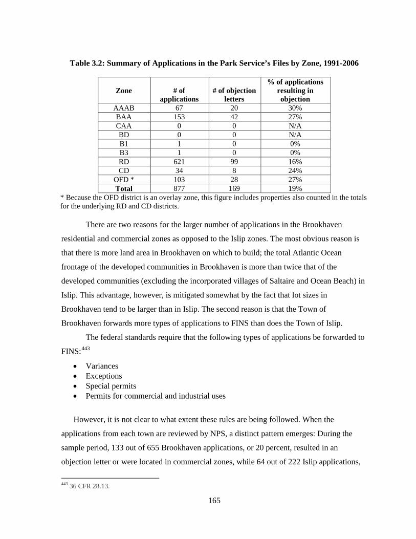
165
Table 3.2: Summary of Applications in the Park Service’s Files by Zone, 1991-2006
Zone
# of
applications
# of objection
letters
% of applications resulting in objection
AAAB 67 20 30% BAA 153 42 27% CAA 0 0 N/A BD 0 0 N/A B1 1 0 0% B3 1 0 0% RD 621 99 16% CD 34 8 24%
OFD * 103 28 27% Total 877 169 19%
* Because the OFD district is an overlay zone, this figure includes properties also counted in the totals for the underlying RD and CD districts. There are two reasons for the larger number of applications in the Brookhaven
residential and commercial zones as opposed to the Islip zones. The most obvious reason is
that there is more land area in Brookhaven on which to build; the total Atlantic Ocean
frontage of the developed communities in Brookhaven is more than twice that of the
developed communities (excluding the incorporated villages of Saltaire and Ocean Beach) in
Islip. This advantage, however, is mitigated somewhat by the fact that lot sizes in
Brookhaven tend to be larger than in Islip. The second reason is that the Town of
Brookhaven forwards more types of applications to FINS than does the Town of Islip.
The federal standards require that the following types of applications be forwarded to
FINS:443
• Variances
• Exceptions • Special permits • Permits for commercial and industrial uses
However, it is not clear to what extent these rules are being followed. When the
applications from each town are reviewed by NPS, a distinct pattern emerges: During the
sample period, 133 out of 655 Brookhaven applications, or 20 percent, resulted in an
objection letter or were located in commercial zones, while 64 out of 222 Islip applications,
443 36 CFR 28.13.
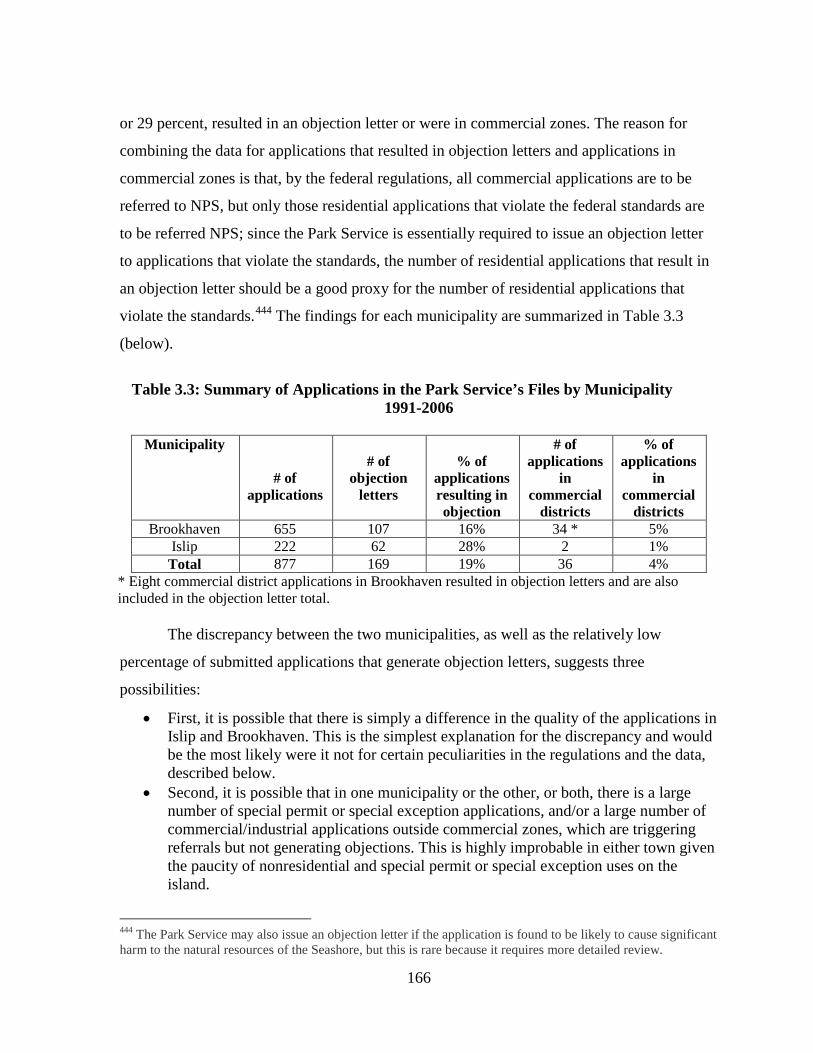
166
or 29 percent, resulted in an objection letter or were in commercial zones. The reason for
combining the data for applications that resulted in objection letters and applications in
commercial zones is that, by the federal regulations, all commercial applications are to be
referred to NPS, but only those residential applications that violate the federal standards are
to be referred NPS; since the Park Service is essentially required to issue an objection letter
to applications that violate the standards, the number of residential applications that result in
an objection letter should be a good proxy for the number of residential applications that
violate the standards.444
The findings for each municipality are summarized in Table 3.3
(below).
Table 3.3: Summary of Applications in the Park Service’s Files by Municipality 1991-2006
Municipality
# of
applications
# of
objection letters
% of
applications resulting in objection
# of applications
in commercial
districts
% of applications
in commercial
districts Brookhaven 655 107 16% 34 * 5%
Islip 222 62 28% 2 1% Total 877 169 19% 36 4%
* Eight commercial district applications in Brookhaven resulted in objection letters and are also included in the objection letter total. The discrepancy between the two municipalities, as well as the relatively low
percentage of submitted applications that generate objection letters, suggests three
possibilities:
• First, it is possible that there is simply a difference in the quality of the applications in Islip and Brookhaven. This is the simplest explanation for the discrepancy and would be the most likely were it not for certain peculiarities in the regulations and the data, described below.
• Second, it is possible that in one municipality or the other, or both, there is a large number of special permit or special exception applications, and/or a large number of commercial/industrial applications outside commercial zones, which are triggering referrals but not generating objections. This is highly improbable in either town given the paucity of nonresidential and special permit or special exception uses on the island.
444 The Park Service may also issue an objection letter if the application is found to be likely to cause significant harm to the natural resources of the Seashore, but this is rare because it requires more detailed review.
167
• Third, there are two peculiarities that may be responsible for both the relatively large number of applications that did not result in an objection letter and the observed difference in the proportion of objection letters issued for applications in the two towns. In Islip, it appears that the Town is referring applications that request variances from the Town standards, thereby requiring referral to NPS, but not from the federal standards, thereby resulting in no objection letter. There, the lot occupancy limit (25 percent for principal structures plus 5 percent for accessory structures) is far below the federal standard of 35 percent, and furthermore, a maximum floor area ratio of 0.30 applies in most areas. By contrast, Brookhaven appears to be referring large numbers of applications that do not require review under the standards. The Brookhaven records are full of applications that either involve lot occupancies below the federal and local standard of 35 percent, or have lot occupancies above 35 percent but are apparently legal nonconforming uses on which unrelated work that does not involve an expansion is being done. This explains why the number of applications referred in Brookhaven is so much greater than in Islip and why the percentage of applications resulting in an objection letter is lower in Brookhaven than in Islip.
Both towns in their own way, therefore, create excess work for NPS. In Islip’s case,
the significantly lower lot occupancy threshold, coupled with a maximum floor area ratio
requirement, results in the referral of many applications that would not require variances if
Islip adopted the federal standard. As for Brookhaven, which has a zoning ordinance that is
much closer in conformity to the federal standards, it simply appears to be indiscriminately
sending applications to NPS.
Approvals Sought and the Park Service’s Response: Detailed Evidence from the Seashore’s Records
The preceding analysis provides a broad outline of the records found in NPS files. To
examine some of these records in more detail, samples were taken of the records for
Brookhaven and Islip in the Seashore’s records. Our findings with regard to the samples are
summarized in Tables 3.4 and 3.5 (below).
NPS objected to approximately 70 applications, and in Islip’s case, a random sample
of 34 of these were examined. In addition, 15 applications which did not result in an
objection (out of an approximate 150) were selected because the files included enough
information to facilitate a meaningful review.
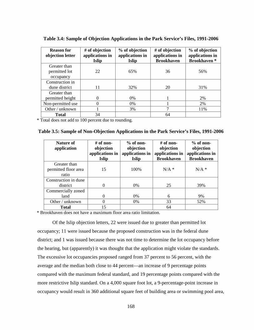
168
Table 3.4: Sample of Objection Applications in the Park Service’s Files, 1991-2006
Reason for objection letter
# of objection applications in
Islip
% of objection applications in
Islip
# of objection applications in
Brookhaven
% of objection applications in Brookhaven *
Greater than permitted lot occupancy
22
65%
36
56%
Construction in dune district
11
32%
20
31%
Greater than permitted height
0
0%
1
2%
Non-permitted use 0 0% 1 2% Other / unknown 1 3% 7 11%
Total 34 64 * Total does not add to 100 percent due to rounding. Table 3.5: Sample of Non-Objection Applications in the Park Service’s Files, 1991-2006
Nature of
application # of non-objection
applications in Islip
% of non-objection
applications in Islip
# of non-objection
applications in Brookhaven
% of non-objection
applications in Brookhaven
Greater than permitted floor area
ratio
15
100%
N/A *
N/A *
Construction in dune district
0
0%
25
39%
Commercially zoned land
0
0%
6
9%
Other / unknown 0 0% 33 52% Total 15 64
* Brookhaven does not have a maximum floor area ratio limitation. Of the Islip objection letters, 22 were issued due to greater than permitted lot
occupancy; 11 were issued because the proposed construction was in the federal dune
district; and 1 was issued because there was not time to determine the lot occupancy before
the hearing, but (apparently) it was thought that the application might violate the standards.
The excessive lot occupancies proposed ranged from 37 percent to 56 percent, with the
average and the median both close to 44 percent—an increase of 9 percentage points
compared with the maximum federal standard, and 19 percentage points compared with the
more restrictive Islip standard. On a 4,000 square foot lot, a 9-percentage-point increase in
occupancy would result in 360 additional square feet of building area or swimming pool area,
169
and since lot occupancy does not include walkways, the actual portion of the lot that is
covered by surfaces could be much higher than indicated in these applications.
The sampled applications that did not result in objection letters in Islip all involved
exceedences of Islip’s floor area ratio maximum of 0.30, as did 10 of the applications that did
result in objections. Of the non-objection applications, the average requested floor area ratio
was 38.56 (a 28 percent increase over the maximum), while the median was 35.75 (a 19
percent increase). These increases are potentially significant; on a 4,000 square foot lot, an
increase in floor area ratio equivalent to the median requested would result in 230 additional
square feet—easily enough for an extra bedroom. If this floor area increase were added
entirely to the second floor of a building, it would not trigger a lot occupancy variance,
although the possibility for impacts from increased human occupation would be present.
In Brookhaven, the sample included 62 randomly chosen records that resulted in
objection letters (approximately 40 percent of the total) and 64 records that did not result in
objection letters (approximately 10 percent of the total). In the sample, the ratio of
applications that resulted in objections to those that did not in Brookhaven was different than
in Islip to reflect the greater number of non-objection applications forwarded to NPS in
Brookhaven, and also to allow for an enhanced sample of the commercial applications that
did not result in objection letters (as it turned out, the commercial applications were not of
particular interest). Again, the 64 non-objection records chosen were not randomly chosen,
but rather were selected because they contained enough information to make reviewing them
worthwhile. In addition, one out of every two non-objection applications that involved
construction in the dune district was selected, thereby weighting the sample toward those
types of applications.
Of the Brookhaven sample, 36 of the applications that resulted in objection letters
requested lot occupancy variances. The average lot occupancy requested was 48.5 percent,
and the median was 45.8 percent, with the range extending from 36.3 percent to 83.9 percent.
Both the average and the median are over ten percentage points higher than the federal
maximum of 35 percent. Twenty of the applications resulted in objections because they were
in the dune district, including four of the lot occupancy variance requests. Two of the
remaining objectionable applications requested height variances, one involved a preexisting
170
illegal use as a two-family home, and the remaining seven applications were chosen for
objections because the applications were unclear, or for other unknown reasons. It should be
noted that several of the applications that resulted in objection letters had lot occupancies that
already exceeded the maximum but did not appear to request a further increase in lot
occupancy. Typically, an application that did not involve an expansion would not be subject
to an objection letter, so they may have been seeking approvals for illegally constructed or
expanded dwellings; alternatively, NPS may have found that the proposal was likely to cause
significant harm to the natural resources of the seashore, a subjective judgment that requires
a more detailed review than simply determining whether the application violates the
standards.
Of the non-objection applications in the Brookhaven sample, 25 were in the dune
district, but involved expansions up to less than 35 percent of lot area or the relocation of a
dwelling. Six involved commercially zoned lands and the remainder appeared to be ordinary
applications within the RD zone. There are two possible reasons why these last applications
were referred to NPS: they may have involved variances other than lot occupancy, use or
height, such as setbacks; or, as we suggested above, they may simply have been directed to
FINS without regard for whether the federal regulations required it.
It is apparent from this analysis that applications that might merit an objection letter
from the perspective of impacts on FINS (and, therefore, incompatibility with legislative
intent) are getting through without one because the regulations are so narrowly focused on lot
occupancy. A number of applications in Brookhaven requested a significant increase in floor
area ratio, but without an increase in lot occupancy, NPS did not issue an objection letter. In
Brookhaven, a number of cases involved reconstruction or expansion in the dune district
which was permitted by ordinance, and perhaps even consistent with the federal standards,
but which was very likely to exacerbate erosion by restricting dune formation. Again, no
objection letter could be issued, and the number of these cases is probably understated
because the dune district has literally drifted out to sea over the years without being
remapped, so that some building within the community development district is actually
taking place on the dune. There were also cases in both municipalities where pre-existing
buildings that exceeded lot occupancy, sometimes significantly, were not issued objection
171
letters—again, likely because of the nonconforming use provisions in the federal standards.
At the same time, it appears that in both Brookhaven and Islip, the Seashore’s resources were
partly misdirected toward the review of applications that were not objectionable, either
because the towns failed to follow the required procedures for referring applications to NPS
or had zoning standards that varied significantly from the federal standards.
The next section of this report will follow a selection of applications in Brookhaven
and Islip to the conclusion of the municipal review process in order to determine the extent to
which the approving boards were willing to say no to the excessive variances that have been
routinely requested on the island.
Building Permits Granted: Detailed Evidence from Local Records
As has been described earlier in this chapter, researching the local agency decisions
on the development applications found in the Seashore’s files has been difficult. Until the
early part of this decade, Brookhaven did not have a practical system for filing permit
records. Application and approval records were filed not by date, lot number or street
address, but by a peculiar so-called “metes and bounds” system that involved ascertaining the
nearest intersection to the subject site and counting the number of feet from that intersection
to the site. The use of this convoluted and error-prone filing system has unfortunately
rendered much of the Town’s development permit archive inaccessible for systematic
research. Islip’s archives were until recently stored on microfilm; while the Town has begun
digitizing the old records, the process is not yet complete, and the microfilm files are not
easily accessible. In both municipalities, local records from the sample of properties taken
from NPS files were examined.
Building department records for 31 out of the sample 49 records were located in
Islip’s digitized archive, including cases back to 1995. In most instances the decision of the
Zoning Board of Appeals were studied, and in others the records of the actual building
permits granted were used.
Although Zoning Board of Appeals decisions were not available for Brookhaven, 46
building permit approvals, a majority of the sample records from 2001 to 2005 were
available for inspection.
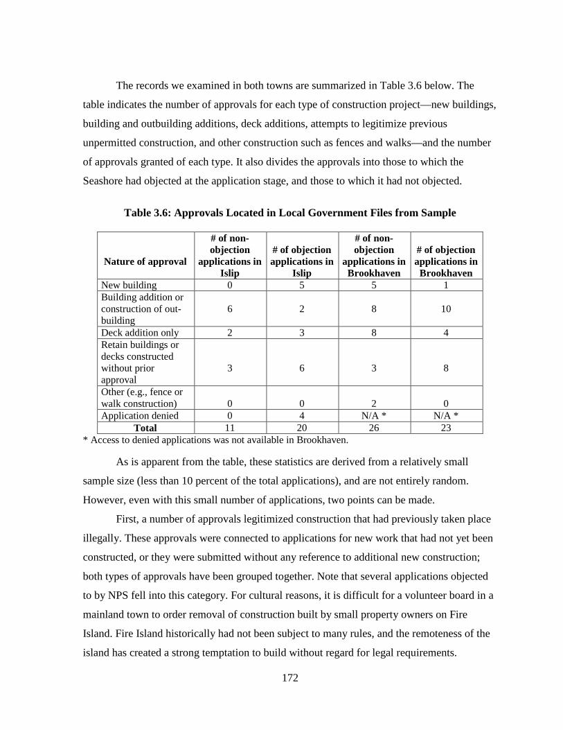
172
The records we examined in both towns are summarized in Table 3.6 below. The
table indicates the number of approvals for each type of construction project—new buildings,
building and outbuilding additions, deck additions, attempts to legitimize previous
unpermitted construction, and other construction such as fences and walks—and the number
of approvals granted of each type. It also divides the approvals into those to which the
Seashore had objected at the application stage, and those to which it had not objected.
Table 3.6: Approvals Located in Local Government Files from Sample
Nature of approval
# of non-objection
applications in Islip
# of objection applications in
Islip
# of non-objection
applications in Brookhaven
# of objection applications in
Brookhaven New building 0 5 5 1 Building addition or construction of out-building
6
2
8
10
Deck addition only 2 3 8 4 Retain buildings or decks constructed without prior approval
3
6
3
8
Other (e.g., fence or walk construction)
0
0
2
0
Application denied 0 4 N/A * N/A * Total 11 20 26 23
* Access to denied applications was not available in Brookhaven. As is apparent from the table, these statistics are derived from a relatively small
sample size (less than 10 percent of the total applications), and are not entirely random.
However, even with this small number of applications, two points can be made.
First, a number of approvals legitimized construction that had previously taken place
illegally. These approvals were connected to applications for new work that had not yet been
constructed, or they were submitted without any reference to additional new construction;
both types of approvals have been grouped together. Note that several applications objected
to by NPS fell into this category. For cultural reasons, it is difficult for a volunteer board in a
mainland town to order removal of construction built by small property owners on Fire
Island. Fire Island historically had not been subject to many rules, and the remoteness of the
island has created a strong temptation to build without regard for legal requirements.
173
Second, there were only a few denials. Partly, this is due to the difficulty in obtaining
records (particularly in Brookhaven where records of denied applications were unavailable),
but it is still significant that many applications objected to by NPS were approved. In at least
one case, the local government’s file included a memorandum acknowledging the NPS
objection but stated that since FINS was unwilling to back up its objection with
condemnation proceedings, the project would be approved.445
Third, almost all of the sample approvals dealt with new buildings, additions to
buildings and deck additions, rather than such matters as the construction of walks and
fences, or changes in use, in addition to the fact that the sampling procedure led to greater
consideration of larger applications. There are two reasons to support this result. First, most
fence and walk construction takes place outside the bounds of the land use regulatory system,
as do changes in use, i.e., the barely acknowledged conversion of single-family dwellings
into guest houses. This is a problem in itself, since both fences and walks are self-evidently
artificial structures that interfere with natural processes such as wildlife movement and dune
formation, and they should be subject to scrutiny. The second reason is at the root of the land
use conflict on Fire Island; nature has dictated that the island is subject to constant erosion,
yet the real estate market has dictated that houses on the island are subject to pressures for
endless expansion. Descriptions of a few of the approvals granted are listed below:
• 4x24 deck with stairs; shower stall; hot tub; 1-story addition (closet); fireplace • 1-story guest house with enclosure under house; access walk, decks • 2 story residence with wraparound deck; roof deck; 6 bedrooms max. per Suffolk
Dept of Health • New 1 family 2 story residence with decks, walks, porch, shower, steps in 2003; 1st
floor additions, 2nd floor additions, etc., in 2004 • 793 square foot 2nd floor addition; 478 square foot 1st floor deck addition; 516
square foot 2nd floor deck addition; storage shed renovated to outdoor shower • Subdivide into 3 parcels, construct 2 2-story dwellings; lot size variance required
from wetlands overlay district (minimum 80,000 sq. ft. is permitted, where 9,000 sq. ft. is proposed).
With the exception of the subdivision in the Islip wetlands overlay district, these are
not atypical projects. Looking back to Chapter One, a question arises: How do any of these
445 Islip Department of Planning and Development Interoffice Memorandum from Thomas A. Isles to Ruth Desart regarding Building Permit Application 0500-497-02-018, May 6, 1999.
174
projects square with the legislators’ and bill drafters’ apparent belief at the time the Seashore
was established that they could protect Fire Island from growth and retain compatibility
between the developed communities and surrounding public lands? Obviously none of them
do. In light of this examination of the mechanisms of the land use regulatory system in place
on Fire Island, the fact that these types of projects are approved on a routine basis is a strong
indication that the system contains too many conflicting demands to be able to implement the
intent of the legislation for the developed communities; or, to simplify, the system
fundamentally does not work in the public interest.
Before turning to possible solutions to this problem, we will briefly describe four
ancillary land use approval processes that contribute to development outcomes on Fire
Island, but are nowhere acknowledged in the federal regulations.
Suffolk County Septic Regulations
In states like New York, where all lands are within organized municipalities that at
least theoretically have their own planning and zoning powers, the county occupies an uneasy
position in land use control. Although it may conduct planning, the county has little or no
sway over the municipalities within it. As a result, some states have moved to abolish
counties; Connecticut, for example, no longer has any county governments. New York,
however, continues to assign some functions to counties which may include specific health
and safety related regulations and additional support to municipalities; Nassau County, for
example, manages an extensive array of Geographic Information Systems data for all the
municipalities in its purview.
In Suffolk County, although some development applications are referred to the
County Planning Commission for opinions, it is actually the county’s Health Department that
has the potential say over land use on Fire Island. Because Fire Island does not have
centralized sewer systems, the residences on the island rely on individual subsurface septic
disposal systems for waste disposal. These systems require a permit from the Suffolk County
Health Department prior to installation, and the County has a set of regulations that govern
them. A septic system is a holding tank designed to separate the biological components of
human waste allowing them to filter into the surrounding soil. If too many septic tanks are
175
installed within a given area, the ability of the soil to absorb the discharged waste is at risk;
additionally, groundwater contamination may result, which is a problem in areas of Fire
Island that utilize groundwater as their water supply. The specific location and density
requirements for septic tanks are typically a function of soil type; however, a common rule of
thumb for land use planning in areas served by individual septic systems is that a minimum
of 1 to 1.5 acres is required for each single-family dwelling. Depending on soil type, the
minimum threshold may actually be much higher; for example, a model commonly used in
New Jersey, known as a nitrate dilution model, predicts minimum lot size needed to protect
groundwater based on recharge rate: at slower recharge rates, minimum lot sizes as high as
20 acres may be needed.446
The Suffolk County Health Department’s regulations allow individual septic systems
to be installed only in areas with a minimum lot size of 20,000 square feet (approximately
1/2 acre) or, in certain areas, 40,000 square feet.
This model is less applicable to Fire Island, where drinking water
is drawn from great depth, but septic discharges into the island’s soils pose environmental
threats to its ecosystem from nutrients and toxic chemicals, since these materials will
eventually reach the waters of the bay.
447 This requirement, although less stringent
than the planners’ rule of thumb discussed above, would appear to preclude the use of septic
systems in Fire Island’s developed communities. However, the code includes a process to
obtain a variance from the standards, as well as a blanket waiver for parcels that were shown
as being separately assessed on a tax map as of January 1, 1981.448 Additionally, the Health
Department has special guidelines for treating pre-existing dwellings449 and the rebuilding of
septic systems destroyed in a coastal storm,450
446 New Jersey Department of Environmental Protection, “Technical Guidance: A Recharge-Based Nitrate-Dilution Model for New Jersey,” July 2001, p. 21.
both of which are favorable to property
owners. As a result, septic systems on lots far smaller than the County’s minimum standards
are routinely approved. If the County’s standards were applied more restrictively, most lots
on Fire Island would not be buildable.
447 Suffolk County Sanitary Code, Article 6, §760-606. 448 Suffolk County Sanitary Code, Article 6, §760-609. 449 Suffolk County Department of Health Services General Guidance Memorandum #12, June 8, 2000. 450 Suffolk County Department of Health Services General Guidance Memorandum #11, February 14, 2000.
176
While that outcome might be unreasonable, one might question why Suffolk County
has not developed a special set of standards for the island that acknowledges its unique
environment and strongly seasonal patterns of dense habitation. Many development
applications reviewed involve the construction of additional bathrooms and outdoor showers
used heavily in the summer by property owners and their guests, and scarcely used other
times of the year. The effect this intense seasonal usage has on the island’s groundwater,
soils and the biological health of the bay is not reflected in the regulations, which are
designed for mainland properties used year-round in a much different physical environment.
In 2004, the United States Geological Survey and NPS began studying the island’s
groundwater system, in part to determine the flow of contaminants;451
this study may hold
promise for the development of new septic regulations.
State Land Use Regulations
FINS was designated at a time in history just prior to the large scale enactment of
environmental regulation throughout the country. Within the two decades following the
Seashore’s establishment, landmark federal environmental laws such as the Coastal Zone
Management Act (CZMA) and NEPA, along with their state counterparts, had begun a shift
from largely local control over land use policy-making to an enhanced state and federal role
in setting policy direction.452
None of these laws were in place in 1964, and the act creating FINS was therefore
crafted under the old model of land use policies that were set exclusively by local
governments. This model had been significantly weakened by the 1980s, when the Act’s
current version was put in place, but the Act was not changed to acknowledge the new
reality. As a result, the effect of these new federal and state environmental laws has been to
create an additional, completely separate layer of regulation on top of the Seashore’s
regulations and the local regulations.
While responsibility for implementing these acts was typically
handed to local governments, the policies themselves were created at higher levels.
451 “Simulation of the Shallow Ground-Water Flow System at Fire Island National Seashore, Long Island, New York.” http://ny.cf.er.usgs.gov/nyprojectsearch/projects/2457-BUF-1.html, retrieved November 21, 2007. 452 The Coastal Zone Management Act, adopted in 1972, significantly expanded the federal role in coastal regulation. See Timothy J. Beatley, David J. Brower and Anna K. Schwab, An Introduction to Coastal Zone Management, 2nd ed., Washington: Island Press, 2002.
177
Three state environmental laws are of interest on Fire Island: the Coastal Erosion
Hazard Areas Act, the Tidal Wetlands Act and the State Environmental Quality Review Act.
The Coastal Erosion Hazard Areas (CEHA) Act was enacted in 1981 as part of New York’s
implementation of the federal CZMA although the line was not fully mapped on Fire Island
until 1998 and not implemented until 2001.453 The CEHA Act provided for the Department
of Environmental Conservation (DEC) to map “coastal erosion hazard areas,” which include
shoreline lands likely to be subject to erosion over a 40-year period, as well as lands which
constitute natural protective features, “the alteration of which might reduce or destroy the
protection afforded other lands against erosion, or lower the reserves of sand or other natural
materials available to replenish storm losses through natural processes.”454 Under the terms
of this legislation, a coastal erosion hazard area has been designated on Fire Island including
the beach, the primary dune, and the area 25 feet landward of the landward toe of the primary
dune. The landward boundary of the CEHA is referred to as the CEHA line. The regulations
implementing the CEHA Act prohibit most development on the beach and on the primary
dune, and require that a permit be obtained for new construction on the secondary dune.455
The regulations also contain a variance procedure.456
The designation of the CEHA line and the approval process by which it has been
implemented has had an interesting effect on the enforcement of the federal regulations.
Because the federal dune district line is now located seaward of the actual dunes, the CEHA
line has become effectively a de facto dune district boundary. NPS objections sometimes
refer to a property’s location seaward of the CEHA line,
Enforcement of the CEHA line within
Islip rests with the DEC, but has been delegated to the local government in Brookhaven.
457 even though the federal
regulations make no mention of this line. Unfortunately, like the dune district line, the CEHA
line has not been remapped despite shifts in the dune line, meaning that it, too, will likely
become obsolete in the future.458
453 E-mail communication from Diane Abell, July 15, 2008.
454 New York State Environmental Conservation Law, Article 34, Section 34-0103. 455 6 NYCRR §505.8. 456 6 NYCRR §505.13. 457 See, for example, correspondence L-415 from FINS Superintendent Mark Reynolds to Marvin Colson, Chairman of the Brookhaven Board of Zoning Appeals, regarding the application of David Sloan, December 7, 2005. 458 Conversation with Diane Abell, Park Planner, February 21, 2006.
178
The Tidal Wetlands Act was enacted by New York State in 1973 to “preserve and
protect tidal wetlands, and to prevent their despoliation and destruction, giving due
consideration to the reasonable economic and social development of the state.”459 The
regulations implementing the Act provided that tidal wetlands be inventoried and mapped,
and that most development activities be prohibited on tidal wetlands or within buffers
extending 75 feet landward of a tidal wetland.460
The State Environmental Quality Review Act (SEQRA) is the third state land use act
that has significant bearing on Fire Island. This act is patterned after the NEPA which
requires that environmental impact assessments be undertaken for most federal projects, but
covers a much broader range of projects including much private development. The rules for
assessment are set in state law and regulation,
As with the CEHA Act, a variance
procedure is included. The Tidal Wetlands Act affects parts of Fire Island with tidal wetlands
mapped by the DEC, generally near the bay side of the island.
461
SEQRA is a very complex act, and its workings are largely outside the focus of this
report. However, it merits a brief discussion here because some projects on Fire Island are
subject to it. For projects larger than a single-family or two-family house, which, along with
other minor projects, are excluded from SEQRA review, SEQRA has become as important as
local planning and zoning in assisting municipalities in making decisions about land use.
but implementation is the responsibility of
everyone who carries out and approves projects.
Despite the exclusion of one- and two-family houses from SEQRA, the act is relevant
in certain aspects of development on Fire Island. Projects, including one- and two-family
homes, which are adjacent to publicly owned parkland or open space, are listed as “Type I”
actions in the SEQRA regulations, which means that they are prejudged as being likely to
have a significant environmental impact and require heightened scrutiny.462
459 New York State Environmental Conservation Law, Article 25, Section 25-0102.
In addition,
municipalities may designate additional types of projects as Type I actions. Brookhaven has
determined that projects within designated critical environmental areas require SEQRA
460 6 NYCRR §661. Islip subsequently adopted a tidal wetlands overlay zone that provided for a 100-foot buffer. 461 6 NYCRR §617 et seq. 462 6 NYCRR §617.4(a).
179
review; however, Fire Island is explicitly excluded from the list of critical environmental
areas, which includes Brookhaven’s other coastal areas.463
Thus, certain projects on Fire Island are subject to SEQRA. These projects require
significantly more investigation into their environmental impacts than projects not subject to
SEQRA, providing opportunity for environmental analysis not afforded by the federal/local
zoning system. NPS has submitted opinions and analysis advocating for its positions in
projects subject to SEQRA.
464
Federal Flood Insurance Program
In any coastal area, the cost and availability of flood insurance are influential in
affecting land use patterns. As Platt, Scherf and O’Donnell have found,465 the National Flood
Insurance Program (NFIP) in 1994 had assumed $1.2 billion in liability within the towns of
Islip and Brookhaven, including both Fire Island and the mainland. Platt has found that the
NFIP lost $1.1 billion between 1986 and 1997; the NFIP has also been criticized for failing
to account for long-term erosion466 which has resulted in a systematic underestimation of
risks. Platt, Scherf and O’Donnell have detailed how, in the early 1990s, Congress resisted
reforming the program to reduce its liability, in part due to lobbying by Fire Island property
owners.467
As a result, the flood insurance program continued to assess risk using the same
methodologies, contributing to building and rebuilding on Fire Island and other coastal
communities, that might not have occurred under a more solvent insurance program.
463 Brookhaven code, Chapter 80, Appendix A. 464 See, for example, correspondence L-1415, cited above, on p. 18 of which the Superintendent argues that the Brookhaven Town Board is obliged to require an EIS under SEQRA for the issuance of a development permit. 465 Rutherford H. Platt, David Scherf and K. Beth O’Donnell, “Fire Island: The Politics of Coastal Erosion,” Disasters and Democracy, Washington: Island Press, 1999, p. 189. 466 Beatley, Brower and Schab, p. 125. 467 Platt, Scherf and O’Donnell, p. 197.
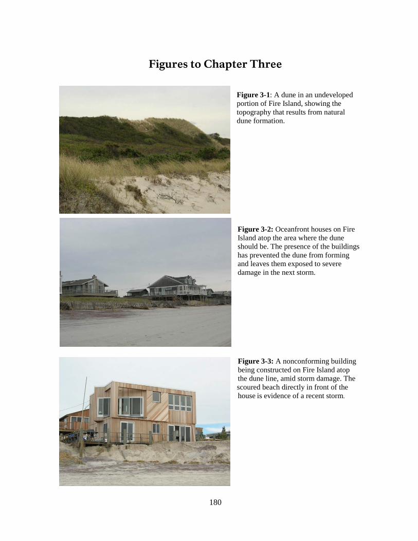
180
Figures to Chapter Three
Figure 3-1: A dune in an undeveloped portion of Fire Island, showing the topography that results from natural dune formation. Figure 3-2: Oceanfront houses on Fire Island atop the area where the dune should be. The presence of the buildings has prevented the dune from forming and leaves them exposed to severe damage in the next storm.
Figure 3-3: A nonconforming building being constructed on Fire Island atop the dune line, amid storm damage. The scoured beach directly in front of the house is evidence of a recent storm.
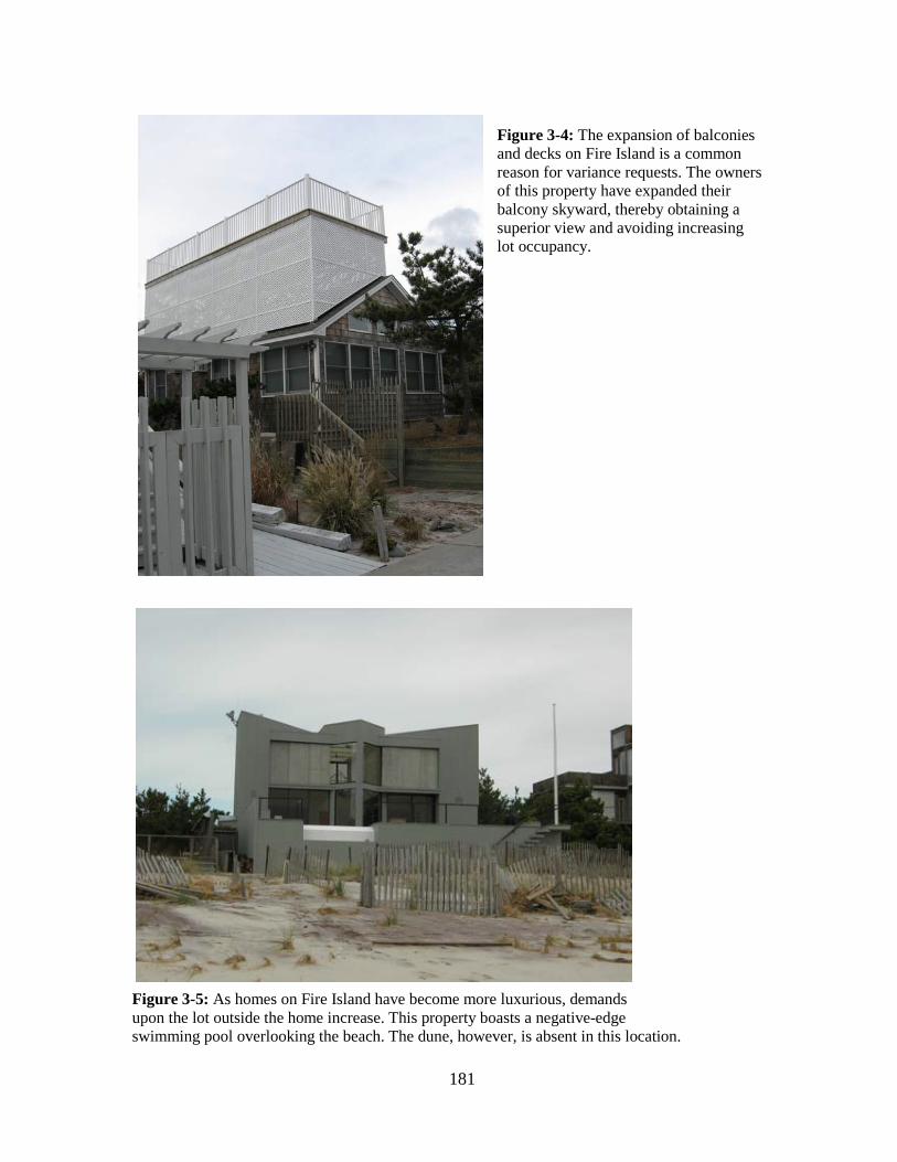
181
Figure 3-4: The expansion of balconies and decks on Fire Island is a common reason for variance requests. The owners of this property have expanded their balcony skyward, thereby obtaining a superior view and avoiding increasing lot occupancy.
Figure 3-5: As homes on Fire Island have become more luxurious, demands upon the lot outside the home increase. This property boasts a negative-edge swimming pool overlooking the beach. The dune, however, is absent in this location.

182
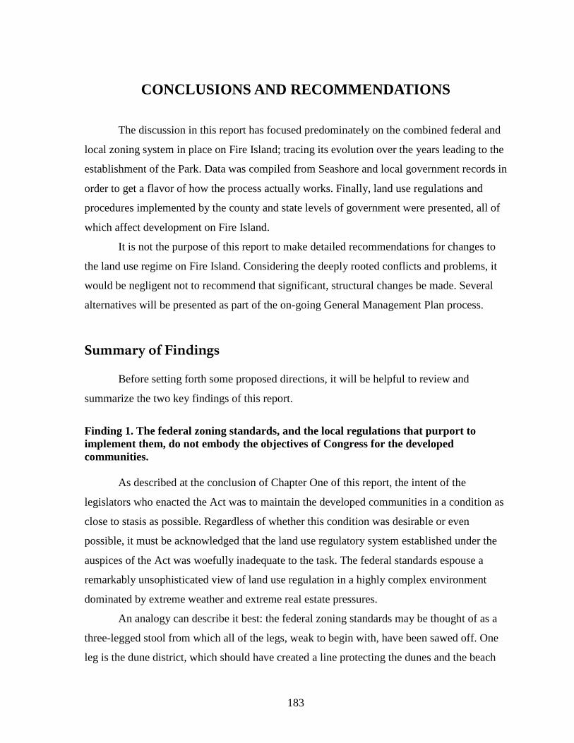
183
CONCLUSIONS AND RECOMMENDATIONS The discussion in this report has focused predominately on the combined federal and
local zoning system in place on Fire Island; tracing its evolution over the years leading to the
establishment of the Park. Data was compiled from Seashore and local government records in
order to get a flavor of how the process actually works. Finally, land use regulations and
procedures implemented by the county and state levels of government were presented, all of
which affect development on Fire Island.
It is not the purpose of this report to make detailed recommendations for changes to
the land use regime on Fire Island. Considering the deeply rooted conflicts and problems, it
would be negligent not to recommend that significant, structural changes be made. Several
alternatives will be presented as part of the on-going General Management Plan process.
Summary of Findings
Before setting forth some proposed directions, it will be helpful to review and
summarize the two key findings of this report.
Finding 1. The federal zoning standards, and the local regulations that purport to implement them, do not embody the objectives of Congress for the developed communities.
As described at the conclusion of Chapter One of this report, the intent of the
legislators who enacted the Act was to maintain the developed communities in a condition as
close to stasis as possible. Regardless of whether this condition was desirable or even
possible, it must be acknowledged that the land use regulatory system established under the
auspices of the Act was woefully inadequate to the task. The federal standards espouse a
remarkably unsophisticated view of land use regulation in a highly complex environment
dominated by extreme weather and extreme real estate pressures.
An analogy can describe it best: the federal zoning standards may be thought of as a
three-legged stool from which all of the legs, weak to begin with, have been sawed off. One
leg is the dune district, which should have created a line protecting the dunes and the beach
184
from development. This line has never been remapped despite the island’s erosion, so this leg
has literally been washed out to sea.
The second leg represents the regulations for the community development district.
Unfortunately, this leg is hollow, because it relies entirely on the simplistic measure of lot
occupancy—that is, land coverage by buildings. Other structures such as walks and fences
are ignored by federal standards regardless of their environmental effects, as are the
expansions of building and deck areas onto upper stories, which increase population density
on the island just as much as ground-floor expansions do. Septic systems have potentially
significant environmental effects on the island, however, construction of them is very weakly
regulated by the County and not addressed at all by the federal lot-occupancy standard.
The final leg is the power of land acquisition, which theoretically threatens any
property not in compliance with the zoning; this leg was removed decades ago when
Congress stopped appropriating funds to acquire properties.
Even if the stool were still standing, it would hardly be adequate to confront the
challenges that face the barrier island. The unsophisticated model of zoning that informs the
federal standards was already obsolete when FINS was established; it is good at protecting
residential areas from commercial intrusion and not much else, and was never designed as a
means of regulating land use in a fragile environment.
The weakness of the federal/local zoning system is underscored by the importance of
New York State’s CEHA and SEQRA Acts, which are nowhere referenced in the federal
standards in assisting NPS fight inappropriate development. The state CEHA line has
essentially replaced the federal dune district line, and where SEQRA applies, it provides a
significant opportunity to document potential environmental impacts so that more informed
decisions can be made.
Finding 2. Review of the zoning history and data shows that even if the federal and local zoning standards were appropriate for the task, the local governments themselves have proven incapable of implementing the congressional intent.
Notwithstanding recent efforts by both Brookhaven and Islip to cooperate more fully
with NPS—for example, Islip now, for the first time, has a system in place to notify Fire
Island applicants that their properties are subject to heightened scrutiny—this study has
185
shown that, on the whole, the assignment of zoning and building code enforcement to
Brookhaven and Islip has significantly hindered implementation of the legislation. It took
Brookhaven 20 years to adopt zoning standards that were somewhat consistent with the
federal standards, while Islip has never done so. Over time, application after application for
expansion of houses and construction on the dunes has been approved regardless of NPS
objections. The towns’ failure to comply with the federal standards for referrals to the
Seashore has created excess paperwork that has drained the Park’s limited resources for
application review. Too often, the Seashore has been put in the position of begging the local
governments to enforce the rules.
For their part, Brookhaven and Islip are massive, sprawling jurisdictions that
undeniably have more pressing concerns than regulating the construction of resort houses on
an inaccessible barrier island used three months of the year. The isolation of the island makes
inspections difficult, and much construction is done surreptitiously in the off-season; many of
the zoning applications approved by both towns were simply to legitimize construction that
had already taken place without a permit. The well-known culture of corruption in the area
has undoubtedly contributed to these problems.
Recommendations
The Park is currently preparing a new GMP, which is an opportunity to consider
alternative structures for the land use regulatory system for the developed communities
within FINS. There is no doubt that the system adopted in the 1960s is broken beyond repair,
but fortunately the field of land-use regulation has evolved significantly in the past four
decades, and today we can suggest several specific substantive and procedural regulatory
changes that we believe would help solve the problems we have identified in this report.
The following substantive changes to the federal zoning standards should be
considered:
• The dune district boundary should be made identical to the Coastal Erosion Hazard Area (CEHA) line, provided that the CEHA statute is modified to state that an artificial manipulation of the dune line (for example, a dune fill project) does not
186
constitute a change in the primary dune line.468
• The current zoning system should be replaced by a more sophisticated performance-based approach that ties approvals to environmental impacts. Standards should be adopted for all aspects of development with the potential to create impacts, including maximum lot coverage by buildings, walks and other structures; maximum floor area ratio for buildings alone; maximum floor area ratio for buildings plus decks; and the installation and expansion of septic systems. This approach would set targets for the performance of these critical measures of development intensity based on the carrying capacity of the island to support growth. It is recommended that planning be carried out to determine that capacity and the specific standards that could be allowed. While this planning process is underway, it is recommended that interim controls be established to prevent the situation from deteriorating.
This would eliminate overlapping regulations and facilitate remapping. Naturally, the CEHA line also needs to be enforced rigorously by approval authorities. No regulation is effective without enforcement. The other problem with the CEHA line—that it has not been remapped—will be addressed in the procedural recommendations to follow.
• Applicants should be required to document and provide more information about natural resources when submitting plans for development. On a barrier island, each storm potentially reshapes the natural system, yet lines drawn on maps by bureaucracies can never be redrawn quickly enough. There should be an island-wide checklist of natural resource information—dunes, wetlands, woodlands, habitat—that must be provided by each applicant.
These proposed substantive regulations, if implemented, would begin to replace the
current collapsing three-legged stool with a firmer four-legged chair: one leg, the CEHA line;
the second leg, a performance-based zoning system with a set of interlocking regulations that
address all of the complex problems that exist in the island’s developed communities; the
third, a uniform, island-wide checklist of information to be provided with applications, which
would ensure that development proposals receive adequate, consistent scrutiny; and the
fourth leg of this new chair would be a new administrative structure for the island’s approval
and permitting processes.
We conclude with recommended structural changes to the land-use procedures. At the
time of the establishment of FINS, there was a dearth of models for regulating private lands
within a park—hence the adoption of the Cape Cod model for Fire Island—but today, that is
happily no longer the case. In fact, within a few hours’ drive of Fire Island, there are three
468 This change would ensure that an artificial dune fill project could not result in the line being remapped seaward inappropriately.
187
significant examples of regulatory systems for private land within a public park or reserve,
one of which is practically in Fire Island’s backyard. These examples include the following:
• The Central Pine Barrens Commission on Long Island, part of which occupies the northeastern section of Brookhaven. This area was designated a forested and wetlands reserve in 1993 and is governed by a commission consisting of representatives of the governor, the towns within its boundaries, and Suffolk County. There is also an advisory committee consisting of various stakeholders in the region. The commission has developed a comprehensive plan for its jurisdiction and established a transfer of development rights program. It manages a development permitting program for projects that meet specified criteria.
• The Adirondack Park Agency in upstate New York, created in 1971, manages a vast forested park encompassing several counties and extensive private landholdings. This agency has a board appointed by the governor which develops a long-term plan for the park. NPS also administers the park’s land-use regulatory system.
• The Pinelands Commission in New Jersey, similar to the Adirondack Park Agency, manages a very large forested reserve with extensive private landholdings. The Pinelands Commission was created as part of a partnership between the federal and state governments. The federal government in 1978 designated the Pinelands as a National Reserve and subsequently worked with the state to establish a commission to manage the reserve. The commission is largely state-controlled; it has seven members appointed by the governor; seven members appointed by the counties within its jurisdiction; and one member appointed by the Secretary of the Interior. It prepares a comprehensive management plan for the Pinelands and manages an extensive land use planning and regulatory program including a transfer of development rights scheme. There is also a municipal council for municipalities within the Pinelands area.
It is suggested that the State constitute a commission for Fire Island along the lines of that used by Adirondack Park or the New Jersey Pinelands.
Because Fire Island has a diverse group of stakeholders that do not necessarily have
close ties to Islip and Brookhaven, a significant number of gubernatorial appointments to
such a commission would help ensure adequate representation from all groups—something
that is sorely lacking in the current system. The Seashore itself should have guaranteed
appointments on the commission, while other seats could be reserved for appointees from
various constituencies—for example, representatives of the towns and villages,
representatives of property owners who live away from the island, year-round residents of the
island, and so on.
188
It is further recommended that such a commission be fully responsible for land use planning, zoning, permitting and enforcement on the island, with the possible exception of the two incorporated villages.
Islip and Brookhaven, whatever their intentions, have been given ample opportunity
and have shown that they are not able to manage land-use effectively or in the public interest
on Fire Island. A commission with adequate representation by all stakeholders, including
property owners and the Seashore itself, would be in a much better position to create plans
and zoning regulations consistent with federal objectives; undertake needed studies such as
remapping the CEHA line; evaluate development applications or appoint a zoning board to
do so; and manage permitting and enforcement. The planning system would require external
funding, but the application and permitting system could potentially be self-financing
through application and permitting fees. Ocean Beach and Saltaire could continue to
maintain their current systems or be subsumed into the new system.
If necessary, an advisory committee similar to that established for the Central Pine
Barrens could also be established. Such a committee could perform a watchdog role for the
commission, and give voice to groups that might not be fully represented on the commission.
189
BIBLIOGRAPHY Major Sources and Collections for Chapters One and Two
The major source collections consulted were government files and repositories. Files before 1991 at the Seashore offices are stored in the Annex building and are poorly preserved and poorly organized. The library possesses an extensive set of binders containing newspaper clippings from 1962 to 1982 and 1996 through 2002. The Washington office of the NPS contains two important series of files: Park History and Park Planning. A complete copy of the House subcommittee hearings was obtained courtesy of the Department of Special Collections at the library of SUNY Stony Brook, while the unpublished House transcripts were obtained from the main branch of the National Archive in Washington, D.C. Other Congressional documents, more widely available, were consulted at the law library of Columbia University. Within each section, sources are listed in chronological order. Short form citations used in footnotes are indicated in square brackets. Legislation All Fire Island acts, and the relevant portions of omnibus acts, are reprinted in “Legislative History of Fire Island National Seashore,” a brochure produced by Fire Island National Seashore (nd). [P.L. 88-587] “An Act to Establish the Fire Island National Seashore, and for Other Purposes,” Public Law 88-587, 88th Congress, September 11, 1964 [P.L. 89-244] “An Act to authorize the Secretary of the Interior to accept a donation of property in the county of Suffolk, State of New York, known as the William Floyd Estate, for addition to the Fire Island National Seashore, and for other purposes,” Public Law 89-244, 89th Congress, October 9, 1965 [P.L. 94-578] “An Act to provide for increases in appropriation ceilings and boundary changes in certain units of the National Park System, and for other purposes,” Public Law 94-578, 94th Congress, October 21, 1976 [P.L. 95-625] Public Law 95-625, 95th Congress, November 10, 1978 (short title: “National Parks and Recreation Act of 1978”)
190
[P.L. 96-585] “An Act to designate certain lands of the Fire Island National Seashore as the ‘Otis Pike Fire Island High Dune Wilderness,’ and for other purposes,” Public Law 96-585, 96th Congress, December 23, 1980 [P.L 98-482] “An Act to modify federal land acquisition and disposal policies carried out with respect to Fire Island National Seashore, and for other purposes,” Public Law 98-482, 98th Congress, October 17, 1984 Congressional Documents [Senate Hearing] Hearing before the Subcommittee on Public Lands of the Committee on Interior and Insular Affairs, United States Senate, Eighty-eighth Congress, First Session, on S. 1365, A Bill to Establish the Fire Island National Seashore, and for Other Purposes, December 11, 1963, U.S. Government Printing Office, 1964 [House Hearings] Hearings before the Subcommittee on National Parks of the Committee on Interior and Insular Affairs, House of Representatives, Eighty-Eighth Congress, on H.R. 3693, H.R. 4999, H.R. 6111, H.R. 6213, H.R. 6934, H.R. 6936, H.R. 7107, H.R. 7297, H.R. 7359, and H.R. 7512, Bills to Establish the Fire Island National Seashore in the State of New York, September 30, 1963 – Islip, N.Y., April 10, 1964 – Washington, D.C., (Serial No. 21), U.S. Government Printing Office, Washington, 1964 [Dept. Of Special Collections, SUNY Library, Stony Brook, NY] [House Subcommittee Transcript, May 12, 1964] “Transcript of Proceedings: House of Representatives, Committee on Interior and Insular Affairs, Subcommittee on National Parks, Executive Session, H.R. 7107, Washington, D.C. , May 12, 1964,” typescript, Washington, D.C., (Pages 1 thru 71), Veley Reporting Company (Unrevised and Unedited, Not for Quotation or Duplicated [sic] in any Form” [House Subcommittee Transcript, June 30, 1964] “Transcript of Proceedings, House of Representatives, Committee on Interior and Insular Affairs, Subcommittee on National Parks, H.R. 7107: Executive Session, Fire Island National Seashore, June 30, 1964,” typescript [pp. 72-109], Veley Reporting Company “Unrevised and Unedited, Not for Quotation or Duplicated [sic] in any Form” [House Committee Transcript, July 22, 1964] “Transcript of Proceedings, House of Representatives, Committee on Interior and Insular Affairs, H.R. 7107: Executive Session, Fire Island National Seashore, Washington, D.C., July 22, 1964,” typescript (Pages 1 thru 25), Washington, D.C., Veley Reporting Company, “Unrevised and Unedited, Not for Quotation or Duplicated [sic] in any Form”
191
[House Committee Transcript, July 28, 1964] “House of Representatives, Hearings before the Committee on Interior and Insular Affairs, H.R. 7107, To provide the establishment of Fire Island National Seashore....,” Official Reporters to Committees [July 28, 1964] [USGAO Report] U.S. General Accounting Office, “Report to the Honorable Daniel P. Moynihan, United States Senate: The National Park Service Should Improve Its Land Acquisition and Management at the Fire Island National Seashore,” U.S. General Accounting Office, May 8, 1981 [NPS-WASO, Planning Files] [Report 1984] U.S. House of Representatives, Committee on Interior and Insular Affairs, Report [To accompany H.R. 3697], September 24, 1984 (House of Representatives, 98th Congress, 2nd Session, Report 98-1065) Documents Prepared by or for the Department of the Interior and National Park Service [Circular, 1963] Recreation Advisory Council, “Federal Executive Branch Policy Governing the Selection, Establishment, and Administration of National Recreation Areas: Circular No. 1,” March 26, 1963; reprinted in Dilsaver, pp. 263-268 [Proposal] Fire Island National Seashore: A Proposal. A Report on the Fire Island National Seashore, U.S. Department of the Interior, Bureau of Outdoor Recreation and National Park Service, March, 1964 (NPS-WASO, Planning Files) [Proposed Zoning Standards] Fire Island National Seashore, Proposed Zoning Standards, Federal Register, vol. 30, no. 207, October 26, 1965, pp. 13678-13580 [Statement for Witness] “Statement for Witness for Department of the Interior Before the Subcommittee on Parks and Recreation, Senate Committee on Interior and Insular Affairs, Concerning S. 867, A Bill “To Amend the Act Establishing the Fire Island National Seashore,” November, 1975 [NPS-WASO, Planning Files, fol. FINS 1965-75] [Babcock] Richard F. Babcock, Esq., and Richard J. Roddewig, Esq. (for Ross, Hardies, O’Keefe, Babcock & Parsons), “Report to National Park Service on Fire Island National Seashore,” December 1, 1975 [copy provided by park]
192
[Model Zoning] Ross, Hardies, O’Keefe, Babcock & Parsons (Chicago), “Report to the National Park Service: Outline of Key Standards for Model Zoning Ordinance for Fire Island Communities,” November 29, 1976 [copy provided by park] [Summary] “Summary: Fire Island Community Land Use Control Problems, June 1976 NPS Draft Proposals for Land Use Controls, Public Comments, Planning Team Recommendations for Final GMP,” attached to Briefing Statement for Director, December 14, 1976: [NPS-WASO, Planning Files, fol. FINS 1965-75] [GMP, 1977] National Park Service, General Management Plan: Fire Island National Seashore, 1977 [Stewart and Ritenour] J.W. Stewart and J. Ritenour, “Draft Staff Report on Land Acquisition Review, Fire Island National Seashore,” September 14, 1979 (with covering memo, Fire Island Land Acquisition Review Task Force” to Stan Albright (Chairman, NPS Land Acquisition Policy Review), September 19, 1979 [NPS-WASO, Planning Files: fol: Fire Island Land Acquisition] [Land Acquisition Plan] “Land Acquisition Plan for Fire Island National Seashore,” p. [1] annot. “DRAFT 6/28/79,” attached to memo, Superintendent (Richard W. Marks) to Regional Director, NAR, August 14, 1979 [Draft Staff Report, 1979] “Draft Staff Report on Land Acquisition Review, Fire Island National Seashore,” September 19, 1979 [a document with the same title as the above but containing, according to the title page, a “compilation of comments received from persons interviewed….”] [NPS-WASO, Planning Files: fol Fire Island Land Acquisition] [Wilderness Study] Fire Island National Seashore, NY: Wilderness Study/Preliminary Wilderness Proposal, NPS, North Atlantic Regional Office, January, 1980. Bound with: “Draft Supplement to the Final Environmental Statement, General Management Plan: Wilderness Study/Preliminary Wilderness Proposal,” North Atlantic Regional Office, NPS, January, 1980 (approved by regional director, March 26, 1980). [NPS-WASO, Planning Files] [Final Rule, Jan. 1980] “Fire Island National Seashore, New York; Zoning Standards” (Final Rule), Federal Register, vol. 45, no. 12, January 17, 1980, pp. 3261-3270
193
[Final Rule, Sept. 1980] “Fire Island National Seashore, New York; Zoning Regulations” (Final Rule with additional public comments and revisions), Federal Register, vol. 45, no. 17, September 10, 1980, pp. 59569 ff. [Land Protection Plan] “Fire Island National Seashore: Land Protection Plan,” August, 1984 (approved by regional director, September 21, 1984) [Proposed Rule, Oct. 1987] “Fire Island National Seashore, New York; Federal Zoning Regulations,” Proposed Rule, Federal Register, vol. 52, no. 194, October 7, 1987, pp. 37586-37592. [Final Rule, Aug. 1991] “Fire Island National Seashore, New York; Federal Zoning Regulations,” Federal Register, vol. 56, no. 168, August 29, 1991, p.42788-42795 Other Government Documents and Court Papers [Executive Order 12630] Executive Order 12630, “Governmental Actions and Interference with Civil Constitutionally Protected Property Rights,” March 15, 1988. [Biderman v. Secretary of the Interior] George Biderman, et al, v. Secretary of the Interior, et al.: Memorandum Incorporating Findings of Fact and Order, United States District Court, Eastern District of New York, September 18, 1973 Press Coverage All references to news articles are drawn from clippings contained in binders in the library at the Seashore offices in Patchogue, Long Island. Secondary Sources [Dilsaver] Larry M. Dilsaver, ed., America’s National Park System: The Critical Documents, London, Rowman & Littlefield, 1994 [Koppelman and Forman] Lee Koppelman and Seth Forman. Fire Island National Seashore, 1964-2004. Draft Administrative History, June, 2004.
194
Major Sources and Collections for Chapter Three Cases, Regulations, and Statutes New York State Department of Environmental Conservation. “6 NYCRR 505: Coastal Erosion Management.” New York Codes, Rules and Regulations. Retrieved October 5, 2007 from http://www.dec.ny.gov/regs/. New York State Department of Environmental Conservation. “6 NYCRR 617: State Environ-mental Quality Review.” New York Codes, Rules and Regulations. Revised through June 26, 2000. New York State Department of Environmental Conservation. “6 NYCRR 661: Tidal Wetlands Land Use Regulations.” New York Codes, Rules and Regulations. Retrieved October 5, 2007 from http://www.dec.ny.gov/regs/. New York State Department of Health. “10 NYCRR Part 75: Standards for Individual Water Supply and Individual Sewage Treatment Systems.” New York Codes, Rules and Regulations. Retrieved October 5, 2007 from http://www.health.state.ny.us/nysdoh/phforum/nycrr10.htm. State of New York. “Article 8: Environmental Quality Review”; “Article 25: Tidal Wetlands”; “Article 34: Coastal Erosion Hazard Areas.” Environmental Conservation Law, Consolidated Laws of New York. Retrieved October 5, 2007, from http://public.leginfo.state.ny.us/menugetf.cgi?COMMONQUERY=LAWS. Suffolk County Department of Health Services forms and regulations. http://www.co.suffolk.ny.us/webtemp3.cfm?dept=6&id=982. Retrieved October 5, 2007. Suffolk County. “Article 6: Realty Subdivisions, Developments and Other Construction Projects.” Suffolk County Sanitary Code. Retrieved from http://www.co.suffolk.ny.us/webtemp3.cfm?dept=6&id=982 on October 5, 2007. Town of Bedford v. Village of Mount Kisco, 33 NY2d 178, 188 (1973). Town of Brookhaven. “Chapter 76: Coastal Erosion Hazard Areas”; “Chapter 80: Critical Environmental Areas; SEQR Implementation”; “Chapter 81: Wetlands and Waterways”; “Chapter 85: Zoning.” Code of the Town of Brookhaven, New York. Retrieved from http://www.generalcode.com/webcode2.html on October 5, 2007. Town of Islip. “Chapter 13B: Environmental Quality Review”; “Chapter 67: Wetlands and Watercourses”; “Chapter 68: Zoning.” Code of the Town of Islip, New York. Retrieved from http://www.generalcode.com/webcode2.html on October 5, 2007.
195
United States Government Printing Office. “Fire Island National Seashore: Zoning Standards.” Code of Federal Regulations Title 36, Part 28. Retrieved from http://ecfr.gpoaccess.gov on October 29, 2007. Personal Interviews Diane Abell and Robin Lepore (NPS) and Rutherford Platt (University of Massachusetts: October 28, 2005); Diane Abell and Robin Lepore (December 15, 2005); Diane Abell (January 9, February 21, February 28, October 6, 2006); Diane Abell, Robin Lepore, and Ellen Carlson (NPS: June 12, 2006); Bob Spencer (property owner: October 30, 2006): Erica Fried and Jerry Feder (property owners: November 2, 2006): Alan Svoboda and Tom Carrano (Town of Brookhaven: November 21, 2006); Dave Geneway (Town of Islip: June 20, 2007). Publications and Reports Babcock, Richard, and Richard J. Roddewig. “Report to National Park Service on Fire Island National Seashore.” Ross, Hardies, O’Keefe, Babcock & Parsons, December 1975. Babcock, Richard. The Zoning Game: Municipal Practices and Policies. Madison: University of Wisconsin Press, 1966. Beatley, Timothy J., David J. Brower and Anna K. Schwab. An Introduction to Coastal Zone Management. 2nd ed. Washington: Island Press, 2002. Castillo, Alfonso A., “Town inspector gets probation, short jail stay,” Newsday, March 6, 2007. Gerckens, Larry. “American Zoning and the Physical Isolation of Uses.” Planning Commissioners Journal Reprint Article #573. Leatherman, Stephen P. Barrier Island Handbook. College Park: University of Maryland Laboratory for Coastal Research, 1988. Mandelker, Daniel R., Roger A. Cunningham and John M. Payne. Planning and Control of Land Development: Cases and Materials, Fourth Edition. Charlottesville, Va.: Michie, 1995. Mead, Julia C. and Vivian S. Toy, “A G.O.P. Stalwart Quits Islip Post, Then Pleads Guilty,” The New York Times, March 10, 2006. New Jersey Department of Environmental Protection. “Technical Guidance: A Recharge-Based Nitrate-Dilution Model for New Jersey,” July 2001. New York State Department of State, Division of Local Government Resources. State of New York Local Government Handbook, Fifth Edition, 2000.
196
New York State Department of State, Division of Local Government Resources. “Guide to Planning and Zoning Laws of New York State.” James A. Coon Local Government Technical Series, January 2006. This publication includes the complete text of all state laws enabling local land use planning, zoning and capital programming in New York. The Town Law and the General Municipal Law are pertinent to the issues discussed in this report. New York State Department of State, Division of Local Government Resources. “Zoning and the Comprehensive Plan.” James A. Coon Local Government Technical Series, December 1999. Newsday. “Previous Coverage of Brookhaven Corruption.” Retrieved from www.newsday.com/news/local/longisland/ny-brookhaven-sg,0,1391648.storygallery on November 21, 2007. Petersen, Jon A. The Birth of City Planning in the United States, 1840-1917. Baltimore: Johns Hopkins University Press, 2003. Platt, Rutherford H., ed. Disasters and Democracy, Washington: Island Press, 1999. Psuty, Norbert B., Michele Grace and Jeffery P. Pace. “The Coastal Geomorphology of Fire Island: A Portrait of Continuity and Change.” Boston: U.S. Department of the Interior, National Park Service, 2005. Reps, John. The Making of Urban America. Princeton, N.J.: Princeton University Press, 1955. Scherf, David J. “Reconstruction of Shorefront Structures at Fair Harbor and Ocean Bay Park, Fire Island, New York: Case Studies of Land Use Control in the Dynamic Coastal Fringe.” Master’s Thesis. University of Massachusetts Department of Geology and Geography. May 1995. United States Geological Survey. “Simulation of the Shallow Ground-Water Flow System at Fire Island National Seashore, Long Island, New York.” http://ny.cf.er.usgs.gov/nyprojectsearch/projects/2457-BUF-1.html. Retrieved November 21, 2007. Wagoner, Nicolette. “Exclusionary Access and the Role of the Public Trust Doctrine on Fire Island, New York.” Master’s Thesis. Columbia University Faculty of Architecture and Planning. May 1999. Wilson, William H. The City Beautiful Movement. Baltimore: Johns Hopkins University Press, 1989.
197
Records and Data Fire Island National Seashore. Paper files containing development applications and permits referred from Brookhaven, Islip, Ocean Beach and Saltaire from 1991 to 2005. Retrieved March and April 2006. Fire Island National Seashore. Paper file regarding the application of David Sloan, Wetlands and Waterways Permit #2005-2649-04; Suffolk County Tax # 0200-98700-0200-054002. Retrieved April 2006. Town of Brookhaven. Electronic files containing building permit records for 2001 to 2005. Retrieved on May 15, 2007. Town of Islip. Electronic files containing building permit records, change of zone records and Zoning Board of Appeals decisions for 1995 to 2007. Retrieved on June 28, 2007. United States Census Bureau. http://www.census.gov. Site Visit Site Visit to Fire Island National Seashore. October 28, 2005.