Embed Size (px)
Citation preview
Kenya Semi-Arid FFS OP15 PDF B Proposal 2 May 2005
PROJECT CONCEPT and PROJECT DEVELOPMENT PREPARATION (PDF) PROPOSAL:REQUEST FOR PDF BLOCK B APPROVAL
AGENCY’S PROJECT ID: 3245GEFSEC PROJECT ID: 2783COUNTRY: KenyaPROJECT TITLE: Using Farmer Field School approaches to overcome land degradation in agro-pastoral areas of eastern Kenya. GEF IA AGENCY: UNDPOTHER EXECUTING AGENCY: FAODURATION: PDF B 15 mGEF FOCAL AREA: Land DegradationGEF OPERATIONAL PROGRAM: OP15GEF STRATEGIC PRIORITY: SLM 1 and 2ESTIMATED STARTING DATE: July 2005ESTIMATED WP ENTRY DATE: NOVEMBER 2006 CWPPIPELINE ENTRY DATE: APRIL 2005
FINANCING PLAN (US$)GEF PROJECT/COMPONENTProject (estimated) 3,000,000PDF A* NonePDF B** 350,000Sub-Total GEF 3,350,000PROJECT CO-FINANCING (estimated)GEF Agency 1,000,000Government 700,000Bilateral 5,000,000NGOs 300,000OthersSub-Total Co-financing: 7,000,000Total Project Financing: 10,350,000
PDF CO-FINANCING (details provided in Part II, Section E - Budget
GEF Agency UNDP-FAO FFS
50,000
National Contribution 47,000Others 61,500Sub-Total Co-financing: 158,500Total Project Financing: 10,508,500
Record of endorsement on behalf of the Government:(Enter Name, Position, Ministry) Date: Prof R. Michieka, Director General National Environmental Management Authority, Kenya
April 4th 2005
This proposal has been prepared in accordance with GEF policies and procedures and meets the standards of the GEF Project Review Criteria for PDF Block B approval.
Yannick GlemarecDeputy Executive Coordinator
Dr W A Rodgers. Regional Coordinator, NairobiProject Contact Person
Date: 12 May 2005 Tel. and email:++ 254 20 [email protected]
Kenya Semi-Arid FFS OP15 PDF B Proposal 2 May 2005
CONTENTS
PART 1 PROJECT CONCEPT 4
A Project Summary 4B Country Ownership 5
Country EligibilityCountry Drivenness
C Program and Policy Conformity 6Environmental and Socio-Economic Context 6Causes of Land Degradation 8Baseline Action to Address Land Degradation 11Barriers to Implement SLM 14Project Rationale and Design 16
Project Objectives of FSPExpected Outcomes and Outputs of FSP
Global and Local Benefits of FSP 21Sustainability and Replicability 22Stakeholders 23Monitoring and Evaluation Process 24Information on Project Proponent 24
Financing Plan 24IA Coordination 24
PART 2 PROJECT PREPARATION PROCESS 26 A Description of Activities 26B PDF B Outputs 31C Justification 32D Timeline 33E Budget and Co-Finance 34F Implementation 35G Acronyms 36
ANNEXES 37
ANNEX A: GEF Focal Point Letter of Endorsement (separate file).ANNEX B: Delineation maps of the ASALs according to Agro-Ecological Zones.ANNEX C: Bibliographic references.ANNEX D: An Overview of Land Use, Land Degradation and Food Production and Security in
Kenya, with specific reference to Ukambani.ANNEX E: A Short Note on the Farmer Field Schools Approach.
2
Kenya Semi-Arid FFS OP15 PDF B Proposal 2 May 2005
ANNEX F: Comparison Matrix with WB OP 15 Project: Agricultural Productivity and SLM supporting the implementation of the KAPP
PART I - PROJECT CONCEPT
A. PROJECT SUMMARY
1. In Kenya, land degradation and desertification are serious environmental as well as socio-economic problems. Over 80% of the total land surface is classified as Arid and Semi-Arid Land (ASAL), with some 8 - 10 million people, or approximately 30% of the Kenyan population. Around 60% of the ASAL inhabitants live below the poverty line (subsisting on < one dollar a day) and are adversely affected by land degradation, desertification and drought. Whilst the majority of the population are pastoralists and agro-pastoralists, farming communities have migrated into the drylands from high and medium potential areas, which has influenced changes in land-use, subsistence economies and lifestyles. The ASALs conjure up an image of barren unproductive lands, not worthy of development investments; and for many years these areas and their residents have been marginalized politically, socially and economically. Past development initiatives in ASALs have been characterized by: 1) inappropriate policies, 2) changes in traditional ways of life, 3) increasing pressure on the natural resource base, 4) security and conflict problems, and 5) poor provision of services.
2. Given the minimal success of dryland development in the past, there is a major challenge to develop the ASALs in a sustainable manner. The Government of Kenya (GoK) therefore, is seeking GEF assistance to face these challenges through intervention at two different levels: firstly, the overall policy development framework with special considerations to sustainable land management; and secondly, through participatory interventions with selected agro-pastoral communities in North-Eastern and Eastern Kenya.
3. The project will adopt a cross-sectoral development approach in order to ensure a sustainable development of the ASALs. Through a set of targeted incremental activities the proposed GEF project would strengthen the sustainable land management (SLM) framework and assist in identifying and removing capacity-related barriers currently impeding the implementation of SLM in the North-Eastern and Eastern Kenya. The project will support and promote the mainstreaming of sustainable land management principles and practices into the overall development framework of Kenya. The project will build both institutional and individual capacities for SLM at the central level district and local levels of activity.
4. The project will build on the extensive FAO Farmer Field Schools (FFS) experience, a unique approach developed and tested as an extension-training and adult non-formal education tool for agricultural related topics. The project will adapt the FFS approach to agro-pastoral systems in the semi-arid lands through focussing on community-based land use innovations and learning. The GEF supported activities will strengthen the existing extension system in Kenya to scale up and out appropriate technologies for improved land-use practices. This extension support will be elaborated though testing support tools and methods in agro-pastoral field schools as community-based experiential learning, and through the identification of sustainable land-use innovations. The positive and adaptive results would then feed into the national
3
Kenya Semi-Arid FFS OP15 PDF B Proposal 2 May 2005
development framework and promote sustainable land management through policies and innovative mechanisms that are mainstreamed into cross-sectoral District Planning and National/District Decision Making Processes.
B. COUNTRY OWNERSHIP
COUNTRY ELIGIBILITY
5. Kenya signed the United Nations Convention to Combat Desertification and Mitigate Drought Effects (UNCCD) in 1994, and ratified this in 1997. Kenya is committed to implement the UNCCD, and to do so effectively at the national level, Kenya prepared its National Action Programme for Combating Desertification (NAP). The NAP was developed through a participatory bottom-up and consultative process to address land degradation and desertification problems and constraints. The process brought together local communities, Government, UN agencies, research institutions, NGOs, the private sector and other stakeholders to develop the strategic action plan. The main objective is to combat desertification and mitigate the effects of drought through the promotion of sustainable development to improve the living conditions of populations in affected areas. The NAP has three broad priority areas; enabling environment, sectoral programmes and cross-sectoral programmes. The enabling environment addresses: a) policy, legal and institutional frameworks; b) land use and tenure, c) information and enhancement of knowledge, d) public awareness, e) local level community initiatives, f) financial mechanisms, and g) capacity building. The NAP has seven sectoral programme areas for intervention: (i) energy; (ii) vegetation cover and wildlife; (iii) forest conservation; (iv) the conservation of biodiversity; (v) agriculture and pastoralism; (vi) soil management and (vii) water resources management. The four cross-sectoral programme areas are a) mainstreaming gender; b) science and technology; c) poverty and environment and d) early warning systems (National Environment Secretariat, 2002).
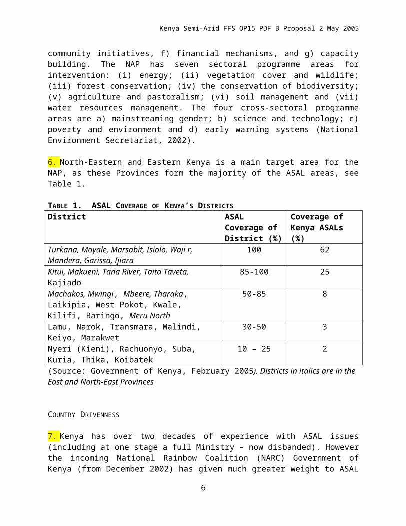
6. North-Eastern and Eastern Kenya is a main target area for the NAP, as these Provinces form the majority of the ASAL areas, see Table 1.
TABLE 1. ASAL COVERAGE OF KENYA’S DISTRICTSDistrict ASAL Coverage
of District (%)Coverage of Kenya ASALs (%)
Turkana, Moyale, Marsabit, Isiolo, Waji r, Mandera, Garissa, Ijiara
100 62
Kitui, Makueni, Tana River, Taita Taveta, Kajiado 85-100 25Machakos, Mwingi, Mbeere, Tharaka, Laikipia, West Pokot, Kwale, Kilifi, Baringo, Meru North
50-85 8
Lamu, Narok, Transmara, Malindi, Keiyo, Marakwet 30-50 3Nyeri (Kieni), Rachuonyo, Suba, Kuria, Thika, Koibatek
10 – 25 2
(Source: Government of Kenya, February 2005). Districts in italics are in the East and North-East Provinces
4
Kenya Semi-Arid FFS OP15 PDF B Proposal 2 May 2005
COUNTRY DRIVENNESS
7. Kenya has over two decades of experience with ASAL issues (including at one stage a full Ministry – now disbanded). However the incoming National Rainbow Coalition (NARC) Government of Kenya (from December 2002) has given much greater weight to ASAL programmes through their November 2002 “NARC Political Manifesto”. The Economic Recovery Strategy for Wealth and Employment Creation (ERS), a successor to the PRSP, gives the ASALs special attention. Within a broad development framework for reviving the economy, creating jobs, and reducing poverty. The ERS notes a decline in agricultural production over the past decade, and outlines measures to revitalize agriculture, including in the semi-arid lands. The Government of Kenya is committed to The New Partnership for Africa’s Development (NEPAD) in general, and in specific terms relevant to this project, agrees with the primary objectives and priorities on 1) establishment of the conditions for sustainable development though e.g. peace and security and capacity building, 2) policy reforms and increased investment in the priority sectors of agriculture, human development, improving infrastructure, promotion of diversification of products, trade and environment, and 3) mobilising resources. Kenya has participated in the development of the Sub-Regional Action Plan on Environment which prioritises overcoming land degradation in ASAL lands.
8. The draft National Policy for the Sustainable Development of Arid and Semi-arid Lands of Kenya (GoK, 2005) highlights the need for specific investments in 25 of the 36 districts classified as ASALs. It is recognized that the linkages between livestock, crop production and land – water resources are complex and need special attention. The draft policy highlights a number of areas for intervention in the semi-arid districts, which include: i) support to mixed farming, ii) environmental conservation, iii) household food security and drought management and iv) investments in social and community development.
9. The Strategy for Revitalizing Agriculture (SRA) gives special attention to the ASALs and agro-pastoralists. The SRA suggests the introduction of new enterprises, including the production of tree crops such as pecans, dates; as well as medicinal plants and forages. The strategy stresses the need for developing a participatory extension system that is responsive to the needs of the communities in the ASALs. This proposed GEF project would support the implementation and realization of responsive service provision through community-based learning and innovations through Agro-Pastoral Field Schools, which are facilitated by extension agents and community-based workers.
10. The SRA links environmental and disaster management to sustainable agricultural development. With higher populations of human and livestock and other drivers such as inappropriate policies and poor governance, there is a need to create awareness on related environmental pressures such as higher wood-fuel consumption and overgrazing leading to loss of vegetative cover and soil erosion and related impacts on key ecosystem functions, particular the critical hydrological regime. Both the draft ASAL policy document and the SRA link emerging ASAL problems to cross-sectoral solutions, which is a challenge in the current policy framework of Kenya. The proposed GEF intervention would develop a mechanism to realize cross-sectoral implementation.
5
Kenya Semi-Arid FFS OP15 PDF B Proposal 2 May 2005
11. The Kenya Agricultural Productivity Project (KAPP) with World Bank – IDA funding, will contribute to the SRA by (i) facilitating farmer empowerment to both access and apply profitable technologies; (ii) laying the groundwork for a pluralistic agricultural extension and learning system; and (iii) integrating and rationalizing the agricultural research system. Five districts have been selected for the first phase of KAPP in Eastern and North-eastern Province: Makueni, Embu, Meru Central, Wajir and Garissa. This proposed GEF intervention, through the adaptation of FFS approaches to agro-pastoral systems, will contribute to these broad based objectives. In eastern and north-eastern Kenya,
12. The Kenyan UNCCD Focal Point, hosted in the National Environmental Management Authority (NEMA), has been fully consulted in discussions from the project concept through the process of formulating this proposal. Feedback has been positive, with strong linkages to the implementation of the NAP. The Kenyan Government has throughout the years demonstrated its commitment to fight environmental and natural resource degradation recently by establishing NEMA under the Environmental Coordination Management Act (EMCA) of 1999. NEMA’s purpose is supervising and coordinating all matters related to en environment and to be the principal instrument in the implementation of all policies relating to the environment in Kenya. The Government adopted the National Environmental Action Plan (NEAP) for successful national implementation of the Global Plan of Action. Overcoming “Land Degradation” through participatory holistic interventions was a main recommendation of NEAP.
C – PROGRAM AND POLICY CONFORMITY
ENVIRONMENT AND SOCIO-ECONOMIC CONTEXT
13. Kenya covers 582,646 km2 (Markakis, 2004), most of the country lies within the eastern end of the Sudano-Sahelian belt, a region often affected by drought and desertification in Africa. Kenya has diverse landforms ranging form the coastal plains through dry plateaux to savannah, grasslands and highlands. A total of 83% of Kenya’s landmass is classified as ASAL (see Map B1, Annex B), with only 17 % as medium and high potential1 production areas. The ASAL area covers 48 million ha., of which 9.6 million ha supports some sort of agriculture, almost 15 million ha are only suitable for largely sedentary livestock production and the remaining 24 million ha are dry and only suitable for nomadic pastoralism (NEMA, 2003). The ASAL ecosystem is complex and extremely vulnerable. Whilst the overall status and knowledge of dryland diversity and complexity are still not fully known, there is clear evidence that the integrity of these ecosystems is being seriously undermined (National Environment Secretariat, 2002). Despite this perceived severity of degradation, there is a dearth of hard factual data on effects on the hydrological regime, soil losses, extent of gully and sheet erosion, loss of vegetative cover and reduced agricultural productivity. Research data tends to be location specific and remain hidden within research institutions and is not available or applied to influence mainstream policy process.
14. In 1998 over 60 % of the population in the ASALs were living below the poverty line, higher than the 50% country average. There is little comparative base-line data or socio-economic
1 High, medium and low potential areas refers to the high, medium and low potential of these areas for plant growth assuming that soil conditions are not limiting (Agroclimatic Zone Map of Kenya; Sombroek et al., 1982)
6
Kenya Semi-Arid FFS OP15 PDF B Proposal 2 May 2005
indicators, since the ASAL Districts in Kenya have not been included in the Integrated Household and Budget Surveys undertaken in 1989, 1993 and 1998. The first Kenya Demographic and Health Survey to include the ASALs was in 2003, which reported that the ASALs have the highest illiteracy level for both females (86.8%) and males (65.2%) (Office of the President, 2005) compared to 29.1% illiteracy level as country average (Institute of Economic Affairs, 2002). Social services in the ASALs are not adequately provided to the population and all social development indicators (income, health and education status) fall behind the rest of the country.
15. Arid areas receive between 200-550 mm rainfall annually, whilst semi-arid areas receive between 550-850 mm annual rainfall (GoK, 2005). This is a key distinction as livelihood options differ considerably between the two. The agricultural production system in the arid areas is based on sorghum, millet, cowpea and green gram in combination with communally grazed herds of livestock. In the driest parts there is little to no crop production, with a focus on grazing of cattle, goats and camels, which is reflected in a mobile lifestyle in search for pastures and water. In the semi-arid areas maize, beans and cotton are important crops, however, livestock (cattle, goats, sheep and poultry) become an increasingly important component of the production system. Increasing aridity leads to greater emphasis on non-agricultural products: fuelwood, charcoal, honey, hunting, gums and resins.
16. In the Eastern and North-Eastern parts of Kenya the problem of land degradation is especially severe due to the fact that desertification presents a major threat to all facets of land productivity, both in relation to agriculture and livestock production. Unfortunately, in Kenya there are only very general estimates of the areas affected country-wide and consequent loss of productivity which arises (KARI-DMP, 2005). This threat of desertification is compounded by the fast growing population, which is believed to accelerate land degradation (National Environment Secretariat, 2002). The rapid population increase leads to cultivation and encroachment of rangeland, which leads to the collapse of the traditional cultivation systems that, through fallow periods, allowed land to regain its productivity. With increasing pressure on resources, the fallow periods are therefore progressively getting shorter with disastrous results on land productivity and sustainability.
17. In Kenya land tenure systems are classified in three broad categories: 1) Trust/Communal Land which is held by local authorities in trust on behalf of the local communities, 2) Public land, held by the central administration on behalf of the public (e.g. Forest Reserves), and 3) individual/private land either freehold or leasehold. Most ASALs are communal owned as trust land under county councils, even though this is undergoing change and more and more communal owned land is changing into individual or freehold ownership. This trend has a large influence on the pastoral lifestyle since private ownership restricts movement under the traditional land-use management systems. This change contributes to land use conflicts, which increasingly occur between pastoral, agro-pastoral and cultivation communities, mainly over water use and pastures.
18. Increasing aridity is associated with greater dependence on scarce water sources (springs, seepages, rivers, wells). As lands become degraded, so surface and ground water sources are depleted with the result that water scarcity lasts longer as sources dry earlier or become less
7
Kenya Semi-Arid FFS OP15 PDF B Proposal 2 May 2005
accessible (falling water table), and larger areas become water deficient. Land-use systems thus increasingly focus around water availability and conflict over resources is increasingly over access to water.
19. Besides limited precipitation and high evaporation rates, these arid/semi-arid climates have considerable inherent spatial and temporal diversity in rainfall patterns (necessitating some form of mobile lifestyles in the most arid areas). Droughts are the rule, not the exception, and traditional coping mechanisms need support. Moreover, evidence suggests that climatic extremes may increase under global climate change predictions. North-eastern and Eastern Kenya will largely become drier, with increased severity of drought. There is need for strategic land-use planning to build in adaptations to such forecasts. This project will explore linkages to Climate Change - Adaptation funding within GEF, and maintain linkages to the developing UNDP-GEF project “Coping with Drought” within the Climate Change Adaptation Window.
CAUSES OF LAND DEGRADATION IN KENYA
20. Despite some 60 years of planned interventions (triggered by droughts in the Second World War years; National Environment Secretariat, 2002) to mitigate and combat desertification, the ASALs continue to face increasing land degradation and desertification problems. Inappropriate policies and a growing imbalance between population, resources, development and environment are the main causes for land degradation (see details in Annex D). Forty years of post independence have seen greater social differentiation and a widening gap between the rich and the poor to the extent that 10% of the population controls 42% of the country’s wealth. The poor households in the ASALs are more marginalized and vulnerable to droughts and floods, with consequent loss of their productive assets. Left with few options and possibilities for existence often environmentally unsustainable practices are adopted as a method of survival. An example of this is charcoal burning, which not only causes deforestation but also leads to serious land degradation if no replanting or other ways of rehabilitation take place. There is often a lack of alternatives for the poorest and few opportunities to invest or the time and effort to search for these alternatives. All social development indicators in the ASALs (income, health and education status) fall far behind those of the rest of the country (Institute of Economic Affairs, 2002). Traditional land rights are currently not respected and greater pressure is being exerted on the natural resource base (pasture and water) as populations (both human and livestock) increase. Pressure on land is increasing due to loss of access to grazing as land is taken for cultivation, conservation areas and state use. The net effect is increased social insecurity and conflict in which the more vulnerable in society are the hardest hit.
21. There is a general lack of investment (both public and private) in the infrastructure, economic development, access to markets in the ASALS, with few opportunities for diversification and creating new possibilities for the absorption of surplus labour. Poverty, food insecurity, unemployment conflicts and an unskilled and rising human population with a dwindling natural resource base will continue to characterise the ASALs. However, this situation can be reversed with the commitment and political will that is increasingly available in Kenya today, and provides an enabling environment at the highest levels of governance, suggesting that this is an opportune time to invest in sustainable land management in ASALs. The new ASAL policy
8
Kenya Semi-Arid FFS OP15 PDF B Proposal 2 May 2005
proposes major investments into infrastructure, especially roads which will support market access and improve security.
22. Whilst there is a long history of environmental analysis, writing and history for pasts of eastern ASAL Kenya, this has a relatively weak database on quantitative indices of degradation. The “Ukambani” Districts (Machakos, Kitui, Mwingi), have been most studied, gaining international attention through the writings of Mary Tiffen and colleagues on Machakos hills: “More People and Less Erosion” and Diane Rochelau and her colleagues’ extensive research in Ukambani. Their findings are summarised in Annex D.
23. The soils of Ukambani and other eastern ASAL areas are all generally of low fertility, and many are highly erodible. The ultisols and alfisols are also susceptible to sealing (capping), which increases runoff and makes the clay soils hard to plough by the end of the dry season. A rough estimate of the agricultural quality of the region's soils indicates that less than 20 per cent of Kitui and Machakos has well-drained, deep, friable red and brown clays of good fertility; more than 60 per cent of the region has very erodible, relatively shallow, sticky, red, black, and brown clays of variable fertility, on steep slopes; and 20 per cent has poorly drained, shallow, stony soils of low fertility.
24. In Kenya soil degradation is seen as the most important land degradation process (FAO 2000), with all the following processes: 1) water erosion, including splash, sheet and gully erosion measured as soil loss, 2) landslides, 3) wind erosion, 4) chemical degradation, 5) water pollution, 6) physical degradation, and 7) biological degradation (Muchena, 1989 and Wanjogu et al., 2001). 1, 3, 5 and 7 are of importance in the ASALs. Decline in soil fertility is mainly due to over exploitation of soils through continuous cultivation and erosion. In the ASALs removal of vegetation cover by overgrazing, trampling and cutting of trees and scrubs for charcoal are the major causes of soil degradation, but also growing of not-suitable and non-drought resistant crops by the agro-pastoral communities contribute to soil erosion, which further underlines the need for improved extension services.
25. Scattered datasets in the Agricultural and Livestock sectors in Kenya illustrate the pattern of declining yields across the ASALs, and link these declining yields to loss of productive potential due to forces of land degradation (erosion of top-soils, moisture retention capacity and nutrients). A total of 35% ASAL land is extremely vulnerable to severe land degradation and desertification process (National Environment Management Authority, 2003; National Environment Secretariat, 2002; Government of Kenya, February 2005). However, there are only very general estimates of the areas affected, the rate as which land degradation is occurring, the relationship between the various forms of land use and hazards and the losses of productivity which arise as the effect of land degradation (KARI, DMP, 2005). Furthermore, most of the information available focuses on symptoms of land degradation, rather than on ecosystem stability, functions and services.
26. Kenya’s ASAL policies and documentation draw attention to these conclusions, but also stress the paucity of hard replicable datasets. Detailed analysis of Kenya’s land degradation problems (e.g. that of Dianne Rochelau and colleagues – see Annex D) is largely based on many past external researches, rather than on current research efforts. A major contribution of this GEF project will be to assist ASAL policy leaders to develop stronger data resources to be used
9
Kenya Semi-Arid FFS OP15 PDF B Proposal 2 May 2005
in Monitoring and Evaluation Processes. In this process, strong links will be developed with the UNEP- FAO LADA project, which has just been approved by GEF. The project will develop methodologies and tools for Land Degradation Assessment of the world’s dry-lands.
27. Over the past two decades, Kenya has experienced accelerating deforestation, accelerated land and watershed degradation soil erosion, and domestic and industrial pollution. Soil erosion, resulting from deforestation and inappropriate agricultural practices on fragile soils and sloping lands, is affecting agricultural productivity and contributing to the siltation of dams. Unless the issues of environmental conservation and protection are appropriately balanced with economic development initiatives, the country’s capacity for generating sustainable growth from its main economic sectors for poverty reduction will be undermined. If environmental conservation activities are to be successful, they must become development priorities. This particular project will intervene through an agro-pastoral entry point with a focus on land use planning that will emphasise both sustainable land management practices and sustainable livelihoods, in selected districts of North-Eastern and Eastern Kenya where land degradation present a major threat to all facets of land productivity.
28. Land degradation in Kenya is a result of inappropriate land use practices: overstocking, overgrazing, deforestation, poor irrigation methods, overexploitation of aquifers, intensive tillage and cropping, recurrent drought and climate change. As a result net effects are increased social insecurity and conflicts in which the more vulnerable in society are hit hardest. The rights of women and other minority groups continue to be abused. Population pressures in the medium and high potential areas have forced people to migrate to the ASALs where the pressure on the land is then increasing and causes loss of access to grazing areas as land is taken into cultivation, for conservation areas and state use (Markakis 2004). They appropriate moister areas in the ASALS, such as valley bottoms and wetlands, causing disruption of traditional dry-season grazing practices. Settlement at water points can exclude livestock. There are increasing disputes over land and water, inappropriate land use and consequent land degradation by both migrants and settled pastoralists. These new purely farming communities settle in agro-pastoral or even pastoral areas, bringing technologies suited to more humid farming systems. An example of the ties between poverty and environmental degradation is from eastern Mount Kenya where soil erosion resulting from deforestation and inappropriate agricultural practices on fragile soils reduces agricultural productivity by 2% per year. (IFAD, 2002).
BASELINE ACTION TO ADDRESS LAND DEGRADATION IN KENYA ASALS.
29. There are two important elements of the baseline activity in the past few years. One is the emphasis on policy process, coming from political priorities into the ERS, and through to specific ASAL and agricultural policy process driven by ERS and KAPP.
30. The second is the increasing emphasis on delivery mechanisms through farmer / landowner experience based processes. The Farmer Field Schools Approach has been a major force in this regard. This GEF project builds on both processes.
31. Kenya has a long history of supporting efforts towards reducing land degradation and the management has been guided by several cross-cutting policy instruments but few of these have
10
Kenya Semi-Arid FFS OP15 PDF B Proposal 2 May 2005
had a significant impact, which explains the current state of the ASALs in Kenya. Recent initiatives included:
The National Environment Action Plan of 1994, Sessional Paper no. 1 1994 on Recovery and Sustainable Development by the Year 2010. The National Poverty Eradication Plan (1999), Poverty Reduction Strategy Paper (2001) and the latest, the Economic Recovery Strategy
for Wealth and Employment Creation (2003), with two chapters dedicated to ASALs.
32. A common problem for many of these previous programmes and policies is the lack of commitment and coordination between line ministries. The government also criticizes the donor community for lack of commitment of resources for implementation, since lack of transparency in government departments has held donors back from giving budget support in past years.
33. The review of the ASAL Development Policy and Investment Plan (dating from 1992) is a more recent activity, using participatory national and localized stakeholder discussions and drafting sessions. The draft revised policy documents the past decades of gaps and political failure regarding the necessary attention to Kenyan ASALs, which is of key importance to understanding the situation and development state of Kenyan ASALs. The policy presents a new approach to development in the ASALs as it introduces an integrated cross-sectoral approach to sustainable development and links this to an investment plan for all relevant sectors. The investment plan was prepared by each of the line ministries and the two coordinating ministries.
34. In March 2004 the Ministry of Agriculture launched the Strategy for Revitalisation Agriculture (SRA). The Economic Recovery Strategy for Wealth and Employment Creation (ERS) gives particular emphasis to agriculture as the engine for growth for the Kenyan economy (Ministry of Agriculture, March 2004). The overall goal is to achieve a progressive reduction in unemployment and reduce the level of poverty. The agricultural sector contributes with 26% of the total GDP and another 27% indirectly though agricultural related sectors, which underlines the importance of the sector to the country’s economy. Ensuring food security, increasing smallholder real incomes and raising agricultural productivity is essential for the realisation of a significant improvement in the standard of living of Kenyans, which corresponds with the Millennium Development Goal 1: Eradicating extreme poverty and hunger. In Kenya 56% of the population live below the poverty line and 80% of these live in the rural areas. The prevalence of poverty is, as many other places in the world, highest among women and it is proved that women are more vulnerable to poverty than men (Ministry of Agriculture, March 2004). This phenomenon can be explained by the over-dependency of women in subsistence farming and this problem is even worse in the ASALs, where women spend much of their time in daylight searching for firewood and water. Food security is another reason for the government to give priority to the agricultural sector, as a high percentage of the Kenyan population is food insecure, and about half the population lacks access to adequate food. Again this problem is worse in the ASALs than in the rest of the country due to lack of adequate resources and many communities in the ASALs are depending, very much against their will, on relief food from government and development partners.
35. At District Level the Government of Kenya has a major extension mainstream programme, the National Agriculture and Livestock Extension Programme (NALEP) Phase II, which will
11
Kenya Semi-Arid FFS OP15 PDF B Proposal 2 May 2005
move to the semi-arid districts during the Phase II. NALEP is co-funded by SIDA, who have been involved in the Kenyan agricultural sector for several decades. The overall goal of NALEP is to enhance the contribution of agriculture and livestock to the social and economic development and poverty alleviation. This goal will be reached though a pluralistic, efficient, effective and demand-driven professional national agricultural extension system. The Kenya Agricultural Productivity Project (KAPP), funded by the World Bank, also supports participatory extension mechanisms, and links this to applied research and technology adoption. The national KAPP is the main baseline entry point for a developing GEF WB OP15 project in five selected water catchment areas, titled “Agricultural Productivity and Sustainable Land Management project, but referred to in Kenya as “KAPP-SLM”.
36. The Special Programme for Food Security (SPFS) first introduced the Farmer Field School (FFS) approach (see Annex E for a short explanation of the FFS Approach) on a small-scale in Kenya in 1995 of which Kenya was one of 15 pilot countries, with an initial focus on Integrated Pest Management (IPM). Since 1995, the FFS approach has been tested and adapted for for farmer driven learning for a range of crop and livestock enterprises and has increasingly been applied as a training tool for agricultural topics in general rather than just for IPM. In 1999, FAO’s Global IPM Facility launched an East African pilot project for FFS on Integrated Production and Pest Management (IPPM) covering three districts in Western Kenya. With IPPM as the entry point, the FFSs have included other aspects that have a bearing on production and livelihoods in general. Improved resources management issues as well as financial management are recognized as important components for capacity-building.
37. FFS activities in Kenya are currently being implemented through many development programmes including:
The UNDP funded FAO-PFI-FFS project was started in 2001, including Field Schools on a range of topics, as diverse as bee keeping and soil management.
ILRI initiated a Livestock FFS project with DFID Animal Health Programme funding, adapting FFS methodology to production issues of smallholder dairy production.
In 2002 a FAO Technical Cooperation Project in Bondo District developed the Food Security Field School model, where health, nutrition and other topics closely related to farmers’ livelihoods have been addressed in the FFS activities.
Through support from JICA starting in 2003, the GOK Forest Department has been piloting Farm Forestry Field Schools where crop production and forestry establishment have been addressed in an integrated manner
FAO through funding from the Netherlands have supported the development of soil & water specific FFS tools and exercises and established activities in 3 provinces in Kenya.
DANIDA’s Agricultural Sector Programme adopted the FFS approach as the main tool of extension in its program in 4 districts in Kenya and has been working closely with MOA in the establishment of a large number of FFS groups in varying topics.
38. Up to 2005 a total of about 2500 FFSs have been implemented in Kenya in about 25 districts. The numbers of FFSs, the diversity of topics, and FFS innovations makes Kenya a leading country in Africa for FFS development and Kenyan expertise is increasingly drawn upon for the development and back-stopping of similar programs elsewhere.
12
Kenya Semi-Arid FFS OP15 PDF B Proposal 2 May 2005
39. The DANIDA supported Agricultural Sector Programme has focused on crop production and poultry but the next phase of the Agricultural Sector Programme Support, starting in June 2005, will emphasise the transition of the agricultural sector with the private sector as a vehicle for economic growth while the public sector establishes a conducive environment for this development. The project is located in Eastern and Coastal Provinces and will therefore be an important player and complement to this proposed project though e.g. its support to strengthen market opportunities in the area. Several other donor projects within the agricultural sector, most of which focus on improved crop production and improving market related issues e.g. the USAID-supported Kenya Maize Development Programme and the Rockefeller Foundation supported Cereal Banks, are important partners.
40. With Kenya’s program to address the Millennium Development Goals on hunger and poverty discussions are on going to mainstream a food security programme using among other approaches, the FFS approach. This ten year initiative “Njaa Marafuku Kenya” will start mid 2005 and will cover the majority of the semi-arid districts and some of the arid districts. Through this initiative GoK will become the largest donor of FFS activities in Kenya, which demonstrates the commitment by the government to scale-up FFS development. The approach has further been taken up by MoA regular programmes within the national extension programme in a number of districts (e.g. Bomet, Tana River and Nandi).
41. The opportunities to apply the FFS approach in a more pastoral context with semi-mobile communities have yet not been explored due to the inherent challenges in operating an extension system in such contexts. However, there is a growing demand by the dryland districts of Kenya for the approach and, with the increasing interest by the Kenyan government to assist pastoral communities, these opportunities would be explored through the GEF project.
42. There is a lot of FFS experience in Kenya, and several initiatives are working on land degradation related issues. However, there are still many gaps that need to be covered. By approaching the agro-pastoral communities in the North-Eastern and Eastern Provinces with innovative methods for extension services and learning to support sustainable land management, this project will fill an important gap and reach communities that have often been neglected, and would play an important role in the efforts of combating land degradation and desertification.
43. The proposed GEF actions will be integrated with and complement ongoing projects and policy implementation that seek to improve the livelihoods of populations living in the ASALs of North Eastern and Eastern Kenya. A major project in the ASALs of Kenya is the Arid Lands Resource Management Project (ALRMP), a World Bank initiative now into its second 6-year phase. The second phase objective is to enhance food security and promote sustainable livelihoods though implementing effective systems and development approaches which reduce vulnerability, in both arid and some semi-arid districts. The project will support three complementary channels of intervention, which address the complex problem of vulnerability, and enable communities in the project area to move beyond survival and subsistence to sustainable development (World Bank, 2003b). These are natural resource and drought management, community-driven development, and support to local development. The eleven Arid Districts will be targeted through all three components. The semi-arid areas will have
13
Kenya Semi-Arid FFS OP15 PDF B Proposal 2 May 2005
reduced input. The community component has experienced many challenges, partly due to the vastness of the target area. Many of the best practices from community projects have not been shared or replicated elsewhere in the districts and the numbers of beneficiaries were lower than expected in project design (World Bank, 2003a). This GEF project will learn from this experience and will invest in strengthening extension services and will be able to extend services broadly.
44. The proposed GEF intervention will complement and expanding FFS activities, programmes and projects in Arid and Semi-arid districts of Kenya, by seeking to improve the living conditions of rural populations through increased profitability of agro-pastoral activities using sustainable practices that, among others, help combat desertification processes. As such it is fully concordant with district development plans for the region as well as the NAP. Barriers to implementation of Sustainable Land Management Practices
45. Whilst the new national policies and ongoing programmes and projects offer a window of opportunity for serious changes in ASAL resource management, the policies need support through a range of delivery mechanisms in order to achieve impact on both livelihoods and land degradation issues. Whilst the past two years with positive political support to ASALs give grounds for optimism, there are still a range of barriers and constraints that impede the full implementation of these new initiatives. A participatory workshop in the preparation process of this concept debated important barriers, which are summarised below. These barriers will need further analysis in PDF B activities as part of the root cause / barrier analysis.
46. Weak policy support . Seen in a historical perspective the ASALs have been characterised by inappropriate policies designed from above with little regard for the unique features of livelihood systems in the ASALs. Due to cultural, economic, political and social barriers, ASAL communities have lacked a ‘voice’ to be adequately represented in the national affairs. The policy makers have lacked an understanding of ASAL livelihood systems with little differentiation between pastoralist and agro-pastoralist needs. The result has been that ASALs have remained peripheral to national development and investment. The challenges and constraints of insecurity and conflict, poor infrastructure, financial limitations, inadequate community participation and capacity building were not addressed by the development planners within the government in order to support investments. As a result technical solutions to problems that were mainly social and political were introduced in the areas, with little impact. The last two years have seen greater documentation of the benefits of investment in ASAL areas (Dobie, 2003). Investing in drylands can offer a range of rewarding opportunities for sustainable national development.
47. Institutional capacity deficiencies. District governments are responsible for the protection and sustainable management of natural resources within their districts. Each District has representatives from the line ministries and a environmental agencies that oversee for example, environmental impact assessments, support to rehabilitation of degraded land and re-afforestation efforts. Many agencies have severe human resources limitations in terms of numbers, capacity and funds. There are overlapping mandates, lack of coordination both between government departments and development partners. This can be especially complex for the agro-
14
Kenya Semi-Arid FFS OP15 PDF B Proposal 2 May 2005
pastoral communities since their interests often fall between two technical ministries (Ministry of Agriculture and Ministry of Livestock and Fisheries Development) Decision-making occurs without sufficient knowledge of the interrelations between proposed interventions and the complex processes of ecosystem functions or the consequences that land degradation may have on ecosystem integrity. Awareness of the economic implication of the loss of this integrity and concomitant losses of ecosystem services is low, further impeding a clearer appreciation of the importance of SLM. These deficiencies affect the control of land use. The proposed project will build capacity and knowledge on both district and national levels to introduce new strategies and methods for extension services and cross-sectoral planning.
48. Sectoral Approach. Many projects have been sectoral in nature, with little coordination between actors at the national and district levels. Consequently, it is very difficult to assess complementarities, duplications or conflicts and so efforts and opportunities are lost and funds wasted. Relevant ministries and departments and development partners use different planning procedures with little room for change, or adoption of integrated planning procedures needed for sustainable land management. This sectoral approach results in limited opportunity to share experiences among projects and programmes supported by different sponsors. This affects the application of sustainable practices that has been identified in the areas, and fails to address the broader causes of land degradation. By introducing a landscape/ecosystem approach through cross-sectoral planning mechanisms the proposed GEF interventions will support a more holistic planning circle for SLM related activities and efforts.
49. Knowledge and information gaps. There is insufficient quantitative data on the status and trends of natural resources, impeding the full assessment of desertification problems and the quantification of losses to society from these. Although some districts have been carrying out isolated monitoring of environmental variables, there is no specific, coordinated system at the regional level to assess degradation dynamics. The absence of a comprehensive monitoring system limits the application of adaptive management based on early detection of negative impacts. This limits decision-making; both at a local level to correct or mitigate the impact of current practices, and at a regional level to define land use policies. Furthermore, there is a general poor level of information flow on most things like market prices for both livestock and other products. Finally, there are no planning tools presented by the government to allow assessment of the feasibility and cost/benefits of land rehabilitation and ecosystem restoration efforts that has been on going in the region. The proposed GEF project would introduce methods to develop understanding of the full benefits of ecosystem restoration and emphasise the value of sustainable land management for livelihoods.
50. Cultural differences and high level of insecurity. The ASALs have many different tribal groups with different languages, cultures and land-use practices both pastoral and agro-pastoral. Due to high illiteracy in the area and little interaction these groups have not had or been given the opportunity to develop a common goal for their region. This can be seen as one of the underlying factors for the insecurity in the region, but is not only caused by Kenyan intertribal clashes but also with the neighbouring countries, Ethiopia and Somalia. Most often the conflicts are rooted in disputes over natural resource management; lack of pasture and water but also traditional differences between these tribes, like traditional cattle raiding, are also part of the insecurity characterising these areas. Furthermore, the absence of well-developed mechanisms
15
Kenya Semi-Arid FFS OP15 PDF B Proposal 2 May 2005
for communication and conflict resolution through which information exchange and consensus building could be reached. Poor infrastructure and lack of services are all factor adding to the level of insecurity.
51. Alternative land uses, technology and knowledge. Most ASAL land-users have little knowledge of improved technologies to improve land-use practices and alternative resource uses. Many promising results obtained through different pilot projects are not shared and up-scaled through dissemination of results. Implementation remains with only a few land users. The adoption of new technologies or alternative livelihoods, in an area where one traditional land-use has dominated for decades, faces sociological barriers as well as capacity constraints, but this is not an indicator of lack of interest in improving their land-use practises but mainly a lack of capacity and even more, the approach taken to implement new uses. The system of rural extension is challenged by limited human and operational capacity and scarce knowledge of environmentally sound practices to improve or diversify productivity. Although some promising examples exist for alternative land uses in Kenya these have not been scaled-up. For example very good experiences have been achieved in Baringo District with land reclamation with agro-pastoral communities though reseeding of grassland though many years of testing and research on grass and methods2. The work in Baringo has been on individual land as well as communal land resulting in both reclaimed and rehabilitated land, with the benefits such as allowing beekeeping, grass seed harvesting, fodder for dry season production and also significant economic benefit for the landowners, communal owned land as individual, by selling product from the grass field; fattening of livestock, hay and honey.
PROJECT RATIONALE AND DESIGN
52. The Government of Kenya has documented the critical level of land degradation in the ASALs, emphasizing that if this trend is not reversed the social and environmental consequences will be devastating. However, there are opportunities to reverse this trend. As detailed commentary points out (Annex D), there are potential interventions that will show benefit. The baseline discussion points out that the GoK and partners are starting action. However, there is a need to strengthen these efforts by focusing on one particularly hard-hit, but important group of resource / land-users - the agro-pastoralists in North-Eastern and Eastern Kenya. The overall focus of the GEF project is to ensure transferability of knowledge and best ways to motivate change within the agro-pastoral communities in issues relating to sustainable land management.
53. The current FFS programme in Kenya does not have a focus on agro-pastoral areas, but rather on the medium/high potential areas, where the needs are different and to an extent less complicated than the agro-pastoral system. The FFS approach has proven successful in Kenya, but it has focused largely on crop production, and, until recently, it has not used cross-sectoral approaches, and paid little attention to sustainability at the larger landscape level. The existing FFS activities will not halt desertification processes to the extent required to restore or conserve ecosystem integrity across the ASALs of Kenya. The GEF project would support the FFS
2 Rehabilitation of Arid Environment Charitable Trust is based in Baringo District, Kampi ya Samaki where it has been operating for 25 years within the area of land rehabilitation. The Trust has throughout the years received funding from, among others, Rockefeller Foundation, Ford Foundation, JICA and UNDP.
16
Kenya Semi-Arid FFS OP15 PDF B Proposal 2 May 2005
concepts to lift barriers that help baseline programmes to reach wider geographical scales during and after the project.
54. Under the suggested GEF intervention, the promotion of agro-pastoral innovations, demand-driven community experimentation and community-based experiential learning in agro-pastoralism will allow ASAL communities to discover sustainable interventions about their livelihoods and use of resources, whilst addressing food security, enhanced knowledge and income generation. The FFS approach provides great potential, through experiential learning for agro-pastoralists to deal with a changing livelihood and resource base, by creating an enabling environment to cope with their changed livelihood situation. The project does not intend to develop new technologies, but to adapt existing technologies to new situations. This will entail: 1) moving from a focus on private land holdings to communal and trust lands, 2) moving from a focus on plot level to a broader ‘landscape’ level, which include local watersheds, river-valleys, grazing lands, croplands, 3) broaden the entry point from agriculture to a cross-sectoral entry point, 4) reduce the reliance on GoK extension staff and focus more on the use of community-based and farmer facilitators, and farmer innovators, 5) focus on a broader land/crop/livestock interaction perspective, and the 6) development of tools and methods appropriate for illiterate, nomadic communities.
55. The project will address both existing Strategic Priorities under OP15. SLM 1 “policy harmonisation” forms the first outcome, building capacities at local levels
to implement (with adaptive learning feedback mechanisms) cross-sectoral land-use policies, and translating this into practice.
SLM 2 (piloting innovation) works with extending FFS technologies into new themes and new ecological conditions. Results from these pilot processes will feed back into policy process.
The project fits present and emerging guidance under OP15, with reference to bottom-up participatory and integrated cross-sectoral planning at landscape levels. Land-use planning processes are emphasised. GEF 4 will have four strategic directions. These are:
Mainstreaming SLM into the production landscape by addressing both global environmental and sustainable livelihood values within a holistic development framework.
Creating synergies across GEF Focal Areas to address SLM in the context of biodiversity, land and water management and adaptation to climate change.
Promoting country programming partnerships through multiple stakeholders. Capacity building leading to long-term sustainability and visible impact for preventing
and controlling land degradation.Whilst all four directions have some relevance to this project, Directions 1 (mainstreaming) and 4 (capacity building) are immediate priorities. The development of this project within the PDF B will look at potential for linkage to direction 2 (Integration) as both land-water synergies and climate change synergies have potential (see Annex D on LD in the Ukambani area).
56. The project fills a strategic gap in the developing portfolio of GEF SLM and OP1 – OP12 projects in Kenya and the eastern Africa region. This project addresses agro-pastoralism in the semi-arid lands, an area where resource-use conflict is increasing with immigrant farmers taking
17
Kenya Semi-Arid FFS OP15 PDF B Proposal 2 May 2005
over dry-season grazing reserves and water points. Other GEF projects address more arid lands (e.g. Desert Margins Inititiative in Marsabit District and Indigenous Vegetation Programme in Turkana – Marsabit Districts). Other projects address the moister end of the spectrum focusing on mountain water towers and peripheral productive (WB-GEF Agricultural Productivity and Sustainable Land Management project with inputs to Taita, Tugen and Cherangani Hills areas, among others; and UNEP IFAD on Mount Kenya). This suite of interventions was discussed at Kenya’s CDW with staff of the office of the OFP, seeking a portfolio that was complementary, and not overlapping.
Project Objectives
57. The development objective, or goal, to which this project contributes is: To facilitate uptake of sustainable land use management (SLM) practices in order to reduce land degradation in arid and semi-arid lands of Kenya within the context of sustainable development.
58. The immediate objective, or purpose, of the project is: To remove capacity-related barriers impeding the implementation of SLM in North-Eastern and Eastern Kenya, through community-based innovations and learning that reduce land degradation and conserve ecosystem integrity.
59. This immediate objective will be achieved through delivering a series of outputs that lead to two specific and measurable outcomes. The outcomes will be refined in the PDF B process.
60. The first specific Outcome is: Sustainable land management policies and innovative mechanisms targeting agro-pastoral communities mainstreamed into cross-sectoral national/district decision-making processes that target agro-pastoral land-users, leading to improved land use practices. This would consist of programmes to strengthen district government institutional capacities for SLM and provide them with tools needed for informed decision-making, adaptive management, and to strengthen existing systems for monitoring and evaluating uses of the ecosystem. It would also entail activities focusing on outreach material to reach a larger group of both users and planners to ensure the participation of all stakeholders in the implementation of SLM policies and procedures. The agro-pastoral community-based experiential outputs and best practises would be used to sensitise national development framework sensitised of innovative SLM mechanisms.
61. The second specific Outcome is: Site-specific Agro-pastoral innovations and community-based experiential learning are providing tangible results in preventing and controlling degradation processes and restoring ecosystem integrity, and providing lessons to advise policy and capacity building processes. Community-based interventions would include FFS initiatives in dryland landscapes and ensure that livestock is complemented by alternative land uses in those areas that are unable to provide sufficient profit from livestock alone without aggravating land degradation processes. This could include developing incentives for the non-extractive and sustainable use of land through a grant, and possibly a loan system. The community-based learning would also be particularly stimulated through agro-pastoralist innovation and experimentation.
18
Kenya Semi-Arid FFS OP15 PDF B Proposal 2 May 2005
62. Intervention sites will be selected to cover a range of agro-pastoralist potentials, alternative land-use at district level in North-Eastern and Eastern Kenya and production possibilities, ecosystems and desertification processes3. At the end of the project a comprehensive range of tested land-uses would be available for the different challenges throughout the ASALs. Mechanisms for replication would be strengthened by the increased capacities delivered through the cross cutting outputs of the project.
Expected Outcomes and Outputs of Full Project
Outcome 1 is: Sustainable land management policies and innovative mechanisms mainstreamed into cross-sectoral district planning and national/district decision-making processes, leading to improved land use practices. There are 4 outputs:
1.1. SLM capacities of national and district institutions strengthened
63. Actions would seek to provide district and national institutions related to natural resource use control and land use planning with qualified and experimental tools to support agro-pastoral communities in ASALs in developing and adopting sustainable resources management strategies and actions. Existing relevant policies, at both national and district level, would be more tuned to the specificities of pastoral communities and their implementation supported, thus leading to the control and prevention of land degradation within a framework of cross-sectoral and multi-institutional co-ordination. For this purpose, national and local environmental authorities would be trained in SLM principles tailored to ASAL conditions, tested through community-based experiential learning actions and identification of innovations and sustainable land management practices. These practises would feed into the national policy development framework to improve the conservation and restoration of ecosystem integrity through the Project Steering Group. Project preparatory activities for this line of action would be a root cause analysis including a more in-depth assessment of current institutional deficiencies and constraints, including the policies and procedures used to control other potential threats to land degradation such as infrastructure projects that would needed if SLM is to be fully adopted.
1.2. Decision support systems and SLM tools developed
64. To enhance institutional capacities and further facilitate mainstreaming SLM in planning, a series of Decision Support Systems and tools would be developed. This would include, in some cases, strengthening of existing environmental monitoring systems on interrelations among human management activities, climate, soil, flora and fauna and effects of early warning structures and mechanisms for drought management. In other cases, a participatory monitoring system would be established. Such a system would be used to both inform decision-makers on the status of the ecosystems at the regional and local levels and furthermore, to advise on the most appropriate land use management. The system would also be used for early warning purposes to inform land-users on climatic change indicators and conditions hence work as an alarm system for extreme climate events and count with land-users’ active participation. The M&A system would be hosted within the district administration, which would receive training to ensure continues running and updating of system, and to feed information into the central
3 Selection of locations will be done during the PDF B process.
19
Kenya Semi-Arid FFS OP15 PDF B Proposal 2 May 2005
administration where the land uses and management practices would be monitored and compared in order to identify most suitable practises for specific situations and reapplication possibilities. The project would aim to ensure that the system would be fully financially sustainable by the end of the project and would serve as a dynamic tool to be used at different scales and by different users. Details for the system would be fully defined through the preparatory activities. During the preparatory phase, enough basic information would be collected to allow an initial quantification of baseline socio-economic and ecological conditions, and identification of project monitoring and evaluation indicators.
1.3. Established outreach and awareness programmes on SLM, desertification and ecosystem functions
65. Programmes would be designed to enhance public understanding of the need to help agro-pastoral communities in overcoming the challenges to reversing land degradation and desertification in Kenya and to increase participation of such communities in the work and in the implementation of SLM policies and procedures. Forums and mechanisms would be developed to facilitate the incorporation of grassroots-organizations recommendations and result from agro-pastoral community-based experiential learning in developing and implementing SLM and natural resources use policies. Well-defined mechanisms for disseminating the results obtained from the project would also be developed for outreach to local communities and to regional, national and global audiences in an appropriate format. Mechanisms, foras and networks would be established and supported to permit closer co-ordination between the different projects and government efforts in the ASALs that seek the conservation of natural and cultural resources and economic, ecological and social sustainability.
1.4. National development framework sensitised of Innovative SLM Mechanisms
66. Guidelines and “extension tools” to feed the good land-use practices into the national policy level on would be prepared, these will include a broader understanding of ecosystem functions and services. Through workshops with presentation of results from the community-based experiential learning actions and identification of innovations and sustainable land management practices the central administration and planning level will be sensitised on the guidelines and recommendations. This would also promote a better understanding of the ASALs at the central administration level as well as the need for good and fully knowledgeable extension services and the impact extension workers have on the community level.
Outcome 2 is: Site-specific agro-pastoral innovations and community-based experiential learning are providing tangible results in preventing and controlling degradation processes and restoring ecosystem integrity, and providing lessons to advise policy and capacity building processes
2.1. Innovation and experimentation among land-users for sustainable livelihoods
67. Promoting Farmer Initiatives (PFI) activities funded through FAO/UNDP would be complemented with GEF funding to shift to areas of the ASALs that have not yet been covered to especially capture and identify farmer innovations that lead to tangible results in reducing land
20
Kenya Semi-Arid FFS OP15 PDF B Proposal 2 May 2005
degradation processes and restore ecosystem integrity. District coordinators and facilitators will be trained to identify innovators immediately, within their geographical area of work. Identified innovations as well as the farmer innovators themselves will be used to stimulate moves by other farmers towards a more sustainable use of their land and water resources.
2.2. Strengthened capacities of service providers to respond cross-sectoral to demands for reducing land degradation processes and conserving ecosystem integrity.
68. Existing experiential learning curricula for Farmer Field Schools, Farmer Life Schools and Food Security Field Schools would be strengthened through continuous participatory curriculum development for cross-sectoral operating service providers at the district level to be able to respond to farmers. They also respond to GoK (through NEMA) and GEF needs to reduce land degradation processes and conserve ecosystem integrity. Sustainable land management topics to include: rangeland rehabilitation, catchment approach, livestock rearing, cultural and livelihood differences between pastoralists, agro-pastoralists and farmers, agro-forestry, sustainable land and water management, agro-ecological approaches to environmental services, etc.
69. Based on a revised SLM curriculum for Field Schools, district extension workers from various sectors (mainly agriculture, forestry and livestock) will be trained in SLM to facilitate participatory, community-based experiential learning activities with agro-pastoralists. In areas where there is a low presence of extension agents the training will be also provided to community-based workers and in a separate training the agro-pastoralists themselves.
70. With the objective to coordinate cross-sectoral implementation of experiential learning activities on SLM an independent FFS Secretariat at the national/district levels will be set-up.
2.3. Strengthened capacities of land-users for agro-pastoralist activities that reduce land degradation processes and conserve ecosystem integrity.
71. Existing Farmer Field Schools in semi-arid districts (eg Mwingi, Kitui or Makueni Districts) will be able to access facilitators whose capacities have been strengthened in SLM through training and farmer-led experimentation. Through the establishment of a SLM fund advanced groups would be able to develop, facilitated and supported by the facilitator, a plan to invest in mitigating land degradation and restoring ecosystem integrity. For control over the use of the SLM funds GEF would develop a mechanism at district level to ensure for joint control over the use of the SLM fund, whereby district administration would need to ensure that activities implemented through the SLM fund are leading towards Sustainable Land Management.
72. New Field School activities with an agro-pastoral focus would be piloted in a number of ASAL districts that have not yet been covered. District selection for these activities will take place during the PDF B phase, including the development of selection criteria. The focus of these activities would be on topics such as sustainable livestock production, land and water management, access to water and range management, as well as other land-uses.
GLOBAL AND LOCAL BENEFITS OF THE FULL PROJECT
21
Kenya Semi-Arid FFS OP15 PDF B Proposal 2 May 2005
73. The project is designed to produce significant benefit at global and local/national levels. The global benefits are based around the issues described in the start to this concept. The ASAL lands of Kenya are extensive, and the scale of land degradation has considerable implication for ecological integrity over large areas, which include major river systems (Tana, Voi, Galana feeding into the Indian Ocean) and contain important conservation areas (Tsavo, Amboseli, Meru, Kora, Samburu National Parks). The semi-arid lands of eastern Kenya have considerable prominence in the global sustainable land management literature, with close to 70 years of documented intervention in “Ukambani”4. This history has considerable learning value for SLM, both the technical aspects and the important socio-economic triggers to adoption of technologies, including access and tenure. This concept argues that pioneering an agro-pastoralist ASAL element to the well founded FFS methodology has benefits well outside Kenya.
74. The local benefits are stated throughout this document and include improved land management patterns, with many benefits including higher level of food security, reduction of conflict between the different ethnic groups, increased level of knowledge for the targeted agro-pastoralists communities and more secure livelihoods. It is expected that the project will motivate change for other agro-pastoralists in the country through targeted replication strategies, and the documentation of positive impacts.
75. There are thus considerable global and local benefit, and a range of potential intervention partners for this GEF project. The PDF B process will seek clarity on the incremental nature of interventions focusing on innovating adaptation and policy reform and developing M and E processes. Co-Finance partners focus on the national benefits around improved food security. SUSTAINABILITY AND REPLICABILITY OF THE FULL PROJECT
76. The proposed project centres on developing sustainable land management in Kenya to redress the current levels of land degradation and losses in ecosystem integrity. As such ecological sustainability has been a key element in defining the proposed intervention even at this early stage in design. It will place special emphasis on the main cause of land degradation in the region and complement a baseline programme that seeks to develop sustainable agro-pastoralism in the area.
77. This baseline policy and FFS programmes were developed through participatory workshops and a range of national and local stakeholders endorsed their objectives. As the proposed project complements these objectives, there is strong indication of stakeholder support for the proposed GEF alternative. This has been confirmed in consultations held during the design of this Concept further indicating stakeholder support (see below). Moreover, the proposed GEF alternative builds on a baseline action that specifically focuses on increasing the profitability of farms in the region, thus increasing social and financial sustainability. The project works to overcome the problem of past limited investment into ASALs, which again improves sustainability of interventions. The project complements ongoing approaches, expanding concepts both thematically and geographically (into more arid areas). This will improve replication, creating critical mass of development to encourage increasing private investment.
4 “Ukambani”, the home of the Wa-kamba people, e.g. Machakos, Kitui, Mwingi and surrounding districts. See Annex D for detail.
22
Kenya Semi-Arid FFS OP15 PDF B Proposal 2 May 2005
78. Specific mechanisms are incorporated into project design to facilitate replication. These include the balance of crosscutting capacity building programmes targeting a large number of farmers in the region, and site-specific interventions to develop new alternatives that will enrich these programmes. The baseline FFS programme that GEF will complement provides a key mechanism for replication of project impacts. FFS processes take place in many countries (> 30) in the tropics, FAO’s FFS learning mechanisms allow the transfer of lessons learned from this GEF intervention to these other countries, ensuring a rapid replication of relevant methodologies. The PDF B process will highlight the need to adopt a broad replication strategy. FAO’s current success with FFS up-scaling in-country has proven that there will be potential to replicate the approach in mainstream agricultural programmes such as KAPP and “Njaa Marafuku Kenya”, as well as donor-supported FFS programmes (for instance DANIDA’s ASPS), and NGO and community-supported programmes. In addition, there is a high potential for replication in other countries with agro-pastoral systems, for example in Tanzania, where IFAD is developing a livestock component (support for pastoral and agro-pastoral development) as part of the Agricultural sector Development Programme (ASDP). Livestock Field Schools will be a key component in this programme. Globally FFS implementation is weak in pastoral and agro-pastoral systems and the proposed GEF intervention creates a demand in order countries to take up the approach used.
79. Existing FFS financial sustainability mechanisms include self-financing revolving fund mechanisms within the FFS Networks. In addition new “Farmer Empowerment Investment” through the “Njaa Marafuku Kenya” initiative and the World Bank funded Kenya Agricultural Productivity Programme (KAPP) use such mechanisms. The KAPP supports institutional and financial mechanisms to achieve farmer inputs to extension and research services and increase their access to productivity enhancing products. Based on these approaches a similar group based agro-pastoralist “SLM Fund” will be incorporated into the project design as a specific mechanism to facilitate investment in Sustainable Land Management.
STAKEHOLDERS INVOLVED IN PROJECT
80. Representatives of Ministry of Agriculture, Ministry of Livestock and Fisheries Development, National Environment Management Authority and CCD Focal Point, Jomo Kenyatta University of Agriculture and Technology, International Water Management Institute, Kenya Agricultural Research Institute (KARI), KARI representatives from “Kenya Agricultural Productivity Project (KAPP)” and “Agricultural Productivity and Sustainable Land Management (KAPP-SLM) project”, Forest Department, ICRISAT, Kenya Forestry Research Institution, Arid Lands Resource Management Project, National NGO Coordinating Committee for Desertification – Kenya, UNDP Kenya and UNDP-GEF and FAO Rome and FAO Kenya have taken part in the development of this Concept Document, with additional significant input from FAO/Ministry of Agriculture Farmer Field School facilitators and coordinators. The CCD focal point for Kenya5 has been involved with the project since the first concept, and participated in the design of this PDF document. The concept grew out of discussions on SLM OP 15 opportunities during the recent GEF – CDW in Kenya (July 2004).
5 Mr. Stephen N. Njoroge, in the National Environment Management Authority (NEMA)
23
Kenya Semi-Arid FFS OP15 PDF B Proposal 2 May 2005
81. A field visit to two districts (Mwingi and Kitui at district HQ and FFS field sites) provided on-ground appreciation of real issues in land management. A large stakeholder workshop in Nairobi provided strong feedback on project ideas. This workshop discussed the barriers that prevent SLM implementation today, and debated issues of cross-sectoral project implementation modalities, the practical transfer of information, and methods for improving extension.
82. An equally high level of stakeholder participation is expected in the implementation and will include especially Ministry of Agriculture, Ministry of Livestock and Fisheries Development, National Environment Management Authority and Forest Department, and district and civil society partners. This project is build upon the idea of cross-sectoral corporation and therefore, the involvement of all sectors is essential for a successful project. The key stakeholders and beneficiaries however will be the land-users, local communities and indigenous groups of dryland Kenya that will have improved livelihoods from a broader range of land use and in environmental conditions that permit their long term sustainability. At the national level Kenya will have addressed one of its’ most urgent challenges desertification and sustainable economic development. The global community will also benefit from the conservation of ecosystem integrity over such large areas and from the important tolls and mechanisms, which will have replication potential in other drylands areas throughout the world.
MONITORING AND EVALUATION SYSTEMS
83. Earlier paragraphs described the need for improved monitoring systems for both the ecological (land, soil and water, agricultural productivity) and socio-economic (acceptance, cost benefits, opportunity costs, incomes, livelihoods) parameters around the FFS interventions in Kenya. This will be particularly important in the new challenges of moving FFS into new ecological frontiers. The PDF B activity will collect up-to-date baseline data on key parameters in selected sites, to inform the M and E process. This new dataset will be integrated into the longer term information available for “Ukambani” sites. The PDF B will formulate a detailed M and E strategy for the project, tied into ongoing government-led agricultural, rural development and land health indices. The project will ensure that datasets inform the implementation of PRSP activity, and feed into coping with drought, climate information systems.
84. The project is aware of the importance of long-term variability in ASAL landscapes, characterised by spatial and temporal heterogeneity. The project will strengthen the M and E capacity to monitor changes over the long-term, which would allow tracking impact after project completion. Project development will incorporate guidance, best practice and standards from GEF, UNDP, and FAO in project design including M & E process. This builds on the development of this concept / PDF B, which has incorporated lessons from similar programmes in the past – nationally, building on the Ukambani experiences (e.g. History of settlement, land use, and environment 1890 – 1990) and elsewhere in the tropics.
INFORMATION ON PROJECT PROPONENT
85. The Project grew out of discussions with GoK (CCD Focal Point) and OFP for GEF, and was discussed during past GEF CDW (Country Dialogue Workshop) in Kenya. The main FFS
24
Kenya Semi-Arid FFS OP15 PDF B Proposal 2 May 2005
practitioners in Kenya have been FAO and partners in Ministries of Agriculture and Livestock. This consortium will execute this project.
FINANCING PLAN OF FULL PROJECT AND PROPOSED PROJECT DEVELOPMENT STRATEGY
86. While preparatory work would fully define the activities in the full size project and their financial plan, initial estimates indicate that the proposed project would be approximately US$ 10 million, with co-funding contribution in the range of US$ 7 million and GEF resources tentatively in the range US$ 3 million. Co-funding sources for the FSP have been preliminarily identified in general terms. Upon successful entry into the Pipeline PDF B resources will fully develop the project. The PDF B project is expected to last 15 months and cost some US$ 508,000 with a requested GEF funding of US$ 350,000 and co-financing of US$ 158,000, of which 42,000 is Government support in kind.
IA COORDINATION AND LINKAGES TO GEF AND IA PROGRAMS AND ACTIVITIES
87. UNDP’s five-year Country Programme Action Plan for Co-operation between Kenya and UNDP focuses on four key programmatic component goals: expanded opportunities to the poor through employment creation, enhancement of empowerment of Kenyan citizens, Security (HIV/AIDS, climate related disasters, man-made conflicts) and the fourth is long-tern sustainability of the environment. The proposed project can be included in three of the four components though its focus on both capacity building with the land-user for sustainable land management hence reducing man-made conflict, creating opportunities in some of the poorest parts of Kenya and increase participation of stakeholders in implementing innovative sustainable land use. Furthermore, the decision-making tools incorporate early warning mechanisms, which will assist the farmer in forecasting climatic events and preparedness.
88. Real working linkages will be sought with the other GEF projects in Kenya that address Land Degradation and agricultural biodiversity. These include WB, UNEP as well as UNDP initiatives. The developing WB OP15 project, which focuses on more productive landscapes of higher potential around major water catchments (Agro-Ecological Zones - AEZ - 1-3), and this proposed UNDP/FAO OP 15 project, which focuses on selected semi-arid and arid districts of Eastern and North-eastern Provinces (predominantly AEZ 5-6), will complement each other geographically as well as though testing of pluralistic SLM approaches. This is highlighted in Annex F. In this way a broad-based approach to Sustainable Land Management will be developed in a complementary manner, which will be coordinated through a coordination and interaction mechanism, which will be operated by NEMA (UNCCD) and the agricultural ministries. Support for this mechanism is provided through one output of this PDF-B.
89. The GEF-UNDP Project on Indigenous Vegetation Project has developed useful site based participatory planning methods in Arid Districts – using Indigenous technologies for rangeland management. GEF-UNEP is working with ASAL situations through two targeted research initiatives (LUCID which includes southern Kenya, and a global programme LADA), both are expected to provide useful M and E indicator examples. UNEP’s support to GoK for NCSA processes, will lay a foundation for convention synergies through NEMA. UNEP’s Desert Margins Programme again offers useful lessons as does the large WB agricultural programme in
25
Kenya Semi-Arid FFS OP15 PDF B Proposal 2 May 2005
moister western Kenya. The ongoing UNDP-FAO FFS project, which has provided the entry point for this concept, continues its second phase through 2005, and is expected to start the third two-year phase in 2006. The proposed GEF project will be integrated and build on the experiences and results of the IFAD-funded Mount Kenya East Pilot Project for Natural Resource Management. This project will work on improved river basin management, which will result in increased water flow, improved water quality and reduced water wastage. This will directly benefit populations in the downstream arid and semi-arid land areas, who desperately need water to improve their livelihoods.
90. There is a growing portfolio of GEF, other donor and government / NGO interventions into overcoming land degradation / sustainable land management in Kenya. There is thus a need for coordination at national levels and on the ground. NEMA through their Operational Focal Point offers one avenue for increasing coordination and linkage (sharing lessons, resources etc). This was emphasised in the outcome of the 2004 CDW.
91. FAO has the technical expertise and experience to support the project. In addition to drawing on the expertise available in the technical divisions responsible for land and water management, animal production and health, and crop production and protection, the project would benefit from the Priority Areas of Interdisciplinary Action (PAIA) on Combating Desertification, which is an inter-departmental working group on cross-cutting land degradation issues. Through its FFS networks FAO has the capacity to support technical collaboration. In addition, the LADA project gives the opportunity to provide guidance on participatory assessment and monitoring methods to overcome degradation. In turn, this project should feed understanding and knowledge on agro-pastoral communities and their livelihood management options for global application through LADA. This project, through the PDF B process will explore optimum collaboration modalities across projects and national institutions.
26
Kenya Semi-Arid FFS OP15 PDF B Proposal 2 May 2005
PART II - PROJECT DEVELOPMENT PREPARATION
A - DESCRIPTION OF PROPOSED PDF B ACTIVITIES
92. The objective of the 15-month PDF B phase is to carry out the groundwork for the implementation and preparation of the full-scale project. The PDF will focus on in-depth analysis of causes, effects and assessment of land degradation, develop tools and methods for Agro-pastoral Field Schools that will reduce land degradation processes and assist in restoring ecosystem integrity. The PDF will investigate and determine project implementation and coordination mechanisms, undertake additional stakeholder consultations and formulate a project document for the Full Size GEF Project, which will describe the overall framework, strategy, scope and interventions to achieve the desired objectives. The preparatory phase will define the financial and institutional mechanisms including over-all coordination, implementation and incremental costs of the full size project (FSP).
93. The preparatory activities within this PDF B can be divided into seven categories:1. Analysis of Policy and-Related Actions that are required for sustainable land management
to be mainstreamed into cross-sectoral district planning and national/district decision-making processes. This feeds into the Outcome 1 of the proposed project.
2. Development and Testing of Agro-pastoral Field Schools, specifically on tools and methods for carrying out experiential learning with agro-pastoral communities and technology options for reducing land degradation processes and restoring ecosystem integrity. This feeds into Outcome 2 of the proposed project.
3. District Land Degradation Assessment Tool Kit to set the stage for a baseline survey for assessment of project impact after the FSP.
4. Selection of Project Districts and Sites for implementation during the PDF phase and full-scale project using specific selection criteria.
5. Cross-cutting Project Design and Preparation Actions, including a more detailed stakeholder assessment, logframe matrix workshops, definition of monitoring and evaluation systems, collection of baseline data, analysis of incremental cost and resources mobilization, and the definition of implementing arrangements for the full-scale project. These basic design activities will feed into, and draw from, the three other groups of activities and is a vital set of actions underpinning the PDF phase.
6. Coordination and Management of the PDF phase, which will be continued during the FSP.
7. Development of the Full Size Project Brief and Document. These are tabulated below, described in more detail in the following paragraphs.
1 Broad Policy Analysis and related ActionsRoot Cause AnalysisAssess Policy framework for SLM
2 Developing and Testing of Agro-Pastoral Field Schools
27
Kenya Semi-Arid FFS OP15 PDF B Proposal 2 May 2005
Curriculum development Development of training materials Training of Facilitators for Agro-pastoral systems Assessments at the community level Agro-pastoralist Training Establishment of Community-based Experiential Learning Secretariat
3 District Land Degradation Assessment Tool Kit Tool Kit Development Baseline survey
4 Selection of Project Districts and Sites District Assessments for implementation of project activities
5 Cross-cutting Project Design and Preparation Actions Stakeholder identification and assessment Assess existing decision-making tools.
6 Coordination and Management National Level Steering Committee District level Coordination Land and Water Development Division Coordination and linkages between ongoing projects
7 Participatory evaluation of the PDF-B results and development of a GEF FSP Participatory evaluation of the PDF Incremental Costs and Resources Mobilization Preparation of a GEF project brief
1. Analysis of the Required Policy-related Actions
94. Root Cause Analysis. Identifying root causes for land degradation is very much a cross-sectoral study as well as a vertical analysis. The analysis will spell out the gaps at the policy level, overlaps in ongoing efforts to combat land degradation and introduce SLM. The root cause analysis will identify the most suitable practices for replication. The study will address problems and challenges Kenya is facing in implementing SLM across the agro-pastoral ASAL landscape, including replication and institutional barriers.
95. Assess the Policy Framework for Cross-sectoral Implementation of Sustainable Land Management. As part of the root cause analysis, a separate study will review the Kenyan Development Policy Framework, and the many sector policies and draft policies and working papers with the purpose of identifying gaps, overlaps and barriers in implementation of Sustainable Land Management. The study will adopt a cross-sectoral focus for this policy assessment and whilst the emphasis is on agro-pastoral scenarios, it is essential that all sectors be recognised in the analysis process (See Annex D, which documents this point).
2. Developing and Testing of Agro-Pastoral Field Schools
96. Curriculum development for Agro-pastoral systems. A curriculum development process will
28
Kenya Semi-Arid FFS OP15 PDF B Proposal 2 May 2005
be undertaken to identify key intervention areas (“best practices”) in agro-pastoral systems to achieve tangible results in reducing land degradation processes and restoring ecosystem integrity. Pasture and range management and rehabilitation, land and water management, use of the catchment approach, sustainable use of communal and trust lands, and livestock husbandry are major components. Developing the curriculum will include identification of local land management innovations as well as review of research generated options. Identification of local innovations will be done in participating districts and the final curriculum developed through a national workshop. Best practices will be sought both from Kenya and from successful examples elsewhere, globally and in Africa. Zimbabwe FFS activities in drylands offer opportunities for south-south linkages.
97. Development of training materials for Agro-pastoral systems. The outcome of the curriculum development workshop will allow training materials to be developed for experiential learning in Agro-pastoral systems, (including dealing with illiterate communities), visual training aids, simplified experiential learning exercises, facilitation guides for relevant technical agro-pastoral topics and the development of modified training curricula targeted at “Community extension workers”. Subsequently district planning workshops, in districts selected for the PDF B phase, will be organised to develop and agree on detailed work programmes for the PDF B phase.
98. Training of Facilitators for Agro-pastoral systems. A participatory training will be organized for experienced FFS Facilitators to undergo a complementary hands-on training focusing on specific technical agro-pastoral issues, in the context of reducing land degradation processes and restoring ecosystem integrity. The selection of these topics will be done jointly by the facilitators and agro-pastoralist groups through initial community-level assessments (see below). This training will also include the identification of agro-pastoral innovators within the geographic areas covered by the field schools.
99. Assessments at the community level. Assessments at the community level will be carried at the start of each Field School to identify the main SLM issues and production problems that the groups confront and to identify technological options and local land use innovations that may be tried out in the FFS
100. Agro-pastoralist Training through Intensive Agro-Pastoral Field Schools. A small number of Agro-Pastoral Field schools will piloted in order to test and fine tune the modified FFS approach and the curriculum developed for agro-pastoralists’. Each “school” will comprise of between 15 -30 members who will meet on regular basis. Operational costs of the field schools will be allocated through group training grants as per experience of the past FAO field school projects in Kenya. This activity of the PDF B Phase will specifically be used to test 1) group sizes, 2) the amount of the training grant and 3) the length of the agro-pastoral learning cycle 4) field testing and improvement of the curriculum.
101. Establishment of Community-based Experiential Learning Secretariat. At national level a Community-based Experiential Learning Secretariat will be established to coordinate cross-sectoral and multi-partner/donor implementation, ensure quality control, and facilitate exchange
29
Kenya Semi-Arid FFS OP15 PDF B Proposal 2 May 2005
of information, contacts and experiences. With the proposed GEF intervention FFS implementation will move from a purely agriculture-based to a cross-sectoral point of entry, which requires strong coordination as well as information and knowledge sharing among the involved sectors and implementing institutions. Key members of the Secretariat will be Ministry of Agriculture, Ministry of Livestock and Fisheries Development, Kenya Agricultural Research Institute, International Livestock Research Institution, DANIDA and FAO.
3. District Land Degradation Assessment Tool Kit
102. Tool Kit Development. A comprehensive tool kit will be developed as part of the PDF phase with the objective to assess land degradation changes at district level to measure the impact, which will be implemented during the FSP to reduce land degradation processes and restore ecosystem integrity. The land degradation tool will also provide indicators for the baseline situation and set-up an indicator system to capture and measure the changes introduced by the FSP. The tool kit will be discussed and localised indicators of land degradation will be identified through participatory workshops with relevant district stakeholders.
103. Baseline survey. Using the above-mentioned land degradation indicators, a baseline survey of each selected district will be carried out in order to be able to assess impact of the GEF intervention in each district by the end of the FSP. The baseline survey will also be utilised to review the agro-pastoral production systems and identify constraints and advantages. Furthermore, the survey will look at current SLM practices and gather other basic data in order to prepare an outline for a detailed project workplan to be used as an input in the planning workshops.
4. Selection of Project Districts and Sites
104. District Assessments for implementation of project activities. An assessment will be made of potential districts in Eastern and North-Eastern Provinces for selection in project implementation for both PDF activity and for detailed investment for the FSP. Assessment criteria will include: significance of agro-pastoral land-use practices, prevalence of land degradation problems, potential for effective cross-sectoral implementation, status of water catchment areas, presence of Field School activities, and potential for a District Field School network or farmer/agro-pastoralist forum. Some five districts will be selected for implementation of activities during the PDF phase, based on the initial district assessments. At the National Stakeholder workshop at the end of the PDF phase the districts for the FSP will be selected.
5. Cross-cutting Project Design and Preparation Actions
105. Stakeholder identification and assessment. Identify, assess and facilitate institutional capacities and collaboration strategies at two levels:
The identified policies in the activity described in paragraph 91 will assessed as to implementation cycles and the coordination of implementation at central administration
30
Kenya Semi-Arid FFS OP15 PDF B Proposal 2 May 2005
and district levels. The second level assesses institutions to identify the best location and situation for the
implementation of the full size project. This capacity assessment will look at funding flows and audits, project implementation experience and technical capacity. The FSP will be implemented through a participatory approach with support, involvement, and consultations of all the relevant line ministries, district line departments, NGOs and local communities in a way that each proposed activity for the FSP will complement the baseline activities. However, the project still needs to be anchored and this activity will help determining the optimal goal.
106. Assess existing decision-making tools. Decision-making tools for land use planning at national and district levels in agro-pastoralists settings, will be assessed as to what extent these existing tools are sufficient for land use planning during FSP implementation.
6. Coordination and Management 107. A National Level Steering Committee will be established to guide and oversee PDF-B activities and agree on the main directions of the FSP. Detailed Terms of Reference for this committee will be developed in collaboration with the representative partners to ensure a full understanding from all parities of responsibilities and roles to play within the PDF phase. The Steering Committee will include UNDP Kenya Country Office, UNDP-GEF Regional Office, Ministry of Agriculture, Ministry of Livestock and Fisheries Development (Chair), Kenya Agricultural Research Institute, National Environmental Management Authority, International Livestock Research Institution, Jomo Kenyatta University of Agriculture and Technology, District partners and FAO. The Steering Committee will be convened by FAO. At least three Steering Committee meetings will be held during the project period, one upon the start of the PDF-B, one midway through the process and one following the final stakeholders’ workshop/consultations. The three major meetings will respectively:
Approve the draft workplan, terms of reference for case studies, contracts, short-term consultancies, etc. and endorse timetable and detailed project activities;
Reassess the progress and ensure that the PDF process is on track and discuss the need for adjustments to the workplan.
Review initial project outputs and project progress, and agree upon the outline for the full-fledged GEF project brief.
108. At district level government appointed staff will coordinate project activities and work closely with project partners and collaborating organisations or projects in the districts to ensure collaboration.
109. Project Management. FAO will execute the project, with lead technical responsibility falling within the Agriculture Department of FAO. A Project Task Force will be established maximising benefit from the Land and Water Development Division, the Plant Production and Protection Division, and the Animal Production and Health Division. Technical advice and backstopping would be provided, as well as full access to FAO’s global information on FFS, land/water and other related topics. At country level the FAO Representative in Kenya will
31
Kenya Semi-Arid FFS OP15 PDF B Proposal 2 May 2005
be the budget holder and responsible for day-to-day implementation of the project as well as maintaining the necessary contacts with UNDP country office.
110. Due to the growing portfolio of GEF, other donor and government / NGO interventions into overcoming land degradation and enhancing sustainable land management in Kenya there is an urgent need for collaboration, coordination and interaction at national levels and on the ground. This project will work with the GEF Operational Focal Point in NEMA (and the UNCDD Focal Point) to strengthen synergy effects and linkages between different projects. Special focus should be on creating a mechanism for collaboration and coordination between the WB OP 15 project and the proposed project for both projects to utilise the results from the other project and make use of best practises and lessons learned. At the policy level through intervention with partners in government a joint coordination group would be established, not just for the two GEF OP15 projects mentioned here, but as a forum where GEF OP15 projects and other related activities in Kenya would interact. The group would be hosted by NEMA in line with their mandate for coordination of environment related projects and as the OPF for GEF in Kenya.
7. Participatory evaluation of the PDF-B results and development of the GEF FSP
111. Participatory evaluation of the PDF. At the end of the PDF-B phase a participatory evaluation will be carried out by participating districts and communities with the aim to assess results of the PDF-B. The evaluation will be forward-looking providing input to the formulation of the full GEF project. The PDF process will organise a national stakeholders’ workshop to discuss results of the PDF-B. The workshop will share field findings and establish linkages among decision-makers, technical institutes and NGOs working on these issues.
112. Incremental Costs and Resources Mobilization. Undertake the financial and incremental assessments for the FSP including: firstly, the full identification, description and costing of relevant programmes in the baseline scenario; secondly the costing of proposed project activities; thirdly the assessment and negotiation of the incremental cost of these; and fourthly the mobilisation of co-funding resources to project activities that are not considered incremental.
113. Preparation of a GEF FSP Project Brief. Based on the agreed-upon project strategy outline (which will be endorsed by the PDF-B Steering Committee), FAO will lead the preparation of the full-scale project proposal, in collaboration with the Project Steering Committee, key national partner institutions, and UNDP -GEF.
B – PDF BLOCK B OUTPUTS
114. The expected outputs for the PDF Phase are as follows: Steering Committee established and functional. District land degradation assessment tool developed. Baseline survey with land degradation indicators, which reflect the agro-pastoral situation
32
Kenya Semi-Arid FFS OP15 PDF B Proposal 2 May 2005
in target districts carried out. Root causes of land degradation identified. Options for cross-sectoral implementation of SLM identified, based around an “anchor”
institution. Districts for implementation during FSP identified. Initial curriculum for Agro-pastoral Field Schools developed. Initial adaptations in changing the FFS approach to an agro-pastoral context. Innovations, data and experiences on agro-pastoral management for reduced land
degradation exchanged among agro-pastoral communities. An increased awareness in the five participating Kenyan Districts of the proposed project
and its’ activities and the elements of project information dissemination and participation mechanisms established to facilitate its implementation.
Detailed documentation required for submission of the request to GEF for consideration for funding under OP 15. This will consist of a GEF Executive Summary and Brief.
A detailed Project Document following UNDP-GEF formats with all the information needed for project implementation upon GEF approval. This will include the Terms of Reference of the project personnel, studies and consultants, the budget, and detailed and agreed upon implementing arrangements.
C – JUSTIFICATION
115. In the view of the scale of environmental and livelihood problems caused by increasing land degradation in Eastern and the North-Eastern Kenya intervention is necessary now. Historically these areas have been both economically and politically neglected but with the political change in Kenya now is an opportune time to assist these extensive areas through sustainable land management. Land and water resources being the foundation of life in the North-Eastern and Eastern Kenya.
116. The Concept for this proposed project has been developed in collaboration with an extensive list of partners though series of initial consultations, a field visit and a stakeholder’s workshop with representation from both district and central administration. However, in view of the complexity of adapting Field Schools to an Agro-pastoral setting, integrating the cross-sectoral point of entry and the temporal dimension that affect land degradation in the target provinces, there is still a need for further preparatory work to ensure that all the main elements are considered and that interventions are designed in the most cost effective manner and to ensure sustainability of impacts. The PDF is therefore requested to finance activities essential to further analyse the range of land degradation causes and the barriers to sustainable land management and test tools, methods and mechanisms for implementation of Agro-pastoral Field Schools.
117. There is need to continue the stakeholder involvement in the project design and this will further be emphasised during the PDF phase in order to finalise crucial aspects of the design and additionally, to agree on the roles and contributions of the different involved stakeholders. Due
33
Kenya Semi-Arid FFS OP15 PDF B Proposal 2 May 2005
to the cross-sectoral entry point preparatory funding is also required to ensure that consultations across all five districts and with all stakeholders can take place. Information from these consultations will be utilised in the discussions with central administration on how the FSP should be anchored and also feed into the complete design of the project. The PDF outputs will be utilised to formulate the full sized GEF project document, which will submitted to the GEF Secretariat in November 2006.
34
Kenya Semi-Arid FFS OP15 PDF B Proposal 2 May 2005
D – Timetable
ACTIVITY MONTH1 2 3 4 5 6 7 8 9 10 11 12 13 14 15
1. Analysis of the Required Policy-related Actions1.1 Root cause analysis X X X1.2 Assess the policy framework for cross-sectoral implementation of SLM
X X X
2. Developing and Testing of Agro-Pastoral Field Schools2.1 Curriculum development for Agro-pastoral systems X X
2.2 Development of training materials for Agro-pastoral systems X X X X X
A.3 Training of Facilitators for Agro-pastoral systems X X
2.4 Assessments at the community level X X
2.5 Agro-pastoralist training through Intensive Agro-pastoral Field Schools
X X X X X X X X X
2.6 Establishment of a Community-based Experiential Learning Secretariat
X X X X X X X X X X X X X X
3. District Land Degradation Assessment Tool Kit3.1 Tool kit development X X X X X X3.2 Baseline survey X X4. Selection of Project Districts and Sites4.1 District assessments for implementation of project activities X X X X
5. Cross-cutting Project Design and Preparation Actions5.1 Stakeholder identification X X5.2 Assess existing decision-making tools X X
6. Coordination and Management6.1 A National Level Steering Committee X X X
6.2 Project Management/Coordination X X X X X X X X X X X X X X X
7. Participatory evaluation of the PDF-B results and development of a GEF FSP7.1 Participatory evaluation of the PDF B X
7.2 Incremental Costs and Resources Mobilization X X
7.3 Preparation of the GEF FSP Proposal X X
35
Kenya Semi-Arid FFS OP15 PDF B Proposal 2 May 2005
E – Budget
COMPONENTS AND ACTIVITIES US$FAO & others GoK-in kind GEF TOTAL
1. Analysis of the Required Policy-related Actions 15,000 6,000 40,000 61,0001.1 Root cause analysis 10,000 3,000 20,000 33,0001.2 Assess the policy framework for cross-sectoral implementation of SLM 5,000 3,000 20,000 28,0002. Developing and Testing of Agro-Pastoral Field Schools 60,500 19,500 115,000 195,0002.1 Curriculum development for Agro-pastoral systems 5,000 2,500 10,000 17,5002.2 Development of training materials for Agro-pastoral systems 20,000 2,500 20,000 42,5002.3 Training of Facilitators for Agro-pastoral systems 10,000 4,000 25,000 30,0002.4 Assessments at the community level 2,500 1,500 10,000 14,0002.5 Agro-pastoralist training through Intensive Agro-pastoral Field Schools 15,000 6,000 25,000 46,0002.6 Establishing a Community Experiential Learning Secretariat 8,000 3,000 25,000 36,0003. District Land Degradation Assessment Tool Kit 7,500 7,000 85,000 99,5003.1 Tool kit development 5,000 2,000 35,000 42,0003.2 Baseline survey 2,500 5,000 50,000 57,5004. Selection of Project Districts and Sites 7,000 2,000 12,000 21,0004.1 District assessments for implementation of project activities 7,000 2,000 12,000 21,0005. Cross-cutting Project Design and Preparation Actions 5,500 3,500 19,000 28,0005.1 Stakeholder identification 4,000 2,500 15,000 21,5005.2 Assess existing decision-making tools 1,500 1,000 4,000 6,5006. Coordination and Management 12,000 5,000 62,000 79,0006.1 National Level Steering Committee 2,000 3,000 5,000 10,0006.2 Project Management/Coordination 10,000 2,000 57,000 69,0007. Participatory evaluation of the PDF-B results and development of a GEF FSP 4,000 4,000 17,000 25,0007.1 Participatory evaluation of the PDF B 1,000 2,000 10,000 13,0007.2 Incremental Costs and Resources Mobilization 2,000 1,000 2,000 5,0007.3 Preparation of the GEF FSP Proposal 1,000 1,000 5,000 7,000TOTAL 111,500 47,000 350,000 508,500
Co-Financier Classification Type Amount (US$) StatusUNDP/ FAO FFS* IA Agency Financing 50,000 CommittedFAO FFS Projects* Combined Financing 61,500 CommittedGovt of Kenya** Government In-Kind 47,000 PromisedTOTAL 158,500Notes: * Co-financing by FAO and others will be through the following projects:
UNDP/FAO supported “Promoting Farmer Innovation through Farmer Field Schools (PFI-FFS)” Project Agro-biodiversity theme of the FAO Netherlands Partnership Programme (FNPP) FAO/Norway Programme Cooperation Agreement “Capacity Building for Soil Productivity Improvement
and Soil and Water Management through Farmer Field Schools and Agro-ecological Approaches”
** GoK (in kind) co-financing through involvement of national/district level GoK staff in project activities.
36
Kenya Semi-Arid FFS OP15 PDF B Proposal 2 May 2005
E – IMPLEMENTING ARRANGEMENTS
118. FAO is the lead organisation in Kenya in implementing and supporting FFS activites and promoting the overall FFS approach. UNDP-GEF has, therefore, requested FAO to assist in the development and implementation of this GEF project. FAO would execute the PDF-B activities through the FAO Representation in Kenya Office and in close collaboration and consultation with national partners. As outlined in this PDF-B proposal, consultations will take place at national, provincial and district level. FAO will promote synergies with other ongoing and planned activities in Kenya which aim at combating land degradation and desertification with a view to achieving national and global benefits.
119. FAO will set up and provide the secretariat for the PDF National Level Steering Committee (NSC), to guide and oversee PDF B activities. The committee will be chaired by the Ministry of Livestock. Members of the committee will be designated by their respective institutions to represent and be focal point for specific technical parts of the PDF B formulation. The NSC will identify a National Project Coordinator (NPC) in Government6. The PDF project will recruit a national Project Manager (PM) who in collaboration with FAO and the NSC will be responsible for the overall preparatory phase; ensure the workplan is undertaken in a timely manner and that activities are in correspondence with the activities spelled out in the PDF B document. The PM, NSC and FAO form a small project preparation unit, which will coordinate field work and consultations with stakeholders at district, provincial and national level; and identify and undertake negotiations with potential co-financial partners and coordinate all inputs into project formulation. The NPC will be responsible for liaison with all national stakeholders.
120. The PM and FAO will identify qualified institutions and individuals to undertake the different tasks spelled out in the activities and budget of the PDF B document, and ensure the quality of the outputs corresponds with the given terms of reference and budget allocated.
121. UNDP as the GEF Implementing Agency will be responsible for overall project supervision to ensure consistency with GEF and UNDP policies and procedures, and will provide guidance on linkages with related UNDP and GEF-funded activities. UNDP will monitor implementation of the activities undertaken during the execution of the project.
122. Following approval of the PDF B concept and proposal by GEF, partners will develop a more detailed set of implementation arrangements within the Project Document, with costed log-frame activities, targets and indicators.
6 The NPC is a non-salaried appointment, responsible for liaison into Government. The PM is a salaried appointment, using normal UN recruitment processes and rates. TOR will be developed in the operational Pro-Doc.
37
Kenya Semi-Arid FFS OP15 PDF B Proposal 2 May 2005
ABBREVIATIONS and ACRONYMSAEZ Agro-Ecological ZonesALRMP Arid Lands Resource Management ProjectASAL Arid and Semi-Arid LandsCDW Country Dialogue WorkshopDANIDA Danish Development AidDFID Department for International DevelopmentDMP Desert Margins ProgrammeEMCA Environmental Management Coordination ActERS Economic Recovery Strategy for Wealth and Employment CreationFAO Food and Agriculture Organization of the United Nations FFS Farmer Field SchoolsFNPP FAO Netherlands Partnership Programme FSP Full Scale ProjectGDP Gross Development ProductGEF Global Environment FacilityGoK Government of KenyaICRISAT International Centre for Research in Semi-Arid TropicsIFAD International Fund for Agricultural DevelopmentIPM Integrated Pest ManagementIPPM Integrated Production and Pest ManagementJICA Japanese International Corporative AssistanceKAPP Kenya Agricultural Productivity ProjectKARI Kenya Agricultural Research InstitutionMoA Ministry of AgricultureNEAP National Environmental Action PlanLADA Land Degradation Assessment (A GEF – UNEP project via FAO)LUCID Land Use Change in Development (A GEF – UNEP project)NALEP National Agriculture and Livestock Extension ProgrammeNAP National Action Programme to Combat Desertification and DroughtNARC National Rainbow CoalitionNCSA National Capacity Self AssessmentNEMA National Environment Management AuthorityNGO Non-Governmental OrganizationNPC National Project CoordinatorNSC National-level Steering CommitteeOFP Operational Focal PointOP Office of the PresidentPDF B Project Development PhasePFI Promoting Farmer InitiativesPM Project ManagerPRSP Poverty Reduction Strategy Programme SIDA Swedish International Development AidSLM Sustainable Land ManagementSPFS Special Programme for Food SecuritySRA Strategy for Revitalisation of AgricultureUN United NationsUNCCD United Nations Convention to Combat Desertification and Mitigate Drought EffectsUNDP United Nations Development ProgrammeUNEP United Nations Environment ProgrammeWB World Bank
38
Kenya Semi-Arid FFS OP15 PDF B Proposal 2 May 2005
LIST OF ANNEXES
ANNEX A: GEF Focal Point Letter of Endorsement (separate file).
ANNEX B: Delineation maps of the ASALs according to Agro-Ecological Zones + map of ASAL Districts in Kenya
ANNEX C: Bibliographic references.
ANNEX D: An Overview of Land Use, Land Degradation and Food Production and Security in Kenya, with specific reference to Ukambani.
ANNEX E: A Short Note on the Farmer Field Schools Approach.
ANNEX F: Comparison Matrix with WB OP 15: Agricultural Productivity and SLMsupporting the implementation of the KAPP
39
Kenya Semi-Arid FFS OP15 PDF B Proposal 2 May 2005
Annex A: GEF Focal Point Letter of Endorsement : Separate File.
40
Kenya Semi-Arid FFS OP15 PDF B Proposal 2 May 2005
Annex B: Delineation maps of the ASALs according to Agro-Ecological Zones7
7 Zone1/2 are High/Medium Potential Areas, and Zones 3-5 are ASALs (based on Sombroek et al., 1982).
41
Kenya Semi-Arid FFS OP15 PDF B Proposal
42
Kenya Semi-Arid FFS OP15 PDF B Proposal
Annex C: Bibliography
Dobie, Philip, 2003. Potentials in the Drylands. Drylands Development Centre, UNDP. Nairobi. FAO, 2000. Extent and Causes of Land Degradation – Kenya.
http://www.fao.org/ag/agl/agll/madssea/topic2.htm#kenya
GoK, 2005. Arid and Semi-Arid Lands Development Policy. Draft. February 2005.
GoK, Royal Netherlands Government and UNEP, 1997. National Land Degradation and Mapping in Kenya. United Nations Office, Nairobi.
Institute of Economic Affairs 2002, The Little Fact Book: Socio Economic & Political Profiles of Kenya’s Districts
KARI-DMP, 2005. Desert Margin Programme, Kenya Component. Synthesis Report (June 2002 – December 2004). Nairobi, Kenya.
Markakis, J. 2004. Pastoralism on the Margin. Minority Rights Group International.
MoA, 2004. Strategy for Revitalising Agriculture. March 2004.
National Environment Secretariat, 2002. National Action Programme - A framework for combating desertification in Kenya, in the Context of the United Nations Convention to Combat Desertification. Nairobi, Kenya. http://www.unccd.int/actionprogrammes/africa/national/2002/kenya-eng.pdf
NEMA, 2003. State of the Environment (SoE) Report for Kenya, 2003. Nairobi, Kenya. http://www.nema.go.ke/SOE03summary.pdf
Office of the President, 2005. Economic Recovery Programme for North-Eastern Province and Isiolo, Marsabit and Moyale Districts.
Rochelau, D ., P. Benjamin and A. Diang'a, 1995. Chapter 5: The Ukambani Region of Kenya. In Regions at Risk: Comparisons of Threatened Environments. Kasperson, J.K., R.E. Kasperson and B.L. Turner (Eds). United Nations University Press. Tokyo.
Sombroek, W.G., Braun, H.M.H. and Van der Pouw, B.J.A. 1982. The exploratory Soil Map and agro-climatic Zone Map of Kenya, Scale 1:1million. Exploratory Soil Survey No. E1. Kenya Soil Survey, Nairobi.
Tiffen, M., M. Mortimore and F. Gichuki, (1994) More people less erosion: Environmental recovery in Kenya. London: John Wiley
Wanjogu, S.N., E.M. Muya, P.T. Gicheru and B.K. Waruru. 2001. Soil degradation: Management and rehabilitation in Kenya. Proceedings of the FAO/ISCW expert
43
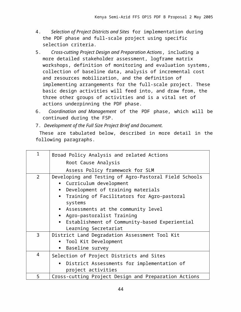
Kenya Semi-Arid FFS OP15 PDF B Proposal
consultation on Management of Degraded Soil in Southern and Eastern Africa (MADS-SEA) 2nd Networking Meeting 18-22 September 2000, Pretoria, South Africa. PR102-113
World Bank, 2003a, Arid Lands Resource Management Project Phase II. Project Document. Nairobi Kenya.
World Bank, 2003b, Information Shop: Kenya-Arid Lands Resource Management Project. Phase Two. Report No. AB39. Nairobi. Kenya
44
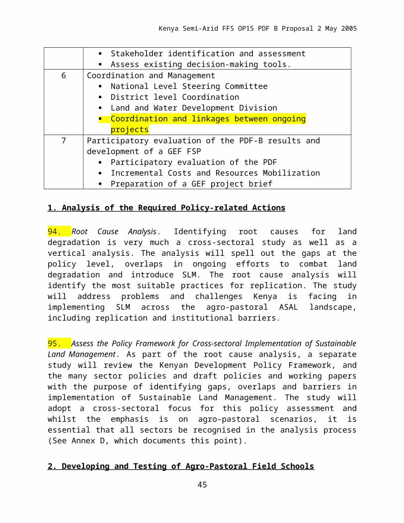
Kenya Semi-Arid FFS OP15 PDF B Proposal
Annex D: An Overview of Land Use, Land Degradation and Food Production and Security in Kenya, with specific reference to Ukambani
1) An Introduction to Land Degradation in Dryland Kenya.
Kenya has a total land area of 57 million ha of which 4.5 million are arable and permanent crops. On the basis of the ratio of annual rainfall (r) and average annual potential evaporation (Eo), Kenya can be divided into seven classes of moisture availability regions. Three of these classes (agro-climatic zones 5, 6.7), whose upper boundary of r/Eo ratio are 40, 25 and 15 respectively, are semi-arid, arid, and very arid, the so-called arid and semi-arid (ASAL) areas. These cover approximately 83 percent of the country. The arid zone (6/7) alone covers nearly half of Kenya. Only approximately 17 percent of the country is of medium to high agricultural potential. The major production constraint is low rainfall coupled with low fertility status of most soils. Agriculture supports over 80 percent of the population (total population is 28.4 million). Maize is the most important food crop in Kenya and constitutes the staple food for over 95 percent of the population. Subdivision of land since 1979, leads to uneconomically viable parcels of agricultural land. Population pressure has resulted in increased land pressure, leading people into fragile land, with a large decrease in per capita cultivated land.
Physical, chemical and biological land degradation occur in Kenya, the main cause being high production pressure due to increasing demands on the limited land resources. Soil erosion is by far the most important land degradation process in Kenya. Areas which are known to be suffered from medium to high levels of erosion include: Most of Machakos; Kitui and Taita Taveta Districts; semi-arid and arid areas of Kajiado and Narok Districts (southern Maasailand); areas of Muranga, Embu and Meru particularly the drier areas below 1500 m asl; and large areas of Samburu and Baringo Districts;
In general water and wind erosion are both active in Kenya. The forms of water erosion in Kenya are splash, rill, gully and stream bank erosion. It is estimated that up to 35 percent of the sediment load from 61 catchments in Kenya originated from roadside gullies and an equal amount from foot paths and cattle tracks. Erosion in cultivated areas is closely related to rainfall, landform, soil, land use and level of conservation. Wind erosion is a problem during the dry season in the drylands with up to 600 mm annual rainfall and with sparse vegetation. Loss of nutrients by erosion is a major problem in many areas.
Decline in soil fertility is most common in soils derived from Basement System rocks commonly found in Machakos, Kitui, Kajiado, Kakamega, Busia and West Pokot Districts. Soils on sedimentary formations are also affected by this decline in soil fertility. Decline in fertility is mainly due to over exploitation of soils through continuous cultivation and erosion. In the arid and semi-arid zones, removal of vegetation cover by overgrazing, trampling and cutting of trees and shrubs for charcoal are the major causes of soil degradation. Soil compaction occurs in areas where there is prolonged use of heavy agricultural implements and in areas with excess trampling by animals.
Management and Rehabilitation of Degraded Soils in Kenya
The severity of soil erosion was realized as early as 1920. In an attempt to arrest the situation, some soil conservation measures were introduced during the period 1930-1940, including terracing, strip cropping, crop residues and perennial cover. During the early 1960s there was considerable laxity in soil conservation efforts, the soil conservation measures which were being carried out were not maintained and terraces started to disappear at a faster rate than they were being constructed. From 1972 a country-wide soil conservation programme has been undertaken to increase the awareness of the importance of land degradation. At the community level, farmer-based soil management practices and mechanical
45
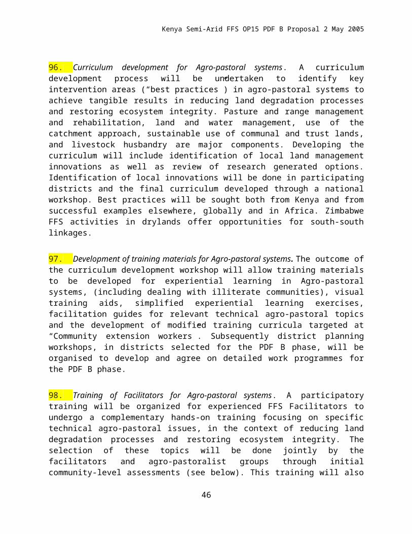
Kenya Semi-Arid FFS OP15 PDF B Proposal
measures have been practiced including strip cropping, control farming, ridging mulching and rotation, and physical techniques include terracing, cutting of drains, etc.
2) The Ukambani Story (Rochelau et al. 19958)
Regional environmental change in the dry farmlands of eastern Kenya represents a microcosm of the processes at work in the savanna and dry forest landscapes of East Africa. For global-change studies in particular, Kenya's dry farmlands provide a valuable lesson for the future of the larger region. Many other nations are encouraged to strive for the economic standards that Kenya has attained, yet the arid and semi-arid farmlands of Kenya suffer from multiple environmental problems associated with land-use change and development itself. These problems, in turn, will affect and be affected by larger global processes. The dryland farming regions throughout Kenya epitomize the co-determination of economic and ecological change within and among local, regional, and global systems.
The well-documented case of the Akamba people in eastern Kenya provides particular insight into both the substance and process of regional environmental change. The region regularly recurs as a "classic example" of land degradation in accounts dating back to the 1930s, and state policies have continuously been devised to address this concern. Rural residents report frequent crop failures and water shortages, and food relief has become a permanent feature of rural life A community leader in a semi-arid part of Kitui District, for example, classified 51 per cent of the years from 1947 to 1979 as "bad" or "very bad" famine years. The Machakos District was a net importer of maize for 14 of the years between 1942 and 1962 for which data are available, and for 8 of the years from 1974 to 1985.
The story of the Akamba people and their lands provides important lessons about the interaction of environmental change with state policy, especially the impacts of sedentarization, privatization, and the commercialization of agriculture, on rapid demographic change (numbers, composition, and distribution of population within the region). The most significant changes in land use at regional scale have included: the movements of highland Akamba to dryland areas, an ongoing land survey and tenure reform, a gradual shift from agro-pastoral to mixed farming production systems, the continuing conversion of dry forest and savannas to agriculture, the progressive replacement of subsistence by commercial production from household to regional level, the "mining" of dry forest and savanna trees for commercial charcoal markets in the city, and the quarrying of sand from dry river-beds and channels to construct new housing and commercial buildings in the city.
Ukambani constitutes an endangered region, assuming that the area remains non-industrial and rural for the foreseeable future. That is, under the current and foreseeable circumstances of nature-society interaction, land and water degradation threatens the health and livelihoods of the people of the region, and some of the degradation that has already occurred is irreversible. It is important in this case to note the striking variability in the conditions within the region and the very high uncertainty about the future directions and magnitude of environmental change. The central lessons of Ukambani over the last 100 years combine the changing nature and perception of environmental change over time with the distinct experience of those changes across different scales of analysis and between different groups of people. It is important to stress the differences in Ukambani between the more productive moister district of Machakos in the west and the drier district of Kitui (now split into Kitui and Mwingi) in the east.
8 This lengthy but important discussion is based on the detailed work of Diane Rocheleau of Clark University in the USA and her colleagues, in the main Districts of Ukambani in the 1990s. This work is complied in a detailed set of case histories on land degradation globally, published by United Nations University Press: Rocheleau et al 1995.
46
Kenya Semi-Arid FFS OP15 PDF B Proposal
Table Classification of agricultural land in agro-ecological zones (%)
Zone
District 2/3 ¾ 4 5 516 6
Machakos 1.2 5.1 26.2 53.5 4.3 9.7
Kitui - 0.5 14.0 50.7 - 34.9
Zones: 2, 3 Are suitable for banana and coffee; 4 Semi-humid to semi-arid transition; suitable for maize; 5 is Semi-arid; suitable for livestock, millet, and sorghum; 6 suitable for ranching
Population, settlement, and land-use practices
Preliminary results from the last census indicate that the current population of Machakos and Kitui districts is approximately 2.2 million people. The vast majority (90 per cent) of the population live in rural villages and rely on a combination of subsistence and commercial agriculture, with some wage labour. According to a 1982/83 survey of rural households in the Machakos District, agriculture accounted for 50 per cent of income, off-farm enterprises for 17 per cent, salaries and wages for 24 per cent, and other sources for 9 per cent.
Table : Population Estimatess for Ukambani (thousands) and Zonal Densities (per sqkm)
Year Machakos Kitui Total
1902 102 - -
1910 - 87 [190]
1918 120 104 224
1931 239 140 379
1948 358 211 569
1962 551 285 836
1969 707 343 1,050
1979 1,023 457 1,480
1989 1,382 - [1,990]
Land-use change
As urban and civil service opportunities contract, or fail to keep pace with the growing demand from Ukambani and other regions, many men have returned home to farm and young people are increasingly choosing not to leave. This has spurred a new cycle of agricultural intensification and experimentation in many communities since the beginning of the 1990s. The current process of land-use intensification represents a delayed response to higher population density overall and to progressive displacement of population into the drier portions of Ukambani. The changes in land use and settlement also reflect a changing pattern of land tenure, in both the character and the distribution of land rights.
Zone Machakos Kitui
2/3 285
3 231
4 110 103
5/6 40
5 26
6 3
47
Kenya Semi-Arid FFS OP15 PDF B Proposal
Landholdings range from 0 to 1000's of hectares (ha), with most households in agro-ecological zone 4 owning 2-10 ha and in zone 5 owning 2-15 ha. As land is subdivided and allocated or sold to the rising generation, farm sizes of 0.5-1 ha have become commonplace. Among all holdings in Machakos District (all zones), 30 per cent are less than 0.9 ha in size; the figure for Kitui is 17 per cent. Increasing numbers of people in zone 4 have been rendered landless, or migrate to urban areas (mostly men), to plantations (mostly women), or to zone 5 frontier areas (whole families and clusters of brothers, sisters, and friends with families). In Machakos, as migrants from zone 4 and resident young people subdivide the available land in zone 5, the landholding size is also shrinking. New settlers often purchase plots of 5-10 ha.
Most households (with an average of eight persons) keep both cattle and goats, with an average of two cattle and eight goats or sheep in Machakos and somewhat higher numbers in Kitui. The most common food crops are maize, beans, cowpeas, pigeon peas, pumpkins, sweet potatoes, green gram, and bananas. Farmers intercrop maize, beans, bananas, potatoes, sweet potatoes, pumpkins, and sometimes coffee in the wet uplands of Ukambani. Many upland coffee farmers also grow other tree crops, including macadamia nuts, mango, papaya, timber, and fuelwood. Cabbages, tomatoes, onions, red peppers, and greens are usually limited to river flood plains or poorly drained valley sites. In the drier parts of the region most farmers grow maize, beans (on moister sites), cowpeas, pigeon peas, and sometimes green gram and cotton. Sorghum and millet, once the staple grains, are found in small patches in croplands, but have been largely replaced by maize. Sweet potatoes, pumpkins, and bananas are fitted into the wetter sites in the field, along the base of terrace walls, in deep pits (1 m³) with fruit trees, on termite mounds, or in gardens near the home. Increasingly, farmers in zone 4 are also intercropping papaya, citrus, and some fodder or timber trees with their field crops.
Environmental hazards and environmental degradation
For most of Machakos and Kitui, the main limiting factors for settlement and agriculture are the lack of rainfall and of reliable sources of surface water. The latter has been further exacerbated by disruption of streamflow due to deforestation. Most streams are intermittent and deeply incised. In some areas, ticks and tsetse here limited livestock development into the 1970s. Crop environmental limits have always been less clear, tempting government and international agencies to push agricultural settlement into dry or hilly areas not capable of supporting intensive maize cultivation under existing levels of technology.
Land degradation by cropping and overgrazing has been a recurring theme throughout the last 70 years of colonial and later national agricultural and resource-management programmes. In this region, the high susceptibility of cropland to erosion derives from a combination of factors: concentrated settlement in fertile and well-watered hilly terrain; the tendency of the soils to "cap"; and the fact that 70 per cent of the most erosive rainstorms occur in the first month of the rainy season, before crops can establish an effective cover. Cattle, goats, and sheep also have pronounced effects on those Ukambani soils that have a propensity to form a pavement-like surface when denuded by overgrazing and physically compacted by trampling. The resulting land degradation, in turn, reduces future crop and livestock production.
Although the climate, soil, and topography of Ukambani make the region susceptible to erosion, compaction, and denudation, crop and livestock management practices can exacerbate, prevent, or even reverse land degradation. In reality, both regional and local variation in physical characteristics and cultural practices determines the potential for crop and livestock production and the condition of land and water resources in Ukambani. The state has tended to work primarily from regional-level differentiation of agricultural potential, whereas farmers and herders tended to focus more on local-level variations. Rural people in the region have often been thwarted by settlement, tenure, and agricultural development policies that force them into single "consolidated" holdings. There, they are expected to pursue a single land use, with household heads as single points of ownership and control. Land allocation has also tended
48
Kenya Semi-Arid FFS OP15 PDF B Proposal
to treat all local land as equivalent in inherent characteristics, current condition, productive potential, and vulnerability to damage. Likewise, many agricultural production and conservation programmes have promoted single-technology packages to achieve "sustainable production.
The trajectories of wealth, population, and environmental degradation 5.6 suggest that land-use intensification and soil-conservation measures counteracted population and other production pressures on the land at particular points in history. During the land-rush and settlement periods, however, the land degradation in newly opened regions outstripped the counter-effects of intensive resource management in the more densely settled regions. Once again, the divergence between Machakos and Kitui figures prominently in the projected future of population, wealth, and land degradation in the region.
The apparent stability of Machakos over the last decade may be attributed in part to the displacement of many of the poorest (or the next-poorest group, the near-landless-but-still-mobile) people to the rangelands and sparsely populated dry farmlands of frontier areas in Machakos and Kitui. If the past is any indicator, then it is reasonable to expect a cycle of serious environmental degradation in Kitui and the remaining frontier zones of Machakos during the next decades. The distribution of income streams between ecozones and the higher reliance of zone 5 households on migration and remittances during the drought of 1984-1985 both suggest that future residents of Kitui will be increasingly dependent on wage labour, yet they will be even further removed from local and national centres of employment, within an increasingly competitive labour market. For all of these reasons the region is best described as being on a slippery slope that could lead to either higher or lower wealth, reduced or improved well-being, and slower or more rapid environmental degradation. The net effect at the regional level over the next two decades is likely to be declining per capita wealth, increasingly skewed distribution of land and access to resources, and net environmental degradation.
The hydrologic system in this semi-arid environment is both the linchpin and the "Achilles heel" of the regional ecosystem. Water is a scarce resource, crucial to life support and livelihoods, and yet it is the single most sensitive element within the system in its responses to land-use change, reductions in forest cover, and increasing compaction near-sedentary cattle. This translates into a major criterion for judging land-use options in degraded areas. For example, intensification of agriculture in a deforested, degraded area could well restore partial tree cover through on-farm and boundary planting of trees.
An effective response to offset deforestation and watershed disruption would require major labour, management, and capital inputs from the farmers of Ukambani. This is a high expectation given the increasing proportion of smallholders and near-landless people who will either clear new plots from forest and range elsewhere, colonize marginal and fragile spaces within their local landscapes, or deplete the remaining resources in their existing plots in order to compensate for the shrinking size of holdings as plots are subdivided to children. Eventual outcomes depend on a host of contingencies in the national and international systems in which the region is embedded, as well as on the vagaries of local and regional weather and internal social and political processes.
Many writers have pointed out the folly of the dire predictions of imminent desertification. After six decades and a five-fold increase in population, not only is Ukambani not a desert, but soil condition and tree cover have improved in much of Machakos District. Yet fear of eco-tragedy is not unrealistic for the "bottom" 20-30 per cent in Ukambani who are food short and food poor, and who are likely to experience food deprivation in future droughts and displacement over the long term. The region may sustain livelihoods and life support for some, as well as contribute to national production, at the expense of excluding an ever-larger number of Akamba from access to home, workplace, and habitat within its borders, and by relegating many of those who remain to a precarious and vulnerable status with respect to ecological and economic perturbations. Biological impoverishment of the otherwise "stable", "recovered"
49
Kenya Semi-Arid FFS OP15 PDF B Proposal
landscape in the higher-potential lands (mostly in Machakos) may also narrow future livelihood and life-support options for all those who remain in Ukambani.
In terms of the physical resource base, it is the disruption of hydrological cycles that will do the most damage to both biological and economic productivity. The story of land-use change in Ukambani is a story of people maximizing returns to water under changing economic and ecological conditions, at different scales, and with varying degrees of control over their own and other people's use of the resource. Whereas people formerly concentrated around permanent groundwater sources or along perennial streams, widespread deforestation and soil compaction have led to the transformation of many permanent groundwater sources to seasonal supplies and have reduced perennial streams to intermittent flow. This has changed water quantity and quality and has radically altered the timing and terms of water availability for agriculture, livestock, and domestic use. Moreover, the changes in use pattern engendered by these effects has in turn caused further damage and disruption in watershed systems. Soil erosion is the single most visible and notorious form of environmental degradation in Ukambani. Ironically, it is also probably the most reversible - that is, the most responsive to restoration and rehabilitation. Past experiments in range management and land rehabilitation suggest that many of the degraded sites, if fenced and protected, are likely to recover rather quickly and dramatically. Until such measures are taken, however, many areas will produce less fodder, food, and other goods and services essential to rural life.
Table: Three types of "impositions" on the future generations of Ukambani
Resource Depletion of resource
Degradation of environment quality
Vulnerability of resource/of people
Prospects for reversal Local/ regional
Water high Moderate High/high moderate/low
Soil moderate High moderate/high moderate/low
Forests/trees high High low/high high/low
Range/pasture low High moderate/high high/high
What is really at issue for the people of Ukambani is the ability of the existing mixed land-use system, with its current biotic composition, to maintain or regenerate itself and to support the current and rising human population. The current divergence of environmental, economic, and social indicators between Machakos and Kitui, and between distinct groups (by gender, class, and generation), is illustrated in figures 5.5, 5.6, and 5.7. The future trajectory of the region will ultimately depend on whose home, habitat, and workplace it will and on the ability of affected groups to moderate state and market influences to serve their own interests, to reconcile population and production growth, and to negotiate a new basis for integrating ecology and economy in Ukambani as a region.
50
Kenya Semi-Arid FFS OP15 PDF B Proposal
Annex E: Short Note on the FFS Approach
1. Introduction. In general, Farmer Field Schools (FFS) consist of groups of people with a common interest, who get together on a regular basis to study the “how and why” of a particular topic. The topics covered can vary considerably - from IPM, organic agriculture, animal husbandry, and soil husbandry, to income-generating activities such as handicrafts. The FFS, however, are particularly adapted to field studies, where specific hands-on management skills and conceptual understanding (based on non-formal adult education principles) is required. So what are the essential elements of a FFS? Below is a list of elements that commonly appear in successful FFS programmes:
2. The group. A group of people with a common interest form the core of the FFS. The group may be mixed with men and women together, or separated, depending on culture and topic. The group could be an established one, such as a self-help, women’s, or youth group. Participatory technology groups, for example, sometimes undertake a season of study in FFSs before starting their research. The FFS tends to strengthen existing groups or may lead to the formation of new groups. Some FFS groups do not continue after the study period. The FFS is not developed with the intention of creating a long-term organization - although it often becomes one.
3. The field. FFSs are about practical, hands-on topics. In the FFS, the field is the teacher, and it provides most of the training materials like plants, pests, soil particles and real problems. Any new “language” learned in the course of study can be applied directly to real objects, and local names can be used and agreed on. Farmers are usually much more comfortable in field situations than in classrooms. In most cases, communities can provide a study site with a shaded area for follow-up discussions.
4. The facilitator. Each FFS needs a technically competent facilitator to lead members through the hands-on exercises. There is no lecturing involved, so the facilitator can be an extension officer or a Farmer Field School graduate. Extension officers with different organizational backgrounds, for example government, NGOs and private companies, have all been involved in FFS. In most programmes, a key objective is to move towards farmer facilitators, because they are often better facilitators than outside extension staff - they know the community and its members, speak a similar language, are recognized by members as colleagues, and know the area well. From a financial perspective, farmer facilitators require less transport and other financial support than formal extensionists. They can also operate more independently (and therefore cheaply), outside formal hierarchical structures.
5. All facilitators need training. Extension facilitators need adequate training to (re)learn facilitation skills and develop management skills such as fund-raising and development of local programmes. Computer literacy is often included in the training of facilitators, especially for preparing local training materials, budgets and project proposals. Email is also becoming more widely available. Once the facilitators have completed their training and are leading the FFS process, it is easy to identify capable farmers who are interested in becoming facilitators. Farmer Field School graduates are usually given special farmer facilitator training (10-14 days) to improve technical, facilitation and organizational skills.
6. The curriculum. The FFS curriculum follows the natural cycle of its subject, be it crop, animal, soil, or handicrafts. For example, the cycle may be “seed to seed” or “egg to egg”. This approach allows all aspects of the subject to be covered, in parallel with what is happening in the FFS member’s field. For example, rice transplanting in the FFS takes place at the same time as farmers are transplanting their own crops - the lessons learned can be applied directly. One key factor in the success of the FFS has been that there are no lectures – all activities are based on experiential (learning-by-doing), participatory, hands-on work. This builds on adult learning theory and practice. Each activity has a procedure for action, observation, analysis and decision making. The emphasis is not only on “how” but also on “why”.
51
Kenya Semi-Arid FFS OP15 PDF B Proposal
Experience has shown that structured, hands-on activities provide a sound basis for continued innovation and local adaptation, after the FFS itself has been completed. It is also one of the main reasons that farmer facilitators can easily run FFSs - once they know how to facilitate an activity, the outcomes become obvious from the exercise itself.
7. Activities are sometimes season-long experiments – especially those related to soils or plant physiology (for example soil or variety trials, plant compensation trials). Other activities in the curriculum include 30-120 minutes for specific topics. Icebreakers, energisers, and team/organisation building exercises are also included in each session. The curriculum of many FFSs is combined with other topics. In Kenya, for example, the FFSs follow a one-year cycle including cash crops, food crops, chickens or goats and special topics on nutrition, HIV/AIDS, water sanitation and marketing. FFSs for literacy are also promoted where there is a need.
8. The programme leader. Most FFS programmes exist within a larger programme, run by government or a civil society organisation. It is essential to have a good programme leader who can support the training of facilitators, get materials organized for the field, solve problems in participatory ways and nurture field staff facilitators. This person needs to keep a close watch on the FFSs for potential technical or human relations problems. They are also the persons likely to be responsible for monitoring and evaluation. The programme leader must be a good leader and an empowering person. He or she is the key to successful programme development and needs support and training to develop the necessary skills.
9. Financing. FFSs can be expensive or low-cost, depending on who implements them and how they are conducted. Due to high allowances, transportation costs and several layers of supervision programmes can end up being expensive (about USD 30-50 per farmer). Obviously, the greater the distance that facilitators need to travel to get to the field, the higher the cost of transport. Transport is one of the biggest costs in any extension programme. However, in FFS programmes training is a key recurrent component, which takes up a large portion of the budget. When the FFS is carried out by local organizations and farmer facilitators, initial start-up costs may be moderate, but the running costs will be much lower (about USD 1-20 per farmer). A trend in East Africa is to manage small commercial plots alongside the FFS study plots, so that the FFS can actually raise more funds than it uses for inputs and stationary. In some cases in East Africa farmers have also cost-shared training expenses by buying their own exercise books, offering training sites and other locally available training materials (e.g. planting materials and labour).
10. Final word. Farmer Field Schools are not difficult or mysterious. However, they are meant to empower through education on skills and concepts (how’s and why’s) and therefore, require an empowering environment. The basis for a successful FFS starts with the programme’s culture of operation - from a nurturing and empowering programme leader and good facilitators, to transparent budgets and open management. FFSs are not difficult to set up if there is a commitment to, and faith in farmers’ and facilitators’ ability to learn locally and apply learning to local problems themselves.
52
Kenya Semi-Arid FFS OP15 PDF B Proposal
ANNEX F: GEF PROJECT COMPARISON MATRIX:WB OP 15 Project: Agricultural Productivity and SLM and This UNDP OP15 Project on Semi-arid-Agro Pastoralist Field Schools
Item Project 1
Agricultural Productivity and Sustainable Land Management in Kenya
(GEFSEC Project ID 2355)
Project 2
Using Farmer Field School approaches to overcome land degradation in agro-pastoral areas of Eastern Kenya
(GEFSEC Project ID 2783)
Comparison, Differences and Complementarities
Geographical scope
Five mountain watersheds across Kenya, which are threatened by lack of environmental management and increasing human encroachment. These are: in the west (Cherangani, Yala); the centre (Tugen and Kikuyu Scarp) and south-east (Taita Hills).
Selected districts within North-eastern and Eastern Provinces of Kenya, typically an ancient and denuded flat peneplain with relict rocky inselbergs
Project 1 focuses on the high and medium potential parts of the five watersheds, whilst project 2 focuses on selected semi-arid and arid districts of Eastern and North-eastern Provinces
Agro-Ecological Zones (AEZ)
Agro-ecological zones 1-3 within the targeted watersheds (i.e. the high potential areas – intensive cropping areas).
Predominantly agro-ecological zones 5-6 with some input to 7.
The two projects have different entry points at the AEZ level.
Development objective or goal
Contribute to the modernization of Kenya’s agricultural sector and improvement of the lives and livelihoods of its rural communities through the development, acquisition and application of improved and profitable agricultural technologies and production
To facilitate uptake of sustainable land use management (SLM) practices in order to reduce land degradation in arid and semi-arid lands of Kenya within the context of sustainable development.
Both projects see the KAPP as the main overarching framework for agricultural development.
53
Kenya Semi-Arid FFS OP15 PDF B Proposal
practices.Immediate objective or purpose
Mitigate land degradation in selected priority watersheds through promotion of sustainable land management technology packages and practices that have local and global benefits.
To remove capacity-related barriers impeding the implementation of SLM in North-Eastern and Eastern Kenya, through community-based innovations and learning that reduce land degradation and conserve ecosystem integrity.
Project 1 will work through pluralistic extension approaches (using ATIRI, FFS and others), while Project 2 will focus on developing an approach to effectively support neglected mobile agro-pastoral communities adapting the very successful FFS experiential learning approach. In this respect Project 2 complements KAPP in areas that largely lack an extension system, i.e. the Eastern and North-eastern Provinces.
Outcomes 1. Inventory of the baselines, constraints and opportunities to adoption of SLM practices (soil and water conservation, nutrient management) including integration of crops, trees and livestock developed.
2. Methods of restoring and sustaining land management and best management practices for increased net benefits developed, adopted and scaled-up.
3. Understanding of the socio-economic and policy factors which affect land management and adoption of sustainable land management best practices deepened and methodology and models to assess impacts of
1. Sustainable land management policies and innovative mechanisms targeting agro-pastoral communities mainstreamed into cross-sectoral national/district decision-making processes that target agro-pastoral land-users, leading to improved land use practices.
2. Site-specific Agro-pastoral innovations and community-based experiential learning are providing tangible results in preventing and controlling degradation processes and restoring ecosystem integrity, and providing lessons to advise policy and capacity building processes.
Project 1 will be an integral part of KAPP, focussing on baseline inventories, constraints and opportunities for adoption, understanding of socio-economic and policy factors, exchange of information, and development of SLM practices. These activities will serve as key inputs to creating an enabling environment for the implementation of Project 2.
Project 2, through focussing on supporting previously neglected agro-pastoral communities by adapted the FFS approach, will contribute to KAPP in selected semi-arid and arid districts of Eastern and North-eastern Kenya. Project 2 will
54
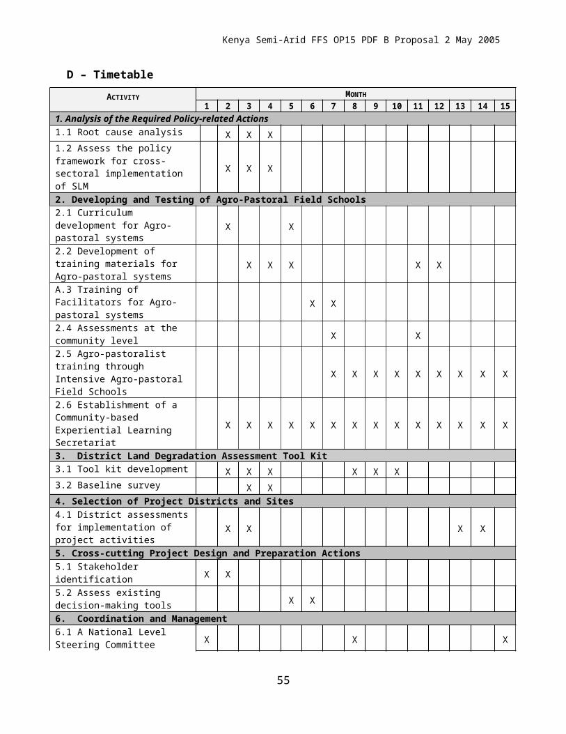
Kenya Semi-Arid FFS OP15 PDF B Proposal
policies on natural resource management developed.
4. Institutional capacity of stakeholders to undertake participatory and multidisciplinary land resource management activities sustainably enhanced.
5. Exchange of information on land resource management and best management practices among farmers, communities, policy makers and the global fraternity markedly fostered.
6. Better marketing channels for farm produce and value-added products for improved livelihoods (on-farm/off-farm linkages strengthened).
also work on removing barriers to SLM through cross-sectoral implementation of Agro-pastoral Field Schools.
Kenya GEF SLM and Related Projects Portfolio Review
Project IA/EA Op Program
Scale Agro Ecol zone
Entry Point Sector Province in Kenya
Mount Kenya UNEP / IFAD 12 National 2-5 Agriculture CentralFFS Agro Pastoralist UNDP /FAO 15 National 5-6 Agro-Pastoralists East/North East. Catchment and SLM WB 15 National 1-3 Agriculture Western, Rift Valley,
Central and Coast
Indig Vegetation UNEP / UNDP 1 Regional 6-7 Pastoralism Rift Valley
55
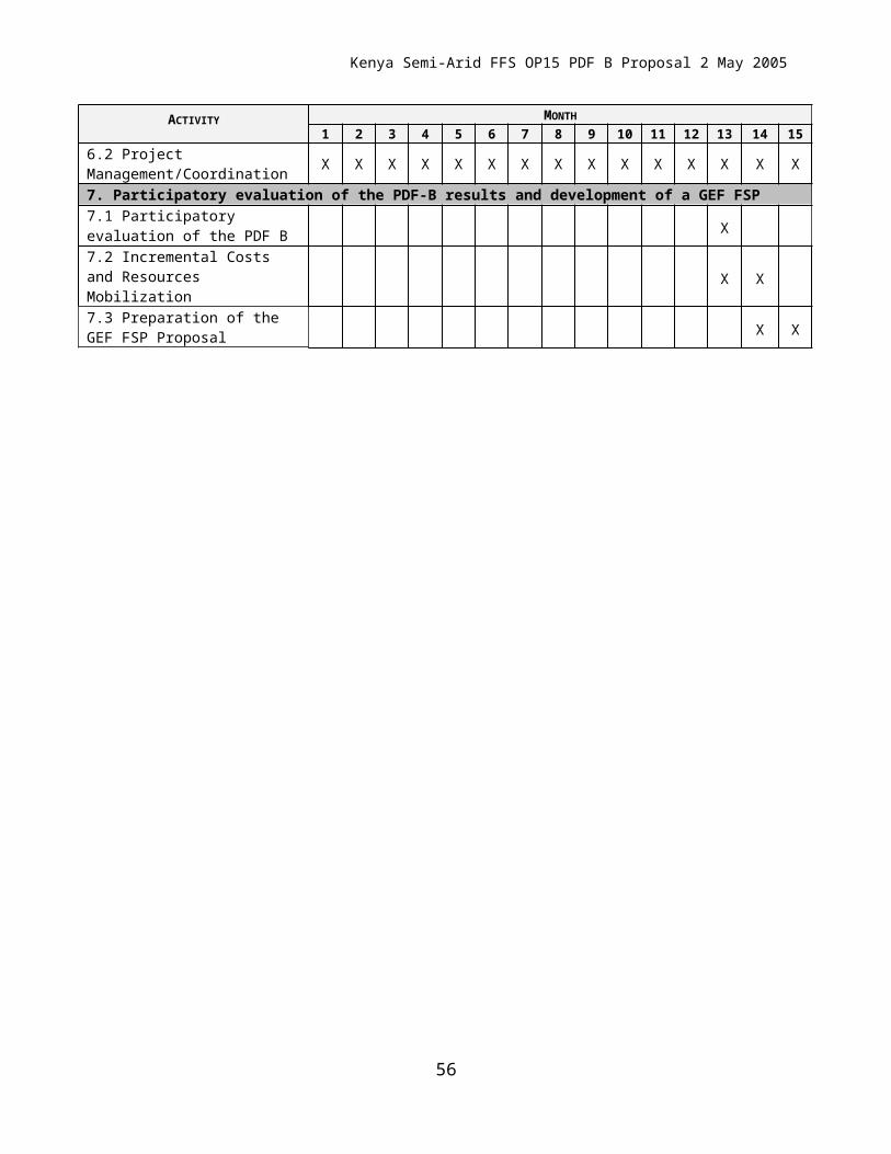
Kenya Semi-Arid FFS OP15 PDF B Proposal
Desert Margins UNEP /UNDP 15 Regional 6-7 Pastoralism Rift ValleyLUCID UNEP T. Research Regional 1-7 Varied SeveralDryland PDFA Forestry (Concept stage)
UNDP 15 National 5-7 Forest/Districts. Concept follows from new priorities in Kenya Policy
Eastern
MSP Livestock Wildlife Interface
UNEP BD2/15 Regional& Burkina)
6-7 Wildlife/Livestock Rift Valley
Poverty Environment Mapping
UNDP/UNEP 15 Regional(E Africa)
4-7 Planning, Environment Rift Valley
56