Embed Size (px)
Citation preview

E C O L O G I C A L R E V I E W
Ship Shoal: Whiskey West Flank Restoration CWPPRA Priority Project List 11
(State No. TE-47)
September 28, 2005
Mark A. Stead
Restoration Technology Section Coastal Restoration Division
Louisiana Department of Natural Resources
This document reflects the project design as of the 95% Design Review meeting, incorporates all comments and recommendations received following the meeting, and is current as of October 12 2005.
1
95% Ecological Review
Ship Shoal: Whiskey West Flank Restoration (TE-47)
In August 2000, the Louisiana Department of Natural Resources (LDNR) initiated the Ecological Review to improve the likelihood of restoration project success. This is a process whereby each restoration project’s biotic benefits, goals, and strategies are evaluated prior to granting construction authorization. This evaluation utilizes environmental data and engineering information, as well as applicable scientific literature, to assess whether or not, and to what degree, the proposed project features will cause the desired ecological response.
I. Introduction
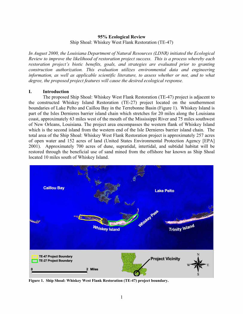
The proposed Ship Shoal: Whiskey West Flank Restoration (TE-47) project is adjacent to the constructed Whiskey Island Restoration (TE-27) project located on the southernmost boundaries of Lake Pelto and Caillou Bay in the Terrebonne Basin (Figure 1). Whiskey Island is part of the Isles Dernieres barrier island chain which stretches for 20 miles along the Louisiana coast, approximately 63 miles west of the mouth of the Mississippi River and 75 miles southwest of New Orleans, Louisiana. The project area encompasses the western flank of Whiskey Island which is the second island from the western end of the Isle Dernieres barrier island chain. The total area of the Ship Shoal: Whiskey West Flank Restoration project is approximately 257 acres of open water and 152 acres of land (United States Environmental Protection Agency [EPA] 2001). Approximately 700 acres of dune, supratidal, intertidal, and subtidal habitat will be restored through the beneficial use of sand mined from the offshore bar known as Ship Shoal located 10 miles south of Whiskey Island.
Figure 1. Ship Shoal: Whiskey West Flank Restoration (TE-47) project boundary.
2
The Isles Dernieres barrier island chain shoreline is one of the most rapidly deteriorating barrier shorelines in the United States (Williams et al. 1992). It is estimated that most of Louisiana’s barrier islands have naturally decreased in land mass by approximately 40% over the last 100 years (Monteferrante and Mendelssohn 1982). Historically, tropical storms and hurricanes have caused beach erosion and overwash of these islands. In addition, winter storms and cold front passages contribute to the erosion of the islands, most notably the back barrier salt marsh shorelines (LCWCRTF & WCRA 1999). Erosion of the gulf and bay shorelines is causing the islands to narrow. From the 1890’s to 1988, island width had decreased approximately 2,612 feet (Williams et al. 1992). Historical landloss estimates in the area have averaged between 32.8 and 49.2 feet per year (LCWCRTF & WCRA 1999). Future landloss projections estimate that several islands in the Isles Dernieres chain will become sub-aqueous by 2007 and none will remain by 2050 (LCWCRTF & WCRA 1999). Nourishment of the beaches on the western flank of Whiskey Island with sand mined from Ship Shoal will aid in reducing storm surge and in protecting interior marsh and infrastructure (LCWCRTF & WCRA 1999). This objective is in accordance with Coast 2050 Region 3 Ecosystem Strategies which include maintaining and restoring the Isles Dernieres barrier island chain. II. Goal Statement
• Maintain approximately 125 acres of the created/restored dune, intertidal, and supratidal habitat by the end of the 20-year project life (Table 1).
• Prevent breaching of the barrier island throughout the 20-year project life. • Assess the effectiveness of mining offshore Ship Shoal sand for use in future barrier
island restoration projects.
Table 1. Acreage targets for the west flank of Whiskey Island with and without project (EPA 2003). Target Year Future Without Project (Acres) Future With Project (Acres)
TY-0 186 186 TY-1 (as built) 179 500 TY-10 126 322 TY-20 60 125
III. Strategy Statement
• Create a 200-foot wide gulfside beach berm at an elevation of +3.0 feet NAVD 88 and a 100 to 300-foot wide dune at an elevation of +4.0 to +6.0 feet NAVD 88.
• Create back barrier marsh on the bay side of the island at an elevation of +2.0 feet NAVD 88 at the toe of the dune to +1.0 foot NAVD 88 at the toe of the platform.
• Erect sand fencing and plant vegetation to stabilize dune and back barrier components. IV. Strategy-Goal Relationship
Project goals will be achieved by mining and transporting offshore Ship Shoal sand to restore the west flank of Whiskey Island. Material will be transported a distance of approximately 10 miles via pipeline and booster pumps to the island and used to create dune, marsh, and intertidal habitat. Conventional earth moving equipment would be used to obtain design elevations, widths, and slopes. A design template, which was selected through the numerical modeling of alternatives, was used to achieve the goal of preventing island breaching over the life of the project.

3
V. Project Feature Evaluation Alternative Designs
Three alternative island designs were modeled by Moffatt & Nichol Engineers, Inc. (2004) to determine the best method for restoring the west flank of Whiskey Island. The alternatives include three designs of differing dune width and height, back barrier marsh width and height, and berm width and height are presented in detail below (Table 2).
Table 2. Alternative design parameters for the west flank of Whiskey Island. Alternatives Berm
Width (feet)
Berm Height (feet NAVD 88)
Dune Width (feet)
Dune Height (feet NAVD 88)
Back Barrier Marsh Width
(feet)
Back Barrier Marsh Height
(feet NAVD 88)
Total Acres
Created
A 100 3.0 200 7.0 975-1325 1.0-2.0 547 B 200 3.0 300 6.0 825-1225 1.0-2.0 549 C 300 3.0 400 5.0 675-1025 1.0-2.0 542
Alternative A (Figure 2 and Appendix A) involves the construction of a marsh platform, beach berm, and dune. Because the design widths of the dune and beach berm are relatively small, this alternative design allows for the creation of more back barrier marsh habitat (204 acres) in lieu of beach and dune habitat (126 and 83 acres, respectively) and 134 acres of intertidal habitat. A total of 547 acres of subtidal gulf beach, dune, and intertidal marsh would be created and or restored using this design alternative.
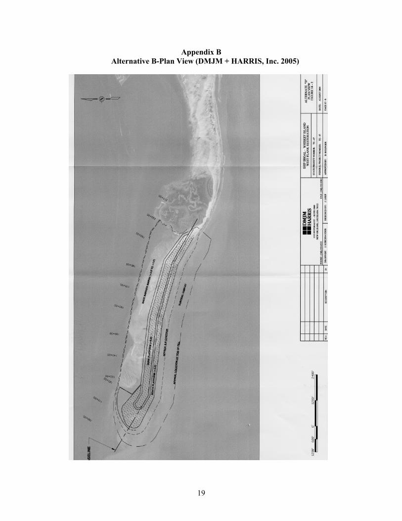
Figure 2. Alternative A (DMJM + HARRIS, Inc. 2005). Alternative B (Figure 3 and Appendix B) involves the same components as Alternative A except that dune height is at a slightly lower elevation and dune and beach berm widths are increased. This alternative will allow for the creation of more beach and dune habitat (144 and 90 acres, respectively) then Alternative A, but less back barrier marsh habitat (181 acres) and a similar acreage of intertidal habitat (134 acres). A total of 549 acres of subtidal, gulf beach, dune, and intertidal marsh would be created and or restored using this design alternative.
4
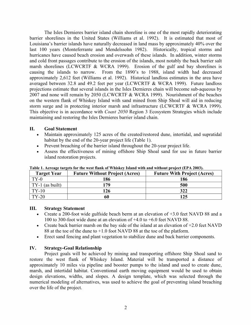
Figure 3. Alternative B (DMJM + HARRIS, Inc. 2005). Alternative C (Figure 4 and Appendix C) also involves the same components as Alternatives A and B except dune height will be further reduced than Alternative B and the width of the beach berm and dune will be increased. Alternative C will result in the least amount of back barrier marsh creation (146 acres) but the largest acreage of beach berm and dune habitat (163 and 99 acres, respectively) and a similar total of intertidal habitat (134 acres). A total of 542 acres of subtidal gulf beach, dune, and intertidal marsh would be created and or restored using this design alternative.
Figure 4. Alternative C (DMJM + HARRIS, Inc. 2005). Model Discussion Numerical models were developed by Moffatt & Nichol Engineers, Inc. (2004) to examine hydrodynamics, waves, sediment transport, and morphological changes under “future with-project” and “future without-project” conditions. In addition, the models were used to compare the performance of the three alternatives under design storm conditions and during a series of other storm scenarios over the 20-year project life. The models were developed using the Delft3D modeling system, an integrated surface water modeling system by WL|Delf Hydraulics in the Netherlands (DMJM + HARRIS, Inc. 2005).

5
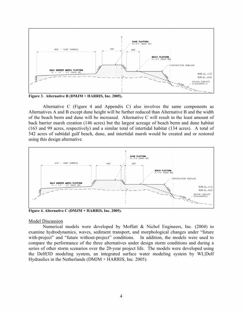
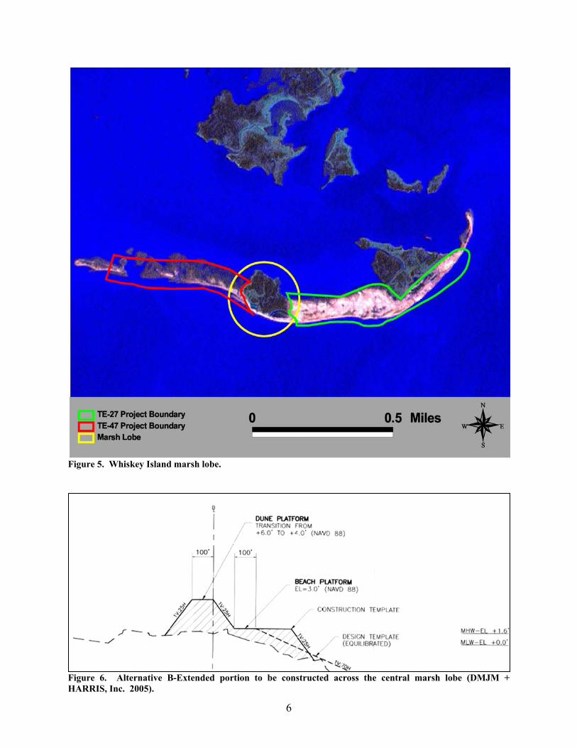
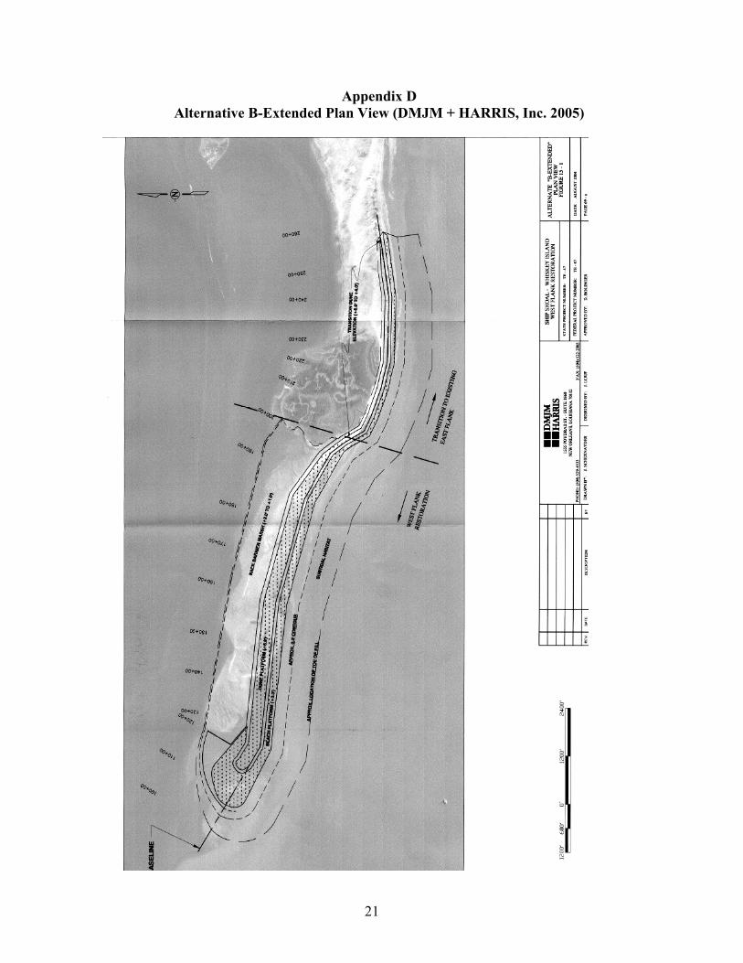
Design Storm and Alternative Performance Hurricanes and the associated storm surge play a large role in determining design parameters for barrier island restoration projects. Dune height and width often reduce the frequency of overwashing and breaching events that may occur and allow for the establishment of back barrier marsh vegetation. Using a developed stage of storms versus frequency estimate for East Timbalier Island (Suhayda 1991) and Grand Isle (United States Army Corps of Engineers [USACE] 1979), Moffatt & Nichol Engineers, Inc. estimated that a Category 2 storm was a reasonable design storm for this project. A design storm is essentially a storm that would recur over or near Whiskey Island once every thirty years and have an estimated storm surge of +5.0 feet NAVD 88. Storm surge combined with wave setup would increase the total height of surge to an estimated +7.0 feet NAVD 88. Moffatt & Nichol Engineers, Inc. modeled the effects of the design storm and a major storm (Category 3-4), which is estimated to impact Whiskey Island once every 30 to 100 years, respectively, in the three alternative designs. The model showed that the three alternatives would likely survive the design storm without catastrophic damage. However, Alternative C would experience overwashing and breaching and would be vulnerable to smaller tropical systems. In addition, Alternative C has an extremely wide dune, thereby reducing the acreage of the back barrier marsh. Alternative A was estimated to prevent breaching and experience less inundation and erosion than both Alternatives B and C during a design storm but caused increased flow-training effects (mid-island overwashing) on the central and eastern sections of Whiskey Island outside of the project area. Alternative B also prevented breaching but caused less flow-training effects, compared to Alternative A, on the central marsh lobe and eastern portions of the island. Also, the dune height of Alternative B (+6.0 feet NAVD 88) is consistent with the recommendations of Penland et al., (2003) that natural dune height (3.0-6.0 feet NAVD 88) results in a significant increase in biodiversity. Therefore, the Alternative B template was chosen by Moffatt & Nichol Engineers, Inc. as a superior design for the reconstruction of the Whiskey Island western flank. In the event of a major storm (Category 3-4), the hydrodynamic and morphological impacts on the restored western flank of Whiskey Island would be significantly more severe (DMJM + HARRIS, Inc. 2005). It is estimated that the entire island would be under more than +7.0 feet NAVD 88 of water. Significant breaching and subsequent erosion of the restored island area would occur (DMJM + HARRIS, Inc. 2005). Alternative B-Extended As mentioned previously, modeling results of Alternatives A, B, and C showed that the central marsh lobe (Figure 5) would experience increased overwash and possible breaching (flow-training effects) if the island experienced a storm surge associated with a Category 2 hurricane. Therefore, a fourth alternative, called Alternative B-Extended, was formulated by Moffatt & Nichol Engineers Inc. by modifying Alternative B (Appendix D) with the intention of protecting the central marsh lobe from inundation. Modeling results show that by extending the beach berm and dune template of Alternative B eastward, flow over the marsh lobe in the middle section of the island would be reduced during a design storm. This extended beach berm and dune template (Figure 6) would tie in with the previously constructed TE-27 project. Additionally, this extension would, through longshore transport processes, act as a feeder beach for the western flank. Alternative B-Extended was chosen as the preferred alternative by the project team at the 30% Design Review Meeting.
6
Figure 5. Whiskey Island marsh lobe.
Figure 6. Alternative B-Extended portion to be constructed across the central marsh lobe (DMJM + HARRIS, Inc. 2005).
7
Alternative B-Extended involves the same components as Alternative B except that dune and beach berm length extends farther east and dune height transitions from +6.0 feet NAVD 88 to +4.0 feet NAVD 88 to protect the central marsh area of Whiskey Island (Table 3). This alternative will allow for more subtidal (203 acres), beach (198 acres), dune (121 acres), and intertidal marsh habitat creation (181 acres) compared to the other alternatives. A total of 703 acres of subtidal gulf beach, dune, and intertidal marsh would be created and/or restored using this design alternative. Table 3. Design parameters of Alternative B and Alternative B-Extended for the west flank of Whiskey Island (DMJM + HARRIS, Inc. 2005).
The model also showed that significant losses of the restored western flank can be expected over the life of the project. At the end of the project life it is estimated that only 20-30%, or roughly 100 to 150 acres of the restored subaerial portion of the western flank using the Alternative B-Extended design will remain without a maintenance event (Moffatt & Nichol Engineers, Inc. 2004). In addition, the habitat type will change significantly over the life of the project. Following construction, the restored western flank will likely have a habitat distribution of 40% supratidal beach, 20% intertidal beach, and 40% intertidal marsh. At year 20 the distribution would be similar to pre-construction conditions in that 20% supratidal beach, 60% intertidal beach, and 20% intertidal marsh, would still exist. The relatively high loss of material is a direct result of overwash during storm events, longshore transport, and other natural erosional processes. Alternatives A, B, and C were estimated to have a similar percent of restored area remaining at the end of the project life (DMJM + HARRIS, Inc. 2005). Geotechnical Analysis of Borrow Site
The proposed borrow site is located approximately 10 miles due south of Whiskey Island and is contained entirely within Ship Shoal-Block 88. Ship Shoal is an east-west linear offshore bank 31 miles long by 3 miles wide and up to 16 feet thick and submerged in approximately 10-30 feet of water (DMJM + HARRIS, Inc. 2005). In order to determine a suitable borrow site within Ship Shoal, a preliminary geophysical survey was conducted by C & C Technologies (2003). C & C Technologies determined that the west-central section of Ship Shoal-Block 88 contained material suitable for restoring the west flank of Whiskey Island. A subsequent sand source investigation of Ship Shoal–Block 88 was conducted by Soil Testing Engineers, Inc. (STE) in late March and early April of 2004. The purpose of this investigation was to further assess the suitability of the offshore borrow site material within Block 88 for the restoration of the west flank of Whiskey Island (STE 2004). Thirty-five vibracores were collected from a 5,500-foot by 6,500-foot plan view area of the middle to southern half of Block 88. The depth at which the samples were collected ranged from 18 to 23 feet. Analysis of grain size, Atterberg limits determinations, moisture content determinations, and specific gravity revealed that the upper sands were the most suitable sediment type present within the area of Block 88 for island restoration. Typically, an upper fine sand layer was
Alternatives Berm Width (feet)
Berm Height (feet NAVD 88)
Dune Width (feet)
Dune Height (feet NAVD 88)
Back Barrier Marsh Width
(feet)
Back Barrier Marsh Height
(feet NAVD 88)
Total Acres
Created
B 200 3.0 300 6.0 825-1225 1.0-2.0 549 B-Extended 100-200 3.0 100-300 4.0-6.0 0-1225 1.0-2.0 703

8
located at the crest or top of the shoal while a central silty sand to sandy silt layer and a lower clay layer were contained underneath. It was determined that within the investigated area that the upper sands ranged in thickness from 4 feet at the northeast corner to 20 feet or greater at the northwest corner. A total of approximately 17,300,000 cubic yards of sand is contained within the investigated area of Block 88. Mean grain size of the upper crest of the shoal was determined to be 0.20 mm, with a 2.3 phi value (the phi value is the negative logarithm to the base 2 of the particle diameter). These values were used to determine the compatibility of the sediments at the borrow site to those contained at the western flank of Whiskey Island. Geotechnical Analysis of Whiskey Island West Flank Soil Testing Engineers (STE 2004) performed a sampling investigation of the sediments on and around both the eastern and western flanks of Whiskey Island in May of 2004. The purpose of this sampling investigation was to compare the sediment characteristics of Whiskey Island to those of the borrow site using a sediment suitability assessment. Forty-nine “grab” samples were collected across the subaerial profile, south Gulf side, and back barrier of Whiskey Island. Grain size sieve analyses and moisture content determinations were performed by STE to classify sediments collected. Results of the geotechnical analysis indicated that the average grain size of the material collected at or above mean low water from the west flank of Whiskey Island was approximately 0.20 mm. Sediment Suitability Index
A sediment suitability assessment was conducted to determine how similar texturally the borrow material in Ship Shoal-Block 88 was compared to the native material on Whiskey Island’s western flank (STE 2004). If the material added to the western flank of Whiskey Island is coarser or finer than the native material the performance of the project will be significantly reduced. The borrow material placed on the beach of Whiskey Island will undergo a natural sorting process as a result of coastal processes and will eventually approach the native grain-size distribution. The finer material that does not match the native material will be lost offshore (USACE 2002).
The mean grain size of samples taken from at or above MLW of the west flank of
Whiskey Island was approximately 0.20 mm, while deeper Gulf and bay subtidal samples were significantly finer. Therefore, it was determined that the samples collected in Ship Shoal-Block 88 were similar to those collected at Whiskey Island and contained primarily fine sand with a mean grain size of 0.20 mm. An overfill factor was used in order to estimate the volume of borrow material needed to produce a stable unit of usable fill material with similar grain size characteristics as the native material. If the overfill factor is estimated to be 1.0, the borrow and native material are nearly identical. Overfill factors were computed using data from each of the borrow area vibracores and samples from the MLW and shallow crest of the west flank. The average overfill factor was calculated to be 1.2, meaning 1.2 volumetric units of borrow material would be required to create 1.0 unit of stable Whiskey Island beach material. Dredging Alternative Analysis
An estimated 2-4 million cubic yards of sand will be dredged and transported nearly 10 miles from Ship Shoal-Block 88. Dredging and transport alternatives were chosen based on several factors including production rates, transport distance, water depth, environmental factors, cost, and equipment availability (DMJM + HARRIS, Inc. 2005). Three dredging and transport

9
options were chosen for further evaluation after completion of the Preliminary 30% Design Review Meeting.
• Hydraulic Suction Cutterhead Dredge with pipeline/booster station to shore: Transport of sediments will be accomplished by pumping material through twenty to thirty-six inch pipelines to shore. Floating and fixed booster pumps will be situated along the pipeline and spaced to optimize cost. Once the sediment is transported, the material will be placed along the front of the restoration project for final placement and grading.
• Hopper Dredges to intermediate point for transfer to pipeline/booster station to shore:
The pipeline to shore, with booster stations, would be similar to the first option but shorter in overall length. Dredges will be chosen based on the operating drafts and transfer points from the hopper dredge to pipeline to the shore of Whiskey Island.
• Hydraulic Cutterhead Dredge filling a Hopper Barge for delivery to intermediate
transfer point to pipeline/booster station to shore: This approach is similar to the second option substituting a cutterhead dredge and barges for the hopper dredges. This option offers more flexibility and assurance of production output by using multiple units as well as the ability to locate the transfer point in shallower water closer to shore.
Dredging cost estimates were computed based on the USACE Cost Engineering and
Dredge Estimating Programs (CEDEP), and included the costs of performing the dredging, transport and placement of material. Based on these cost estimates DMJM+HARRIS determined that the hydraulic suction cutterhead dredge with pipeline/booster station to shore is the most cost effective and efficient alternative for the construction of this project. Borrow Site Impacts The Moffatt & Nichol Engineers, Inc. model evaluated the changes in shoal geometry and the resulting impacts on local wave conditions following mining of sediments from the shoal (DMJM + HARRIS, Inc. 2005). One concern with removing sand from Ship Shoal was the impacts on regional and local wave conditions. Stone et al. (2003) found that removal of the shoal (1.6 billion cubic yards) would increase significant wave heights during severe storms as much as 90-100% over the shoal and 50% in the lee of the shoal, but that shoal removal would not measurably increase near-shore wave energies or erosion on the Isles Dernieres. It can be expected that impacts from removing 2-4 million cubic yards of material for this project would be less severe than removal of the entire shoal. Moffatt & Nichol Engineers, Inc. used the SWAN wave model for both existing and post-dredge conditions to better understand the hydrodynamic impacts of removing 17 million cubic yards of sediment (entire volume of Block 88) from the shoal, although only 2-4 million cubic yards would be required for the restoration of the western flank of Whiskey Island. It was determined that during a severe storm the change in wave height was estimated at 1.4 feet or a 7.0% increase compared to current conditions. However, the extent of these impacts were localized and limited to an area of approximately 4 miles wide by 6 miles long. Waves associated with fair weather conditions travel over the existing shoal without dissipating. It can

10
therefore be assumed that removing sand from Ship Shoal-Block 88 would have only a small localized impact on wave climate under storm conditions. Back Barrier Marsh Creation
Back barrier marsh will be created using coarse material mined from Ship Shoal. The elevation of the back barrier will be +2.0 feet NAVD 88 at the back toe of the dune and +1.0 feet NAVD 88 at the bay shoreline. Vegetation will be used to further stabilize the material. No settlement analysis was conducted on the back barrier component but it is estimated that the coarse material being used will experience little dewatering and consolidation. The back barrier marsh elevation for this project is significantly lower than design elevations of similar barrier island projects. However, many of the previously constructed back barrier marsh components were built at an elevation too high to be considered functional intertidal marsh (DMJM + HARRIS, Inc. 2005). Sand Fencing Sand fencing aids in dune formation and traps sand that otherwise would be lost (Khalil and Lee 2004). The Barrier Island Comprehensive Monitoring (BICM) Program, recommends installing sand fencing 4 feet high with 50% porosity (i.e., ratio of area of open space to total projected area) placed parallel to shore along the entire length of the dune. The purpose of the sand fencing design is to capture wind-blown sand and help build and stabilize mounds. Sand fencing will be constructed on the western flank of Whiskey Island after the construction of the dune, intertidal and supratidal components of the project are completed. Vegetation The United States Department of Agriculture (USDA) recommended the use of both marshhay cordgrass (Spartina patens) and bitter panicum (Panicum amarum) in dune restoration projects (USDA 1992). These plants should stabilize sand particles when used in conjunction with sand fencing. A slightly altered protocol was recently formulated by LDNR’s Coastal Engineering Division’s Planting Section. This protocol is based on reviews of previous planting plans, specifications, and is meant to improve survival and coverage for the vegetative planting of future projects. The new planting strategy includes increasing the diversity of the plants used on berm and dune habitat and installing the plants earlier in the growing season. The added species are thought to better tolerate the dry harsh conditions found on the berm and dune areas of barrier islands during the summer months (Ken Balingher, LDNR, Personal Communication April 2005). By planting earlier in the spring, the vegetation will have more time to establish root systems before summer and disturbances to bird nesting areas will be minimized. VI. Assessment of Goal Attainability
Environmental data and scientific literature documenting the effects of the proposed project features in field application are evaluated below to assess whether or not, and to what degree the project features will elicit the desired ecological response. Dune Building
According to the Louisiana Gulf Shoreline Restoration Report (LGSRR) (Campbell and Benedet 2003), the basic design for beach nourishment should place enough sediment in the island system to produce a volumetrically stable and sediment-rich barrier complex. The most important parameter when developing an optimal design is to compensate for the amount of

11
sediment typically lost naturally by the system. The initial increase in volume should also include natural components of barrier islands, such as berm, dune, and back barrier marsh.
The height of artificial dunes has been a controversial subject. Some believe that dune
height should mimic the natural surroundings and allow for overwash of the islands. Penland et al. (2003) recommends building dunes at an elevation that mimics natural barrier island conditions (+3.0 to +6.0 feet NAVD 88) to facilitate an increase in biodiversity. Others believe that dune height should be significantly higher than natural dunes to protect infrastructure and prevent overwashing during storm events (LGSRR 2003). Therefore, dune height should be a function of specific project goals. If the goal of the project is to prevent overwashing and breaches, higher dunes are needed. In contrast, if the goals of the project are to maximize island and marsh footprints while maintaining the island area and its environment, then lower and wider dunes should be constructed. The overall objective of the TE-47 project is to maintain island area and mimic natural barrier island habitat; therefore, lower wider dunes that allow some island rollover would be the favorable design specification.
There are several recently constructed Coastal Wetlands Planning, Protection and Restoration Act (CWPPRA) barrier island projects that have included the design and implementation of dune and marsh platforms. However, it is difficult to evaluate these projects due to the fact that environmental monitoring data are limited. A list of constructed projects along the Isle Dernieres barrier island chain and their respective design parameters are listed below. Isles Dernieres Restoration East Island (TE-20)
• Approximately 242 acres of supratidal, intertidal, and dune habitat was created using sediments dredged from Whiskey Pass
• Marsh platform constructed to an elevation of +4 feet NAVD 88 • Dune elevation of +8 feet NAVD 88 with a dune width of 300 to 500 feet • Construction completed in July 1999
Isles Dernieres Restoration Trinity Island (TE-24)
• Included the creation of approximately 353 acres of supratidal, intertidal, and dune habitat using sediments dredged from Whiskey Pass
• Marsh platform constructed to an elevation of +4 feet NAVD 88 and 800 feet wide • Dune elevation of +8 feet NAVD 88 with a dune width of 300 feet • Construction completed in July 1999
East Timbalier Island Sediment Restoration – Phase 1 (TE-25) • Included the creation of approximately 226 acres of barrier island habitat. • Marsh platform constructed to an elevation of +2.0 feet NAVD 88 and 500 feet wide • Dune elevation of +5 feet NAVD 88 and dune width of 200 feet • A 7,000 foot seawall was constructed along the Gulf shoreline. • Construction was completed in May 2001
Whiskey Island Restoration (TE-27)
• Included the creation of approximately 355 acres of supratidal, intertidal, and dune habitat using sediments dredged from Whiskey Pass

12
• Dune and Marsh elevations ranging from +3 to +4 feet NAVD 88 with a width of 300-500 feet
• Construction completed in July 1999 Timbalier Island Dune and Marsh Creation (TE-40)
• Marsh platform constructed to an elevation of 1.4 feet NAVD 88 and 800 feet wide • Dune elevation of +8 feet NAVD 88 and a dune width of 400 feet • Construction recently completed
Preliminary observations show that these barrier island restoration projects were effective
at reducing island erosion and initially succeeded in increasing the height and volume of the islands (West 2004a, b, c). However, the aforementioned barrier islands sustained considerable loss of land on both the gulf and bay sides of the island due to the impacts of Tropical Storm Isidore and Hurricane Lili. Although a significant amount of sediment was lost, the island chain has yet to become sub-aqueous due to the preventative sediment fill before the arrival of the two storms. Sand fencing and vegetation plantings have been shown to reduce sediment loss on the islands and should be installed as soon as possible following construction. Increasing species richness and vegetative cover may promote increased sediment stability and facilitate further synergistic effects of vegetation growth and volume maintenance (West 2004a, b, c).
Although the previously listed projects differ in design, the general objectives of creating
dune and marsh habitat, preventing breaching and overwashing, and establishing vegetation are similar. Future performance evaluations are needed for each of these projects to determine an optimized design for island and marsh restoration in the barrier island systems. Vegetation Plantings and Sand Fencing
Factors that may affect vegetative planting projects include soil characteristics, wave fetch, herbivore threats, and many other site-specific conditions (Bahlinger 1995). The USDA recommends the use of both marshhay cordgrass (Spartina patens) and bitter panicum (Panicum amarum) in dune restoration projects (USDA 1992). The following studies support the use of vegetation plantings in barrier island restoration projects, when used in combination with sand fencing. • Mendelssohn et al. (1991) demonstrated the success of effectively building dunes in low
sediment supply systems such as Pass La Mer to Chaland Pass and Pelican Island by combining vegetation plantings with sand fencing to decrease wind velocity along the dune. The three species of plants used in the study were bitter panicum (Panicum amarum), sea oats (Uniola paniculata), and seashore paspalum (Paspalum vaginatum). In addition, Mendelssohn et al. (1991) concluded that straight fences with spurs were initially more successful at accumulating sand and promoting dune height. Additionally, straight fences arranged parallel to the shoreline were more effective overall when compared to those angled perpendicularly to the shoreline.
• The Timbalier Island Planting Demonstration (TE-18) project was a 5-year demonstration of
sediment trapping fences used in conjunction with vegetative plantings to build dunes along the gulf shoreline of Timbalier Island, in Terrebonne Parish, Louisiana. Over 7,390 linear feet of sand fencing was constructed parallel to the Gulf of Mexico shoreline and each fence site had perpendicular spurs added every 50 feet that extended 25 feet from the fence

13
bayward. Marshhay cordgrass (Spartina patens) and Atlantic panicgrass (Panicum amarum var. amarulum) were planted on the bay side of the fences. Both Panicum amarum var. amarulum and Spartina patens displayed excellent transplant survival when sand fences remained intact, approximately 93% and 53% respectively. Fenced and planted sections of the project area experienced a 0.8 foot per year increase in average dune height between 1995 and 1999, while the reference areas experienced a 0.5 foot per year increase. Sand fencing along with vegetative plantings appeared to be successful in trapping sediment and increasing overall dune height particularly in the first one to two years after construction (Townson et al. 2000).
• In 1992, the LDNR performed a restoration study which incorporated the use of marshhay
cordgrass (Spartina patens) planted on 1-foot centers at Trinity Island, one of the four islands within Isles Dernieres. By 1994, this and other native vegetation such as salicornia (Salicornia virginica), baccharis (Baccharis halimifolia), black mangrove (Avicennia germinans), and seaside goldenrod (Solidago sempervirens) had propagated and assisted in stabilizing the island (Bahlinger 1995).
• Preliminary analyses of data from two similar CWPPRA barrier island projects showed only
a slight increase in vegetation cover two years following construction. At Isles Dernieres Restoration East Island (TE-20), there was a slight increase in vegetation from 1999 (immediate post-construction) to 2001 (2 year post-construction) for bay, spur, and areas left unplanted. Data for Isles Dernieres Restoration Trinity Island (TE-24) showed that vegetation slightly increased in cover between 1999 (immediate post-construction) and 2001 (2 year post-construction) for unplanted areas and for bay, dune, and spur areas planted (Krumrine and Brass 2003).
• Although marshhay cordgrass (Spartina patens) has been successfully transplanted in many
studies, high mortality rates occurred in plantings for TE-25 and TE-30 on East Timbalier Island. The drought conditions of 2001 could have negatively affected the vegetation in these projects. A site visit in 2001 revealed that bitter panicum (Panicum amarum) was growing vigorously in most areas. The advantages of bitter panicum as stabilizing vegetation far outweigh those of marshhay cordgrass, thus bitter panicum is planted more often (Keith Lovell, LDNR, Personal Communication, October 2003).
• The Whiskey Island Restoration (TE-27) project included vegetative plantings of dune, berm
and back barrier marsh areas with smooth cordgrass (Spartina alterniflora), bitter panicum (Panicum amarum) and marshhay cordgrass (Spartina patens). Initial monitoring indicated that vegetative survival one growing season after planting was very low (30.0%), possibly due to drought after planting (Khalil and Lee 2004). Additionally, vegetative cover in planted areas was low (<15.0%), indicating alternate planting designs need to be considered in future projects to maximize cover of bare sediment faster (West 2004a). In 2003, thirty of the fifty-six vegetation plots were underwater. Elevation models from the surveys indicated volume loss of sediment 1.5 years after deposition to be approximately 21,600 cubic yards, indicating the need for sand fencing used in conjunction with vegetative plantings soon after construction.

14
Vegetative plantings used in conjunction with sand fencing have been successfully implemented to conserve and stabilize barrier island material that might otherwise be lost through natural erosion processes. In most instances, vegetation plantings of bitter panicum (Panicum amarum) and marshhay cordgrass (Spartina patens) appeared to be the most successful type of vegetation, in terms of survival and coverage, used on barrier islands. However, species diversity should be a consideration in future plantings. Both sand fencing and vegetation plantings should be installed soon after completion of construction to conserve as much barrier island material as possible. Summary and Conclusion
The purpose of the Ship Shoal: Whiskey West Flank Restoration project is to rebuild and nourish the western end of Whiskey Island using sand mined from the offshore submerged bar known as Ship Shoal. Storm impacts, inadequate supply of sediments, and relative sea level rise have left the western flank of the island in a critical state. Future landloss projections estimate that none of the Isles Dernieres chain will remain in 2050 and that some of the islands will become sub-aqueous by 2007 (LCWCRTF & WCRA 1999).
Numerical models developed by Moffatt and Nichol Engineers Inc. were used to mimic
surrounding hydrology, evaluate project design alternatives, and determine the effects of mining sand on the Ship Shoal borrow site. The model predicted that both Alternatives A and B would withstand a possible design storm (Category 2 hurricane). The model determined that Alternative A would experience less inundation and erosion during storm conditions, but previous literature has suggested the dune height of Alternative B would mimic natural dune height (+3.0 to +6.0 feet NAVD 88) and result in an increase in biodiversity. Alternative B was selected as the most feasible means of restoring the western flank of Whiskey Island. However, in order to prevent water from inundating the central marsh lobe and eastern section of the island, an extension to Alternative B has been included in the design. Analysis of model results indicated that the consequences of removing sand from Ship Shoal would be relatively insignificant and the hydrodynamic effects would be localized (Moffatt and Nichol Engineers Inc. 2004).
Observations from past Isles Dernieres restoration projects have shown some initial success was achieved in reducing erosion and increasing the height and volume of these systems. Thus far, these projects have prevented the restored islands from becoming sub-aqueous despite impacts from two storms. However, narrowing on both the bay and gulf sides of the islands has been reported due to natural erosional forces, including longshore and cross-shore losses and loss due to storm impacts.
Monitoring results and literature reviews have revealed that sand fencing and vegetation
plantings aided in the formation of dunes and in conserving material that otherwise would be lost. In order to increase survival and percent coverage rates of vegetation on barrier islands the Coastal Engineering Division plans to increase the diversity of plants used on dune habitat and back barrier marsh areas and plant vegetation earlier in the season to allow root systems to develop before the harsh summer months (Ken Balingher, LDNR, Personal Communication April 2005). A review of monitoring reports indicates the need to install sand fencing and vegetation plantings as soon as possible after construction completion to conserve sediment (West 2005).

15
VII. Recommendations
Based on information gathered from similar restoration projects, engineering designs, and
related literature, the proposed strategies in the Ship Shoal: Whiskey West Flank Restoration project will likely achieve all of the desired goals for the majority of the 20-year project life. It is therefore recommended that this project progress towards construction. Restoration of Louisiana’s barrier islands using offshore borrow material has had great initial success, albeit at a high cost. Barrier islands will continue to erode, narrow and migrate landward, and experience loss due to storm events over time. However, without the addition of new sand material to Louisiana’s barrier island systems valuable oil infrastructure, coastal communities and interior marsh areas would be more vulnerable to flooding and wave energies associated with hurricanes. Alternative restoration techniques, including the use of rock shoreline protection structures on barrier islands, have proven largely ineffective. The exceptions to this statement are the rock breakwaters constructed to protect Raccoon Island. In this instance, a submerged shoal offshore of the island resulted in net accretion behind constructed breakwaters. In most cases, rock breakwaters used to protect barrier islands inhibit island rollover and in some cases interfere with longshore transport process resulting in increased erosion effects down-drift of the shoreline protection structure.

16
References
Bahlinger K. 1995. Vegetation Plantings as a Method of Coastal Wetland Restoration. Louisiana Department of Natural Resources, Coastal Restoration Division. Baton Rouge, Louisiana. 20 pp.
C & C Technologies. 2003. High Resolution Geophysical and Archeological Survey of Portions
of Blocks 87, 88, 89, 94 and 95 Ship Shoal Area, Whiskey West Flank Restoration Project Using Ship Shoal Sediment Coastal Terrebonne Parish, Louisiana.
Campbell, T. and L. Benedet. 2003. Louisiana Gulf Shoreline Restoration Report, Chapter 10.
Coastal Planning and Engineering, Inc. Boca Raton, Florida. 13 pp. DMJM + HARRIS, Inc. 2005. Ship Shoal :Whiskey West Flank Restoration (TE-47) 95%
Design Report. New Orleans, Louisiana 88 pp. Krumrine, B. F. and A. Y. Brass. 2003. Ecological Review: Timbalier Island Dune and Marsh
Restoration. Louisiana Department of Natural Resources: Coastal Restoration Division. Baton Rouge, Louisiana. 16 pp.
Khalil, S. M. and D. M. Lee. 2004. Restoration of Isles Dernieres, Louisiana: Some Reflections
on Morphodynamic Approaches in the Northern Gulf of Mexico to Conserve Coastal/Marine Systems. Journal of Coastal Research, Special Issue 39. 8 pp.
Louisiana Gulf Shoreline Restoration Report (LGSRR). 2003. Louisiana Coastal Area,
Louisiana Ecosystem Restoration. Comprehensive Coastwide Ecosystem Restoration Study.
Louisiana Coastal Wetlands Conservation and Restoration Task Force and the Wetlands
Conservation and Restoration Authority (LCWCRTF & WCRA). 1999. Coast 2050: Toward a Sustainable Coastal Louisiana, The Appendices. Appendix E—Region 3 Supplemental Information. Louisiana Department of Natural Resources. Baton Rouge, Louisiana. 173 pp.
Mendelssohn, I. A., M. W. Hester, F. J. Monteferrante, and F. Talbot. 1991. Experimental Dune
Building and Vegetative Stabilization in a Sand-Deficient Barrier Island Setting on the Louisiana Coast, USA. Journal of Coastal Research 7:137-149.
Moffatt & Nichol Engineers, Inc. 2004. Draft Coastal Engineering & Modeling Report. TE-47
Ship Shoal: Whiskey West Flank Restoration. New Orleans, Louisiana. 251 pp. Monteferrante, F. J. and I. A. Mendelssohn. 1982. Vegetative Investigation for the Management
of Barrier Islands and Beaches in Louisiana. Proceedings of the Coastal Society. October 12, 1982. Baltimore, Maryland.
Penland, S., P. Connor, F. Cretini, and K. Westphal. 2003. CWPPRA Adaptive Management:
Assessment of Fiver Barrier Island Restoration Projects in Louisiana. Pontchartrain Institute for Environmental Sciences, University of New Orleans.

17
Soil Testing Engineers, Inc (STE). 2004. Sand Source Investigation Ship Shoal: Whiskey West Flank Restoration (TE-47) Project. 10 pp. plus appendices.
Stone, G.W., A. Sheremet, X. Zhang, Q. Liu, and B. Strong. 2003. Landfall of two tropical
systems seven days apart along South-central Louisiana, USA. Coastal Sediments 2003, St. Petersburg, Florida.
Suhayda, J. N. 1991. Environmental Data and Conceptual Design for the Protection of Oil
Production Facilities at East Timbalier Island. Prepared for Greenhill Petroleum Corporation by Paragon Engineering Services.
Townson, M. A., N. Clark and D. M. Lee. 2000. Timbalier Island Plantings Demonstration
(TE-18) Progress Report No. 6. Louisiana Department of Natural Resources, Coastal Restoration Division, Baton Rouge, Louisiana. 31 pp.
United States Army Corps of Engineers (USACE). 1979. Grand Isle and Vicinity Louisiana
General Design Memorandum: Beach Erosion and Hurricane Protection. New Orleans District, New Orleans, Louisiana. 103 pp.
United States Army Corps of Engineers (USACE). 2002. Coastal Engineering Manual (CEM).
Engineer Manual 1110-2-1100, U. S. Army Corps of Engineers, Washington, D.C. (in 6 volumes).
United States Department of Agriculture, Soil Conservation Service (USDA). 1992. Measures
for Stabilizing Coastal Dunes. Americus Plant Materials Center. Americus, Georgia. 10pp.
United States Environmental Protection Agency (EPA). 2001. Ship Shoal Whiskey Pass Closure
and West Flank Extension, Wetland Value Assessment. 24 pp. plus Appendices. United States Environmental Protection Agency (EPA). 2003. Ship Shoal Whiskey Pass Closure
and West Flank Extension, Wetland Value Assessment. Williams, S.J., S. Penland and A.H. Sallenger, Jr. (edition.) 1992. Atlas of Shoreline Changes in
Louisiana from 1853-1989. United States Geologic. Survey, Miscellaneous. Investment. Series I-2150-A, 103 pp.
West, J.L. 2004a. 2003 Operations, Maintenance, and Monitoring Report for Whiskey Island
Restoration (TE-27). Louisiana Department of Natural Resources, Coastal Restoration Division. Thibodaux, Louisiana.
West, J.L. 2004b. 2003 Operations, Maintenance, and Monitoring Report for Isle Dernieres
Restoration Trinity Island (TE-24). Louisiana Department of Natural Resources, Coastal Restoration Division. Thibodaux, Louisiana.
West, J.L. 2004c. 2003 Operations, Maintenance, and Monitoring Report for Isles Dernieres
Restoration East Island (TE-20). Louisiana Department of Natural Resources, Coastal Restoration Division. Thibodaux, Louisiana.

18
Appendix A Alternative A-Plan View (DMJM + HARRIS, Inc. 2005)
19
Appendix B Alternative B-Plan View (DMJM + HARRIS, Inc. 2005)

20
Appendix C Alternative C-Plan View (DMJM + HARRIS, Inc. 2005)
21
Appendix D Alternative B-Extended Plan View (DMJM + HARRIS, Inc. 2005)