Embed Size (px)
Citation preview

‘Buy Land Today and Become Lord Tomorrow1’
Land Governance in the Peri-Urban Region of Chennai
A Research Paper presented by:
Pratheep Purushothaman
(India)
in partial fulfilment of the requirements for obtaining the degree of
MASTER OF ARTS IN DEVELOPMENT STUDIES
Major:
Governance Policy and Political Economy
(GPPE)
Specialization:
Public Policy and Management
Members of the Examining Committee:
Dr. Joop de Wit
Dr. Sunil Tankha
The Hague, The Netherlands
November 2014
1 The Tittle phrase is adopted from a Real Estate Advertisement that I came across during field visit

[ii]
Disclaimer:
This document represents part of the author’s study programme while at the Institute of Social Studies.
The views stated therein are those of the author and not necessarily those of the Institute.
Inquiries:
Postal address: Institute of Social Studies
P.O. Box 29776
2502 LT The Hague
The Netherlands
Location: Kortenaerkade 12
2518 AX The Hague
The Netherlands
Telephone: +31 70 426 0460
Fax: +31 70 426 0799

[iii]
Acknowledgements
I would like to express my sincere gratitude to all my respondents in the Kondancheri Village and
other respondents without whom this volume would not have taken shape.
I am grateful to Dr. Joop de Wit, my supervisor for his constant encouragement and support
throughout this endeavour. Dr. Wit, made me think in multiple dimensions about the problem in hand,
introduced me to his contacts - public officials and academicians in Chennai. I specifically thank him,
for writing to me to understand my progress during the lull period from my side that kept me going.
I thank Dr. Sunil Tankha, second supervisor for his feedback on the Design and Draft of this paper.
I acknowledge the contribution of some of my fellow batch mates at ISS for being my discussants and
providing suggestions to improvise this work.

[iv]
Contents
Acknowledgements iii
Contents iv
List of Figures v
List of Tables v
List of Abbreviations vi
Abstract vii
Chapter 1 Introduction 1
1.1 Problem Statement 2
1.2 Objective of this Paper 5
1.3 Primary and Sub-Research Questions 5
1.4 Methodology 5
1.5 Structure of the paper 6
Chapter 2: Conceptual Framework 7
2.1 Land Governance 7
2.1.1 Formal Dynamics - Land Governance Discourse by FAO and World Bank 8
2.1.1.1 Land-use planning in FAO and World Bank Framework 9
2.1.2 Informalities in land governance 12
2.1.2.1 Power Dimensions 12
2.1.2.2 Legal Pluralism 12
2.1.2.3 Corruption and Clientelism 12
2.1.2.4 Taking Advantage of Insider Information 12
2.1.2.5 Using Force 13
2.2 The Concept of Peri-Urban 13
2.3 Integrating Land Governance and Peri-Urban 15
2.4 Policy Implementation 19
2.5 Conceptual Framework 19
Chapter 3: The Context - Chennai, it’s Peri-Urban Region and Land-use Policies 21
3.1 Chennai City and Early Expansion 21
3.1.1 Present Day Chennai and Chennai Metropolitan Area 21
3.1.2 Governance structure 21
3.1.3 Demographics 22
3.1.4 City Planning by CMDA prior to 1991 22
3.1.5 Effect of Globalization and Planning post 1991 23
3.2 Peri-Urbanization of Chennai 24
3.2.1 Land-use in Peri-Urban Chennai 25
3.2.2 Forms of Land-use Conversion in Peri-Urban Chennai - Land Grabbing vs Land Alienation 26
3.2.3 The Growth of SEZs in Peri-Urban Chennai 27
3.2.4 Real Estate Growth in Peri-Urban Chennai 27

[v]
3.3 Land-Use Policies 29
3.3.1 National Policies 29
3.3.2 State Policies 30
3.3.3 Irregularities in Land-use conversion 31
3.3.4 Legal Intervention 32
Chapter 4: The Case of Kondancheri Village 34
4.1 Reasons for choosing the Village 34
4.2 Location 34
4.3 Demographics 34
4.4 Occupation 35
4.5 Land-use in the Hamlet 35
4.6 Rural-Urban linkages 35
Chapter 5: Analysis: Informal Mechanisms Overpowering the Formal Dynamics 37
5.1 Stakeholders and their interests 37
5.2 Have the objectives of the existing land-use policies met? 41
5.3 Influence of stakeholders on policy implementation 42
5.4 Formal Dynamics vs Informal Mechanisms in land-use conversion 42
Chapter 6 Conclusion 45
References 47
Appendix A – Some pictures from the field 53
List of Figures
Figure 1: Problem statement - Land-Use Conversion by Consent or Coercion 4
Figure 2: Similarities in Land-use planning in World Bank and FAO Framework 11
Figure 3: Peri-Urban Interface 14
Figure 4: Stakeholders in Land-use conversion 18
Figure 5: Conceptual Framework 20
Figure 6: Map of CMA 23
Figure 7: Map showing Kondancheri Village 35
Figure 8: Formal and Informal Dynamics that influences policy implementation in Kondancheri 44
List of Tables Table 1: Competition for land - Urbanization vs Food Production 16
Table 2: Land Diversion and Mediating Agency 26
Table 3: Stakeholders and their interests in land-use conversion in Kondancheri Village 38
[vi]
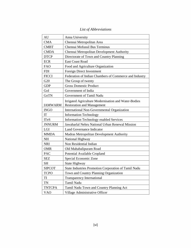
List of Abbreviations
AU Anna University
CMA Chennai Metropolitan Area
CMBT Chennai Mofussil Bus Terminus
CMDA Chennai Metropolitan Development Authority
DTCP Directorate of Town and Country Planning
ECR East Coast Road
FAO Food and Agriculture Organization
FDI Foreign Direct Investment
FICCI Federation of Indian Chambers of Commerce and Industry
G20 The Group of twenty
GDP Gross Domestic Product
GoI Government of India
GoTN Government of Tamil Nadu
IAMWARM
Irrigated Agriculture Modernisation and Water-Bodies
Restoration and Management
INGO International Non-Governmental Organization
IT Information Technology
ITeS Information Technology enabled Services
JNNURM Jawaharlal Nehru National Urban Renewal Mission
LGI Land Governance Indicator
MMDA Madras Metropolitan Development Authority
NH National Highway
NRI Non Residential Indian
OMR Old Mahabalipuram Road
PAC Potential Available Cropland
SEZ Special Economic Zone
SH State Highway
SIPCOT State Industries Promotion Corporation of Tamil Nadu
TCPO Town and Country Planning Organization
TI Transparency International
TN Tamil Nadu
TNTCPA Tamil Nadu Town and Country Planning Act
VAO Village Administrative Officer

[vii]
Abstract
Land has been the source of livelihood particularly among peasants across the since ages. With the
limited supply and ever increasing demand due to reasons like food production, industrialization and
urbanization, land is considered to be an important asset. Of late, there are many instances in which land
is being converted from agricultural use to non-agricultural uses. This paper two main processes of land-
use conversion. One by means of forceful acquisition by powerful actors including the State and other the
land owners willingly parting away with the land. This paper focussed on land-use conversion in the peri-
urban region of Chennai, where it happens with consent of farmers. The land-use conversion happens in
spite of national and state policies to prevent the conversion of agricultural land. This paper investigated
the formal dynamics and informal mechanisms and the roles of various stakeholders in land-use
conversion by studying policies, media reports and various published sources. Further, discussions with
various stakeholders in a selected village in peri-urban Chennai established that informal mechanisms
overpower the implementation of policies that prohibit land-use conversion. This paper sought to make
some modest recommendations and suggests making farming a viable option might help in reducing land-
use conversion. The means to achieve this needs a detailed research in itself.
Relevance to Development Studies
This work attempts to understand the role of stakeholders and their influence in implementing policies
pertaining to land-use conversion in peri-urban region within in the context of formal dynamics and
informal mechanisms thus establishing relevance to the broader field of Development Studies
Keywords
Land Governance, Land-use, Peri-urban, Formal Dynamics, Informal Mechanisms, Policy
Implementation

1
Chapter 1 Introduction We are in the times, when the food prices are dramatically increasing and the entire World is
concerned about the food supply. Many countries are investing in land in other countries as
pointed out by Pearce(2013:7) ‘Gulf sheikhs, Chinese state corporations, Wall street speculators,
Russian oligarchs, Indian microchip billionaires…are sourcing the globe for cheap land to feed
their people’. It is the increasing demand for land, a finite resource, due to globalization and
urbanization has led to competition in using this resource. With the expected world population of
more than 9 billion by middle of this century and nearly 67% of whom are expected to live in
cities, urbanization is one major factor that affects the land-use change globally (Seto and
Reenberg 2014:1).
‘More urban land area will be developed during the first three decades of the twenty-
first century than all of human history’ (ibid:4).
Lambin and Meyfrodit (2014:12) note that globally there is less Potential Available Cropland
(PAC) – a land that could be used for rain fed farming with low capital investment that what is
assumed available. They add that the crop land might become a ‘scarce resource’ in most
developing countries by 2030. On the one hand, the availability of cropland is showing a
downward trend, and on the other Australian Bureau of Agricultural Resource Economics
Science (in Seto and Reenberg 2014:4) estimate the total world demand for food will increase
three times the population by 2050. The competition between ‘urban land-use and intensive
agriculture’ is considered as one of the key ‘friction point’ in the global land-use change
particularly in the developing economies (Lambin and Meyfroidt 2014). Study by Angel and
other as cited by (ibid) nearly half of the urban expansion will happen by converting the fertile
agricultural land. Gregory(2014:28) notes that most of conversion from agricultural land to
urban use will happen in the periphery of the existing cities and they add that the land
surrounding the city is generally fertile as it was from where the city was meeting its food
demand.
This research paper attempts to understand the problem of land-use conversion in a fast
expanding Indian metropolis, Chennai. ‘Chennai is growing economically and demographically’
and it is the ‘globalization hotspot’. ‘It is a magnet for considerable foreign direct investment and
economic transformation’ (Dowal and Monkkonen 2007:10). The Chennai Metropolitan Area
(CMA) is roughly semi-circular in shape with extension in North, South and Western directions
(CMDA 2008a:6). With a population of less than half a million during 1901 to nearly 5 million
as per the latest census in 2011(GoTN :16), Chennai city has grown manifolds.
‘Population and economic growth do not take place in thin air; they require land and lots of it’
(TCPO 2006:197). Hence, in order to meet the land requirement, the city has expanding by
engulfing the surrounding villages into its fold. From 1971 until 2006, many villages in the
surrounding areas of Chennai city are absorbed into the folds of the Chennai Metropolitan Area
2
(Sekar and Kanchanamala 2011:38). To coordinate the city expansion activities, the Chennai
Metropolitan Development Authority (CMDA) was constituted in the year 1972. The CMDA
acts as ‘secretariat of the metropolitan planning committee’ for the entire CMA region (CMDA
2008b:iii).
To satisfy the needs of development, there are changes in the land-use within the boundaries of
the CMA. The villages that are part of CMA were ‘generally fertile’ particularly in the North and
Western corridors. However, since 1980, the agriculture activity within CMA was gradually
decreasing and it is ‘abysmally minimal’ (CMDA 2008a:9). Over the period of 20 years from
1980 to 2001, the percentage of agricultural zone has drastically come down all over CMA,
‘much more land was converted away from agricultural use between 1991 and 2001 than in the
previous decade’. At present, the agriculture land exists only near the boundary of CMA (Dowal
and Monkkonen 2007: 28). Interestingly, it becomes a newspaper article to find a cultivating
farmer in the CMA region, as published by The Hindu (2013) titled ‘A farmer amidst us’. This
indicates that most of the CMA is urbanized and the land-use pattern as on 2006 indicates that
nearly 50% of the land in the CMA is under residential, industrial, commercial and institutional
use. The agriculture occupies just 10% and balance land is classified as ‘others’ which includes
lakes, hills, forest cover etc(CMDA 2008a:297). Hence, the further growth might have to happen
by engulfing the agricultural land surrounding the CMA.
1.1 Problem Statement
Land is being diverted from agriculture use for two major reasons namely industrialization and
to meet the residential demand due to urbanization. In India, ‘the state could forcibly acquire the
land from the peasants and tribals and hand it over to private speculators, real estate
corporations, mining companies and industry’ (Shiva et al. 2011:vii). The State uses the old land
acquisition act of 1894 to acquire land for ‘public purpose’ and there have been deliberation on
what exactly is the ‘public purpose’ among the affected people and civil society organisations
that give voice to the affected farmers. There have been instance of violence to protest against
the State acquiring the land forcefully and displacing people from their ancestral land without
adequate compensation and resettlement (ibid).
The other form of land-use conversion is the farmers ‘willingly’ selling the land to the private
players, who in turn use the land for non-agricultural uses like residential plots. The growth of
the city and the proposal under consideration by the State Government to increase the boundaries
of the Chennai Metropolitan Area is paving way for many real estate players, industrialists and
even politicians start buying land in the villages that are within CMA limits and those villages
that are near CMA boundary. The process of creation of land banks by the state government for
setting up SEZs and the law permitting the private players to purchase the land directly from the
farmers (Vijayabaskar 2010:39) has led to increased prices of the land is further adding to the
demand of land in these villages. This increase in the demand of land is giving rise to speculation

3
of land prices in the villages in the rural-urban fringe area (Dowal and Monkkonen 2008:155).
The rise in demand for land due to speculative reasons, and the limited supply, as Mark Taiwan
(in Pearce 2013:7) called it ‘Buy land, they are not making it anymore’ makes the private players
to offer higher prices than the government determined prices.
The fact that agriculture has ceased to be an income generating occupation with low return on
investment along with high prices offered to the land and has made farmers to see land as ‘store
of value’ than as an option of livelihood (Vijayabaskar 2010:42). The farmers see an economic
opportunity in selling the land they own to private players like real estate developers, who see
investing in land is a profitable activity. (Visser 2013:1) notes ‘The fact that so many companies
do invest in land can easily be interpreted as proof that land investment is indeed a profitable
business’. The Private firms generally collaborate with a local intermediary to acquire the land in
the village. The intermediaries act as forerunners by selling their lands and then talk to other
people about the ‘positive’ aspects of selling the lands (Vijayabaskar 2010:41).
‘The relatively silent process of land acquisition in TN seems to be therefore secured more
through a process of consent than coercion’ (Vijayabaskar 2010:42). Thus, it appears like land
alienation and not land grabbing, where the farmers who are cultivating the land voluntarily
transfer the tittle of the land (sell) to these private dealers/individuals.
The conversion of agricultural land for non-agricultural task is not a straightforward task, at least
on paper. There are policies that attempt to prevent the conversion of land from agricultural to
non-agricultural use. India is a federation of various states and there are certain subjects on
which the central government has control and certain subjects on which the state government has
authority and certain others that are under concurrent list on which both the central and the
provincial government can have policymaking powers (GoI 2011). Land is a state subject in
India and the planning and all other activities related to land like maintenance of land records,
land management and alienation is under the State Government (GoI 2013c). However, the
Central Government has come out with policies and guidelines like National Farmer Policy and
National Land Utilization Policy that aim at preventing and/or controlling the conversion of
agricultural land (GoI 2013a). The Jawaharlal Nehru Urban Renewal Mission (JNNURM), aims
at effective urbanization with proper planning gives a general framework to convert agricultural
land for non-agricultural use (JNNURM 2011) which can be adopted for the conversion of
agricultural land. In TN, the Industrial policy, TN Town and Country Planning Act, 1971
(TNTCPA) with recent amendments (Vijayabaskar 2010:40) has defined clauses to minimize the
conversion of agricultural land.
In spite of all these laws and procedures, agriculture land is converted to non-agriculture use
throughout TN and in particular in the rural-urban fringe of Chennai city. The land-use
conversion happens due to interaction of various stakeholders like the farmers, real-estate firms,
land brokers and government institutions. The involvement of institutions like locally elected
president, district administration and regulatory bodies like CMDA or the Directorate of Town
and Country planning (DTCP) makes it a complex process. It can be also be indicated that, in
this whole process, informal dynamics ranging from bribes to influencing policies for benefit of
a particular group play a significant role.

4
This has not only led to ‘artificial realty boom’ but also shrink in the total cultivated area (Sivan
2011). It appears that due to these changes in the land-use pattern, has resulted in changes in the
occupation and increased consumerism altering the socioeconomic conditions of the village as
indicated by Narain (2009:506). As Gregory (2014) points out the change in land-use can be
threatening to the food security of the country. The figure summarizes the problem of land-use
conversion in peri-urban Chennai
Figure 1: Problem statement - Land-Use Conversion by Consent or Coercion
Farmers selling the
agricultural land by
themselves to the private
players particularly real
estate firms for layout
development as residential
plots
Changes in Land-use in
CMA region and the
periphery villages
State acquiring the
agricultural land applying the
land acquisition act and use it
for ‘public purpose’ like
infrastructure eg. roads or
industrialization eg. SEZs
Act of coercion Act of consent
Issues of displacement,
compensation, resettlement
and rehabilitation
Land as ‘store of value’ –
leading to ‘speculative
urbanism’
Changes in the socio-
economic aspects on the
livelihood of people
dependent on land
Food security problem in the
long term
Population growth Presence of Global and
National industries
Expansion of the city area by
engulfing nearby villages
Urbanization
Source: Own Construction

5
1.2 Objective of this Paper
Although, both means of land-use conversion will ultimately have more or less similar ends like
affecting the socio-economic aspects of those dependent on land and threatening the food
security of the country in the long run, the process by which these conversions happens tends to
be an important phenomenon. This paper attempts to check the process of land conversion, with
respect to, the aspect of the farmers selling their agricultural land to the real estate firms,
whereby creating a speculative land market in the villages bordering CMA region. This
conversion happens amidst the existing legislation and policies that prescribe stringent checks to
reduce the conversion of agricultural land to non-agriculture use, particularly housing plots.
1.3 Primary and Sub-Research Questions
How does the conversion of agricultural land to non-agricultural use occur in the peri-urban
region of Chennai?
o Who are the Stakeholders involved and what are their interests?
o Have the objectives of the existing land-use policies met?
o How do the weaker and more powerful stakeholders influence the policy process?
1.4 Methodology
The study is based on mix of primary and secondary data sources.
As the research question involved understanding the policies and the stakeholders, I attempted to
use various documents ranging from Indian national and state policies, books, research journals,
newspaper articles in English and Tamil. While Government webpages were the chief sources
for getting these policies, the ISS library and online resources helped in gaining access to print
and electronic documents. The documents were ‘examined and interpreted in order to elicit
meaning, gain understanding, and develop empirical knowledge’ (Bowen 2009:27).
The desk study was complemented with the field study in a peri-urban hamlet of Chennai city.
Semi-structured interview method was used to generate knowledge related to land-use
conversion. Fourteen people in different groups like cultivating farmers, village representatives
were interviewed. Details of the people interviewed is discussed in the chapter 4. The interviews
were approached with the ‘miner’ mind-set, which is the knowledge is present there and it is the
role of the interviewer to extract it. Here data collection and analysis were considered to be two

6
separate actions. It is a positivist approach, searching for ‘pre-existing truth’ (Kvale and
Brinkmann 2009:48).
1.5 Structure of the paper
The paper is structured into six chapters. The first chapter discusses the background of land-use
conversion, defines the problem and deduces the research question. In addition, it briefly
explains the methodology that is used for collecting the primary and secondary data. The second
chapter introduces the conceptual framework, which is used for analysing the data. The third
chapter gives the context in detail about Chennai city, its peri-urban regions and land-use in
these regions. Further, the chapter discusses national and state level policies related to land-use
conversion. The fourth chapter introduces the case of the Kondancheri village, which is selected
to understand the process of land-use conversion. The fifth chapter attempts to answer the
research questions with the aid of conceptual framework developed. The paper concludes by
suggesting possible solutions to the land-use conversion.

7
‘Land governance concerns the rules, processes and structures
through which decisions are made about access to land and its use, the
manner in which the decisions are implemented and enforced, the way
that competing interests in land are managed’
Chapter 2: Conceptual Framework Dissecting the sub-tittle of this paper one gets the concepts of land governance and peri-urban
area. This chapter will attempt to understand these concepts independently and then integrate
them to get a wholesome perspective of ‘land governance in the peri-urban areas’.
2.1 Land Governance
Geographically, land is the surface of the earth along with the resources included in it like water,
forests, minerals, gas and oil. ‘Land, therefore, is taken to include the physical land as well as
related natural resource’ (Palmer et al. 2009:7). Economically, land along with its qualities like
size, topography, surface and sub-surface water levels and natural parameters like precipitation
and soil quality constitute a factor of production along with labour and capital (Found 1974:12).
‘The fulcrum of rural life’ as Habibullah (2003:15) puts it, brings out the sociological importance
of the land as it is interlinked with the livelihood and identity of people in terms of culture and
history. With the King levying taxes on the cultivated land (Chandrasekaran 2005:2) in the
ancient times, to the present day, where the Government plays a role in the land policies and land
reforms brings out the political dimension of the land. This makes one to understand that land is
an important subject perceived by the Governments across the States.
The concept of governance takes no single definition. However, there are similarities in the
various definitions of governance. ‘Governance is broader than the Government’ (Palmer et al.
2009:7) implies the existence and participation of private sector and civil society in the decision-
making process and the same is acknowledged by Heywood (2007:6) and FAO (2007:5). Hyden
and others (2003:5) define governance as ‘formation and stewardship of the rules that regulate
the public realm-the space where state as well as economic and societal actors interact to make
decisions’. This is line with ‘Governance emphasizes process and institutions’ (Palmer et al.
2009:9). The institutions and the rules therein can be either formal like laws, policies or informal
like the rules set by informal groups like social networks or elderly village councils etc (ibid:8)
Although, Land and Governance are well-known terms, their combination as ‘Land Governance’
is relatively new. Land Governance deals with both the ‘legal and political framework’ and
‘traditional practices’ concerning the land management issues. Thus, the following definition by
FAO (ibid:9) is adopted in this paper

8
The issue of Land Governance has become the matter of interest among the international players
like the World Bank, FAO, G20 countries and INGOs like Oxfam. Further, that the private
players investing in land, has given rise to ‘multidimensionality of land’ making land governance
an important aspect in the current situation. Thus, it is the ‘public’, ‘private’ and/or ‘hybrid’
bodies might have the role to play in governing the land (Margulis 2014).
Borras and Franco (2010:3) argue that most of the land governance principles put forth by the
‘mainstream development’ institutions focuses on ‘technical and administrative’ aspects from the
economic perspective and these institutions tend to assume that good land policies will
automatically lead to ‘democratization’. They add that informal dynamics can influence the land
policies making these policies ineffective and consider this as a ‘gap’ in the land governance
discourse. ‘Formal institutions can help establish rights that challenge informal power relations,
while those informal structures can also undermine formal structures.’ (Fox in ibid:6)
Thus, in order to understand the land policies and their implementation, it becomes necessary to
analyse both the formal mechanisms and informal dynamics associated with the land
governance. The donor discourse on land governance by World Bank and FAO might be helpful
in comprehending the formal land governance aspects. Investigating the concepts of corruption,
power influence, land price speculation, legal pluralism within in the perspective of land might
help in assessing the informal dynamics in the land governance.
2.1.1 Formal Dynamics - Land Governance Discourse by FAO and World
Bank
When the demand for land is on the rise due to various reasons like commercialization,
residential requirement because of urbanization, industrial uses or for public purpose, there arises
a strong competition among the stake holders (Palmer et al. 2009:10). Hence, in order to
regularize the competition and ensure fair play, institutionalizing the land administration by
means of rules and policies is required. The FAO and World Bank have introduced land
governance frameworks titled ‘Good Governance in Land Tenure and Administration’ (FAO
2007) and ‘The Land Governance and Assessment Framework’ (Deininger et al. 2012)
respectively. Although, the land policies are country and issue specific (Palmer et al. 2009), these
frameworks are designed to provide technical guidance and support the countries moving ahead
towards improved governance in land services (The World Bank 2003). One could establish
many points of convergence between these two frameworks despite their different sources of
origin.
The FAO framework (2007:9) adopts 12 good governance principles like effective, efficient and
competent land administrative system; responsive to the needs of the citizens; legitimate;
transparent; accountable; equitable; participatory and applies them to specific areas of land
administration like land-use management and registration. On the other hand, the World Bank
framework (2012:28) has come out with five major themes like Legal and Institutional

9
Framework, Land-use Planning and Management, Management of Public Land among others.
The five themes are assessed using 21 Land Governance Indicators (LGIs). The good governance
principles mentioned in the FAO framework are interwoven in the 21 LGIs of the World Bank
framework. For example, effective and competent land administrative system of FAO framework
is established in the LGI8 of World Bank- ‘land-use plans are justified and effectively
implemented’. Transparency principle is accounted in the indicators LGI7 – ‘transparency of
land-use restrictions’, LGI10 – ‘transparency of valuations’ and LGI14 – ‘Transparency and
fairness of expropriation procedures’.
Although, both these frameworks bring out various aspects pertaining to land governance,
keeping in line with the main objective of this paper, understanding the changes in the land-use
patterns in the peri-urban areas of Chennai, the aspect of land-use planning, put forth by World
Bank and FAO might be relevant to this work. Thus for the purpose of this paper, changes in
land-use pattern and dealing with it will be considered as land governance.
2.1.1.1 Land-use planning in FAO and World Bank Framework
The FAO framework (2007) argues that the policies and procedures pertaining to land-use are
essential legal factors and these policies have a direct impact on the land’s value in the monetary
terms, especially in the peri-urban areas where the change in the land-use from agriculture to
urban commercial and residential is on the rise. It identifies the following practices for good
governance in the land-use planning.
Land conversion from rural to urban use is associated with huge returns and thus subjected to
problems when there is lack of transparency. This framework notes the involvement of land
administrators and users in land-use planning. It argues preparing proper land-use plans and their
orderly implementation within the boundaries of the appropriate laws, might reduce the conflicts
that result in the conversion of rural land. It advocates inclusive and complete participation of all
the stakeholders in the planning process and separate agencies of the government might be
involved in planning and implementation of land-use policies. It is essential to evaluate the
technical and political feasibilities of land-use conversion in a transparent manner within the
existing legal framework when a particular individual decides to change the usage of land on
which he might hold the legal tittle. The framework proposes a suitable appeal mechanism to
resolve the disputes among the stakeholders. The framework proposes performance indicators
including the time taken for the approvals and implementation to monitor the agencies involved
in land-use planning process.
The World Bank (2012) has identified five LGIs out of 21 under the theme Land-use Planning,
Management and Taxation. The LGI7, ‘Transparency of land-use restrictions’ mentions that
while planning land-use, the availability of land to meet the future demand, resources required to
implement the land-use plan in a cost effective way should be taken into consideration. Further,
the land-use plan should be implementable and designed based on participation of the
stakeholders to ensure transparency. The LGI8, ‘Efficiency in land-use planning process’

10
acknowledges that economic growth might result in changes in the land-use especially in the
peri-urban areas and will eventually lead to corruption. Those having access to information about
the projects in pipeline in a particular region might invest speculatively in the land, thus
increasing the value of land manifolds. In order to prevent this and to ensure such changes in the
land-use benefits the society at large than few select individuals, LGI8 suggests that the process
should be transparent and the authorities should be made accountable for their decisions. The
indicator further suggests that good governance might play a role in reducing the conflicts that
arise because many a times it is the same institution, which frames policies, implements them
and hear appeals. The LGI9, ‘Speed and predictability of applications for restricted land-uses’
establishes the importance of faster and predictable decisions pertaining to land-use as the delay
in making decisions might hinder the economic progress. The LGI10 and 11 ‘Transparency in
land evaluation and tax collection efficiency’ advocates decentralization of land valuation and
tax collection to the local governments and the revenues thus generated should be part of local
government. In addition, the local government’s capacity in land valuation and in subsequent
evaluations needs to be enhanced. This when implemented effectively and transparently might
prevent the idle land holding for speculative purposes and might pave way for corruption. The
below figure shows the similarities in land-use planning as advocated by FAO and World Bank.

11
Figure 2: Similarities in Land-use planning in World Bank and FAO Framework
Land-use
Planning
Go
od
Go
ver
na
nce
in
La
nd
Ten
ure
an
d A
dm
inis
tra
tio
n
by
FA
O
Involvement of
Land
Administrators
and Users
Transparency
Proper Land-use
plans and their
orderly
implementation
Inclusive and
complete
participation of all
the Stakeholders
Involvement of
different
Government
agencies
Technical and
Political
feasibilities within
the legal
framework
Tax collection
efficiency
Transparency
in land
evaluation
Speed and
predictability
of applications for restricted
land-uses
Efficiency in
land-use planning
process
Transparency of
land-use
restrictions
Performance
Indicators
Appeal
Mechanism
Th
e La
nd
Go
ver
na
nce a
nd
Assessm
en
t Fra
mew
ork
by
Wo
rld B
an
k
Source: Own Construction

12
2.1.2 Informalities in land governance
The international norms on land-use conveys how the land-use policies needs to be framed and
implemented. However, the reality might be different as is brought out in many land governance
studies across the world. For example, Wit (2013a) on his study in Vietnam, points out various
informalities prevalent in land-use planning and implementation. The same may be extrapolated
to most of the developing countries.
2.1.2.1 Power Dimensions
He points out ‘power dimensions’ as important factor that determines land-use change.
Although, the formal discourse mandates participatory approach in the planning process, but it is
the powerful actors who influence the policy formation and implementation. Palmer (2009:10)
calls it as ‘State capture’, where the powerful ‘direct public policy for their own benefit’.
Johnson and Chakravarty (2013) in their study on land-use in Kolkata have noted the ‘informal
power relations’ influencing land-use policies by means of unholy nexus between government
institutions and ‘local shadow networks’ which are the local politicians and land dealers.
2.1.2.2 Legal Pluralism
In developing countries as in Vietnam, land transactions happen outside the context of State and
this makes one to wonder, if at all, the formal dynamics regulate the informal mechanisms, or do
they coexist. Wit (2013a:9) notes this as ‘legal pluralism’ due to multiple institutions both
formal and informal, have a say on the land-use policies. Thus, he raises the question ‘Should
there be more attention for the difference between ‘theoretical land-use planning’ and the actual,
practical, real, and ‘likely to be implemented’ land-use planning?’ (ibid:25).
2.1.2.3 Corruption and Clientelism
When the land governance as well as formal governance institutions are weaker, it paves way to
corruption because of the limited supply and greater demand for land (The World Bank 2003)
and massive profits that can be made. TI (2009:9) points out that the corruption in the land
services is next only to the police and the courts. In India, annually USD 700 million is spent on
bribes on land related services (TI 2011:3). Kaldor and Luckham (in Shiva et al. 2011:66)
indicate the role of private players and international firms in the land-use conversion has
increased corruption and clientelism the major factors of informal dynamics in land governance.
2.1.2.4 Taking Advantage of Insider Information
Vasudevan (2013:54-58) in her case on land-use conversion in Noida, notes that access to insider
information plays an important role in land-use conversion. She points out that the top
bureaucrats pass on important details such as the arrival of new airport in a particular region to
the powerful real estate firms. The firms then in-turn start acquiring land in that region by
offering ‘higher premium’. These firms collaborate with the key persons in the village, ‘block of
builder-authority-rich farmer’ as she refers the partnership and use these strongmen to influence

13
the rest of the farmers to sell the land. The rent offered to the strongmen is skyrocket prices for
his land, which the other villagers are not aware. The land developers register the land purchased
in ‘benami’ names i.e in the name of the representative of the real purchaser and once the project
starts, the land is sold for huge profit margins.
2.1.2.5 Using Force
Fazal (2013:67)in his study on Aligarh, notes ‘property dealers and land developers pressurize
small land owners to dispose their land as these people need big areas for developing colonies’.
It is because of poor economic conditions and inability to resist the pressure from powerful the
farmers decide to part with their lands even if they are not genuinely interested.
The above summarizes the World Bank’s statement (2003:44) ‘issues of governance, conflict
resolution, and corruption …are among the key reasons why land is coming to the forefront of
the discussion in many countries’.
2.2 The Concept of Peri-Urban
Wehrwein (1942:217) defined rural-urban fringe as ‘the area of transition between well
recognized urban land-uses and the area devoted to agriculture’. Fazal (2013:4) identifies words
like ‘rural fringe’, ‘city’s country side’, ‘desakota region’, ‘rural hinterland of the city’ that are
used interchangeably with peri-urban by various authors. Kurtz and Eicher (1958) distinguished
fringe areas of the city from suburban areas. Fazal (2013) describes fringe areas as the places
where there is no differentiation between rural and urban areas and he calls it ‘rural-urban
continuum’. It appears to be widely accepted that the fringe areas are formed because of
expansion of the cities (Garreau and Hall in ibid). Shindhe in Fazal (2013:8) calls Peri-Urban
Interface (PUI) as ‘transitional zone around the city’, and as ‘link between urban and rural areas’.
Narain and Nishal (2007:261) understand peri-urban as ‘place’, ‘concept’ or ‘process’. By
‘place’ it means the area surrounding the city. McGee (in Fazal 2013:18) puts forward in some
Asian cities peri-urban extends up to a distance of 30 Km from the city’s core area. However,
Narain and others (2013:3) in their study on Indian cities conclude that distance cannot be a
defining factor to define peri-urban and they characterize peri-urban region as the one in which,
there is visible land-use change from agriculture to real estate and SEZs. As ‘process’ peri-urban
can mean the exchange of goods and services from urban and rural areas and as ‘concept’ it is
‘interface between three systems, namely, the agricultural system, the urban system, and the
natural resource system’ (Allen in ibid:6). This paper will understand peri-urban as ‘concept’ to
understand the land-use change, as it is the result of interaction of various systems and
institutions. Further, peri-urban region is a dynamic one and it constantly undergoes change with
reference to usage of land and the boundaries of the region (ibid:10)
Pryor (in Kupková 2007:4) uses the ‘process-response model’ diagram to distinguish the urban
fringe from the rural fringe in the Peri-urban region based on the land-use pattern. As the region
gets closer to the city, the urban land-use tends to be on a higher side and vice versa. Bentinck

14
(in Fazal 2013) supports this aspect by considering peri-urban or rural-urban region as he calls it
as the one that extends from the centre of the city with no rural land-use to the region where most
of the workers are involved in non-agricultural activities.
Figure 3: Peri-Urban Interface
Oliveau (2005:11) distinguishes peri-urban areas from suburban region. The latter is the
continuation of the city without any physical separation, whereas in case of peri-urban region, it
is separated from the city by means of agricultural land and open spaces.
As Brook and others (in Fazal 2013:23) points out ‘there is no single satisfactory definition of
peri-urban interface and moreover different definitions will probably apply in different
circumstances’. In connection with the main objective of this paper, which is studying the
changes in land-use patterns in peri-urban areas of Chennai, the below definition by Fazal
(2013:4) will be used in this work.
25 50 75 100 0
25
50
75
100
100
25
50
0
75
0
Peri-Urban Interface
Urban Fringe Rural Fringe
Percentage Distance – Urban to Rural Land
Per
cen
tage
Urb
an la
n -
Use
Percen
tage Ru
ral land
- Use
Source: Pryor (in Kupková 2007:4)

15
‘An area of mixed rural and urban populations and land-uses, which begins at the
point where agriculture land-uses appear near the city and extends up to the point
where villages have distinct urban land-uses or where some persons, at least, from
the village community commute to the city daily for work or other purposes’
Now that we have an idea of common peri-urban dynamics, it becomes necessary to understand
the relationship between land-use governance and peri-urban area. In this study, the peri-urban
area can be considered as policy arena where the different stakeholders with diverse stakes and
powers interact to influence the land-use conversion.
2.3 Integrating Land Governance and Peri-Urban
As mentioned, the managing land-use pattern is predominantly considered as land governance in
this paper. Post the discussion on academic literature on land governance and peri-urban
individually, it becomes essential to integrate these concepts as a single unit of analysis in this
work. With the limited supply and increasing demand for land, there seems to be a competition
for land globally. Haberl and others (2014:37) define land-use competition as ‘contest between
different purposes, or functions, for which a given piece of land, or the resources flowing to and
from such land, could be used’. They attribute competition for land is the foremost reason for the
land-use change. Three categories of land-use competition defined by Haberl (ibid:42) are
‘Production vs production’ – Food production vs bio-fuel production
‘Production vs conservation’ – Food production vs deforestation
‘Built-up environment vs production/conservation’ – urbanization vs food production and
conservation
This paper will focus on the third category, ‘built-up environment vs production’. The projected
global population is 9.3 billion by 2050 and about 6.3 billion of which might live in cities
(Haberl et al. 2014:39). The ‘Urban land area is expected to triple in the time period from 2000
to 2030’ (Seto in Haberl et al. 2014:39). This will have direct effect on the land-use in the peri-
urban areas of cities ‘pushing agriculture elsewhere’ (ibid).
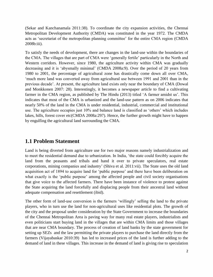
The below table, customized from Haberl (2014:45 and 51), captures the essence of the
conversion of land from agriculture to urban use that arises due to competition between food
production and urbanization of land. It is a global phenomenon, but has an impact in the
particular region where land is converted from agriculture to urban use. The impact can be either
direct or indirect and categorised as environmental and social impact. The decrease in
agricultural land and the land price speculation in the peri-urban areas are the issues of concern
of this paper.
16
Table 1: Competition for land - Urbanization vs Food Production
Shah and Kumar (2008:382) notes the following on land-use in peri-urban area: It is more fertile’
than the land located away from city, ‘diversion of urban fringe’ is the main reason for land-use
change and ‘voluntary’ selling of the land by the owners than forced acquisition. Manonmani et
al. (2011:5) notes that the agricultural land situated in the peri-urban areas are in high demand
for residential use. The sudden rise in the land value has resulted in change in the land-use and
this change is not harmonious (Fazal 2013). The suburban area of metropolitan cities,
particularly in developing countries are ‘forced to undergo process of transformation’, the same
is attributed to development (Kirschenbaum in Ramesh et al. 2011:1)
‘Land-use conversion, that is, the farmlands located at the suburbs get into a cycle of
development, namely, layouts and vacant land for future development. Layouts
inherit the characteristics of various land-uses and as such, land devoted for
commercial purposes within the residential area, public spaces namely park and
public sanitation places. Similarly, plots devoted to residential development take up
new forms of development such as apartments, duplex houses and row type of
houses. It explains the nature of modification in land-uses of an area and adds
richness to the complex urbanisation process’ (Ramesh et al. 2011:1)
Types of
land-use
competiti
on
Shifts in
land-use/
system
characteristi
cs
Geograph
ic
location
Examples of
competition
Direct Impact Indirect Impact
Environmental
Social
Environm
ental
Social
Built-up
environm
ent
vs.
productio
n
Food or
feed
↓
Urban areas
Global in
reach, but
localized
impact
Cities, urban
development,
and
increasing
“urbanity”
globally
often occurs
in prime
agricultural
locations
Increased
impervious
surfaces and
urban run-off;
reduced
agricultural
run-off;
potential land
sparing if
rural residents
abandon land
when
moving to
city; less
reversibility
in land-use;
loss of
ecosystem
services
Loss of rural
lifestyle and
culture;
increased
incomes for
rural
landowners
selling land;
speculative
investment;
greater
opportunities
for (peri)urban
agriculture
Increased
temperatu
res in
microclim
ate
Increased
concerns
about
food
security
Source: Haberl (2014:45 and 51)
17
The intrusion of fertile agricultural land and changes in the socio-economic life style of the
people in the peri-urban areas are significant factors of the city expansion (Fazal 2013:10). The
land-use transformation is influenced by variety of actors and hence becomes the issue of
governance. ‘Land-use is no longer under one single territorial institution—if it ever was—but
rather the subject of multiple, flow anchored governance arrangements’ (Gentry et al. 2014:240).
These actors are not only formal institutions like elected governments, international
organisations but variety of other stakeholders like private institutions and civil society
organisations, farmers, landless labourers deepening on the land. ‘Revalorization’ of land both in
economic and social terms drives the interests of many of these stakeholders in land-use
transformation. Thus, it is the ‘multi-stakeholder’ process, which contributes to ‘both public and
private rules, formal rules (such as binding intentional law), and soft, voluntary arrangements
(such as certification)’ (ibid:247)
The concept of ‘multi-stake holder’ governance (de Wit 2013a:9), ‘Government is not alone any
longer in governing; there are many other stakeholders in formal and informal configurations
who co-govern, and who have smaller or larger influence on government and government
outcomes’ will have direct relevance to this paper. The conversion of agricultural land involves
the interests of many stakeholders like individual farmers, private sector like the real estate
firms, government policies that attempt to ensure the prevention of agricultural land conversion.
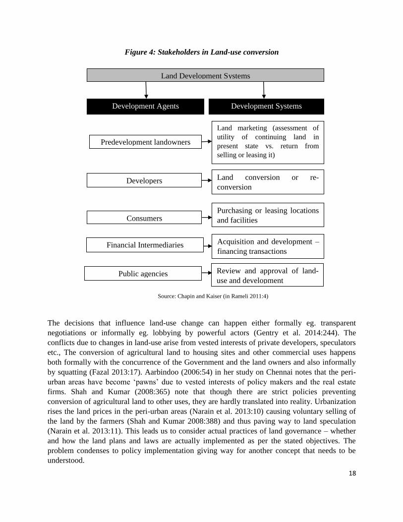
The Land development systems framework of Chapin and Kaiser (in Rameli 2011:4) identifies
the various stakeholders their perceived roles in the process of land conversion. However, it is
important to note that this framework misses the most important stakeholder – the owner of the
land or the farmer.
18
Figure 4: Stakeholders in Land-use conversion
The decisions that influence land-use change can happen either formally eg. transparent
negotiations or informally eg. lobbying by powerful actors (Gentry et al. 2014:244). The
conflicts due to changes in land-use arise from vested interests of private developers, speculators
etc., The conversion of agricultural land to housing sites and other commercial uses happens
both formally with the concurrence of the Government and the land owners and also informally
by squatting (Fazal 2013:17). Aarbindoo (2006:54) in her study on Chennai notes that the peri-
urban areas have become ‘pawns’ due to vested interests of policy makers and the real estate
firms. Shah and Kumar (2008:365) note that though there are strict policies preventing
conversion of agricultural land to other uses, they are hardly translated into reality. Urbanization
rises the land prices in the peri-urban areas (Narain et al. 2013:10) causing voluntary selling of
the land by the farmers (Shah and Kumar 2008:388) and thus paving way to land speculation
(Narain et al. 2013:11). This leads us to consider actual practices of land governance – whether
and how the land plans and laws are actually implemented as per the stated objectives. The
problem condenses to policy implementation giving way for another concept that needs to be
understood.
Land Development Systems
Development Agents Development Systems
Predevelopment landowners
Developers
Consumers
Financial Intermediaries
Land marketing (assessment of
utility of continuing land in
present state vs. return from
selling or leasing it)
Land conversion or re-
conversion
Purchasing or leasing locations
and facilities
Acquisition and development –
financing transactions
Review and approval of land-
use and development Public agencies
Source: Chapin and Kaiser (in Rameli 2011:4)

19
2.4 Policy Implementation
Of the four conventional stages of policy cycle, mentioned by Jann and Wegrich (2007:43)
namely ‘agenda setting’, ‘policy formulation and decision making’, ‘implementation’ and
‘evaluation’, policy implementation might be of importance in this paper, as stated above.
O’Toole (in ibid:51) understands implementation as difference that arises between the intended
and actual impact of the policy. Mosse(2004:640) call it as ‘gap between theory and practice’.
Thus, implementation need not be and mostly is not a simple and straightforward process
(Turner and Hulme 1997:75). Various powerful actors having interests in the outcome of
particular policy might attempt to influence the implementation. These actors can range from
international institutions, private sector organisations, economic elites, national and local
politicians and civil society organisations. They might end up having ‘political relationships’
with the government departments and bureaucrats responsible for implementing the policy. It can
be inferred that politics and power play an important role in policy implementation (ibid:77-81).
Dhal (1957) notes that power is not concentrated in particular group, it is dispersed among
different elite groups, and these groups tend to influence policies based on their interests. Wit
(2013b) describes the implementation as an ‘arena’ where the interaction of strong and weak
actors happens by negotiating and/or manipulating. As Mosse (2004:650-653) argues, the
interests of these stakeholders need not be a legitimate always. Some of these actors might have
own self-interests in the policy outcomes. Due to this, they might restore to illegitimate means to
influence the policy implementers through informal mechanisms like corruption, nepotism.
From the above literature presented, one can deduce that policy implementation is not a ‘linear
process’ but rather happens with the ‘interaction’ of various stakeholders particularly the ‘policy
elites’ and ‘managers’ as suggested by Grindle and Thomas (1991). This interaction might
influence the policy outcome from the intended to unexpected ones (ibid).
‘Good policy is unimplementable…… or, rather than unimplementable, we should say
that policy goals come into contradiction with other institutional or system goals such
that policy models are poor guides to understanding the practices, events and effects of
development actors, which are shaped by the relationships and interests and cultures of
specific organizational settings’ (Mosse 2004:663)
Just like governance, the policy process is also determined by interaction of weaker and stronger
stakeholders who position themselves around the policy issue.
2.5 Conceptual Framework
The concepts introduced in this chapter are standalone ones. The framework presented below
shows the interrelationship between these concepts. This paper will use this framework to
understand the land-use changes in the peri-urban areas of Chennai city.

20
Figure 5: Conceptual Framework
Land-use planning and
management – An aspect of
land governance in Peri-
urban areas Peri-Urban Area
Land Governance
Interest of various
Stakeholders
Formal
Dynamics
Informal
Mechanisms
Gaps in policy
implementation
Conversion of
agricultural land for
non-agricultural use
in the peri-urban
region
Policy Arena
– negotiation/
manipulation
of strong and
weak actors
Transparency
Efficiency
Speed and
Predictability
Appeal
Mechanism
Participation
Land-use
Plans
Power
Dimensions
Legal
Pluralism
Corruption
and
Clientelism
Using Force
Making use
of insider
information Source: Own Construction

21
Chapter 3: The Context - Chennai, it’s Peri-Urban Region
and Land-use Policies
3.1 Chennai City and Early Expansion
The history of India’s fourth largest metropolitan city and the capital of TN, Chennai, dates back
to 1640 with the establishment of Fort St. George by erstwhile East India Company (CMDA
2008a). Madras, as it was called then, was the capital of British India until 1774 and the Madras
Corporation was the first governing body setup by British outside Europe in 1687 (Muthiah in
Jothilakshmy 2011:112). Few villages like Mylapore and Santhome and fishing hamlets like
Chennai pattanam were brought together as Madras city. Jyothilakshmy (2011) traces the origin
of the city from 16th century AD. She points out that Mylapore port was known to Roman and
Greek traders and the human settlements had existed around the ancient Hindu temples. She
points out that most of the important road of present day like Poonamalle high road, Santhome
high road were created in 17th century to connect these settlements. It was in 1798, 16 hamlets in
the radius of 69 km surrounding the Fort St. George was together called as Madras city. The
demarcation of eight divisions with commissioners, establishment of central station, construction
of infrastructure like parks, radial and ring roads, public buildings in 19th century made the city
paved way for city’s development. Further, the growth in number of business houses in the early
20th century made Madras an important commercial and administrative centre in South India.
Post-independence, Madras continued to be important cities of India and as capital of Madras
Presidency. With the reorganisation of States based on language, Madras became capital of
present day TN. The city was rechristened as Chennai in 1996 (Arabindoo 2006:26).
3.1.1 Present Day Chennai and Chennai Metropolitan Area
The Chennai Metropolitan Area (CMA) at present is 1189 sq.km spread across three districts
Chennai and parts of neighbouring Thiruvallur and Kanchipuram districts. The entire Chennai
district, which is called Corporation of Chennai measuring 176 sq.km and 637 sq.km in
Thiruvallur district and 376 sq.km in Kanchipuram district, is part of the CMA (CMDA
2008a:8).
3.1.2 Governance structure
The CMA is a heterogeneous mix of various governance structures namely Chennai Corporation,
16 municipalities, 20 town panchayats and 214 villages in 10 panchayat2 unions in the
Thiruvallur and Kanchipuram districts. The CMDA is the umbrella body that takes care of
planning and co-ordination in the CMA region. The other governance structures are involved in
2 Panchayat roughly translates to local council

22
service provisioning and civic management in the specific region over which they have
jurisdiction (CMDA 2008b:iv). The State government is pursuing a plan to setup ‘Chennai Mega
Region’ by expanding the CMA limits to 8898 sq.km (GoTN 2013a:59) by including the entire
Thiruvallur and Kanchipuram districts.
3.1.3 Demographics
With a population of less than half a million during 1901 (TCPO 2006:17) to nearly 5 million as
per the latest census in 2011, Chennai city’s population has grown manifolds. The population of
CMA is 9 million and that of Thiruvallur and Kanchipuram districts is 3.7 and 4 million
approximately according to the Census data (2011a). Chennai, Thiruvallur and Kanchipuram
have figured in the top four districts of the State based on population. Although, the decadal
growth rate of Chennai district is nearly 50% points lesser than the State average (15.6%), the
Thiruvallur and Kanchipuram districts have figured as top two districts with 35.2% and 38.7%
increase in population over 2001 census. The corresponding figures of these districts in the 2001
census stood at 23.06% and 19.15% over the 1991 data. In terms of population density, Chennai
district is ranked second in the country, next only to, Northeast district in Delhi with 26,903
persons/sq.km (GoTN 2011b). The population of CMA is expected to be 12 million by 2025.
The CMA occupies less than 1% area of TN, but it is home for more than 11% of State’s
population (Sekar and Kanchanamala 2011:34).
TN is the most urbanized state in India, with 48.5% of the population living in urban areas. The
Chennai district is completely urbanized (100%). Here again, Thiruvallur and Kanchipuram
districts are highly urbanized with 65.1% and 63.5% of population living in the urban areas. The
work participation rate, which is the workers as the percentage of population in urban areas is
again high in TN at 40.2% (GoTN 2013b:253).
3.1.4 City Planning by CMDA prior to 1991
The ‘General Plan 1957’ and ‘Madras Interim Plan 1967’ by Corporation of Madras addressed
the problems of city, which was 129 sq.km in total then. These plans recommended
Comprehensive Plan for organised city development with detailed financial requirements
(Jothilakshmy 2011:128). The form of municipal government, Corporation of Madras,
established by colonial rule could not face the challenges of like population growth and
unregulated Chennai’s expansion. The Chennai Metropolitan Development Authority (CMDA)
or Madras Metropolitan Development Authority (MMDA), as it was called then, was
institutionalised by dissolving the erstwhile Corporation of Madras due to issues of corruption.
The CMDA functions as a planning authority under the guidance of State Government. The
CMDA was entrusted to implement the first detailed plan for Chennai, Madras Metropolitan Plan
1971-1991. The corporation limits was extended in 1978 by CMDA (Arabindoo 2006:27). It is
during this period the city saw rapid industrialization particularly in the North and Western
directions of the city with industries like Ennore refineries, Ashok Leyland, Madras fertilizers
coming up in Manali and Ennore in North and T.V.S group, TI cycles coming up in Ambattur
and Avadi in the West. The centre of the city with areas like Nungambakkam becoming the
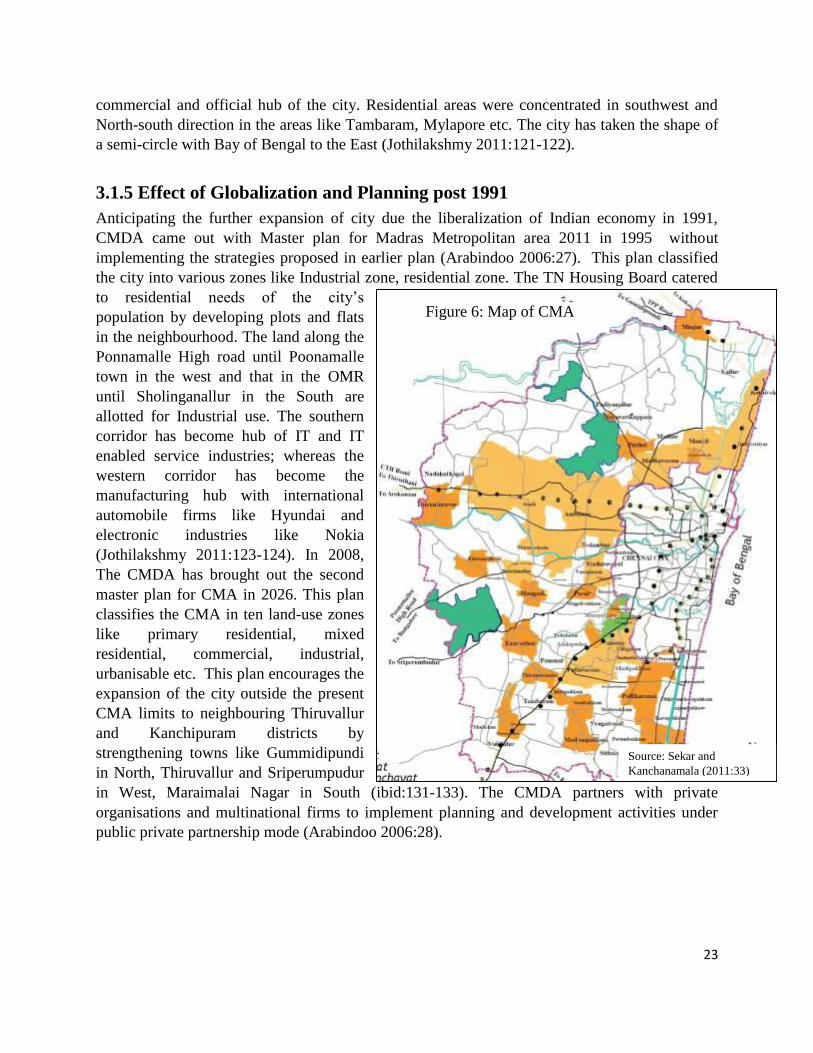
23
Source: Sekar and
Kanchanamala (2011:33)
commercial and official hub of the city. Residential areas were concentrated in southwest and
North-south direction in the areas like Tambaram, Mylapore etc. The city has taken the shape of
a semi-circle with Bay of Bengal to the East (Jothilakshmy 2011:121-122).
3.1.5 Effect of Globalization and Planning post 1991
Anticipating the further expansion of city due the liberalization of Indian economy in 1991,
CMDA came out with Master plan for Madras Metropolitan area 2011 in 1995 without
implementing the strategies proposed in earlier plan (Arabindoo 2006:27). This plan classified
the city into various zones like Industrial zone, residential zone. The TN Housing Board catered
to residential needs of the city’s
population by developing plots and flats
in the neighbourhood. The land along the
Ponnamalle High road until Poonamalle
town in the west and that in the OMR
until Sholinganallur in the South are
allotted for Industrial use. The southern
corridor has become hub of IT and IT
enabled service industries; whereas the
western corridor has become the
manufacturing hub with international
automobile firms like Hyundai and
electronic industries like Nokia
(Jothilakshmy 2011:123-124). In 2008,
The CMDA has brought out the second
master plan for CMA in 2026. This plan
classifies the CMA in ten land-use zones
like primary residential, mixed
residential, commercial, industrial,
urbanisable etc. This plan encourages the
expansion of the city outside the present
CMA limits to neighbouring Thiruvallur
and Kanchipuram districts by
strengthening towns like Gummidipundi
in North, Thiruvallur and Sriperumpudur
in West, Maraimalai Nagar in South (ibid:131-133). The CMDA partners with private
organisations and multinational firms to implement planning and development activities under
public private partnership mode (Arabindoo 2006:28).
Figure 6: Map of CMA

24
3.2 Peri-Urbanization of Chennai
From the demographic statistics of Chennai, Thiruvallur and Kanchipuram districts, one can
infer that the population in Chennai has a direct consequence on the urbanization of
neighbouring districts. The housing demand for Chennai. The Second Master plan (CMDA
2008b:63) projects the housing demand in the CMA will be 12.3 million by 2026. However,
about 70% of available land in the CMA limits is already under residential as of 2006 (CMDA
2008b:114). This means the city has to expand the limits as the effects of urbanization ‘spills
over’ to the peri-urban regions (GoTN 2013b: 253). The Census (2011a:3) used the concept of
‘outgrowth’ to include areas that to do not represent urban areas themselves, but are clubbed with
nearby towns as their ‘continuous urban spread’. The growth of peri-urban regions generally
happens along the transport corridors based on the availability of land for development at
comparatively cheaper rates than the city centre (AU 2005:9).
Chennai is no exemption to this, the city has expanded to about 25 km in South and Western
direction between 1963 and 1980 (ibid:24). Arabindoo (2006:31) considers this as ‘powerful
growth corridor’. The city shares its boundary with Andhra Pradesh in north; hence, there is not
much scope for expanding in that direction (ibid). Further, northern side is not considered
suitable for residential use, as the industries there are perceived to be polluting and hazardous.
Sekar and Kanchanamala (2011:40) have traced the expansion of city since 1971 and they have
noted the city has engulfed the villages that are nearer to it in 1971 and with passage of time,
more and more villages that are farther away from the city have also become part of the city,
particularly along the main transport corridors.
The OMR or the IT express highway in the southern direction is the hub of plethora of IT firms.
This has led to growth in the migrant population along the southern peripheries of the city since
2000 (Narain et al. 2014:9). The development in the region has already crossed the CMA limits
about 15 km further south, to Siruseri in the Kanchipuram district, home for SEZs with massive
IT parks. This is included as peri-urban region of the city. The ECR running parallel to the OMR
is also the region of massive growth as this corridor connects the southern TN with the capital
city. Arabindoo (2006) uses the case studies of Neelangarai and Valmiki nagar in this corridor to
understand the urbanization in ECR by displacing local residents and turning the area into beach
villas and apartments making it an upper class residential area. The fisher folk, who are the
original occupants, are moved to slums near the seashore and she attributes the role of powerful
real estate firms and the local panchayats in making the ECR what it is today. ‘The local people
are submerged in the development…in the process of becoming urban without even moving’
(Seabrook in ibid:51).
The Western corridor, which is the extension of Poonamalle high road as National Highway
(NH) 4 to Bangalore, is another important transport corridor. Though the present CMA limits are
until Chemberumbakkam lake, the city has expanded till Sriperumpudur in Kanchipuram district
about 40 km from Chennai city. Sriperumpudur and its adjacent areas is the hub of
manufacturing SEZ. The SEZ are vast hectares of land ranging between 10 to 3000 hectares,
made available to the national and multinational firms by the State Government and offers tax

25
concessions to the firms established in the SEZ. The chief objective of these zones is export
promotion. Many a times, the governments of various States compete to attract investments by
offering extra concessions to the multinational firms like relaxing labor laws. Nokia factory in
Sriperumpudur SEZ is one such example. This area is attracting investments with automobile
and electronic firms topping the list with 59% and 27% as of 2011 by European, Japan, Korean
and Chinese firms in addition to Indian companies. The population of Sriperumpudur increased
by more than 50% in past one decade and this can be attributed to the rapid industrialization. It is
logical that the media addresses this region as ‘India’s Schengen’ (Homm 2013:49-72).
Although, it cannot be disputed that the Chennai city has grown in all directions, the emphasis is
the south and west transport corridors (Arabindoo 2006:32), in which lot of rural areas are
absorbed into the city limits and have become present day peri-urban regions of Chennai city.
3.2.1 Land-use in Peri-Urban Chennai
One of the important characteristic of Peri-urban region is the change in the land-use from
agricultural to non-agricultural use. There will be mix of urban and rural land-use with
competition for available land (Narain et al. 2014). Anna University (2005:26) identifies change
in land-use, depletion of fertile agricultural land on a continuous scale, reduction in the
agricultural production as certain indicators of peri-urban region. Of the three categories of land-
use competition namely production vs production, production vs conservation, and production vs
built-up environment put forth by Haberal et al.(2014), peri-urban region compete for using land
either for cultivation or urbanisation.
In the CMA region as of 2006 (CMDA 2008b:114), more than 70% of the available land was put
to residential use. Sekar and Kanchanamala (2011:52) note that the agricultural land in CMA
region has drastically come down from 48.91% in 1975 to nearly 10% in 2006. The land-use
pattern (GoTN. 2006) statistics of TN shows that Chennai district with 98.3% of total
geographical area is used for non-agricultural use followed by Kanchipuram district with 33%
and Thiruvallur district with 30%. The twelfth five-year plan of GoTN (2012:736) attributes
urbanization as the chief cause for conversion of agricultural land to non-agricultural use in the
land constraint State. The per capita availability of land in TN is 0.18 ha of which only 0.07 ha is
sown area. Shah and Kumar (2008:370) have noted that most of the land transformed into
industries and residential plots in India have come from fertile agricultural land than non-
cultivable fallow lands. Raveendran et al.(2005:15) attributes certain indirect factors like
relatively lesser income from agriculture compared to other occupations, non-supportive
agricultural policies and lack of agricultural labour for changing land-use patterns in the State.
They have projected the total land demand for both agricultural and non-agricultural use by 2020
will be more than the available land in the State, and recommend immediate policy changes to
manage the land-use pattern in the State, as the supply is limited. The TN Vivasayigal Sangam,
farmer’s union, notes ‘Fertile land areas were depleting in Kanchipuram and Tiruvallur districts;
and ‘has urged the Government to take necessary steps to stop the conversion of cultivable land
into construction sites’ (The Hindu 2006).

26
3.2.2 Forms of Land-use Conversion in Peri-Urban Chennai - Land Grabbing
vs Land Alienation
The conversion of agricultural land in the peri-urban Chennai chiefly happens for reasons like
infrastructure building, industrialization and residential or the real estate reasons (Homm 2013).
The State acquires the land from the legal owners for ‘public purpose’ say constructing highways
and for industries. The state used to apply the century old Land Acquisition act of 1894, which of
late was replaced by the new Land Acquisition and Rehabilitation act of 2013. Land acquisition
by State has been into controversies involving lack of fair compensation, displacement of people
and their resettlement problems (Shiva et al. 2011). Various authors like Shiva (2011),
Vasudevan (2013) have pointed out the huge protests across the country in order to prevent the
land acquisition by the State and to ensure proper resettlement and rehabilitation of the people
who have lost their land to the State. This aspect of land acquisition may be equated as ‘Land
Grabbing’ by the State where the land is acquired without the consent/interest of the farmers.
On one hand, the State is forcefully acquiring land for industries and infrastructure leading to
protests and troubled atmosphere, on the other, the farmers from the nearby villages are
voluntarily selling their land to the private players. These firms are majorly real estate firms that
are interested in creating plots and apartments in order to meet the demands of the nearby
industrial zone. Shah and Kumar (2008:369) notes that this creates ‘land market’ in the peri-
urban region, resulting in the conversion of fertile agricultural land. They also indicate that there
is not exact data of how much land is being converted in this manner due to illegal transactions.
The forms of land diversions along with the mediating agency and end users of land in peri-
urban Chennai is summarized as below.
Table 2: Land Diversion and Mediating Agency
Understanding the form of diversion where the land is purchased by the real estate developers
with the consent of farmers leading to ‘speculative urbanism’ as Goldman (2011) refers, is the
main objective of this paper. Hence, this aspect will be discussed in detail. However, the land-
use conversion due to real estate market does not happen on its own, but due to the influence of
Land Type Purpose End user of land Mediating
agency
Form
Agricultural
land in peri-
urban Chennai
Infrastructure like roads Private or Public
use
State –
through
acquisition
Land
Grabbing
SEZs - Industrialization Mainly Private
use
For Urban growth –
Residential apartments
and plots
Generally Private
use
Mainly
through
purchase by
land
developers
Land
Alienation
Source: customized based on Shah and Kumar (2008:405)

27
emergence of industries in the peri-urban region, a brief note on SEZ in the peri-urban corridors
might will help in understanding the emergence of real estate market.
3.2.3 The Growth of SEZs in Peri-Urban Chennai
In the peri-urban areas of the City, the State acquires land for industries, particularly SEZs. In
case of SEZ, the State exhibits its monopoly in acquiring land and then transferring it to the
private firms. SEZs are ‘delineated duty free enclave and shall be deemed to be foreign territory
for the purposes of trade operations and duties and tariffs’ (Shiva et al. 2011:2). The private
sector will develop the land and establish manufacturing units. These zones are mainly created
for promoting exports and are generally exempted from tax regulation, labour laws and
environmental laws of the State. Many villages in the peri-urban areas of the city are transformed
as SEZs and the livelihood of the villagers of that area, which is chiefly dependent on agriculture
is threatened (ibid).
TN has 33 SEZs constituting 21% of total SEZs in India. In addition, about 35 of them were
principally approved SEZs yet to be operational as of 2012. Of these SEZs, 30 of them are in the
peri-urban Chennai particularly along the western and southern corridors of the city. The ones in
the western corridor like Sriperumpudur and Oragadam are predominantly manufacturing SEZs;
the ones in Southern corridors like Siruseri, Tambaram are IT and ITeS based SEZs. The State
Government advertises SEZs as ‘land of abundant opportunity’ to attract domestic and
international investment. 95.5% of total exports value from TN in 2010 is from the SEZs situated
in peri-urban Chennai (Homm 2013:56).
3.2.4 Real Estate Growth in Peri-Urban Chennai
The land conversion from agricultural to residential plots and apartments happens because of
industrial development in particular region. The rise in population gives rise to the demand for
housing the region that is industrialized. In case of Chennai, it is the southern and western
corridor. Thangavel and Sachithanandan’s study (in Arabindoo 2006) on land subdivision
substantiate this by stating that there is a marked increase in the demand for housing plots in
these corridors. The real estate sector was opened to Foreign Direct Investment (FDI) up to
100% in 2006 (FICCI 2012), consequently, one can see the apartment industry growing in the
peri-urban region of the city. Homm’s (2013:70) study throws light on the rapid growth of the
apartment industry in peri-urban Chennai; of the 34,773 units built in peri-urban region nearly
78% of them are in Western corridor (Sriperumpudur and Oragadam) and about 12% in Southern
corridor (OMR). Foreign firms are involved in building most of these apartments and they
christen these as ‘Palace Garden’, ‘Palm Grove’ ‘Roma Paradise’ in order to attract the urban
middle class and these complexes are provided with amnesties such as clubs, supermarkets,
swimming pool, school, library etc.
‘Agriculture is going down’ is a common phrase in peri-urban Chennai according to Homm
(2013) and the one major reason attributed to this is the ‘land market’ which is the effect of
urbanization and industrialization in the peri-urban region. The peri-urban region has witnessed
28
the dramatic increase in the land prices due to real estate activities. The demand within the CMA
region has almost saturated because of the low availability of land, so the peri-urban region
having supply of agricultural land has shown rise in guideline value (a value fixed by the
Government for the land) by 270% on an average (Ramakrishnan 2012). In addition to this
guideline, value there is ‘market value’ fixed by the real estate firms and brokers (Homm
2013:108). The market value, which is used for actual transactions is generally higher than the
guideline value.
The ‘Real estate business has become an avocation to make quick money’ notes the High Court
of TN (Imranullah 2014). The agricultural land is converted to plots with fencing separating the
layouts created and are highly marketed. The signboard across the major corridors like NH4 and
OMR pointing to the availability of residential plots and advertisements in the local channels
with the small screen actors promoting the plots enumerating the benefits of buying the plot is a
testimony to this.
Most of the plots developed are sold to the investors who believe in ‘investing’ rather than
constructing houses. The demand for plots in the peri-urban Chennai is about 40% more than the
constructed houses (Yogesh 2014). Investing is plots is seen as profitable investment (The Hindu
- Tamil Edition 2014). Residential plots along peri-urban Chennai has become a chief point of
investment to the Non Residential Indians (NRI) as well (ETASTAR. 2014). Nagarajan (2012:1)
notes that plots in southern and western regions are always in high demand due to various
developments like industries, infrastructure and transport and this has led to the ‘spurt in land
prices’
‘There has been a consistent demand for developed plots in and around Chennai,
according to land developers. A number of projects coming up in suburbs have seen
the prices doubling in a span of just four years in select areas’ (ibid).
The property dealers are offering special offers for NRIs like maintenance and resale of the plots
making it the desired investment option among NRIs. Thus, the land market in the peri-urban
Chennai turns into a speculative investment option expecting higher prices in the future.
‘The land market in peri-urban spaces around large Indian cities is developing so
rapidly, it is already seen as responsible for producing a new type of ‘speculative
urbanism’, where rural spaces are turned into urban real estate by powerful
alliances between real-estate brokers and politicians’ (Homm 2013:106)

29
3.3 Land-Use Policies
The Indian Constitution under the Articles 39 (b) and (c) of Directive Principles of State Policy
mandates the ‘preservation and conservation’ of natural resources for common good. Thus, at the
central level Ministry of Agriculture, Ministry of Environment and Forests and Ministry of Rural
Development are responsible for ‘conservation and management’ of land resources. The
Department of Land Resources under the ministry of Rural Development co-ordinates various
programs related to land-use and management from the central government end. The
Constitution with the 73rd and 74th amendments allows participation of rural local bodies –
panchayats and urban local bodies – municipalities. Urban planning, land-use regulation are
enlisted as functions of the municipalities. The National policies act as guidelines to the State
Government and has no binding on the State Governments as land is State subject in India and
the Constitution allows every State to form and modify policies according to the local needs and
situation situation (Negi 2012:150).
Shah and Kumar (2008:365) note that in India although the land conversion policies are
‘conservative and conservationist’, but they are ‘liberal’ in practice. These policies appear not to
take into consideration the growing demand for land for manufacturing and urbanization and
they lack transparency in mentioning the extent to which the land can be converted and for what
uses. They add the policies appear to be biased based on the fact that nearly 60% of Indians
depend on agriculture leaving behind the fact that agriculture contributing 24% of GDP occupies
nearly 64% of land whereas the manufacturing and service industry contributing 76% of GDP
occupies mere 8% of the land area.
3.3.1 National Policies
The National Farmer Policy ( 2007:4) mentions ‘Prime farmland must be conserved for
agriculture except under exceptional circumstances’. It mandates in case of such conversion, the
converting agency should be responsible in developing the equivalent volume of wasteland and
compensating the same to the affected farmer. The policy does not detail what can be considered
as ‘exceptional circumstances’ and what if the conversion does not adhere to the policy by
compensating developed wasteland.
The Right to Fair Compensation and Transparency in Land Acquisition, Rehabilitation and
Resettlement act ( 2013:10) in Chapter III that mandates food security under clause 10(1) notes
‘no irrigated multi-cropped land can be acquired’. However, in clause 10(2), it says such land
can be acquired under ‘exceptional circumstances’ but restricts only 5% of total irrigated area of
the district can be acquired. The act mandates that ‘equivalent area of cultivable wasteland shall
be developed for agricultural purposes’, but the act does not talk about violations of these rules.
Further, the act exempts land acquisition for infrastructure from its purview. It is worthy, to note
at this junction the Land Acquisition Act of 1894, which was in force until 2013, did not have
any reference to preventing the acquisition agricultural/cultivated land. It even had a clause 4(2)
permitting the officer in-charge to destroy the standing crop if it is an inhibition to acquisition
(GoI:4).

30
The recent policies under formulation (Draft) stage by the Department of Land Reforms in 2013
namely National land utilization Policy and National land reforms policy deal with conversion of
agricultural land. The main objective of the former policy is ‘protection of agricultural land’
from land conversion’ (GoI 2013b:18) and it is is expected to replace the National Land-use
Guidelines of 1988. The later policy suggests a strict monitoring should be in place to ensure that
only barren and non-cultivable land is converted to industries and other non-agricultural use (GoI
2013a:20). These policies are expected to act as a ‘guideline framework’ for the State
governments to design their policies of land-use
It is to be noted that all the recent land related policies give importance to preventing land-use
conversion as compared to earlier ones and this shows the urgency of the issue and the
importance that the central government assigns to prevent transformation of agricultural land.
However, this is just one side of the coin, whereas the policies related to urbanization like
JNNURM (2011) has outlined a procedure to make the conversion of agricultural land easier.
The framework desires to ensure easy availability of land for urbanization and considers the
existing laws pertaining to the same are bottlenecks. The land conversion procedure is time
consuming with the requirement of many approvals is common feature across the States with
respect to land conversion. Some States even charge high fees for the conversion of agricultural
land to non-agricultural use. The framework suggests delinking the submission of development
plan at the time of applying for land-use conversion as the farmer may not be the developer, and
they sell their land to relator who is the ultimate benefiter of the entire transaction. This shows
the policy conflict, while those related agriculture and rural development want to prevent land-
use conversion; the ministry of urbanization wants to relax the procedure of converting
agricultural land to make land available easily for urbanization.
3.3.2 State Policies
Some States like Andhra Pradesh, Kerala, and Maharashtra have specific policies preventing the
land-use conversion from agricultural use to non-agricultural use (JNNURM 2011:4), however,
in TN there is no such exclusive legislation. In TN there are clauses in certain policies and acts
that mandates the conversion of fertile land to be kept to minimum extent as possible. The State
Government through the Order number 885 dated 2005 (Vijayabaskar 2010:39), has given
authority to the district collector to negotiate privately with the landowners and the collector is
empowered to offer the price as high as 150% of the guideline value or market value whichever
is lower. The TN Acquisition of Land for Industrial Purposes Act, (1999) offers negotiation as
against legal route to settle the land acquisition and expedite the process. The TN Industrial
policy (2014:31) states ‘The lands required by the company shall be barren, non-irrigated and
dry land to the extent possible. Land requirement with more than 10% wetlands will not be
entertained’ but the High Power Committee that the policy proposes can consider the conversion
even if it is more than 10% of the cultivated land. It can be inferred from these policies, that the
GoTN is not keen on stringently restricting land-use conversion.
While the above policies deal with land acquisition for industries, Land Reforms (fixation and
ceilings) Act ( 1961), restricts land holding up to 15 acres for agricultural use; however, under

31
the section 3(22) of the act, there is no such upper limit for non-agricultural land-use. The
TNTCPA by DTCP is the chief act that regulates residential and commercial land-use (GoI
2007:42). The act until 2011 mandated the permission of Thasildars, Taluk level officers to
ensure the land under consideration is not agricultural land. However, with the 2011 amendment
act, the section 47(A) has entrusted the authority with the District Collector). The Government
Order 24935/10GR (GoTN 2011), clearly lists the role of the district collector in the process. It
requires the collector to inspect the land along with Regional Deputy Director of the planning
body say CMDA or DTCP. The collector is required to ascertain the irrigation sources available
to the land, the present status of cultivation and for how long the land remained uncultivated (as
the case may be), the surrounding developments/cultivation of this land and the effects the land
conversion might have on ground water and irrigation channels affecting the nearby land. Only
when the collector is satisfied that the land is not cultivable, he can give permission. It is based
on collector’s concurrence, the planning authority say CMDA or DTCP can approve the
conversion of wetlands.
The twelfth five-year planning report of TN (2012:746) asserts though there are restrictions to
prevent land-use conversion, these are relaxed when the cultivated land lies between non-
cultivable land and also when the dry land is not available in that particular region. It mandates
passing a separate act as in other States like Kerala with the main objective of protection of
wetlands.
Although, both the national and state policies state the need for protection of agricultural land
from being used for non-agricultural use, it is to be noted that none of the policies discussed have
clauses related to consequences of non-adherence. Shah and Kumar (2008:367) point out the
existence of such gaps in policies leads to implementation difficulties as many a times, the
decisions are taken under pressure and influence of powerful people having vested interests.
They add such not well laid polices creates ‘fertile ground’ for corruption.
3.3.3 Irregularities in Land-use conversion
In spite of these policies to convert agricultural lands into non-agricultural lands, there are large-
scale conversions of agricultural land in the peri-urban Chennai. There is huge gap in actual
policy and its implementation (Shah and Kumar 2008:398). This is due to interests of various
stakeholders involved in the process including farmers who to make quick money. A large
portion of land converted remains idle as plots because of speculative reasons. While it is true
that farmers are willingly selling their land as ‘to get rid of the land and farming as an
occupation’, and not only do the relators benefit from the entire transactions, the farmers both
large and small have shown improved economic status. There are losers as well (ibid).
The real estate firms and property dealers who have access to information about the new project
development in the area are determined to buy land from farmers much lesser than the market
value. There is always information asymmetries, the price one farmer receives is not revealed to
the other. These actors ensure to prevent transparency and create disparity among the farmers
selling the land. The developers go to the extent of spreading rumours that land prices will fall in

32
the future and hence it is the best time to sell land and enjoy the money. On the other hand, the
farmer who might not have seen huge money at one go is happy on receiving it without even
being aware of the exorbitant profit that the property developer might make by transforming his
land into plots (Homm 2013)
The property developers transform the agricultural land into plots and make them as marketable
commodity. The signs boards across the various roads in peri-urban Chennai and the Television
commercials in the prime slots testimonies this. They lure people in buying these plots
promoting them as investment for future. ‘The thriving land market empowers local networks
and institutions that regulate landownership. Town and village institutions gain ample
opportunities for corruption, patronage and long term clienteilism’ notes Homm (2013:117).
There has to be multiple approvals for the plan of the plots made from agricultural land by the
lowest officer in the administration, VAO to the DTCP or CMDA. Without out these approvals it
is illegal to sell the plots and construct houses. Homm (2013:126) notes that bribing is always
involved in such transactions and adds ‘powerful informal networks’ with land owners, brokers,
local politicians and even public servants dominate the land market in peri-urban Chennai.
The land developers have found an alternative of marketing the unapproved plots as ‘panchayat
approved plots’ (Indiarealestateforum. 2013). Although, approval of the local panchayat is
necessary, but it is more important to have approval from DTCP or CMDA. These are as good as
unapproved plots, but the real-estate firms project them as approved plots to make quick money.
The Hindu (2014) has cautioned people on buying such plots in peri-urban Chennai.
3.3.4 Legal Intervention
The Supreme Court of India has sent a ‘notice’ to both the Union Government and the State
Governments in response to the petition filed stating nearly 38% of agricultural land in the
country was transformed to urban structures in the past 10 years and the Governments has not
taken any action to prevent this. The petition notes this phenomenon is on the rise in States like
TN, Gujarat, and Andhra Pradesh (Dinamalar 2014).
Real Estate business has become easy way to make money and this has led to increase in crime
rates ranging from land grabbing, forging document and even murders. The Madras High Court
has directed the State Government to submit details pertaining to number of murders and
kidnaping incidents, land grabbing and forging incidents, role of government officials in land-use
conversion and the action taken by the State Government to regulate the real estate business in
the state. ‘As offences relating to real estate have risen in the past 10 to 15 years and absolutely
there is no mechanism to regulate the real estate dealings, the above details are necessary to pass
appropriate orders’ noted the Judge (Imranullah 2014)
In a recent verdict, the Madras High Court noted the land grabbers and those who forge
documents to convert agricultural land deserve ‘finger chopping’. The judgement mentions ‘If
laws are so rigid and deterrent, criminals will not dare to indulge in illegal activities…officials of
the sub-registrar office were hand in glove in helping the criminals to usurp and loot properties
of the innocents’ (Sangameswaran 2014). From the above-mentioned instances, where in Indian

33
Judiciary has shown concern on land governance issues, it can be inferred that the land-use is
taking utmost importance in India.

34
Chapter 4: The Case of Kondancheri Village3 A village in peri-urban Chennai, Kondancheri where agricultural land is converted to non-
agricultural use is chosen as arena to understand the various stakeholders involved in land-use
conversion, implementation of formal land-use policies and ascertain the involvement of the
stakeholders in informal mechanisms explained in the previous chapter.
4.1 Reasons for choosing the Village
My area of study is primarily the Kondancheri Mettu Kandigai hamlet, where one could witness
huge scale land conversion from Agricultural to other commercial uses predominantly housing
plots. According to me the Kondancheri village qualifies the definition of peri-urban used in this
paper – there is mix of urban and rural land-use and villagers commute to the city regularly for
work as the distance is about 40 Km from the city’s core area.
4.2 Location
The study village, Kondancheri is a Panchayat village in the Kadambathur Taluk of Tiruvallur
district in TN. It is situated at a distance of 44 Km in the North-west direction of the Chennai
Mofussil Bus Terminus (CMBT). From the CMA boundary, the Chemberumbakkam lake, the
village is 21 Km. The road State Highway 120, from Thandalam Koot Road to Thakolam, a 20
Km stretch which bifurcates from the National Highway 45 to Bangalore leads to the village.
The National Highway 45 is one of the busiest roads and highly industrialized as well. There are
Multinational companies like Nokia, Dell, Asian Paints, Samsung situated in along the highway
between Poonamalle and Kanchipuram. One can come across academic institutions like
engineering colleges, international schools and amusement parts in the said highway.
4.3 Demographics
The population of the village according to the Census (2011c) (Director of Census Operations
2011) is 1916 with almost equal men (973) and women (943). Thirty seven percent of the
population are categorised as scheduled caste people. The village comprises of five different
hamlets namely Kondancheri, Kondancheri Bust Stand, Kondancheri Colony, Kondancheri
Mettu Colony and Kondancheri Mettu Kandigai. These are hamlets are divided based on caste.
The Kondancheri and Kondancheri bus stand is occupied by Mudaliars who speak Tamil as their
primary language and the Telugu speaking people belonging to the Kamma Naidu category
occupy the Mettu Kandigai hamlet. These two are upper caste hamlets. People belonging to the
scheduled caste considered as lower caste occupy the other two hamlets.
3 The Details referred are from the author’s field visit and not from any published source

35
Source: Google Maps
4.4 Occupation
The occupation of upper caste people was mainly agriculture and of late, the residents have
diversified to different occupations like employment in government sector, private sector
employment, business etc., because of the higher education status. The village elders and some
young men are involved in the agricultural activities at present. Whereas, those categorized as
lower caste are employed as as agricultural laborers in the lands of the upper caste villagers. The
youngsters from these colonies have started working in the industries that have come up in the
Thakolam road (SH 120) and nearby Sriperumpudur SEZ in the past 10 years and some are
employed in Government sector as well.
Figure 7: Map showing Kondancheri Village
4.5 Land-use in the Hamlet
The hamlet lies in between dry Cooum
River on one side and an irrigation canal
on the other. There are 22 households in
the hamlet and the total land owned by
residents of this hamlet is approximately
170 acres. About 80 acres of land in the
hamlet is categorised as ‘Nanjai’ or wet
land cultivated through river and water
bodies and the balance is categorised as
‘Punjai’ or non-irrigated land.
However, according to the local
residents, these classifications had
ceased to exist as now most of the land
is cultivated only using tube wells which are operated by electricity provided free of cost by the
GoTN for agricultural purposes. Paddy is the chief crop of the hamlet and is cultivated two times
in a year in the season from January to April and from August to December. In ‘Nanjai’ land,
the soil is sandy in nature and may not absorb water, so paddy remains the chief crop of
cultivation. Where as in the ‘Punjai’ land vegetables and groundnuts are cultivated in the period
from May to August.
4.6 Rural-Urban linkages
The road, SH 120, from Thandalam Koot Road to Perambakkam, the neighbouring town to the
hamlet and further beyond has seen drastic conversion in the land-use. The road has seen
plethora of industries, both well-established and small start-ups in the past few years. Empee
group, Parle Agro, Nifco South India, Rhenus logistics, Dymos Automotive, Delphi TVS are
SH
120

36
some of them. Further, 125 acres of land in nearby village, Irungattukotai, Mapedu is acquired
by SIPCOT industrial estate for developing as dry port and was handed over to Madras Port.
There are no activities expect for a sign board ‘This Land belongs to SIPCOT, trespassers will be
prosecuted’. The SH 120 is being re-laid now into four-lane road by the highway departments to
facilitate the heavy vehicles that might be moving to and from the dry port once when it starts
functioning. These developments in the recent 5 to 7 years has seen rise in the land values across
the SH 120. When one travels in the road, one could see coexistence of real estate offices,
placards and posters advertising the availability of housing plots, agricultural land converted into
plots, agricultural cultivation activities, mango orchards, industries, village houses and roadwork
activities.
The changes in the SH 120 has had an effect on the Kondancheri village as well. The next
chapter attempts to answer the research questions raised, based on the discussions with the
residents of the hamlet with respect to the land-use conversion.

37
Chapter 5: Analysis: Informal Mechanisms Overpowering
the Formal Dynamics
In the hamlet under study, 54 acres of fertile agricultural land is to the south of the hamlet and
adjacent to the SH 120. A real estate firm has acquired 26 acres of the land and started
developing it as housing plots. The lay out by the real estate firm is christened as
‘Vasanthapuram Phase I and Phase II’. Of the remaining 28 acres, the residents of the hamlet
cultivate 25 acres, either directly or by leasing them to a relative in the villager.
5.1 Stakeholders and their interests
The conceptual framework introduced in the chapter has identified involvement of ‘multi-
stakeholders’ in the land development systems. Based on my discussion with the residents of the
hamelt and studying the peri-urban land use literature, I could understand there are various
groups with varying interests in the land-use conversion. I could identify the following as the
main stakeholders in the process – the farmers who are cultivating at present, land owners who
do not cultivate directly but have leased out, landless agricultural labourers, the other residents of
the village, village representatives, real estate firms/property developers, local government
functionaries and the public institutions. I have attempted a stakeholder analysis, to understand
the interest of these groups in the conversion process based on the interviews.

38
Table 3: Stakeholders and their interests in land-use conversion in Kondancheri Village
Stake Holder
Category
Who are they? No of
people
contacted
What they have to say
on land-use conversion
Interest in the Land Conversion
Cultivating
Farmers Residents of
the village,
Elderly people
and some
youngsters
whose
education level
generally is
not more than
secondary
school level.
4 ‘Main occupation’,
‘Not easy to find other
jobs’
‘inherited from my
ancestors’, ‘why now-
price may rise further’,
‘if I get lump sum can
start a business’
Consider land conversion as a
threat to their livelihood. However,
receiving huge sum at one go
makes some to think about selling
their land.
Though not keen on selling land to
the land developers, some are ok, if
they receive enough money to start
alternate business.
Non-
Cultivating
land owners
Residing
outside, mostly
in Chennai –
Government
and private
sector
employees,
have leased the
land to present
cultivators
1 ‘If I get right price, I
am ready to sell’
‘income from land is
not lucrative and it is
just an additional
income’
Depending on the present Price,
they are ready to sell. But are fine
with waiting if prices are expected
to rise in the future.
Landless
agricultural
laborers
People from
the Mettu
colony
3
4 ‘decent 9 to 5 job’,
‘regular income’ – so
prefer employed in
neighbouring
industries.
A middle aged women
noted ‘youngsters can
get the employment,
but, what about us’ ‘no
place for even grazing
our cattle’
As long as an alternative option of
working in industries is an option
they are not affected.
However, the elders and some
women who are not in a position to
gain alternative employment
believe the land conversion as a
threat
Other residents
of the village Those who
have already
sold their land
and engaged in
other
occupation
like owning a
shop in nearby
town
2 ‘agriculture was not
profitable – labor
problems’
‘my son is the States,
so he will never want
to cultivate’
‘Better roads and
They tend to influence others to sell
land indirectly by their improved
lifestyle after selling the land and
changing occupation or some time
‘promote’ the advantages of selling
the land
Interested in better infrastructure
due to urban impact

39
Stake Holder
Category
Who are they? No of
people
contacted
What they have to say
on land-use conversion
Interest in the Land Conversion
facilities to the village’
The Local
Village
representatives
The Panchayat
president
(woman in this
case) and her
husband, the
councillor
1 ‘It is their wish, who
am I to comment’
Act as negotiators between the
landowners and Property
dealers/real estate executives.
Few respondents believed they get
a share from the property dealer if
the deal is a beneficiary to the
relator.
A cultivator noted ‘he is behind me
to sell my land and is promising to
get better rates than offered to
others’
Their role is important to the real
estate developer as their support is
required in getting some basic
infrastructure to the laid plots
Property
developers/Re
al estate firms
The employees
of the real
estate firm that
had purchased
more than 50
acres of land
The firm has
strong
financial
strength and
political
influence (A
MLA,
officially
‘launched’ the
plots
1 ‘All the procedure has
been followed’,
‘we will get necessary
approvals for the land’
‘I am only a manager,
only my owner can
talk about the price
deals’
The property developers are
strongly interested because of high
returns and gain.
A non-cultivating land owner noted
‘they have illegally occupied part of
my land and the councillor is
negotiating with me so as to
smoothly close the deal’ –
Allegation of forging document and
involving goons to ensure that they
purchase the land they want
‘The councillor and VAO joins
them whenever they visit the
village’ - Have the support of
village representatives and
government employees

40
Stake Holder
Category
Who are they? No of
people
contacted
What they have to say
on land-use conversion
Interest in the Land Conversion
Village level
Government
functionaries
VAO 1 Requesting
confidentiality, he
noted ‘the pressure is
high’
There appears to be political
pressure to him to process the
documents with ease. Responsible
for primary checking if the land is
converted as per the policy
guidelines and report it to District
collector in case of any
irregularities.
It appears that he is working closely
with the firm and the councillor for
material gain.
Government
and Public
Institutions
Sub Registrar
Office, District
Collector,
CMDA
officials
1 ‘We understand there
is illegalities, but there
is not much will to
change the situation’
‘No collector or other officials
have visited the village to inspect
the land’
‘The land was under cultivation
even till February/March; you can
see I have planted paddy in the
adjacent field’ –
Policies are there, but appears that
they are not implemented

41
5.2 Have the objectives of the existing land-use policies met?
The response ‘The land was under cultivation even till February/March; you can see I have
planted paddy in the adjacent field’, and cultivated land nearby shows that land is converted into
plots was under cultivation till few months ago. A random check of the survey numbers
mentioned in the Vasanthapuram brochure – 304, 305,314, and 315 in the registration
department webpage mentions these as wet lake, wet well and dry well irrigation land. This
proves that land is still classified under cultivable land. Further, the village is part of the World
Bank’s Irrigated Agriculture Modernisation and Water-Bodies Restoration and Management
(IAMWARM) Project as read from a nearby signboard show the importance of agriculture in
that region. This project aims at restoring the Cooum River and the lake. However, the
Vasanthapuram brochure has already started advertising the plots made from cultivable land.
A villager noted the buyers of the plots are from the city and sometimes even from the
neighbouring districts. He added, ‘every Sunday there is a mela conducted and they serve free
food to the visitors’. The increased number of print and television advertisement testimonies his
Statement. The real estate firms advertise the plots in the Tamil-channels with the actors from
small screen industry acting as brand ambassadors. Sundays become the busiest day of the week,
as these real estate firms bring people in the sports utility vehicles from the city free of cost to
the land layout and provide them with lunch. Interestingly, some of the real estate firms offers
few grams (ranging between two to five) of gold as ‘free gift’ if someone does a spot booking of
the plot. In addition, there are bumper prices like a car, free trip to some tourist place to be won
based on random selection of the buyers who pay the entire amount within few days of the initial
booking. The firm has advertised proving 500 bags of cement free of cost to the first 500
homebuilders in the Vasanthapuram (Rich India Housing Private Limited 2014). However, a
respondent mentioned that these plots are sold mainly for investment purpose expecting the
prices might rise in next few years and he was confident there might not be many houses
constructed in those plots.
I could not conclude, because of lack of proper evidence that the district collector has approved
the conversion of agricultural land, which was under use till few months back. However, from
‘No collector or other officials have visited the village to inspect the land’, I can infer two
possibilities; either the collector’s permission is not sought as mandated by the TNTCPA or the
collector has given the permission without proper inspection. In either way, the Section 47(A) of
the act is violated. This shows the objectives of the National and State policies discussed in the
chapter 4 are not met.

42
5.3 Influence of stakeholders on policy implementation
The discussions with manager of the real estate firm gave light on the land conversion process.
He mentioned that the panchayat president of the village and in this case her husband who is the
councillor is their point of first contact. He added that he does not know the actual deals between
the firm and the councillor. ‘There are always farmers who come forward selling their land and
using them as mediators and the local village representative as negotiator the company tries to
purchase the nearby land’, notes the manager. A cultivating farmer’s response ‘he (councillor) is
behind me to sell my land and is promising to get better rates than offered to others’ testimonies
the influence of certain villagers exhibit on others to sell the land to the property dealer. The
manger was confident in saying ‘we will get necessary approvals for the land’. It can be
understood the power relations between the firm and the public institution. Interestingly, it is the
Member of Legislative Assembly visited the site to ‘launch’ the inauguration of the
‘Vasanthapuram’ project. This confirms the manager’s statement, that the firm will ‘certainly’
receive the required approval. Further ascertains ‘Right from the local MLA to the village
development officer, all are hand in glove in this (land –use conversion) at a number of places’
(Prabu 2011)
The guideline value (2014) of the land with the the survey number 315 is 22 lakh or 2.2 million
rupees per acre. Although, I could not get the actual amount paid to the farmer who had sold this
land, I understand from the rumours of the village that the price paid ranged from 20 lakhs to 25
lakhs. Taking the median value, I understand the farmer who has sold his land would have
received 23 lakhs or 2.3 million/acre of land. The real-estate firm has advertised a plot of 1200
sq.feet, which is 0.028 acres at Rs. 4,50, 000. Based on simple arithmetic, for one acre of land at
this cost, the firm is expected to make Rs 1, 60,71,429 a whopping 60% profit. In addition, none
of the farmers who sold their land revealed an exact figure, as they do not want others in the
village to know about the same.
The Vasanthapuram brochure notes the land bearing survey number 316/2A as part of it.
However, the owner of the land confirmed that he has not sold the land and he is not interested in
selling it. The Encumbrance certificate (2014) of land obtained from the registration department
webpage and the patta document that the farmer had, clarifies that the land is not been sold.
However, a part of the land is occupied by the firm and have demarcated it as their territory. The
owner mentioned ‘there have been several negotiations with me by the village councillor and
when I refused to part with my land, there were threatening calls from some unknown persons’.
5.4 Formal Dynamics vs Informal Mechanisms in land-use
conversion
The National and TN policies dealing with land-use conversion are detailed in the section 3.3.
These policies are found to be in line with the good governance principles discussed by the
World Bank and FAO framework and referred in the conceptual framework of this paper. The
JNNURM (2011) primer on land conversion mandates ‘Transparency’ by means of single
window processing of applications and evaluations with respect to the existing legislature. It

43
obligates to the authorities to either approve or reject land-use conversion within a specific time
limits in line with the ‘Speed and predictability’ principle. It requires the authorities to clearly
and concisely state the conditions within which land may be converted, and to do away with non-
value adding procedure in the process. It argues ‘effective and efficient’ regulation might curb
the land-use conversion due to speculative reasons. The primer requires ‘escalation
mechanisms’ and improved capacity of the public institutions to make and evaluate ‘land-use
plans’.
Similarly, TNTCPA ( 1972), the ‘parent act’ dealing with land-use conversion in TN prescribes
Transparency in the form of making the required information pertaining to land-use conversion
to all the stakeholders. The act mandates issuance of public notice to raise objections regarding
land-use conversion, thus insisting on participation. It requires the site visit by the appropriate
authorities in order to approve/reject the land-use conversion. The act prescribes a maximum
time-frame of six months for either approval or rejection. It requires the proper land-use plans
to be accompanied with the application and insists that these should be in the lines of the
Development Control Rules. It is prohibited to develop the land for non-agricultural use without
the permission from the respective authority.
Although, the policies enforce the land governance principles, but the reality based on the
observation and discussion with the stakeholders in the Kondancheri was not in line with these
policy frameworks.
The influence of local village representatives like panchayat president and councillor, property
dealers, VAO, politicians on land-use conversion is evident from the Stakeholder analysis
discussed in the Table 3. This clearly brings out the power dimensions mentioned in the
conceptual framework. As mentioned by Rao (2012:134), the presence of multiple governance
bodies is evident in peri-urban Kondancheri. The institution range from local leaders, VAO, local
politicians, District administration and the planning body like DTCP. Most of these institutions
have a role in land-use conversion either formally or informally as explained in the above
sections. Thus, the dimension of legal pluralism is perceivable here. The conversion of land,
which is still classified under wetland type in the registration department data base into plots and
widespread advertising these plots, and the local MLA inaugurating the unapproved layouts
shows the prevalence of corruption and clientelism. The case case of interviewee, who
mentioned about the property dealer illegally occupying his land and the local representatives
attempting to convince him to sell the land to the property dealer by means of negotiating, and
threatening calls shows that land-use conversion happens through forceful mechanisms as well.

44
By considering the Kondancheri as the policy arena, it can be understood that the informal
mechanisms influence the implementation of formal policies, thus resulting in the land-use
conversion in the village.
Figure 8: Formal and Informal Dynamics that influences policy implementation in
Kondancheri
Thus, the case of Kondancheri village is clearly a case in point and confirms what Homm
(2013:126) has noted about the manifestation of informal networks and their influence on
implementing formal policies.
‘The networks of the actors involved in producing the land market are made up of
trust, informal reciprocity and open forms of cooperation. Since many of the
activities are illegal or semi-legal, it is in particular the weakness of governance
often associated with peri-urban areas that allows the networks of land brokers,
local politicians and company representatives to make enormous profit by forging
largely uncontrolled land deals’
Agricultural land
converted to non-
agricultural use in
Kondancheri village
Resulting in
National and
State level
policies that
are in line
with FAO
and World
Bank Land
Governance
principles
Informal
Mechanisms
Transparency
Efficiency
Speed and
Predictability
Appeal
Mechanism
Participation
Land-use
Plans
Power
Dimensions
Legal
Pluralism
Corruption
and
Clientelism
Using Force
Overpowers
implementation
of
Policy Arena: Kondancheri Village
Source: Own Construction

45
Chapter 6 Conclusion
The previous chapter answered the three sub research questions raised in chapter 1. The various
stakeholders and their interests in land-use conversion were identified. Analysing the process of
land-use conversion in the Kondancheri village gave the answer to the second question that the
objectives of national and state level policies prescribing prevention of land-use conversion are
not met. The discussion on informal power relations like existence of knowledge gaps in terms
of price offered, the local village representatives acting as mediators and influencing the farmers
to sell their land to real estate firm, shows that, the powerful stakeholders influence the policy
implementation process, thus, answering the third sub question.
It can be noted that there is lack of transparency in the method of acquiring the land and
converting it into housing plots in Kondancheri village. The people are not involved in the
process and their views were not considered by the official machinery. No defined appeal
mechanism exists for the farmers who are not interested in selling the land, but is
forced/persuaded to sell, or whose land is illegally occupied, except for seeking the help of the
court, which is a lengthy and time consuming process. The presence of formal and informal
institutions governing the land-use, prevalence of bribes, political influence ascertain that
informal mechanisms definitely overpower the formal dynamics in land-use conversion in case
of peri-urban Chennai. This answers the main research question that land-use conversion
predominantly happens through the informal mechanisms and the formal policies and good
governance principles though exist, their implementation has certainly taken a back seat as noted
by Mossee (2004:663) that ‘Good Policy is unimplementable’.
Baradhan and Tewari (2010)note that land-use conversion from agricultural use to non-
agricultural use is a common phenomenon throughout India and in the States of TN, West
Bengal and Kerala is more significant. They again attribute Urbanization and Industrialization as
the chief causes for the same. This phenomenon is unavoidable for the country’s economic
growth and I accept the fact the development needs land and cannot happen in air. I subscribe to
the opinion of Shah and Kumar (2008:399) that strictly restricting the land-use conversion will
always pave way for illegal means, which might be difficult to control and on the other hand
liberating might have effect on food security of the nation as predicted by Lambin and Meyfrot
(2014:12)that Potential Available Crop land might become a ‘scare resource’.
Further, when ‘low returns to agriculture on the one hand, and vibrant land markets on the other,
driven largely by speculation and the rise of new uses of land, for many farmers in TN, land
appears to be more a store of value than a source of livelihood’ (Vijayabaskar 2010:42) the
farmer prefers to move away from agriculture and the same needs to be considered.
A possible solution in the short term might be State controlling the informal networks that
control the land markets and allowing the formal mechanisms to function by themselves. It might
benefit the farmer and the State. The implementation failure which is the Achilles’ heel of Indian
policy, as noted by Pritchett and Bhattacharya (2012), needs to be addressed. Murgesan a farmer
from TN (in Prabu 2011) asks

46
‘Though the Government is giving free goats and cattle, they do not bother to prevent
the sale of fields into plots? In short, there is no governance, only politicking. Our
elected representatives are only interested in ribbon cutting and posing for photos
rather than addressing our problems. What can we poor farmers do? Will our voice be
heard in the portals of power?’
The long term solution for the land use conversion is making farming attractive. From just a
rural vocation, the Government may consider promoting it as occupation by creating ‘Special
Agricultural Zones’ as noted by Baradhan and Tewari (2010:675) on the lines of SEZs to
attract young people to farming. ‘Making farming attractive’ is an important area that needs
detailed research.

47
References
Arabindoo, P. (2006) 'Neighbourhood Transformations in Peri-Urban Chennai', CSH Occassional Paper -
Peri-urban Dynamics : Case studies in Chennai, Hyderabad and Mumbai, No. 17, pp. 17-54. New Delhi:
French Institute of Pondicherry.
AU (2005) 'Sustainable Settlements in Periurban Areas, (Acronym: Periurban)', Socio-economic
Conceptual Frame Work-WP2. Chennai: Division of Urban Systems Development; Anna University.
Bardhan, D. and S.K. Tewari (2010) 'An Investigation into Land use Dynamics in India and Land Under-
Utilisation', Indian Journal of Agricultural Economics 65(4): 658-676.
Borras, S.M. and J.C. Franco (2010) 'Contemporary Discourses and Contestations Around Pro-Poor Land
Policies and Land Governance', Journal of Agrarian Change 10(1): 1-32.
Bowen, G.A. (2009) 'Document Analysis as a Qualitative Research Method', Qualitative Research
Journal 9(2): 27-40.
Chandrasekaran, A. (2005) 'Early Revenue Administration in Tamil Nadu', in A. Chandrasekaran (ed.)
Land Laws of Tamil Nadu, pp. 2. Chennai: C. Sitaraman & Co Pvt Ltd.
CMDA (2008a) 'Sectoral Background', Second Master Plan for Chennai Metropolitan Area, 2026, No. III.
Chennai: CMDA.
CMDA (2008b) 'Vision Strategies and Action Plan', Second Master Plan for Chennai Metropolitan Area,
2026, No. I. Chennai: CMDA.
de Wit, J. (2013a) 'Land Governance of Suburban Areas of Vietnam: Dynamics and Contestations of
Planning, Housing and the Environment', Working Paper, No. 561. The Hague: Institute of Social
Studies.
de Wit, J. (2013b) 'Tracing the Welfare and Livelihood Choices of Farm Households Following
Displacement through Land Recovery in Vietnam', Working Paper Series, No. 574. The Hague: Institute
of Social Studies.
Deininger, K., H. Selod and A. Burns (2012) 'The Land Governance Assessment Framework: Identifying
and Monitoring Good Practice in the Land Sector'. Washington DC: The World Bank.
Dhal, R.A. (1957) 'The Concept of Power', Behavioral Science 2(3): 201-215.
Dinamalar (2014) 'Why Waste the Agricultural Land? (Translated)' Dinamalar, First page. 11-09, .
Dowal, D.E. and P. Monkkonen (2008) 'Urban Development and Land Markets in Chennai, India ',
International Real Estate Review 11(2): 155.
Dowal, D.E. and P. Monkkonen (2007) 'Chennai Urban Land Market Assessment', Working Paper 2007 -
02, No. 2. Berkeley: Institute of Urban and Regional Development, University of California.
ETASTAR (Last updated 2014) 'Chennai's Real Estate Preferred by New Segment of Buyers' (a webpage
of ETA STAR). Accessed 09-11 2014 <http://www.etastar.com/chennais-real-estate-preferred-by-a-new-
segment-of-buyers/>.

48
FAO (2007) 'Good Governance in Land Tenure and Administration', FAO Land Tenure Studies, No. 9.
Rome: Food and Agriculture Organisation.
Fazal, S. (2013) Land use Dynamics in a Developing Economy: Regional Perspectives from India. (1 edn)
London: Springer.
FICCI (2012) 'Real Estate Profile', Sector Profiles, No. 59. New Delhi: Federation of Indian Chambers of
Commerce and Industry.
Found, W.C. (1974) 'Input-Output Relationships, Economic Rent, and Land-use Competition', in W.C.
Found (ed.) A Theoretical Approach to Rural Land-use Patterns, pp. 12. London: Edward Arnold
Publishers.
Gentry, B.S., T. Sikor, G. Auld, A.J. Bebbington, T.A. Benjaminsen, C.A. Hunsberger, A. Izac, M.E.
Margulis, T. Plieninger, H. Schroeder and C. Upton (2014) 'Changes in Land-use Governance in an
Urban Era', in K.C. Seto and A. Reenberg (eds) Rethinking Global Land-use in an Urban Era, pp. 239-
274. Cambridge: The MIT Press.
GoI (2013) ' The Right to Fair Compensation and Transparency in Land Acquisition, Rehabilitation and
Resettlement Act '. Act, India.
GoI (2013a) 'Draft National Land Reforms Policy'. New Delhi: Department of Land Resources,
Government of India.
GoI (2013b) 'National Land Utilisation Policy: Framework for Land use Planning & Management
(Draft)', No. 02. New Delhi: Department of Land Resources, Government of India.
GoI (2013c) 'National Land Utilization Policy - Framework for Land-use Planning and Management
(Draft)', No. 02Department of Land Resources, Government of India.
GoI (2011) 'Constitutional Provisions', Restructuring of Centrally Sponsered Schemes, pp. 1-4. New
Delhi: Planning Commission, Government of India.
GoI (2007) 'India Real Estate: Handbook of State Policies and Regulations'. New Delhi: Ernst&Young for
Department of Industrial Policy and Promotion, GoI.
GoI (2007) 'National Farmer Policy'. Policy, India.
GoI (1894) 'Land Acquisition Act'. Act, India.
Goldman, M. (2011) 'Speculative Urbanism and the Making of the Next World City', International
Journal of Urban and Regional Research 35(3): 555-581.
GoTN (2014) 'Encumbrance Certificate Based on Input Data'. Registration Department, Government of
Tamil Nadu. (The encumbtance certificate of land with survey number 316/2A obtained
from http://ecview.tnreginet.net/).
GoTN (Last updated 2014) 'Survey Numberwise Guideline Values' (a webpage of Registration
Department, Government of Tamil Nadu). Accessed 09-11 2014
<http://www.tnreginet.net/guidelinevalue_2012/greportsurvey.asp>.
GoTN (2014) 'Tamil Nadu Industrial Policy'. Policy, Tamil Nadu.

49
GoTN (2013a) 'Housing and Urban Development', Policy Note 2013-14, No. 26, pp. 59. Chennai:
Housing and Urban Development Department, Government of Tamil Nadu.
GoTN (2013b) 'Urban Development', Tamil Nadu - An Economic Appraisal 2011-12 to 2013-14, No. 15.
Chennai: Department of Evaluation and Applied Research, Government of Tamil Nadu.
GoTN (2012) 'Land-use Planning for Tamil NAdu', Twelfth five year plan, Tamil Nadu, No. 15.4.
Chennai: State Planning Commission, Government of Tamil Nadu.
GoTN (2011a) 'Census 2011 - Tamil Nadu'. Chennai: Director of Census Operations, Tamil Nadu;
Ministry of Home Affairs.
GoTN (2011b) 'Census 2011 - Tamil Nadu: Provisional Population Totals'. Chennai: Director of Census
Operations, Tamil Nadu; Ministry of Home Affairs.
GoTN (2011) 'Insertion of New Section 47(A) in the Tamil Nadu Town and Country Planning Act 1971
with Regard to Conversion of Wetland into Other Purposes'. Government Order, Tamil Nadu.
GoTN (2011c) 'Total Population and Population of Scheduled Castes and Scheduled Tribes for Village
Panchayats and Panchayat Unions Thiruvallur District'. Chennai: Directorate of Census Operations,
Government of Tamil Nadu.
GoTN (Last updated 2006) 'Land-use Pattern' (a webpage of Department of Economics and Statistics,
Government of Tamil Nadu). Accessed 11/09 2014 <http://www.tn.gov.in/crop/LandusePattern.htm>.
GoTN (1999) 'The Tamil Nadu Acquisition of Land for Industrial Purpose Act, 1997'. Act, Tamil Nadu.
GoTN (1972) 'The Tamil Nadu Town and Country Planning Act, 1971'. Act, Tamil Nadu.
GoTN (1961) 'TN Land Reforms (Fixation and Ceilings) Act 1961'. Act, Tamil Nadu.
Gregory, P.J. and J.S.I. Ingram (2014) 'Food Production and Land-Use', in K.C. Seto and A. Reenberg
(eds) Rethinking Global Land-use in an Urban Era, pp. 23-34. Cambridge: The MIT Press.
Grindle, M.S. and J.W. Thomas (1991) 'Implementing Reform: Arenas, Stakes and Resources', in M.S.
Grindle and J.W. Thomas (eds) Public Choices and Public Change: The Political Economy of Reform in
Developing Countries, pp. 121-141. Baltimore: Johns Hopkins University Press.
Haberl, H., C. Mbow, X. Deng, E.G. Irwin, S. Kerr, T. Kuemmerle, O. Mertz, P. Meyfroidt and B.L.
Turner II (2014) 'Finite Land Resources and Competition', in K.C. Seto and A. Reenberg (eds) Rethinking
Global Land-use in an Urban Era, pp. 35-70. Cambridge: The MIT Press.
Habibullah, W. (2003) 'Foreword', in M. Thangaraj (ed.) Land Reforms in India - Tamil Nadu: An
Unfinished Task, Vol. 9. pp. 17. New Delhi: Sage Publications.
Heywood, A. (2007) 'What is Politics?', in A. Heywood (ed.) Politics, Newyork: Palgrave Macmillian.
Homm, S. (2013) 'Global Players – Local Struggles: Globalised Transformations in Peri-Urban Chennai:
Approaching the Nexus of Industrialisation and Social Change with Lefebvre’s Theory of the Production
of Space', Bonn: University of Bonn.
Hyden, G., J. Court and K. Mease (2003) 'Making Sense of Governance: The Need for Involving Local
Stakeholders', Politics and Governance, pp. 5. London: Overseas Development Institute.

50
Imranullah, M.S. (2014) 'Real Estate Business has Become an Avocation to make Quick Money: Madras
High Court' The Hindu, Tamil Nadu. 21-10, .
Indiarealestateforum (Last updated 2013) 'Panchayat Approval Vs DTCP Vs CMDA Approval of Land' (a
webpage of Indiarealestateforum). Accessed 09-11 2014 <http://www.indiarealestateforums.com/news-
feed-blogs/20-chennai/129-panchayat-approval-vs-dtcp-vs-cmda-approval-of-land>.
Jann, W. and K. Wegrich (2007) 'Theories of the Policy Cycle', in F. Fischer, G.J. Miller and M.S. Sidney
(eds) Handbook of Public Policy Analysis: Theory, Politics, and Methods, pp. 43-62. Boca Raton: CRC
Press.
JNNURM (2011) 'Simplification of Legal and Procedural Framework for Conversion of Agricultural
Land to Non-Agricultural Purposes', Primers for optional reforms. New Delhi: JNNURM, Government of
India.
Johnson, C. and A. Chakravarty (2013) 'Re-Thinking the Role of Compensation in Urban Land
Acquisition: Empirical Evidence from South Asia', Land 2: 278-303.
Jothilakshmy, N. (2011) 'Evaluation of Form-Based Codes and the Image of Chennai, Tamilnadu', Doctor
of Philosophy. Chennai: Anna University.
Kupková, L. (2007) 'Suburbanization and Urbanization of Prague-the Theory of Zonal Models and
Reality', in P. Dostal and J. Langhammer (eds) Modelling Natural Environment and Society, pp. 206-221.
p3k.
Kurtz, R.A. and J.B. Eicher (1958) 'Fringe and Suburb: A Confusion of Concepts', Social Forces 37(1):
32-37.
Kvale, S. and S. Brinkmann (2009) 'Epistemological Issues of Interviewing', in S. Kvale and S.
Brinkmann (eds) <br />Interviews: Learning the Craft of Qualitative Research Interviewing, pp. 47-60.
Los Angeles: Sage Publications.
Lambin, E.F. and P. Meyfroidt (2014) 'Trends in Global Land-use Competition', in K.C. Seto and A.
Reenberg (eds) Rethinking Global Land-use in an Urban Era, pp. 11-22. Cambridge: The MIT Press.
Manonmani, I.K., S. Tamilenthi and G.R. Parthasarathy (2011) 'An Analysis of Fringe Suburb Residential
Pattern: A Case Study of Madurai City, Tamil Nadu, India', Journal of Experimental Sciences 2(2): 21-
26.
Margulis, M.E. (2014) 'Emergent Global Land Governance', in K.C. Seto and A. Reenberg (eds)
Rethinking Global Land-use in an Urban Era, pp. 183-200. Cambridge: The MIT Press.
Mosse, D. (2004) 'Is Good Policy Unimplementable? Reflections on the Ethnography of Aid Policy and
Practice', Development and Change 35(4): 639-671.
Nagarajan, V. (2012) 'Demand for Plots Stable' Chennai Property - A Bimonthly Tabloid, Land
Investment. 16-30 September 2012, .
Narain, V. (2009) 'Growing City, Shrinking Hinterland: Land Acquisition, Transition and Conflict in
Peri-Urban Gurgaon, India', Environment and Urbanization 21(2): 501-512.

51
Narain, V., P. Anand and P. Banerjee (2013) 'Periurbanization in India: A review of the Literature and
Evidence', Report for the project – Rural to Urban Transitions and the Peri-urban Interface, pp. 1-27.
Secunderabad: SaciWATERs.
Narain, V., P. Banerjee and P. Anand (2014) 'The Shadow of Urbanization: The Peri-Urban Interface of
Five Indian Cities in Transition', Environmental Change, Vulnerability and Governance, No. 68. Hawaii:
East-West Center.
Narain, V. and S. Nischal (2007) 'The Peri-Urban Interface in Shahpur Khurd and Karnera, India',
Environment and Urbanization 19(1): 261-273.
Negi, M. (2012) 'Land a Critical Resource in Urban and Rural Planning and Management', Urban and
Rural Planning and Management, pp. 149-160. New Delhi: Ministry of Housing and Urban Poverty
Alleviation, Government of India.
Oliveau, S. (2005) 'Periurbanization in Tamil Nadu: A Quantitative Approach', CSH Occasional Paper,
No. 15. New Delhi: French Research Institutes in India.
Palmer, D., S. Fricska and B. Wehrmann (2009) 'Towards Improved Land Governance', Land Tenure
Working Paper, No. 11. Rome: Food and Agricultural Organization.
Pearce, F. (2013) 'Introduction - Buy Land. they are Not Making it any More', in F. Pearce (ed.) The
Landgrabbers: The New Fight Over Who Owns the Earth, pp. 7-12. London: Transworld Publishers.
Prabu, M.J. (2011) 'Unbridled Real Estate Business Threatens Farmers' Livihoods' The Hindu, Sci-Tech
and Agri. 13-10, .
Pritchett, L. and Bhattacharya, S. (2012) 'Achilles’ Heel of Social Policy' The New Indian Express, 06-06,
.
Ramakrishnan, T. (2012) 'Huge Jump in Guideline Values' The Hindu, Tamil Nadu. 28-03, .
Rameli, A.b. (2011) 'Land-use Planning System: Its Role in Housing Development Process', Occassional
Paper Series, No. 01, pp. 4. Peninsular Malaysia: Federal Department of Town and Country Planning.
Ramesh, S., N. Nagarajan and S. Poongothai (2011) 'Land use in Suburbia: Perungalathur Village of
Chennai Metropolitan Area', International Journal of Scientific & Engineering Research 2(8).
Rao, P. (2012) 'Peri-Urban Land Developments in India – Issues and Concerns', Urban and Rural
Planning and Management, pp. 131-140. New delhi: Ministry of Housing & Urban Poverty Alleviation,
Government of India.
Raveendaran, N., M. Chandrasekaran and R. Balasubramanian (2005) 'Revision of Perspective Plan for
Land-use in Tamil Nadu'. Coimbatore: Department of Agricultural Economics, Tamil Nadu Agricultural
University.
Rich India Housing Private Limited (2014) 'Vasanthapuram Mapedu - we Wish You to Live with Land'.
Chennai: Rich India Housing Private Limited. (This is an advertisement Brochure of plots that are made
out of agricultural land in the Kondancheri Village).
Sangameswaran, K.T. (2014) 'Land Grabbers Deserve 'Finger Chopping' Says HC' The Hindu, 12-07, .

52
Sekar, S.P. and S. Kanchanamala (2011) 'An Analysis of Growth Dynamics in Chennai Metropolitan
Area', Institute of Town Planners, India 8(4): 31-57.
Seto, K.C. and A. Reenberg (2014) 'Rethinking Global Land-use in an Urban Era - an Introduction', in
K.C. Seto and A. Reenberg (eds) Rethinking Global Land-use in an Urban Era, pp. 1-10. Cambridge: The
MIT Press.
Shah, A. and A. Kumar (2008) 'Diversion of Land and Displacement in India: Review of Evidence and
Issues', in M.S. Dev and K.S. Babu (eds) India's Development: Social and Economic Disparities, pp. 365-
405. New Delhi: Manohar.
Shiva, V., S. Jani and S.M. Fontana (2011) 'The Great Indian Land Grab'. New Delhi: Navdanya.
Sivan, J. (2011) 'TN Tightens Rules on Conversion of Wetlands' The Times of India, City. February 04, .
TCPO (2006) 'Trends in Land Prices in Chennai', Urban Land Price Scenario - Chennai, pp. 199. New
Delhi: Town and Country Planning Organization, Government of India.
The Hindu (2013) 'A Farmer in our Midst' The Hindu, Metroplus. 11.12.2013, .
The Hindu (2006) 'State Urged to Stop Conversion of Cultivable Land into Construction Sites' The Hindu,
Tamil Nadu. 16-11, .
The Hindu - Tamil Edition (2014) 'Be Careful while Buying Plots! (Translated)' The Hindu - Tamil
Edition, Own House. 04-10, .
The World Bank (2003) 'Land Policies for Growth And Poverty Reduction', A world Bank Policy
Research Report, pp. 44. Washington DC: World Bank and Oxford University Press.
TI (2011) 'Corruption in the Land Sector', Working Paper, No. 04. Berlin: Transparency International.
TI (2009) 'Global Corruption Barometer', pp. 9. Berlin: Transparency International.
Turner, M. and D. Hulme (1997) 'The Policy Process: Politics and Technics', in M. Turner and D. Hulme
(eds) Governance, Administration and Development: Making the State Work, pp. 57-81. London:
Macmillan.
Vasudevan, V. (2013) Urban Villager: Life in an Indian Satellite Town. New Delhi: Sage Publications.
Vijayabaskar, M. (2010) 'Saving Agricultural Labour from Agriculture: SEZs and Politics of Silence in
Tamil Nadu', Economic and Political Weekly 45(6).
Visser, O. (2013) 'Running out of Farmland? - Financialisation, Land Value and the Sluggishness of
Commoditisation', Research in Progess Seminar, 30-10-2013. International Institute of Social Studies.
Wehrwein, G.S. (1942) 'The Rural-Urban Fringe', Economic Geography 18(3): 217.
Yogesh, R.S. (2014) 'Increasing in Appartment Sales (Translated)' The Hindu - Tamil Edition, Own
House. 20-09, .

53
Appendix A – Some pictures from the field
Agricultural land converted in to plots
Cultivated Land next to plots
High-rise Apartments coming up near the
village
One of the Mushrooming Real-Estate
Offices in the SH 120
World Bank IAMWARM project in the
village to revive irrigation sources
Catchy Real-Estate Advertisements