Embed Size (px)
Citation preview

N0428A.AR.002825NAS PATUXENT RIVER
5090.3a
FINAL SITE MANAGEMENT PLAN 2017 UPDATE NAS PATUXENT RIVER MD8/1/2017
CH2M HILL

Final
Site Management Plan 2017 Update
Naval Air Station Patuxent River St. Mary’s County, Maryland
Contract Task Order JU01
August 2017
Prepared for
Department of the Navy Naval Facilities Engineering Command
Washington
Under the
NAVFAC CLEAN 9000 Program Contract N62470-16-D-9000
Prepared by
Herndon, Virginia

NG0822170604WDC III
Contents Acronyms and Abbreviations ............................................................................................................................... v
1 Introduction ......................................................................................................................................... 1-1 1.1 Purpose ............................................................................................................................................ 1-1 1.2 Facility Description .......................................................................................................................... 1-2 1.3 Facility History ................................................................................................................................. 1-3 1.4 Federal Facility Agreement .............................................................................................................. 1-3 1.5 Site Planning and Investigation Management ................................................................................. 1-4 1.6 History and Status of ER Program Investigations ............................................................................ 1-5 1.7 Remedial/Removal Action and Construction .................................................................................. 1-5 1.8 Five-Year Reviews ............................................................................................................................ 1-6 1.9 Sites Closed under the ER Program ................................................................................................. 1-7 1.10 Munitions Response Program ......................................................................................................... 1-7 1.11 Emerging Contaminants .................................................................................................................. 1-7 1.12 Dioxins ............................................................................................................................................. 1-8
2 Active Sites .......................................................................................................................................... 2-1 2.1 Site Descriptions .............................................................................................................................. 2-1
2.1.1 Site 9—Former Drum Disposal Area Building 665 .............................................................. 2-1 2.1.2 Site 21—Sludge Drying Beds ............................................................................................... 2-2 2.1.3 Site 23—DPDO Salvage Yard (includes former Site 42) ...................................................... 2-2 2.1.4 Site 31–Tire Shop Building 307 ........................................................................................... 2-3 2.1.5 Site 34–Drum Disposal Area ............................................................................................... 2-4 2.1.6 Site 55–Former Hazardous Waste Storage Hut .................................................................. 2-5 2.1.7 Site 56–Abandoned Hazardous Waste UST ........................................................................ 2-6
3 Remedy In Place Sites .......................................................................................................................... 3-1 3.1 Site Descriptions .............................................................................................................................. 3-1
3.1.1 Site 1—Fishing Point Landfill .............................................................................................. 3-1 3.1.2 Site 6 OU-1—Bohneyard ..................................................................................................... 3-3 3.1.3 Site 11—Former Sanitary Landfill ....................................................................................... 3-5 3.1.4 Site 12—Landfill Behind Rifle Range................................................................................... 3-8 3.1.5 Site 17—Pesticide Control Shop Building 841 .................................................................. 3-10 3.1.6 Site 39–Waste PCE Storage Area Building 503 ................................................................. 3-12
4 Munitions Response Sites .................................................................................................................... 4-1 4.1 Site Descriptions .............................................................................................................................. 4-1
4.1.1 UXO-0001—Historical Disposal of MEC .............................................................................. 4-1 4.1.2 UXO-0002—Former Pistol Range (OU-1)/Skeet Ranges (OU-2) ......................................... 4-3 4.1.3 UXO-0003—Former Water Ranges..................................................................................... 4-4
5 Site Management Schedules ................................................................................................................ 5-1
6 References ........................................................................................................................................... 6-1
Appendices
A Summaries of Closed Sites B Regulatory Correspondence
Tables
1 ER Sites Relative Risk Rank and Schedule Summary

SITE MANAGEMENT PLAN 2017 UPDATE
IV NG0822170604WDC
Figures
1 Naval Air Station Patuxent River and Webster Field US Naval Reservation 2 Active and Remedy In Place Sites 3 Response Complete, No Further Action, and Closed Sites 4 MR Sites – UXO-0001 and UXO-0002 5 UXO-0003 – Former Water Ranges

NG0822170604WDC V
Acronyms and Abbreviations ACM Asbestos Containing Material AGC Advanced Geophysical Classification AIMD Aircraft Intermediate Maintenance Department AWQC Ambient Water Quality Criteria ATSDR Agency for Toxic Substances and Disease Registry
BTVs Background Threshold Values
CCR Construction Closeout Report CERCLA Comprehensive Environmental Response, Compensation, and Liability Act CFR Code of Federal Regulations CLEAN Comprehensive Long-Term Environmental Action—Navy
DDD 4,4’-dichlorodiphenyldichloroethane DDE 4,4’-dichlorodiphenyldichloroethylene DDT 4,4’-dichlorodiphenyltrichloroethane DE Desktop Evaluation DGM Digital Geophysical Mapping Dioxins Polychlorinated Dibenzodioxins DoD Department of Defense DDESB Department of Defense Explosive Safety Board DPDO Defense Property Disposal Office DRMO Defense Resource Management Office
EE/CA Engineering Evaluation and Cost Analysis EPA United States Environmental Protection Agency ER Environmental Restoration ER,N Environmental Restoration, Navy ESD Explanation of Significant Differences ESI Expanded Site Investigation ESS Explosive Safety Submittal
FFA Federal Facility Agreement FFS Focused Feasibility Study FS Feasibility Study FY Fiscal year
IAS Initial Assessment Study IRA Interim Removal Action IRACR Interim Remedial Action Closeout Report IRI Interim Remedial Investigation
LCS Leachate collection system LNAPL Light Non Aqueous Phase Liquid LUC Land Use Control LTM Long-term monitoring
MC Munitions Constituents MCL Maximum Contaminant Level MDE Maryland Department of the Environment MEC Munitions and Explosives of Concern METCOM St. Mary’s County Metropolitan Commission mg/kg milligrams per kilogram

SITE MANAGEMENT PLAN 2017 UPDATE
VI NG0822170604WDC
NACIP Naval Assessment and Control of Installation Pollutants NAS Naval Air Station NAVFAC Naval Facilities Engineering Command NOSSA Naval Ordnance Safety and Security Activity NPL National Priorities List NTCRA Non-time Critical Removal Action
OU Operable Unit
PA/SI Preliminary Assessment/Site Inspection PAHs Polycyclic aromatic hydrocarbons PCB Polychlorinated biphenyl PFAS Per- and Polyfluoroalkyl Substances PCE Tetrachloroethene PFOS Perfluorooctanesulfonic acid PFOA Perfluorooctanoic acid POL Petroleum-oil lubricant PRAP Proposed Remedial Action Plan ppm parts per million
QAPP Quality Assurance Project Plan
RA Remedial Action RACR Remedial Action Completion Report RAOs Remedial Action Objectives RCRA Resource Conservation and Recovery Act RD Remedial Design RFA RCRA Facility Assessment RfD Oral reference dose RI Remedial Investigation RI/FS Remedial Investigation/Feasibility Study ROD Record of Decision
SARA Superfund Amendment and Reauthorization Act SI Site Investigation SMP Site Management Plan SSI Site Screening Investigation SWOD Solid Waste Operations Division SVOC Semivolatile Organic Compound
µg/kg micrograms per kilogram UST underground storage tank UU/UE unlimited use/unrestricted exposure
VOCs Volatile Organic Compound
NG0822170604WDC 1-1
SECTION 1
1 Introduction 1.1 Purpose Naval Air Station (NAS) Patuxent River, located in St. Mary’s County, Maryland (Figures 1 and 2), was proposed for the National Priorities List (NPL) on January 18, 1994, and was formally placed on the NPL on June 30, 1994. The U.S. Environmental Protection Agency (EPA) Identification Number is MD7170024536. The purpose of this update to the Site Management Plan (SMP) is to:
• Summarize the status of previous and current environmental investigations for Environmental Restoration (ER) Program1 sites identified at NAS Patuxent River to be addressed under the Comprehensive Environmental Response, Compensation, and Liability Act (CERCLA);
• Present decisions made during the project planning and site prioritization process for NAS Patuxent River and identify environmental activities for the upcoming fiscal year (i.e., Fiscal Year (FY) 2017); and
• Provide schedule projections for future fiscal years (i.e., FY 2017 and beyond) for anticipated long-term environmental management at the facility in accordance with the Department of the Navy (Navy) ER Program.
The ER Program for NAS Patuxent River is managed by Naval Facilities Engineering Command (NAVFAC) Washington. This SMP is a management tool to plan, review, and set priorities for response actions at sites covered under the plan. The 46 original ER sites, as outlined in the Federal Facility Agreement (FFA) plus three additional sites (i.e., Sites 54, 55, and 56) added to the ER Program are listed in Table 1, and the location of each site is shown in Figure 2.
The SMP is organized as follows:
• Section 1—Introduction presents a description of the station and a brief synopsis of the environmental history of the facility;
• Section 2—Active Sites provides a brief description for each of the current ER Program sites, including the relative risk ranking and programmed schedule, site location and history, actions completed, and current status;
• Section 3- Remedy In Place Sites provides a brief description for each of the ER Program sites that have a remedy in place;
• Section 4—Munitions Response Sites provides a brief description for each of the MR sites and current status;
• Section 5-Site Management Schedules presents the NAS Patuxent River Tier I Partnering Team Goals (FY 2016-2017) and the estimated schedules beyond FY 2017;
• Section 6—References lists the various references used to prepare the SMP;
• Appendix A—Summaries of Closed Sites; and
• Appendix B – Regulatory Correspondence
Figures and tables referenced in the text are presented at the end of the report. The dates presented in this document are calendar year unless indicated otherwise (i.e., FY).
This document presents the status of the ER sites and anticipated schedule as of June 2017. As a result of progress on the ER Program, as well as ongoing operations at the station, the information presented about the ER sites will change over time. The information presented in this document will be updated or revised as appropriate during the next SMP update.
1 The ER Program was formerly known as the Installation Restoration (IR) Program

SITE MANAGEMENT PLAN 2017 UPDATE
1-2 NG0822170604WDC
1.2 Facility Description NAS Patuxent River is located in St. Mary’s County, Maryland, approximately 65 miles southeast of Washington, D.C. The facility encompasses approximately 7,900 acres, including both the primary NAS parcel at the confluence of the Patuxent River and the Chesapeake Bay, and Webster Field Annex, an outlying parcel located in St. Inigoes, Maryland, approximately eight miles south of the NAS (Figure 1). There are no ER sites at Webster Field Annex to be addressed under CERCLA. NAS Patuxent River is surrounded by a security fence and routinely patrolled, and access to the facility is through three manned security gates along or just off of Maryland State Highway Route 235.
NAS Patuxent River is bounded on the north, east, and southeast by more than 11.7 miles of shoreline, ranging from sandy beaches to tidal marshes. State Highway Route 235 and the town of Lexington Park, an unincorporated community, border the station to the west and southwest. The station has three seaplane basins, five man-made freshwater ponds, and three tidal creeks.
The station is located within the Patuxent River watershed. Most of the streams that drain NAS Patuxent River are intermittent and originate northwest of State Highway Route 235. Streams that originate on the facility remain within the facility boundaries and discharge into man-made ponds, the Patuxent River, or the Chesapeake Bay. A few small intermittent streams discharge primarily to Harper Creek, Pearson Creek, or Goose Creek. Harper Creek and Pearson Creek discharge directly into the Patuxent River, which is estuarine in the vicinity of the facility. Goose Creek discharges directly into the Chesapeake Bay. Pine Hill Run also discharges to the Chesapeake Bay. Man-made structures, such as aircraft runways and the stormwater drainage system, affect surface water flow and precipitation runoff. The stormwater drainage system consists of concrete storm sewers that receive groundwater seepage and surface water from a network of shallow roadside ditches, culverts, sub-drains, storm sewers and associated laterals, and natural streams. Discharge points for the stormwater drainage system include ponds, the Patuxent River, and the Chesapeake Bay.
Five man-made ponds (Ponds 1 through 5 on Figure 2) located throughout the facility are used for recreational fishing and are periodically stocked. Saltwater fishing occurs along the northern shoreline and seaplane basin walls. An effort to seed oyster beds in Harper Creek and Pearson Creek has been initiated, but harvesting oysters for human consumption currently is not allowed.
Groundwater beneath the facility occurs in four principal aquifers, specifically a shallow unconfined water-table aquifer (within Upland and Lowland deposits) and three deeper confined aquifers (Piney Point-Nanjemoy, Aquia and Patapsco aquifers). The Piney Point-Nanjemoy aquifer is a major source of potable water for residential users in southern Maryland. The Aquia aquifer, which is deeper than the Piney Point-Nanjemoy, is the principle source of potable and industrial water for both NAS Patuxent River and local public water suppliers. NAS Patuxent River has also drilled two water supply wells (one each at the NAS and Webster Field Annex) into the Patapsco aquifer, which is deeper than the Aquia aquifer. The Patapsco aquifer production wells have replaced some of the groundwater being withdrawn from the Aquia aquifer, thus reducing the overall regional groundwater demand on the Aquia aquifer.
Ponds and streams in the area serve as local discharge points for groundwater, resulting in local variations in the groundwater flow direction throughout the station. The groundwater elevation of the water table beneath the facility ranges from sea level along the coastal areas to approximately 80 feet above mean sea level in the southwestern portion of the facility.
Several broad wetland cover types have been identified at the station. These include forested wetlands, scrub/shrub wetlands, saline marshes, freshwater tidal marshes, nontidal marshes, and open water/emergent wetlands. Five types of forests have been identified and include uplands hardwoods, upland pine, bottomland pine, bottomland hardwood, and mixed forest. Approximately 37 percent of NAS Patuxent River is forested, with mature upland hardwoods and mixed pine/hardwood stands being the most common. Shrubs and young trees cover approximately 11 percent of NAS Patuxent River.
SECTION 1—INTRODUCTION
NG0822170604WDC 1-3
Freshwater and saltwater marshes and open water habitats cover a little less than 9 percent of NAS Patuxent River. Principal estuaries and associated wet marshes are located at the confluence of the Patuxent River with Harper and Pearson Creeks, and at the confluence of the Chesapeake Bay with Goose Creek and Pine Hill Run.
Animals common to the facility include white-tailed deer, gray squirrels, rabbits, gray and red foxes, raccoons, woodchucks, quail, doves, woodcocks, various songbirds, and raptors. The facility has designated areas for seasonal hunting, and has a wildlife management program. One specie listed by the U.S. Department of the Interior Fish and Wildlife Service as being endangered, specifically the Shortnose Sturgeon (Acipenser brevirostrum) has been observed in the area. One federally threatened species, the Northern Beach Tiger Beetle (Cicindela dorsalis dorsalis), has been observed in the sandy portions of Cedar Point Beach and Hog Island. The Eastern Narrow-mouthed Toad (Gastrophuyne carelinensis), which is considered endangered by the State of Maryland, was reported once in the 1980s as a possible single individual vocalizing near the edge of the upper antenna fields in the southwest corner of the station. While there are suitable breeding pools located there, no specimens were ever collected and no subsequent observations were ever reported – despite several attempts. Species occurring at the facility that have been designated by the State of Maryland as ‘of special concern’ include the great blue heron, the red-shouldered hawk, the osprey, and the eastern bluebird.
1.3 Facility History NAS Patuxent River was commissioned on April 1, 1943, in an effort to centralize widely dispersed air testing facilities that had been established prior to World War II. This consolidation effort was swift, and the farming operations at Cedar Point, Maryland, were replaced by flight test operations within a year after ground breaking for construction in 1942. The U.S. Naval Test Pilot School was established in 1958. In 1975, the Naval Air Test Center began to assume its role as the principal site for Naval Air Systems Command development testing. Test facilities were upgraded in the late 1970s, with some of the largest construction appropriations in the history of the base.
As a recipient activity during three successive rounds of base realignment and closure in the 1990s, NAS Patuxent River became the fastest-growing installation in the Department of Defense (DoD). Patuxent River gained workers from the Naval Air Warfare Center, Aircraft Division sites at Trenton, New Jersey, and Warminster, Pennsylvania, and the Naval Air Systems Command headquarters was relocated to the station from Arlington, Virginia. This growth resulted in a large investment in new and renovated facilities and infrastructure at NAS Patuxent River. In addition to construction investments, the station obtained Webster Field Annex for use as an outlying airfield. As a result of the consolidation that occurred throughout the 1990s, the Naval Aviation Systems Team at NAS Patuxent River now hosts the full spectrum of acquisition management, research and development capabilities, air and ground testing and evaluation, aircraft logistics, and maintenance management for naval aviation.
1.4 Federal Facility Agreement NAS Patuxent River was proposed for the NPL on January 18, 1994, and was placed on the NPL on June 30, 1994. On December 9, 2000, the Navy and EPA Region III signed a FFA, III-FCA-CERC-017, which outlines the scope of efforts for remedial activities at NAS Patuxent River. In accordance with the FFA, §11.5, the Navy shall submit an Amendment or an update to the SMP on an annual basis.
The Navy, EPA, and the Maryland Department of the Environment (MDE) agree to meet regularly to discuss project schedules, proposed budgets, milestones, including Near Term, Out Year, and Project End Dates. In the case of a budget shortfall, the Navy, EPA and MDE agree to follow the procedures for re-scoping and rescheduling of activities that do not cause Near Term Milestones or Out Year Milestones to be missed or to cause implementation of cost-saving measures. Moreover, the Navy, EPA and MDE agree to document modifications to Milestones due to budget shortfalls in accordance with the FFA §12.6, and to include a statement in the SMP documenting any changes agreed to by the Parties at any meetings, as required by the FFA.

SITE MANAGEMENT PLAN 2017 UPDATE
1-4 NG0822170604WDC
1.5 Site Planning and Investigation Management Under the FFA, the Navy and EPA have the flexibility to designate an operable unit (OU) to subdivide a site depending on the complexity of the site or the need to address portions of a site (e.g., different environmental media) independently. Therefore, the number of sites and OUs pertaining to each site are subject to change from year to year. In accordance with Navy Guidance (March 2006), NAVFAC Washington has divided some ER sites into OUs to facilitate remediation of the sites and achievement of key milestones associated with site closeout, such as ‘Remedy In Place’ or ‘Response Complete’ (Table 1). Sites/OUs that have not reached either of these two milestones are considered active sites in various phases of investigation or remediation.
Sites/OUs with a 'Remedy In Place' designation have a completed long term remedy in place and the remedy is operating as planned to meet project remedial action objectives (RAOs) in future, or have a short-term remedy that has been successfully implemented and the final documentation has been completed (Department of the Navy, 2006). Currently, seven sites/OUs at NAS Patuxent River have a ‘Remedy In Place” as identified below and on Figure 2:
• Site 1: OU-1 • Site 12: OU-1 • Site 11: OU-1 and OU-2 • Site 6: OU-1 • Site 17: OU-1 • Site 39
Sites/OUs with a 'Response Complete' designation have either met the remedial action objectives and the operation, maintenance, and monitoring actions for the remediation system and the site has achieved cleanup goals specified in the applicable ROD, or have been closed based on information presented in a decision document (Department of the Navy, 2006) referred to in the FFA as a Desktop Evaluation. At present, 45 sites/OUs at NAS Patuxent River have achieved the status of Response Complete, No Further Action, or Closed as listed on Figure 3.
Sites/OUs that are considered to be ‘Active’ are sites/OUs currently under investigation, awaiting investigation to begin, or have an interim action or remedial action in progress. These sites/OUs can be at various phases within the site closeout process in accordance with CERCLA requirements. Currently, seven sites/OUs at NAS Patuxent River are considered to be Active (Sites 9, 21, 23, 31, 34, 55, and 56) as listed on Figure 2.
All of the original sites/OUs as defined in the FFA were previously given an overall risk ranking (Table 1) by NAVFAC Washington using the DoD Relative Risk Site Evaluation program. This tool was used to evaluate the relative risk posed by a site in relation to other sites at NAS Patuxent River. Sites were grouped into “high,” “medium,” and “low” categories based on an initial evaluation of hazardous substances that could have been released from these sites and a qualitative evaluation of pathways and potential human and ecological receptors. The relative risk rankings cannot be used to compare sites between installations, nor to show a quantitative risk estimate as is developed during Remedial Investigation/Feasibility Study (RI/FS) investigations. The relative risk site evaluation is intended by DoD as a methodology to evaluate the relative risks posed by sites, but is not intended to replace a more formal human health or ecological risk assessment. The ranks shown in Table 1 are subject to change as new information becomes available.
The relative risk rank is developed on the basis of three factors: the contaminant hazard factor, the migration potential factor, and the receptor factor. The contaminant hazard factor is developed as a composite score for all contaminants on site, using the ratio of the maximum concentration of a given contaminant detected in the environment to a risk-based comparison value for that contaminant in that medium. The migration potential factor is a qualitative factor, determined by using available site information on potential contaminant migration pathways. The receptor factor provides information about potential present or future receptors for each site that could be exposed to potential contaminants.
SECTION 1—INTRODUCTION
NG0822170604WDC 1-5
At present, there are five “High” and two “Medium” ranked sites/OUs still active at NAS Patuxent River, but there are no “Low” ranked sites/OUs. The Navy utilizes these rankings to guide efforts for investigation and remediation of the sites/OUs on a “worst first” basis. Congress established a goal for Response Complete for 90% of all ER sites by 2018 and 95% by 2021. Where possible, the schedules presented in this document have been set to reflect these goals; however, certain factors such as presumed versus actual site conditions, yearly funding constraints, and other unforeseen issues have and will continue to impact these schedules. The NAS Patuxent River Tier I Partnering Team meets regularly to review and adjust the site schedules for these changing conditions.
1.6 History and Status of ER Program Investigations A variety of facility-wide, multi-site, and single-site environmental investigations have been conducted at NAS Patuxent River in the past to identify and assess the presence of contaminants in areas of potential concern. Numerous investigations are underway or are anticipated to begin during FY 2017. These past and current investigations are summarized in Table 1 and in the discussion for each ER Site description in Sections 2 and 3 under the subheading Actions Performed.
In October 2008, the facility-wide background study for surface and subsurface soil was completed. The study identified constituents derived from natural or anthropogenic sources not related to activities conducted at ER sites, and estimated concentration of metals, polycyclic aromatic hydrocarbons (PAHs), and pesticides that represent background or ambient conditions throughout NAS Patuxent River. The background threshold values (BTVs) established in the study for detected constituents will be used to support risk management decisions for ER sites at the base. Specifically, the BTVs will be compared to concentrations of constituents detected in surface and subsurface soil samples for the remaining ER sites that have not yet been closed or remediated. Results of these comparisons will be used to determine whether the constituents are attributable to natural or anthropogenic conditions when the constituents are identified as contributing to human health and/or ecological risk.
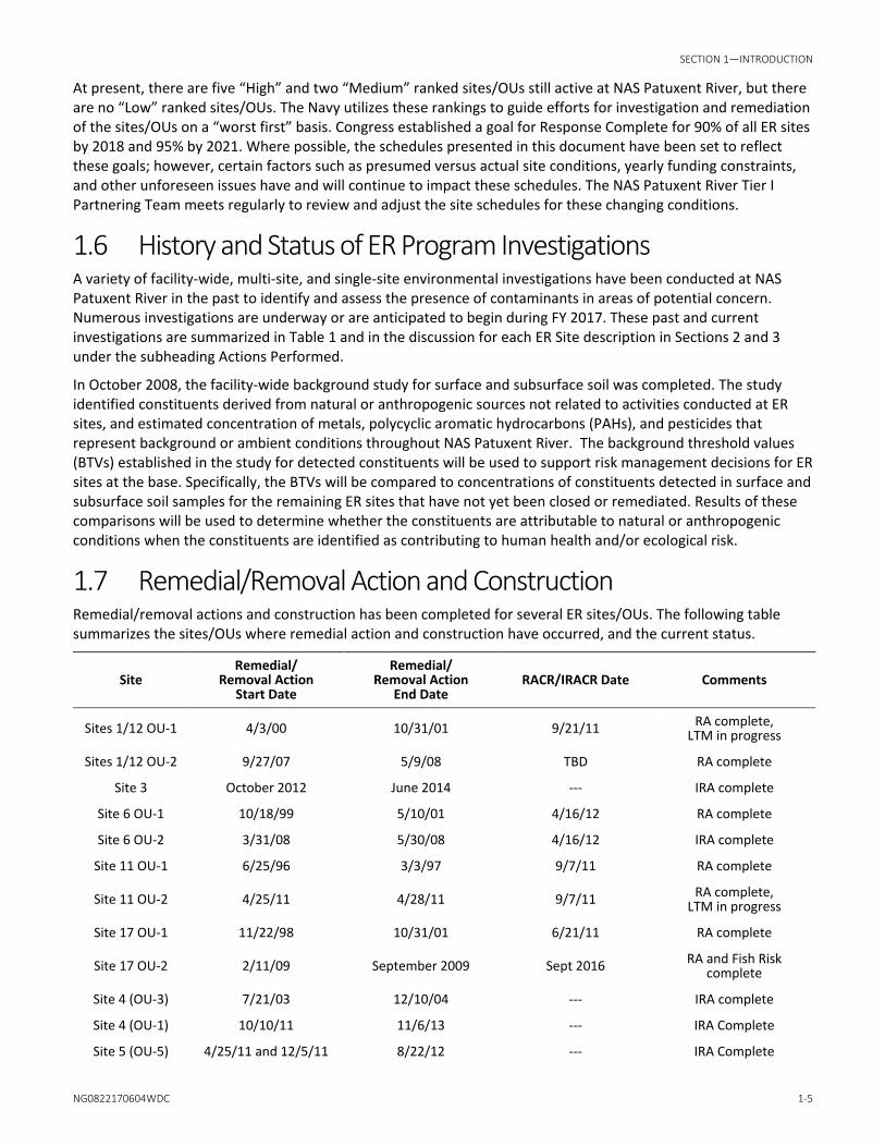
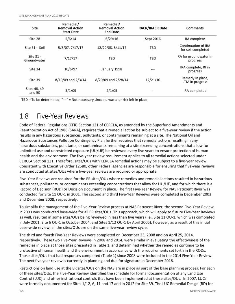
1.7 Remedial/Removal Action and Construction Remedial/removal actions and construction has been completed for several ER sites/OUs. The following table summarizes the sites/OUs where remedial action and construction have occurred, and the current status.
Site Remedial/
Removal Action Start Date
Remedial/ Removal Action
End Date RACR/IRACR Date Comments
Sites 1/12 OU-1 4/3/00 10/31/01 9/21/11 RA complete, LTM in progress
Sites 1/12 OU-2 9/27/07 5/9/08 TBD RA complete
Site 3 October 2012 June 2014 --- IRA complete
Site 6 OU-1 10/18/99 5/10/01 4/16/12 RA complete
Site 6 OU-2 3/31/08 5/30/08 4/16/12 IRA complete
Site 11 OU-1 6/25/96 3/3/97 9/7/11 RA complete
Site 11 OU-2 4/25/11 4/28/11 9/7/11 RA complete, LTM in progress
Site 17 OU-1 11/22/98 10/31/01 6/21/11 RA complete
Site 17 OU-2 2/11/09 September 2009 Sept 2016 RA and Fish Risk complete
Site 4 (OU-3) 7/21/03 12/10/04 --- IRA complete
Site 4 (OU-1) 10/10/11 11/6/13 --- IRA Complete
Site 5 (OU-5) 4/25/11 and 12/5/11 8/22/12 --- IRA Complete
SITE MANAGEMENT PLAN 2017 UPDATE
1-6 NG0822170604WDC
Site Remedial/
Removal Action Start Date
Remedial/ Removal Action
End Date RACR/IRACR Date Comments
Site 28 5/6/14 6/29/16 Sept 2016 RA complete
Site 31 – Soil 5/8/07, 7/17/17 12/20/08, 8/11/17 TBD Continuation of IRA for soil completed
Site 31 - Groundwater 7/17/17 TBD TBD RA for groundwater in
progress
Site 34 10/6/97 January 1998 --- IRA complete, RI in progress
Site 39 8/10/09 and 2/3/14 8/20/09 and 2/28/14 12/21/10 Remedy in place, LTM in progress
Sites 48, 49 and 50 3/1/05 4/1/05 --- IRA completed
TBD – To be determined; “---“ = Not necessary since no waste or risk left in place
1.8 Five-Year Reviews Code of Federal Regulations (CFR) Section 121 of CERCLA, as amended by the Superfund Amendments and Reauthorization Act of 1986 (SARA), requires that a remedial action be subject to a five-year review if the action results in any hazardous substances, pollutants, or contaminants remaining at a site. The National Oil and Hazardous Substances Pollution Contingency Plan further requires that remedial actions resulting in any hazardous substances, pollutants, or contaminants remaining at a site exceeding concentrations that allow for unlimited use and unrestricted exposure (UU/UE) be reviewed every five years to ensure protection of human health and the environment. The five-year review requirement applies to all remedial actions selected under CERCLA Section 121. Therefore, sites/OUs with CERCLA remedial actions may be subject to a five-year review. Consistent with Executive Order 12580, other Federal agencies are responsible for ensuring that five-year reviews are conducted at sites/OUs where five-year reviews are required or appropriate.
Five-Year Reviews are required for the ER sites/OUs where remedies and remedial actions resulted in hazardous substances, pollutants, or contaminants exceeding concentrations that allow for UU/UE, and for which there is a Record of Decision (ROD) or Decision Document in place. The first Five-Year Review for NAS Patuxent River was conducted for Site 11 OU-1 in 2001. The second and third Five-Year Reviews were completed in December 2003 and December 2008, respectively.
To simplify the management of the Five-Year Review process at NAS Patuxent River, the second Five-Year Review in 2003 was conducted base-wide for all ER sites/OUs. This approach, which will apply to future Five-Year Reviews as well, resulted in some sites/OUs being reviewed in less than five years (i.e., Site 11 OU-1, which was completed in July 2001, Site 6 OU-1 in October 2004, and Sites 1/12 OU-1 by April 2005); however, as a result of this initial base-wide review, all the sites/OUs are on the same five-year review cycle.
The third and fourth Five-Year Reviews were completed on December 23, 2008 and on April 25, 2014, respectively. These two Five-Year Reviews in 2008 and 2014, were similar in evaluating the effectiveness of the remedies in place at those sites presented in Table 1, and determined whether the remedies continue to be protective of human health and the environment in accordance with the requirements set forth in the RODs. Those sites/OUs that had responses completed (Table 1) since 2008 were included in the 2014 Five-Year Review. The next five year review is currently in planning and due for signature in December 2018.
Restrictions on land use at the ER sites/OUs on the NAS are in place as part of the base planning process. For each of these sites/OUs, the Five-Year Review identified the schedule for formal documentation of any Land Use Control (LUC) and other institutional controls that have been implemented at these sites/OUs. In 2007, LUCs were formally documented for Sites 1/12, 6, 11 and 17 and in 2012 for Site 39. The LUC Remedial Design (RD) for

SECTION 1—INTRODUCTION
NG0822170604WDC 1-7
Site 39 was amended in November 2015 to include the vapor intrusion (VI) risk. The LUC RD documentation consists of a LUC implementation plan which addresses LUC implementation and enforcement.
The performance objectives for the LUC components of the remedies implemented for Sites 1 /12, 6, 11, 17, and 39 are included in the LUC discussion of the site description for each of these sites in Sections 3.1.1, 3.1.4, 3.1.2, 3.1.3, 3.1.5, and 3.1.6, respectively.
1.9 Sites Closed under the ER Program Since 2002, 45 sites/OUs have achieved Response Complete, No Further Action, or have been removed from the ER Program. These sites/OUs have achieved this status as documented by one of three types of decision documents: 1) Desktop Evaluations; 2) Site Investigations; and 3) No Action or No Further Action RODs. Figure 3 presents the location and site name of all sites removed from the ER Program at NAS Patuxent River and the decision documents used to document site closure. Additionally, because NAS Patuxent River in its entirety is designated as the NPL site under CERCLA, all individual ER sites to date that have been removed from the ER Program without a ROD will be included in a future ROD to document completion of the CERCLA process for NAS Patuxent River.
1.10 Munitions Response Program Beginning in 2008, the Navy started to evaluate munitions response (MR) sites at NAS Patuxent River starting with Preliminary Assessments (PAs) and initial rankings of sites for the MR Program (MRP). There are currently three MR sites associated with NAS Patuxent River: UXO-0001 (Historical Disposal of MEC), UXO-0002 (Former Pistol/Skeet Ranges), and UXO-0003 (Former Water Ranges). An initial PA was completed by Tetra Tech in January 2012 and summarizes the history of munitions used at these ranges. The PA further provides information for Navy to differentiate MR sites that may not require further munitions response actions and to determine if an imminent hazard from munitions or munitions constituents (MC) to human health or the environment is present and warrants an accelerated response action. The Navy completed the draft expanded PAs for NAS Patuxent River Ranges and Solomon Ranges under UXO-0003 in September and November 2013, respectively (CH2M HILL, 2013).
Site inspections (SI) for UXO-0001, UXO-0002, UXO-0003 have been completed following the expanded PAs. The SI is not intended to provide definitive identification of the types or number of potential MEC items, nor is it intended as a full-scale study of the nature and extent of contamination or explosives hazards. The SI for UXO-0003 will be used to confirm or deny the presence of anomalies that may be indicative of large amounts of MEC at the underwater sites. As necessary, a remedial investigation will be performed consisting of sampling and other field data to determine if a response action or additional investigation is appropriate. Section 4 provides a brief description for each of the three MR sites and current status.
1.11 Emerging Contaminants In its letters of acceptance of the most recent Five-Year Review, EPA recommended that the Navy sample for perfluorooctanesulfonic acid (PFOS) and perfluorooctanoic acid (PFOA) at Site 14 - Old Firefighting Burn Pad and Site 41 - Fire Fighting Burn Pad due to previous activities that may have caused a release of these contaminants into groundwater. Upon review of the RI and historical evidence of a previously buried container labeled “fire extinguishing material” at Site 34 – Drum Disposal Area, the NAS Patuxent River Partnering Team determined that additional groundwater sampling for PFOS/PFOA was necessary for the RI. Currently, the Navy is doing a basewide historical review of uses and potential releases of Per- and Polyfluoroalkyl Substances (PFAS) at NAS Patuxent River. The report for PFAS will be completed later this year.
As well, the EPA recommended that the Navy consider sampling for polychlorinated dibenzodioxins (dioxins) at Site 1 – Fishing Point Landfill, Site 4 – Hermanville Disposal Site (Areas 4C Trenches), and Site 41 – Firefighting Burn Pad due to previous activities that may have caused a release of dioxin (USEPA, 2014).

SITE MANAGEMENT PLAN 2017 UPDATE
1-8 NG0822170604WDC
At this time, the Navy has published a Guidance regarding PFAS. The Navy is aware of the EPA’s concerns and is currently using the guidance to investigate where PFAS may have been used in the past. With respect to dioxins, the Navy is reviewing the conceptual site model of the noted sites to determine whether or not activities occurred that may have led to the release of these emerging contaminants.
1.12 Dioxins As mentioned previously, EPA recommended that the Navy consider sampling for dioxins at Site 1 Fishing Point Landfill, Site 4 - Hermanville Disposal Site (Area 4C Trenches), and Site 41 - Firefighting Burn Pad due to previous activities that may have caused a release of dioxin. EPA lowered the integrated risk information system (IRIS) level for dioxin in February 2012. The new oral reference dose (RfD) is 0.7 picograms per kilogram.

NG0822170604WDC 2-1
SECTION 2
2 Active Sites 2.1 Site Descriptions 2.1.1 Site 9—Former Drum Disposal Area Building 665
Site No. OU Relative
Risk Desktop
Evaluation PA/SI RI/FS PRAP ROD RD RA LTM IRA Response Complete
9 High 2010-2019
3Q 2019
4Q 2019
2Q 2020
3Q 2020
4Q 2020
Site Location Site 9 is located on the northern embankment of the Supply Pond in the northwestern quadrant of the facility. The Supply Pond (Site 8 in the IAS report) is located between Building 655 and Bonnie Road, and discharges via Beaver Pond to the Patuxent River. The site is heavily vegetated with scrub grasses, briars, and young trees.
History Site 9 covers approximately 5 acres and was used for disposal of drums, aluminum pipe, trashcans, sheet metal, and tires. Over 100 drums were disposed at the site. Most of the drums were empty, although some reportedly contained an asphalt-like material. Many of the drums were partially buried.
Actions Performed Site 9 was included in the 1984 IAS conducted at NAS Patuxent River. A confirmation study was not recommended for Site 9 because the materials deposited at this site consisted of construction-derived material (primarily hardened asphaltic materials) that are neither toxic nor mobile.
At the direction of EFA CHES (predecessor to NAVFAC Washington), a limited confirmation study of Site 9 was conducted in April 1984 because of the unknown contents of the drums and the proximity of the site to the Supply Pond. A drum inventory was completed, and two drum samples and seven soil samples were collected at the site. Approximately 180 drums were inventoried at the site. A general cleanup in 1984 removed nearly all surface debris.
Groundwater, surface water, and sediment samples were collected in and near the Supply Pond in June 1988 as part of site characterization activities for the Fuel Farm (formerly ER Site 7). VOCs were detected in groundwater samples, oil/grease and metals were detected in surface water samples, and elevated concentrations of metals were detected in sediment samples.
A site screening investigation was conducted for Site 9 in 1993. VOCs were detected in groundwater samples at concentrations exceeding the respective Federal Maximum Contaminant Level (MCL) for drinking water. Low concentrations of VOCs, SVOCs, pesticides, and metals were detected in soil and sediment samples, and elevated concentrations of metals also were detected in surface water samples.
Current Status Site 9 is currently used as a storm water retention basin. A work plan for the initial phase (Phase I) of the RI was completed in January 2011. Phase I fieldwork and a wetland delineation of Supply Pond were completed in March 2011. A work plan amendment for Phase II of the RI was completed in April 2012. Fieldwork for Phase II is was completed in November 2012. A draft RI was submitted for regulatory review in July 2013, and was finalized in November 2014. In 2015, the NAS Patuxent River Partnering Team agreed to perform additional groundwater characterization and an ecological assessment of Supply Pond and Stream as part of the Expanded RI for Site 9.

SITE MANAGEMENT PLAN 2017 UPDATE
2-2 NG0822170604WDC
The purpose of the proposed expanded RI is to delineate the chlorinated VOC groundwater plume on the north side of Site 9, and determine the ecological impact of petroleum hydrocarbons to Supply Pond from the former tank leak at the fuel farm located southeast of the Supply Pond. The expanded RI is anticipated to begin in late 2017.
2.1.2 Site 21—Sludge Drying Beds Site No. OU Relative
Risk Desktop
Evaluation PA/SI RI/FS PRAP ROD RD RA LTM IRA Response Complete
21 Medium 2011-2012
2012-2020
3Q 2020
4Q 2020
GW in 1Q
2021 3Q
2021 4Q
2021 Soil 3Q 2018
Site Location Site 21 is west of and behind Building 600, the former wastewater treatment plant located in the south-central portion of the station.
History From the mid-1940s until 1970, eight bays were used to dry sludge generated by the sewage treatment plant. An estimated 300 cubic yards of sewer sludge were generated per year. The dried sludge, consisting of 25 percent solids, was removed annually and disposed at the station landfill in operation at the time disposal occurred. Site 21 was included in the IAS conducted at NAS Patuxent River in 1984. A confirmation study was not recommended for Site 21 because the sludge had been removed from the site and no evidence of contamination was observed.
Site 21 was included in the RFA conducted at NAS Patuxent River in 1998-99. No documented releases were recorded in the files reviewed as part of the RFA for Site 21. No evidence of a release was observed at the site during the RFA site visit.
Current Status The sludge drying beds at Site 21 are no longer in use. The treatment plant was shut down in 1970 and dismantled in 1986. Since then, the site has been allowed to re-vegetate. The draft RI report was submitted for regulatory review in September 2013. Additionally, mercury soil sampling and geophysical survey was conducted in January 2016 to delineate the extent of subsurface mercury in an area with Light Non Aqueous Phase Liquid (LNAPL) and buried subsurface debris from former wastewater structures. The NAS Patuxent River Partnering Team has agreed a NTCRA should be performed for the source soil in the LNAPL area and the subsurface debris to eliminate potential future risk and help to achieve unrestricted future land use in site media. An EE/CA was completed in February 2017 and an Action Memorandum is currently being reviewed by EPA and MDE. It is anticipated the Action Memorandum will be signed this year and the NTCRA can begin in 2018. After the NTCRA is completed, the final RI report will be prepared followed by a PRAP and ROD for remedial action for the groundwater.
2.1.3 Site 23—DPDO Salvage Yard (includes former Site 42) Site No. OU Relative
Risk Desktop
Evaluation PA/SI RI/FS PRAP ROD RD RA LTM IRA Response Complete
23 Medium 2011-2020
3Q 2021
4Q 2021 Soil 2Q
2020

SECTION 2—ACTIVE SITES
NG0822170604WDC 2-3
Site Location Site 23 is located on the western side of Building 604, approximately 220 feet east of the West Patuxent River seaplane basin and 400 feet south of the Patuxent River, in the northwestern quadrant of the station. A shallow stream runs into the Patuxent River west of the site. A fence restricts access to the site.
History Site 23 has had two distinctly different uses, first as a coal storage area, then as a salvage yard. The site was most likely used for storage of coal from the 1940s until the late 1950s. Subsequently, the area was used between 1961 and 1998 as a salvage yard. Wastes stored at the site included excess and waste chemicals, electronic equipment, cars, tires, aircraft parts, medical equipment, kitchen equipment, machinery, electrical control panels, trailers, oil, shell casings, printed circuit boards, plastic-coated wire, cable, file cabinets, and automobile batteries. Liquids spilled at the site may have included POL products, solvents, paints, and sulfuric acid. The site was covered with asphalt in 1971.
Actions Performed Site 23 was included in the 1984 IAS conducted at NAS Patuxent River. A confirmation study was recommended for Site 23 because of the potential for contaminants to migrate via groundwater or surface water into the Patuxent River.
A NACIP Program confirmation study was conducted at Site 23 between 1985 and 1987. Low concentrations of lead were detected in two of the soil samples. VOCs and zinc were detected in groundwater at concentrations slightly exceeding detection limits. Additional sampling was recommended for Site 23 to confirm that no hazard to human health or the environment was present.
Site 23 was included in the RFA conducted at NAS Patuxent River in 1988-89. Soil staining and stressed vegetation were observed along much of the perimeter of the site during the RFA site visit. The asphalt pavement covering the site was severely cracked and stained in several areas. A groundwater sample was collected from the on-site monitoring well during IRI activities in September 1991. Neither VOCs nor trace metals were detected in the groundwater sample.
Current Status The DPDO Salvage Yard was closed in 1998, and a recycling operation called the Defense Resource Management Office (DRMO) now occupies Site 23. Portions of the yard where asphalt pavement had deteriorated have been repaved. As Site 23 covers the entire area associated with Site 42, the concerns for Site 42 have been incorporated into Site 23 for investigation purposes. The RI fieldwork was completed in August 2012 and the Final RI report was submitted in November 2014. The NAS Patuxent River Partnering Team has agreed the RI has data gaps in specific areas of the site for human health COCs and ecological COPCs. Currently, a draft technical memorandum for additional investigation for an expanded RI is in review by EPA and MDE. An addendum to the existing UFP-SAP will be prepared later this year after the technical memorandum is finalized.
2.1.4 Site 31–Tire Shop Building 307 Site No. OU Relative
Risk Desktop
Evaluation PA/SI RI/FS PRAP ROD RD RA LTM IRA Response Complete
31 NA 2004-2007
2012-2016 2016 2017 2017 2017 2018-
2023 Soil & GW in 2017
Site Location Site 31 is located at Building 307, the active Aircraft Intermediate Maintenance Department (AIMD), in the northwestern quadrant of the station. A drainage ditch leads from the building to the West Patuxent River seaplane basin.

SITE MANAGEMENT PLAN 2017 UPDATE
2-4 NG0822170604WDC
History The AIMD shop is responsible for cleaning aircraft tires, repairing fiberglass radomes, painting aircraft ground-handling equipment, and testing structural parts for signs of failure. The site has been used as a tire shop since 1943. Tires were cleaned in large vats containing solvent and a cleaning compound, then placed on the floor and rinsed with water. The rinsate contained organic and inorganic compounds from the brake linings. Before 1970, the rinsate drained from the building into an open ditch that discharges to the West Patuxent Basin. In 1970, the site drainage and shop floor drains were connected to a 24-inch storm drain that discharges directly to the West Patuxent River seaplane basin. An estimated 180 gallons of water were discharged each day. The quantity of water generated at Site 31 was less than the quantity generated during similar operations at Building 110/111 (Site 15).
Actions Performed Site 31 was included in the IAS conducted at NAS Patuxent River in 1984. No visible evidence of contamination was observed in the drainage ditch during the site visit. A confirmation study was recommended for Site 31 if the confirmation study for Site 15 confirmed a hazard to aquatic life. Site 31 was included in the RFA conducted at NAS Patuxent River in 1988-89. No visible evidence of a release was observed at Site 31 during the RFA site visit.
A site screening investigation (SSI) was completed at Site 31 in 1999. Concentrations of PAHs, pesticides, and metals in West Patuxent Basin sediment slightly exceeded ecological screening levels used for the SSI, and concentrations of one PAH and three metals in soil exceeded human health screening criteria. VOCs in groundwater also exceeded MCLs for drinking water.
Current Status Site 31 is in use. To address concerns with the 1999 SSI, an ESI was conducted in FY 2004-2005. Preliminary results from the ESI indicated a minimal area of contamination exists that may pose a risk to ecological receptors. Therefore, additional sampling was conducted in July 2006 to refine the extent of constituents at the site requiring remediation and complete an EE/CA for the site. As a result of this additional investigation, the railroad beds along which coal was historically transported to the former steam plant for the base was identified as the upgradient source of the PAHs in the ditch. The EE/CA report was completed in December 2006, and an Action Memorandum was issued in March 2007. An IRA, including confirmatory soil sampling, was performed in June 2007 to address this area. The construction closeout report was completed in May 2008.
In May 2009, additional groundwater characterization was completed to investigate the extent of VOCs in the proximity of one monitoring well with an MCL exceedance. Results indicated the presence of a VOC plume in groundwater with concentrations exceeding MCLs beyond the immediate vicinity of the well location. Based on these findings, RI field activities were conducted in 2013 and 2014 to fully characterize the extent of the VOC plume and to perform a VI assessment on building 307. The RI, FS, and PRAP were finalized in 2016. The Final ROD was signed in June 2017 for limited removal of cobalt and in-situ bioremediation of the VOC plume in groundwater. The remedial action is scheduled to be implemented later this year.
2.1.5 Site 34–Drum Disposal Area Site No. OU Relative
Risk Desktop
Evaluation PA/SI RI/FS PRAP ROD RD RA LTM IRA Response Complete
34 High 2010-2020
3Q 2019
2Q 2020 1997 2020
Site Location Site 34 is located adjacent to what was known as the “Current Landfill” and Site 11, the Former Sanitary Landfill, on the southern portion of the station. An undeveloped hardwood forest is located north of the site. A fence restricts site access, and the area is routinely patrolled.

SECTION 2—ACTIVE SITES
NG0822170604WDC 2-5
History The area was formerly used as a sand and gravel borrow pit; however, the dates of operation for the borrow pit are unknown. After borrow excavation ceased, the borrow pits were used for the disposal of construction debris and soil. Site 34 is reported to have been the location of an undocumented, one-time drum disposal event. The exact locations, quantities, and contents of the suspected drums were not reported.
Actions Performed A site screening investigation was conducted at Site 34 in 1993/1994. Low concentrations of SVOCs and elevated concentrations of metals were detected in subsurface soil samples. Pesticides and elevated concentrations of metals were detected in groundwater samples. Several SVOCs were detected in sediment samples, and elevated concentrations of metals were detected in surface water samples.
In 1997, contractors working at the site discovered 5-gallon plastic pails containing a mixture of commonly used solvents (chlorinated VOCs and SVOCs). The origin of the pails is unknown. An EE/CA was performed in 1997 for a soil removal action at Site 34. The recommended alternative was removal of the contaminated soil and any remaining plastic pails, with off-site disposal at an RCRA-permitted landfill. An interim removal action was conducted in 1997. During the removal action, 112 additional buried 55-gallon drums were located and removed, along with 800 cubic yards of contaminated soil. The contaminated soil was disposed off-site at a RCRA-permitted Subtitle D landfill. The drums were handled as hazardous waste based on the flammability and elevated concentrations of solvents in drum contents.
Current Status Site 34 is not in use. An anomaly excavation was conducted in July 2011 to remove anomalies detected by geophysical survey completed in March 2010. Construction debris discovered at the anomaly locations was removed and stockpiled at the site. The RI fieldwork was divided into two phases and was completed in March 2012. A continuation of the anomaly investigation to remove subsurface debris remaining in the ground and collect addition investigation samples was completed by Tetra Tech in April 2014. The draft RI report was reviewed by the NAS Patuxent River Partnering Team, at which time EPA determined that additional groundwater characterization will be necessary for PFOS/PFOA based upon debris found within the anomalies. Groundwater sampling for PFAS in groundwater will be completed in 2017 once the work plan is finalized. The RI report is anticipated to be completed in 2017 followed by a PRAP and ROD in 2018.
2.1.6 Site 55–Former Hazardous Waste Storage Hut Site No. OU Relative
Risk Desktop
Evaluation PA/SI RI/FS PRAP ROD RD RA LTM IRA Remedy In Place
Response Complete
55 High 2013-2018
1Q 2019
3Q 2019 Soil
2017 2019
Site Location Site 55 is a portion of the perennial stream downgradient from Site 24. The portion of the stream to be investigated is located southeast of the intersection of Standley Road/Sears Road and adjacent to the former location of a temporary hazardous waste storage hut.
History Materials containing PCBs were previously stored in the former hazardous waste storage hut located upgradient from the site. Sampling associated with the RI for Site 24 identified PCB concentrations in sediment in a portion of the stream. Based on these findings, the Navy designated this as Site 55 in the ER Program. The FFA did not list or included Site 55 as a site that required action under the CERCLA program.

SITE MANAGEMENT PLAN 2017 UPDATE
2-6 NG0822170604WDC
Actions Performed During an RI conducted at Site 24 in 1996, PCBs were detected in two stream sediment samples in the ditch downgradient of Site 24, close to the location of a former hazardous waste storage area that was near the stream channel. No documented releases have been reported from the former hazardous waste storage area. The RI for Site 55 was started in 2013 and the fieldwork was divided into two phases: a phase for soil, sediment, and surface water sampling and a phase for well installation and groundwater sampling. The first phase was completed in August 2013 and the second phase was completed in April 2015. The RI has characterized the extent of PCBs in soil, sediment and surface water and the groundwater investigation is ongoing.
Current Status The former hazardous waste storage hut is no longer in use. Based upon the RI results and human health and ecological risk screening for soil, sediment and surface water, a Final EE/CA was completed in August 2015. The EE/CA outlines the removal action alternatives and supports a NTCRA for PCBs in soil and sediment at Site 55. The EE/CA report was followed by a public comment period and a signed action memorandum in September 2015. The NTCRA for PCBs in soil and sediment was recently completed in May 2017. Currently, the draft closeout report for the NTCRA and the draft RI report are in progress.
Additionally, the NAS Patuxent River Partnering Team is evaluating human health risk in groundwater at Site 55.
2.1.7 Site 56–Abandoned Hazardous Waste UST Site No. OU Relative
Risk Desktop
Evaluation PA/SI RI/FS PRAP ROD RD RA LTM IRA Remedy In Place
Response Complete
56 High 2015-2019
2Q 2020
4Q 2020
Site Location Site 56 is the location of a former waste oil storage tank. The site is located along a slope and drainage ditch located adjacent to the eastern edge of Bohne Road and northwest of the fuel truck parking area of Site 6.
History Liquids containing PCBs were previously stored in a partially buried 10,000-gallon waste oil storage tank at the boundary of Site 6. The former waste oil storage tank was excavated and scrapped in 1992. The FFA did not list or included Site 56 as a site that required action under the CERCLA program.
During the RA performed in May 2008 for Site 6 OU-2, soil was excavated from the former location of the waste oil storage tank in an attempt to remove all surface and subsurface soil containing PCB concentrations greater than the RA action level of 1,000 micrograms per kilogram (µg/kg). However, the extent of subsurface soil contamination was more extensive than anticipated. Due to funding limitations and schedule constraints for the RA plus the presence of an aboveground pipeline immediately adjacent to the excavation, the Navy stopped excavation after removing approximately 674 tons (449 cubic yards) of PCB-contaminated soil. The results for the Site 6 OU-2 RA post-excavation confirmatory samples indicated PCBs were still present in the floor and sidewall soils of the northern portion of the excavation at concentrations exceeding the RA cleanup level.
Actions Performed In June 2008, direct push sampling was performed around the perimeter of the excavated area to characterize the extent of PCBs in the subsurface soil beyond the limits of excavation completed during the Site 6 OU-2 RA. Results indicated PCBs exceeding the cleanup level in subsurface soil extended 30 feet beyond the RA excavation footprint.

SECTION 2—ACTIVE SITES
NG0822170604WDC 2-7
Current Status Based on the results of post-excavation confirmatory samples and results of subsurface samples collected in June 2008, further investigation is necessary to delineate the extent of PCB-contaminated soils. Consequently, the Navy decided to designate this area as a new ER site. A RI approach technical memorandum was completed in February 2017. The draft work plan is currently in progress to further characterize the soils at the site. Field activities for the RI will begin once the work plan has been reviewed and approved by EPA and MDE.

NG0822170604WDC 3-1
SECTION 3
3 Remedy In Place Sites 3.1 Site Descriptions 3.1.1 Site 1—Fishing Point Landfill
Site No. OU Relative
Risk Desktop
Evaluation PA/SI RI/FS PRAP ROD RD RA LTM IRA Response Complete
1 OU-1 NA 1998 1999 2000 2002 2003 2001-2006, 2010-
1 OU-2 High 2005 2005 2006 2006-2008 2008
Site Location Fishing Point is located along the shoreline of the Patuxent River in the northern portion of the station, upstream of the confluence of the Patuxent River and the Chesapeake Bay (Figure 2). The majority of the site is a low, flat-lying meadow and wetland area. A wooded area is present to the southeast.
Operable Units To efficiently manage remedial action priorities, Site 1 and adjacent Site 12 were divided into two operable units as summarized below.
• OU-1 consists of soil and groundwater at Site 1 and adjacent Site 12, and surface water and sediment in the Patuxent River adjacent to Site 1.
• OU-2 consists of surface water and sediment in the marsh south of the Site 1 landfill and west of the Site 12 landfill.
History The site covers approximately 15 acres in area and was used between 1960 and 1974 for the disposal of an estimated 54,350 tons of solid waste and 120 gallons of liquid waste generated by the facility. Liquid wastes deposited at the landfill consisted primarily of liquid-soaked rags and the liquid residue in cans. Solid waste that was disposed included petroleum, oil, and lubricant (POL) products, construction debris, sewage treatment plant sludge, paints, paint thinners, solvents, antifreeze products, photographic laboratory wastes, pesticides, miscellaneous station wastes, and residue from the open burning of various liquid wastes. Disposal operations consisted of landfilling waste material in 10-foot lifts along a 50-foot working face.
Actions Performed Site 1 was included in the Initial Assessment Study (IAS) (Fred C. Hart Associates, Inc., 1984) conducted at NAS Patuxent River in 1984. A confirmation study was recommended for Site 1 because of the potential for contaminants to leach and migrate in groundwater from the site to the Patuxent River and/or the Chesapeake Bay and subsequently accumulate in aquatic organisms.
A Naval Assessment and Control of Installation Pollutants (NACIP) Program confirmation study was conducted at Site 1 between 1985 and 1987. Metals were detected in groundwater and surface water samples, and low concentrations of volatile organic compounds (VOCs) were detected in groundwater. Additional sampling was recommended for Site 1 due to the potential for contamination from the site to pose a risk to human health or the environment.

SITE MANAGEMENT PLAN 2017 UPDATE
3-2 NG0822170604WDC
An Interim Remedial Investigation (IRI) was conducted at Site 1 in 1991. VOCs, semi-volatile organic compounds (SVOCs), and metals were detected in groundwater samples. The RI/FS was completed in 1998. The RI included sampling of soil and groundwater as recommended in the IRI report to determine the presence of contaminants in these media and to verify previous results. The Feasibility Study (FS) evaluated two alternatives for capping the landfill.
A shoreline protection program was initiated at the site in 1993 as an Interim Removal Action (IRA) to prevent landfill wastes from being washed into the Patuxent River. Offshore stone breakwater structures were constructed along the shoreline, and sand was placed as beach fill material between the original shoreline and the breakwater structures. A cobble-covered shoreline was also constructed on the western shoreline of the site. An Engineering Evaluation/Cost Analysis (EE/CA) was conducted for the site prior to initiation of the remedial action.
Current Status Site 1 is currently in use in accordance with the ROD. Current use of the site consists of military training and limited recreational use. The current status of OU-1 and OU-2 is summarized below.
• OU-1
− The Navy and EPA signed a ROD for Sites 1/12 OU-1 on February 8, 2000.
− MDE issued a letter of concurrence on January 27, 2000.
− Remedial action began on April 3, 2000, and was completed on October 31, 2001. The remedial construction closeout report for OU-1 was submitted to EPA on March 20, 2002.
− The main components of the selected remedial action consisted of placing a soil cover (minimum 2-foot thickness) over the waste disposal areas of Site 1 (the Fishing Point Landfill) and Site 12 (the Rifle Range Landfill), shoreline stabilization, land use restrictions, mitigation for emergent wetlands that were adversely impacted during construction of the soil cover, long-term monitoring, maintenance of the stormwater management system, vegetation cover, and erosion control structures.
− Documentation of LUCs was completed in 2007.
− In 2004, the passive landfill gas vent system was deemed to be unnecessary due to the low volume of gas produced by the landfill (CH2M HILL, 2004). Perimeter landfill gas monitoring was conducted to verify that complete closure of the landfill gas vent system will not result in off-site transport of landfill gas
− The wetland compensation component of the OU-1 ROD was completed in October 2004 with the construction of a 1.8 acre non-tidal freshwater wetland at Site 5. A five-year wetland monitoring program began in 2004 to monitor the condition of the wetland, and after five years of monitoring, the wetland continues to flourish. The MDE requirement for five years of monitoring of the constructed wetland has been completed and the monitoring report for the last year of monitoring was submitted in March 2010. The annual monitoring documented that the wetland is functional and stable.
• OU-2
− An ecological risk assessment was completed for OU-2, and the conclusions of the ecological risk assessment identified no risk to the ecological receptors. However, lead was detected in surface water at concentrations exceeding the ambient water quality criterion.
− An updated human health risk assessment conducted in 2003 did not identify any unacceptable human health risks.
− Prior to 2003, it was believed that lead detected at the site originated from the waste disposal activities at the landfill. Further evaluation undertaken as part of the FS indicated that the lead most likely originated from an adjacent rifle range backstop.

SECTION 3—REMEDY IN PLACE SITES
NG0822170604WDC 3-3
− A revised FS prepared in 2005 identified a removal action and in-situ mitigation for lead to eliminate the exceedance of the ambient water quality criterion (AWQC) for lead.
− A ROD was signed for OU-2 in September 2005.
− The Remedial Design for OU-2 was completed in September 2007.
− The OU-2 Remedial Action began on September 27, 2007, and was completed on May 9, 2008.
− The OU-2 Construction Closeout Report was completed in September 2008.
The Final Post-Closure Operation and Maintenance Manual for Sites 1/12 OU-1 was submitted in June 2008. The following operation and maintenance activities will be performed periodically at Sites 1/12 to meet long-term post closure care requirements:
• Semi-annual visual landfill cover inspections and maintenance, as necessary; mowing of the landfill vegetative cover; and
• Groundwater monitoring every 15 months to monitor constituent concentrations at the perimeter and downgradient of the landfill.
Land Use Controls The revised final LUC Implementation Plan for OU-1 of Sites 1/12, which was provided to the NAS Patuxent River Department of Public Works in July 2011, presents information on how the LUC portion of the remedy selected in the ROD for this site will be implemented, maintained and enforced (CH2M HILL, 2011a). The ROD for Sites 1/12 OU-1 requires the following performance objectives for the LUC remedy to be implemented at Sites 1/12 OU-1 and to be incorporated into the deed and other LUC mechanisms:
• Prevent exposures to contaminants remaining that pose potential risks exceeding acceptable risk levels; • Prevent intrusive activities that will disrupt the integrity of the landfill soil cover; and • Prevent exposures to contaminants in groundwater that pose potential risks exceeding acceptable risk levels.
Actions to be taken consist of the following:
• Prohibit residential use and limit future development within the LUC boundary; • Maintain the integrity of the landfill soil cover; and • Prohibit use of groundwater beneath and immediately downgradient of Sites 1 and 12.
3.1.2 Site 6 OU-1—Bohneyard Site No. OU Relative
Risk Desktop
Evaluation PA/SI RI/FS PRAP ROD RD RA LTM IRA Remedy In Place
Response Complete
6 OU-1 NA 1996 1999 1999 2000 2001 2001
Site Location Site 6 is located south of Bohne Road in the northwestern quadrant of the station, adjacent to the Fuel Farm and east of the intersection of Bohne Road and the nearby taxiway. For purposes of the ER Program, Site 6 consists of two discrete areas referred to as Site 6 and 6A. Site 6 comprises the western portion of the ER site where a fuel truck parking area was constructed as part of the final remedy. Site 6A refers to the area east of the fuel truck parking area that is currently used for storage of equipment and materials. Surface drainage at Site 6 is primarily westward toward an unnamed drainage channel. This drainage channel discharges into the Supply Pond north of the Fuel Farm, and eventually flows into the West Patuxent River seaplane basin.

SITE MANAGEMENT PLAN 2017 UPDATE
3-4 NG0822170604WDC
Operable Units To efficiently manage remedial action priorities at Site 6 and meet station needs for land use, Site 6 was divided into two operable units. OU-1 consists of soil in the area where drums and tanks historically were stored, and in the storage area to the east referred to as Site 6A. OU-2 consists of downgradient surface water and sediment as well as groundwater beneath and downgradient of both Site 6 and 6A.
History The site occupies a total of approximately 14 acres and was used for multiple purposes in the past. Between 1943 and 1949, the area was used for the disposal of approximately 6,000 tons (107,000 cubic feet) of fly-ash and bottom-ash material generated by the station’s coal-fired power plant. This material reportedly covered the area in a 6-inch thick layer of ash. Between 1949 and approximately 1955, the area was used as the Defense Property Disposal Office (DPDO) storage yard. Beginning about 1955, an estimated 8 tons of liquid wastes were stored in drums and a partially buried 10,000-gallon tank at the site. Many of the drums stored at the site reportedly leaked. The drums and tank were removed, and in October 1989, approximately 6 inches of sludge was placed over the site. Liquid wastes stored at Site 6 included POL wastes, solvents, paint thinners, paints, and oil-water separator sludge. Scrap metal and faulty or unused vehicles and equipment were also stored at the site.
Actions Performed Site 6 was included in the 1984 IAS for NAS Patuxent River. A confirmation study was recommended for Site 6 because of the potential for oils, solvents, and metals released at the site to migrate to the West Patuxent seaplane basin via groundwater and surface runoff.
The NACIP Program confirmation study was conducted at Site 6 between February and June 1984. VOCs, oil and grease, and metals were detected in groundwater samples. Oil and grease and metals were also detected in soil samples.
Site 6 was included in the RCRA Facility Assessment (RFA) (A.T. Kearney, 1989) conducted at NAS Patuxent River in 1988-89. The site was in use at the time of the RFA site visit, and substantial soil staining was observed during that site visit.
An IRI was conducted at Site 6 in 1991. VOCs were detected at several monitoring well locations for three rounds of groundwater sampling. Petroleum hydrocarbons and elevated concentrations of metals were detected in soil samples. Some surface soil samples contained very low concentrations of VOCs, but deeper samples collected at the same locations did not contain detectable VOC concentrations.
An EE/CA report for a Non-Time Critical Removal Action (NTCRA) was prepared in 1994 for Site 6 OU-1. Results for sampling conducted to support the EE/CA were comparable to results obtained for samples collected during previous investigations. The remedial alternative recommended in the Site 6 OU-1 EE/CA report was the excavation and off-site bioremediation of contaminated soil.
A Focused FS was prepared in 1999 for Site 6 OU-1, and the PRAP and ROD were issued in 1999. The selected remedy identified in the ROD consisted of capping contaminated soil at Site 6 with asphalt and concrete for the refueling truck parking lot and a soil and gravel cover in areas not covered by the parking lot.
Current Status Site 6 is currently used as a parking area for aircraft refueling trucks in accordance with the OU-1 ROD. Site 6A is in use as a storage area for equipment and other materials.
The current status of OU-1 is summarized below.
• OU-1
− MDE issued a letter of concurrence for the ROD on September 16, 1999, and the Navy and EPA signed the Site 6 OU-1 ROD on September 29, 1999.
SECTION 3—REMEDY IN PLACE SITES
NG0822170604WDC 3-5
− Remedial action for OU-1 began on October 18, 1999, and was completed on May 10, 2001. The selected remedial action was to cap the site with asphalt and concrete to meet base reuse needs for a parking area for refueling trucks, and to cover the remaining contaminated soil with a soil and gravel cover.
− To address an emerging future reuse of a portion of Site 6 (i.e., Site 6A), a post-ROD investigation was conducted to specifically address potential risk from chromium. The investigation did not identify unacceptable risks for soil based on unrestricted land use. Consequently, a ‘No Action’ OU-1 ROD Amendment was signed by the Navy and EPA for Site 6A soil on September 23, 2004. Site 6A OU-1 has subsequently been removed from the ER Program; however, LUCs are in place to ensure the continued integrity of the asphalt and soil cover.
Land Use Controls The revised final LUC Implementation Plan for Site 6 OU-1, which was provided to the NAS Patuxent River Department of Public Works in July 2011, presents information on how the LUC portion of the remedy selected in the ROD for this site will be implemented, maintained and enforced (CH2M HILL, 2011b). The ROD for Site 6 OU-1 requires the following performance objectives for the LUC remedy implemented at Site 6 be incorporated into the deed and other LUC mechanisms:
• Prevent exposures to contaminants remaining in site soil that pose potential risks exceeding acceptable risk levels; and
• Prevent intrusive activities that will disrupt the integrity of the concrete parking lot, asphalt cover, or soil cover on the site.
Actions to be taken to accomplish the performance objectives are as follows:
• Prohibit residential use of the site;
• Prohibit digging or any other intrusive activity that could affect the integrity of the concrete parking lot, asphalt cover, or soil cover; and
• Annual visual inspections and maintenance of the concrete parking lot, asphalt cover, or soil cover, as necessary.
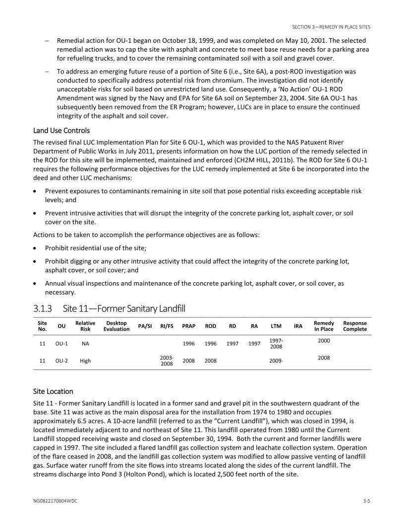
3.1.3 Site 11—Former Sanitary Landfill Site No. OU Relative
Risk Desktop
Evaluation PA/SI RI/FS PRAP ROD RD RA LTM IRA Remedy In Place
Response Complete
11 OU-1 NA 1996 1996 1997 1997 1997-2008 2000
11 OU-2 High 2003-2008 2008 2008 2009- 2008
Site Location Site 11 - Former Sanitary Landfill is located in a former sand and gravel pit in the southwestern quadrant of the base. Site 11 was active as the main disposal area for the installation from 1974 to 1980 and occupies approximately 6.5 acres. A 10-acre landfill (referred to as the “Current Landfill”), which was closed in 1994, is located immediately adjacent to and northeast of Site 11. This landfill operated from 1980 until the Current Landfill stopped receiving waste and closed on September 30, 1994. Both the current and former landfills were capped in 1997. The site included a flared landfill gas collection system and leachate collection system. Operation of the flare ceased in 2008, and the landfill gas collection system was modified to allow passive venting of landfill gas. Surface water runoff from the site flows into streams located along the sides of the current landfill. The streams discharge into Pond 3 (Holton Pond), which is located 2,500 feet north of the site.

SITE MANAGEMENT PLAN 2017 UPDATE
3-6 NG0822170604WDC
Operable Units To efficiently manage remedial action priorities, Site 11 was divided into two operable units as described below:
• OU-1 is the landfill and an interim removal action was implemented to reduce the potential long-term risk to human health and the environment associated with contaminants from the landfill. The IRA consisted of a RCRA Subtitle D cap and a landfill gas collection and treatment system, (i.e., gas flare) as well as monitoring of the landfill gas, and groundwater monitoring. The cap was designed to allow the control, treatment, and monitoring of landfill gases. The amount of leachate generated over time is expected to decrease because of the impermeable landfill cap, which reduces or prevents vertical infiltration of precipitation through the landfill wastes. During the remedial action, the leachate collection system connecting Former Landfill and Current Landfill was evaluated and upgraded. In addition, the cap limits possible exposure to landfill wastes. The IRA was consistent with long-term remedial goals for the site.
• OU-2 consists of groundwater, surface water, and sediment. The RI/FS was completed in September 2008, and the OU-2 ROD was signed by EPA on October 15, 2008.
History Site 11 occupies approximately 6.5 acres and was used between 1974 and 1980 for the disposal of solid and liquid waste generated by the facility. The landfill was the station’s primary disposal site following closure of the Fishing Point Landfill (Site 1). Approximately 22,500 tons of trash and 40 tons of oil-contaminated soils, POL wastes, paints, antifreeze products, solvents, paint thinners, pesticides, and photographic laboratory chemicals were disposed at this site. A leachate collection system is in use at the site, which collects and directs leachate generated by the landfill to the METCOM wastewater treatment facility.
Actions Performed Site 11 was included in the 1984 IAS conducted at NAS Patuxent River. A confirmation study was recommended for Site 11 because of the potential for contaminants leaching into groundwater to migrate via groundwater to Pond 3 (Holton Pond) and Pine Hill Run.
The NACIP Program confirmation study was conducted at Site 11 between 1985 and 1987. VOCs and metals were detected in groundwater and surface water samples, and metals were detected in soil and sediment samples. Additional sampling was recommended for Site 11 to identify potential risks to human health or the environment.
A hydrogeologic study of the current and former landfills was conducted in 1989. VOCs and metals were detected in groundwater samples, and VOCs were also detected in surface water samples. Sampling results for an interim remedial investigation conducted at Site 11 in 1991 indicated VOCs and elevated concentrations of metals groundwater. VOCs were also detected in surface water.
Site 11 was capped in 1997, although an RI/FS had not yet been completed to evaluate the entire site. A ROD for OU-1 was signed by EPA on July 29, 1996. Remedial action began on June 25, 1996, and was completed on March 3, 1997. The remedial construction closeout report for OU-1 was submitted to EPA on March 31, 1999, and EPA approved the report on August 3, 1999.
In 2001, a five-year review was conducted for Site 11 OU-1 as required under CERCLA to ensure that the implemented remedy for OU-1 remains protective of human health and the environment. The start date for the five-year review period was triggered by the start of remedial action in June 1996. The initial five-year review report for Site 11 OU-1 was submitted to EPA in July 2001.
Current Status Site 11 is not in use. A ROD for Site 11 OU-1 was signed by EPA on July 29, 1996. MDE issued a letter of concurrence on November 20, 1995. Initial fieldwork on the RI/FS for groundwater, surface water, and sediment under OU-2 was conducted in 1996 and 1997. Optimization and evaluation of operation and maintenance activities associated with the landfill cap are ongoing. The landfill gas collection and treatment system was shut down in 2008 and the gas collection system converted to a passive venting system. Additional RI fieldwork was

SECTION 3—REMEDY IN PLACE SITES
NG0822170604WDC 3-7
completed in 2004 through 2006. An updated groundwater monitoring plan for long-term monitoring was submitted to MDE in 2010 as part of an update to the post-closure operations and maintenance manual (CH2M HILL, 2010).
The RI and Focused Feasibility Study (FFS) reports for OU-2 were completed in July 2008, and the OU-2 ROD -2 was signed by EPA on October 15, 2008. The selected remedial alternative consisting of LUCs and long-term monitoring will be implemented over the next five years and reevaluated after each five year period to optimize the groundwater monitoring program.
A Final Post-Closure Operation and Maintenance Manual for Site 11 was approved by MDE in December 2010. This manual included the abandonment of monitoring wells (MW-22 and MW-23) and the installation of new compliance wells MW-25 and MW-26 to meet MDE requirements. The following operation and maintenance activities will be performed periodically at Site 11 to meet long-term post closure care requirements:
• Semi-annual visual landfill cover inspections and maintenance, as necessary;
• Mowing of the landfill vegetative cover;
• Landfill gas monitoring will be conducted quarterly using six gas monitoring wells currently installed along the perimeter of the landfill to comply with MDE and Federal solid waste regulations (COMAR 26.04.07.03B(9) and 40 CFR 258.23, respectively);
• Groundwater monitoring every six months to monitor constituent concentrations upgradient (two wells) and downgradient (three wells) of the landfill to comply with both CERCLA requirements associated with the OU-1 and OU-2 RODs and MDE solid waste post-closure requirements for landfills; and
• During the semi-annual monitoring groundwater monitoring event conducted prior to the end of each CERCLA Five Year Review period, all monitoring wells at the landfill will be sampled to meet requirements of the CERCLA Five-Year Review Process and the OU-2 ROD.
In a technical memorandum submitted to EPA and MDE in August 2005, the Navy recommended removing the landfill gas collection and flare system from service and allowing the landfill gas to be passively vented to the atmosphere. The landfill gas probes were monitored monthly for first three months and quarterly thereafter for up to one year after the landfill gas collection and flaring system was removed to demonstrate compliance with the MDE landfill closure regulations (COMAR 26.04.07.21). In February 2009, after finalizing the technical memorandum, the flare system was shut down and landfill gas was monitored monthly until April 2009. In April 2009, the landfill gas collection was converted to a passive gas venting system. Landfill gas probes were monitored quarterly through December 2009, and did not identify a release of methane from the landfill. As a result of discussion with the MDE SWP, the Navy resumed quarterly landfill gas monitoring in 2010. Such monitoring will continue until MDE SWP concurs that gas monitoring is no longer required.
In June 2008, the Navy recommended modifications to the leachate collection system (LCS) at Site 11 in a technical memorandum submitted to EPA and MDE. The Navy proposed temporarily blocking off the southern portion of the LCS where located below the water table to determine if groundwater intrusion is the likely source of the liquids captured by the LCS and subsequently discharged to the METCOM wastewater treatment facility. The Navy further proposed to monitor the hydrogeologic impacts and leachate collection rates and quality for one year to determine impacts associated with the modification. Modifications to and operation of the LCS would be reevaluated after the one year monitoring period. In October 2013, the Navy in agreement with MDE Solid Waste Operations Division (SWOD) collected samples and water parameters to determine whether or not water in the leachate collection system had similar chemistry to groundwater in adjacent monitoring wells next to the Site 11 Former Landfill. The Navy and MDE SWOD met in September 2014 to discuss evaluation of the sampling results and non-intrusive options for investigating the depth to waste and groundwater beneath the former landfill. The Navy is proceeding forward with non-intrusive investigation methods to help determine the impact and flow of leachate or groundwater to the LCS piping and manholes from the former landfill.

SITE MANAGEMENT PLAN 2017 UPDATE
3-8 NG0822170604WDC
Land Use Controls The revised final LUC Implementation Plan for Site 11 OU-1 was provided to the NAS Patuxent River Department of Public Works in July 2011 and presents information on how the LUC portion of the remedy selected in the ROD for this site will be implemented, maintained and enforced (CH2M HILL, 2011c). The ROD for Site 11 OU-1 requires the following performance objectives for the LUC remedy to be implemented at Site 11 and to be incorporated into the deed and other LUC mechanisms:
• Prevent exposures to contaminants and wastes remaining at the site that pose potential risks exceeding acceptable risk levels;
• Prevent intrusive activities that will disrupt the integrity of the landfill cap; and
• Prevent exposures to contaminants in groundwater that pose potential risks exceeding acceptable risk levels.
Actions to be conducted consist of the following:
• Prohibit residential use of the site and limit future development within the LUC boundary; • Maintain the integrity of the existing landfill cap; and • Prohibit portable use of groundwater beneath and immediately downgradient of the site.
3.1.4 Site 12—Landfill Behind Rifle Range Site No. OU Relative
Risk Desktop
Evaluation PA/SI RI/FS PRAP ROD RD RA LTM IRA Remedy In Place
Response Complete
12 OU-1 NA 1998 1999 2000 2002 2003 2001- 2005
12 OU-2 NA 2004-2005 2005 2005 2006 2006-
2008 2008 2009
Site Location Site 12 is located between the old rifle range and Fishing Point Landfill (Site 1), along the south shoreline of the Patuxent River on the northern portion of the base. The site is covered by grasses and low bushes.
Operable Units To efficiently manage remedial action priorities, Site 12 and adjacent Site 1 were divided into two operable units as summarized below:
• OU-1 consists of soil and groundwater at Site 12 and adjacent Site 1, and surface water and sediment in the Patuxent River adjacent to Site 1.
• OU-2 consists of surface water and sediment in the marsh south of the Site 1 landfill and west of the Site 12 landfill.
History Site 12 covers approximately 2 acres and was used as an alternate disposal site from the 1950s until 1960. The main disposal area for the station’s industrial waste during this time period was the Hermanville Disposal Area (Site 4).
Actions Performed Site 12 was included in the IAS conducted at NAS Patuxent River in 1984. A confirmation study was not recommended for Site 12 because of the inert nature of the materials disposed at the site. Waste at Site 12 consists of household debris as well as other miscellaneous items. The RI/FS for Site 12 was completed in 1999.

SECTION 3—REMEDY IN PLACE SITES
NG0822170604WDC 3-9
Current Status Site 12 is currently in use in accordance with the ROD. Current use of the site consists of military training activities and limited recreational use. The current status of each operable unit is summarized below.
• OU-1
− The Navy and EPA signed a ROD for Sites 1/12 OU-1 on February 8, 2000.
− MDE issued a letter of concurrence on January 27, 2000.
− Remedial action began on April 3, 2000, and was completed on October 31, 2001. The remedial construction closeout report for OU-1 was submitted to EPA on March 20, 2002.
− The main components of the selected remedial action consisted of placing a soil cover (minimum 2-foot thickness) over the waste disposal areas of Site 1 (Fishing Point Landfill) and Site 12 (Rifle Range Landfill), shoreline stabilization, land use restrictions, mitigation for emergent wetlands that were adversely impacted during construction of the soil cover, long-term monitoring, maintenance of the stormwater management system, vegetation cover, and erosion control structures.
− Documentation of LUCs was completed in 2007.
− The wetland compensation component of the OU-1 ROD was completed in October 2004. A five-year wetland monitoring program began in 2005 to monitor the condition of the wetland, and after five years of monitoring, the wetland flourished. The final monitoring report for the five-year monitoring period was submitted on March 31, 2010.
− In 2004, the passive landfill gas vent system was deemed to be unnecessary due to the low volume of gas produced by the landfill (CH2M HILL, 2004). Perimeter landfill gas monitoring was conducted to verify that complete closure of the landfill gas vent system did not result in off-site migration of landfill gas.
• OU-2
− An ecological risk assessment was completed for OU-2, and risks to ecological receptors were not identified. However, lead was detected in surface water at concentrations exceeding the ambient water quality criterion.
− An updated human health risk assessment conducted in 2003 did not identify any unacceptable human health risks.
− Prior to 2003, it was believed that lead detected at the site originated from the waste disposal activities at the landfill. Further evaluation undertaken as part of the FS indicated that the lead is most likely from an adjacent rifle range backstop.
− A FS prepared in 2005 recommended a removal of soil with lead concentrations exceeding 400 milligrams per kilogram (mg/kg) and in-situ stabilization of remaining soil. The goal of the removal action was to reduce surface water concentrations of lead to concentrations less than the ambient water quality criterion.
− A ROD was signed for OU-2 in September 2005.
− The Remedial Design for OU-2 was completed in September 2007.
− The OU-2 Remedial Action began on September 27, 2007, and was completed in May 2008.
− The OU-2 Construction Closeout Report was completed in September 2008.
The Final Post-Closure Operation and Maintenance Manual for Sites 1/12 OU-1 was submitted in June 2008. The operation and maintenance activities and Land Use Controls performed at Sites 1/12 are discussed in Section 3.1.1 above as part of the discussion for Site 1.

SITE MANAGEMENT PLAN 2017 UPDATE
3-10 NG0822170604WDC
3.1.5 Site 17—Pesticide Control Shop Building 841 Site No. OU Relative
Risk Desktop
Evaluation PA/SI RI/FS PRAP ROD RD RA LTM IRA Remedy In Place
Response Complete
17 OU-1 NA 1991-1998 1998 1998,
2001a 1998 1999-2001 2000 2002
17 OU-2 NA 2003-2006 2006 2006 2009 2006-
2009 2009 2016
a ROD Amendment
Site Location Site 17 is located at the intersection of Tate Road and Payne Road in the west-central portion of the station. Pond 3 (Holton Pond) is located southwest of the site and Pond 4 (Calvert Pond) is located west of the site. Surface runoff from the site collects in an adjacent drainage ditch that discharges to Pond 3. Building 841, the Pesticide Shop, has been demolished.
Operable Units To efficiently manage remedial action priorities, two operable units were identified for Site 17 as summarized below.
• OU-1 consists of soil that was within the fenced source area adjacent to Building 841. • OU-2 consists of groundwater, surface water, and sediment downgradient of Site 17.
History Site 17 was used between 1962 and 1989 as a mixing, storage, and general staging area for the station’s pest and weed control program. An estimated 300 to 400 gallons of pesticide rinsate were generated per day. Until 1979, the rinsate was released to an interior mixing sink, an exterior washrack and asphalt wash pad, an exterior curbed concrete wash pad, and an exterior dry well.
Actions Performed Site 17 was included in the IAS conducted at NAS Patuxent River in 1984. A confirmation study was recommended for Site 17 because of the potential for human ingestion of pesticides that could bioaccumulate in the fish in Pond 3.
The NACIP Program confirmation study was conducted at Site 17 between 1985 and 1987. Low concentrations of pesticides were detected in groundwater samples. Pesticides were also detected in moderate concentrations in soil and sediment samples, and elevated concentrations of pesticides were detected in a surface water sample. Based on the sampling results, it was confirmed that a hazard to human health and the environment was present at Site 17.
An EE/CA report was prepared in 1989/1990 for Site 17 because pesticide contamination was confirmed during confirmation study sampling. The EE/CA report summarized the results of pre-response activities, and developed, evaluated, and recommended potential response action alternatives. The remedial alternative recommended in the EE/CA report for Site 17 was the excavation and disposal of contaminated soil at an off-site RCRA landfill. Soil cleanup action levels of 4 parts per million (ppm) total DDT, DDD, and DDE and 2 ppm chlordane were set for Site 17 by the MDE. On the basis of the EE/CA, a soil removal action was performed adjacent to the southern portion of Building 841 and in the drainage ditch in March and April 1991. A total of 3,245 tons of contaminated soil were excavated from the site and transported to a RCRA landfill cell in Model City, New York.
An IRI was conducted at Site 17 in 1991. High concentrations of pesticides were detected in soil samples in the source area, moderate levels were detected in sediment samples, and trace concentrations of pesticides were detected in the groundwater samples.

SECTION 3—REMEDY IN PLACE SITES
NG0822170604WDC 3-11
An evaluation by the MDE indicated that human ingestion of fish from Pond 3 with trace levels of pesticides is acceptable. ATSDR conducted a public health assessment that included fish consumption in Pond 3 (ATSDR, 1997). The report concluded that no apparent public health hazard was present, but fish consumption should be limited to 19 meals per year for a maximum of 7 years. The NAS has placed restrictions on the number of fish an individual should consume each year from Pond 3.
Another EE/CA for a NTCRA was prepared in 1994 for OU-1 (i.e., source area soil). A subsequent FFS completed for Site 17 in September 1998 determined that the preferred alternative was to haul the excavated soil off-site for incineration and disposal. A ROD was signed on December 16, 1998, selecting excavation and off-site treatment and disposal for OU-1. Because a significantly greater quantity of contaminated soil was present on site than had originally been identified, the selected remedy was re-evaluated, and a ROD Amendment was signed on June 25, 2001, to allow portions of the site to be covered with a soil cover rather than completely excavated. Remedial action was completed for Site 17 OU-1 on October 31, 2001.
Initial field work for the Site 17 OU-2 RI was conducted in 1996. Additional field work was conducted in 2004, and the RI for OU-2 was completed in 2006. The RI determined there was potential ecological risk associated with total DDT concentrations in the sediment contained in Holton Pond, which is located downgradient of Site 17. An FFS for Site 17 OU-2 was completed in 2006 that recommended a removal action for sediment containing greater than 2,100 micrograms per kilogram of total DDT. A ROD for OU-2 was signed on September 29, 2006. MDE issued a letter of concurrence for the ROD on September 28, 2006. The RD was initiated in 2007 and was completed in 2008.
Current Status The status of OU-1 and OU-2 are summarized below:
• Site 17 is not in use. EPA signed a ROD for Site 17 OU-1 on December 16, 1998. The selected remedy was excavation and off-site incineration of soil contaminated with pesticides, and placement of a soil and gravel cover over the area of the former pesticide shop. MDE issued a letter of concurrence for the ROD on November 16, 1998. Remedial action for OU-1 was completed on October 31, 2001, and the remedial action closeout report was issued on March 14, 2002. EPA signed a ROD Amendment on June 25, 2001, to address the excavation of a larger volume of soil than originally anticipated and institutional controls as a result of modification of the original remedy. MDE issued a letter of concurrence for the ROD Amendment on June 13, 2001. The first five-year review for OU-1 was completed by December 22, 2003.
• The Remedial Action (RA) for OU-2 began in February 2009 with the dewatering of Holton Pond. In July 2009, the dam creating the pond was breached and a dewatering channel was cut through the dam in to prevent the pond from refilling during and after the RA. In October 2009, the RA was completed, thus mitigating potential risk associated with total DDT concentrations in the sediment of Holton Pond. Upon completion of the RA, the pond was allowed to re-fill. The construction closeout report for the OU-2 RA was completed in June 2010. Additionally, the restrictions on fish consumption remained in place after the RA until fish tissue sampling and a human health risk assessment indicate that the restrictions were no longer warranted.
• In early 2015, the NAS Patuxent River Partnering Team agreed that fish tissue sampling from Holton Pond and analyzed for pesticides, antimony, and mercury to determine if the Land Use Controls (LUCs) identified in the Record of Decision (ROD) (Navy, 2006) for maintaining the fish advisory consumption limit can be removed for Site 17 OU-2. Fish tissue sampling was conducted in July 2015 and the human health risk assessment in the October 2015. The human health risk assessment concluded no unacceptable risks were identified at a recreational angler ingestion of fish tissue and LUCs are not necessary for the protection of human health associated with the ingestion of fish from Holton Pond.
• Additionally, since the Site 17 OU-2 ROD signed in 2006 stated “[Holton] pond will then be stocked with hatchery fish. The fish will be tested for pesticides prior to stocking the pond to determine any initial pesticide levels.” and this action was not performed, an Explanation of Significant Differences (ESD) to the Site 17 OU-2 ROD was required. The ESD was signed by the Navy in June 2016 to document the actual action that was

SITE MANAGEMENT PLAN 2017 UPDATE
3-12 NG0822170604WDC
implemented for Site 17 OU-2 which was the fish population from which subsequent fish tissue sampling occurred was a native population that developed from the fish that survived the RA. The ESD is required to document the variance in the sampling protocol in the ROD and will be signed later this year by EPA and made available for public review. A RACR for Site 17 OU-2 was signed in September 2016.
• Reconstruction of the dam is still awaiting funding and at this current time the schedule is unknown.
Land Use Controls The revised final LUC Implementation Plan for Site 17 OU-1 was provided to the NAS Patuxent River Department of Public Works in July 2011 and presents information on how the LUC portion of the remedy selected in the ROD for this site will be implemented, maintained and enforced (CH2M HILL, 2011d). The ROD for Site 17 OU-1 requires the following performance objectives for the LUC remedy to be implemented at Site 17 and to be incorporated into the deed and other LUC mechanisms:
• Prevent intrusive activities that will disrupt the integrity of the soil cover; and
• Prevent exposures to contaminants remaining at the site that pose potential risks exceeding acceptable risk levels.
Actions to be conducted consist of the following:
• Prohibit excavation at the site to protect the integrity of the soil cover; • Annual visual inspections and maintenance of the soil cover, as necessary; and • Limit future site development to industrial uses.
3.1.6 Site 39–Waste PCE Storage Area Building 503 Site No. OU Relative
Risk Desktop
Evaluation PA/SI RI/FS PRAP ROD RD RA LTM IRA Response Complete
39 NA 2005-2007 2007 2007 2008,
2013 2009, 2014
2009-2018
Site Location Site 39 is located at Building 503 on Tate Road in the central portion of the facility.
History Building 503 previously housed the dry cleaning and laundry operations for the station. The dry cleaning operations used tetrachloroethylene (PCE), which was stored at the facility in three steel underground storage tanks (USTs) located adjacent to the building. Spent PCE generated by dry cleaning and associated filters contaminated with PCE were stored in 55-gallon steel drums on a concrete pad outside the building.
Actions Performed Site 39 was included in the RFA conducted at NAS Patuxent River in 1988-89. No documented releases were recorded in the files reviewed as part of the RFA for Site 39. No visible evidence of a release was observed at the site during the RFA site visit.
The site screening investigation for Site 39 was completed in 1999. VOCs were detected in groundwater and surface water. Pesticides were detected in surface water and sediment. PCBs and mercury were also detected in sediment. Concentrations of VOCs, pesticides, and mercury exceeded human health or ecological screening values.
The site is no longer used as a dry-cleaning facility, but the building is used for equipment storage. The Final RI and FS reports were submitted to EPA and MDE in August 2007. The ROD for Site 39 was signed by the Navy in September 2007. The selected remedy for Site 39 was injection of a commercial substrate product into shallow

SECTION 3—REMEDY IN PLACE SITES
NG0822170604WDC 3-13
groundwater to enhance the biodegradation of PCE and associated degradation products to achieve MCLs. The remedial design was initiated in August 2008, which resulted in selection of 3-D Microemulsion (3DMe)™, for injection, and the RD/RA activities were completed in August 2009. A remedial action construction closeout report was completed in March, 2010. Following the first injection, monitoring showed a second injection was necessary to continue bioremediation of the plume to reach MCLs. A second substrate injection was performed in February 2014 and performance monitoring of the groundwater is completed semi-annually. VOC concentrations have declined since substrate injections were completed but have not achieved MCLs in all the monitoring wells.
Current Status LTM is anticipated to continue for an additional 2-3 years to gauge the effectiveness of the second substrate injection. The last round of performance monitoring was completed in January 2016, almost two years after the second injection. The next monitoring event is scheduled for July 2016.
In March 2015, a VI assessment was completed in Building 503 to assess building conditions prior to occupancy in July 2015. The VI assessment concluded the VI pathway may be complete under current building use; however, there was no immediate concern inside the building. Per recommendations from the first VI assessment, an additional round of indoor air sampling was conducted March 2016 to assess the completeness and significance of the VI pathway in light of the building’s recent occupation. This assessment concluded the current concentrations in indoor air does not pose a human health risk under the current commercial/industrial use of Building 503; however, subslab soil gas concentrations represent a potential ongoing vapor intrusion source. It was recommended that indoor air sampling be conducted periodically to confirm air concentrations remain at acceptable levels. The next sampling event is scheduled for June 2017.
Additionally, an ESD to the Site 39 ROD was completed in September 2015 to document that the previous RI did not contain a VI evaluation which identified contaminants in soil gas beneath Building 503 that could pose a risk to future residents. Therefore, an institutional control was needed to prevent residential use of Building 503 until contaminants in the soil gas decrease to acceptable levels. The ESD was required to document the variance in the land use controls and ROD.
Land Use Controls A revised Final LUC Remedial Design for Site 39 was provided to the NAS Patuxent River Department of Public Works in November 2015 and presents information on how the LUC portion of the remedy selected in the ROD for this site will be implemented, maintained and enforced (NAVFAC, 2015). The ROD for Site 39 requires the following performance objectives for the LUC remedy to be implemented at Site 39 and to be incorporated into the deed and other LUC mechanisms:
• Prevent use of shallow groundwater at Site 39 until risk levels are acceptable and cleanup levels are achieved;
• Ensure that any construction activities and base operations do not interfere with required monitoring at the site;
• Ensure that any proposed changes in land use are evaluated in terms of exposure pathways and risks; and
• Prevent residential use of the site;
Actions to be conducted consist of the following:
• Prohibit potable use of groundwater beneath and immediately downgradient of the site; and
• Performance monitoring to assess the performance of the technology and track the reduction of chlorinated VOC concentrations and continue for a 3-year period or until cleanup is achieved and acceptable risk levels are attained.

NG0822170604WDC 4-1
SECTION 4
4 Munitions Response Sites 4.1 Site Descriptions 4.1.1 UXO-0001—Historical Disposal of MEC
Site No.
Relative Risk
Desktop Evaluation PA/SI RI/FS PRAP ROD RD RA LTM IRA Response
Complete
UXO0001 High 2010-
2013 2015-2020 2017-
2018
Site Location UXO-0001 includes the known disposal area along the seawalls of the Chesapeake Basin and a former pier that was located on base property a few hundred feet south of the basin, as well as a portion of the privately owned beach south of the installation fence that is part of the Cedar Cove subdivision (Figure 4). The privately owned beach is separated from the NAS Patuxent River to the north by Pine Hill Run, which drains into the Chesapeake Bay. The adjacent residential community, Cedar Cove, has approximately 200 homes. Currently, the beach is used for recreational activities by community residents.
The shoreline of the beach initially planned for the terrestrial UXO-0001 investigation is approximately 1,325 feet long, varies from approximately 40 feet to 150 feet wide, and encompasses a total area of approximately 86,000 square feet. The terrestrial investigation extended to the area exposed during low tide. The addition of the community’s stone revetment project area at the southern end of the investigation area added approximately 630 feet of shoreline with an additional area of 43,560 square feet. In total, the terrestrial geophysical investigation included approximately 1,955 feet of shoreline occupying approximately 129,560 square feet (3 acres).
The underwater area included in the UXO-0001 investigation consists of approximately 16 acres located approximately 0.5 mile south of the Chesapeake Basin. Water depths are generally shallow ranging from 0 to approximately 12 feet mean lower low water. The marine portion of the investigation is bounded on the north by the NAS Patuxent River property boundary and on the south by the Cedar Cove Subdivision. The area is bounded on the west by the high tide water mark and extends approximately 600 feet into the Chesapeake Bay. The intention was to have the marine survey overlap into the terrestrial survey area so that there would be complete coverage in the near shore area (i.e., no unsurveyed area between the two).
History From approximately 1954 to 1974, NAS Patuxent River personnel discarded a variety of excess munitions, both live and inert, into the Chesapeake Bay. At that time, it was a standard safety practice to dispose of old munitions into open water. This practice was halted at NAS Patuxent River in 1974.
Ordnance was reportedly discarded into the Chesapeake Bay from two locations at NAS Patuxent River:
• Along the seawalls of the former seaplane basin (the “Chesapeake Basin” as shown on Figure 2) that extend approximately 700 feet into the Chesapeake Bay. Based on the locations where discarded munitions have been recovered during past efforts, the majority of the munitions were discarded inside the seaplane basin.
• A pier, located approximately 350 feet south of the former seaplane basin and extending about 50 feet into the bay (Figure 2), which no longer exists. However, the evidence for this disposal location is anecdotal (Lateulere and LaFleur, 1992).

SITE MANAGEMENT PLAN 2017 UPDATE
4-2 NG0822170604WDC
Over time, the munitions items disposed into the water were moved by tides and currents and eventually some items started washing up on the shoreline both within and beyond the base boundary near where the items were originally discarded.
NAS Patuxent River has been responding to the appearance of munitions and debris along the shoreline in and around the Historic Munitions Disposal Area for over 30 years. Reportedly, a recreational diver discovered munitions in the former seaplane basin in the spring of 1977 (Karson, 1988). From 1977 to 1993, the Navy conducted periodic surveys and cleanup of the former sea plane basin and nearby beaches, including sweeps by divers as far as 300 feet offshore.
Actions Performed The four major munitions recovery sweeps conducted in 1977, 1979, 1987, and 1991 recovered a large variety of munitions types ranging from .50 caliber rounds to 1000-pound bombs. The majority of larger items were recovered in the first two sweeps, and most of the larger items were inert. The items recovered from the initial recovery sweep were disposed at NAS Patuxent River in 1978, and at offsite locations thereafter (i.e., Bloodsworth Island Range, Pumpkin Neck Annex of Naval Surface Warfare Center, and Naval Surface Warfare Center Dahlgren Division, as shown on Table 2-1). In November 1978, the seaplane basin was designated an Explosive Hazard Area due to the remaining items and the difficulty and uncertainty of recovering all of them (NAS Patuxent River, 1978; Lateulere and LaFleur, 1992).
According to the survey reports, poor visibility, large concentrations of scrap metal, and the presence of jellyfish made diving recovery of munitions items difficult. Nonetheless, the sweeps recovered most of the larger munitions and significantly reduced the amount of smaller munitions washing up on the beach, reducing the amount recovered during visual sweeps from approximately 100 pounds per month in 1985 to 150 pounds per year in 1992 (Lateulere and LaFleur, 1992).
In 2010, as part of a site inspection for UXO-0001, geophysical investigations were performed to determine the potential presence or suggested absence of MEC along a portion of a privately owned beach and in the sediment in the underwater environment to a distance of approximately 600 feet from the shoreline. These investigations included a terrestrial digital geophysical mapping (DGM) survey and a marine hydrographic and geophysical survey using three methods: 1) bathymetric survey using a multi-beam ecosounder and a single-beam ecosounder; 2) marine gradiometer array; and 3) a towed electromagnetic induction array. Results of the surveying identified hundreds of terrestrial and marine geophysical anomalies. However, it was not possible to determine whether the sources of the geophysical anomalies are munitions-related items without visual confirmation.
Current Status A Final SI report was completed for UXO-0001 in July 2013. In October 2014, the Navy in agreement with EPA and MDE split up the land and water portions for UXO-0001. UXO-0001 was redefined as comprising of the land portion only and the near-shore water portion was incorporated into MRP Site UXO-0003, Former Water Ranges, which includes the waters around NAS Patuxent River. Currently, a revised ESS and revised EE/CA for UXO-0001 are in review to remove use of Advanced Geophysical Classification (AGC) geophysical techniques and replace with regular electromagnetic or EM geophysical techniques. This decision was made by the Navy so 100% anomaly removal can be performed instead of selected anomalies using AGC. The action memorandum is also in progress. RI fieldwork is anticipated to begin in early 2018.

SECTION 4—MUNITIONS RESPONSE SITES
NG0822170604WDC 4-3
4.1.2 UXO-0002—Former Pistol Range (OU-1)/Skeet Ranges (OU-2)
Site No. Relative Risk
Desktop Evaluation PA/SI RI/FS PRAP ROD RD RA LTM IRA Response
Complete
UXO-0002 OU-1 Former Pistol Range
Medium 2010-2013
2015-2018
UXO-0002 OU-2 Former Skeet Ranges
Medium 2010-2013
2016-2019
Site Location Site UXO-0002 consists of three former Small Arms Ranges (SARs), including one former Pistol Range and two former Skeet Ranges, all located in the northwest portion of the NAS (Figure 4).
History The former Pistol Range was reportedly used for training between approximately 1943 and 1993. It is located immediately north of the intersection of Cedar Point Road and Sully Road. The two former Skeet Ranges are located just north of the former Pistol Range, between the Engine Test Cell Facility to the east and the Patuxent River to the west. Review of historical aerial photographs suggests use of the former Skeet Ranges began after 1943 and before 1952 (a semicircular feature for skeet range shooting positions is visible on the 1952 aerial but not on the 1943 aerial). The firing lines are visible on a 1964 aerial photograph, but appeared overgrown at that time, and use of the former Skeet Ranges purportedly terminated by the time the 1984 aerial photograph was taken. There are no areas of archaeological or historical importance at the sites, and neither site is currently in use.
Actions Performed A report by General Physics Corporation (General Physics) (General Physics, 1996) references a sampling event at the former Pistol Range that was conducted by the Navy on May 26, 1995. Five shallow soil samples were reportedly collected and analyzed for 11 metals using the Toxicity Characteristic Leaching Procedure (TCLP).
Two samples collected from the primary impact berm had TCLP lead concentrations of 540 and 600 parts per million (ppm). TCLP concentrations for all other metals were either less than or slightly exceeding the detection limits.
In 1996, General Physics performed a field investigation to characterize leachable lead in soil and groundwater at the NAS Patuxent River SARs, including the former Pistol Range included in this SI and a former rifle range previously located along the opposite side of Sully Road (General Physics, 1996).
Total lead concentrations detected in soil at the former Pistol Range ranged from 8.65 to 21,600 milligrams per kilogram (mg/kg). Of the 10 sample locations in 1996, six locations had total lead concentrations (ranging from 940 mg/kg to 21,600 mg/kg) greater than the human health screening criterion of 400 mg/kg, and two of these locations had TCLP lead concentrations greater than the TCLP limit of 5,000 micrograms per liter (µg/L) (112,000 µg/L at P-SC-03 and 188,000 µg/L at P-SC-04). These six sample locations were on the primary impact berm and the low berm that ran along the front of the primary impact berm.
Two of the five samples analyzed for lead via SPLP had detectable lead concentrations in the extract (311 µg/L at P-SC-03 and 266 µg/L at P-SC-04). These were the same samples that exceeded the TCLP limit.
Total lead concentrations in groundwater samples from 1996 ranged from 6.05 to 49.5 µg/L. Dissolved lead concentrations ranged from below the quantitation limit to 5.68 µg/L. The report concluded that, based on the groundwater and SPLP results, there is no evidence of significant current or potential groundwater impact at either site.

SITE MANAGEMENT PLAN 2017 UPDATE
4-4 NG0822170604WDC
In 2010, as part of a site inspection for UXO-0002, surface soil and subsurface soil samples were collected from the former Pistol Range and analyzed for lead. Surface soil samples only were collected at the former Skeet Ranges and analyzed for lead only, or lead and PAHs. The analytical data were evaluated by comparison to EPA risk-based human health screening levels (surface and subsurface soil data) and ecological screening levels (surface soil data only). Subsurface soil data were not evaluated for ecological risk because there is not a complete exposure pathway for ecological receptors. In addition, analytical data exceeding EPA screening levels were compared to the NAS Patuxent River BTVs for soil (CH2M HILL, 2008).
Current Status The Final SI report was completed for UXO-0002 in July 2013. In May 2013, the Navy and EPA agree to split the former Pistol Range and Skeet ranges into separate operable units under UXO-0002 to accelerate restoration of the former Pistol Range. EPA agreed with the proposal and replied to the Navy’s email in a letter dated June 10, 2013. The former Pistol Range became OU-01 and the former skeet ranges became OU-2. At the request of EPA, a technical memorandum using available site data was completed in December 2013 to evaluate the leachability of lead in soils to groundwater at the former Pistol Range (OU-1). After discussions with EPA and EPA technical reviewers, it was decided that impacts to groundwater from the lead in the soil is unknown and additional groundwater characterization will need to be performed. The work plan for additional soil and groundwater characterization as part of the RI for the Pistol Range is in progress. RI fieldwork at OU-1 is anticipated to begin in 2017. Additionally, the work plan for additional soil and groundwater characterization as part of the RI for former skeet ranges (OU-2) is in progress. RI fieldwork at OU-2 is anticipated to begin in late 2017.
4.1.3 UXO-0003—Former Water Ranges Site No.
Relative Risk
Desktop Evaluation PA/SI RI/FS PRAP ROD RD RA LTM IRA Response
Complete
UXO-0003 2012-
2018
Site Location and History UXO-0003 consists of five separate former water ranges in and around the vicinity of NAS Patuxent River. Figure 5 shows the approximate location of the ranges. The following information on site location and history of these five ranges is taken from the PA (Tetra Tech, 2012). The Expanded PA completed in 2013 for NAS Patuxent River Ranges gives a more accurate history of the five ranges (CH2M HILL, 2013).
Gunnery Ranges
The location of the Gunnery Ranges/Gun Testing Station was identified at the southeast corner of the facility near the Chesapeake Bay during site walks performed by Tetra Tech. A circular gun turret mounted on the ground was proved onsite. In a document from January 10, 1945 (author and date are unknown), seven 2-pile markers at 100-foot intervals were constructed for proving guns from airplanes over the Chesapeake Bay. Three of these pile markers currently exist onsite. No further details have been provided on this range; however, the firing fan from the activities on this range can be approximated as shown in a document from 1945. MEC is not suspected to be present at the former Gunnery Range, but there is the potential for MC to be present in the sediment.
Sharp’s Island Range
In 1945, a Bombing and Strafing Target was established at Sharp’s Island in the Chesapeake Bay. This site is no longer used, and Sharp’s Island is currently underwater. Only structures that remain today are some of the pylons constructed for the targets. The entire area encompassed by the Sharp’s Island Range is suspected to contain MEC. There is also potential for MC to be present in the sediment.

SECTION 4—MUNITIONS RESPONSE SITES
NG0822170604WDC 4-5
Kent Island Range
Bloody Point off Kent Island was used for torpedo proofing from July 6, 1944 to January 22, 1946. The entire area encompassed by the Kent Island Range is suspected to contain MEC. There is also the potential for MC to be present in the sediment.
Barren Island Range
An area between Cedar Point Lighthouse and Barren Island was reportedly used by aircraft for underwater detonations of explosive charges. These tests were conducted by various naval ordnance laboratories for tests of explosive charges ranging from 1 pound to 10,000 pounds. The known uses occurred between 1948 into the 1980s. The entire underwater area encompassed by the Barren Island Range is suspected to contain MEC. There is also the potential for MC to be present in the sediment.
Piney Point Range
The Piney Point Range is located in the Potomac River near Piney Point Maryland. The Piney Point Range was used for anti-torpedo work and torpedo testing. Operations began during September 1940. The Ranges was originally used for testing torpedoes constructed in a factory in Alexandria, Virginia. The “line-of-fire” was from a floating barge located approximately one and a quarter mile due south of Piney Point, halfway out in the channel, and paralleling the coast to Point Lookout. From Piney Point to Point Lookout the Piney Point Range included approximately half the channel. The purpose of the Piney Point facility was to test whether torpedoes could hold straight course. Torpedoes were transported to Piney Point where they were fitted with dummy heads, fired from boats or planes, and retrieved by men on tenders. Some torpedoes sunk to the river bottom and were not retrieved. The Torpedo Facility closed in 1954. The entire area encompassed by the Piney Point Range is suspected to contain MEC. There is also the potential for MC to be present in the sediment.
Actions Performed An initial PA was completed in January 2012 for all the former island ranges in UXO-0003. After the initial PA report was completed, the Navy determined that additional historic research was needed for NAS Patuxent River and Expanded PAs were conducted for NAS Patuxent River Ranges and Solomon Ranges. The Expanded PAs presented additional research of historical records and personnel interviews, revised incorrect information presented in the initial PAX report, and to added additional information obtained.
Current Status Based on the findings of the two Expanded PAs, the Navy completed field work for the SI consisting of digital geophysical mapping (DGM) surveying with the focus on confirming or denying the presence of anomalies that may be indicative of large amounts of MEC at select underwater sites. The draft SI report was completed in July 2016 and has been in Navy review.
NG0822170604WDC 5-1
SECTION 5
5 Site Management Schedules Table 1 presents a summary of the site schedules for the NAS. The dates presented in the schedules are subject to funding constraints imposed by Congress. The dates shown in Table 1 are based upon FY 2017 budget planning information. Should these funding appropriations be changed, there will be adjustments to the site schedules. In accordance with Section 12 of the FFA, the Navy, EPA and MDE meet to set milestones (i.e., annual Tier I Team goals) based upon available funding and other circumstances. These milestones are reflected in the schedules presented in the annual SMP updates and documented in annual Tier I Team goals submitted to Tier II. The NAS Patuxent River Tier I Partnering Team has determined that the most effective way to document changes to these goals is through revision of Tier I Team goals during the fiscal year versus submission of a formal revised SMP. This approach allows for more timely concurrence of the Navy, EPA and MDE in view of frequent schedule changes that result from numerous external factors not controlled by the Tier I Team. Schedule information and feedback are obtained from the public at regularly scheduled Restoration Advisory Board meetings.

NG0822170604WDC 6-1
SECTION 6
6 References CH2M HILL, 2016. Final Site Management Plan – August 2016 Update, Naval Air Station Patuxent River, Maryland. November.
CH2M HILL. 2013. Draft Multiple Munitions Response Sites Expanded Preliminary Assessment, Naval Air Station Patuxent River, St. Mary’s County, Maryland. September.
CH2M HILL. 2011a. Final Revision 1, Land-Use Control Remedial Design, Site 1 – Fishing Point Landfill and Site 12 – Landfill Behind the Rifle Range, Naval Air Station Patuxent River, St. Mary’s County, Maryland. June.
CH2M HILL. 2011b. Final Revision 1, Land-Use Control Remedial Design, Site 6 – Bohneyard Site, Naval Air Station Patuxent River, St. Mary’s County, Maryland. June.
CH2M HILL. 2011c. Final Revision 1, Land-Use Control Remedial Design, Site 11 – Former Sanitary Landfill, Naval Air Station Patuxent River, St. Mary’s County, Maryland. June.
CH2M HILL. 2011d. Final Revision 1, Land-Use Control Remedial Design, Site 17 – Pesticide Shop, Naval Air Station Patuxent River, St. Mary’s County, Maryland. June.
CH2M HILL, 2010. Post Closure Operation and Maintenance, Site 11, Former and Current Landfills, Naval Air Station Patuxent River, St. Mary's County, Maryland. July.
CH2M HILL, 2008. Final Site Management Plan – September 2008 Update, Naval Air Station Patuxent River, Maryland. November.
CH2M HILL, 2005. Final Closeout Report Interim Remedial Action Sites 48, 49 and 50, Naval Air Station Patuxent River, Maryland. April.
CH2M HILL, March 2004. Evaluation and Recommended Disposition of IR Sites 1 and 12 Landfill Gas Vents. Technical memorandum prepared for NAVFAC Washington, March 12.
Department of the Navy , March 2006. Guidance to Documenting Milestones throughout the Site Closure Process, User’s Guide: UG-2072-ENV. Naval Facilities Engineering Service Center.
Fred C. Hart Associates, Inc., March 1984. Initial Assessment Study, Naval Air Station Patuxent River, Maryland.
A.T. Kearney, Incorporated and the Earth Technology Corporation, March 1989. RCRA Facility Assessment Revised Phase II Report, Patuxent Naval Air Station, Patuxent River, Maryland.
NAVFAC, 2015. Land-Use Control Remedial Design, Site 39 - Waste Perchlorethylene Storage Area (Building 503) Amendment 1, Naval Air Station Patuxent River, St. Mary’s County, Maryland. November.
Tetra Tech, January 2012. Preliminary Assessment for Munitions Response Program. Naval Air Station Patuxent River, Maryland.
USEPA. 2014. USEPA Review and Concurrence Letter on 2013 Five-Year Review Report, Naval Air Station Patuxent River, St. Mary’s County, Maryland. April.
U.S. Department of Health and Human Services, Agency for Toxic Substances and Disease Registry (ATSDR), August 1997. Public Health Assessment for Naval Air Station Patuxent River (a/k/a Patuxent Naval Air Station) Patuxent, St. Mary’s County, Maryland.

Tables
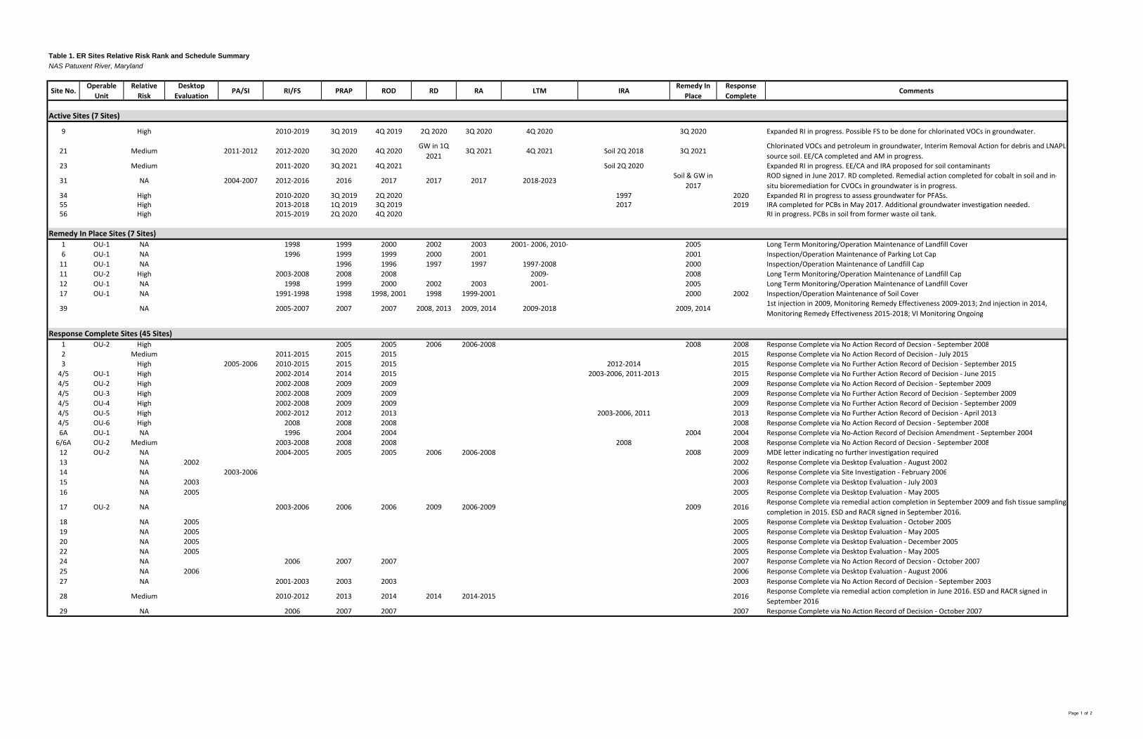
Table 1. ER Sites Relative Risk Rank and Schedule SummaryNAS Patuxent River, Maryland
Site No.Operable
UnitRelative Risk
Desktop Evaluation
PA/SI RI/FS PRAP ROD RD RA LTM IRARemedy In
PlaceResponse Complete
Comments
9 High 2010‐2019 3Q 2019 4Q 2019 2Q 2020 3Q 2020 4Q 2020 3Q 2020 Expanded RI in progress. Possible FS to be done for chlorinated VOCs in groundwater.
21 Medium 2011‐2012 2012‐2020 3Q 2020 4Q 2020GW in 1Q 2021
3Q 2021 4Q 2021 Soil 2Q 2018 3Q 2021Chlorinated VOCs and petroleum in groundwater, Interim Removal Action for debris and LNAPL source soil. EE/CA completed and AM in progress.
23 Medium 2011‐2020 3Q 2021 4Q 2021 Soil 2Q 2020 Expanded RI in progress. EE/CA and IRA proposed for soil contaminants
31 NA 2004‐2007 2012‐2016 2016 2017 2017 2017 2018‐2023Soil & GW in
2017ROD signed in June 2017. RD completed. Remedial action completed for cobalt in soil and in‐situ bioremediation for CVOCs in groundwater is in progress.
34 High 2010‐2020 3Q 2019 2Q 2020 1997 2020 Expanded RI in progress to assess groundwater for PFASs.55 High 2013‐2018 1Q 2019 3Q 2019 2017 2019 IRA completed for PCBs in May 2017. Additional groundwater investigation needed. 56 High 2015‐2019 2Q 2020 4Q 2020 RI in progress. PCBs in soil from former waste oil tank.
1 OU‐1 NA 1998 1999 2000 2002 2003 2001‐ 2006, 2010‐ 2005 Long Term Monitoring/Operation Maintenance of Landfill Cover6 OU‐1 NA 1996 1999 1999 2000 2001 2001 Inspection/Operation Maintenance of Parking Lot Cap11 OU‐1 NA 1996 1996 1997 1997 1997‐2008 2000 Inspection/Operation Maintenance of Landfill Cap11 OU‐2 High 2003‐2008 2008 2008 2009‐ 2008 Long Term Monitoring/Operation Maintenance of Landfill Cap12 OU‐1 NA 1998 1999 2000 2002 2003 2001‐ 2005 Long Term Monitoring/Operation Maintenance of Landfill Cover17 OU‐1 NA 1991‐1998 1998 1998, 2001 1998 1999‐2001 2000 2002 Inspection/Operation Maintenance of Soil Cover
39 NA 2005‐2007 2007 2007 2008, 2013 2009, 2014 2009‐2018 2009, 20141st injection in 2009, Monitoring Remedy Effectiveness 2009‐2013; 2nd injection in 2014, Monitoring Remedy Effectiveness 2015‐2018; VI Monitoring Ongoing
1 OU‐2 High 2005 2005 2006 2006‐2008 2008 2008 Response Complete via No Action Record of Decsion ‐ September 20082 Medium 2011‐2015 2015 2015 2015 Response Complete via No Action Record of Decision ‐ July 20153 High 2005‐2006 2010‐2015 2015 2015 2012‐2014 2015 Response Complete via No Further Action Record of Decision ‐ September 20154/5 OU‐1 High 2002‐2014 2014 2015 2003‐2006, 2011‐2013 2015 Response Complete via No Further Action Record of Decision ‐ June 20154/5 OU‐2 High 2002‐2008 2009 2009 2009 Response Complete via No Action Record of Decision ‐ September 20094/5 OU‐3 High 2002‐2008 2009 2009 2009 Response Complete via No Further Action Record of Decision ‐ September 20094/5 OU‐4 High 2002‐2008 2009 2009 2009 Response Complete via No Further Action Record of Decision ‐ September 20094/5 OU‐5 High 2002‐2012 2012 2013 2003‐2006, 2011 2013 Response Complete via No Further Action Record of Decision ‐ April 20134/5 OU‐6 High 2008 2008 2008 2008 Response Complete via No Action Record of Decsion ‐ September 20086A OU‐1 NA 1996 2004 2004 2004 2004 Response Complete via No‐Action Record of Decision Amendment ‐ September 20046/6A OU‐2 Medium 2003‐2008 2008 2008 2008 2008 Response Complete via No Action Record of Decsion ‐ September 200812 OU‐2 NA 2004‐2005 2005 2005 2006 2006‐2008 2008 2009 MDE letter indicating no further investigation required 13 NA 2002 2002 Response Complete via Desktop Evaluation ‐ August 200214 NA 2003‐2006 2006 Response Complete via Site Investigation ‐ February 200615 NA 2003 2003 Response Complete via Desktop Evaluation ‐ July 200316 NA 2005 2005 Response Complete via Desktop Evaluation ‐ May 2005
17 OU‐2 NA 2003‐2006 2006 2006 2009 2006‐2009 2009 2016Response Complete via remedial action completion in September 2009 and fish tissue sampling completion in 2015. ESD and RACR signed in September 2016.
18 NA 2005 2005 Response Complete via Desktop Evaluation ‐ October 200519 NA 2005 2005 Response Complete via Desktop Evaluation ‐ May 200520 NA 2005 2005 Response Complete via Desktop Evaluation ‐ December 200522 NA 2005 2005 Response Complete via Desktop Evaluation ‐ May 200524 NA 2006 2007 2007 2007 Response Complete via No Action Record of Decsion ‐ October 200725 NA 2006 2006 Response Complete via Desktop Evaluation ‐ August 200627 NA 2001‐2003 2003 2003 2003 Response Complete via No Action Record of Decision ‐ September 2003
28 Medium 2010‐2012 2013 2014 2014 2014‐2015 2016Response Complete via remedial action completion in June 2016. ESD and RACR signed in September 2016
29 NA 2006 2007 2007 2007 Response Complete via No Action Record of Decision ‐ October 2007
Active Sites (7 Sites)
Remedy In Place Sites (7 Sites)
Response Complete Sites (45 Sites)
Page 1 of 2

Table 1. ER Sites Relative Risk Rank and Schedule SummaryNAS Patuxent River, Maryland
Site No.Operable
UnitRelative Risk
Desktop Evaluation
PA/SI RI/FS PRAP ROD RD RA LTM IRARemedy In
PlaceResponse Complete
Comments
30 NA 2005 2006 Response Complete via Desktop Evaluation ‐ February 200635 NA 2003 2003 Response Complete via Desktop Evaluation ‐ October 200336 NA 2002 2002 Response Complete via Desktop Evaluation ‐ June 200237 NA 2002 2002 Response Complete via Desktop Evaluation with Sampling ‐ November 200238 NA 2002 2002 Response Complete via Desktop Evaluation ‐ August 200240 NA 2006 2006 Response Complete via Desktop Evaluation ‐ February 200641 NA 2004 2005 2005 2005 Response Complete via No Action Record of Decision ‐ Septemer 200542 NA 2001 Sites 23 and 42 are co‐located; investigation will occur as part of Site 23 RI43 Medium 2008 2008 Response Complete via Expanded Site Investigation ‐ November 200844 Medium 2010‐2011 2011 Response Complete via Site Investigation ‐ March 201145 NA 2003 2004 Response Complete via Desktop Evaluation ‐ June 200446 NA 2004 2004 2004 2004 2004 Response Complete via No Action Record of Decision ‐ Septemer 200447 NA 2004‐2006 2006 Response Complete via Expanded Site Investigation ‐ February 200648 NA 2002‐2003 2004 2005 EE/CA with Decision Document ‐ 200549 NA 2002‐2003 2004 2005 EE/CA with Decision Document ‐ 200550 NA 2002‐2003 2004 2005 EE/CA with Decision Document ‐ 200552 NA 2005 2005 Response Complete via Desktop Evaluation ‐ April 200553 NA 2002 2002 Response Complete via Desktop Evaluation ‐ August 200254 NA 2008 2008 Response Complete via Desktop Evaluation ‐ March 2008
Response Complete Sites (Continued)
Page 2 of 2

Figures
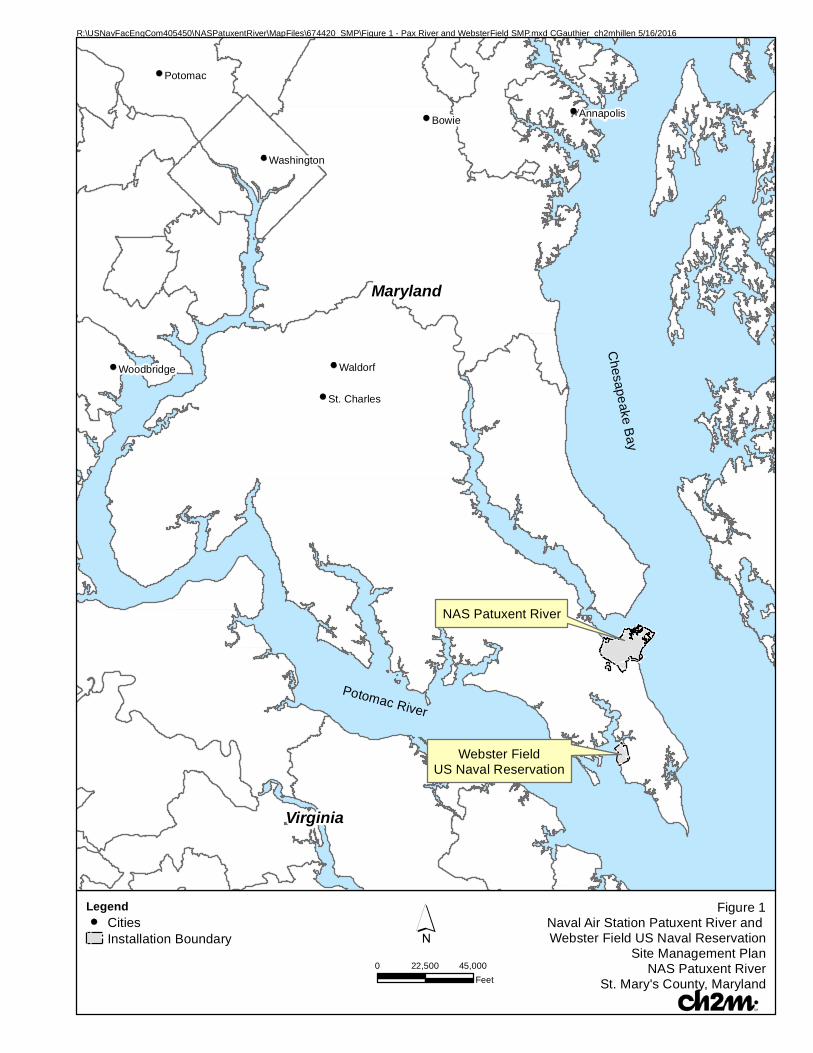
!(
!(
!(
!(
!(
!(!(
Bowie
Waldorf
Potomac
Annapolis
Washington
Woodbridge
St. Charles
Figure 1Naval Air Station Patuxent River and Webster Field US Naval Reservation
Site Management PlanNAS Patuxent River
St. Mary's County, Maryland
´0 45,00022,500
Feet
R:\USNavFacEngCom405450\NASPatuxentRiver\MapFiles\674420_SMP\Figure 1 - Pax River and WebsterField SMP.mxd CGauthier_ch2mhillen 5/16/2016
Legend!( Cities
Installation Boundary
Potomac River
Chesapeake B
ay
Maryland
Virginia
NAS Patuxent River
Webster FieldUS Naval Reservation

Patuxent River
Ches
apeake
Bay
EastPatuxent
Basin
WestPatuxent
Basin
CalvertPond
(Pond #4)
HoltonPond
(Pond #3)
SewallPond
(Pond #2)
Gardiner'sPond
(Pond #1)
SacawaxhitPond
(Pond #5)
Pine HillRun
Chesapeake Basin
Goose Creek
PearsonCreek
HarpersCreek
55
1
11
6
34
9
21
39
23 & 42
17
12
31
56
Figure 2Active and Remedy In Place Sites
Site Management PlanNAS Patuxent River
St. Mary's County, Maryland/0 3,0001,500
Feet
Legend
Active ER Sites (High Risk)
Active ER Sites (Medium Risk)
Remedy In Place Sites
Roads
Buildings
Base Boundary
Note: Communications Towers located throughout the base.
\\BROOKSIDE\GIS_SHARE\ENBG\00_PROJ\N\NAVY\CLEAN\WASHINGTON\NASPATUXENTRIVER\MAPFILES\SMP\2017\FIGURE 2 - ACTIVE AND REMEDY IN PLACE SITES.MXD CG021858 6/7/2017 8:54:17 AM
Active Sites
Site Number Operable Unit Site Name Area (Acres) Risk
9 Former Drum Disposal Area Building 665 2.04 High
21 Sludge Drying Beds 2.47 Medium
23 DPDO Salvage Yard 5.28 Medium
31 Tire Shop Building 307 1.47 High
34 Drum Disposal Area 6.92 High
55 PCBs in Soil/Sediment Unknown High
56 Abandoned Hazardous Waste UST Unknown High
Remedy in Place Sites
Site Number Operable Unit Site Name Area (Acres) Risk
1 OU-1 Fishing Point Landfill 65.03 High
6 OU-1 Bohneyard 8.4 Medium
11 OU-1, OU-2 Former Sanitary Landfill 17.23 High
12 OU-1 Landfill behind Rifle Range 1.15 High
17 OU-1 Pesticide Control Shop Building 841 1.63 High
39 Waste PCE Storage Area Building 503 2.25 High

Patuxent River
Ches
apeak
e B
ay
EastPatuxent
Basin
WestPatuxent
Basin
CalvertPond
(Pond #4)
HoltonPond
(Pond #3)
SewallPond
(Pond #2)
Gardiner'sPond
(Pond #1)
SacawaxhitPond
(Pond #5)
Pine HillRun
Chesapeake Basin
Goose Creek
PearsonCreek
HarpersCreek
4 (OU-2)4 (OU-3)
4 (OU-4)
1
12
5
4 (OU-1)
43
6
44
41
6A
27
16
14
9
29
45
19
35
15
38
46
18
28
22
25
13
20
48
30
50
49
40
24
47
53
36
37
42 23
3
2
2
Figure 3Response Complete, No Further Action, and Closed Sites
Site Management PlanNAS Patuxent River
St. Mary's County, Maryland/0 3,0001,500
Feet
Legend
Response Complete Sites
Roads
Buildings
Base Boundary
Note: Communications Towers located throughout the base.
\\BROOKSIDE\GIS_SHARE\ENBG\00_PROJ\N\NAVY\CLEAN\WASHINGTON\NASPATUXENTRIVER\MAPFILES\SMP\2017\FIGURE 3 - RESPONSE COMPLETE, NO FURTHER ACTION, AND CLOSED SITES.MXD CG021858 6/7/2017 10:17:58 AM
Site Investigations
Site Number Operable Unit Site Name Area (Acres) Risk
14 Old Fire Fighting Burn Pad 3.64 High
43 Solid & Probable Liquid Waste Disposal Area 18.07 Medium
44 Fill Area 17.09 Medium
47 Dry Well Building 1354 0.008 High
48 Water Tower Building 519 0.04 High
49 Water Tower Building 520 0.02 High
50 Water Tower Building 521 0.02 High
Desktop Evaluations
Site Number Operable Unit Site Name Area (Acres) Risk
13 PCB Transformer Spill Area Building 585 0.07 Medium
15 Former Washrack Drainage Way Building 110/111 1.27 Medium
16 Drainage Ditch Buildings 305/306 6.7 Medium
18 Hobby Shop Building 415 0.5 Medium
19 Drainage Ditch Buildings 101/109 1.6 Medium
20 Battery Shop Building 158 0.05 Medium
22 Washrack and Bowser Buildings 115/201 0.29 Medium
25 Solvent Spills at Building 114 0.28 High
30 Paint and Solvent Locker Building 863 0.03 Medium
35 Agricultural Area 1.51 Medium
36 Waste Battery Storage Building 214 0.003 Medium
37 Sand Blasting Area Building 214 0.001 Medium
38 Scrap Storage Building 1811 0.93 Medium
40 Construction Debris Landfill 0.009 Medium
42 Coal Disposal Area Building 604 5.28 Medium
45 Disposal Area 2.01 Medium
52 Communication Towers Unknown Medium
53 Waste Flammable Storage Building 1811 0.005 Medium
54 Aircraft Hot Refueling, Building 1644 Unknown Medium
Action Record of Decisions
Site Number Operable Unit Site Name Area (Acres) Risk
1 OU-2 Fishing Point Landfill (Area E) 65.03 High
12 OU-2 Landfill behind Rifle Range (Area E) 1.15 High
17 OU-2 Pesticide Control Shop Building 841 (Holton Pond) 1.63 High
28 Transformer Storage Yard 0.32 Medium
No Action Record of Decisions
Site Number Operable Unit Site Name Area (Acres) Risk
2 Disposal Site near Pond 1 15 High
4/5 OU-6 Hermanville Disposal Site/Disposal Site near Pine Hill Run 76.39/11.44 High
6A OU-1 Bohneyard 6.00 Medium
27 Construction Debris Disposal Area 7.43 High
29 Carbon Tetrachloride Disposal Area 2.05 High
46 Liquid Spill/Disposal Area 0.76 Medium
No Further Action Record of Decisions
Site Number Operable Unit Site Name Area (Acres) Risk
3 Disposal Site near Goose Creek, soil 10 high
4 OU-1 Hermanville Disposal Site 31.46 High
4 OU-2 Hermanville Disposal Site 1.97 High
4 OU-3 Hermanville Disposal Site 16.33 High
4 OU-4 Hermanville Disposal Site 29.23 High
5 OU-5 Disposal Site near Pine Hill Run 11.44 High
6/6A OU-2 Bohneyard 6.41 Medium
24 Dry Well Building 114 0.01 High
41 Fire Fighting Burn Pad 11.83 High

Patuxent River
Ches
apeake
Bay
EastPatuxent
Basin
WestPatuxent
Basin
CalvertPond
(Pond #4)
HoltonPond
(Pond #3)
SewallPond
(Pond #2)
Gardiner'sPond
(Pond #1)
SacawaxhitPond
(Pond #5)
Pine HillRun
Chesapeake Basin
Goose Creek
PearsonCreek
HarpersCreek
55
17
UXO-0002Former Pistol
& Skeet Ranges
UXO-0001Historic Munitions Disposal Area
Figure 4MR Sites UXO-0001 and UXO-0002
Site Management PlanNAS Patuxent River
St. Mary's County, Maryland
/0 3,0001,500
Feet
Legend
Active Munitions Response Site
Buildings
Base Boundary
Roads
Note:Communications Towers located throughout the base.Map updated July 2011.
\\BROOKSIDE\GIS_SHARE\ENBG\00_PROJ\N\NAVY\CLEAN\WASHINGTON\NASPATUXENTRIVER\MAPFILES\SMP\2017\FIGURE 4 - MUNITION RESPONSE SITES.MXD CG021858 6/7/2017 10:04:36 AM
Munition Response Sites
Site Number Site Name Area (Acres)
UXO-0001 Historic Munitions Disposal Area 2.72
UXO-0002 Former Pistol & Skeet Ranges 2.46

_̂
_̂
_̂
_̂
_̂
_̂_̂NAS Patuxent River
Chesapeake Bay
Potomac River
Patuxent River
Gunnery Ranges
Piney Point Range
Barren Island RangeAir Drop Area - 1945
Sharp's Island Range
Kent Island (Bloody Point) Range
Figure 5UXO-0003 - Former Water Ranges
Site Management PlanNAS Patuxent River
St. Mary's County, Maryland
´0 63
Miles
Legend_̂ Water Range Site
Installation Boundary
R:\USNAVFACENGCOM405450\NASPATUXENTRIVER\MAPFILES\674420_SMP\FIGURE 5 - UXO-0003 - FORMER ISLAND RANGES.MXD CGAUTHIER_CH2MHILLEN 5/16/2016 3:16:19 PM

Appendix A Summaries of Closed Sites

A-1
Desktop Evaluation Sites Summaries of ER Program Sites 13, 15, 16, 18, 19, 20, 22, 25, 30, 35, 36, 37, 38, 40, 42, 45, 52, 53, and 54 which were closed and removed from the ER Program using the desktop evaluation process identified in the FFA, are presented below.
Site 13—PCB Transformer Spill Area Building 585 Site No. OU Relative
Risk Desktop
Evaluation PA/SI RI/FS PRAP ROD RD RA LTM IRA Response Complete
13 NA 2002 2002
Site Location
Site 13 is located in Building 585 in the Carpenter Park area of the southwestern quadrant of the station.
History
Building 585 was used prior to 1981 for the storage of 27 transformers, 24 of which contained PCBs. The transformers were stored on a concrete pad in the building. In 1981, NAS Patuxent River personnel discovered that five of the transformers were leaking. An estimated 1 to 5 gallons of fluid had leaked from the transformers onto the concrete floor of the building interior. The transformers were moved to Building 1496, and facility personnel cleaned the concrete floor.
Actions Performed
Site 13 was included in the IAS study conducted at NAS Patuxent River in 1984. A confirmation study was not conducted for Site 13 because the spill was contained within the building interior. Further action was later recommended because small quantities of the spilled material remained after cleanup.
In 2000, Building 585 was identified by NAS Patuxent River for demolition. An expedited site evaluation was implemented in 2001 to determine whether demolition would pose a human health risk to construction workers, and whether demolition debris had to be handled as hazardous material. This evaluation identified two small adjacent areas of the concrete floor with relatively high concentrations of PCBs.
The PCB-contaminated section of the concrete floor identified in 2001 was remediated in 2002 so that the building debris could be disposed as industrial demolition debris. The initial cleanup action used a solution to extract PCB contamination from the concrete floor. These actions were successful in removing contamination, but were not able to achieve a complete removal below regulatory limits necessary for disposal of construction and demolition debris. Concurrent with the initial cleanup action, further testing occurred to determine if any of the PCB contamination had migrated into soil beneath the concrete slab. The testing indicated that no PCBs had migrated from the floor to soil beneath the concrete slab. Since the initial cleanup action did not achieve the desired cleanup level, the PCB-contaminated portion of the concrete slab was physically removed from the building in September 2002 and disposed off-site in accordance with applicable regulations.
Current Status
Site 13 consists of Building 585, which is not in use, and the site has been closed and removed from the ER Program. As no release of PCBs has occurred to the environment at Site 13, and the PCB-contaminated portion of the concrete floor was removed and properly disposed in accordance with applicable regulations, Site 13 was closed using the Desktop Evaluation (DE) process described in the FFA. The Navy and EPA signed a DE decision document on August 20, 2002 for no further action at Site 13. The MDE provided a 'No Comment' letter on August 13, 2002 in lieu of signing the desktop evaluation document. Consequently, Site 13 has been closed and removed from the ER Program.

APPENDIX A−SUMMARIES OF CLOSED SITES
A-2
Site 15—Former Washrack Drainage Way Building 110/111 Site No. OU Relative
Risk Desktop
Evaluation PA/SI RI/FS PRAP ROD RD RA LTM IRA Response Complete
15 NA 2003 2003
Site Location
Site 15 is located at the Test Pilot School, to the southeast of the East Patuxent Basin, in the northern portion of the station.
History
The site was used for aircraft cleaning using Turco, an organic solvent that contains aliphatic naphtha. From 1943 to 1970, rinsate from the washrack reportedly drained into an open drainage ditch that discharged to the East Patuxent Basin. In 1970, a stormwater drainage system was installed at the site to eliminate the use of the open drainage ditch, and in 1976, an oil water separator was installed to collect the rinsate. Before installation of the oil water separator, it was reported that approximately 415,800 pounds of solids and 188,600 pounds of petroleum products were estimated to have been discharged to the basin from Site 15.
During the DE study, it was determined that the location of Site 15 was not where it was identified in historic documents that described the ER sites. The actual location of Site 15 was determined to be located on paved surfaces immediately adjacent to the aircraft hangar prior to construction of the current wash rack location that was constructed in the late 1970s or early 1980s.
Actions Performed
Site 15 was included in the IAS study conducted at NAS Patuxent River in 1984. No visible signs of contamination were observed in the drainage ditch or basin during the on-site survey. A confirmation study was recommended for Site 15 based on the potential for sediments in the drainage ditch or basin to be contaminated.
A NACIP Program confirmation study was conducted at Site 15 between 1985 and 1987. With the exception of one slightly elevated lead value, the concentrations of metals detected in the soil samples collected during Phase 1 fall within the ranges typical of soils. Elevated levels of oil and grease were detected at one of the soil sampling locations. No other organic compounds were detected in the soil samples. Elevated concentrations of oil and grease and some SVOCs, slightly elevated concentrations of metals, and low concentrations of some VOCs were detected in sediment samples from the East Patuxent Basin. Low concentrations of oil and grease and some VOCs were detected in surface water samples, and a low concentration of an SVOC was detected in one crab sample.
Current Status
Site 15 is no longer used for cleaning aircraft as it was replaced by the current wash rack. The oil water separator associated with the current wash rack is routinely inspected. The area of Site 15 originally believed to be part of the ER site is now used as an aircraft staging area. The Tier I Partnering Team agreed in December 2003 that no further action was required at Site 15. In lieu of signing the DE document, the EPA provided a letter on December 5, 2003 indicating that no further investigation is required. The MDE provided a No Comment Letter on December 1, 2003 in lieu of signing the DE document. As a result, Site 15 is closed and has been removed from the ER Program.

APPENDIX A−SUMMARIES OF CLOSED SITES
A-3
Site 16—Drainage Ditch Building 305/306 Site No. OU Relative
Risk Desktop
Evaluation PA/SI RI/FS PRAP ROD RD RA LTM IRA Response Complete
16 NA 2005 2005
Site Location
Site 16 is associated with Hangars 305 and 306 in the northwestern quadrant of the station. In the past, a drainage ditch flowed from the vicinity of the hangar washracks to a ravine that leads to the southeastern end of Pond 1.
History
The vicinity of the site was used for aircraft cleaning and maintenance. From 1943 to 1976, rinsate from the washrack drained into an open drainage ditch connected to Pond 1. The rinsate included Turco, petroleum products, xylene, and toluene. In 1970, a stormwater drainage system was installed to eliminate the use of the open drainage ditch, and in 1976, an oil water separator was installed to collect the rinsate. The quantity of waste generated by washing operations at Site 16 was much less than the quantity generated during similar operations at Building 110/111 (Site 15).
Site 16 was included in the IAS study conducted at NAS Patuxent River in 1984. No visible signs of contamination were observed in the drainage ditch during the on-site survey. The study recommended that a confirmation study be conducted for Site 16 if the confirmation study for Site 15 confirmed a hazard to aquatic life.
Current Status
The drainage ditch at Site 16 still receives surface water runoff, but no disposal activities occur at this site. The oil water separator at the site is routinely inspected. The Navy and EPA signed a DE decision document on May 11, 2005 for no further action at Site 16. The MDE provided a No Comment Letter on July 12, 2005 in lieu of signing the desktop evaluation document. Consequently, Site 16 has been closed and removed from the ER Program.
Site 18—Hobby Shop Building 415 Site No. OU Relative
Risk Desktop
Evaluation PA/SI RI/FS PRAP ROD RD RA LTM IRA Response Complete
18 NA 2005 2005
Site Location
Site 18 is located in Building 415 in the southwestern quadrant of the station.
History
The building is currently in use and has been used since 1943 for various hobby projects. From 1943 to 1971, small quantities (i.e., less than 1 quart per month) of solvents such as turpentine and paint thinners were reportedly discharged into a drainage ditch leading to a stream that flows into Pond 2. Starting in 1981, the solvents were stored in drums and taken to the Bohneyard (Site 6) or removed by a contractor for off-site disposal in a RCRA-approved landfill.
Actions Performed
Site 18 was included in the IAS study conducted at NAS Patuxent River in 1984. A confirmation study was not recommended for Site 18 because of the small quantities of solvents disposed at the shop.

APPENDIX A−SUMMARIES OF CLOSED SITES
A-4
Current Status
Site 18 is still active as a hobby shop. A DE was completed for Site 18 in 2005 with a recommendation of no further investigation for the site. The Navy and EPA signed the DE decision document on October 27, 2005 for no further action at Site 18. The MDE provided a 'No Comment' letter on December 14, 2005 in lieu of signing the desktop evaluation document. Consequently, Site 18 has been closed and removed from the ER Program.
Site 19—Drainage Ditch Buildings 101/109 Site No. OU Relative
Risk Desktop
Evaluation PA/SI RI/FS PRAP ROD RD RA LTM IRA Response Complete
19 NA 2005 2005
Site Location
Site 19 is located at Buildings 101 and 109 in the central portion of the facility, and consists of the drainage ditch from the washracks at the buildings to Pond 3.
History
The site was used for aircraft cleaning and maintenance. From 1943 to 1976, rinsate from the wash rack may have drained to an open drainage ditch. The rinsate included Turco, petroleum products, xylene, and toluene. In 1970, a stormwater drainage system was installed at the site to eliminate the use of the open drainage ditch, and in 1976, an oil water separator was installed to collect the rinsate. The quantity of waste generated by washing operations at Site 19 was much less than the quantity generated during similar operations at Building 110/111 (Site 15).
Actions Performed
Site 19 was included in the IAS conducted at NAS Patuxent River in 1984. No visible signs of contamination were observed in the drainage ditch during the on-site survey. A confirmation study was recommended for Site 19 if the confirmation study for Site 15 confirmed a hazard to aquatic life.
Current Status
The drainage ditch remains in use to convey surface water runoff. The oil water separator at the site is routinely inspected. The Navy and EPA signed a DE decision document on May 11, 2005 for no further action at Site 19. The MDE provided a 'No Comment' letter on July 12, 2005 in lieu of signing the desktop evaluation document. Consequently, Site 19 has been closed and removed from the ER Program.
Site 20—Battery Shop Building 158 Site No. OU Relative
Risk Desktop
Evaluation PA/SI RI/FS PRAP ROD RD RA LTM IRA Response Complete
20 NA 2005 2005
Site Location
Site 20 is located within Building 158 in the central portion of the station.
History
The site is currently in operation, but the startup date of operations is unknown. From 1969 to 1975, battery acid was discharged to a leaching field adjacent to Building 158. No evidence is available to confirm that the battery acid was neutralized before it was discharged. Since 1975, approximately 26 gallons of sulfuric acid per year from old and damaged batteries have been neutralized in a lead-lined sink inside the building. The sink is connected to

APPENDIX A−SUMMARIES OF CLOSED SITES
A-5
a drum located in a fully enclosed, locked wooden storage shed. The Public Works Department collects the neutralized discharge from the drum for disposal.
Actions Performed
Site 20 was included in the IAS study conducted at NAS Patuxent River in 1984. A confirmation study was not recommended for Site 20 because of the small quantity of acid that was discharged. Additionally, any acid that may have reached groundwater would have been diluted to such an extent that the only detectable effect would have been a slight, temporary decrease in pH.
Current Status
Site 20 is still in use. A draft Desktop Evaluation concluded that no releases occurred to surface soil outside of Bldg. 158 from alleged historic disposal practices based on soil sampling for lead and other metals of potential concern that was conducted in April 2005. During site reconnaissance, floor drains were noted within the battery storage portion of the building. The results of the initial site reconnaissance and soil sampling effort were presented to the Tier I Partnering Team at a June 7, 2005, meeting. EPA and MDE expressed concerns about the general lack of available information regarding the cistern located southwest of the building. In response to these concerns, a second site visit was conducted to Site 20 on August 30, 2005. Site reconnaissance within Building 158 indicated that three floor drains within the building are currently connected to the cistern. According to a 1998 Industrial Wastewater Survey and 1999 Illicit Discharge Report obtained for the installation, the cistern reportedly discharges to the NAS Patuxent River sanitary sewer.
Information regarding the active Building 158 piping connection to the cistern was reported to the NAVFAC Washington Environmental Compliance Department and the NAS Patuxent River Environmental Department. Since the floor drain/cistern system is currently active, further investigation and/or remediation of Site 20 was not conducted using the Environmental Restoration, Navy (ER,N) funding that supports the ER Program because of the Navy's policy at that time for the source of ER and compliance program funding. Only environmental sites that were both active and ceased operation prior to 1986 are eligible for ER,N funding. Consequently, responsibility for this site was turned over to the NAVFAC Washington Environmental Compliance Department for further investigation and/or corrective action. Further action regarding investigation and/or remediation of the Building 158 floor drain/cistern system will occur under the Navy Environmental Compliance program. The Navy and EPA signed a DE decision document in December 6, 2005 for no further action at Site 20 under CERCLA. The MDE provided a 'No Comment' letter on December 8, 2005 in lieu of signing the desktop evaluation document. Site 20 has been closed and removed from the ER Program.
Site 22—Washrack and Bowser Buildings 115/201 Site No. OU Relative
Risk Desktop
Evaluation PA/SI RI/FS PRAP ROD RD RA LTM IRA Response Complete
22 NA 2005 2005
Site Location
Site 22 is located at Hangars 115 and 201 in the southeastern quadrant of the station. A 400-foot long drainage ditch leads from the vicinity of the wash racks at the hangars to the Chesapeake Bay seaplane basin.
History
The site was used for aircraft cleaning and maintenance. From 1943 to 1976, rinsate from the wash rack drained into an open drainage ditch that discharged to the Chesapeake Bay seaplane basin. The rinsate included Turco, grease, and oil. In 1970, a stormwater drainage system was installed at the site to eliminate the use of the open drainage ditch, and in 1976, an oil water separator was installed to collect the rinsate. The quantity of waste generated by washing operations at Site 22 was less than the quantity generated during similar operations at Building 110/111 (Site 15).

APPENDIX A−SUMMARIES OF CLOSED SITES
A-6
Actions Performed
Site 22 was included in the IAS conducted at NAS Patuxent River in 1984. No visible signs of contamination were observed in the drainage ditch or basin during the on-site survey. A confirmation study was recommended for Site 22 if the confirmation study for Site 15 confirmed a hazard to aquatic life.
Site 22 was included in the RFA conducted at NAS Patuxent River in 1988-89. No evidence of a release was observed at Site 22 during the RFA site visit.
Current Status
Site 22 is in use. The oil-water separator at the site is routinely inspected. The Navy and EPA signed a DE decision document on May 11, 2005 for no further action at Site 22. The MDE provided a 'No Comment' letter on July 12, 2005 in lieu of signing the desktop evaluation document. Consequently, Site 22 has been closed and removed from the ER Program.
Site 25—Solvent Spills at Building 114 Site No. OU Relative
Risk Desktop
Evaluation PA/SI RI/FS PRAP ROD RD RA LTM IRA Response Complete
25 NA 2006 2006
Site Location
Site 25 is located approximately 25 feet north of Building 114 in the southeastern quadrant of the station.
History
The site occupies an area approximately 200 feet by 200 feet that was used between 1943 and 1975 as a disposal area for solvents and as a cleaning area for paint brushes used in the metal plating shop. Materials reportedly released at the site contained V-M & P naphtha, turpentine, trichloroethylene, toluene, 1,1,1-trichloroethane, acetone, ethyl alcohol, benzene, zinc, chromium, lead, iron, cadmium, and silver. An estimated 13,000 pounds of thinner, turpentine, and solvents and 20,800 pounds of paint wastes were reportedly disposed at the site. The plating shop was relocated from Building 114 to Building 104 in 1975.
Actions Performed
Site 25 was included in the IAS conducted at NAS Patuxent River in 1984. A confirmation study was recommended for Site 25 because the dry well next to Building 114 (Site 24) is hydraulically connected to a small stream located southeast of Building 114. Organic constituents (e.g., benzene) and metals (e.g., lead and chromium) from solvent residues, lacquer thinner, and paint in the soil at Site 25 may have leached and migrated to the stream.
The NACIP Program confirmation study was conducted at Site 25 between 1985 and 1987. VOCs were not detected in the soil samples. The concentrations of metals detected in the soil samples were within the ranges typical of soils. The concentration of copper detected in one of the samples was one order of magnitude greater than the concentration detected in the other soil samples.
Current Status
Based on the DE prepared for this site, previous investigation results indicate there is no evidence of disposal activities having occurred at this site. Therefore, the Navy and EPA signed a DE decision document on April 4, 2006 for no further action at Site 25. The MDE provided a 'No Comment' letter on July 11, 2006 in lieu of signing the desktop evaluation document. Consequently, Site 25 has been closed and removed from the ER Program.

APPENDIX A−SUMMARIES OF CLOSED SITES
A-7
Site 30–Paint and Solvent Locker Building 863 Site No. OU Relative
Risk Desktop
Evaluation PA/SI RI/FS PRAP ROD RD RA LTM IRA Response Complete
30 NA 2005 2006
Site Location
Site 30 is located at Building 863, west of the West Patuxent Basin in the northwestern quadrant of the station. A 200-foot drainage ditch leads from Building 863 to the West Patuxent Basin.
History
According to a report, in 1970 there was visible evidence of a spill along the length of the ditch. The type(s) and quantities of the material spilled are unknown.
Actions Performed
Site 30 was included in the IAS conducted at NAS Patuxent River in 1984. No visible evidence of contamination was observed in the drainage ditch. Based on NACIP site investigations of similar facilities, the quantities of material generated were not likely to be significant and the contaminants would have been washed away, mixed with and subsequently diluted by the Patuxent River. A confirmation study was not recommended for Site 30.
Current Status
The area around Site 30 is in use, but the site no longer contains a paint and solvent locker. Based upon current site conditions, the NAS Patuxent River Tier I Partnering Team determined a PA/SI was not necessary for Site 30. The Navy and EPA signed a DE decision document on February 7, 2006 for no further action at Site 30. The MDE provided a 'No Comment' letter on February 14, 2006 in lieu of signing the desktop evaluation document. Consequently, Site 30 has been closed and removed from the ER Program.
Site 35–Agricultural Site Site No. OU Relative
Risk Desktop
Evaluation PA/SI RI/FS PRAP ROD RD RA LTM IRA Response Complete
35 NA 2003 2003
Site Location
Site 35 is located north of Pine Hill Run in the southeastern quadrant of the facility.
History
The site was reportedly used as a coal storage area.
Actions Performed
Organic carbon and trace metals were detected in samples collected at the site. In 2003, aerial photography and on-site reconnaissance conclusively identified the location and extent of Site 35. It has been confirmed that the site was used to store coal.
Current Status
Site 35 is currently used for agriculture. The Navy and EPA signed a DE decision document on November 4, 2003 for no further action at Site 35. The MDE provided a 'No Comment' letter on December 15, 2003 in lieu of signing the DE document. As a result, Site 35 is closed and has been removed from the NAS ER Program.

APPENDIX A−SUMMARIES OF CLOSED SITES
A-8
Site 36–Waste Battery Storage Building 214 Site No. OU Relative
Risk Desktop
Evaluation PA/SI RI/FS PRAP ROD RD RA LTM IRA Response Complete
36 NA 2002 2002
Site Location
Site 36 is located north of the Chesapeake Bay seaplane basin on the eastern side of the station.
History
The site was used to store waste batteries removed from boats and golf carts used for mobile targets. The spent batteries were stored on the jetty behind Building 214 while awaiting final disposition. After several batteries had accumulated, the DRMO collected the batteries and handled disposal.
Actions Performed
Site 36 was included in the RFA conducted at NAS Patuxent River in 1988-89. No documented releases were recorded in the files reviewed as part of the RFA. No visible evidence of a release was observed at the site during the RFA site visit. This site was observed in January 2002 by the NAS Patuxent River Tier 1 Partnering Team to support consideration of removing the site from the ER Program using the DE process described in the FFA.
Current Status
The Navy and EPA signed a DE decision document on June 13, 2002 for no further action at Site 36. The MDE provided a 'No Comment' letter on August 5, 2002 in lieu of signing the DE document. As a result, Site 36 is closed and has been removed from the ER Program.
Site 37–Sand Blasting Area Building 214 Site No. OU Relative
Risk Desktop
Evaluation PA/SI RI/FS PRAP ROD RD RA LTM IRA Response Complete
37 NA 2002 2002
Site Location
Site 37 is located at Building 214 north of the Chesapeake Bay seaplane basin, on the eastern side of the station.
History
Building 214 was used for activities associated with maintenance of mobile targets, including repair of electronic components used for the targets. A 55-gallon steel drum of waste sand from sand blasting operations was observed immediately outside the building when the 1988-89 RFA was conducted. The RFA report stated that this drum was used to store waste sand from sand blasting operations that reportedly occurred inside the building; however, station personnel familiar with the history of operations at Building 214 indicated during the DE that sand blasting operations had not been conducted in the building.
Actions Performed
Site 37 was included in the RFA conducted at NAS Patuxent River in 1988-89. No visible evidence of a release was observed at Site 37 during the RFA site visit. This site was observed in January 2002 by the NAS Patuxent River Tier 1 Partnering Team to support consideration of removing the site from the ER Program using the DE process presented in the FFA.

APPENDIX A−SUMMARIES OF CLOSED SITES
A-9
Current Status
The Navy and EPA signed a DE decision document on November 12, 2002 for no further action at Site 37. The MDE provided a 'No Comment' letter in October 22, 2002 in lieu of signing the DE document. As a result, Site 37 is closed and has been removed from the ER Program.
Site 38–Scrap Storage Building 1811 Site No. OU Relative
Risk Desktop
Evaluation PA/SI RI/FS PRAP ROD RD RA LTM IRA Response Complete
38 NA 2002 2002
Site Location
Site 38 is located behind Building 1811, north of the Chesapeake Bay seaplane basin on the eastern side of the station.
History
Material used to construct targets for target practice by strike pilots is stored on the ground in an open storage area behind the building. The material (55-gallon drums, pieces of Styrofoam-like material and lumber) is used to adorn motorized golf carts to resemble enemy targets. The description of the site as a “Scrap Storage Area” is incorrect, since this area was never used to store scrap materials.
Actions Performed
Site 38 was included in the RFA conducted at NAS Patuxent River in 1988-89. No documented releases were recorded in the files reviewed as part of the RFA at Site 38. No visible evidence of a release was observed at the site during the RFA site visit. This site was observed in January 2002 by the NAS Patuxent River Tier 1 Partnering Team to support consideration of removing the site from the ER Program using the DE process described in the FFA.
Current Status
The Navy and EPA signed a DE decision document in August 21, 2002 for no further action at Site 38. The MDE provided a 'No Comment' letter on October 8, 2002 in lieu of signing the DE document. As a result, Site 38 is closed and has been removed from the ER Program.
Site 40–Construction Debris Landfill, Strike Area Site No. OU Relative
Risk Desktop
Evaluation PA/SI RI/FS PRAP ROD RD RA LTM IRA Response Complete
40 NA 2006 2006
Site Location
Site 40 is located between the strike area building and the Chesapeake Basin seaplane basin in the southeastern quadrant of the station.
History
This area contains construction debris and miscellaneous material, including pieces of asphalt and concrete, bricks, spools of wire, scrap metal, ordnance containers, and drums.

APPENDIX A−SUMMARIES OF CLOSED SITES
A-10
Actions Performed
Site 40 was included in the RFA conducted at NAS Patuxent River in 1988-89. No documented releases were recorded in the files reviewed as part of the RFA for Site 40. No visible evidence of a release was observed at the site during the RFA site visit, but three barrels of waste oil were present at the time of the site visit.
Current Status
Site 40 is not in use. The DE determined there is no evidence that disposal of hazardous materials occurred at the site. Therefore, the Navy and EPA signed a DE decision document on February 7, 2006 for no further action at Site 40. The MDE provided a 'No Comment' letter on February 14, 2006 in lieu of signing the desktop evaluation document. Consequently, Site 40 has been closed and removed from the ER Program.
Site 42–Coal Disposal Area Building 604 Site No. OU Relative
Risk Desktop
Evaluation PA/SI RI/FS PRAP ROD RD RA LTM IRA Response Complete
42 NA 2001
Site Location
Site 42 is located adjacent to Building 604 in the northwestern quadrant of the station, and based on review of historic aerial photographs, is co-located with Site 23.
History
This area was used as a storage area for coal used in a former boiler at Building 604. The site is approximately 500 square feet in area, and is located upslope of the Patuxent River. Drainage across the site appears to flow through a ditch which likely discharges to the river.
Actions Performed
Site 42 was included in the RFA conducted at NAS Patuxent River in 1988-89. Crushed coal, slag, and fly ash material covered the site at the time of the RFA site visit.
Current Status
Site 42 is in use. As Site 42 is co-located with Site 23, the issues requiring investigation will be addressed by the Site 23 investigation; consequently, Site 42 is considered to be a duplicate site and has been removed from the ER Program.
Site 45–Disposal Area Site No. OU Relative
Risk Desktop
Evaluation PA/SI RI/FS PRAP ROD RD RA LTM IRA Response Complete
45 NA 2003 2004
Site Location
Site 45 is located at the intersection of Taxiways A and B in the center of the station.
History
The area was used for asphalt and concrete production prior to construction of engine test facilities.
APPENDIX A−SUMMARIES OF CLOSED SITES
A-11
Actions Performed
A preliminary site investigation was conducted at Site 45 in 1995. Exploratory trenches were excavated to check for buried debris, and three soil samples were collected. Additional soil samples were collected from 0 to 1 foot and at 10 feet below grade at six locations. Several VOCs and SVOCs were detected at low concentrations in soil samples. In 2003, the NAS Patuxent River Tier I Partnering Team reviewed the history of Site 45, and made a determination as to the aerial extent of the site to be considered in the DE.
Current Status
Site 45 contains an engine test facility that is in use. The Navy and EPA signed a DE decision document on March 17, 2004 for no further action at Site 45. The MDE provided a 'No Comment' letter on October 4, 2004 in lieu of signing the DE document. As a result, Site 45 has been removed from the ER Program.
Site 52–Communication Towers Site No. OU Relative
Risk Desktop
Evaluation PA/SI RI/FS PRAP ROD RD RA LTM IRA Response Complete
52 NA 2005 2005
Site Location
Site 52 includes all communication towers on the station that satisfy two criteria.
• Towers that are no longer in use, or towers that have been previously removed; and • Towers that were painted with lead-based paint (generally those constructed prior to 1978).
History
The communication towers may have been painted with lead-based paint, in which case soil underlying the communication towers may contain chips of lead-based paint as a result of historic maintenance activities.
Actions Performed
An inventory of Communication Towers was prepared.
Current Status
Site 52 is in use. The Navy and EPA signed a DE decision document on April 6, 2005, for no further action at Site 52. The MDE provided a “No Comment” letter on July 12, 2005 in lieu of signing the desktop evaluation document. Consequently, Site 52 was closed and removed from the ER Program.
Site 53–Waste Flammable Storage Building 1811 Site No. OU Relative
Risk Desktop
Evaluation PA/SI RI/FS PRAP ROD RD RA LTM IRA Response Complete
53 NA 2002 2002
Site Location
Site 53 was a wooden shed known as Building 1811, located behind Boathouse No. 2, north of the Chesapeake Bay seaplane basin.
History
Raw material flammables were stored inside the shed. Waste flammables (i.e., JP-5 and gasoline) used as cleaning solvents were placed in 5-gallon cans that were stored in 55-gallon drums used as overpack drums. The drums

APPENDIX A−SUMMARIES OF CLOSED SITES
A-12
were stored on pallets outside the shed in an area covered by a hinged roof attached to the side of the shed pending removal for off-site disposal.
Actions Performed
Site 53 was included in the RFA conducted at NAS Patuxent River in 1988-89. No documented releases were recorded in the files reviewed as part of the RFA for Site 53. No visible evidence of a release was observed at the site during the RFA site visit. This site was observed in January 2002 by the NAS Patuxent River Tier 1 Partnering Team to support consideration of removing the site from the ER Program using the DE process described in the FFA.
Current Status
Site 53 is not in use. The Navy and EPA signed a DE decision document in June 2002 for no further action at Site 53. The MDE provided a 'No Comment’ letter in August 2002 in lieu of signing the DE document. As a result, Site 53 has been removed from the ER Program.
Site 54–Aircraft Hot Refueling Building 1644 Site No. OU Relative
Risk Desktop
Evaluation PA/SI RI/FS PRAP ROD RD RA LTM IRA Response Complete
54 NA 2008 2008
Site Location
Site 54 was an Aircraft Hot Refueling Facility Area near the Pantograph fuel dispensing system and Building 1644.
History
This site was first identified in the RFA (A.T. Kearney, 1989) as the Aircraft Hot Refueling Facility Area. The site was not given a SWMU designation or never formally part of the CERCLA program. The site was noted as one of the areas where underground and aboveground storage tanks (USTs/ASTs) were present at the NAS Patuxent River. The RFA (A.T. Kearney, 1989) identified four steel ASTs to have been located at the site. Two ASTs had a capacity of 12,000 gallons and two had a capacity of 24,000 gallons. The tanks stored JP-5 and installed in 1978.
Actions Performed
The FFA did not list or included Site 54 as a site that required action under the CERCLA program or the Maryland UST program. Additionally, no records were found indicating any spills or releases at Site 54.
Current Status
The Navy documented response complete/site closeout for Site 54 in a Memorandum to File dated March 28, 2008.

A-13
Site Investigations Summaries of ER Program Sites 14, 43, 44, 47, 48, 49, and 50 which were closed and removed from the ER Program based on SI findings are presented below.
Site 14—Old Fire Fighting Burn Pad Site No. OU Relative
Risk Desktop
Evaluation PA/SI RI/FS PRAP ROD RD RA LTM IRA Response Complete
14 NA 2003-2006 2006
Site Location
Site 14 is located in the middle of the airfield immediately adjacent to Echo South Taxiway in the east-central portion of the facility.
History
Based on historic aerial photographs, the site was used from the late 1950s to the late 1970s or early 1980s by the NAS Patuxent River Fire Department to practice extinguishing aircraft fires. Typically, fires at this site were started on a concrete pad using gasoline, diesel oil, or waste oil. Free-phase petroleum product was detected at Site 14. NAS Patuxent River has addressed the petroleum contamination at the site under the MDE Oil Pollution Control Program.
Actions Performed
Site 14 was included in the IAS conducted in 1984. A confirmation study was not recommended for Site 14 because no evidence of environmental damage or stressed vegetation was visible in the vicinity of the site.
Current Status
Fieldwork for a Preliminary Assessment/Site Investigation (PA/SI) was completed in 2004, and a PA/SI report recommending no further action was completed in early 2006. Consequently, Site 14 has been closed and removed from the ER Program.
Site 43–Solid and Probable Liquid Waste Disposal Area Site No. OU Relative
Risk Desktop
Evaluation PA/SI RI/FS PRAP ROD RD RA LTM IRA Response Complete
43 Medium 2008 2008
Site Location
Site 43 is located south of Site 12 (Rifle Range Landfill) and north-northwest of Site 41 in the northern portion of the station.
History
The site reportedly served as a drying bed for material dredged from the East Patuxent and West Patuxent basins. The NAS had a permit to use the site for dredged material.
Actions Performed
A DE was performed in 2005 to provide information on historical operation at Site 43 and to serve as an initial assessment of this site to determine if there is a need for further evaluation.

APPENDIX A−SUMMARIES OF CLOSED SITES
A-14
Current Status
Site 43 is sometimes used for military training, but was used for placement of additional sediment dredged from the West Patuxent Basin in 2008, and more recently from East Patuxent Basin. Due to comments provided by the EPA and MDE on the initial DE report, additional investigation of the site was conducted. In August 2007, a work plan to further characterize the site was prepared, and surface and subsurface soil sampling was completed in October 2007. The site investigation report was completed in September 2008. Based on the findings presented in the SI report, no further action is necessary at Site 43, and the site was removed from the ER Program.
Site 44–Fill Area Site No. OU Relative
Risk Desktop
Evaluation PA/SI RI/FS PRAP ROD RD RA LTM IRA Response Complete
44 Medium 2011 2011
Site Location
Site 44 is located south-southwest of Site 3, the disposal site near Goose Creek and along the shoreline of Chesapeake Bay in the east-central portion of the station.
History
The area may have been used as a fill area from 1957 until 1965.
Actions Performed
A SI was conducted in April 2010. Based on the results of the human health and ecological screening level risk evaluations for the SI, no further investigation or action was warranted for Site 44.
Current Status
The SI report for Site 44 was completed in March 2011 and has been removed from the ER Program.
Site 47–Dry Well Building 1354 Site No. OU Relative
Risk Desktop
Evaluation PA/SI RI/FS PRAP ROD RD RA LTM IRA Response Complete
47 NA 2004-2006 2006
Site Location
Site 47 is located adjacent to Cedar Point Road in the central portion of the station.
History
Photographic chemicals from the Photo Shop were discharged to the sanitary sewer. A dry well exists on the west side of the building that may have received wastewater from the lab in the past. The dry well contains one influent pipe and a pervious gravel base that allows direct discharge to the subsurface. Dye released in floor drains within the mechanical room of the photo lab was detected in the dry well. Condensate from the air conditioning/heater system is also discharged to the dry well.
Actions Performed
A Site Screening Investigation was completed at Site 47 in 1999. Tetrachloroethene and three metals detected in groundwater exceeded the human health screening levels. Drywell sediments contained one PCB, one pesticide,

APPENDIX A−SUMMARIES OF CLOSED SITES
A-15
and six metals that exceeded conservative human health screening levels. The SSI concluded the material in the drywell does not appear to have adversely affected groundwater quality.
Current Status
To address concerns identified by the 1999 screening investigation, an Expanded Site Investigation work plan was prepared and implemented in 2004. The Expanded Site Investigation report completed in early 2006 recommended that no further action was required. Therefore, Site 47 has been closed and removed from the ER Program.
Site 48–Water Tower Building 519, Site 49–Water Tower Building 520, Site 50–Water Tower Building 521
Site No. OU Relative
Risk Desktop
Evaluation PA/SI RI/FS PRAP ROD RD RA LTM IRA Response Complete
48 NA 2002-2003 2004 2005
49 NA 2002-2003 2004 2005
50 NA 2002-2003 2004 2005
Site Location
Site 48 is located at Building 519, and Site 49 is located at Building 520, both of which are in the west-central portion of the station. Site 50 is located at Building 521 in the southeastern quadrant of the station.
History
The original water towers at Sites 48, 49, and 50 were constructed prior to 1978; therefore, it is suspected that lead-based paint was used on the towers. The original towers at these three locations were demolished in 2001 and replaced with new water towers currently located adjacent to the locations of the original water towers. There was a concern that soil under or in the vicinity of the original water towers may contain lead-based paint chips as a result of maintenance activities on the former towers.
Actions Performed
A PA/SI work plan and associated field sampling event was completed in FY 2003. Sampling results indicate levels of lead exceeding the EPA human health benchmark of 400 mg/kg.
Current Status
Sites 48, 49, and 50 are in use, and each contains a new water tower adjacent to the former water tower location on each site. After a review of draft results from the PA/SI sampling, the NAS Patuxent River Tier I Partnering Team agreed that a formal PA/SI report was not required. The sampling findings were incorporated into an EE/CA report prepared in support of a removal action for each of these sites to address lead-contaminated soil as a result of paint chips in the soil. An IRA was conducted for these sites in the fall of 2004. A closeout report was prepared in 2005 documenting that no further action is required for Sites 48, 49 and 50 as a result of the removal action (CH2M HILL, 2005). Consequently, Sites 48, 49 and 50 were removed from the ER Program.

A‐17
No Action, No Further Action, and Action Record of Decisions The sites closed and removed from the ER Program based on a No Action ROD, No Further Action ROD, or Action ROD where the removal action or protective remedy was completed and cleanup levels were achieved (Sites 2, 3, 4 OU‐1, OU‐2, OU‐3, OU‐4, OU‐6, 6 OU‐2, 6A, 24, 27, 28, 29, 41, 46, 1 OU‐2, and 12 OU‐2) are summarized below.
Site 2—Disposal Site Near Pond 1
Site No. OU Relative
Risk Desktop Evaluation PA/SI RI/FS PRAP ROD RD RA LTM IRA Response
Complete
2 ‐‐ Medium 2011‐2015 2015 2015 2015
Site Location
Site 2 occupies approximately 15 acres and is located on the southern and northeastern shores of Pond 1 in the northwestern quadrant of the station. The area around Pond 1 is wooded and rises steeply from the surface of the pond. Pond 1 occupies the former site of a wetland that was located at the bottom of a ravine.
History
The site was used in 1942 and 1943 during the construction of the station for the disposal of construction debris, miscellaneous station wastes, and 55‐gallon drums containing various types of oils. An unknown quantity of waste was disposed at the site. In 1950, Pond 1 was created when the wetland was cleaned out using draglines and subsequently dammed. During the construction of Pond 1, partially buried 55‐gallon drums were found in the vicinity of what is now the southern shore of the pond. Leachate from partially buried drums was observed during the excavation of the pond.
Actions Performed
Site 2 was included in the IAS study conducted at NAS Patuxent River in 1984. A confirmation study was recommended for Site 2 because of the potential for residual organic contamination present in the soil and groundwater to migrate into Pond 1 and accumulate in the bottom sediments and/or fish tissue. Pond 1 is stocked for recreational fishing, so a potential exists for organic contaminants to enter the food chain.
A NACIP Program confirmation study was conducted at Site 2 between 1985 and 1987. No VOCs or elevated concentrations of inorganic constituents were detected in surface water samples collected at Site 2. Elevated concentrations of metals and low levels of organic compounds were detected in sediment samples, and low concentrations of SVOCs and pesticides were detected in sediment and fish samples. The pesticides detected at Site 2 may be the result of historical widespread use of pesticides at NAS Patuxent River to control insects.
An IRI was conducted at Site 2 in 1991. Low concentrations of metals, one polychlorinated biphenyl (PCB) compound and several pesticides were detected in sediment samples. Low concentrations of metals and one pesticide were detected in fish samples.
In April 2011, a magnetometer survey was conducted at Site 2 as part of the RI scoping and the magnetic anomalies were investigated in August 2011. The anomalies that could not be attributed to known sources (e.g., metallic debris) will be further investigated or removed to extent practical as part of the RI. RI fieldwork was completed in October 2012.

APPENDIX A−SUMMARIES OF CLOSED SITES
A-18
Current Status Site 2 is not in use. The RI report for Site 2 was completed in January 2015. An ecological investigation of the watershed that contains Site 2 has been completed. The Agency for Toxic Substances and Disease Registry (ATSDR) conducted a public health assessment at NAS Patuxent River in 1995 and 1996 (ATSDR, 1997). ATSDR concluded that until additional data were available for a risk assessment, fish consumption from Pond 1 should be limited to 19 meals per year for 7 years. The Final PRAP was completed in June 2015 and a public meeting for the PRAP was held on June 16, 2015. A ‘No Action’ ROD for Site 2 soil, sediment, surface water, and groundwater was signed on September 15, 2015, and as a result, the site has been closed and removed from the ER program.
Site 3—Disposal Site Near Goose Creek Site No. OU Relative
Risk Desktop
Evaluation PA/SI RI/FS PRAP ROD RD RA LTM IRA Response Complete
3 -- High 2005-2006
2010-2015 2015 2015 2012-
2014 2015
Site Location Site 3 occupies approximately 21.9 acres and is located west of the southern edge of Goose Creek in the northeastern quadrant of the facility.
Site History The site was used for approximately six months during 1959 and 1960 as the main solid waste disposal site for the station. Waste reportedly disposed at the site included cardboard, plastic, paper, landscaping debris, hospital wastes, cesspool and sewage sludge, demolition and construction debris, POL products, paints, antifreeze, solvents, pesticides, asbestos, and photographic laboratory wastes. It is also reported that the liquid wastes were occasionally burned (flashed) at the site.
Actions Performed Site 3 was included in the IAS conducted for NAS Patuxent River in 1984. A confirmation study was not recommended for Site 3 because relatively minor quantities of waste had been disposed and the liquids had been flashed.
A site screening investigation for this site was completed in 1999. The investigation indicated the fill area appears to be contained and stable. Only trace quantities of VOCs and pesticides were detected in in-situ groundwater samples, and elevated levels of pesticides were detected in sediment samples.
An Expanded Site Investigation (ESI) was initiated in FY 2006 to provide additional data necessary to definitively determine the need for a remedial investigation. As a result of Navy, EPA and MDE review of the draft ESI report, a decision was made to proceed directly to generation of a remedial investigation report. The draft RI report was submitted to EPA and MDE in July 2009. As a result of EPA and MDE comments, the Navy decided to collect additional data to fill some data gaps, and to prepare an EE/CA report to support a Non-time-Critical Removal Action (NTCRA) prior to completing the RI. The supplemental RI investigation to fill the data gaps was completed in April 2012 and the EE/CA was completed in June 2012. An action memorandum was signed by the Navy in August 2012 and the NTCRA was performed between 2012 and 2014.
Current Status Site 3 is not in use. The NTCRA was completed in June 2014, and followed by a Final RI in September 2015. The Final PRAP and public meeting for Site 3 was held in August 2015. A ROD designating ‘No Further Action’ for site soil and ‘No Action’ for site sediment, surface water and groundwater was signed on September 29, 2015, resulting in site closure and removal from the ER Program.

APPENDIX A−SUMMARIES OF CLOSED SITES
A-19
Site 4 OU-1, 2, 3, 4 and 6 — Hermanville Disposal Site Site No. OU Relative
Risk Desktop
Evaluation PA/SI RI/FS PRAP ROD RD RA LTM IRA Response
Complete
4 OU-1 High 2002-2014 2014 2015
2003-2006, 2011-2013
2015
4 OU-2 High 2002-2008 2009 2009 2009
4 OU-3 High 2002-2008 2009 2009 2009
4 OU-4 High 2002-2008 2009 2009 2009
4/5 OU-6 High 2008 2008 2008 2008
Site Location
Site 4 occupies approximately 76.4 acres, and is located east of Shaw Road and south of Pine Hill Run near the southern boundary of the station. A portion of Site 4 is also located west of Shaw Road. Pond 3 (Holton Pond, which is currently dry as a result of the need to breach the dam due to structural instability of the dam) is located northwest of the portion of Site 4 located west of Shaw Road. The St. Mary’s County Metropolitan Commission (METCOM) Wastewater Sewage Treatment Plant is located east of the site. In general, the ground surface slopes gently to the north. North and northwest of the site, the elevation of the ground surface abruptly decreases to Pine Hill Run and Pond 3 (Holton Pond), respectively.
History
Between 1943 and 1960, an approximately 8 acre area in the central portion of the site was used for the disposal of an estimated 63,900 tons of solid and liquid waste generated by the station. Approximately 63,750 tons of cardboard, paper, and plastic were disposed at Site 4, along with 150 tons of waste oil, paint cans, antifreeze products, solvents, paint thinners, photographic laboratory wastes, asbestos, pesticides, hospital wastes, cesspool and sewage sludge, demolition and construction debris, and landscaping wastes. Disposal operations consisted of placing waste material in trenches that were approximately 10 feet wide, 10 feet deep, and 300 feet long. The waste material was regularly burned and covered with soil. The area west of Shaw Road reportedly was used for random dumping of soil and construction debris after Shaw Road was rerouted.
Actions Performed
Site 4 was included in the IAS conducted for NAS Patuxent River in 1984. The study recommended that a confirmation study be performed for Site 4 because a potential exists for metals and organic constituents to migrate from the disposal trenches via groundwater to Pond 3, Pine Hill Run, and adjacent wetlands. Also, the potential was identified for constituents to accumulate in the aquatic organisms and enter the food chain.
The NACIP Program confirmation study was conducted at Site 4 between 1985 and 1987. Metals and low concentrations of VOCs were detected in groundwater samples. An IRI was conducted at Site 4 in 1991. Low concentrations of VOCs were detected in groundwater samples. RI field work was conducted at Site 4 in 1996 and 1997. A surface geophysical survey was conducted to confirm landfill boundaries estimated from aerial photographs, and to identify potential buried debris west of Shaw Road. Test pits were excavated to confirm the geophysical survey results. Additional remedial investigation activities were conducted in 2003 and 2004. RI report preparation began in FY 2007 and will be completed in FY 2013. An interim remedial action was conducted in 2003-2004 to remove surface debris and wastes from the trench landfill areas, and another interim action is planned for a portion of Site 4 located west of Shaw Road.

APPENDIX A−SUMMARIES OF CLOSED SITES
A-20
During the 2003-2004 interim remedial action, four locations were identified with lead concentrations exceeding regulatory criteria for hazardous waste. A phosphate amendment was mixed with the soil from these areas and the soil sampled and analyzed for lead concentrations using the Toxicity Characteristic Leaching Procedure. Once analytical results indicated the soil was not hazardous, the material was hauled to the Charles County Sanitary Landfill, Maryland. Approximately 80,170 tons of waste material were removed or excavated from both Sites 4 and 5 and disposed off-site as nonhazardous waste.
Operable Units
Site 4 was divided into multiple operable units to facilitate addressing the data quality objectives developed for the remedial investigation of different areas of Site 4 and to expedite removal of portions of the site from the ER Program in the event that parcels of these sites were designated to support the base mission. In addition, site-wide groundwater for Sites 4 and 5 was designated as a separate OU. The OU designations for areas of Site 4 are as follows:
• OU-1 (designated as Area 4A in previous documents) is west of Shaw Road;
• OU-2 (Area 4B in previous documents) is the southern portion of Site 4;
• OU-3 (Area 4C in previous documents) is the central portion of Site 4 encompassing the former excavation areas;
• OU-4 (Area 4D in previous documents) is the northern portion of Site 4;
• OU-5 is Site 5 in its entirety; and
• OU-6 is site-wide groundwater combined for both Sites 4 and 5.
The OUs designated for Sites 4 and 5 correspond to separate physical areas where activities were conducted at various times during the site history that may have contributed the release of different potential contaminants to the site.
Current Status
The remedial investigations for OU-2, OU-3 and OU-4 were completed in November 2008 and March 2009. A ROD was signed in September 2009 that identified ‘No Action’ for OU-2 (Area 4B) and ‘No Further Action’ for OU-3 (Area 4C) and OU-4 (Area 4D). Additionally, a ‘No Action’ ROD for OU-6 (Groundwater at Sites 4/5) was signed in October 2008.
The Remedial investigation for OU-1, ongoing since 2002, was completed in September 2014. Following the results of the RI, a PRAP was issued in December 2014, identifying ‘No Further Action’ for OU-1 soil and ‘No Action’ for OU-1 sediment and surface water. No comments or new information were received during the public comment period that would affect this decision, thus, a ROD identifying ‘No Further Action’ for OU-1 soil and ‘No Action’ for OU-1 sediment and surface water was signed on September 15, 2015.
Site 5 OU-5 — Disposal Site Near Pine Hill Run Site No. OU Relative
Risk Desktop
Evaluation PA/SI RI/FS PRAP ROD RD RA LTM IRA Response Complete
5 OU-5 High 2002-2012 2012 2013
2003-2006, 2011
2013
Site Location Site 5 occupies approximately 11.4 acres and is located along the south bank of a portion of Pine Hill Run in the southeastern area of the facility. The topography of the site drops steeply to Pine Hill Run to the north and east.
APPENDIX A−SUMMARIES OF CLOSED SITES
A-21
History The site was used for disposal by placement of waste and construction debris on the ground surface along an embankment bordering Pine Hill Run. The period of time the site was in use and the types and quantities of waste disposed at Site 5 are unknown. However, rusty vehicle parts, coils, springs, and miscellaneous scrap metal were partially exposed at the site prior to removal of surface debris during the interim remedial action conducted in 2003-2004, and concrete construction debris is also visible in some areas of the site.
Actions Performed Site 5 was included in the 1984 IAS conducted for NAS Patuxent River. A confirmation study was not recommended for Site 5 because of the largely inert nature of the material disposed at the site. However, the site was designated in the FFA as one of the sites requiring completion of an RI/FS. The initial RI field work was conducted at Site 5 in 1996 and 1997. RI activities continued in 2003-2004, and were completed in 2006. An interim remedial action was conducted in 2003-2004 to remove surface debris from Site 5. Approximately 75,206 tons of waste were removed from Site 4, and approximately 4,964 tons were removed from Site 5 and disposed off-site as nonhazardous waste.
The RI and interim removal action for Site 5 were conducted concurrently with the RI and interim removal action for Site 4. As a result of grouping investigation and remedial activities together for Sites 4 and 5, Site 5 was also designated as a separate operable unit in its entirety, specifically OU-5. In addition, groundwater beneath both Sites 4 and 5 was combined and designated as a separate operable unit, specifically OU-6.
The boundaries of the Sites 4 and 5 push-out disposal areas were initially delineated during a geophysical screening survey conducted in April 2005 for munitions and explosives of concern. Subsequently, test pits were excavated at selected locations to confirm the horizontal and vertical extent of the push-out disposal areas. In addition, samples were collected to determine whether contaminants may have migrated beyond the limits of the disposal areas into surrounding undisturbed/native soil.
For OU-5 (Site 5), as part of the RI, four trenches were excavated in the push-out area to assess the types and volume of wastes present in this location. Waste characterization samples, native soil samples, and groundwater samples were collected from each trench. In addition, undisturbed/native soil samples from different depths were collected immediately outside of the footprint of the push-out area near the end of each trench.
Current Status Site 5 is not in use. The western portion of Site 5 was the location selected for the construction of a 1.8 acre non-tidal freshwater wetland constructed in 2004 as part of the OU-1 ROD for Sites 1/12 to compensate for wetlands filled during construction of the soil cover for the Fishing Point Landfill remedy. Ecological risks associated with Site 4 were addressed as part of the Pine Hill Run Watershed Baseline Ecological Risk Assessment. Soil, sediment, and surface water for Site 5 were addressed as OU-5 concurrently with Site 4, and the RI for OU-5 is presented in Volume 7 of the ten volume RI report for both Sites 4 and 5. Groundwater for Site 5 was included in OU-6, and the RI is presented in Volume 8 of the ten volume RI report for Sites 4 and 5. The Final RI for OU-6 was completed in June 2008 and a ‘No Action’ ROD was signed in September 2008.
The RI for OU-5 identified waste material disposed in an unpermitted disposal area at Site 5. The waste needs to be removed to support the final remedy for Site 5 and to achieve the goal of unrestricted future use. An interim removal action was scheduled to remove the waste at Site 5. The IRA helps to support the possible reuse of a portion of Site 5 for the potential future expansion of the METCOM wastewater treatment plant.
In June 2009, an After Action Report was completed and approved by NOSSA and DDESB to remove the explosive safety requirements imposed as a result of the Explosive Safety Submission (ESS) completed in September 2005 for the remedial investigation activities at Sites 4/5. An EE/CA report was completed in March 2009 for the IRA, and an Action Memorandum was executed by the Navy in 2010 for the removal action at Site 5. The removal action for Site 5 began in April 2011, but was stopped when MEC were found. An ESS was completed and approved by NOSSA and DDESB in December 2011. The IRA resumed in December 2011 and site restoration was

APPENDIX A−SUMMARIES OF CLOSED SITES
A-22
completed in April 2013. A “No Further Action” for soil and “No Action” for sediment and surface water ROD was issued for Site 5 OU-5 in April 8, 2013. The Construction Closeout Report was finalized in June 2014.
Site 6 and 6A OU-2 – Bohneyard Site No. OU Relative
Risk Desktop
Evaluation PA/SI RI/FS PRAP ROD RD RA LTM IRA Remedy In Place
Response Complete
6 OU-2 Medium 2003
-2008
2008 2008 2008 2008
6A NA 1996 2004 2004 2004
Site Location Site 6 is located south of Bohne Road in the northwestern quadrant of the station, adjacent to the Fuel Farm and east of the intersection of Bohne Road and the nearby taxiway. For purposes of the ER Program, Site 6 consists of two discrete areas referred to as Site 6 and 6A. Site 6 comprises the western portion of the ER site where a fuel truck parking area was constructed as part of the final remedy. Site 6A refers to the area east of the fuel truck parking area that is currently used for storage of equipment and materials. Surface drainage at Site 6 is primarily westward toward an unnamed drainage channel. This drainage channel discharges into the Supply Pond north of the Fuel Farm, and eventually flows into the West Patuxent River seaplane basin.
Operable Units
To efficiently manage remedial action priorities at Site 6 and meet station needs for land use, Site 6 was divided into two operable units. OU-1 consists of soil in the area where drums and tanks historically were stored, and in the storage area to the east referred to as Site 6A. OU-2 consists of downgradient surface water and sediment as well as groundwater beneath and downgradient of both Site 6 and 6A.
History
The site occupies a total of approximately 14 acres and was used for multiple purposes in the past. Between 1943 and 1949, the area was used for the disposal of approximately 6,000 tons (107,000 cubic feet) of fly-ash and bottom-ash material generated by the station’s coal-fired power plant. This material reportedly covered the area in a 6-inch thick layer of ash. Between 1949 and approximately 1955, the area was used as the Defense Property Disposal Office (DPDO) storage yard. Beginning about 1955, an estimated 8 tons of liquid wastes were stored in drums and a partially buried 10,000-gallon tank at the site. Many of the drums stored at the site reportedly leaked. The drums and tank were removed, and in October 1989, approximately 6 inches of sludge was placed over the site. Liquid wastes stored at Site 6 included POL wastes, solvents, paint thinners, paints, and oil-water separator sludge. Scrap metal and faulty or unused vehicles and equipment were also stored at the site.
Actions Performed
Actions performed at OU-1 are summarized in Section 3.1.2. The actions performed at OU-2 are summarized below.
• Initial fieldwork for the OU-2 RI was completed during 1996 and 1997, and additional fieldwork was completed in 2004 and 2005. The Final RI for OU-2 was completed in July 2008.
• Completion of the OU-2 RI was complicated by the discovery of PCB contamination in an area previously presumed to be uncontaminated.
• The ecological risks associated with Site 6 were addressed as part of the Gardiner’s Pond/Supply Pond Watershed Baseline Ecological Risk Assessment.

APPENDIX ASUMMARIES OF CLOSED SITES
A‐23
With the support of the EPA and MDE, the Navy completed an EE/CA with a subsequent NTCRA to address PCB contamination in surface soil/sediment for OU‐2. The removal action was completed in June 2008 and addressed all areas of OU‐2 that posed potential ecological risks to downgradient receptors.
During the IRA, subsurface PCB contamination was discovered in a limited area outside of but immediately adjacent to the boundary of Site 6. The Navy, in consultation with EPA and MDE, decided that this area with subsurface PCB contamination will be addressed as new ER Site 56.
Current Status
Following completion of the IRA in June 2008, a ‘No Further Action’ ROD was signed in September 2008 for OU‐2.
Site 24—Dry Well Building 114
Site No. OU Relative
Risk Desktop Evaluation PA/SI RI/FS PRAP ROD RD RA LTM IRA Response
Complete
24 NA 2006 2007 2007 2007
Site Location
Site 24 is the former dry well located southwest of Building 114, just west of Sears Road in the southeastern quadrant of the station. Surface runoff from the site flows to a stream located southeast of the site that discharges into the Chesapeake Bay seaplane basin. The dry well, associated piping, and surrounding soils were removed in 1996.
History
Rinse waters from plating operations at Building 114 were discharged to the dry well from 1943 to 1970. Metals common in the rinse waters included chromium, cadmium, copper, and silver. Limestone chips were placed in the bottom of the dry well to treat the acidic rinse water discharged into the dry well.
Actions Performed
Site 24 was included in the IAS conducted at NAS Patuxent River in 1984. A dye test conducted during the IAS demonstrated a hydraulic connection between the dry well and the stream, which is located southeast of Building 114.
The NACIP Program confirmation study was conducted at Site 24 between 1985 and 1987. Elevated concentrations of metals were detected in one of the groundwater samples and a water sample from the dry well. Slightly elevated concentrations of metals were detected in soil, surface water, and sediment samples and the dry well sediment sample.
An IRI was conducted at Site 24 in 1991. Metals and cyanide were detected in groundwater samples at concentrations exceeding those detected in the background well. VOCs were detected in sediment samples.
An EE/CA for a NTCRA was prepared in 1994 for the Site 24 dry well. The remedial alternative recommended in the EE/CA for Site 24 was the excavation and off‐site disposal of the contaminated soil from the source area in a landfill. A removal action was conducted in 1996, and the dry well, associated piping, and surrounding contaminated soil were removed and disposed off‐site. Soil from the drainage ditch also was removed. The final section of piping at Site 24 was removed in 2000 following a delay due to ongoing construction at a nearby site.
Current Status
The dry well at Site 24 was removed in 1998, and the building adjacent to the former dry well location is currently used for office space. Initial fieldwork for the RI was conducted in 1996 and 1997. Additional field investigation was performed in late 2005 to complete the RI. The Final RI report was completed in August 2007. Based on the RI results, no further action was necessary to protect human health and the environment. A ‘No Further Action’

APPENDIX A−SUMMARIES OF CLOSED SITES
A-24
ROD for the site was signed by the Navy in September 2007, and as a result the site has been closed and removed from the ER Program.
Site 27—Construction Debris Disposal Area Site No. OU Relative
Risk Desktop
Evaluation PA/SI RI/FS PRAP ROD RD RA LTM IRA Response Complete
27 NA 2001-2003 2003 2003 2003
Site Location
Site 27 is located south-southwest of the Hermanville Disposal Site (Site 4) and east of the Patrol Road near the southern boundary of the station. The site has been developed since being removed from the ER Program.
History
Site 27 was first evaluated during an IAS of the NAS conducted in 1984 (Hart and Associates, 1984). This study concluded there was no need for further investigation of Site 27 based on a lack of evidence of waste disposal at the site. During a 1994 study of historical aerial photographs conducted by EPA, Site 27 was grouped together with Sites 4 and 5, both of which are known waste disposal areas, because of the proximity of Site 27 to these known disposal sites and because the boundaries of the individual sites had not been clearly defined. Several ground scars (i.e., disturbed areas) were visible on Site 27 in a 1943 aerial photograph. These ground scars and the proximity of Site 27 to the disposal areas at Sites 4 and 5 apparently served as the basis for inclusion of Site 27 in the ER Program.
Actions Performed
Site 27 was included in the IAS conducted at NAS Patuxent River in 1984. The study recommended that a confirmation study not be conducted for Site 27 because the on-site survey found no evidence of waste at the site.
The initial RI activities for Site 27 were conducted in 1996-97 when RI field activities were performed concurrently to investigate Sites 4, 5, and 27. A surface geophysical survey was conducted to determine whether buried debris was present in the disturbed areas shown in historical aerial photographs, and one monitoring well was installed on Site 27. No geophysical anomalies were identified.
Due to a request by the station in 2001 to use Site 27 for a Military Construction project to build a training/readiness center for the Maryland Army National Guard, Site 27 was addressed separately from Sites 4 and 5 to close the site on an expedited schedule. Additional RI activities to complete the investigation of Site 27 were conducted in late 2001 and 2002.
Current Status
The RI was completed in 2003, and unacceptable risks to human health or the environment were not identified for Site 27. EPA signed a ‘No Action’ ROD on September 26, 2003. MDE issued a letter of concurrence for the ROD on September 25, 2003. Site 27 has been removed from the NAS ER Program.
Site 28—Transformer Storage Area Site No. OU Relative
Risk Desktop
Evaluation PA/SI RI/FS PRAP ROD RD RA LTM IRA Response Complete
28 Medium 2010-2012 2013 2014 2014 2014-
2016 2016
APPENDIX A−SUMMARIES OF CLOSED SITES
A-25
Site Location
Site 28 is located south of Peary Road in the central portion of the station. The site is currently grass-covered and essentially flat.
History Site 28 was used from the 1940s until 1973 for the storage of vintage 1940s and 1950s transformers. It has been reported that as many as 100 transformers were stored on concrete pads at the site.
Actions Performed
Site 28 was included in the 1984 IAS conducted at NAS Patuxent River. The study recommended that a confirmation study be performed for Site 28 because of the potential for PCB-contaminated oil to have leaked from transformers into soil adjacent to the storage pad.
The NACIP Program confirmation study was conducted at Site 28 between 1985 and 1987. Pesticides were detected in soil samples. PCBs were detected in all surface soil samples and two of the subsurface soil samples. Based on the sampling results, it was confirmed that a hazard to human health and the environment was present at Site 28.
Site 28 was included in the RFA conducted at NAS Patuxent River in 1988-89. Stains were observed on the concrete pads during the RFA site visit.
An EE/CA report was prepared in 1989/1990 for a removal action at Site 28. The EE/CA report summarized the results of pre-response activities and developed, evaluated, and recommended potential response action alternatives. The remedial alternative recommended by the EE/CA for Site 28 was the excavation and disposal of contaminated soil in an off-site RCRA-compliant landfill. A PCB soil clean-up action level of 50 ppm was set by MDE for Site 28.
An IRI was conducted at Site 28 in 1991. A fuel odor was detected in the soil during borehole drilling, and PCBs were detected in one groundwater sample.
A soil removal action was performed at Site 28 in February and March 1991. A total of 2,300 tons of contaminated soil were excavated from the site and transported to a landfill cell in Model City, New York, that met the requirements of the Toxic Substances Control Act. Samples collected after the removal of the contaminated soil confirmed that a PCB soil cleanup action level of 10 ppm was achieved for Site 28. The excavation was backfilled with well-graded and contaminant-free fill, compacted, and covered with a layer of topsoil.
Current Status
Site 28 is not in use. Additional sampling was conducted along a drainage area downgradient of Site 28 in March 2007 to support the East Patuxent River Watershed ecological risk assessment. Recently, the RI confirmed the presence of PCBs at concentrations that warrant remediation in soils at Site 28. The Final RI was completed in August 2012 followed by the Final FS in November 2012. The ’Action’ ROD was signed by EPA in April 2014. The remedial action work plan for excavation and first phase of offsite disposal of soil at Site 28 was completed in May 2014 by Tetra Tech, as the Remedial Action Contractor. Additional PCB delineation and sampling was performed in April, May, and October 2015 by CH2M. Tetra Tech is completed an additional phase of excavation and soil disposal as part of the remedial action in June 2016. An ESD and RACR were signed in September 2016 by the Navy and EPA. Site 28 is considered Response Complete.
Site 29—Carbon Tetrachloride Disposal Area Site No. OU Relative
Risk Desktop
Evaluation PA/SI RI/FS PRAP ROD RD RA LTM IRA Response Complete
29 2006 2007 2007 2007

APPENDIX A−SUMMARIES OF CLOSED SITES
A-26
Site Location
Site 29 is located on the eastern side of Building 306 in the west-central portion of the station. Building 306 is on the northern side of Davis Road. Site 29 is currently covered by asphalt and concrete, and a fence and other security measures restrict site access.
History
In the late 1940s, waste oils and solvents from Buildings 305 and 306 were reportedly disposed on the ground surface. Carbon tetrachloride was reportedly disposed daily for a period of 2 to 3 years. Hydraulic fluid and motor oil mixed with JP-5 aviation fuel and gasoline were also reportedly disposed at this location.
Actions Performed
Site 29 was included in the IAS conducted at NAS Patuxent River in 1984. A confirmation study was recommended for Site 29 because of the potential for contaminants from the site to migrate via groundwater and surface water into Pond 1.
The NACIP Program confirmation study was conducted at Site 29 between 1985 and 1987. Analytes detected in downgradient wells were at or less than background concentrations. Elevated concentrations of metals, oil and grease, and SVOCs were detected in soil samples. Additional sampling was recommended for Site 29 to confirm there is no hazard to human health or the environment.
Site 29 was included in the RFA conducted at NAS Patuxent River in 1988-89. A lack of vegetative cover was observed in the vicinity of the site during the RFA site visit. Groundwater samples were collected from monitoring wells in February 1991 during IRI activities, and 2-butanone was detected in one of the wells.
Current Status
The hangars and airfield areas around Site 29 are in use. Based upon previous investigations, no current or future risk to human health or the environment is posed by Site 29. Fieldwork to complete the RI was performed in late 2005. The Final RI report was submitted to EPA and MDE in July 2007. The ‘no action’ ROD for Site 29 was signed by the Navy in September 2007. As a result, Site 29 has been closed and removed from the ER Program.
Site 41–Fire Fighting Burn Pad Site No. OU Relative
Risk Desktop
Evaluation PA/SI RI/FS PRAP ROD RD RA LTM IRA Response Complete
41 NA 2004 2005 2005 2005
Site Location
Site 41 is located south of Fishing Point Landfill (Site 1) and west of Harpers Creek in the north-central portion of the station.
History
The site was used as a fire-fighting training facility beginning in 1952. This site consisted of an approximately 10-foot diameter round pit enclosed by a concrete berm that was surrounded by an earthen berm. The earthen berm was enclosed by a 25 square-foot concrete berm. During training exercises, waste jet fuel was placed in the round pit and ignited. Following training exercises, the fire was extinguished using a mixture of “Purple K” and baking soda. Before 1972, a protein-based foam was used to extinguish the fire. A drain within the berm area transferred the mixture from inside the pit area to an oil-water separator and two waste holding tanks.
Two USTs at the site stored waste oil that was pumped approximately 100 feet to the burn pad and used as a source for the fire exercises. A third UST functioned as an oil water separator that collected excess fire-fighting

APPENDIX A−SUMMARIES OF CLOSED SITES
A-27
water. These concrete tanks were decommissioned in 1992 by cleaning and breaking the tanks, and disposing of the debris on-site.
Actions Performed
Site 41 was included in the RFA conducted at NAS Patuxent River in 1988-89. During the RFA site visit, fuel staining was observed inside and outside the bermed area and in the area near the underground drain valve system.
In September 1990, subsurface soil samples were collected adjacent to the USTs. These samples were collected from 3 feet and 5 feet below grade and analyzed for petroleum hydrocarbons, which were detected. Water samples collected from the “fire burn pit” in December 1992 contained VOCs and SVOCs.
A site characterization study was performed in response to a Notice of Violation issued by MDE on January 25, 1993. Six monitoring wells were installed in the area where the underground tanks were removed. Non-aqueous phase petroleum product was discovered in one well, and a petroleum recovery system was installed in the well to recover the free product. Groundwater samples from two of the five other wells contained SVOCs. The well where the recovery system was installed at Site 41 no longer yields product.
An SSI was completed in 1999. No soil constituents exceeded the human health screening levels, and none of the VOCs detected in groundwater exceeded Federal MCLs. Concentrations of some constituents detected in groundwater exceeded risk-based concentrations. Site 41 was also managed under the MDE’s Oil Control Program due to free-phase petroleum hydrocarbons previously detected in the subsurface as a result of former fire-fighting training activities. Additional site characterization was completed with respect to the petroleum hydrocarbons, and the site was closed under the Oil Control Program in 2005.
An RI/FS was also completed in 2005. A ROD for no further action was signed by EPA on September 26, 2005, as the site did not pose any unacceptable risk for unrestricted use. MDE issued a letter of concurrence for the ROD on September 23, 2005.
Current Status
No further action is required for Site 41. The site has been removed from the ER Program.
Site 46–Liquid Spill/Disposal Area Site No. OU Relative
Risk Desktop
Evaluation PA/SI RI/FS PRAP ROD RD RA LTM IRA Response Complete
46 NA 2004 2004 2004 2004 2004
Site Location
Site 46 is located along Taxiway A, south of Site 6 in the northwestern quadrant of the station.
History
This area may have been used for liquid and/or solids disposal from 1957 until 1965.
Actions Performed
An RI/FS was completed in 2004. A ‘No Further Action’ ROD was signed by EPA on September 23, 2004, as the site did not pose any unacceptable risk for unrestricted use. MDE issued a letter of concurrence for the ROD on September 21, 2004.

APPENDIX A−SUMMARIES OF CLOSED SITES
A-28
Sites 1 and 12 OU-2 - Fishing Point Landfill and Landfill Behind the Rifle Range Site No. OU Relative
Risk Desktop
Evaluation PA/SI RI/FS PRAP ROD RD RA LTM IRA Response Complete
1 OU-2 High 2005 2005 2006 2006-2008 2008
12 OU-2 High 2004-2005 2005 2005 2006 2006-
2008 2008
Site Location, History, and Actions Performed
Site descriptions for Sites 1 and 12 OU-2 are summarized in Sections 3.1.1 and 3.1.4 along with summaries for OU-1 for each site.

Appendix B Regulatory Correspondence

1
Ledbetter, John/WDC
From: Rick Grills -MDE- <[email protected]>Sent: Tuesday, August 01, 2017 3:46 PMTo: Ledbetter, John/WDCCc: Jenny Herman -MDE-Subject: Re: PAX River Redline Draft SMP 2017 Update [EXTERNAL]
John, No comments or letter was sent on this document. We defer to the EPA because of their very formal requirements for both the format and content of this document. On Tue, Aug 1, 2017 at 2:48 PM, Ledbetter, John/WDC <[email protected]> wrote:
Hey Rick or Jenny,
Forgive me if I missed it, but did MDE have any comments on the redline draft SMP Update or send us a letter already?
Thank you.
From: Ledbetter, John/WDC Sent: Wednesday, July 26, 2017 3:09 PM To: 'Sochanski, Andy' <[email protected]>; 'Rick Grills -MDE-' <[email protected]> Cc: Saunders, Carrie/AUS <[email protected]>; 'Steckler, David J CIV NAVFAC Washington' <[email protected]>; Morgan, Heidi A CIV Navfac Wash, PWD Pax River <[email protected]>; 'Jenny Herman -MDE-' <[email protected]> Subject: RE: PAX River Redline Draft SMP 2017 Update
Andy and Rick,
Please let me know if you have any comments on the redline SMP 2017 Update so we can finalize it. I attached it here in case you can’t find the email below. Thank you.
From: Ledbetter, John/WDC Sent: Wednesday, June 07, 2017 12:25 PM To: [email protected]; 'Sochanski, Andy' <[email protected]>; Rick Grills -MDE- <[email protected]>; Morgan, Heidi A CIV NAVFAC Washington, Environmental Dept <[email protected]> Cc: Saunders, Carrie/AUS <[email protected]> Subject: PAX River Redline Draft SMP 2017 Update

2
Pax Team,
Attached for your review is the Redline Draft Site Management Plan 2017 Update, including Table 1 and Figures 1-5. All of the changes made since the 2016 Update are in redline/track changes in the text to make your review a bit easier.
Please make any track changes in the word document as you deem necessary. If at all possible, I’d like to see if we can finalize the SMP Update by the end of this month. Therefore, I would need any comments or edits by 6/30. We can also discuss any changes during our SMP topic at our partnering meeting next week.
Thank you.
John Ledbetter, PG*
Project Manager | Activity Manager National Governments Client Sector
CH2M
2411 Dulles Corner Park, Suite 500
Herndon, Virginia 20171
D 703.376.5172 M 540.454.9039
www.ch2m.com *Registered in VA.
Upcoming Leave:
-- Rick Grills Maryland Dept of Environment Federal Facilities Division 1800 Washington Blvd Baltimore, MD 21230 410-537-3398 office Click here to complete a three question customer experience survey.


August 22, 2017 674420.PP.PA Mr. Andrew Sochanski U.S. Environmental Protection Agency, Region III Federal Facilities Branch (3HS11) 1650 Arch Street Philadelphia, PAX 19103-2029 Subject: Responses to Comments
Redline Draft 2017 Update Site Management Plan Naval Air Station Patuxent River, St. Mary’s County, Maryland
Dear Mr. Sochanski:
On behalf of Naval Facilities Engineering Command (NAVFAC) Washington, the Navy’s responses to the U.S. Environmental Agency (USEPA) comments on the document titled Redline Draft 2017 Update Site Management Plan, Naval Air Station Patuxent River, St. Mary’s County, Maryland, Contract Task Order JU01, June 2017, are presented below. Comments are addressed in the order presented in USEPA correspondence dated July 27, 2017, followed by Navy responses.
USEPA Review Comments
ER Sites Relative Risk and Schedule Summary
1. Comment: Page 2-1, Section 2: Active Sites and LTM Sites: This section should be divided into two sections. The first should be Active Sites and the second should only include the LTM sites since the critical schedules activities are for the Active Sites.
Response: Section 2 will be changed to be similar to Table 1 where the sites are divided into Active Sites and Remedy in Place Sites.
2. Comment: Site 21: Th schedule for the proposed remedial action plan (PRAP), record of decision (ROD), remedial design (RD) and remedial action (RA) to all be completed in 2018 is optimistic. Response: The site schedule for Site 21 has been changed for these various CERCLA phases. See changes in the table at the beginning of the Site 21 summary and in Table 1.
CH2M 2411 Dulles Corner Park Suite 500 Herndon, VA 20171 O +1 703 376 5000 F +1 703 376 5010 www.ch2m.com

Page 2
3. Comment: Site 23: Please see comment 2 above regarding the PRAP and ROD schedule.
Response: The site schedule for Site 23 has been changed for these various CERCLA phases. See changes in the table at the beginning of the Site 23 summary and in Table 1.
4. Comment: Site 31: The RA should replace the interim remedial action (IRA) in the schedule.
Response: Agreed. There is no IRA at Site 31 and only a RA date in the schedule.
5. Comment: In addition, a RACR should be planned about 18 months after the groundwater treatment is completed in accordance with the ROD to document the remedy selected in the ROD is operational and functional.
Response: Comment noted.
6. Comment: Site 34: The PRAP And ROD schedule is optimistic.
Response: The site schedule for Site 34 has been changed for these various CERCLA phases. See changes in the table at the beginning of the Site 34 summary and in Table 1.
7. Comment: Site 55: The schedule again puts the PRAP and ROD in 2018. All the PRAPs and RODs to be completed in 2018 is unrealistic. Response: The site schedule for Site 55 has been changed for these various CERCLA phases. See changes in the table at the beginning of the Site 55 summary and in Table 1.
8. Comment: Site 56: There is no beyond the 2018 RI/FS. Why? The SMP should cover 2018 and 2019. Response: As discussed at the August 9, 2017 partnering meeting and per Comment 1 below, future dates for the sites with uncertainty could be added as fiscal year quarters (i.e., 1Q 2019). This change has been made to the site schedules and Table 1.
9. Comment: The MMRP sites have no schedule beyond the RI/FS. Why?
Response: Dates for the RI go into 2019. Future dates beyond the RI will be added once results of the RI fieldwork are reviewed and the determination is made if any additional investigation is necessary at the MMRP sites.

Page 3
ER Sites Relative Risk and Schedule Summary
1. Comment: The schedule should identify not just the year but the quarter such 1 Q/FY 2108 or 4/Q 2018, etc. The above is pertinent since the past year; EPA has observed that it takes approximately one year to sign the record of decision (ROD) from start to finish.
Response: This changed has been made.
2. Comment: Site 9: Please be aware that for groundwater a FS is required. An EE/CA is not acceptable.
Response: Agreed. A FS has been included in the Stie 9 schedule.
3. Comment: Site 9: The PRAP and ROD in 2018 appears unlikely and the ROD should at least be moved to December or January FY 2019.
Response: The site schedule for Site 9 has been changed for these various CERCLA phases. See changes in the table at the beginning of the Site 9 summary and in Table 1.
4. Comment: Site 21: The ROD appears unlikely to be completed in 2018 since the EE/CA has not been started.
Response: Agreed. The ROD for Site 21 has been pushed out until 4Q 2020.
5. Comment: Site 31: Remedy might change based upon our conference call on July 25 2016. Response: Agreed. The remedy for Site 31 may change if the current EVO remedy is not able to injected into all areas of the plume or shows little degradation of the CVOCs.
6. Comment: Site 34: If PFCs are detected, the PRAP and ROD dates might be optimistic. Response: Agreed. PFAS compounds were detected at Site 34 so these dates have been moved out. See Table 1.
7. Comment: Site 55: Will require a FS and remedy for VOCs in ground provided TCE is above the maximum contaminant level (MCL). Response: Once the additional groundwater sampling is performed at Site 55 and results are reviewed by the partnering team then the path forward for an FS or PRAP can be made.
8. Comment: Site 56: There is no schedule for the PRAP and ROD. Why?
Response: The schedule for the PRAP and ROD is 2Q-4Q 2020.
Page 4 If there are any questions or additional information is needed, please contact Mr. David Steckler directly at (202) 685-3275 or Mr. John Ledbetter with CH2M at (703) 376-5172.
Sincerely, CH2M
Carrie Saunders Project Manager cc:
David Steckler/NAVFAC Washington Heidi Morgan/NAVFAC Washington Rick Grills/MDE John Ledbetter/CH2M Monica Marrow/CH2M


![Untitled-2 [contents.iptime.co.kr]contents.iptime.co.kr/~contents/link/NAS-I.pdf · 2018-10-01 · Windows 192.1680250 admin ipTIME NAS NAS ëë..l admin ipTIME NAS](https://img.pdfslide.us/doc/110x75/5f0814dc7e708231d4203dfa/untitled-2-contentslinknas-ipdf-2018-10-01-windows-1921680250-admin.jpg)


![Untitled-2 [contents.iptime.co.kr]contents.iptime.co.kr/~contents/link/NAS-II.pdf · 2018-10-01 · Windows 192.1680250 admin ipTIME NAS NAS ëë..l admin ipTIME NAS](https://img.pdfslide.us/doc/110x75/5ec53605e2d46f7ca85b5c6b/untitled-2-contentslinknas-iipdf-2018-10-01-windows-1921680250-admin.jpg)