Embed Size (px)
Citation preview
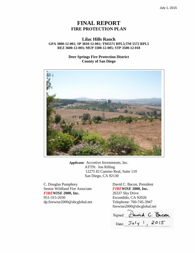
July 1, 2015
FINAL REPORT FIRE PROTECTION PLAN
Lilac Hills Ranch GPA 3800-12-001; SP 3810-12-001; TM5571 RPL5;TM 5572 RPL5
REZ 3600-12-003; MUP 3300-12-005; STP 3500-12-018
Deer Springs Fire Protection District
County of San Diego
Applicant: Accretive Investments, Inc.
ATTN: Jon Rilling
12275 El Camino Real, Suite 110
San Diego, CA 92130
C. Douglas Pumphrey David C. Bacon, President
Senior Wildland Fire Associate FIREWISE 2000, Inc.
FIREWISE 2000, Inc. 26337 Sky Drive
951-315-2030 Escondido, CA 92026
[email protected] Telephone: 760-745-3947

July 1, 2015
FIREWISE 2000, INC. Lilac Hills Ranch Fire Protection Plan iii
TABLE OF CONTENTS
1.0 INTRODUCTION ................................................................................................................ 1
Project Location ....................................................................................................... 1 1.1
Project Description ................................................................................................... 3 1.2
General Land Use Designations, Land Uses and Site Improvements. ................ 4 1.3
Environmental Setting ............................................................................................. 4 1.4
2.0 GUIDELINES FOR THE DETERMINATION OF SIGNIFICANCE ........................... 9
People and Structures Exposure to Fire ................................................................ 9 2.1
Fire Apparatus Access Roads .................................................................................. 9 2.2
Water Supply .......................................................................................................... 10 2.3
Ignition Resistant Construction and Fire Protection Systems. .......................... 10 2.4
3.0 ANTICIPATED FIRE BEHAVIOR IN THE VICINITY .............................................. 10
On-Site Vegetation ................................................................................................. 12 3.1
3.2 Off-Site Vegetation .................................................................................................. 12
Wildland Fire Behavior Assessment ..................................................................... 14 3.3
4.0 MITIGATION MEASURES AND DESIGN CONSIDERATIONS ............................. 19
Adequate Emergency Services .............................................................................. 20 4.1
Fire Apparatus Access ........................................................................................... 28 4.2
Water Supply .......................................................................................................... 32 4.3
Defensible Space and Vegetation Management ................................................... 33 4.4
Fuel Modification Zone(s) for This Development ............................................... 34 4.5
Ignition Resistant Construction and Fire Protection -Residential .................... 39 4.6
Protection of Commercial and Civic Structures, School, Senior Citizen 4.7
Neighborhood and Other Facilities and Emergency Trail Access .................. 41
Additional Requirements ....................................................................................... 44 4.8
Fuel Treatment Location Map .............................................................................. 44 4.9
5.0 CONCLUSIONS ................................................................................................................. 44
Emergency Response .............................................................................................. 45 5.1
Emergency Road Access ........................................................................................ 45 5.2
Fire-Resistive Building Materials ......................................................................... 45 5.3
Fuel Management Zones ........................................................................................ 46 5.4
Cumulative Impact Analysis ................................................................................. 46 5.5
6.0 LIST OF PREPARERS, PERSONS, AND ORGANIZATIONS CONTACTED ........ 47
List of Preparers ..................................................................................................... 47 6.1
List of Persons Contacted During the Course of this Project ............................ 47 6.2

July 1, 2015
FIREWISE 2000, INC. Lilac Hills Ranch Fire Protection Plan iv
LIST OF FIGURES
Figure 1 - Vicinity Map ................................................................................................................. 2
Figure 2 - Fire History Map ......................................................................................................... 8
Figure 3 – Aerial Photo Illustrating Adjacent and Contiguous Off-Site Land Uses on
Northeast Corner of Property .................................................................................. 15
Figure 4 - Emergency Service Routes Map ............................................................................... 28
Figure 5 - Illustration of Defensible Space Zones ..................................................................... 34
LIST OF TABLES
Table 1 – Fire Scenario 1 Summary .......................................................................................... 18
Table 2 – Fire Scenario 2 Summary .......................................................................................... 18
Table 3 – Fire Scenario 3 Summary .......................................................................................... 18
Table 4 – Fire Scenario 4 Summary .......................................................................................... 18
Table 5 – Fire Scenario 5 Summary .......................................................................................... 19
Table 6 - 2005 – 2011 Response Data Summary for Deer Springs Fire Protection
District.......................................................................................................................... 21
Table 7 – Proposed Emergency Travel Distance and Times Summary ................................. 25
TECHNICAL REFERENCES
APPENDIX A ............................................................................................................................ - 1 -
APPENDIX B ................................................................................................................................. 1
Undesirable Plant List ..................................................................................................................... 1
APPENDIX C .............................................................................................................................. 6-1
Literature Referenced in this FPP ................................................................................................ 6-1
APPENDIX D ................................................................................................................................. 1
Behaveplus Version 4.0.0 ................................................................................................................ 1
Fire Behavior Calculations .............................................................................................................. 1
APPENDIX E .................................................................................................................................. 1
Project Facility Availability Forms ................................................................................................. 1
(Fire and Water) .............................................................................................................................. 1
APPENDIX F .................................................................................................................................. 1
Weather Summary Charts ............................................................................................................... 1
APPENDIX G ................................................................................................................................. 1
Lilac Hills Ranch Phasing Plan ....................................................................................................... 1
and 1
Lilac Hills Ranch Internal Circulation Map ............................................................................ 1
and 1
Lilac Hills Ranch Access Exhibit .................................................................................................... 1
APPENDIX H ................................................................................................................................. 1
Fuel Modification and ..................................................................................................................... 1

July 1, 2015
FIREWISE 2000, INC. Lilac Hills Ranch Fire Protection Plan v
Agriculture Within RPO Wetland ................................................................................................... 1
Or Wetland Buffer ........................................................................................................................... 1
APPENDIX I ................................................................................................................................... 1
Specific Plan – Site Plan ................................................................................................................. 1
APPENDIX J ................................................................................................................................... 1
Flammap Analysis - Dudek ............................................................................................................. 1
APPENDIX K ............................................................................................................................... 13
2005 – 2011 Response Data for Deer Springs Fire Protection District ........................................ 14
APPENDIX L .................................................................................................................................. 1
Automatic Aid Agreement Between Deer Springs Fire Protection District and North .................. 1
County Fire Protection District ....................................................................................................... 1
APPENDIX M ............................................................................................................................. 6-A
County of San Diego-Department of Purchasing and Contracting — Contract 515388 ........... 6-A
Amendment No. 2 – Deer Springs .............................................................................................. 6-A
Fire Protection District For Use .................................................................................................. 6-A
of Fire Protection Funds .............................................................................................................. 6-A
APPENDIX N .............................................................................................................................. 6-J
FUEL MODIFICATION ZONES ANALYSIS – DUDEK ......................................................... 6-J
Fuel Modification Zones .............................................................................................................. 6-J
APPENDIX O ............................................................................................................................... 12
Trails Plan - Phase 1 Access Points Map ...................................................................................... 12
APPENDIX P .................................................................................................................................. 2
Lilac Hills Ranch ............................................................................................................................. 2
Road Standard Comparison Matrix ................................................................................................. 2
EXHIBIT 1 ...................................................................................................................................... 1
FUEL TREATMENT LOCATION MAP ....................................................................................... 1
EXHIBITS
EXHIBIT 1: Fuel Treatment Location Map

July 1, 2015
FIREWISE 2000, INC. Lilac Hills Ranch Fire Protection Plan vi
EXECUTIVE SUMMARY
This Fire Protection Plan (FPP) for the proposed Lilac Hills Ranch development has been prepared to
evaluate the level of potential fire hazard affecting or resulting from the proposed project and the
methods and measures proposed to minimize that hazard. The FPP identifies and prioritizes the
measures necessary to adequately reduce the fire risks of the project. The FPP also evaluated the
consistency of the proposed project with applicable fire protection regulations. The FPP has
considered the property location, topography, geology, combustible vegetation (fuel types), climatic
conditions, and fire history. It considers water supply, access, structure ignitability, fire resistive
building materials for residential structures, technical guidance for protection of commercial
structures, fire protection systems and equipment, impacts to existing emergency services, defensible
space, and vegetation management.
The proposed Lilac Hills Ranch community is a 608 acre mixed use pedestrian oriented sustainable
community, comprised of 59 contiguous properties within the northern unincorporated area of San
Diego County approximately one quarter mile from the Interstate 15 corridor on the east side with
freeway access off the Old Hwy 395 interchange. The project site is located to the south and west of
West Lilac Road with State Route 76 to the north, downtown Valley Center 10 miles to the east,
downtown Escondido 16 miles to the south, and Interstate 15 and Old Highway 395 to the west (see
Figure 1). The Lilac Hills Ranch project is located entirely in the Escondido zip code (92026) and
primarily within the westernmost portion of the Valley Center Community Planning Area (CPA),
although a small portion is within the Bonsall Subregional Plan Area. From the northwest project
corner, West Lilac Road serves as the northern and eastern boundary of the project site, while Circle
R Drive is less than a 1/2 mile south of the project Boundary. From the southwest project corner, the
western boundary of the project runs along Shirey Road and extends to Standel Lane, which serves as
the northwestern project boundary. The project is within Township 10 South, Range 3 West, Section
24, and Township 10 South, Range 2 West, Sections 19 and 30, on the USGS 7.5' Pala and Bonsall
quadrangles.
The proposed Specific Plan includes a residential component consisting of 1,746 homes with an
overall density of less than 2.9 dwelling units per acre (du/ac). This project is planned to be
constructed in five phases. Agreements for emergency service are based on phasing, occupied units,
and call volume demand thresholds. Planned phasing and land use categories are presented in
APPENDIX ‘I’. The proposed Specific Plan includes varying lot sizes, a neighborhood-serving
commercial village center, an active park/village green, retail uses, and a school site. Also, proposed
on-site are a recycling and buy back facility; a water reclamation facility; active orchards and other
supporting infrastructure. A rezone is proposed to implement the Specific Plan by changing the
existing Use Regulations, Development Regulations, and Special Residential Land Use Designation
and the A70 (Limited Agricultural) Zoning. The project would also include the submittal of a Master
Tentative Map, Implementing Tentative Map, Site Plan (s) and/or Major Use Permit(s).

July 1, 2015
FIREWISE 2000, INC. Lilac Hills Ranch Fire Protection Plan Page 7 of 130
The Deer Springs Fire Protection District (DSFPD) encompasses the entire site within its boundaries,
and the applicant will work with the nearby fire agencies, including DSFPD and CAL FIRE to
provide fire service for the project. This FPP must be submitted to the Deer Springs Fire Protection
District (DSFPD) and the San Diego County Department of Planning and Land Use (DPLU) for
review and comments. It provides a proposed menu of fire protection requirements which would be
imposed when each lot within a phase is developed, and recommends standards that will guide
detailed design for each phase of development and each lot within each phase.
This plan is consistent with DSFPD‘s Ordinance No. 2010-01 (District Standards) and County
guidance and referenced material in the 2014 San Diego County Consolidated Fire Code, the 2010
Guidelines for Determining Significance and Report Format Content Requirements-Wildland Fire
and Fire Protection, and applicable State of California requirements. All detailed phase plans shall
comply with the requirements of the County Consolidated Fire and Building Codes. The Valley
Center Municipal Water District will serve the water needs for this general commercial and
residential project. This water supply will meet the requirements of the County Consolidated Fire
Code and the County of San Diego Fire Code (Fire Code) for a commercial/business/residential
development.
In addition, this FPP provides fuel modification requirements to mitigate the exposure of people or
structures to a significant risk of loss, injury or death from wildland fires. Fuel modification will be
achieved by removing, clearing, or modifying combustible vegetation and other flammable materials
from the edge outward from all structures in accordance with the County Consolidated Fire Code and
with approval of DSFPD. Where the standard 100 feet of fuel modification cannot be met entirely
within the boundary of the project or where adjacent to preserved interior native fuels, alternative
measures that achieve the same level of protection as fuel modification are proposed, as allowed
underthe fire code, including, but not limited to: 1) utilization of adjacent irrigated and managed
agricultural crops (orchards, commercial flower fields, etc.) as a dual-purpose fuel modification/crop
production area; 2) customized fuel modification zones based on site-specific fire behavior modeling
and fire environment analysis (i.e., areas with flat terrain, grass or other light fuels, justify reduced
fuel modification areas); 3) enhanced ignition-resistant construction methods and the use of other
non-combustible features, i.e., parking lots, sidewalks, concrete patios, decorative rock, natural
boulders on-site, and similar landscape features; and 4) fire-barrier walls where structures face off-
site native flammable fuels along the northeast, northwest, and southwest boundary.
Ignition-resistant construction required by the 2013 State of California Building Code, Chapter 7A
for all structures, will provide significant protection in this very high fire hazard zone. Ignition-
resistant construction requirements provide critical structure improvements for surviving a worst case
scenario fire. Also, the FPP requires that ignition-resistant construction would apply to mitigate the
ignitability of all future proposed structures and projections (exterior balconies, carports, decks, patio
covers, unenclosed roofs and floors).
Lastly, plant species used in the landscape must follow those listed in the approved plant list in
APPENDIX ‘A’ – San Diego County Approved Plant List For High Fire Hazard Areas. Highly
flammable, non-fire resistive vegetation will be removed and prohibited from being replanted within

July 1, 2015
FIREWISE 2000, INC. Lilac Hills Ranch Fire Protection Plan Page 8 of 130
the fuel modification areas. Three specific non-fire resistive plants that will not be permitted to grow
in the Fuel Management Zones, even as specimen plants, because of their flammability, are as
follows:
California sagebrush, Artemisia californica;
Flat-topped buckwheat, Eriogonum fasciculatum; and
Black sage, Salvia mellifera.
July 1, 2015
FIREWISE 2000, INC. Lilac Hills Ranch Fire Protection Plan Page 1 of 130
FIRE PROTECTION PLAN
Lilac Hills Ranch Project GPA 3800-12-001; SP 3810-12-001; TM5571 RPL5;TM 5572 RPL5
REZ 3600-12-003; MUP 3300-12-005; STP 3500-12-018
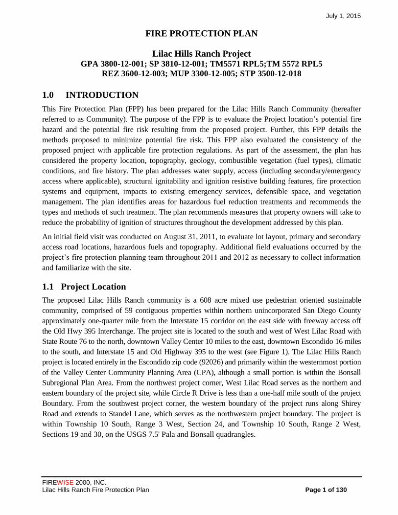
1.0 INTRODUCTION
This Fire Protection Plan (FPP) has been prepared for the Lilac Hills Ranch Community (hereafter
referred to as Community). The purpose of the FPP is to evaluate the Project location’s potential fire
hazard and the potential fire risk resulting from the proposed project. Further, this FPP details the
methods proposed to minimize potential fire risk. This FPP also evaluated the consistency of the
proposed project with applicable fire protection regulations. As part of the assessment, the plan has
considered the property location, topography, geology, combustible vegetation (fuel types), climatic
conditions, and fire history. The plan addresses water supply, access (including secondary/emergency
access where applicable), structural ignitability and ignition resistive building features, fire protection
systems and equipment, impacts to existing emergency services, defensible space, and vegetation
management. The plan identifies areas for hazardous fuel reduction treatments and recommends the
types and methods of such treatment. The plan recommends measures that property owners will take to
reduce the probability of ignition of structures throughout the development addressed by this plan.
An initial field visit was conducted on August 31, 2011, to evaluate lot layout, primary and secondary
access road locations, hazardous fuels and topography. Additional field evaluations occurred by the
project’s fire protection planning team throughout 2011 and 2012 as necessary to collect information
and familiarize with the site.
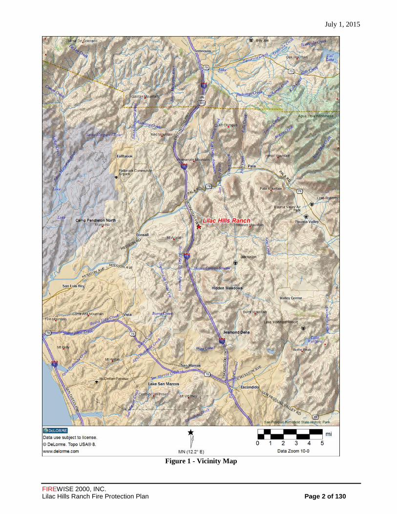
Project Location 1.1
The proposed Lilac Hills Ranch community is a 608 acre mixed use pedestrian oriented sustainable
community, comprised of 59 contiguous properties within northern unincorporated San Diego County
approximately one-quarter mile from the Interstate 15 corridor on the east side with freeway access off
the Old Hwy 395 Interchange. The project site is located to the south and west of West Lilac Road with
State Route 76 to the north, downtown Valley Center 10 miles to the east, downtown Escondido 16 miles
to the south, and Interstate 15 and Old Highway 395 to the west (see Figure 1). The Lilac Hills Ranch
project is located entirely in the Escondido zip code (92026) and primarily within the westernmost portion
of the Valley Center Community Planning Area (CPA), although a small portion is within the Bonsall
Subregional Plan Area. From the northwest project corner, West Lilac Road serves as the northern and
eastern boundary of the project site, while Circle R Drive is less than a one-half mile south of the project
Boundary. From the southwest project corner, the western boundary of the project runs along Shirey
Road and extends to Standel Lane, which serves as the northwestern project boundary. The project is
within Township 10 South, Range 3 West, Section 24, and Township 10 South, Range 2 West,
Sections 19 and 30, on the USGS 7.5' Pala and Bonsall quadrangles.
July 1, 2015
FIREWISE 2000, INC. Lilac Hills Ranch Fire Protection Plan Page 2 of 130
Figure 1 - Vicinity Map

July 1, 2015
FIREWISE 2000, INC. Lilac Hills Ranch Fire Protection Plan Page 3 of 130
Project Description 1.2
The proposed Specific Plan includes a residential component consisting of 1,746 homes with an
overall density of approximately 2.9 dwelling units per acre (du/ac). However, the project is planned
to be constructed in five phases. Thus, the delivery of emergency service is based on phasing,
occupied units, and/or call volume demand thresholds. Planned phasing and Roadway Circulation are
presented in APPENDIX ‘G’ – Phasing Exhibit and Roadway Circulation.
Phase 1 would include construction of approximately 352 dwelling units along with parks and
roadways. Completion of Phase 1 would result in an estimated 995 persons living in the community.
Phase 2 includes 466 dwelling units along with commercial, retail, office, civic center, information
center and a 50-room Country Inn. Estimated population increase for residents is 1,384 persons.
Phase 3 would include 460 dwelling units and a recreational facility, commercial, water reclamation,
and a school. Estimated population of residents is 1,352 persons. Phase 4 includes construction of
171 dwelling units, single family senior, group care, and a senior center. Estimated resident
population is 818 persons. Phase 5 includes 297 single family senior housing dwelling units with an
estimated population of 549 persons. Total estimated number of residents is 5,098 persons.
The highest density is located in the Town Center (Phase 2). The Specific Plan includes a Town
Center and two smaller Neighborhood Centers permitting 90,000 square feet of retail, commercial
and office uses, a 174-acre Senior Citizen neighborhood component (Phases 4 and 5) which includes:
market rate residential housing (a total of 468 du included in the 1,746 du above), and Group
Residential and Group Care living facilities (Phase 4).
The Community also includes a park system with one public park and multiple private parks, public
trails, and a K-8 school site. Also, proposed within the Community are a Recycling Facility; a Water
Reclamation Facility; and other supporting infrastructure (varying phases). The Community’s open
space system is proposed to retain some of the existing citrus and avocado groves within the
disturbed areas, along with 104.1 acres of sensitive biological/wetland habitat.
The project proposes a 20.6-acre mixed-use commercial Town Center, near the center of the
Community (Phase 2). The Community also proposes two Neighborhood Centers and a 12-acre
school site is proposed within the Specific Plan project area (Phase 3). A Recycling Facility will be
provided on-site per Section 6970-b of the Zoning Ordinance and an on-site Water Reclamation
Facility are planned (Phase 3).
The Lilac Hills Ranch Specific Plan Map shows the Community divided into multiple Planning Areas
(excluding areas designated for open space, roads, common areas, slopes, etc) with 19 types of land
uses ranging from Single Family Detached to Manufactured Slopes. The Phasing Map (APPENDIX
‘G’ - Phasing Plan with Roadway Circulation) shows how the Community has been divided into five
phases with Phase 1 at the north and Phase 5 in the southeast corner of the Community. The
following table shows the Land Use Summary by Phase provides a detailed breakdown by Phase, for
each of the land use types, including acreage numbers and, where appropriate, number of dwelling
units.
July 1, 2015
FIREWISE 2000, INC. Lilac Hills Ranch Fire Protection Plan Page 4 of 130
General Land Use Designations, Land Uses and Site Improvements. 1.3
The project is located entirely within the Deer Springs Fire Protection District (DSFPD) and DSFPD
is the Fire Authority Having Jurisdiction (FAHJ). This FPP was submitted to DSFPD and the San
Diego County Department of Planning and Land Use (DPLU), in accordance with the San Diego
County requirements. The FPP describes the requirements and standards that will be imposed on the
development. This plan is consistent with County guidance and referenced material in the 2014 San
Diego County Consolidated Fire Code, the 2010 Guidelines for Determining Significance
Significance and Report Format Content Requirements-Wildland Fire and Fire Protection, and
applicable State of California requirements. All detailed phase plans shall comply with the then-
current requirements of the County Fire and Building Codes at the time they are submitted. Detailed
site plans for each lot shall reference and include the recommendations and standards in this plan as
may be modified to address the actual proposed development. All detailed site plans shall comply
with the then-current requirements of the District and County Fire and Building Codes at the time
they are submitted.
The Community is located entirely within the boundaries of the Valley Center Municipal Water
District (VCMWD). Imported water and sewer service would be provided by the Valley Center
Municipal Water District. In order to provide sewer service, the project may complete one of the
following: construct a new water reclamation facility on-site, or use the existing Lower Moosa
Canyon Water Reclamation Facility (P73-018) located south of the project site off Circle R Drive.
The extension of sewer and water utilities will be required by the project.
Environmental Setting 1.4
The project vicinity includes larger parcel (1 acre and larger) single family residences in a rural/semi-
rural area dominated by small agricultural operations. The area’s native fuel beds have been largely
converted to irrigated agriculture with remnant native fuels in a patchy mosaic across the landscape.
In general terms, the Community and adjoining properties are similar in topography, and dominated
by irrigated and maintained agricultural vegetation, including floricultural species, avocado, citrus,
and small amounts of other agricultural resources, orchards and small riparian woodland. The area is
best categorized as a wildland urban intermix (structures are intermixed with wildland fuels) where
no consistent interface is present. Most of the area includes landscapes that support low to highly
flammable vegetation. The following sections discuss the surrounding land use, topography, climate,
vegetation, and fire history.

July 1, 2015
FIREWISE 2000, INC. Lilac Hills Ranch Fire Protection Plan Page 5 of 130

July 1, 2015
FIREWISE 2000, INC. Lilac Hills Ranch Fire Protection Plan Page 6 of 130
Topography and Uses 1.4.1
The topography of the area consists of a series of rolling hills dissected by drainage courses and a
valley bottom that drain primarily to the south and southwest. Elevations across the site range from
960 feet MSL at the highest to 590 feet MSL at the lowest. The drainage courses on the site convey
storm water and urban/agricultural runoff. Both intermittent and ephemeral drainages occur on the
site.
The major drainage courses (wetlands) and steeper slopes will be placed into open space easements
with each phase of development. The largest of the drainage courses are located primarily along the
western boundary and involve phases 1, 2 and 3 of the development. Two other major drainages are
within Phases 4, and 5. See APPENDIX ‘I’ – Specific Plan-Site Plan for the location of the proposed
open space on-site. Terrain affects fire behavior and the types of fire protection features that will be
required. For example, the steeper slope areas allow faster combustion of fuel in the upslope
direction. As a general rule with other factors constant, it can be assumed that the steeper slopes on-
site would contribute to faster fire speed.
Climate 1.4.2
The County is divided into five climate zones from the coast to the desert: Maritime, Coastal,
Transitional, Interior, and Desert (Climate Zones in San Diego County, Guidelines for Determining
Significance, Wildland Fire and Fire Protection). These climate zones are determined by several
factors: proximity to the ocean, terrain, elevation, and latitude. Southern California has a
Mediterranean climate, characterized by mild, sometimes wet winters and warm, very dry summers.
The Mediterranean climate includes all coastal areas, valleys and foot hills. Annual precipitation
amounts increase gradually from the coast to the mountain crests, then drop dramatically into the
deserts. Most precipitation comes from winter storms between November and March. The Lilac Hills
Ranch site is located in the transitional climate zone. The Valley Center RAWS station is the nearest
RAWS station within the Transitional climate zone.
The following chart represents the typical weather of a hot summer day in the Transitional Climate
Zone, Santa Ana and “peak” (or worst case fire weather/climate conditions) elements for this Fire
Protection Plan:
Period Temperature Relative
Humidity
Sustained
Wind Speed
Burning
Index (99%)
Summer 90-109°F 10-14% 19 mph 119
Santa Ana 90-109°F 5-9% 28 mph 145
Peak 90-109°F 5-9% 41 mph
The BehavePlus 4.0.0 Fire Modeling Program (to be discussed later in this plan) utilizes fuel
moisture levels in both live and dead vegetation, projected wind, topography and vegetation type to
determine fire behavior. Temperature is not an input. Large fires may occur at much lower
temperatures than shown above. Relative humidity of less than 5 percent may also occur.

July 1, 2015
FIREWISE 2000, INC. Lilac Hills Ranch Fire Protection Plan Page 7 of 130
The Burning Index listed above is an indicator of the relative difficulty of fire control and is part of
the National Fire Danger Rating Program. The higher the number, the more intense and severe a
wildfire would be burning under the weather conditions described.
Mean precipitation for the Lilac Hills Ranch site is 11.38 inches per year and the mean average air
temperature for the site for a year is approximately 63 degrees. The mean maximum wind gusts are
41 mph, with gusts of 100 mph recorded during the 2007 Rice Fire. Wind gusts, precipitation and
temperature, particularly in a regional context, will significantly impact wildland fire.
The most critical fire weather wind pattern in the project area would be an off-shore wind from the
north/northeast, typically referred to as a Santa Ana wind. Such wind conditions are usually
associated with strong (> 60-MPH), hot, dry winds with very low (<15%) relative humidity. Santa
Ana winds are caused by high-pressure weather systems and can occur any time of the year.
However, they generally occur in the late fall (September through November). This is also when non-
irrigated vegetation is at its lowest moisture content.
The typical prevailing summer time wind pattern is out of the south or southwest and normally is of a
much lower velocity (5-19 MPH with occasional gusts to 30-MPH). It is associated with higher
relative humidity readings (> 30% and frequently more than 60%) due to a moist air on-shore flow
from the ocean.
All other (northwest, south, west) wind directions may be occasionally strong and gusty. However,
they are generally associated with cooler, moist air and often have higher relative humidity (> 40%).
They are considered a serious wildland fire weather condition when wind speeds reach > 20 MPH.
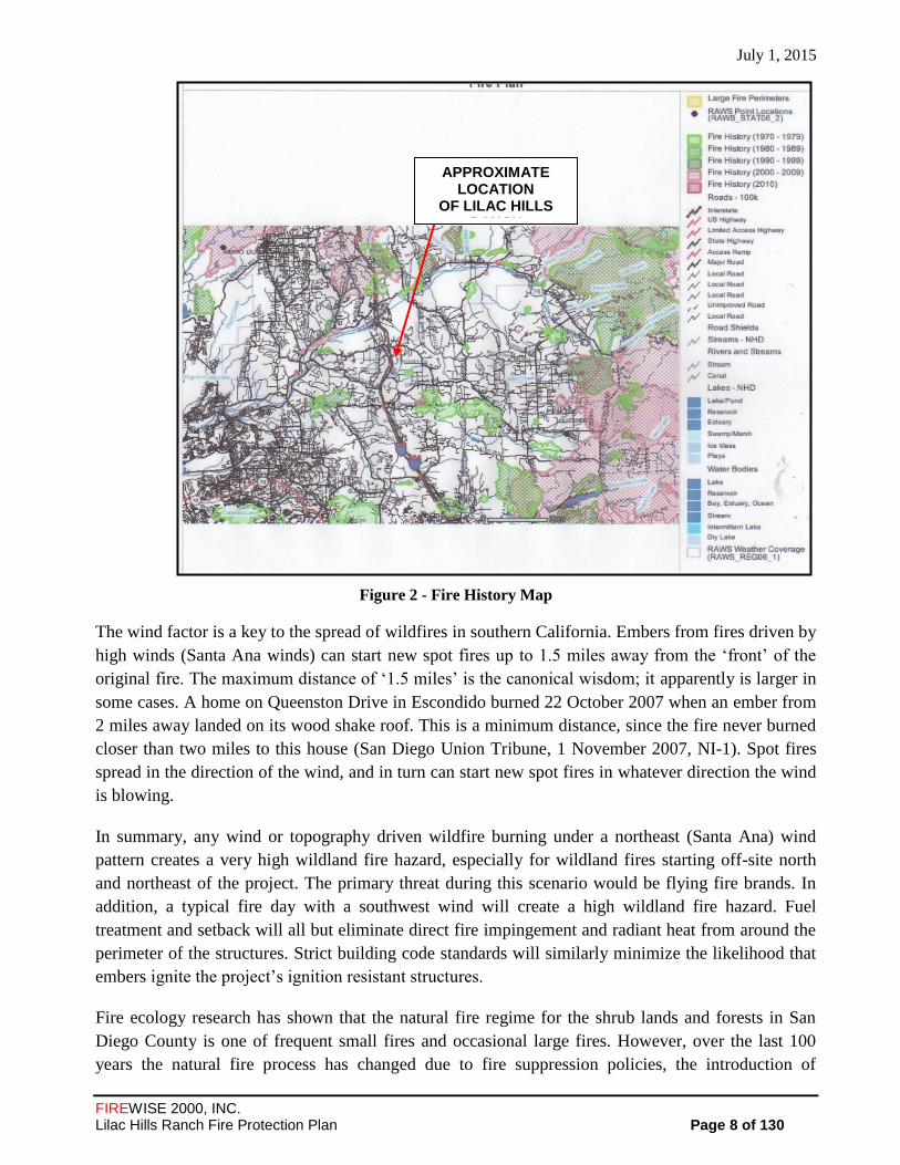
Fire History 1.4.3
This general area has a history of burning from wildland fires, as does most of the County. A fire
history map was created by utilizing the California Fire Planning and Mapping Tools, available from
the California Fire Alliance web site at http://cafirealliance.org/ (See Figure 3). This map only
contains large (100+ acres) wildfires unless there were unusual circumstances. This information helps
determine the frequency of wildfire and the likely vegetation cover during such events. For fire
behavior planning purposes, climax vegetation (Fuel Model SCAL18 & FM sh7) is utilized for worst
case scenarios. FIREWISE 2000, Inc. did not find that any large fires burned the project area in the
last 50 years. The data indicates that in the last 50 years, there have been several large fires around
the project site to the north, east and south (see Figure 3). For example, the Rice Fire of 2007 burned
9,472 acres during a worst case wildfire scenario.
July 1, 2015
FIREWISE 2000, INC. Lilac Hills Ranch Fire Protection Plan Page 8 of 130
Figure 2 - Fire History Map
The wind factor is a key to the spread of wildfires in southern California. Embers from fires driven by
high winds (Santa Ana winds) can start new spot fires up to 1.5 miles away from the ‘front’ of the
original fire. The maximum distance of ‘1.5 miles’ is the canonical wisdom; it apparently is larger in
some cases. A home on Queenston Drive in Escondido burned 22 October 2007 when an ember from
2 miles away landed on its wood shake roof. This is a minimum distance, since the fire never burned
closer than two miles to this house (San Diego Union Tribune, 1 November 2007, NI-1). Spot fires
spread in the direction of the wind, and in turn can start new spot fires in whatever direction the wind
is blowing.
In summary, any wind or topography driven wildfire burning under a northeast (Santa Ana) wind
pattern creates a very high wildland fire hazard, especially for wildland fires starting off-site north
and northeast of the project. The primary threat during this scenario would be flying fire brands. In
addition, a typical fire day with a southwest wind will create a high wildland fire hazard. Fuel
treatment and setback will all but eliminate direct fire impingement and radiant heat from around the
perimeter of the structures. Strict building code standards will similarly minimize the likelihood that
embers ignite the project’s ignition resistant structures.
Fire ecology research has shown that the natural fire regime for the shrub lands and forests in San
Diego County is one of frequent small fires and occasional large fires. However, over the last 100
years the natural fire process has changed due to fire suppression policies, the introduction of
APPROXIMATE LOCATION
OF LILAC HILLS RANCH
APPROXIMATE LOCATION OF LILAC HILL RANCH
DEVELOPMENT

July 1, 2015
FIREWISE 2000, INC. Lilac Hills Ranch Fire Protection Plan Page 9 of 130
invasive plant species that burn readily (i.e., eucalyptus and palm trees), and the increasing human
ignition sources from associated with building and living within the wildland-urban interface areas.
Thus, fires may occur at any time and in most areas of San Diego County, are occurring at higher
frequencies than historically. However, fire readiness and response capabilities have at least
maintained pace if not exceeded this rate, as evidenced by CAL FIRE’s 95% success rate at keeping
wildfires under 10 acres in size.
2.0 GUIDELINES FOR THE DETERMINATION OF SIGNIFICANCE
This FPP evaluates the fire hazard of the area and its potential affect on the project as well as the
potential increased hazard that may result from the proposed project. In addition, this FPP evaluates
the methods proposed to minimize potential hazard. This FPP also evaluates the consistency of the
proposed project with applicable fire protection regulations. As part of the assessment, the plan has
considered the property location, topography, geology, combustible vegetation (fuel types), climatic
conditions, and fire history. The plan addresses water supply, access (including secondary/emergency
access where applicable), solar structural ignitability, protection systems and equipment, impacts to
existing emergency services, and vegetation management.
The FPP will consider factors such as; the modification of fuels, fire access, water supply, the use of
ignition-resistant construction to protect people and structures from exposure to wildfire events, and
the fire service response capacity and response time. The FPP was prepared in accordance with the
County of San Diego Guidelines for Determining Significance for Wildfire and Fire Protection.
People and Structures Exposure to Fire 2.1
This FPP evaluates the proposed community and its survivability in a worst case scenario of northeast
winds with gusts of 60 MPH (Santa Ana winds) and ‘rare event’ 30-MPH southwest winds during a
wildland wildfire event in the area. It also documents fuel modification requirements in combination
with the non-combustible construction materials and other fire protections systems for the protection
of life and property within this proposed community.
Fire Apparatus Access Roads 2.2
The primary fire apparatus access roads to the Lilac Hills Ranch project will be via two
ingress/egress points to an upgraded West Lilac Road on the north side of the development. West
Lilac Road connects to Old Highway 395 to the west of the Community and continues eastward and
southward where it intersects with Circle R Drive. Each of these roads will be improved to Fire
District Standards and the County Consolidated Fire Code, complying with travel lane width, grade,
surface, radius, and other requirements.
The interior project road circulation will be will also be constructed to the Fire District Standards and
the County Consolidated Fire Code, which will provide unimpeded fire apparatus access throughout
the project.

July 1, 2015
FIREWISE 2000, INC. Lilac Hills Ranch Fire Protection Plan Page 10 of 130
An additional emergency ingress/egress road is provided to/from the southern portion of the project
via existing Mountain Ridge Road and Rodriguez Road. Mountain Ridge Road is accessed from
Circle R Drive, and Rodriguez Road is accessed via Covey Lane. All proposed roads are designed in
accordance with the County of San Diego Consolidated Fire Code. All roads will meet or exceed the
28 feet driveway minimum horizontal radius with a minimum proposed horizontal radius of 100 feet.
All proposed roads will meet or exceed the 20 percent allowable grade and meet or exceed the
minimum paved width requirement of 24 feet (14 feet lanes on roads with medians). See APPENDIX
“P” for road comparison matrix.
Water Supply 2.3
The Valley Center Municipal Water District has agreed to serve the water needs for this general
commercial and residential project. Therefore, the water supply meets fire emergency water needs,
including water sprinkler system (and meters) for all facilities on the project site. Hydrants will be
installed for each Phase prior to the allowance of combustibles on the active project site.
Ignition Resistant Construction and Fire Protection Systems. 2.4
This FPP evaluates ignition-resistant construction related to protecting new structures from an
approaching wildfire. These construction standards provide a high level of protection to structures
built in the wildland/urban interface area when completed in combination with other fire protections
systems within this proposed development.
3.0 ANTICIPATED FIRE BEHAVIOR IN THE VICINITY
As statutorily designated, fire severity is zoned as “Very High” Fire Severity for some portions of the
project vicinity, and “Moderate” for the remainder. These designations indicate that there is not a
consistent fuel bed and current land uses have interrupted and converted native fuels to lower
flammability/intensity land uses. Several scenarios were evaluated to determine the potential fire
behavior of a wildland fire that might occur in the vicinity of the Lilac Hills Ranch Project. Fire
Behavior calculations were used to assist in the determination of suitable fuel modification
requirements and adequate vegetation treatment and maintenance widths.
On-Site Vegetation 3.1
Historic. The historic vegetation on the majority of the proposed development boundaries includes
Coastal sage scrub, Southern coast live oak riparian woodland and southern mixed chaparral. These
vegetation types are characterized as high and very high load, dry climate brush. In these vegetation
types, a high percentage of dead material is typical in mature stands. This is due to the effects of the
local Mediterranean climate where warm wet winters promote new growth followed by long, hot and
very dry summer seasons which significantly affects plant moisture. Periodically, multi-year droughts
cause significant parts of these plants to die back. Though these plants are adapted to survive hot dry
summer seasons and extended drought, significant parts of these plants die back. All of these plants
July 1, 2015
FIREWISE 2000, INC. Lilac Hills Ranch Fire Protection Plan Page 11 of 130
are adapted to the intense wildfires for species regeneration, but the on-site, wildland fire threat is
largely is significant. With the development of the project and the conversion of lower flammable
vegetative fuels, the wildfire risk is significantly reduced. The fuels adjacent to the onsite fuels near
developed sites are a primary focus for fuel modification. These interior site native and agricultural
vegetated areas shall be mitigated with implementation of required fuel modification and fire
protection features outlined in this FPP.
For fire modeling purposes, these historic and dominant plant communities best characterize the
predominant fuel types that would tend to result in fire spread and were used for conservative-based
fire modeling purposes.
Existing. The existing condition is a result of disturbance from decades of agricultural activity. The
primary agricultural activities found in the immediate area include orchards, vineyards, row crops,
and nursery operations.
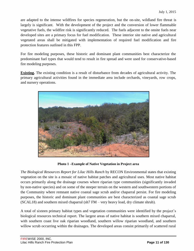
Photo 1 –Example of Native Vegetation in Project area
The Biological Resources Report for Lilac Hills Ranch by RECON Environmental states that existing
vegetation on the site is a mosaic of native habitat patches and agricultural uses. Most native habitat
occurs primarily along the drainage courses where riparian type communities (significantly invaded
by non-native species) and on some of the steeper terrain on the western and southwestern portions of
the Community where remnant native coastal sage scrub and/or chaparral persist. For fire modeling
purposes, the historic and dominant plant communities are best characterized as coastal sage scrub
(SCAL18) and southern mixed chaparral (sh7 FM – very heavy load, dry climate shrub).
A total of sixteen primary habitat types and vegetation communities were identified by the project’s
biological resources technical report. The largest areas of native habitat is southern mixed chaparral,
with southern coast live oak riparian woodland, southern willow riparian woodland, and southern
willow scrub occurring within the drainages. The developed areas consist primarily of scattered rural

July 1, 2015
FIREWISE 2000, INC. Lilac Hills Ranch Fire Protection Plan Page 12 of 130
residences with ornamental landscaping. Roughly 75% of the property is mapped as agriculture,
developed or disturbed.
The vegetation communities identified by the RECON survey identifies the vegetation on the project
site at present. In an undisturbed environment, the historic native vegetative communities would
predominately have been coastal sage scrub, southern coast live oak riparian woodland and mixed
southern chaparral. Therefore, in the absence of ongoing manipulations, these vegetation
communities would return over time. The anticipated exposure to natural fuels by the project will
remain in the planned open space areas within and adjacent the development. These open space
corridors will have the potential to result in fire spread, however, the project will restore some of the
open space areas to remove flammable non-native species (peppers, eucalyptus, palms, arrundo, etc),
will include higher fuel moistures due to drainage locations, and will include a maintenance
agreement to remove dead and dying vegetation as well as non-native species that may establish over
time. In addition, Fuel Management Zones (FMZs) supplemented by required fire protection features
would create acceptable wildfire protection for all structures within this development.
In summary, wind or topography driven wildfires burning under a northeastern (Santa Ana) wind
pattern from the north, northeast or east creates a moderate to high wildland fire hazard, especially
for wildland fires starting north and/or east of the project site. Also, a “rare event” 30 MPH southwest
wind will create a low to moderate wildland fire hazard. However, the vegetation on the north and
eastern exposure of the development are lighter fuels and adjacent to small rural residential parcels
and agricultural crops, resulting in reduced fire intensity and slower rates of spread. The worst case
on-site fuel loading scenario is found in the northwest, west, and southwest exposure. These
exposures are from planned fuel loads and steeper slopes. However, with the proposed fuel
modification treatments, fire protection features, “firewise” landscaping, and the use of ignition
resistive building construction standards, the wildfire threat will be mitigated to less than significant
levels. As a result, the potential loss of any structure due to direct flame impingement, wind driven
embers, or radiant heat around the perimeter of any planned inhabitable building is extremely low.
Although this project is not considered a shelter-in-place community, and the state-adopted “Ready,
Set, Go” policy for early evacuation will be thoroughly supported and promoted to all residents,
visitors and guests, there will be opportunities for residents to safely remain in their homes or another
on-site building/location should evacuation be considered too dangerous
Off-Site Vegetation 3.2
Historic. The historic vegetation communities listed as the dominant fuel loads would be similar to
the historic on-site vegetation. In a wildland fire the native vegetation provides the fuel, which
usually includes both living and dead vegetation. However, wildfire in the wildland urban intermix
areas is spread through both native and non-native vegetation as well as other combustible objects,
including older, vulnerable homes, outbuildings, and debris. Land uses and resulting vegetation on
adjacent properties consist of similar agricultural uses as those found on the majority of the project
site.

July 1, 2015
FIREWISE 2000, INC. Lilac Hills Ranch Fire Protection Plan Page 13 of 130
Existing. The off-site area surrounding the Lilac Hills Ranch presently consists of residential
communities with agricultural crops (orchards, vineyards, row crops, and nursery operations), and
interspersed islands of native vegetation.
Northern Boundary. There is a large area of native vegetation north of West Lilac Road located in
the Draft MSCP Pre-Approved Mitigation Area, single family dwellings, orchards, and other
agricultural activities. The fuel modification and hazard abatement associated with the existing single
family dwellings, agricultural activities, and a County maintained road provide significant protection
from wildfires along this boundary. The greatest risk from this exposure would be firebrands
generated from the area of native vegetation and/or the fuels associated with the existing single
family dwelling parcels to the north of West Lilac Road during a worst case scenario of late fire
season northeast Santa Ana Winds. As previously mentioned, firebrands/embers can be carried a long
distance (potentially one mile or more) by fire drafts or strong Santa Ana winds and may ignite the
on-site open space fuels or other combustible materials that are receptive to burning.
Eastern Boundary. The vegetation on the eastern exposure of the development has much lighter
fuels. Also, the eastern boundary of the development is adjacent to single family dwellings and with a
large portion contiguous to roads and road easements, and existing agriculture crops and activities
(orchards, commercial flower field and other agricultural activities). The road and managed and
irrigated agriculture provides significant fuel modification that results in less ignition prone
vegetation and reduced fire intensity and spread rates, resulting in sufficient mitigation from wildfires
along this boundary exposure.
Southern Boundary. The exposure along the eastern side of the southern boundary is part of a
narrow strip of disturbed southern willow scrub which occurs along a drainage course. On-site
agricultural activities, the placement of a church and attendant facilities, access roads, and adequate
space to provide fuel modification, will provide fire protection for this part of the southern boundary
exposure.
Western Boundary. A riparian woodland vegetation community occurs along most of the western
border of the main project area and along tributary east-west drainages in the central portions of the
site. Also, southern mixed chaparral vegetation occurs as large, relatively undisturbed patches in the
northwest, central, and southern portions of the project area on the western-facing slopes. Dominant
plant species for the southern mixed chaparral vegetation include chamise, mission manzanita, hoary-
leafed ceanothus, black sage, California buckwheat, and laurel sumac. A wildland fire threat for the
development would be from a fire approaching from the south, southwest or west exposures in off-
site and on-site highly flammable native and non-native vegetation along these exposures. This threat
would be the greatest during a typical late fire season with above average 30 MPH southwest wind
conditions. Fuel modification zones meeting code requirements, a non-combustible wall, roadways
and a maintained park facility will be applied along this boundary to provide the fire buffer required
to protect ignition-resistant structures along this exposure from late fire season wildfires during 30
MPH southwest wind conditions.
July 1, 2015
FIREWISE 2000, INC. Lilac Hills Ranch Fire Protection Plan Page 14 of 130
As state above, the agricultural related land uses and structural hazard abatement practices provide
significant fuel modification and fire protection buffers around the perimeter of the Lilac Hills Ranch
property and have been considered as part of the overall wildfire risk and need for full fuel
modification zones, consistent with San Diego County’s Guidelines for Determining Significance –
Wildland Fire and Fire Protection (2010). Figure 3 below illustrates the significance of fire buffers
which are provided by these adjacent and contiguous land uses along the north and northeast
boundary. This is particularly significant for fire protection during strong winds (Santa Ana Winds)
which occur in the late fire season.
Wildland Fire Behavior Assessment 3.3
3.3.1 Fuel Modeling
The minute by minute movement of a wildland fire is never totally predictable, and is certainly not
predictable from weather conditions forecast many hours before the fire. Nevertheless, practice and
experienced judgment in assessing the fire environment, coupled with a systematic method of
calculating fire behavior, yields surprisingly good results (Rothermel, 1983).
The primary driving force in the fire behavior calculations is the dead fuel, less than one-fourth inch
in diameter. These are the fine fuels that carry the fire. Fuels larger than 1/4-inch contribute to fire
intensity, but not necessarily to fire spread. The BehavePlus 4.0.0 fire model describes a wildfire
spreading through surface fuels, which are the burnable materials within six (6’) feet of the ground
and contiguous to the ground.
Fuels larger than three (3”) inches in diameter are not included in the calculations (Andrews 1986).
Regardless of the limitations expressed, experienced wildland fire managers can use the BehavePlus
4.0.0 modeling system to project the expected fire intensity (expressed as Btu/ft/sec), rate-of-spread
(feet/minute) and flame lengths (feet) with a reasonable degree of certainty for use in Fire Protection
Planning purposes. Of these three fire behavior projected flame length is the most critical in
determining structure protection requirements.

July 1, 2015
FIREWISE 2000, INC. Lilac Hills Ranch Fire Protection Plan Page 15 of 130
Figure 3 – Aerial Photo Illustrating Adjacent and Contiguous Off-Site Land Uses on Northeast Corner of Property
The BehavePlus 4.0.0 Fire Behavior Prediction and Fuel Modeling System by Patricia L. Andrews
and Collin D. Bevins is one of the best systematic methods for predicting wildland fire behavior. The
BehavePlus 4 0.0 fire behavior computer modeling system was developed by USDA–Forest Service
research scientists at the Intermountain Forest Fire Laboratory, Missoula, Montana, and is utilized by
wildland fire experts nationwide. Because the model was designed to predict the spread of a fire, the
fire model describes the fire behavior only within the flaming front. The results of the modeling
calculations are summarized in APPENDIX ‘E’.
The BehavePlus 4.0.0 Fire Modeling System has been used to predict the wildland fire behavior
(rate-of-spread, and flame length) for the northern and western boundary vegetative fuels. The
BEHAVE: Fire Behavior Prediction and Fuel Modeling System–Burn Subsystem, Part 1 by Patricia
L. Andrews, is one of the best systematic methods for predicting wildland fire behavior. The
BEHAVE fire behavior computer modeling system was developed by USDA–Forest Service research
scientists at the Intermountain Forest Fire Laboratory, Missoula, Montana, and is utilized by wildland
fire experts nationwide. Since the model was designed to predict the spread of a fire, the fire model
describes the fire behavior only within the flaming front.
The FIREWISE 2000, Inc. evaluation team used the computer based BehavePlus 4.0.0 Fire Behavior
Prediction Model to make the fire behavior assessments and projections for the hazardous vegetative
fuels on the areas in proximity to the proposed site for the Lilac Hills Ranch facility (see APPENDIX
‘E’ for actual calculations). Four (4) worst case fire scenarios are displayed based on ‘worst case’ fire
N
Lilac Hills Ranch
Approximate
Boundary
Adjacent and
Contiguous
Agricultural
Crops
Adjacent &
Contiguous
Roads/Road
Easements, Single
Family Dwellings &
Orchards With
Prescribed Hazard
Abatement &
Management

July 1, 2015
FIREWISE 2000, INC. Lilac Hills Ranch Fire Protection Plan Page 16 of 130
weather assumptions for the project area. Each fire scenario displays the expected Rate of Fire Spread
(expressed in feet per minute), Fire Line Intensity (expressed in BTU’s/foot/sec, and Flame Length
(expressed in feet). These fire behavior parameters are calculated for the following scenarios: 1)
untreated fuels in a worst case scenario northeast Santa Ana winds in coastal sage scrub fuel model,
2) treated fuels in late fire season northeast Santa Ana winds, 3) untreated fuels in above average 30
MPH southwest wind conditions in southern mixed chaparral, 4) treated fuels in above average 30
MPH southwest winds, 5) untreated fuels two in a worst case scenario for northeast Santa Ana winds
in southern mixed chaparral fuel model, and 6) treated fuels in northeast Santa Ana winds, 7)
untreated fuels in southwest 30 MPH southwest winds, and 8) treated fuels in 30 MPH southwest
winds. The Tables below include the calculation inputs used in the BEHAVE Plus program which
were obtained from project site observations and fuel levels typically observed during the local fire
season.
In order to provide wildland fire protection measures for this project, fire behavior parameters were
calculated for the hazardous native vegetation/fuels historically located on- and off-site. These
calculations will be the basis for recommended fuel modifications for the project site development.
The existing on-site and off-site fuels will also be considered in evaluating the wildfire threat to this
proposed development.
Normal weather conditions consist of an onshore flow from the southwest. This condition has a lower
temperature and higher humidity then does a Santa Ana condition. A fire under normal conditions is
typically a fuel driven fire. However, wind will also contribute to the rate of spread. A summer fire
coming from the southwest would be burning uphill and as a result would get a run on the project
site. The late fire season strong non-typical southwest winds and the late fire season northeast winds
(Santa Ana winds) create the dangerous and severe conditions for wildfires. Modification and/or
elimination of hazardous fuels and the reduction of fuel loading are key to “firewise” planning.
In order to project the fire behavior benefit for the proposed fuel modifications for the project, worst-
case scenarios were used in the modeling system to project fire behavior variables. Scenario 1 is a 60-
MPH northeast wind (Santa Ana winds) in the SCAL18 Fuel Model historic fuels and then expected
fire behavior in fuels that have been modified (treated) for favorable fire behavior variables within
this fuel load. Scenario 2 is a late fire season, strong, non-typical (30-MPH) southwest winds in the
SCAL 18 Fuel Model and the expected fire behavior after they have been modified (treated) for
favorable fire behavior variables within this this fuel load. Scenario 3 is a 60 MPH northeast wind in
the southern mixed chaparral fuel model and the expected fire behavior after fuel modification
(treated) in this fuel load. And, Scenario 4 is 30-MPH southwest wind in mixed chaparral fuel model
and the expected fire behavior after fuel modification in this fuel load.
The worst-case climate parameters and assumptions used for the fire behavior modeling process were
as follows:
1. 1-Hour Fine Fuel Moisture 2%
2. 10-Hour Fuel Moisture 3%

July 1, 2015
FIREWISE 2000, INC. Lilac Hills Ranch Fire Protection Plan Page 17 of 130
3. 100-Hour Fuel Moisture 5%
4. Live Herbaceous Fuel Moisture 30%
5. Live Fuel Moisture 50%
Other site characteristics used for Fire Behavior modeling are as follow:
Slopes. The existing slopes for the majority (approximately 91.2 percent) of the entire site range from
0 to 30 percent. This range of slopes includes 110 acres between 0 and 10 percent, 141.1 acres
between 10 and 15 percent, and 306.4 acres between 15 and 30 percent. There are also 54.5 acres
that are 30+ percent and are the steeper and more gullied locations generally in the west and
southwest area of the site (from Slope Analysis by Landmark Consulting). These steeper locations
would not be developed but would create an overall concern and fire threat to the development.
The range of on-site site slopes will change when the final grading is completed for the development.
The representative slope used with the fire behavior model for the slopes prior to development is 20
percent. The fire behavior model representative slope used for the final grading landscape is 10
percent. The exception is that the slopes on the western perimeter area is estimated to average 40
percent. The analysis in fire scenario 5 utilized this slope percentage.
Fuel Model. The majority of the on-site and off-site fuels is coastal sage scrub (SCAL 18) and
southern mixed chaparral, and will be used to represent the brush land vegetation predominately and
historically found on-site and off-site. The historic native fuels on the project site have been modified
significantly by past agricultural activity. However, for purposes of evaluating worst case scenario it
was assumed that the disturbance to the site were discontinued and the site would revert quickly to
some form of a disturbed coastal sage scrub community. In the majority of the areas used for
agricultural purposes over several decades, the vegetation would likely revert to disturbed lands or
non-native grassland.
3.3.2 Fire Behavior Modeling Summary
The following tables summarize the expected wildland fire behavior for the fuel model found within
and adjacent to the proposed LHR development under the worst case scenarios. Tables 2 thru 5
display the expected Rate of Fire Spread (expressed in feet per minute), Fireline Intensity (Btu/ft/sec)
and Flame length (feet) for four different BehavePlus 4.0.0 – Fire Behavior Prediction and Fuel
Modeling System fuel model computer calculations. All of these calculations are based on forecast
vegetation conditions of a typical SCAL 18 Fuel Model-Coastal Sage Scrub and Fuel Model sh7
(very heavy fuel load, dry climate Fuel Model). Variables were slope, projected wind speed, and
anticipated weather.
Four (4) different fire scenarios are presented based on “worst case” fire weather assumptions for the
project area. Each fire scenario displays the expected Rate of Fire Spread (expressed in feet per
minute), Fireline Intensity (expressed in British Thermal Units per foot per second) and Flame
Length (expressed in feet). For the longest flame lengths along the north and south exposures,
separate BehavePlus 4.0.0 predications were made for the treated fuels following the completion of
July 1, 2015
FIREWISE 2000, INC. Lilac Hills Ranch Fire Protection Plan Page 18 of 130
the required fuel modification work. The tables also include the calculation inputs used in the
BehavePlus 4.0.0 program which were obtained from project site observations and fuel moisture
levels typically observed during the local fire season.
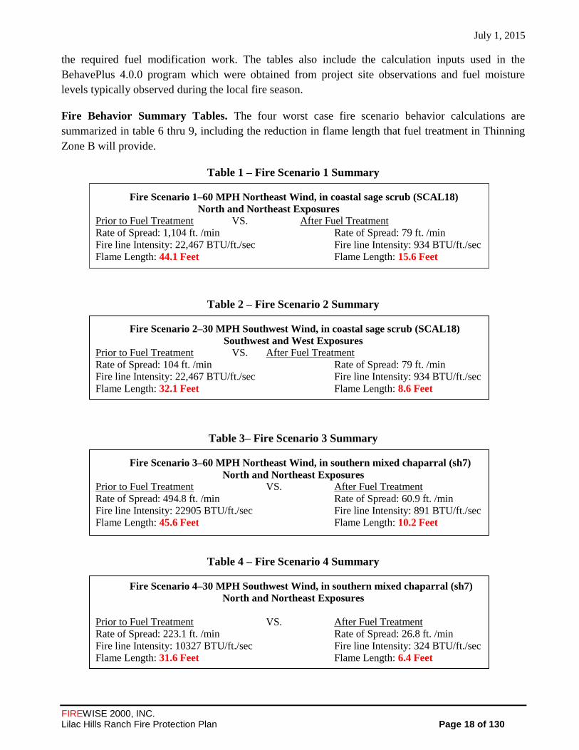
Fire Behavior Summary Tables. The four worst case fire scenario behavior calculations are
summarized in table 6 thru 9, including the reduction in flame length that fuel treatment in Thinning
Zone B will provide.
Table 1 – Fire Scenario 1 Summary
Fire Scenario 1–60 MPH Northeast Wind, in coastal sage scrub (SCAL18)
North and Northeast Exposures
Prior to Fuel Treatment VS. After Fuel Treatment
Rate of Spread: 1,104 ft. /min Rate of Spread: 79 ft. /min
Fire line Intensity: 22,467 BTU/ft./sec Fire line Intensity: 934 BTU/ft./sec
Flame Length: 44.1 Feet Flame Length: 15.6 Feet
Table 2 – Fire Scenario 2 Summary
Fire Scenario 2–30 MPH Southwest Wind, in coastal sage scrub (SCAL18)
Southwest and West Exposures
Prior to Fuel Treatment VS. After Fuel Treatment
Rate of Spread: 104 ft. /min Rate of Spread: 79 ft. /min
Fire line Intensity: 22,467 BTU/ft./sec Fire line Intensity: 934 BTU/ft./sec
Flame Length: 32.1 Feet Flame Length: 8.6 Feet
Table 3– Fire Scenario 3 Summary
Fire Scenario 3–60 MPH Northeast Wind, in southern mixed chaparral (sh7)
North and Northeast Exposures
Prior to Fuel Treatment VS. After Fuel Treatment
Rate of Spread: 494.8 ft. /min Rate of Spread: 60.9 ft. /min
Fire line Intensity: 22905 BTU/ft./sec Fire line Intensity: 891 BTU/ft./sec
Flame Length: 45.6 Feet Flame Length: 10.2 Feet
Table 4 – Fire Scenario 4 Summary
Fire Scenario 4–30 MPH Southwest Wind, in southern mixed chaparral (sh7)
North and Northeast Exposures
Prior to Fuel Treatment VS. After Fuel Treatment
Rate of Spread: 223.1 ft. /min Rate of Spread: 26.8 ft. /min
Fire line Intensity: 10327 BTU/ft./sec Fire line Intensity: 324 BTU/ft./sec
Flame Length: 31.6 Feet Flame Length: 6.4 Feet

July 1, 2015
FIREWISE 2000, INC. Lilac Hills Ranch Fire Protection Plan Page 19 of 130
Table 5 – Fire Scenario 5 Summary
Fire Scenario 5–30 MPH Southwest Wind, in southern mixed chaparral (sh7)
North and Northeast Exposures
Prior to Fuel Treatment VS. After Fuel Treatment
Rate of Spread: 236.2 ft. /min Rate of Spread: 28.0 ft. /min
Fire line Intensity: 10936 BTU/ft./sec Fire line Intensity: 342 BTU/ft./sec
Flame Length: 32.4 Feet Flame Length: 6.6 Feet
In addition to BehavePlus fire behavior modeling for this project, Dudek’s fire protection planners
completed a FlamMap Fire Behavior Modeling for the proposed development. FlamMap provides the
ability to model the anticipated fire behavior across a landscape based on site-specific data whereas
BehavePlus provides fire behavior predictions at specific point locations. Dudek’s analysis states that
wildfire behavior in chaparral fuel beds on and adjacent the Project site is expected to be of moderate
to high intensity during extreme, Santa Ana weather conditions with maximum sustained wind speeds
of 56 mph and low fuel moistures. Based on the observed fuel beds east of the project site, a
relatively high-intensity fire can be expected during extreme weather conditions, with flame lengths
reaching approximately 43 feet and peak intensity of over 20,000 Btu/ft/s. The report then states this
type of fire would be relatively short-duration as vegetative fuels are consumed rapidly, and there
would not be a sustained source of heat and or flame associated with site-adjacent wildland fuels. The
analysis further notes that the site’s fuels would be converted and reduced to ground cover on most of
the Project area, resulting in proportionately reduced fire behavior. The post-project fuel modification
areas would provide a significant reduction in the potential for fire ignition as well as the flame
length, spread rate, and intensity of fires should ignition occur (See APPENDIX ‘J’ – FlamMap
Analysis – Dudek 2013). 1
4.0 MITIGATION MEASURES AND DESIGN CONSIDERATIONS
The Lilac Hills Ranch development is planned to be completed in 5 phases (See APPENDIX ‘G’ –
Phasing Exhibit). For each implementing Tentative Map, defined as a map containing individual lots
that will be developed with structures that is submitted to the County for approval, will provide
mitigation measures and design considerations for those Implementing Tentative Map(s). For
example, the Implementing Tentative Maps for Phase 1 and 4 may be approved prior to
implementation of Phases 2, 3 and 5. The timing of construction for phases 2, 3 and 5 will be
determined at a later time but those Implementing Maps will then be submitted to the County for
approval of the mitigation measures and design considerations.
1 Dudek and Hunt Research Corporation were commissioned to conduct an assessment of the fire and emergency response
capabilities of Deer Springs Fire Protection District (DSFPD) and California Department of Forestry and Fire Protection (CAL FIRE) by Accretive Investments, Inc. This Assessment (Lilac Hills Ranch Fire Services Response Capabilities Assessment, March 2014; a t tached as appendix to the Spec i f ic P lan ), is referenced and used to support throughout this FPP.

July 1, 2015
FIREWISE 2000, INC. Lilac Hills Ranch Fire Protection Plan Page 20 of 130
Adequate Emergency Services 4.1
The Deer Springs Fire Protection District (DSFPD) is the Fire Authority Having Jurisdiction (FAHJ)
for the Project. The DSFPD was established pursuant to state law to provide an effective level of fire
protection and emergency medical services for the preservation of life and property within the
District in which Lilac Hills Ranch is located. The District covers an area of approximately 47 square
miles and serves a population estimated at 13,000. The District is funded through special District
assessments, County fees, and tax allocations and supplemented by State and Federal grants. There
are four fire stations located in the DSFPD; Station 11 (District Headquarters) at 8709 Circle R Drive,
Escondido, CA 92026, Station 12 at 1321 Deer Springs Road, San Marcos, CA 92069 , Station 13 at
10308 Meadow Glen Way East Escondido, CA 92026 and CAL FIRE Station 15 (Miller Station) at
9127 West Lilac Road, Escondido, CA 92026. Station 15 is the closest fire station, surrounded on
three sides by the project. Station 11 is the next closes fire station.
Firefighting services for the District are provided via contract by CAL FIRE (California Department
of Forestry and Fire Protection). DSFPD utilizes generated fire fees and assessments to contract with
CAL FIRE for staffing of its engines. In addition, DSFPD receives funding from the County to staff a
third firefighter position on two of its engines. Furthermore, the County provides funding to CAL
FIRE as part of the Amador Agreement to provide fire services during the offseason. APPENDIX
‘M’ provides the Automatic Aid Agreement between Deer Springs Fire Protection District and North
County Fire Protection District and APPENDIX ‘N’ is the County of San Diego-Department of
Purchasing and Contracting Contract 515388 Amendment no. 2 – Deer Springs Fire Protection
District for Use of Fire Protection Funds.
DSFPD Preparedness and Firefighting Capability Provided by the Deer Springs Fire
Protection District. Initial response to all fire, medical and associated emergencies within the
District, including the 14-mile stretch of Interstate 15, is the responsibility of the Deer Springs Fire
Protection District. The District currently provides staffing for the following resources within the
District:
A. 3-Type 1 Front Line Engines (one at Station 11, two at Station 13, and 1 at Station 12); two
reserve Type I engines (unstaffed, with one at Station 11, and one at Station 13)
B. 2-Type 3 Wildland Brush Engines (one located at Station 12 (not staffed) and one at CAL
FIRE Station 15 (Miller)
C. 1-Paramedic ALS (Advanced Life Support) ambulance is staffed and housed at DSFPD
Station 11under contract with Mercy Ambulance Service, Inc.
D. 23 Full-Time Firefighters
E. 1 District Administrative Employee
F. 1 Fire Prevention Specialist
G. 1 Chief
July 1, 2015
FIREWISE 2000, INC. Lilac Hills Ranch Fire Protection Plan Page 21 of 130
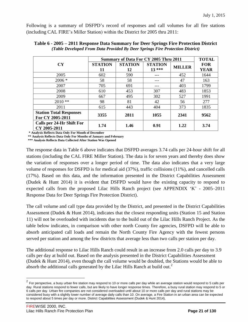
Following is a summary of DSFPD’s record of responses and call volumes for all fire stations
(including CAL FIRE’s Miller Station) within the District for 2005 thru 2011:
Table 6 - 2005 – 2011 Response Data Summary for Deer Springs Fire Protection District (Table Developed From Data Provided By Deer Springs Fire Protection District)
CY
Summary of Data For CY 2005 Thru 2011 TOTAL
FOR
YEAR
STATION
11
STATION
12
STATION
13 *** MILLER
2005 602 590 --- 452 1644
2006 * 58 58 --- 47 163
2007 705 691 --- 403 1799
2008 610 453 307 483 1853
2009 667 495 302 527 1991
2010 ** 98 81 42 56 277
2011 615 443 404 373 1835
Station Total Responses
For CY 2005-2011 3355 2811 1055 2341 9562
Calls per 24-Hr Shift For
CY 2005-2011 1.74 1.46 0.91 1.22 3.74
* Analysis Reflects Data Only For Month of December
** Analysis Reflects Data Only For Months of January and February
*** Analysis Reflects Data Collected After Station Was Opened
The response data in Table 6 above indicates that DSFPD averages 3.74 calls per 24-hour shift for all
stations (including the CAL FIRE Miller Station). The data is for seven years and thereby does show
the variation of responses over a longer period of time. The data also indicates that a very large
volume of responses for DSFPD is for medical aid (37%), traffic collisions (11%), and cancelled calls
(17%). Based on this data, and the information presented in the District Capabilities Assessment
(Dudek & Hunt 2014) it is evident that DSFPD would have the existing capacity to respond to
expected calls from the proposed Lilac Hills Ranch project (see APPENDIX ‘K’ - 2005–2011
Response Data for Deer Springs Fire Protection District).
The call volume and call type data provided by the District, and presented in the District Capabilities
Assessment (Dudek & Hunt 2014), indicates that the closest responding units (Station 15 and Station
11) will not be overloaded with incidents due to the build out of the Lilac Hills Ranch Project. As the
table below indicates, in comparison with other north County fire agencies, DSFPD will be able to
absorb anticipated call loads and remain the North County Fire Agency with the fewest persons
served per station and among the few districts that average less than two calls per station per day.
The additional response to Lilac Hills Ranch could result in an increase from 2.0 calls per day to 3.9
calls per day at build out. Based on the analysis presented in the District Capabilities Assessment
(Dudek & Hunt 2014), even though the call volume would be doubled, the Stations would be able to
absorb the additional calls generated by the Lilac Hills Ranch at build out.2
2 For perspective, a busy urban fire station may respond to 10 or more calls per day while an average station would respond to 5 calls per
day. Rural stations respond to fewer calls, but are likely to have longer response times. Therefore, a busy rural station may respond to 5 or 6 calls per day. Urban fire companies are not considered overloaded until about 10 or more calls per day and rural stations may be considered busy with a slightly lower number of average daily calls than 10. On average, a Fire Station in an urban area can be expected to respond about 5 times per day or more. District Capabilities Assessment (Dudek & Hunt 2014),
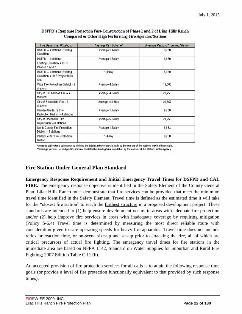
July 1, 2015
FIREWISE 2000, INC. Lilac Hills Ranch Fire Protection Plan Page 22 of 130
Fire Station Under General Plan Standard
Emergency Response Requirement and Initial Emergency Travel Times for DSFPD and CAL
FIRE. The emergency response objective is identified in the Safety Element of the County General
Plan. Lilac Hills Ranch must demonstrate that fire services can be provided that meet the minimum
travel time identified in the Safety Element. Travel time is defined as the estimated time it will take
for the “closest fire station” to reach the furthest structure in a proposed development project. These
standards are intended to (1) help ensure development occurs in areas with adequate fire protection
and/or (2) help improve fire services in areas with inadequate coverage by requiring mitigation
(Policy S-6.4) Travel time is determined by measuring the most direct reliable route with
consideration given to safe operating speeds for heavy fire apparatus. Travel time does not include
reflex or reaction time, or on-scene size-up and set-up prior to attacking the fire, all of which are
critical precursors of actual fire fighting. The emergency travel times for fire stations in the
immediate area are based on NFPA 1142, Standard on Water Supplies for Suburban and Rural Fire
Fighting; 2007 Edition Table C.11 (b).
An accepted provision of fire protection services for all calls is to attain the following response time
goals (or provide a level of fire protection functionally equivalent to that provided by such response
times):

July 1, 2015
FIREWISE 2000, INC. Lilac Hills Ranch Fire Protection Plan Page 23 of 130
1. Total response time for deployment and arrival of the first-in engine company for a fire
suppression incident should be within 5 minutes. Add one minute for turnout time and one
minute for dispatch time.
2. Total response time for deployment and arrival of the full first alarm assignment for a fire
suppression incident should be within 8 minutes. Add one minute for turnout time and one
minute for dispatch time.
The “closest” fire station to Lilac Hills Ranch Project is CAL FIRE’s Station 15 (Miller Station) at
9127 West Lilac Road, located adjacent to the development and approximately 2.3 miles from the
furthest structure when the development is fully constructed. Miller Station consists of a 3,000 square
foot station located on a 2-acre parcel and is staffed by a three member crew. This station receives
District funding from the County of San Diego, for extension of its use during the non-fire season
under and Amador contract (see APPENDIX N – County of San Diego and CAL FIRE Fire
Protection Reimbursement Agreement Amendment, No. 3CA77059, dated April 15, 2011). The
travel time from this station to the furthest structure when all phases of the proposed development are
completed would be approximately 4.5 minutes, below the 5 minutes travel time requirement (see
Figure 5 below).
Primary Fire Station Listed in Project Facility Availability Form
The Project Facility Availability Form (PFAF) from DSFPD (see APPENDIX E) indicates that Station
11, located at 8709 Circle R Drive, Escondido, CA, would be the “primary” station to serve Lilac Hills
Ranch Project. Station 11 is located at Old Highway 395 and West Lilac Road and is approximately 4
miles from the northwest access point of the development and 2.6 miles from the southern access point
via the Circle R Drive-Mountain Ridge Road emergency service route.
The Dudek and Hunt Capabilities Assessment (Attached as an Appendix Item to the Specific Plan)
states: the existing four fire stations in the DSFPD (including one CAL FIRE station) are currently
located where they can respond to the highest population density areas in an efficient manner. The
existing DSFPD Station 11 is located to the south of the proposed project on Circle R Drive. The
project includes a potentially gated emergency access along Covey Lane and Rodriguez Road from
the east and a gated private road for additional ingress/egress off of Circle R Drive at Mountain
Ridge Road for a portion of Phase 5. Station 11 does not currently meet the time standards identified
by the County General Plan (Dudek and Hunt 2014). Using Covey Lane or Mountain Ridge Road,
Station 11 cannot reach the entire project site within a 5- minute travel time. Engines from Station
11 can reach the southern portion of the Project within a roughly 7.5- minute travel time (including
gates). Should Mountain Ridge Road be designated a public roadway and proposed gates not be
utilized, roughly 7 lots can be reached within 5 minutes from Station 11. Engines from Station 11
can reach the northern portion of the Project (via I-15 to Old 395 to W. Lilac Road) within 6
minutes travel (to most remote point) or less, with 71 units reachable within 5 minutes travel. A
total of 85% of Phase 1 of the Lilac Hills Ranch Project can be reached by Station 11 within 5
minutes 50 seconds travel and up to 70% of Phase 2 can be reached by Station 11 within 6 minutes
travel.

July 1, 2015
FIREWISE 2000, INC. Lilac Hills Ranch Fire Protection Plan Page 24 of 130
The Assessment states that the existing Station 15 is located directly adjacent to the proposed
development and can service 95% or more of the development within a 4-minute (NFPA 1710) and
100% of the project within a 5- minute (SD County General Plan) travel time. The location of
Station 15, regardless of association with DSFPD, is a critical point for emergency service
(medical emergencies, vehicle accidents, and structure and wildland fires) in this portion of San
Diego County and historical call volume indicates they do respond to these calls within the
District. Station 15 is an Amador Station – The Amador contract continues CDF staffing and station
coverage through the winter “off season,” resulting in year-round staffing of this facility. Amador
contract funding is provided by San Diego County.
DSFPD also has two other stations, Station 12 at 1321 Deer Springs Road, San Marcos, CA and
Station 13 at 10308 Meadow Glen Way East, Escondido, CA, which are within approximately 17 and
20 minutes travel time, respectively. In addition, the DSFPD has established several mutual and
automatic aid agreements with surrounding fire departments such as CAL FIRE, North County Fire
Protection District, and Valley Center Fire Protection District. The North County Fire Protection
District, Station 4, located at 4375 Pala Mesa Drive, Fallbrook, CA, is 3.8 miles and approximately
7.1 minutes travel time to the project (See APPENDIX N - County of San Diego-Department of
Purchasing and Contracting Contract 515388 Amendment no. 2 – Deer Springs Fire Protection
District for Use of Fire Protection Funds). In addition, the closest unit/drop boundary agreement, with
automatic vehicle locators on every engine, enables dispatch to locate and send the closest unit,
regardless of agency. Table 7 illustrates that the project has three fully staffed stations within 10-
minutes of the furthest structure. The proposed development has five phases of construction (See
Exhibit G - Phasing Exhibit with Road Circulation Plan). The construction of Phases 1 and 2 is
projected to begin in 2014, but the timeline beyond these phases is to be determined. This FPP
evaluates the adequacy of emergency service routes for phases 1 and 2 and through build out. Table 8
below provides emergency travel distances and times under the travel time standard set forth in the
General Plan (from the closest fire station-Miller Station) and from the primary response fire station
described in the Project Facility Availability Form (Station 11) by phases of development. It should
be noted that the chart shows alternate emergency service routes for phases 3 and 4.
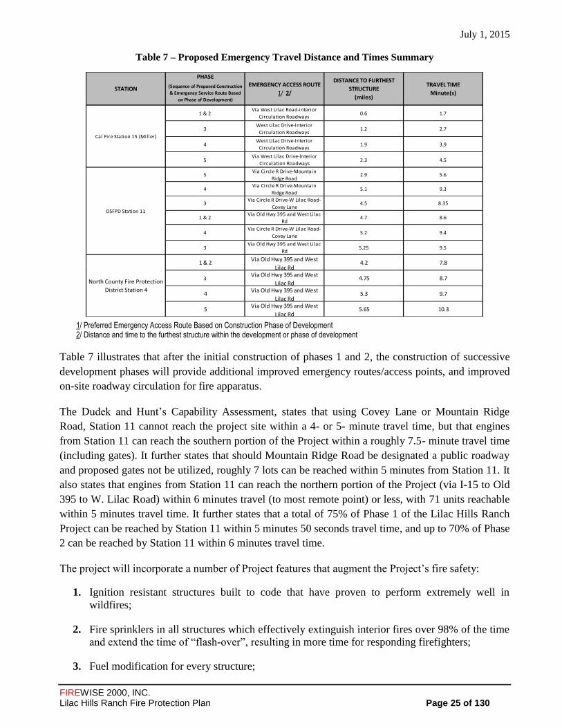
July 1, 2015
FIREWISE 2000, INC. Lilac Hills Ranch Fire Protection Plan Page 25 of 130
Table 7 – Proposed Emergency Travel Distance and Times Summary
1/ Preferred Emergency Access Route Based on Construction Phase of Development 2/ Distance and time to the furthest structure within the development or phase of development
Table 7 illustrates that after the initial construction of phases 1 and 2, the construction of successive
development phases will provide additional improved emergency routes/access points, and improved
on-site roadway circulation for fire apparatus.
The Dudek and Hunt’s Capability Assessment, states that using Covey Lane or Mountain Ridge
Road, Station 11 cannot reach the project site within a 4- or 5- minute travel time, but that engines
from Station 11 can reach the southern portion of the Project within a roughly 7.5- minute travel time
(including gates). It further states that should Mountain Ridge Road be designated a public roadway
and proposed gates not be utilized, roughly 7 lots can be reached within 5 minutes from Station 11. It
also states that engines from Station 11 can reach the northern portion of the Project (via I-15 to Old
395 to W. Lilac Road) within 6 minutes travel (to most remote point) or less, with 71 units reachable
within 5 minutes travel time. It further states that a total of 75% of Phase 1 of the Lilac Hills Ranch
Project can be reached by Station 11 within 5 minutes 50 seconds travel time, and up to 70% of Phase
2 can be reached by Station 11 within 6 minutes travel time.
The project will incorporate a number of Project features that augment the Project’s fire safety:
1. Ignition resistant structures built to code that have proven to perform extremely well in
wildfires;
2. Fire sprinklers in all structures which effectively extinguish interior fires over 98% of the time
and extend the time of “flash-over”, resulting in more time for responding firefighters;
3. Fuel modification for every structure;
PHASE
(Sequence of Proposed Construction
& Emergency Service Route Based
on Phase of Development)
1 & 2Via West Lilac Road-interior
Circulation Roadways0.6 1.7
3West Lilac Drive-Interior
Circulation Roadways1.2 2.7
4West Lilac Drive-Interior
Circulation Roadways1.9 3.9
5Via West Lilac Drive-Interior
Circulation Roadways2.3 4.5
5Via Circle R Drive-Mountain
Ridge Road2.9 5.6
4Via Circle R Drive-Mountain
Ridge Road5.1 9.3
3Via Circle R Drive-W Lilac Road-
Covey Lane4.5 8.35
1 & 2Via Old Hwy 395 and West Lilac
Rd4.7 8.6
4Via Circle R Drive-W Lilac Road-
Covey Lane5.2 9.4
3Via Old Hwy 395 and West Lilac
Rd5.25 9.5
1 & 2Via Old Hwy 395 and West
Lilac Rd4.2 7.8
3Via Old Hwy 395 and West
Lilac Rd4.75 8.7
4Via Old Hwy 395 and West
Lilac Rd5.3 9.7
5Via Old Hwy 395 and West
Lilac Rd5.65 10.3
TRAVEL TIME
Minute(s)
DISTANCE TO FURTHEST
STRUCTURE
(miles)
North County Fire Protection
District Station 4
Cal Fire Station 15 (Miller)
DSFPD Station 11
STATIONEMERGENCY ACCESS ROUTE
1/ 2/
July 1, 2015
FIREWISE 2000, INC. Lilac Hills Ranch Fire Protection Plan Page 26 of 130
4. Roadside fuel modification;
5. Automatic aid “drop boundary” agreements in place enable closest unit to respond, even if
from neighboring district/agency;
6. Roads and access meeting the County Consolidated Fire minimum road standards and the Deer
Springs Fire Protection Districts minimum road standards;
7. Long-term agriculture areas adjacent the site (reduced, irrigated fuels not native brush);
8. No buildings 35 feet or taller, and no buildings requiring 3,500 gpm fire flow, minimizing or
eliminating the need for a ladder truck, without the approval of the Fire District;
9. Redundant water supply of district water, recycled water, grey water and well water; and,
10. Automated External Defibrillator’s (AED’s) installed in any high occupancy uses with staffing
for use by trained administrators.
Summary
Response times from Miller station to the furthest structure of the project when all phases of the
proposed development are completed would be approximately 4.5 minutes, well below the 5 minutes
travel time standard set forth in the General Plan. Miller station is located 2.3 miles from the furthest
structure when the development is fully constructed. It is a publicly supported facility, fully staffed
24 hours a day, seven days a week, and includes three firefighting personnel per shift. Miller station
is committed to responding to emergency alarms through an Amador Contract with the County of San
Diego pursuant to Public Resources Code Section 4143.
DSFPD identified Fire Station 11 as the “primary” fire station for the project in the Project Facility
Availability Form (DPLU J-399F Form). Although response times from Station 11 do not meet the
time standards identified by the County General Plan, it has been determined as acceptable to the
District because pursuant to the County’s Guidelines for Determining Significance a finding can be
made that sufficient mitigating factors associated with fire protection would be available for the
project for the following reasons:
1. The District can augment response with ALS capable equipment to the entire project within 7-
9 minutes, which is an acceptable District Standard travel time and would ensure adequate fire
services to protect health, safety and the general welfare of the community;
2. The analysis shows that the DSFPD has existing capability and capacity to respond to fire
emergency incidents on the project;
3. The project will pay statutory mitigation fees and annual assessments that will be provided to
the District, which can be used by the District to upgrade and provide new facilities if
necessary, as determined by the District;

July 1, 2015
FIREWISE 2000, INC. Lilac Hills Ranch Fire Protection Plan Page 27 of 130
4. The project can be provided with fire services from three fire stations within 10-minutes to
the furthest structure and nearby fire departments pursuant to mutual aid agreements,
5. Sufficient mitigation measures (as set forth in the FPP) that minimize fire hazards are
included in the project, such as fire resistant construction methods and fuel modification
zones;
6. Travel time from the closest fully staffed fire station - Miller Station to the furthest structure
within the project would meet the travel time identified by the County General Plan;
7. The project’s water supply meets the requirements of the San Diego County’s Consolidated
Fire Code and the Fire Code for a commercial/business/residential development; and,
8. Fire access to the project will meet the requirements of the County and Deer Springs Fire
Protection District.
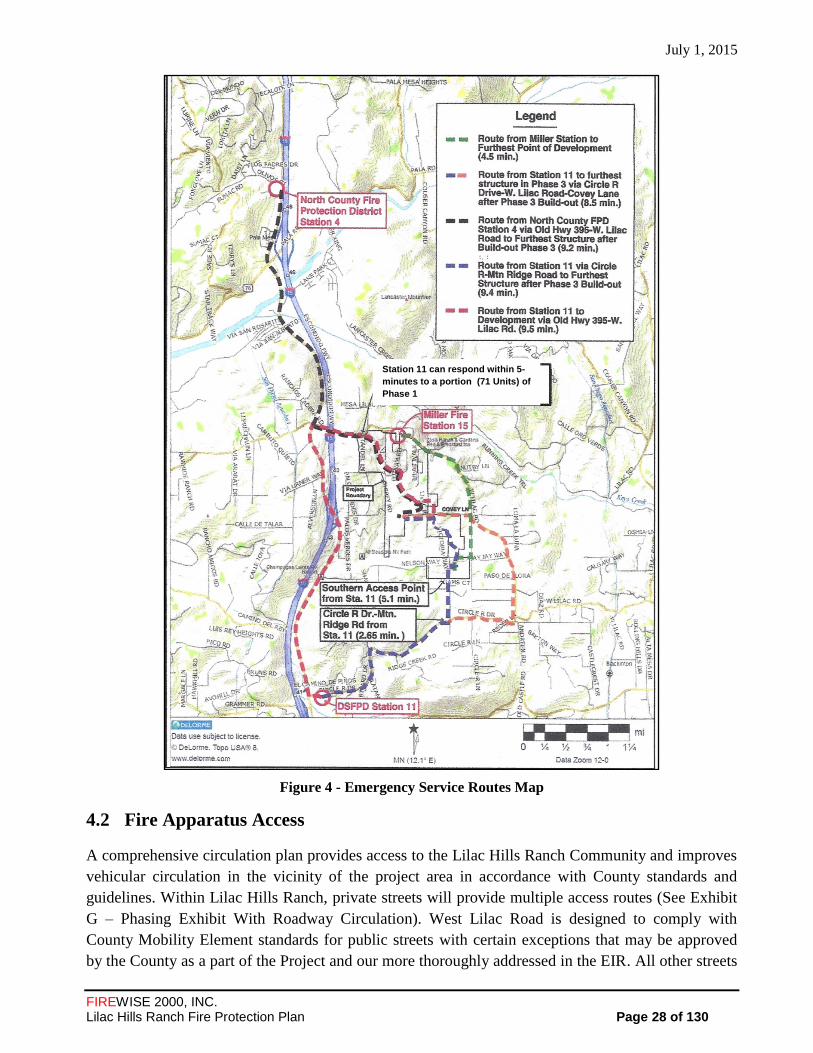
July 1, 2015
FIREWISE 2000, INC. Lilac Hills Ranch Fire Protection Plan Page 28 of 130
Figure 4 - Emergency Service Routes Map
Fire Apparatus Access 4.2
A comprehensive circulation plan provides access to the Lilac Hills Ranch Community and improves
vehicular circulation in the vicinity of the project area in accordance with County standards and
guidelines. Within Lilac Hills Ranch, private streets will provide multiple access routes (See Exhibit
G – Phasing Exhibit With Roadway Circulation). West Lilac Road is designed to comply with
County Mobility Element standards for public streets with certain exceptions that may be approved
by the County as a part of the Project and our more thoroughly addressed in the EIR. All other streets
Station 11 can respond within 5-
minutes to a portion (71 Units) of
Phase 1

July 1, 2015
FIREWISE 2000, INC. Lilac Hills Ranch Fire Protection Plan Page 29 of 130
within the Community are private, and will be designed and developed per the special standards
established by the specific plan to reflect the traditional character and rural theme of the Community.
The Community street system in Phases 1 through 3 will generally be available to the public traveling
from the adjacent public road system. The Community street system in Phases 4 and 5 is proposed to
be gated and not open to the public except during emergencies and in accordance with the County
Consolidated Fire Code.
To minimize impediments to fire apparatus access, the circulation network shall be designed
according to the Fire District Standards and the County Consolidated Fire Code see APPENDIX ‘G’ -
Phasing Exhibit, Project Internal Circulation Map and Access Exhibit Map). The needs of truck traffic
and loading activities for proposed commercial structures and fire apparatus shall be incorporated in the
design of the roadways.
The primary access to the Lilac Hills Ranch project will be via two ingress and egress points from
West Lilac Road, an existing public road located along the north boundary of the project site (See
APPENDIX ‘G’ - Phasing Exhibit, Project Internal Circulation and Access Exhibit). The initial
development of Phases 1 and 2 will include two ingress and egress points to West Lilac Road
connecting to internal roads for access throughout the development. Development of phases 3 thru 5
will also include internal roads and will include one additional fire apparatus access point via Covey
Lane and an additional gated emergency ingress/egress private roads via Rodriques Road and
Mountain Ridge Road. All proposed roads are designed in accordance with the Fire District
Standards and the County Consolidated Fire Code. Following are specific requirements (not all
inclusive) outlined for fire apparatus access:
Fire apparatus access roads shall have an unobstructed improved width of not less than 24 feet,
except for single-family residential driveways, serving no more than two single-family dwellings,
shall be a minimum of 16 feet of unobstructed improved width. Fire apparatus access roads will not
be obstructed in any manner, including the parking of vehicles. Specific interior roadways will be
designated ‘fire access roadways’ or ‘fire lanes’. All standards for apparatus access roads will follow
APPENDIX ‘D’ of the California Fire Code. The fire code official shall have the authority to require
an increase in the minimum access road widths where determined the minimum are inadequate for
fire or rescue operations.
4.2.1 Roadway infrastructure for each Phase (first and/or second pavement lift) will be installed
prior to the allowance of combustibles on the project site.
4.2.2 One-way fire apparatus access roads, roadways with gated entrances, guard stations, or center
medians are allowed, provided each lane is not less than 14 feet wide.
4.2.3 All fire apparatus access roads and driveways shall have an unobstructed vertical clearance of
not less than 13 feet 6 inches, unless in the opinion of the fire code official that the width shall
be increased if not adequate to provide fire apparatus access. The fire code official shall have
the authority to require an increase the minimum access road widths where the fire code
official determines the minimum are inadequate for fire or rescue operations. This same
authority by the fire code official may reduce the vertical clearance

July 1, 2015
FIREWISE 2000, INC. Lilac Hills Ranch Fire Protection Plan Page 30 of 130
4.2.4 or road width requirement if it does not impair access for fire apparatus, and includes
approved signs installed and maintained indicating the amount of vertical clearance.
Access points to pockets of islands of open space/flammable vegetation shall be provided and
identified for fire and emergency service apparatus (See APPENDIX G – Project Internal
Circulation, Figure 24).
4.2.5 Emergency access to the extensive trail system will be provided at numerous points
throughout the community.
4.2.6 Emergency vehicle turnarounds shall be provided on ‘fire lanes’ exceeding 150 feet in length.
In this development, turnarounds must be approved by the DSFPD, especially for aerial ladder
trucks if multiple story structures are proposed (see APPENDIX ‘K’ - lot configurations and
conceptual layouts). NOTE: no buildings 35 feet or taller are proposed for this project,
without approval of DSFPD).
4.2.7 Fire apparatus access road shall extend within 150 feet of all portions of a structure and all
portions of the exterior walls of the first story of the building as measured by a route around
the exterior of every building in the development.
4.2.8 Gates proposed for this development shall be in compliance with DSFPD guidelines and
County Consolidated Fire Code, Section 503.6. A gate across a fire access roadway shall be
equipped with an approved design feature for opening the gate for access by the fire
department or law enforcement. Specifically, The Project proposes to include gates
controlling public access to Phases 4 and 5, which will be developed as a Senior Citizen
Neighborhood. Private streets with gates are features of a number of major developments
approved by the County of San Diego, some of which are still undergoing development,
including the Rancho Cielo, Castle Creek, Montecito Ranch, Woods Valley Ranch, and The
Crosby Specific Plans, as documented in the Dudek and Hunt 2013 Assessment.
Any gate or barrier across a fire access roadway shall have specific plans reviewed and approved by
DSFPD, and receive Specific Plan approval prior to installation.
All automatic gates across fire access roadways and driveways shall be equipped with approved
emergency key-operated switches overriding all command functions and opening the gate(s).
Per the DSFPD conditions attached and part of the Project Availability Form (Form DPLU-399F),
gates accessing more than four residences or residential lots, or gates accessing hazardous
institutional, educational or assembly occupancy group structures, shall also be equipped with
approved emergency traffic control-activating strobe light sensor(s), or other devices approved by the
fire code official, which will activate the gate on the approach of emergency apparatus with a battery
back-up or manual mechanical disconnect in case of power failure. In addition, all automatic gates
are required to have a Knox key switch override system along with an approved emergency traffic
control-activating strobe light sensor(s); e.g., Opticom.
Other optional features for automatic gates may include:
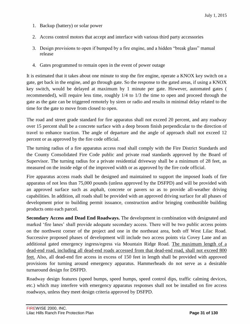
July 1, 2015
FIREWISE 2000, INC. Lilac Hills Ranch Fire Protection Plan Page 31 of 130
1. Backup (battery) or solar power
2. Access control motors that accept and interface with various third party accessories
3. Design provisions to open if bumped by a fire engine, and a hidden “break glass” manual
release
4. Gates programmed to remain open in the event of power outage
It is estimated that it takes about one minute to stop the fire engine, operate a KNOX key switch on a
gate, get back in the engine, and go through gate. So the response to the gated areas, if using a KNOX
key switch, would be delayed at maximum by 1 minute per gate. However, automated gates (
recommended), will require less time, roughly 1/4 to 1/3 the time to open and proceed through the
gate as the gate can be triggered remotely by siren or radio and results in minimal delay related to the
time for the gate to move from closed to open.
The road and street grade standard for fire apparatus shall not exceed 20 percent, and any roadway
over 15 percent shall be a concrete surface with a deep broom finish perpendicular to the direction of
travel to enhance traction. The angle of departure and the angle of approach shall not exceed 12
percent or as approved by the fire code official.
The turning radius of a fire apparatus access road shall comply with the Fire District Standards and
the County Consolidated Fire Code public and private road standards approved by the Board of
Supervisor. The turning radius for a private residential driveway shall be a minimum of 28 feet, as
measured on the inside edge of the improved width or as approved by the fire code official.
Fire apparatus access roads shall be designed and maintained to support the imposed loads of fire
apparatus of not less than 75,000 pounds (unless approved by the DSFPD) and will be provided with
an approved surface such as asphalt, concrete or pavers so as to provide all-weather driving
capabilities. In addition, all roads shall be provided with an approved driving surface for all phases of
development prior to building permit issuance, construction and/or bringing combustible building
products onto each parcel.
Secondary Access and Dead End Roadways. The development in combination with designated and
marked ‘fire lanes’ shall provide adequate secondary access. There will be two public access points
on the northwest corner of the project and one in the northeast area, both off West Lilac Road.
Successive proposed phases of development will include two access points via Covey Lane and an
additional gated emergency ingress/egress via Mountain Ridge Road. The maximum length of a
dead-end road, including all dead-end roads accessed from that dead-end road, shall not exceed 800
feet. Also, all dead-end fire access in excess of 150 feet in length shall be provided with approved
provisions for turning around emergency apparatus. Hammerheads do not serve as a desirable
turnaround design for DSFPD.
Roadway design features (speed bumps, speed humps, speed control dips, traffic calming devices,
etc.) which may interfere with emergency apparatus responses shall not be installed on fire access
roadways, unless they meet design criteria approved by DSFPD.

July 1, 2015
FIREWISE 2000, INC. Lilac Hills Ranch Fire Protection Plan Page 32 of 130
Approved signs or other approved notices shall be provided for fire apparatus access roads to identify
such roads or prohibit the obstruction thereof. Signs or notices shall be maintained in a clean and
legible condition at all times. All public roads and private roads serving four or more parcels shall be
named. Road names signs shall comply with County of San Diego Department of Public Works
Design Standard #DS-13.
To ensure fire apparatus access, the fire code official may designate existing roadways as fire access
roadways as provided by Vehicle Code Section 22500.1 (public) and (private).
The fire code official is authorized to require more than one fire apparatus access road on the
potential for impairment of a single road by vehicle congestion, condition of terrain, climatic
conditions or other factors that could limit access.
Water Supply 4.3
Water supply will meet the water supply requirements of the San Diego County’s Consolidated Fire
Code and the Fire Code for a commercial/business/residential development. Following are specific
requirements.
All fire hydrants shall be installed and serviceable by all acceptable code standards prior to delivery
of combustibles for each development phase(s).
For single-family dwellings, fire hydrants shall be installed at intersections, at the beginning radius of
cul-de-sacs, and every 300 feet from structures, regardless of parcel size. In multi-family, commercial
and industrial zones, fire hydrants shall be installed at intersections, at the beginning radius of cul-de-
sacs and every 300 feet from structures, regardless of parcel size.
An approved fire hydrant/water supply system shall be capable of supplying 2500 gallons per minute
fire flow for 2 hours (California Fire Code and the Consolidated Fire Code for the County of San
Diego). Waterlines for fire control must be capable of supplying this required demand through the
hydrants, plus the largest fire sprinkler demand, plus any domestic use supplied from that line.
When an on-site waterline serves more than two hydrants, the line must be looped, providing two
hydraulically remote points of connection with the water district lines. The interior loop must have
isolation valving, such that not more than two hydrants and/or sprinkler systems are between isolation
points. If the onsite fire water system for a building is a private loop, the two points of connection are
needed to the public supply and appropriate fire department connections.
Fire hydrants shall be located along ‘fire lanes’ and all structures and other improvements shall be
reached with a maximum hose pull of 150 feet, or as approved by the DSFPD.
Each hydrant for this development shall have one 4-inch and one 2-1/2-inch outlets. In some
instances DSFPD may require a fire hydrant to have other combinations of 4 inch and 2½ inch
outlets. All fire hydrants will be of bronze construction, including all internal parts except seats. Fire
protection systems service meters shall be a minimum of one inch (1”) and separate from the
domestic supply.
The DSFPD approval shall be required for on-site hydrant and fire service waterline based on the
final building construction location, type and largest building size. A waterline extension for the

July 1, 2015
FIREWISE 2000, INC. Lilac Hills Ranch Fire Protection Plan Page 33 of 130
purpose of installing a fire hydrant if the water main is 1,500 feet or less from the property line may
be required by the fire code official.
All hydrants shall be located along an access roadway and shall not be closer than 50 feet from
structures.
Fire hydrants shall be located with blue reflective raised pavement markers at approved locations for
each hydrant
All buildings shall be fully protected with automatic fire sprinkler systems. The installation of the
sprinkler systems shall meet NFPA 13 and 13D Standards. The 2010 California Building Standards
Code published July 1, 2010, with an effective date of January 1, 2011, requires automatic fire
sprinkler systems for all new one-and two-family dwellings and townhouse construction statewide.
Defensible Space and Vegetation Management 4.4
Fire resistant landscape management is the act of converting native vegetative fuels from a highly
flammable and high fire intensity state to a more fire resistant and low fire intensity condition. Fire
resistant landscaping has been proven to be very effective treatment for minimizing structure losses
due to wildland fire radiant heat.
The County’s Consolidated Fire Code and the California Fire Code require a Fuel Management Zone
(FMZ), within 100 feet of structures, to the extent possible, for each Implementing Tentative Map
that is submitted to the County for approval. Implementing the following measures for the
management of flammable vegetation would provide acceptable management of flammable
vegetation for wildfire protection of structures within each phase of this development:
Implement and maintain a standard to provide an irrigated Zone A (low fuel 4.4.1
volume/defensible space) and a selectively thinned non-irrigated Zone B around each
residential and commercial structure, and along roadways as described herein.
A long-term interior open space fuel modification treatment plan and fire resistant 4.4.2
landscaping criteria to be deployed around all planned structures as described herein.
For the benefit of the community, the fuel modification and maintenance of common areas 4.4.3
would be under the control of a homeowners association or other common ownership,
established in perpetuity.
Alternative measures that achieve the same level of protection may be used, including 1) 4.4.4
additional ignition-resistant construction methods and other non-combustible features, i.e.,
parking lots, sidewalks, concrete patios, decorative rock, natural boulders on-site, and similar
landscape features; 2) fire-barrier walls; and, 3) condition for focused fire protection plan for
any area with a reduced fuel modification zone should off-site fuels (which are currently
agriculture) convert to native shrub land.
A wildland fire hazard rating assessment and calculations of the expected fire behavior, in the 4.4.5
event a wildland fire should occur within the off-site and on-site native and non-native
vegetation.

July 1, 2015
FIREWISE 2000, INC. Lilac Hills Ranch Fire Protection Plan Page 34 of 130
Fuel Modification Zone(s) for This Development 4.5
On-site, a minimum Fuel Management Zone (FMZ) of 100 foot will apply throughout the entire
project in accordance with the specification of County Consolidated Fire Code, Section 96.1.4907.2.
Additional clearance may be required as necessary as necessary depending on specific conditions on
site up to 100-foot . The perimeter buffer and on-site FMZs would consist of a 50-foot irrigated zone,
or in some cases, the FMZ may be 100 feet of actively managed irrigated agricultural crops/orchard,
per the fuel management plan. The area 50 feet from the edge of all structures in the development
would be cleared of all vegetation that is not fire resistant and re-planted with irrigated fire-resistant
landscaping. The actively managed irrigated agricultural crops/orchards, presently located within the
development may also be integrated into the zone. This would be defined as Zone A.
In the area between 50 to 100 feet from the edge of structure, all dead and dying vegetation shall be
removed (in some areas, this zone may also be the actively managed irrigated agricultural
crops/orchards. Maintenance of fuel treatment zones is highly important. Latham (1989) found that
ember ignitions were primarily a function of ground fuels, especially litter depth. Also imporant to
ignition of a ground fuel is moisture content, size of the litter material as well as the mineral content
of the dead vegetation. To the benefit of the eventual homeowners, ground fires burn with less
intensity than an aerial fuel. However, a ground fire may carry to adjacent aerial fuels which is a
concern.
Most of the fuel modification zone includes an 8 feet wide trail located roughly in the middle of the
fuel modification area that will be maintained free of vegetation. This vegetation free area provides
an enhanced “fire break within a fuel break”, resulting in decreased flame length and heat reduction,
particularly for non-wind driven fires.
Figure 5 - Illustration of Defensible Space Zones
ZONE A
ZONE B

July 1, 2015
FIREWISE 2000, INC. Lilac Hills Ranch Fire Protection Plan Page 35 of 130
Where native vegetation does exist adjacent to this zone, native vegetation may remain provided that
the vegetation is modified so that combustible vegetation does not occupy more than 50 percent of
the square footage of this area. This would be defined as Zone B (see Figure 6 – Illustration of
Defensible Space Zones).
As stated above, the FMZ shall be a minimum of a 100-foot area in all directions from all structures,
in which flammable vegetation or other combustible growth is cleared away or modified, except for:
1. Single specimens of trees or other vegetation which are well-pruned and maintained.
2. Grass and other vegetation located more than 50 feet from the structure and less than 18
inches in height above the ground.
3. All ornamental landscaping that is consistent with San Diego County Wildland Urban
Interface plant list (see APPENDIX ‘A’).
4. Identified areas where reduced fuel modification zones have been established based on site-
specific fire behavior modeling in addition to off-site fuel beds (primarily agriculture) and
where additional fire protection features to harden structures will be employed.
5. Irrigated agriculture
Buildings or structures in a hazardous fire area must be set back 100 feet from the property line and
shall meet the requirements in the above paragraph, to the extent possible. Enhanced fire-resistive
construction measures shall be used to mitigate fire, including the elimination of vents and skylights
on structures facing natural fuel and open space areas on-site and off-site native flammable fuels.
Roadways, parking lots, sidewalks, concrete patios, decorative rock, natural boulders on-site, and
similar landscape features may be included as objects that will not support fire. Other alternative
measures that achieve the same level of required protection may be used, including, but not limited to
one of the following: 1) utilize adjacent irrigated and managed agricultural crops (orchards, commercial
flower fields, etc.); 2) fuel modification and hazard abatement required and completed around structures
by adjacent landowners to meet fire code on their property and which is contiguous with the
development; 3) DSFPD hazard abatement requirements for fuel modification and hazardous abatement
50 feet along the perimeter of adjacent properties, 4) additional ignition-resistant construction methods,
non-combustible features, i.e., roadways and right-of-way modified fuels, parking lots, sidewalks, etc.;
5) fire-barrier/deflection walls; or, 6) a recorded easement acquired from adjacent landowners for the
purpose of maintaining required fuel modification (there is no off-site clearing proposed). However, if
off-site clearing is proposed in the future, the easements must be provided before the project can move
forward).
The proposed project shall also provide fuel modification on either side of public roadways, pursuant
to the County’s Consolidated Fire Code and the California Fire Code for clearance of brush and
vegetative growth from roadways. This requirement shall modify combustible vegetation in the area
within 10 feet from each side of a road or driveway to establish a fuel modification zone on fire
apparatus access roads and driveways. This requirement for modified fuel combustible vegetation
shall also apply to off-site private ingress and egress roadways.

July 1, 2015
FIREWISE 2000, INC. Lilac Hills Ranch Fire Protection Plan Page 36 of 130
FMZ’s for the Lilac Hills Ranch Development will be determined as a part of the site plan review for
the development of each phase. If the level of development within the overall project increases, these
zones would be revisited at the time of site plan review to determine if less strigent requirements may
be more appropriate due to these circumstances. When the final FPP for the development is
completed, a detailed Fuel Treatment Location Map will illustrate the placement of the zones for each
developmental phase.
Fuel Modification Zone A - Irrigated 4.5.1
The following specific requirements are outlined, but not all inclusive, for Zone A.
4.5.1.1 This Zone shall be irrigated (micro-irrigation acceptable when overhead irrigation may
cause erosion). It includes all manufactured slopes. Landscaping material from the approved
plant list (see APPENDIX ‘A’) required or in an approved landscape plan and approved by
the Fire Marshal.
4.5.1.2 All undesirable non-native vegetation (see APPENDIX ‘B’) shall be removed. Also, no
plants on the California Exotic Pest Plant Council’s list of “Exotic Pest Plants of Greatest
Ecological Concern in California as of October 1999” or more recent version shall be
planted.
4.5.1.3 Vegetation may include single or cluster (no more than two to three plants/tree) of trimmed
fire resistant native and ornamental plants.
4.5.1.4 Dense plant masses adjacent to the structures and at bases of trees and tree clusters shall not
be placed in this Zone. Vegetation must be low growing, fire resistive, deep rooted, drought
tolerant plantings to maintain erosion control and soil stability, especially on manufactured
slopes.
4.5.1.5 Active irrigated agriculture and native or ornamental trees can be retained within this fuel
modification zone. They shall be pruned to maintain a vertical separation of approximately
10 feet above underlying shrubs or groundcover. Pruning of the shrubs will minimize the
impact of the tree pruning. Trees may be planted and/or maintained as individual specimens,
or clustered. Groups should be two to three trees maximum, with mature foliage of any
group separated horizontally by at least 10 feet, if planted on less than 20 percent slope, and
20 feet, if planted on greater than 20 percent slope.
4.5.1.6 Tree canopies shall not be allowed to overhang the roof of any structure; the outer edge of
the canopies of mature trees will be a minimum of 10 feet from the building eaves, and free
of all dead or dying parts. All the dead material must be pruned out of all vegetation on a
regular basis. Trees and vegetation should not be planted in areas where fire truck access is
impaired, should not impair or obstruct the use of fire department ladders.
4.5.1.7 Mulches, chips and other small multi-cuttings (cut to less than two inches in diameter and
four inches in length) shall be evenly spread over the area no more than 4 inches, at least 50
feet from structures. This can be used to maintain soil moisture and prevent grass and weed
encroachments within the treated areas. Regular maintenance, vegetation pruning, and

July 1, 2015
FIREWISE 2000, INC. Lilac Hills Ranch Fire Protection Plan Page 37 of 130
irrigation to establish drought tolerant, fire-resistive landscaping are very important in this
Zone.
4.5.1.8 Construction materials, firewood, and other combustible materials shall not be stored in
unenclosed spaces beneath buildings or structures, or on decks or under eaves, canopies or
other projections or overhangs. Storage may occur in the defensible space located a
minimum of 30 feet from structures and separated from the crown of trees by a minimum of
10 feet, measured horizontally.
4.5.1.9 Ornamental plants will not be planted or allowed to become established within this Zone,
unless shown in the Recommended Plant Lists in APPENDIX ‘A’ (or in an approved
landscape plan and approved by the Fire Marshal).
4.5.1.10 Plants in this Zone will not include any pyrophytes that are high in oils and resins.
Exception: All non- fire resistive trees, including conifers, pepper trees, eucalyptus and
acacia species shall be planted and maintained so that the tree’s drip line at maturity is a
minimum of 50 feet from any combustible structure.
4.5.1.11 Ornamental plants will not be planted or allowed to become established within this Zone,
unless fire resistive trees, including conifers, pepper trees, eucalyptus and acacia species
shall be planted and maintained so that the trees drip line at maturity is a minimum of 50
feet from any combustible structure.
4.5.1.12 Non-flammable patios, walkways, rock, driveways, and gravel can be used to break up fuel
continuity within this Zone.
4.5.1.13 If shrubs are located underneath a tree’s drip line, the lowest branch will be at least three
times as high as the understory shrubs or 10 feet, whichever is greater.
4.5.1.14 Trees may be planted and/or maintained as individual specimens, or clustered with 2 to 3
trees in a single cluster; crowns of mature trees shall maintain a minimum horizontal
clearance of 10 feet for fire resistant trees and 30 feet for non-fire resistive trees; and avoid
planting trees directly uphill or one another. The following table 4907.3.1 from the County
Consolidated Fire Code defines the distance between mature tree canopies by percent slope.
Zone B Fuel Modification – Non-Irrigated 4.5.2
Zone B is the remaining 50 feet of fuel management adjacent to flammable vegetation. Roads and
other “non-structure” improvements are allowed in this zone. Zone B fuel management shall be
applied to all roadways, including private controlled access roadways; i.e., Covey Lane and Mountain

July 1, 2015
FIREWISE 2000, INC. Lilac Hills Ranch Fire Protection Plan Page 38 of 130
Ridge Road (Lilac Hills Ranch would be responsible for these two private roadways only where the
development is adjacent to these private roadways and DSFPD would enforce the minimum fuel
modification requirements on the other private properties being serviced by the private roads). Zone
B can either be cleared in conformance with Zone A above, or selectively cleared and modified as
described below.
4.5.2.1 Zone B is an area 50 to 100 feet (or more) away from any structure where the fuel
volume will be removed or thinned by 50 percent, including the removal of undesirable
species.
4.5.2.2 Irrigation will be used only if needed to establish and maintain fire-resistive landscaping.
4.5.2.3 As the native vegetation cover in Zone B is reduced, there is a very high probability that the
openings will be dominated with non-native weed or grass species. Therefore, all grasses
and weeds are to be mowed or weed-whipped to a 4-inch stubble height by June 1st of each
year or when the fuels become cured, whichever occurs first.
4.5.2.4 Any vegetative biomass (debris and trimmings) produced by thinning and pruning shall be
removed from the site or converted to mulch by chipping and evenly distributed to a
maximum depth of four (4) inches. This mulching concept helps to maintain soil moisture
for the designated plants, reduces the growth of annual grass and minimizes soil erosion.
4.5.2.5 The area on each side of the improved width of highways, private roads, and driveways
shall comply with the requirements of a fuel modification zone. For newly constructed
roads, the vegetation shall be modified/reduced by 50 percent for 20 feet on either side of
the road.
4.5.2.6 The following native species will not be permitted to grow in this zone even as specimen
plants because of their flammability:
California sagebrush, Artemisia californica;
Flat-topped buckwheat, Eriogonum fasciculatum; and,
Black sage, Salvia mellifera.
Fuel Maintenance 4.5.3
Maintenance within the zones shall be performed year-round and include the following:
4.5.3.1 Prune and thin trees around structures to decrease fuel volume, retain succulent growth and
to provide adequate clearance between structures and plants, as required in the County
Consolidated Fire Code.
4.5.3.2 Tree branches overhanging roofs shall be removed.
4.5.3.3 Trash and combustible debris shall be cleared from around structures, and removed from
roofs and rain gutters.
4.5.3.4 Irrigation systems will be maintained to ensure that they function properly and plantings are
watered sufficiently to maintain succulent growth.
4.5.3.5 The responsibility for the fuel modification maintenance defined below shall remain with
each lot owner and any subsequent owners, and a maintenance agreement through a Home
July 1, 2015
FIREWISE 2000, INC. Lilac Hills Ranch Fire Protection Plan Page 39 of 130
Owner Association to remove dead and dying vegetation, non-native species that may
establish over time, and general compliance with the fuel modification requirements the
common areas.
Fuel Modification Zones Analysis – DUDEK
Dudek conducted an analysis of fuel modification zones which analyzed the fire behavior across the
project site and compared it against the proposed development footprint, product type and proposed
structure setbacks (See APPENDIX J – Fuel Modification Zones Analysis – DUDEK). This analysis
was used to support the analysis of Section 4.4 – Defensible Space and Vegetation Management in
this FPP.
Ignition Resistant Construction and Fire Protection -Residential 4.6
Ignition-resistant construction for all structures will provide significant protection in this very high
fire hazard zone. Ignition-resistant construction requirements will provide critical improvements to
all types of structures for them to survive a worst case scenario fire storm in this area. Another
significant requirement will be that maintenance and repair of these proposed structures will be with
the same ignition-resistant materials and construction features. Also, the FPP requires that ignition-
resistant construction will apply to mitigate the ignitability of all future proposed residential
structures and projections (exterior balconies, carports, decks, patio covers, unenclosed roofs and
floors).
All structures within a wildland-urban interface as defined in the County Building Code must be built
using ignition-resistive construction methods (Building Code (Title 9, Division 2, Chapter 1 of the
San Diego County Code of Regulatory Ordinances). Construction requirements must meet all then-
current County and State of California Building Codes (Chapter 7A) requirements for construction in
wildland areas. Ignition-resistant building requirements found in the County Building Code (more
restrictive than the California Building Code) will significantly reduce the threat of wildfire for this
development, especially the flying embers entering a structure, landing on a receptive fuel and
starting a new fire.
Following are specific fire-resistive building features that shall be applied to all structure construction
that will be implemented at the site plan or building permit stage:
All structures within the Lilac Hills Ranch project shall be built with a Class A roof assembly, 4.6.1
including a Class A roof covering (per CBC Chapter 7A). It should be noted that recent
testing has found that solar panels mounted within about 5 inches of a Class A roof assembly
may nullify the Class A rating of the assembly.
All exterior walls on all sides of the buildings shall be constructed with one-hour fire resistant 4.6.2
building materials, and protected with two-inch nominal solid blocking between rafters at all
roof overhangs and under the exterior wall covering. Wood siding of 3/8-inch plywood or 3/4-
inch drop siding is permitted, but must have an underlayment of ½-inch fire-rated gypsum
sheathing that is tightly butted or taped and mudded, or other ignition-resistive materials
approved by the Fire Authority Having Jurisdiction (FAHJ) and/or the Planning Authority
Having Jurisdiction (PAHJ).
July 1, 2015
FIREWISE 2000, INC. Lilac Hills Ranch Fire Protection Plan Page 40 of 130
All vents (roof, foundation, combustion-air, etc.) shall resist the intrusion of flames and 4.6.3
embers or shall be protected by louvers and 1/8” non-combustible, corrosion-resistant mesh.
Turbine attic vents shall be equipped to allow rotation in only one direction (County Building
Code 704A.2.1). Attic ventilation shall also comply with the requirements of the California
Fire Code.
Exception: Where a 100-foot fuel modification zone from a structure to the project site
boundary cannot be met in the northeast and southwest corner of the property, all vents shall
provide ventilation while trapping flames and embers before they enter the home (e.g., use of
vents produced by Vulcan or Brandguard or any simiular vents).
Attic ventilation openings or ventilation louvers will not be permitted in soffits, in eave 4.6.4
overhangs, between rafters at eaves, or in other similar exterior overhanging areas in this
wildland/urban interface area.
Exception: Where a 100-foot fuel modification zone from a structure to the project site
boundary cannot be met in the northeast and southwest corner of the property, all vents shall
provide ventilation while trapping flames and embers before they enter the home (e.g., use of
vents produced by Vulcan or Brandguard).
All eaves of roof overhangs shall be enclosed (boxed eaves) on all sides with non combustible 4.6.5
materials or constructed with heavy timber such as 2x starter board and 3x6 rafter tails.
Structure openings: Louvers, ventilators, or openings in walls, roofs, attics, and underfloor
areas having headroom less than four (4) feet in height which are not fitted with sash or doors
shall be covered with wire screen. The screen covering of such openings will be of corrosion-
resistant metal or other approved material that offers equivalent protection, and will have a
maximum mesh of one-eighth (1/8) inch.
All projections (exterior balconies, stairs, covers, unenclosed roofs and floors, and similar 4.6.6
architectural appendages and projections) shall be of non-combustible construction, one-hour
ignition resistive construction on the underside, or heavy timber construction. When such
appendages and projections are attached to exterior fire-resistive walls, they shall be
constructed to maintain the fire-resistive integrity of the wall.
All glass or other transparent, translucent or opaque glazing materials, including skylights, 4.6.7
shall be constructed of tempered glass or a dual glazed windows with minimally one pane of
tempered glass.
Fences and other structures less than 5 feet from a building shall be non-combustible 4.6.8
construction, heavy timber or fire retardant pressure treated wood.
All rain gutters, down spouts and gutter hardware shall be constructed from metal or other 4.6.9
noncombustible material to prevent wildfire ignition along eave assemblies.
Gutters shall be designed to reduce the accumulation of leaf litter and debris that contribute to 4.6.10
roof edge ignition.
July 1, 2015
FIREWISE 2000, INC. Lilac Hills Ranch Fire Protection Plan Page 41 of 130
Exterior door assemblies will conform to the performance requirements of standard SFM 12-4.6.11
7A-1 or will be of approved non-combustible construction, or solid core wood having stiles
and rails not less than 1 3/8 inches thick with interior field panel thickness no less than 1 1/4
inches thick, or will have a fire-resistance rating of not less than 20 minutes when tested
according to ASTME 2074.
All windows to be screened shall be provided with mesh metal or similar non-combustible 4.6.12
window screens to prevent embers from entering the structure during high wind condition.
Any damaged or replacement window, siding, roof coverings, and specific non-combustible 4.6.13
wall shall meet or exceed the original intent of the fire protection discussed in this Plan.
Buildings and structures will be set back a minimum of 30 feet from property lines and open 4.6.14
space easements unless the County Zoning Ordinance requires a greater minimum. When the
property line abuts a roadway the setback will be measured from the centerline of the
roadway.
Fire protection tactical operations for proposed two-story residential structures will be based 4.6.15
on structures less than 35 feet in height, unless approved by the fire district.
Protection of Commercial and Civic Structures, School, Senior Citizen 4.7
Neighborhood and Other Facilities and Emergency Trail Access
The proposed project includes commercial, civic structures, schools, and senior citizen neighborhood
within the development. Three-story structures are proposed but will not exceed 35 feet in height,
with access to the third floor from the second floor. Based on maximum height of structures, none of
the structures would be required to meet mid-rise structure fire code requirements there are applicable
fire protection requirements that shall be required to ensure that proposed and future buildings on this
site meet specific construction features. Guidance to mitigate fire protection measures and to mitigate
structural firefighting risks for individual commercial/structure and other public facilities will be
established in accordance with the requirements of the 2014 County Consolidated Fire Code and the
2013 California Building Code. The County of San Diego and the DSFPD will review all proposed
buildng plans for compliance with the requirements of fire codes and this Fire Protection Plan.
Following are specific requirements, not all inclusive, for commercial, industrial, school, age-
restricted community, and other public facilities structures on this development:
Buildings shall be protected throughout by an automatic fire sprinkler system designed and 4.7.1
installed in conformance with the latest edition of NFPA 13.
A shut-off valve and a water flow alarm shall be provided for each floor of structures. Each 4.7.2
shut-off valve and water flow alarm shall be electronically supervised.
Smoke detectors shall be connected to an automatic fire alarm system and shall be installed in 4.7.3
accordance with the latest edition of NFPA 72.
An approved and listed, automatic and manual, fully addressable and electronically-4.7.4
supervised fire alarm system shall be provided in conformance with the California Building
Code.
July 1, 2015
FIREWISE 2000, INC. Lilac Hills Ranch Fire Protection Plan Page 42 of 130
Stairway enclosures shall be continuous and shall fully enclose all portions of the stairway. 4.7.5
Exit enclosures shall exit directly to the exterior of the building or include an exit passageway
on the ground floor leading to the exterior of the building. Each exit enclosure shall extend
completely through the roof and be provided with a door that leads onto the roof.
School grounds may be fenced and gates therein may be equipped with locks, provided that 4.7.6
safe dispersal areas based on three square feet per occupant are located between the school
and the fence. Such required safe dispersal areas shall not be located less than 50 feet from
school buildings.
The project’s extensive trail system is accessible by emergency responders via numerous 4.7.7
access points throughout the Lilac Hills Ranch community. The largest distance to a roadway
access point from any point along the proposed trail is 765 feet in Phase 1. Access points are
called out in the Trail Plan for Phase 1. The trail system has not been designed for the latter
phases of the development. However, similar access point spacing will be provided (See
APPENDIX ‘P’ – Trails Plan-Phase 1 Access Points).
The following checklist for design concepts may be utilized to ensure that future commercial
buildings meet specific performance standards requried by the DSFPD that may exceed what is
normally required by standard California building codes. This list is provided to memorialize the
requirement or design measure, to help mitigate the structural firefighting risk, and to notify the
applicant, engineer, architect, and future lot owners, what will be required in these future buildings.
A. Applicable fire protection and building construction related codes and standards for commercial,
industrial, and public facilities
B. Maximum allowable height of buildings for existing fire apparatus capability
C. On-site fire protection water system, required fire flow, on site hydrants, and fire sprinkler systems
D. Sprinkler risers and flow alarms and signals
E. Fire detection and fire alarm systems where required by CFC and where needed in large buildings
to provide early detection
F. Fire department sprinkler connection locations
G. Wet standpipes where needed in large buildings based on travel distances exceeding 150 feet from
doors
H. Site access and on-site fire access roads
I. Identification of onsite fire lanes and provision of signage
J. Clear paved setbacks from property lines to allow fire engine and fire truck operations
K. Protection for trash chutes and trash storage
L. Heating Ventilation and Air Conditioning (HVAC) System controls for firefighter use
M. High piled stock requirements
N. Firefighter access doors for high piled stock
O. Firefighter foot access around buildings
P. Roof access for firefighters through parapets and mansards
Q. Addressing and identification of buildings
R. Geographical directories
July 1, 2015
FIREWISE 2000, INC. Lilac Hills Ranch Fire Protection Plan Page 43 of 130
S. Smoke removal provisions
T. Private or public motor fuel dispensing, if applicable
U. Hazardous materials storage, use and handling; interior and exterior, if applicable
V. Maximum allowable quantities for hazardous materials (define/discuss CFC requirement in
general, and threshold for becoming an ‘H’ occupancy)
W. Exterior storage, and interior storage
X. Fire alarms, water flow alarms and monitoring
Y. Exits and emergency/standby power
Z. Portable extinguishers
AA. Combustible decorations, displays and combustible storage
BB. No smoking signs
CC. Signs on exterior doors to electrical panel rooms, riser rooms, etc. NFPA hazard signals
DD. Solar panels on roofs
EE. Natural gas shutoffs
FF. Emergency plan and equipment
GG. Fire prevention program
HH. Construction fire safety
II. Fire command center in larger buildings (CFC Section 508)
JJ. Pre-emptive traffic devices at signalized intersections
KK. Emergency responder radio coverage in buildings (CFC section 510)
LL. Special requirements for vehicles operating in buildings
The following fire protection and building construction related codes are listed so that architects,
engineers, contractors, and owners are aware of their potential applicability.
A. 2013 California Fire Code (CFC) including but not limited to Chapter 9 for Fire Protection
Systems, Chapter 23 for High Piled Stock; Chapter 27 for Hazardous Materials; and, Chapter
34 for Flammable and Combustible Liquids.
B. 2013 California Building Code
C. Local County Building Codes
D. Fire District and County Fire Codes
E. National Fire Protection Association (NFPA) standards as may be applicable including:
1) NFPA 10-- Fire extinguishers
2) NFPA 13--Fire sprinkler systems
3) NFPA 14 – Standpipes
4) NFPA 20--Fire Pumps (if needed but doubtful due to high water system pressures)
5) NFPA 70--National Electrical Code
July 1, 2015
FIREWISE 2000, INC. Lilac Hills Ranch Fire Protection Plan Page 44 of 130
6) NFPA 72--Fire Alarms
7) NFPA 90A--Air Conditioning and Ventilation Systems
8) NFPA 110--Emergency and Standby Power Systems
Additional Requirements 4.8
Single-story structures shall be setback a minimum 15 feet horizontally from top of a slope to 4.8.1
the farthest projection from a roof. A single-story structure shall be less than 12 feet above
grade. A two-story structure shall be setback a minimum of 30 feet horizontally from top of
slope to the farthest projection from a roof.
Where a bridge or an elevated surface is part of a fire apparatus access road, the bridge shall 4.8.2
be constructed and maintained in accordance with AASHTO HB-17. Bridges and elevated
surfaces shall be designed for a live load sufficient to carry the imposed loads of fire
apparatus. Vehicle load limits and clearance limitations shall be posted at both entrances to
bridges when required by the fire code official.
Brush and other flammable vegetation will be removed prior to commencing any construction 4.8.3
activity. During construction at least 50 feet of clearance around the structures will be kept
free of all flammable vegetation as an interim fuel modification zone during construction of
structures.
A lighted directory of the development noting building numbers, solar panel designations (if 4.8.4
applicable), etc. shall be installed near the entrance with approval from the DSFPD.
Any disputes of individual yard landscaping with regard to interpretation of this Fire 4.8.5
Protection Plan (FPP) shall be decided by DSPD’s Fire Chief and Fire Marshal. The Fire
Marshal’s decision shall be final and binding for the development.
This plan and its recommendations should be incorporated by reference into the final project 4.8.6
Supplemental Environmental Impact Report.
Separate from the conditions in this FPP, the DSFPD will require a Memorandum of 4.8.7
Agreement to be settled prior to the initial phase of the development. The conditions of the
agreement will not set aside or alter the conditions with the FPP.
Fuel Treatment Location Map 4.9
Each developmental phase will include a Fuel Treatment Location Map which will show the location
of all proposed fuel modification treatment locations and other mitigation measures for the known
locations of structures within the development. For this FPP, Exhibit 1 illustrates the recommended
fuel modification treatment locations to provide adequate fuel modification requirements for the
development.
5.0 CONCLUSIONS
This FPP evaluated the adverse environmental effects that the proposed Lilac Hills Ranch residential
and commercial development may have from wildland fire and to properly mitigate those impacts to

July 1, 2015
FIREWISE 2000, INC. Lilac Hills Ranch Fire Protection Plan Page 45 of 130
ensure that this development does not unnecessarily expose people or structures to a significant risk
of loss, injury or death involving wildland fires.
Emergency Response 5.1
Lilac Hills Ranch must demonstrate that fire services can be provided that meet the minimum travel
time identified in Polcy S-6.4. Travel time is defined as the estimated time it will take for the “closest
fire station” to reach the furthest structure in a proposed development project. (Policy S-6.4).
The “closest” fire station to Lilac Hills Ranch is CAL FIRE’s Miller Station at 9127 West Lilac
Road, located adjacent to the development and approximately 2.3 miles from the furthest structure
when the development is fully construct. The travel time from this station to the furthest structure
when all phases of the proposed development are completed would be approximately 4.5 minutes,
below the 5 minutes travel time requirement (see Figure 5).
DSFPD identified Fire Station 11 as the “primary” fire station for the project in the Project Facility
Availability Form (DPLU J-399F Form).
The analysis in this FPP along with the analysis and findings in DUDEK and Hunt’s Capabilities
Assessment for Lilac Hils Ranch project was referenced and used to recommend options for
emergency services. The analysis and Assessment indicates that certain improvements/options to the
existing fire response system would provide fire and emergency medical services that would be
within the travel times identified in the General Plan.
Emergency Road Access 5.2
The emergency road access (Fire Apparatus Access Roads) requirements for this project shall be
adequate and fire code compliant in terms of access and construction standards for roadways. The
Fire District Standards and the County Consolidated Fire Code will apply to roadway improvements
along West Lilac Road and a portion of Covey Lane and to all interior roads.
In addition, emergency access to the extensive trail system will be provided at numerous points
throughout the community.
Fire-Resistive Building Materials 5.3
The required 2014 San Diego County Consolidate Fire Codes ignition-resistant construction for all
structures will provide significant protection in this very high fire hazard zone. The ignition-resistant
construction requirements provide critical improvements to structures for minimizing ember
penetration and resisting potential heat exposure, resulting in a very high survival rate during a worst
case scenario fire storm in this rural area. In addition, the FPP requires that ignition-resistant
construction will apply to mitigate the ignitability of all future proposed structures and projections
(casitas, storage sheds, exterior balconies, carports, decks, patio covers, unenclosed roofs and floors,
etc.).

July 1, 2015
FIREWISE 2000, INC. Lilac Hills Ranch Fire Protection Plan Page 46 of 130
Fuel Management Zones 5.4
The requirements of this FPP provide the fuel modification standards which mitigate the exposure of
people to a significant risk of loss, injury or death. The setback area and fuel modification criteria
prescribed provide a defensible space zone for fire suppression forces and will protect structures from
radiant and convective heat. The project includes a few areas where fuel modification zones are less
than 100 feet wide. However, the project is provided with customized fuel modification based on site
specific fire behavior modeling and risk assessments. In these areas, off-site, adjacent land uses and
overall fuel densities and terrain justify less than 100 feet of fuel modification zone, but will also be
subject to other compensating measures (FireWise2000, Inc.’s Fire Protection Plan 2015), which
have been evaluated to be sufficient based on adjacent flame lengths and heat intensity.
The project demonstrates compliance with applicable fire regulations, including but not limited to the
California Fire Code, California Code of Regulations, County Fire Code, or the County Consolidated
Fire Code.
Cumulative Impact Analysis 5.5
Cumulative impacts from multiple projects within DSFPD can cause fire response service to decline
and must be analyzed. The Lilac Hills Ranch Project represents a significant development that would
increase the existing District population by 5,135 people. The resulting impact on fire services has
been analyzed in detail within this report and despite the large population increase, the existing fire
service delivery system is considered underutilized on a call volume basis but may need to be
augmented by DSFPD to respond to the type of District population change (as discussed in the Deer
Springs Fire Protection District Capability Assessment by DUDEK and Hunt Research Corp,
September 2013). The DSFPD Capability Assessment further states that besides the Lilac Hills Ranch
project: The most significant foreseeable DSFPD project is in the southern/central portion of the
District in the Merriam Mountains area. There is no current application for this area. However, the
San Diego County Board of Supervisors, in June 2012, approved the project owner specific request of
1,200 units. Based on the size, substantial one-time fire mitigation fees and on-going property tax fire
availability and suppression fees would be generated by a potential project, similar to the Lilac Hills
Ranch Project, DSFPD Station 12 is located in close proximity to the southern end of this project and
would be the first responder for fire and emergency medical calls. Based on the currently low call
volume at Station 12 and the proximity and low call volumes associated with Stations 13 and 11, the
area may be able to be serviced by existing stations, depending on the northerly extents of any
development on the Merriam Mountains property and the type and size of the Project that may impact
the ability to respond within 4 or 5 minute travel times for first-due and 8 minutes for second-due.
The Capability Assessment also found that no other significant, large master planned communities
were identified as reasonably foreseeable. However, just north of the DSFPD and within Station 15’s
8 minute travel time response area, a large master planned community is being constructed in the
North County Fire Protection District at the corner of I-15 and SR-76. Certain portions of this
community have been approved while others are still being entitled. This project includes several
components including:

July 1, 2015
FIREWISE 2000, INC. Lilac Hills Ranch Fire Protection Plan Page 47 of 130
A. Meadowood – 900 units, commercial, school
B. Campus Park – 751 units
C. Campus Park West – 355 unit Palomar College Campus – up to 5,000 students
The “closest” fire station to Lilac Hills Ranch is CAL FIRE’s Miller Station at 9127 West Lilac Road
located adjacent to the development and approximately 2.3 miles from the furthest structure when the
development is fully constructed. The travel time from the Miller Station site to the furthest structure
when all phases of the proposed development are completed would be approximately 4.5 minutes,
which is below the 5 minutes travel time requirement (see Figure 5). DSFPD identified Fire Station
11 as the “primary” fire station for the project in the Project Facility Availability Form (DPLU J-
399F Form). Response times from Station 11 can be found in Table 8 and in Dudek and Hunt’s
DSFPD Capabilities Assessment, and do not meet the time standards identified by the County
General Plan. The analysis provided by this FPP and the Deer Springs Fire Protection District
Capability Assessment, the options listed above in section 4.1 would ensure that the project would
meet the County’s travel time and fire service requirements (from Deer Springs Fire Protection
District Capability Assessment by Dudek and Hunt Research Corp, June 2013).
The Assessment focused on the DSFPD’s current configuration including stations, staffing,
apparatus, and response efficiency and considered the potential fire service impacts that the Project,
and other foreseeable projects in the DSFPD.
If the recommendations in this Plan are implemented, this development will not expose people or
habitable structures to a significant risk of loss, injury or death. Following the recommendations
would also decrease the risk of loss for surrounding existing uses. As proposed, the project is not
anticipated to contribute to a significant cumulative impact relative to wildland fire risk.
6.0 LIST OF PREPARERS, PERSONS, AND ORGANIZATIONS CONTACTED
List of Preparers 6.1
The principal author and preparer of this Deer Springs Fire Protection Plan is C. Douglas Pumphrey,
Senior Wildland Fire Associate of FIREWISE 2000, Inc. and certified by David C. Bacon, President
of FIREWISE 2000, Inc. and a San Diego County DPLU certified wildland fire consultant.
List of Persons Contacted During the Course of this Project 6.2
Randy Goodson, CEO, Accretive Investment, Inc.
Jon Rilling, President, Accretive Investment, Inc.
Ann Moore, Esquire, Norton Moore and Adams
Chris Amestoy, Fire Chief, Deer Springs Fire Protection District
Cathey Michna, Fire Marshal, Deer Springs Fire Protection District
Mark Brencick, Landmark Consulting
Gerald Scheid, Senior Biologist, RECON
Monique Chen, Chen Ryan Associates
Rikki Schroeder, RMA Consultants
Michael Huff, Dudek

July 1, 2015
APPENDICES

July 1, 2015
FIREWISE 2000, INC.
Lilac Hills Ranch Fire Protection Plan A-1
APPENDIX A
County of San Diego
Acceptable Plants For Defensible Space
In Fire Prone Areas
ALL NATIVE PLANTS ON THE FOLLOWING LIST are considered to be drought-tolerant in the particular climate zone they are found. Those that grow best in riparian areas, as indicated by the "R,” are generally the least drought-tolerant plants on the list.
SPECIAL NOTE: When planting, it is necessary to water deeply to encourage the plant roots to seek natural moisture in the soil. This watering should continue for at least three years to allow the plants to naturalize. More water should be provided in summer and less (if any) in the winter. These plants should be weaned off the supplemental irrigation and become less dependent on it over the establishment period.
No plant is totally fire resistant. The plants listed were chosen due to their high water content, minimum amount of flammable resins and/or low fuel volume.
Definitions:
Defensible Space: The area around a structure, where material capable of causing fire has been cleared, reduced or changed, to act as a barrier between an advancing fire and the structure.
Drought-Tolerant Plant Materials: Trees, shrubs, groundcovers, and other vegetation capable of sustained growth and reproduction with only natural moisture. Occasional supplemental irrigation is necessary only in extreme drought situations.
Establishment Period: The time it takes for a plant to become drought-resistant. This is usually a period of three years and is the time when supplemental irrigation is necessary.
Native or Naturalizing Plant Species: Plant species native to the region or introduced which, once established, are capable of sustaining growth and reproduction under local climatic conditions without supplemental irrigation.
FIREWISE 2000, Inc. Note: The plant list which follows was developed using the plants found on the San Diego County approved plant list. This list was then compared to those plants which are suitable for the climatic zone in which the project is located. Only those plants suitable for the project area listed below. The list is therefore shorter than that provided by the County. By providing this custom list, plants that are likely to be killed or seriously damaged by frost or will not perform in hot dry conditions have been eliminated. FIREWISE 2000, Inc. believes that the planting species suited to the site is essential to fire management goals and is an environmentally sound practice.
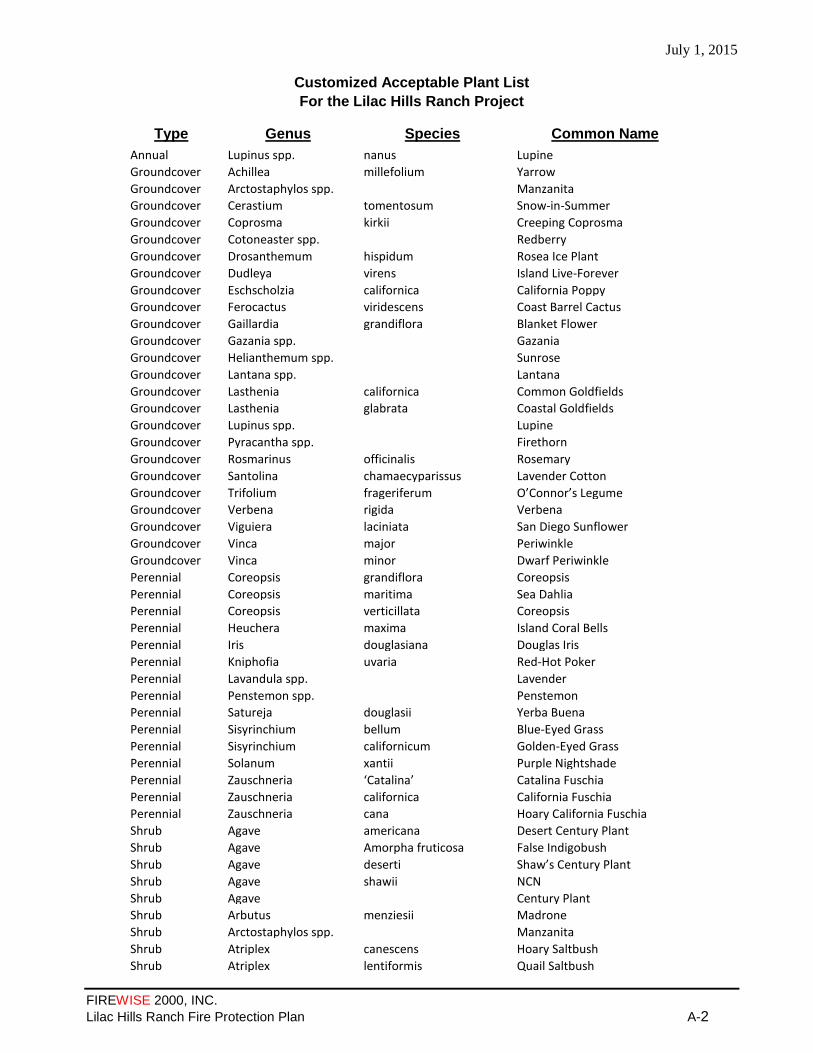
July 1, 2015
FIREWISE 2000, INC.
Lilac Hills Ranch Fire Protection Plan A-2
Customized Acceptable Plant List
For the Lilac Hills Ranch Project
Type Genus Species Common Name
Annual Lupinus spp. nanus Lupine
Groundcover Achillea millefolium Yarrow
Groundcover Arctostaphylos spp. Manzanita
Groundcover Cerastium tomentosum Snow-in-Summer
Groundcover Coprosma kirkii Creeping Coprosma
Groundcover Cotoneaster spp. Redberry
Groundcover Drosanthemum hispidum Rosea Ice Plant
Groundcover Dudleya virens Island Live-Forever
Groundcover Eschscholzia californica California Poppy
Groundcover Ferocactus viridescens Coast Barrel Cactus
Groundcover Gaillardia grandiflora Blanket Flower
Groundcover Gazania spp. Gazania
Groundcover Helianthemum spp. Sunrose
Groundcover Lantana spp. Lantana
Groundcover Lasthenia californica Common Goldfields
Groundcover Lasthenia glabrata Coastal Goldfields
Groundcover Lupinus spp. Lupine
Groundcover Pyracantha spp. Firethorn
Groundcover Rosmarinus officinalis Rosemary
Groundcover Santolina chamaecyparissus Lavender Cotton
Groundcover Trifolium frageriferum O’Connor’s Legume
Groundcover Verbena rigida Verbena
Groundcover Viguiera laciniata San Diego Sunflower
Groundcover Vinca major Periwinkle
Groundcover Vinca minor Dwarf Periwinkle
Perennial Coreopsis grandiflora Coreopsis
Perennial Coreopsis maritima Sea Dahlia
Perennial Coreopsis verticillata Coreopsis
Perennial Heuchera maxima Island Coral Bells
Perennial Iris douglasiana Douglas Iris
Perennial Kniphofia uvaria Red-Hot Poker
Perennial Lavandula spp. Lavender
Perennial Penstemon spp. Penstemon
Perennial Satureja douglasii Yerba Buena
Perennial Sisyrinchium bellum Blue-Eyed Grass
Perennial Sisyrinchium californicum Golden-Eyed Grass
Perennial Solanum xantii Purple Nightshade
Perennial Zauschneria ‘Catalina’ Catalina Fuschia
Perennial Zauschneria californica California Fuschia
Perennial Zauschneria cana Hoary California Fuschia
Shrub Agave americana Desert Century Plant
Shrub Agave Amorpha fruticosa False Indigobush
Shrub Agave deserti Shaw’s Century Plant
Shrub Agave shawii NCN
Shrub Agave Century Plant
Shrub Arbutus menziesii Madrone
Shrub Arctostaphylos spp. Manzanita
Shrub Atriplex canescens Hoary Saltbush
Shrub Atriplex lentiformis Quail Saltbush

July 1, 2015
FIREWISE 2000, INC.
Lilac Hills Ranch Fire Protection Plan A-3
Shrub Baccharis pilularis Coyote Bush
Shrub Baccharis salicifolia Mule Fat "R"
Shrub Carissa macrocarpa Natal Plum
Shrub Ceanothus spp. California Lilac
Shrub Cistus spp. Rockrose
Shrub Cneoridium dumosum Bush rue
Shrub Comarostaphylis diversifolia Summer Holly
Shrub Convolvulus cneorum Bush Morning Glory
Shrub Elaeagnus pungens Silverberry
Shrub Encelia californica Coast Sunflower
Shrub Encelia farinosa White Brittlebush
Shrub Eriobotrya deflexa Bronze Loquat
Shrub Eriophyllum confertiflorum Golden Yarrow
Shrub Escallonia spp. Escallonia
Shrub Feijoa sellowiana Pineapple Guava
Shrub Fouqueria splendens Ocotillo
Shrub Fremontodendron californicum Flannelbush
Shrub Fremontodendron mexicanum Southern Flannelbush
Shrub Galvezia juncea Baja Bush-Snapdragon
Shrub Galvezia speciosa Island Bush-Snapdragon
Shrub Garrya elliptica Coast Silktassel
Shrub Garrya flavescens Ashy Silktassel
Shrub Heteromeles arbutifolia Toyon
Shrub Lantana spp. Lantana
Shrub Lotus scoparius Deerweed
Shrub Mahonia spp. Barberry
Shrub Malacothamnus clementinus San Clemente Island Bush Mallow Shrub Malacothamnus fasciculatus Mesa Bushmallow
Shrub Melaleuca spp. Melaleuca
Shrub Mimulus spp. Monkeyflower
Shrub Nolina parryi Parry’s Nolina
Shrub Photinia spp. Photinia
Shrub Pittosporum rhombifolium Queensland Pittosporum
Shrub Pittosporum tobira ‘Wheeleri’ Wheeler’s Dwarf
Shrub Plumbago auriculata Cape Plumbago
Shrub Prunus caroliniana Carolina Laurel Cherry
Shrub Prunus ilicifolia Hollyleaf Cherry
Shrub Prunus lyonii Catalina Cherry
Shrub Puncia granatum Pomegranate
Shrub Pyracantha spp. Firethorn
Shrub Rhamus alaternus Italian Buckthorn
Shrub Rhamus californica Coffeeberry
Shrub Rhaphiolepis spp. Rhaphiolepis
Shrub Rhus continus Smoke Tree
Shrub Rhus ovata Sugarbush
Shrub Rhus trilobata Squawbush
Shrub Romneya coulteri Matilija Poppy
Shrub Rosa californica California Wild Rose
Shrub Rosa minutifolia Baja California Wild Rose
Shrub Salvia spp. Sage
Shrub Sambucus spp. Elderberry
Shrub Symphoricarpos mollis Creeping Snowberry
Shrub Syringa vulgaris Lilac

July 1, 2015
FIREWISE 2000, INC.
Lilac Hills Ranch Fire Protection Plan A-4
Shrub Teucrium fruticans Bush Germander
Shrub Verbena lilacina Lilac Verbena
Shrub Xylosma congestum Shiny Xylosma
Shrub Yucca schidigera Mojave Yucca
Shrub Yucca whipplei Foothill Yucca
Tree Acer macrophyllum Big Leaf Maple
Tree Acer saccarum Sugar Maple
Tree Acer saccharinum Silver Maple
Tree Alnus rhombifolia White Alder "R"
Tree Arbutus unedo Strawberry Tree
Tree Brahea edulis Guadalupe Palm
Tree Ceratonia siliqua Carob
Tree Cercis occidentalis Western Redbud
Tree Cerdidium floridum Blue Palo Verde
Tree Cornus nuttallii Mountain Dogwood
Tree Cornus stolonifera Redtwig Dogwood
Tree Elaeagnus angustifolia Russian Olive
Tree Eriobotrya japonica Loquat
Tree Gingko biloba "Fairmount" Fairmount Maidenhair Tree
Tree Gleditisia triacanthos Honey Locust
Tree Juglans californica California Walnut
Tree Juglans hindsii California Black Walnut
Tree Lagerstroemia indica Crape Myrtle
Tree Ligustrum lucidum Glossy Privet
Tree Liquidambar styraciflua Sweet Gum
Tree Liriodendron tulipifera Tulip Tree
Tree Melaleuca spp. Melaleuca
Tree Nerium oleander Oleander
Tree Parkinsonia aculeata Mexican Palo Verde
Tree Pistacia chinensis Chinese Pistache
Tree Pistacia vera Pistachio Nut
Tree Pittosporum phillyreoides Willow Pittosporum
Tree Platanus acerifolia London Plane Tree
Tree Platanus racemosa California Sycamore "R"
Tree Populus alba White Poplar
Tree Populus fremontii Western Cottonwood "R"
Tree Populus trichocarpa Black Cottonwood "R"
Tree Prunus caroliniana Carolina Laurel Cherry
Tree Prunus cersifera ‘Newport’ Newport Purple-Leaf Plum
Tree Prunus ilicifolia Hollyleaf Cherry
Tree Prunus lyonii Catalina Cherry
Tree Prunus serrulata ‘Kwanzan’ Flowering Cherry
Tree Prunus xblireiana Flowering Plum
Tree Prunus yedoensis ‘Akebono’ Akebono Flowering Cherry
Tree Quercus agrifolia Coast Live Oak
Tree Quercus engelmannii Engelmann Oak
Tree Quercus suber Cork Oak
Tree Rhus lancea African Sumac
Tree Salix spp. Willow "R"
Tree Ulmus parvifolia Chinese Elm
Tree Ulmus pumila Siberian Elm
Tree Umbellularia californica California Bay Laurel "R"
Vine Antigonon leptopus San Miguel Coral Vine

July 1, 2015
FIREWISE 2000, INC.
Lilac Hills Ranch Fire Protection Plan A-5
Vine Distictis buccinatoria Blood-Red Trumpet Vine
Vine Keckiella cordifolia Heart-Leaved Penstemon
Vine Lonicera japonica ‘Halliana’ Hall’s Honeysuckle
Vine Lonicera subspicata Chaparral Honeysuckle
Vine Solanum jasminoides Potato Vine
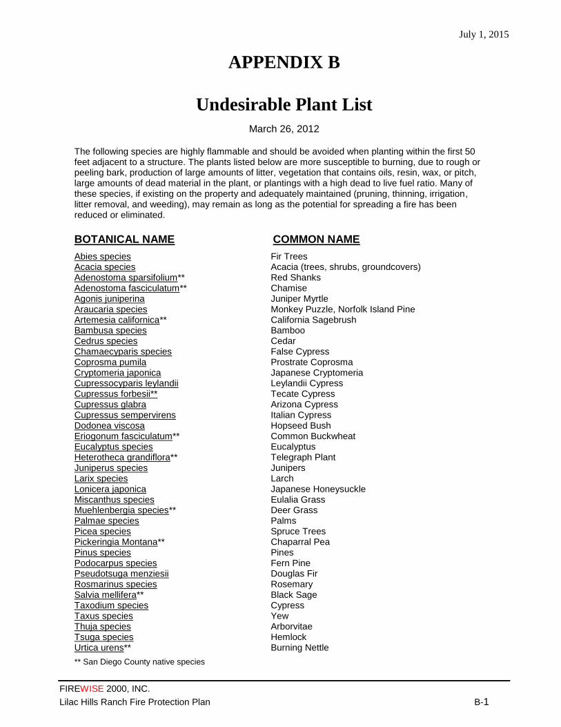
July 1, 2015
FIREWISE 2000, INC.
Lilac Hills Ranch Fire Protection Plan B-1
The following species are highly flammable and should be avoided when planting within the first 50 feet adjacent to a structure. The plants listed below are more susceptible to burning, due to rough or peeling bark, production of large amounts of litter, vegetation that contains oils, resin, wax, or pitch, large amounts of dead material in the plant, or plantings with a high dead to live fuel ratio. Many of these species, if existing on the property and adequately maintained (pruning, thinning, irrigation, litter removal, and weeding), may remain as long as the potential for spreading a fire has been reduced or eliminated.
BOTANICAL NAME COMMON NAME
Abies species Acacia species Adenostoma sparsifolium** Adenostoma fasciculatum** Agonis juniperina Araucaria species Artemesia californica** Bambusa species Cedrus species Chamaecyparis species Coprosma pumila Cryptomeria japonica Cupressocyparis leylandii Cupressus forbesii** Cupressus glabra Cupressus sempervirens Dodonea viscosa Eriogonum fasciculatum** Eucalyptus species Heterotheca grandiflora** Juniperus species Larix species Lonicera japonica Miscanthus species Muehlenbergia species** Palmae species Picea species Pickeringia Montana** Pinus species Podocarpus species Pseudotsuga menziesii Rosmarinus species Salvia mellifera** Taxodium species Taxus species Thuja species Tsuga species Urtica urens**
Fir Trees Acacia (trees, shrubs, groundcovers) Red Shanks Chamise Juniper Myrtle Monkey Puzzle, Norfolk Island Pine California Sagebrush Bamboo Cedar False Cypress Prostrate Coprosma Japanese Cryptomeria Leylandii Cypress Tecate Cypress Arizona Cypress Italian Cypress Hopseed Bush Common Buckwheat Eucalyptus Telegraph Plant Junipers Larch Japanese Honeysuckle Eulalia Grass Deer Grass Palms Spruce Trees Chaparral Pea Pines Fern Pine Douglas Fir Rosemary Black Sage Cypress Yew Arborvitae Hemlock Burning Nettle
** San Diego County native species
APPENDIX B
Undesirable Plant List
March 26, 2012
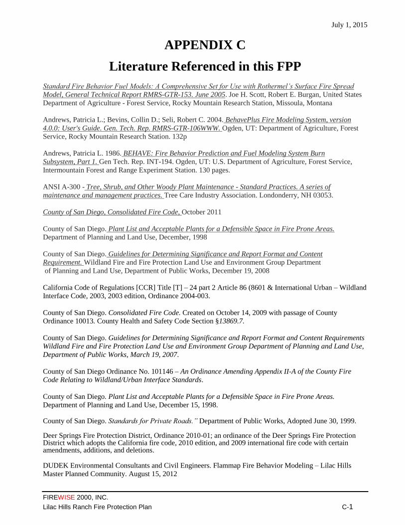
July 1, 2015
FIREWISE 2000, INC.
Lilac Hills Ranch Fire Protection Plan C-1
APPENDIX C
Literature Referenced in this FPP
Standard Fire Behavior Fuel Models: A Comprehensive Set for Use with Rothermel’s Surface Fire Spread
Model, General Technical Report RMRS-GTR-153. June 2005. Joe H. Scott, Robert E. Burgan, United States
Department of Agriculture - Forest Service, Rocky Mountain Research Station, Missoula, Montana
Andrews, Patricia L.; Bevins, Collin D.; Seli, Robert C. 2004. BehavePlus Fire Modeling System, version
4.0.0: User's Guide. Gen. Tech. Rep. RMRS-GTR-106WWW. Ogden, UT: Department of Agriculture, Forest
Service, Rocky Mountain Research Station. 132p
Andrews, Patricia L. 1986. BEHAVE: Fire Behavior Prediction and Fuel Modeling System Burn
Subsystem, Part 1. Gen Tech. Rep. INT-194. Ogden, UT: U.S. Department of Agriculture, Forest Service,
Intermountain Forest and Range Experiment Station. 130 pages.
ANSI A-300 - Tree, Shrub, and Other Woody Plant Maintenance - Standard Practices. A series of
maintenance and management practices. Tree Care Industry Association. Londonderry, NH 03053.
County of San Diego, Consolidated Fire Code, October 2011
County of San Diego. Plant List and Acceptable Plants for a Defensible Space in Fire Prone Areas.
Department of Planning and Land Use, December, 1998
County of San Diego. Guidelines for Determining Significance and Report Format and Content
Requirement. Wildland Fire and Fire Protection Land Use and Environment Group Department
of Planning and Land Use, Department of Public Works, December 19, 2008
California Code of Regulations [CCR] Title [T] – 24 part 2 Article 86 (8601 & International Urban – Wildland
Interface Code, 2003, 2003 edition, Ordinance 2004-003.
County of San Diego. Consolidated Fire Code. Created on October 14, 2009 with passage of County
Ordinance 10013. County Health and Safety Code Section §13869.7.
County of San Diego. Guidelines for Determining Significance and Report Format and Content Requirements
Wildland Fire and Fire Protection Land Use and Environment Group Department of Planning and Land Use,
Department of Public Works, March 19, 2007.
County of San Diego Ordinance No. 101146 – An Ordinance Amending Appendix II-A of the County Fire
Code Relating to Wildland/Urban Interface Standards.
County of San Diego. Plant List and Acceptable Plants for a Defensible Space in Fire Prone Areas.
Department of Planning and Land Use, December 15, 1998.
County of San Diego. Standards for Private Roads.” Department of Public Works, Adopted June 30, 1999. Deer Springs Fire Protection District, Ordinance 2010-01; an ordinance of the Deer Springs Fire Protection District which adopts the California fire code, 2010 edition, and 2009 international fire code with certain amendments, additions, and deletions. DUDEK Environmental Consultants and Civil Engineers. Flammap Fire Behavior Modeling – Lilac Hills
Master Planned Community. August 15, 2012

July 1, 2015
FIREWISE 2000, INC.
Lilac Hills Ranch Fire Protection Plan C-2
DUDEK and Hunt Research Corporation. Lilac Hills Ranch Fire Services Response Capabilities Assessment,
December 2013
DUDEK Environmental Consultants and Civil Engineers. Fuel Modification Zones Analysis. September 2012
Fire Planning and Mapping Tools. California Fire Alliance. Web site is available at:
http://wildfire.cr.usgs.gov/fireplanning/
Guidance Document Ignition Resistant Eave Construction. County of San Diego, Department of Planning and
Land Use, Building Division, DPLU # 198 (3-21-2005).
How to Predict the Spread and Intensity of Forest and Range Fires. General Technical Report INT-143. June
1983. Richard C. Rothermel. United States Department of Agriculture - Forest Service, Intermountain Station,
Ogden, Utah 84401
Latham, D. J. and J. A. Schleiter. (1989) Ignition Probabilities of Wildland Fuels Based on Simulated
Lightning Discharges. USDA Forest Service General Technical Report INT-411, Ogden, UT. (6,497 KB; 20
pages)
National Fire Protection Association - NFPA 1144 Standard for Reducing Structure Ignition Hazards from
Wildland Fire (2008 Edition). 30 pages.
National Fire Protection Association - NFPA 1142 Standard on Water Supplies for Suburban and Rural Fire
Fighting, 2007 Edition. 64 pages.
Scott, Joe H.; Burgan, Robert E. 2005. Standard fire behavior fuel models: a comprehensive set for use with
Rothermel’s surface fire spread model. Gen. Tech. Rep. RMRS-GTR-153. Fort Collins, CO: U.S. Department
of Agriculture, Forest Service, Rocky Mountain Research Station. 72 pages.
The Biological Resources Report for Lilac Hills Ranch by RECON. 2012
Western Garden Book 2001 Edition. Editor: Kathleen Norris Brenzel. ISBN-0376039175 Sunset Publishing
Corporation. Menlo Park, CA. 768 pages.
Western Region Climate Center. Historic Climate Data from Remote Automated Weather Stations. RAWS
USA Climate Archive. Reno, NV. Data for all Remote Automated Weather Stations is available at:
http://www.raws.dri.edu/index.html.
Wildland/Urban Interface Development Standards. San Diego County Fire Chief’s Association, originally
Developed by Orange County Wildland/Urban Interface Task Force Subcommittee on Open Space
Management, July, 1994, Modified by the San Diego County Wildland/Urban Interface Task Force,
November, 1995, Revised August, 1997.

July 1, 2015
FIREWISE 2000, INC.
Lilac Hills Ranch Fire Protection Plan D-1
APPENDIX D
Behaveplus Version 4.0.0
Fire Behavior Calculations
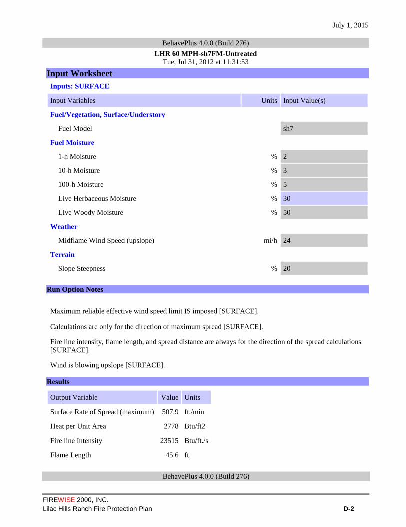
July 1, 2015
FIREWISE 2000, INC.
Lilac Hills Ranch Fire Protection Plan D-2
BehavePlus 4.0.0 (Build 276)
LHR 60 MPH-sh7FM-Untreated Tue, Jul 31, 2012 at 11:31:53
Input Worksheet
Inputs: SURFACE
Input Variables Units Input Value(s)
Fuel/Vegetation, Surface/Understory
Fuel Model sh7
Fuel Moisture
1-h Moisture % 2
10-h Moisture % 3
100-h Moisture % 5
Live Herbaceous Moisture % 30
Live Woody Moisture % 50
Weather
Midflame Wind Speed (upslope) mi/h 24
Terrain
Slope Steepness % 20
Run Option Notes
Maximum reliable effective wind speed limit IS imposed [SURFACE].
Calculations are only for the direction of maximum spread [SURFACE].
Fire line intensity, flame length, and spread distance are always for the direction of the spread calculations
[SURFACE].
Wind is blowing upslope [SURFACE].
Results
Output Variable Value Units
Surface Rate of Spread (maximum) 507.9 ft./min
Heat per Unit Area 2778 Btu/ft2
Fire line Intensity 23515 Btu/ft./s
Flame Length 45.6 ft.
BehavePlus 4.0.0 (Build 276)
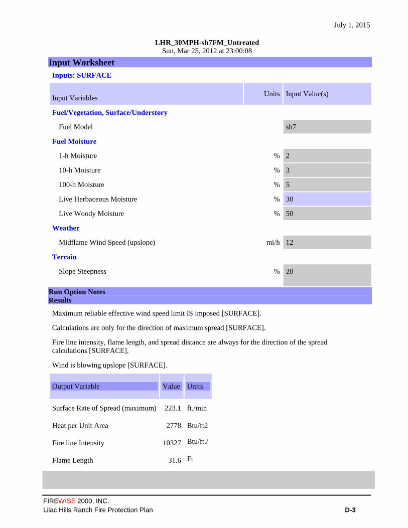
July 1, 2015
FIREWISE 2000, INC.
Lilac Hills Ranch Fire Protection Plan D-3
LHR_30MPH-sh7FM_Untreated Sun, Mar 25, 2012 at 23:00:08
Input Worksheet
Inputs: SURFACE
Input Variables Units Input Value(s)
Fuel/Vegetation, Surface/Understory
Fuel Model sh7
Fuel Moisture
1-h Moisture % 2
10-h Moisture % 3
100-h Moisture % 5
Live Herbaceous Moisture % 30
Live Woody Moisture % 50
Weather
Midflame Wind Speed (upslope) mi/h 12
Terrain
Slope Steepness % 20
Run Option Notes
Results
Output Variable Value Units
Surface Rate of Spread (maximum) 223.1 ft./min
Heat per Unit Area 2778 Btu/ft2
Fire line Intensity 10327 Btu/ft./
s
Flame Length 31.6 Ft
Maximum reliable effective wind speed limit IS imposed [SURFACE].
Calculations are only for the direction of maximum spread [SURFACE].
Fire line intensity, flame length, and spread distance are always for the direction of the spread
calculations [SURFACE].
Wind is blowing upslope [SURFACE].

July 1, 2015
FIREWISE 2000, INC.
Lilac Hills Ranch Fire Protection Plan D-4
BehavePlus 4.0.0 (Build 276)
LHR_30MPH-tl6(50%)+gr1(50%)FMs_Treated Sun, Mar 25, 2012 at 23:10:27
Input Worksheet
Inputs: SURFACE
Input Variables Units Input Value(s)
Fuel/Vegetation, Surface/Understory
First Fuel Model tl6
Second Fuel Model gr1
First Fuel Model Coverage % 50
Fuel Model Type S
Fuel Moisture
1-h Moisture % 2
10-h Moisture % 3
100-h Moisture % 5
Live Herbaceous Moisture % 30
Live Woody Moisture % 50
Weather
Midflame Wind Speed (upslope) mi/h 12
Terrain
Slope Steepness % 20
Run Option Notes
Two fuel model weighting method: two-dimensional spread [SURFACE].
Maximum reliable effective wind speed limit IS imposed [SURFACE].
Calculations are only for the direction of maximum spread [SURFACE].
Fire line intensity, flame length, and spread distance are always for the direction of the spread calculations
[SURFACE].
Wind is blowing upslope [SURFACE].
Results
Output Variable Value Units
Surface Rate of Spread (maximum) 26.8 ft./min
Heat per Unit Area 580 Btu/ft2
Fire line Intensity 324 Btu/ft./s
Flame Length 6.6 ft.
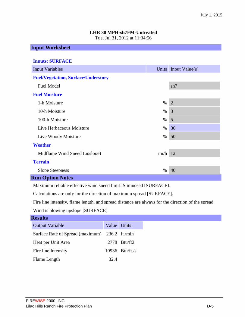
July 1, 2015
FIREWISE 2000, INC.
Lilac Hills Ranch Fire Protection Plan D-5
LHR 30 MPH-sh7FM-Untreated Tue, Jul 31, 2012 at 11:34:56
Input Worksheet
Inputs: SURFACE
Input Variables Units Input Value(s)
Fuel/Vegetation, Surface/Understory
Fuel Model sh7
Fuel Moisture
1-h Moisture % 2
10-h Moisture % 3
100-h Moisture % 5
Live Herbaceous Moisture % 30
Live Woody Moisture % 50
Weather
Midflame Wind Speed (upslope) mi/h 12
Terrain
Slope Steepness % 40
Run Option Notes
Maximum reliable effective wind speed limit IS imposed [SURFACE].
Calculations are only for the direction of maximum spread [SURFACE].
Fire line intensity, flame length, and spread distance are always for the direction of the spread
calculations [SURFACE]. Wind is blowing upslope [SURFACE].
Results
Output Variable Value Units
Surface Rate of Spread (maximum) 236.2 ft./min
Heat per Unit Area 2778 Btu/ft2
Fire line Intensity 10936 Btu/ft./s
Flame Length 32.4

July 1, 2015
FIREWISE 2000, INC.
Lilac Hills Ranch Fire Protection Plan D-6
BehavePlus 4.0.0 (Build 276)
LHR 30 MPH-tl6(50%)&gr1(50%)-Treated Tue, Jul 31, 2012 at 11:48:26
Input Worksheet
Inputs: SURFACE
Input Variables Units Input Value(s)
Fuel/Vegetation, Surface/Understory
First Fuel Model tl6
Second Fuel Model gr1
First Fuel Model Coverage % 50
Fuel Model Type S
Fuel Moisture
1-h Moisture % 2
10-h Moisture % 3
100-h Moisture % 5
Live Herbaceous Moisture % 30
Live Woody Moisture % 50
Weather
Midflame Wind Speed (upslope) mi/h 12
Terrain
Slope Steepness % 40
Run Option Notes
Two fuel model weighting method: two-dimensional spread [SURFACE].
Maximum reliable effective wind speed limit IS imposed [SURFACE].
Calculations are only for the direction of maximum spread [SURFACE].
Fire line intensity, flame length, and spread distance are always for the direction of the spread
calculations [SURFACE]. Wind is blowing upslope [SURFACE].
Results
Output Variable Value Units
Surface Rate of Spread (maximum) 28.0 ft./min
Heat per Unit Area 580 Btu/ft2
Fire line Intensity 342 Btu/ft./s
Flame Length 6.6 ft.

July 1, 2015
FIREWISE 2000, INC.
Lilac Hills Ranch Fire Protection Plan D-7
FIRE BEHAVIOR MODELING SUMMARY BY FIRE SCENARIO
Fire Scenario #1 – Fire Approaching from the North and East (Late Fire Season With 60 MPH North, Northeast And East Wind Conditions in SCAL 18 Fuel Model)
Fire Behavior Calculation Input Data
20 percent slope
60 mph wind speed
225o aspect from north
45o
wind direction from north
Anticipated Fuel Moistures 1-Hour Fine Fuel Moisture ………....…...2%
10-Hour Fuel Moisture ....………....….…3%
100-Hour Fuel Moisture ………....……….5%
Live Herbaceous Fuel Moisture .….....30%
Live Woody Fuel Moisture ……..........50%
Expected Fire Behavior Fuel Model SCAL 18 – Coastal Sage Scrub
Rate of Spread - 294 feet/minute
Fire line Intensity - 21,329BTU's/foot/second
Flame Length - 44.1 feet in length
Expected Fire Behavior in Treated Fuels Combined Fuel Model - [tl6 – Very High Load Broadleaf Litter 50% and
gs1 - Short, Sparse Dry Climate Grass 50%]
Rate of Spread - 79.5 feet/minute
Flame Length – 15.6 feet in length
Fire Scenario #2 – Fire Approaching from the southwest (Late Fire Season With 30 MPH Wind Conditions in SCAL 18 Fuel Model)
Fire Behavior Calculation Input Data
20 percent slope
30 mph wind speed
45o aspect from north
225o wind direction from north
Anticipated Fuel Moistures
1-Hour Fine Fuel Moisture ………....…...2%
10-Hour Fuel Moisture ....………....…..…3%
100-Hour Fuel Moisture ………......…….5%
Live Herbaceous Fuel Moisture …….....30%
Live Woody Fuel Moisture ……............50%
Expected Fire Behavior Fuel Model SCAL 18 – Coastal Sage Scrub
Rate of Spread - 147 feet/minute
Fire line Intensity - 10695 foot/second
Flame Length - 32.1 feet in length
Expected Fire Behavior in Treated Fuels Combined Fuel Model - [tl6 – Very High Load Broadleaf Litter 50% and
gs1 - Short, Sparse Dry Climate Grass 50%]
Rate of Spread - 25.1 feet/minute
Fire line Intensity - 612 BTU's/foot/second
Flame Length – 8.6 feet in length

July 1, 2015
FIREWISE 2000, INC.
Lilac Hills Ranch Fire Protection Plan D-8
Fire Scenario #3 – Fire Approaching from the North and East (Late Fire Season Santa Ana Wind Event With 60 MPH North, Northeast And East Wind Conditions in southern mixed chaparral, sh7 Fuel Model)
Fire Behavior Calculation Input Data 20 percent slope 60 mph wind speed 225
o aspect from north
45o
wind direction from north
Anticipated Fuel Moistures 1-Hour Fine Fuel Moisture ………....…...2% 10-Hour Fuel Moisture ....………....….…3% 100-Hour Fuel Moisture ………....……….5% Live Herbaceous Fuel Moisture .….....30% Live Woody Fuel Moisture ……..........50%
Expected Fire Behavior Fuel Model SCAL 18 – Coastal Sage Scrub
Rate of Spread - 495 feet/minute
Fire line Intensity - 22905 BTU's/foot/second
Flame Length - 45.6 feet in length
Expected Fire Behavior in Treated Fuels Combined Fuel Model - [tl6 – Very High Load Broadleaf Litter 50% and
gs1 - Short, Sparse Dry Climate Grass 50%]
Rate of Spread - 60.9 feet/minute
Fire line Intensity - 890 BTU’s/foot/second
Flame Length – 10.2 feet in length
Fire Scenario #4 – Fire Approaching from the south and southwest (Late Fire Season “Rare Event” With 30 MPH Wind Conditions in southern mixed chaparral, sh7 Fuel Model)
Fire Behavior Calculation Input Data 20 percent slope 30 mph wind speed 45
o aspect from north
225o
wind direction from north
Anticipated Fuel Moistures 1-Hour Fine Fuel Moisture ………....…...2% 10-Hour Fuel Moisture ....………....…..…3% 100-Hour Fuel Moisture ………......………5% Live Herbaceous Fuel Moisture ………....30% Live Woody Fuel Moisture …….............50%
Expected Fire Behavior Fuel Model SCAL 18 – Coastal Sage Scrub
Rate of Spread - 223 feet/minute
Fire line Intensity - 10327 foot/second
Flame Length - 31.6 feet in length
Expected Fire Behavior in Treated Fuels Combined Fuel Model - [tl6 – Very High Load Broadleaf Litter 50% and
gs1 - Short, Sparse Dry Climate Grass 50%]
Rate of Spread - 26.8 feet/minute
Fire line Intensity - 324 BTU's/foot/second
Flame Length – 6.4 feet in length

July 1, 2015
FIREWISE 2000, INC.
Lilac Hills Ranch Fire Protection Plan D-9
Fire Scenario #5 – Fire Approaching from the south and southwest (Late Fire Season “Rare Event” With 30 MPH Wind Conditions in southern mixed chaparral, sh7 Fuel Model)
Fire Behavior Calculation Input Data 40 percent slope 30 mph wind speed 45
o aspect from north
225o
wind direction from north
Anticipated Fuel Moistures 1-Hour Fine Fuel Moisture ………....…...2% 10-Hour Fuel Moisture ....………....…..…3% 100-Hour Fuel Moisture ………......………5% Live Herbaceous Fuel Moisture ………....30% Live Woody Fuel Moisture …….............50%
Expected Fire Behavior Fuel Model SCAL 18 – Coastal Sage Scrub
Rate of Spread - 236.2 feet/minute
Fire line Intensity - 10936 foot/second
Flame Length - 32.4 feet in length
Expected Fire Behavior in Treated Fuels Combined Fuel Model - [tl6 – Very High Load Broadleaf Litter 50% and
gs1 - Short, Sparse Dry Climate Grass 50%]
Rate of Spread - 28.0 feet/minute
Fire line Intensity - 342 BTU's/foot/second
Flame Length – 6.6 feet in length
July 1, 2015
FIREWISE 2000, INC.
Lilac Hills Ranch Fire Protection Plan E-1
APPENDIX E
Project Facility Availability Forms
(Fire and Water)
The Attached Project Facility Availability Form (DPLU-399F) Dated 2/14/2014, Documents Deer
Springs Fire Protection District’s Requirements to Comply and Adhere to Any and All Current Fire
Codes, Building Codes and County Codes Applicable At the Time of Project Start
Separate From the Conditions Outlined in The Project Availability Form (PFAF), The Deer Springs
Fire Protection District Will Require a Memorandum of Agreement To Settle Prior To The Initial
Phase of the Development. The Conditions of the Agreement Will Not Set Aside or Alter The
Conditions In The Attached PFAF.

July 1, 2015
FIREWISE 2000, INC.
Lilac Hills Ranch Fire Protection Plan E-2
July 1, 2015
FIREWISE 2000, INC.
Lilac Hills Ranch Fire Protection Plan E-3

July 1, 2015
FIREWISE 2000, INC.
Lilac Hills Ranch Fire Protection Plan E-4

July 1, 2015
FIREWISE 2000, INC.
Lilac Hills Ranch Fire Protection Plan E-5

July 1, 2015
FIREWISE 2000, INC.
Lilac Hills Ranch Fire Protection Plan E-6

July 1, 2015
FIREWISE 2000, INC.
Lilac Hills Ranch Fire Protection Plan E-7
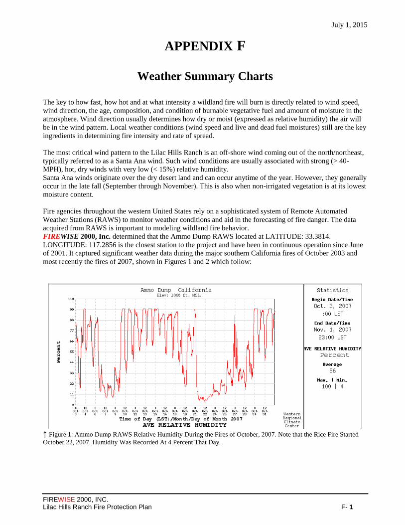
July 1, 2015
FIREWISE 2000, INC. Lilac Hills Ranch Fire Protection Plan F- 1
APPENDIX F
Weather Summary Charts
The key to how fast, how hot and at what intensity a wildland fire will burn is directly related to wind speed,
wind direction, the age, composition, and condition of burnable vegetative fuel and amount of moisture in the
atmosphere. Wind direction usually determines how dry or moist (expressed as relative humidity) the air will
be in the wind pattern. Local weather conditions (wind speed and live and dead fuel moistures) still are the key
ingredients in determining fire intensity and rate of spread.
The most critical wind pattern to the Lilac Hills Ranch is an off-shore wind coming out of the north/northeast,
typically referred to as a Santa Ana wind. Such wind conditions are usually associated with strong (> 40-
MPH), hot, dry winds with very low (< 15%) relative humidity.
Santa Ana winds originate over the dry desert land and can occur anytime of the year. However, they generally
occur in the late fall (September through November). This is also when non-irrigated vegetation is at its lowest
moisture content.
Fire agencies throughout the western United States rely on a sophisticated system of Remote Automated
Weather Stations (RAWS) to monitor weather conditions and aid in the forecasting of fire danger. The data
acquired from RAWS is important to modeling wildland fire behavior.
FIREWISE 2000, Inc. determined that the Ammo Dump RAWS located at LATITUDE: 33.3814.
LONGITUDE: 117.2856 is the closest station to the project and have been in continuous operation since June
of 2001. It captured significant weather data during the major southern California fires of October 2003 and
most recently the fires of 2007, shown in Figures 1 and 2 which follow:
↑ Figure 1: Ammo Dump RAWS Relative Humidity During the Fires of October, 2007. Note that the Rice Fire Started
October 22, 2007. Humidity Was Recorded At 4 Percent That Day.

July 1, 2015
FIREWISE 2000, INC. Lilac Hills Ranch Fire Protection Plan F- 2
↑ Figure 2: Ammo Dump RAWS Wind Gusts During the Fires of October, 2007. Note The Peak Wind Gust Of 49 Miles
Per Hour Occurred During A Very Dry Period That Is Shown In Figure 1.
In reviewing the two figures above, note that in late October the wind gusts were very strong and relative
humidity was very low, an indicator of a Santa Ana wind event. For planning purposes, FIREWISE 2000, Inc.
utilized 60 MPH winds as the extreme or worst case wind likely at the Lilac Hills Ranch project during low
relative humidity. Higher wind speeds may occur during winter storms when humidity is high. Such winds are
not a wildfire concern.
The Ammo Dump RAWS is located approximately 12 miles to the northwest of the project at an elevation of
1,068 feet. Data for all RAWS is archived in the Western Region Climate Center in Reno, Nevada. Weather
data for all of October 2007 for Ammo Dump RAWS is presented in APPENDIX ‘C’, as an example of
extreme fire weather. This historic weather data was used to help determine the more extreme fuel moisture
regimes found later in this plan.

July 1, 2015
FIREWISE 2000, INC. Lilac Hills Ranch Fire Protection Plan G- 1
APPENDIX G
Lilac Hills Ranch Phasing Plan
and
Lilac Hills Ranch Internal Circulation Map
and
Lilac Hills Ranch Access Exhibit
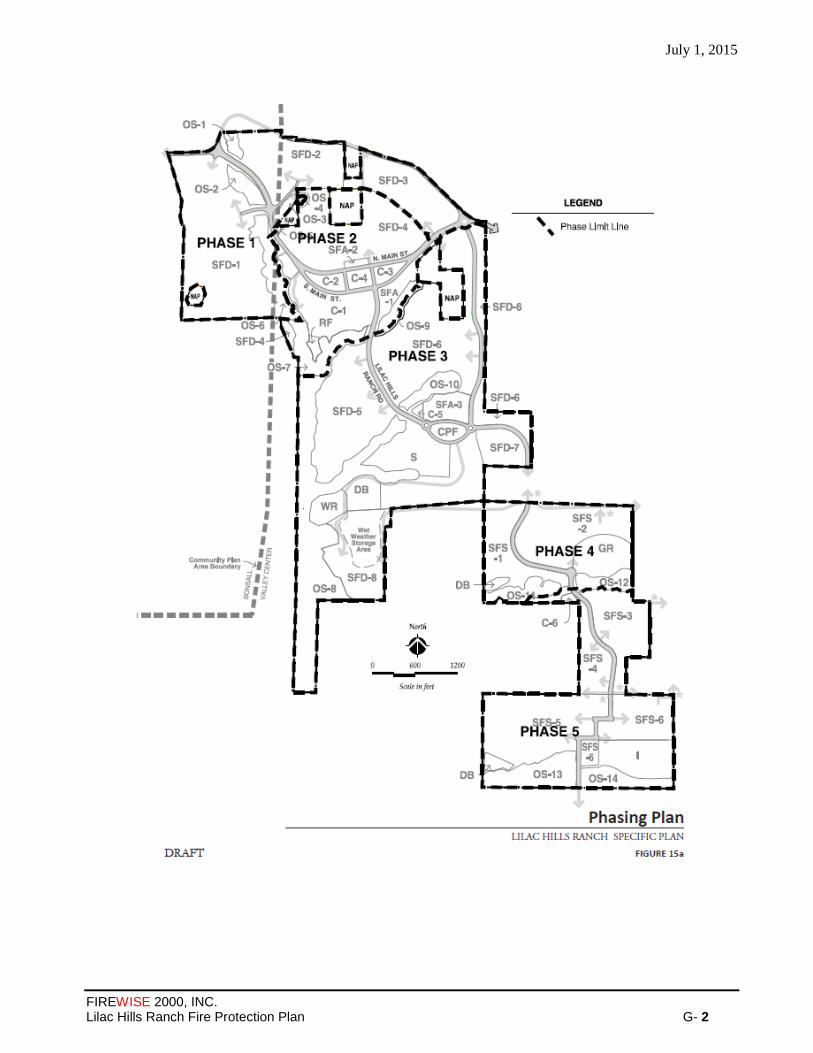
July 1, 2015
FIREWISE 2000, INC. Lilac Hills Ranch Fire Protection Plan G- 2
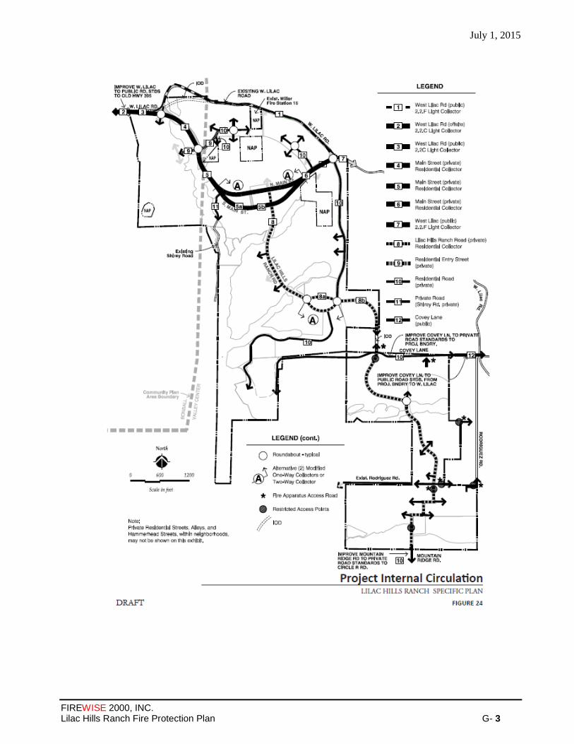
July 1, 2015
FIREWISE 2000, INC. Lilac Hills Ranch Fire Protection Plan G- 3
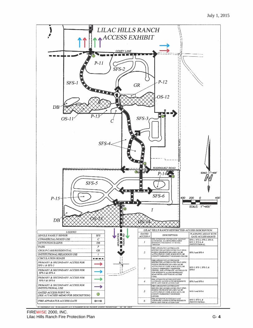
July 1, 2015
FIREWISE 2000, INC. Lilac Hills Ranch Fire Protection Plan G- 4

July 1, 2015
FIREWISE 2000, INC. Lilac Hills Ranch Fire Protection Plan H- 1
APPENDIX H
Fuel Modification and
Agriculture Within RPO Wetland
Or Wetland Buffer
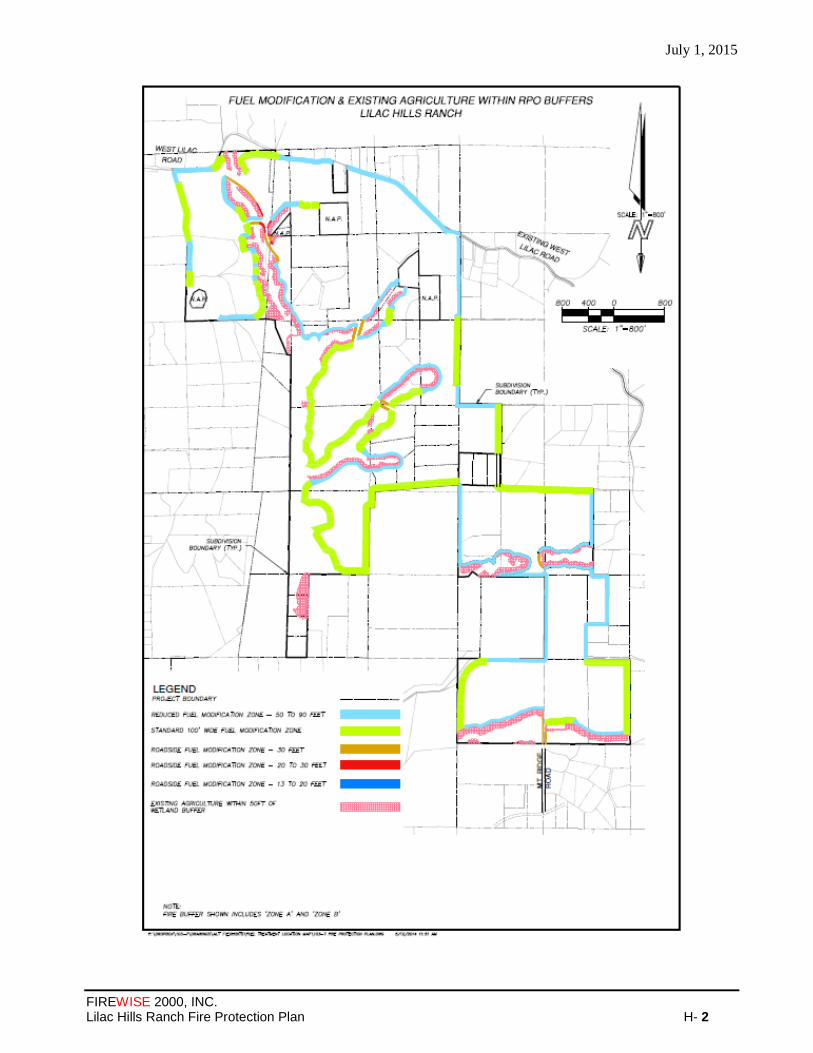
July 1, 2015
FIREWISE 2000, INC. Lilac Hills Ranch Fire Protection Plan H- 2

July 1, 2015
FIREWISE 2000, INC. Lilac Hills Ranch Fire Protection Plan I- 1
APPENDIX I
Specific Plan – Site Plan
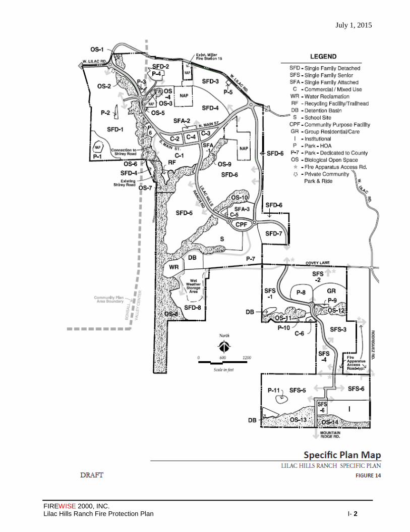
July 1, 2015
FIREWISE 2000, INC. Lilac Hills Ranch Fire Protection Plan I- 2

July 1, 2015
FIREWISE 2000, INC. Lilac Hills Ranch Fire Protection Plan J-1
APPENDIX J
Flammap Analysis - Dudek

July 1, 2015
FIREWISE 2000, INC. Lilac Hills Ranch Fire Protection Plan J-2
July 1, 2015
FIREWISE 2000, INC. Lilac Hills Ranch Fire Protection Plan J-3
July 1, 2015
FIREWISE 2000, INC. Lilac Hills Ranch Fire Protection Plan J-4
July 1, 2015
FIREWISE 2000, INC. Lilac Hills Ranch Fire Protection Plan J-5

July 1, 2015
FIREWISE 2000, INC. Lilac Hills Ranch Fire Protection Plan J-6

July 1, 2015
FIREWISE 2000, INC. Lilac Hills Ranch Fire Protection Plan J-7

July 1, 2015
FIREWISE 2000, INC. Lilac Hills Ranch Fire Protection Plan J-8
July 1, 2015
FIREWISE 2000, INC. Lilac Hills Ranch Fire Protection Plan J-9

July 1, 2015
FIREWISE 2000, INC. Lilac Hills Ranch Fire Protection Plan J-10

July 1, 2015
FIREWISE 2000, INC. Lilac Hills Ranch Fire Protection Plan J-11

July 1, 2015
FIREWISE 2000, INC. Lilac Hills Ranch Fire Protection Plan J-12

July 1, 2015
FIREWISE 2000, INC. Lilac Hills Ranch Fire Protection Plan J-13
APPENDIX K

July 1, 2015
FIREWISE 2000, INC. Lilac Hills Ranch Fire Protection Plan J-14
2005 – 2011 Response Data for Deer Springs Fire
Protection District
(Tables Developed From Data Provided By Deer Springs Fire Protection District)
RESPONSE within IA CY 2005 TOTAL
FOR YEAR STATION 11 STATION 12 STATION 13 MILLER
Medical Aid (MU) 258 230 19 507
Traffic Collision (TC) 73 76 30 179
Vehicle Fire (VF) 9 16 2 27
Vegetation Fire (VEG) 6 7 6 19
Structure Fire (STR) 4 2 2 8
Hazardous Material Response 1 40 21 62
False Alarm (FA) 9 2 0 11
Cancel = CA 52 19 25 96
Illegal Burn (IB) 4 8 8 20
Smoke Check (SC) 4 10 3 17
PSA 18 33 5 56
Mutual Aid/Assist Out of District (MUT)
33 6 145 184
Assist to other DSFPD Units 131 141 186 458
Burn Permit Inspections --- --- --- 0
Station Total Responses 602 590 452 1644
Calls per 24-Hr Shift 1.65 1.62 1.24 4.50
RESPONSE within IA CY 2006 * TOTAL FOR YEAR STATION 11 STATION 12 STATION 13 MILLER
Medical Aid (MU) 30 24 7 61
Traffic Collision (TC) 6 5 9 20
Vehicle Fire (VF) 0 0 4 4
Vegetation Fire (VEG) 0 1 9 10
Structure Fire (STR) 0 0 0 0
Hazardous Material Response 0 1 0 1
False Alarm (FA) 7 5 11 23
Illegal Burn (IB) 0 0 3 3
Smoke Check (SC) 0 4 4
PSA 4 1 0 5
Mutual Aid/Assist Out of District (MUT)
0 0 4 4
Assist to other DSFPD Units 10 16 0 26
Burn Permit Inspections --- --- --- 0
Station Total Responses 58 58 47 163
Calls per 24-Hr Shift 1.90 1.90 1.55 5.36
* Data Only Available For The Month Of December
RESPONSE within IA CY 2007 TOTAL
FOR YEAR STATION 11 STATION 12 STATION 13 MILLER
Medical Aid (MU) 290 278 29
Traffic Collision (TC) 83 78 25
Vehicle Fire (VF) 12 22 11
Sta
tion
No
t In S
erv
ice
Sta
tion
No
t In S
erv
ice
Sta
tion
No
t In
Se
rvic
e
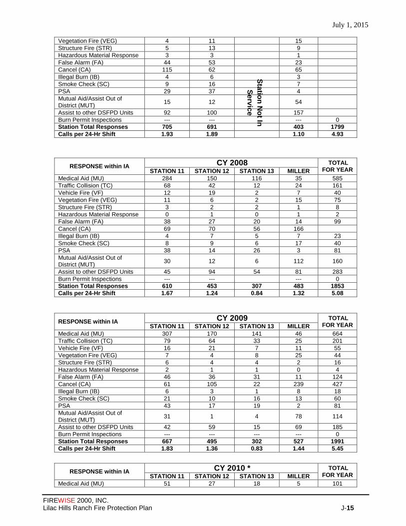
July 1, 2015
FIREWISE 2000, INC. Lilac Hills Ranch Fire Protection Plan J-15
Vegetation Fire (VEG) 4 11 15
Structure Fire (STR) 5 13 9
Hazardous Material Response 3 3 1
False Alarm (FA) 44 53 23
Cancel (CA) 115 62 65
Illegal Burn (IB) 4 6 3
Smoke Check (SC) 9 16 7
PSA 29 37 4
Mutual Aid/Assist Out of District (MUT)
15 12 54
Assist to other DSFPD Units 92 100 157
Burn Permit Inspections --- --- --- 0
Station Total Responses 705 691 403 1799
Calls per 24-Hr Shift 1.93 1.89 1.10 4.93
RESPONSE within IA CY 2008 TOTAL
FOR YEAR STATION 11 STATION 12 STATION 13 MILLER
Medical Aid (MU) 284 150 116 35 585
Traffic Collision (TC) 68 42 12 24 161
Vehicle Fire (VF) 12 19 2 7 40
Vegetation Fire (VEG) 11 6 2 15 75
Structure Fire (STR) 3 2 2 1 8
Hazardous Material Response 0 1 0 1 2
False Alarm (FA) 38 27 20 14 99
Cancel (CA) 69 70 56 166
Illegal Burn (IB) 4 7 5 7 23
Smoke Check (SC) 8 9 6 17 40
PSA 38 14 26 3 81
Mutual Aid/Assist Out of District (MUT)
30 12 6 112 160
Assist to other DSFPD Units 45 94 54 81 283
Burn Permit Inspections --- --- --- 0
Station Total Responses 610 453 307 483 1853
Calls per 24-Hr Shift 1.67 1.24 0.84 1.32 5.08
RESPONSE within IA CY 2009 TOTAL
FOR YEAR STATION 11 STATION 12 STATION 13 MILLER
Medical Aid (MU) 307 170 141 46 664
Traffic Collision (TC) 79 64 33 25 201
Vehicle Fire (VF) 16 21 7 11 55
Vegetation Fire (VEG) 7 4 8 25 44
Structure Fire (STR) 6 4 4 2 16
Hazardous Material Response 2 1 1 0 4
False Alarm (FA) 46 36 31 11 124
Cancel (CA) 61 105 22 239 427
Illegal Burn (IB) 6 3 1 8 18
Smoke Check (SC) 21 10 16 13 60
PSA 43 17 19 2 81
Mutual Aid/Assist Out of District (MUT)
31 1 4 78 114
Assist to other DSFPD Units 42 59 15 69 185
Burn Permit Inspections --- --- --- --- 0
Station Total Responses 667 495 302 527 1991
Calls per 24-Hr Shift 1.83 1.36 0.83 1.44 5.45
RESPONSE within IA CY 2010 * TOTAL FOR YEAR STATION 11 STATION 12 STATION 13 MILLER
Medical Aid (MU) 51 27 18 5 101
Sta
tion
No
t In
Se
rvic
e
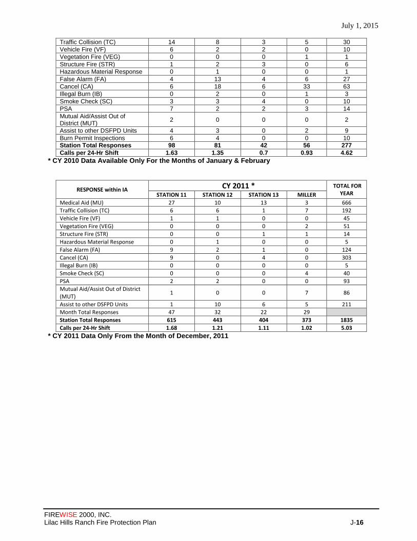
July 1, 2015
FIREWISE 2000, INC. Lilac Hills Ranch Fire Protection Plan J-16
Traffic Collision (TC) 14 8 3 5 30
Vehicle Fire (VF) 6 2 2 0 10
Vegetation Fire (VEG) 0 0 0 1 1
Structure Fire (STR) 1 2 3 0 6
Hazardous Material Response 0 1 0 0 1
False Alarm (FA) 4 13 4 6 27
Cancel (CA) 6 18 6 33 63
Illegal Burn (IB) 0 2 0 1 3
Smoke Check (SC) 3 3 4 0 10
PSA 7 2 2 3 14
Mutual Aid/Assist Out of District (MUT)
2 0 0 0 2
Assist to other DSFPD Units 4 3 0 2 9
Burn Permit Inspections 6 4 0 0 10
Station Total Responses 98 81 42 56 277
Calls per 24-Hr Shift 1.63 1.35 0.7 0.93 4.62
* CY 2010 Data Available Only For the Months of January & February
RESPONSE within IA CY 2011 * TOTAL FOR
YEAR STATION 11 STATION 12 STATION 13 MILLER
Medical Aid (MU) 27 10 13 3 666
Traffic Collision (TC) 6 6 1 7 192
Vehicle Fire (VF) 1 1 0 0 45
Vegetation Fire (VEG) 0 0 0 2 51
Structure Fire (STR) 0 0 1 1 14
Hazardous Material Response 0 1 0 0 5
False Alarm (FA) 9 2 1 0 124
Cancel (CA) 9 0 4 0 303
Illegal Burn (IB) 0 0 0 0 5
Smoke Check (SC) 0 0 0 4 40
PSA 2 2 0 0 93
Mutual Aid/Assist Out of District (MUT)
1 0 0 7 86
Assist to other DSFPD Units 1 10 6 5 211
Month Total Responses 47 32 22 29
Station Total Responses 615 443 404 373 1835
Calls per 24-Hr Shift 1.68 1.21 1.11 1.02 5.03
* CY 2011 Data Only From the Month of December, 2011

July 1, 2015
FIREWISE 2000, INC. Lilac Hills Ranch Fire Protection Plan L- 1
APPENDIX L
Automatic Aid Agreement Between Deer Springs Fire
Protection District and North
County Fire Protection District

July 15, 2015
FIREWISE 2000, INC. Lilac Hills Ranch Fire Protection Plan Page 2 of 130

July 1, 2015
FIREWISE 2000, INC. Lilac Hills Ranch Fire Protection Plan Exhibit- 3

July 1, 2015
FIREWISE 2000, INC. Lilac Hills Ranch Fire Protection Plan Exhibit- 4

July 1, 2015
FIREWISE 2000, INC. Lilac Hills Ranch Fire Protection Plan Exhibit- 5
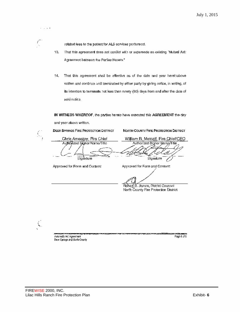
July 1, 2015
FIREWISE 2000, INC. Lilac Hills Ranch Fire Protection Plan Exhibit- 6

July 15, 2015
FIREWISE 2000, INC. Lilac Hills Ranch Fire Protection Plan O-1
APPENDIX M
County of San Diego-Department of Purchasing
and Contracting — Contract 515388
Amendment No. 2 – Deer Springs
Fire Protection District For Use
of Fire Protection Funds

July 15, 2015
FIREWISE 2000, INC. Lilac Hills Ranch Fire Protection Plan O-1
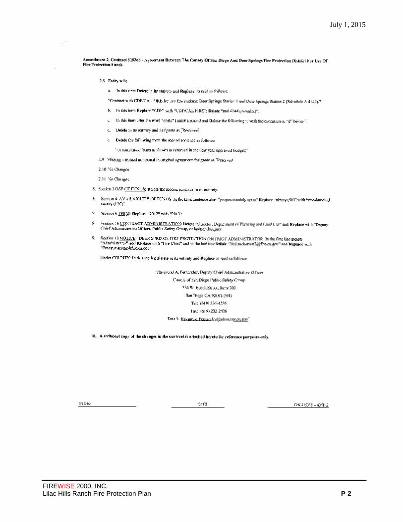
July 1, 2015
FIREWISE 2000, INC. Lilac Hills Ranch Fire Protection Plan P-2
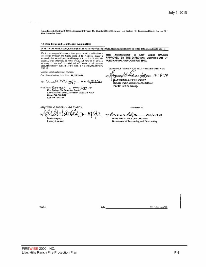
July 1, 2015
FIREWISE 2000, INC. Lilac Hills Ranch Fire Protection Plan P-3

July 1, 2015
FIREWISE 2000, INC. Lilac Hills Ranch Fire Protection Plan P-4

July 1, 2015
FIREWISE 2000, INC. Lilac Hills Ranch Fire Protection Plan P-5
July 1, 2015
FIREWISE 2000, INC. Lilac Hills Ranch Fire Protection Plan P-6
July 1, 2015
FIREWISE 2000, INC. Lilac Hills Ranch Fire Protection Plan P-7

July 1, 2015
FIREWISE 2000, INC. Lilac Hills Ranch Fire Protection Plan P-8
July 1, 2015
FIREWISE 2000, INC. Lilac Hills Ranch Fire Protection Plan P-9

July 1, 2015
FIREWISE 2000, INC. Lilac Hills Ranch Fire Protection Plan P-10
APPENDIX N
FUEL MODIFICATION ZONES ANALYSIS – DUDEK
Fuel Modification Zones
Fire Behavior and Associated Fuel Modification Zones
Dudek conducted analysis of the fire behavior across the site and compared it against the proposed
development footprint, product type, and proposed structure setbacks. In some instances, based on a variety of
factors including the ignition resistant construction materials and methods, the anticipated wind alignment, off-
site land use and vegetation type, or favorable terrain and fire behavior, the justification for a reduced fuel
modification zone is evident. Most of the site will be provided a full 100 feet of fuel modification zone. Where
not possible, the reduced fuel modification is considered more than would be necessary for fire protection
given the fire-hardened structures, favorable terrain, light fuels and low projected flame lengths. Although fire
behavior modeling software systems are not specifically intended for determining sufficient fuel modification
zone/defensible space widths, they do provide the average length of the flames, which is a key element for
determining defensible space distances for minimizing structure ignition. When coupled with experienced
evaluation of the fire environment, site-specific landscape features and characteristics, development type and
construction, and potential fire risk, the models do help substantiate where the most aggressive fuel
modification is necessary and where it may be possible to provide reduced fuel modification zones.
Fuel modification on the site includes a variety of types (Attachment 1 – Lilac Hills Fuel Modification Zone
Plan):
1. Standard 100 feet wide fuel modification zone
2. Agriculture-adjacent fuel modification zone (varying width adjacent to irrigated agriculture lands)
3. Reduced Fuel Modification Zone – 50 to 90 feet
4. Roadside Fuel Modification Zone – 20 feet (exception where sensitive wetland vegetation, which is
typically high moisture content vegetation, constrains achievement of 20 feet)
Although there are several fuel modification zone types, each will be permanently marked in the field so that
annual maintenance is facilitated. Hard and electronic copies of the fuel modification zones and their required
maintenance and final plant palettes and densities will be provided by the community HOA or similar entity to
all fuel maintenance contractors and successful contract completion will be based on these plans.
The following descriptions provide summaries of the site’s fuel modification zones as well as site
characteristics that provide justification for reductions from the standard 100 feet. Please refer to the associated
Lilac Hills Ranch Fuel Modification Zone exhibit for location of each fuel modification zone type and Fire
Protection Plan Appendix J for FlamMap fire behavior modeling and relation to reduced fuel modification
areas.
Standard 100 Feet Wide Fuel Modification Zones
Standard zones will include two 50 foot wide zones with the first 50 feet starting at the structure.
These areas include two 50 feet wide zones to break up fuel continuity and reduce spread rates and
July 1, 2015
FIREWISE 2000, INC. Lilac Hills Ranch Fire Protection Plan P-11
fire intensity. The first 50 feet will be irrigated, but will include plant species that are drought tolerant
to minimize water use. The outer 50 foot wide zone will be a reduced fuel zone where the most
flammable species will be removed and the remaining fuel will be maintained at densities of less than
50 percent of field conditions with minimal fuel continuity. Some of these areas overlap LBZs fully
or partially.
Reduced Fuel Modification Zones
Reduced fuel modification zones are limited on the site. A few areas include less than 100 feet of fuel
medication zone, ranging from 50 to 90 feet wide. These areas, due to the adjacent land uses and landscape
cover types, produce low flame lengths and fire intensity and function consistently with a full 100 foot FMZ.
In one instance, the extreme northwest portion of the project, terrain and wind alignment justifies a reduced
fuel modification zone and a non-combustible landscape wall will be placed at the top of slope as an additional
fire protection measure. Where reduced fuel modification zones are proposed, the project will condition these
areas to future inspection and analysis. If, at any point, the off-site fuels should convert to a shrub dominated
fuel type, then the project’s HOA will be required to provide a focused fire protection plan for that specific
area that analyzes the risk and offers implementable fire protection features to mitigate the potential risk, to the
approval of the fire authority having jurisdiction.
Agriculture-Adjacent Fuel Modification Zones
Agriculture-adjacent fuel modification zones vary from 30 feet to 100 feet wide and include irrigated
agriculture at the outer edge of the zone, in most cases associated with a wetland buffer. The irrigated
agriculture areas vary from roughly 50 to over 100 feet in width. In no case are the irrigated
agriculture lands relied on as the only fuel modification. These areas augment provided fuel
modification zones. The combined fuel modification zones and adjacent irrigated agriculture areas
perform in substantial conformance with a standard 100 feet wide fuel modification zone due to the
fuel types, irrigation throughout the zone and agriculture, and ongoing maintenance.
Roadside Fuel Modification Zones
Roadside fuel modification zones throughout the site where adjacent to unmaintained, developed landscapes
will be at least 30 feet wide on each side and in some cases, will be adjacent to irrigated agriculture areas.
Roadside fuel modification areas are commonly 20 feet wide (County Consolidated Fire Code) so the project
exceeds the standard.

July 15, 2015
FIREWISE 2000, INC. Lilac Hills Ranch Fire Protection Plan O-12
APPENDIX O
Trails Plan - Phase 1 Access Points Map

July 15, 2015
FIREWISE 2000, INC. Lilac Hills Ranch Fire Protection Plan O-1

July 1, 2015
FIREWISE 2000, INC. Lilac Hills Ranch Fire Protection Plan P-2
APPENDIX P
Lilac Hills Ranch
Road Standard Comparison Matrix
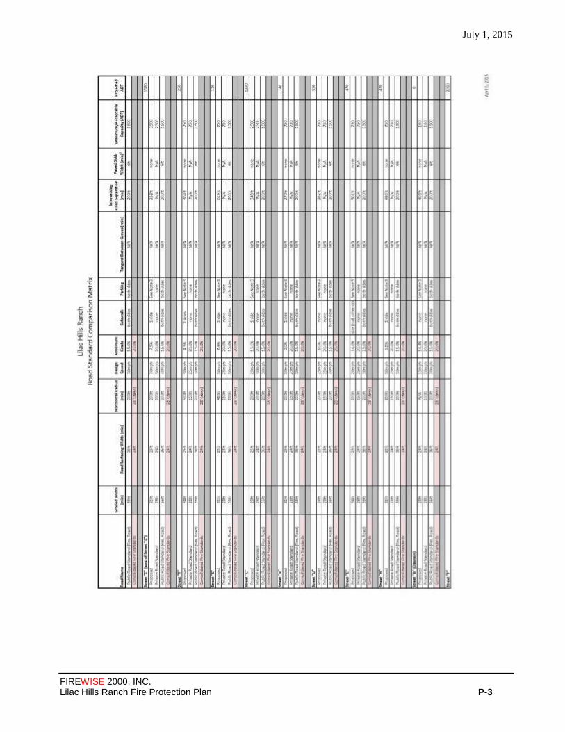
July 1, 2015
FIREWISE 2000, INC. Lilac Hills Ranch Fire Protection Plan P-3

July 1, 2015
FIREWISE 2000, INC. Lilac Hills Ranch Fire Protection Plan P-4
July 15, 2015
FIREWISE 2000, INC. Lilac Hills Ranch Fire Protection Plan Exhibit- 1
EXHIBIT 1
FUEL TREATMENT LOCATION MAP
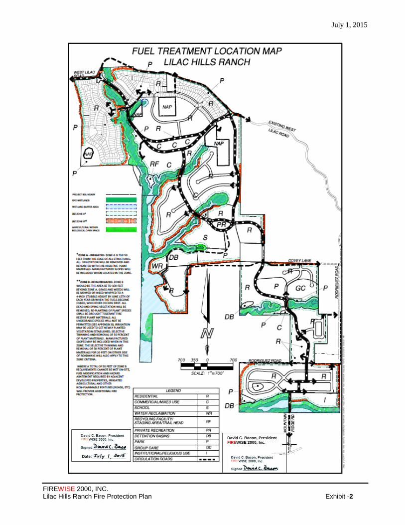
July 1, 2015
FIREWISE 2000, INC. Lilac Hills Ranch Fire Protection Plan Exhibit -2
David C. Bacon, President FIREWISE 2000, Inc.