Embed Size (px)
Citation preview
FINAL REPORT ON
Submitted to:
Saskatchewan Environment Environmental Assessment Branch
3211 Albert Street Regina, Saskatchewan
S4S 5W6
Attention: Mr. Malcolm Ross
DISTRIBUTION: 25 Copies - Saskatchewan Environment, Environmental Assessment Branch, Regina, Saskatchewan 5 Copies - Claude Resources Inc., Saskatoon, Saskatchewan 2 Copies - Golder Associates Ltd., Saskatoon, Saskatchewan July 2006 05-1365-034A
PROJECT PROPOSAL FOR THE
SANTOY 8 SATELLITE MINE AT SEABEE GOLD MINE
July 2006 - i - 05-1365-034A
Golder Associates N:\ACTIVE\_2005\1365\05-1365-034A CLAUDE RESOURCES SANTOY BASELINE SURVEY\PROJECT PROPOSAL REPORTS\SANTOY 8 PROJECT PROPOSAL\MASTER REPORT VERSION\05-1365-034A RPT 06 JULY 25 S8 PROJECT PROPOSAL FINAL.DOC
EXECUTIVE SUMMARY
The Seabee Gold Mine is a trackless underground gold mine owned by Claude Resources Inc. The mine site is located approximately 120 km north east of La Ronge, Saskatchewan, and has been operating since 1991. Exploration activity has been on-going in the area surrounding the mine since 1949. Three new significant zones of gold mineralization have been found: Santoy 7, Santoy 8, and Porky. Given appropriate regulatory approvals, these sites are planned for development as “Satellite Mines” that would utilize existing facilities at the Seabee Gold Mine (i.e., waste management facilities, camp kitchen, camp bunkhouses, and airstrip).
Submission of the following Project Proposal Document is part of the regulatory approvals process for the proposed Santoy 8 Satellite Mine. No bulk sampling program, mining activities, or permitting have yet occurred for Santoy 8 Satellite Mine (Santoy 8 or the Project). More specifically, Claude Resources Inc. is seeking regulatory approval for mining at Santoy 8 and operating the Project as a satellite mine of Seabee Gold Mine.
Mining activities at Santoy 8 Satellite Mine, if approved, would begin in 2007 and are anticipated to be completed in 2013. The Project will involve the mining of approximately 0.33 million cubic metres (or 910,000 tonnes) of processed gold ore and approximately 85,000 cubic metres of waste rock. The workforce for Santoy 8 will vary between 10 persons (for the initial construction year) and an estimated maximum of 35 persons. The mine footprint for Santoy 8 Satellite Mine is currently estimated at 25 hectares.
Processing of ore from Santoy 8 will be done at the existing Seabee mill. During the life of the Santoy 8 project, the milling rate will be increased from 800 tonnes per day to 1,100 tonnes per day, which is within the current capacity of the mill. However, the tailings storage facility at the Seabee Mine will need to be upgraded.
The objectives of the Project proposal for Santoy 8 are to describe:
• the preferred Project and alternatives to the preferred Project (Section 2); • the existing biophysical, cultural, and socio-economic environment (Section 3); and, • the potential effects (positive and negative) of Santoy 8 Satellite Mine, together with
appropriate mitigation and resultant residual effects (i.e., impacts remaining after mitigation has been considered; Section 4).
July 2006 - ii - 05-1365-034A
Golder Associates N:\ACTIVE\_2005\1365\05-1365-034A CLAUDE RESOURCES SANTOY BASELINE SURVEY\PROJECT PROPOSAL REPORTS\SANTOY 8 PROJECT PROPOSAL\MASTER REPORT VERSION\05-1365-034A RPT 06 JULY 25 S8 PROJECT PROPOSAL FINAL.DOC
Identification of impacts, description of appropriate mitigation, and classification of residual effects were completed on an environmental-component basis (e.g., air quality, soils, hydrogeology, vegetation, wildlife, hydrology, aquatic resources). In general, identification of impacts and classification of residual effect were determined through:
• review of best available information, including numerical data when available; • judgement and experience of scientific personnel conducting the assessment; • use of federal and provincial environmental standards/criteria/guidelines, when
applicable; • definition of potential residual effects according to their direction, magnitude,
geographic extent, duration, and occurrence; and, • classification of the ecological consequence of the residual effect (negligible, low,
moderate, high).
No residual effects or residual effects of negligible ecological consequence are anticipated for the following environmental components as a result of Santoy 8: noise (some aspects), geology, soils, hydrogeology, vegetation (some aspects), wildlife (some aspects), hydrology (some aspects), aquatic resources (some aspects), land use and heritage resources. Negative residual effects with an ecological consequence rating of low were identified for vegetation (some aspects) and wildlife (some aspects). Positive residual effects with an ecological consequence rating of low were identified for the socio-economic component.
Based on the current information available for the Santoy 8 project description, the majority of potential environmental impacts could be assessed, as outlined in the previous paragraph. However, further project details are required to fully assess the potential Project impacts on the following environmental components: air, noise, hydrology, and aquatic resources.
July 2006 - iii - 05-1365-034A
Golder Associates N:\ACTIVE\_2005\1365\05-1365-034A CLAUDE RESOURCES SANTOY BASELINE SURVEY\PROJECT PROPOSAL REPORTS\SANTOY 8 PROJECT PROPOSAL\MASTER REPORT VERSION\05-1365-034A RPT 06 JULY 25 S8 PROJECT PROPOSAL FINAL.DOC
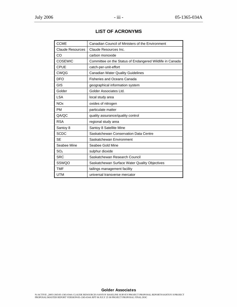
LIST OF ACRONYMS
CCME Canadian Council of Ministers of the Environment
Claude Resources Claude Resources Inc.
CO carbon monoxide
COSEWIC Committee on the Status of Endangered Wildlife in Canada
CPUE catch-per-unit-effort
CWQG Canadian Water Quality Guidelines
DFO Fisheries and Oceans Canada
GIS geographical information system
Golder Golder Associates Ltd.
LSA local study area
NOx oxides of nitrogen
PM particulate matter
QA/QC quality assurance/quality control
RSA regional study area
Santoy 8 Santoy 8 Satellite Mine
SCDC Saskatchewan Conservation Data Centre
SE Saskatchewan Environment
Seabee Mine Seabee Gold Mine
SO2 sulphur dioxide
SRC Saskatchewan Research Council
SSWQO Saskatchewan Surface Water Quality Objectives
TMF tailings management facility
UTM universal transverse mercator

July 2006 - iv - 05-1365-034A
Golder Associates N:\ACTIVE\_2005\1365\05-1365-034A CLAUDE RESOURCES SANTOY BASELINE SURVEY\PROJECT PROPOSAL REPORTS\SANTOY 8 PROJECT PROPOSAL\MASTER REPORT VERSION\05-1365-034A RPT 06 JULY 25 S8 PROJECT PROPOSAL FINAL.DOC
LIST OF UNITS
ACU apparent color unit
Bq/L Bequerel per litre
m3 cubic metres
m3/d cubic metres per day
°C degrees Celsius
$ dollars
ft feet
gal gallons
g/t grams per tonne
ha hectares
hp horse power
hr hour
“ inch
kg kilogram
kg/tonne kilogram per tonne
km kilometre
L/s litres per second
m metre
tpd tonnes per day
µS/cm micro Siemens per centimetre
µg/L microgram per litre
µm micrometers
mg/L milligram per litre
ml millilitres
mm millimetre
NTU Nephelometric turbidity units
% percent
km2 square kilometres
m2 square metre
t/m3 tonnes per cubic metre
July 2006 - v - 05-1365-034A
Golder Associates N:\ACTIVE\_2005\1365\05-1365-034A CLAUDE RESOURCES SANTOY BASELINE SURVEY\PROJECT PROPOSAL REPORTS\SANTOY 8 PROJECT PROPOSAL\MASTER REPORT VERSION\05-1365-034A RPT 06 JULY 25 S8 PROJECT PROPOSAL FINAL.DOC
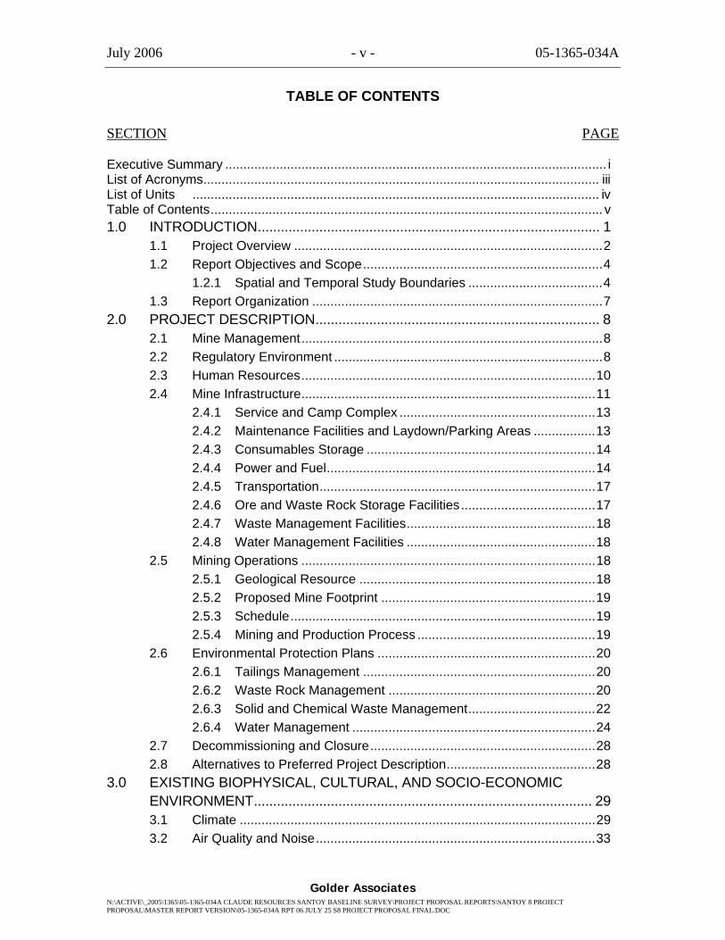
TABLE OF CONTENTS
SECTION PAGE Executive Summary ......................................................................................................... i List of Acronyms............................................................................................................. iii List of Units ................................................................................................................ iv Table of Contents............................................................................................................ v 1.0 INTRODUCTION......................................................................................... 1
1.1 Project Overview .....................................................................................2 1.2 Report Objectives and Scope..................................................................4
1.2.1 Spatial and Temporal Study Boundaries .....................................4 1.3 Report Organization ................................................................................7
2.0 PROJECT DESCRIPTION.......................................................................... 8 2.1 Mine Management...................................................................................8 2.2 Regulatory Environment ..........................................................................8 2.3 Human Resources.................................................................................10 2.4 Mine Infrastructure.................................................................................11
2.4.1 Service and Camp Complex ......................................................13 2.4.2 Maintenance Facilities and Laydown/Parking Areas .................13 2.4.3 Consumables Storage ...............................................................14 2.4.4 Power and Fuel..........................................................................14 2.4.5 Transportation............................................................................17 2.4.6 Ore and Waste Rock Storage Facilities.....................................17 2.4.7 Waste Management Facilities....................................................18 2.4.8 Water Management Facilities ....................................................18
2.5 Mining Operations .................................................................................18 2.5.1 Geological Resource .................................................................18 2.5.2 Proposed Mine Footprint ...........................................................19 2.5.3 Schedule....................................................................................19 2.5.4 Mining and Production Process .................................................19
2.6 Environmental Protection Plans ............................................................20 2.6.1 Tailings Management ................................................................20 2.6.2 Waste Rock Management .........................................................20 2.6.3 Solid and Chemical Waste Management...................................22 2.6.4 Water Management ...................................................................24
2.7 Decommissioning and Closure..............................................................28 2.8 Alternatives to Preferred Project Description.........................................28
3.0 EXISTING BIOPHYSICAL, CULTURAL, AND SOCIO-ECONOMIC ENVIRONMENT........................................................................................ 29 3.1 Climate ..................................................................................................29 3.2 Air Quality and Noise.............................................................................33
July 2006 - vi - 05-1365-034A
Golder Associates N:\ACTIVE\_2005\1365\05-1365-034A CLAUDE RESOURCES SANTOY BASELINE SURVEY\PROJECT PROPOSAL REPORTS\SANTOY 8 PROJECT PROPOSAL\MASTER REPORT VERSION\05-1365-034A RPT 06 JULY 25 S8 PROJECT PROPOSAL FINAL.DOC
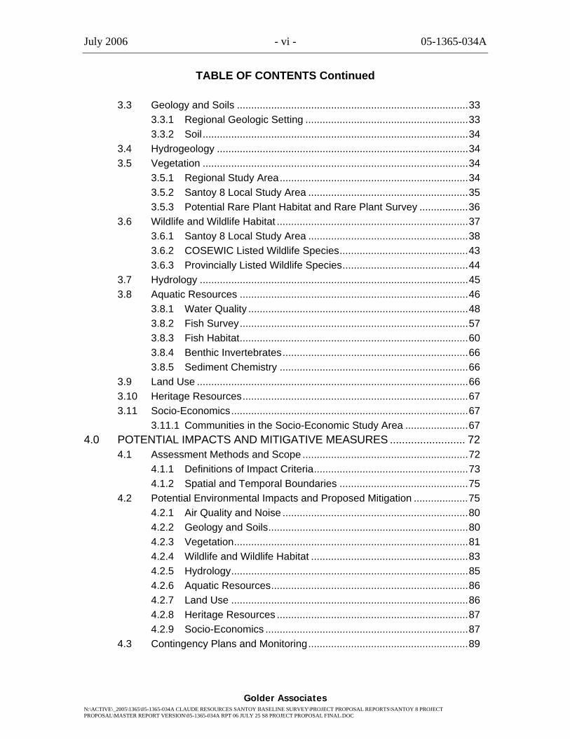
TABLE OF CONTENTS Continued
3.3 Geology and Soils .................................................................................33 3.3.1 Regional Geologic Setting .........................................................33 3.3.2 Soil.............................................................................................34
3.4 Hydrogeology ........................................................................................34 3.5 Vegetation .............................................................................................34
3.5.1 Regional Study Area..................................................................34 3.5.2 Santoy 8 Local Study Area ........................................................35 3.5.3 Potential Rare Plant Habitat and Rare Plant Survey .................36
3.6 Wildlife and Wildlife Habitat ...................................................................37 3.6.1 Santoy 8 Local Study Area ........................................................38 3.6.2 COSEWIC Listed Wildlife Species.............................................43 3.6.3 Provincially Listed Wildlife Species............................................44
3.7 Hydrology ..............................................................................................45 3.8 Aquatic Resources ................................................................................46
3.8.1 Water Quality .............................................................................48 3.8.2 Fish Survey................................................................................57 3.8.3 Fish Habitat................................................................................60 3.8.4 Benthic Invertebrates.................................................................66 3.8.5 Sediment Chemistry ..................................................................66
3.9 Land Use ...............................................................................................66 3.10 Heritage Resources...............................................................................67 3.11 Socio-Economics...................................................................................67
3.11.1 Communities in the Socio-Economic Study Area ......................67 4.0 POTENTIAL IMPACTS AND MITIGATIVE MEASURES ......................... 72
4.1 Assessment Methods and Scope ..........................................................72 4.1.1 Definitions of Impact Criteria......................................................73 4.1.2 Spatial and Temporal Boundaries .............................................75
4.2 Potential Environmental Impacts and Proposed Mitigation ...................75 4.2.1 Air Quality and Noise .................................................................80 4.2.2 Geology and Soils......................................................................80 4.2.3 Vegetation..................................................................................81 4.2.4 Wildlife and Wildlife Habitat .......................................................83 4.2.5 Hydrology...................................................................................85 4.2.6 Aquatic Resources.....................................................................86 4.2.7 Land Use ...................................................................................86 4.2.8 Heritage Resources ...................................................................87 4.2.9 Socio-Economics .......................................................................87
4.3 Contingency Plans and Monitoring........................................................89
July 2006 - vii - 05-1365-034A
Golder Associates N:\ACTIVE\_2005\1365\05-1365-034A CLAUDE RESOURCES SANTOY BASELINE SURVEY\PROJECT PROPOSAL REPORTS\SANTOY 8 PROJECT PROPOSAL\MASTER REPORT VERSION\05-1365-034A RPT 06 JULY 25 S8 PROJECT PROPOSAL FINAL.DOC
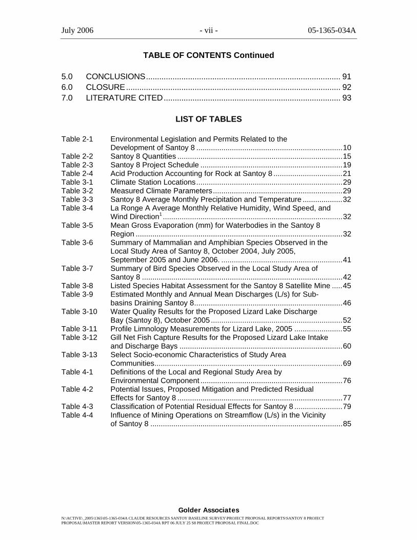
TABLE OF CONTENTS Continued
5.0 CONCLUSIONS........................................................................................ 91 6.0 CLOSURE................................................................................................. 92 7.0 LITERATURE CITED................................................................................ 93
LIST OF TABLES
Table 2-1 Environmental Legislation and Permits Related to the Development of Santoy 8 ......................................................................10
Table 2-2 Santoy 8 Quantities ...............................................................................15 Table 2-3 Santoy 8 Project Schedule ....................................................................19 Table 2-4 Acid Production Accounting for Rock at Santoy 8 .................................21 Table 3-1 Climate Station Locations......................................................................29 Table 3-2 Measured Climate Parameters..............................................................29 Table 3-3 Santoy 8 Average Monthly Precipitation and Temperature ...................32 Table 3-4 La Ronge A Average Monthly Relative Humidity, Wind Speed, and
Wind Direction1 ......................................................................................32 Table 3-5 Mean Gross Evaporation (mm) for Waterbodies in the Santoy 8
Region ...................................................................................................32 Table 3-6 Summary of Mammalian and Amphibian Species Observed in the
Local Study Area of Santoy 8, October 2004, July 2005, September 2005 and June 2006. ..........................................................41
Table 3-7 Summary of Bird Species Observed in the Local Study Area of Santoy 8 ................................................................................................42
Table 3-8 Listed Species Habitat Assessment for the Santoy 8 Satellite Mine .....45 Table 3-9 Estimated Monthly and Annual Mean Discharges (L/s) for Sub-
basins Draining Santoy 8.......................................................................46 Table 3-10 Water Quality Results for the Proposed Lizard Lake Discharge
Bay (Santoy 8), October 2005 ...............................................................52 Table 3-11 Profile Limnology Measurements for Lizard Lake, 2005 .......................55 Table 3-12 Gill Net Fish Capture Results for the Proposed Lizard Lake Intake
and Discharge Bays ..............................................................................60 Table 3-13 Select Socio-economic Characteristics of Study Area
Communities..........................................................................................69 Table 4-1 Definitions of the Local and Regional Study Area by
Environmental Component ....................................................................76 Table 4-2 Potential Issues, Proposed Mitigation and Predicted Residual
Effects for Santoy 8 ...............................................................................77 Table 4-3 Classification of Potential Residual Effects for Santoy 8 .......................79 Table 4-4 Influence of Mining Operations on Streamflow (L/s) in the Vicinity
of Santoy 8 ............................................................................................85
July 2006 - viii - 05-1365-034A
Golder Associates N:\ACTIVE\_2005\1365\05-1365-034A CLAUDE RESOURCES SANTOY BASELINE SURVEY\PROJECT PROPOSAL REPORTS\SANTOY 8 PROJECT PROPOSAL\MASTER REPORT VERSION\05-1365-034A RPT 06 JULY 25 S8 PROJECT PROPOSAL FINAL.DOC
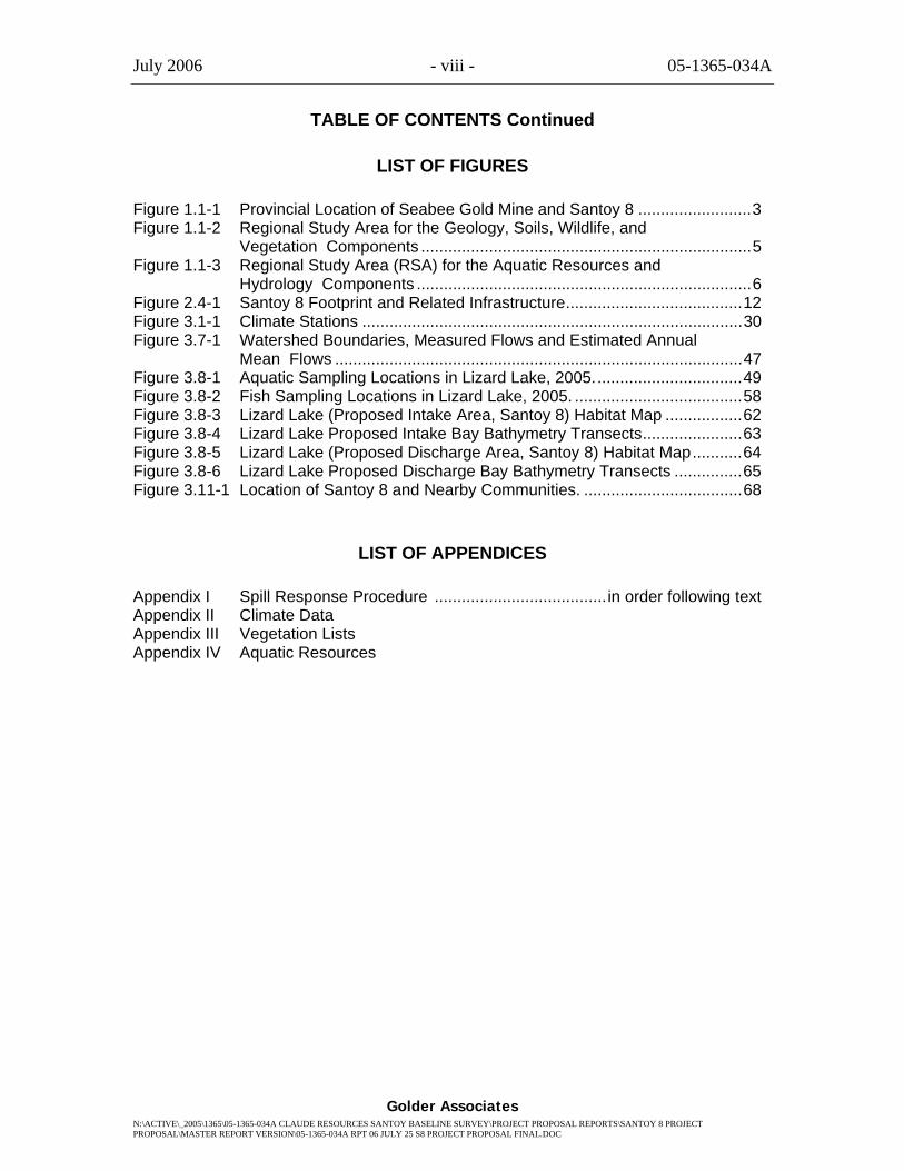
TABLE OF CONTENTS Continued
LIST OF FIGURES
Figure 1.1-1 Provincial Location of Seabee Gold Mine and Santoy 8 .........................3 Figure 1.1-2 Regional Study Area for the Geology, Soils, Wildlife, and
Vegetation Components .........................................................................5 Figure 1.1-3 Regional Study Area (RSA) for the Aquatic Resources and
Hydrology Components ..........................................................................6 Figure 2.4-1 Santoy 8 Footprint and Related Infrastructure.......................................12 Figure 3.1-1 Climate Stations ....................................................................................30 Figure 3.7-1 Watershed Boundaries, Measured Flows and Estimated Annual
Mean Flows ..........................................................................................47 Figure 3.8-1 Aquatic Sampling Locations in Lizard Lake, 2005.................................49 Figure 3.8-2 Fish Sampling Locations in Lizard Lake, 2005. .....................................58 Figure 3.8-3 Lizard Lake (Proposed Intake Area, Santoy 8) Habitat Map .................62 Figure 3.8-4 Lizard Lake Proposed Intake Bay Bathymetry Transects......................63 Figure 3.8-5 Lizard Lake (Proposed Discharge Area, Santoy 8) Habitat Map...........64 Figure 3.8-6 Lizard Lake Proposed Discharge Bay Bathymetry Transects ...............65 Figure 3.11-1 Location of Santoy 8 and Nearby Communities. ...................................68
LIST OF APPENDICES
Appendix I Spill Response Procedure ...................................... in order following text Appendix II Climate Data Appendix III Vegetation Lists Appendix IV Aquatic Resources
July 2006 - 1 - 05-1365-034A
Golder Associates
1.0 INTRODUCTION
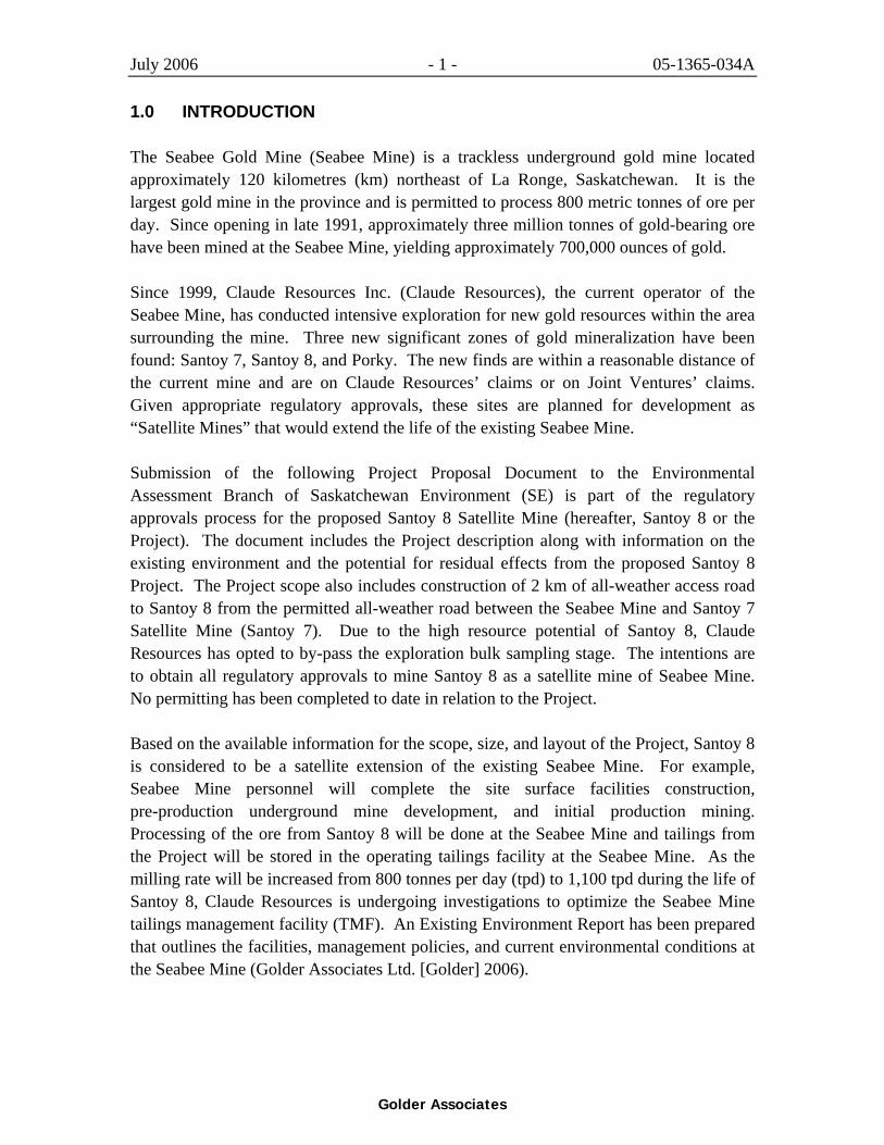
The Seabee Gold Mine (Seabee Mine) is a trackless underground gold mine located approximately 120 kilometres (km) northeast of La Ronge, Saskatchewan. It is the largest gold mine in the province and is permitted to process 800 metric tonnes of ore per day. Since opening in late 1991, approximately three million tonnes of gold-bearing ore have been mined at the Seabee Mine, yielding approximately 700,000 ounces of gold.
Since 1999, Claude Resources Inc. (Claude Resources), the current operator of the Seabee Mine, has conducted intensive exploration for new gold resources within the area surrounding the mine. Three new significant zones of gold mineralization have been found: Santoy 7, Santoy 8, and Porky. The new finds are within a reasonable distance of the current mine and are on Claude Resources’ claims or on Joint Ventures’ claims. Given appropriate regulatory approvals, these sites are planned for development as “Satellite Mines” that would extend the life of the existing Seabee Mine.
Submission of the following Project Proposal Document to the Environmental Assessment Branch of Saskatchewan Environment (SE) is part of the regulatory approvals process for the proposed Santoy 8 Satellite Mine (hereafter, Santoy 8 or the Project). The document includes the Project description along with information on the existing environment and the potential for residual effects from the proposed Santoy 8 Project. The Project scope also includes construction of 2 km of all-weather access road to Santoy 8 from the permitted all-weather road between the Seabee Mine and Santoy 7 Satellite Mine (Santoy 7). Due to the high resource potential of Santoy 8, Claude Resources has opted to by-pass the exploration bulk sampling stage. The intentions are to obtain all regulatory approvals to mine Santoy 8 as a satellite mine of Seabee Mine. No permitting has been completed to date in relation to the Project.
Based on the available information for the scope, size, and layout of the Project, Santoy 8 is considered to be a satellite extension of the existing Seabee Mine. For example, Seabee Mine personnel will complete the site surface facilities construction, pre-production underground mine development, and initial production mining. Processing of the ore from Santoy 8 will be done at the Seabee Mine and tailings from the Project will be stored in the operating tailings facility at the Seabee Mine. As the milling rate will be increased from 800 tonnes per day (tpd) to 1,100 tpd during the life of Santoy 8, Claude Resources is undergoing investigations to optimize the Seabee Mine tailings management facility (TMF). An Existing Environment Report has been prepared that outlines the facilities, management policies, and current environmental conditions at the Seabee Mine (Golder Associates Ltd. [Golder] 2006).

July 2006 - 2- 05-1365-034A
Golder Associates
1.1 Project Overview
Santoy 8 is an underground, narrow vein gold deposit located approximately 12.2 km east of the Seabee Mine (Figure 1.1-1). During the summer of 2004 and through 2005, diamond drilling outlined the Santoy 8 and 8 East zones. The two Santoy 8 gold-bearing chlorite quartz veins have potentially economical mineralization within zones of up to 20 metres (m) thick, but typically 1 m to 5 m in thickness. The veins trend northwest-southeast and the mineralization style is similar to that at the Seabee Mine. Drilling at Santoy 8 indicates good gold grades with tonnage to justify the capital investment in infrastructure.
During 2005, a resource estimate was completed on the Santoy 8 and 8 East zones and a preliminary mine plan was drawn up. A detailed underground mine plan and surface facility design were completed in late 2005. The Project description in Section 2 is based on information contained in the 2005 resource update, and information generated through the feasibility studies as of October 2005.
In brief, the Project will involve the mining of approximately 0.33 million cubic metres (m3) of processed gold ore. The construction and operation workforce for Santoy 8 involve a maximum of 35 persons. The mine footprint for Santoy 8 is currently estimated at 25 hectares (ha). If regulatory approval is granted to Santoy 8, initial construction activities are planned for the first quarter of 2007; underground mining is anticipated to take place from 2007 to 2013, with decommissioning occurring in 2014.
The Project scope also includes construction of 2 km of all-weather access road to Santoy 8 from the permitted all-weather road between the Seabee Mine and Santoy 7 (Figure 1.1-1).
Consultation with the local communities regarding Santoy 8 is scheduled to occur during the fall of 2006.
LaonilLake
Pine Lake
TriangleLake
PorkyLake
MunroLake
MunroLake
PortageLake
SantoyLake
CarruthersLake
Carruthers Lake
Santoy 7BananaLake
ThunderbirdLake
Santoy 8
Lizard Lake
PROVINCIAL LOCATION OF SEABEEGOLD MINE AND SANTOY 8
CLAUDE RESOURCES INC.MINE EXPANSION
SEABEE GOLD MINE
FIGURE:1.1-1
Legend
Seabee Mine Site Area
Winter Road
Local Study Area
Proposed All-Weather Access Road
Key Plan
SeabeeGold Mine
July 2006 - 4- 05-1365-034A
Golder Associates
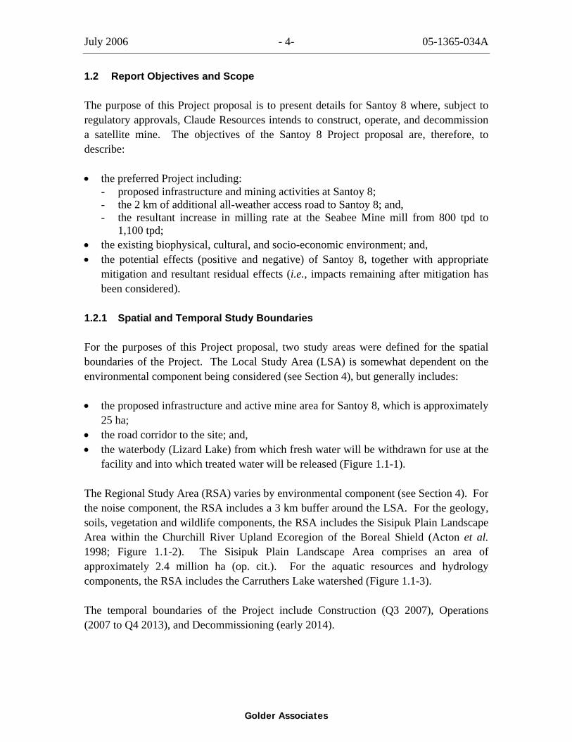
1.2 Report Objectives and Scope
The purpose of this Project proposal is to present details for Santoy 8 where, subject to regulatory approvals, Claude Resources intends to construct, operate, and decommission a satellite mine. The objectives of the Santoy 8 Project proposal are, therefore, to describe:
• the preferred Project including: - proposed infrastructure and mining activities at Santoy 8; - the 2 km of additional all-weather access road to Santoy 8; and, - the resultant increase in milling rate at the Seabee Mine mill from 800 tpd to
1,100 tpd; • the existing biophysical, cultural, and socio-economic environment; and, • the potential effects (positive and negative) of Santoy 8, together with appropriate
mitigation and resultant residual effects (i.e., impacts remaining after mitigation has been considered).
1.2.1 Spatial and Temporal Study Boundaries
For the purposes of this Project proposal, two study areas were defined for the spatial boundaries of the Project. The Local Study Area (LSA) is somewhat dependent on the environmental component being considered (see Section 4), but generally includes:
• the proposed infrastructure and active mine area for Santoy 8, which is approximately 25 ha;
• the road corridor to the site; and, • the waterbody (Lizard Lake) from which fresh water will be withdrawn for use at the
facility and into which treated water will be released (Figure 1.1-1).
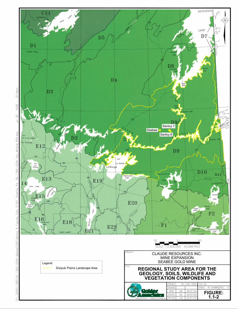
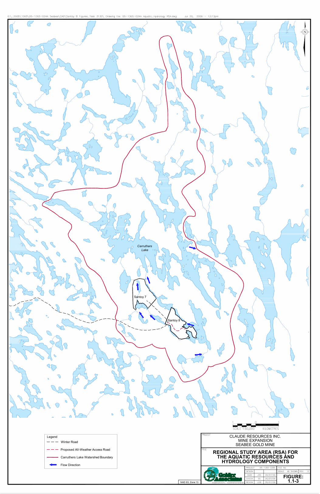
The Regional Study Area (RSA) varies by environmental component (see Section 4). For the noise component, the RSA includes a 3 km buffer around the LSA. For the geology, soils, vegetation and wildlife components, the RSA includes the Sisipuk Plain Landscape Area within the Churchill River Upland Ecoregion of the Boreal Shield (Acton et al. 1998; Figure 1.1-2). The Sisipuk Plain Landscape Area comprises an area of approximately 2.4 million ha (op. cit.). For the aquatic resources and hydrology components, the RSA includes the Carruthers Lake watershed (Figure 1.1-3).
The temporal boundaries of the Project include Construction (Q3 2007), Operations (2007 to Q4 2013), and Decommissioning (early 2014).
REGIONAL STUDY AREA FOR THEGEOLOGY, SOILS, WILDLIFE AND
VEGETATION COMPONENTS
CLAUDE RESOURCES INC.MINE EXPANSION
SEABEE GOLD MINE
FIGURE:1.1-2
LegendSisipuk Plains Landscape Area
Santoy 7Seabee
Santoy 8
Santoy 7
Santoy 8
CarruthersLake
REGIONAL STUDY AREA (RSA) FORTHE AQUATIC RESOURCES AND
HYDROLOGY COMPONENTS
CLAUDE RESOURCES INC.MINE EXPANSION
SEABEE GOLD MINE
FIGURE:1.1-3NAD 83, Zone 13
LegendWinter Road
Proposed All-Weather Access Road
Carruthers Lake Watershed Boundary
Flow Direction
July 2006 - 7- 05-1365-034A
Golder Associates
1.3 Report Organization
Background information on the Project exploration history has been provided in Section 1. Section 2 provides specific details on the preferred Project description for Santoy 8 including:
• aspects of general mine management, including key goals, policies, and plans for Santoy 8;
• the regulatory environment for the Project; • issues related to human resources (employment, work schedule, hiring commitments); • proposed mine infrastructure; • mining operations (including geological resource, schedule, mining production, and
processing); • environmental protection plans relating to waste rock, solid waste, and water
management; and, • decommissioning and closure.
Section 3 provides information on the existing biophysical, cultural, and socio-economic environment as it relates to Santoy 8. The potential impacts, associated mitigation, and residual effects for Santoy 8 are provided in Section 4. Contingencies and monitoring programs are presented in Section 4.3 and conclusions of the assessment are found in Section 5.
July 2006 - 8- 05-1365-034A
Golder Associates
2.0 PROJECT DESCRIPTION
2.1 Mine Management
The goal for Santoy 8 is to provide ore to the existing Seabee Mine for approximately five to six years, thereby extending the life of the existing Seabee facilities. Seabee Mine personnel will complete the site surface facilities construction, pre-production underground mine development, and initial production mining. Processing of the ore from Santoy 8 will be done at the Seabee Mine, and tailings from the Project will be stored in the operating TMF at the Seabee Mine. Claude Resources is currently undertaking optimization investigations for tailings storage.
Claude Resources wishes to provide a safe working environment for its miners. Because Santoy 8 is a satellite extension of the Seabee Mine, the reader is asked to refer to the Existing Environment Report for the Seabee Mine (Golder 2006) to obtain information on Mine policies related to loss control and the environment. Appendix I provides details on the Spill Response Procedure for Santoy 8.
2.2 Regulatory Environment
The proposed Santoy 8 Project is subject to two primary regulatory processes. The first of these is the environmental assessment process. The second is the regulatory permitting process. For environmental assessment, a review is completed to determine if approval under the Environmental Assessment Act (Saskatchewan) or the Canadian Environmental Assessment Act is required. If a determination is made that no further review under these acts is required, a project may proceed in obtaining any necessary permits, licenses, approvals, or authorizations. If further environmental assessment is required, regulators may request additional data collection, analysis, and assessment. A full Environmental Impact Assessment can be triggered if the project is determined to be a “development” as defined by the Environmental Assessment Act (Saskatchewan):
According to the Act, a “development” is: any project, operation or activity or any alteration or expansion of any project, operation or activity which is likely to:
1. have an effect on any unique, rare or endangered feature of the environment; 2. substantially use any provincial resource and in so doing pre-empt the use, or
potential use, of that resource for any other purpose; 3. cause the emission of any pollutants or create byproducts, residual or waste
products which require handling and disposal in a manner that is not regulated by another Act or regulation;
4. cause widespread public concern because of potential environmental changes;

July 2006 - 9- 05-1365-034A
Golder Associates
5. involve a new technology that is concerned with resource use and that may induce significant environmental change; or,
6. have a significant impact on the environment or necessitate a further development which is likely to have a significant impact on the environment.
The need for further federal environmental assessment is tied primarily to the role that federal agencies may play in supporting or approving the project.
Once the reports for the project are complete and submitted, and the provincial and/or federal review is conducted, approval to proceed may be achieved, and the project proponent must then obtain appropriate permits, licenses, approvals, and authorizations.
A review in relation to the requirement for an Authorization under the federal Fisheries Act will need to be completed by Fisheries and Oceans Canada (DFO) for the Santoy 8 project once they receive appropriate documentation. Based on the information available to date, it is not expected that an Authorization will be required for this project. Currently it is anticipated that this is the only potential trigger for the federal environmental assessment process.
Once the above process is completed, permitting for Santoy 8 can proceed. Legislation and associated permits related to the development of Santoy 8 are summarized in Table 2-1.
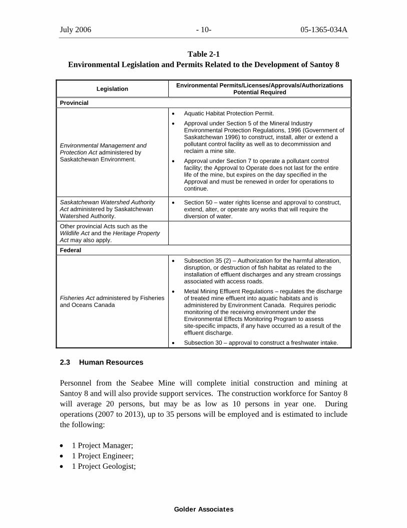
July 2006 - 10- 05-1365-034A
Golder Associates
Table 2-1 Environmental Legislation and Permits Related to the Development of Santoy 8
Legislation Environmental Permits/Licenses/Approvals/Authorizations Potential Required
Provincial
Environmental Management and Protection Act administered by Saskatchewan Environment.
• Aquatic Habitat Protection Permit. • Approval under Section 5 of the Mineral Industry
Environmental Protection Regulations, 1996 (Government of Saskatchewan 1996) to construct, install, alter or extend a pollutant control facility as well as to decommission and reclaim a mine site.
• Approval under Section 7 to operate a pollutant control facility; the Approval to Operate does not last for the entire life of the mine, but expires on the day specified in the Approval and must be renewed in order for operations to continue.
Saskatchewan Watershed Authority Act administered by Saskatchewan Watershed Authority.
• Section 50 – water rights license and approval to construct, extend, alter, or operate any works that will require the diversion of water.
Other provincial Acts such as the Wildlife Act and the Heritage Property Act may also apply.
Federal
Fisheries Act administered by Fisheries and Oceans Canada
• Subsection 35 (2) – Authorization for the harmful alteration, disruption, or destruction of fish habitat as related to the installation of effluent discharges and any stream crossings associated with access roads.
• Metal Mining Effluent Regulations – regulates the discharge of treated mine effluent into aquatic habitats and is administered by Environment Canada. Requires periodic monitoring of the receiving environment under the Environmental Effects Monitoring Program to assess site-specific impacts, if any have occurred as a result of the effluent discharge.
• Subsection 30 – approval to construct a freshwater intake.
2.3 Human Resources
Personnel from the Seabee Mine will complete initial construction and mining at Santoy 8 and will also provide support services. The construction workforce for Santoy 8 will average 20 persons, but may be as low as 10 persons in year one. During operations (2007 to 2013), up to 35 persons will be employed and is estimated to include the following:
• 1 Project Manager; • 1 Project Engineer; • 1 Project Geologist;

July 2006 - 11- 05-1365-034A
Golder Associates
• 12 Underground Miners; • 1 Surveyor; • 3 Service personnel (mechanic and electrician); • 2 to 7 Casual Labourers/students; and, • 2 Catering staff.
In general, one hundred and twenty person-years of employment will be created for each 300,000 tonnes of reserves mined.
Personnel will access Santoy 8 by using the permanent road from the Seabee Mine. Travel to the Seabee Mine from other areas of the province is primarily achieved by air.
Santoy 8 will operate on the following schedule, which is similar to the Seabee Mine:
• senior management: two weeks in/two weeks out; • senior staff: one week in/one week out; • miners from Saskatchewan and Manitoba: two weeks in/two weeks out; • miners from other Provinces: four weeks in/two weeks out; and, • mill workers (Seabee): two weeks in/two weeks out.
Priorities in hiring will target available local people first. More specifically, Claude Resources is committed to recruiting and hiring as many Aboriginals and northerners as possible during both the construction and operation phases. Therefore, priorities in hiring will be as follows:
• first: Aboriginals born or residing in one of the primary communities; • second: residents of Saskatchewan; • third: Canadians willing to relocate to Saskatchewan; and, • fourth: others from across Canada.
2.4 Mine Infrastructure
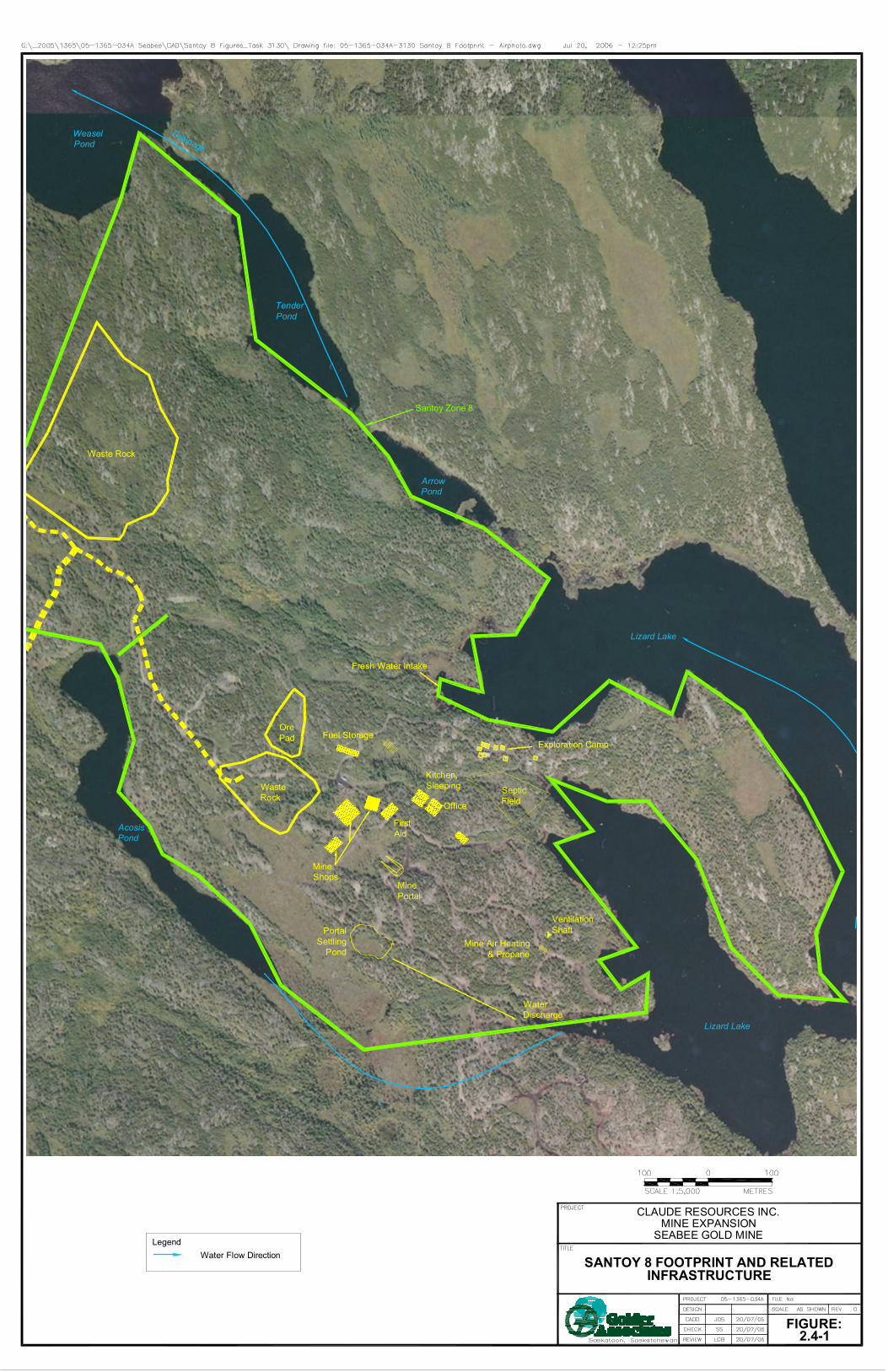
Locations of facilities associated with Santoy 8 are shown in Figure 2.4-1. All of the site support and storage facilities shown on Figure 2.4-1 will be included within the Project footprint. Exact locations of any facilities yet to be constructed will not be finalized until the detailed engineering is complete. However, the overall size of the site footprint (approximately 25 ha) will not be altered by location changes.
Fuel Storage
DrainageWeaselPond
TenderPond
ArrowPond
Lizard Lake
Lizard Lake
WaterDischarge
AcosisPond
Fresh Water Intake
Exploration Camp
Waste Rock
OrePad
WasteRock
SepticField
VentilationShaft
Mine Air Heating& Propane
PortalSettling
Pond
MineShops
MinePortal
FirstAid
Kitchen,Sleeping
Office
Santoy Zone 8
SANTOY 8 FOOTPRINT AND RELATEDINFRASTRUCTURE
CLAUDE RESOURCES INC.MINE EXPANSION
SEABEE GOLD MINE
FIGURE:2.4-1
LegendWater Flow Direction
July 2006 - 13- 05-1365-034A
Golder Associates
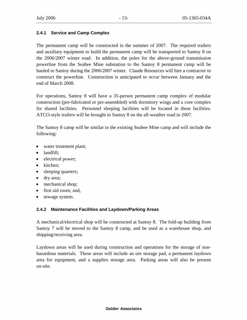
2.4.1 Service and Camp Complex
The permanent camp will be constructed in the summer of 2007. The required trailers and auxiliary equipment to build the permanent camp will be transported to Santoy 8 on the 2006/2007 winter road. In addition, the poles for the above-ground transmission powerline from the Seabee Mine substation to the Santoy 8 permanent camp will be hauled to Santoy during the 2006/2007 winter. Claude Resources will hire a contractor to construct the powerline. Construction is anticipated to occur between January and the end of March 2008.
For operations, Santoy 8 will have a 35-person permanent camp complex of modular construction (pre-fabricated or pre-assembled) with dormitory wings and a core complex for shared facilities. Personnel sleeping facilities will be located in these facilities. ATCO-style trailers will be brought to Santoy 8 on the all-weather road in 2007.
The Santoy 8 camp will be similar to the existing Seabee Mine camp and will include the following:
• water treatment plant; • landfill; • electrical power; • kitchen; • sleeping quarters; • dry area; • mechanical shop; • first aid room; and, • sewage system.
2.4.2 Maintenance Facilities and Laydown/Parking Areas
A mechanical/electrical shop will be constructed at Santoy 8. The fold-up building from Santoy 7 will be moved to the Santoy 8 camp, and be used as a warehouse shop, and shipping/receiving area.
Laydown areas will be used during construction and operations for the storage of non-hazardous materials. These areas will include an ore storage pad, a permanent laydown area for equipment, and a supplies storage area. Parking areas will also be present on-site.
July 2006 - 14- 05-1365-034A
Golder Associates
2.4.3 Consumables Storage
Consumable products used on-site will include:
• camp maintenance products (detergents, cleaning fluids and powders, light bulbs, etc.);
• office supplies; • shop supplies (batteries, hardware, fasteners, solvents, machining lubricants, etc.); • surface and underground drilling consumables (drill bits, etc.); and, • equipment maintenance parts.
All unconsumed products will be shipped back to the Seabee Mine.
Quantities of some consumables used over the life of the Santoy 8 operation are listed in Table 2-2.
Santoy 8 will use the same explosives area as is used for Santoy 7 (an explosive storage area located 1 km from site, off the Santoy 7 access road.) The bulk sample explosive permit (S-CR, S-F-3) for Santoy 7 was allocated for 50,000 kg. The amount of explosive storage at this location is expected to increase to accommodate the needs for Santoy 8. Required permits will be obtained.
2.4.4 Power and Fuel
For the first two years, power may be supplied by diesel generation. The plan for the project includes installing a permanent power line from the Seabee Mine sub-station to Santoy 8; it is anticipated that the power line will be installed and fully functional by the end of third quarter in 2008. The powerline corridor will run primarily along the existing all-weather road right-of-way (ROW) and is part of the new infrastructure associated with the Santoy 8 Project. A more detailed design plan and ROW alignment will be available later in 2006.
Diesel fuel will be used to supply power (until the power line is operational), to operate the mining fleet and surface vehicles, and for mine air heating. At the completion of mining at Santoy 7, three 75,000 litre Enviro Tanks used at that location will be moved to Santoy 8. The fuel truck unloading facility will include a concrete pad and spill containment sump. Fuel will be distributed by means of double-walled pipes on the surface of the ground.
A double walled Enviro Tank already located in the vicinity of Santoy 7 and Santoy 8 will be filled with gasoline.
July 2006 - 15- 05-1365-034A
Golder Associates
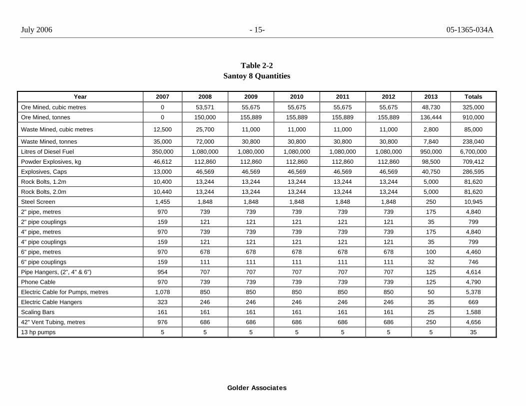
Table 2-2 Santoy 8 Quantities
Year 2007 2008 2009 2010 2011 2012 2013 Totals
Ore Mined, cubic metres 0 53,571 55,675 55,675 55,675 55,675 48,730 325,000
Ore Mined, tonnes 0 150,000 155,889 155,889 155,889 155,889 136,444 910,000
Waste Mined, cubic metres 12,500 25,700 11,000 11,000 11,000 11,000 2,800 85,000
Waste Mined, tonnes 35,000 72,000 30,800 30,800 30,800 30,800 7,840 238,040
Litres of Diesel Fuel 350,000 1,080,000 1,080,000 1,080,000 1,080,000 1,080,000 950,000 6,700,000
Powder Explosives, kg 46,612 112,860 112,860 112,860 112,860 112,860 98,500 709,412
Explosives, Caps 13,000 46,569 46,569 46,569 46,569 46,569 40,750 286,595
Rock Bolts, 1.2m 10,400 13,244 13,244 13,244 13,244 13,244 5,000 81,620
Rock Bolts, 2.0m 10,440 13,244 13,244 13,244 13,244 13,244 5,000 81,620
Steel Screen 1,455 1,848 1,848 1,848 1,848 1,848 250 10,945
2" pipe, metres 970 739 739 739 739 739 175 4,840
2" pipe couplings 159 121 121 121 121 121 35 799
4" pipe, metres 970 739 739 739 739 739 175 4,840
4" pipe couplings 159 121 121 121 121 121 35 799
6" pipe, metres 970 678 678 678 678 678 100 4,460
6" pipe couplings 159 111 111 111 111 111 32 746
Pipe Hangers, (2", 4" & 6") 954 707 707 707 707 707 125 4,614
Phone Cable 970 739 739 739 739 739 125 4,790
Electric Cable for Pumps, metres 1,078 850 850 850 850 850 50 5,378
Electric Cable Hangers 323 246 246 246 246 246 35 669
Scaling Bars 161 161 161 161 161 161 25 1,588
42" Vent Tubing, metres 976 686 686 686 686 686 250 4,656
13 hp pumps 5 5 5 5 5 5 5 35

July 2006 - 16- 05-1365-034A
Golder Associates
Table 2-2 Santoy 8 Quantities Continued
Year 2007 2008 2009 2010 2011 2012 2013 Totals
Storage Unitsa
Fuel, 75,000 Litre tanks 3 12 12 12 12 12 12 81
Propane (18,000 gal) tanks 2 8 8 8 8 8 7 49
Gasoline, 45 gal drums 50 100 100 100 100 100 100 650
Major Mining Equipment
Scoop Tram Units 2 2 2 2 2 2 2 2
Jumbo Units 1 2 2 2 2 2 2 2
Haul Truck Units 1 3 3 3 3 3 3 3
Generator 1 1 1 1 1 1 1 1
75 hp Fan 2 2 2 2 2 2 2 2
200 hp fan 1 1
Personnel On Site 10 30 30 30 30 30 30 30
a = The number in 2007 (first year of operation) indicates the total number of units at Santoy 8 and the following numbers (2008 to 2013) are a reflection of the number of times the units will be filled in a year (i.e., 12 fuel tank units in 2008 is equivalent to the 3 tanks being filled 4 times in 2008).
July 2006 - 17 - 05-1365-034A
Golder Associates
2.4.5 Transportation
Year-round air service is available at Seabee Mine, with regular service to La Ronge, Flin Flon, and Saskatoon. Access to Santoy 8 is currently available by a road from the Seabee Mine. In late 2005, permits were obtained from SE to upgrade the existing seasonal road to an all-weather, approximately 17 km, road between the Seabee Mine and the Santoy area. Construction should be complete in late 2006.
An additional 2 km all-weather access road between the Santoy 7 all-weather road and Santoy 8 is being proposed within the scope of the Santoy 8 Project described herein (Figure 1.1-1). This road will be used to access the Santoy 8 Project area.
The following types of vehicles will be utilized to support the mining operation at Santoy 8:
• three 40 tonne Terex to haul ore to the Seabee Mine; • one 35 tonne Terex to haul ore to the Seabee Mine; • two F350 Ford crew cab trucks to haul staff from the Seabee Mine to Santoy 8; • one diesel operated mini-bus to haul up to 12 staff from the Seabee Mine to Santoy 8; • one 3 tonne service truck at Santoy 8; • one tandem 10-wheel fuel truck to haul equipment and fuel from the Seabee Mine to
Santoy 8; • four or five diesel half-ton trucks; • 1 high hab; • one loader; and, • one ambulance (suburban vehicle).
2.4.6 Ore and Waste Rock Storage Facilities
Two types of rock are mined from a gold mine – ore and waste. An ore pad will be present on-site and will be used to store ore until it is trucked to the mill at the Seabee Mine (Figure 2.4-1).
Ore will be stored for short periods of time on the ore pad prior to transport to the mill at the Seabee Mine. If the ore is deemed acid generating, trenches will be created which will direct the run off water into a settling pond. If necessary, the settling pond will be installed downhill from the ore pad. Run-off from the ore pad will be directed to the pond. If the ore is non-acid generating, run-off water will feed into a nearby muskeg before entering Lizard Lake.
July 2006 - 18- 05-1365-034A
Golder Associates
Waste rock is a term used to characterize rock with no economical value. Two waste rock areas will be located on the northwest side of the Santoy 8 site (Figure 2.4-1).
2.4.7 Waste Management Facilities
Waste management facilities at Santoy 8 will include a waste transfer storage area and a landfill site. The waste transfer storage area will be used to store wastes that will be transported to the Seabee Mine. The landfill site will be determined during construction of the mine and will be located in an appropriate location. Further details related to waste management are provided in Section 2.6.3.
2.4.8 Water Management Facilities
Water management facilities at Santoy 8 will include:
• a freshwater intake (possibly a well for potable water); • collection ditches, sumps, and settling ponds for surface runoff and mine seepage; • a water treatment plant; and, • a settling pond.
Further details related to water management are provided in Section 2.6.4.
Drinking water will be supplied in 20 litre containers until a suitable water is supplied by a drilled well.
2.5 Mining Operations
2.5.1 Geological Resource
The Santoy property is underlain by metamorphosed and structurally complex Pine Lake mafic to intermediate volcanics, volcanoclastics, and minor sedimentary rocks, which have been intruded by granitoid sills. The gold ore will be mined by underground mining methods at an average rate of approximately 500 tpd. The mine will operate at 500 tpd gold ore for approximately six years, with rates decreasing as the number of mining areas becomes more limited near the end of operations.
Currently, the geological resource associated with Santoy 8 and 8E includes approximately 910,000 inferred tonnes. The total volume of processed gold ore will be 0.33 million m3 and the volume of waste rock approximately 85,000 m3.
July 2006 - 19- 05-1365-034A
Golder Associates
2.5.2 Proposed Mine Footprint
The active mine area for Santoy 8 (i.e., the mine footprint) will be approximately 25 ha. In comparison, the mine footprint for the existing Seabee Mine is approximately 525 ha (Golder 2006).
2.5.3 Schedule
The submission of the Project Proposal report will initiate the regulatory approval process for Santoy 8. Construction of the mining facilities is scheduled to begin during the first quarter of 2007; however, this is dependent on regulatory approval by the governing bodies. The proposed schedule for construction and operation of Santoy 8 is presented in Table 2-3. Decommissioning of the Project will occur after mining is complete in 2013.
Table 2-3 Santoy 8 Project Schedule
Begin pre-construction Q1 - 2007
Set-up settling ponds Q1 - 2007
Mobilize equipment, materials, and crews to site Q2 - 2007
Begin underground pre-production development Q2 - 2007
Underground mining operation 2007 - 2013
Seepage and runoff collection pond closure 2014
Water management pond closure 2014 Note: Q= quarter (e.g., Q3 = third quarter).
2.5.4 Mining and Production Process
The method of mining to be used at Santoy 8 is currently unknown and will be dictated by the dip and strike length and thickness of the ore body.
Ore will be hauled to the Seabee Mine in the vehicles listed above in Section 2.4.5. Gold ore processing will be completed at the Seabee Mine.
Please refer to the Existing Environment report for the Seabee Mine for further details on gold ore processing (Golder 2006).
July 2006 - 20- 05-1365-034A
Golder Associates
2.6 Environmental Protection Plans
2.6.1 Tailings Management
Ore from Santoy 8 will be processed at the Seabee Mine site. Therefore, tailings management for Santoy 8 will be included in the management plan at the Seabee Mine.
Details of tailings management at the existing Seabee facility are provided in the Existing Environment Report (Golder 2006). In brief, tailings produced at the Seabee Mine are currently released into the Triangle Lake TMF. Water is recycled from the East Lake and Triangle Lake TMF, which reduces the amount of freshwater intake. No treated effluent is released from either TMF into the environment.
Perimeter pumps are installed every year at strategic locations to collect surface water run-off and re-direct the water away from the East Lake and Triangle Lake TMF.
Approximately 910,000 tons of tailings will be produced from Santoy 8 over five to six years. The current mill processing rate at the Seabee Mine is 800 tpd and with the ore produced from Santoy 8, the mill processing rate is proposed to be increased to 1,100 tpd. Based on current production rates and disposal methods, it is estimated that the Triangle Lake TMF will reach its ultimate capacity in approximately 4.25 years. Claude Resources is in the process of investigating options to optimize the East Lake TMF and Triangle Lake TMF.
2.6.2 Waste Rock Management
Waste rock accessed by mining includes metamorphosed mafic to intermediate volcanic flows and air-fall rocks (lavas and tuffs), along with metamorphosed sedimentary rocks. These rocks are generally acid consuming and can be used for road and pad construction. Two waste rock areas will be located on the northwest side of Santoy 8 (Figure 2.4-1).
A small portion of the waste rock produced at Santoy 8 will be used to build the road between Santoy 7 and Santoy 8. Some of the waste rock will be stored on the surface and used to cover the landfill. The remaining waste rock will be disposed underground as space becomes available.
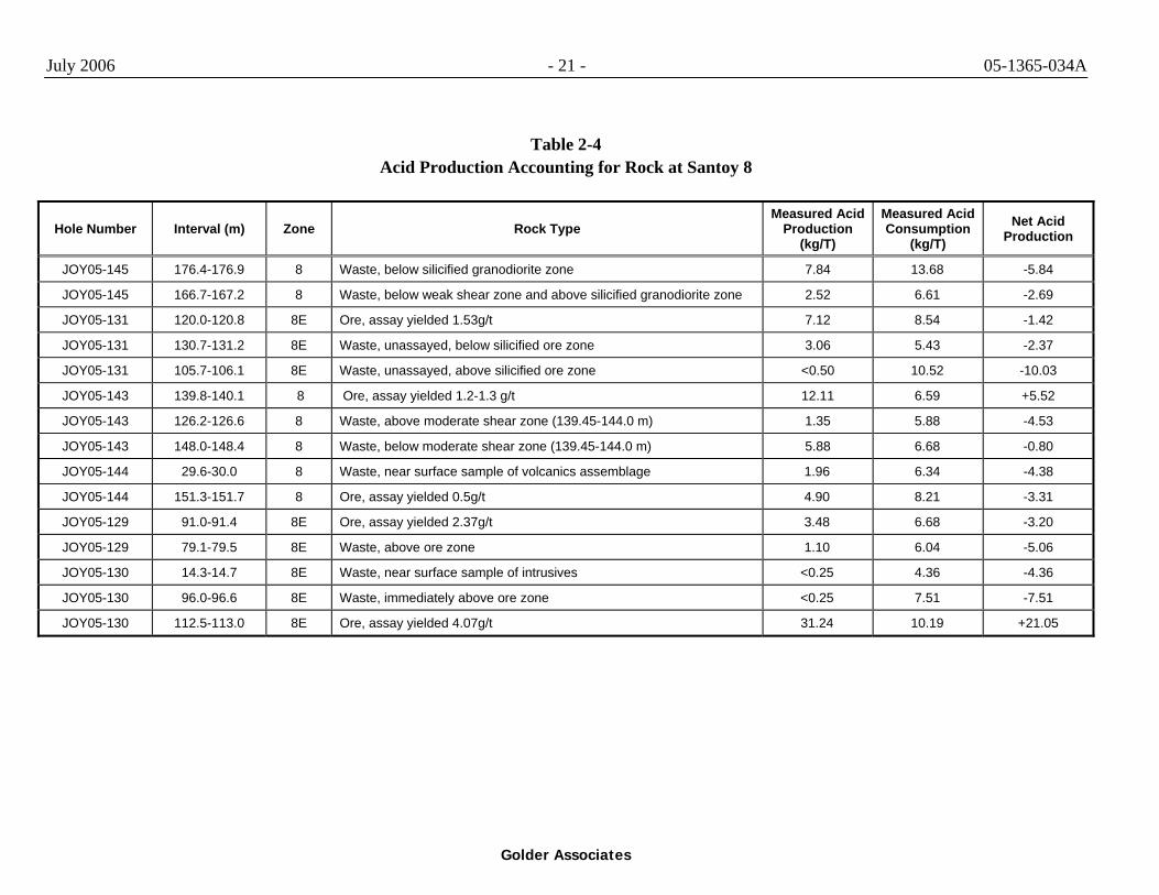
Of the 15 samples of Santoy 8 rock analyzed for acid production/acid consuming potential, 13 were found to be acid consuming and two were found to be acid producing (Table 2-4). Rocks with a sulphide mineral content above 2% are generally acid producing and will not be used for road or pad construction. Claude Resources will
July 2006 - 21 - 05-1365-034A
Golder Associates
Table 2-4 Acid Production Accounting for Rock at Santoy 8
Hole Number Interval (m) Zone Rock Type Measured Acid
Production (kg/T)
Measured Acid Consumption
(kg/T) Net Acid
Production
JOY05-145 176.4-176.9 8 Waste, below silicified granodiorite zone 7.84 13.68 -5.84
JOY05-145 166.7-167.2 8 Waste, below weak shear zone and above silicified granodiorite zone 2.52 6.61 -2.69
JOY05-131 120.0-120.8 8E Ore, assay yielded 1.53g/t 7.12 8.54 -1.42
JOY05-131 130.7-131.2 8E Waste, unassayed, below silicified ore zone 3.06 5.43 -2.37
JOY05-131 105.7-106.1 8E Waste, unassayed, above silicified ore zone <0.50 10.52 -10.03
JOY05-143 139.8-140.1 8 Ore, assay yielded 1.2-1.3 g/t 12.11 6.59 +5.52
JOY05-143 126.2-126.6 8 Waste, above moderate shear zone (139.45-144.0 m) 1.35 5.88 -4.53
JOY05-143 148.0-148.4 8 Waste, below moderate shear zone (139.45-144.0 m) 5.88 6.68 -0.80
JOY05-144 29.6-30.0 8 Waste, near surface sample of volcanics assemblage 1.96 6.34 -4.38
JOY05-144 151.3-151.7 8 Ore, assay yielded 0.5g/t 4.90 8.21 -3.31
JOY05-129 91.0-91.4 8E Ore, assay yielded 2.37g/t 3.48 6.68 -3.20
JOY05-129 79.1-79.5 8E Waste, above ore zone 1.10 6.04 -5.06
JOY05-130 14.3-14.7 8E Waste, near surface sample of intrusives <0.25 4.36 -4.36
JOY05-130 96.0-96.6 8E Waste, immediately above ore zone <0.25 7.51 -7.51
JOY05-130 112.5-113.0 8E Ore, assay yielded 4.07g/t 31.24 10.19 +21.05
July 2006 - 22 - 05-1365-034A
Golder Associates
develop a system to characterize the waste rock mined so that the sulphide waste rock remains underground and the “clean” waste rock is stored on surface. Ore can be weakly acid generating as the gold is often associated with the sulphides (e.g., pyrrhotite, pyrite, and chalcopyrite). A thick pad of acid consuming waste rock will be laid down prior to ore samples being stockpiled. A layer of sand or other distinctive material will be laid on top of the waste rock. This will alert loaders when they have reached the base of the pile, and thus minimize dilution.
Waste rock from Santoy Zone 8 will consume about two times as much acid as it generates, while the mineralized sections will produce 1.1 times as much acid as consumed. Waste rock from Santoy Zone 8E will consume about three times as much acid as it generates, while the mineralized sections will consume 1.3 times as much acid as generated. If all of the rock decomposed, there would be 51.32 kg/tonne acid generated and 95.56 kg/tonne acid consumed, resulting in a net consumption of acid by the rock from Santoy 8.
2.6.3 Solid and Chemical Waste Management
2.6.3.1 Waste Management Plan
The overall waste management plan for hazardous and non-hazardous materials is based on the following key principles:
• health and safety of all site employees, visitors, and the environment; • reduction, reuse, and recycling of waste materials; • proper management of wastes that may attract wildlife or result in the interaction
between humans and wildlife; • environmental awareness and waste management training; • a site-based waste management auditing program; and, • contractor's compliance with site waste management procedures.
Use, storage, shipping, and disposal of all hazardous materials will be controlled according to the site-specific waste management plan. The waste management system for Santoy 8 will incorporate a waste transfer storage area at Santoy 8, waste handling facilities at the Seabee Mine, and a landfill site at Santoy 8.
2.6.3.2 Waste-storage On-site and at the Seabee Mine
Solid and chemical wastes will be collected and stored in a short-term waste transfer storage area at Santoy 8 prior to being transported to a waste transfer storage area at the
July 2006 - 23- 05-1365-034A
Golder Associates
Seabee Mine. Waste will be removed from Santoy 8 on a daily-basis. Solid domestic waste will be transported to the Santoy 8 landfill.
The types of wastes stored at the Santoy 8 waste transfer storage area will include:
• chemicals (e.g., glycol, acids, solvents, battery acids, laboratory agents, waste oil) collected in lined trays, drums, or other suitable containers. The lined trays will be emptied on a regular basis;
• other hazardous non-combustible waste and contaminated materials stored in suitable containers;
• food waste collected in plastic bags and placed in sealed containers; and, • non-toxic solid wastes.
Contaminated soil will be placed in 45 gallon drums and returned to the Seabee Mine for proper disposal.
Details of waste storage and management at the Seabee Mine are reported in the Existing Environment Report (Golder 2006). In brief, a sorting and storage area is located adjacent to the mill at the Seabee Mine. Wastes from Santoy 8 will be brought to this area for processing. Depending on the nature of the waste (hazardous, recyclable), it will be placed in suitable containers and transported to the landfill site, or under-go long-term storage for backhaul to off-site disposal or recycle facilities. Waste products that are not incinerated or landfilled immediately will be sorted and placed within designated areas.
2.6.3.3 Landfill Site
The Santoy 8 landfill will be developed early in the construction of the mine from waste rock excavated from the underground decline. Inert solid waste will be deposited on a layer of inert waste rock to eliminate any risks of leaching and/or contamination of the water table. A berm will be built around the entire area. The inert solid waste will be regularly buried with a cover of waste rock to minimize exposure to wind and wildlife. The landfill site will conform to applicable Saskatchewan regulations for the operation of landfills. A location for this landfill has not been finalized, however the site will be at least 90 m from any waterbody and a natural depression is preferred. Piezometers will be installed around the perimeter of the landfill and regularly monitored.
July 2006 - 24- 05-1365-034A
Golder Associates
2.6.4 Water Management
2.6.4.1 Water Management Plan
Water management is defined as the collection, storage, recycling, and treatment of water in a safe, efficient, and compliant manner. Water management at Santoy 8 is designed to reduce the potential for effects on the surrounding natural water bodies and is based on two objectives:
• reduce the quantity of surface water runoff requiring management or treatment; and, • managing the quality of ground and surface water through mitigation and treatment to
achieve compliant water quality results and to reduce the potential for effects to water resources.
Claude Resources has developed a preliminary water management plan to address these objectives. The plan outlines the water management system (infrastructure and management practices), and is summarized below. Some details of the system (i.e., number of settling ponds) cannot be finalized at this stage of the development and will be determined once the acid generating potential of the waste rock has been confirmed.
2.6.4.2 Water Supply and Distribution
Drinking water will be supplied in 20 litre containers until suitable water is supplied by a drilled well. A water treatment plant will be constructed to treat the potable water from the well so it is within regulation standards.
The potable water supply will be pumped from the well via a main overland pipeline to the freshwater storage tank in the water treatment plant. The pipeline will consist of insulated and heat-traced, high-density polyethylene pipe, located on a fill bench adjacent to the service road. Water will be stored in a storage tank in the potable water treatment plant, chlorinated, and sampled monthly to ensure it meets Saskatchewan health regulations. Treated water will be piped to areas in the process plant requiring potable water and to the accommodations and service complexes.
Subject to approval, freshwater will be drawn from Lizard Lake (local name = Ospackew Lake) and piped to camp facilities (Figure 2.4-1). Freshwater will have the following uses:
• dust suppression (initial construction only); • fire suppression and central fire line in shop area; and, • drill water for underground drilling (only if necessary).
July 2006 - 25- 05-1365-034A
Golder Associates
The volume of water to be drawn from Lizard Lake is estimated to be 20.0 cubic metres per day (m3/d). This is a conservative estimate because recycling of the groundwater inflow at Santoy 8 is expected to reduce the volume of freshwater required to fulfill the underground mining volume requirements.
The underground freshwater supply will consist of a filtered intake pump that will supply water on demand. The water intake will be screened to prevent fish entrainment. Intake velocities will be below the federal regulatory criteria for the operation of water intakes. In addition, the freshwater intake on Lizard Lake will only be temporary (i.e., will be removed during decommissioning of the site) and will not disturb the bottom of the lake.
Water for fire suppression will be pumped from Lizard Lake through a pressurized system to the accommodations and camp. The volume of water and duration of flow in the pressurized system will be standardized to national fire codes. The fire system which consists of a pump, valves, hydrants and pipeline is completely independent from any other systems at the mine. From this system, an outlet will be installed to fill the water tanker to suppress the dust on the road.
2.6.4.3 Surface and Seepage Water Management
Surface Water / Site Run-off
Rock-lined ditches and grading, if required, will direct runoff from disturbed areas toward the settling pond. Traps will collect sediment generated from runoff in outlying areas. Any spills will be contained, collected, and remediated as described in the Spill Response Procedure (Appendix I).
Waste Rock Pile - Water Collection System
Internal Water Collection System
If required, two temporary collection ponds will be constructed within the waste pile to collect water from the following sources:
• direct precipitation and runoff from the waste pile; and, • seepage water from the waste pile.
As mentioned earlier, the need for the additional ponds will be determined once the acid generating potential of the waste rock has been defined. The internal water collection system will be designed in such a manner that all water will undergo the necessary treatment to comply with regulations.
July 2006 - 26- 05-1365-034A
Golder Associates
Waste Pile - External Water Collection System
The external water collection system will receive water from the internal system and external sources of water including the following:
• direct precipitation to the outside slopes of the waste pile; • runoff from the waste pile and related catchment areas; and, • seepage water from the waste in the waste pile.
If required, ditches around the perimeter of the waste pile will direct and collect runoff from the outside slopes of the waste pile and will intercept seepage from the northern toe and near-surface of the waste pile. The ditches will direct water to three external sedimentation ponds.
Underground Water Quantity
Groundwater will seep into the underground mine from the surrounding rock. Initially, this volume will be very small. The volume of water entering Santoy 8 will increase over time as more underground areas are exposed and mined. Once the volume of inflowing water becomes significant, a sump system with a recirculation pump will be installed and subsequently discontinue the need for the use of freshwater in the underground operations, which will rely on inflowing groundwater. If Santoy 8 satellite mine experiences the same groundwater influx as is occurring at the 2B Zone of the Seabee Mine, the volume of inflowing groundwater may be between 200 m3/d and 300 m3/d. To reduce the volume of water entering the mine, grout (cement compounds) will be injected into fractures and drill holes in the underground walls.
Seepage water will be directed by ditches maintained along the ramp and drifts (underground tunnel below the ore) to a series of sumps. These sumps will allow initial settlement of coarse suspended solids from the water. Pipelines from the sumps will be routed along drifts and up the ramp and/or vent raise to the surface and to the settling pond. Under upset conditions in the mine, water will be stored in the sumps.
In the event of electrical or mechanical failures, adequate back-up power generators will be utilized to limit the degree of flooding.
Underground Water Quality
As water travels through the underground mine, it will pick up residual explosives, grout, fine sediment, and cement materials. Coarse material suspended in the water will settle in the sumps, and will be removed and disposed of in inactive areas of the mine. The
July 2006 - 27- 05-1365-034A
Golder Associates
small amount of fine sediment that remains in the water will be decanted in the dirty sump, with the addition of flocculent, if required. The final stage of filtration occurs when the water percolates through the bottom of the settling pond. Fine sediment will settle once the water is transported to the settling pond (see further details in Section 2.6.4.4 for treatment process). Continual monitoring of the sedimentation pond will determine the need for the installation of a flocculent system. One will be installed if necessary.
2.6.4.4 Water Treatment and Discharge
Mine Water
Water treatment may be necessary to ensure water released to Lizard Lake meets discharge quality. Treated water will be recycled and reused to the greatest extent possible for process water, and dust suppression underground, on roads, and on the waste pile.
Mine water from Santoy 8 will be transported to a settling pond via a 13 hp Flygt sump pump. A flow meter will determine the volume of water entering the settling pond from the underground pipe. It is anticipated that initially, the maximum volume of water discharged into the settling pond will be less than 50 m3/d. As mining continues and depending on the quality of the rock, the discharged volume may be equivalent to or exceed 50 m3/d. At this time, Claude Resources will consider the option to either increase the pumping capacity or to grout the ground and limit the volume of inflowing groundwater.
The settling pond will be constructed in the following manner. The east wall will be a natural bedrock slope and the remaining three walls will involve approximately 4 m of waste rock. A layer of sand will be deposited on the inside of the waste rock walls to offer additional filtration capabilities. The bottom of the pond will be natural ground. The pond will be constructed in such a manner as to filter the mine water and allow it to percolate into the receiving environment through the bottom and lower portions of the walls. Suspended particulates in the water will be entrapped in the pond walls. A plastic liner (4ft. wide) will line the walls from the top down. On the interior of the pond, gravel or fine waste rock will be deposited.
Claude Resources will monitor the water level in the pond to maintain 0.5 m of free board. If the water level encroaches the freeboard level, Claude Resources will take appropriate action to rectify the situation, i.e., raise the height of the walls or scrape the inside of the pond and send the slimes underground. Monitoring will be done on a weekly basis and a flow meter will be installed on the pipe coming from underground.
July 2006 - 28- 05-1365-034A
Golder Associates
Levels of total suspended solids and pH will be monitored in the settling pond and, if necessary, a flocculent system will be installed prior to the underground sump system. A water sample will be collected in the low lying spot outside of the settling pond, where the water accumulates before dispersing into the environment. From the settling pond, water will flow naturally into a low lying swamp south of the portal and eventually flow into the southeast portion of Lizard Lake (Figure 2.4-1).
Sewage Treatment
A septic system will be installed to treat sewage effluent. More specifically, an engineered septic field will put in place for camp sewage and grey water.
2.7 Decommissioning and Closure
Decommissioning and closure of Santoy 8 will take place using best practicable, northern mine closure techniques that will comply with accepted protocols and standards. Decommissioning efforts will be focused on promoting natural re-vegetation. A detailed decommissioning plan will be prepared as part of future regulatory submissions and an Environmental Impact Statement if required.
2.8 Alternatives to Preferred Project Description
No detailed alternative to the Project have been investigated. The mine footprint for the preferred Santoy 8 Project description has been kept to a minimum to reduce environmental impacts and the need for reclamation.