Embed Size (px)
Citation preview

SOS SAHEL
Final Report
Submitted
To
Save the Children US
By
SOS Sahel Ethiopia
2
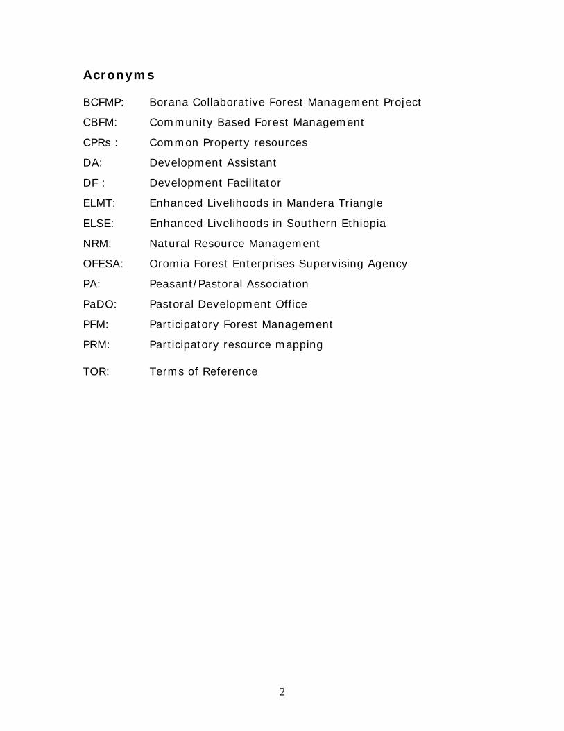
Acronyms BCFMP: Borana Collaborative Forest Management Project
CBFM: Community Based Forest Management
CPRs : Common Property resources
DA: Development Assistant
DF : Development Facilitator
ELMT: Enhanced Livelihoods in Mandera Triangle
ELSE: Enhanced Livelihoods in Southern Ethiopia
NRM: Natural Resource Management
OFESA: Oromia Forest Enterprises Supervising Agency
PA: Peasant/Pastoral Association
PaDO: Pastoral Development Office
PFM: Participatory Forest Management
PRM: Participatory resource mapping TOR: Terms of Reference
3
Executive Summary This report documents implementation of participatory rangeland resource mapping and formulation of Community Action Plans in the lowlands of the Borana Zone of Oromia Regional State where SOS Sahel Ethiopia and its partners have been implementing ELSE project under the regional ELMT. The project has implemented production of participatory resource maps in two pilot grazing zones of Borana Zone. Different social and age groups were involved in the project; also persons with particular knowledge about distribution and “borders” of key resources and mobility routes took part. From the government partners, Zonal Pastoral Development Office, Zonal Land Use and Environmental Protection Office, District Administration, District Pastoral Development Office, District Land Use and Environmental Protection Office and frontline development staffs (DAs) participated as co-implementers (Appendices I & II). The mapping project covered 55 PAs (against 10 originally planned) in 5 districts. The participatory maps contain key natural resources (pasture and perennial and temporary water sources); settlement patterns; farm encroachment; bush encroached land; spatial distribution of gum and incense-producing trees useful in generating household income; mobility routes; social and physical infrastructure; de facto private enclosures; degraded high forests areas; rivers, etc. Through the maps, natural resource-related problems were assessed, visualized, discussed and prioritized in the target areas (See Progress Reports 1 & 2 for details). Results of the resource mapping project were presented and discussed at several Consortium forums in Addis Ababa and Nairobi at different times. The work was then presented at the Community Feedback and CAPs formulation Workshop in Yaballo (5-7 December 2009), culminating in formulation and endorsement of community action plans. As planning tools, the participatory resource maps reaffirmed the indispensability of understanding community’s systems of territorial organisation and land use for sustainable rangeland management and appropriate pastoral development planning in the eco region.
4
I. Introduction 1.1 Environment and pastoral land use: a landscape approach Pastoral environments in the tropics are variable due to fluctuating rainfall. Resources are patchily distributed over different landscape units such as forested mountains, dry plains, hill sides and river valleys. A key feature of the rangeland in the arid environment is that different landscape units are functionally interconnected in supporting pastoral production across seasonal divides. Herders devise mobility as an essential strategy towards opportunistic resource utilisation and arrange common property land tenure system in order to allow physical mobility and ensure negotiated access to resource mosaics. Functional resource base, robust governance institutions and pastoral oriented NRM policy are the key to sustainable pastoral production in these variable environments so as to ensure, among others, integration of landscape units and mobility. This means that eecological conditions, pastoralist strategies and institutional arrangements are inherently interlinked in the arid/semi-arid environments. As pastoral land use system considers ecological nature and is practised in an integrative way, it implies that natural resource-centred development plan, resource management approach and policy must maintain this intrinsic integrity of all elements of the landscape to ensure its support to livelihoods in the wider ecosystem. It also calls for coherent governance of the landscape as a whole. Ensuring landscape interconnectivity and coherent governance necessitates institutional empowerment for landscape management and sustainable livelihoods (Tache, 2008). Herders’ perception of their environment is holistic in that they adopt a territorial approach and assess range conditions across scalar, spatial and seasonal divides. They maintain a comprehensive mental map of their environment; this detailed emic knowledge is regularly updated through the tradition of information network (contacts and oral exchanges on daily encounters). Therefore, participatory resource mapping is just a facilitatory exercise that taps into pastoralists’ rich indigenous ecological knowledge and converts their mental map into a visualized planning tool. 1.1.1 Territorial organization in the Borana landscape The Borana Oromo use River Dawa as the natural water shade to classify their territory (Helland, 1977; Oba, 1998). All lands located to

5
the east of the River are known as Liban while the expanse of land to the west of Dawa is generally termed as Dirree. The two macro regions are further divided into grazing zones (dheeda) that comprise several madda and sub-madda units (reera, ardaa, ollaa). Accordingly, Liban comprises Golba and Gubbaa that are separated by an escarpment while the Dirree macro region consists of 5 dheeda: Wayaama, Goomolee, the tulaa wells cluster (also known as Dirree), Malbee and Golboo (Tache, 2000; Bassi and Tache, 2008). Different grazing dheeda often exhibit peculiar ecological characteristics resulting from the variant microclimatic conditions. However, it must be underlined that the customary territorial units are neither mutually exclusive entities nor have clearly defined/rigid boundaries. In deed, the fluid mental borders do overlap and access to the key resources is constantly negotiated in both normal years and during emergencies. 1.2 Participatory resource mapping in Borana lowlands 1.2.1 The evolution Participatory resource mapping was introduced in the Borana-Guji lowlands with commencement of SOS Sahel’s BCFMP (1999-2007), which primarily focused on dry land natural juniper forest conservation in the priority forest areas of Liban, Yaballo and Arero districts, and implemented in collaboration with the then Zonal Natural Resources Department and the communities. The project principally aimed at establishing management systems over which local people or institutions have control, and by which natural resources can be used sustainably by local communities (Tache and Irwin, 2003). The community maps (Fig. 1, for example) drawn during the Project’s Investigation Phase (Box 1) were used as planning tools for institutionalization of PFM in the Negotiation Phase (Fig.2). An important output of the project was the creation of different community based forest management units in all the project sites and formation of forest management bodies based on the customary system of resource management in the area. The PFM structure is pyramid shaped, comprising forest unit management body (“Jaarsa madda kan finna baddaa”), forest block management body (“Jaarsa finna ejjaa baddaa”) district level participatory forest management working groups (“Jaarsa Aanaa kan finna baddaa”) and participatory forest management assembly (“Gumii finna baddaa”) with large community at the base of the pyramid. This multi-leveled CBFM system consists of persons elected from the forest impacting PAs and customary institutions (such as gadaa and laduu) and pertinent
6
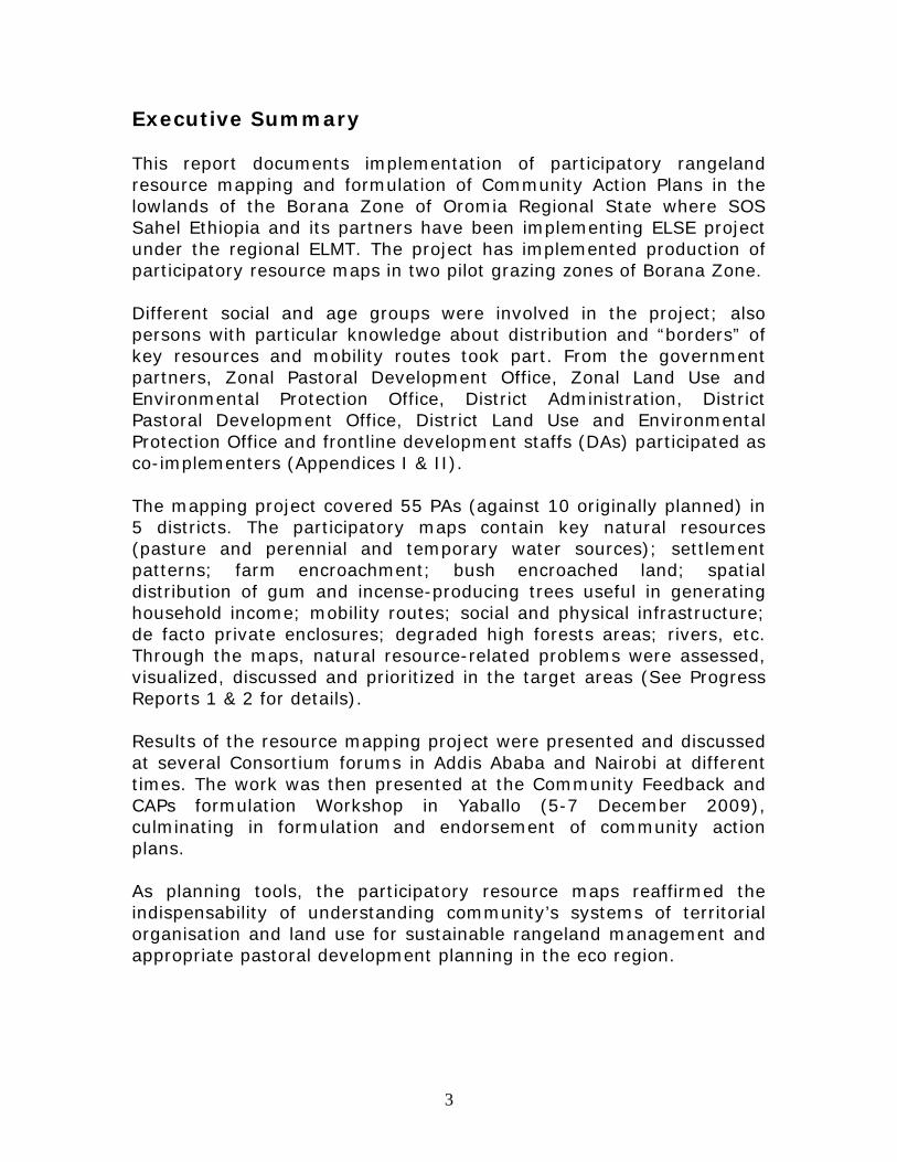
government offices, with 33% of women’s representation (Tache and Irwin, 2003). Fig. 1: A Manqubsa forest map drawn by the community in Simminto, Liban
Source: Tache and Irwin, 2003
7
Fig. 2: Participatory Forest Management Working Groups Structure
G. F.B.
J.A.F.B
J.F.E.B
J.M.F.B
Pastoral Community
Zone
Woreda
Forest units
PA
Forest BlocksForest Blocks
Box 1: The three stages in developing PFM
Investigation stage: The first stage of the collaborative forest management (CFM) process is to understand forest use in terms of who is using the forest and how, and the impact of that use on the forest and local livelihoods. Participatory learning and action approaches are used, building the capacity of all involved to produce, analyze and utilize relevant information to plan for CFM. Negotiation stage: The second stage of the process uses the information and plans developed during the investigation phase to facilitate negotiations between different stakeholders, including resource users and government agencies. The outcomes of these negotiations are forest management plans and shared management arrangements. Participatory forest-land use planning and facilitated negotiation involving all stakeholders form the basis of this work. Implementation stage: The third and final stage of the process involves the implementation and monitoring of the forest management agreements. This stage is one of learning by doing (Source: Tache and Irwin, 2003: 19).
8
The PFM process culminated in signing of PFM agreement between the community (represented by their customary leadership and representatives of Jaarsa Finna Ejjaa Baddaa – Forest Block management groups) and District Pastoral and Rural Development Offices in Yaballo, Liban and Arero districts, in 2007. The abbaa gadaa of the entire Borana Oromo (Liban Jaldessa) and the abbaa gadaa of the Hawaxxuu section (Hiddo Galgalo) signed the agreement on behalf of the gadaa institution and the community at large. The Project handed over forest management responsibility to the two key stakeholders in accordance with terms and roles specified in the agreement document. The three forest sites in Yaballo, Arero and Liban have thus been under de jure management responsibility of the community and District Pastoral and Rural Development Office (now Oromia Forestry & Wild Life Development Enterprise) since the agreement was signed. Another important development in the evolution of participatory resource mapping in the area was the commencement of the USAID-funded Pastoral Livelihood Initiative (2005-2008, including the one year non-cost extension period). The project widely used resource mapping for drought risk reduction strategy planning. Consequently, activities such as delineation of community drought reserves and rangeland rehabilitation were implemented in both Guji Zone and Borana Zone (by Save the Children, SOS Sahel and Care). Although the mapping activities were conducted at PA level, the endeavor significantly contributed in terms of learning by doing besides its positive livelihood impacts such as reduced drought mortality. 1.2.2 The present scaled up resource mapping project Despite the above-mentioned positive contributions, the PA focus in resource mapping suffered serious limitations as it failed to sufficiently consider pastoralists’ interdependence across the rigid PA boundaries. The current mapping exercise has bridged the lacuna by adopting a scaled-up dheeda approach. This approach has considered pastoralists’ mental map and turned it into a visual tool that informed community action plans developed during the Community Feedback Workshop and CAPs in Wayaama and Dirree grazing zones of Borana Rangeland (see later). The community-drawn visual maps, piloted in the two dheeda, have magnified problems relating to resource management in general and pasture scarcity in particular. Also, problems affecting natural resources and pastoral livelihoods have been identified and thoroughly discussed.
9
The mapping project covered 55 PAs in 5 districts (Dhaas, Dirree, Arero, Moyale and Miyo) in the Borana Zone. The maps contain key natural resources (pasture and perennial and temporary water sources); settlement patterns; farm encroachment; bush encroached land; spatial distribution of gum and incense-producing trees useful in generating household income; mobility routes; social and physical infrastructure; de facto private enclosures; degraded high forests areas; rivers, etc. Through the maps, natural resource-related problems were assessed, visualized, discussed and prioritized in the target areas (See Progress Reports 1 & 2 for details). As planning tools, the participatory resource maps reaffirmed the indispensability of understanding community’s systems of territorial organisation and land use for sustainable rangeland management and appropriate pastoral development planning in the eco region. 1.2.2.1 Scale and digitization of participatory maps Pastoral land use is inherently a large-scale activity given the ecological characteristics and resource patterns as was discussed earlier. But there is an apparent gap between technical skills in translating participatory maps into a digital object (ease for digitization) and appropriateness and relevance of maps for pastoralists’ knowledge and land use practice. Large-scale participatory maps are blamed for being uneasy for geo-referencing. It is not clear why, for example, a dheeda-level map is not digitizable without disintegrating it, given sophistication with GIS technology? A key question one would raise is: which priority issue should the maps aim at as pastoral development planning tools - a technically precise and easy-to-digitize map or people’s own map that carries higher degree of relevance for their livelihood and life style, with, however, technical imperfections? Obviously, geo-referenced maps would supplement participatory maps by integrating scientific knowledge with indigenous ecological knowledge applicable for long-term environmental monitoring. However, from the pastoralist perspective, immediate application of coordinates and their relevance for immediate pastoral livelihood objective and routine activities is minimal, if not none. An attempt to subordinate people’s map to technical simplicity in digitization will only disempower the pastoralists. Therefore, one must be able to digitize pastoralist’s own map regardless of the technical difficulties involved in implementing the mapping project as there is no technical quick fix that can better serve the immediate pastoral
10
livelihood objective than pastoralists’ own practice, knowledge and experience. Land use planning that aims at enhancing pastoral livelihoods is meaningful only when built on indigenous ecological knowledge complemented by scientific knowledge. 1.3 Methodology 1.3.1 Implementation process Participatory resource mapping in southern Oromia was implemented following carefully designed and followed steps over about 5 months period in order to ensure participation of all relevant stakeholders and process transparency, targeting quality outputs. Subsequent to the signing of agreement with SOS Sahel Ethiopia to implement the project, the consultant conducted a reconnaissance trip to Borana Zone (over the period of June 19 to July 1, 2009) to seek stakeholders’ consent on the envisaged mapping approach, as was stipulated in the consultancy TOR. The reconnaissance trip had the following objectives: 1. Checking, with the stakeholders, appropriateness and relevance of
the proposed dheeda approach in the rangeland resource mapping vis-à-vis pastoral land use system and resource tenure,
2. Identifying major water shades in the southern rangeland, 3. Consulting with key informants and ELSE Project partners on
feasibility (achievability) of the large-scale resource mapping, 4. Assessing stakeholders’ perception of customary territorial
organization of Borana pastoralists and their decision-making institutions
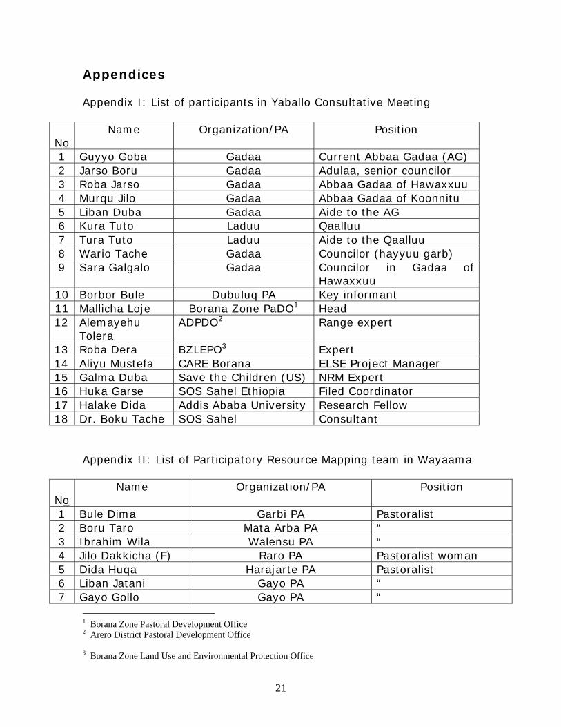
Accordingly, key actors from the Government, NGOs, leadership of customary institutions (including the current and the outgoing gadaa leaders along with their councilors) and key informants were consulted. The participants endorsed the proposed approach in resource mapping (see progress Report 1 for details). Preliminary findings were presented at the ELSE partners’ meeting held at the LVIA Office in July 2009. As a sequel, all the stakeholders that had been consulted on institutional basis before were brought together under one shade during the second fieldwork, with the following set of objectives:
a. Promoting shared understanding among the Zonal-level stakeholders about the rationale, approach and method of the resource mapping project
11
b. Discussing and clarifying concepts and units around customary territorial organization of the Borana pastoralists in southern rangeland
c. Agreeing the resource mapping site (see Progress Report 1 for details)
With participants’ recommendation (18 in number, see Appendix I), the mapping site was changed from the originally proposed Wayaama-Goomolee grazing zone to Wayaama-dirree ecosystem. The change considered (1) the role and importance of the site in supporting pastoral livelihood. It was underlined that wayaama still supported huge pastoral activities as the zone was relatively less disturbed by land use types that directly competed with pastoralism. Dirree was the centre of deep traditional tulaa wells, which are the most reliable perennial water sources. Particularly in dry season when surface water sources dry up or performance of shallow wells reduces, the tulaa wells provide continuous service, sometimes day and night. The two geographically contiguous sub-regions serve as back bone to the pastoral economy in southern rangeland and therefore, mapping and subsequent planning, would present an excellent opportunity for the pilot project as well as future livelihood initiatives. (2) ELSE being a multi-partner project where consortia of NGOs were involved (SOS Sahel, CARE and SC), the resource mapping exercise was expected to be conducted in a dheeda where the NGOs currently operated. All the three NGOs confirmed that the selected eco region would satisfy expectation of their respective organization as all currently engaged in pastoral development activities there. The Yaballo stakeholders’ recommendations led to the formation of resource mapping teams in Wayaama and Dirree grazing zones, comprising 34 and 41 members respectively, representing all the PAs in the microclimatic areas. The team members were selected on the basis of personal competence, age and gender consideration. Mapping exercises were conducted in Borbor and Dubuluq over the period of July 31 to August 8, and Sept 5 to Oct 9, 2009 respectively. Results of the resource mapping project were presented at several Consortium forums in Addis Ababa and ELMT/ELSE Stakeholders’ Final Meeting, which was convened in Nairobi over 23-27 November 2009. This was followed by presentation at the Community Feedback and CAPs formulation Workshop in Yaballo (5-7 December 2009), culminating in formulation and endorsement of community action plans.
12
II. Project Outputs 2.1 Production of participatory maps at dheeda level The major project outputs are two first ever participatory maps produced at dheeda level (one per site). Community interpretation of the resource maps revolved around livelihood decline due to pasture scarcity (both dheeda) and conflict and lack of stable security (mainly in Wayaama). Causes of pasture scarcity were widely discussed and summaries are as under. • Territorial shrinkage and decline in rangeland productivity Rangeland productivity decline in Borana is a result of several factors. One important factor is the change in customary land use system and management practice imposed by the state. In Ethiopia, mobile pastoralism was perceived as a backward activity and thus ‘modernizing’ measures (emergence of competing land use types, such as crop cultivation and sedentarizing social services) were introduced with the aim of replacing pastoralism. Loss of territory (largely in the Wayaama grazing zone) due to geopolitical and domestic political processes has also caused displacement and competition of people and their livestock over limited space in the pilot grazing zones and beyond. Bush encroachment and declining rainfall have had direct impact on rangeland productivity. This has, in turn, led to confusion in the grazing system and pastoral land use, implying greater risk to poverty. The trend of change in pastoral land use system seems to be more towards resource ‘privatization’, relating to spontaneous expansion of de facto private enclosures and ‘farmlands’, in disharmony with the core principles of common property resource tenure. Unsystematic settlement pattern is another major cause of confusion in the pastoral land use and environmental degradation. Traditionally, pastoralists’ settlement pattern reflected seasonal variation of key pastoral resources and villages systematically established to ensure availability of pasture on livestock watering and non-watering days. Currently, however, villages are concentrated one after the other in the manner that contradicts customary pastoral land use and sustainable resource management practices. • Large-scale and multi-faceted resource degradation that implies
profound sustainability problem of pastoral livelihood.

13
• Imminent poverty at societal level with the higher possibility of livelihood viability limited only to fewer stock rich families who are more diversified in terms of herd composition, animal species reared and income sources in general.
• Relative variation in the magnitude of resource degradation. Although pasture scarcity is the prime problem in Borana today, its magnitude varies. It has been chronic in areas with long history of sedentism (such as resettlement sites) and crop cultivation. Apparently, and also consistent with the community’s fear expressed during the discussions, the scale of chronic resource degradation is increasing in the whole dheeda. What the maps displayed confirmed that fear. Remarkable in this regard was the lack of wet season grazing zone in the entire dheeda of Dirree due to sedentarizing water schemes in the former wet season areas. In the past, grazing scarcity was a transient condition in pastoral production system where rainfall variability drives seasonal variability in resource pattern and condition. Due to recurrent drought and above-mentioned confusion in land use, however, sustainable pastoral livelihood is uncertain in the two grazing zones and beyond, implying huge livelihood risk and need for comprehensive community-initiated plans to forestall the imminent danger. • Growing self interest that accelerated expansion of spontaneous de
facto private enclosures in the communal rangeland. • The importance of larger-scale in considering problems facing
sustainable land use and corresponding rage management plans • Overtaking of pastoral land use by agro-pastoral land use and thus
encroachment of private interest in land holding The following factors were identified as additional causes of breakdown/confusion in land use and grazing systems in Wayaama and Dirree: • Patchy rainfall imposing competition over better off places • Sedentism and reduced mobility driven by farming, provision of
social and physical infrastructure, water schemes in wet season grazing areas and subsequent intensive grazing (indicator: house style)
14
• Overtaking of community forums by state forums and marginalization of elders. This has led to the weakening of effectiveness of customary rules
• Innovation into alternative livelihood source that has shifted attitude and practice of some pastoralists to non-pastoral activities
• Population pressure • Kebele system given prominence by the state over grazing system
and customary structure and implementation of development plans through the former.
• Less seriousness in taking up pastoralists’ problems, relating to what the participants called the new culture in the making- the culture of frequent and monotonous meetings.
• Ethnic conflict is a major threat to sustainable pastoral production
(mainly in Wayaama). Conflict is likely to continue escalating between the rival pastoralist groups so long as the root cause of conflict remains unresolved. Suggested solutions include restoration of land use system through conflict resolution by addressing territorial claims on the basis of historical rights to the rangeland.
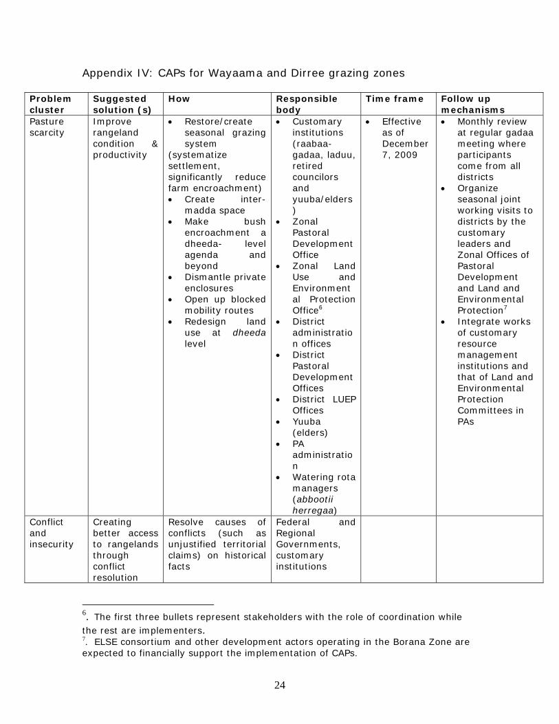
Participants summarized livelihood implication of the current resource condition as follows, “Given the existing trend in the rangeland, our livelihood is under destitution threat.” 2.2 Formulation of Community Action Plans 2.2.1 CAPs for Wayaama and Dirree grazing zones The previous CAPs were informed by resource mapping exercises conducted at the PA and sub-PA levels, thus the corresponding CAPs were formulated at those units. PA boundaries being formalized and fixed administrative structures, the PA-level information would guide subsequent CAPs only at that level, inconsistent with the tenets of pastoral strategies and CPRs tenure. Furthermore, this narrow approach implies fragmentation of the pastoral landscape; contributes to rigid resource borders and ignores basic ecological characteristics. With current mapping and subsequent CAPs attempts have been made to rectify these inherent weaknesses by basing the project thinking on pastoralists’ rationale, in the manner that recognizes complex resource users’ relations over key resources and mobility across spatial scale over and above the PA confine. As the dheeda-level CAPs require
15
involvement of more people than the number participated in drawing the maps, the latter developed framework for formulating detailed dheeda CAPs, which were later presented and discussed at the Community Feedback and CAPs Formulation Workshop conducted in Yaballo during the 1st week of December 2009 (see next). III. The Community Feedback and CAPs Workshop The consultant and Borana Zone Pastoral Development Office organized the Workshop with the objective to providing feedback to the community and other stakeholders on the participatory resource mapping works conducted in the two pilot grazing zones and formulating detailed CAPs. The workshop was conducted from 5-7 December 2009 in the Yaballo Town Hall and attended by participants numbering over 130, drawn from 7 districts (including Liban District in the Guji Zone). Participants’ profiles included resource mapping teams, elders and youth invited from each dheeda, representatives of NGOs operating in the Borana Zone, Zonal and districts government partners, leaders of various customary institutions and PA leadership (see Appendix VI). The scale and magnitude of environmental problems displayed by the maps signaled alert to the looming large-scale livelihood crises, which naturally calls for corresponding large-scale solutions. This basically meant urgency in revitalizing customary resource management strategies and decision making, taking into account modern day challenges. Participants formulated a more focused planning to tackle the central problem that threatened pastoral livelihood in the Zone - resource degradation and pasture scarcity (Appendix IV). Therefore current CAPs are peculiar in the sense that both problem selection and corresponding planning initiatives were purposely focused in order to achieve a concrete result as opposed to the common tradition with workshops where long problem lists are provided, often remaining unaddressed. Another evident peculiarity is the fact that leaders of various customary institutions made their voices heard by issuing a 4-paged decision and directives, which were refined through comments at the main plenary.
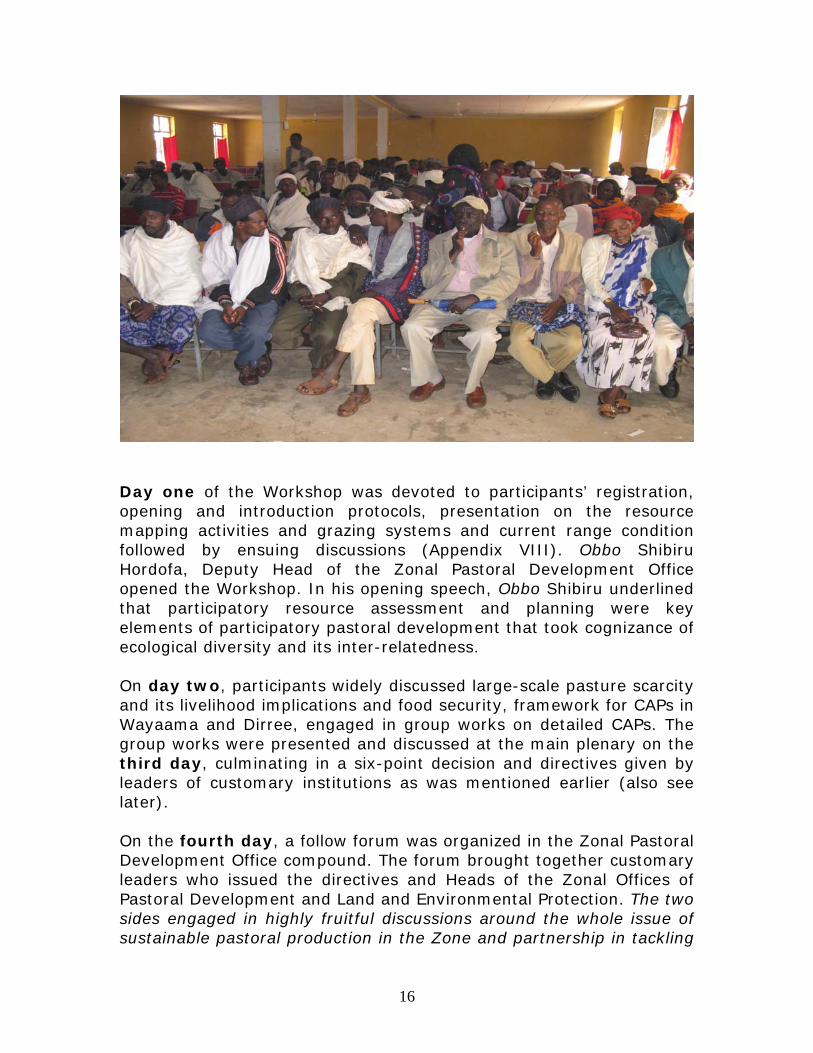
16
Day one of the Workshop was devoted to participants’ registration, opening and introduction protocols, presentation on the resource mapping activities and grazing systems and current range condition followed by ensuing discussions (Appendix VIII). Obbo Shibiru Hordofa, Deputy Head of the Zonal Pastoral Development Office opened the Workshop. In his opening speech, Obbo Shibiru underlined that participatory resource assessment and planning were key elements of participatory pastoral development that took cognizance of ecological diversity and its inter-relatedness. On day two, participants widely discussed large-scale pasture scarcity and its livelihood implications and food security, framework for CAPs in Wayaama and Dirree, engaged in group works on detailed CAPs. The group works were presented and discussed at the main plenary on the third day, culminating in a six-point decision and directives given by leaders of customary institutions as was mentioned earlier (also see later). On the fourth day, a follow forum was organized in the Zonal Pastoral Development Office compound. The forum brought together customary leaders who issued the directives and Heads of the Zonal Offices of Pastoral Development and Land and Environmental Protection. The two sides engaged in highly fruitful discussions around the whole issue of sustainable pastoral production in the Zone and partnership in tackling
17
problems faced. They underlined that free riders and land grabbers must not be tolerated by either side. The two Offices accorded full recognition to the decisions and directives given by the customary leaders and dispatched them to all districts with accompanying letters signed by their respective heads (Appendix VII). Agreed upon follow up mechanism included: • Monthly review at regular gadaa meeting where participants come
from all districts • Organizing seasonal joint monitoring visits to districts by the
customary leaders and Zonal Offices of Pastoral Development and Land and Environmental Protection
• Integration of works of customary resource management institutions and that of Land and Environmental Protection Committees in PAs (Appendix IV)

18
Customary leaders and Heads of Zonal Offices of PaDO and LUEP in a follow up meeting
In conclusion, the Workshop demonstrated exemplary partnership commitment between the community, their customary leaders, the Zonal and district partners and non-state actors in joint appreciation of core problems; forging shared vision and direction through formulation of focused planning, devising of joint follow up mechanisms and communication of the shared decisions to the implementers in districts. This innovation needs to be upheld and promoted not only in monitoring implementation of this particular joint plan but also in any other relevant pastoral development projects in the Zone. It is hoped that if development actors maintain earnest partnership such as the case in point, enhancement of pastoral livelihood through improved rangeland conditions and institutional empowerment will be realized beyond rhetorical development discourses.
19
Acknowledgements I am indebted to all individuals and institutions that kindly spared their time, knowledge and energy to support me with information and assistance that were invaluable in implementing the highly demanding project. My deepest gratitude goes to members of the resource mapping teams in Wayaama and Dirree grazing zones of Borana Zone, both the representatives of pastoralists in different parts of the rangeland and government staffs from pertinent line departments in Dhaas and Dirree districts, whose refined ecological knowledge and demonstrated super skills made the large-scale rangeland resource mapping possible. They are too many to mention by name. I thank them all. However, I must raise particular vote of thanks to Borana Zone Administration and the Chief Administrator Obbo Boru Godana, Pastoral Development Office, the Head, Obbo Mallicha Loje and his staff; Borana Zone Land and Environmental Protection Office, the Head, Obbo Liban Arero and his staff; and the district branches of these two Offices. They earnestly supported the project and made its implementation possible along with administration of Dhaas and Dirree districts. They all deserve my sincere gratitude for facilitating the project implementation in their constituencies. I thank the Head Offices and Field Offices of SOS Sahel Ethiopia, Care Ethiopia and SC. I am profoundly indebted to the leaders of various customary institutions of Borana Oromo, the abbaa gadaa and his councilors, hayyuu, laduu, elders and key informants, thank you all for taking the project idea very seriously and for tirelessly supporting its implementation. Dida Wako and Endale Work are duly thanked for playing greater role in assisting me with organization of various consultative meetings and in diligently copying the ground maps onto papers.
20
Reference Bassi, M. and Tache, B. (2008), ‘The Borana conserved landscape,
Ethiopia’, in Protected Landscapes and Agrobiodiversity Values, Heidelberg: IUCN & GTZ, pp. 105-115.
Helland J. (1977), ‘Social organization and water control among the Borana of Southern Ethiopia’, ILCA Working Document 16.
Oba, G. (1998) ‘Assessment of Indigenous Range Management Knowledge of the Booran Pastoralists of Southern Ethiopia. (Part I)’, Report to Booran Lowlands Pastoral Development Program, BLPDP/GTZ, Nagelle Borana.
Tache, B. (2000), ‘Individualising the Commons: Changing resource tenure among the Boorana Oromo of southern Ethiopia’, MA Thesis submitted to the School of Graduate Studies, Addis Ababa University.
Tache, B. (2008a), Pastoralism Under Stress: Resources, Institutions and Poverty among the Borana Oromo in Southern Ethiopia. PhD Thesis, Department of International Environment and Development Studies, Norwegian University of Life Sciences, Ås.
Tache, B. (2008b) “Borana Managed Landscape in Southern Oromia, Ethiopia” Paper presented at “The landscape dynamic mosaic—embracing diversity, equity and change”, IUCN Congress in Barcelona.
21
Appendices Appendix I: List of participants in Yaballo Consultative Meeting
No
Name Organization/PA Position
1 Guyyo Goba Gadaa Current Abbaa Gadaa (AG) 2 Jarso Boru Gadaa Adulaa, senior councilor 3 Roba Jarso Gadaa Abbaa Gadaa of Hawaxxuu 4 Murqu Jilo Gadaa Abbaa Gadaa of Koonnitu 5 Liban Duba Gadaa Aide to the AG 6 Kura Tuto Laduu Qaalluu 7 Tura Tuto Laduu Aide to the Qaalluu 8 Wario Tache Gadaa Councilor (hayyuu garb) 9 Sara Galgalo Gadaa Councilor in Gadaa of
Hawaxxuu 10 Borbor Bule Dubuluq PA Key informant 11 Mallicha Loje Borana Zone PaDO1 Head 12 Alemayehu
Tolera ADPDO2 Range expert
13 Roba Dera BZLEPO3 Expert 14 Aliyu Mustefa CARE Borana ELSE Project Manager 15 Galma Duba Save the Children (US) NRM Expert 16 Huka Garse SOS Sahel Ethiopia Filed Coordinator 17 Halake Dida Addis Ababa University Research Fellow 18 Dr. Boku Tache SOS Sahel Consultant
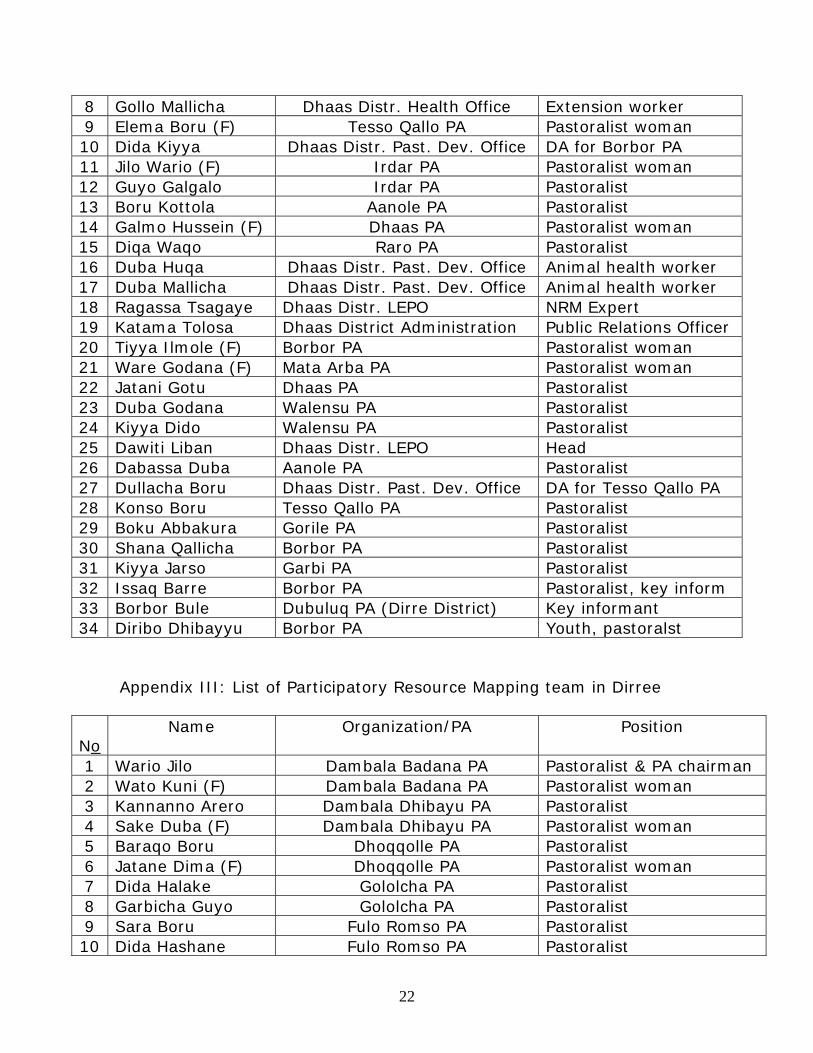
Appendix II: List of Participatory Resource Mapping team in Wayaama
No
Name Organization/PA Position
1 Bule Dima Garbi PA Pastoralist 2 Boru Taro Mata Arba PA “ 3 Ibrahim Wila Walensu PA “ 4 Jilo Dakkicha (F) Raro PA Pastoralist woman 5 Dida Huqa Harajarte PA Pastoralist 6 Liban Jatani Gayo PA “ 7 Gayo Gollo Gayo PA “
1 Borana Zone Pastoral Development Office 2 Arero District Pastoral Development Office 3 Borana Zone Land Use and Environmental Protection Office
22
8 Gollo Mallicha Dhaas Distr. Health Office Extension worker 9 Elema Boru (F) Tesso Qallo PA Pastoralist woman 10 Dida Kiyya Dhaas Distr. Past. Dev. Office DA for Borbor PA 11 Jilo Wario (F) Irdar PA Pastoralist woman 12 Guyo Galgalo Irdar PA Pastoralist 13 Boru Kottola Aanole PA Pastoralist 14 Galmo Hussein (F) Dhaas PA Pastoralist woman 15 Diqa Waqo Raro PA Pastoralist 16 Duba Huqa Dhaas Distr. Past. Dev. Office Animal health worker 17 Duba Mallicha Dhaas Distr. Past. Dev. Office Animal health worker 18 Ragassa Tsagaye Dhaas Distr. LEPO NRM Expert 19 Katama Tolosa Dhaas District Administration Public Relations Officer 20 Tiyya Ilmole (F) Borbor PA Pastoralist woman 21 Ware Godana (F) Mata Arba PA Pastoralist woman 22 Jatani Gotu Dhaas PA Pastoralist 23 Duba Godana Walensu PA Pastoralist 24 Kiyya Dido Walensu PA Pastoralist 25 Dawiti Liban Dhaas Distr. LEPO Head 26 Dabassa Duba Aanole PA Pastoralist 27 Dullacha Boru Dhaas Distr. Past. Dev. Office DA for Tesso Qallo PA 28 Konso Boru Tesso Qallo PA Pastoralist 29 Boku Abbakura Gorile PA Pastoralist 30 Shana Qallicha Borbor PA Pastoralist 31 Kiyya Jarso Garbi PA Pastoralist 32 Issaq Barre Borbor PA Pastoralist, key inform 33 Borbor Bule Dubuluq PA (Dirre District) Key informant 34 Diribo Dhibayyu Borbor PA Youth, pastoralst
Appendix III: List of Participatory Resource Mapping team in Dirree
No
Name Organization/PA Position
1 Wario Jilo Dambala Badana PA Pastoralist & PA chairman 2 Wato Kuni (F) Dambala Badana PA Pastoralist woman 3 Kannanno Arero Dambala Dhibayu PA Pastoralist 4 Sake Duba (F) Dambala Dhibayu PA Pastoralist woman 5 Baraqo Boru Dhoqqolle PA Pastoralist 6 Jatane Dima (F) Dhoqqolle PA Pastoralist woman 7 Dida Halake Gololcha PA Pastoralist 8 Garbicha Guyo Gololcha PA Pastoralist 9 Sara Boru Fulo Romso PA Pastoralist 10 Dida Hashane Fulo Romso PA Pastoralist

23
11 Tadhicha Duba Magado PA Pastoralist 12 Boru Godana Magado PA Pastoralist 13 Dido Duba Dida Jarsa PA Pastoralist 14 Dima Wario (F) Dida Jarsa PA Pastoralist woman 15 Jatane Jatani (F) Harallo PA Pastoralist woman 16 Jarso Duba Harallo PA Pastoralist 17 Sara Galgalo Hodhodh-Samaro PA Pastoralist 18 Adi Abiduba (F) Hodhodh-Samaro PA Pastoralist woman 19 Jarso Kushuna Soda PA Pastoralist 20 Kutullo Huqqa Soda PA Pastoralist 21 Jilo Doyo (F) Madhacho PA Pastoralist woman 22 Abagudo Dawa Madhacho PA Pastoralist 23 Mallicha Guyo Higo PA Pastoralist 24 Kanu Oda Gayo PA Pastoralist & PA chairman 25 Abdullah Qoday Dida Mega PA Pastoralist 26 Wario Sallessa Dirree District LUEP4 Office Head 27 Jamal Adam Dirree District PaDO5 Acting Head 28 Guyo Dawud Dirree District Education Office Deputy Head 29 Galgalo Dida Dubuluq kebele Vice Chair 30 Kane Abigudo Dubuluq kebele Pastoralist 31 Qallicha Qancorro Web PA (Arero District) Pastoralist 32 Ajoftu Sora Web PA (Arero District) Pastoralist 33 Abikula Wakala Web PA (Arero District) Pastoralist 34 Jarso Liban Melbana PA (Miyo District) Pastoralist 35 Teshome Sonnesa Iddilola PA (Miyo District) Agro-pastoralist/elder 36 Mellese Gamachu Iddilola PA (Miyo District) Agro-pastoralist/elder 37 Sara Guyo Miyo PA (Miyo District) Agro-pastoralist/elder 38 Sode Woche Iddilola PA (Miyo District) Agro-pastoralist/elder 39 Diqqa Dalacha Miyo District Culture &
Tourism Office Head
40 Sora Dalacha Cari Liche PA (Miyo District) Agro-pastoralist/youth 41 Girra Waqo Tuqa PA (Moyale District) Security personnel
4 Land Use and Environmental Protection Office 5 Pastoral Development Office
24
Appendix IV: CAPs for Wayaama and Dirree grazing zones
Problem cluster
Suggested solution (s)
How Responsible body
Time frame Follow up mechanisms
Pasture scarcity
Improve rangeland condition & productivity
• Restore/create seasonal grazing system
(systematize settlement, significantly reduce farm encroachment) • Create inter-
madda space • Make bush
encroachment a dheeda- level agenda and beyond
• Dismantle private enclosures
• Open up blocked mobility routes
• Redesign land use at dheeda level
• Customary institutions (raabaa-gadaa, laduu, retired councilors and yuuba/elders)
• Zonal Pastoral Development Office
• Zonal Land Use and Environmental Protection Office6
• District administration offices
• District Pastoral Development Offices
• District LUEP Offices
• Yuuba (elders)
• PA administration
• Watering rota managers (abbootii herregaa)
• Effective as of December 7, 2009
• Monthly review at regular gadaa meeting where participants come from all districts
• Organize seasonal joint working visits to districts by the customary leaders and Zonal Offices of Pastoral Development and Land and Environmental Protection7
• Integrate works of customary resource management institutions and that of Land and Environmental Protection Committees in PAs
Conflict and insecurity
Creating better access to rangelands through conflict resolution
Resolve causes of conflicts (such as unjustified territorial claims) on historical facts
Federal and Regional Governments, customary institutions
6. The first three bullets represent stakeholders with the role of coordination while the rest are implementers. 7. ELSE consortium and other development actors operating in the Borana Zone are expected to financially support the implementation of CAPs.
25
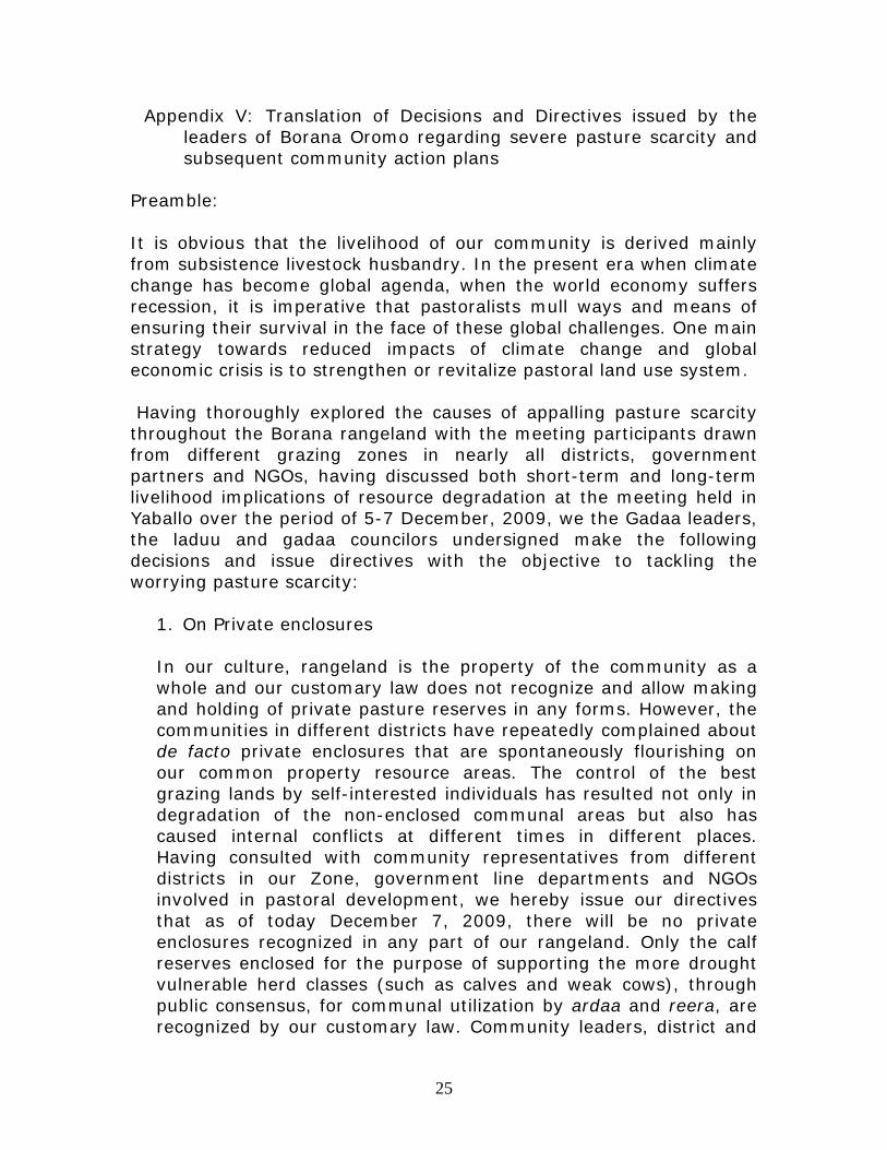
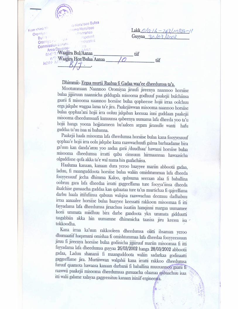
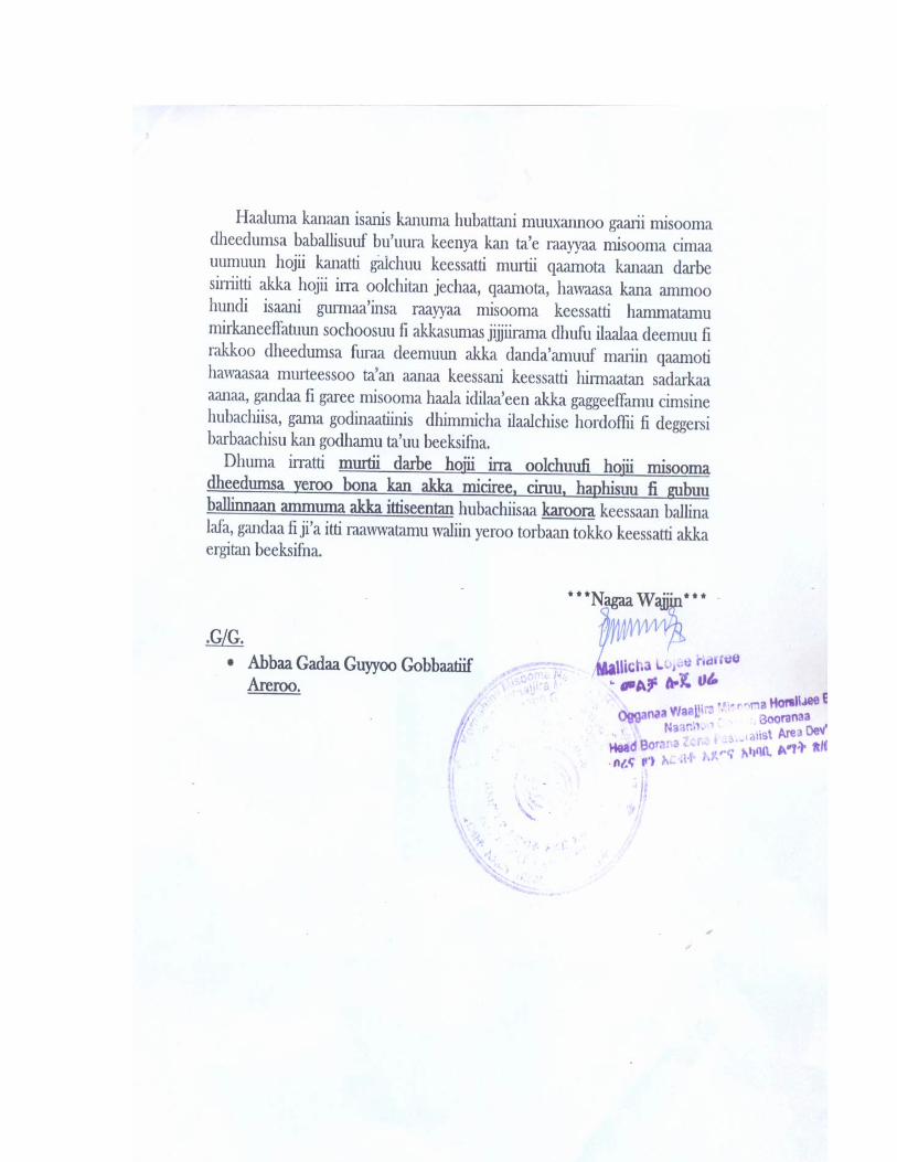
Appendix V: Translation of Decisions and Directives issued by the leaders of Borana Oromo regarding severe pasture scarcity and subsequent community action plans
Preamble: It is obvious that the livelihood of our community is derived mainly from subsistence livestock husbandry. In the present era when climate change has become global agenda, when the world economy suffers recession, it is imperative that pastoralists mull ways and means of ensuring their survival in the face of these global challenges. One main strategy towards reduced impacts of climate change and global economic crisis is to strengthen or revitalize pastoral land use system. Having thoroughly explored the causes of appalling pasture scarcity throughout the Borana rangeland with the meeting participants drawn from different grazing zones in nearly all districts, government partners and NGOs, having discussed both short-term and long-term livelihood implications of resource degradation at the meeting held in Yaballo over the period of 5-7 December, 2009, we the Gadaa leaders, the laduu and gadaa councilors undersigned make the following decisions and issue directives with the objective to tackling the worrying pasture scarcity:
1. On Private enclosures In our culture, rangeland is the property of the community as a whole and our customary law does not recognize and allow making and holding of private pasture reserves in any forms. However, the communities in different districts have repeatedly complained about de facto private enclosures that are spontaneously flourishing on our common property resource areas. The control of the best grazing lands by self-interested individuals has resulted not only in degradation of the non-enclosed communal areas but also has caused internal conflicts at different times in different places. Having consulted with community representatives from different districts in our Zone, government line departments and NGOs involved in pastoral development, we hereby issue our directives that as of today December 7, 2009, there will be no private enclosures recognized in any part of our rangeland. Only the calf reserves enclosed for the purpose of supporting the more drought vulnerable herd classes (such as calves and weak cows), through public consensus, for communal utilization by ardaa and reera, are recognized by our customary law. Community leaders, district and
26
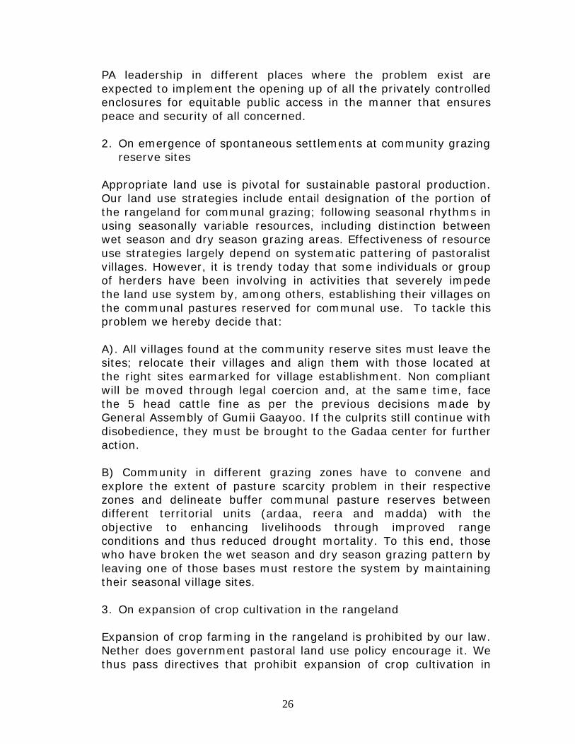
PA leadership in different places where the problem exist are expected to implement the opening up of all the privately controlled enclosures for equitable public access in the manner that ensures peace and security of all concerned. 2. On emergence of spontaneous settlements at community grazing
reserve sites Appropriate land use is pivotal for sustainable pastoral production. Our land use strategies include entail designation of the portion of the rangeland for communal grazing; following seasonal rhythms in using seasonally variable resources, including distinction between wet season and dry season grazing areas. Effectiveness of resource use strategies largely depend on systematic pattering of pastoralist villages. However, it is trendy today that some individuals or group of herders have been involving in activities that severely impede the land use system by, among others, establishing their villages on the communal pastures reserved for communal use. To tackle this problem we hereby decide that: A). All villages found at the community reserve sites must leave the sites; relocate their villages and align them with those located at the right sites earmarked for village establishment. Non compliant will be moved through legal coercion and, at the same time, face the 5 head cattle fine as per the previous decisions made by General Assembly of Gumii Gaayoo. If the culprits still continue with disobedience, they must be brought to the Gadaa center for further action. B) Community in different grazing zones have to convene and explore the extent of pasture scarcity problem in their respective zones and delineate buffer communal pasture reserves between different territorial units (ardaa, reera and madda) with the objective to enhancing livelihoods through improved range conditions and thus reduced drought mortality. To this end, those who have broken the wet season and dry season grazing pattern by leaving one of those bases must restore the system by maintaining their seasonal village sites. 3. On expansion of crop cultivation in the rangeland Expansion of crop farming in the rangeland is prohibited by our law. Nether does government pastoral land use policy encourage it. We thus pass directives that prohibit expansion of crop cultivation in
27
our rangeland. To this effect, in the dheeda where microclimatic condition may allow small scale opportunistic crop cultivation, farming sites must be distinguished from grazing sites and those who wish to engage in crop cultivation must do so in places designated for this purpose. In allocating farmlands where applicable, the customary and statutory structures must make sure that multiple and oversized farm plots are reduced to appropriate number and size. Farms sites emerged at water points (ponds) and wells and ritual grounds must be dismantled unconditionally and immediately in all corners of our rangeland. 4. On consumption and sale of alcohol As alcoholic behavior weakens effectiveness of rules governing land use and thus contributes to environmental degradation and poverty, we hereby renew the verdict of the previous Gadaa of Liiban Jaldeessaa (passed on July 19, 2002) that forbade sale and drinking of all liquors (locally distilled liquor called araqee, ouzo, wine, gin, daadhii or xajjii) in any part of the rural PAs and sub-municipal small towns in our territory. 5. On irreverence and use of vulgar language In Oromo culture, blasphemy and use of vulgar languages are highly discouraged. We strongly believe that they annoy the Creator, the land and spirit of our ancestors. The annoyance entails grave consequence onto orderly social life. It was with this understanding that the 38th Borana Oromo Assembly at Gaayo in 2004 decided to control use of bad language (such as insulting somebody’s mother using the vulgar “ f words“ , cursing humans and domestic animals not to bear offspring [hin dhalin] ) by imposing the fine of 5 head of cattle. As the above-described behavior is anti-social, anti-production and reproduction, we hereby renew the decision.
6. On forest and wildlife conservation Forest and forest-dwelling animals are among the natural endowments that our rangeland has been blessed with. Intact forests modify climate and supports sustainable livelihoods. So are the well-conserved wildlife. We therefore decide that all stakeholders refrain from illegal forest cutting and poaching of wildlife in our territory.
28
7. We appeal to community members and customary institutional leaders, government institutions, NGOs operating in our areas, to take initiative towards implementation of these directives. All concerned are hereby requested to render due support to persons and institutions making efforts to translate the directives into practice. No Name Signature 1 Abbaa Gadaa Guyyoo Gobbaa 2 Abbaa Gadaa Rooba Jaarsoo 3 Abbaa Gadaa Murquu Jiloo 4 Qaalluu Kuraa Tuuttoo 5 Qaalluu Dhaayee Kosii 6 Adulaa Jaarsoo Boru 7 Adulaa Jaldeessa Diidoo 8 Hayyuu Liiban Duubaa 9 Hayyuu Guyyoo Diidoo 10 Hayyuu Waariyoo Xachee 11 Hayyuu Jalddeessa Godaanaa 12 Hayyuu Diida Fooraa 13 Hayyuu Galgaloo Huqqaa 14 Hayyuu Yaayyaa Qancooraa 15 Hayyuu Liiban Jaldeessaa 16 Hayyuu Faayoo Dhibaa
Date: 7-12-2009 Yaballo
29
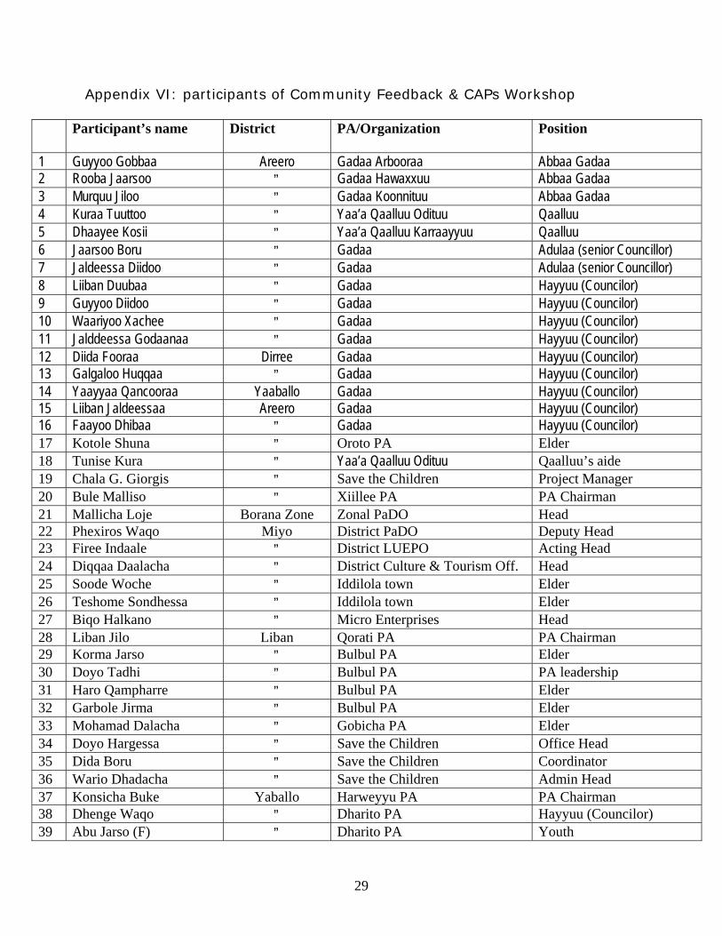
Appendix VI: participants of Community Feedback & CAPs Workshop
Participant’s name District PA/Organization Position
1 Guyyoo Gobbaa Areero Gadaa Arbooraa Abbaa Gadaa 2 Rooba Jaarsoo ” Gadaa Hawaxxuu Abbaa Gadaa 3 Murquu Jiloo ” Gadaa Koonnituu Abbaa Gadaa 4 Kuraa Tuuttoo ” Yaa’a Qaalluu Odituu Qaalluu 5 Dhaayee Kosii ” Yaa’a Qaalluu Karraayyuu Qaalluu 6 Jaarsoo Boru ” Gadaa Adulaa (senior Councillor) 7 Jaldeessa Diidoo ” Gadaa Adulaa (senior Councillor) 8 Liiban Duubaa ” Gadaa Hayyuu (Councilor) 9 Guyyoo Diidoo ” Gadaa Hayyuu (Councilor) 10 Waariyoo Xachee ” Gadaa Hayyuu (Councilor) 11 Jalddeessa Godaanaa ” Gadaa Hayyuu (Councilor) 12 Diida Fooraa Dirree Gadaa Hayyuu (Councilor) 13 Galgaloo Huqqaa ” Gadaa Hayyuu (Councilor) 14 Yaayyaa Qancooraa Yaaballo Gadaa Hayyuu (Councilor) 15 Liiban Jaldeessaa Areero Gadaa Hayyuu (Councilor) 16 Faayoo Dhibaa ” Gadaa Hayyuu (Councilor) 17 Kotole Shuna ” Oroto PA Elder 18 Tunise Kura ” Yaa’a Qaalluu Odituu Qaalluu’s aide 19 Chala G. Giorgis ” Save the Children Project Manager 20 Bule Malliso ” Xiillee PA PA Chairman 21 Mallicha Loje Borana Zone Zonal PaDO Head 22 Phexiros Waqo Miyo District PaDO Deputy Head 23 Firee Indaale ” District LUEPO Acting Head 24 Diqqaa Daalacha ” District Culture & Tourism Off. Head 25 Soode Woche ” Iddilola town Elder 26 Teshome Sondhessa ” Iddilola town Elder 27 Biqo Halkano ” Micro Enterprises Head 28 Liban Jilo Liban Qorati PA PA Chairman 29 Korma Jarso ” Bulbul PA Elder 30 Doyo Tadhi ” Bulbul PA PA leadership 31 Haro Qampharre ” Bulbul PA Elder 32 Garbole Jirma ” Bulbul PA Elder 33 Mohamad Dalacha ” Gobicha PA Elder 34 Doyo Hargessa ” Save the Children Office Head 35 Dida Boru ” Save the Children Coordinator 36 Wario Dhadacha ” Save the Children Admin Head 37 Konsicha Buke Yaballo Harweyyu PA PA Chairman 38 Dhenge Waqo ” Dharito PA Hayyuu (Councilor) 39 Abu Jarso (F) ” Dharito PA Youth
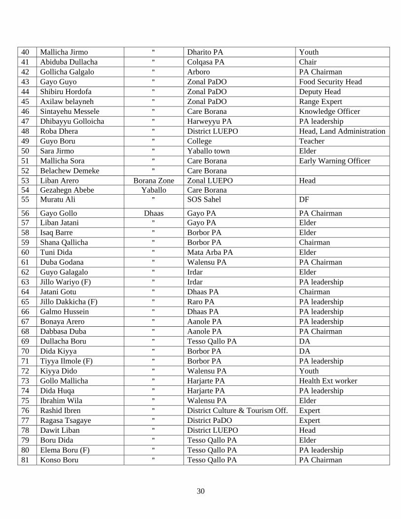
30
40 Mallicha Jirmo ” Dharito PA Youth 41 Abiduba Dullacha ” Colqasa PA Chair 42 Gollicha Galgalo ” Arboro PA Chairman 43 Gayo Guyo ” Zonal PaDO Food Security Head 44 Shibiru Hordofa ” Zonal PaDO Deputy Head 45 Axilaw belayneh ” Zonal PaDO Range Expert 46 Sintayehu Messele ” Care Borana Knowledge Officer 47 Dhibayyu Golloicha ” Harweyyu PA PA leadership 48 Roba Dhera ” District LUEPO Head, Land Administration 49 Guyo Boru ” College Teacher 50 Sara Jirmo ” Yaballo town Elder 51 Mallicha Sora ” Care Borana Early Warning Officer 52 Belachew Demeke ” Care Borana 53 Liban Arero Borana Zone Zonal LUEPO Head 54 Gezahegn Abebe Yaballo Care Borana 55 Muratu Ali ” SOS Sahel DF
56 Gayo Gollo Dhaas Gayo PA PA Chairman 57 Liban Jatani ” Gayo PA Elder 58 Isaq Barre ” Borbor PA Elder 59 Shana Qallicha ” Borbor PA Chairman 60 Tuni Dida ” Mata Arba PA Elder 61 Duba Godana ” Walensu PA PA Chairman 62 Guyo Galagalo ” Irdar Elder 63 Jillo Wariyo (F) ” Irdar PA leadership 64 Jatani Gotu ” Dhaas PA Chairman 65 Jillo Dakkicha (F) ” Raro PA PA leadership 66 Galmo Hussein ” Dhaas PA PA leadership 67 Bonaya Arero ” Aanole PA PA leadership 68 Dabbasa Duba ” Aanole PA PA Chairman 69 Dullacha Boru ” Tesso Qallo PA DA 70 Dida Kiyya ” Borbor PA DA 71 Tiyya Ilmole (F) ” Borbor PA PA leadership 72 Kiyya Dido ” Walensu PA Youth 73 Gollo Mallicha ” Harjarte PA Health Ext worker 74 Dida Huqa ” Harjarte PA PA leadership 75 Ibrahim Wila ” Walensu PA Elder 76 Rashid Ibren ” District Culture & Tourism Off. Expert 77 Ragasa Tsagaye ” District PaDO Expert 78 Dawit Liban ” District LUEPO Head 79 Boru Dida ” Tesso Qallo PA Elder 80 Elema Boru (F) ” Tesso Qallo PA PA leadership 81 Konso Boru ” Tesso Qallo PA PA Chairman
31
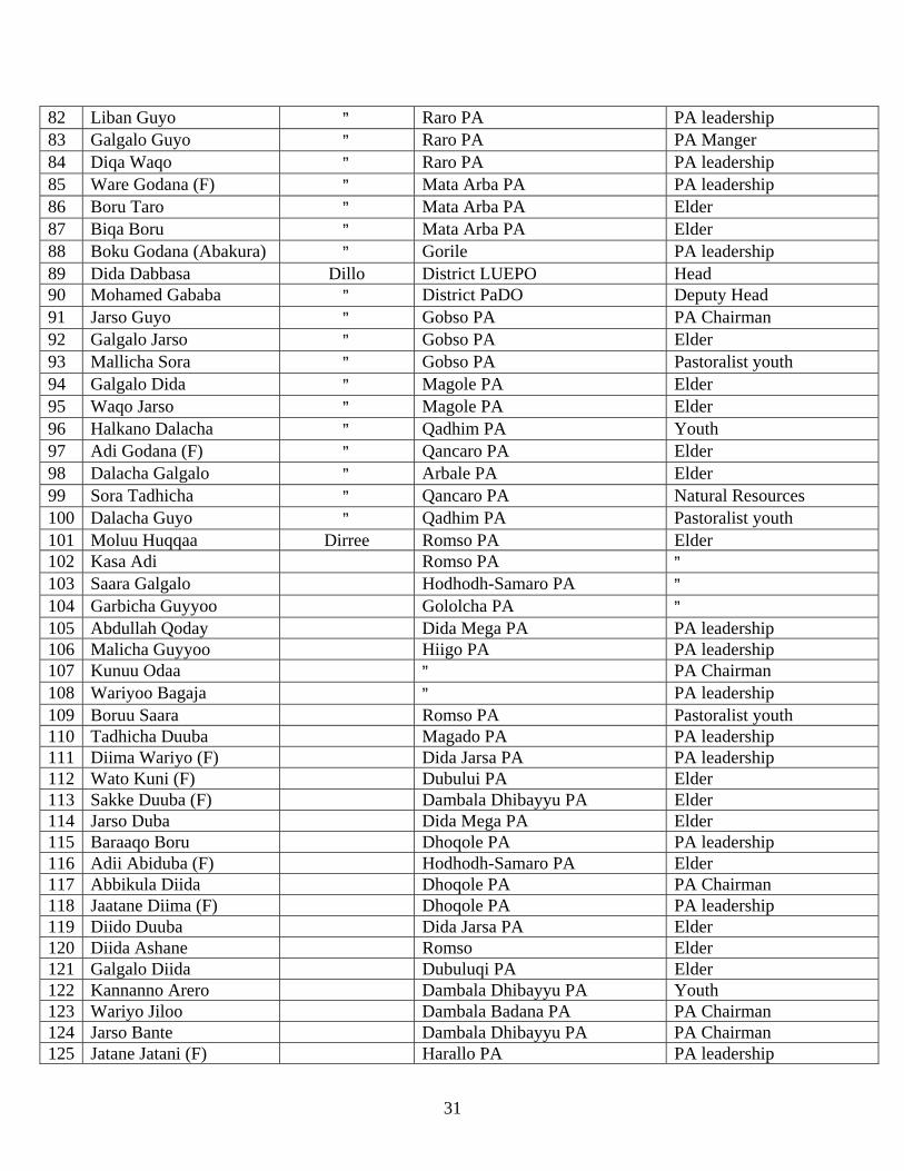
82 Liban Guyo ” Raro PA PA leadership 83 Galgalo Guyo ” Raro PA PA Manger 84 Diqa Waqo ” Raro PA PA leadership 85 Ware Godana (F) ” Mata Arba PA PA leadership 86 Boru Taro ” Mata Arba PA Elder 87 Biqa Boru ” Mata Arba PA Elder 88 Boku Godana (Abakura) ” Gorile PA leadership 89 Dida Dabbasa Dillo District LUEPO Head 90 Mohamed Gababa ” District PaDO Deputy Head 91 Jarso Guyo ” Gobso PA PA Chairman 92 Galgalo Jarso ” Gobso PA Elder 93 Mallicha Sora ” Gobso PA Pastoralist youth 94 Galgalo Dida ” Magole PA Elder 95 Waqo Jarso ” Magole PA Elder 96 Halkano Dalacha ” Qadhim PA Youth 97 Adi Godana (F) ” Qancaro PA Elder 98 Dalacha Galgalo ” Arbale PA Elder 99 Sora Tadhicha ” Qancaro PA Natural Resources 100 Dalacha Guyo ” Qadhim PA Pastoralist youth 101 Moluu Huqqaa Dirree Romso PA Elder 102 Kasa Adi Romso PA ” 103 Saara Galgalo Hodhodh-Samaro PA ” 104 Garbicha Guyyoo Gololcha PA ” 105 Abdullah Qoday Dida Mega PA PA leadership 106 Malicha Guyyoo Hiigo PA PA leadership 107 Kunuu Odaa ” PA Chairman 108 Wariyoo Bagaja ” PA leadership 109 Boruu Saara Romso PA Pastoralist youth 110 Tadhicha Duuba Magado PA PA leadership 111 Diima Wariyo (F) Dida Jarsa PA PA leadership 112 Wato Kuni (F) Dubului PA Elder 113 Sakke Duuba (F) Dambala Dhibayyu PA Elder 114 Jarso Duba Dida Mega PA Elder 115 Baraaqo Boru Dhoqole PA PA leadership 116 Adii Abiduba (F) Hodhodh-Samaro PA Elder 117 Abbikula Diida Dhoqole PA PA Chairman 118 Jaatane Diima (F) Dhoqole PA PA leadership 119 Diido Duuba Dida Jarsa PA Elder 120 Diida Ashane Romso Elder 121 Galgalo Diida Dubuluqi PA Elder 122 Kannanno Arero Dambala Dhibayyu PA Youth 123 Wariyo Jiloo Dambala Badana PA PA Chairman 124 Jarso Bante Dambala Dhibayyu PA PA Chairman 125 Jatane Jatani (F) Harallo PA PA leadership

32
126 Liban Jarso Soodda PA PA leadership 127 Borbor Bule Dubuluqi Key informant 128 Abagudo Daawaa Madhacho PA Elder 129 Liiban Huqaa Soodda PA PA leadership 130 Doyyo Cafaa Madhacho PA Elder 131 Boru Godana Magado PA Elder 132 Jamal Adan District PaDO Expert 133 Wariyo Salessa District LUEPO Head 134 Garbole Boru Romso PA Elder 135 Dida Halake Gololcha Elder 136 Huqa Garse Yaballo SOS Sahel Coordinator 137 Boku Tache (Dr) Addis Ababa SOS Sahel Consultant
33
Appendix VII: Letters dispatch to districts by Zonal PaDO and LUEPO
34
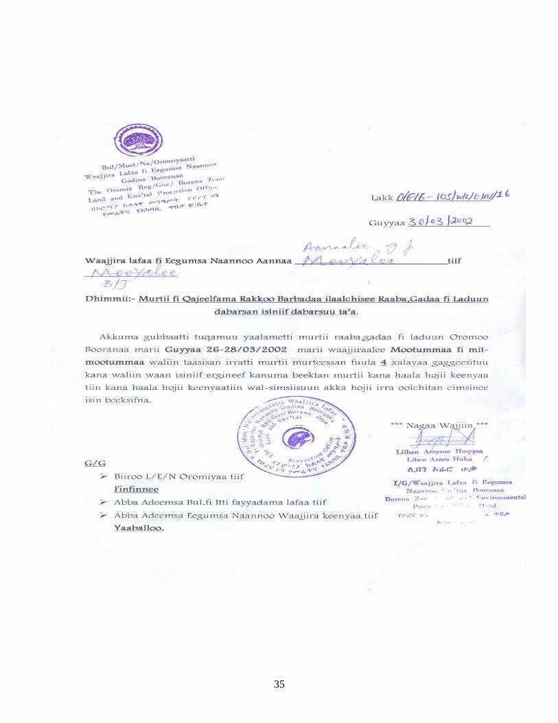
35
36
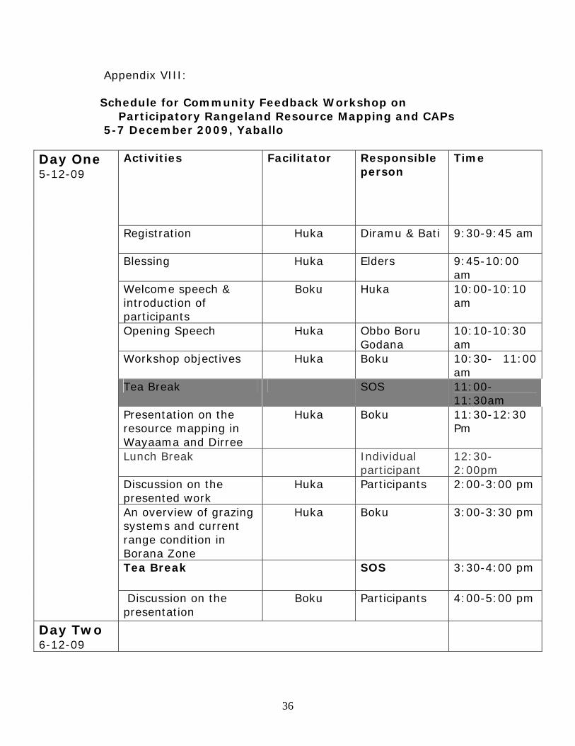
Appendix VIII: Schedule for Community Feedback Workshop on
Participatory Rangeland Resource Mapping and CAPs 5-7 December 2009, Yaballo
Activities Facilitator Responsible person
Time
Registration
Huka Diramu & Bati 9:30-9:45 am
Blessing Huka Elders 9:45-10:00 am
Welcome speech & introduction of participants
Boku Huka
10:00-10:10 am
Opening Speech Huka Obbo Boru Godana
10:10-10:30 am
Workshop objectives Huka Boku 10:30- 11:00 am
Tea Break SOS 11:00-11:30am
Presentation on the resource mapping in Wayaama and Dirree
Huka Boku 11:30-12:30 Pm
Lunch Break Individual participant
12:30- 2:00pm
Discussion on the presented work
Huka Participants 2:00-3:00 pm
An overview of grazing systems and current range condition in Borana Zone
Huka Boku 3:00-3:30 pm
Tea Break SOS 3:30-4:00 pm
Day One 5-12-09
Discussion on the presentation
Boku Participants 4:00-5:00 pm
Day Two 6-12-09
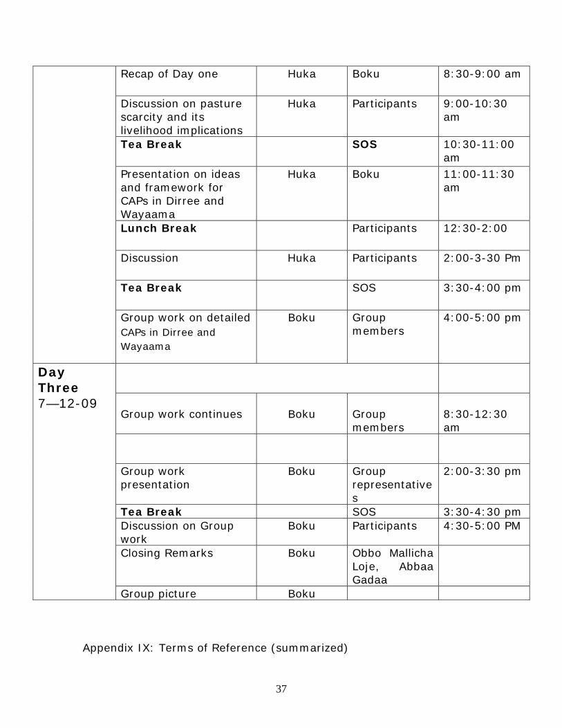
37
Recap of Day one Huka Boku 8:30-9:00 am
Discussion on pasture scarcity and its livelihood implications
Huka Participants 9:00-10:30 am
Tea Break SOS 10:30-11:00 am
Presentation on ideas and framework for CAPs in Dirree and Wayaama
Huka Boku 11:00-11:30 am
Lunch Break Participants 12:30-2:00
Discussion Huka Participants 2:00-3-30 Pm
Tea Break SOS 3:30-4:00 pm
Group work on detailed CAPs in Dirree and Wayaama
Boku Group members
4:00-5:00 pm
Group work continues
Boku
Group members
8:30-12:30 am
Group work presentation
Boku Group representatives
2:00-3:30 pm
Tea Break SOS 3:30-4:30 pm Discussion on Group work
Boku Participants 4:30-5:00 PM
Closing Remarks Boku Obbo Mallicha Loje, Abbaa Gadaa
Day Three 7—12-09
Group picture Boku Appendix IX: Terms of Reference (summarized)
38
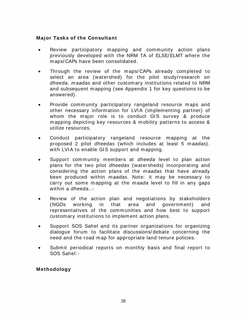
Major Tasks of the Consultant • Review participatory mapping and community action plans
previously developed with the NRM TA of ELSE/ELMT where the maps/CAPs have been consolidated.
• Through the review of the maps/CAPs already completed to select an area (watershed) for the pilot study/research on dheeda, maadas and other customary institutions related to NRM and subsequent mapping (see Appendix 1 for key questions to be answered).
• Provide community participatory rangeland resource maps and other necessary information for LVIA (implementing partner) of whom the major role is to conduct GIS survey & produce mapping depicting key resources & mobility patterns to access & utilize resources.
• Conduct participatory rangeland resource mapping at the proposed 2 pilot dheedas (which includes at least 5 maadas). with LVIA to enable GIS support and mapping.
• Support community members at dheeda level to plan action plans for the two pilot dheedas (watersheds) incorporating and considering the action plans of the maadas that have already been produced within maadas. Note: it may be necessary to carry out some mapping at the maada level to fill in any gaps within a dheeda..-
• Review of the action plan and negotiations by stakeholders (NGOs working in that area and government) and representatives of the communities and how best to support customary institutions to implement action plans.
• Support SOS Sahel and its partner organizations for organizing dialogue forum to facilitate discussions/debate concerning the need and the road map for appropriate land tenure policies.
• Submit periodical reports on monthly basis and final report to SOS Sahel:-
Methodology
39
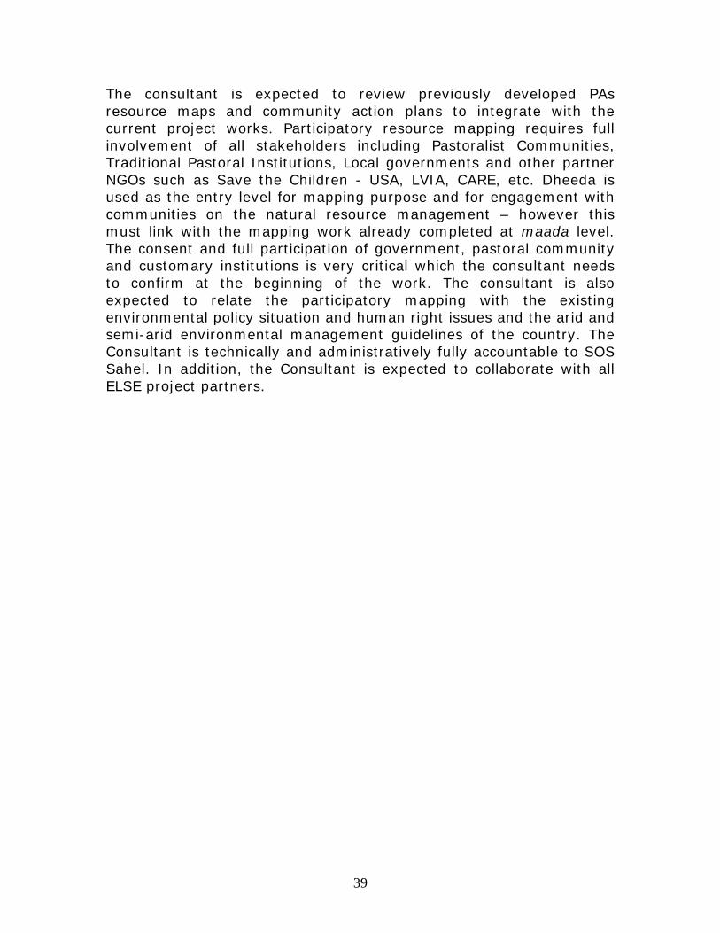
The consultant is expected to review previously developed PAs resource maps and community action plans to integrate with the current project works. Participatory resource mapping requires full involvement of all stakeholders including Pastoralist Communities, Traditional Pastoral Institutions, Local governments and other partner NGOs such as Save the Children - USA, LVIA, CARE, etc. Dheeda is used as the entry level for mapping purpose and for engagement with communities on the natural resource management – however this must link with the mapping work already completed at maada level. The consent and full participation of government, pastoral community and customary institutions is very critical which the consultant needs to confirm at the beginning of the work. The consultant is also expected to relate the participatory mapping with the existing environmental policy situation and human right issues and the arid and semi-arid environmental management guidelines of the country. The Consultant is technically and administratively fully accountable to SOS Sahel. In addition, the Consultant is expected to collaborate with all ELSE project partners.