Embed Size (px)
Citation preview
Agenda Item #54/11/11
FINAL REPORT
DRI #269
Parrish Lakes
Manatee County
4000 Gateway Center Boulevard, Suite 100, Pinellas Park, FL 33782Phone (727) 570-5151 / FAX (727) 570-5118
www.tbrpc.org
REPORT ADOPTED: April 11, 2011
DRI #269 - PARRISH LAKESMANATEE COUNTY
Table of Contents
SECTION I - INTRODUCTION
Applicant Information . . . . . . . . . . . . . . . . . . . . . . . . . . . . . . . . . . . . . . . . . . . . . . . . . . . . 1Chronology of Project . . . . . . . . . . . . . . . . . . . . . . . . . . . . . . . . . . . . . . . . . . . . . . . . . . . . 2Project Description . . . . . . . . . . . . . . . . . . . . . . . . . . . . . . . . . . . . . . . . . . . . . . . . . . . . . . 2Development Area . . . . . . . . . . . . . . . . . . . . . . . . . . . . . . . . . . . . . . . . . . . . . . . . . . . . . . 3Summary of Project Benefits and Impacts . . . . . . . . . . . . . . . . . . . . . . . . . . . . . . . . . . . . 4Maps:
1. General Location . . . . . . . . . . . . . . . . . . . . . . . . . . . . . . . . . . . . . . . . . . . . 52. Proposed Master Development Plan . . . . . . . . . . . . . . . . . . . . . . . . . . . . . 63. Natural Resources of Regional Significance . . . . . . . . . . . . . . . . . . . . . . . 74. Hurricane Evacuation Zone/Vulnerability Map . . . . . . . . . . . . . . . . . . . . 8
SECTION II - REGIONAL IMPACTS
Economy . . . . . . . . . . . . . . . . . . . . . . . . . . . . . . . . . . . . . . . . . . . . . . . . . . . . . . . . . . . . . . 9Vegetation, Wildlife and Wetlands . . . . . . . . . . . . . . . . . . . . . . . . . . . . . . . . . . . . . . . . . 11Water Quality and Stormwater Management . . . . . . . . . . . . . . . . . . . . . . . . . . . . . . . . . 13Soils . . . . . . . . . . . . . . . . . . . . . . . . . . . . . . . . . . . . . . . . . . . . . . . . . . . . . . . . . . . . . . . . 15Floodplains . . . . . . . . . . . . . . . . . . . . . . . . . . . . . . . . . . . . . . . . . . . . . . . . . . . . . . . . . . . 15Water Supply . . . . . . . . . . . . . . . . . . . . . . . . . . . . . . . . . . . . . . . . . . . . . . . . . . . . . . . . . 16Wastewater Management . . . . . . . . . . . . . . . . . . . . . . . . . . . . . . . . . . . . . . . . . . . . . . . . 17Solid Waste/Hazardous Waste/Medical Waste . . . . . . . . . . . . . . . . . . . . . . . . . . . . . . . . 18Transportation . . . . . . . . . . . . . . . . . . . . . . . . . . . . . . . . . . . . . . . . . . . . . . . . . . . . . . . . . 19Air Quality . . . . . . . . . . . . . . . . . . . . . . . . . . . . . . . . . . . . . . . . . . . . . . . . . . . . . . . . . . . 22Hurricane Preparedness . . . . . . . . . . . . . . . . . . . . . . . . . . . . . . . . . . . . . . . . . . . . . . . . . . 23Affordable Housing . . . . . . . . . . . . . . . . . . . . . . . . . . . . . . . . . . . . . . . . . . . . . . . . . . . . 24Police and Fire Protection . . . . . . . . . . . . . . . . . . . . . . . . . . . . . . . . . . . . . . . . . . . . . . . . 25Recreation and Open Space . . . . . . . . . . . . . . . . . . . . . . . . . . . . . . . . . . . . . . . . . . . . . . . 25Education . . . . . . . . . . . . . . . . . . . . . . . . . . . . . . . . . . . . . . . . . . . . . . . . . . . . . . . . . . . . 26Health Care . . . . . . . . . . . . . . . . . . . . . . . . . . . . . . . . . . . . . . . . . . . . . . . . . . . . . . . . . . . 26Energy . . . . . . . . . . . . . . . . . . . . . . . . . . . . . . . . . . . . . . . . . . . . . . . . . . . . . . . . . . . . . . . 27Historical and Archaeological . . . . . . . . . . . . . . . . . . . . . . . . . . . . . . . . . . . . . . . . . . . . 28
SECTION III - DEVELOPER COMMITMENTS
General . . . . . . . . . . . . . . . . . . . . . . . . . . . . . . . . . . . . . . . . . . . . . . . . . . . . . . . . . . . . . . 29Vegetation and Wildlife . . . . . . . . . . . . . . . . . . . . . . . . . . . . . . . . . . . . . . . . . . . . . . . . . . 29Wetlands . . . . . . . . . . . . . . . . . . . . . . . . . . . . . . . . . . . . . . . . . . . . . . . . . . . . . . . . . . . . . 30Water Quality . . . . . . . . . . . . . . . . . . . . . . . . . . . . . . . . . . . . . . . . . . . . . . . . . . . . . . . . . . 31Soils . . . . . . . . . . . . . . . . . . . . . . . . . . . . . . . . . . . . . . . . . . . . . . . . . . . . . . . . . . . . . . . . . 32Floodplains . . . . . . . . . . . . . . . . . . . . . . . . . . . . . . . . . . . . . . . . . . . . . . . . . . . . . . . . . . . . 32Water Supply . . . . . . . . . . . . . . . . . . . . . . . . . . . . . . . . . . . . . . . . . . . . . . . . . . . . . . . . . . 32Wastewater Management . . . . . . . . . . . . . . . . . . . . . . . . . . . . . . . . . . . . . . . . . . . . . . . . . 33Stormwater Management . . . . . . . . . . . . . . . . . . . . . . . . . . . . . . . . . . . . . . . . . . . . . . . . . 33Transportation . . . . . . . . . . . . . . . . . . . . . . . . . . . . . . . . . . . . . . . . . . . . . . . . . . . . . . . . . 33Air Quality . . . . . . . . . . . . . . . . . . . . . . . . . . . . . . . . . . . . . . . . . . . . . . . . . . . . . . . . . . . . 33Affordable Housing . . . . . . . . . . . . . . . . . . . . . . . . . . . . . . . . . . . . . . . . . . . . . . . . . . . . . 33Police & Fire Protection . . . . . . . . . . . . . . . . . . . . . . . . . . . . . . . . . . . . . . . . . . . . . . . . . 34Recreation and Open Space . . . . . . . . . . . . . . . . . . . . . . . . . . . . . . . . . . . . . . . . . . . . . . . 34Health Care . . . . . . . . . . . . . . . . . . . . . . . . . . . . . . . . . . . . . . . . . . . . . . . . . . . . . . . . . . . 34Energy . . . . . . . . . . . . . . . . . . . . . . . . . . . . . . . . . . . . . . . . . . . . . . . . . . . . . . . . . . . . . . . 34
SECTION IV - RECOMMENDED REGIONAL CONDITIONS
Vegetation, Wildlife and Wetlands . . . . . . . . . . . . . . . . . . . . . . . . . . . . . . . . . . . . . . . . . 35Water Quality and Stormwater Management . . . . . . . . . . . . . . . . . . . . . . . . . . . . . . . . . 36Soils . . . . . . . . . . . . . . . . . . . . . . . . . . . . . . . . . . . . . . . . . . . . . . . . . . . . . . . . . . . . . . . . 37Floodplains . . . . . . . . . . . . . . . . . . . . . . . . . . . . . . . . . . . . . . . . . . . . . . . . . . . . . . . . . . . . 37Water Supply . . . . . . . . . . . . . . . . . . . . . . . . . . . . . . . . . . . . . . . . . . . . . . . . . . . . . . . . . 38Wastewater Management . . . . . . . . . . . . . . . . . . . . . . . . . . . . . . . . . . . . . . . . . . . . . . . . . 38Solid Waste/Hazardous Waste/Medical Waste . . . . . . . . . . . . . . . . . . . . . . . . . . . . . . . . 39Transportation . . . . . . . . . . . . . . . . . . . . . . . . . . . . . . . . . . . . . . . . . . . . . . . . . . . . . . . . . 39Air Quality . . . . . . . . . . . . . . . . . . . . . . . . . . . . . . . . . . . . . . . . . . . . . . . . . . . . . . . . . . . 42Hurricane Preparedness . . . . . . . . . . . . . . . . . . . . . . . . . . . . . . . . . . . . . . . . . . . . . . . . . . 42Affordable Housing . . . . . . . . . . . . . . . . . . . . . . . . . . . . . . . . . . . . . . . . . . . . . . . . . . . . . 42Police and Fire Protection . . . . . . . . . . . . . . . . . . . . . . . . . . . . . . . . . . . . . . . . . . . . . . . . 44Recreation and Open Space . . . . . . . . . . . . . . . . . . . . . . . . . . . . . . . . . . . . . . . . . . . . . . . 44Energy . . . . . . . . . . . . . . . . . . . . . . . . . . . . . . . . . . . . . . . . . . . . . . . . . . . . . . . . . . . . . . . 44Historical and Archaeological . . . . . . . . . . . . . . . . . . . . . . . . . . . . . . . . . . . . . . . . . . . . . 45General Conditions . . . . . . . . . . . . . . . . . . . . . . . . . . . . . . . . . . . . . . . . . . . . . . . . . . . . . 45
SECTION V - VOLUNTARY AFFORDABLE HOUSING/WORKFORCE HOUSINGMITIGATION PROGRAM/ STIPULATIONS . . . . . . . . . . . . . . . . . . . . . . . . . . . . . . . . . . . 47
SECTION VI - REVIEW AGENCY COMMENTS/RECOMMENDATIONS
Southwest Florida Water Management District . . . . . . . . . . . . . . . . . . . . . . . . . . . . . . . . 53Florida Department of Environmental Protection . . . . . . . . . . . . . . . . . . . . . . . . . . . . . . 56Florida Fish and Wildlife Conservation Commission . . . . . . . . . . . . . . . . . . . . . . . . . . . 57
SECTION VII - MINUTES FROM APRIL 11, 2011 COUNCIL MTG (Forthcoming) . . . 61
Parrish Lakes Final Report - Introduction Page 1
SECTION I - INTRODUCTION DRI #269 - PARRISH LAKES
MANATEE COUNTY
This report is prepared in accordance with the Florida Land and Water Management Act, Chapter 380,Florida Statutes (F.S.), and in compliance with this legislation addresses the development's efficient use orundue burdening of public facilities in the region, as well as the positive and negative impacts of thedevelopment on economics and natural resources. The report presents the findings and recommendationsof the Tampa Bay Regional Planning Council (TBRPC) based upon data presented in the Development ofRegional Impact (DRI) application (ADA and all Sufficiency Responses) as well as upon informationobtained through on-site inspections, local and state agencies, outside sources and comparisons with localand regional plans. Policies cited in this report are from the Council's adopted policy document, Future ofthe Region: A Strategic Regional Policy Plan for the Tampa Bay Region (SRPP), adopted September 12,2005.
APPLICANT INFORMATION
OWNER
FLM, Inc.4602 Dogwood Hills Ct.Brandon, FL 33511Attention: Mr. Claude Melli, President
LEGAL COUNSEL
Icard Merrill et al2033 Main StreetSarasota, FL 34237Attention: Mr. William Merrill III
PLANNING/ENGINEERING
King Engineering Associates, Inc.4921 Memorial Hwy., Suite 300Tampa, FL 33634Attention: Mr. Scott Sheridan
TRANSPORTATION
ENVIRONMENTAL& ENGINEERING
ECONOMIC
ARCHAEOLOGICAL
Archaeological Consultants, Inc.8110 Blakie Court, Suite ASarasota, FL 34240Attention: Ms. Marion Almy
Parrish Lakes Final Report - Introduction Page 2
CHRONOLOGY OF PROJECT:
Transportation Methodology Meeting - March 10, 2009Preapplication Conference - May 18, 2009
ADA Submittal - February 10, 2010Site Inspection - March 2, 2010
ADA Comments - March 12, 2010First Sufficiency Response Submittal - August 12, 2010
First Sufficiency Response Comments - September 10, 2010Second Sufficiency Response Submittal - January 10, 2011
Declaration of Sufficiency by TBRPC - February 9, 2011 Notify Manatee County to Set Hearing Date - February 9, 2011 Notification Received of Hearing Date - February 24, 2011 TBRPC Final Report adoption - April 11, 2011 Manatee County BOCC Meeting - July 26, 2011
PROJECT DESCRIPTION
The applicant for the Parrish Lakes Development of Regional Impact (DRI) is seeking DRI approval for a1,155+ acre multi-use community in northeast Manatee County. The project is located along the southernside of Moccasin Wallow Road, north of Erie Road and less than one mile east of Interstate 75. Theproject’s northern limits are approximately three miles south of the Hillsborough County line. The GeneralLocation Map is provided as Map 1 (Page 5). As proposed, the project consists of: 3,300 Residential units,400,000 sq. ft. of Retail and 50,000 sq. ft. of Office to be completed over two phases with build-outscheduled for 2030. The following constitutes the proposed phasing schedule:
LAND USEPHASE 1
(2020)PHASE 2
(2030)BUILDOUT
(2030)
RESIDENTIAL(Single Family Units) (Multi-Family Units)
900 600
1,300 500
2,200 1,100
RETAIL (Square Feet) 250,000 150,000 400,000
OFFICE (Square Feet) 0 50,000 50,000
The applicant has also requested approval of a Land Use Equivalency Matrix (LUEM) to allow conversionbetween the various approved project uses, within specific ranges. The proposed Matrix is included on Page43 of the Recommended Regional Conditions section of this Report.
As depicted on the Master Development Plan (Map 2), Residential uses surround the centrally-located TownCenter parcel. A proposed 250,000 sq. ft. Retail parcel will front the northern entry to the project (i.e.Carter Road) along Moccasin Wallow Road. Seven Wetland Conservation Areas (totaling 18+ acres),inclusive of Buffalo Creek which spans the project from east to west, are located across the project. An
Parrish Lakes Final Report - Introduction Page 3
additional 5+ acre parcel will remain undeveloped and undisturbed with its corresponding designation asan Upland Preservation Area. This Preservation Area is situated along the northeast boundary of theproperty.
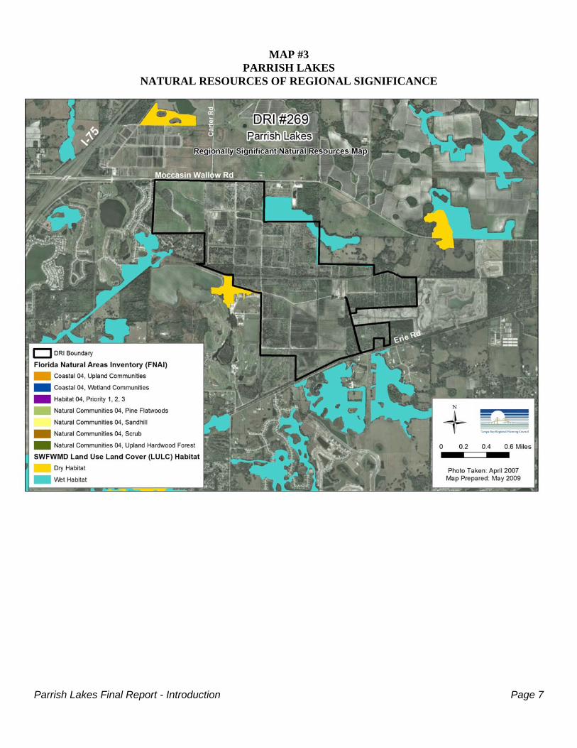
Map 3 has been provided to indicate the Natural Resources of Regional Significance located within andadjacent to the project site.
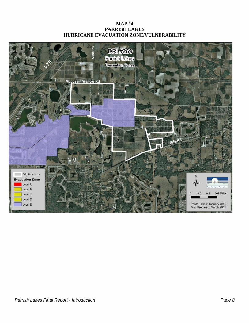
Map 4 illustrates the portion of the site susceptible to flooding associated with only the most severehurricanes, Category 5.
DEVELOPMENT AREA:
LAND USEFLUCCS
#
EXISTING AT BUILDOUT
Acres % of Site Acres % of Site
Medium Density Residential 120 0 0.0 665 57.6
High Density Residential 130 0 0.0 373 32.3
Roads 814 0 0.0 47 4.1
Mixed Commercial & Services (Town Center) 147 0 0.0 25 2.2
Retail 140 0 0.0 22 2.0
Mixed Wetland Hardwoods 617 12 1.1 12 1.0
Streams and Waterways 510 43 3.7 5 0.4
Hardwood-Conifer Mixed 434 10 0.8 5 0.4
Willow and Elderberry 618 1 0.1 1 0.1
Citrus Groves 221 690 59.7 0 0.0
Improved Pasture/Field Crops 211/215 292 25.3 0 0.0
Improved Pasture 211 56 4.9 0 0.0
Field Crops 215 19 1.6 0 0.0
Other Open Lands (Rural) 260 13 1.1 0 0.0
Live Oak 427 10 0.9 0 0.0
Fallow Crop Land 261 5 0.4 0 0.0
Reservoirs Less than 10 Acres 534 4 0.4 0 0.0
TOTAL 1,155 100.0 1,155 100.0* See Page 11 (of this Report) for detailed breakdown of existing habitat types. Source: SR2/Table 10-2
Parrish Lakes Final Report - Introduction Page 4
SUMMARY OF PROJECT BENEFITS AND IMPACTS
The following summary identifies those benefits and impacts anticipated following project buildout:
BENEFITS
Employment1 Permanent Employment at Buildout: 1,481 jobs
Government TaxRevenue2
Estimated County Ad Valorem Tax Revenues (Annual at Buildout): $10,698,440Estimated School Board Taxes (Annual at Buildout): $ 6,199,598Estimated Other Agency Revenues (Annual at Buildout): $ 4,498,842Estimated County Sales Tax (Annual at Buildout): $ 714,912Estimated County Gas Taxes (Annual at Buildout): $ 398,376
Affordable/WorkforceHousing7
Mitigation Proposal:Minimum of 10% (i.e. 330 units) affordable units for “households making 120%(or less) of the Area Median Income for Manatee County”; $2,000 “payment-in-lieu” of construction fee; or combination thereof. Further details regardingproposal is provided within Section V of this Report.
IMPACTS
Water Supply3 Estimated Avg. Daily Potable Water Demand (At Buildout): 632,000 gpdEstimated Avg. Daily Non-Potable Water Demand (At Buildout): 564,576 gpd
Wastewater4 Estimated Average Daily Wastewater Generation (At Buildout): 622,000 gpd
Solid Waste5 Estimated Average Daily Solid Waste Generation (At Buildout): 44,100 lbs./day
Transportation6Estimated Trip Generation following completion:P.M. Peak Hour Trips: 4,748 (2,661 Inbound/2,087 Outbound)Net Ext. P.M. Peak Hour Trips: 2,904 (1,739 Inbound/1,165 Outbound)
School8
Estimated Elementary School Students at Buildout: 424 StudentsEstimated Middle School Students at Buildout: 222 StudentsEstimated High School Students at Buildout: 279 Students[TOTAL PROJECTED STUDENTS] 925 Students
Energy9 Estimated Average Daily Electrical Demand (At Buildout): 36,813 KWEstimated Average Peak Hour Demand (At Buildout): 23,750 KW
DEFINITIONS:
gpd - gallons per dayKW - kilowatts
SOURCES:
1. SR2/Table 11-1 (Revised 1/05/11)2. SR2/Table 11-1 (Revise 1/05/11)3. SR2/Table 17-1 (Revised 12/10/10)4. SR1/Table 18-1 (Revised 7/14/10)5. SR1/Table 20-1 (Revised 7/12/10)6. Interim DRI Transportation Report (9/09)7. SR2/Pages 27-288. ADA/Exhibit 27-19. ADA/Tables 29-1 & 29-2
NOTES:
* - In lieu of conducting an affordable housing analysis in accordance with Rule 9J-2.048, FAC, as part of the overall DRI assessment, the Applicant has voluntarily proposed an affordable housing/workforce housing mitigation program described in Section V of this Report (i.e. Page 49). It is recommended that the proposed stipulations be slightly modified to reflect the recommendations of the Tampa Bay Regional Planning Council, as recognized on Pages 44-46 of the Recommended Regional Conditions section of this Report.
Parrish Lakes Final Report - Introduction Page 5
MAP #1PARRISH LAKES
GENERAL LOCATION
Parrish Lakes Final Report - Introduction Page 6
MAP #2PARRISH LAKES
PROPOSED MASTER DEVELOPMENT PLAN
Parrish Lakes Final Report - Introduction Page 7
MAP #3PARRISH LAKES
NATURAL RESOURCES OF REGIONAL SIGNIFICANCE
Parrish Lakes Final Report - Introduction Page 8
MAP #4PARRISH LAKES
HURRICANE EVACUATION ZONE/VULNERABILITY
Parrish Lakes Final Report - Regional Impacts Page 9
SECTION II- REGIONAL IMPACTSDRI #269 - PARRISH LAKES
MANATEE COUNTY
ECONOMY
Employment
The applicant estimates that the Parrish Lakes commercial, office, and retail components will create 1,481jobs at buildout in 2030.
Revenues Generated
Parrish Lakes will generate revenues for the Manatee County Board of County Commissioners, the ManateeCounty School Board, and other taxing units of government through several sources. The primary sourcesof revenue are ad valorem taxes and impact fees. Revenues will also be realized from State and Federalrevenue sharing.
Property Tax Revenues
The proposed Parrish Lakes DRI is a mixed use project with retail, office and residential uses. The projectwill generate substantial property tax revenues for Manatee County and the School Board. Revenueestimates were derived from estimated construction costs, land costs and sales as well as per capita estimatesof other revenue sources such as grants and court related costs. At buildout, annual property taxes will yieldabout $10.7 million in revenues to Manatee County. Manatee County’s Operational Budget will receive $4.5million and the School Board will receive an additional $6.2 million. Estimated annual tax revenues to otheragencies include $449,917 to the Southwest Florida Water Management District; $33,134 to the West CoastInland Navigation District; $513,746 to the Municipal Fire Service Unit Fund, and $91,497 to the MosquitoControl Fund.
The property taxes generated by Parrish Lakes DRI will depend on the value of land and verticalconstruction, as indicated above, and on the millage rates charged by Manatee County and the School Board.In calculating revenues, Manatee County was anticipated to levy a millage of 5.3389 and Manatee CountySchool Board was anticipated to levy 7.372. These millage levels are expected to remain relatively constantin the future.
Impact Fee Revenues
Manatee County Impact fees for roads, fire/EMS, and parks as well as utility fees are anticipated to surpass$64 million by buildout.
Sales Tax Revenues
Sales tax revenues generated within Parrish Lakes will be collected by the State of Florida. A portion ofthese revenues are shared with all 67 Florida counties. The distribution formula is complex, but it isdominated by the relative share of the State's population living in the subject county and secondarily by theamount of sales taxes generated by the county.
For Parrish Lakes DRI, sales taxes are generated by on-site retail sales. Manatee County will receive an

Parrish Lakes Final Report - Regional Impacts Page 10
estimated additional tax revenues of $714,912 per year following project completion.
Gas Taxes
Gas Taxes are estimated on a per capita basis and are anticipated to be $398,376 annually at buildout.
School Board ad valorem
School Board ad valorem tax revenue will surpass $6 million annually following buildout.
Summary
Parrish Lakes DRI will provide Manatee County with significant economic benefits. These funds can beused to enhance the quality of services provided to Manatee County residents. Of these revenues, one timeimpact fee and utility collections will be about $64 million over the construction period and over $14.6million in annual ongoing operating revenues project to be generated at buildout.
ANNUAL REVENUE PROJECTIONS SUMMARY
RECIPIENT ENTITY/SOURCE
ANTICIPATED AVERAGEANNUAL REVENUES
(2011-2030)
ANTICIPATED ANNUALREVENUES FOLLOWING
BUILDOUT(2030+)
Manatee County/Total Ad Valorem Taxes $4,471,281 $10,698,440
Sales Taxes $359,080 $714,912 Gas Taxes $200,999 $398,376 Impact/Utility Fees $3,221,457 $2,797,918 School Board Taxes $2,440,086 $6,199,598 Other Agency Revenues $2,031,735 $4,498,842
TOTAL $8,282,817 $14,609,646 SOURCE: SR2/Table 11-1.
The following policies of the current Strategic Regional Policy Plan, pertaining to Economy, typically applyto DRI-scale proposals:
2.4 Actively pursue new high-paying job-producing industries, corporate headquarters, distribution and service centers,regional offices, research and development facilities, and small businesses.
2.5 Continue to support business and industrial expansion which provides construction and non-construction (permanent)employment opportunities.
2.12 Encourage supportive and complementary industrial and commercial activities to locate in proximity to each other toestablish linkages between such activities and the services they provide.
2.14 The rate of private development should be supported by local concurrency management plans and commensurate witha reasonable rate of expansion of public and semi-public facilities.
2.15 Coordinate land use and transportation planning with the provision of public facilities to assure suitable siting of newcommercial or industrial enterprises.
Parrish Lakes Final Report - Regional Impacts Page 11
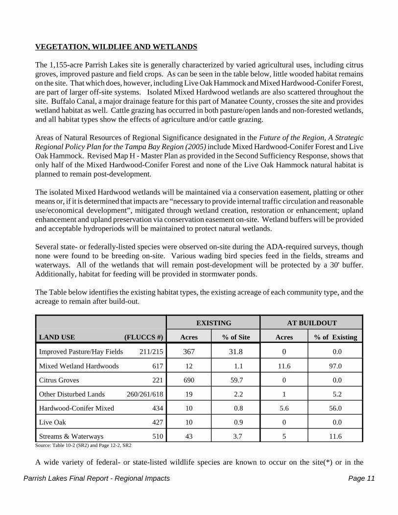
VEGETATION, WILDLIFE AND WETLANDS
The 1,155-acre Parrish Lakes site is generally characterized by varied agricultural uses, including citrusgroves, improved pasture and field crops. As can be seen in the table below, little wooded habitat remainson the site. That which does, however, including Live Oak Hammock and Mixed Hardwood-Conifer Forest,are part of larger off-site systems. Isolated Mixed Hardwood wetlands are also scattered throughout thesite. Buffalo Canal, a major drainage feature for this part of Manatee County, crosses the site and provideswetland habitat as well. Cattle grazing has occurred in both pasture/open lands and non-forested wetlands,and all habitat types show the effects of agriculture and/or cattle grazing.
Areas of Natural Resources of Regional Significance designated in the Future of the Region, A StrategicRegional Policy Plan for the Tampa Bay Region (2005) include Mixed Hardwood-Conifer Forest and LiveOak Hammock. Revised Map H - Master Plan as provided in the Second Sufficiency Response, shows thatonly half of the Mixed Hardwood-Conifer Forest and none of the Live Oak Hammock natural habitat isplanned to remain post-development.
The isolated Mixed Hardwood wetlands will be maintained via a conservation easement, platting or othermeans or, if it is determined that impacts are “necessary to provide internal traffic circulation and reasonableuse/economical development”, mitigated through wetland creation, restoration or enhancement; uplandenhancement and upland preservation via conservation easement on-site. Wetland buffers will be providedand acceptable hydroperiods will be maintained to protect natural wetlands.
Several state- or federally-listed species were observed on-site during the ADA-required surveys, thoughnone were found to be breeding on-site. Various wading bird species feed in the fields, streams andwaterways. All of the wetlands that will remain post-development will be protected by a 30' buffer.Additionally, habitat for feeding will be provided in stormwater ponds.
The Table below identifies the existing habitat types, the existing acreage of each community type, and theacreage to remain after build-out.
LAND USE (FLUCCS #)
EXISTING AT BUILDOUT
Acres % of Site Acres % of Existing
Improved Pasture/Hay Fields 211/215 367 31.8 0 0.0
Mixed Wetland Hardwoods 617 12 1.1 11.6 97.0
Citrus Groves 221 690 59.7 0 0.0
Other Disturbed Lands 260/261/618 19 2.2 1 5.2
Hardwood-Conifer Mixed 434 10 0.8 5.6 56.0
Live Oak 427 10 0.9 0 0.0
Streams & Waterways 510 43 3.7 5 11.6Source: Table 10-2 (SR2) and Page 12-2, SR2
A wide variety of federal- or state-listed wildlife species are known to occur on the site(*) or in the
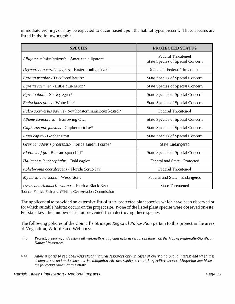
Parrish Lakes Final Report - Regional Impacts Page 12
immediate vicinity, or may be expected to occur based upon the habitat types present. These species arelisted in the following table.
SPECIES PROTECTED STATUS
Alligator mississippiensis - American alligator* Federal ThreatenedState Species of Special Concern
Drymarchon corais couperi - Eastern Indigo snake State and Federal Threatened
Egretta tricolor - Tricolored heron* State Species of Special Concern
Egretta caerulea - Little blue heron* State Species of Special Concern
Egretta thula - Snowy egret* State Species of Special Concern
Eudocimus albus - White ibis* State Species of Special Concern
Falco sparverius paulus - Southeastern American kestrel* Federal Threatened
Athene cunicularia - Burrowing Owl State Species of Special Concern
Gopherus polyphemus - Gopher tortoise* State Species of Special Concern
Rana capito - Gopher Frog State Species of Special Concern
Grus canadensis praetensis- Florida sandhill crane* State Endangered
Platalea ajaja - Roseate spoonbill* State Species of Special Concern
Haliaeetus leucocephalus - Bald eagle* Federal and State - Protected
Aphelocoma coerulescens - Florida Scrub Jay Federal Threatened
Mycteria americana - Wood stork Federal and State - Endangered
Ursus americanus floridanus - Florida Black Bear State ThreatenedSource: Florida Fish and Wildlife Conservation Commission
The applicant also provided an extensive list of state-protected plant species which have been observed orfor which suitable habitat occurs on the project site. None of the listed plant species were observed on-site.Per state law, the landowner is not prevented from destroying these species.
The following policies of the Council*s Strategic Regional Policy Plan pertain to this project in the areasof Vegetation, Wildlife and Wetlands:
4.43 Protect, preserve, and restore all regionally-significant natural resources shown on the Map of Regionally-SignificantNatural Resources.
4.44 Allow impacts to regionally-significant natural resources only in cases of overriding public interest and when it isdemonstrated and/or documented that mitigation will successfully recreate the specific resource. Mitigation should meetthe following ratios, at minimum:
Parrish Lakes Final Report - Regional Impacts Page 13
- Seagrass 4:1- FNAI Habitat 04 3:1- FNAI Coastal 04 3:1- FNAI Natural Communities 3:1- LULC Habitat Dry 2:1- LULC Habitat Wet 3:1
4.45 Ensure that mitigation by habitat re-creation employs native plant material which provides the same natural value andfunction. Monitor mitigation areas for a sufficient time to ensure success: a minimum 85 percent final coverage ofdesired species. Yearly maintenance and replanting should be undertaken to ensure final cover as necessary.
4.46 Recognize that, consistent with other policies in this section, permitted mitigation banking shall set the criteria forimpact mitigation.
4.47 Recognize that mitigation efforts shall be:- Performed within the same drainage basin where the unavoidable impacts to regionally significant wetlands
occurs; and- Allowed only after avoiding impact to the greatest extent possible; and that habitat creation, restoration, and
enhancement, with long-term management, be considered as viable methods of impact mitigation.
4.48 Mitigation by restoring disturbed habitat of a similar nature, including the removal of exotic plant species, may beacceptable. The minimum acceptable ratio should be twice the habitat re-creation ratio set forth in policy 4.44.
4.49 Maintain and improve native plant communities and viable wildlife habitats, determined to be regionally-significantnatural resources in addition to the Map of Regionally-Significant Natural Resources, including those native habitatsand plant communities that tend to be least in abundance and most productive or unique.
4.50 Maintain a naturally vegetated buffer sufficient to preserve the value and function of the regionally-significant naturalresource.
4.51 Provide and maintain adequate long-term monitoring of native plant communities and listed species' populations toprovide a sound database and to identify trends upon which future regulatory and acquisition decisions can be based.
4.55 Encourage the removal of invasive, exotic species such as punk tree (Melaleuca), Australian pine (Casuarina) andBrazilian pepper (Schinus) and the replacement by native species.
4.56 Promote the principles of ecosystem management for the protection of regionally-significant natural resources.
4.57 Ensure that land use decisions are consistent with federal- and state-listed species protection and recovery plans, andadopted habitat management guidelines.
WATER QUALITY AND STORMWATER MANAGEMENT
The Parrish Lakes DRI site is located in the Gulf Coastal Lowlands physiographic province. Severalsignificant drainage ditches were created within and around the periphery of the site to modify the surfaceand subsurface drainage for citrus and other farming activities. Additionally Buffalo Canal, a ManateeCounty drainage facility, bisects the site and is the main discharge feature of the site. It ultimatelydischarges into Terra Ceia Bay.
The applicant states that the property provides groundwater recharge to the surficial aquifer but is notexpected to have any Floridan Aquifer recharge areas. It is also stated that groundwater elevations withinthe site range from a high of 30' NGVD to a low of 15' NGVD within the Buffalo Canal. However land
Parrish Lakes Final Report - Regional Impacts Page 14
elevations, as shown on Map C of the ADA, are all below 30' NGVD.
The proposed stormwater management system will employ grassed swales, surface water detention pondsand stormwater attenuation ponds to treat stormwater before it is discharged to existing wetlands andwaterways.
All existing wells on-site that are not to be used for the development will be plugged and abandoned asrequired by SWFWMD. Those to be used will be subject to permitting by SWFWMD.
The project is located in a segment of Buffalo Canal (WBID 1823) that is impaired for dissolved oxygenand fecal coliform. This would require the project’s surface water management system to be designed tocause net improvement, for those parameters not meeting standards, to the receiving water.
The applicant did not provide ground or surface water quality measurements, but expects to be required todevelop a pre- and post-development environmental monitoring plan, including water quality parametersand intends to perform baseline water quality monitoring for ambient groundwater conditions.
The stormwater management system will be owned and maintained by legal entities. It is intended that thedeveloper and/or his assigns, including possible purchasers of individual development tracts, will assumethe responsibility.
Adherence to the following Goals and/or Policies of the Council*s Strategic Regional Policy Plan will helpminimize impacts in the areas of Water Quality and Stormwater Management:
4.32 Improve the quality of receiving waters by:
- Upgrading or retrofitting drainage systems to effectuate improved stormwater treatment;- Encouraging multi-purpose facilities which complement open space, recreation and conservation objectives;
and- Requiring control and treatment of point and non-point discharges to estuarine and near-shore coastal waters.
4.33 Promote stormwater reuse as a component of irrigation plans for new development proposed within the watershed ofa potable water reservoir and encourage Best Management Practices (BMPs).
4.34 Promote environmentally-acceptable effluent disposal alternatives and encourage water conservation and alternativewater source use including the use of reclaimed wastewater.
4.35 Support the initiatives and restoration projects identified in the SWIM plans.
4.36 Incorporate by reference and implement the stormwater management strategies identified in the Sarasota Bay EstuaryProgram’s and Tampa Bay Estuary Program’s Comprehensive Conservation and Management Plans.
4.37 Provide sufficient inspection and maintenance of all stormwater facilities. 4.38 Support the preparation and implementation of comprehensive basinwide stormwater management master plans.
4.39 Encourage the use of Low Impact Development techniques in site design to store, infiltrate, and evaporate stormwaterrunoff on the site. General performance criteria which eliminate wetland impacts and minimize stormwaterinfrastructure needs include:
Parrish Lakes Final Report - Regional Impacts Page 15
- Disturbing no more land than is necessary to provide for the desired use;- Preserving indigenous vegetation to the maximum extent possible; and- Minimizing impervious cover in all land development activities.
4.40 Prohibit hardening of unaltered shorelines or other structural lining of natural waterways or shorelines, except whenrequired by adopted watershed and/or stormwater management plans.
SOILS
The Parrish Lakes DRI site includes a variety of soil types. EauGallie Fine Sand, Floridana Fine Sand, andManatee Mucky Loamy Fine Sand predominate. All are poorly to very poorly drained soils, exhibitingsevere limitations for the proposed uses and subject to seepage and wetness. The applicant proposes toutilize standard engineering practices to offset the soil limitations for roadways and buildings. A largepercentage of the uplands will be altered by fill material to raise the elevations above the 100-yearfloodplain. Fill will likely come from excavation of stormwater management areas and from off-site.
Lake banks will be stabilized by use of moderate side slopes, preservation of existing vegetation and/orplacement of sod or other soil stabilizing techniques. Wind and water soil erosion will be managed usinglocal government-approved techniques.
Detailed subsurface investigations will be necessary prior to design of the stormwater management systemand site development.
FLOODPLAINS
The Parrish Lakes site is located almost entirely within the FEMA-delineated 100-year floodplain. Bothstate and local agencies have strict criteria regarding stormwater design, to prohibit downstream andupstream flooding from development projects.
Compensatory mitigation for the loss of flood storage capacity and the predevelopment 25-year dischargerate will be provided on-site. In order to minimize flood losses, finished floor elevations of habitablebuildings will be located above the determined Base Flood Elevation in accordance with countyrequirements.
Adherence to the following Policies of the Council*s Strategic Regional Policy Plan would be anappropriate strategy for floodplain management:
4.98 Discourage development in the undeveloped 100-year floodplain.
4.99 Implement floodplain management strategies to prevent erosion, retard runoff, and protect natural functions and values.
WATER SUPPLY
Planned uses associated with the Parrish Lakes DRI are expected to generate a demand of nearly 1.2 milliongallons per day of water split between potable and non-potable sources at full buildout of the project in
Parrish Lakes Final Report - Regional Impacts Page 16
2030. The considerable demand on the water system will be significantly reduced when (and if) reclaimedwater service and/or backup wells are constructed and operational.
The Applicant provided a August 25, 2009 correspondence from Mr. William Sagatys, Senior EngineeringSpecialist for Manatee County Public Works, confirming ample capacity to meet the potable water demandprojections associated with the project. As identified, the Lake Manatee Water Treatment Plant currentlyhas a plant capacity of 84.0 million gallons per day (MGD) and a current service volume of 59.9 MGD. Theproject also benefits from the existence of a 20" reclaimed water main along some of the project boundaries.
Mr. Sagatys’ correspondence further acknowledged that the Applicant will still need to seek a utilitiescertificate of level of service and bear the construction costs associated with providing “all potable water,non potable water and sanitary sewer facilities required to serve the project.”
The proposed Parrish Lakes development is within the Southwest Florida Water Management District’sSouthern Water Use Caution Area, where future water demand is expected to exceed the ability oftraditional groundwater sources to provide necessary supplies over the next 20 years. New developmentincreases the potential for additional water demand in an area already stressed in providing for currentreasonable and beneficial uses. The development must therefore implement, to the maximum extentpossible, water conservation and use alternative supplies.
While installation of required water conserving fixtures and technology regarding irrigation systems willconsequently reduce water demand, the Applicant intends to implement irrigation restrictions and encouragethe use of native, drought tolerant landscaping within the development.
The following summarizes the projected potable and non-potable water demand by phase by land use:
PHASE LAND USEENTITLEMENTS/
IRRIGATED ACRES
WATER DEMAND (GPD)
Potable Non-Potable
PHASE 1(2011-2020)
RESIDENTIAL900 SF Units/62.1 Acres 175,500 221,076
600 MF Units/7.5 Acres 78,000 26,700
RETAIL 250,000 Sq. Ft./2.1 Acres 30,000 3,402
PHASE 1 SUBTOTAL þ 283,500 251,178
PHASE 2(2020-2030)
RESIDENTIAL1,300 SF Units/82.35 Acres 253,500 293,166
500 MF Units/4.5 Acres 65,000 16,020
RETAIL 150,000 Sq. Ft./1.8 Acres 18,000 2,916
OFFICE 50,000 Sq. Ft./0.8 Acres 12,000 1,296
PHASE 2 SUBTOTAL þ 348,500 313,398
TOTAL PROJECTED WATER DEMAND þ 632,000 564,576SOURCE: SR2/Table 17-1 (Revised 12/10/10)
Applicable Water Supply Policies of the Strategic Regional Policy Plan include:
4.25 Encourage the use of the lowest quality water reasonably available, suitable and environmentally-appropriate to a givenpurpose in order to reduce the use of potable-quality water for irrigation and other non-potable purposes.
Parrish Lakes Final Report - Regional Impacts Page 17
4.26 Encourage the continued development of new, energy-efficient technologies and funding mechanisms which increasethe feasibility of using drought resistant methods or alternative water supply sources to provide potable water.
4.27 Encourage the continued development and promotion of water conservation methods and technologies for use bothinside and outside buildings.
4.29 Encourage use of the most practical, economically feasible and efficient irrigation methods available and the timelyreplacement or improvement of less water efficient systems.
WASTEWATER MANAGEMENT
The various project uses within the Parrish Lakes DRI are expected to generate more than 600,000 gallonsof wastewater per day upon completion. Utilizing a projected wastewater generation rates of 195 gallonsper day (gpd) per single-family and 130 gpd per multi-family unit, more than 90 percent of the overall622,000 gpd of wastewater is expected to be derived from the proposed 3,300 residential units.
While restaurants, laundromats, dry cleaners and supermarkets typically locate within retail components ofmixed-use projects, any generator of industrial-type effluents would be required to comply with allapplicable federal, state and local regulatory and licensing criteria.
The following summarizes the anticipated daily wastewater generation by phase by land use:
PHASE LAND USE ENTITLEMENTSWASTEWATER
GENERATION (GPD)
PHASE 1(2011-2020)
RESIDENTIAL900 SF Units 175,500
600 MF Units 78,000
RETAIL 250,000 Sq. Ft. 25,000
PHASE 1 SUBTOTAL þ 278,500
PHASE 2(2020-2030)
RESIDENTIAL1,300 SF Units 253,500
500 MF Units 65,000
RETAIL 150,000 Sq. Ft. 15,000
OFFICE 50,000 Sq. Ft. 10,000
PHASE 2 SUBTOTAL þ 343,500
TOTAL PROJECTED WASTEWATER GENERATION þ 622,000SOURCE: SR1/Table 18-1 (Revised 7/14/10)
Mr. William Sagatys, Manatee County Utilities Sr. Engineering Specialist, has indicated that the Countyhas sufficient capacity to serve the entire project area. Currently, the North Water Reclamation facility hasa permitted capacity of 7.5 MGD and a daily demand of 5.03 MGD. Further expansion of capacity at thisfacility is currently under design.
Parrish Lakes Final Report - Regional Impacts Page 18
As indicated in the Water Supply section above, the Applicant will be required to obtain a utilities certificateof level of service and construct “all potable water, non potable water and sanitary sewer facilities requiredto serve the project.”
As committed, no septic tanks will be used in the Project.
SOLID WASTE/HAZARDOUS WASTE/MEDICAL WASTE
It is estimated that the Parrish Lakes DRI will generate more than 22 tons of solid waste on a daily basisfollowing buildout in 2030. Residential development will account for an estimated 90 percent of theproject’s solid waste stream. The applicant provided a copy of Mr. C. Michael Gore’s (Manatee CountyUtilities Department Solid Waste Manager) August 18, 2009 correspondence confirming sufficient capacityto serve the solid waste needs of the project at the Manatee County landfill, which currently has“16,188,140 CY of remaining volume or an estimated year end life expectance of 31.5 years.” Thisestimated landfill life does take “projected growth into account, while maintaining certain compaction andrecycling rates.”
The following summarizes the anticipated daily solid waste generation by phase by land use:
PHASE LAND USE ENTITLEMENTSSOLID WASTE
GENERATION (GPD)
PHASE 1(2011-2020)
RESIDENTIAL900 SF Units 12,150
600 MF Units 5,400
RETAIL 250,000 Sq. Ft. 2,500
PHASE 1 SUBTOTAL þ 20,050
PHASE 2(2020-2030)
RESIDENTIAL1,300 SF Units 17,550
500 MF Units 4,500
RETAIL 150,000 Sq. Ft. 1,500
OFFICE 50,000 Sq. Ft. 500
PHASE 2 SUBTOTAL þ 24,050
TOTAL PROJECTED SOLID WASTE GENERATION þ 44,100SOURCE: SR1/Table 20-1 (Revised 7/12/10)
If potential commercial tenants utilize, produce, or store hazardous wastes or materials on site, thesefacilities must operate in accordance with federal and state regulations and guidelines.
TRANSPORTATION
The Parrish Lakes DRI development will have an impact on several regionally significant roadway facilitieswithin the primary project area. The following tables identify the significantly impacted Roadway Links
Parrish Lakes Final Report - Regional Impacts Page 19
and Intersections for Phase 1 (Tables 1 & 2 respectively) as well as the significantly impacted RoadwayLinks and Intersections for Phase 2 (Tables 3 & 4 respectively). While improvements have been identifiedto restore these facilities to the adopted level of service, the Applicant is not responsible for “reducing oreliminating” backlogged transportation facilities, as defined by Section 163.3180(12)(d), F.S. As indicatedin each of the following respective Tables, the identified improvements appearing in “yellow” highlightswere attributed solely to the anticipated project traffic for which the Applicant is responsible, and wouldnot otherwise be needed as a result of background traffic alone.
TABLE 1Phase 1 (2020) Required Link Improvements
LOCATION
TOTAL TRAFFICLOS PRIOR TO
IMPROVEMENT
PROJECTTRAFFIC
IMPACT (%)TOTAL TRAFFIC REQUIRED
IMPROVEMENTSErie Rd: CR 10 to US 301 F 19.0 Construct 4-lane divided
Moccasin Wallow Rd: I-75 to Carter Rd F 35.0 Construct 4-lane divided
US 301: 51st St to I-75 West F 5.0 Construct 6-lane divided
US 301: 60th Av E to Victory Rd F 6.0 Construct 6-lane divided
US 301: Victory Rd to Tara Siesta Blvd F 7.0 Construct 6-lane divided
US 301: SR 62 to Moccasin Wallow Rd F 8.0 Construct 4-lane divided
Carter Rd: Moccasin Wallow Rd to EE F 100.0 Construct 4-lane divided
TABLE 2Phase 1 (2020) Required Intersection Improvements
LOCATION
TOTAL TRAFFICLOS PRIOR TO
IMPROVEMENT*
PROJECTTRAFFIC
IMPACT (%) REQUIRED IMPROVEMENTErie Rd @ 69th St A/F 17.5 Add SB LT lane
Moccasin Wallow @ Carter Rd B/F 20.5 Add WB LT & EB RT lanes. Sig-nalize when warranted by MUTCD
Moccasin Wallow @ I-75 SB Ramp A/F 15.0 Signalize when warranted by MUTCD
Erie Rd @ Carter Rd A/F 24.5 Add EB LT lane
Moccasin Wallow @ Ft Hamer Ext. A/F 5.5 Add EB LT & SB RT lanes
Moccasin Wallow @ Sawgrass Rd A/E 8.5 Add NB LT laneACRONYM LISTING:
NB - North Bound LT - Left Turn SB - South Bound RT - Right Turn EB - East Bound TH -Thru LaneWB - West Bound MUTCD - Manual of Uniform Traffic Control Devices
* - Unsignalized intersection Level of Service for each critical movement.
Tables 3 and 4 (below) identify the improvements needed to accommodate Phase 2. These Phase 2improvements are in addition to the Phase 1 improvements noted above.
TABLE 3Phase 2 (2030) Required Link Improvements
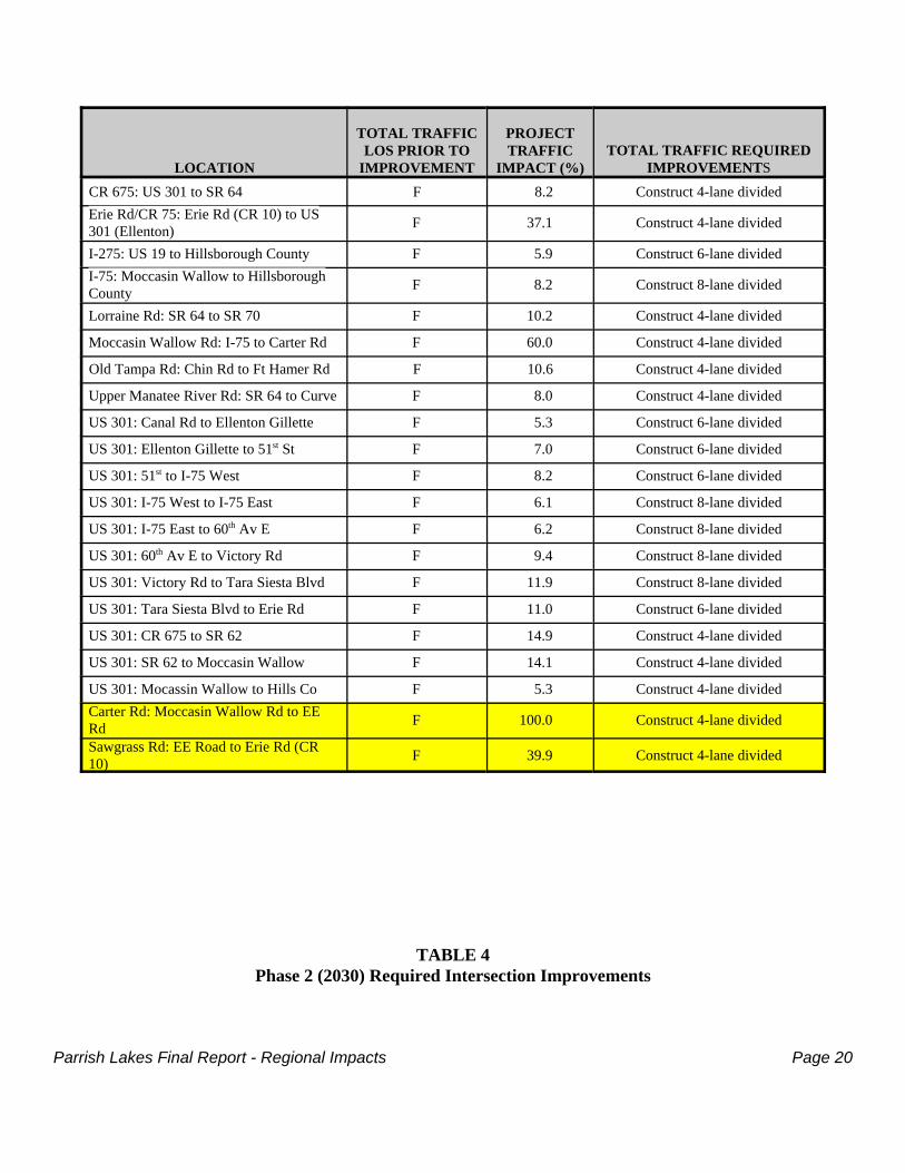
Parrish Lakes Final Report - Regional Impacts Page 20
LOCATION
TOTAL TRAFFICLOS PRIOR TO
IMPROVEMENT
PROJECTTRAFFIC
IMPACT (%)TOTAL TRAFFIC REQUIRED
IMPROVEMENTSCR 675: US 301 to SR 64 F 8.2 Construct 4-lane dividedErie Rd/CR 75: Erie Rd (CR 10) to US301 (Ellenton) F 37.1 Construct 4-lane divided
I-275: US 19 to Hillsborough County F 5.9 Construct 6-lane dividedI-75: Moccasin Wallow to HillsboroughCounty F 8.2 Construct 8-lane divided
Lorraine Rd: SR 64 to SR 70 F 10.2 Construct 4-lane divided
Moccasin Wallow Rd: I-75 to Carter Rd F 60.0 Construct 4-lane divided
Old Tampa Rd: Chin Rd to Ft Hamer Rd F 10.6 Construct 4-lane divided
Upper Manatee River Rd: SR 64 to Curve F 8.0 Construct 4-lane divided
US 301: Canal Rd to Ellenton Gillette F 5.3 Construct 6-lane divided
US 301: Ellenton Gillette to 51st St F 7.0 Construct 6-lane divided
US 301: 51st to I-75 West F 8.2 Construct 6-lane divided
US 301: I-75 West to I-75 East F 6.1 Construct 8-lane divided
US 301: I-75 East to 60th Av E F 6.2 Construct 8-lane divided
US 301: 60th Av E to Victory Rd F 9.4 Construct 8-lane divided
US 301: Victory Rd to Tara Siesta Blvd F 11.9 Construct 8-lane divided
US 301: Tara Siesta Blvd to Erie Rd F 11.0 Construct 6-lane divided
US 301: CR 675 to SR 62 F 14.9 Construct 4-lane divided
US 301: SR 62 to Moccasin Wallow F 14.1 Construct 4-lane divided
US 301: Mocassin Wallow to Hills Co F 5.3 Construct 4-lane dividedCarter Rd: Moccasin Wallow Rd to EERd F 100.0 Construct 4-lane divided
Sawgrass Rd: EE Road to Erie Rd (CR10) F 39.9 Construct 4-lane divided
TABLE 4Phase 2 (2030) Required Intersection Improvements
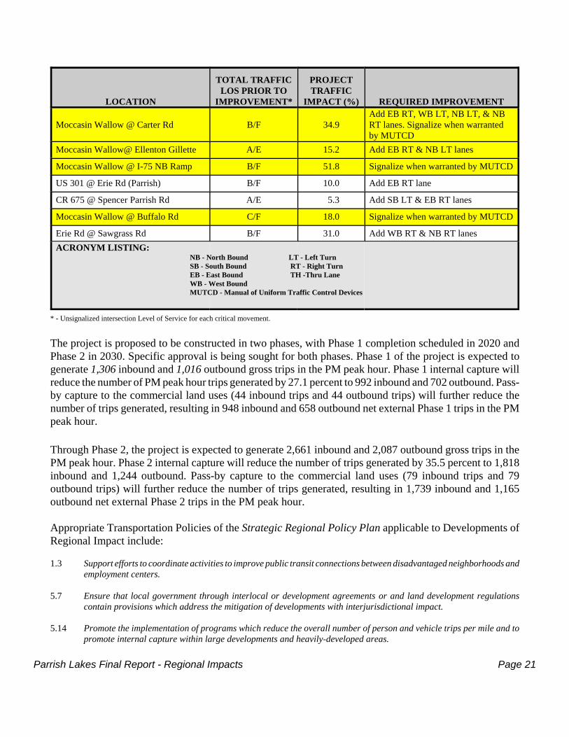
Parrish Lakes Final Report - Regional Impacts Page 21
LOCATION
TOTAL TRAFFICLOS PRIOR TO
IMPROVEMENT*
PROJECTTRAFFIC
IMPACT (%) REQUIRED IMPROVEMENT
Moccasin Wallow @ Carter Rd B/F 34.9Add EB RT, WB LT, NB LT, & NBRT lanes. Signalize when warrantedby MUTCD
Moccasin Wallow@ Ellenton Gillette A/E 15.2 Add EB RT & NB LT lanes
Moccasin Wallow @ I-75 NB Ramp B/F 51.8 Signalize when warranted by MUTCD
US 301 @ Erie Rd (Parrish) B/F 10.0 Add EB RT lane
CR 675 @ Spencer Parrish Rd A/E 5.3 Add SB LT & EB RT lanes
Moccasin Wallow @ Buffalo Rd C/F 18.0 Signalize when warranted by MUTCD
Erie Rd @ Sawgrass Rd B/F 31.0 Add WB RT & NB RT lanesACRONYM LISTING:
NB - North Bound LT - Left Turn SB - South Bound RT - Right Turn EB - East Bound TH -Thru LaneWB - West Bound MUTCD - Manual of Uniform Traffic Control Devices
* - Unsignalized intersection Level of Service for each critical movement.
The project is proposed to be constructed in two phases, with Phase 1 completion scheduled in 2020 andPhase 2 in 2030. Specific approval is being sought for both phases. Phase 1 of the project is expected togenerate 1,306 inbound and 1,016 outbound gross trips in the PM peak hour. Phase 1 internal capture willreduce the number of PM peak hour trips generated by 27.1 percent to 992 inbound and 702 outbound. Pass-by capture to the commercial land uses (44 inbound trips and 44 outbound trips) will further reduce thenumber of trips generated, resulting in 948 inbound and 658 outbound net external Phase 1 trips in the PMpeak hour.
Through Phase 2, the project is expected to generate 2,661 inbound and 2,087 outbound gross trips in thePM peak hour. Phase 2 internal capture will reduce the number of trips generated by 35.5 percent to 1,818inbound and 1,244 outbound. Pass-by capture to the commercial land uses (79 inbound trips and 79outbound trips) will further reduce the number of trips generated, resulting in 1,739 inbound and 1,165outbound net external Phase 2 trips in the PM peak hour.
Appropriate Transportation Policies of the Strategic Regional Policy Plan applicable to Developments ofRegional Impact include:
1.3 Support efforts to coordinate activities to improve public transit connections between disadvantaged neighborhoods andemployment centers.
5.7 Ensure that local government through interlocal or development agreements or and land development regulationscontain provisions which address the mitigation of developments with interjurisdictional impact.
5.14 Promote the implementation of programs which reduce the overall number of person and vehicle trips per mile and topromote internal capture within large developments and heavily-developed areas.
Parrish Lakes Final Report - Regional Impacts Page 22
5.16 Maximize development of existing facilities and services before expansion into undeveloped areas.
5.17 Develop incentives to encourage mixed-use developments which include residential land uses to locate in and/oradjacent to designated Regional Activity Centers and activity nodes which are recognized within local governmentcomprehensive plans.
5.21 Recognize that Developments of Regional Impact which impact more than one mode of transportation shall addresssolutions for mitigating the impacts to each mode.
5.35 Prioritize transportation modes and/or improvement projects which facilitate pedestrian friendly development throughinfill and compact projects which foster the availability of transit and multi-modal means of transportation.
5.37 Provide opportunities and/or incentives for the development of bicycle, pedestrian, and other forms of non-vehicularsystems and connections with adjacent developments, activity centers, and other jurisdictions.
5.41 Encourage development and redevelopment projects to reflect an increased emphasis on the development of publictransportation and bicycle and pedestrian facilities.
5.43 Encourage public/private cooperative efforts to develop an interconnected public transit system for the region consistentwith the CCC’s Regional Transit Plan.
5.53 Ensure that Developments of Regional Impact and large-scale developments with interjurisdictional impacts shouldassess and mitigate their impact on regionally significant transportation facilities in a compatible manner.
AIR QUALITY
Fugitive dust is common to all construction sites. Wind erosion of disturbed soils, the movement ofconstruction equipment and the burning of cleared vegetation are air pollution sources. Best ManagementPractices can be employed to reduce air emissions from the construction site, such as: clearing and grubbingonly individual parcels where construction is scheduled to proceed; sodding, seeding, mulching or plantingof landscaped material in cleared and disturbed areas; and watering of exposed areas. The applicant expectsto comply with local regulations governing site preparation and demolition.
The analysis of transportation impacts and potential vehicle emissions identified that air quality will bedegraded at various intersections at project build-out without certain improvements. The applicant statesthat the improvements identified to allow operation of those intersections at LOS D or better, onceconstructed, will preclude air quality problems. The applicant does not propose to delay projectconstruction until the intersection improvements are scheduled or constructed, but to pay its proportionateshare of all improvement costs.
Adherence to the following Goals and/or Policies of the Council*s Strategic Regional Policy Plan wouldbenefit air quality in the vicinity of Parrish Lakes:
4.110 Incorporate specific mitigative measures to prevent fugitive dust emissions during excavation and construction phasesof all land development projects which produce heavy vehicular traffic and exposed surfaces.
4.111 Implement land use-related performance standards that minimize negative air quality impacts resulting fromdevelopment.
4.145 Encourage the availability of educational materials and learning programs concerning air quality issues.
Parrish Lakes Final Report - Regional Impacts Page 23
HURRICANE PREPAREDNESS
It appears that approximately 340 acres of the project are located within Hurricane Evacuation Level Eaccording to the 2010 Statewide Regional Evacuation Study for the Tampa Bay Region (2010 ManateeCounty Hurricane Guide). Evacuation Level E requires the evacuation of all habitable structures onlyduring the most intense hurricane events (i.e. Category 5), which would be characterized by wind velocitiesexpected to surpass 155 MPH and potential tide heights of up to 28 feet. This vulnerable portion of theproject is essentially the central section of the DRI (see Map #4) and constitutes nearly one-third of theoverall 1,155+ acre site.
It is acknowledged that the Evacuation Levels were recently revised within Manatee County based onupdated Sea, Lake and Overland Surge from Hurricane (SLOSH) modeling conducted for the County in2009.
The following Hurricane Preparedness Policies of the Strategic Regional Policy Plan shall apply to theproject:
3.1 Reduce the risk of natural and technological hazards by state, regional, and local governments working together to:• Mitigate the impacts affecting emergency management /life safety issues through growth management and land
development regulations;• Consider the relative vulnerability of proposed development to natural and technological hazards and specify
mitigation strategies for evacuation and shelter impacts, life safety/security issues, and potential propertydamage; and
• Advocate that real estate disclosure forms, deeds of sale, and lease agreements for land and/or structures inthe 100-year flood zone be provided accompanied by a hazard disclosure statement generally describing theproperty’s relative probability of damage from coastal storm surge, fresh water flooding, and/or velocity waveaction.
3.5 Continue to establish, expand, and enhance coordination and cooperative efforts with the public and private sectorswithin the region.
3.6 Identify partners to support projects within the community which will enhance public awareness, training, andneighborhood efforts.
3.9 Ensure that adequate and efficient evacuation routes and shelter space are available to serve the needs of the TampaBay region in the time of an emergency by continuing the following activities:
• Assessing the impacts on public shelter capacity and hurricane clearance times and determining theappropriate mitigation of residential, commercial, and industrial development...;
• Identifying, expanding, and staffing of public and private facilities to serve as additional shelters;• Prioritizing maintenance and improvement projects on designated major regional evacuation routes; and• Prioritizing projects designed to enhance the capacity or relieve congestion of roadways identified as “critical
links” by the most recent regional or statewide evacuation study.
3.13 Enforce all appropriate federal and state coastal construction codes, coastal setback requirements, and floodplainmanagement regulations recognizing the vulnerability of this region to hurricanes, fresh water flooding, and tropicalstorms.
3.15 Ensure that the reconstruction of public facilities proceeds only if the reconstruction incorporates appropriate mitigationtechniques/alternatives.
Parrish Lakes Final Report - Regional Impacts Page 24
AFFORDABLE HOUSING
In lieu of completing an affordable housing analysis acceptable to Manatee County, the Tampa BayRegional Planning Council and the Florida Department of Community Affairs, the applicant has proposeda “Voluntary Affordable Housing Mitigation Program” fully described in Section V of this Report. Selectprovisions of the proposed mitigation Program have been revised as recognized in the RecommendedRegional Conditions portion of this Report (Section IV).
Affordable Housing Policies of the current Strategic Regional Policy Plan particularly pertinent to DRI-scale projects include:
1.3 Support efforts to coordinate activities to improve public transit connections between disadvantaged neighborhoods andemployment centers.
1.4 Promote new and innovative incentives and technical assistance programs which induce financial leveraging for newconstruction of affordable housing.
1.6 Support housing programs which further community-based organizations’ efforts, private sector residential investment,and improve credit opportunity through community lender partnerships to provide housing for very low-, low-, andmoderate-income families.
1.7 Support the establishment of programs to assist very low-, low-, and moderate- income families to attain compliancewith local building codes.
1.8 Promote use of alternative construction techniques and building materials designed to reduce construction, maintenance,and energy costs while ensuring that public safety and health standards are maintained.
1.9 Encourage the funding and implementation of home-ownership programs that benefit the ability of very-low, low-, andmoderate- income families’ to successfully manage the responsibilities associated with homeownership. Such programsshould also include education on energy conservation and water conserving technology both in and outside the home.
1.12 Site and design residential development in a way that: enhances and protects life and property from natural and man-made hazards; is compatible with the type and scale of surrounding land uses; fosters a pedestrian friendly environment;enhances connectivity with adjacent development; and protects existing residential areas from the encroachment ofincompatible activities. Likewise, other land use areas should be protected from the encroachment of incompatibleresidential activities. The implementation or interpretation of these provisions, however, should not be seen asdiscouraging mixed-use development.
1.13 Encourage affordable housing for very low-, low-, and moderate-income families/ households that includes enhancedopportunities for traditional neighborhood, mixed-use, and single-use residential developments which are readilyaccessible to employment centers, health care facilities, recreation, shopping, and public transportation.
POLICE AND FIRE PROTECTION
Law enforcement support for the site will be provided by the Manatee County Sheriff’s Office, while EMSand fire protection will be provided by the North River Fire District, approximately one mile west of theParrish Lakes DRI. Manatee County Sheriff’s Office Comptroller Tom Salisbury has identified that asignificant increase in deputies will be necessary in order to patrol this area 24/7 at buildout in 2030. The
Parrish Lakes Final Report - Regional Impacts Page 25
law enforcement coverage in this area is relatively low considering the present rural characteristics of thearea. Manatee County Fire Marshal Ron Cales has indicated that “this office reserves the option ofconsidering land within this project for future fire department expansion.” Any specific law enforcementand/or fire protection obligations, if applicable, shall be negotiated as part of (and included within) theDevelopment Order.
The following fire protection policy would be appropriate for the Parrish Lakes DRI:
4.158 Minimize the conflicts between residential development and the wildland/urban interface by encouraging developersand residents to apply the following firewise techniques:• Create a defensible space surrounding the dwelling unit;• Follow only lean (i.e., prune shrubs and cut back tree branches), clean (i.e., remove all dead plant material
from around the home), and green (i.e., plant fire-resistant vegetation) landscaping practices;• Develop and practice a home fire emergency plan;• Ensure that roofing and exterior construction materials and attachments connected to the dwelling unit are fire-
resistant; and• Identify the dwelling unit and neighborhood with legible and clearly marked street names and address numbers
for emergency access.
RECREATION AND OPEN SPACE
On-site recreational opportunities shall be provided in accordance with the Manatee County Code. Ascommitted, the Applicant shall prepare a Parks Master Plan prior to or concurrent with the first preliminarysite plan approval. The Plan shall address the location and appropriate acreage of each park/recreationfacility and may include such facilities as trails, neighborhood parks, community parks, boardwalks, fishingpier, gazebos, wetland areas, etc. The Applicant has committed to providing up to 26 acres of parks withinthe project.
“Ponds and preserved wetlands will provide additional open space as well as the 330' Florida Power & Lighteasement running north-south on the eastern portion of the project.”
Consistent with the requirements of neighboring projects along Erie Road, the Applicant has agreed toprovide frontage along Erie Road for extension of the Ellenton-Willow Trail.
Recreation and Parks Policies of the Strategic Regional Policy Plan particularly pertinent to DRI-scaleprojects include:
4.129 Plan park and recreational facilities, and the acquisition and restoration of open space and facilities for futurerecreational use, to include protection of environmental and natural resources, scenic areas, energy efficiency, waterconservation, and the orderly extension and expansion of compatible public facilities and services.
4.135 Provide adequate park and recreational facilities, equitably and geographically distributed for the projected numbersof people in the region.
4.136 Hold recreation and park sites inviolate against diversion to other uses, except in cases of overriding public interest.
4.138 Protect the natural resources of regionally-significant parks, greenways, preserves, and conservation lands fromincompatible land uses adjacent to these areas. Include pedestrian trails, where appropriate.
Parrish Lakes Final Report - Regional Impacts Page 26
EDUCATION
The projected number of students is calculated as a percentage of the number of residential units byresidential unit type. It is projected that 925 students would reside within the residential component of theParrish Lakes DRI at buildout. A September 22, 2009 correspondence from Ms. Amy Anderson of theSchool District of Manatee County has identified that “the School Board of Manatee County and ManateeCounty Government have adopted a school concurrency management system and this development isrequired to obtain a Certificate of Level of Service for Public School Facilities upon submission of anapplication for horizontal or vertical construction approval (final site plan or functional equivalent).”
School District staff identified a current shortage of elementary school capacity within School Service Area1 but ample capacity at local middle and high schools presently although this “Preliminary SchoolConcurrency Analysis does not encumber or reserve capacity and is based on current trends for growth anddevelopment.”
A breakdown of anticipated students by school type is as follows by PhaseELEMENTARY
SCHOOLMIDDLESCHOOL
HIGHSCHOOL
TOTAL #OF STUDENTS
Phase 1 (2011-2010) 193 101 127 421
Phase 2 (2020-2030) 231 121 152 504
TOTAL 424 222 279 925Source: ADA/Exhibit 27-1, as extrapolated by residential units within each Phase.
The following Education Policy of the Strategic Regional Policy Plan is relevant to DRI-scale projects:
2.59 Continue to support local school districts as active participants in the implementation of local growth managementefforts through active communication, cooperation, and coordination and as prescribed in Florida Statutes.
HEALTH CARE
It is anticipated that the majority of health care needs of the project can/will be met at the two nearesthospitals, both located in Bradenton: Manatee Memorial Hospital (8+ miles away) and Blake MedicalCenter (10+ miles away). Many specialized medical facilities are additionally located across the Regionto potentially supplement many of the medical needs which are not met locally (e.g. Tampa GeneralHospital and All Childrens Hospital).
ENERGY
An August 18, 2009 correspondence was provided by Mr. Paul Roberts of Peace River Electric Cooperative,Inc. indicating that their company has a “more than adequate supply of electric power available for the fullbuildout of this development and its surrounding area.”
An August 19, 2009 correspondence from Mr. Dan Shanahan of TECO/Peoples Gas was provided withinthe Application for Development Approval confirming that “natural gas is available for the development”
Parrish Lakes Final Report - Regional Impacts Page 27
and that they already “maintain facilities in the vicinity” of the project limits. The Applicant hasacknowledged further coordination with TECO/Peoples Gas will transpire regarding potential service withinthe site and the supporting infrastructure which would be necessary.
As presented in the Table below, the anticipated average daily energy consumption at buildout is more than36,813 kilowatts (KW), with a peak hour demand of 23,750 KW.
The following summarizes the projected energy demand for each land use by phase:
PHASE LAND USE ENTITLEMENTS
ENERGY DEMAND(IN KILOWATTS)
Average Daily Peak Hour
PHASE 1(2011-2020)
RESIDENTIAL900 SF Units 9,068 5,850
600 MF Units 4,185 2,700
RETAIL 250,000 Sq. Ft. 3,875 2,500
PHASE 2 SUBTOTAL þ 17,128 11,050
PHASE 2(2020-2030)
RESIDENTIAL 1,300 SF Units 13,098 8,450
500 MF Units 3,488 2,250
RETAIL 150,000 Sq. Ft. 2,325 1,500
OFFICE 50,000 Sq. Ft. 775 500
PHASE 2 SUBTOTAL þ 19,685 12,700
TOTAL PROJECTED ENERGY DEMAND þ 36,813 23,750SOURCE: ADA/Tables 29-1 & 29-2
Applicable Energy Conservation Policies of the Strategic Regional Policy Plan include:
1.9 Encourage the funding and implementation of home-ownership programs... such programs should also include educationon energy conservation and water conserving technology both in and outside the home.
4.26 Encourage the continued development of new, energy-efficient technologies and funding mechanisms which increasethe feasibility of using drought resistant methods or alternative water supply sources to provide potable water.
4.113 Encourage public and private sector support and participation in electric energy conservation programs.
4.146 Support the development of educational programs promoting energy conservation and efficiency in order to reduceunhealthful and environmentally-damaging air emissions.
HISTORICAL AND ARCHAEOLOGICAL
On behalf of the Applicant, Archaeological Consultants, Inc. (ACI) completed a Cultural ResourceAssessment of the project site in September 2009. A copy of the Assessment was provided in associationwith the First Sufficiency response.
Parrish Lakes Final Report - Regional Impacts Page 28
Although the historic Buffalo Canal (8MA1445) was identified within the project area, no additional culturalresources were discovered during the investigation.
As the Historic Preservationist Supervisor for the Florida Division of Historical Resources, Ms. LauraKammerer’s November 20, 2009 correspondence indicated concurrence with ACI’s determination that “theproposed development will have no effect on cultural resources listed, or eligible for listing, in the NRHP[National Register of Historic Places], or otherwise of historical, archaeological or architectural value”and that “no further investigation of the subject parcel” will be necessary. This finding was made inaccordance with Chapter 1A-46, Florida Administrative Code.
The following policies of the Strategic Regional Policy Plan typically apply to Developments of RegionalImpact and other large-scale development proposals:
2.31 Preserve recreation and historic sites.
2.33 Support private and public participation of historic preservation by offering public recognition and incentives for activepreservation efforts.
2.34 Encourage the rehabilitation and adaptive reuse of historic properties.
2.35 Encourage local governments to protect significant archaeological and historical resources by assessing, and asappropriate, mitigating the potential for adverse impacts and ensuring compatibility with adjacent land uses.
2.36 Protect historic properties that are designated to be of local, regional, or national significance and are eligible fornomination to the appropriate local or national historical register.
Parrish Lakes Final Report - Developer Commitments Page 29
SECTION III - DEVELOPER COMMITMENTSDRI #269 - PARRISH LAKES
MANATEE COUNTY
The following commitments have been made in the Application for Development Approval (ADA), the FirstSufficiency Response (SR1) and/or the Second Sufficiency Response (SR2).
GENERAL
1. The owner will maintain a prudent fencing program to segregate and control the agriculturalbusiness operations from the development areas... (ADA/Page 10-5)
2. Any development that may be proposed within the [330'] FPL easement will be consistent with theproperty owner’s easement rights. Such development is typically for ponds, or mitigation areas,park land and roadway crossings. (SR1/Page 9-1)
VEGETATION AND WILDLIFE
1. Until such time that the site is actually developed, it is anticipated that the site will remain inagricultural use with continuously active agricultural operations. (ADA/Page 12-2)
2. The property owners have a business plan regarding the continued maintenance of pasturelands thatwill remain in effect throughout the DRI process and the future sale of specific parcels toindependent development entities. This plan provides that the available pastureland use areas mustbe maintained in order to sustain a viable cattle herd, and consequently, a viable agribusiness. Themaintenance that is proposed to occur will include periodic discing of pastures followed byreseeding with various pasture grass species. (ADA/Page 12-2)
3. The upland listed species and other transects that have been completed on the property have verifiedthe potential presence of this species [i.e. Gopher Tortoise] on the property, and therefore, futureburrow surveys will have to be completed prior to future development of individual parcels withinthe overall DRI. Those surveys will be required as part of the normal development review of thesite... The Applicant is amenable to a development order condition stipulating that pre-constructiontortoise burrow surveys be required, and if tortoises are verified to be present, a permit sought fromFWC. (ADA/Page 12-16)
4. The applicant intends to coordinate with the FWC as necessary during the construction design andpermitting phase of the project, to determine appropriate off-site mitigation, if required, for impactsto those listed species (e.g. gopher tortoise) that cannot be accommodated entirely on-site.(ADA/Page 12-18)
5. The Applicant has “confirmed” that “Buffalo Creek will be retained during and after developmentand therefore will maintain the ‘corridor’ for use by wildlife.” (SR2/Page 10-7)
6. The Applicant agrees to set aside a preservation area, the 5.6+ acre Hardwood Conifer MixedForested upland area located in the northeast portion of the property. (SR2/Page 12-2)
Parrish Lakes Final Report - Developer Commitments Page 30
7. To provide some assurance that additional environmental degradation does not occur on theproperty after the DRI approval and D.O. have been issued, the Applicant will agree to utilize theproperty for similar or no more intense agricultural uses than are currently in operation. (SR1/Page12-1)
8. The wetlands that are to remain onsite are intended to be set aside as preservation areas, and thesewetlands are depicted on the revised Map H. (SR1/Page 12-5)
9. Any wetlands and their buffers that are to remain within a development parcel will be set aside viaconservation easements dedicated in favor of Manatee County and the property owner. Theconservation easements will be provided at the time that a future development parcel or phase isplatted. (SR1/Page 12-5)
10. The Applicant “understood” the need to complete the “updated wood stork and eastern Indigo snakeKeys dated January 25, 2010.” as well as “provide an endangered species assessment for the projectsite” at the time of Corps permit application. (SR1/Page 13-8)
WETLANDS
1. The project will be consistent with the elements of the Manatee County Comprehensive Plan as setforth in... Objective 3.3.1 - Wetland Protection: Preserve and protect existing, viable wetlandsystems to: maintain control of flooding and erosion through storage of agricultural and urbanrunoff in wetland areas; achieve biological filtration of pollutants associated with urban andagricultural runoff by wetlands; maintain protection of coastal areas from tidal storm surgesthrough maintaining wetlands as a natural buffer; achieve water recharge of surficial aquifersthrough wetland areas; maintain unique habitat functions of wetland areas as homes and criticalbreeding areas for many animals and plant species; maintain essential chemical and energy cyclesfacilitated by wetlands; and maintain educational and recreational opportunities provided bywetlands. (ADA/Page 10-21)
2. In order to obtain more accurate/real elevations for these field-established hydroperiod elevations,it will be necessary in the future (prior to the construction permitting process) for a registeredprofessional surveyor to perform a vertical survey of such elevations prior to field review/approvalby regulatory (SWFWMD) staff. These surveyed and agency-approved elevations in conjunctionwith a wetland jurisdiction delineation will then be utilized during the design process fordetermining stormwater system control elevations, floodplain compensation elevations and for thedesign of any proposed wetland mitigation areas. (ADA/Page 13-2)
3. Opportunities to enhance or restore wetlands and their hydroperiods (e.g. via capture of stormwaterrunoff) will be evaluated as construction plans are developed for each development phase.(ADA/Page 13-3)
4. The relatively higher quality or larger size onsite wetlands will be avoided to the greatest extentpossible, with the intent to incorporate these wetlands into the post-development landscape, and
Parrish Lakes Final Report - Developer Commitments Page 31
potentially target the wetlands to receive pre-treated stormwater runoff as a means of improvingor stabilizing the wetland hydrology while achieving additional stormwater treatment or“polishing” effects. Natural wetland areas on the property that will remain in the post-developmentcondition will include an upland buffer/setback, which will serve as a transition zone from thedevelopment to the wetland boundary, will provide potential habitat for wildlife utilization and willprovide some uptake and treatment of stormwater runoff entering wetlands via overland flow orthrough designated drainage swales. (ADA/Page 13-3)
5. Upland buffers/setbacks will be provided around all wetlands to remain in the post-developmentcondition, as appropriate and in accordance with SWFWMD and Manatee County standards.(ADA/Page 13-5).
WATER QUALITY
1. The requirements of Chapter 17-25 F.A.C. for stormwater treatment will be met using acceptedmethods including: (1) construction of littoral zones to be vegetated by native aquatic species; and(2) utilization of existing isolated wetland systems to provide biological treatment to maintain waterquality. The stormwater management plan will place particular emphasis on these methods toenhance water quality by using natural biological mechanisms for the breakdown of pollutants andnutrient uptake. (ADA/Page 14-3)
2. The surface water management system proposed for the site will be designed to protect water qualitythrough the use of grass swales, surface water detention ponds, and stormwater attenuation ponds...Water quality treatment ponds will attenuate and treat stormwater runoff before discharging to theexisting wetlands/waterways internal and adjacent to the proposed development areas... Drainageswales will also provide for filtration of pollutants prior to discharge into stormwater managementponds. (ADA/Page 14-3)
3. On-site surface waters within Parrish Lakes will be protected from construction impacts by variousmeasures, including the use of staked hay bales and silt screen fences, reducing both erosion andsediment transport into wetland areas. The preparation and implementation of a NPDESStormwater Pollution Prevention Plan will further insure that the site will minimize impacts duringconstruction. (ADA/Page 14-4)
4. Removal of the agricultural drainage system will also increase the residence time of the waterentering isolated wetlands and the surface waters within the site, resulting in an increase in theability of the systems to biologically filter pollutants and nutrients before the water is dischargedto ultimate drainage outfall locations. (ADA/Page 14-4)
5. The Applicant has committed to develop a pre and post development environmental monitoring planfor the property... The monitoring plan will propose a methodology by which water qualityparameters and monitoring will be established... It is reasonable to expect that the DevelopmentOrder can be conditioned to include a requirement for development and implementation of aGround and Surface Water monitoring Plan prior to site development. (SR2/Page 14-1)
Parrish Lakes Final Report - Developer Commitments Page 32
SOILS
1. Any soil limitations that may impact development of the site will be specifically identified andaddressed by the Registered Geotechnical Engineer at the time of permitting. (ADA/Page 15-1)
2. Buildings will be constructed on compacted fill material, with habitable structures sufficientlyelevated to be at least one foot above the determined 100-year flood elevation. (ADA/Page 15-1)
FLOODPLAINS
1. A more detailed floodplain analysis will be performed during the design and permitting phase of thisproject. (ADA/Page 16-1)
2. The storage of the water will be provided within the proposed compensation ponds between theseasonal high groundwater elevation and the design high elevation of the pond, as is typical.(SR1/Page 16-1)
WATER SUPPLY
1. The Parrish Lakes DRI will obtain potable water from the Manatee County public water system andwill comply with their requirements for installation of water conservation fixtures and adherenceto water-conserving maintenance practices. (ADA/Page 10-27)
2. Xeriscaping within the project... will likely result in reduced non-potable water demands forirrigation within the project. (ADA/Page 17-2)
3. The Applicant will continue to work with SWFWMD and Manatee County to develop a long-termplan to optimize potable and non-potable water resource use in the development through methodssuch as designation of potable water well site(s) within the development and decreasing the amountof well withdrawals as reclaimed water becomes increasingly available to the site. (ADA/Pages 17-3 -17-4)
4. All existing wells onsite that are not to be used to provide water to the development will be pluggedand abandoned as required by SWFWMD regulations. (SR1/Page 14-3)
5. All potable water is to be provided by Manatee County Utilities. (SR1/Page 17-2)
6. The Applicant will commit to provide all developers in the project a copy of SWFWMD’s FloridaFriendly Landscaping brochures and booklets, “Fertilizer Facts”, “Florida Friendly LandscapingPrinciples” and “Micro-Irrigation, a Guide to the Basics.” (SR1/Page 17-2)
7. The new residential units shall be energy efficient homes that use low flow toilets and waterconserving faucets. (SR2/Page 10-3)
8. The project will utilize reclaimed water that currently transects the property and is providedimmediately adjacent to the property and phase out the current agricultural pumping operation.(SR2/Page 10-3)
Parrish Lakes Final Report - Developer Commitments Page 33
9. Parrish Lakes will also encourage Florida friendly landscape materials so long as it is notinconsistent with other land development codes. (SR2/Page 17-6)
WASTEWATER MANAGEMENT
Permanent septic tanks will not be used in the Parrish Lakes DRI. (ADA/Page 18-2)
STORMWATER MANAGEMENT
1. The project’s stormwater management system and reuse of reclaimed water for irrigation will beintegrated into the project in a way that furthers SWFWMD’s goal of maintaining minimum flowsand levels for natural wetlands, as well as ensuring that surface and ground water quality duringthe after-development will meet or exceed all State and local water quality standards. (ADA/Page10-26)
2. Control structures will be baffled to preclude the discharge of floatables and be provided with bleeddown orifices or V-notches sized to the appropriate SWFWMD criteria. (ADA/Page 19-2)
3. Legal entities will be charged with the operation and maintenance of the stormwater system(s). Thedeveloper and/or his assigns, including possible purchasers of individual tracts, will assume theresponsibility to manage the system at full development. (ADA/Page 19-3)
4. The Applicant will schedule a pre-application meeting with SWFWMD prior to initiating thestormwater design for the development, within which all of these regulatory requirements can beaddressed. (SR1/Page 19-2 & SR2/Page 19-3)
TRANSPORTATION
1. No age restricted units are [/were] assumed in the project or in the transportation analysis.(SR1/Page 10-8)
2. The Applicant will commit to coordinate with MCAT [Manatee County Area Transit] at the time ofdevelopment on the location and needs for bus stops and shelters along Moccasin Wallow and ErieRoads. (SR1/Page 10-13)
AIR QUALITY
The project will either be improving these facilities to an acceptable level of service or paying forits proportionate share to mitigate these facilities as part of the project mitigation, thereforeeliminating or mitigating any air quality impacts. (SR2/Page 22-1)
AFFORDABLE HOUSING
The Applicant has proposed a “Voluntary Affordable Housing/Workforce Housing” mitigationprogram. (SR2/Exhibit 24-1)
Parrish Lakes Final Report - Developer Commitments Page 34
POLICE & FIRE PROTECTION
The Applicant will cooperate with Manatee County officials in locating facilities to serve ParrishLakes, should fire or police facilities be required in the future. (ADA/Page 25-1)
RECREATION AND OPEN SPACE
1. The project’s extensive recreation opportunities, including pedestrian nature trails/paths, sidewalksand bike paths, will provide alternatives to the utilization of motor vehicles. (ADA/Page 10-27)
2. On-site parks and open space facilities will be maintained by an appropriate entity, such as aCommunity Development District or Homeowners Association. (ADA/Page 26-1)
3. The quantity of parks and the requirements to prepare a Parks Master Plan shall be specificallyaddressed within the Development Order. (SR2/Page 9-4)
4. The Applicant commits to up to 26 acres of parks to be contained within the project. Parrish Lakeswill develop parks at a rate of 0.8 acres of park per 100 units. (SR2/Pages 26-1 & 26-2)
5. The Applicant will provide the frontage [along Erie Road for the Ellenton-Willow Trail]. The trailto be provided shall be consistent in width, and configuration as other projects along Erie Road.(SR2/Page 26-2)
HEALTH CARE
1. The Applicant will work with the County on any suitable cost sharing that may be required. Thiscommitment was in association with the “cost of land acquisition, construction, and equipping ofemergency service facilities for emergency medical services.” Currently, the nearest EMS facilityis approximately five miles away along U.S. 41 North. (SR1/Page 28-1)
2. The Applicant has acknowledged that “any approved gates or emergency access points within orto the project should be accessible to emergency service providers by a remote control, inaccordance with Manatee County Ordinance No. 09-22.” (SR2/Page 28-2)
ENERGY
Energy conservation methods to be used in the site planning process include provision of interconnectedstreets and sidewalks to promote walking and biking throughout the project to decrease vehicle dependency.Retail and office development will utilize energy efficient appliances, building insulation and technologiesto increase energy efficiency... Energy efficient landscape design principles to maximize the shading ofstructures, minimize evapotranspiration and microclimate control will be considered while meeting therequired landscape code. (ADA/Page 29-3)
Parrish Lakes - Recommended Regional Conditions Page 35
SECTION IV - RECOMMENDED REGIONAL CONDITIONSDRI #269 - PARRISH LAKES
MANATEE COUNTY
Subsection 380.06(15), F.S., requires that the local government render a decision on the developmentproposal within 30 days after a public hearing, and issue a development order containing, at minimum:
! findings of fact! conclusions of law! conditions of approval! consideration of whether or not the development interferes with the achievement of the objectives
of an adopted state land development plan applicable to the area! consideration of whether the development is consistent with the local comprehensive plan and local
land development regulations! consideration of whether the development is consistent with the report and recommendations of the
regional planning agency! monitoring responsibility! expiration dates for commencing development, compliance with conditions or phasing requirements
and termination date of the order! biennial report requirements! a date until which the local government agrees that the approved DRI shall not be subject to down-
zoning, unit density reduction or intensity reduction! substantial deviation determinations! legal description of the property
Any Development Order adopted for Parrish Lakes shall include the above-referenced Section 380.06, F.S.,requirements and shall include the following recommended regional conditions:
BASED ON THE FINDINGS AND THE ISSUES RAISED IN THIS REPORT, IT IS THERECOMMENDATION OF THE TAMPA BAY REGIONAL PLANNING COUNCIL THATPARRISH LAKES, AS CURRENTLY PROPOSED, BE APPROVED SUBJECT TO THEFOLLOWING CONDITIONS, AT MINIMUM:
VEGETATION, WILDLIFE AND WETLANDS
1. Impacts to Natural Resources of Regional Significance, as delineated on Map 3 in this report, shallonly occur if justified pursuant to Future of the Region, A Strategic Regional Policy Plan for theTampa Bay Region (2005) Policy 4.44. Mitigation for justifiable impacts to Natural Resources ofRegional Significance should meet the ratios set forth in that policy and Policy 4.45; i.e. 2 created: 1 impacted for Dry Habitats (Live Oak Hammock and Mixed Hardwood-Conifer Forest) and twicethat amount if mitigation is in the form of restoration of disturbed habitat of a similar nature, atminimum.
Parrish Lakes - Recommended Regional Conditions Page 36
2. As committed, the applicant shall preserve and protect the wetlands designated on Map H within theADA using 30' upland buffers which are created and managed as wildlife habitat.
3. Pursuant to Future of the Region, A Strategic Regional Policy Plan for the Tampa Bay Region(2005) Policy 4.50, the applicant shall create and maintain a naturally vegetated buffer sufficient topreserve the value and function of the regionally-significant natural resources on and abutting theParrish Lakes site. These areas, including the buffers, should be set aside in conservation easements.
4. In the event that any state- or federally-listed species are discovered breeding on-site during projectdevelopment, the developer shall immediately notify the Florida Fish and Wildlife ConservationCommission and implement the recommended measures for species protection.
5. Nuisance and exotic plant species shall be removed from the project site during site development.A plan shall be developed to address how the preserved areas will be maintained free of nuisanceand exotic species. The Plan shall be submitted to Manatee County for approval and included in thefirst biennial report.
6. The project site may continue to be used for agricultural activities during development, but at nogreater intensity than at present. No silvicultural or agricultural activities shall be initiated on landnot currently under such use. As committed, the Applicant shall maintain a prudent fencing programto separate the agricultural business operations from the development areas through buildout.
WATER QUALITY AND STORMWATER MANAGEMENT
1. The stormwater management system should be designed to restore and maintain the naturalhydroperiod of the receiving wetlands and to ensure the quality of the discharge. Upland habitatadjacent to the wetland system shall be created and preserved in wetland buffers to enhance waterquality.
2. Development practices shall incorporate the Best Management Practices described in the ADA,including those which prevent construction-related turbidity.
3. The developer shall encourage the use of water conserving landscapes and the responsible use ofwater by residents and occupants throughout the project.
4. Native plant species shall be incorporated into the landscape design to the greatest extentpracticable.
5. To prevent adverse effects to groundwater quality during construction, there shall be no excavationinto or through the Floridan aquifer’s confining layers.
6. Stormwater management ponds shall not be constructed within wetland buffers or natural resourcesof regional significance.
Parrish Lakes - Recommended Regional Conditions Page 37
7. Applicant shall implement resident education programs advocating surface water protection. Anexample of this is information on the proper use of fertilizers and pesticides. (SWFWMD)
8. A separate storage facility, from the surface water management system, is encouraged for reclaimedwater use. (SWFWMD)
9. Low Impact Development techniques are encouraged throughout the development. Thesetechniques shall include, but are not limited to, the following (SWFWMD):
! Retention of the maximum amount of existing native vegetation;! Shallow vegetated swales in all areas, including parking;! Appropriate Florida-friendly plant selections;! Small, recessed garden areas throughout landscaped areas;! Porous pavement and other pervious pavement technologies; and! Stabilized grass areas for overflow parking
10. Prior to construction, the applicant must provide a plan detailing the operation and maintenance ofthe stormwater management system. The plan shall, at a minimum, identify the responsible entity,establish a long-term funding mechanism and provide assurance through written commitments thatthe entity in charge of the program has the technical expertise necessary to carry out the operationand maintenance functions of the stormwater management system. The plan must be approved byManatee County and implemented at construction. (SWFWMD)
11. The applicant or other responsible entities shall hire a licensed engineer to conduct annualinspections of the stormwater management systems on the project site to ensure that the system isbeing properly maintained in keeping with its design, and is capable of accomplishing the level ofstormwater storage and treatment for which it was designed and intended. Inspection results shallbe included in each biennial DRI report. (SWFWMD)
SOILS
Appropriate methods, including those identified in the ADA, shall be employed during site preparation andconstruction to prevent wind and water soil erosion and sedimentation.
FLOODPLAINS
1. Any development within the 100-year floodplain shall include full compensation for the loss offlood storage capacity.
2. Floodplain management strategies shall be employed to prevent erosion, retard runoff, and protectnatural functions and values.
Parrish Lakes - Recommended Regional Conditions Page 38
WATER SUPPLY
1. Assurance of adequate water supply capacity to serve the project and identification of the entity(ies)responsible for maintenance of the water supply systems within the project site shall be providedfor within the Development Order. This would include the necessity for adequate water supply forfire-fighting. Future biennial reports shall contain an updated summary of utility servicecommitments.
2. The project shall utilize the lowest quality water allowable and available for irrigation purposes.
3. The Developer has committed to the following:
! installation of water conserving fixtures;! adherence to water conserving maintenance practices;! use of xeriscaping; and! providing water conservation educational materials to all developers within the project.
4. The use and potential future use of reclaimed water, stormwater or other alternative supplies shallbe maximized. Dual water lines are encouraged to facilitate this. (SWFWMD)
5. Irrigation time clocks shall be reset after the establishment period for new landscaping has expired.(SWFWMD)
6. Water-saving plumbing fixtures must be used inside all buildings, including residential units.(SWFWMD)
7. Water-conserving irrigation systems shall be used throughout the development. Soil moisturesensors are encouraged for these systems. (SWFWMD)
8. Florida-friendly landscaping principles shall be used throughout the development. (SWFWMD)
9. Ecologically viable portions of existing native vegetation shall be incorporated into the landscapedesign to the greatest extent practicable and shall not be irrigated. (SWFWMD)
10. Conservation education shall be provided for the residents and other users of the development.(SWFWMD)
WASTEWATER MANAGEMENT
1. Approval of the project shall include assurance of adequate wastewater treatment capacity as wellas any developer provision(s) of any improvements to the internal wastewater collection system.Future biennial reports shall contain an updated summary of utility service commitments.
Parrish Lakes - Recommended Regional Conditions Page 39
2. No permanent septic tanks shall be installed on the Parrish Lakes site.
SOLID WASTE/HAZARDOUS WASTE/MEDICAL WASTE
Commercial and office tenants shall be provided with information at the time of purchase or lease whichidentifies hazardous and/or medical materials and proper procedures for the handling and disposal of suchmaterials. In the event that businesses using or producing hazardous materials or medical waste locatewithin the project, these materials shall be handled in a manner consistent with applicable Federal, State andLocal regulations.
TRANSPORTATION
1. Mitigation shall be provided to offset the significantly impacted roadways and links identified in“yellow” highlights in Tables 1-4 (Pages 19-21 of this Report). While improvements were identifiedto various other significantly impacted links and intersections, the highlighted improvements wereattributed solely to the anticipated project traffic for which the Applicant is responsible, and thatwould not have been necessitated to accommodate projected background traffic alone. The Tablescharacterize the necessary improvement(s) and quantify the extent of project related traffic as apercentage of the existing directional capacity for links and intersections.
Section 163.3180(12), F.S. states that “proportionate-share mitigation shall be limited to ensure thata development of regional impact meeting the requirements of this subsection mitigates its impacton the transportation system but is not responsible for the additional cost of reducing or eliminatingbacklogs.” The term backlog was defined as “facility or facilities on which the adopted level-of-service standards is exceeded by the existing trips, plus additional projected background trips fromany source other than the development project under review that are forecast by established trafficstandards, including traffic modeling, consistent with the University of Florida Bureau of Economicand Business Research medium population projections. Additional projected background trips areto be coincident with the particular stage or phase of development under review.”
With the assistance of the Florida Department of Transportation concerning impacted State orFederal roadways, Manatee County shall specify all corresponding transportation mitigation whichwill be required of the project from the options identified within Rule 9J-2.045, F.A.C., below:
A. SCHEDULING OF FACILITY IMPROVEMENTS. A schedule which specifically providesfor the mitigation of impacts from the proposed development on each significantly-impactedroadway which will operate below the adopted level of service standard at the end of eachproject phase's buildout, or, alternatively, a subset stage of that phase. The schedule shallensure that each and every roadway improvement which is necessary to achieve the adoptedlevel of service standard for that project stage or phase shall be guaranteed to be in place andoperational, or under actual construction for the entire improvement, at buildout of eachproject stage or phase that creates the significant impact.
B. ALTERNATIVE CONCURRENCY PROVISIONS. A schedule that appropriatelyaddresses each significantly impacted state and regional roadway segment throughcompliance with that jurisdiction's specific alternative concurrency provision of Subsections163.3180, F.S., where such mitigative measures are specifically adopted in an in-compliance
Parrish Lakes - Recommended Regional Conditions Page 40
local government comprehensive plan and are fully explained and applied in theDevelopment Order.
C. PROPORTIONATE SHARE PAYMENTS. This option is available if affectedextra-jurisdictional local governments, or the Florida Department of Transportation forfacilities on the State Highway System, agree to accept proportionate share payments asadequately mitigating the extra-jurisdictional impacts of the development on thesignificantly-impacted state and regional roadways within their jurisdiction. A project’sproportionate share payment shall be calculated in accordance with Florida Statutes.
D. LEVEL OF SERVICE MONITORING. A monitoring schedule for the mitigation of impactsfrom the proposed development on each significantly-impacted roadway which will operatebelow the adopted level of service standard at the end of each project phase's buildout, or,alternatively, a subset stage of that phase shall be developed. The schedule shall identifyeach roadway improvement which is necessary to achieve the adopted level of servicestandard, and indicate the amount of development and the timing of that development whichwill cause a roadway to operate below the adopted level of service. In the circumstancewhere the schedule does not identify the necessity and timing of improvements for aparticular phase or substage, the development order shall require that building permits forthat phase or substage will not be issued until the appropriate written approvals are obtainedand any needed mitigation requirements are complied with.
E. COMBINATION OF MITIGATION MEASURES. A combination of the mitigativemeasures contained in paragraphs A-D, above, that mitigates for each significantly impactedstate and regional roadway, or other mitigative measures which are proposed and reviewedin the ADA, including the provision for capital facilities for mass transportation, or theprovision for programs that provide alternatives to single occupancy vehicle travel, whichreasonably assure that public transportation facilities shall be constructed and made availablewhen needed to accommodate the impacts of the proposed development.
2. Due to the rapid growth projections for northern Manatee County, deficiencies of the existingtransportation system and the impacts anticipated from this project, the following measures arenecessary as conditions of approval.
! A monitoring program to verify that the actual number of trips generated by the ParrishLakes DRI is reflective of the transportation analysis and subsequently prescribed mitigativemeasures instituted by the developer. The program shall provide biennial PM peak hourproject driveway counts at all project entrance driveway intersections with public roadways.The monitoring program shall commence upon completion of 50 percent of Phase 1, or theequivalent, in terms of trip generation. Monitoring shall continue on a biennial basis untilproject buildout. The monitoring shall be conducted a maximum of three months prior toeach respective biennial report submittal to ensure relatively current traffic data.
! The monitoring program shall consist of weekday PM peak hour directional counts from
Parrish Lakes - Recommended Regional Conditions Page 41
4:00 to 6:00 PM, with subtotals at 15-minute increments, at all project entrance drivewayswith public roadways. Only turns to and from the project entrances need to be counted(through volumes on the public roadways will not be required). The sum of the projectentrance trips will be totaled in 15-minute increments and the highest four consecutive 15-minute totals will be summed to determine the project's total PM peak hour traffic volume.This total will include net external trips, diverted trips, and pass-by trips of the Parrish Lakesdevelopment.
! The total PM peak hour project traffic through Phase 1 was estimated to be 1,607 netexternal, 88 pass-by, and 628 internal trips, for a gross total of 2,322 trips. The total PM peakhour project traffic through Phase 2 was estimated to be 2,905 net external, 157 pass-by, and1,686 internal trips, for a gross total of 4,748 trips.
! The required monitoring data shall be included in each Biennial Report. If the monitoringresults demonstrate that the project is generating more than fifteen (15) percent above thenumber of trips estimated in the original analysis (as stated above) or a Biennial Report isnot submitted within 30 days of its due date, Manatee County shall not issue furtherdevelopment permits and proceed to conduct a substantial deviation determination pursuantto Subsection 380.06(19), F.S. As a result, the County may amend the Development Orderto change or require additional roadway improvements. The revised TransportationAnalyses, if required, shall be subject to review by all appropriate review entities.
3. As committed, the Developer shall coordinate with Manatee County Area Transit (MCAT) regardingincorporating mass transit use and facilities into the development plan.
4. A Land Use Equivalency Matrix would allow the developer slight variations in the quantity ofapproved land uses without the requirement of pursuit of such modifications through the Notice ofProposed Change process. The conversion formulas presented below are based on p.m. peak hourtrip generation factors. Each conversion proposed in accordance with the Equivalency Matrixpresented below would require approval by Manatee County pending a determination that anyresulting increases in water demand, wastewater and solid waste generation, school impacts andparkland requirements, as appropriate, have all been satisfactorily addressed or can beaccommodated.
Each conversion request shall be provided to, at minimum, the Tampa Bay Regional PlanningCouncil and the Florida Department of Community Affairs for review a minimum of 14 days priorto approval consideration by Manatee County. Any/all approved conversion(s) shall additionallybe recognized in the next Biennial Report.
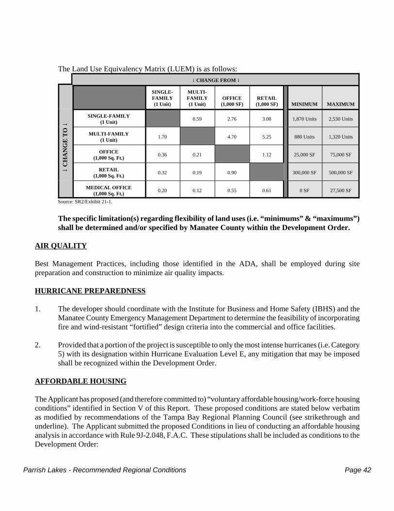
Parrish Lakes - Recommended Regional Conditions Page 42
The Land Use Equivalency Matrix (LUEM) is as follows:9 CHANGE FROM 9
9 C
HA
NG
E T
O 9
SINGLE-FAMILY(1 Unit)
MULTI-FAMILY(1 Unit)
OFFICE(1,000 SF)
RETAIL(1,000 SF) MINIMUM MAXIMUM
SINGLE-FAMILY(1 Unit) 0.59 2.76 3.08 1,870 Units 2,530 Units
MULTI-FAMILY(1 Unit) 1.70 4.70 5.25 880 Units 1,320 Units
OFFICE(1,000 Sq. Ft.) 0.36 0.21 1.12 25,000 SF 75,000 SF
RETAIL(1,000 Sq. Ft.) 0.32 0.19 0.90 300,000 SF 500,000 SF
MEDICAL OFFICE(1,000 Sq. Ft.) 0.20 0.12 0.55 0.61 0 SF 27,500 SF
Source: SR2/Exhibit 21-1.
The specific limitation(s) regarding flexibility of land uses (i.e. “minimums” & “maximums”)shall be determined and/or specified by Manatee County within the Development Order.
AIR QUALITY
Best Management Practices, including those identified in the ADA, shall be employed during sitepreparation and construction to minimize air quality impacts.
HURRICANE PREPAREDNESS
1. The developer should coordinate with the Institute for Business and Home Safety (IBHS) and theManatee County Emergency Management Department to determine the feasibility of incorporatingfire and wind-resistant “fortified” design criteria into the commercial and office facilities.
2. Provided that a portion of the project is susceptible to only the most intense hurricanes (i.e. Category5) with its designation within Hurricane Evaluation Level E, any mitigation that may be imposedshall be recognized within the Development Order.
AFFORDABLE HOUSING
The Applicant has proposed (and therefore committed to) “voluntary affordable housing/work-force housingconditions” identified in Section V of this Report. These proposed conditions are stated below verbatimas modified by recommendations of the Tampa Bay Regional Planning Council (see strikethrough andunderline). The Applicant submitted the proposed Conditions in lieu of conducting an affordable housinganalysis in accordance with Rule 9J-2.048, F.A.C. These stipulations shall be included as conditions to theDevelopment Order:
Parrish Lakes - Recommended Regional Conditions Page 43
1. The Developer shall enter into a voluntary housing mitigation program as set forth in the conditionsbelow.
2. The Developer may provide up to 330 units within the project that satisfies the requirements of the“affordable” or “workforce/essential worker” housing as defined by the Manatee County LandDevelopment Code.
3. The 330 units shall qualify upon the first sale or rental to an end user as workforce housing asdefined by the Manatee County Land Development Code. The sales price for such units shall bedetermined to qualify as workforce housing after excluding upgrades and options from theprice. The maximum sales price for the workforce housing units shall be based upon currentworkforce sales price as established by the methodology in the Manatee County Land DevelopmentCode and may be modified each year as determined by Manatee County.
4. The proposed units may be provided as either sale units or for rent multi-family units provided therental units meet the requirements within the Manatee County Local Housing Assistance Plan.
5. As an alternative to the construction of the units, the Developer may elect to contribute to theVoluntary Affordable Housing Mitigation Program payment no greater than $660,000 (330 units x$2,000 each), in terms of 2011 dollars, to the Manatee County Neighborhood Services Departmentor its designated Housing Assistance Program to fully satisfy any affordable or workforce housingrequirements for the Parrish Lakes DRI.
6. The Voluntary Affordable Housing Mitigation Program payment shall be made at time of buildingpermit for each residential unit on the project and payable at the rate of $100 $200 per residentialunit in terms of 2011 dollars. (3,300 units X $200 per unit = $660,000).
7. Residential units sold within the Parrish Lakes DRI that meet the Maximum Income Limits forqualifying individual(s) or Maximum Sales Price requirements for affordable or workforce housingas identified by the Manatee County Maximum Income Limits Table shall not require voluntary cashmitigation payment described in section 6 above. These units shall also receive all applicableincentives described in Section 1302 of the Manatee County Land Development Code for affordableand workforce housing. These maximum income limits and maximum sales prices are updatedperiodically by Manatee County and shall be utilized accordingly. The maximum sales price andincome limits in effect at the time a contract for purchase of an affordable or workforce housing unitis executed shall apply.
8. Residential units rented within the Parrish Lakes DRI that qualify as affordable housing or are equalto or less than a monthly mortgage payment for a workforce housing unit as identified in theManatee County Maximum Income Limits Table shall not require the voluntary cash mitigationpayment described in section 6 above. These units shall also receive all applicable incentivesdescribed in Section 1302 of the Manatee County Land Development Code for affordable andworkforce housing. These maximum income limits and maximum sales prices are updatedperiodically by Manatee County and shall be utilized accordingly. The maximum sale price (andrental equivalent) and income limits as well as the proposed price range of rental units in effect atthe time a certificate of occupancy is issued for multi-family residential building containingaffordable and/or workforce housing units shall apply.
Parrish Lakes - Recommended Regional Conditions Page 44
9. In lieu of the cash mitigation payments required above, either in whole or in part, Parrish Lakes DRImay propose for TBRPC, Florida Department of Community Affairs (FDCA) and ManateeCounty approval, one (1) or more “on-site” affordable housing programs to satisfy such obligationby one (1) or more of the following types of programs: provision of land for other affordablehousing programs; provision of affordable rental or purchase subsidy assistance; or other affordablehousing assistance deemed appropriate and suitable, in whole or in part, by TBRPC, FDCA andManatee County. If one or more such “on-site” programs are approved, then the funds in themitigation special revenue fund above, shall be utilized for such program(s).
10. The Developer shall include in its Biennial Report data showing the number and sale prices ofaffordable and/or workforce housing units sold or rented within the reporting period. The BiennialReport shall identify the sale of any unit via the property appraiser data for sales date. Rental shallinclude documentation on the number of units, rental rate and duration of initial contract. TheDeveloper shall also report the amount of voluntary cash mitigation payments made for residentialunits that do not qualify as affordable or workforce housing units.
11. The Developer retains the right to perform an affordable housing analysis consistent with 9J-2.048,Florida Administrative Code, at any time during development of the DRI to determine the affordablehousing need created by the project and the appropriate mitigation, if necessary, to be applied to theremainder of the project, subject to the concurrence of Manatee County, the Tampa BayRegional Planning Council and the FDCA.
12. The Developer shall attempt to maintain the 10% ratio of workforce/affordable units to make thenecessary mitigation payments throughout the development schedule. Should the project developmitigation units in excess of 10% at any time, any exceedance of mitigation units shall be createdcredited towards future development of the project. If during any biennial reporting period it isdetermined that the project had developed or paid the cash mitigation for less than 10% ratio, themitigation payments or units shall be provided to may be requested by the County as necessary.
POLICE AND FIRE PROTECTION
1. The Development Order shall include identification of the police/fire protection mitigation measuresnecessary to accommodate this development.
2. The Developer should apply Fire Wise principles such as clearing around houses and structures,carefully spacing trees, and maintaining irrigation systems.
RECREATION AND OPEN SPACE
1. All open space and recreation facilities within the Project shall be maintained by an appropriateentity such as a Community Development District or a Homeowners Association.
2. As committed, the Developer shall provide: up to 26 acres of parks within the project; the requestedfrontage along Erie Road, consistent with the requirements to the neighboring parcels, for expansionof the Ellenton-Willow Trail; and a Parks Master Plan to Manatee County.
Parrish Lakes - Recommended Regional Conditions Page 45
ENERGY
1. The developer shall incorporate energy conservation measures into the site design, buildingconstruction and landscaping to the maximum extent feasible.
2. The developer shall work with TECO/Peoples Gas to coordinate the availability of natural gaswithin the project, as committed.
HISTORICAL AND ARCHAEOLOGICAL
Any significant historical or archaeological resources discovered during project development, if applicable,shall be reported to the Florida Division of Historical Resources (FDHR) and the disposition of suchresources shall be determined in cooperation with the FDHR and Manatee County.
GENERAL CONDITIONS
1. Should development significantly depart from the parameters set forth in the ADA, the project willbe subject to substantial deviation review pursuant to Section 380.06, F.S.
2. Physical development shall commence within five years of Development Order adoption, in orderto have reasonable expectation of achieving the Phase 1 buildout date. For the purpose of theDevelopment Order, this term means construction of infrastructure, roadways or other verticaldevelopment.
3. Any approval of Parrish Lakes shall, at minimum, satisfy the provisions of Subsection 380.06(15),F.S., and the following provisions of the Florida Administrative Code (F.A.C.): Rule 9J-2.041(Listed Plant and Wildlife Resources Uniform Standard Rule); Rule 9J-2.043 (Archaeological andHistorical Resources Uniform Standard Rule); Rule 9J-2.044 (Hazardous Material Usage, PotableWater, Wastewater, and Solid Waste Facilities Uniform Standard Rule); Rule 9J-2.045(Transportation Uniform Standard Rule); and 9J-2.048 (Adequate Housing Uniform Standard Rule).
4. Any approval of this development shall require that all of the developer’s commitments set forth inthe ADA and subsequent Sufficiency Responses be honored as Development Order conditions,except as they may be superseded by specific terms of the Development Order. Such developercommitments have been summarized in Section III of this Report.
5. Payment for any future activities of the TBRPC with regard to this development including, but notlimited to monitoring or enforcement actions, shall be paid to the TBRPC by the developer inaccordance with Rule 9J-2.0252, F.A.C.
6. Approval of Parrish Lakes DRI shall be contingent upon the project's consistency with the ManateeCounty Comprehensive Plan adopted pursuant to the Local Government Comprehensive PlanningAct, Chapter 163, F.S., and the state and regional plans.
Parrish Lakes - Recommended Regional Conditions Page 46
7. The Development Order should take into account any applicable concerns set forth in the attachedletters of the Southwest Florida Water Management District and the Florida Department ofEnvironmental Protection.
_______________________________ William Dodson, Chair
ATTEST: _______________________________ Lori Denman, Recording Secretary
These comments and recommendations were approved by a majority vote ofthe Tampa Bay Regional Planning Council on this 11th day of April, 2011
Parrish Lakes - Voluntary Affordable Housing/Workforce Housing Mitigation Program Page 47
SECTION VVOLUNTARY AFFORDABLE HOUSING/WORKFORCE HOUSING CONDITIONS
DRI #269 - PARRISH LAKESMANATEE COUNTY

Parrish Lakes - Voluntary Affordable Housing/Workforce Housing Mitigation Program Page 48
Parrish Lakes - Voluntary Affordable Housing/Workforce Housing Mitigation Program Page 49
Parrish Lakes - Voluntary Affordable Housing/Workforce Housing Mitigation Program Page 50

Parrish Lakes - Voluntary Affordable Housing/Workforce Housing Mitigation Program Page 51
Parrish Lakes - Review Agency Comments Page 51
SECTION VII - REVIEW AGENCY COMMENTSDRI #269 - PARRISH LAKES
MANATEE COUNTY
Comments for the following Review Agencies are attached
Southwest Florida Water Management DistrictFlorida Department of Environmental Protection
Florida Fish and Wildlife Conservation Commission

Parrish Lakes - Review Agency Comments Page 52
Parrish Lakes - Review Agency Comments Page 53
Parrish Lakes - Review Agency Comments Page 54
Parrish Lakes - Review Agency Comments Page 55
Parrish Lakes - Review Agency Comments Page 56
Parrish Lakes - Review Agency Comments Page 57
Parrish Lakes - Review Agency Comments Page 58
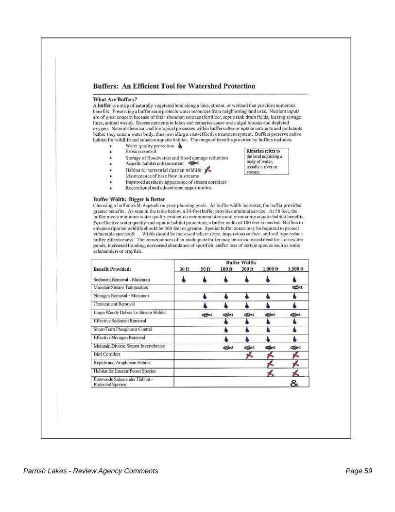
Parrish Lakes - Review Agency Comments Page 59
Parrish Lakes - Review Agency Comments Page 60
1
Agenda Item #105/9/11
Council MinutesApril 11, 2011
10:00 a.m.REPRESENTATIVES PRESENTChair, Vice Mayor Bill Dodson, City of Plant CityVice Chair, Commissioner Larry Bustle, Manatee CountySecretary/Treasurer, Mayor Bob Minning, City of Treasure IslandPast Chair, Commissioner Jack Mariano, Pasco County Commissioner Nina Bandoni, City of Safety HarborVice Mayor Ron Barnette, City of DunedinMayor Scott Black, City of Dade CityCommissioner Neil Brickfield, Pinellas CountyCommissioner Woody Brown, City of LargoCommissioner Victor Crist, Hillsborough CountyCommissioner Robin DiSabatino, Alt., Manatee CountyCommissioner Al Halpern, City of St. Pete BeachCouncilman Sam Henderson, City of GulfportCouncil Member Bill Jonson, City of ClearwaterMr. Robert Kersteen, Pinellas County Gubernatorial AppointeeMr. Harry Kinnan, Manatee County Gubernatorial AppointeeMs. Angeleah Kinsler, Hillsborough County Gubernatorial AppointeeCouncilor Bob Matthews, City of SeminoleCouncil Member Janice Miller, City of OldsmarCouncil Member Wengay Newton, City of St. PetersburgMs. Barbara Sheen Todd, Pinellas County Gubernatorial AppointeeMr. Charles Waller, Pasco County Gubernatorial AppointeeMs. Pamela Vazquez, Ex-Officio, Department of Environmental ProtectionMr. Waddah Farah, Alt., Ex-Officio, Florida Department of Transportation Ms. Michelle Miller, Ex-Officio, Enterprise Florida
REPRESENTATIVES ABSENTMayor David Archie, City of Tarpon SpringsMayor Shirley Groover Bryant, City of Palmetto Commissioner Larry Bustle, Vice Chair, Manatee CountyCouncilman Bob Langford, City of New Port Richey Councilwoman Mary Mulhern, City of TampaMr. Andy Núñez, Pinellas County Gubernatorial AppointeeMayor Kathleen Peters, City of South PasadenaCouncil Member David Pogorilich, City of Temple TerraceVice Mayor Patrick Roff, City of BradentonVice Mayor Ed Taylor, City of Pinellas Park Ms. Kim Vance, Hillsborough County Gubernatorial AppointeeMr. Earl Young, Pasco County Gubernatorial AppointeeMr. Todd Pressman, Ex-Officio, Southwest Florida Water Management District
2
OTHERS PRESENTTrisha Neasman, Planner, SWFWMDJohn Healey, Planner, Hillsborough CountyJennifer Salmon, Alt., Council Member, City of GulfportLisa Barrett, Manatee CountyBob Agouse, Manatee CountyCori Cuttler, Community Affairs Manager, SWFWMDTodd Pokrywa, V.P. Planning, SMRScott Sheridan, VP Planning, King EngineeringWill Augustine, Planner, Hillsborough County Planning Commission
STAFF PRESENTMr. Manny Pumariega, Executive DirectorMr. Donald Conn, Legal CounselMs. Suzanne Cooper, Principal PlannerMs. Lori Denman, Recording SecretaryMr. John Jacobsen, Accounting ManagerMs. Betti Johnson, Principal PlannerMs. Wren Krahl, Director of Administration/Public Information Ms. Jessica Lunsford, Senior PlannerMr. John Meyer, Principal PlannerMr. Greg Miller, Senior PlannerMr. Patrick O’Neil, Senior PlannerMs. Amanda Shaw, Senior PlannerMr. Brady Smith, Senior PlannerMr. Avera Wynne, Planning Director
Call to Order – Chair DodsonThe April 11, 2011 regular meeting of the Tampa Bay Regional Planning Council (TBRPC) was called toorder at 10:03 a.m.
...
5. Review Item(s) or Any Other Item(s) for DiscussionDRI # 269 - Parrish Lakes, Final Report, Manatee County
Mr. John Meyer, DRI Coordinator, Principal Planner, provided the Final Report. The project islocated in northern Manatee County, approximately one mile to the east of I-75, and about threemiles south of the Hillsborough County line. The project is proposed to be built over two phasesover the next 19 years. The mixed uses consist of 3,300 residential units, 400,000 sq. ft. of Retailand 50,000 sq. ft. of Office with a buildout date of 2030. The Residential units are intended to bescattered across the entire project with a large concentration of Retail uses located at one of theproposed project drives at Moccasin Wallow Road. A proposed Town Center is also centrallylocated.
Very few Natural Resources of Regional Significance are located on the project site. Note that theproposed Preservation Area essentially coincides with the NRRS designation. The project willrequire evacuation from only the most severe hurricane events, a Category 5. The vulnerable portionof the site is projected to be the central section.
3
The applicant is seeking specific approval of both phases of the 2-phase project and has made severalcommitments during the course of the DRI review including: up to 26 acres of parkland, ROW foralong southern end of project for continuance of the Ellenton-Willow Trail, and the Preservation areaas proposed in the Master Development Plan. The applicant will prepare a Habitat ManagementPlan, Stormwater Management Plan and a Parks Master Plan to coincide with the projectdevelopment.
Pages 19-21of the Council’s Final Report identify the impacted roadway links and intersectionssignificantly impacted by the project. Please recall that Subsection 163.3180, F.S. acknowledges thatDRI Developers are no longer responsible to mitigating transportation impacts for roadway links andintersections that are reduced below an acceptable level of service in the current or current plusbackground traffic conditions. The ones highlighted in yellow are the ones which would requiremitigation. A biennial traffic monitoring requirement would ensure the validity of the trafficprojections.
The applicant has additionally proposed a Voluntary Affordable Housing/Workforce Housingprogram which should be recognized in the Development Order.
Mr. Meyer introduced Scott Sheridan, King Engineering, representing the developer FLM, Inc.Parrish Lakes is specifically bound by Moccasin Wallow Road on the north, and Erie Road on thesouth. The property was mainly agricultural and citrus, a little bit of cattle. Mr. Sheridan showedaerial views of the property and stated that in the center the Town Center will be located. In thenortheast corner of the property there is an upland preserve which is the limit of the natural resourcesof regional significance. We have committed to incorporate that into a Master Parkland Plan andpreserve that upland area, along with Buffalo Canal which bisects the property going east and west.Up to 26 acres of Parks and Open space will be provided to the county via a Master Parks Plan.There is also a provision for land along Erie Road for the Willow Ellenton Trail, running southboundthrough this property, buffers to all wetlands consistent with Manatee County Code and SWFWMDregulations, as well as adherence to State and Federal regulations for listed species.
The property is located adjacent to a wastewater treatment plant and we are optimistic that we canuse reclaimed water throughout the property to reduce ground withdrawal. We worked closely withMr. Meyer and the county on the ground and surface water monitoring plan. There will be minimalimpacts to Buffalo Creek/Canal. The school board owns the property on the southwest corner, justoutside the limits of the DRI. My client is committed to assist them in providing access to theinfrastructure of this project so they can access that property a little more directly than their currentfrontage allows. There are two roads that run north/south through the property which provideimportant connections.
We would appreciate the Council adopting staff’s Final Report. We will work with the county overthe next 60 days to finalize the Development Order with Manatee County. Then we will movethrough the public hearing process with Manatee County to hopefully conclude this by the end of thesummer.
Questions & Comments:Council Member Newton: What is voluntary workforce/affordable housing?Mr. Sheridan: We worked with staff and in lieu of doing an affordable housing study
when this project was originally contemplated we knew there was probablysome workforce housing available in the immediate area. So rather thangoing through this study and doing the evaluation, my client was opened toproviding some form of affordable/workforce housing in the county. The
4
county has a workforce housing ordinance that is already in place whichestablishes parameters and thresholds for income levels, etc. for both rentaland home buyer assistance. We proposed following the county ordinancethat is in place. It is a commitment for the project that they will eitherprovide the housing on site or make a contribution to the county’s existingprograms to provide it as well.
Commissioner Mariano: The school site, was that one of the conditions of the DRI?Mr. Sheridan: The school board actually acquired that property. They own that property
outright. It has frontage along Erie Road on the south side of the property.Mr. Kinnan: I’m with the school board and yes, we have owned that for some time. The
20 acres is suitable for an elementary school. I think it is time for you to getin touch with the school board as you move forward with this initiative.
Mr. Sheridan: We’ve made that commitment for when this goes to development. Theinfrastructure of corridor roads, the alignment that will run along the easternboundary, the west side of this property, and access.
Commissioner Mariano: The reclaimed water, is that already set up or is it in the process?Mr. Sheridan: The reclaimed line is existing in the ground through the property already so
the infrastructure is already there. At the appropriate time that it needs tocome on line we will coordinate with the utility.
Ms. Todd: Has the county reviewed? Mr. Sheridan: Yes, the county has been very much involved in the DRI review process.
The process requires that we come to the RPC first for yourrecommendation, as well as the county’s own recommendation and then wemove to the county process for the Development Order. The county hasbeen involved since the inception of this project. Relative to both CorridorRoad and Sawgrass Road, the roads on site, it is contemplated that thedeveloper will construct those roads. They are not in place right now. Theywill be built incrementally as the project develops.
Commissioner Halpern: What is the target for your residential? What are you visualizing the price range?Mr. Sheridan: That’s tough to answer today. There is both multi-family and rental as well
as single family. The way the product has been contemplated is there couldbe a diverse amount of housing supply to both address the affordableworkforce element as well as higher end single family. It’s probably entrylevel through the middle of the market.
Council Member Jonson: I’m interested in the transportation impact fees and how we accommodatesome of the resolutions of some of the roads that aren’t highlighted. Ingeneral, how do you eventually resolve some of these issues?
Mr. Conn, TBRPC Legal Counsel: The legal issue that I think is underlying the question has to do with
backlog. This is a question that has been coming up before localgovernment for at least the last few years when SB 360 was passed. Therehas been legislation over the past couple of years trying to address thisissue. SB 360, as you may recall, was passed in the 2009 session and wasruled by trial court to be unconstitutional. An appeal was taken, and thatappeal is still pending. There is no anticipated action in that appeal. In themeantime, the legislature this session has gone back and basically reenactedSB 360 - in three separate bills. They did that in order to address one of thelegal challenges which was the single subject rule violation and they passedit. The other legal challenge had to do with unfunded mandates. That isthat the legislation created an unfunded mandate burden on localgovernments. They have overcome that legal argument by passing the bills
5
by super majority. The bills have passed both the House and the Senate andthey are on their way to the Governor for his action. On the issue ofbacklog, backlog under that legislation, as well as other bills that arepending before the legislature, is specifically declared not to be somethingthat new development must address. But rather new development must beresponsible for new development’s impacts. So that leaves the questionabout impacted roads that are already at “F” or highly impacted - what is tohappen with those roads? Unfortunately I can’t give you an answer to thatother than to observe that there are only two ways of dealing with that. Oneis through FDOT on State Roads, assistance from FDOT which in theircurrent budget is unlikely, and the second way is through local government.But on the point of backlog, the current state of the law would relieve newdevelopment of the responsibility to deal with current conditions. That iscurrent backlog conditions. New development would be expected toaddress and to fund improvements to address impacts caused by the newdevelopment. That’s probably the underlying issue you raised. As to thespecific roads and whether they are “F” or what level they are, I will haveto defer to Mr. Meyer.
Council Member Jonson: Mr. Chair, Mr. Conn’s comments were right on. Based on my experiencesworking with TBARTA and some of the problems we have in PinellasCounty I’m more or less floating a question for the body, not so much forthe developer because it sounds like they are complying with all of therequirements that are in state law, but more a question of how do we get outof this box as a region for the future in trying to develop some of ourtransportation alternatives. I’m sure that Hillsborough County has the samekind of situation that Pinellas County has with some of the challenges withroads that are already in the “F” category. I’m just putting the question outfor any strategic response. Has the RPC thought about how to address thisperhaps on a regional basis?
Chair Dodson: It appears that Council Member Jonson is wanting feedback from the RPC.Anyone who wishes to provide a comment, please do so.
Commissioner Mariano: Pasco County has a plan for all the new development that takes the burdenoff the people.
Council Member Jonson: Is that transportation impact fee something that could be adopted by thecounty commissioners, or does that require a referendum?
Commissioner Mariano: No it doesn’t. It requires about a three month process. Chair Dodson: Plant City adopted mobility fees in lieu of transportation impact fees about
six months ago. I believe we were the first in our regional planning councilarea to do that. We are finding it to be a very acceptable manner in whichwe can recover against the cost or impacts when it comes to transportation.We did it by breaking up our city into five quadrants. The measure againstthe cost for impacts created by a specific development we recognized isgreater in some parts than others because in some parts we have a lot ofinfrastructure already in place and in other parts it is weaker. In the weakerareas the fees would be greater. If you would like any information from ourcity for your reference and your staff, we would be happy to supply it.
Commissioner DiSabatino: According to the study there’s anticipated 1481 jobs that will be created bythis development, $64 million in impact fees at full build-out, and an annualrevenue before full build-out in over $8 million and after full build-out of$14 million. That’s very significant for our county.
Councilman Newton: They reenacted SB 360 and got rid of the unfunded mandate. I wonder howthey did that.
6
Mr. Conn: Unfortunately the impacts are still there. They overcame the legal challengeby passing the bills by a super majority. The constitution allows thelegislature, by super majority, to pass legislation that does impose impactson local government.
Council Member Henderson: Is this going to be a gated community? Or a walled community?Mr. Sheridan: I don’t know the answer to that today. That has not been contemplated to
date. Council Member Henderson: The reason I asked is because Buffalo Creek is acting as a wildlife corridor
and I wondered if that is included in the 17.2 acres out of the 1,155. WouldBuffalo Creek be a part of that?
Mr. Sheridan: Yes. But I don’t believe Buffalo Creek is 17.2 acres. What you are lookingat is a table that identifies all of the ditches on the property.
Council Member Henderson: So the 17.2 acres is planned to be kept as preservation or park land?Mr. Sheridan: Buffalo Creek will be maintained in its existing configuration and at least
two roadways will have to cross it. But it will be retained as it sits today onthe property. That will be incorporated into the Master Park Plan.
Mr. Kinnan: Buffalo Creek isn’t really much of a creek. I think it’s going to beincumbent to have the open space and to try to incorporate what they can.There isn’t a real natural environment that you might think by the names.
Motion to adopt the Parrish Lakes Final Report and transmit to Manatee County and the FloridaDepartment of Community Affairs. (Black/Matthews)