Embed Size (px)
Citation preview

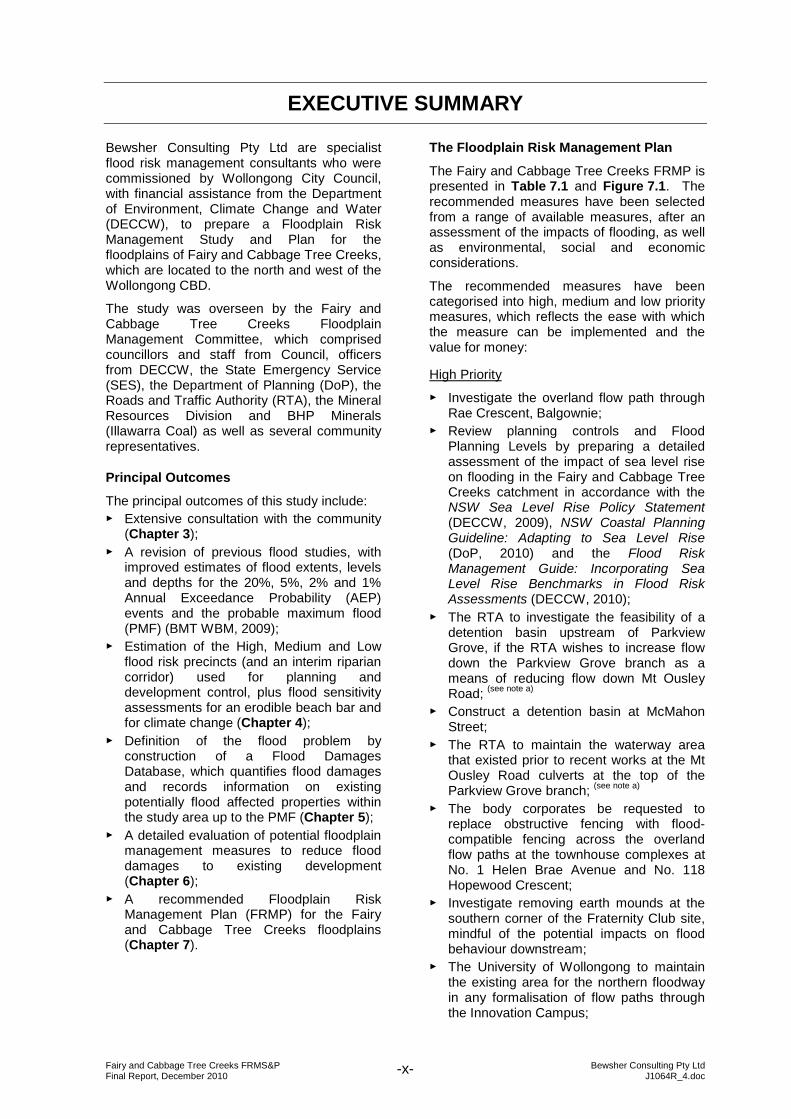
Damaged pedestrian bridge near Rae Crescent after the August 1998 flood
Final Report December 2010 Report of Wollongong City Council’s Fairy and Cabbage Tree Creeks Floodplain Management Committee
WOLLONGONG CITY COUNCIL
Fairy and Cabbage Tree Creeks Floodplain Risk Management Study & Plan Final Report December 2010 Report of Wollongong City Council’s Fairy and Cabbage Tree Creeks Floodplain Management Committee
Prepared by: Bewsher Consulting Pty Ltd 6/28 Langston Place, Epping NSW 2121 Australia P O Box 352, Epping NSW 1710 Australia Telephone: (02) 9868 1966. Facsimile: (02) 9868 5759 Web: www.bewsher.com.au E-mail: [email protected] ACN 003137068. ABN 24 312 540 210 The concepts and information contained in this document are the property of Bewsher Consulting Pty Ltd. Use or copying of this document in whole or part without the written permission of Bewsher Consulting Pty Ltd constitutes an infringement of copyright. This report has been prepared on behalf of and for the exclusive use of Bewsher Consulting Pty Ltd’s client. Bewsher Consulting Pty Ltd accepts no liability or responsibility whatsoever in respect of any use of or reliance upon this report by any third party.

Fairy and Cabbage Tree Creeks FRMS&P Bewsher Consulting Pty Ltd Final Report, December 2010 J1064R_4.doc -i-
FOREWORD In New South Wales the prime responsibility for local planning and the management of flood liable land rests with local government. To assist local government with floodplain management, the NSW Government has adopted a Flood Prone Land Policy in conjunction with the Floodplain Development Manual. The Policy is directed at providing solutions to existing flood problems and to ensure that new development is compatible with the flood hazard and does not create additional flood problems. The Policy sets out four sequential stages in the process of floodplain management: 1. Flood Study — Assessment to define the nature and extent of
flooding. 2. Floodplain Risk Management Study — Comprehensive evaluation of management
options with respect to existing and proposed development.
3. Floodplain Risk Management Plan — Formal adoption by Council of a management
plan for floodplain risks. 4. Implementation of the Plan — Measures undertaken to reduce the impact of
flooding on existing development, and implementing controls to ensure that new development is compatible with the flood hazard.
This Floodplain Risk Management Study and Plan (FRMS&P) constitutes the second and third stage of the management process for the Fairy and Cabbage Tree Creeks catchments. In broad terms, the Floodplain Risk Management Study has investigated what can be done to minimise the effects of flooding in the Fairy Creek and Cabbage Tree Creek catchments and has recommended a strategy in the form of the Floodplain Risk Management Plan. Wollongong City Council commissioned Bewsher Consulting to prepare this report. Council has prepared this document with financial assistance from the NSW Government through the Department of Environment, Climate Change and Water (DECCW). This document does not necessarily represent the opinions of the NSW Government or the Department of Environment, Climate Change and Water. The assistance of the Fairy and Cabbage Tree Creeks Floodplain Management Committee and officers from Wollongong City Council and DECCW in preparing this document is gratefully acknowledged. The assistance of Grech Planners in providing town planning advice is also acknowledged. It is noted that a separate study is underway to review and update the flood risk management provisions of Wollongong Development Control Plan 2009. Since this study was prepared before the release of the NSW Sea Level Rise Policy Statement (Oct 2009) and two State Government guidelines addressing sea level rise (DoP, 2010; DECCW, 2010), there is also a need for more detailed climate change flood risk assessments than were undertaken in this study.
Fairy and Cabbage Tree Creeks FRMS&P Bewsher Consulting Pty Ltd Final Report, December 2010 J1064R_4.doc -ii-
TABLE OF CONTENTS Page
EXECUTIVE SUMMARY ........................................................................................... x
1. INTRODUCTION ................................................................................................ 1 1.1 REASONS FOR THE STUDY ............................................................................... 1 1.2 OBJECTIVES OF THE STUDY............................................................................. 1 1.3 STUDY AREA ....................................................................................................... 1 1.4 FLOODPLAIN MANAGEMENT PROCESS........................................................... 3 1.5 PREVIOUS STUDIES ........................................................................................... 4
1.5.1 Fairy Creek Floodplain Management Study 1990 .......................................... 9 1.5.2 Cabbage Tree Creek Flood Study 1991 ........................................................ 9 1.5.3 Fairy Creek Floodplain Management Study 1996 .......................................... 9 1.5.4 Cabbage Tree Creek Floodplain Management Study 1997 ......................... 10 1.5.5 17 August 1998 Storms in Wollongong: Flood Data Report ......................... 11 1.5.6 Wollongong Innovation Campus Master Plan 2003 ..................................... 11 1.5.7 Fairy, Towradgi and Hewitts/Tramway Creeks Estuary Management Study &
Plan 2005 .................................................................................................... 12 1.5.8 Fairy Lagoon Entrance Management Policy 2007........................................ 12 1.5.9 Conference Papers and Other Literature ..................................................... 13
2. BACKGROUND INFORMATION ..................................................................... 15 2.1 CATCHMENT DESCRIPTION AND LANDUSE .................................................. 15 2.2 FLOOD HISTORY............................................................................................... 16
2.2.1 General ....................................................................................................... 16 2.2.2 August 1998 flood........................................................................................ 17
2.3 VEGETATION..................................................................................................... 19 2.3.1 Endangered Ecological Communities .......................................................... 19 2.3.2 Riparian Corridors ....................................................................................... 21
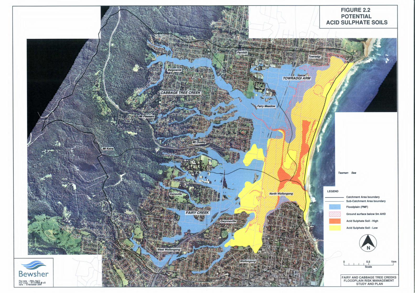
2.4 POTENTIAL ACID SULPHATE SOILS................................................................ 22 2.5 SOCIAL PROFILE............................................................................................... 24 2.6 HERITAGE ISSUES............................................................................................ 27
2.6.1 Aboriginal Heritage...................................................................................... 27 2.6.2 European Heritage ...................................................................................... 27
3. COMMUNITY CONSULTATION ...................................................................... 29 3.1 CONSULTATION PROCESS.............................................................................. 29 3.2 STORM SURVEY ............................................................................................... 29
3.2.1 August 1998 flood........................................................................................ 29 3.2.2 Floodplain Management Measures.............................................................. 30
3.3 FLOODPLAIN MANAGEMENT COMMITTEE..................................................... 32 3.4 PROJECT WEB-SITE ......................................................................................... 32 3.5 COMMUNITY NEWSLETTER............................................................................. 32 3.6 POSTER DISPLAY OF FLOOD MODEL RESULTS............................................ 33 3.7 COMMUNITY QUESTIONNAIRES ..................................................................... 33
3.7.1 Flood Model Evaluation ............................................................................... 33 3.7.2 Floodplain Management Measures.............................................................. 33
3.8 AGENCY AND INTEREST GROUP QUESTIONNAIRE...................................... 38 3.8.1 Potential Damage to Assets and Services ................................................... 39 3.8.2 Other Comments and Suggestions for Study to Address ............................. 39
Fairy and Cabbage Tree Creeks FRMS&P Bewsher Consulting Pty Ltd Final Report, December 2010 J1064R_4.doc -iii-
TABLE OF CONTENTS Page
3.9 PUBLIC EXHIBITION.......................................................................................... 40
4. FLOOD BEHAVIOUR SUMMARY ................................................................... 41 4.1 EXISTING FLOOD BEHAVIOUR – METHODS................................................... 41 4.2 EXISTING FLOOD BEHAVIOUR – RESULTS .................................................... 42
4.2.1 Flood Depths ............................................................................................... 42 4.2.2 Flood Risk Precincts.................................................................................... 43
4.3 BEACH BAR MORPHOLOGY SENSITIVITY TEST ............................................ 45 4.3.1 Background ................................................................................................. 45 4.3.2 Method ........................................................................................................ 45 4.3.3 Results ........................................................................................................ 45
4.4 CLIMATE CHANGE SENSITIVITY TEST............................................................ 45 4.4.1 Background ................................................................................................. 45 4.4.2 Method ........................................................................................................ 46 4.4.3 Results ........................................................................................................ 46
4.5 FUTURE WORK ................................................................................................. 47
5. DEFINING THE FLOOD PROBLEM ................................................................ 55 5.1 FLOOD DAMAGES DATABASE ......................................................................... 55 5.2 TYPES OF FLOOD DAMAGE............................................................................. 57 5.3 BASIS OF FLOOD DAMAGES CALCULATIONS................................................ 58
5.3.1 Residential................................................................................................... 58 5.3.2 Commercial/Industrial .................................................................................. 58 5.3.3 Infrastructure ............................................................................................... 58 5.3.4 Motor Vehicles............................................................................................. 58 5.3.5 Social .......................................................................................................... 59
5.4 ECONOMIC ANALYSIS ...................................................................................... 59 5.5 SUMMARY OF FLOOD DAMAGES .................................................................... 60
6. EVALUATION OF FLOODPLAIN MANAGEMENT MEASURES .................... 64 6.1 MEASURES THAT MODIFY FLOOD BEHAVIOUR ............................................ 69
6.1.1 Detention Basins ......................................................................................... 69 6.1.1.1 Existing Basin Performance ........................................................................................ 69 6.1.1.2 Guest Park basin ......................................................................................................... 70 6.1.1.3 Parkview Grove basin.................................................................................................. 70 6.1.1.4 McMahon Street basin................................................................................................. 70
6.1.2 Flow Diversions and Floodways .................................................................. 72 6.1.2.1 Mt Ousley Road to Parkview Grove branch flow diversion ......................................... 72 6.1.2.2 Helen Brae Avenue/Hopewood Crescent overland flow path enhancement .............. 72 6.1.2.3 Anama Street floodway ............................................................................................... 73 6.1.2.4 Northern Distributor mounds ....................................................................................... 73 6.1.2.5 University of Wollongong Innovation Campus floodways ........................................... 74 6.1.2.6 Keiraville Public School floodway restoration.............................................................. 77 6.1.2.7 F6 Freeway soundwalls............................................................................................... 81 6.1.2.8 Towradgi Arm ocean exit............................................................................................. 82 6.1.2.9 Rann Street floodways ................................................................................................ 82 6.1.2.10 Floodway south of Squires Way bridge ................................................................. 82
6.1.3 Managing Bridge and Culvert Blockage....................................................... 83 6.1.3.1 The influence of structure blockage ............................................................................ 83 6.1.3.2 Strategies for managing blockage............................................................................... 85
Fairy and Cabbage Tree Creeks FRMS&P Bewsher Consulting Pty Ltd Final Report, December 2010 J1064R_4.doc -iv-
TABLE OF CONTENTS Page
6.1.4 Bridge/Culvert Amplification......................................................................... 86 6.1.4.1 Helen Brae Avenue/Hopewood Crescent culverts ...................................................... 86 6.1.4.2 Dawson Street culvert ................................................................................................. 87 6.1.4.3 Parkview Grove culvert................................................................................................ 87 6.1.4.4 Robsons Road culvert ................................................................................................. 87 6.1.4.5 Northern Distributor/Railway culverts .......................................................................... 88
6.1.5 Debris Control Structures ............................................................................ 91 6.1.6 Channel Works............................................................................................ 94
6.1.6.1 Wellington Drive branch .............................................................................................. 95 6.1.6.2 Cabbage Tree Creek upstream of Chalmers Street.................................................... 96 6.1.6.3 Cabbage Tree Creek upstream of Anama Street........................................................ 96 6.1.6.4 Dobinson Street branch upstream of Hopewood Crescent......................................... 96
6.1.7 Manage Riparian Corridor ........................................................................... 97 6.1.8 Levees......................................................................................................... 99
6.1.8.1 Balmoral Street levee .................................................................................................. 99 6.1.8.2 College Place levee..................................................................................................... 99
6.1.9 Fairy Lagoon Entrance Management Policy .............................................. 100 6.2 MEASURES THAT MODIFY PROPERTY......................................................... 101
6.2.1 Voluntary House Purchase ........................................................................ 101 6.2.1.1 General scheme ........................................................................................................ 101 6.2.1.2 Anama Street motel................................................................................................... 103
6.2.2 Voluntary House Raising/Redevelopment ................................................. 105 6.2.3 Flood-proofing ........................................................................................... 107 6.2.4 Planning and Development Controls.......................................................... 108
6.2.4.1 NSW Floodplain Risk Management Policy Context .................................................. 108 6.2.4.2 Wollongong City Council Floodplain Risk Management Policy Context ................... 110 6.2.4.3 Wollongong LEP........................................................................................................ 110 6.2.4.4 Development Control Plan (WDCP 2009) ................................................................. 111 6.2.4.5 Flood Planning Levels (FPLs) ................................................................................... 112 6.2.4.6 Climate Change Considerations................................................................................ 113
6.3 MEASURES THAT MODIFY PEOPLE’S RESPONSE TO FLOODING............. 115 6.3.1 Improve Flood Warning System................................................................. 115 6.3.2 Improve Emergency Management Planning .............................................. 119
6.3.2.1 Flood intelligence....................................................................................................... 119 6.3.2.2 Shelter-in-place versus evacuate .............................................................................. 120 6.3.2.3 Isolation ..................................................................................................................... 121 6.3.2.4 SES Local Headquarters ........................................................................................... 122
6.3.3 Improve Public Flood Readiness ............................................................... 123 6.3.3.1 Certificates................................................................................................................. 124 6.3.3.2 Brochures .................................................................................................................. 124 6.3.3.3 Web-site .................................................................................................................... 124 6.3.3.4 Markers/Road Depth Indicators................................................................................. 126 6.3.3.5 Meter Box Labels....................................................................................................... 126 6.3.3.6 Workshops................................................................................................................. 126 6.3.3.7 Commemorations ...................................................................................................... 126 6.3.4.8 Recommendations..................................................................................................... 127

Fairy and Cabbage Tree Creeks FRMS&P Bewsher Consulting Pty Ltd Final Report, December 2010 J1064R_4.doc -v-
TABLE OF CONTENTS Page
7. FLOODPLAIN RISK MANAGEMENT PLAN ................................................. 128 7.1 RECOMMENDATIONS..................................................................................... 128 7.2 HIGH PRIORITY MEASURES .......................................................................... 128 7.3 MEDIUM PRIORITY MEASURES..................................................................... 129 7.4 LOW PRIORITY MEASURES ........................................................................... 129 7.5 FUNDING AND IMPLEMENTATION................................................................. 130 7.6 ON-GOING REVIEW OF PLAN ........................................................................ 130
8. REFERENCES ............................................................................................... 134
9. FREQUENTLY ASKED QUESTIONS............................................................ 138
10. GLOSSARY.................................................................................................... 142
Fairy and Cabbage Tree Creeks FRMS&P Bewsher Consulting Pty Ltd Final Report, December 2010 J1064R_4.doc -vi-
LIST OF APPENDICES APPENDIX A – FLOOD HISTORY
APPENDIX B – EXTRACT FROM RIPARIAN CORRIDOR MANAGEMENT STUDY
APPENDIX C – COMMUNITY CONSULTATION MATERIAL
APPENDIX D – SAND PARTICLE GRADING ANALYSIS, FAIRY LAGOON BEACH BAR
APPENDIX E – FLOOD DAMAGES SUMMARY
APPENDIX F – ASSESSMENT OF BRIDGE AND CULVERT BLOCKAGE IN THE AUGUST 1998 FLOOD
APPENDIX G – DRAFT, INTERIM PRESCRIPTIVE CONTROLS FOR FAIRY AND CABBAGE TREE CREEKS FLOODPLAIN
APPENDIX H – CLIMATE CHANGE PLANNING CONSIDERATIONS
APPENDIX I – RAIN GAUGES AND WATER LEVEL RECORDERS IN THE FAIRY AND CABBAGE TREE CREEKS CATCHMENTS
APPENDIX J – REVISED FLOOD MAPPING AT INNOVATION CAMPUS
Fairy and Cabbage Tree Creeks FRMS&P Bewsher Consulting Pty Ltd Final Report, December 2010 J1064R_4.doc -vii-
LIST OF TABLES Page
TABLE 1.1 – Floodplain Management Recommendations from Previous Studies, and
Status of Implementation 4
TABLE 1.2 – Fairy Lagoon Entrance Management Policy 13
TABLE 2.1 – Watercourse and Tributary Naming Conventions 16
TABLE 2.2 – Riparian Management Objectives 21
TABLE 2.3 – Estimated Association between Elevation and ASS Potential 22
TABLE 2.4 – Census Data for Suburbs in Study Area 25
TABLE 2.5 – Heritage Items Located Within the Floodplain 28
TABLE 3.1 – Types of Damage Reported from the August 1998 Flood 31
TABLE 3.2 – Meetings of Fairy and Cabbage Tree Creeks Floodplain Management Committee
32
TABLE 3.3 – Floodplain Management Measures Most Favoured by the Community 34
TABLE 3.4 – Floodplain Management Measures Most Opposed (or Least Favoured) by the Community
34
TABLE 3.5 – Liaison with Agencies and Interest Groups (March 2004) 38
TABLE 5.1 – Attributes Recorded in Flood Damages Database 56
TABLE 5.2 – Summary of Flood Damages by Event 60
TABLE 5.3 – Summary of Flood Damages by Area 60
TABLE 5.4 – Summary of Problem Areas 61
TABLE 5.5 – Components of Flood Damage for Fairy and Cabbage Tree Creeks (AAD) ($2008)
62
TABLE 6.1 – Explanation of Assessment Scores for Qualitative Assessment Matrix 66
TABLE 6.2 – Qualitative Matrix Assessment of Floodplain Risk Management Options 67
TABLE 6.3 – Existing Detention Basin Performance 69
TABLE 6.4 – Influence of Blockage on Building Inundation Patterns 84
TABLE 6.5 – Strategies for Managing Blockage 85
TABLE 6.6 – Influences on Management of Riparian Corridors 97
TABLE 6.7 – Potential Variation of Subsidies for Voluntary House Raising/ Redevelopment
106
TABLE 6.8 – Bureau of Meteorology Warning Services of Potential Benefit in Flash Flood Catchments
116
TABLE 6.9 – Illawarra Retirement Trust Facilities within the Fairy and Cabbage Tree Creeks Floodplain
120
TABLE 7.1 – Fairy and Cabbage Tree Creeks Floodplain Risk Management Plan 131
Fairy and Cabbage Tree Creeks FRMS&P Bewsher Consulting Pty Ltd Final Report, December 2010 J1064R_4.doc -viii-
LIST OF FIGURES Page
FIGURE 1.1 – Study Area 2
FIGURE 1.2 – The Floodplain Risk Management Process 3
FIGURE 1.3 – Previously Implemented Floodplain Management Measures 8
FIGURE 2.1 – Endangered Ecological Communities 20
FIGURE 2.2 – Potential Acid Sulphate Soils 23
FIGURE 2.3 – Dwelling Structure by Suburb, 2006 Census 26
FIGURE 3.1 – Flood Depths, August 1998 Flood, Fairy and Cabbage Tree Creeks Catchment
30
FIGURE 3.2 – Community Views on Quality of Match between Experience of Flood and Model Results, 1998 Flood
34
FIGURE 3.3 – Community Views on List of Potential Floodplain Management Options
35
FIGURE 3.4 – Community Views on Solutions to Flood Problem 36
FIGURE 4.1 – Existing 1% AEP Flood Depths 49
FIGURE 4.2 – Existing Flood Risk Precincts 50
FIGURE 4.3 – Morphology Sensitivity: Change in Water Level 20% AEP Flood 51
FIGURE 4.4 – Morphology Sensitivity: Change in Water Level 5% AEP Flood 52
FIGURE 4.5 – Morphology Sensitivity: Hydrographs at Squires Way, 5% AEP Flood 53
FIGURE 4.6 – Climate Change Sensitivity: Change in Water Level 1% AEP Flood 54
FIGURE 5.1 – Types of Flood Damage 57
FIGURE 5.2 – Distribution of Dwellings and Businesses Expected to be Inundated above Floor Level in the 20%, 5% and 1% AEP Floods
63

Fairy and Cabbage Tree Creeks FRMS&P Bewsher Consulting Pty Ltd Final Report, December 2010 J1064R_4.doc -ix-
LIST OF FIGURES (cont.) Page
FIGURE 6.1 – McMahon Street Detention Basin 71
FIGURE 6.2 – Wollongong Innovation Campus Floodway Concept Design 75
FIGURE 6.3 – Wollongong Innovation Campus Floodway Impacts 76
FIGURE 6.4 – Keiraville Public School Floodway Scheme Photos 78
FIGURE 6.5 – Keiraville Public School Floodway Scheme 79
FIGURE 6.6 – Keiraville Public School Floodway Scheme Impacts 80
FIGURE 6.7 – Influence of F6 Freeway Soundwalls near Robsons Road 81
FIGURE 6.8 – Degree of Hydraulic Structure Blockage versus Diagonal Width, Fairy and Cabbage Tree Creeks Catchment, August 1998 Flood
83
FIGURE 6.9 – Bridge and Culvert Photos 89
FIGURE 6.10 – Proposed Sites for Debris Control Structures 92
FIGURE 6.11 – Debris Control Structure Photos 93
FIGURE 6.12 – Cabbage Tree Creek Channel Erosion and Remediation after August 1998 Flood, Upstream of Balgownie Road
94
FIGURE 6.13 – Erosion at No. 47 Wellington Drive 95
FIGURE 6.14 – Dwellings Recommended for Inclusion in Voluntary Purchase or Voluntary House Raising/Redevelopment Schemes, or for Flood Proofing
104
FIGURE 6.15 – Flood Hydrographs, Cabbage Tree Creek and Fairy Creek MHL Recorders, 17 August 1998
118
FIGURE 6.16 – Sample Flood Certificate 125
FIGURE 7.1 – Recommended Measures 133
Fairy and Cabbage Tree Creeks FRMS&P Bewsher Consulting Pty Ltd Final Report, December 2010 J1064R_4.doc -x-
EXECUTIVE SUMMARY
Bewsher Consulting Pty Ltd are specialist flood risk management consultants who were commissioned by Wollongong City Council, with financial assistance from the Department of Environment, Climate Change and Water (DECCW), to prepare a Floodplain Risk Management Study and Plan for the floodplains of Fairy and Cabbage Tree Creeks, which are located to the north and west of the Wollongong CBD.
The study was overseen by the Fairy and Cabbage Tree Creeks Floodplain Management Committee, which comprised councillors and staff from Council, officers from DECCW, the State Emergency Service (SES), the Department of Planning (DoP), the Roads and Traffic Authority (RTA), the Mineral Resources Division and BHP Minerals (Illawarra Coal) as well as several community representatives.
Principal Outcomes
The principal outcomes of this study include: ► Extensive consultation with the community
(Chapter 3); ► A revision of previous flood studies, with
improved estimates of flood extents, levels and depths for the 20%, 5%, 2% and 1% Annual Exceedance Probability (AEP) events and the probable maximum flood (PMF) (BMT WBM, 2009);
► Estimation of the High, Medium and Low flood risk precincts (and an interim riparian corridor) used for planning and development control, plus flood sensitivity assessments for an erodible beach bar and for climate change (Chapter 4);
► Definition of the flood problem by construction of a Flood Damages Database, which quantifies flood damages and records information on existing potentially flood affected properties within the study area up to the PMF (Chapter 5);
► A detailed evaluation of potential floodplain management measures to reduce flood damages to existing development (Chapter 6);
► A recommended Floodplain Risk Management Plan (FRMP) for the Fairy and Cabbage Tree Creeks floodplains (Chapter 7).
The Floodplain Risk Management Plan
The Fairy and Cabbage Tree Creeks FRMP is presented in Table 7.1 and Figure 7.1. The recommended measures have been selected from a range of available measures, after an assessment of the impacts of flooding, as well as environmental, social and economic considerations.
The recommended measures have been categorised into high, medium and low priority measures, which reflects the ease with which the measure can be implemented and the value for money:
High Priority ► Investigate the overland flow path through
Rae Crescent, Balgownie; ► Review planning controls and Flood
Planning Levels by preparing a detailed assessment of the impact of sea level rise on flooding in the Fairy and Cabbage Tree Creeks catchment in accordance with the NSW Sea Level Rise Policy Statement (DECCW, 2009), NSW Coastal Planning Guideline: Adapting to Sea Level Rise (DoP, 2010) and the Flood Risk Management Guide: Incorporating Sea Level Rise Benchmarks in Flood Risk Assessments (DECCW, 2010);
► The RTA to investigate the feasibility of a detention basin upstream of Parkview Grove, if the RTA wishes to increase flow down the Parkview Grove branch as a means of reducing flow down Mt Ousley Road; (see note a)
► Construct a detention basin at McMahon Street;
► The RTA to maintain the waterway area that existed prior to recent works at the Mt Ousley Road culverts at the top of the Parkview Grove branch; (see note a)
► The body corporates be requested to replace obstructive fencing with flood-compatible fencing across the overland flow paths at the townhouse complexes at No. 1 Helen Brae Avenue and No. 118 Hopewood Crescent;
► Investigate removing earth mounds at the southern corner of the Fraternity Club site, mindful of the potential impacts on flood behaviour downstream;
► The University of Wollongong to maintain the existing area for the northern floodway in any formalisation of flow paths through the Innovation Campus;
Fairy and Cabbage Tree Creeks FRMS&P Bewsher Consulting Pty Ltd Final Report, December 2010 J1064R_4.doc -xi-
► Implement the Keiraville Public School floodway restoration scheme;
► The RTA to increase the spacing between the F6 Freeway soundwalls near Buckle Crescent and Robsons Road; (see note a)
► Install 16 debris control structures and secure fencing at critical locations through the catchment, noting the high priorities at sites C4, C7, F3 and F7 marked on Figure 6.10;
► Protect an eroding creek bank at No. 47 Wellington Drive;
► Investigate the feasibility of extending the existing concrete-lined channel upstream of the Hopewood Crescent culvert past No. 118 Hopewood Crescent to increase flow conveyance;
► Continue to manage riparian vegetation loads commensurate with the high flood risk exposure (refer to Section 6.1.7);
► Endorse the existing Fairy Lagoon Entrance Management Policy;
► Amend Council’s planning and development controls in this manner: 1) Endorse the planning approach outlined within the
Towradgi FRMS&P, requiring a graded set of planning controls for different land uses relative to different levels of flood risk in the study area;
2) When WLEP 2009 and WLEP (West Dapto) 2010 are merged, adopt Clause 7.2 of the latter LEP;
3) Review the appropriateness of the existing LEP zonings against the mapped flood risk precincts, at the next review of the LEP;
4) For the Fairy and Cabbage Tree Creeks’ floodplain, adopt a matrix of prescriptive planning controls in WDCP 2009 similar to that adopted for the Towradgi FRMP;
5) Adopt a range of flood planning levels (FPLs) for different types of development and circumstances, with the 1% AEP flood plus freeboard as the base control for residential development;
6) As an interim measure to incorporate climate change flood risk for the Fairy and Cabbage Tree Creeks floodplain, and until such time as additional climate change investigations are complete and policies are resolved at the LGA level, apply the following interim adjustments to the mapping available in 2010:
(a) in areas adjacent to the coast where flood levels are dominated by sea levels, existing flood levels are increased by 0.4m for Year 2050 and 0.9m for Year 2100;
(b) in areas distant from the coast where sea level does not influence flood levels, existing flood levels are increased by 0.15m for Year 2050 and 0.3m for Year 2100; and
(c) in between (a) and (b), flood level increases are determined by interpolation;
7) Endorse the strategy to review existing Council and State Government planning policy documents to generally incorporate climate change considerations, in the manner outlined in Appendix H;
► Improve the flood warning system in this manner: 1) Establish a strategic working group with a view to
enhancing flash flood warning services (Council, Bureau, SES, etc);
2) Maintain existing hydrological reporting network and on-line presence (Council, Bureau, MHL);
3) Develop processes to report hydrological data in real-time (Council, Bureau, MHL);
4) Develop site-specific flood warning system for motel in Anama Street (Council, motel owner);
► Improve flood emergency management planning in this manner: 1) Update flood intelligence using the outputs of the Fairy
and Cabbage Tree Creeks Flood Study and FRMS&P, including the identification of properties requiring evacuation or subject to isolation (SES);
2) Identify an appropriate, flood-free site for the relocation and expansion of the Wollongong SES Headquarters (Council, SES);
► Improve the public’s flood readiness in this manner: 1) Prepare and distribute flood certificates regularly
(Council); 2) Prepare brochures in languages other than English,
and develop a strategy for distributing these brochures, including to students via the University of Wollongong’s Accommodation Service (SES, Council);
3) Maintain Council’s floodplain management web-site; 4) Install road depth indicators at key locations including
at Dawson Street (Council); 5) Run a Business FloodSafe breakfast (SES).
Medium Priority ► Replace the existing Hopewood Crescent
culvert with a bridge; ► Replace the existing Dawson Street
culverts with a larger culvert, realign the channel upstream, and install bollards and road depth indicators;
► Realign the channel and install velocity deflectors along Cabbage Tree Creek upstream of Chalmers Street;
► Implement a voluntary house purchase (VP) scheme for 49 dwellings subject to dangerous flood conditions in the 1% AEP flood;
► Provide a maximum $60K/house subsidy towards the voluntary raising or redevelopment of 52 houses subject to serious flooding risks;
► Prepare flood-proofing guidelines and distribute to all buildings flooded above floor level in the 1% AEP flood; and
► Provide a subsidy of $20K/house towards flood-proofing for nine two-storey houses subject to deep flooding in the 1% AEP flood, plus one house with serious evacuation problems in the 1% AEP flood.
Low Priority ► Obtain an accurate cost estimate for the
purchase of a motel in Anama Street, and extend the VP scheme to include this property as funding permits.
Fairy and Cabbage Tree Creeks FRMS&P Bewsher Consulting Pty Ltd Final Report, December 2010 J1064R_4.doc -xii-
Funding
The total capital cost of implementing the FRMP is $25.2M (plus an as yet unknown sum for the voluntary acquisition of a motel in Anama Street). This would yield damage savings of at least $17.8M, resulting in an overall benefit-cost ratio of 0.7 (excluding the benefits of removing the risk exposure at the motel in Anama Street). It would reduce the number of houses flooded above floor level in the 1% AEP flood by at least 176, from 599 to 423. The stated benefits are regarded as minimums, since the benefits of debris control structures although expected to be substantial are not readily quantifiable. Also, there are other intangible benefits associated with the proposed culvert enlargement at Dawson Street and with the recommended improvements to flood warning systems, emergency management planning and community flood readiness.
Note a At the final Floodplain Management Committee meeting on 29 October 2010 and in subsequent correspondence, the RTA expressed some concerns which Council is working to resolve through ongoing discussions. The RTA does not necessarily consent to actions this document recommends the RTA undertakes. In particular, the RTA believes that more attention needs to be given to alleviating inundation at the bottom of Mt Ousley Road and on other arterial roads, which currently may compromise the capacity of the emergency services to respond during flooding.
Fairy and Cabbage Tree Creeks FRMS&P Bewsher Consulting Pty Ltd Final Report, December 2010 J1064R_4.doc -1-
1. INTRODUCTION 1.1 REASONS FOR THE STUDY A number of previous flood studies have been carried out in the Fairy and Cabbage Tree Creeks catchments. These studies used different flood models and provide different levels of detail in terms of their flood assessments. Most of the studies were carried out in isolation without proper recognition of the hydraulic inter-relation of Fairy Creek and Cabbage Tree Creek. The studies were also completed prior to the August 1998 flood, which provided a large amount of data that can be used as inputs to a flood model. In addition, the 1998 flood demonstrated the problems caused when blockage of culverts causes flow diversions and increased water levels, and led to the establishment of Council’s conduit blockage policy. Several flood mitigation works have also been undertaken since the earlier flood studies, which should be included in a new model. For these reasons, Wollongong City Council (WCC) commissioned Bewsher Consulting to prepare a Flood Study and a Floodplain Risk Management Study & Plan (FRMS&P) for Fairy and Cabbage Tree Creeks. The Fairy and Cabbage Tree Creeks Flood Study is presented in BMT WBM (2009). It covers the Fairy Creek, Cabbage Tree Creek and Towradgi Arm catchments. The computer model uses extensive data from the August 1998 flood and takes account of Council’s conduit blockage policy. The new Flood Study provides the opportunity for a fresh assessment of flooding problems in the Fairy and Cabbage Tree Creek catchments and a reassessment of the strategies proposed to manage the flood risk. This report comprises the FRMS&P aspects of the floodplain management process (see Section 1.4). In addition, this report presents the results of two flood sensitivity tests which were not presented in the Flood Study report – the first allowing for an erodible beach bar at the entrance to Fairy Creek, and the second testing the potential impacts of climate change. 1.2 OBJECTIVES OF THE STUDY The Fairy and Cabbage Tree Creeks FRMS&P investigates what can be done to minimise the effects of flooding. Specific objectives of the study include: ► preparation of a flood study (see BMT WBM, 2009); ► quantification of the flood problem; ► evaluation of potential floodplain management measures to address the existing
problem; and ► preparation of a recommended Floodplain Risk Management Plan (FRMP) for the Fairy
and Cabbage Tree Creeks floodplains, outlining the best measures to reduce future flood damages, based on consideration of economic, social, ecological and engineering issues.
1.3 STUDY AREA The study area comprises the catchments of Fairy Creek, Cabbage Tree Creek and Towradgi Arm, as depicted in Figure 1.1. The combined area comprises all or part of these suburbs: Balgownie, Fernhill, Fairy Meadow, Towradgi, Mount Pleasant, Mount Ousley, Keiraville, West Wollongong, Gwynneville and North Wollongong.


Fairy and Cabbage Tree Creeks FRMS&P Bewsher Consulting Pty Ltd Final Report, December 2010 J1064R_4.doc -3-
1.4 FLOODPLAIN MANAGEMENT PROCESS The NSW Government’s Flood Prone Land Policy and a Floodplain Development Manual (NSW Government, 2005) form the basis of floodplain management in NSW. The main responsibility for managing flood prone lands in NSW rests with local government councils. The NSW Government’s Floodplain Management Program is administered by the Department of Environment, Climate Change and Water (DECCW) and provides councils with technical and financial assistance to undertake flood and floodplain risk management studies, and for the implementation of works identified in those studies. The Department of Planning is responsible for assisting councils on land use planning matters consistent with the Floodplain Development Manual (NSW Government, 2005). The primary objective of the Flood Prone Land Policy is: to reduce the impact of flooding and flood liability on individual owners and occupiers of flood prone property, and to reduce private and public losses resulting from floods, utilising ecologically positive methods wherever possible. For existing developed areas, the impacts of flooding shall be reduced by flood mitigation works and measures, including on-going emergency management measures, the raising of houses where appropriate and by development controls. For areas proposed for development or redevelopment, the potential for flood losses shall be contained by the application of ecologically sensitive planning and development controls. The implementation of the Flood Prone Land Policy generally culminates in the preparation and implementation of a FRMP by Council, which is the ultimate objective of the current study. Community consultation is an important part of the process and this has been undertaken via Council’s Floodplain Management Committee and public displays and questionnaires with the local community. The steps in the floodplain management process are summarised in Figure 1.2.
FIGURE 1.2 – The Floodplain Risk Management Process
Floodplain Risk Management Committee
Committee to oversee process & provide local input
Data Collection
Data to calibrate flood models & to assess
options
Flood Study
Determines nature and extent of flood
problem
Floodplain Risk Management Study
Evaluates options for addressing flood
problem
Floodplain Risk Management Plan
Recommends options for addressing flood
problem
Implementation of Plan
Council undertakes recommended
measures
Periodic Review
Steps undertaken in the current report
Fairy and Cabbage Tree Creeks FRMS&P Bewsher Consulting Pty Ltd Final Report, December 2010 J1064R_4.doc -4-
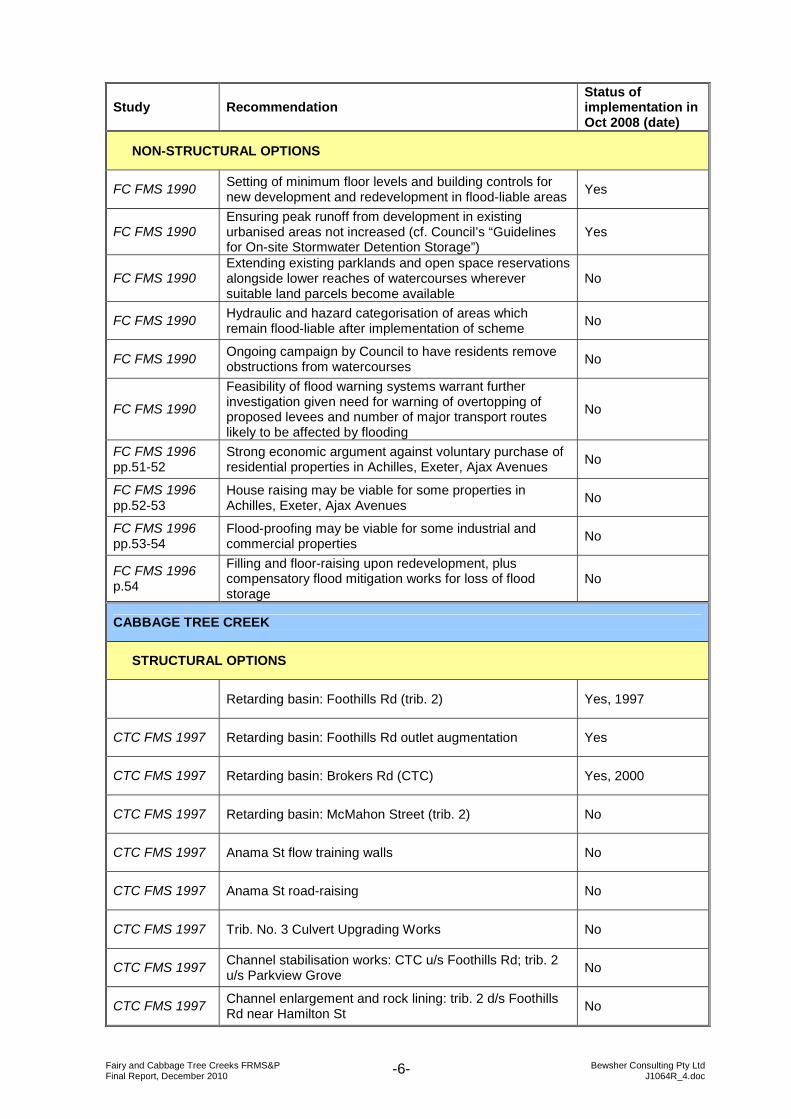
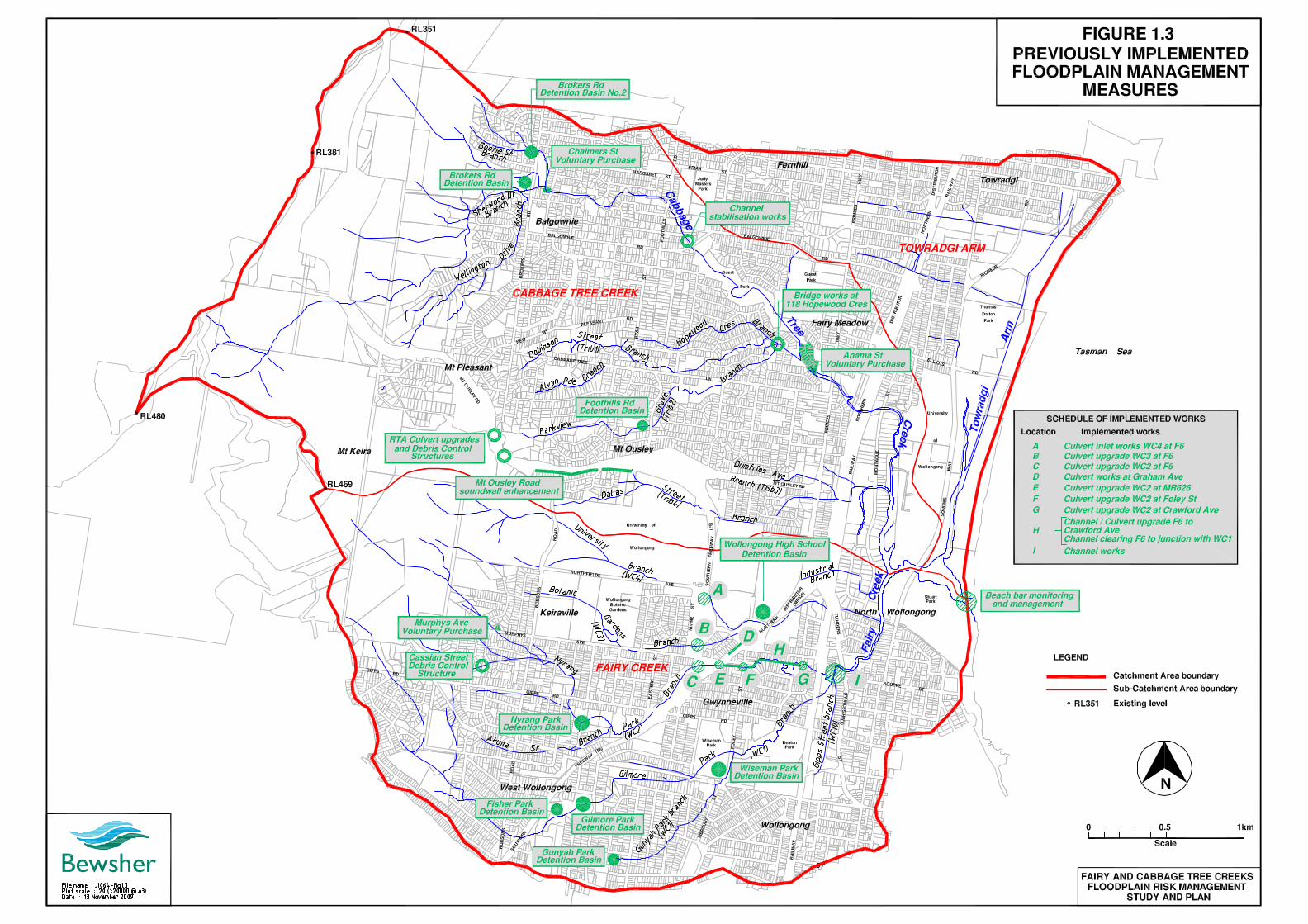
1.5 PREVIOUS STUDIES A number of studies have been previously undertaken to define flood behaviour and to evaluate floodplain management options for the Fairy and Cabbage Tree Creeks catchments. The main studies are summarised below. A summary of the recommended options from these previous studies, together with an indication of the status of their implementation, is provided in Table 1.1. In addition, Figure 1.3 maps floodplain management measures implemented since about 1990. TABLE 1.1 – Floodplain Management Recommendations from Previous Studies, and Status of Implementation Sources: FC FMS = Fairy Creek Floodplain Management Study; CTC FMS = Cabbage Tree Creek Floodplain Management Study); WCC (2001) and WCC (pers. comm.) for status of implementation Notes: WC = watercourse number; Trib. = tributary number; refer to Table 2.1 and Figure 1.1 for translation of, and location of watercourses/tributaries
Study Recommendation Status of implementation in Oct 2008 (date)
FAIRY CREEK
STRUCTURAL OPTIONS
FC FMS 1990 Retarding basin: Edmund Rice College (WC1) No (informal basin)
FC FMS 1990 Retarding basin: Gilmore Park (WC1) Yes, 1995
FC FMS 1990 Retarding basin: Gunyah Park (WC1) Yes, 1992
FC FMS 1990 Retarding basin: Wiseman Park (WC1) Yes, 1991
FC FMS 1990 Retarding basin: Nyrang Park (WC2) Yes, 1994
FC FMS 1990 Retarding basin: Robsons Road (WC4) No (informal basin)
FC FMS 1990/ 1996 pp.38-40
Retarding basin: Wollongong High School (1996 study proposed large basin augmentation) Yes, 2002
Channel upgrade: WC2 from F6 to Foley St Yes, 1999
Channel upgrade: WC2 from Foley St to Crawford Ave Yes, 1994
FC FMS 1990/ 1996 p.28
Channel clearing: WC1 downstream of Princes Hwy (Bodes Bridge) No
FC FMS 1990/ 1996 p.28
Channel clearing: WC2 from the F6 freeway to the confluence with WC1 Yes
FC FMS 1996 p.37
Channel clearing and works: WC2 from Crawford Ave to confluence with WC1 No (see note a)
FC FMS 1990 Channel clearing: WC3 from Princes Hwy to confluence with WC1 No
FC FMS 1990/ 1996 p.28 Channel clearing: WC3 from the F6 to MR626 No

Fairy and Cabbage Tree Creeks FRMS&P Bewsher Consulting Pty Ltd Final Report, December 2010 J1064R_4.doc -5-
Study Recommendation Status of implementation in Oct 2008 (date)
FC FMS 1990/ 1996 p.28
Channel clearing: WC10 from Gipps St to confluence with WC1 No
FC FMS 1990/ 1996 p.29
Culvert upgrading: WC1 under the Princes Hwy (1996 study proposed modified upgrade) No
FC FMS 1990/ 1996 pp.29,37 Culvert upgrading: WC2 under the railway No (see note b)
FC FMS 1996 pp.29,37 Culvert upgrading: WC2 under Crawford Ave Yes, <1996
FC FMS 1996 p.29 Culvert upgrading: WC2 under Foley St Yes, 1996
FC FMS 1996 p.29 Culvert upgrading: WC2 under unit driveways Yes
FC FMS 1996 p.29
Culvert upgrading: WC2 under Northern Distributor (MR626) Yes
FC FMS 1996 p.29 Culvert upgrading: WC2 under Freeway (F6) Yes
FC FMS 1996 p.29 Culvert upgrading: WC3 under University Ave – optional No
FC FMS 1996 p.29 Culvert upgrading: WC3 under Foley Lane – optional No
FC FMS 1996 pp.34,55
Flood mitigation associated with freeway works (option F6-2): ► [Culvert works: WC2 under F6] ► Culvert works: WC3 under F6 ► Culvert works: along and under Graham Ave and/or MR626
shoulder ► [Culvert works: WC2 under MR626] ► [Culvert works: WC2 under Unit driveways] ► [Culvert works: WC2 under Foley St] ► Channel works: WC2, MR626 to Foley St ► Other works: Graham Ave culvert outlet surcharge structure ► Other works: low flow 600 mm RCP from Graham Ave outlet
structure to WC3 ► Other works: construct grassed floodway between WC2 and
WC3 adjacent to and upstream of the F6 ► Other works: construct earth and concrete wall surrounding
the inlet to culverts on WC4 under the F6
Yes, 1998
FC FMS 1990 Opening in New Jersey kerb barriers along the F6 freeway and F8 Northern Suburbs Distributor No
FC FMS 1996 p.50
Floodway across Squires Way south of the bridge over WC1 (lower road) No
FC FMS 1996 p.42f Beach bar monitoring Yes
FC FMS 1996 p.43f Beach bar management i.e. periodic excavation Yes
FC FMS 1990/ 1996 Removal of units over WC3 in College Place No
FC FMS 1996 p.29 Divert flood flows around College Place (units remain) No
FC FMS 1990/ 1996 p.49
Levee construction to protect Achilles, Exeter and Ajax Avenues (max 2.7 m above ground level, mostly concrete wall); 1996 study withdrew recommendation
No
Fairy and Cabbage Tree Creeks FRMS&P Bewsher Consulting Pty Ltd Final Report, December 2010 J1064R_4.doc -6-
Study Recommendation Status of implementation in Oct 2008 (date)
NON-STRUCTURAL OPTIONS
FC FMS 1990 Setting of minimum floor levels and building controls for new development and redevelopment in flood-liable areas Yes
FC FMS 1990 Ensuring peak runoff from development in existing urbanised areas not increased (cf. Council’s “Guidelines for On-site Stormwater Detention Storage”)
Yes
FC FMS 1990 Extending existing parklands and open space reservations alongside lower reaches of watercourses wherever suitable land parcels become available
No
FC FMS 1990 Hydraulic and hazard categorisation of areas which remain flood-liable after implementation of scheme No
FC FMS 1990 Ongoing campaign by Council to have residents remove obstructions from watercourses No
FC FMS 1990
Feasibility of flood warning systems warrant further investigation given need for warning of overtopping of proposed levees and number of major transport routes likely to be affected by flooding
No
FC FMS 1996 pp.51-52
Strong economic argument against voluntary purchase of residential properties in Achilles, Exeter, Ajax Avenues No
FC FMS 1996 pp.52-53
House raising may be viable for some properties in Achilles, Exeter, Ajax Avenues No
FC FMS 1996 pp.53-54
Flood-proofing may be viable for some industrial and commercial properties No
FC FMS 1996 p.54
Filling and floor-raising upon redevelopment, plus compensatory flood mitigation works for loss of flood storage
No
CABBAGE TREE CREEK
STRUCTURAL OPTIONS
Retarding basin: Foothills Rd (trib. 2) Yes, 1997
CTC FMS 1997 Retarding basin: Foothills Rd outlet augmentation Yes
CTC FMS 1997 Retarding basin: Brokers Rd (CTC) Yes, 2000
CTC FMS 1997 Retarding basin: McMahon Street (trib. 2) No
CTC FMS 1997 Anama St flow training walls No
CTC FMS 1997 Anama St road-raising No
CTC FMS 1997 Trib. No. 3 Culvert Upgrading Works No
CTC FMS 1997 Channel stabilisation works: CTC u/s Foothills Rd; trib. 2 u/s Parkview Grove No
CTC FMS 1997 Channel enlargement and rock lining: trib. 2 d/s Foothills Rd near Hamilton St No
Fairy and Cabbage Tree Creeks FRMS&P Bewsher Consulting Pty Ltd Final Report, December 2010 J1064R_4.doc -7-
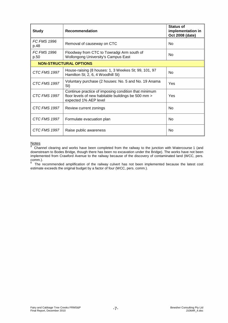
Study Recommendation Status of implementation in Oct 2008 (date)
FC FMS 1996 p.48 Removal of causeway on CTC No
FC FMS 1996 p.50
Floodway from CTC to Towradgi Arm south of Wollongong University’s Campus East No
NON-STRUCTURAL OPTIONS
CTC FMS 1997 House-raising (8 houses: 1, 3 Weekes St; 99, 101, 97 Hamilton St; 2, 6, 4 Woodhill St) No
CTC FMS 1997 Voluntary purchase (2 houses: No. 5 and No. 19 Anama St) Yes
CTC FMS 1997 Continue practice of imposing condition that minimum floor levels of new habitable buildings be 500 mm > expected 1% AEP level
Yes
CTC FMS 1997 Review current zonings No
CTC FMS 1997 Formulate evacuation plan No
CTC FMS 1997 Raise public awareness No
Notes a Channel clearing and works have been completed from the railway to the junction with Watercourse 1 (and downstream to Bodes Bridge, though there has been no excavation under the Bridge). The works have not been implemented from Crawford Avenue to the railway because of the discovery of contaminated land (WCC, pers. comm.). b The recommended amplification of the railway culvert has not been implemented because the latest cost estimate exceeds the original budget by a factor of four (WCC, pers. comm.).

Fairy and Cabbage Tree Creeks FRMS&P Bewsher Consulting Pty Ltd Final Report, December 2010 J1064R_4.doc -9-
1.5.1 Fairy Creek Floodplain Management Study 1990 Reference: FC FMS 1990 Prepared for: Wollongong City Council By: Willing and Partners Pty Ltd Date: March 1990 ► Study area included Fairy Creek and its main tributaries from Gipps Street
(Watercourses (WC) 1 & 10) and upstream F6 Freeway (WC2, WC3 & WC4) to Squires Way bridge downstream of confluence with Cabbage Tree Creek (refer to Figure 1.1 for watercourse names).
► Detailed the calibration and verification of the hydrologic (RAFTS) and hydraulic (HEC-2) models to the March 1983 and March 1975 events.
► Design flood behaviour predicted for the 1%, 2% and 5% AEP events. ► Proposed “Scheme 2” which provided for channel clearing, provision of five new
retarding basins (Wollongong High School, Wiseman Park, Nyrang Park, Gilmore Park and Gunyah Park), construction of levees along the watercourses downstream of the railway to protect the Achilles/Exeter/Ajax Avenues area, amplification of Bodes Bridge and the pipe culvert under the Illawarra Railway, and the demolition of a block of flats built over Watercourse 3 at College Place. Also recommended that consideration be given to providing openings in the New Jersey barriers along the F6 Freeway and the F8 Northern Distributor at the watercourse crossings.
1.5.2 Cabbage Tree Creek Flood Study 1991 Reference: CTC FS 1991 Prepared for: PWD By: Willing and Partners Pty Ltd Date: February 1991 ► Study area included Cabbage Tree Creek from Chalmers Street to its confluence with
Fairy Creek. ► Detailed the calibration and verification of the hydrologic (RORB) and hydraulic (MIKE
11) models to the March 1983 and March 1975 events. ► Design flood behaviour predicted for the 1%, 2% and 5% AEP events and the PMF. ► Described a history of channel works including concrete-lining of the channel upstream
of the Princes Hwy in 1983 and construction of the F6 Freeway bridge in 1986.
1.5.3 Fairy Creek Floodplain Management Study 1996 Reference: FC FMS 1996 Prepared for: Wollongong City Council By: Kinhill Engineers Pty Ltd Date: 1996 ► Study area included: Fairy Creek WC1 and WC10 downstream of Gipps Street, WC2
downstream of Gipps Road, WC3 downstream of Paulsgrove Street, WC4 downstream of Irvine Street, and tributary WHS-IND downstream of Wollongong High School; Cabbage Tree Creek main channel and Tributary 3 downstream of the Northern Distributor; and Towradgi Arm downstream of Elliotts Road. The downstream boundary was the ocean. (Refer to Figure 1.1 for watercourse names).
► Detailed the verification of the hydrologic (RAFTS) and hydraulic (MIKE 11) models to the June 1991 and March 1975 events.

Fairy and Cabbage Tree Creeks FRMS&P Bewsher Consulting Pty Ltd Final Report, December 2010 J1064R_4.doc -10-
► Design flood behaviour predicted for the 1%, 5% and 20% AEP events and the PMF. ► Assessed the hydraulic impacts of the F6 Freeway upgrading works, and evaluated flood
mitigation options including lowering Graham Avenue to provide an overflow path and purchasing all properties in College Place and Graham Avenue to provide space for a detention basin. Recommended Option F6-2, which involved channel and culvert works to WC2 in the vicinity of the F6 Freeway and the Northern Distributor, as well as some works to the inlet to the culverts on WC4 under the F6.
► Investigated options to reduce flood impacts in Crawford Avenue area on WC2 and downstream of Northern Distributor near WC3. Recommended large-scale augmentation of Wollongong High School Basin, channel works on WC2 between Crawford Avenue and WC1, and culvert upgrading on WC2 under railway.
► Investigated options to reduce flood impacts downstream of the railway, including: beach bar monitoring and management, structural measures including channel works, culvert upgrades, floodways and levee to protect the Achilles/Exeter/Ajax Avenues area (levees not recommended) and non-structural measures including voluntary purchase (VP not recommended), house raising, flood-proofing and development controls. Recommended beach bar monitoring and management, floodways across Squires Way south of bridge and from Cabbage Tree Creek to Towradgi Arm south of Campus East, and removal of causeway on Cabbage Tree Creek.
1.5.4 Cabbage Tree Creek Floodplain Management Study 1997 Reference: CTC FMS 1997 Prepared for: Wollongong City Council By: Willing and Partners Pty Ltd Date: 1997 ► Study area included: Cabbage Tree Creek from Brokers Road to the railway; Tributary 1
from Brynymor Place to Hopewood Crescent; Tributary 2 from Parkview Grove to Trib. 1 confluence; Tributary 3 from Mount Ousley Road to the railway; and Tributary 4 from Wollongong University to the railway. (Refer to Figure 1.1 for watercourse names).
► Detailed the calibration and verification of the hydrologic (RAFTS) and hydraulic (EXTRAN-HP) models to the March 1983 and March 1975 events.
► Design flood behaviour predicted for the 1%, 2% and 5% AEP events. ► Described a history of channel works including realignment of Cabbage Tree Creek
downstream of Montague Street as part of the Campus East site development in 1992. ► Assessed potential flood damages and floodplain management schemes. The preferred
floodplain management scheme included the Brokers Road retarding basin (an off-line basin at Guest Park was not recommended), augmentation of the Foothills Road retarding basin outlet, the McMahon Street retarding basin, Anama Street flow training walls and roadworks, culvert upgrading works at Tributary 3, channel improvements at Hamilton Street, channel improvements at Cabbage Tree Creek and Parkview Crescent, house raising (8 houses – 1 & 3 Weekes Street, 97, 99 & 101 Hamilton Street, 2, 4 & 6 Woodhill Street) and voluntary purchase (5 & 19 Anama Street).

Fairy and Cabbage Tree Creeks FRMS&P Bewsher Consulting Pty Ltd Final Report, December 2010 J1064R_4.doc -11-
1.5.5 17 August 1998 Storms in Wollongong: Flood Data Report Reference: 1998 Storm Data Report Prepared for: N/a By: Dept of Land and Water Conservation and Wollongong City Council Date: May 2002 ► Collected data on 1998 storms: rainfall, flood levels, ocean levels, stream erosion,
resident questionnaire (3,075 returned from 9,028 issued, with 472 citing building/house flooding), flood damage estimates (including by public sector organisations), excerpts from Illawarra Mercury.
1.5.6 Wollongong Innovation Campus Master Plan 2003 Reference: WIC Flood Management Strategy 2002 Prepared for: University of Wollongong By: Forbes Rigby Date: December 2002
Reference: WIC Master Plan 2003 (Chapter 12 Floodplain Management) Prepared for: University of Wollongong By: Graham, Bell & Bowman Architects et al. Date: August 2003 ► Study area included the Campus East site, the Science Centre, the Brandon Park site
and reserves bounded by Cabbage Tree Creek. ► Recognised flood-prone nature of the Campus East site and the access roads, Squires
Way and Cowper Street. ► Proposed two shallow overflow swales on the northern and southern sides of the existing
Campus East development, as well as a low levee, in order to accommodate existing flow breakouts and to better manage the present uncontrolled flood flows through Campus East.
► Did not rely on the deep floodway proposal recommended in the Fairy Creek FMS 1996, noting the possible adverse environmental effects in changing the creeks’ hydrological regime, the visual impact, the impact on linkages across the campus, and the construction and maintenance costs.
► The Master Plan stipulated minimum habitable floor levels at 5.4m AHD, based on the PMF levels calculated in the 1996 flood study, and minimum roadway levels at 4.2m AHD, based on the 1% AEP flood levels calculated in the 1996 study, with basements to be flood proofed to 4.7m AHD.
► Concluded that providing safe refuge within the Innovation Campus site was the most appropriate flood access and evacuation strategy solution. This involved minimum floor levels at 1996 PMF level, multi storey buildings with upper floor levels several metres above PMF, the central section of the main pedestrian spine set at 6.0m AHD, and a requirement to prepare a detailed Flood Safety Strategy (including warning and education) prior to the occupation of the first stage of development.
Fairy and Cabbage Tree Creeks FRMS&P Bewsher Consulting Pty Ltd Final Report, December 2010 J1064R_4.doc -12-
1.5.7 Fairy, Towradgi and Hewitts/Tramway Creeks Estuary Management Study & Plan 2005
Reference: Fairy EMS 2005 Prepared for: Wollongong City Council By: Cardno Lawson Treloar Date: November 2005 ► Study area included the tidal waterways, foreshores, surrounding open space and
adjacent lands of Fairy Creek (including Cabbage Tree Creek and Towradgi Arm). ► Developed plan to manage the Fairy Creek estuary in a balanced, socially responsible
and ecologically sustainable manner. The recommendations address the areas of habitat and species conservation, water quality, sedimentation and erosion control, cultural heritage, development, recreation, entrance management and visual amenity.
► Made many recommendations for the Fairy Creek estuary including (1) protection, enhancement and rehabilitation of vegetation, (2) improvement of fish passage at the Cabbage Tree Creek weir, (3) preparation of Riparian Corridor Management DCP, (4) clearance of accumulated rubble and anthropogenic material from Fairy Creek, (5) development of a Fairy Creek entrance management policy, and (6) development of a policy to manage escarpment runoff.
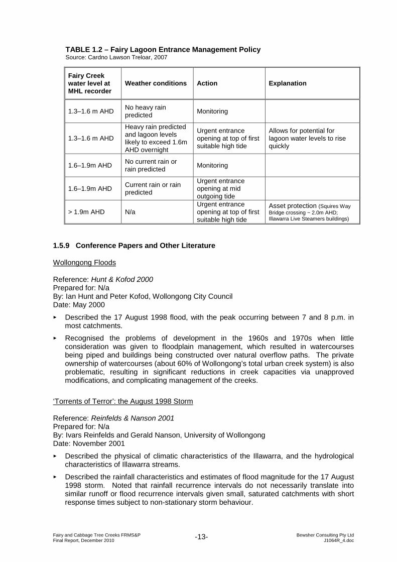
1.5.8 Fairy Lagoon Entrance Management Policy 2007 Reference: Fairy Lagoon EMP 2007 Prepared for: Wollongong City Council By: Cardno Lawson Treloar Date: February 2007 ► Described the need for a formal entrance management policy for the Fairy Creek
Lagoon, which is an Intermittently Closed and Open Lake or Lagoon (ICOLL). ► Identified that a water level of 1.6m AHD with forecast of further rain in the catchment
was likely to represent a significant flooding threat. ► Considered two potential entrance management options: (1) mechanical breakout and
(2) berm height management. ► (1) The mechanical breakout option involves the deployment of equipment such as a
backhoe to dig a “pilot” channel which will induce the creation of a scoured channel through which lagoon water can flow to the sea. The triggers for this action are the lagoon water level and the weather conditions. The policy recommends that the existing MHL water level monitoring system at Bodes Bridge on Fairy Creek be extended to include an automatic alert to Council officers when critical water levels are reached. Three trigger levels were identified: an “alert” level at 1.3m AHD, an “action” trigger level at 1.6m AHD, and an “emergency” trigger level at 1.9m AHD (Table 1.2).
► (2) The berm height management option involves monitoring of the sand berm at the lagoon entrance and maintaining a notch at a pre-determined level in order to prevent water level in the lagoon from exceeding critical flooding levels. The purpose of the notch is to dispense with the need to mechanically open the lagoon when a flood arrives. If maintained correctly, the notch would breach without intervention when the water level reaches the appropriate level.
► Following a Review of Environmental Factors (Cardno Lawson Treloar, Feb 2007) and public exhibition, Council formally adopted the Fairy Lagoon Entrance Management Policy in May 2007, endorsing the “mechanical breakout” option as the preferred environmental and economic practice.
Fairy and Cabbage Tree Creeks FRMS&P Bewsher Consulting Pty Ltd Final Report, December 2010 J1064R_4.doc -13-
TABLE 1.2 – Fairy Lagoon Entrance Management Policy Source: Cardno Lawson Treloar, 2007
Fairy Creek water level at MHL recorder
Weather conditions Action Explanation
1.3–1.6 m AHD No heavy rain predicted Monitoring
1.3–1.6 m AHD
Heavy rain predicted and lagoon levels likely to exceed 1.6m AHD overnight
Urgent entrance opening at top of first suitable high tide
Allows for potential for lagoon water levels to rise quickly
1.6–1.9m AHD No current rain or rain predicted Monitoring
1.6–1.9m AHD Current rain or rain predicted
Urgent entrance opening at mid outgoing tide
> 1.9m AHD N/a Urgent entrance opening at top of first suitable high tide
Asset protection (Squires Way Bridge crossing ~ 2.0m AHD; Illawarra Live Steamers buildings)
1.5.9 Conference Papers and Other Literature Wollongong Floods Reference: Hunt & Kofod 2000 Prepared for: N/a By: Ian Hunt and Peter Kofod, Wollongong City Council Date: May 2000 ► Described the 17 August 1998 flood, with the peak occurring between 7 and 8 p.m. in
most catchments. ► Recognised the problems of development in the 1960s and 1970s when little
consideration was given to floodplain management, which resulted in watercourses being piped and buildings being constructed over natural overflow paths. The private ownership of watercourses (about 60% of Wollongong’s total urban creek system) is also problematic, resulting in significant reductions in creek capacities via unapproved modifications, and complicating management of the creeks.
‘Torrents of Terror’: the August 1998 Storm Reference: Reinfelds & Nanson 2001 Prepared for: N/a By: Ivars Reinfelds and Gerald Nanson, University of Wollongong Date: November 2001 ► Described the physical of climatic characteristics of the Illawarra, and the hydrological
characteristics of Illawarra streams. ► Described the rainfall characteristics and estimates of flood magnitude for the 17 August
1998 storm. Noted that rainfall recurrence intervals do not necessarily translate into similar runoff or flood recurrence intervals given small, saturated catchments with short response times subject to non-stationary storm behaviour.

Fairy and Cabbage Tree Creeks FRMS&P Bewsher Consulting Pty Ltd Final Report, December 2010 J1064R_4.doc -14-
► Described the geomorphological effects of the 1998 storm including the erosion of material from Kemira Colliery’s working platform and dump site, and the deposition of this material at the base of the escarpment e.g. entirely filling Cedar Park in Keiraville and severely damaging a home downstream that was subsequently demolished.
► Noted the effect of blockage of culverts and bridge handrails as a result of debris build up on flood behaviour.
► Noted that floods which are commonly perceived to be of exceptional magnitude should be expected much more frequently across the city as a whole.
The Impact of Blockages on Flood Behaviour in the Wollongong Storm of August 1998 Reference: Rigby & Silveri 2002 Prepared for: N/a By: E.H. Rigby & P. Silveri Date: May 2002 ► Explored the relationships between degree of structure blockage and opening size in
Hewitts, Towradgi, Fairy/Cabbage Tree and Allans Creeks in the August 1998 floods. ► Found that structures up to 6m diagonal opening are prone to block substantially in large
events almost irrespective of upstream slope, land use or debris type. ► Described the evolution of Council’s new blockage policy. ► Evaluated the implications of blockage on flow diversions.
FMA Conference North Tour 2008 Reference: FMA Guide 2008 Prepared for: Conference delegates By: Wollongong City Council Date: February 2008 ► Included a general description of the nature of Wollongong’s flood hazard. ► Included a description of the August 1998 storm impacts. ► Described flood behaviour, flood impacts and voluntary purchase scheme at Anama
Street, Fairy Meadow. ► Described erosion upstream of Donnans Bridge, Balgownie, and a stabilisation solution
involving an integrated approach. ► Described loss of footbridge joining Rae Crescent to Church Street in 1998 flood, and
design of new footbridge with deck above modelled 100 year flood height. ► Described design and construction of Brokers Road detention basin (completed in 2000)
at a cost of $1.5 million. ► Described the challenges of handrail design at the Chalmers Street Bridge given
competing requirements of vehicle impact, public safety and flood considerations. Described the damage to No. 32 Chalmers Street in the 1998 flood and its subsequent acquisition and demolition under a VP scheme.
► Described the failure of a 1650 mm diameter steel pipe at Dobinson Street in the 1998 flood.
► Described the objectives of the Fairy Lagoon Entrance Management Policy.
Fairy and Cabbage Tree Creeks FRMS&P Bewsher Consulting Pty Ltd Final Report, December 2010 J1064R_4.doc -15-
2. BACKGROUND INFORMATION 2.1 CATCHMENT DESCRIPTION AND LANDUSE The study area comprises the catchments of Fairy Creek, Cabbage Tree Creek and Towradgi Arm, as depicted in Figure 1.1. The total catchment area is about 20.7 km2. The highest elevation on the catchment divide is approximately 480m (Mount Keira has an elevation of 469m, Figure 1.1). The watercourses flow from the escarpment in an easterly direction, across a straight-line distance of only 5 km, to a narrow coastal plain and a small tidal lagoon that debouches into the Tasman Sea. In the upper reaches the creeks have very steep slopes (typically 20% to 30%), while in the lower reaches they are quite flat (typically 0.5%). The Illawarra escarpment produces a strong orographic rainfall gradient, with average annual rainfall varying from about 1100mm at the coast to over 1600mm at the escarpment crest, and up to 1800mm at spurs that extend onto the coastal plain, such as Mt Keira (Reinfelds & Nanson, 2001). The streams are prone to erosion, and considerable amounts of soil and rock including large boulders are transported with flows during significant events. Historical evidence indicates a high probability of blockage occurring at stream crossings in major events, as natural and man-made debris is mobilised. Land uses in the catchments can be discerned from aerial photography and zoning plans. In the steep upper reaches, the catchments are heavily forested. There is significant urban development in the mid to lower areas, including encroachment onto the floodplain and into the channels, and in places the channels have been piped with development built on top. Residential development is mainly low to medium density, with the exception of areas zoned for high density residential development near Wollongong City centre. There is a concentration of commercial and industrial development along the Princes Highway in Fairy Meadow and in the vicinity of Montague Street in North Wollongong. The catchments are also home to several large educational establishments, including the University of Wollongong’s Main Campus at Keiraville and Innovation Campus at Fairy Meadow. The Fairy Creek Floodplain Management Study (Willing & Partners, 1990) divided the Fairy Creek catchment into five major sub-catchments, and the Cabbage Tree Creek Floodplain Management Study (Willing & Partners, 1997) divided the Cabbage Tree Creek catchment into five major sub-catchments. Table 2.1 lists these sub-catchments (and some additional) from north to south (see Figure 1.1). In consultation with Council, some alternative, distinctive names are proposed.
Fairy and Cabbage Tree Creeks FRMS&P Bewsher Consulting Pty Ltd Final Report, December 2010 J1064R_4.doc -16-
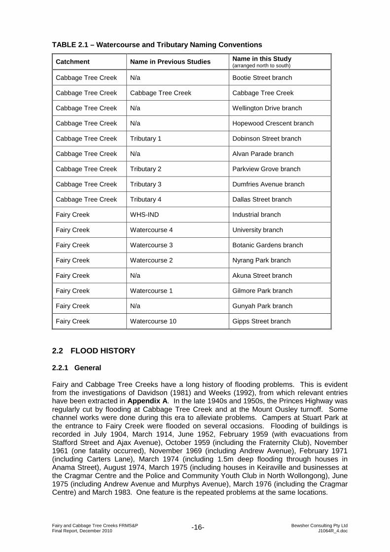
TABLE 2.1 – Watercourse and Tributary Naming Conventions
Catchment Name in Previous Studies Name in this Study (arranged north to south)
Cabbage Tree Creek N/a Bootie Street branch
Cabbage Tree Creek Cabbage Tree Creek Cabbage Tree Creek
Cabbage Tree Creek N/a Wellington Drive branch
Cabbage Tree Creek N/a Hopewood Crescent branch
Cabbage Tree Creek Tributary 1 Dobinson Street branch
Cabbage Tree Creek N/a Alvan Parade branch
Cabbage Tree Creek Tributary 2 Parkview Grove branch
Cabbage Tree Creek Tributary 3 Dumfries Avenue branch
Cabbage Tree Creek Tributary 4 Dallas Street branch
Fairy Creek WHS-IND Industrial branch
Fairy Creek Watercourse 4 University branch
Fairy Creek Watercourse 3 Botanic Gardens branch
Fairy Creek Watercourse 2 Nyrang Park branch
Fairy Creek N/a Akuna Street branch
Fairy Creek Watercourse 1 Gilmore Park branch
Fairy Creek N/a Gunyah Park branch
Fairy Creek Watercourse 10 Gipps Street branch
2.2 FLOOD HISTORY 2.2.1 General Fairy and Cabbage Tree Creeks have a long history of flooding problems. This is evident from the investigations of Davidson (1981) and Weeks (1992), from which relevant entries have been extracted in Appendix A. In the late 1940s and 1950s, the Princes Highway was regularly cut by flooding at Cabbage Tree Creek and at the Mount Ousley turnoff. Some channel works were done during this era to alleviate problems. Campers at Stuart Park at the entrance to Fairy Creek were flooded on several occasions. Flooding of buildings is recorded in July 1904, March 1914, June 1952, February 1959 (with evacuations from Stafford Street and Ajax Avenue), October 1959 (including the Fraternity Club), November 1961 (one fatality occurred), November 1969 (including Andrew Avenue), February 1971 (including Carters Lane), March 1974 (including 1.5m deep flooding through houses in Anama Street), August 1974, March 1975 (including houses in Keiraville and businesses at the Cragmar Centre and the Police and Community Youth Club in North Wollongong), June 1975 (including Andrew Avenue and Murphys Avenue), March 1976 (including the Cragmar Centre) and March 1983. One feature is the repeated problems at the same locations.
Fairy and Cabbage Tree Creeks FRMS&P Bewsher Consulting Pty Ltd Final Report, December 2010 J1064R_4.doc -17-
2.2.2 August 1998 flood The flood of 17 August 1998 caused a great deal of damage in the Fairy and Cabbage Tree Creeks catchment. The following provides a representative selection of the impacts of the flooding, based mainly on newspaper reports and responses to Wollongong City Council’s post-flood damage survey (see Section 3.2). Andrews Avenue and Cassian Street, Keiraville Extensive deposits of waste coal, ash and slag had been deposited on Mt Keira by Kemira Colliery, which closed in 1993. These deposits were mobilised in the August 1998 flood, travelling at high velocities and scouring channels to bedrock in steep reaches. As they reached the base of the escarpment, these debris flows lost momentum, depositing coal waste to depths of 1.5m in backyards, garages and swimming pools where the natural watercourse had been piped and built over (Reinfelds & Nanson, 2001, pp.343, 346). Mt Ousley Road Residents of several streets (especially Binda Street and Falder Place, Keiraville) situated on the southern side of Mt Ousley Road threatened to take class action against the RTA, after water poured through the sound barriers, destroying fences, retaining walls and causing extensive structural damage to homes. There were also reports of several “close shaves” at the bottom of Mt Ousley Road. Dobinson Street, Mt Pleasant An “exploding” underground water pipe, which carried runoff under Mt Ousley Road, caused extensive damage to houses and injuries at Dobinson Street, Mt Pleasant. University of Wollongong, Keiraville and Fairy Meadow At the main campus in Keiraville, millions of dollars of damage was incurred from flooding and rainwater, especially to carpets and computers in the Information Technology Resources Centre, as well as electrical circuitry. Lectures and tutorials were suspended for four days. At Campus East in Fairy Meadow, water spilled out of Cabbage Tree Creek at the right-angled bend and flowed as sheetflow through and around the various buildings. Floodwater at a depth of about 0.5m pushed parked vehicles “domino-style” towards the east (Forbes Rigby, 2002, p.16-18). At the University’s Science Centre (then situated at Campus East, Fairy Meadow), displays and equipment, including video projectors, were muddied. Anama Street, Fairy Meadow One of the worst-affected places was Anama Street in Fairy Meadow, where the water was reported to have risen from floors to ceilings (2 metres) in less than 30 minutes, leaving 50 cars wrecked (see Figure A1), 21 homes badly damaged, and 15 families without all their possessions. Figure A2 summarises the damage in this street. While no lives were lost, there were a number of near misses – one woman was reportedly washed out of her house and rescued by the fire brigade; another woman was forced to break a window to escape with her three children. Intangible losses included the loss of a computer containing a nearly complete PhD thesis.
Fairy and Cabbage Tree Creeks FRMS&P Bewsher Consulting Pty Ltd Final Report, December 2010 J1064R_4.doc -18-
Bourke Street, Fairy Meadow Elsewhere in Fairy Meadow, an estimated $5 million damage was caused when 1m high floodwater swept through the Fraternity Club (Bourke Street), ruining fixtures, furnishings, poker machines (valued at $140,000 each) and bowling greens. Exeter Street, Porter Street and Montague Street, North Wollongong As in 1975, the Police and Community Youth Club in Exeter Street was again flooded, with severe damage to the basketball court surface, computers, furniture, gym equipment, and valuable historical items. At Porter Street, a family was forced to climb onto the roof to evade the floodwaters, which destroyed most of the household contents. Substantial damage was incurred by factories in Montague Street, and vehicles were washed away, one of which was deposited at the creek’s mouth (Figure A3).
Fairy and Cabbage Tree Creeks FRMS&P Bewsher Consulting Pty Ltd Final Report, December 2010 J1064R_4.doc -19-
2.3 VEGETATION An assessment of vegetation within the Fairy and Cabbage Tree Creeks catchments is important for the following reasons: ► To provide an understanding of the ecological characteristics and value of vegetation
within the study area in order that floodplain management decisions are sympathetic to conservation values, cognisant of contemporary Government riparian and biodiversity policies and, where appropriate, take advantage of the opportunities provided by existing vegetation to form open space areas and linkages;
► To ensure that any proposed flood mitigation measures, in particular structural measures, are not fundamentally unacceptable due to their potential impact upon important vegetation areas;
► To manage riparian vegetation in such a way to improve the river hydraulics (and provide other ecological benefits) which may reduce flood levels or prevent the redirection of the flow path of floodwaters. Such management needs to recognise that revegetation will also occur naturally and may impact flood levels.
2.3.1 Endangered Ecological Communities Council provided GIS layers showing the locations of mapped Endangered Ecological Communities (EECs) and sightings of threatened species. These are shown in Figure 2.1. In the lower reaches of Fairy Creek, Cabbage Tree Creek and especially Towradgi Arm at Puckey’s Estate, several endangered vegetation communities intersect with the floodplain: the Coastal Swamp Oak Forest, the Estuarine Alluvial Wetland, the Alluvial Swamp Mahogany Forest and the Coastal Sand Bangalay-Blackbutt Forest. The Coastal Grassy Red Gum Forest is present in Wiseman Park and Gilmore Park along the Gilmore Park branch. Some areas containing Lowland Dry-Subtropical Rainforest and Illawarra Escarpment Subtropical Rainforest are present further upstream. (The connection between these vegetation communities and endangered ecological communities listed under the Threatened Species Conservation Act 1995 is explained in NPWS, 2003, pp.47-48). Among the threatened fauna species that have been observed in the floodplain are the Green and Golden Bell Frog and bird species including the Blue-billed Duck, the Australian Bittern and the Gang-gang Cockatoo. Further details about the ecological attributes of the estuarine area are provided in Chapter 5 of the Fairy, Towradgi and Hewitts/Tramway Creeks Estuary Management Study & Plan (Cardno Lawson Treloar, 2005).
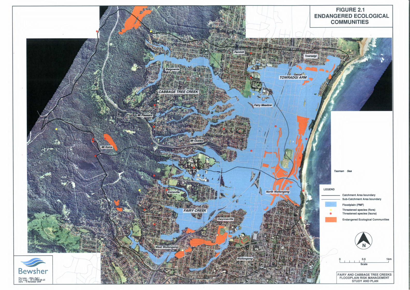
Fairy and Cabbage Tree Creeks FRMS&P Bewsher Consulting Pty Ltd Final Report, December 2010 J1064R_4.doc -21-
2.3.2 Riparian Corridors A Riparian Corridor Management Study prepared for Wollongong City Council (DIPNR, March 2004) developed three categories of riparian environmental objectives for the watercourses in the study area, with varied minimum riparian zone widths in order to achieve the functioning identified by each objective (Table 2.2). TABLE 2.2 – Riparian Management Objectives Source: DIPNR, March 2004, pp.15-20
Stream category Objective Minimum width
core riparian zone (from top of each bank)
Cat. 1: Environmental Corridor
Provide biodiversity linkages ideally between one key destination to another (e.g., the coast and the escarpment, or large nodes of vegetation)
40m + 10m buffer
Cat. 2: Terrestrial and Aquatic Habitat
Provides basic habitat and preserves the natural features of a watercourse (not necessarily linking key destinations)
20m + 10m buffer
Cat 3: Bank Stability and Water Quality
Has limited (if any) habitat value but contributes to the overall basic health of a catchment Normally 10m
Most of the watercourses in the study area were allocated a category (i.e., objective), which is shown in Appendix B. The Riparian Corridor Management Study recognises the interlinkages between floodplain risk management and riparian corridor management, with these implications: ► It is critical that an integrated approach to floodplain risk and riparian corridor
management is pursued if the objectives of both policies are to be realised; ► Implementation of riparian management strategies should be undertaken in such a
manner so as not to make flooding worse to existing flood liable development; and ► Structures to treat water quality and/or quantity should not compromise core riparian
zones. Actual riparian corridors for Fairy and Cabbage Tree Creeks were not mapped as part of the Riparian Corridor Management Study. Ecological Australia (2006) was later engaged to conduct field work to produce GIS layers in support of a Riparian Corridor DCP (not adopted as at November 2009). However, no mapped riparian corridors were made available for the current study. In Council’s flood risk management DCP, riparian corridors are treated with the high flood risk precinct, so it was necessary to map riparian corridors within the boundaries of the flood model. Aerial photographs, contours from the Digital Elevation Model (DEM) and GIS files from the hydrologic model were used to estimate creek centrelines and tops of banks where banks are well defined. At Council’s instruction, this mapping continued even where the creek has been piped and there is no longer a defined watercourse. A 10m offset was applied to the mapped creek centrelines or to the tops of banks. The resulting riparian corridors are presented in Figure 4.2.

Fairy and Cabbage Tree Creeks FRMS&P Bewsher Consulting Pty Ltd Final Report, December 2010 J1064R_4.doc -22-
2.4 POTENTIAL ACID SULPHATE SOILS Acid sulphate soils (ASS) is the common name given to sediment and soil containing iron sulphides (principally iron pyrite or iron disulfide). The exposure of pyrite in these soils to oxygen by drainage or excavation, leads to the generation of sulphuric acid. Acidic leachate can dissolve clay and release toxic concentrations of aluminium, iron or other metals into water bodies. As a result, drainage waters from areas of ASS can impact water quality and can lead to death or disease of aquatic organisms. Acid sulphate soil maps (ASS) have been generated for the Wollongong region by the former Department of Infrastructure, Planning and Natural Resources (DIPNR). Figure 2.2 shows that areas with potential ASS are extensive in the lower catchment, though areas with a high potential for ASS are confined to the areas downstream of Flinders Street (Fairy Creek catchment), the railway (Cabbage Tree Creek catchment) and Elliotts Road (Towradgi Arm catchment). Council’s field testing has found this mapping to be imprecise. Instead, ground elevations have proved to be a good guide to the probability of encountering ASS (Table 2.3). TABLE 2.3 – Estimated Association between Elevation and ASS Potential Source: WCC, pers. comm.
Elevation ASS potential
< 3.0m AHD >95%
3.0–4.5m AHD 80%
4.5–5.0m AHD 20%
> 5.0m AHD <5%
Basic principles for the management of acid sulphate soils are summarised below: ► Minimise the disturbance of ASS. ► If soil needs to be excavated and stockpiled, manage the material so as to minimise the
generation of ASS. This may include covering the stockpile and installing bunds around the stockpile.
► Implement runoff control measures so that no runoff escapes from the stockpiled material to the stormwater system.
► For any excavation on the site greater than 500mm below natural ground level, an assessment of the presence of acid sulphate soils is required. In this case, a qualified environmental consultant is to collect soil samples and have them analysed by a NATA certified laboratory to determine its acid generation and acid neutralisation capacity. A copy of the report must be provided to Council’s Environment and Health Division for review, prior to works continuing.
► Any spoil material extracted or excavated from the foundation must be neutralized with commercial lime before it is disposed of or re-used on-site.
► Techniques for the management of acid sulphate soils should be detailed in an Erosion and Sediment Control Plan.