Embed Size (px)
Citation preview

Prepared for:
In association with:
FINAL REPORT
By:
DECEMBER 2017


Delaware Ave Complete Streets Feasibility Study i
DisclaimerThis report was funded in part through a grant from the Federal Highway Administration, U.S. Department of Transportation. The views and opinions of the authors [or agency] expressed herein do not necessarily state or reflect those of the U.S. Department of Transportation. This report was prepared in cooperation with the Town of Bethlehem, the Capital District Transportation Committee, the Capital District Regional Planning Commission, the Capital District Transportation Authority, and the New York State Department of Transportation. The contents do not necessarily reflect the official views or policies of these government agencies. The recommendations are conceptual in nature and are presented to characterize the types of improvements that are desirable, and that may be implemented as part of future land use and transportation improvement projects. All transportation concepts will require further engineering evaluation and review. Undertaking additional engineering or other follow up work will be based upon funding availability. The Delaware Avenue Complete Streets Feasibility Study will have a positive impact on affected Environmental Justice populations, as documented in the Appendix A.
AcknowledgmentsThis study was conducted by CME and subcontractor the L.A. Group on behalf of the Town ofBethlehem and the Capital District Transportation Committee, and funded by CDTC’s Linkage Program and the Town of Bethlehem.
Thank you to the following:Delaware Avenue Improvement Group/Study Advisory Committee • Chamber of Commerce – Jennifer Kilcoyne• Delaware Plaza Associates – Debbie Battaglia• Main Square –Mark Kelly• Phillips Hardware – Jon Phillips• Quality P.M., Inc. – Gregg Biche• Bethlehem Garden Club – Virginia Acquario• Bethlehem Garden Club – Ellie Prakken• Delmar Progress Club – Wilma DeLucco• Friends of the Rail Trail/Bethlehem Planning Board
member – Scott Lewendon• Bethlehem Zoning Board member/ Delaware
Neighborhood Resident – Jeremy Martelle• Delaware Neighborhood Resident – Maud Easter • My Place & Company – Jim Giacone• Frese’s Landscaping – Chris Frese• Capital District Regional Planning Commission –
Martin Daley
Members of the public and business owner community who gave thoughtful comment and feedback throughout the process.
Town of Bethlehem• Supervisor John Clarkson• Town Board Members:• Joyce Becker• Julie Sasso• David VanLuven• Giles Wagoner
Technical Advisory Committee• NYSDOT Region 1 Staff – Rob Cherry, Audrey
Burneson and Brian Kirch• CDTA Staff – Mike Williams and Brent Irving• Creighton Manning, CDTC and Town of Bethlehem
staffs as listed below
Staff and Contractors• Town of Bethlehem Planning Staff – Rob Leslie,
Elizabeth Staubach and Ken Kovalchik• CDTC Staff – Anne Benware, David Jukins and Chris
O’Neill• Creighton Manning Staff – Mark Sargent, Kristie
DiCocco, Mark Nadolny, Ami Parikh and Jesse Vogl• LA Group Staff – Tim Larson, Jon Stilan

This page intentionally left blank

Delaware Ave Complete Streets Feasibility Study ii
EXECUTIVE SUMMARY ................................................................. ES-1CHAPTER 1 .........................................................................................1Introduction .........................................................................................................1 Why is Delaware Avenue being studied for Complete Streets Feasibility? .................... 2 What is a Complete Street? .................................................................................................. 3 Why are Complete Streets Important? ................................................................................ 3 WhataresomeoftheSpecificCompleteStreetsFeaturesConsideredinthisStudy? .. 4 HowwilltheSpecificCompleteStreetsFeaturesBeEvaluated? ................................... 5 What is the Study Approach? ............................................................................................... 5 What are the Study Goals? ................................................................................................... 6 What is the Study Area? ........................................................................................................ 7
CHAPTER 2 .........................................................................................9Existing Conditions .............................................................................................9 Zoning and Land Use ............................................................................................................. 9 Land Use Access, Driveways and Trip Generation ........................................................... 11 Transportation Infrastructure ............................................................................................... 13 Physical Characteristics .................................................................................................................13 Pedestrian and Bike Facilities ........................................................................................................14 Trail Access ......................................................................................................................................20
TrafficCharacteristics ........................................................................................................... 21 Historical Volumes ...........................................................................................................................21 Existing Volume and Speed ...........................................................................................................22
Multimodal Operations ........................................................................................................ 28 AutomobileTraffic ..........................................................................................................................28 Transit ...............................................................................................................................................32 Bicycle Level of Service and Intersection Pedestrian Facilities Analysis ...................................34
Crashes .................................................................................................................................. 37 Lighting .................................................................................................................................. 41
TABLE OF CONTENTS

iii Delaware Ave Complete Streets Feasibility Study
CHAPTER 3 .......................................................................................43Alternatives and Analysis ................................................................................43 Public Input ............................................................................................................................ 43 Alternatives ............................................................................................................................ 45 Forecasts ................................................................................................................................ 47 Background .....................................................................................................................................47
Residential and Commercial Development ...............................................................................47
TrafficAssignmentResults ..............................................................................................................49
Multi-modal Analysis ............................................................................................................. 52 AutomobileTraffic ..........................................................................................................................52
Signalized Intersections ..................................................................................................................52
Unsignalized side streets and driveways ......................................................................................53
Queuing and Travel Times .............................................................................................................56
Bicycle LOS and Pedestrian Scores ..............................................................................................61
Economic Assessment ......................................................................................................... 64 Review of Available Literature ......................................................................................................64
Safety Assessment ................................................................................................................ 66 Performance Measures ........................................................................................................ 67 Safety ...............................................................................................................................................67
Access ..............................................................................................................................................67
Economy ..........................................................................................................................................67
Place ................................................................................................................................................67
Public Meeting #2 ................................................................................................................ 69
CHAPTER 4 .......................................................................................71Conclusions and Recommendations .............................................................71 Big Picture .............................................................................................................................. 71 The Plan ................................................................................................................................. 72 Transportation Enhancements ............................................................................................ 77 Driveways and Sidewalks .................................................................................................... 83 Speeds ................................................................................................................................... 85 Costs and Implementation .................................................................................................. 86
TABLE OF CONTENTS (CONT’D)

APPENDIX A - ENVIRONMENTAL JUSTICE
APPENDIX B - TOWN OF BETHLEHEM COMPLETE STREETS RESOLUTION
APPENDIX C - PUBLIC INVOLVEMENT
APPENDIX D - CURB CUT INVENTORY
APPENDIX E - TRAFFIC CALCULATIONS
APPENDIX F - EXISTING CRASHES
APPENDIX G - ALTERNATIVES
APPENDIX H - DRAFT REPORT COMMENTS AND RESPONSES
Delaware Ave Complete Streets Feasibility Study iv
TABLE OF CONTENTS (CONT’D)

Figure 1.1. Study Area ................................................................................................................... 7Figure 2.1. Existing Zoning ............................................................................................................. 9Figure 2.2. Existing Land Use....................................................................................................... 10Figure 2.3. Existing Pedestrian Facilities ..................................................................................... 14Figure 2.4. Town of Bethlehem Bicycle and Pedestrian Priority Network Map .................... 18Figure 2.5. CDTC Bicycle and Pedestrian Priority Network Map ............................................ 19Figure 2.6. Traffic Volume ........................................................................................................... 24Figure 2.7. Speed Profile ............................................................................................................. 27Figure 2.8. Existing Transit Stops .................................................................................................. 32Figure 2.9. Intersection Pedestrian Facilities and Bicycle LOS Analysis) ................................ 36Figure 2.10. Study Area Types of Crashes (2011 – 2015) ......................................................... 37Figure 2.11. Study Area Crashes (2011 – 2015) ........................................................................ 38Figure 2.12. Lighting Map ........................................................................................................... 41Figure 3.1. 2030 Traffic Volumes for Null, C, D and E ............................................................... 50Figure 3.2. 2030 Traffic Volumes Road Diet .............................................................................. 51Figure 3.3. Average Queuing PM Peak Hour Delaware Avenue/Delaware Plaza/Normanskill Blvd ........................................................................................................................... 57Figure 3.4. Average Queuing PM Peak Hour Delaware Avenue/Elsmere Avenue/Groesbeck Place ........................................................................................................................ 58Figure 3.5. Average Queuing AM Peak Hour Delaware Avenue/Elsmere Avenue/Groesbeck Place ........................................................................................................................ 58Figure 4.1. Road Diet Concept Plan ......................................................................................... 75Figure 4.2. Corridor Enhancements Map ................................................................................. 81
LIST OF FIGURES
v Delaware Ave Complete Streets Feasibility Study
Table 2.1. Delaware Avenue/NY 443 Arterial Level of Conflict Index ................................... 12Table 2.2. Traffic Volume and Speed Summary ...................................................................... 22Table 2.3. Level of Service Criteria for Signalized Intersections ............................................. 28Table 2.4. Level of Service Criteria for Unsignalized Intersections ......................................... 28Table 2.5. Signalized Level of Service Summary ...................................................................... 29Table 2.6. Unsignalized Level of Service Summary .................................................................. 30
LIST OF TABLES

Table 2.7. Ridership Summary .................................................................................................... 33Table 2.8. Pedestrian Intersection Facilities Analysis Inputs .................................................... 34Table 2.9. Pedestrian Scores ...................................................................................................... 34Table 2.10. Delaware Avenue Bicycle Level of Service Summary Ratings Estimates ......... 35Table 2.11. Summary of Available Crash Data (January 1, 2011 to December 31, 2015) ... 37Table 2.12. Summary of Crash Rates ........................................................................................ 38Table 2.13. Road Diet Crash Reduction Factors ...................................................................... 40Table 3.1. Alternatives ................................................................................................................. 45Table 3.2. Proposed Developments as of October 2017........................................................ 48Table 3.3. Level of Service Summary (AM Peak Hour) ............................................................ 54Table 3.4. Level of Service Summary (PM Peak Hour)............................................................. 55Table 3.4 (Continued). Level of Service Summary (PM Peak Hour) ...................................... 56Table 3.5. Average Queue lengths (Feet) – AM Peak Hour ................................................... 60Table 3.6. Average Queue lengths (Feet) – PM Peak Hour ................................................... 60Table 3.7. PM Peak Hour Corridor travel times: Elsmere Avenue to the Bridge over the Normanskill (minutes:seconds) .................................................................................................. 61Table 3.8. Bicycle Level of Service ............................................................................................ 61Table 3.9. Pedestrian Scores ...................................................................................................... 61Table 3.10. Estimated Crash Reductions .................................................................................. 66Table 4.1. Traffic Speed Summary ............................................................................................. 85Table 4.2. Cost Estimate ............................................................................................................. 88
Delaware Ave Complete Streets Feasibility Study vi
LIST OF TABLES (CONT’D)
LIST OF CHARTSChart 2.1. Historic Traffic Volumes (AADT) ................................................................................ 21Chart 2.2. Traffic Profile A ........................................................................................................... 23Chart 2.3. Traffic Profile B ............................................................................................................ 23Chart 2.4. Speed Profile .............................................................................................................. 25Chart 3.1. Feedback from Attendees at the First Public Meeting (February 16, 2017) ....... 44Chart 3.2. Public Feedback on Alternatives ............................................................................ 69Chart 3.3. Chamber Feedback on Alternatives ...................................................................... 70

This page intentionally left blank

Delaware Ave Complete Streets Feasibility Study
The Delaware Avenue Complete Streets Feasibility Study was sponsored by the Town of Bethlehem to identify and analyze the feasibility of appropriate complete streets elements for Delaware Avenue between Elsmere Avenue and the Normanskill Bridge. The study included corridor specific traffic operations and crash analyses, development of feasible alternatives based on a complete streets framework, and strong stakeholder and community based outreach, education and input.
The primary goal of the study is to create a plan for a more balanced transportation system along Delaware Avenue to enable safe and comfortable ADA (Americans with Disabilities Act) compliant access for users of all ages and abilities, including pedestrians, bicyclists, transit users and motor vehicle drivers, otherwise known as Complete Streets. A major objective of the study was to examine the feasibility of a road diet. Road diets come in various forms, with the most common being a reduction in the number of through-traffic lanes to one in each direction, and a center turn lane with space used for a bicycle lane, transit area, and buffer. Because of its documented safety benefits, the FHWA and NYSDOT have identified road dieting as both a Proven Safety Countermeasure and effective traffic engineering initiative.
The study set out to develop conceptual future roadway designs that are acceptable to the town, its residents and businesses and NYSDOT as the road owner. To create a more balanced transportation corridor respectful of the existing land uses and Town vision for a community street, trade-offs will be required.
Through this study process an assessment of the feasibility, benefits, and impacts of various street design concepts along the Delaware Avenue corridor was completed using a context sensitive, complete streets framework. Alternatives developed focused on maintaining the existing curb lines. At the outset one alternative to be examined for feasibility was a road diet because Delaware Avenue is a four-lane undivided roadway (for most of its length within the study area) and experiences higher than state-wide average crash rates. According to FHWA’s Road Diet Information Guide “For roads with appropriate traffic volumes, there is strong research support for achieving safety benefits through converting four lane undivided roads to three-lane cross sections with TWLTLs (two-way center left turn lanes). The FHWA advises that roadways with ADT (average daily traffic) of 20,000 vpd (vehicles per day) or less may be good candidates for a Road Diet and should be evaluated for feasibility.
EXECUTIVE SUMMARY
ES-1

Delaware Ave Complete Streets Feasibility Study
This linkage study is an important step toward the implementation of the Town of Bethlehem’s adopted plans, resolutions, and initiatives including the Comprehensive Plan, the Complete Streets Resolution and the Delaware Avenue Hamlet Enhancement Plan, among others, and is consistent with the NYS Complete Streets Act, as well as the Capital District Transportation Committee’s long range regional transportation plan, New Visions 2040.
During the development of the Study, there were 5 Study Advisory Committee meetings, two public meetings, a business owner meeting, and two presentations provided to the Town Board (a third will occur at the December 13, 2017 meeting).
The study’s analyses and public and stakeholder input resulted in development of five alternative concepts including the • Null • Full Road diet (1-1-1) • Half corridor road diet • 1-1-2 Eastbound • Westbound 2-1-1.
The results of the technical analysis and public input show that a road diet is feasible, and the majority of people who provided input are willing to accept the additional 50 seconds of motor vehicle travel time (on average) from end to end in the corridor, in exchange for a calmed Delaware Avenue that is more user friendly to other modes (bicyclists, pedestrians, transit users).
The character of the corridor has changed since its construction. Delaware Avenue was widened to four lanes in the early 1960’s with little consideration given to the impacts on neighborhood livability. At the time, conventional street design focused largely on forgiving driver error and moving cars rather than people, and was grounded in a strong road hierarchy with wide roads, broad intersections, and high posted speeds. The thinking about a four-lane roadway was based on the assumption that the corridor’s environment would remain more rural than urban, and that thru-traffic would continue to grow, exceeding the capacity of a two-lane road. But as the hamlets of Delmar and Elsmere developed, the demand for frequent left turns changed the nature of the roadway. Left-turning vehicles now conflict with through traffic and other road users, greatly reducing the quality of traffic flow. And traffic growth has been modest.
Delaware Avenue is now recognized as more of a community main street, serving a wide range of activity. As the Town’s primary main street, Delaware Avenue connects the town to the City of Albany to the east and the more rural parts of Albany County to the west. It serves the neighborhood residential and business hamlets of Delmar and Elsmere. Daily traffic has remained fairly stable over the last 30 years, carrying between 15,000 and 18,000 vehicles per day. Since property lot sizes are modest and shallow, future opportunity for new traffic intensive development does not exist.
The corridor is uninviting to pedestrians and bicyclists. Despite the existence of sidewalks on both sides of the roadway for most of the corridor, traffic speed is high, the buffer separating
ES-2

Delaware Ave Complete Streets Feasibility Study
traffic and pedestrians is shallow, and safe crossings between signalized intersections are non-existent. Safe and comfortable pedestrian treatments can link residential areas to the business areas and transit stops, and provide a viable alternative to driving. There are no facilities specifically oriented to bicycle travel in the corridor other than the Albany County Helderberg Hudson Rail Trail (which serves a very different travel market).
The crash rate in the study area exceeds the statewide average crash rate for similar facilities. Traffic crashes within the study area number 213 for the most recent five year period. There were no fatalities but 23% of crashes resulted in injuries. Nine (9) of the 213 crashes involved bicyclists or pedestrians. Together, right-angle and rear-end crashes make up the majority of crashes (25% and 20%, respectively). The 5 year crash data history also indicates that a majority of crashes are of the type that can be reduced by a road diet. Road Diets are designated a Federal Highway Administration (FHWA) Proven Safety Countermeasure. Installing a median two-way left turn lane, would improve safety by making left turns much more comfortable and safer, allowing traffic to flow more smoothly.
Traffic speeds are too high for the community context. While compliance with the existing speed limit is fairly strong, NACTO, ITE, and others explain that a road design that fosters higher speeds is not the kind of road that supports a community street. Roads like Delaware Avenue should be designed for a specific context, consistent with the level of multimodal activity generated by adjacent land use to provide a safe environment for pedestrians, cyclists, and transit users. For a community street, operating speed should be as low as possible, but not exceed 30-35 mph.
The corridor currently operates under capacity. Under existing geometry, the traffic engineering analysis demonstrates that the corridor functions well during the entire day with a very good level-of-service, and will continue to do so for the next 10 years. Mainline traffic conditions were evaluated using guidelines included in CDTC’s adopted Congestion Management Process for regional and corridor planning work. Compared to the practical level-of-service D capacity of 2,500 vehicles per hour per direction, Delaware Avenue currently carries about 1,200 vehicles per hour during the peak travel hour in the peak direction. Looking at the traffic profile over the entire day, Delaware Avenue operates well throughout the day with traffic demand well-below the capacity threshold of the roadway segments.
Study analyses have shown that a road diet is feasible. Traffic analysis has indicated that on a dieted Delaware Avenue, traffic will flow more smoothly and crashes will be reduced. A road dieted Delaware Avenue will benefit the community by making the corridor more attractive for walking, cycling, and doing business in general. Although it would result in some additional queuing at signalized intersections and an average increase in peak hour travel time of about 50 seconds, it would be consistent with Town desires for speed reduction, traffic calming and walkability.
ES-3

Delaware Ave Complete Streets Feasibility Study
This study was guided by a Study Advisory Committee (SAC) and a Technical Advisory Committee (TAC). Two public meetings have been held in addition to a business owners meeting. Public comment received at the public meetings shows majority support for complete streets elements and specifically the full road diet alternative. The NYSDOT participates on both the SAC and TAC. NYSDOT Traffic and Safety staff has reviewed the alternatives analysis and has indicated their support for the full road diet concept as long as the community supports it, and subject to further design and approvals.
ES-4

1Delaware Ave Complete Streets Feasibility Study
The Delaware Avenue Complete Streets Feasibility Study is sponsored by the Town of Bethlehem and the Capital District Transportation Committee (CDTC) to identify and analyze the feasibility of a full range of appropriate complete streets elements for Delaware Avenue between Elsmere Avenue and the Normanskill Bridge. (See: https://www.fhwa.dot.gov/publications/publicroads/10julaug/03.cfm) This study is funded by the CDTC’s Linkage Planning Program (See: http://www.cdtcmpo.org/documents-reports/statewide-plans) and the Town of Bethlehem.
Delaware Avenue is one of Bethlehem’s primary main streets, connecting the town to the City of Albany to the east and the more rural parts of Albany County to the west. Delaware Avenue serves as “Main Street” for the neighborhood hamlet areas of Delmar and Elsmere and is home to Elsmere Elementary school, many small to larger businesses and adjacent residential areas. The section of Delaware Avenue, which is the subject of this study, extends approximately 1.3 miles from the intersection of Delaware Avenue and Elsmere Avenue to the Normanskill Bridge.
Delaware Avenue is currently used by motorists, walkers, bicyclists, school and CDTA buses, and trucks. The potentially feasible future street designs and complete streets features identified through this study will balance the needs of all roadway users (drivers, pedestrians, bicyclists, and transit users). This balance will be achieved in a manner that enhances community quality of life, the local economy, and safety for all roadway users along this multi-modal and increasingly mixed use corridor and its adjacent neighborhoods.
This study evaluates existing multi-modal conditions and needs, and a full range of alternatives to recommend the most feasible and context appropriate complete streets features for this corridor that can potentially be implemented during roadway maintenance/improvement projects or other state or town activities. The reasoning for tying the complete streets changes to a maintenance project is because Federal, State, and Regional programming prioritizes funding for preservation of existing facilities, know as “Preservation First.” Funding for improvements “beyond preservation” is scarce. A robust stakeholder and community driven process will be used through-out the project and during development of the recommendations.
CHAPTER 1
Introduction

2 Delaware Ave Complete Streets Feasibility Study
Why is Delaware Avenue being studied for Complete Streets Feasibility? The Town’s adopted Delaware Avenue Hamlet Enhancement Study included a recommendation to study potential transportation improvements on this section of Delaware Avenue from Elsmere Avenue to the Normanskill Bridge, including the feasibility of a road diet. (See: http://www.townofbethlehem.org/documentcenter/view/3833)
New York State owns the road and has a Complete Streets Law- As the Town thinks about the future of Delaware Avenue, it is important to study it in a manner consistent with state law which states that the purpose of the law is to “Enable safe access to public roads for all users by utilizing complete street design principles”. The law applies to projects that are undertaken by NYSDOT, or to local projects that receive both federal and state funding and are subject to NYSDOT oversight.(See: https://www.dot.ny.gov/programs/completestreets).
The Town of Bethlehem has a Complete Streets Policy, which states in part… “The Highway Superintendent shall consider the safe and efficient accommodation of bicyclists and pedestrians in all new street construction and street reconstruction undertaken by the Town of Bethlehem on town-owned roads and the Town encourages the NYSDOT and Albany County to consider a Complete Streets approach when constructing or reconstructing their respective streets in the Town.” The full text of the resolution is in the Appendix. (See: http://www.townofbethlehem.org/documentcenter/view/3727)
Adopted principles of CDTC’s adopted Regional Long Range Transportation Plan, New Visions 2040, focus on planning roadway projects based on complete streets design principles (See: http://www.cdtcmpo.org/documents-reports/new-visions-regional-transportation-plan).
This Study is also consistent with goals and recommendations of the Town’s:
• 2005 Comprehensive Plan• 2009 Climate Smart Community Pledge• 2011 Sustainable Bethlehem Initiative• 2013 Comprehensive Plan Assessment Committee Report to Town Board
The Town’s Comprehensive Plan states “The Delmar / Elsmere Hamlet Area is located along the busy Delaware Avenue corridor. Many areas of Delaware Avenue can be unfriendly to pedestrians and difficult to negotiate due to the existing roadway width, the many curb cuts, and a lack of attention to the pedestrian. This is especially true where Delaware Avenue consists of four travel lanes, as it does through Elsmere. A landscaped median, access management, and improved pedestrian facilities are some of the techniques that should be considered for improving both vehicular and pedestrian safety along this corridor.” (See: page 4.8 http://www.townofbethlehem.org/DocumentCenter/View/2047)
3Delaware Ave Complete Streets Feasibility Study
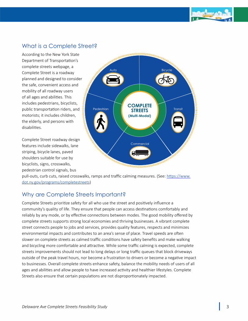
What is a Complete Street?According to the New York State Department of Transportation’s complete streets webpage, a Complete Street is a roadway planned and designed to consider the safe, convenient access and mobility of all roadway users of all ages and abilities. This includes pedestrians, bicyclists, public transportation riders, and motorists; it includes children, the elderly, and persons with disabilities.
Complete Street roadway design features include sidewalks, lane striping, bicycle lanes, paved shoulders suitable for use by bicyclists, signs, crosswalks, pedestrian control signals, bus pull-outs, curb cuts, raised crosswalks, ramps and traffic calming measures. (See: https://www.dot.ny.gov/programs/completestreets)
Why are Complete Streets Important?Complete Streets prioritize safety for all who use the street and positively influence a community’s quality of life. They ensure that people can access destinations comfortably and reliably by any mode, or by effective connections between modes. The good mobility offered by complete streets supports strong local economies and thriving businesses. A vibrant complete street connects people to jobs and services, provides quality features, respects and minimizes environmental impacts and contributes to an area’s sense of place. Travel speeds are often slower on complete streets as calmed traffic conditions have safety benefits and make walking and bicycling more comfortable and attractive. While some traffic calming is expected, complete streets improvements should not lead to long delays or long traffic queues that block driveways outside of the peak travel hours, nor become a frustration to drivers or become a negative impact to businesses. Overall complete streets enhance safety, balance the mobility needs of users of all ages and abilities and allow people to have increased activity and healthier lifestyles. Complete Streets also ensure that certain populations are not disproportionately impacted.
COMPLETESTREETS
(Multi-Modal)
Pedestrian Transit
BicycleAuto
Commercial

4 Delaware Ave Complete Streets Feasibility Study
WhataresomeoftheSpecificCompleteStreetsFeaturesConsidered in this Study?A fundamental goal of this study is to determine if a road diet is feasible on Delaware Avenue from Elsmere Avenue to the Normanskill Bridge. Road diets reduce the number or width of travel lanes on a facility making more room for bicycles, improving buffer space to pedestrians, reducing travel speeds and improving safety. Road diets can reduce speed differential and have been shown to slow vehicle speeds and decrease the frequency of people speeding. Average and 85th percentile speeds are likely to decrease by 3 to 5 mph1. Road diets are recognized by the FHWA as a proven safety counter measure and can reduce crashes by 19 to 47 percent2. In addition to the road diet, this study looks at other complete streets enhancements, such as improved transit stops and service, Americans with Disabilities Act (ADA) requirements, pedestrian crossing improvements, gateway and traffic calming improvements, and additional access to the Albany County Rail Trail, among others. After analysis of existing conditions within the Study Area the next phase of the study will include development and evaluation of alternatives encompassing different roadway configurations and complete streets elements.
http://safety.fhwa.dot.gov/road_diets/guidance/info_guide/rdig.pdf
1 Road Diet Informational Guide, FHWA Report No. SA-14-028, dated November, 2014, pg. 15 2 Ibid, pg. 7
Why is a Road Diet being considered for Delaware Avenue?Delaware Avenue is a four-lane undivided roadway (for most of its length within the study area) and experiences higher than state-wide average crash rates (see Crash section later in this Chapter). According to FHWA’s Road Diet Information Guide “For roads with appropriate traffic volumes, there is strong research support for achieving safety benefits through converting four-lane undivided roads to three-lane cross sections with TWLTLs (two-way center left turn lanes). A Road Diet is generally described as “removing travel lanes from a roadway and utilizing the space for other uses and travel modes.”

5Delaware Ave Complete Streets Feasibility Study
HowwilltheSpecificCompleteStreetsFeaturesBeEvaluated?The Study Approach is designed to provide sufficient factual information and engage all stakeholders to understand the benefits and trade-offs of the alternatives, and to enable informed decision making. This includes:
• Safety analysis (acceptable to road owner – NYSDOT)• Operational Analysis (acceptable to road owner – NYSDOT)• Public and Stakeholder Input• Identification and Analysis of Community Needs and Impacts• Implementation and Generalized Costs
What is the Study Approach?A Study Advisory Committee (SAC) was established to help guide the study, and to review and give feedback on interim and final study products. SAC members include diverse interests and agencies including study area businesses, study area residents and civic organizations, Town staff and Town officials, and a number of public agencies (Capital District Transportation Committee (CDTC), Capital District Transportation Authority (CDTA), Capital District Regional Planning Commission (CDRPC), and the New York State Department of Transportation, (NYSDOT) Region 1).
A Technical Advisory Committee (TAC) was also formed to meet regularly, undertake project tasks, review progress and guide the overall study. Specific SAC and TAC committee members are listed in the project’s Public Participation Plan contained in the Appendix.
The goal of these committees is to share technical information, provide input on public outreach materials, enable informed decision-making, help shape the draft and final study recommendations, and provide overall guidance on the study as it progresses. The good cross section of agencies and interests on these committees, combined with the open public process will ensure that diverse views are represented, and that the plan is comprehensive and publicly supported.
The recommendations presented in this study are intended to support the Town’s efforts to fully develop the community’s vision, and the realistic multi-modal functionality and appearance of Delaware Avenue. The recommendations are conceptual in nature and are presented to characterize the types of improvements that are desirable, and that may be implemented as part of future land use and transportation improvement projects. All transportation concepts will require further engineering evaluation and review. This report was prepared in cooperation with the Town of Bethlehem, CDTC, CDTA, NYSDOT and the Federal Highway Administration. The contents do not necessarily reflect the official views or policies of these government agencies.
The recommendations set forth in this report are conceptual in nature and do not commit NYSDOT, CDTC, CDTA or the Town of Bethlehem to funding any of the improvements. The concepts need to be investigated in more detail before any financial commitments can be made.

6 Delaware Ave Complete Streets Feasibility Study
What are the Study Goals?At the outset of the Study, the SAC developed the following five draft study goals which will be reviewed with the public at the first public workshop and revised if needed. These goals establish the framework for this Study, and the resulting conclusions and recommendations.
The overall goal of the Delaware Avenue Complete Streets Feasibility Study is to:
1. Create a plan for a more balanced transportation system along Delaware Avenue to enable safe and comfortable ADA compliant access for users of all ages and abilities, including pedestrians, bicyclists, transit users and motor vehicle drivers, otherwise known as a Complete Street.
2. Ensure an effective public involvement process to engage the community in learning about the benefits and potential tradeoffs of complete streets designs along Delaware Avenue and to seek and obtain public input on conceptual designs that balance the needs of all roadway users.
3. Explore the feasibility a full range of context-sensitive complete streets elements in a manner that enhances community quality of life, the local economy, and safety for all users along this multi-modal and increasingly mixed use corridor and its adjacent residential neighborhoods.
4. Continue to implement the Town’s stated goals of fostering a walkable, bikeable and transit friendly community serving the needs of all ages and abilities.
5. Develop conceptual future roadway designs that are acceptable to the town, its residents and businesses and NYS DOT as the road owner utilizing the space for other uses and travel modes.

7Delaware Ave Complete Streets Feasibility Study
What is the Study Area?The Study area extends along Delaware Avenue from Elsmere Avenue to the Normanskill Bridge including the transportation corridor itself, along with the adjacent land and businesses. This 1.3 mile section of NY Route 443 is an important corridor for all modes including, regional commuting between Albany and Bethlehem and points west, local transit, and also for short trips by foot or car or bicycle between local neighborhoods, Elsmere Avenue, the Elsmere Elementary School, the Delaware Plaza, and other corridor businesses and services. The study area also extends to the south along the Albany County Rail Trail where additional access to the trail is considered. Within the study area, a detailed traffic simulation model was developed to help understand the operational trade-offs of various alternatives.
Figure 1.1. Study Area

8 Delaware Ave Complete Streets Feasibility Study
This page intentionally left blank

9Delaware Ave Complete Streets Feasibility Study
Zoning and Land UseZoning along the corridor is Commercial Hamlet. The areas immediately outside the corridor are zoned Residential. The residents and businesses in these areas are likely to be a majority of those that will benefit from any improvements. The Town has a long history of making smart land use, planning, and zoning decisions that have ensured that the adjacent small businesses and the look of the street have improved over time.
CHAPTER 2
Existing Conditions
Figure 2.1. Existing Zoning

10 Delaware Ave Complete Streets Feasibility Study
Figure 2.2. Existing Land Use

11Delaware Ave Complete Streets Feasibility Study
Land Use Access, Driveways and Trip GenerationThe roadway network of a community is defined in terms of street hierarchy. This hierarchy describes the principal use and intended function of each road. Under the functional classification system Delaware Avenue is classified as an urban minor arterial. In comparison, Delmar Bypass (NY 32) is classified as an urban principal (or major) arterial and Elsmere Avenue/NY 335 is an urban major collector street.
According to the Federal Highway Administration (FHWA) minor arterials provide service for trips of moderate length, serve geographic areas that are smaller than their principal arterial counterparts and offer connectivity to the principal arterial system. In an urban context, minor arterials interconnect and supplement the principal arterial system, provide for trips of moderate length within a community and may carry local bus routes. Simply put, streets like Delaware Avenue/NY 443, serve the through movement of traffic between communities. Local streets provide access to abutting land, such as residential neighborhoods. Collector streets funnel traffic between the two, and usually serve a secondary land access function. When a street begins to serve more than its principal function, conflicts can occur.
One type of conflict that occurs along Delaware Avenue – a minor arterial – involves access with adjacent land use generated traffic. Where frequent or closely spaced curb cuts and resulting driveway turn movements are found they interrupt traffic flow. As conflict between the primary function of a roadway as conveyor of through traffic and access to adjoining parcels increases, congestion and traffic conflict follow. This situation also limits the suitability of arterials for use by pedestrians, transit users, and bicyclists.
As shown in the Delaware Avenue Curb Cut Inventory in Appendix D, there are currently already 20 shared driveways and another 10 land uses which do not have direct access to Delaware Avenue; these uses have access to the adjacent side street. By using these access management techniques such as shared driveways to access multiple land uses and access via side streets only, conflicts are reduced. Through this study opportunities to further reduce driveway conflicts will be explored using these and other access management techniques where appropriate and feasible.
To measure the conflict in the Delaware Avenue/NY 443 study area, CDTC evaluated level of conflict (LOC) for the corridor on a scale of A to F. The LOC ratings compare the number and spacing between driveways along a roadway to its traffic volume – the more frequent the number of driveways and the higher the traffic volume, the poorer the rating. This comparison provides a measure of arterial function in terms of potential conflicts between through traffic on a roadway and vehicles turning into or out of adjacent driveways. A level-of-conflict of “C” or better indicates that the interplay between driveway access and through traffic is minimal. Ratings from D to F indicate that there is probably frequent conflict which often negatively affects traffic flow and

12 Delaware Ave Complete Streets Feasibility Study
increases traffic conflict and crashes. The level of conflict scores for the two segments of Delaware Avenue within the study area are shown below.
There are approximately 73 driveways and 14 unsignalized side street intersections within the study area as shown in Appendix D. The Delaware Avenue Curb Cut Inventory table details the use name, street address, land use type, building square footage or number of residential units, parcel frontage length along Delaware Avenue, type of access (e.g. all types of turns are allowed or turns are restricted to rights in/out only), whether the parcel has access to a traffic signal or access to an unsignalized side street, and finally, information used to estimate the number of trips each use is forecast to generate during the PM peak hour. Trip generation estimates for both existing land uses and for new uses planned for the corridor over the next year were calculated by applying a known trip rate for each use type derived in part by data reported in the 9th edition of the ITE Trip Generation Manual, and supplemented by local traffic and land use data collected by Town staff and CDTC.
Using the ITE Trip Generation Manual data, the number of PM Peak Hour trips estimated to be produced by existing Delaware Avenue land uses within the study area is approximately 2,170; currently planned new development located within the study area will add approximately 70 additional trips.
Road Segment Length (Miles) AADT Driveways
per mile
Average Driveway
Spacing (Feet)*
Conflict Index (AADT/Avg
Spacing)
Level of Conflict
Segment 1: Elsmere Avenue to Delaware Plaza/Normanskill Boulevard(Approximate Segment Length = 2,650 Ft. or 0.5 miles)
0.5 18300 72 147 124 E
Segment 2: Delaware Plaza/Normanskill Boulevard to Normanskill Bridge(Approximate Segment Length = 4,224 Ft. or 0.8 miles)
0.8 15600 45 250 62 D* Average Driveway Spacing calculated using Delaware Avenue Curb Cut Inventory (see Appendix X)
Level of Conflict Definitions Grade Score
Arterial function not affected by access A 0-9.9Aware of turning traffic, but not an issue B 10-19.9Access traffic noticeable; a concern C 20-49.9Frequent conflict between access and through traffic D 50-99.9Persistent conflict between access and through traffic E 100-199.9Either access or through movement not functional F 200+
Table 2.1. Delaware Avenue/NY 443 Arterial Level of Conflict Index

13Delaware Ave Complete Streets Feasibility Study
Transportation Infrastructure
Physical CharacteristicsDelaware Avenue (NY Route 443) extends in an east-west direction through the Town of Bethlehem and is classified as an urban minor arterial. In general, Delaware Avenue is a four-lane roadway 48 feet wide, with two 11-foot wide travel lanes in each direction, one-foot wide shoulders off-set to curb, and a two-foot wide median The roadway widens in the central part of the study area near Delaware Plaza and provides a 5-lane cross section (60 feet wide), and transitions on both ends to provide a two-lane cross section entering the Delmar hamlet on the west, and the City of Albany to the east. There is typically a 3 foot wide asphalt utility strip separating the traveled way from the sidewalk. The Right-of-way width is typically 66 feet wide in the four lane areas, widens to 90 feet in the vicinity of Delaware Plaza, and is variable in width east of Old Delaware Ave.
The roadway is curbed with closed drainage which functions well overall with no history of flooding or ponding. The curb is predominately concrete and is overall in average condition, but with good reveal to channel storm water. In a few areas, where driveways have been removed, the drop curb still remains.
Data published by the New York State Department of Transportation (NYSDOT) in the latest version of the Pavement Data Report indicates that the pavement on Delaware Avenue in the study area is in fair-to-good condition (Rated 6 or 7) with distress clearly visible or beginning to show. The NYSDOT’s current 5 year capital program does not include any pavement work on Route 443 within the study limits.
Typical view of Delaware Avenue near Lincoln Avenue and My Place & Co.

14 Delaware Ave Complete Streets Feasibility Study
The posted speed limit on Delaware Avenue is 40-mph in the study area. Immediately beyond the study area in both directions, the posted speed limit is lower (30-mph entering the Hamlet of Delmar to the west, and 30-mph entering the City of Albany to the east. Within the study area, a 30-mph school zone speed limit exists on school days from 7:00 a.m. to 6:00 p.m. in the vicinity of Elsmere Elementary school.
Pedestrian and Bike FacilitiesThe narrow or limited shoulders for the majority of the corridor makes bicyclists share the road in the travel lane. Less confident bicyclists use the sidewalks. Sidewalks are present along the south side of Delaware Avenue for the entire length of the study area from Elsmere to the Normanskill Bridge, and along the north side for approximately half of the corridor, leaving the 0.65 mile section on the north side from the Park and Ride/Bank of America to the Normanskill Bridge without a sidewalk. Sidewalks are typically narrow – four feet wide for most of the corridor, except in front of Delaware Plaza where wider 5-foot sidewalks are present. The 5-foot sidewalk width is the recommended minimum width for a pedestrian access route. A 4-foot sidewalk width can be ADA compliant, provided wider (5 ft by 5 ft) passing areas are provided at intervals of 200 feet or less. (See page 33: https://www.access-board.gov/attachments/article/743/nprm.pdf, and pages 18-28 to 18-30: https://www.dot.ny.gov/divisions/engineering/design/dqab/hdm/hdm-repository/chapt_18.pdf)
Figure 2.3. Existing Pedestrian Facilities

15Delaware Ave Complete Streets Feasibility Study
Detectable warning strips are present at only a few locations (signalized intersections). The Town has completed a self-evaluation for ADA compliance, and identified the need to upgrade the sidewalk infrastructure on Delaware Avenue. The NYSDOT ADA Transition Plan also recognizes the need to upgrade the pedestrian infrastructure (from Elsmere Avenue to Mason Road generally excluding the area near Delaware Plaza). Marked cross-walks are present at the two traffic signals with push buttons and protected signal phasing. Based on the NYS Vehicle and Traffic Law, pedestrian crossing demand should be assumed at all intersecting public streets, and unmarked crosswalks exist at these locations. Pedestrian crossings during busy times can be a challenge at these unmarked locations, and walking distances to the nearest protected pedestrian crossing can be long (approximately ¼ mile) for someone near the central part of the corridor (i.e. in the vicinity of Bedell Ave).

16 Delaware Ave Complete Streets Feasibility Study
Bicyclist using sidewalk eastbound approaching Salisbury Road.
Elsmere Elementary School Zone:Elsmere Elementary School is located at 247 Delaware Avenue on the north side of the roadway. This neighborhood school serves 300 students from Kindergarten to Grade 5.
It was reported in 2015 that about 25 students typically walk or bike to school on a typical day (8% of students) - this number doubles in nice weather to over 16% of students. Walkers make up most of this group.
According to the school principal, students are walking from neighborhoods on the north side of Delaware Avenue as well as from the south side, requiring them to cross Delaware Avenue. The Delaware Avenue/Elsmere Avenue signalized intersection is the required route for crossing and is staffed with a school crossing guard during the morning school arrival and afternoon school dismissal periods.
During the Fall of 2016 data was collected at the Delaware Avenue/Elsmere Avenue intersection during the school dismissal time period on a sunny day. Between 3:15 to 3:30 pm 40 pedestrians were observed using the signalized intersection with the assistance of a school crossing guard. The crossing guard activated the pedestrian signal for each crossing and accompanied pedestrians across each leg of the intersection during the WALK phase. Students were typically in groups and accompanied by at least one adult.
Bicyclist sharing the road eastbound approaching McDonald’s area

17Delaware Ave Complete Streets Feasibility Study
According to the New York State Highway Design Manual (NYS HDM) Section 18.7.1.1 Pedestrian Street Crossing Dynamics, suggested walking distances and spacing of crossings are highlighted in the adjacent text box.
Pedestrian Crossings: “Based on FHWA research and AASHTO guidance, 1.6 km (1 mile) is recognized as the maximum walking distance that most healthy/able-bodied people would be willing to undertake. However, the research also states that the majority of pedestrian trips are 0.4 km (1/4 mile) in length. Subject to good engineering judgment, 0.4 km is an appropriate average distance for accommodating “most” pedestrians of all abilities, outside of high-pedestrian traffic zones. In high-pedestrian traffic zones, or central business/walking districts, pedestrian crossings spaced between 100 m and 150 m (330 ft to 500 ft) apart would be reasonable and may correspond with the typical block lengths in high-pedestrian traffic zones. Suggested spacing of crossings are as follows:
• Central business/walking districts – from 100 m to 150 m (330 ft to 500 ft) apart and based on density.
• Urban or suburban residential/retail areas – based on density/ land use and not to exceed 0.4 km. (1/4 mile)
• Low-density rural centers/seasonal use areas – as needed. It is easier to find crossable gaps.
The maximum distance that people with disabilities should reasonably be expected to divert from their intended path would be between 50 m and 75 m. (165 ft and 250 ft)”
18 Delaware Ave Complete Streets Feasibility Study
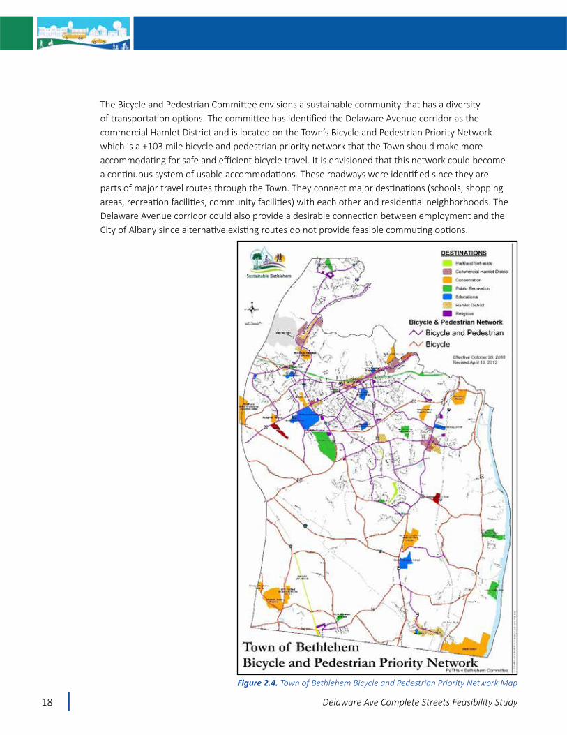
The Bicycle and Pedestrian Committee envisions a sustainable community that has a diversity of transportation options. The committee has identified the Delaware Avenue corridor as the commercial Hamlet District and is located on the Town’s Bicycle and Pedestrian Priority Network which is a +103 mile bicycle and pedestrian priority network that the Town should make more accommodating for safe and efficient bicycle travel. It is envisioned that this network could become a continuous system of usable accommodations. These roadways were identified since they are parts of major travel routes through the Town. They connect major destinations (schools, shopping areas, recreation facilities, community facilities) with each other and residential neighborhoods. The Delaware Avenue corridor could also provide a desirable connection between employment and the City of Albany since alternative existing routes do not provide feasible commuting options.
Figure 2.4. Town of Bethlehem Bicycle and Pedestrian Priority Network Map

19Delaware Ave Complete Streets Feasibility Study
The Capital District Transportation Committee’s regional long range transportation plan, New Visions 2040, identifies the study area as a Tier 1 Pedestrian District, with Delaware Avenue itself as a part of the region’s adopted Bicycle and Pedestrian Priority Network (See: http://www.cdtcmpo.org/page/57-project-programs/pedestrian/43-bicycle-and-pedestrian-priority-network)
The CDTC Bicycle and Pedestrian Priority Network consists of two components – pedestrian districts and a linear network.
• Pedestrian districts were created to highlight and address the fact that pedestrian movement is more fluid than linear, and that investments in pedestrian infrastructure should be made where there are greater densities of people living or working and in closest proximity to pedestrian generating destinations.
• The linear network connects the pedestrian districts via major travel routes and makes connections to activity generators outside of designated districts. The basis for the linear network was that these longer routes are attractive to bicyclists and manageable to travel by bicycle, whereas walking would be less feasible.
Bicycle and pedestrian infrastructure improvement projects proposed on these networks will be prioritized for funding. A complete description of the Bicycle and Pedestrian Priority Network can be found in CDTC’s Bicycle-Pedestrian White Paper. (http://www.cdtcmpo.org/images/New_Visions_RTP/Bicycle-Pedestrian-White-Paper-September-2015.pdf
http://cdta.maps.arcgis.com/apps/MapTools/index.html?appid=25b0d9cee20341219784e3954d12fe85
Figure 2.5. CDTC Bicycle and Pedestrian Priority Network Map

20 Delaware Ave Complete Streets Feasibility Study
Trail AccessThe recently opened Helderberg Hudson Rail Trail (also known as the Albany County Rail Trail), is a tremendous asset to the community and is widely used by enthusiasts, commuters, walkers and bicyclists of all ages. Within the study area, there is one formal access point to the trail, located at the end of Booth Road. Unofficial foot paths to and from the trail also exist at a number of locations such as the waterline between Ellsworth Ave and East Poplar Drive, and both ends of Mason Road, among others. This study will explore improved access to the trail.
A Plank over the ditch at Bedell Ave provides informal trail access. Additional formal trail access points are needed
Users enjoying the rail trail. Additional access points to the trail are needed.
21Delaware Ave Complete Streets Feasibility Study
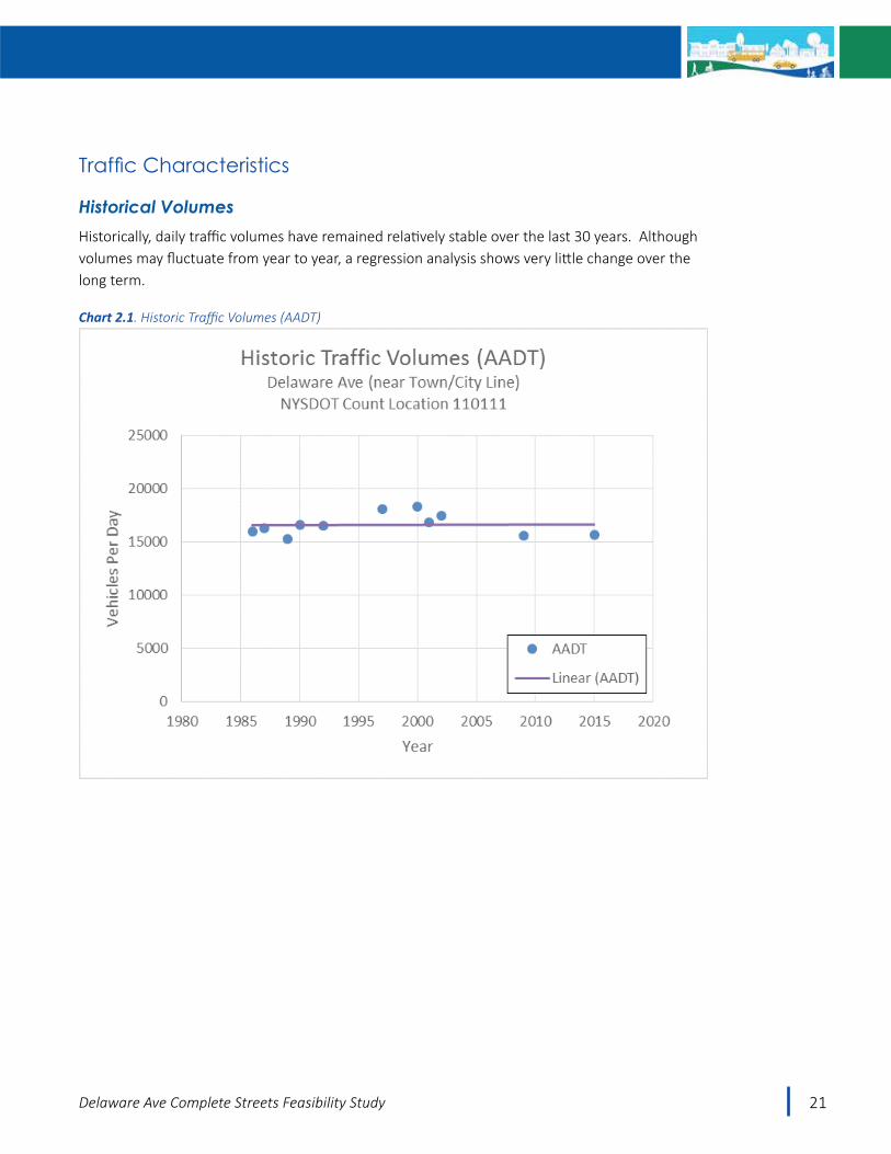
TrafficCharacteristics
Historical VolumesHistorically, daily traffic volumes have remained relatively stable over the last 30 years. Although volumes may fluctuate from year to year, a regression analysis shows very little change over the long term.
Chart 2.1. Historic Traffic Volumes (AADT)

22 Delaware Ave Complete Streets Feasibility Study
Existing Volume and SpeedAutomatic traffic recorders were installed at several locations along Delaware Avenue during October 2016 to document traffic characteristics including daily traffic volumes, peak travel times, and travel speed information. Intersection turning movement counts, pedestrian counts, and delay counts were also conducted during May, June, September and October, 2016 to facilitate the development of a traffic simulation model. The existing traffic data is summarized below.
DELAWARE AVENUE630 Ft East of Elsmere
Ave50 Ft East of Salisbury
Rd1000 Ft East of Old
Delaware Ave
Volume AADT (vpd)
DHV (vph)K
DDHV% HV
18,100
17949.9%10912%
18,300
185610.1%11412%
15,600
160810.3%10092%
Speed (mph)Average EB
WB
85th Percentile EBWB
34.734.4
40.339.8
35.236.4
40.041.2
41.340.2
46.344.9
AADT = Average Annual Daily Traffic; (vpd = vehicles per day)DHV = Design Hour Volume; (vph – vehicles per hour)K = Peak hour traffic as a percent of daily traffic volumeDDHV = Directional Design Hour Volume% HV = Percent Heavy Vehicles
The data shows that the average annual daily traffic volume on Delaware Avenue is approximately 18,300 vehicles per day between Elsmere Ave and the Delaware Plaza, and approximately 15,600 vehicles per day east of Delaware Plaza to the City line.
Chart 1 shows the two-way traffic volumes for a typical weekday, Saturday and Sunday, and shows that peak travel times generally occur from 5:00 to 6:00 p.m. on a weekday. Saturday and Sunday volumes are less.
Chart 2 shows the directional traffic volumes for a typical weekday and shows that eastbound traffic peaks during the morning as commuters are traveling towards Albany, and westbound traffic peaks during the afternoon. In terms of mainline or corridor level-of-service, Delaware Avenue has maintained a high level-of-service related to mid-block capacity thresholds that compare the number of travel lanes with the estimated amount of daily traffic as shown on Chart 2. Mainline traffic conditions were evaluated by using guidelines reported in CDTC’s Congestion Management System for regional and corridor planning work. Mainline highway capacity deficiencies are identified by comparing mid-block traffic demand against estimated
Table 2.2. Traffic Volume and Speed Summary

23Delaware Ave Complete Streets Feasibility Study
mid-block capacities. As shown in Chart 2.2, Delaware Avenue in the study area operates well throughout the day with demand well-below the capacity threshold of the roadway. In general, results show that there is some potential for right-sizing the corridor.
0
200
400
600
800
1000
1200
1400
1600
1800
2000
Vehi
cles
per
Hou
r (VP
H)
Hourly Traffic Variations (Typical Week)Delaware Ave - East of Salisbury Rd
WeekdaySaturdaySunday
LegendTraffic Demand
Existing 2016 Demand
Chart 2.2. Traffic Profile A
0
200
400
600
800
1000
1200
12:0
0 AM
1:00
AM
2:00
AM
3:00
AM
4:00
AM
5:00
AM
6:00
AM
7:00
AM
8:00
AM
9:00
AM
10:0
0 AM
11:0
0 AM
12:0
0 PM
1:00
PM
2:00
PM
3:00
PM
4:00
PM
5:00
PM
6:00
PM
7:00
PM
8:00
PM
9:00
PM
10:0
0 PM
11:0
0 PM
Vehi
cles
per
Hou
r (VP
H)
Hourly Traffic Variations (Weekday)Delaware Ave - East of Salisbury Rd
EB WB
Legend
Traffic Demand
Existing 2016 Demand
Level of Service Threshold(VPH each direction)
Existing 4-lane cross section
LOS D = 2500 VPHLOS E = 3120 VPH
Road Diet 3-lane cross section
LOS D = 1250 VPHLOS E = 1625 VPH
Chart 2.3. Traffic Profile B

24 Delaware Ave Complete Streets Feasibility Study
Figure 2.6. Traffic Volume

25Delaware Ave Complete Streets Feasibility Study
The data shows that the 85th percentile speeds are 40 to 41-mph near Salisbury Road, and 45 to 46-mph immediately west of the Normanskill Bridge. The 85th percentile speed is the speed at or below which 85 percent of motorists travel and is the standard procedure used to establish posted speed limits for NYSDOT roads. An examination of speed characteristics over a single 24-hour weekday period is shown on Chart 2.4 and shows that speeds are the lowest during the noon hour and the PM rush hour, and are higher during the morning commute and during off-peak periods. The issue of speeds is important as speed reduction measures are part of the Complete Streets elements that can improve safety and quality of life consistent with the goals of this study.
Chart 2.4. Speed Profile

26 Delaware Ave Complete Streets Feasibility Study
Operating speeds were also examined based on five off-peak travel time runs in each direction and showed that it takes around two to two and a half minutes to travel the corridor from end to end during off-peak periods. There is some delay at the traffic signals, but overall traffic moves very well along Delaware Avenue with little delay. During the PM peak hour it takes roughly two and half to three minutes to travel the corridor as delays at the signals are more pronounced, but traffic flow for motorists is still good. A speed profile was developed from the off-peak travel time runs as shown on the following page and shows that operating speeds on the west end of the corridor are generally below 40 mph, while speeds on the eastern end are higher, especially crossing the bridge to/from Albany. This graphic is fairly consistent with the 85th percentile speed data presented earlier and illustrates the difference between the spot speed measurements and how traffic flows along the corridor as a whole. Enforcement can be used to reduce speed differential and help keep speeds closer to the speed limit. This information will be considered later in this study as the feasibility of speed reduction strategies is evaluated, and if a gateway on the east end of the corridor can calm traffic.

27Delaware Ave Complete Streets Feasibility Study
Figure 2.7. Speed Profile

28 Delaware Ave Complete Streets Feasibility Study
Multimodal Operations
Automobile TrafficIntersection Level of Service (LOS) and capacity analysis relate traffic volumes to the physical characteristics of an intersection. Level of Service criteria for the automobile-mode criteria are based on performance measures that are field measurable and perceivable by travelers. Intersection evaluations for the study intersections were conducted using Synchro 8 software which automates the procedures contained in the 2010 Highway Capacity Manual (HCM). Levels of service range from A to F, with LOS A conditions considered excellent (very little delay) while LOS F represents conditions with very long delays. Tables 2.3 and 2.4 highlight the level of service criteria for signalized and unsignalized intersections, while Tables 2.5 and 2.6 show the results of the analysis
Level of Service
Control Delay per Vehicle (seconds)
A ≤10B >10 and ≤20C >20 and ≤35D >35 and ≤55E >55 and ≤80F >80
Level of Service
Control Delay per Vehicle (seconds)
A ≤10B >10 and ≤10C >15 and ≤25D >25 and ≤35E >35 and ≤50F >50
Table 2.4. Level of Service Criteria for Unsignalized Intersections
Table 2.3. Level of Service Criteria for Signalized Intersections

29Delaware Ave Complete Streets Feasibility Study
Intersection Approach
Cont
rol AM PEAK HOUR PM PEAK HOUR
2016 Existing
2016 Existing
Delaware Ave/Elsmere Ave/ Groesbeck Pl S
Delaware Avenue EB
Delaware Avenue WB
Elsmere Avenue NB
Groesbeck Place SB
LT,TR
LTRLTR
LTR
B (15.8)C (21.3)A (9.5)
B (10.4)D (46.2)D (49.9)C (34.5)
B (17.2)C (20.1)D (40.6)B (18.5)D (37.2)B (18.8)C (28.6)
Overall C (26.4) C (25.4)
Delaware Ave/Normanskill B/Delaware Plz S
Delaware Avenue EB
Delaware Avenue WB
Delaware Plaza NB
Normanskill Boulevard SB
LT,TR
LT,TR
LTR
LTR
NA
D (35.6)C (29.3)B (19.9)C (26.3)C (25.2)B (19.2)B (19.9)B (19.9)
Overall C (26.3)
S = Traffic Signal; EB, WB, NB, SB = Eastbound, Westbound, Northbound, and Southbound L, T, R = Left-turn, Through, and/or Right-turn movements; X (Y.Y) = Level of service (Average delay (sec/veh)NA = Not Available
Table 2.5. Signalized Level of Service Summary

30 Delaware Ave Complete Streets Feasibility Study
Intersection Approach
Cont
rol PM PEAK HOUR
2016 Existing
Delaware Avenue/Herrick Avenue UDelaware Avenue EB
Herrick Avenue SBL
LRB (11.5)C (24.2)
Delaware Avenue/Booth Road UDelaware Avenue WB
Booth Road NBL
LRA (9.0)
C (16.4)
Delaware Avenue/Handy Dandy West UDelaware Avenue WB
Handy Dandy West DrwyL
LRA (9.5)
D (27.1)
Delaware Avenue/Handy Dandy East/My Place & Co. West UDelaware Avenue EB
Delaware Avenue WBHandy Dandy East NB
My Place & Co. West SB
LL
LTRLTR
B (11.1)A (9.5)
C (20.7)C (18.6)
Delaware Avenue/Dunkin Donuts West/My Place & Co. East UDelaware Avenue EB
Delaware Avenue WBDunkin Donuts West NB
My Place & Co. East SB
LL
LTRLTR
B (11.3)A (9.4)
D (29.9)B (13.1)
Delaware Avenue/Dunkin Donuts East/School’s Out Drwy UDelaware Avenue EB
Delaware Avenue WBDunkin Donuts East NB
School’s Out Drwy SB
LL
LTRLTR
B (11.2)A (9.3)
D (25.0)D (31.6)
Delaware Avenue/Lincoln Avenue/Phillips Hardware UDelaware Avenue EB
Delaware Avenue WBLincoln Avenue NB
Phillips Hardware SB
LL
LTRLTR
B (11.4)A (9.3)
C (22.2)E (48.8)
Delaware Avenue/Leonard Place UDelaware Avenue EB
Leonard Place SBL
LRB (11.2)D (25.3)
Delaware Avenue/Salisbury Road UDelaware Avenue EB
Salisbury Road SBL
LRB (11.3)C (22.3)
Delaware Avenue/Snowden Avenue UDelaware Avenue WBSnowden Avenue NB
LLR
A (9.2)C (19.2)
Delaware Avenue/Euclid Avenue UDelaware Avenue EB
Euclid Avenue SBL
LRB (11.4)C (17.0)
Delaware Ave/Brueggers / Delaware Plaza UDelaware Avenue WB L A (0.0)
U = Unsignalized intersection; EB, WB, NB, SB = Eastbound, Westbound, Northbound, and Southbound L, T, R = Left-turn, Through, and/or Right-turn movements; X (Y.Y) = Level of service (Average delay (sec/veh)NA = Not Available
Table 2.6. Unsignalized Level of Service Summary

31Delaware Ave Complete Streets Feasibility Study
The analysis shows that overall traffic operations are good with motorists experiencing average delays during peak times. The Elsmere Avenue intersection operates at LOS C overall during both peak hours. The Delaware Plaza intersection also operates at LOS C overall. Some individual lanes experience longer delays as evidenced by the LOS D/E on some movements. The analysis also shows that average delays from the unsignalized side streets are generally 15 to 30 seconds or LOS C/D, with the exception of the Philips Hardware driveway, which experiences average peak delays of 49 seconds (LOS E) Some motorists wait longer especially trying to make left turns, but the overall average delay is reasonable based on these standard traffic engineering measures.

32 Delaware Ave Complete Streets Feasibility Study
TransitThe Capital District Transportation Authority (CDTA) provides bus service along this section of Delaware Avenue. The bus route 18 begins at the Price Chopper Plaza in Slingerlands, travels along Cherry Avenue Extension (Route 140), to Cherry Ave (CR 52) to Delaware Avenue, then along Delaware Avenue through the study area into the City of Albany and terminates in downtown Albany. Buses operate on a 20 minute headway during the morning peak hour, half hour headways during mid-day, 15-minute headways during the evening commute, and approximately 50 minute headways in the evening before ending service around 11:00 p.m. Within the 1.3 mile long study area, there are 7 bus stops in each direction. The following map illustrates the existing bus stop locations. CDTA’s Route 18 is considered a trunk route with total ridership of over 449,700 passengers during the period from April 1, 2015 to March 31, 2016.
Most of the bus stops are designated by a sign on a stand-alone sign post or an existing utility pole. There are three bus stop locations with shelters on the eastbound side (Far side at Elsmere Avenue, nearside at Delaware Plaza and mid-block outside Healthy Pet Center) and one westbound nearside at the Delaware Plaza. The existing Park and Ride lot that CDTA operates near 99 Delaware Ave has 99 parking spaces and four accessible spots. The lot also has four lockable bike storage lockers accessible to the public free of charge, so linking bike and bus trips
Figure 2.8. Existing Transit Stops

33Delaware Ave Complete Streets Feasibility Study
is convenient. Based on data provided by the CDTA, Table 2.6 shows the average daily ridership for each bus stop along the corridor. The table shows that the bus stops located at the Delaware Plaza/Normanskill Boulevard have the highest ridership in both directions. The bus stops at the Healthy Pet Center and Elsmere Avenue in the eastbound direction and Mason Road in the westbound direction also have higher ridership. Most of the bus stops are paired stops (meaning stops in both directions) with the exception of Lincoln Avenue and 243 Delaware Avenue. Since there are only two signalized intersections in the corridor, most of the bus stops are located at unsignalized intersections. Bus stops create pedestrian crossing demand and bus stop placement and design should consider pedestrian crossing needs.
Stop Location Average Daily On
Average Daily Off
Total Average On/Off
Eastbound StopsDelaware Ave & Elsmere Ave (01257) 20 3 23Delaware Ave & Lincoln Ave (01429) 4 1 5
Delaware Ave & Snowden Ave (01255) 7 1 8
Delaware Ave & Normanskill Blvd (01254) 43 7 50154 Delaware Ave (Healthy Pet Center) (01253) 32 2 34Delaware Ave & Mason Rd (02988) 5 1 6Delaware Ave & Grant St (01312) 7 1 8
Westbound StopsDelaware Ave & Grant St (01338) 1 9 10Delaware Ave & Mason Rd (11431) 1 19 2099 Delaware Ave(Albany Med Center Corporate Finance) (01965) 2 12 14Delaware & Normanskill (NYS Dept. Of Public Service) (01333) 8 51 59
Delaware Ave & Salisbury Rd (01281) 1 6 7
243 Delaware Ave (Pearl’s Pet Store) (11432) 1 10 11Delaware Ave & Herrick Ave (01329) 1 11 12
Later in this study as alternatives are developed and analyzed, bus stop locations will be considered and recommendations coordinated with CDTA. According to TCRP Report 19, Guidelines for the
Table 2.7. Ridership Summary
Existing eastbound station in front of Community Care Medical building (250 to 256 Delaware Ave) -
One of the better equipped bus stops in the corridor.

34 Delaware Ave Complete Streets Feasibility Study
Location and Design of Bus Stops, bus stop spacing in suburban areas is typically 1000 feet, and can range 600 to 2500 feet. Accordingly there may be opportunities to consolidate bus stops in the study area and coordinate them with improved pedestrian crossing opportunities.
Bicycle Level of Service and Intersection Pedestrian Facilities AnalysisBicycle comfort and intersection pedestrian facilities assessments were completed using CDTC Linkage Study methods to assign values according to how amenable the facilities are to bicycle and pedestrian travel. The pedestrian scoring and grades are summarized in Tables 2.8 and 2.9, and on Figure 2.9 and show that the two signalized intersections grades of B/C and the unsignalized intersections are graded D.
Amenity Score if Present
Partial ped head 1
Full ped head 2
Stop sign 1
Partial crosswalk 1
Full crosswalk 2
Median / median island 1
No shoulders 1
All curb ramp 2
Partial curb ramps 1
Partial sidewalk 1
Full sidewalk 2
Number of Lanes Traversed Score if True5 0
4 1
3 2
2 3
Total Possible 13
Grade Score
A 12-14
B 10-11
C 8-9
D 5-7
E 3-4
F 1-2
Table 2.8. Pedestrian Intersection Facilities Analysis Inputs
Table 2.9. Pedestrian Scores

35Delaware Ave Complete Streets Feasibility Study
The Bicycle level of service (BLOS) in the corridor was estimated based on a model developed by Landis3, and consistent with previous CDTC linkage study methodologies. The model reflects bicyclist’s perceived safety and comfort with respect to motor vehicle traffic while traveling along a roadway and is useful for evaluating bicycling conditions in a shared roadway environment. The most recent version of the Highway Capacity Manual 2010 includes a BLOS measure4 adapted from an earlier version of the Landis model using similar attributes. Various roadway characteristics such as travel lane and shoulder widths, motor vehicle speeds and volumes, including the amount of heavy vehicle traffic, and the condition of the pavement are used in the tested traveler-perception model to calculate a Bicycle LOS score. The resulting scores generally range from 0.5 to 6.5 and are broken down into ranges corresponding to LOS A to F, with F representing a roadway with the highest level of discomfort and perceived danger to cyclists. Table 2.10 summarizes the inputs and resulting BLOS ratings for Delaware Avenue, and shows that bicyclists generally experience BLOS D/E while riding in the corridor.
From To Lanes per directions
% Heavy Vehicles
Posted Speed Limit
Traffic Volumes
Travel Lane
Width (ft)
Shoulder Width
(ft)
BLOS Grade
Elsmere Ave Euclid Ave 2 2.13 40 18,200 11 1 E
Euclid Ave Park & Ride Driveway 2 2.13 40 18,200 11-14 0 D
Park & Ride Driveway
800 feet East of Old Delaware Ave
2 2.13 40 15,600 11 1 E
800 feet East of Old Delaware Ave
Normanskill Bridge 1 2.13 40 15,600 12 0 D
3 Landis, Bruce W. et. Al. “Real-Time Human Perceptions: Toward a Bicycle Level of Service” Transportation Research Board 1578, Transportation Research Board (TRB), Washington DC, 19974 Highway Capacity Manual, pp 15-36 to 15-38. Bicycle Mode, TRB, Washington DC, 2010
Table 2.10. Delaware Avenue Bicycle Level of Service Summary Ratings Estimates

36 Delaware Ave Complete Streets Feasibility Study
Figure 2.9. Intersection Pedestrian Facilities and Bicycle LOS Analysis)

37Delaware Ave Complete Streets Feasibility Study
CrashesCrash data was provided by the CDTC for the most recent five years of available data (January 1, 2011 to December 31, 2015), for the segment of Delaware Avenue between Elsmere Avenue and the Albany City line. Table 2.11 summarizes the available data obtained and they are illustrated on Figures 2.10 and 2.11.
Type Crashes
Vehicle 204
Pedestrian 2
Bicycle 7
Total 213
Figure 2.10. Study Area Types of Crashes (2011 – 2015)
Table 2.11. Summary of Available Crash Data (January 1, 2011 to December 31, 2015)

38 Delaware Ave Complete Streets Feasibility Study
The data shows that a total of 213 crashes occurred in the 1.3 mile corridor over the five year study period, with two pedestrian related and seven (7) bicycle related crashes with motor vehicles. Of the 213 crashes, 37 occurred at the two signalized intersections (26 at Elsmere Ave, and 11 at Delaware Plaza), and the remainder occurred along the roadway segments and at unsignalized driveways and intersections. The Figure shows that the crashes are concentrated in the western portion of the corridor and at the unsignalized driveways and intersections near Delaware Plaza.
The Table 2.12 compares the crash rates for the corridor with the State-wide average crash rates for similar facilities.
Location Number of Crashes Crash Rate State-wide Crash Rate
Intersection Crashes (Crashes/MEV)Delaware Avenue/Elsmere Avenue 26 0.68 0.50Delaware Avenue/Delaware Plaza 11 0.32 0.24
Segment Crashes (Crashes/MVM)Elsmere to Delaware Plaza 102 5.80 3.26
Delaware Plaza to Albany City Line 74 3.38 3.26
ACC/MVM = Accidents per Million Vehicle MilesACC/MEV = Accidents per Million Entering Vehicles
Table X. Road Diet Crash Reduction Factors
Figure 2.11. Study Area Crashes (2011 – 2015)
Table 2.12. Summary of Crash Rates

39Delaware Ave Complete Streets Feasibility Study
The table shows that the intersection crash rates are above the statewide average, and that the segment crash rates are also higher than average. It should be recognized that during the summer of 2013, the NYSDOT completed modifications to the Rt 443/Rt 335 intersection and the lanes were reconfigured. (Exclusive east-west left turn lanes were added in place of the shared through/turn lanes.). Since the change (September 2013), the crash rates have been similar (0.70 Crashes/MEV with 12 crashes at the intersection, and 4.93 crashes/MVM with 39 crashes on the segment of Elsmere to Delaware Plaza).
Further review of the crash data showed a number of characteristics summarized below.
• Of the 213 crashes, 49 (23%) involved injury. There were no fatalities in the corridor.
• Analysis of the nine pedestrian and bicycle crashes show that three of the crashes were attributed to driver inattention and two to pedestrian/bike confusion/error. The remaining four were attributed to glare, failure to yield ROW, turning improperly, and outside car distraction.
• The crash data indicates that four of the bicycle crashes occurred on the sidewalk and the remaining three occurred in the roadway. One of the three bicycle crashes that occurred in the roadway involved a bicyclist who was traveling against traffic.
• The majority of the crashes 181/213 (85%) occurred during good weather (clear or cloudy), and with dry pavement 164/213 (77%) indicating weather is not a major contributing factor.
• In terms of the apparent contributing factors, the data shows that the largest portion 62/213 (30%) involved driver inattention followed by 40/213 (19%) involving failure to yield right-of-way.
• The data shows that there were a majority of right-angle crashes 54/213 (25%) and rear-end crashes 42/213 (20%). Based on FHWA Desktop Reference for Crash Reduction Factors (2008), road diets can reduce all crash types by 26 percent (which is consistent with the FHWA range of 19 to 47 percent cited earlier) and are effective at reducing the predominant crash types in the corridor - right angle and rear-end.

40 Delaware Ave Complete Streets Feasibility Study
Countermeasure Crash Type Crash Reduction Factor
Narrow roadway cross section (4 to 3 lanes) with two way left-turn lane
All 26%
Left-turn 24%
Rear-end 31%
Right-angle 37%
• All other categories (animal action, pavement slippery, reaction to uninvolved vehicle, unsafe lane change) reported less than ten occurrences. Twenty-one (21) of the crashes were categorized as unknown.
• The relatively high number of crashes involving driver behavior suggests that education and enforcement should be considered when evaluating potential corrective measures, in addition to the complete streets infrastructure improvements in this study.
In addition to the crash analysis conducted for this study, it is noted that the NYSDOT monitors crashes annually through their Safety Information Management System (SIMS). According to the NYSDOT’s 2011 to 2015 data, various locations within the study area along Delaware Avenue were listed as having statistically significant higher than average accident rates for both overall crashes and for the category of “right angle” crashes. As the complete streets alternatives are identified and evaluated later in this study, the corridor’s crash experience and crash reduction factors will be considered.
Table 2.13. Road Diet Crash Reduction Factors

41Delaware Ave Complete Streets Feasibility Study
LightingLighting is present along Delaware Avenue with overhead cobra style lighting provided on most utility poles, generally along the north side of Delaware Avenue from Elsmere to Euclid, and along the south side of Delaware Ave from Euclid near to the Normanskill Bridge, before switching back to the north side again. A corridor visit during dark conditions showed that a number of the lights were out which can make night time driving, walking or bicycling more difficult. The Town should address lighting maintenance with National Grid in the short term. In the long term, any complete streets design or improvement project should include development of a lighting model to confirm the lighting recommendations and the need for any supplemental lighting in the corridor.
Photo looking east near Herrick Ave shows lighting on the north side of Delaware Avenue
Figure 2.12. Lighting Map

42 Delaware Ave Complete Streets Feasibility Study
This page intentionally left blank

43Delaware Ave Complete Streets Feasibility Study
Two public meetings and a business owner meeting were conducted to gather public input on the corridor issues and potential solutions and the various alternatives. The alternatives were developed to address public and stakeholder input, the goals of the study, and the Complete Streets needs identified in the previous Chapter. This Chapter also presents the analysis of the alternatives so the relative ability of each alternative to meet the project objectives is understood.
Public InputA public information meeting was held on Thursday, February 16, 2017, with over 100 residents, stakeholders, and study advisory committee members present. The purpose of the meeting was to inform the public about this transportation planning study, provide information on the existing conditions and needs, and obtain input from the public on Complete Streets issues and ideas (problems and solutions), that should be considered as the study progressed. Meeting attendees had several opportunities to provide input, map ideas, and were asked what was most important to them as part of a project priorities ranking exercise.
CHAPTER 3
Alternatives and Analysis

44 Delaware Ave Complete Streets Feasibility Study
During a ranking exercise, participants selected traffic calming, auto access to businesses and side streets, and non-vehicular access as the top three choices of what was most important. Safety, corridor beautification and space for bicycles also ranked high. Less popular, were traffic operations for cars, gateway improvements, enhanced livability, and improved transit. Taken together, attendees were looking for an attractive and safer corridor with reduced speeds that provides good access for all modes. Having optimal operations for cars alone was not a priority, but providing reasonable access for cars to and from side streets and businesses was a priority. The full public meeting summary is included in Appendix C.
Chart 3.1. Feedback from Attendees at the First Public Meeting (February 16, 2017)
0
10
20
30
40
50
60
Num
ber o
f Respo
nses
What is Most Important to You?

45Delaware Ave Complete Streets Feasibility Study
Alternatives Based on the public feedback, input from the Advisory Committee, and the nearly 200 mapped ideas that were provided by the public, five roadway alternatives were developed for evaluation, along with an overall enhancements plan. As mentioned in Chapter 1, a fundamental input tothe Alternatives development was to identify alternatives that could potentially be implemented during roadway maintenance/improvement projects, i.e. keeping the majority of the roadway work between the existing curbs, with at least one alternative being a road diet (reducing the number of lanes from four to three). Corridor Complete Streets enhancements such as improved crosswalks are incorporated into these alternatives to varying degrees. The following Table and descriptions summarize the five roadway alternatives that were developed. Plan view concepts for each alternative are included in Appendix G.
Table 3.1. Alternatives
Name Description
A Null2-2
Maintain existing lanes (2 lanes each way) Elsmere Ave to the bridge over the Normanskill
B Full Road Diet1-1-1
3 lanes - 1 lane each way with a center turn lane Elsmere Ave to the bridge over the Normanskill
C Half CorridorRoad Diet
East Segment - Road diet (3 lanes) - Delaware Plaza to the NormanskillWest segment - 2 lanes each way Elsmere Ave to Delaware Plaza
D 1-1-2Eastbound
East Segment - Road diet (3 lanes) - Delaware Plaza to the NormanskillWest Segment – 1 lane to Delmar, 1 center turn lane, 2 lanes to Albany
E Westbound2-1-1
East Segment - Road diet (3 lanes) - Delaware Plaza to the NormanskillWest segment – 2 lanes to Delmar, 1 center turn lane, 1 lane to Albany

46 Delaware Ave Complete Streets Feasibility Study
Null (2-2) – This is the “do nothing” alternative that would keep the existing roadway as it is, with two lanes in each direction. The potential to calm traffic and incorporate Complete Streets enhancements is small.
Full Road Diet (1-1-1) – This alternative would reduce the number of travel lanes from four lanes to three providing one general purpose through lane each way, with a two-way continuous left turn lane in the middle. The space recovered by reducing the number of travel lanes would be used for wider shoulders. The intention is to stripe these wider shoulders as bike lanes (minimum 5 feet wide and desirably 6 feet wide). The potential to incorporate Complete Streets enhancements is improved over Alternative A because a three-lane roadway will reduce speeds and enable marked crosswalks.
Half Corridor Road Diet – This alternative would implement the three lane road diet east of the Delaware Plaza to the bridge over the Normanskill, while maintaining the existing four lanes (two lanes each way) between Elsmere Ave and the Delaware Plaza. The logic of this alternative is that traffic volumes are lower in the eastern section of the corridor so this alternative could be implemented with no real traffic impact. The benefits of the road diet would be realized on the east end of the corridor and traffic impacts would be avoided on the west end of the corridor. The crash reduction benefits would also be missed on the western end of the corridor, which is the main activity area and where most of the crashes have occurred,
1-1-2 Eastbound – This alternative would carry two travel lanes toward Albany, one travel lane toward Delmar, and provide a two-way continuous left turn lane in the middle(between Elsmere Ave and the Delaware Plaza). A local example of this lane configuration is Fuller Road in Albany from Railroad Ave to Central Ave. East of the Delaware Plaza to the bridge of the Normanskill, this alternative would implement the three lane road diet (as described in Alternative C).
Westbound 2-1-1 – This alternative would provide two travel lanes westbound toward Delmar, with one travel lane toward Albany and a two-way continuous left turn lane in between. Similar to Alternatives B, C, and D, this alternative would implement the three lane road diet east of the Delaware Plaza to the bridge over the Normanskill.
A
B
C
D
E

47Delaware Ave Complete Streets Feasibility Study
Forecasts
BackgroundCDTC maintains a travel demand model for the four county region which is called the STEP Model (Systematic Transportation Planning and Evaluation Model). The STEP Model is based on population, housing and employment data and estimates traffic volumes based on demand. These estimated volumes are compared against actual traffic counts to validate the model. Each trip in the model simulation chooses a path based on the best travel time available, and as congestion increases, trips divert to alternate routes if the alternate route travel time is less. CDTC STEP Model utilizes Visum software developed by the PTV Group. The model includes 1,000 traffic analysis zones that cover the entire four counties of Albany, Rensselaer, Saratoga and Schenectady. The network includes all federal aid highways in the four counties, as well as selected streets not on the federal aid system. The network consists of over 11,100 directional links and over 4,300 nodes.
Future traffic volume forecasts were prepared for the year 2030 to examine the operational characteristics of the Alternatives for a 10-year horizon. CDTC’s STEP model was used to develop the forecasts, accounting for regional growth and specific nearby pending projects.
Residential and Commercial DevelopmentThe Capital District Regional Planning Commission (CDRPC) provides forecasts of population, households and employment. CDRPC forecasts were compared against developments that have been planned in the Delaware Avenue corridor. The following table presents proposed developments that were considered:

48 Delaware Ave Complete Streets Feasibility Study
Development Size Status Location
McCormacks Hollow Subdivision
10 single-family Currently under review by Planning Board
North St/Wright Lane
154 Delaware Avenue 3 multi-family units (apartments)
site plan not yet submitted 154 Delaware Avenue
Delmar Pointe Subdivision
46 single-family attached units (townhomes)
Under construction 950 feet west of Van Dyke Road/Delaware Avenue
Rockefeller Road Planned Development District
74 units, comprised of 50 multi-family units (rental apartments) and 24 single family attached units (townhomes)
Currently under review by the Town Board and Planning Board
400 feet north of Kenwood Ave/ Rockefeller Road
65 Kenwood Avenue Subdivision
30 single-family homes and 38 townhomes
Currently under review by Planning Board
65 Kenwood Avenue
48 Kenwood Avenue Subdivision
11 single-family lots No longer proposed for development
48 Kenwood Avenue
Albany Med Administrative Offices (re-occupancy of existing vacant office space)
3,720 square feet office Construction completed 99 Delaware Avenue
Albany Med Outpatient Bariatric Center(re-occupancy of existing vacant office space)
14,019 square feet office Construction completed 99 Delaware Avenue
225 Delaware Avenue 6 apartments Construction completed 225 Delaware Avenue224 Delaware Avenue 14 new apartments Currently under review by
Planning Board224 Delaware Avenue
Table 3.2. Proposed Developments as of October 2017

49Delaware Ave Complete Streets Feasibility Study
For each development proposal, levels were compared to CDRPC forecasts. When the proposed development exceeded the CDRPC forecast, the trips corresponding to the proposed developments were used in the STEP Model. Where the CDRPC forecast was higher, the trips corresponding to the CDRPC forecast were used.
Traffic Assignment ResultsThe trips corresponding to proposed developments and CDRPC forecasts were incorporated into the STEP Model and traffic assignments were run for 2030 with and without the road diet. The STEP Model results indicate that without any improvements to Delaware Avenue, leaving the roadway as a four lane facility, westbound traffic approaching Elsmere Avenue would increase by about 7% in the PM peak hour between 2016 and 2030. With the Road Diet alternative, about 3% of future westbound traffic approaching Elsmere Avenue would be diverted to alternate routes, such as Route 32 in the PM peak hour because the corridor will operate near capacity during peak hours. However, under the Road Diet Alternative, 2030 PM peak hour westbound traffic approaching Elsmere Avenue would still be greater than existing counts because of traffic growth.
The resulting traffic forecast design hour volumes are shown on the following figures 3.1 and 3.2.

50 Delaware Ave Complete Streets Feasibility Study
Figure 3.1. 2030 Traffic Volumes for Null, C, D and E

51Delaware Ave Complete Streets Feasibility Study
Figure 3.2. 2030 Traffic Volumes Road Diet

52 Delaware Ave Complete Streets Feasibility Study
Multi-modal AnalysisThe same procedures that were applied for the existing conditions analysis in Chapter 2 were applied here to assess and compare the estimated future operational effects of the different alternatives; intersection evaluations for the study intersections were conducted using Synchro 8 software which automates the procedures contained in the 2010 Highway Capacity Manual (HCM). The analysis focuses on the PM peak hour as the highest traffic volume time period, morning conditions are included for the Elsmere Avenue intersection only.
Automobile TrafficTables 3.3 and 3.4 highlight the level of service (LOS) for automobile traffic for the different alternatives; the level of service grades (A through F) are shown followed by the associated estimated seconds of delay in parentheses for each intersection approach or group of turn movements. The tables show that average overall intersection delays at the traffic signals will increase under Alternatives B, D and E as compared to the Null alternative by approximately 10 to 30 seconds depending on the location, time of day, and the specific alternative. It should be noted that the analysis accounts for signal optimization, meaning the signal timings were developed to minimize delay to motorists. This can be seen by comparing the 2030 Existing Geometry to the 2030 Null (Optimized), which generally shows that delay will get worse in 2030, and then better if the signals are optimized.
Motorists turning right from side streets will experience longer delays under the road diet alternatives because all traffic on Delaware Ave would be in a single lane. Motorists turning left from side streets should experience shorter delays because they will be able to make a two stage left. Projected level of service impacts are discussed in detail below as the NYSDOT considers a drop in level of service to be a significant impact that requires mitigation. Any exceptions to their policy must be supported by the Town of Bethlehem.
Signalized Intersections• During the AM peak hour
• Delaware Ave/Elsmere Ave/Groesbeck Place overall intersection will change from LOS C to LOS D (+~25 to 30 seconds for Alternatives B and E)
• Delaware Ave eastbound through traffic at Elsmere Ave will change from LOS C to LOS E (+~50 to 55 seconds for Alternative B and E)
• Elsmere Ave northbound right approaching Delaware Ave will change from LOS D to LOS E (+~35 to 40 seconds for Alternatives B and E)
• During the PM peak hour• Delware Avenue/Delaware Plaza/Normanskill Blvd overall intersection will change
from LOS C to LOS D (+~20 to 25 seconds for Alternatives B and D)

53Delaware Ave Complete Streets Feasibility Study
• Delaware Ave westbound through at Delaware Plaza will change from LOS C to LOS D for Alternative B (+~25 seconds), from LOS C to LOS E for Alternative D (+~45 seconds)
• Delaware Plaza northbound turning left onto Delaware Ave will change from LOS C to LOS E (+ ~35 seconds for Alternatives B and D)
• Delaware Plaza northbound through and right will change from LOS B to LOS C (+ ~15 to 20 seconds for Alternatives B and D)
• Normanskill Blvd southbound will change from LOS B to LOS D (+~ 15 to 20 seconds for Alternatives B and D)
• Delaware Avenue eastbound through at Elsmere Ave will change from LOS C to LOS D (+~20 seconds for Alternatives B and E)
• Delaware Ave westbound left at Elsmere Ave will change from LOS C to LOS D (+ ~ 20 seconds for Alternatives B and E)
• Groesbeck Place southbound will change from LOS C to LOS D (+ ~ 5 seconds for Alternatives B and E)
Unsignalized side streets and driveways• Herrick Avenue will change from LOS D to LOS E (+~10 seconds for Alternatives B and E)• Salisbury Road will change from LOS C to LOS D (+ ~5 seconds for Alternative B)• Euclid Avenue will change from LOS C to LOS D (+ ~10 seconds for Alternatives B and D)
The average overall delay turning to or from all side streets and driveways will stay the sameor decrease slightly as compared to the Null condition. This was the second most important attribute identified at the first public meeting. This delay measure is used as a proxy for impacts to businesses as the perception is that increased delay getting into or out of businesses could havea negative effect on businesses. Individual side streets, driveways and lanes at the traffic signals will experience more or less delay as compared to overall averages as shown in the tables. A review of the individual lanes shows that the delay range for motorists exiting unsignalized side streets and driveways is approximately -30 seconds to +10 seconds.

54 Delaware Ave Complete Streets Feasibility Study
Intersection Approach
Cont
rol
AM Peak Hour
2016 2030
Existing Existing Geometry
A – Null (Optimized)
B – Full Road Diet
(1-1-1)
C – Half Corridor
Road DietD – 1-1-2
EastboundE – Westbound
2-1-1
1) Delaware Avenue/Elsmere Avenue/Groesbeck Place S
Cycle length (seconds) 123.5 123.5 100 118.5 100 100 122.5
Delaware Avenue EBL
T,TR[TR]
B (15.8)C (21.3)
--
B (17.2)C (23.8)
--
B (18.1)C (25.7)
--
B (16.5)--
E (74.9)
B (18.1)C (25.7)
--
B (18.1)C (25.7)
--
B (16.6)--
E (79.7)
Delaware Avenue WB LTR
A (9.5)B (10.4)
B (11.4)B (12.6)
B (10.2)B (10.9)
B (14.9)B (10.5)
B (10.2)B (10.9)
B (10.2)B (10.9)
B (15.7)B (10.6)
Elsmere Avenue NB LTR
D (46.2)D (49.9)
D (37.3)D (48.2)
D (50.6)D (40.9)
D (45.0)E (77.6)
D (50.6)D (40.9)
D (50.6)D (40.9)
D (48.1)E (75.9)
Groesbeck Place SB LTR C (34.5) C (32.7) D (35.3) D (40.1) D (35.3) D (35.3) D (41.5)
Overall C (26.4) C (27.1) C (26.2) D (53.2) C (26.2) C (26.2) D (54.8)
S, U = Traffic Signal or Unsignalized controlled intersectionEB, WB, NB, SB = Eastbound, Westbound, Northbound, and Southbound intersection approachesL, T, R = Left-turn, Through, and/or Right-turn movementsX (Y.Y) = Level of service (Average delay in seconds per vehicle); NA = Not Available
Table 3.3. Level of Service Summary (AM Peak Hour)
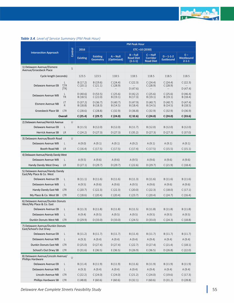
55Delaware Ave Complete Streets Feasibility Study
Intersection Approach
Cont
rol
PM Peak Hour
2016 ETC +10 (2030)
Existing Existing Geometry
A – Null (Optimized)
B – Full Road Diet
(1-1-1)
C – Half Corridor
Road DietD – 1-1-2
EastboundE –
Westbound2-1-1
1) Delaware Avenue/Elsmere Avenue/Groesbeck Place S
Cycle length (seconds) 123.5 123.5 118.5 118.5 118.5 118.5 118.5
Delaware Avenue EBL
T,TR[TR]
B (17.2)C (20.1)
--
B (19.6)C (21.1)
--
C (24.4)C (28.9)
--
C (22.3)--
D (47.6)
C (24.4)C (28.9)
--
C (24.4)C (28.9)
--
C (22.3)--
D (47.4)
Delaware Avenue WB LTR
D (40.6)B (18.5)
D (53.5)C (22.0)
C (25.6)B (19.1)
D (42.2)B (17.3)
C (25.6)B (19.1)
C (25.6)B (19.1)
D (46.4)B (18.4)
Elsmere Avenue NB LTR
D (37.2)B (18.8)
D (36.7)B (18.3)
D (40.7)B (14.5)
D (47.9)B (18.4)
D (40.7)B (14.5)
D (40.7)B (14.5)
D (47.4)B (18.5)
Groesbeck Place SB LTR C (28.6) C (28.8) C (32.9) D (36.8) C (32.9) C (32.9) D (36.9)
Overall C (25.4) C (29.7) C (24.0) C( 32.6) C (24.0) C (24.0) C (33.6)
2) Delaware Avenue/Herrick Avenue U
Delaware Avenue EB L B (11.5) B (12.0) B (12.0) B (11.7) B (12.0) B (12.0) B (12.0)
Herrick Avenue SB LR C (24.2) D (27.3) D (27.3) E (35.2) D (27.3) D (27.3) E (37.0)
3) Delaware Avenue/Booth Road U
Delaware Avenue WB L A (9.0) A (9.1) A (9.1) A (9.2) A (9.1) A (9.1) A (9.1)
Booth Road NB LR C (16.4) C (17.5) C (17.5) C (17.4) C (17.5) C (15.5) C (15.1)
4) Delaware Avenue/Handy Dandy West
Delaware Avenue WB L A (9.5) A (9.6) A (9.6) A (9.5) A (9.6) A (9.6) A (9.6)
Handy Dandy West Drwy LR D (27.1) D (29.7) D (29.7) C (22.6) D (29.7) C (21.9) C (18.4)
5) Delaware Avenue/Handy Dandy East/My Place & Co. West
Delaware Avenue EB L B (11.1) B (11.6) B (11.6) B (11.3) B (11.6) B (11.6) B (11.6)
Delaware Avenue WB L A (9.5) A (9.6) A (9.6) A (9.5) A (9.6) A (9.6) A (9.6)
Handy Dandy East NB LTR C (20.7) C (22.3) C (22.3) C (20.0) C (22.3) C (18.0) C (17.1)
My Place & Co. West SB LTR C (18.6) C (20.4) C (20.4) C (23.7) C (20.4) C (24.7) C (16.4)
6) Delaware Avenue/Dunkin Donuts West/My Place & Co. East
Delaware Avenue EB L B (11.3) B (11.8) B (11.8) B (11.5) B (11.8) B (11.8) B (11.8)
Delaware Avenue WB L A (9.4) A (9.5) A (9.5) A (9.5) A (9.5) A (9.5) A (9.5)
Dunkin Donuts West NB LTR D (29.9) D (33.0) D (33.0) C (24.5) D (33.0) C (24.3) C (18.8)
7) Delaware Avenue/Dunkin Donuts East/School’s Out Drwy
Delaware Avenue EB L B (11.2) B (11.7) B (11.7) B (11.4) B (11.7) B (11.7) B (11.7)
Delaware Avenue WB L A (9.3) A (9.4) A (9.4) A (9.4) A (9.4) A (9.4) A (9.4)
Dunkin Donuts East NB LTR D (25.0) D (27.4) D (27.4) C (22.7) D (27.4) C (21.4) C (18.1)
School’s Out Drwy SB LTR D (31.6) E (36.5) E (36.5) D (26.9) E (36.5) D (26.8) C (22.0)
8) Delaware Avenue/Lincoln Avenue/Phillips Hardware U
Delaware Avenue EB L B (11.4) B (11.9) B (11.9) B (11.6) B (11.9) B (11.9) B (11.9)
Delaware Avenue WB L A (9.3) A (9.4) A (9.4) A (9.4) A (9.4) A (9.4) A (9.4)
Lincoln Avenue NB LTR C (22.2) C (24.0) C (24.0) C (21.2) C (24.0) C (19.6) C (17.3)
Phillips Hardware SB LTR E (48.8) F (60.6) F (60.6) D (32.1) F (60.6) D (31.2) D (28.8)
Table 3.4. Level of Service Summary (PM Peak Hour)
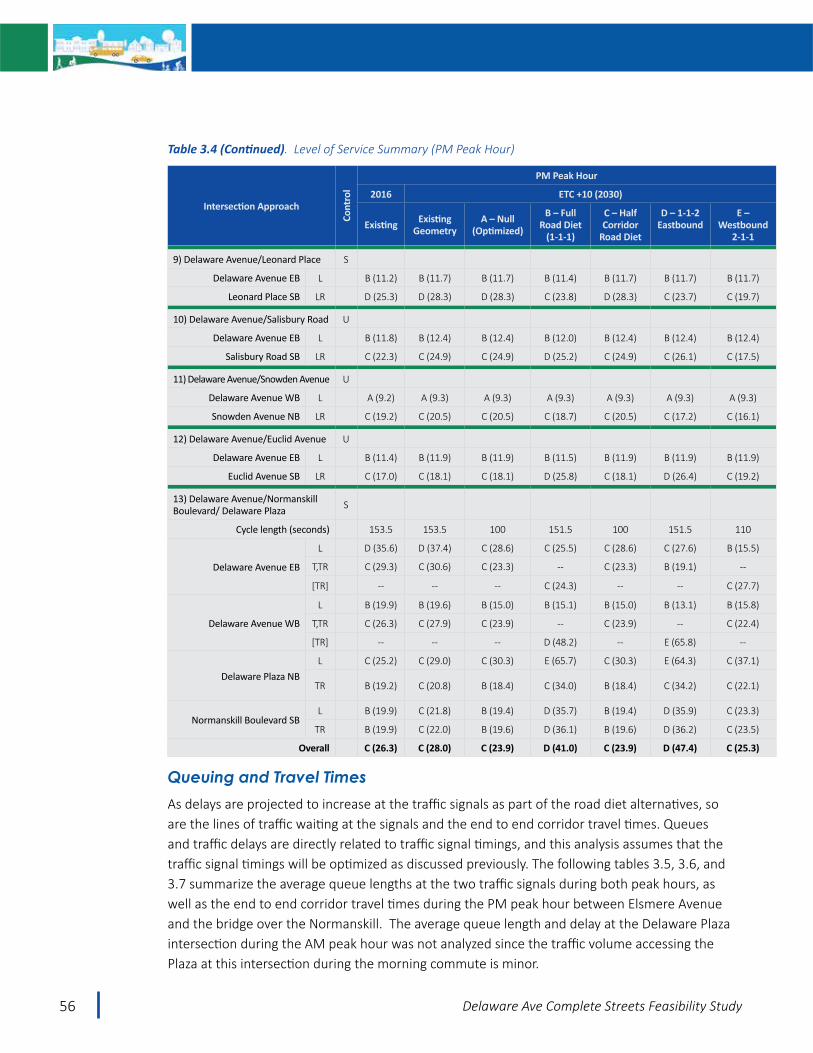
56 Delaware Ave Complete Streets Feasibility Study
Intersection Approach
Cont
rol
PM Peak Hour
2016 ETC +10 (2030)
Existing Existing Geometry
A – Null (Optimized)
B – Full Road Diet
(1-1-1)
C – Half Corridor
Road Diet
D – 1-1-2Eastbound
E – Westbound
2-1-1
9) Delaware Avenue/Leonard Place S
Delaware Avenue EB L B (11.2) B (11.7) B (11.7) B (11.4) B (11.7) B (11.7) B (11.7)
Leonard Place SB LR D (25.3) D (28.3) D (28.3) C (23.8) D (28.3) C (23.7) C (19.7)
10) Delaware Avenue/Salisbury Road U
Delaware Avenue EB L B (11.8) B (12.4) B (12.4) B (12.0) B (12.4) B (12.4) B (12.4)
Salisbury Road SB LR C (22.3) C (24.9) C (24.9) D (25.2) C (24.9) C (26.1) C (17.5)
11) Delaware Avenue/Snowden Avenue U
Delaware Avenue WB L A (9.2) A (9.3) A (9.3) A (9.3) A (9.3) A (9.3) A (9.3)
Snowden Avenue NB LR C (19.2) C (20.5) C (20.5) C (18.7) C (20.5) C (17.2) C (16.1)
12) Delaware Avenue/Euclid Avenue U
Delaware Avenue EB L B (11.4) B (11.9) B (11.9) B (11.5) B (11.9) B (11.9) B (11.9)
Euclid Avenue SB LR C (17.0) C (18.1) C (18.1) D (25.8) C (18.1) D (26.4) C (19.2)
13) Delaware Avenue/Normanskill Boulevard/ Delaware Plaza S
Cycle length (seconds) 153.5 153.5 100 151.5 100 151.5 110
Delaware Avenue EB
L D (35.6) D (37.4) C (28.6) C (25.5) C (28.6) C (27.6) B (15.5)
T,TR C (29.3) C (30.6) C (23.3) -- C (23.3) B (19.1) --
[TR] -- -- -- C (24.3) -- -- C (27.7)
Delaware Avenue WB
L B (19.9) B (19.6) B (15.0) B (15.1) B (15.0) B (13.1) B (15.8)
T,TR C (26.3) C (27.9) C (23.9) -- C (23.9) -- C (22.4)
[TR] -- -- -- D (48.2) -- E (65.8) --
Delaware Plaza NBL C (25.2) C (29.0) C (30.3) E (65.7) C (30.3) E (64.3) C (37.1)
TR B (19.2) C (20.8) B (18.4) C (34.0) B (18.4) C (34.2) C (22.1)
Normanskill Boulevard SBL B (19.9) C (21.8) B (19.4) D (35.7) B (19.4) D (35.9) C (23.3)
TR B (19.9) C (22.0) B (19.6) D (36.1) B (19.6) D (36.2) C (23.5)
Overall C (26.3) C (28.0) C (23.9) D (41.0) C (23.9) D (47.4) C (25.3)
Queuing and Travel TimesAs delays are projected to increase at the traffic signals as part of the road diet alternatives, so are the lines of traffic waiting at the signals and the end to end corridor travel times. Queues and traffic delays are directly related to traffic signal timings, and this analysis assumes that the traffic signal timings will be optimized as discussed previously. The following tables 3.5, 3.6, and 3.7 summarize the average queue lengths at the two traffic signals during both peak hours, as well as the end to end corridor travel times during the PM peak hour between Elsmere Avenue and the bridge over the Normanskill. The average queue length and delay at the Delaware Plaza intersection during the AM peak hour was not analyzed since the traffic volume accessing the Plaza at this intersection during the morning commute is minor.
Table 3.4 (Continued). Level of Service Summary (PM Peak Hour)

57Delaware Ave Complete Streets Feasibility Study
The tables show that average queue lengths will more than double in some peak hour instances for alternatives where lanes are removed, and end to end travel times will increase by 50 seconds on average depending on the alternative and direction of travel. These are the trade-offs for the Complete Streets enhancements such as improved pedestrian crossings, reduced crashes, traffic calming and space for bicycles.
It should be noted that the 2016 PM Peak Hour Existing Corridor Travel times shown in Table 3.7 were obtained through five (5) travel time runs conducted prior to the first public meeting, according to standard traffic engineering practice. Subsequently, as a result of Study Advisory Committee meeting discussions, CDTC staff conducted an additional seven (7) PM Peak Hour travel time runs in March 2017 and independently verified the results. The CDTC corridor travel time data was consistent with the earlier data.
The average peak hour queue lengths are illustrated on the following figures.
Figure 3.3. Average Queuing PM Peak Hour Delaware Avenue/Delaware Plaza/Normanskill Blvd
A C D B Null Partial Road Diet E Westbound 2-1-1 1-1-2 Eastbound Full Road Diet
Delaware Avenue
Delaware Plaza Drw
y
N

58 Delaware Ave Complete Streets Feasibility Study
A Null C Partial Road Diet E Westbound 2-1-1 D 1-1-2 Eastbound B Full Road Diet
N
Figure 3.4. Average Queuing PM Peak Hour Delaware Avenue/Elsmere Avenue/Groesbeck Place
A Null C Partial Road Diet E Westbound 2-1-1 D 1-1-2 Eastbound B Full Road Diet
N
Figure 3.5. Average Queuing AM Peak Hour Delaware Avenue/Elsmere Avenue/Groesbeck Place

59Delaware Ave Complete Streets Feasibility Study
Notable changes in average queue length are highlighted below:
• During the AM peak hour• Delaware Avenue eastbound through movement at Elsmere Avenue/Groesbeck Place
from six vehicles for the Null Alternative to 18 or 20 vehicles for Alternatives B and E. • Elsmere Avenue northbound right turn onto Delaware Avenue from seven vehicles for
the Null Alternative to 10 vehicles for Alternatives B and E.• During the PM peak hour
• Delaware Avenue westbound at the Delaware Plaza/Normanskill Blvd intersection from six vehicles to 22 or 25 vehicles for Alternatives B and D. Average queues will extend back to approximately the CDTA Park and Ride lot.
• Delaware Avenue eastbound at the Delaware Plaza/Normanskill Blvd intersection from four vehicles for the Null Alternative to 10 vehicles for Alternative B.
• Within the Plaza (northbound left turning onto Delaware Avenue westbound), from four vehicles for the Null Alternative to eight vehicles for Alternatives B and D.
• Delaware Avenue eastbound through movement at Elsmere Avenue/Groesbeck Place from four vehicles for the Null Alternative to 10 to 11 vehicles for Alternatives B and E.
• Delaware Avenue westbound left and through approaching Elsmere Avenue/Groesbeck Place will increase by two or three vehicles between the Null Alternative and Alternatives B and E, but the intent is to time the traffic signal to minimize this queue.

60 Delaware Ave Complete Streets Feasibility Study
2016 ETC +10 (2030)
Intersection Approach Existing A – Null (Optimized)
B – Full Road Diet
C – Half Corridor
Diet
D – 1-1-2 Eastbound
E – 2-1-1 Westbound
1) Delaware Avenue/Elsmere Avenue/Groesbeck Place
Delaware Avenue EB LT,TR[TR]
2142--
2161--
2--
449
2161--
2161--
2--
499
Delaware Avenue WB LTR
2079
1975
2184
1975
1975
2289
Elsmere Avenue NB LTR
44162
49170
56245
49170
49170
61255
Groesbeck Place SB LTR 18 20 2 20 2 26
2016 ETC +10 (2030)
Intersection Approach Existing A – Null (Optimized)
B – Full Road Diet
C – Half Corridor
Diet
D – 1-1-2 Eastbound
E – 2-1-1 Westbound
1) Delaware Avenue/Elsmere Avenue/Groesbeck Place
Delaware Avenue EB LT,TR[TR]
480--
7111--
8--
258
7111--
7111--
8--
275
Delaware Avenue WB LTR
80135
130170
180162
130170
130170
189175
Elsmere Avenue NB LTR
5150
6351
7572
6351
6351
7472
Groesbeck Place SB LTR 15 22 26 22 22 26
2) Delaware Avenue/Delaware Plaza Drwy/Normanskill Blvd
Delaware Avenue EB LT,TR[TR]
10120--
1097--
13--
251
1097--
14111--
11--
205
Delaware Avenue WB LT,TR[TR]
33187--
16162--
25--
550
16162--
23--
633
18178--
Delaware Plaza Drwy NB LTR
10710
976
19511
976
19312
1167
Normanskill Blvd SB LTR
2225
2431
4662
2431
4762
2837
Table 3.5. Average Queue lengths (Feet) – AM Peak Hour
Table 3.6. Average Queue lengths (Feet) – PM Peak Hour

61Delaware Ave Complete Streets Feasibility Study
Delaware Avenue Direction of Travel
2016 ETC +10 (2030)
Existing Model A – Null (Optimized)
B – Full Road Diet
C – Half Corridor
Diet
D – 1-1-2 Eastbound
E – 2-1-1 Westbound
Eastbound 2:18 2:18 2:12 2:50 2:29 2:29 2:53
Westbound 2:36 2:29 2:29 3:04 2:46 3:18 2:46
Bicycle LOS and Pedestrian Scores The following tables summarize the bicycle level of service and pedestrian scores related to each of the alternatives, and show some of the positive trade-offs for multi-modal travel that will be gained by the automobile impacts identified in the previous section.
Table 3.8. Bicycle Level of Service
Bicycle LOS
A – Null B – Full
Road Diet(1-1-1)
C – Half Corridor
Road Diet
D – 1-1-2 Eastbound
E – Westbound
2-1-1
Elsmere to Delaware Plaza E/D C D D D
Delaware Plaza to Normanskill E/D C C C C
Pedestrian Scores
A – Null B – Full
Road Diet(1-1-1)
C – Half Corridor
Road Diet
D – 1-1-2 Eastbound
E – Westbound
2-1-1
Elsmere Ave B A B B B
Herrick Ave D C D D D
Booth Rd D C D D D
Lincoln Ave D A D C C
Leonard Place D D D D D
Bedell Ave D C D D D
Salisbury Rd D A D C C
Snowden Ave D C D D D
Burhans Place D C D D D
Plymouth Ave D C D D D
Euclid Ave D A D C C
Normanskill Blvd C A C B C
Mason Rd D C C C C
Winslow St D A A A A
Lenox St D C C C C
Grant St D A A A A
Old Delaware Ave D C C C C
Table 3.7. PM Peak Hour Corridor travel times: Elsmere Avenue to the Bridge over the Normanskill (minutes:seconds)
Table 3.9. Pedestrian Scores

62 Delaware Ave Complete Streets Feasibility Study
Bicycle LOS
• As described in Chapter 2 Bicycle Level of Service calculations are primarily based on travel lane width and width available outside the travel lane for bicycling (shoulders or bike lanes), speed limit and volume of adjacent traffic. Other aspects of a roadway are not included such as availability of protected street crossings which does impact the friendliness of a corridor for bicycling.
• Bicycle level of service will improve for Alternatives B, C, D and E as compared to the Null Alternative in the eastern segment due primarily to the additional space between motorists and bicyclists, and also due to the proposed speed reduction.
• For Alternatives C, D and E, the Bicycle level-of-service will remain poor in the western segment, while it will improve for Alternative B.
• Even with the improved bicycle level-of-service for the overall corridor under the full road diet (Alternative B) with the shoulder bike lanes, the corridor will not be attractive to all types of bicyclists, and many casual, less confident and young riders will use less direct routes to avoid the heavy traffic on Delaware Avenue. However, under
Level of Bicycle User Skill and ComfortExperienced and ConfidentThis group includes bicyclists who are comfortable riding on most types of bicycle facilities, including roads without any special treatments for bicyclists. This group also includes utilitarian and recreational riders of many ages who are confident enough to ride on busy roads and navigate in traffic to reach their destination. However, some may prefer to travel on low-traffic residential streets or shared use paths. Such bicyclists may deviate from the most direct route to travel in their preferred riding conditions. Experienced bicyclists may include commuters, long-distance road bicyclists, racers, and those who regularly participate in rides organized by bicycle clubs.
Casual and Less ConfidentThis group includes a majority of the population, and includes a wide range of people: (1) those who ride frequently for multiple purposes; (2) those who enjoy bicycling occasionally but may only ride on paths or low-traffic and/or low-speed streets in favorable conditions; (3) those who ride for recreation, perhaps with children; and (4) those for whom the bicycle is a necessary mode of transportation. In order for this group to regularly choose bicycling as a mode of transportation, a physical network of visible, convenient, and well-designed bicycle facilities is needed. People in this category may move over time to the “experienced and confident” category.
– AASHTO Guide for Developing Bicycle Facilities, 2012

63Delaware Ave Complete Streets Feasibility Study
Alternative B (full road diet) there is the opportunity to provide additional enhanced street crossings which will allow all types of bicyclists better access to these less direct routes on either side of Delaware Avenue, including the Albany County rail trail.
Pedestrian Scores
• The Pedestrian Facilities analysis shows that the intersections where marked crosswalks are planned will improve the most from a Pedestrian score standpoint. For the Alternatives that reduce the number of lanes, having pedestrians cross fewer lanes also serves to improve the pedestrian scores as there is a “multi-threat” condition for pedestrians that cross a multi lane roadway at uncontrolled locations. A multi-threat crash involves a driver stopping in one lane of a multi lane road to permit pedestrians to cross, and an oncoming vehicle (in the same direction) strikes the pedestrian who is crossing in front of the stopped vehicle.

64 Delaware Ave Complete Streets Feasibility Study
Economic Assessment
Review of Available LiteratureHighlights from research conducted by CDTC staff on the Business/Economic Impacts of Complete Streets and Road Diets is provided below. In general, no compelling data was found to support negative economic effects of road diets. Many studies point to no impact, or a small benefit, but many business owners and those who live on road dieted streets are more likely to be skeptical. For the purpose of this study, the increased traffic delay and potential peak hour traffic diversions described in previous sections may be a deterrent in the corridor during peak times. It is difficult to say the extent to which this would be offset by the other Complete Streets improvements. For example, an improved travel environment for bicyclists and pedestrians may offset the diverted automobile trips projected in the road-diet alternative during the PM peak hour. Further the improved environment may provide for an increase in multi-modal trips to corridor businesses during non-peak hours of the day.
• “The impacts of lane elimination projects on sales tax revenues and property values are mixed, although most studies point to either no overall economic impacts or some positive impact.” http://www.fdot.gov/roadway/csi/Files/Lane-Elimination-Guide-Part2.pdf
• “Quantitative data do not support the notion that road diets lower surrounding local businesses and property values. Opposition to road diets on economic grounds therefore appears unfounded. Still, popular support for converting auto lanes and on-street parking to bike lanes remains lukewarm.” https://nacto.org/docs/usdg/yorkblvd_mccormick.pdf
• “There is little evidence that the Road Diet had a detrimental effect on businesses in terms of their customer volume, revenue, and livelihood.” https://informationknoll.files.wordpress.com/2014/03/road-diet-economic-analysis-centre-college.pdf
• The City of Des Moines Iowa piloted a road diet on Ingersoll Ave for 6 months after which they permanently installed it even though there was “considerable opposition by businesses” mostly for the pilot project. However, in their “after” survey residents and business owners who live/own on the street aren’t as happy with it compared to the rest of the community (survey charts start on slide 17) but crashes were reduced 20%. https://dmampodemo.files.wordpress.com/2015/03/ingersoll-3-lane-after-results-presentation-to-mpo-april-2014-full.pdf
“Studies have shown that lane elimination projects can (but do not always) increase economic activity. Studies have shown a wide variation in lane elimination project impacts on business activity, from little to no increase in economic activity relative to neighborhood growth to a 174% increase in business activity (implying the possibility of positive impacts)”
– Statewide Lane Elimination Guidance, FDOT, 2014

65Delaware Ave Complete Streets Feasibility Study
While the research indicates no compelling data was found to support negative economic effects of road diets, it is also believed that the road diet can increase the demand for available property and reduce vacancy rates. The study area, when compared to the western half of the Delaware Avenue Corridor (“Four Corners” area), has a lower level of demand for real estate and development. Staff within the Town of Bethlehem’s Department of Economic Development and Planning speak with various businesses interested in locating within the Town. Of those businesses looking to locate a restaurant, retail or office space, the “Four Corners” are of Delaware Avenue is the most sought after location. Businesses appreciate the walkability and community feel that surrounds that area of town. As a result there is a very low vacancy rate within that area and when businesses are directed to available properties in the Study area, they are uninterested. Businesses feel they lose the atmosphere they desire for their business, since the Study area currently offers no sense of place. It is believed that a road diet will extend the walkability and sense of place/community to the Normanskill Bridge and increase demand for the available properties in that stretch of the Delaware Avenue Corridor.

66 Delaware Ave Complete Streets Feasibility Study
Safety AssessmentAs discussed in Chapter 2, road diets are a proven safety countermeasure identified by the Federal Highway Administration (FHWA) and have been shown to reduce crashes by 19 to 47 percent (see https://safety.fhwa.dot.gov/provencountermeasures/). As a result, each of the alternatives is expected to reduce crashes to varying degrees, with the full road diet (Alternative B) having the greatest potential crash benefit. Using average expected crash reductions factors for the two segments (east and west of Delaware Plaza), Table 3.10 was prepared to summarize the potential safety benefit in terms of reduced crashes for each alternative. The table shows all of the alternatives will improve safety with the exception of the Null alternative, and that there is a reduced safety benefit for Alternatives C, D and E as compared to Alternative B. Overall, the safety benefits of the Complete Streets alternatives are a clear advantage over the Null alternative. The crash reduction factors used in this planning level analysis apply to all crash types and were applied against the total number of crashes for the 5 year period on each of the segments.
Segment Crashes 2011 to 2015
Crash reduction / % reduced
5 year Estimate of Crashes reduced
A Null
Elsmere Ave to Delaware Plaza 135 00
Delaware Plaza to Normanskill Bridge 74 0
B 1-1-1
Elsmere Ave to Delaware Plaza 135 2960
Delaware Plaza to Normanskill Bridge 74 29C
Half Corridor
Elsmere Ave to Delaware Plaza 135 021
Delaware Plaza to Normanskill Bridge 74 29D
1-1-2 Eastbound
Elsmere Ave to Delaware Plaza 135 1541
Delaware Plaza to Normanskill Bridge 74 29E
Westbound2-1-1
Elsmere Ave to Delaware Plaza 135 1541
Delaware Plaza to Normanskill Bridge 74 29
29% crash reduction from FHWA Crash Modification Factor (CMF) Clearinghouse - Road diet 5 Star rated CMF, Harkey, et. al15% crash reduction from FHWA Desktop Reference Guide – Add Two Way Left turn Lane flush median
Table 3.10. Estimated Crash Reductions
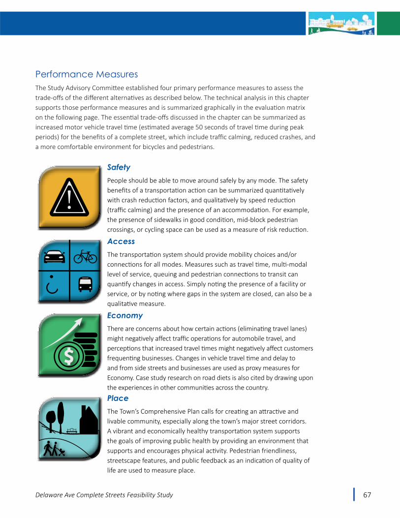
67Delaware Ave Complete Streets Feasibility Study
Performance MeasuresThe Study Advisory Committee established four primary performance measures to assess the trade-offs of the different alternatives as described below. The technical analysis in this chapter supports those performance measures and is summarized graphically in the evaluation matrix on the following page. The essential trade-offs discussed in the chapter can be summarized as increased motor vehicle travel time (estimated average 50 seconds of travel time during peak periods) for the benefits of a complete street, which include traffic calming, reduced crashes, and a more comfortable environment for bicycles and pedestrians.
SafetyPeople should be able to move around safely by any mode. The safety benefits of a transportation action can be summarized quantitatively with crash reduction factors, and qualitatively by speed reduction (traffic calming) and the presence of an accommodation. For example, the presence of sidewalks in good condition, mid-block pedestrian crossings, or cycling space can be used as a measure of risk reduction.
AccessThe transportation system should provide mobility choices and/or connections for all modes. Measures such as travel time, multi-modal level of service, queuing and pedestrian connections to transit can quantify changes in access. Simply noting the presence of a facility or service, or by noting where gaps in the system are closed, can also be a qualitative measure.
EconomyThere are concerns about how certain actions (eliminating travel lanes) might negatively affect traffic operations for automobile travel, and perceptions that increased travel times might negatively affect customers frequenting businesses. Changes in vehicle travel time and delay to and from side streets and businesses are used as proxy measures for Economy. Case study research on road diets is also cited by drawing upon the experiences in other communities across the country.
PlaceThe Town’s Comprehensive Plan calls for creating an attractive and livable community, especially along the town’s major street corridors. A vibrant and economically healthy transportation system supports the goals of improving public health by providing an environment that supports and encourages physical activity. Pedestrian friendliness, streetscape features, and public feedback as an indication of quality of life are used to measure place.
!

68 Delaware Ave Complete Streets Feasibility Study

69Delaware Ave Complete Streets Feasibility Study
Public Meeting #2 A second public meeting was held on Tuesday, September 26, 2017 with good attendance from residents, business owners, stakeholders, and study advisory committee members. The purpose of the meeting was to present and receive feedback on five Complete Streets alternatives. The meeting included a technical presentation, a question and answer period, an alternatives rankingexercise, and other opportunities to provide comment. The full public meeting summary is included in Appendix C.
The results of the ranking exercise are shown on the following bar chart and show that the majority of attendees favored the full Road Diet Alternative at approximately 80 percent favored.
0%10%20%30%40%50%60%70%80%90%
100%
ANull
BFull Road Diet
1‐1‐1
CHalf CorridorRoad Diet
D1‐1‐2
Eastbound
EWestbound
2‐1‐1
Percen
t of R
espo
nses
Public Feedback on Alternativesfrom Public Meeting #2 (9/26/17)
Satisfied or Somewhat Satisfied Dissatisfied
Chart 3.2. Public Feedback on Alternatives

70 Delaware Ave Complete Streets Feasibility Study
In a separate survey, the Bethlehem Chamber solicited its members for input and the majority of respondents also favored the Full Road Diet. Alternative E Westbound 2-1-1 was the second most popular, followed by the Alternative C – the Half Corridor Road Diet. These results recognize that traffic volumes are high in the western half of the corridor and a desire by some to preserve the very good traffic operations that prevail today.
Although, the majority of commenters favored the full road diet alternative, numerous commenters are very concerned with the traffic impact (estimated increase in motor vehicle travel delay), and the potential for economic impacts.
The results of the technical analysis and public input show that a road diet is feasible, and the majority of people who provided input are willing to accept the additional 50 seconds of motor vehicle travel time (on average) from end to end in the corridor, in exchange for a calmed Delaware Avenue that is more user friendly to other modes (bicyclists, pedestrians, transit users).
A
BC
D
E
Chart 3.3. Chamber Feedback on Alternatives

71Delaware Ave Complete Streets Feasibility Study
Big Picture A road diet is feasible. A fundamental question to be answered by this study was – Is it feasible to reduce the number of travel lanes on Delaware Avenue between Elsmere Avenue and the Bridge over the Normanskill from four lanes to three, and the answer is yes. The technical studies show that there will be traffic impacts, but those are outweighed by the projected safety benefits, traffic calming, improved accommodations for pedestrians and bicyclists and community support.
Reducing the number of lanes is also consistent with Complete Streets policies at the local, regional, state, and national levels. Funding needs to be secured and the official approval of the preferred alternative will happen during design, but the technical analysis and community support during this study points to the Full Road Diet as the preferred alternative, and will be considered when funding is obtained and as the design moves forward
CHAPTER 4
Conclusions and Recommendations
Before After

72 Delaware Ave Complete Streets Feasibility Study
The PlanThe plan is to make Delaware Avenue a complete street that balances the needs of all users, not focused solely on automobile traffic. Although the vast majority of users in the corridor are motorists, Bethlehem’s main street can do a better job of accommodating pedestrians and bicyclists. Safety is also a concern. As shown in Chapter 2 crash rates on this section of Delaware Avenue are higher than state-wide average crash rates for similar facilities and there is a “multi-threat” condition for pedestrians that cross the road at unsignalized intersections. Slowing traffic through a road diet and speed limit reduction (from 40MPH to 30 or 35MPH) combined with marked crosswalks aligned with relocated bus stops, and enhancements such as gateway features, raised pedestrian refuge islands where appropriate, and potential rectangular rapid flashing beacons will make the corridor more attractive and welcoming to non-motorized users. The before / after photo simulations on the previous page and below show what the corridor could look like near Tastee-Freez and near Dunkin Donuts. The trade-off will be increased travel time for motorists, particularly during the AM and PM commuter time periods (estimated to be, on average, 50 seconds during peak travel periods). A breakdown of the plan follows.
Before
After

73Delaware Ave Complete Streets Feasibility Study
The road diet concept plan is shown on Figure 4.1. Beginning at the west end of the corridor, work should begin near Hudson Avenue to transition the roadway from two to three travel lanes and introduce the shoulder area for bicycles. This beginning point will tie in nicely for bicycle access to and from the rail trail via Hudson Avenue. It will also require re- striping the area between Hudson Avenue and Elsmere Avenue currently being rehabilitated under the Delaware Avenue Streetscape Enhancements Project (PIN 1759.68).The traffic signal at the Elsmere Avenue intersection will need to be modified for the new lane arrangement.
Continuing east, the road diet and the close proximity of Herrick Avenue to Elsmere Avenue Road diet concept shown with median pedestrian refuge island creates the potential for delayed eastbound left turners to cause back-ups for eastbound through traffic. Options at this intersection including 1) installing “Do Not Block Side Road” signs on the westbound Delaware Ave approach, 2) installing “Do Not Block Intersection” pavement markings, or 3) Full-time or time-of-day left turn prohibitions could also be considered. It is noted that school buses (6 of 8) make this eastbound left turn around 9:00 a.m. and 3:00 p.m. each school day. A conversation with the School District Transportation Department indicated a willingness to reroute these buses down Groesbeck Place and Laurel Drive to avoid this left turn (This route is already established for the bus exit, but on-street parking on Herrick Avenue and Laurel sometimes prevents the buses from being able to use it). Parking restrictions would be needed in isolated areas to ensure this alternate route would be passable for buses. The final plan around Herrick Avenue will be confirmed during the Design phase.
The plan for Delaware Avenue east of Herrick Avenue is to establish two or three marked crosswalks before reaching the traffic signal at Delaware Plaza, and to relocate the bus stops to be far side at the new marked crosswalks. The bus stops should include a 5 ft by 8 ft boarding and alighting area, per the Proposed Accessibility Guidelines for Pedestrian Facilities in the Public Right-of-Way (PROWAG, 2011). A meeting with CDTA showed a willingness to relocate and consolidate bus stops in the area, and CDTA’s Transit Development Plan shows typical bus stop spacing around 1250 feet in Suburban areas. The concept calls for relocating the eastbound bus stop at the Elsmere Ave intersection from far side to near side (Delaware Health Building to CVS), or creating a bus pull out at its current location in front of the Delaware Health building. The concept plan also shows new marked crosswalks at Lincoln Avenue and Salisbury Road, which
Road diet concept shown with median pedestrian refuge island

74 Delaware Ave Complete Streets Feasibility Study
would include far side bus stops. The concept for a marked crosswalk with a median pedestrian refuge island at Euclid Avenue does not include a bus stop.
In the vicinity of Delaware Plaza, the roadway is wider so the three lane road diet could include buffered bike lanes and a shared bus / bike zone at the intersection. This is one of CDTA’s higher volume bus stops, so having buses stop out of traffic at their higher volumes stops will minimize traffic impacts of the road diet. East of the Plaza, the goal again is to establish a few marked crosswalks, aligned with bus stops (far-side) to better accommodate and channelize pedestrians crossing. A raised median with pedestrian refuge island is shown conceptually between Grant Street and Lenox Street. The apartment complex comprised of five parcels owned by the same entity on this block share a driveway in the rear (access provided by both Grant and Lenox Street) so they would continue to have access to/from Delaware Avenue in both directions even with the raised median on Delaware Avenue. The median would calm traffic in the area, and connect pedestrians to the bus stop west of the car wash, and potentially to a new sidewalk on the north side of Delaware Ave. Additional opportunity for a raised median exists east of the Car wash where there are no conflicting driveways on either side of the street.
On the east end of the corridor at the gateway into Bethlehem, the plan is to pursue a small raised median east of the driveway that provides access to the Novus / Bagdon Environmental office building. This driveway also provides access to the trailhead for the Normanskill Preserve Trail – East. A concern raised during the first public meeting was the combination of the eastbound downhill merge, a curve to the right, the Novus driveway and the 40 to 45 MPH operating speeds on Delaware Avenue in the area. The proposed road diet and raised median will eliminate the merge, create a gateway into Bethlehem from Albany, help reduce speeds and provide a left turn lane for access to the Novus building/trailhead. In order to fit the raised median and maintain shoulder widths, a box-out widening will be needed on the south side of Delaware Avenue for about 500 or 600 feet. This would be a desirable enhancement outside of the existing curb and beyond what would normally be funded in a typical Pavement Preservation project.
Short sections of curb and sidewalk should alsobe addressed to complete the work started under previous site plans and access management changes, such as the sidewalk gap in front of Valvoline. Similar abandoned driveways exist at 208 and 243 Delaware Ave. The idea is to inventory and address these areas as part of a NYSDOT Pavement Preservation project.
Curb and sidewalk gaps like this one at Valvoline should be addressed.

75Delaware Ave Complete Streets Feasibility Study
Figure 4.1. Road Diet Concept Plan

Delaware Ave Complete Streets Feasibility Study76
This page intentionally left blank

77Delaware Ave Complete Streets Feasibility Study
Transportation EnhancementsThe Delaware Avenue Complete Streets Corridor Enhancements Map summarizes the ideas that could be incorporated into the area over time to support the goals of this study and the Town’s vision for the corridor. Features such as trail connections, a pocket park, a gateway median, new sidewalks, streetscaping, and access management changes could be incorporated separately, or certain elements could be packaged into the base road diet project if funding becomes available. Straightforward trail connections like the one shown below behind Stewart’s, could be added on Ellsworth Avenue where informal paths already exist. Other trail connections are more complicated and require additional study.
The Enhancements Map is a result of public input provided from public meeting #1.
Trail or Sidewalk Connections to the Delaware Ave Corridor
In May 2016 the Albany County Rail Trail was officially opened and has experienced widespread popularity amongst Town residents. A 2016 CDTC trail users survey: Regional Trail Perspectives: A Survey of Capital District Trail Facilities, estimated that the Albany County Rail Trail receives 164,000 annual users. Compared to other trails in the Capital Region, the Albany County Rail Trail ranked fourth in estimated annual usage. The survey identified that trail access was a major problem for trail users. The Enhancement Map recommends trail access/connections at the following locations:
Example trail connection.

78 Delaware Ave Complete Streets Feasibility Study
• Ellsworth Place – Access from side street locations could provide local access to nearby residents. Informal dirt paths are already utilized along Ellsworth Place. These access points can be achieved through minor improvements consisting of an asphalt surface and the installation of culverts to maintain the drainage channel along the trail.
• Delaware Plaza – An informal dirt path connection to Delaware Plaza exists along Plymouth Avenue and the Albany Water Line (that runs along the roadway). It is recommended that the informal path be improved with a formal asphalt surface to better serve trail users that desire to access Delaware Plaza. The existing path is not plowed during snow events, and is unsuitable to users when during inclement weather. The Town should coordinate the formal access with the Albany Water Board, potentially through an access easement, since permission would be needed to utilize their land. Coordination with the Town Department of Public Works would also be needed since there is a sanitary sewer line in the vicinity of the path connection.
• Mason Road – Mason Road is one of a few town owned right-of-ways that traverse the Rail Trail, and therefore serve as a logical connection location. The right-of-way currently consists of gravel/dirt surface, which does provide for an informal connection for trail users – although the connection meets no access standards. To the north, Mason Road could provide a direct connection to Delaware Avenue and the neighborhood that includes Crannell Ave., Lenox St. and Grant St. residences and commercial uses (i.e Jim’s Tastee Freeze). The grades along this section is about 7% where multi-use path design requirements recommended a 5% grade. A Town sanitary sewer line is also present. To the south, Mason already provides an informal connection to residents along Poplar Drive and the Kenwood Avenue area. However, this section also does not meet any design standards for formal access. The Town should pursue further evaluation of the current conditions of this right-of-way to determine the improvements needed that would provide a formal trail connection that could serve trail users and emergency service responders.
• Rockefeller Road and Old Delaware Turnpike Bridge – A trail connection at Rockefeller Road and improvements to the Old Delaware Avenue Bridge (old yellow brick road bridge) could achieve a connection between the Steven’s Farm in Albany (and other destinations in the southern portion of Albany) and the Rail Trail. An existing National Grid utility right-of-way adjacent to the Rail Trail could accommodate a formal trail connection for trail users and emergency service responders. The Town should pursue further evaluation of a formal trail connection at the Rockefeller Road location. This evaluation would entail an assessment of current topography conditions and initial design plans for access.
The Old Delaware Turnpike Bridge spans the Normans Kill between the Town Of Bethlehem and the City of Albany. In 1990 NYSDOT closed the bridge to all users. Since its closing, two bridge inspections have been completed – 1995 and 2000. According to a review of the bridge inspection reports by the Town Department of Public Works, the ownership of the bridge structure is unclear. NYS DOT has identified the City of Albany as the owner of the structure, but the City has no record of the transfer of ownership or its official acceptance by the Common Council. The 2000 Bridge Inspection completed

79Delaware Ave Complete Streets Feasibility Study
by CHA determined the bridge has a rating of 3, indicating the bridge is seriously deteriorated or not functioning as originally designed. While the structural loading imposed on the bridge by pedestrians and bicyclists would clearly be smaller than the bridge’s design for traffic loading, the deck elements, including wearing surface, curbs, and parapet walls are all rated 1 or 2. In order to reopen the bridge to pedestrian and bicycle users a more recent bridge inspection should be completed or reviewed, and improvements identified that would accommodate safe pedestrian and bicycle use. Ownership of the bridge also needs to be identified, and perhaps both the Town and City could partner towards contributing to improvements.
• Normanskill Preserve East and West connections – The Normanskill Preserve East and West are owned and maintained by the Mohawk Hudson Land Conservancy. Access to the Normanskill East Preserve is provided through an access easement at the Bagdon Environmental/Novus Engineering parking lot at 25 Delaware Avenue. Access to the Normanskill West Preserve is provided at the end of Normanskill Blvd. The two preserves are separated by 0.25 miles following the Normans Kill. To achieve a connection between the two preserves the Town partnering with the MHLC could acquire access easements along the Normans Kill from the following - the NYSDOT, the Albany Water Board, and National Grid.
• Pocket Park at Elsmere Avenue and Poplar Drive – Approximately a 0.50 acre parcel of land located at the northeast corner of the Elsmere Avenue/Poplar Drive intersection is owned by the NYSDOT. At one time this land was associated with the work completed to eliminate the D&H Railroad/Elsmere Avenue at-grade crossing as well as a road connection to the Elsmere train station. The land was also the location of a school associated with School District No. 15. The Town has recently requested conveyance of the land from the State to the Town to convert the 0.50 acres of land to a pocket park that would be accessible to the Rail Trail and surrounding neighborhood. In time, the Town could construct a pavilion within the park that would reflect the former design of the Elsmere Train station. The pavilion could serve as a resting area/trailhead to Rail Trail users, including a bathroom facility and drinking fountain.
The concept of a base complete streets roadway project versus enhancements is detailed further in the Implementation section and is consistent with one of the goals of this study to identify improvements that could be incorporated into a typical NYSDOT Pavement Preservation Project, or Improvements that would be considered Beyond Preservation and likely require separate funding. The trail connections discussed above would require funding separate from a Delaware Avenue preservation project. Fundamentally, the base Pavement Preservation project is new pavement and striping with signing and signal modifications as necessary for the new lane arrangement. The base project would also include a number of marked crosswalks, and is assumed to include spot areas of curb and sidewalk such as the Valvoline example discussed previously, and ADA curb ramp work at the intersections only. Upgrading long stretches of sidewalk is considered an enhancement for the purpose of this study. The Driveway and Sidewalk section below discusses this issue in more detail.

80 Delaware Ave Complete Streets Feasibility Study
This page intentionally left blank

81Delaware Ave Complete Streets Feasibility Study
Figure 4.2. Corridor Enhancements Map

Delaware Ave Complete Streets Feasibility Study82
This page intentionally left blank

83Delaware Ave Complete Streets Feasibility Study
Driveways and SidewalksThe NYSDOT Standard Sheets establish the basis for driveway and sidewalk design and include two methods for how driveways can tie into a State Highway like Delaware Avenue: the Radius method and the Taper method, and both methods are acceptable. It should be noted that the Town of Bethlehem prefers the Taper method for most minor commercial and low volume driveways, which should be pursued for a better pedestrian environment, aesthetics, and consistency along the corridor. Driveways should also include a concrete apron between the sidewalk and edge of pavement.
Opportunities for minimizing driveway widths, frequency, and relocating driveways along Delaware Avenue can be achieved through the Town’s site plan review process conducted by the Planning Board. An example of this approach was recently achieved through site plan review of the Dunkin Donuts site at 232 Delaware Avenue. At the site, a driveway along Delaware Avenue was removed, the remaining driveway width was reduced to 24-feet, and the driveway along Lincoln Avenue was relocated farther away from the intersection. The Town Planning Board should permit the smallest driveway radius necessary to accommodate the frequent vehicle user of the site since a smaller driveway radius encourages a slower vehicle speed entering and exiting the driveway. This provides a safer pedestrian and bicycle environment along the roadway. Connecting sidewalks or crosswalks between the commercial building and roadway sidewalk should also be provided to accommodate pedestrian travel.
NYSDOT driveway detail for Taper method.

84 Delaware Ave Complete Streets Feasibility Study
Related to the driveway design is the potential up and down effect of sidewalks as they are lowered to cross driveways, then raised back up to curb elevations on either side of the driveways. The long term goal for the Delaware Avenue as a Complete Street should be to minimize the frequent up and down of sidewalks due to the numerous driveways crossed, through a combination of access management and design. This could potentially require right-of-way to increase the separation between the curb and the sidewalk. Although driveway tie-ins at the apron are part of a pavement preservation project, substantial changes to sidewalks and driveway reconstructions are considered enhancements beyond pavement preservation for the purpose of this study and could be accomplished as part of a separate ADA Transition Plan project, or combined with the road diet if funding is available. Architectural maintenance strips (brick look treatment to match the current Delaware Avenue Hamlet Enhancement Project) would be done at the time of the sidewalk work.
The goal for the Delaware Avenue Complete Streets Project is to minimize the frequent up and down of sidewalks caused by the
numerous driveways crossed.

85Delaware Ave Complete Streets Feasibility Study
Quality features can add character to an area and contribute to a complete street and the area’s overall sense of place. Opportunities for cultural or public art, and streetscape improvements can make the area attractive and support the goals of improving public health and local business by providing an environment that encourages physical activity. These types of enhancements are considered beyond preservation for the purpose of this study..
Speeds The Delaware Avenue Complete Streets plan and this section of the report are intended to support the Town’s request for a reduction in the posted speed limit on Delaware Avenue. Per State regulation, NYSDOT will perform its own study of the corridor to determine if a reduction in posted speed is warranted.
As discussed in the Existing Conditions section of this document, the posted speed limit for this 1.3 mile long study area is 40-mph. East and west of the study area the posted speed limit is 30-mph. Automatic traffic recorders were installed at several locations along Delaware Avenue during October 2016 to document traffic characteristics including travel speeds. The existing speed information is summarized below for the three locations studied.
DELAWARE AVENUE630 Ft East of Elsmere
Ave50 Ft East of Salisbury
Rd1000 Ft East of Old
Delaware Ave
Speed (mph)Average EB
WB
85th Percentile EBWB
34.734.4
40.339.8
35.236.4
40.041.2
41.340.2
46.344.9
Example decorative maintenance strip – Saratoga Springs.
Table 4.1. Traffic Speed Summary

86 Delaware Ave Complete Streets Feasibility Study
One of the goals of the Delaware Avenue Complete Streets project is to calm traffic speeds by a combination of design and policy measures. The completed project is proposed to include:
• A road diet from four lanes to three. According to the FHWA Road Diet Informational Guide (FHWA Report No. SA-14-028, dated November, 2014, pg. 15), average and 85th percentile speeds are likely to decrease by 3 to 5 mph.
• Improved pedestrian and bicycle environment including new sidewalks, sidewalk extensions, marked crosswalks and bike lanes, leading to increased pedestrian and bicycle activity.
• Geometric elements (including raised medians) designed to reduce travel speeds.• Vertical elements, existing street lights and potential new street trees along the roadside.• Potential enhanced treatments such as Rapid Rectangular Flashing Beacons at several
pedestrian crossing locations. According to the New York State Pedestrian Safety Action Plan, enhanced pedestrian crossing treatments should be used given the characteristics of Delaware Avenue.
The FHWA Methods and Practices for Setting Speed Limits notes that the 85th percentile speed method is the most commonly used approach, but also recognizes the Expert system approach which uses a model developed by FHWA (USLIMITS2) and considers other factors to determine an appropriate speed limit for all roadway users. A preliminary USLIMITS2 analysis for this Planning Study shows that the Delaware Avenue corridor may justify a lower speed limit under its current configuration, and will very likely support a lower speed limit with a road diet, which requires NYSDOT review and approval.
Costs and Implementation Nationally, transportation funding resources are severely constrained, which has influenced State and Regional policies about how to program the limited money that is available. The CDTC New Visions Plan prioritizes maintaining existing infrastructure to keep roads and bridges in a state of good repair. The five year CDTC Transportation Improvement Program (TIP) is also structured around preservation. This objective is consistent with the NYSDOT “Forward Four” policy with preservation of existing facilities as the highest priority for use of limited funds (approximately 80% of such funding both federally and State sourced). The term “Beyond Preservation” is used to categorize projects that involve more than just preserving a facility “as is”. Even with the preservation focus, preservation needs far exceed current and expected funding levels.
Hence, one of the goals of this study was to identify the desired lane configuration for Delaware Avenue that could be implemented as part of a preservation project. The work would take place primarily between the existing curbs and would include those elements needed for the new lane arrangement, and could be funded and implemented the next time NYSDOT schedules a pavement preservation or overlay type of project. Enhancements beyond what is needed to

87Delaware Ave Complete Streets Feasibility Study
make the road diet work may be incorporated with additional funding. As of the date of this document, there is no public funding commitment for a pavement preservation project, nor any of the complete streets changes identified in this study, so pursuing funding is a major step in the implementation plan. However, the NYSDOT has rated the pavement on Delaware Avenue to be in fair to good condition (Rated 6 or 7). Pavements rated 6 or lower usually have too much cracking to be effectively crack sealed, and begin to score points for a potential preservation project as part of NYSDOT’s data driven Pavement Prioritization Index. The goal is to schedule the right maintenance treatment at the right time to extend the life of the road and so more costly reconstruction can be avoided.
Implementation of the road diet preservation project could occur through the following steps:• Pursuing the road diet alternative should be approved via a Town Board Resolution to be
sent to NYSDOT.• The Town should discuss the intent of this project with the NYSDOT and CDTC, to help
schedule preservation funds and supplement it with other eligible funding as appropriate. • Once the roadway is placed on the NYSDOT pavement preservation project list, NYSDOT
would contact the Town and determine if the Town desires to pursue the road diet alternative. The Town should monitor the annual pavement preservation project list. Due to the change in lane configuration, NYSDOT would require a Design Report to be prepared that would further analyze traffic conditions under the road diet alternative.
• Specific roadway design elements would be evaluated and included during Preliminary Design and documented in the Design Report, such as the restricted on-street parking along Herrick Avenue, pedestrian refuge islands, Rapid Rectangular Flashing Beacons (RRFB) locations, CDTA bus turn-out locations, relocating near-side and far-side bus stops, and a vegetated median (gateway treatment) at the eastern end of the corridor.
• Utilize public meetings to further present and discuss the specific design elements with the public.
The estimated costs for a preservation project, plus the additional enhancements contemplated along Delaware Avenue are summarized in the Table below followed by a short discussion of the traditional funding sources expected to be most applicable. The table shows that a preservation project that maintains the existing geometry will cost approximately $2,400,000 dollars. This would include mill and fill of the existing pavement, new striping and ADA compliant curb ramps at the intersections. Approximately $500,000 in additional funding will be needed for the road diet alternative to cover the cost of for the additional cross-walks, RRFBs, lighting at the crosswalks, signing, traffic signal modifications and spot access management improvements bringing the base cost for the Road Diet as described to $2.9M. Reconstructing sidewalks and adding raised medians and other enhancements will make the total cost approximately $5,000,000. These costs do not include storm drainage or underground utility improvements and need for such improvements was not studied.

88 Delaware Ave Complete Streets Feasibility Study
Description Cost Category Estimated Cost(Millions)
Base Preservation Project (Maintain Existing Geometry)
Mill & fill pavement (Elsmere Ave to Normanskill Bridge), ADA ramps at intersections, new striping
Construction Subtotal
Design and CI
Project Total
$1.86M
$0.56M
$2.42M
Road Diet Preservation Project
(Mill & fill pavement, ADA ramps at intersections, spot access management, signing and striping for new lanes, traffic signal modifications, lighting at crosswalks)
Construction Subtotal
Design and CI
Project Total
$2.23M
$0.67M
$2.90M
New five foot wide ADA compliant sidewalk with three foot wide architectural maintenance strip. Maintain existing curb.
(Reconstruct existing sidewalks on both sides of Delaware Avenue)
Construction Subtotal
Design and CI
Project Total
$1.26M
$0.38M
$1.64M
Enhancements
(Box out widening and gateway medians on east end, sidewalk extension Albany Med Bldg. to carwash,
Construction Subtotal
Design and CI
Project Total
$0.33M
$0.10M
$0.43M
Total Construction Subtotal
Design and CI
Project Total
$3.82M
$1.15M
$4.97M
Costs do not include storm drainage or underground utility improvements and the need for such improvements was not studied.
• Preservation Funds – National Highway Performance Program (NHPP), and Surface Transportation Program (STP). These are core federal trust fund sources that can be used for resurfacing, restoration, rehabilitation, and reconstruction. The NYSDOT and CDTC have programming authority and could include enhancements within this funding. The NYSDOT also has an annual pavement marking / striping program, which typically operates on a three-year cycle and may be used for part of the funding. It should be noted that the NYSDOT restriped this section of Delaware Avenue in 2017.
• State Dedicated Funds – These funds are separate from federal fund sources and are programmed at the discretion of NYSDOT. Since Delaware Avenue is a legislated State Highway, this project would be eligible for the funding. Similar to the federal funds, the demand for these funds far exceeds their availability.
• Highway Safety Improvement Program (HSIP) – These funds address safety deficient locations through a cost benefit crash analysis that shows the countermeasure to be cost effective. The HSIP is a core federal-aid program that provides funding for public roadways to reduce fatal and serious injury crashes. It is possible to combine these funds
Table 4.2. Cost Estimate

89 Delaware Ave Complete Streets Feasibility Study
with standard preservation treatment funds (NHSPP/STP) for improvements that include a countermeasure such as a road diet if a HSIP project was determined to be eligible on Delaware Avenue within the study area.
• Transportation Alternatives Program (TAP) – The improvements slated for non-vehicular users are specifically eligible for federal funding and the State has been required to assign a minimum portion of its funding towards these type improvements. Project solicitations have been made on a regular basis and are expected to continue at least through the end of the current Federal Surface Transportation Act (FFY 19-20).
• Local – The federal transportation programs may require a 20% local match. The Town should plan to cover a portion of the project’s cost through its’ general fund or bonding.
• Private – Private mitigation funding through traffic impact studies and SEQR documentation can be used for access management changes, sidewalk and landscaping along site frontages.
In conclusion, a road diet is feasible on Delaware Avenue between Elsmere Avenue and the Bridge over the Normanskill, and the Bethlehem Town Board should adopt or acknowledge the findings of this study as a mechanism to pursue funding and implement Complete Streets improvements in the corridor.