Embed Size (px)
Citation preview

Community Workshop: Traffic and Parking Impact StudyPlanning Proposal (Bunnings) 461‐495 Victoria Rd, Gladesville

Presentation Outline
1. Background ‐ the planning proposal
2. What we heard from you – to August 2013
3. Traffic Study – information on traffic counts
4. Your feedback and comments
5. What comes next
Agenda
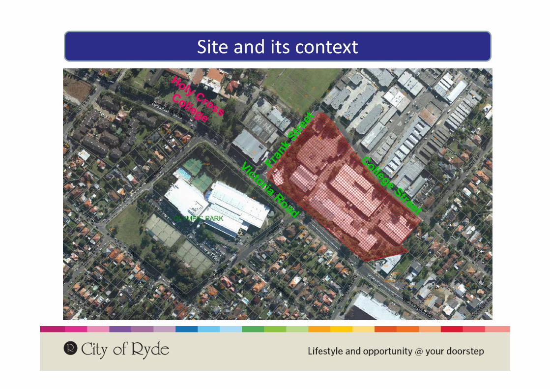
Site and its context
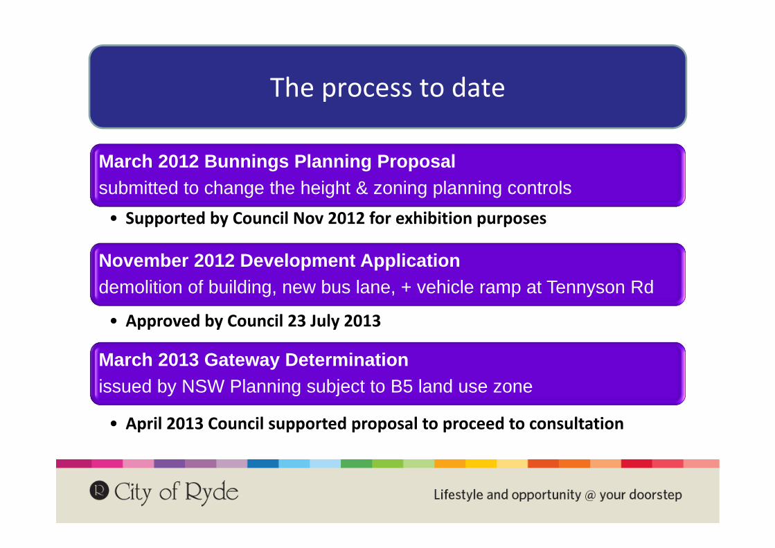
The process to date
March 2012 Bunnings Planning Proposal submitted to change the height & zoning planning controls• Supported by Council Nov 2012 for exhibition purposes
November 2012 Development Application demolition of building, new bus lane, + vehicle ramp at Tennyson Rd
• Approved by Council 23 July 2013
March 2013 Gateway Determination issued by NSW Planning subject to B5 land use zone
• April 2013 Council supported proposal to proceed to consultation

The process to date
August 2013 Community workshop on traffic impacts from a potential Bunnings if site is rezoned• Followed issues raised during public consultation in June‐July
November 2013 Council defers decision on the planning controls for the site pending a new traffic study• Study brief prepared by Council
June 2014Traffic study commenced with data collection• August 2014 community workshop – what we have found so far
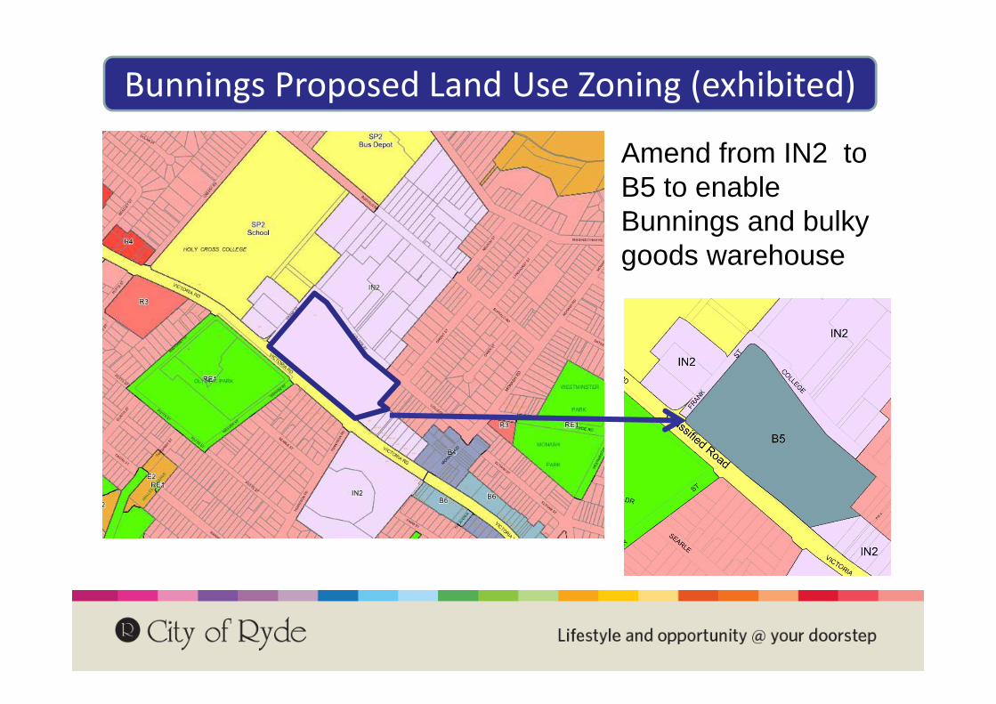
Bunnings Proposed Land Use Zoning (exhibited)
Amend from IN2 to B5 to enable Bunnings and bulky goods warehouse

Bunnings Proposed Height (exhibited)
Existing Height Control – none specified
Proposed Height Control• RL63 (12 to 15 metres
building height)• RL52 (6 to 14 metres
building height) and• RL42 (0 to 4 metres)

What is the Bunnings proposal?
Initial Concept Plans• 2 level Bunnings Warehouse (16,000m2) and a
Bulky Goods Retail Centre (22,000m2)
• Building Heights - equivalent to 3 - 4 storey building
• Basement car parking (895 spaces)
• Tennyson Rd (Victoria Road) access permits vehicles to enter & exit site without reliance on Frank Street.

What we heard from you June‐August 2013
Increased traffic congestion
Increased impacts on
availability of on‐street parking
Impact on character and nature of ‘local
area’
Validity of traffic counts and traffic
modelling
Safety of residents
(particularly children)
Increase in heavy / large vehicles
Cumulative impact with
future / existing development
Impacts on traffic and road
network
Building bulk and built form not in keeping with
surrounding area
Loss of privacy for nearby houses
Impact on property prices /
values
Potential overshadowing of nearby houses
Added noise from increased traffic and activity
Impacts on established retail centres hierarchy
Added noise from longer trading hours plus weekends
Stormwater and flooding not fully
addressed
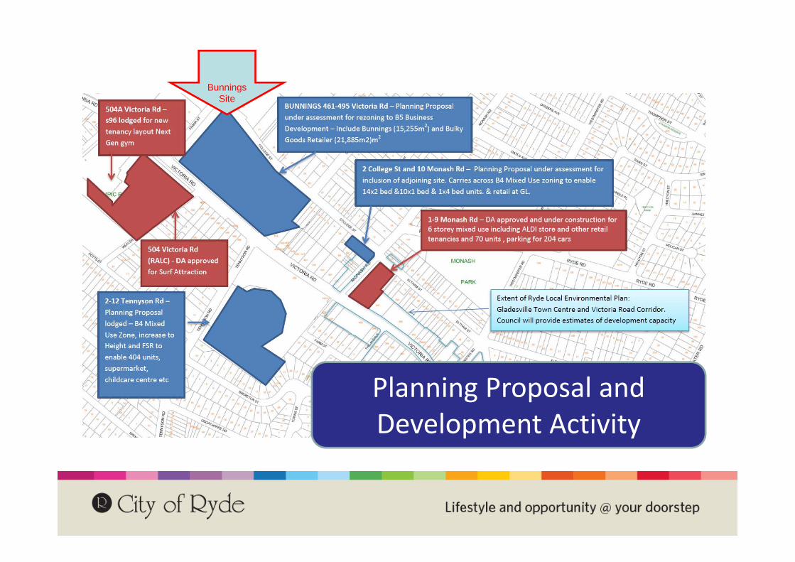
Planning Proposal and Development Activity
Bunnings Site
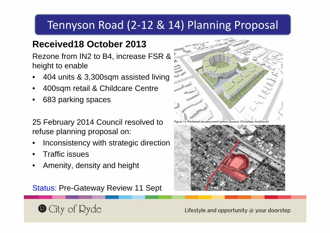
Tennyson Road (2‐12 & 14) Planning ProposalReceived18 October 2013Rezone from IN2 to B4, increase FSR & height to enable• 404 units & 3,300sqm assisted living• 400sqm retail & Childcare Centre• 683 parking spaces
25 February 2014 Council resolved to refuse planning proposal on:• Inconsistency with strategic direction • Traffic issues• Amenity, density and height
Status: Pre-Gateway Review 11 Sept
Questions?

Bunnings Gladesville Traffic and Parking StudyData, Model Development and Issues
Stephen ReadDamien Bitzios
28 August 2014

Overview
Purpose of the Study
Methodology and Scope
Study Area
Traffic Surveys
Traffic Model
Observed Traffic and Parking Issues
Gladesville Development Sites
Bunnings Development
Study Next Steps

Purpose of the Study
Council’s Brief:
To assess the impacts of the Bunnings Development Site Planning Proposal
To investigate traffic and parking impacts and options to try and minimise them
But, set in the context of the needs for all development in the area to 2031 (i.e. cumulative impact).
Consultant’s Role:
Document existing issues
Build a computer traffic model to test options and then develop and test options
Develop a strategy to minimise traffic and parking impacts at various development trigger points
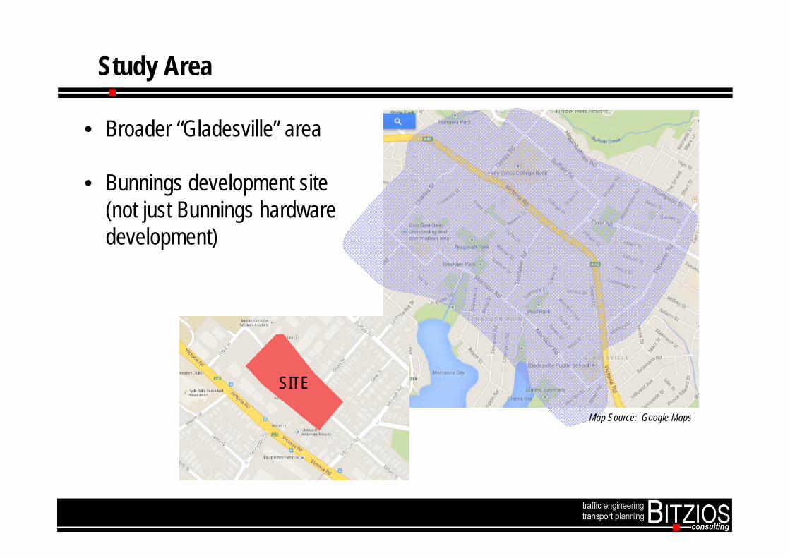
Study Area
SITE
Map Source: Google Maps
• Broader “Gladesville” area
• Bunnings development site (not just Bunnings hardware development)

Study Process
Stage 1• Data Collection and Validation
Stage 2• Traffic Model Development and Calibration
Stage 3• Future Options Development, Testing, Appraisal
Stage 4• Consultation, “Plan” Development and Reporting

Study Process
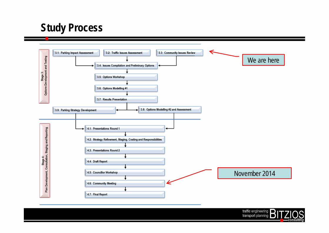
Study Process
We are here
November 2014
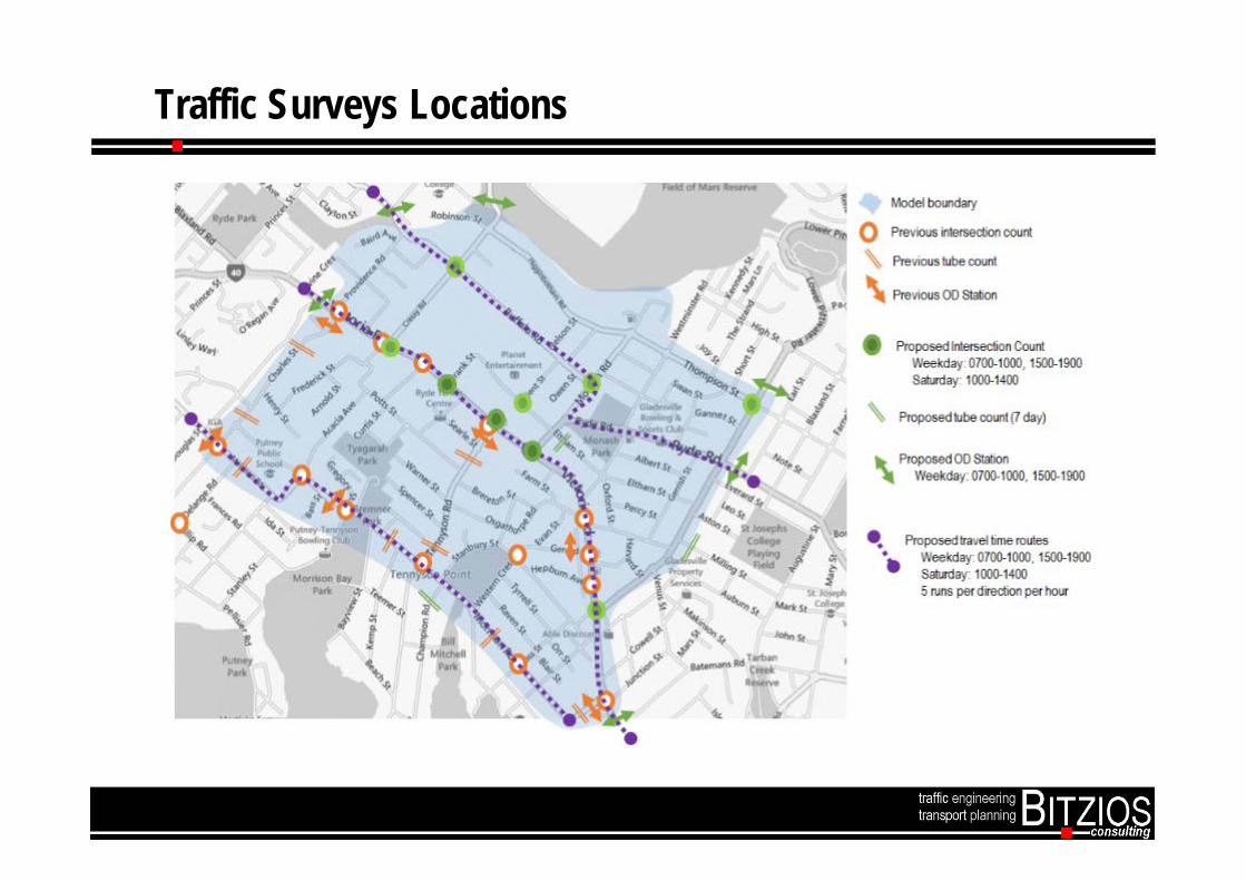
Traffic Surveys Locations

Hourly Intersection Volume (AM)
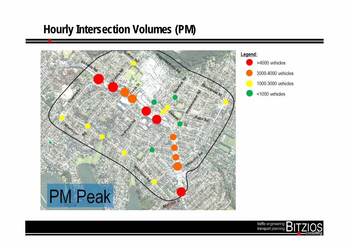
Hourly Intersection Volumes (PM)
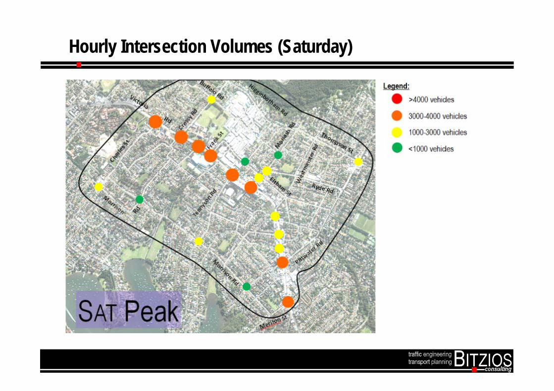
Hourly Intersection Volumes (Saturday)
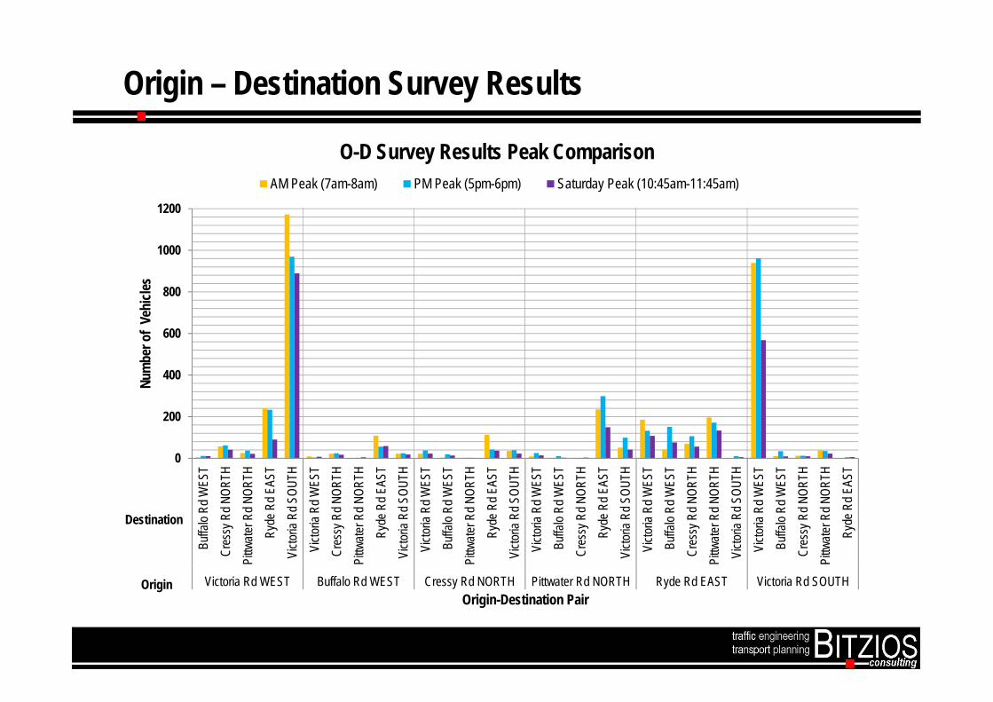
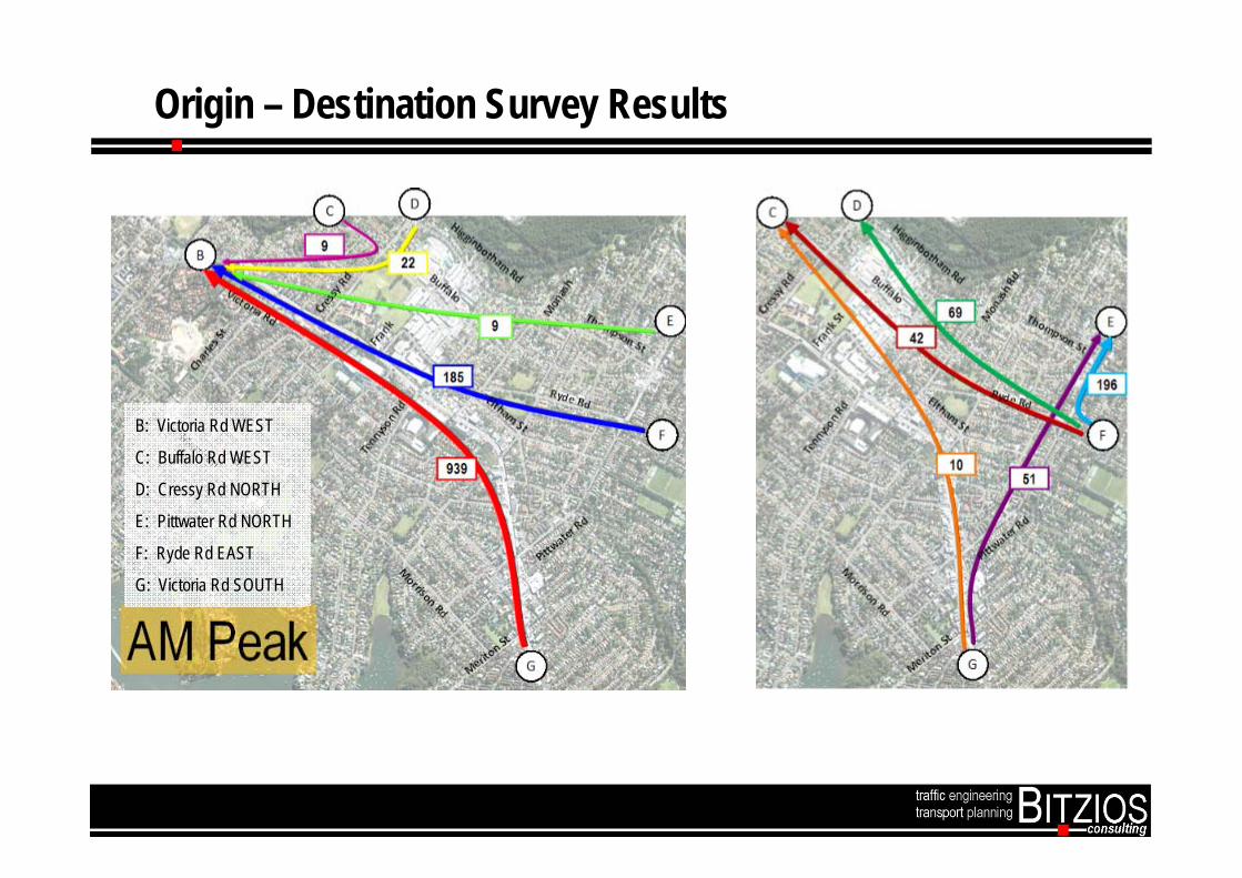
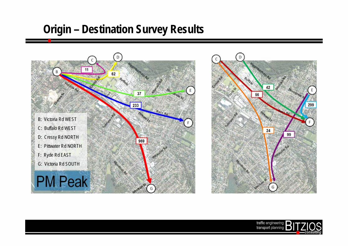
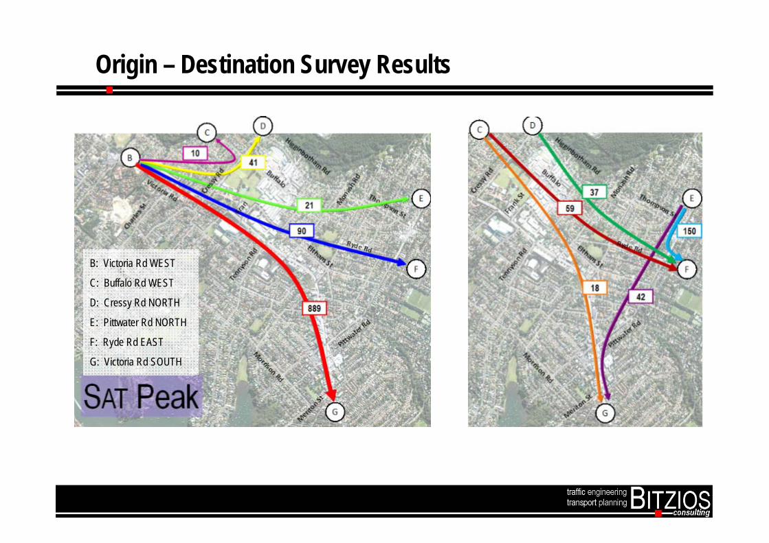
Origin – Destination Survey Results
0
200
400
600
800
1000
1200Bu
ffalo
Rd W
EST
Cres
sy R
d NOR
THPi
ttwate
r Rd N
ORTH
Ryde
Rd E
AST
Victo
ria R
d SOU
THVi
ctoria
Rd W
EST
Cres
sy R
d NOR
THPi
ttwate
r Rd N
ORTH
Ryde
Rd E
AST
Victo
ria R
d SOU
THVi
ctoria
Rd W
EST
Buffa
lo Rd
WES
TPi
ttwate
r Rd N
ORTH
Ryde
Rd E
AST
Victo
ria R
d SOU
THVi
ctoria
Rd W
EST
Buffa
lo Rd
WES
TCr
essy
Rd N
ORTH
Ryde
Rd E
AST
Victo
ria R
d SOU
THVi
ctoria
Rd W
EST
Buffa
lo Rd
WES
TCr
essy
Rd N
ORTH
Pittw
ater R
d NOR
THVi
ctoria
Rd S
OUTH
Victo
ria R
d WES
TBu
ffalo
Rd W
EST
Cres
sy R
d NOR
THPi
ttwate
r Rd N
ORTH
Ryde
Rd E
AST
Victoria Rd WEST Buffalo Rd WEST Cressy Rd NORTH Pittwater Rd NORTH Ryde Rd EAST Victoria Rd SOUTH
Num
ber o
f Ve
hicle
s
Origin-Destination Pair
O-D Survey Results Peak ComparisonAM Peak (7am-8am) PM Peak (5pm-6pm) Saturday Peak (10:45am-11:45am)
Destination
Origin

Origin – Destination Survey Results
B: Victoria Rd WEST
C: Buffalo Rd WEST
D: Cressy Rd NORTH
E: Pittwater Rd NORTH
F: Ryde Rd EAST
G: Victoria Rd SOUTH
Origin – Destination Survey Results
B: Victoria Rd WEST
C: Buffalo Rd WEST
D: Cressy Rd NORTH
E: Pittwater Rd NORTH
F: Ryde Rd EAST
G: Victoria Rd SOUTH
Origin – Destination Survey Results
B: Victoria Rd WEST
C: Buffalo Rd WEST
D: Cressy Rd NORTH
E: Pittwater Rd NORTH
F: Ryde Rd EAST
G: Victoria Rd SOUTH

Origin – Destination Survey Results
B: Victoria Rd WEST
C: Buffalo Rd WEST
D: Cressy Rd NORTH
E: Pittwater Rd NORTH
F: Ryde Rd EAST
G: Victoria Rd SOUTH
Origin – Destination Survey Results
B: Victoria Rd WEST
C: Buffalo Rd WEST
D: Cressy Rd NORTH
E: Pittwater Rd NORTH
F: Ryde Rd EAST
G: Victoria Rd SOUTH

Origin – Destination Survey Results
B: Victoria Rd WEST
C: Buffalo Rd WEST
D: Cressy Rd NORTH
E: Pittwater Rd NORTH
F: Ryde Rd EAST
G: Victoria Rd SOUTH
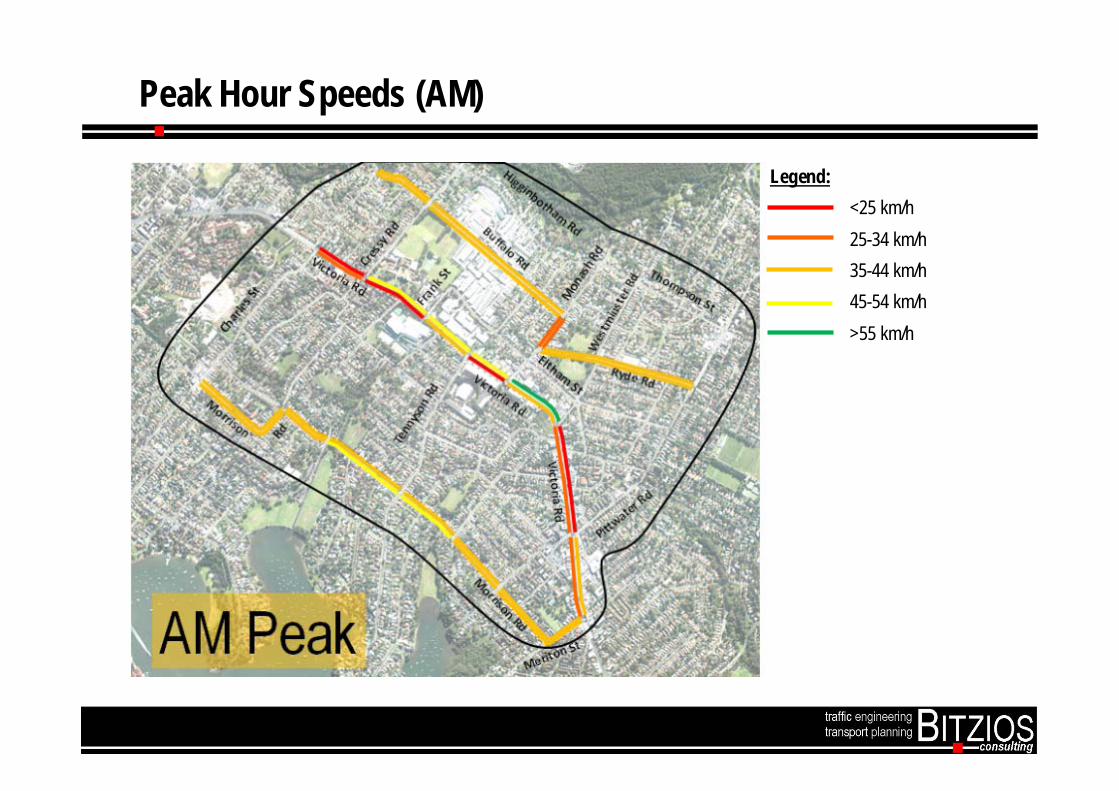
Peak Hour Speeds (AM)
Legend: <25 km/h 25-34 km/h 35-44 km/h 45-54 km/h >55 km/h

Peak Hour Speeds (PM)
Legend: <25 km/h 25-34 km/h 35-44 km/h 45-54 km/h >55 km/h
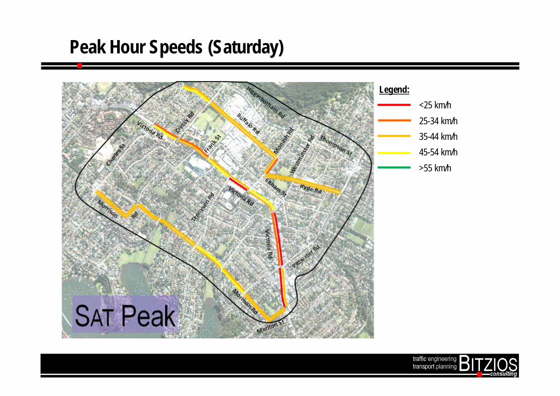
Peak Hour Speeds (Saturday)
Legend: <25 km/h 25-34 km/h 35-44 km/h 45-54 km/h >55 km/h
* Bus Only RIGHT TURN
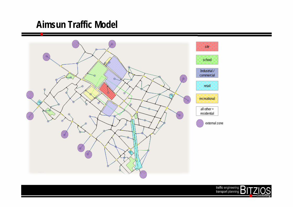
Aimsun Traffic Model
site
school
Industrial / commercial
retail
recreational
all other = residential
external zone

Model Demonstration – Traffic Simulation
Movie Clip to be Attached

Questions?
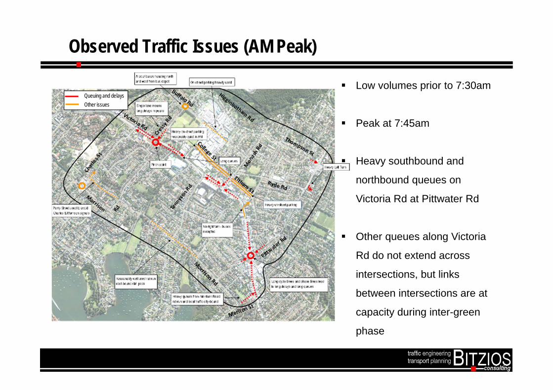
Observed Traffic Issues (AM Peak)
Low volumes prior to 7:30am
Peak at 7:45am
Heavy southbound and
northbound queues on
Victoria Rd at Pittwater Rd
Other queues along Victoria
Rd do not extend across
intersections, but links
between intersections are at
capacity during inter-green
phase
Queuing and delays Other issues
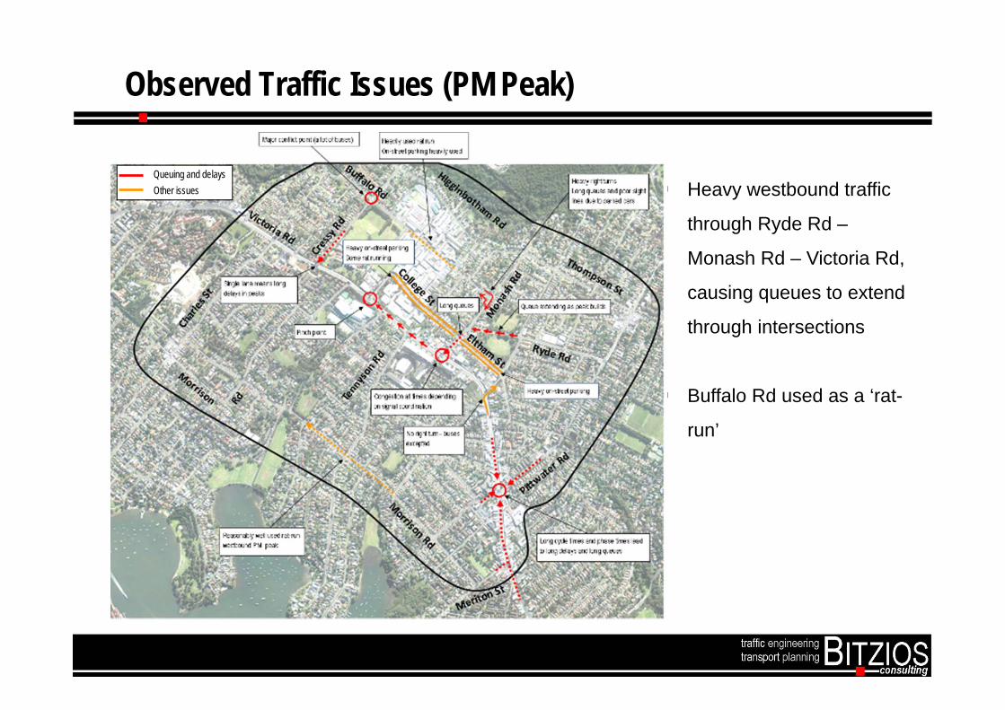
Observed Traffic Issues (PM Peak)
Heavy westbound traffic
through Ryde Rd –
Monash Rd – Victoria Rd,
causing queues to extend
through intersections
Buffalo Rd used as a ‘rat-
run’
Queuing and delays Other issues

Observed Traffic Issues (Sat Peak)
Queuing and delays Other issues Shopping strip on Victoria
Road south creates slow
speeds and delays.
Heavy on-street parking at
Gladesville Shops and
surrounding car parks.
Heavy traffic in both
directions on Victoria Road
More local trips than
weekday peak

Congestion Issues AM (2014 Model Outputs)
Victoria Rd at Tennyson Rd
Victoria Rd at Pittwater Rd
Victoria Rd at Cressy Rd
Victoria Rd at Charles St
Cressy Rd at Victoria Rd
Meriton St

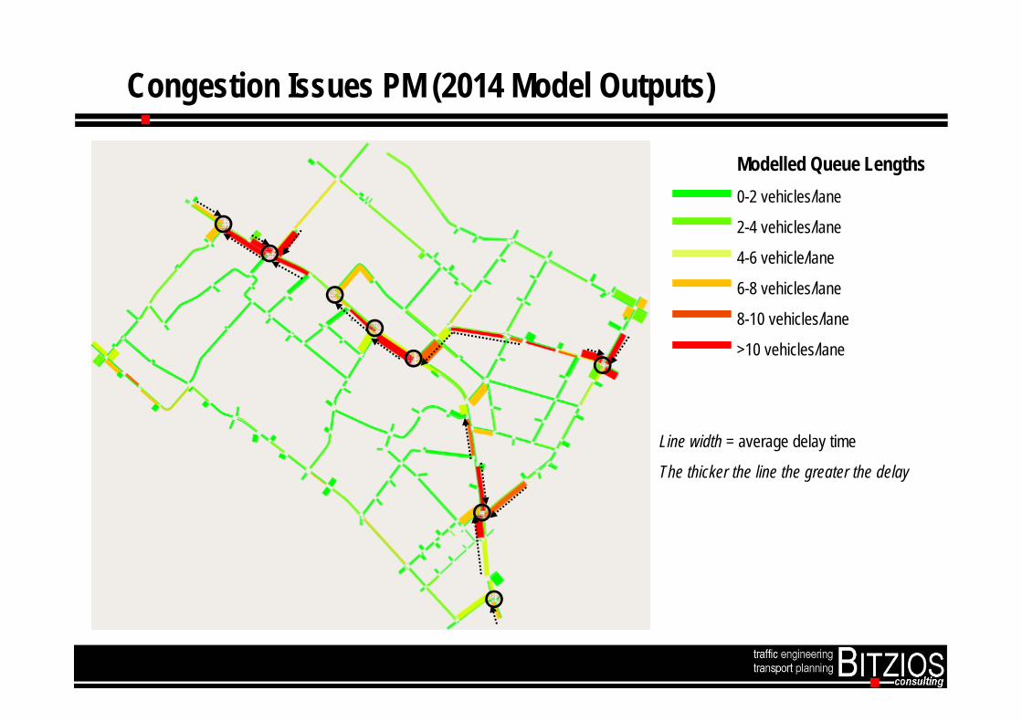
Congestion Issues PM (2014 Model Outputs)
Victoria Rd at Tennyson Rd
Victoria Rd at Pittwater Rd
Victoria Rd at Cressy Rd
Victoria Rd at Charles St
Monash Rd at Victoria Rd
Cressy Rd at Victoria Rd

Congestion Issues Saturday (2014 Model Outputs)
Victoria Rd at Tennyson Rd
Victoria Rd at Pittwater Rd
Victoria Rd at Cressy Rd
Victoria Rd at Charles St
Cressy Rd at Victoria Rd
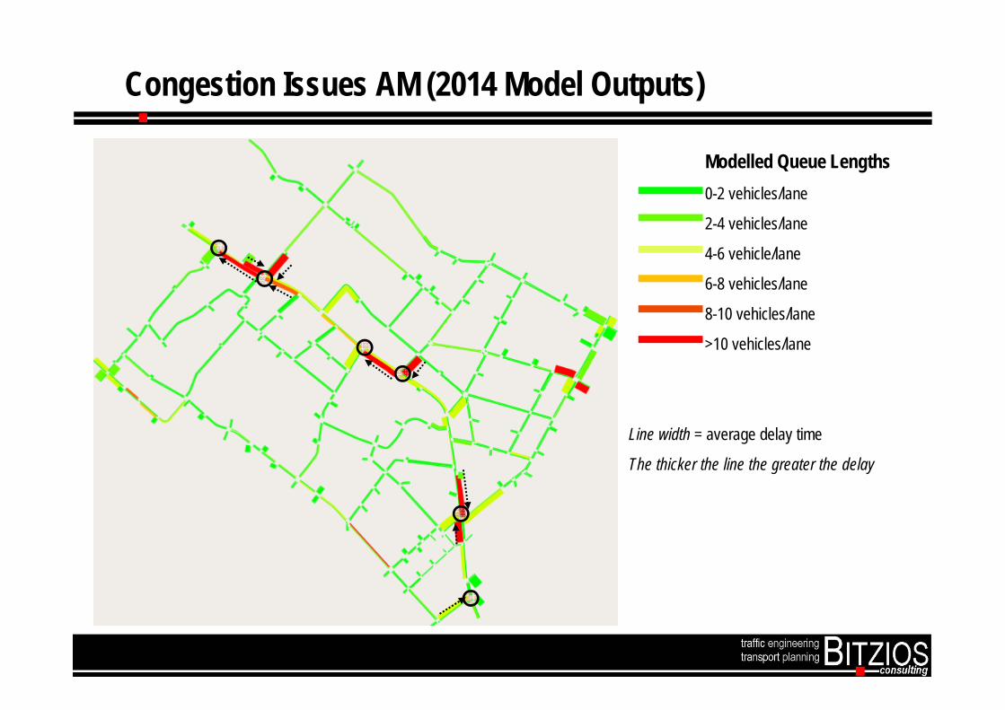
Modelled Queue Lengths0-2 vehicles/lane
2-4 vehicles/lane
4-6 vehicle/lane
6-8 vehicles/lane
8-10 vehicles/lane
>10 vehicles/lane
Line width = average delay time
The thicker the line the greater the delay
Congestion Issues AM (2014 Model Outputs)
Congestion Issues PM (2014 Model Outputs)
Modelled Queue Lengths0-2 vehicles/lane
2-4 vehicles/lane
4-6 vehicle/lane
6-8 vehicles/lane
8-10 vehicles/lane
>10 vehicles/lane
Line width = average delay time
The thicker the line the greater the delay

Congestion Issues Saturday (2014 Model Outputs)
Modelled Queue Lengths0-2 vehicles/lane
2-4 vehicles/lane
4-6 vehicle/lane
6-8 vehicles/lane
8-10 vehicles/lane
>10 vehicles/lane
Line width = average delay time
The thicker the line the greater the delay
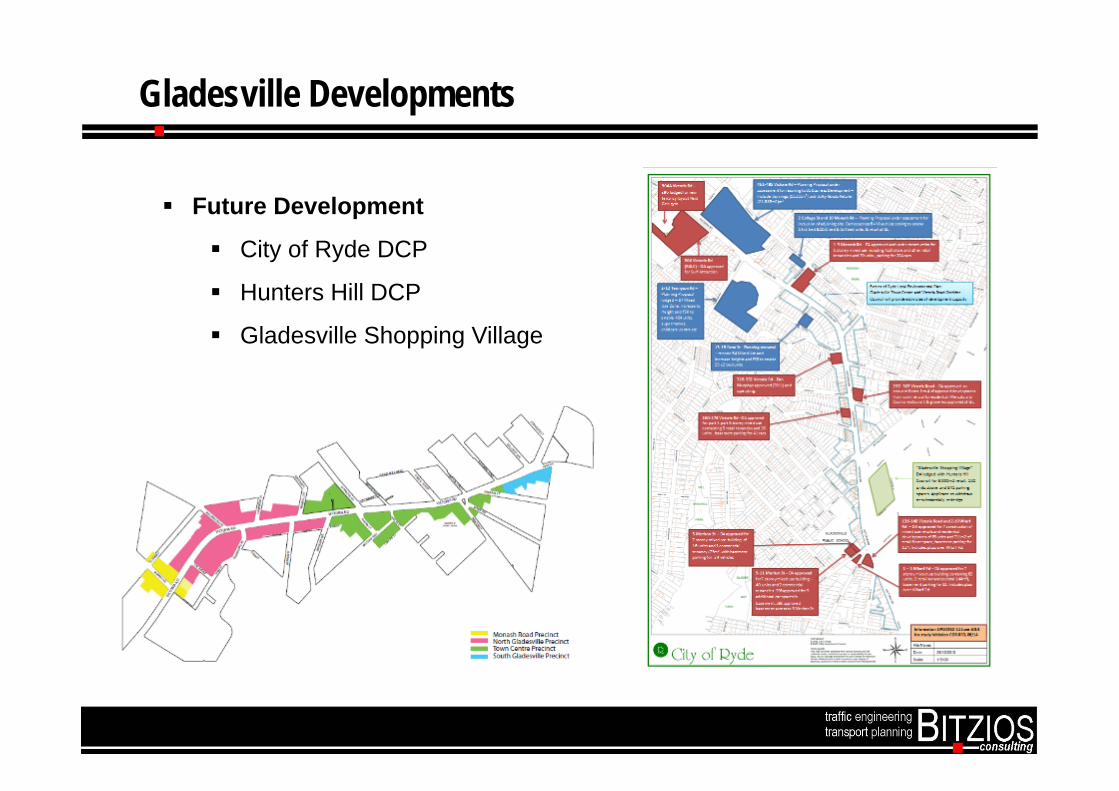
Gladesville Developments
Future Development
City of Ryde DCP
Hunters Hill DCP
Gladesville Shopping Village

Types of Option Testing (2021/2031)
Network ScenarioDevelopment Scenario
1 2 3 4 5
All development, no Bunnings site X X X X X
All development + Bunnings X X X X X
No development + Bunnings site X X X X X
Network scenarios will be developed with Council and RMS, and consider, at various
locations:Street closure measuresIntersection control measures (upgrades, turn bans)Traffic calming measures and speed control measuresCapacity improvement measuresBus priority measuresTraffic, pedestrian and cyclist safety measures
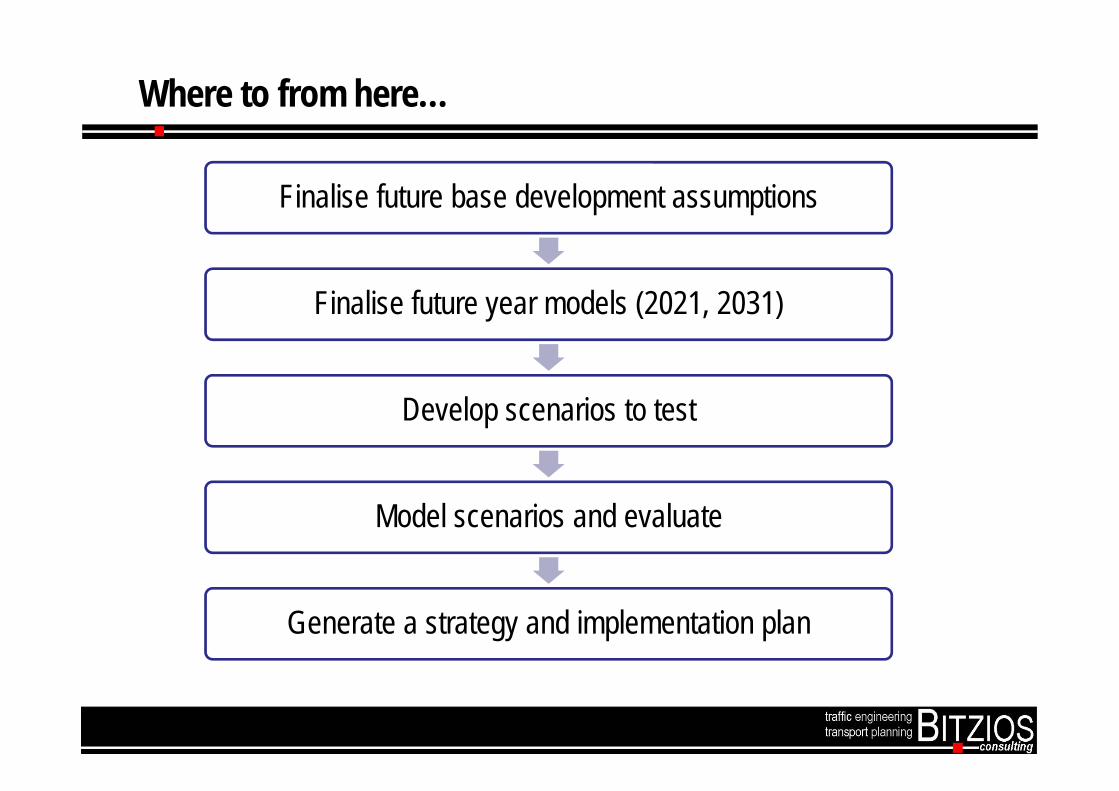
Where to from here…
Finalise future base development assumptions
Finalise future year models (2021, 2031)
Develop scenarios to test
Model scenarios and evaluate
Generate a strategy and implementation plan
Group discussion and Feedback
• Are the issues identified for AM Peak, PM Peak and Saturday Peak reflective of your area?
Questions – Group Discussion

What comes next after tonight
CONSULTANTS TEST OPTIONS &
FINALISE MODEL
COUNCIL REPORTS STUDY
BACK TO COMMUNITY
FURTHER COMMUNITY COMMENT
COMMUNITY COMMENT
CONSIDERED &STUDY FINALISED
EARLY 2015TRAFFIC STUDY AND
ASSESSMENT OF PLANNING PROPOSAL REPORTED TO
COUNCIL FOR DETERMINATION
28 AUG 2014CONSULTANTS
PRESENT STAGE 1 TRAFFIC MODEL FINDINGS

Thank you
To keep updated on the progress of the BunningsTraffic Study please register your interest at: