Embed Size (px)
DESCRIPTION
Submission to Tony Burke regarding the EPBC assessment of Maules Creek and Boggabri Coal mine developments. Report prepared by North West Ecological Services on behalf of the Maules Creek Community Council and the Northern Inland Council for the Environment.January 2013.
Citation preview

Submission to Tony Burke re the EPBC
assessment of Maules Creek and Boggabri
Coal mine developments
Report prepared by North West Ecological Services on behalf of the Maules Creek
Community Council and the Northern Inland Council for the Environment
Leard State Forest Before Mining
Below Artists Impression of the full extent of mining in Leard State Forest
NWES Review of Boggabri & Maules Creek Coal Projects Jan 2013 Page 2
CONTENTS
Background .............................................................................................................................. 4
Summary .................................................................................................................................... 4
Introduction .............................................................................................................................. 5
1.0 Failings of the Ecological Assessment and proposed Biodiversity Offset Management
Plan ............................................................................................................................................ 5
1.1 Mapping of the high condition remnant area .......................................................................... 6
1.2 Vegetation identification and mapping in northern offset properties ..................................... 7
1.3 Consideration of like for like habitat and vegetation in offsets as compared to that to be
destroyed in Leard SF ......................................................................................................................... 9
1.3.1 Wirradale and Mt Lindsey offsets on Nandewar Range ................................................. 9
1.3.2. Boggabri Coal offsets east of Leard State Forest ................................................................ 13
1.4 The long-term security of compensatory offsets ................................................................... 17
1.5. Value of regeneration areas in the eastern and western offsets to the nationally protected
matters ............................................................................................................................................... 18
1.6 Value of remnant vegetation areas in the eastern and western offset properties to the nationally
protected matters ............................................................................................................................... 18
1.7 Value of revegetation of over burden slopes to the nationally protected matters ....................... 19
2.0 Potential impacts for which there is not enough information provided to make an
informed decision that has scientific credibility. ................................................................. 23
3.0 Results from field assessment of offset properties in the Maules Creek locality ....... 24
4.0 Review of Environmental Assessment prepared by Cumberland Ecology for Maules
Creek Project. ......................................................................................................................... 29
5.0 SUMMARY OF IMPACTS ............................................................................................ 32
5.1 Clearing: ...................................................................................................................................... 32
5.2 Noise; .......................................................................................................................................... 32
5.3 Light; ........................................................................................................................................... 33
5.4 Dust; ............................................................................................................................................ 33
5.5 Roads and traffic; ........................................................................................................................ 33
6.0 The protected matters impacted by the mine proposals are; ...................................... 33
6.1 Box – Gum ecological community ............................................................................................. 33
6.2 Corben’s Long-eared bat ............................................................................................................. 34
6.3 Koala ........................................................................................................................................... 36

NWES Review of Boggabri & Maules Creek Coal Projects Jan 2013 Page 3
6.4 Border Thick-tailed Gecko.......................................................................................................... 37
6.5 Grey-headed Flying-fox .............................................................................................................. 37
6.6 Spotted-tailed Quoll .................................................................................................................... 37
6.7 Large-eared Pied Bat ................................................................................................................... 38
6.8 Superb Parrot .............................................................................................................................. 39
6.9 Swift Parrot ................................................................................................................................. 39
6.10 Regent Honeyeater .................................................................................................................... 41
6.11 Rainbow Bee-eater .................................................................................................................... 42
6.12 Tylophora linearis ..................................................................................................................... 42
6.13 Pultenaea setulosa .................................................................................................................... 44
7.0 Components of the Offset Assessment Calculator that indicate species decline and
threat to long-term viability are. .......................................................................................... 44
7.1 Time over which loss is averted .................................................................................................. 44
7.2 Time until ecological benefit ...................................................................................................... 44
7.3 Quality Score .............................................................................................................................. 45
7.4 Future quality of Leard without mines impact and offset ........................................................... 47
7.5 Future quality of Leard with mine impact and proposed offsets................................................. 47
7.6 Risk of Loss % without offset ..................................................................................................... 48
7.7 Risk of Loss % with offset .......................................................................................................... 48
7.8 Confidence in result .................................................................................................................... 48
7.9 Evaluation of Offset Calculator .................................................................................................. 49
8.0 Conclusion ........................................................................................................................ 49

NWES Review of Boggabri & Maules Creek Coal Projects Jan 2013 Page 4
Background
The Maules Creek Community and Northern Inland Council for the Environment met with
Tony Burke at Boggabri on Saturday the 15th of December. Concerns were raised about
misleading information in the environmental assessment for Maules Creek and Boggabri
Coal mine projects. Since then North West Ecological Services has been reviewing the EA’s
and assessing the offset properties, and has prepared this summary report and the eight
Appendices.
Included in this submission are:
1. Overall summary of findings and review, 2. Appendix A report detailing assessment of northern offset properties, 3. Appendix B expert opinion contributions to back up the submission, 4. Appendix C report detailing assessment of eastern and western offset properties, 5. Appendix D report detailing assessment of the offset property Kelso, 6. Appendix E report on research into noise impacts on ecosystems, 7. Appendix F report on research into light impacts on ecosystems 8. Appendix G report detailing assessment of Boggabri Coal eastern offset 9. Tylophora linearis report
This report demonstrates that the impact assessment and Biodiversity Offsets Management
Plan fail to meet the standards set out in the new Federal offsets policy. None of the key
criteria of that policy are met with regard to; Quality of the offsets, Time over which loss is
averted, Time until ecological benefit, Risk of loss, and Confidence of result.
Summary
This report and the Appendices attached provide the evidence to show that the offset
properties are not like for like, and in fact are very different communities to those proposed
for destruction in Leard State Forest.
It provides evidence that the offset properties do not provide suitable habitat for the EPBC
threatened species of Swift Parrot, Regent Honeyeater, Corben’s Long-eared bat and
Tylophora linearis, and that at best the habitat is considered marginal for those species and
the Koala.
The properties do not offset the critically endangered ecological community of Box – Gum
grassy woodland, of which 1,100 has is to be destroyed for the mines in Leard State Forest.
The vegetation mapping (done by Cumberland Ecology) of the high altitude remnants on the
Nandewar Range was found to be wrong, extensive areas mapped as grassy White box –
Stringybark woodland had no White box at all, and were in fact Stringybark open forest.

NWES Review of Boggabri & Maules Creek Coal Projects Jan 2013 Page 5
The review of the environmental assessment found the potential impact of the mines on
Leard State Forest to be underestimated, as the unmined areas will not provide refuge to
the EPBC species and critically endangered ecological community throughout the 21 year
life of the mine.
If the two mines are approved the majority of the forest will be impacted by edge effects,
fragmentation, noise, light, dust and vibration. Research from overseas clearly shows that
ecosystem function is significantly impacted at distance from those pollution sources
Most recently the EPBC endangered plant Tylophora linearis was recorded in the Maules
Creek project area and it is also likely to occur in the Boggabri Coal project area. The dry
season is hampering the chance of surveying the forest to determine its occurrence; further
surveys are required during suitable seasonal conditions. Its presence raises many
considerations not yet contemplated in the environmental assessment process.
There must be a thorough independent review of the vegetation mapping and condition
assessment of the offset properties, extensive surveys for Tylophora linearis during suitable
seasonal conditions, and consideration of the accumulative impacts on the unmined section
of the forest proposed for flora and fauna refuge. That work should be done by
independent botanists and ecologists with high standing and expertise in the area before a
final decision is made in relation to the mine proposals.
Introduction
This review of the environmental assessment reports and field inspection of the proposed
offset properties for the Maules Creek and Boggabri coal mine developments found neither of
the mines should be approved. The main reason is that the offsets and compensatory
measures do not meet the standards set out in the EPBC Act 1999 Environmental Offsets
Policy Oct 2012.
The key requirement of the Environmental Offsets Policy is that the impact + offset =
Improves or maintains the viability of the protected matter.
This fundamental requirement to improve or maintain the area and quality of suitable habitat
for the Regent Honeyeater, Swift Parrot, Corben’s Long-eared bat, Spotted-tailed Quoll,
Border Thick-tailed Gecko, Koala and Tylophora linearis is not achieved for the following
reasons.
1.0 Failings of the Ecological Assessment and proposed Biodiversity Offset
Management Plan

NWES Review of Boggabri & Maules Creek Coal Projects Jan 2013 Page 6
1.1 Mapping of the high condition remnant area
The mapping of high condition remnant area on the offset properties that provides suitable
habitat for the Regent Honeyeater, Swift Parrot, Corben’s Long-eared bat, Spotted-tailed
Quoll and Koala is very misleading.
Remnant vegetation on the eastern and western offset properties is dominated by unnaturally
thick immature regrowth of White Cypress, Narrow-leaf Ironbark and Silverleaf Ironbark on
rocky ridges. With the exception of a few small areas of White box and Dwyer’s Red gum
the vegetation in general has very low value for Koalas, and low nectar production value for
the Regent Honeyeater and Swift Parrot. Virtually all of the lower slopes productive soil
types that were once White box woodland has been cleared and cultivated. (Review of the
photos from the offset properties shown in Appendix C & D highlight the low quality habitat
and vegetation).
The same can be said of the northern offset properties where immature Silvertop Stringybark
open forest is the dominant community; it also has low nectar production value for the
Regent Honeyeater and Swift Parrot. Those open forests do contain productive nectar tree
species such as Yellow box and Blakely’s Red gum, however being sub dominant and in a
forest association, their production value is reduced considerably as compared to a woodland
situation where they are dominant.
Also misleading is that the high elevation open forests are rated as being of high condition
habitat for the Corben’s Long-eared bat. Corben’s Long-eared bat is at its altitudinal limit at
900 metres. It is not likely to occur in the Stringybark open forests. No surveys for the bat
have been done to indicate it does occur above 900m. Many bat surveys have been done in
Mt Kaputar NP and none have been recorded.
Tylophora linearis was not considered in the EA, it was recently recorded in the Maules
Creek project area near where the mining is proposed to commence, it would also not occur
above 900 metres in open forest associations.
The regrowth remnants of the eastern and western offsets are dominated by thick regrowth of
White Cypress and immature Narrow-leaf Ironbark and Silverleaf Ironbark. Whilst that
community is considered preferred habitat for Corben’s Long-eared bat, the immature age of
the trees does not provide sufficient roosting hollow habitat and the extensive areas of thick
White Cypress are a monoculture that limits diversity and abundance of the bats prey and
restricts the bats foraging activity.
The offset property “Kelso” is a classic example, where the figure of 342 ha of high condition
habitat is considered highly misleading, as much of the vegetation is thick White Cypress
regrowth of very low habitat value. Very little of the vegetation on that property has mature
trees that would provide high condition habitat. The results of the field inspection of “Kelso”
illustrate how misleading the calculation of High condition remnant has been. The report and
photos of “Kelso” are presented in Appendix D.

NWES Review of Boggabri & Maules Creek Coal Projects Jan 2013 Page 7
The environmental assessment has given no real recognition of the high habitat value per
hectare of the box woodland in Leard State Forest to the EPBC listed species and community.
There has been no credible assessment of habitat values and condition of the remnants on the
offset properties.
The lack of a credible methodology for condition assessment was raised by the Namoi CMA
in their original submission. They stated; “Without condition assessments it is not possible to
state whether there has been sufficient gain (no net loss) and whether equivalence (like for
like) has been achieved.
There was no comparative analysis of condition assessments or biometric benchmarking for
vegetation communities between the project disturbance area and offset properties.
Without thorough and complete condition assessments and biometric benchmarking of the
vegetation communities in both the project disturbance area and offset properties, it is not
possible for this comparative analysis to take place”.
The gross overestimation of high condition habitat on “Kelso” makes all the other
figures provided in the EA very questionable. All the offset areas must be reassessed by
an independent authority to estimate habitat values and re-evaluate the patch condition
of each remnant.
1.2 Vegetation identification and mapping in northern offset properties
The mapping of White box – Stringybark grassy woodland is also very misleading. The
properties of Wirradale and Mt Lindesay were inspected to verify the vegetation communities
as mapped in figure 2.2 of the Biodiversity Offsets Management Plan. No White box trees
were found in the property Mt Lindesay and the only White box trees observed on the
property Wirradale where at low elevation in the Maules Creek valley.
The bulk of the vegetation mapped as White box – Stringybark grassy woodland was found
to be Stringybark open forest with sub dominant species of Blakely’s Redgum, Apple box
and Yellow box. No White box trees occur in the areas assessed. Refer to report Appendix
A and the DVD of photos that illustrate how misleading the vegetation mapping has been at
the remnant areas assessed.
Extensive areas of the vegetation mapped as White box – Stringybark grassy woodland are in
fact open forests with a continuous shrub layer of greater than 30%, or have less than 50%
ground cover of tussock grasses, being dominated by litter and rock.
The definition of the the critically endangered White box – Yellow box – Blakely’s Red gum
Grassy Woodland and Derived Native Grassland Ecological Community (CEEC) listed under
the Environment Protection and Biodiversity Conservation Act 1999 has been misinterpreted
to suit the desired outcome required.
Thiele and Prober (2000) estimated that less than 0.1% of Grassy White Box Woodlands (a
component of the Box – Gum Grassy Woodland and Derived Grassland ecological
community) remains in a near-intact condition. The community found in Leard State Forest
is part of the 0.1%.

NWES Review of Boggabri & Maules Creek Coal Projects Jan 2013 Page 8
The future of the box-gum woodland is very dire, 1,000’s of hectares of the highest
conservation value areas in Travelling Stock Routes and Crowns lands in the North West has
been destroyed by Coolatai Grass invasion in the last 20 years. None of it can be saved, it is
permanently lost, and what little is left in good condition is rapidly becoming invaded.
The extent of the Critically EEC as mapped in Leard State Forest would be significantly less
now than it would have been pre 1770, due to a lack of fire to maintain grassy ground cover
and limit White Cypress and shrub regrowth.
The EPBC Definition States
Box-gum grassy woodland tree-cover is generally discontinuous and consists of widely-
spaced trees of medium height in which the canopies are clearly separated (Yates & Hobbs
1997).
Extensive areas of Wirradale and Mt Lindsey mapped as White box – Stringybark
grassy woodland have open forest canopies with canopies clearly touching.
Woodlands that fit the Box-gum grassy woodland have a ground layer dominated by tussock
grasses (> 50%)
Extensive areas mapped as woodland have litter dominated ground cover.
Woodlands that fit the Box-gum grassy woodland have an overstorey dominated or co-
dominated by White Box, Yellow Box or Blakely’s Red Gum, or Grey Box in the Nandewar
bioregion.
Extensive areas mapped as White box woodland don’t have any White box and are
dominated by Stringybark or Apple box with sub dominant Yellow box or Blakely’s
Red gum.
Woodlands that fit the Box-gum grassy woodland have a sparse or patchy shrub layer.
Extensive areas mapped as White box woodland have continuous shrub layers 1 – 2.5
m tall.
The shrub cover described in the Box - Gum ecological community is naturally patchy,
shrubs may be dominant only over a very localised area. Shrub cover should therefore be
assessed over the entire remnant, not just in a localised area.
A woodland remnant with a significant ground layer of tussock grasses, and where the
distribution of shrubs is scattered or patchy, is part of the ecological community.
In shrubby woodlands, the dominance of native tussock grasses in the ground layer of
vegetation is lost. Therefore, a remnant with a continuous shrub layer, in which the shrub
cover is greater than 30%, is considered to be a shrubby woodland and so is not part of the
listed ecological community. Remnant attributes, such as shrubbiness, should be measured on
a scale of 0.1 hectares or greater.
All the offset properties must be reassessed by an independent authority to map the
vegetation communities according to the definition of the critically endangered Box –
Gum Grassy Woodland and Derived Grassland community.

NWES Review of Boggabri & Maules Creek Coal Projects Jan 2013 Page 9
All forest communities with touching crowns should be excluded, all shrub layers > 30
% should be excluded, and all areas of less than 50% tussock grass cover should be
excluded.
All the tables quantifying each vegetation community within the offsets, areas of each
vegetation community to be conserved, and areas of suitable habitat for each species in
offsets must be assessed again to have scientific credibility.
If the calculations in Table 2.4 of the BOMP were amended to reflect the results of this
survey, dramatically affect the areal estimates of vegetation type for Wirradale and Mt
Lindesay.
1.3 Consideration of like for like habitat and vegetation in offsets as
compared to that to be destroyed in Leard SF
As mentioned the vegetation mapping cannot be considered reliable. The findings raise
considerable doubts about the vegetation mapping done Cumberland Ecological. All of the
area identified and mapped as CEEC should be reassessed by an independent botanist, and
the area remapped so the calculations can be redone.
1.3.1 Wirradale and Mt Lindsey offsets on Nandewar Range
The extent of the White box woodland on the two properties Wirradale and Mt Lindesay is
the essential offset to compensate for the White box woodland to be cleared for the Maules
Ck Coal Project in Leard State Forest. The field survey found both the flora and fauna
communities on the two properties to be very different to that found in Leard State Forest at
300 m altitude. The dominant vegetation community on the (offset) properties between 930
and 1000m was found to be the Keith Class of Stringybark - Blakely's Red Gum - Rough-
barked Apple open forest, Nandewar and western New England Tablelands – Northern
Tableland Dry Sclerophyll Forests.
There are countless differences between the plants and animals occuring in the two
bioregions. The most obvious differences are the geology, dominant trees and grasses, and
bird species present.
Leard State Forest recorded over thirty species of woodland birds not likely to occur above
900m on the Nandewar Range, and six species of high altitude trees were recorded on the two
properties that would not occur at Leard: Manna Gum (Eucalyptus viminalis), Silvertop
Stringbark (Eucalyptus laevopinea), Orange gum (Eucalyptus prava), New England
Blackbutt (Eucalyputs andrewsii), Apple box (Eucalyptus bridgesiana), and Mallee Red gum
(Eucalyptus nandewarica). The dominant ground cover above 900 m is Snow Grass (Poa
sieberiana) which occurs sparsely in Leard State Forest.

NWES Review of Boggabri & Maules Creek Coal Projects Jan 2013 Page 10
THIS IS NOT LIKE FOR LIKE OFFSET?
Leard State Forest - Liverpool Plains Old growth White box woodland on gravelly
duplex soils at 300 metres elevation – 600mm rainfall - Brigalow Belt South bioregion –
Grazing property – Nandewar Plateau Immature Stringybark open forest on basalt soil
at 950 metres elevation – 1000 mm rainfall – Nandewar bioregion

NWES Review of Boggabri & Maules Creek Coal Projects Jan 2013 Page 11
Differences between the bird assemblages of the two bioregions, Leard State Forest and
Wirradale – Mt Lindesay
Comparison of the diversity of birds recorded at the offset properties of Wirradale and Mt
Lindsey as compared to Leard State Forest provides a good indicator of the faunal differences
between 300m and 900m altitude, and between the Nandewar and Brigalow belt south
bioregions.
The records provided from the field assessment show ninety five birds species at Wirradale
and 65 species at Mt Lindesay as compared to 168 species recorded at Leard State Forest.
The species below were only recorded at Leard State forest in the Brigalow belt south
bioregion; they highlight the value of low elevation large woodland remnants like Leard State
Forest. Scientific Name Common Name
Geopelia humeralis Bar-shouldered Dove
**Apus pacificus Fork-tailed Swift
Elanus axillaris Black-shouldered Kite
Lophoictinia isura Square-tailed Kite
Haliastur sphenurus Whistling Kite
Circus assimilis Spotted Harrier
Turnix varia Painted Button-quail
Cacatua sanguinea Little Corella
Nymphicus hollandicus Cockatiel
Aprosmictus erythropterus Red-winged Parrot
Barnardius zonarius Australian Ringneck
Northiella haematogaster Blue Bonnet
Melopsittacus undulatus Budgerigar
Eudynamys orientalis Eastern Koel
Cacomantis pallidus Pallid Cuckoo
Cacomantis variolosus Brush Cuckoo
Ninox connivens Barking Owl
Tyto novaehollandiae Masked Owl
**Merops ornatus Rainbow Bee-eater
Eurystomus orientalis Dollarbird
Ptilonorhynchus maculatus Spotted Bowerbird
Gerygone fusca Western Gerygone
Acanthiza uropygialis Chestnut-rumped Thornbill
Acanthiza apicalis Inland Thornbill
Lichenostomus fuscus Fuscous Honeyeater
Manorina flavigula Yellow-throated Miner
Myzomela sanguinolenta Scarlet Honeyeater
Philemon citreogularis Little Friarbird
Grantiella picta Painted Honeyeater
Pomatostomus temporalis Grey-crowned Babbler
Pomatostomus superciliosus White-browed Babbler
Coracina tenuirostris Cicadabird
Lalage sueurii White-winged Triller
Falcunculus frontatus Crested Shrike-tit
Corvus mellori Little Raven
Struthidea cinerea Apostlebird
Melanodryas cucullata Hooded Robin
Cincloramphus cruralis Brown Songlark
Petrochelidon nigricans Tree Martin
Taeniopygia guttata Zebra Finch
Stagonopleura guttata Diamond Firetail

NWES Review of Boggabri & Maules Creek Coal Projects Jan 2013 Page 12
The species below were only recorded at Wirradale or Mt Lindesay in the Nandewar
bioregion; they highlight the difference of habitat and altitude as compared to Leard State
Forest.
Scientific Name Common Name
Malurus lamberti Variegated Fairy-wren
Sericornis frontalis White-browed Scrubwren
Acanthiza lineata Striated Thornbill
Acanthiza pusilla Brown Thornbill
Aphelocephala leucopsis Southern Whiteface
Acanthorhynchus tenuirostris Eastern Spinebill
Anthochaera carunculata Red Wattlebird
Cinclosoma punctatum Spotted Quail-thrush
Coracina maxima Ground Cuckoo-shrike
Corvus orru Torresian Crow
Petroica goodenovii Red-capped Robin
Cheramoeca leucosternus White-backed Swallow
Petrochelidon ariel Fairy Martin
Of all the differences the main difference is the lack of White box at high altitude on
Wirradale and Mt Lindesay and the significant difference that makes to nectar production for
nectar feeding birds like the Swift Parrot and Regent Honeyeater. The endangered plant
Tylophora linearis found in Leard State Forest recently, would also not occur in Stringybark
open forests at high altitude.
The surveys of Wirradale and Mt Lindesay were not exhaustive, but walking through the
remnants and looking over other remnants in the locality, it became obvious that the CEEC is
not a naturally occuring community at 930 – 1000 m altitude, with 1000 mm rainfall, on the
Nandewar range. The basalt soil type favoured grassy ground cover over non basalt soils, but
the open forest canopy is dominant throughout all remnants on all soil types at that altitude.
The doubts raised have significant ramifications for the adequacy of the Biodiversity Offset
Management Plan (BOMP), and it would seem that no valid decision can be made on the
mines without getting an independent review of the mapping and vegetation types identifed
as fitting the CEEC. The independent review should be done by independent botanists with
recognised expertise and who are familiar with the regions flora.
It is not clear where the 2604 ha of Conditon C and 1913 ha of Condition C Box Gum
Woodland is located, that must be made apparent and independently reviewed.
The area of 5275 ha on Wirradale declared as high condition remnant habitat for Swift Parrot,
Regent Honeyeater, and Corben’s Long-eared Bat is misleading, as both the nectar-feeding
parrot and honeyeater would not value immature Stringybark open forests at high elevation
and cypress dominated woodlands on the lower slopes as high habitat value. The 5275 ha is
considered at best marginal for the three species.

NWES Review of Boggabri & Maules Creek Coal Projects Jan 2013 Page 13
Stephen Debus states that it is his “professional opinion that, for birds, the offset proposals
cannot meet 'like for like' criteria, at least in the timeframe that will be critical for the Swift
Parrot and Regent Honeyeater. If they are not to decline further, these two species will need
compensatory resources immediately, to offset the loss of habitat in Leard SF. He believes
that the offset proposals cannot meet that requirement in the short to medium term, by which
time, on present trends, those two species are likely to have declined to unsustainable
levels”.
The offset properties Wirradale and Mt Lindesay are claimed to provide compensatory
habitat for the Corben’s Long-eared bat. There have been no surveys to identify if this bat
actually occurs, whereas Leard State Forest is known to be suitable habitat for Corben’s
Long-eared bat, another three were recorded by North West Ecological Services on the 18th
December 2012. The mature/old growth White box woodland with abundant tree hollows of
varying sizes is the preferred habitat for Corben’s Long-eared bat. There is no evidence to
suggest that preferred habitat for Corben’s Long-eared Bat will occur above 900m.
1.3.2. Boggabri Coal offsets east of Leard State Forest
Two properties east of Leard State Forest are proposed as offset properties for Boggabri Coal.
One of the properties adjoins the eastern boundary of Leard State Forest; the other
incorporates a large area of Kelvin Range. There is no vegetation/habitat link between Leard
State Forest and the range. Revegetation is proposed to provide a link to the Kelvin Range
property “Mallee”.
Leard State Forest
“Mallee”

NWES Review of Boggabri & Maules Creek Coal Projects Jan 2013 Page 14
The large property “Mallee” is dominated by immature White Cypress Pine and Narrow-leaf
Ironbark low open forest with occasional Silver-leaf Ironbark, and White box in areas with
better soils.
The majority of the property is steep skeletal ridges, valleys and rock outcrops. A small area
of the property is cultivated (Approx 36ha), approximately 140ha is derived grassland on
lower slopes, adjoining that is immature regrowth low open forest in areas previously cleared
(Approx 60ha).
The lower slopes once had a productive woodland/open forest similar to that on the ridge
communities in Leard SF, but not the critically endangered ecological community of White
box woodland. The soil types are considerably poorer than those found in Leard State Forest,
hence less productive. It appears that White box occurred as an occasional tree in a shrubby
Ironbark /Cypress woodland.
The ironbark and cypress have been logged over the accessible areas of the property. That
disturbance and lack of fire has resulted in thick regrowth of White cypress.
Like for Like comparison to Leard State Forest
North West Ecological Services conducted a fauna survey of “Mallee” for the Nandewar
Biodiversity Western Regional Assessment 2002 - 2004. The EPBC threatened species
Corben’s Long-eared bat was not recorded; however, it is likely to occur at lower
elevations. It was recorded in the area Boggabri Coal propose to mine in Leard State Forest
in December 2012.
Glenn Hoyes monitoring of bats use of mine rehabilitation areas at Mt Owen has found
Corben’s Long-eared bat is not likely to utilise revegetated areas such as the corridor linking
Leard State Forest to Kelvin Range in the life of the mine. It is likely to be 100 years before
suitable hollow and woodland habitat is regenerated.
The nectar production value of the ironbark and cypress associations in “Mallee” are
considerably less than the White box woodlands of Leard State Forest proposed for clearing.
Nectar feeding species such as the Regent Honeyeater, Swift Parrot and Grey-headed
Flying fox would consider “Mallee” to be marginal/unsuitable habitat.
The value of the Koala food source in the ironbark and cypress associations in “Mallee” is
much less than the White box woodlands of Leard State Forest proposed for clearing.
Tylophora linearis is likely to occur in the area Boggabri Coal propose to mine in Leard State
Forest; it is less likely to occur on the poorer soil types found in “Mallee”.
The Border Thick-tailed Gecko is likely to occur in the property “Mallee”, but its habitat
won’t be enhanced by management.
Boggabri Coal propose to destroy 623 hectares of high quality critically endangered Box –
Gum ecological community in a near natural state, of high integrity, weed free, old growth
structure, of very high landscape value. The White box woodland in Leard State Forest is

NWES Review of Boggabri & Maules Creek Coal Projects Jan 2013 Page 15
mature/old growth having never been logged; it has average hollow densities of 70 hollows
per ha of all sizes.
Thiele and Prober (2000) estimated that less than 0.1% of Grassy White Box Woodlands (a
component of the Box – Gum Grassy Woodland and Derived Grassland ecological
community) remains in a near-intact condition. The community found in Leard State Forest
is part of the 0.1%.
The future of the box-gum woodland is very dire, 1,000’s of hectares of the highest
conservation value areas in Travelling Stock Routes and Crowns lands in the North West has
been destroyed by Coolatai Grass invasion in the last 20 years. None of it can be saved, it is
permanently lost, and what little is left in good condition is rapidly being invaded.
Boggabri Coal will destroy 623 ha and Maules Creek Coal will destroy 544 ha. The real
extent of the EEC is likely to have been considerably greater pre 1770, due to the reduction of
fires in last 100 years that has resulted in shrub and Cypress regeneration.
Neither of the eastern offset properties will compensate for the loss of the CEEC in Leard
State Forest. The community does not naturally occur in “Mallee” and the revegetation of the
corridor linking Kelvin Range to Leard State Forest will certainly not recreate the community
lost in Leard State Forest. There has been no assessment or fauna surveys to determine the
habitat value on “Mallee” to the EPBC species. There has been no consideration of how
management would significantly improve habitat values for those species.
The habitat value of the majority of the property “Mallee” will not change in the life of the
mine, as its structure will continue to be stunted or “locked up” by the thick White Cypress
regrowth.
The areas of derived grassland and adjoining regrowth on the lower slopes will continue to
mature to a point where it also becomes “locked up” until a natural disaster such as fire
releases it to mature to woodland/open forest structure. The Native Vegetation Act prohibits
the clearing of native vegetation, so it is under no immediate threat.
Grazing management for “Mallee” is not an issue to stimulate regeneration, other than feral
goat control, which should already be done by the existing landholder.
The aerial photo below shows the property adjoining the eastern boundary of Leard State
Forest, which is proposed as an offset for Boggabri Coal - it is referred to as waypoint 47. It
is to be revegetated to provide the corridor link to Kelvin Range and the offset property
“Mallee”. As can be seen in the photo the property is very highly degraded.
The photo below that shows an enlarged view of the same property east of Leard State Forest,
showing the extensive areas of erosion and bare ground to be revegetated to provide a fauna
corridor to Kelvin Range. Such revegetation is highly unlikely to be successful in the short
term; it will be slow to establish trees and shrubs in such degraded soils.

NWES Review of Boggabri & Maules Creek Coal Projects Jan 2013 Page 16
The revegetation won’t provide mature habitat for threatened EPBC species for at least 100
years, and will never regenerate the critically endangered ecological community found in
Leard State Forest.
The clearing for the mines will occur in the next 21 years. In that timeframe the revegetation
will have little value to fauna and there will no habitat gains for EPBC species in the offset
properties, which will lead to the decline of all EPBC woodland species. The property to be
revegetated to provide a linking corridor to Kelvin Range
Below: Enlarged view of the property showing its degraded state.
Leard State Forest

NWES Review of Boggabri & Maules Creek Coal Projects Jan 2013 Page 17
1.4 The long-term security of compensatory offsets
Over the 21-year life of the mine and the management of the offset properties, very little
habitat change could be attributed to management. The existing vegetation will be protected
and continue to mature despite the management. The past landholders have been controlling
weeds and feral animals, and the Native Vegetation Act has and will prevent clearing of
native vegetation. Threats from environmental weeds will continue to increase, day to day
inspection and control by owner graziers is likely to be more effective for stemming invasion
than absentee management by a mining company. Grazing is proposed to continue in the
BOMP using similar management as that practiced by many farmers following holistic
grazing principles.
National Parks are unlikely to want the properties as they have learnt that ex grazing
properties are very problematic and costly to manage as compared to undisturbed remnants.
They are not funded to manage what they have. Voluntary Conservation Agreements are
only as good as the plan and the landholders desire to implement the plan.
There is no monitoring or auditing of Voluntary Conservation Agreements. When the
properties are put on the market in twenty-one years it will be grazing interests that could
afford to purchase such large areas. The conservation gains of twenty-one years could be lost
in the first severe period of drought. Voluntary Conservation Agreements are binding;
however, it is highly unlikely that any third party or OEH would take an offending landholder
to the Land and Environment Court to enforce an agreement made more than 20 years earlier.
Leard State Forest

NWES Review of Boggabri & Maules Creek Coal Projects Jan 2013 Page 18
1.5. Value of regeneration areas in the eastern and western offsets to the
nationally protected matters
It is the opinion of experts (Appendix B) that the proposed habitat restoration of derived
native grasslands on the proposed offsets, within the life of the mines, will not:
recreate the critically endangered grassy box-gum woodland present in Leard State
Forest,
provide suitable foraging and roosting habitat for the Corben’s Long-eared bat,
provide suitable nesting and food resource for the Swift Parrot and Regent Honeyeater
provide suitable shelter and food resources for the Koala
provide suitable habitat for Tylophora linearis
or provide suitable habitat for the Border Thick-tailed Gecko
1.6 Value of remnant vegetation areas in the eastern and western offset
properties to the nationally protected matters
It is the opinion of experts (Appendix B) that the proposed habitat management of remnant
vegetation on the proposed offsets, will not in the life of the mines, maintain or improve the
populations of Nationally Protected species and community. In particular, those remnants
will not
recreate the critically endangered grassy box-gum woodland present in Leard State
Forest,
provide equivalent foraging and roosting habitat for the Corben’s Long-eared bat, as
compared to that present in Leard State Forest.
provide equivalent nesting and food resource for the Swift Parrot and Regent
Honeyeater, as compared to that present in Leard State Forest.
provide equivalent suitable shelter and food resources for the Koala, as compared to
that present in Leard State Forest.
provide equivalent suitable habitat for Tylophora linearis, as compared to that present
in Leard State Forest.
or provide equivalent suitable habitat for the Border Thick-tailed Gecko, as compared
to that present in Leard State Forest.

NWES Review of Boggabri & Maules Creek Coal Projects Jan 2013 Page 19
1.7 Value of revegetation of over-burden slopes to the nationally protected
matters
It is the opinion of experts (Appendix B) that the proposed revegetation of the pits and
tailings heaps will not in the life of the mines, maintain or improve the populations of
Nationally Protected species and community. In particular, the revegetation will not:
recreate the critically endangered grassy box-gum woodland,
provide additional foraging and roosting habitat for the Corben’s Long-eared bat
provide preferred nesting and food resource habitat for the Swift Parrot and Regent.
provide preferred shelter and food resources for the Koala
provide suitable habitat for Tylophora linearis,
provide suitable habitat for the Border Thick-tailed Gecko
There is a lot of concern about the likely success of revegetating the mine over-burden hills.
The restoration ecologists quoted in Appendix B indicate that revegetation is very
problematic and is highly likely to fail to recreate the woodland destroyed in Leard SF.
To gain an understanding of how successful mine revegetation can be North West Ecological
Services inspected a 25 year old revegetation area at Ravensworth in the Hunter Valley. The
inspection found the trees had grown well up to 2011, at which time there was widespread
deaths of trees 10m tall x 20 cm dbh. The figure below shows the revegetation area of the
Ravensworth open cut mine inspected. The picture below that shows tree deaths and weed
invasion.

NWES Review of Boggabri & Maules Creek Coal Projects Jan 2013 Page 20
Photo above shows tree deaths on mine over burden hills at Ravensworth. The ground cover
observed at the Ravensworth revegetation site was dominantly environmental weeds. The
same problem with serious weed invasion has already been established at the Boggabri mine.
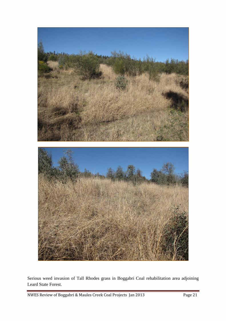
NWES Review of Boggabri & Maules Creek Coal Projects Jan 2013 Page 21
Serious weed invasion of Tall Rhodes grass in Boggabri Coal rehabilitation area adjoining
Leard State Forest.

NWES Review of Boggabri & Maules Creek Coal Projects Jan 2013 Page 22
Boggabri coal mine discharge water killing a section of Leard State Forest
The bottom line with the proposed revegetation is that unless the mines replace the soil with
the appropriate depth of soil and at the correct slope, they can’t replace or rehabilitate the
forest back to anything even slightly resembling what it was before, because there will not be
enough water holding capacity. They can do anything they like, but if they do not achieve
restoration of the soil water holding capacity that was there before, there will be no woodland
created (Rob Banks soil scientist).
The Boggabri mine revegetation is doomed to failure, regardless of the soil depth and water
holding capacity, because the mine has spread Tall Rhodes grass throughout the entire area
and it has already become an uncontrollable environmental weed. Tall Rhodes grass has even
begun to invade the surrounding Leard State Forest from the mine. It is uncontrollable -
spraying throughout the young trees and shrubs is not possible, it will exclude the
regeneration of native ground cover permanently, and it will continue to spread throughout all
the operations area.
Donna Johnston (mine restoration ecologist) states that she can’t think of any examples of
good rehabilitation projects that have adequately accomplished suitable rehabilitation of
native woodland ecosystems on mining disturbed areas (e.g. waste emplacements) in NSW.

NWES Review of Boggabri & Maules Creek Coal Projects Jan 2013 Page 23
2.0 . Potential impacts for which there is not enough information provided
to make an informed decision that has scientific credibility.
Issues for which the precautionary principle should be applied.
There has been no real consideration of the extent of the accumulated impacts to the entire
Leard State Forest. It is likely that very little of the forest will escape the impacts identified
below, thereby further threatening the critically endangered ecological community and the
EPBC threatened species.
Light pollution from three and possibly four mines (Tarrawonga, Boggabri, Maules
Creek and Goonbri) would illuminate the majority of the forest every night. Presently
an unknown impact on ecosystem function. However, research done overseas
indicates it could be significant to invertebrates, predator prey relationships, plant
growth, flowering times and ecosystem function in general. See Appendix F
detailing research into light impacts.
Noise pollution from three and possibly four mines (Tarrawonga, Boggabri, Maules
Creek and Goonbri) would permeate the entire forest day and night. Presently an
unknown impact on ecosystem function, research done overseas indicates it could be
significant to birds, bats and predator prey relationships. See Appendix E detailing
research into noise impacts.
Background sound recordings have been done throughout Leard State Forest and in
forest areas around the Tarrawonga and Boggabri mines when the mines were shut
down. Those same sites will be rerecorded during mine operations, indications from
sound recording at other mines by Lance Batey, suggest significant noise levels over
and above levels required to cause disturbance to ecosystems is normal.
Dust pollution from three and possibly four mines (Tarrawonga, Boggabri, Maules
Creek and Goonbri) will settle over the entire forest day and night. Presently an
unknown impact on ecosystem function, research overseas indicates it could be
significant to flowering plants, seed production, and nectar production.
Will fauna utilise the 500m wide ridge corridor between the mines? They will
likely be deterred by the noise, vibration, and light coming from the two mines either
side of the corridor. The trees along that corridor are likely to die from deep drainage
into the mines either side. Dead trees are not likely to be an attractive corridor for
EPBC threatened species.
Will EPBC fauna disperse through the immature vegetation in the rehabilitation
areas? The juvenile trees will not be of benefit to EPBC species until they are mature,
that could take a long time (100 years), those in the old tailings hills may die before
they reach 30 years. Structure of logs and hollow habitats are not likely to form for
over 100 years. Glenn Hoye states that Corben’s long-eared bat was displaced by
mine operations at Mt Owen, and 20 years of monitoring revegetation areas has failed
to record it using those areas (Appendix B).

NWES Review of Boggabri & Maules Creek Coal Projects Jan 2013 Page 24
Nectar production for the Swift Parrot and Regent Honeyeater is greatest from
mature White box trees such as those in Leard forest; trees planted and regenerated
will not provide the same resource for these two birds within the life of the mine.
Accumulated Impacts
The clearing of 3,500 hectares of habitat in Leard State Forest, plus the impacts of edge
effect, noise, light, and dust, will impact on virtually all of the habitat and potential habitat for
the EPBC critically endangered ecological community and threatened species. Only the north
eastern aspect slopes of the forest will be avoided. That area will only be avoided until the
Goonbri project gets its approval.
3.0 Results from field assessment of offset properties in the Maules Creek
locality
Long-term security of proposed offsets
All of the native vegetation on the properties listed in the proposed offsets is protected under
the Native Vegetation Conservation Act. The only threat to that vegetation is from the mines
changing their plan to mine that land at a later date, which has been done in the Hunter
Valley, and recently Maules Creek applied to increase the mine area by taking in some of the
land they originally proposed for offsets.
The idea of a conservation covenant or granting the offset land to National Parks and Wildlife
Service to manage is no assurance that a conservation benefit is going to be achieved. It is
very evident that National Parks staffs rarely visit the Leard SCA as the gates were left open
for stock to have access to the free feed and two mobs of goats (listed as a key threatening
process) were observed that could devastate threatened plants and the Endangered Ecological
Community
Problems with revegetating old cultivation paddocks
The offset proposal is to revegetate and regenerate the lower slopes of the offset properties to
provide similar habitat to that lost in the forest on the more productive soil type.
The trouble is that the lower slopes have had the most clearing, grazing, and fertiliser
disturbance and are mostly derived grasslands or cropping paddocks. The time frame to
regenerate some sort of mature woodland with a mix of age classes and diversity of habitats
of hollow trees and logs is somewhere in the range of 200 – 300 years. Even at 300 years, it
is highly unlikely that the same suite of plants that are present in the forest would have
regenerated. Coupled to that problem is the likelihood of a weed explosion when the
paddocks are destocked.
The offset properties have large areas of cultivation paddocks. Cultivation effectively
destroys the soil biota and natural nutrient cycling in the soil. Artificial fertilisers and
chemicals have been applied over a long time, grossly affecting the nutrient balance and
leaving chemical residues in the soil. Topsoil has been lost, and compaction layers reduce
water infiltration and root growth.

NWES Review of Boggabri & Maules Creek Coal Projects Jan 2013 Page 25
Problems with revegetating derived grassland paddocks
The offset properties have large areas of derived grassland that have a history of being
repeatedly cleared and grazed. Derived grasslands have low diversity of native plants in the
ground cover.
Those common native species present are those that are the most resilient and least palatable
to stock. In contrast, Leard State Forest still has the full suite of sensitive understorey species
of plants such as Tylophora linearis. Those plants cannot be reintroduced where the soil
structure has been changed by grazing and fertiliser for 100’s of years. Many of them would
also require the forest woodland community with all the associations with fungi and bacteria
that we are only just beginning to comprehend.
All the plants dependent on associations with woodland and open forest ecosystems were
removed when the clearing took place. Derived grasslands have also lost a lot of topsoil due
to wind and downpours after droughts. They also have suffered compaction from stock
trampling over 100’s of years, and the years of urine and dung have affected the soil nutrient
balance. Grasslands also have much less deep nutrient cycling as compared to woodlands
and open forests.
Areas destocked for conservation are notorious for weed explosions. It is only a matter of
time until the serious environmental weeds observed along the roads and riparian zones of the
Maules Creek locality will invade the regeneration and rehabilitation areas and the immature
and mature woodlands. The problem weeds observed were African Boxthorn, Saffron
Thistle, Coolatai grass (listed as key threatening process), Green Panic, Tall Rhodes Grass,
Bridal veil Creeper, Prickly Pear, and Bathurst burr.
When the mines have exploited the resource and left in 25 years, who is going to ensure that
the offset properties are managed for conservation? On the other hand, Leard State Forest
has high integrity that maximises the forests defences against weed invasion in the long-term.
The ongoing control of weeds in all areas of the offset package must be ensured into
perpetuity. Otherwise, we will have lost a forest with high integrity, for weedy rehabilitation
areas that have no hope of achieving the same level of integrity.
Extent of the CEEC in offset properties
Looking at the distribution of where the EPBC Box Gum woodland naturally occurred, it is
clear that it was limited to the more fertile deeper soils of the lower slopes. The Box Gum
woodland in the lower slopes of the TSR and Leard SCA confirm the EEC community’s
preference for good soil depth and nutrient value. Virtually all of that lower slope land has
been cleared repeatedly and any remnants that do occur are immature.

NWES Review of Boggabri & Maules Creek Coal Projects Jan 2013 Page 26
Value of the proposed eastern and western offsets
There was one area of remnant on the property Louenville that is considered to be of high
conservation value, equivalent to that to be destroyed in Leard State Forest. That area is not
threatened by clearing unless the mines decide to include it in their open cut area at a later
date. That area is already providing habitat for the Nationally listed threatened species. The
purchase of it cannot be considered an additional conservation benefit or gain to offset the
clearing of the forest, as it is already contributing to landscape conservation.
None of the proposed offsets measure up to be gains in the next 50 years. It is most likely the
problems of destocking and weed explosion due to the modified nutrient status of the soils
and the high seed bank of exotic seeds will make it impossible to recreate the community lost
in the forest.
Some of the properties are highly degraded, having had sheet erosion, loss of top soil and
humus, and dominance of weeds that have taken advantage of less competition from native
plants. The property that adjoins the north eastern boundary of Leard SF is a classic case of
land that is not going to regenerate natural ground cover, shrubs and trees for a very long
time.
Too much of the BOMP and the offset assessment package is based on hypothetical scenarios
of purchasing land in the future and implementing management plans yet to be developed.
For example the Rehabilitation Plan has not been seen, it will dictate the management of the
over burden regeneration areas where the soil depth, water infiltration, and erosion controls
will be critical to the success of the revegetation.
The remnants of native woodland/open forest on the offset properties in the Maules Creek
locality were found to be dominantly on ridges of rocky slopes on poor skeletal soil. The
vegetation is multilayered (shrubby) and immature having a history of ringbarking in the last
century. Such remnants have low productivity, meaning that the availability of food resources
for fauna (foliage, nectar, invertebrates) are limited by the soil nutrient levels and moisture
levels in the skeletal soil. Whereas the clearing that is occurring in Leard State Forest is
removing the most highly productive lower slopes woodland on the best soils that hold the
most moisture.
Considering like for like, the ridge vegetation community in Leard State Forest is similar to
the ridge remnants in the offsets, however that community is not endangered, although it is
contributing to the overall habitat availability and integrity of the forest.
Problems with revegetation of over burden hills
North West Ecological Services did a tour of regeneration of overburden piles at
Ravensworth last year and inspected an area regenerated at least twenty five years ago.
Despite the previous good seasons, many of the large immature trees were observed to be
dying en masse and the ground cover was dominated by exotic plants. See previous photos
page 18.

NWES Review of Boggabri & Maules Creek Coal Projects Jan 2013 Page 27
It is already evident that Boggabri Coal is not going to be able to regenerate native ground
cover “ever” due to a severe infestation of tall Rhodes Grass. The problem is going to
continually expand with every new attempt to regenerate new areas as it is easily dispersed
and is more adapted to colonising disturbed ground than other native species. To control the
existing problem is already cost prohibitive as it would require the complete chemical kill of
all the existing regeneration areas and would mean restarting the plantings again after the
weed seed bank is destroyed. See photos page 19.
Offset management issues
The bulk of the native vegetation remnants on the potential offset properties surrounding
Leard State Forest are ridge remnants on shallow rocky soils. There are three issues that raise
real concerns about the long-term conservation value of those ridge remnants considered as
offsets.
Those are;
managing White Cypress regrowth (thick cypress dominates disturbed areas),
re-establishing a balanced woodland community (a natural mix of eucalypts, cypress,
tall and low shrubs, and grass ground cover),
and the likely impact of climate change (extensive areas of vegetation presently dying
from hot and dry weather).
Unnaturally thick immature and juvenile regrowth of White Cypress dominates extensive
areas on the mid slopes and upper slope/ridge remnants.
The history of clearing and grazing has advantaged White Cypress, and in the absence of fire
there appears to be no likelihood that its dominance will be challenged. Viewing the photos
of the offset properties it becomes obvious how significant the problem is.
Tree regrowth on the lower slopes deeper soils is patchy, but where it does occur it is often
species of Eucalypts and Allocasuarina, with considerably less cypress.
Inspection of the White box, Pilliga box, White Cypress, and Narrow-leaf Ironbark woodland
and open forest communities in Leard State Forest shows how the Eucalypt/Cypress balance
has been maintained by the large old eucalypts which have maintained their dominance over
the centuries because of the aboriginals use of fire.

NWES Review of Boggabri & Maules Creek Coal Projects Jan 2013 Page 28
Thick White Cypress regrowth on the offset property “Kelso”, mapped as high condition
remnant habitat for EPBC threatened species.
The loss of balanced communities and the loss of ground cover and open canopy that occurs
with White Cypress dominance is a significant threat to future habitat value. Woodland
species adapted to grassy open communities cannot find suitable habitat hence avoid such
areas.
The large ridge remnant in the offset property “Kelso”, showing the thick White Cypress
regrowth and extensive areas dying from hot and dry weather.
NWES Review of Boggabri & Maules Creek Coal Projects Jan 2013 Page 29
The impact of climatic extremes is evident on the ridge remnants, with extensive areas of
dead and dying trees and shrubs. The likelihood of those extremes becoming more frequent
and severe will have a significant impact on the vegetation of ridge remnants in the future.
4.0 Review of Environmental Assessment prepared by Cumberland
Ecology for Maules Creek Project.
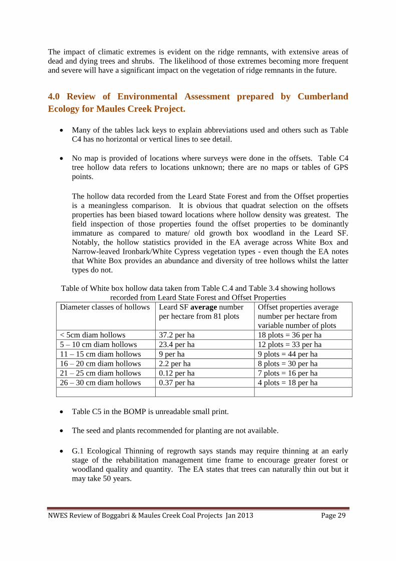
Many of the tables lack keys to explain abbreviations used and others such as Table
C4 has no horizontal or vertical lines to see detail.
No map is provided of locations where surveys were done in the offsets. Table C4
tree hollow data refers to locations unknown; there are no maps or tables of GPS
points.
The hollow data recorded from the Leard State Forest and from the Offset properties
is a meaningless comparison. It is obvious that quadrat selection on the offsets
properties has been biased toward locations where hollow density was greatest. The
field inspection of those properties found the offset properties to be dominantly
immature as compared to mature/ old growth box woodland in the Leard SF.
Notably, the hollow statistics provided in the EA average across White Box and
Narrow-leaved Ironbark/White Cypress vegetation types - even though the EA notes
that White Box provides an abundance and diversity of tree hollows whilst the latter
types do not.
Table of White box hollow data taken from Table C.4 and Table 3.4 showing hollows
recorded from Leard State Forest and Offset Properties
Diameter classes of hollows Leard SF average number
per hectare from 81 plots
Offset properties average
number per hectare from
variable number of plots
< 5cm diam hollows 37.2 per ha 18 plots = 36 per ha
5 – 10 cm diam hollows 23.4 per ha 12 plots = 33 per ha
11 – 15 cm diam hollows 9 per ha 9 plots = 44 per ha
16 – 20 cm diam hollows 2.2 per ha 8 plots = 30 per ha
21 – 25 cm diam hollows 0.12 per ha 7 plots = 16 per ha
26 – 30 cm diam hollows 0.37 per ha 4 plots = 18 per ha
Table C5 in the BOMP is unreadable small print.
The seed and plants recommended for planting are not available.
G.1 Ecological Thinning of regrowth says stands may require thinning at an early
stage of the rehabilitation management time frame to encourage greater forest or
woodland quality and quantity. The EA states that trees can naturally thin out but it
may take 50 years.

NWES Review of Boggabri & Maules Creek Coal Projects Jan 2013 Page 30
Ongoing thinning is required for all Cypress dominated communities in the offsets, it
must be done, not may.
The mitigation measures regularly state that the land disturbed for mining purposes
for the project should be progressively rehabilitated in accordance with an agreed
mine closure plan. The majority of disturbed land should be returned to native forest
and woodland habitat.
“The rehabilitation plan has been designed with the intention of providing a self-
sustaining native forestry operation as well as maintaining pre-mime biodiversity
values. A detailed Rehabilitation Management Plan should be developed for the
project that provides for the progressive rehabilitation of all mine disturbed areas.
Page” S.6
The commitment to return the project area to pre-mine biodiversity values is not
backed up with any credibility that it is actually achievable. No rehabilitation plan
has been available for review. All the objectives are unclear when should is used so
frequently.
S.9 again says that all forest and woodland areas cleared by mining should be
rehabilitated as forest and woodland in the long-term using local native species,
maintaining treed habitat in the locality.
There is no mention of Tylophora linearis in any of the tables that refer to significant
plants likely to occur. Yet is was found on the 15th
January 2013.
Table 2.4 Condition Classes of Box Gum Woodland and Derived Native Grassland in the
Offsets
Several of the properties listed in the proposed offsets have no agreement for purchase
and cannot be considered as offsets until there is a purchase agreement. Those
properties still privately owned are Blue Range, Cattle Plain, Wallandilly, Kelso, and
Wirradale.
The table 2.4 has three columns that indicate the hectares of each property that are
considered in Condition B which is land greater than 0.1 ha that has more than 12
species. That column should indicate that the 12 species must be understorey species
not including grasses and at least one of those species must be listed as an “important
species”. This table needs explanation.
All of this information should be presented in a way that enables independent
verification of all of the sampling points, there are no tables or maps that show the
Grid references for the plots where they recorded more than 12 understorey species or
more than 20 mature trees per ha . It is likely that the definition of mature is used
loosely, referring to larger immature trees. The EPBC definition states that they must
be at least 125 cm circumference at 130 cm above the ground, was that the definition
used? This table needs explanation.

NWES Review of Boggabri & Maules Creek Coal Projects Jan 2013 Page 31
The last two columns of that table refer to habitat hectares of high condition remnant
forest and woodland and hectares of low condition derived native grassland habitat to
be re-vegetated to moderate condition habitat in the medium to long term. The habitat
considered is the hectares suitable for the EPBC species Regent Honeyeater, Swift
Parrot, and Greater Long-eared bat. Based on the findings from the “Kelso” field
assessment all those figures given are disputed.
The hectares listed for each property claimed to be high condition remnant that will
supposedly offset the destruction of known high condition forest in the Leard State
Forest are lacking in reliability. None of the re-vegetated derived native grassland can
be claimed to provide habitat for the two specialist nectar feeding birds for at least
fifty years or the hollow dependent bat for at least 100 years. High condition should
refer only to least disturbed mature structure like Leard State Forest.
It cannot be claimed that management can do anything in the life of the mine to
improve the nectar resource for the two birds or do anything that will provide more
potential hollows for the bat.
All the vegetation of the region is already protected by the native vegetation
conservation act. And as we have seen with the management of the Leard SCA,
formal covenant tenure does not deliver on conservation goals if the conservation
agency does not undertake pro-active management in excluding stock and carrying
out feral animal and weed control.
“Kelso” is a classic example of why shrubby regrowth White Cypress with Narrow-
leaf Ironbark growing on a skeletal ridge should not be considered to be of High
Condition. There is also a major discrepancy in the area of High Condition remnant,
table 2.4 claims that there is 342.8 hectares, this assessment calculated the poor native
vegetation remnant to be 263 hectares. The Condition C column is also not consistent
because it gives 16.4 hectares as having greater than 20 mature trees per hectare. If
the vegetation were in fact to be of High Condition it would have 342 hectares with
greater than 20 mature trees per hectare.
The 342 hectares would not be suitable habitat for the Swift Parrot and Regent
Honeyeater as claimed; neither species feeds on White Cypress and Narrow-leaf
Ironbark. The 342 hectares is not considered High Condition habitat for the South-
eastern Long-eared bat, as it prefers box woodlands like Leard State Forest.
The case studies in the EA report must be viewed with scepticism. The two
restoration ecologists quoted in the Expert Opinion Appendix B state that what the
mines are proposing does not work in reality, and there are no examples of where
box-gum endangered ecological community has been successfully regenerated. That
opinion is shared by North West Ecological Services having observed regeneration
areas in the Hunter Valley and Boggabri Coal rehabilitation.

NWES Review of Boggabri & Maules Creek Coal Projects Jan 2013 Page 32
5.0 SUMMARY OF IMPACTS
5.1 Clearing:
Maules creek forest and woodland clearing = 1664.8ha total
Derived grassland = 413 ha
Cultivation 98.81
Critically Endangered Ecological Community clearing = 544.47ha
The real extent of the CEEC is likely to be considerably greater, but no longer obvious due to
shrub and White Cypress regrowth from a reduction of fires in last 100 years.
Boggabri coal forest and woodland clearing = 1385ha total
Critically Endangered Ecological Community clearing = 623 ha
Future clearing.
There is a very high likelihood of additional clearing for mining in the area in the future.
There is substantial exploration underway all the way from Maules Ck down to the southern
Liverpool Plains around Quirindi. The cumulative impact of the potential mining in the
region is large in scope. History shows that mines do not shut down when the area of
resource they have approval for runs out. What they do instead is apply for an extension to
the their operations, in this case extensions would be mean that more of Leard Forest or land
originally proposed for offsets is earmarked for mining.
5.2 Noise;
Noise from Boggabri coal mine and Tarrawonga coal mine were very loud pre-Christmas,
noise echoed throughout the southern catchment of the forest both night and day. During the
shutdown over Christmas, background noise levels were recorded for night and day, and will
be rerecorded again at those same locations when operations commence again in January.
The impacts of noise have been studied in America and found to be significant to birds and
bats and whole ecosystems through loss of species ability to communicate, foraging for prey,
predator avoidance, and avoidance of noisy areas.
The prospect of Maules Creek mine operating in the northern aspect of the forest will impact
on all the northern half of the forest, leaving only the small section of the eastern aspect
unaffected. However, there is another mine proposed for the eastern aspect of the forest
(Goonbri), if it goes ahead all of the forest will be impacted by light and noise 24 hours each
day. Both noise and light will impact greatly on the State Conservation Area and the offset
properties Teston South and Louenville.
The fauna corridor and the rehabilitation areas expected to provide fauna linkage between the
two forest remnants east and west of the mines will also be badly affected by vibration, noise
and light pollution.

NWES Review of Boggabri & Maules Creek Coal Projects Jan 2013 Page 33
5.3 Light;
As with noise, the very bright lights of the mine flood lights illuminate the entire southern
catchment of the forest at night, to the point that there is low visibility on the darkest nights.
Fauna have activity patterns that have evolved around the moon phases that require periods of
total darkness to maintain predator and prey relationships. As with the noise, the future
scenario of three mines operating on the southern, northern, and eastern aspects will result in
all of the forest impacted by constant light.
5.4 Dust;
As with noise and light, air borne dust levels will increase as the mine operations increase
production. The dry period pre-Christmas saw the southern side of the forest blanketed in
dust. Australian flora and fauna have evolved with dust storms, however constant dust
coupled with prolonged dry periods is likely to impact flowering plants and foliage browsers,
thereby affecting the whole ecosystem.
5.5 Roads and traffic;
As the scale of the mining operations increases so too will the impacts of road construction
and upgrading, which will further fragment the forest, and result in accidents and injury to
fauna.
Species such as the Koala and Pale-headed Snake are particularly vulnerable when crossing
roads. As roads get upgraded to be wider to accommodate more heavy vehicles and traffic,
those impacts will increase significantly.
Of great concern is the propose realignment of the major north south road through the forest
which will be swallowed up by the open cut pit. The new alignment enters the forest on the
eastern boundary, runs through mature White Box woodland critically endangered ecological
community to link up with existing road in the middle of the forest on the northern boundary.
That section of forest was supposed to be the fauna refuge not impacted by the mines. Mine
roads through the retained forest will be used more frequently and most likely will require
upgrading.
6.0 The protected matters impacted by the mine proposals are;
6.1 Box – Gum ecological community
1,167 hectares of high quality critically endangered Box – Gum ecological community in a
near natural state, of high integrity, weed free, old growth structure, and of very high
landscape value will be destroyed if these mines are approved. The White box woodland in
the forest is mature/old growth having never been logged; it has very high hollow densities
per hectare.

NWES Review of Boggabri & Maules Creek Coal Projects Jan 2013 Page 34
Thiele and Prober (2000) estimated that less than 0.1% of Grassy White Box Woodlands (a
component of the Box – Gum Grassy Woodland and Derived Grassland ecological
community) remains in a near-intact condition. The community found in Leard State Forest
is part of the 0.1%.
The future of the box-gum woodland is very dire, 1,000’s of hectares of the highest
conservation value areas in Travelling Stock Routes and Crowns lands in the North West has
been destroyed by Coolatai Grass invasion in the last 20 years. None of it can be saved, it is
permanently lost, and what little is left in good condition is rapidly becoming invaded.
Boggabri Coal will destroy 623 ha and Maules Creek Coal will destroy 544 ha. The real
extent of the EEC is likely to have been considerably greater pre 1770. The community has
changed due to the reduction of fires in last 100 years that has resulted in shrub and White
Cypress regeneration.
Surveys of Leard State Forest fauna have found it to be highly diverse.
Fauna recorded – 13 frogs, 170 birds, 26 mammals, & 42 Reptiles = 251 native species is
high diversity of woodland species. At least 50 of those species are not likely to occur in the
northern offsets.
Species listed in the Threatened Species Conservation Act = 8 mammals, 14 birds, & 1
reptile.
EPBC Migratory birds recorded = Satin Flycatcher, Rainbow Bee-eater, White-throated
Needletail, and Fork-tailed Swift.
6.2 Corben’s Long-eared bat
The vulnerable Corben’s Long-eared bat is known to occur (three more were recorded 18th
& 19th
December 2012).
The proposal will result in the loss of hollow trees and woodland foraging area that will not
be replaced in the revegetated offsets for 100 - 150 years.
The recent records of Corben’s Long-eared bat indicate it has a strong association with the
lower slope White box – Pilliga box woodland. None were trapped in the Leard Forest at the
slopes and ridge communities of Narrow-leaf Ironbark – Silver-leaf Ironbark - Dwyer’s
Redgum and White Cypress. The proposed mines are targeting the bats preferred habitat in
the lower slopes box woodlands.
No surveys have been done to determine if the Corben’s Long-eared bat actually occurs in
the offset properties, or if the offsets are suitable habitat. Knowing that the habitat is suitable
is particularly relevant to the high altitude offsets, thick cypress regrowth offsets, and
rehabilitation areas.
Glenn Hoyes monitoring of 20 year old mine rehabilitation areas at Mt Owen has not
recorded Corben’s Long-eared bat utilising those areas for foraging. Whereas it did occur in
the pre-existing woodland destroyed by the mine.

NWES Review of Boggabri & Maules Creek Coal Projects Jan 2013 Page 35
The Nandewar biodiversity surveys completed in 2004 recorded 72 Corben’s Long-eared bats
(31 females and 34 males and 7 not sexed). Analysis from those records found the preferred
habitat to be low to mid altitude open forests of White box, Ironbark and White Cypress. The
Playgan State Forest was found to have one of the highest populations of the bat. The offset
property “Mallee” was surveyed at that time and no Corben’s Long-eared bats were found.
The Wildlife Atlas records below show the locations where Corben’s Long-eared bat was
recorded to the north east of Kaputar NP in the Horton Valley and south west of the offset
properties Wirradale and Mt Lindesay in Playgan State Forest. Bat surveys in the Kaputar
National Park failed to record the bat indicating high altitude open forests are not suitable
habitat. Whereas the low elevation woodlands such as Leard State Forest are known
preferred habitat.
The impact of noise is likely to affect this bats ability to find prey; hence it is likely to avoid
areas with excessive noise, which will be large areas of the forest considered to be providing
refuge for the bat.
Corben’s Long-eared Bat recorded in Leard State Forest 18th
& 19th
December 2012
Wildlife Atlas below show records of Corben’s Long-eared bat. Many surveys of Kaputar
NP have failed to record the bat above 900m altitude. Those bats recorded nearby in Playgan
State Forest and Horton Valley were surveys done by the author Phil Spark, and Dave
Milledge.

NWES Review of Boggabri & Maules Creek Coal Projects Jan 2013 Page 36
6.3 Koala
The vulnerable Koala is known to occur. The proposal will result in the loss of mature
preferred feed trees that are regularly used for feed and territory marking.
Such mature preferred feed trees will not be replaced in the revegetated offsets for 50 - 100
years. Koala abundance is initially influenced by the availability of preferred tree species and
ultimately influenced by soil fertility and regional rainfall as they affect the growth, and
water and nutrient content of Eucalypt leaves (Gall 1980; Martin & Handasyde 1999; Moore
et al.2004).
The Koalas preferred habitat is the lower slopes White box & Pilliga box woodlands, where
nutrient and moisture levels in the foliage are higher than the trees on the skeletal slopes and
ridges. Such deep rooted woodlands can support higher Koala populations with smaller
home ranges.
High moisture levels in foliage is critical for Koalas to survive heat wave conditions. Both
Silver-leaf and Narrow-leaf Ironbark’s found on the slopes and ridges of the eastern and
western offset properties are not Koala food sources. Dwyer’s Redgum is used, but to a lesser
extent, more in the cooler months when moisture stress is less of an issue.
The even age regrowth proposed for revegetation of the derived grasslands and cultivation
paddocks will not provide suitable Koala habitat for a considerable time, as Koalas require a
mix of age classes of both food and shelter species.
Moore et al 2010 found that Koalas preferentially use larger trees of their preferred food
species up to 60cm dbh, above which tree use is not related to tree size. It is not surprising
that tree size should so strongly affect where koalas are found during the day.

NWES Review of Boggabri & Maules Creek Coal Projects Jan 2013 Page 37
Larger trees possess more foliage and thus represent larger feeding patches; however, they
may also provide more shade and greater safety from perceived dangers on the ground.
(Moore et al.2010).
The proposed mines are targeting the preferred Koala habitat in the lower slopes box
woodlands. Koala recorded in Leard State Forest.
6.4 Border Thick-tailed Gecko
The vulnerable Border Thick-tailed Gecko is predicted to occur. The proposal will result
in the loss of habitat provided by litter layer, logs, and canopy cover that will not be replaced
in the revegetated areas of the offsets for 50 years. Management of the ridge offsets will do
very little to enhance the habitat for this species.
6.5 Grey-headed Flying-fox
The vulnerable Grey-headed Flying-fox is predicted to occur (4000 have been in the
Tamworth region over the last five months). The proposal will result in the loss of mature
nectar producing White box trees, which will not be replaced in the revegetated offsets for 50
- 100 years.
The nectar value of the lower slope White box woodland is higher than the vegetation
communities of Silverleaf and Narrow-leaf Ironbark, White Cypress on the slopes and ridges.
The proposed mines are targeting the preferred nectar producing habitat in the lower slopes
White box woodlands.
6.6 Spotted-tailed Quoll
The vulnerable Spotted-tailed Quoll is likely to occur. The forest is large enough and has
sufficient habitat, food source and integrity to support a small population of Spotted-tailed
Quolls.

NWES Review of Boggabri & Maules Creek Coal Projects Jan 2013 Page 38
The proposal will result in the loss of den habitat in hollow trees, large logs and potential
woodland foraging area. The fragmentation of the forest by the open cut mine, edge effects,
noise and light pollution and road mortality could cause a local population to become extinct.
The Stringybark dominated open forests of the offset properties Wirradale and Mt Lindesay
do provide habitat similar to that in Leard SF for the Spotted-tailed Quoll. However, the
proposed offset management will do little to change the habitat value of those remnants in the
life of the mine.
The Voluntary Conservation Agreements are a good idea, but they are only as good as the
details in the agreement, and how motivated the landholders are to implement those plans.
Having had experience with VCA’s they are only as good as the landholders desire to
manage for conservation. To get them enforced requires the dept. to take the owner to the
Land and Environment Court, which must be considered highly unlikely - hence the VCA’s
will do little more than the Native Vegetation Conservation Act is doing to protect the native
vegetation, and the landholders have the responsibility to continue to control weeds and feral
animals.
It is highly unlikely that National Parks and Wildlife Service will want the disturbed
agricultural land adjoining Kaputar NP and Leard SCA, as the management of such land is
more time consuming and expensive than undisturbed remnants. NPWS do not have the
resources to maintain the land that they are presently responsible for.
The current government has recently slashed their funding by a third, meaning that what
resources they do have will need to be spent maintaining undisturbed remnant parks. The
other option discussed in the report is to sell the land after the life of the mine with a VCA on
the title of the land.
The reality of that scenario is that it would be unlikely that persons buying such large blocks
of land would want it purely for conservation. It would not be attractive as a bush block, as
the existing remnants would still be immature open forest and the regeneration areas would
be still regrowth 20cm dbh. It is likely that grazing production would need to be pursued to
fund daily living costs and the maintenance of the land.
Meanwhile the high habitat value woodlands in Leard SF will have been destroyed for open
cut coal mines, resulting in a net loss of potential suitable habitat.
Potential habitat for the Spotted-tailed Quoll will not be replaced in the revegetated areas of
the eastern and western offsets for 150 - 200 years.
6.7 Large-eared Pied Bat
The vulnerable Large-eared Pied Bat is likely to occur. Leard State Forest is a stepping
stone island remnant between the known population on the Kelvin Range and the known
population in the Pilliga. The proposal will result in the loss of mature woodland/ open forest
foraging area, which will not be replaced in the revegetated offsets for 50-100 years.
NWES Review of Boggabri & Maules Creek Coal Projects Jan 2013 Page 39
6.8 Superb Parrot
The vulnerable Superb Parrot is predicted to occur. The proposal will result in the loss of
hollow trees and woodland foraging area, which will not be replaced in the revegetated
offsets for 50 – 100 years.
Superb Parrot Species Profile and Threats Database – Dept. of Sustainability,
Environment, Water, Population and Communities
The Superb Parrot occurs only in south-eastern Australia. The Superb Parrot is found in NSW
and northern Victoria, where it occurs on the inland slopes of the Great Divide and on
adjacent plains, especially along the major river-systems; vagrants have been recorded in
southern Queensland.
In NSW, it mostly occurs west of the Great Divide, where it mainly inhabits the Riverina, the
South-west Slope and Southern Tableland Regions: west to Mathoura, Boorooban, Goolgowi,
and east to Canberra, Yass and Cowra. Its range extends north to around Narrabri and Wee
Waa in the North-west Plains Region, from a line joining Coonabarabran and Narrabri, and
extending at least as far west as Tottenham and Quambone, with occasional records even
further west.
In the South-west Slope Region of NSW, Superb Parrots breed in box-gum forests and
woodlands dominated by River Red Gum, Blakely's Red Gum, Apple Box (E. bridgesiana),
Grey Box, White Box (E. albens) and Red Box (Webster 1998).
The Superb Parrot inhabits listed threatened habitats such as grassy Yellow Box-Red Gum
woodlands listed as Endangered under the Nature Conservation Act 1980 (ACT Government
1999c) and White Box-Yellow Box-Blakely's Red Gum Grassy Woodland and Derived
Native Grassland listed as Critically Endangered under the EPBC Act (NSW NPWS 2002c).
The Superb Parrot forages on many different species of plants, most of which occur in
woodlands dominated by gum and box eucalypts.
6.9 Swift Parrot
The endangered Swift Parrot is predicted to occur. The proposal will result in the loss of
mature nectar producing White box trees in Leard SF, which will not be replaced in the
revegetated offsets for 50 - 100 years. The proposed mines will destroy the best nectar-
producing habitat for the Swift Parrot in the lower slopes White box woodlands of Leard SF.
The nectar production value of the lower slope White box woodlands in Leard SF are higher
than the Silver-leaf and Narrow-leaf Ironbark communities on the slopes and ridge remnants
in the eastern and western offset properties.

NWES Review of Boggabri & Maules Creek Coal Projects Jan 2013 Page 40
Offset remnants of White Cypress, Narrow-leaf Ironbark and Silver-leaf Ironbark have been
considered and calculated as high condition habitat area for the Swift Parrot. That claim is
false; those eucalypt species are not known food sources.
The Stringybark dominated open forests of the offset properties Wirradale and Mt Lindesay
do not provide habitat equivalent to that in Leard SF for the Swift Parrot. The immature
Yellow box and Blakely’s Red gum trees growing in open forest associations with
Stringybark’s do not produce the nectar that mature trees in woodland situations do.
The proposed offset management will do little to change the nectar resource available for the
Swift Parrot over the life of the mine. Meanwhile the high habitat value White box
woodlands in Leard SF will have been destroyed for open cut coal mines, resulting in a net
loss of suitable habitat.
Swift Parrot Species Profile and Threats Database – Dept. of Sustainability, Environment, Water, Population and Communities
During the non-breeding season, this species feeds extensively on nectar, lerp, and other items from eucalypt foliage. Mugga Ironbark (E. sideroxylon), Red Ironbark (E. tricarpa), White Box (E. albens), Grey Box (E. macrocarpa) and Yellow Gum (E. leucoxylon) are important sources of nectar in the box-ironbark forests and woodlands of Victoria and New South Wales (Kennedy & Tzaros, 2005). Grey Box, River Red Gum (E. camaldulensis) and White Box are major sources of lerps in these areas at times.
Swamp Mahogany (E. robusta), Spotted Gum (Corymbia maculata), Coastal Grey Box (Eucalyptus moluccana) and Red Bloodwood (Corymbia gummifera) are important nectar sources in coastal parts of the non-breeding range. Forest Red Gum (E. tereticornis) and Yellow Box (E. melliodora) are used in northern New South Wales and south-eastern Queensland (Saunders & Heinsohn 2008; Swift Parrot Recovery Team 2001).
There are also several records of the species foraging on lerps in the foliage of Blackbutt (E. pilularis) in the Wollongong area of New South Wales. Over large parts of their box-ironbark winter range, they also consume both developed and undeveloped racemes of Golden Wattle (Acacia pycnantha) (Cheers & Cheers 2005; Kennedy & Tzaros 2005; Mac Nally & Horrocks 2000). Swift Parrots have been observed foraging on lerp from Rough-barked Angophora (Angophora floribunda) during drought conditions (Saunders & Heinsohn 2008).
As a specialist nectarivore, dependent on flowering eucalypts in both breeding and non-breeding parts of its range, Swift Parrots are vulnerable to the loss of quantity and quality of key forage tree species (Swift Parrot Recovery Team 2001).

NWES Review of Boggabri & Maules Creek Coal Projects Jan 2013 Page 41
6.10 Regent Honeyeater
The endangered Regent Honeyeater is predicted to occur. The proposal will result in the
loss of mature nectar producing White box trees, which will not be replaced in the
revegetated offsets for 50 – 100 years.
The nectar production value of mature White box trees on the lower slopes in Leard SF is
much higher than the Silver-leaf and Narrow-leaf Ironbark, White Cypress associations in the
slopes and ridge remnants of the eastern and western offset properties.
The proposed mines are targeting the preferred nectar producing habitat in the lower slopes
White box woodlands.
The Stringybark dominated open forests of the offset properties Wirradale and Mt Lindesay
are not preferred habitat for the Regent Honeyeater. The immature Yellow box and Blakely’s
Red gum trees growing in open forest associations with Stringybark’s do not produce the
nectar of mature trees in woodland situations.
The proposed offset management will do little to change the nectar resource available for the
Regent Honeyeater over the life of the mine. Meanwhile the high production White box
woodland will have been cleared for an open cut coal mine. Stephen Debus comments
(Appendix B) that the impact to Leard State forest will not be compensated and both the
Regent Honeyeater and Swift Parrot will continue to decline.
Regent Honeyeater Species Profile and Threats Database – Dept. of Sustainability, Environment, Water, Population and Communities
The diet of the Regent Honeyeater consists mainly of nectar, supplemented with some invertebrates (mostly insects) and their exudates (e.g. lerp, honeydew), and occasionally fruit or, very rarely, other plant items such as seeds or sap. Nectar is taken mainly from a variety of eucalypt species, especially Mugga Ironbark, Yellow Box, White Box and Yellow Gum, and often from mistletoes (e.g. Needle-leaf Mistletoe, Box Mistletoe (Amyema miquelii)), but also from other plants, both native (Acacia spp., Banksia spp. and Grevillea spp.) and introduced (Fuchsia spp. and Prunus spp.) (Franklin et al. 1989; Geering 2005 pers. comm.; Higgins et al. 2001; Menkhorst 1997a; Oliver 2000; Webster & Menkhorst 1992). The composition of diet varies according to the availability of nectar. When nectar is available, Regent Honeyeaters tend to focus or specialise on flowering plants, and at times may feed almost exclusively on just a few flowering species. When nectar is scarce, they may spend up to 90% of their foraging time feeding on lerp, honeydew and insects. The diet, at least in the Bundarra-Barraba region of NSW, appears to vary little between the breeding and non-breeding seasons, although breeding birds tend to take a greater proportion of insect material (mostly lerp) (Oliver 2000). Furthermore, both insects and lerp are important in the diet of young, comprising 76% of the observed diet of nestlings, and 88% of the observed diet of fledgelings (Oliver 1998c).

NWES Review of Boggabri & Maules Creek Coal Projects Jan 2013 Page 42
Regent Honeyeaters select the largest trees available to forage in, as these typically provide more food (with greater nectar flows) than smaller trees. As such, the Regent Honeyeater is vulnerable to silvicultural practices that selectively remove large, spreading trees to promote the regeneration of dense regrowth, the timber of which is used for production purposes (Geering 2005 pers. comm.; Oliver 2000; Robinson & Traill 1996; Webster & Menkhorst 1992).
6.11 Rainbow Bee-eater
The migratory Rainbow Bee-eater is known to occur; the proposal will result in the loss of
mature woodland foraging area, which will not be replaced in the revegetated offsets for up to
50 years.
6.12 Tylophora linearis
Endangered Plant listed in EPBC Act recently recorded in Leard State Forest
The endangered plant Tylophora linearis was not considered in the environment assessment.
Six plants and likely more were recorded in the northwest corner of Leard State Forest
adjoining Teston south during this survey. The mining consultants did not record the species.
The area where T.linearis was found is likely to be mined in the early stage of the Maules
Creek proposal, effectively destroying the only suitable habitat currently known in the mature
woodland. That suitable habitat will not be replaced in the revegetated offsets for at least 150
years, if ever.
Extensive surveys are required to determine the extent of the plant in Leard State Forest.
Those surveys need to be done when the plant is growing with leaves visible, which is likely
to be November.
Tylophora linearis waypoints recorded in Leard State Forest
TL1 56 J 225003 6616440 305 m 1/15/2013 5:23:42 PM
TL2 56 J 224997 6616443 305 m 1/15/2013 5:24:20 PM
TL3 56 J 225001 6616438 306 m 1/15/2013 5:24:46 PM
TL4 56 J 224997 6616440 305 m 1/15/2013 5:25:10 PM
TL5 56 J 225005 6616437 305 m 1/15/2013 5:25:29 PM
TL6 56 J 225008 6616435 305 m 1/15/2013 5:25:52 PM

NWES Review of Boggabri & Maules Creek Coal Projects Jan 2013 Page 43
Location where six Tylophora linearis plants were recorded in Leard State Forest
Largest Tylophora linearis plant recorded on a low shrub
Leard State Conservation Area
Tylophora linearis

NWES Review of Boggabri & Maules Creek Coal Projects Jan 2013 Page 44
6.13 Pultenaea setulosa A vulnerable plant listed in the EPBC Act
The Pultenaea setulosa has been recorded in the Boggabri Coal Project area. At this point in
time there is no Boggabri BOMP to consider how the vulnerable plant Pultenaea setulosa
will be compensated for in the proposed offsets. The Maules Creek BOMP has identified the
project area as potential habitat for Pultenaea setulosa but has failed to consider it further.
The conservation advice for this species identifies the main threat as the destruction of
individuals and disturbance of habitat through mining activities and associated infrastructure
and development.
Application of the Offsets Assessment Calculator to those protected matters concludes that
the loss of habitat resulting from the proposed mines will not be offset in the time frame
required, which will result in the decline of those protected matters and threaten their long-
term viability.
7.0 Components of the Offset Assessment Calculator that indicate species
decline and threat to long-term viability are.
7.1 Time over which loss is averted
A key requirement of the guide is that the offset provides habitat when required to offset the
loss of habitat destroyed in Leard State Forest.
In this case, the protected matter species will not benefit from the revegetated offsets for 50 –
200 years, and in the case of the critically endangered ecological community destroyed in the
forest, it will never be recreated.
7.2 Time until ecological benefit
The proposed offset properties on the Nandewar range will probably never benefit the
critically endangered ecological community found in Leard State Forest, as they are different
communities in different bioregions.
For the EPBC threatened species, the time required to benefit from the offset properties
ranges from 50 years for nectar feeding bird species to 200 years for species that require large
hollow trees and logs like the Spotted-tailed Quoll.
Management of the offsets properties can do little to speed up the time for trees to mature, to
produce more nectar, provide more shelter, and to develop a range of sizes of tree hollows.
What management can do is enhance ground cover and tree and shrub regeneration in areas
that need it. That enhancement will be very vulnerable when the properties are sold after the
life of the mine, as much of the gains could be lost in the first prolonged drought period from
overgrazing.
NWES Review of Boggabri & Maules Creek Coal Projects Jan 2013 Page 45
Long-term Security of Voluntary Conservation Agreements.
The Voluntary Conservation Agreements are a good idea to formalise conservation plans,
however, they are only as good as the detail in the agreement, and how motivated the
landholder is to implement those plans. Problem is that there is no guarantee that the next
owners of the property will have any interest in conservation, so there is no guarantee that
VCA’s will provide real security.
To get VCA’s enforced requires the dept. to take the owner to the Land and Environment
Court, which is considered unlikely to occur - hence the VCA’s may do little more than the
Native Vegetation Conservation Act is doing now to protect the native vegetation. The offset
properties are regenerating woodland/open forest and the existing landholders have the
responsibility to continue to control weeds and feral animals.
It is highly unlikely that National Parks and Wildlife Service will want the disturbed
agricultural land adjoining Kaputar NP and Leard SCA, as the management of such land is
more time consuming and expensive than undisturbed remnants. NPWS do not have the
resources to maintain the land that they are presently responsible for.
The current government has recently slashed their funding by a third, meaning that what
resources they do have will need to be spent maintaining undisturbed remnant parks. The
other option discussed in the report is to sell the land after the life of the mine with a VCA on
the title of the land.
The reality of that scenario is that it would be unlikely that persons buying such large blocks
of land would want it purely for conservation. It would not be attractive as a bush block, as
the existing remnants would still be immature open forest and the regeneration areas would
be still regrowth 20cm dbh. It is likely that grazing production would need to be pursued to
fund daily living costs and the maintenance of the land.
Meanwhile the mine has cleared the high conservation value woodlands in Leard SF,
resulting in a net loss of potential suitable habitat for EPBC threatened species.
Potential hollow habitat for Corben’s Long-eared bat will not be replaced in the revegetated
areas of derived grassland in the eastern and western offsets for at least100 years.
There is no conservation proposal to offset the destruction of the area of Tylophora linearis.
7.3 Quality Score
Site condition
The site condition for Leard State Forest is very high, if left intact it will contribute
significantly to the viability of the threatened species and critically endangered ecological
community. It has high species diversity, undisturbed mature structure, and very few weeds
and feral animals. It conserves the community and native flora and fauna once found
throughout the adjoining highly disturbed agricultural landscape.

NWES Review of Boggabri & Maules Creek Coal Projects Jan 2013 Page 46
The site condition of the offsets varies considerably from 0 for cultivation paddocks to 2 for
derived grasslands, as they have lost the “important species” of plants. Plant diversity in
general is low, and they provide no shelter of food source habitats for the EPBC species
considered.
Some of the mature forest sections of the Nandewar range properties have high value, but that
value is diminished considerably as the habitat provided is different to that found in Leard
SF.
The environmental assessment has given no real recognition of the high habitat value per
hectare of the box woodland in Leard State Forest to the EPBC listed species and community.
There has been no credible assessment of habitat values and condition of the remnants on the
offset properties.
The lack of a credible methodology for condition assessment was raised by the Namoi CMA
in their original submission. They stated; “Without condition assessments it is not possible to
state whether there has been sufficient gain (no net loss) and whether equivalence (like for
like) has been achieved.
There was no comparative analysis of condition assessments or biometric benchmarking for
vegetation communities between the project disturbance area and offset properties.
Without thorough and complete condition assessments and biometric benchmarking of the
vegetation communities in both the project disturbance area and offset properties, it is not
possible for this comparative analysis to take place”.
Site context
The site context value for Leard State Forest is very high, as it is a large island remnant
situated as a major stepping stone between the Kaputar – Kelvin Ranges and the Pilliga
Forest. It is also the largest remnant on the Liverpool plains, and its woodland community is
poorly conserved in formal conservation reserves.
The proposed offset properties that adjoin Leard forest and Leard SCA also have high site
context values because of the presence of Leard SF and the link they provide to the larger
remnants. There context value will be diminished with the destruction of Leard SF.
Species Stocking Rate
Surveys of the Leard forest fauna have found it to be highly diverse. We do not know the
fauna diversity of the smaller offset remnants; however, it can be expected to be considerably
lower.
Leard SF fauna surveys recorded – 13 frogs, 170 birds, 26 mammals, & 42 Reptiles = 251
native species is high diversity of woodland species. At least 50 of those species are not
likely to occur in the northern offsets.
Species listed in the Threatened Species Conservation Act = 8 mammals, 14 birds, & 1
reptile.
EPBC Migratory birds recorded = Satin Flycatcher, Rainbow Bee-eater, White-throated
Needletail, and Fork-tailed Swift.

NWES Review of Boggabri & Maules Creek Coal Projects Jan 2013 Page 47
7.4 Future quality of Leard without mines impact and offset
The large size, shape, undisturbed state, and high integrity of Leard State Forest provides a
significant conservation benefit capable of maintaining viable populations of native flora and
fauna into the future.
The biodiversity targets set by the Namoi Catchment Management Authority require broad
scale revegetation to occur, certainly no further reduction to high quality remnants like Leard
SF.
Leard is situated nearly midway between the Kaputar – Kelvin Ranges and the Pilliga forest,
it will continue to provide crucial habitat as a stepping stone for many woodland species
including EPBC listed species.
7.5 Future quality of Leard with mine impact and proposed offsets
In 25 years the mines proposal will have resulted in the direct impacts of clearing 3,500
hectares and indirect impacts across the rest of the forest resulting from noise, vibration, dust,
fragmentation, edge effects, roads, traffic, feral animal invasion, and likely weed invasion. It
is highly likely that the full extent of the impacts to Leard State Forest have been
underestimated.
The regeneration areas in the offsets proposed will increase the area of native vegetation
cover and provide linkages in 25 years. However, those areas will continue to lack essential
habitats and flora and fauna diversity as compared to the existing critically endangered
ecological community for a minimum of 200 years. It is likely that they will never recreate
the diversity of habitats and species present in the existing forest.
It is likely that each of those mines will apply for extensions to their mining area that will
further erode the offset areas and refuge areas of Leard State Forest.
The end result will be decline of suitable habitat for EPBC species resulting in population
decline, for some species such as Corben’s Long-eared bat and the Koala those smaller
populations may be no longer viable.
The clearing for the mines will selectively remove the best areas of the critically endangered
ecological community, considering that the offsets wont recreate that same community, its
viability will also be threatened.
Thiele and Prober (2000) estimated that less than 0.1% of Grassy White Box Woodlands (a
component of the Box – Gum Grassy Woodland and Derived Grassland ecological
community) remains in a near-intact condition.
The community found in Leard State Forest is part of the 0.1%.

NWES Review of Boggabri & Maules Creek Coal Projects Jan 2013 Page 48
The future of the box-gum woodland is very dire, 1,000’s of hectares of the highest
conservation value areas in Travelling Stock Routes and Crowns lands in the North West has
been destroyed by Coolatai Grass invasion in the last 20 years. None of it can be saved, it is
permanently lost, and what little is left in good condition is rapidly becoming invaded.
7.6 Risk of Loss % without offset
The risk of loss will be low that external factors could result in the loss of the existing EPBC
critically endangered ecological community and threatened species habitat in the areas of
properties proposed for offsets. Mining poses the single greatest threat to the remnants in the
Maules Creek locality. Farmers’ clearing native vegetation is largely prohibited under the
Native Vegetation Conservation Act.
The grazing management proposed will be similar to that practised by farmers applying
holistic management. Natural regeneration will continue to take place when seasonal
conditions are favourable, and woodlands and open forests will continue to mature to provide
habitat for threatened species. Invasion of weeds and dominance of White Cypress are
potential threats to regeneration of mixed age box gum woodland.
7.7 Risk of Loss % with offset
The risk of loss where the properties will be used to offset/compensate for the loss of EPBC
critically endangered ecological community and threatened species habitat in the State Forest
will be very similar to that without the offset.
The management of existing remnant vegetation will change very little in the life of the mine,
maturity of the vegetation will continue according to the seasonal conditions not the
management applied to grazing.
Considering the combined benefits of all the revegetation areas, habitat enhancement, and
management of the existing remnants against the known loss of mature forest containing
critically endangered ecological community and threatened species habitat there is a very
high risk that there will be significant loss and decline of EPBC species in the life of the
project.
7.8 Confidence in result
There is no confidence in the result achieving the goal of maintaining or improving the
habitat for EPBC species or the extent of critically endangered ecological community.
The mines are going to claim that they have achieved good outcomes elsewhere. But those
claims must be considered in the light that there is evidence and expert opinions from two
restoration ecologists (Appendix B) to say that there are no success stories of good mine
rehabilitation and revegetation, and none of recreating the CEEC on the scale proposed.

NWES Review of Boggabri & Maules Creek Coal Projects Jan 2013 Page 49
What is likely is that the revegetation areas on overburden will suffer moisture stress at 20 –
25 years and die, and the weeds present will continue to prevent regeneration of native
ground cover.
The offset remnants in the locality of Leard State Forest and Leard SCA will become
increasingly dominated by White Cypress regrowth, which will destroy suitable habitat for
EPBC threatened species, not enhance it.
The consideration of suitable habitat in the offsets is predicted only - no surveys have been
done to determine if the Corben’s Long-eared bat actually occurs in the Nandewar offset
properties, or if the offsets are suitable habitat.
There is no proposal to compensate for the loss of Tylophora linearis, compensation will not
be achieved in regeneration and rehabilitation areas, and will not be achieved by the
management of offset remnants. If the plant is not there now, it is not likely to occur.
7.9 Evaluation of Offset Calculator
The mines are going to claim that they can regenerate the EEC with low risk involved, and
they will claim that the corridor function and extent of native vegetation provided at a 5 – 1
ratio will offset the impact on the EPBC EEC to maintain or improve.
Appendix B shows expert opinions from restoration ecologists to say that the EEC
regeneration will not work; it has a very low confidence of succeeding.
The hollow dependent species such as Corben’s Long-eared Bat will not benefit for at least
50 - 100 years, nor will the food source for the Koala. Meanwhile the forest is destroyed and
those species decline.
The nectar dependent species of Swift Parrot, Regent Honeyeater, and Grey-headed Flying
fox will not benefit for at least 50 - 100 years until the trees mature to provide full nectar
production. Meanwhile the forest nectar production is destroyed and those species decline.
8.0 Conclusion
The NSW Government ranked the Leard State Forest in their first Draft Land Use Plan as
being of Tier 1 Biodiversity value, to be protected from further loss, and yet they have gone
against their own wisdom and approved both the Maules Creek project and Boggabri
expansion. This review highlights how planning NSW failed to seriously review the
Environmental Assessment, instead relying on coal company consultants and their list of
offsets and mitigation measures as the gospel truth.

NWES Review of Boggabri & Maules Creek Coal Projects Jan 2013 Page 50
This report has exposed some serious failures with the Environmental Assessment and
BOMP. The plan is for all offset properties to be put under VCA’s and the land next to the
Leard SCA properties C1, C2, & C3, and Wirradale will “hopefully” be added to the NPWS
estate. There are no guarantees for future management beyond 21 years other than VCA’s
which are only as good as the motivation of the landholder to implement them. The lack of
guaranteed long-term management, doesn’t measure up to the offset policy guidelines.
The tropical grasses and Coolatai grass are major threats to the offset properties that have not
been considered in the BOMP. Briars, Willows, Elms, thistles and African Boxthorn are
mentioned.
The failure to achieve a like for like offset community and the huge time delay to regenerate
mature structure with a diversity of habitats can only result in significant declines of all
species that are dependent on woodland structure including those listed in the EPBC Act
1999.
The decline of woodland birds is well documented, as is the decline of all threatened species.
The main cause of decline is habitat loss, meaning that the landscape has already been over
cleared to the point that there is insufficient woodland remnants to conserve what species we
have left.
Considering the low level of confidence that the offsets will ever regenerate the endangered
ecological community and the fact that it will take 50 – 100 years to provide marginal
woodland habitat for the threatened species considered, it is obvious that the precautionary
principle should be applied and the developments refused.
At the very least, the Federal Government should immediately an independent review of the
vegetation mapping, habitat condition, and identification of endangered ecological
communities on the properties Wirradale and Mt Lindesay in particular, and on all offset
properties in general. Such an assessment should be conducted by independent botanists with
suitable expertise in the area.