Embed Size (px)
Citation preview

The Mangrove Forests of the City of Colón:
A Situation Analysis, Socio-Economic, and Environmental Impact Assessment of
Development Initiatives
Punta Galeta Marine Laboratory and Reserve McGill University Internship Report
Researchers: Andrew McKinley and Melany Piette
April 26 2007

1
Table of Contents
Acknowledgements ....................................................................................................................... 3
Contact Information ..................................................................................................................... 4
Summario Ejecutivo - Español .................................................................................................... 5
Executive Summary - English...................................................................................................... 8
1.0 Context ................................................................................................................................... 10
1.1 Introduction......................................................................................................................... 10 1.2 Host Institution.................................................................................................................... 11 1.3 Research Site....................................................................................................................... 11 1.4 The Punta Galeta Internship Program................................................................................. 13 1.5 Days Spent on Project......................................................................................................... 14 1.6 Theoretical Background...................................................................................................... 15 1.7 Methodology....................................................................................................................... 15 1.8 Ethical Considerations ........................................................................................................ 16
2.0 Situation Analysis.................................................................................................................. 17
2.1 Mangrove Forests – A Highly Threatened Ecosystem ....................................................... 17 2.2 Legislative Situation- Law 41 of the 1st of July 1998........................................................ 19 2.3 Legislative Situation - Zoning Legislation and Law 21...................................................... 19 2.4 Legislative Situation - Punta Galeta’s Protected Landscape Classification ....................... 20 2.5 Zoning Laws and Future Projects ....................................................................................... 20 2.6 Colón Container Terminal .................................................................................................. 23 2.7 Colón Container Terminal – Development Plans ............................................................... 24 2.8 Colón Container Terminal – Environmental Impact Statement ......................................... 25 2.9 Summary of Refutation – CCT........................................................................................... 28 2.10 Manzanillo International Terminal ................................................................................... 30 2.11 Manzanillo International Terminal – Development Plans ................................................ 31 2.12 Manzanillo International Terminal – Zone C - Environmental Impact Statement ........... 31 2.13 Summary of Refutation – MIT ......................................................................................... 33 2.14 Conclusion ........................................................................................................................ 35
3.0 Environmental Impact Assessment ..................................................................................... 36
3.1 The Mangrove Ecosystem – Basic Ecology ....................................................................... 36 3.2 Mangrove Ecosystem Services and Economic Values ....................................................... 37 3.3 Biodiversity and the Mangroves of Bahía Las Minas......................................................... 42 3.4 Mangrove Ecosystem Linkages .......................................................................................... 44 3.5 Toxic Sediments.................................................................................................................. 45 3.6 The Impacts of Noise Pollution .......................................................................................... 46 3.7 Impacts for Punta Galeta..................................................................................................... 47 3.8 Conclusions: The Need For Conservation .......................................................................... 49
4.0 Socio-Economic Impact Assessment ................................................................................... 50
4.1 Introduction......................................................................................................................... 50 4.2 The Coco Solo Norte Community ...................................................................................... 50 4.3 Objectives ........................................................................................................................... 51 4.4 Methodology....................................................................................................................... 51 4.5 Coco Solo Survey Results: Basic Demographics ............................................................... 52 4.6 Coco Solo Survey Results: Consultancy and Stakeholder Participation ............................ 52

2
4.7 Coco Solo Survey Results: Developmental Concerns ........................................................ 53 4.8 Coco Solo Survey Results: Mangrove Utilization .............................................................. 55 4.9 Discussion: Developments and the Coco Solo Norte Community ..................................... 56 4.10 Socio-Economic Impacts of Fisheries Declines ............................................................... 57 4.11 The Socio-Economic Impacts of Flooding ....................................................................... 58 4.12 Punta Galeta, Aesthetics, and Spiritual Impacts ............................................................... 60 4.13 Conclusion: Socio-Economic Impacts.............................................................................. 61
5.0 Development Alternatives .................................................................................................... 62
5.1 Alternative Development Sites ........................................................................................... 62 5.2 Ecotourism .......................................................................................................................... 62 5.3 Alternative Methods of Development Planning ................................................................. 63
6.0 Recommendations ................................................................................................................. 65
7.0 Conclusion ............................................................................................................................. 66
Works Cited................................................................................................................................. 68
Appendix I – Maps...................................................................................................................... 76
Appendix II – Personal Interviews............................................................................................ 80
Appendix III – Coco Solo Survey .............................................................................................. 81
Appendix IV – The Millennium Ecosystem Assessment ......................................................... 83
Introduction............................................................................................................................... 83 The Millennium Ecosystem Assessment .................................................................................. 84 Step 1: Organization and Identifying Assessment Goals.......................................................... 84 Step 2: Identifying Needs and Goals ........................................................................................ 86 Step 3: Identifying Ecosystem Service Dependencies and Impacts ......................................... 87 Step 4: Identifying Drivers of Change and Trends ................................................................... 89 Step 5: Detailed Ecosystem Service Assessment and Related Topics...................................... 92 Step 6: Risks and Information Gaps ......................................................................................... 93 Conclusions............................................................................................................................... 94

3
Acknowledgements
The authors of this report would like to thank the following people and institutions for the
continual help and support in the research and writing of this project:
• The Community of Coco Solo Norte for their interest and help in completing the field research.
• Dr. Stanley Heckadon-Moreno for his help, guidance, and supervision. • Jairo Castillo, Gabriel Thomas, and the other personnel of the Punta Galeta Marine
Research Laboratory for their hospitality and help while working in Colón. • McGill University and the Smithsonian Tropical Research Institute for their resources,
facilities, and ongoing administrative help. • The staff of ANAM’s Colón office for their support and time. • Professor Samudio and Professor Catherine Potvin for their supervision and support. • Nilka Tejeira, Professor Catherine Potvin, and everyone at McGill and STRI who made
this field semester possible. • Thank You Everyone! Without your help this research project would not have been
possible.

4
Contact Information
Contact information of host institution: Punta Galeta Marine Laboratory
Smithsonian Tropical Research Institute Unit 0948 APO AA 34002 Email: [email protected] Telephone: 507-212-8191 Fax: 507-212-8148 Contact information of supervisors: Dr. Stanley Heckadon-Moreno
Director of Communications and Public Relations Punta Galeta Marine Laboratory Smithsonian Tropical Research Institute Box 0843-03092 Balboa, Panama Email: [email protected] Telephone: 507-212-8068 Fax: 507-212-8146
Researchers: Andrew McKinley
BA Environment and Development, McGill University MA University of Toronto, Department of Geography (enrolled) Email: [email protected]
Melany Piette
BSC Biodiversity and Conservation, McGill University Email: [email protected]

5
Los Manglares de la Ciudad de Colón:
Un Análisis de la Situación y Un Estudio de Impacto Socio-Económico y Ambiental
Sobre Iniciativas de Desarrollo
Summario Ejecutivo - Español
En años recientes el potencial dañino que ha traído el desarrollo son evidentes en la
República de Panamá, y la preocupación sobre las implicaciones sociales y medioambientales de
este fenómeno para el futuro de esta nación está en aumento. Desde 1969 aproximadamente el
71% de los manglares del Caribe Panameño se han perdido, dicha cifra representa el 56% de la
cobertura total nacional de las costas. Estos cambios son muy importantes porque los manglares
tienen una función ecológica vital y un valor incalculable para el hombre. Cuando los manglares
desaparezcan de Panamá sus servicios ecológicos incluyendo una guardería para los peces de
importancia comercial y artesanal, protección de las tormentas y los terremotos a las costas,
filtración de agua y aire, biodiversidad propia de ellos y otros ecosistemas que protegen,
estabilización litoral y erosión, estética, turismo, y valores culturales, habrán desaparecido con
ellos.
La ciudad de Colón, por su acelerado desarrollo, también atraviesa por una gran pérdida
de manglares. Actualmente los manglares de Bahía Las Minas (norte-este de Colón) han sido
deforestados para la expansión de la Zona Libre de Colón, las instalaciones de puertos asociado
(Colón Container Terminal [CCT] y Manzanillo International Terminal [MIT]), y elementos del
proyecto difunto Multi-Modal (incluir la yarda de ferrocarril por Panamá Railway y áreas para la
expansión del aeropuerto France Field). A pesar de preocupaciones medioambientales y sociales
muy serias y consecuencias negativas evidentes (por ejemplo: la inundación de Colón), la
destrucción de los manglares de Bahía Las Minas está continuando. Por ahora, CCT (Evergreen
Marine Corporation) y MIT (Stevendoring Services of America) están planificando una
expansión de puertos en los que involucran la deforestación de 18.2 ha y 12 ha de manglares
vírgenes respectivamente. También, están hablando sobre más grande Panamá Railway
expansión y aeropuerto France Field expansión proyectos.
En el presente estudio realizamos un análisis de la situación actual de los manglares de
Bahía Las Minas, los proyectos de desarrollo, y sus estudios de impacto ambiental. También,
creamos un estudio detallado de los impactos ambientales y sociales que examina los proyectos
6
de CCT y MIT, y creamos varias alternativas de desarrollo, las cuales son presentadas como
recomendaciones para ambas compañías.
Los autores de este reporte descubrimos que los estudios de impactos ambientales hecho
por CCT y MIT no son comprensivos, le falta credibilidad científica, profesionalismo, son poco
objetivos y a veces llenos de mentiras. Nuestro estudio escogió como blanco los numerosos y
diversos impactos ambientales y sociales asociados con estos desarrollos. Estos incluyen las
pérdidas de funciones del ecosistema, ya mencionado, como también los impactos específicos en
la región. Entre lo más perjudicial podemos mencionar la gran cantidad de sedimentos tóxicos
dentro de los manglares en estas áreas producto de los dos derrames de petróleo ocurrido muy
cerca de estos sitios representan un enorme potencial toxico, ya que al ser talados los manglares
estas sustancias químicas pasaran del suelo a el ambiente marino, también la destrucción de estos
maravillosos ecosistemas traerá consigo una disminución del valor científico y educativo que
están realizando en el Laboratorio Marino de Punta Galeta, como también los impactos socio-
económicos aumentaran en comunidades cercanas como por ejemplo: el pueblo pobre de Coco
Solo Norte.
Debido a estos hallazgos, los autores de este reporte recomiendan que:
• Todos los permisos de desarrollo ya aprobados por la ANAM para la desarrollo de los
manglares de la región de Bahías Las Minas deberían ser revocados hasta que
profesionales imparciales realicen los estudios de manera adecuada.
• Los estudios de impactos ambientales deberían realizarse de forma más rigurosa y
científica.
• Deberían evaluar el sitio como una forma de desarrollo turística y educativa.
• Los evaluadores de uso de suelo, zonificacion del sitio y conservación de la región
deberán recalcar que los diferentes servicios ambientales brindados por estos ecosistema
y al mismo tiempo desarrollar un mejor plan de desarrollo en armonía con la naturaleza.
• Los evaluadores deberían incluir la participación pública, tal cual como fue hecha en el
proyecto “Millennium Ecosystem Assessment Framework.”
Todos estos puntos serán discutidos de manera detallada de principio a fin en el presente
documento. Con la expansión inminente de la canal de Panamá y la desarrollo rápido de la
república de Panamá, la nación esta en un punto crítico de su historia. Por primera vez Panamá
está en una posición para determinar independientemente su propio futuro económico, social y

7
ecológico. Los panameños deberán decidir si su país va a ser mucho más que una canal y sus
industrias asociadas. Entrando en el próximo siglo, nos preguntamos, ¿Panamá será un país
naturalmente bello, con justicia y con una mezcla ricas de culturas o será consumido por sus
propias y estrechas aspiraciones? Las decisiones que elijan hoy, moldeará el país en la cual
vivirán.

8
The Mangrove Forests of the City of Colón:
A Situation Analysis, Socio-Economic, and Environmental Impact Assessment of
Development Initiatives
Executive Summary - English
In recent years the potentially harmful effects of economic development have become
apparent in the Republic of Panama and concern is growing over the long term social and
environmental implications of the nation’s development policies. Since 1969 almost 71% of
Panama’s Caribbean mangrove forest cover has been lost, with a corresponding loss of
approximately 56% nationally. This is of great concern given the vital ecological role that
mangrove forests play and their high value in terms of ecosystem services. As mangroves
disappear from Panama, so too do the ecosystem services that they provide. These include such
things as spawning grounds for commercial fish, storm and flood barriers, water and air
filtration, habitat for biodiversity, erosion stabilization and coastline control, aesthetics, tourism,
and cultural values.
Rapid deforestation has occurred in the mangroves of Bahía Las Minas (north east of
Colón) in order to make room for the expansion of la Zona Libre de Colón, its associated port
facilities (Colón Container Terminal and Manzanillo International Terminal), and elements of the
now defunct Multi-Modal Project (including Panama Railway yard and France Field Airport
expansions). Despite very serious environmental and social concerns, and evident negative
consequences (such as flooding in the city of Colón), deforestation in the Bahía Las Minas
mangroves continues. At present both Colón Container Terminal (Evergreen Marine
Corporation) and Manzanillo International Terminal (Stevedoring Services of America) plan port
expansions that will result in the clearing of 18.2 ha and 12 ha of virgin mangrove respectively.
In addition, much larger Panama Railway expansion and France Field Airport expansion projects
are being discussed.
The authors of this report have generated a situation analysis examining the Bahía Las
Minas mangroves, the development projects, and their environmental impact studies. In addition,
the researchers have conducted their own environmental and social impact assessments and
generated several alternative development options and recommendations.
Over the course of this research, it was found that the environmental impact assessments
filed by Colón Container Terminal and Manzanillo International Terminal were far from
9
comprehensive, they lacked scientific credibility and professionalism, they were highly biased,
and at times blatantly dishonest. Our report highlights the numerous and widespread
environmental and social impacts associated with these development projects, including losses in
the ecosystem services discussed above, as well as impacts specific to this region. Regional
impacts include the potential for the release of toxic sediments sequestered in the mangroves,
diminishing value for the scientific and educational activities of Punta Galeta, and severe socio-
economic impacts for the adjacent impoverished community of Coco Solo Norte.
As a result of these findings, the authors of this report have recommended that:
• All construction permits for projects in the Bahía Las Minas mangroves be revoked until
proper assessments have been filed and the projects has been adequately reevaluated by a
non biased third party.
• The impact assessments be redone in a more rigorous and scientific fashion.
• Consideration be given to development alternatives (alternate sites/ecotourism).
• Planners reassess and develop a land use and conservation plan for the region
emphasizing ecosystem services, conservation in the mangroves, and rezoning of land.
• Governmental and project planners make use of a public participatory approach to
development planning such as the Millennium Ecosystem Assessment Framework.
All of these points are discussed in more detail throughout the report. With the impending
expansion of the Panama Canal and the rapid development of the Republic of Panama, the nation
is at a critical point in its history. For the first time Panama is in a position to independent
determine its own economic, social, and ecological future. The people of Panama must decide
whether their country will be more than a canal and its associated industries. Going into the next
century, will Panama be a nation of beauty, cultural diversity, and justice or will it become
consumed by its own narrow developmental aspirations? The choices that are made today will
shape the country in the years to come.

10
1.0 Context
1.1 Introduction
In recent years the potentially harmful effects of economic development on poverty,
inequality, culture, and the environment has become an area of great concern. These deleterious
effects are expected to increase with growing global inequality and populations, placing more
stress on already strained ecosystems. Currently more than one third of the world’s population
lives within 100 kilometers of the ocean and it is expected that by 2050 nearly half of the world’s
population will live within the coastal zone (Hunt et al. 2005). As a result of this, anthropogenic
pressure on coastal ecosystems is high and continues to intensify.
In much of the tropics mangrove forests form the juncture between the marine and
terrestrial environment. These ecosystems are characterized by plant species which are adapted
to both terrestrial and marine conditions and are able to survive within the changing
environmental conditions of the coastal zone. This entails adaptations to periodic water-logging,
high salinity, variability in ground level temperatures, and periodically intense weather
conditions (Hogarth 1999). Mangrove forests are environments of global ecological significance
providing many critical environmental services. Due to their transitional position mangroves
impact both the terrestrial and marine environment substantially by providing spawning grounds
and nurseries for fish and shellfish, preventing coastal erosion, providing protection against
regular and cataclysmic weather events, and by providing habitat and food for both marine and
terrestrial organisms. In addition, mangroves contain significant biodiversity, are critical for
commercial fishing stocks, and protect human habitations (Quarto 1997). In the 2004 South-East
Asian tsunami, for example, communities that were protected by intact mangroves suffered
substantially less damage and far fewer fatalities than those which were unprotected (Danielsen
et al. 2005). Despite their critical ecological and economic value mangroves are among the
world’s most endangered ecosystems. Since 1980 mangroves have decreased from 18.8 million
ha worldwide to 15 million ha, a loss of approximately 20% (Wilkie & Fortuna 2003).
The mangrove forests of Panama have faired far worse than the terrestrial forests of the
nation. It is estimated that since 1969 the mangrove forest of Panama have shrunk from 360,000
ha to approximately 158,000 ha in 2000 (FAO 1969; WRI 2000). In recent years the Caribbean

11
mangroves around the city of Colón have been significantly reduced and those which remain are
threatened by several port and industrial expansion projects.
In anticipation of the widening of the Panama Canal and increasing canal traffic major
port expansions continue in the Colón area. Currently both the Manzanillo International
Terminal (Stevedoring Services of America) and the Colón Container Terminal (Evergreen
International Corporation) are undergoing major expansion programs while expansions of the
Frances Field Airport and the rail yards of the Panama Canal Railway Company have also been
proposed in the Colón area (Business Panama 2007). Despite their large scale the socio-
economic and environmental impacts of these development projects have not been substantially
studied. In particular, questions regarding the impacts of these developments on the mangrove
ecosystems and the impoverished people of Colón have not been answered.
1.2 Host Institution
The Smithsonian Institute was established in 1846 by the United States Congress based
on the bequeathed legacy of British Scientist James Smithson who willed his estate to the
growing country as a charitable trust. The Smithsonian Tropical Research Institution (STRI) is
an extension of the American institution and was first established in Panama in 1923 in the form
of a modest research station on the newly created Barro Colorado Island. STRI’s mission
continues to be the collection and dissemination of knowledge for the good of mankind through
the understanding of biodiversity and ecology. STRI hosts some 900 visiting researchers
annually and provides important training to tropical ecologists as well as singular opportunities
to study dynamic ecosystems. STRI’s research program emphasizes public education, long term
research, and the exchange of information and personnel without geographical limitations
(Smithsonian Institute 2007; STRI 2007).
1.3 Research Site
The Punta Galeta Marine Research Laboratory is located on Panama’s Caribbean coast
east of Colón. Galeta Point has a long history as a pivotal strategic stronghold for the United
States navy and has housed anti-aircraft and anti-cruiser batteries during WWI, while it also

12
served as a frogman deployment zone during WW2 and an important satellite monitoring center
during the Cold War. Isla Galeta and Punta Galeta are riddled with the concrete ghosts of its
military history. The visitor center was constructed for US naval use during the 1950s and in
1964 this site was given over to the Smithsonian Tropical Research Institute. Punta Galeta is the
location of one of the Caribbean ocean’s oldest marine research sites with the longest running
Caribbean Sea monitoring data in the world. As a result, Punta Galeta has been and remains one
of the most important marine research centers in the world. The Punta Galeta marine laboratory
prioritizes research activities, though the facility has recently incorporated a progressive outreach
and public education program which has received thousands of visitors since the year 2000. The
research station sits within a small protected area which researchers and visitors are attracted to
in order to experience the old growth mangrove stands, rich sea grass beds, and extensive coral
reefs which surround the site (STRI 2006).
The city of Colón and the development initiatives in this region have been intimately
linked to the Punta Galeta Marine Laboratory. The majority of the staff and volunteers from
Punta Galeta come from Colón and, when the mangroves around the research center have been
threatened in the past, the community has rallied around the research center and assisted in
defending the area’s critical environments. The city of Colón is the second largest city in the
Republic of Panama boasting a population of over 204 000 inhabitants (2000 census). Colón was
founded under the name Aspinwall and is located at the Caribbean mouth of the Panama Canal.
The city was originally established by Americans working on the Panama Railroad Project.
Urban development since its inception in 1850 has been driven by Canal traffic and shipping
interests continue to dominate the city’s economy. Currently Colón is home to three modern free
ports and is the location of the second largest free zone in the world; the Colón free zone or la
Zona Libre de Colón. Despite its considerable economic activity, Colón has very high poverty
and unemployment rates with prevalent inequality (Green 1996; Geocities 2007).

13
1.4 The Punta Galeta Internship Program
Punta Galeta has hosted interns from McGill University for several years. Previous
McGill interns have completed reports examining fishing activities and the viability of
ecotourism, both involving the nearby artisanal fishing community of La Playita. Originally the
2007 McGill internship group had planned to continue work with the fishermen of La Playita
with the intention of implementing an ecotourism project by the end of the internship period.
However, news of impending developments in the mangrove forests around Punta Galeta have
brought into question the future of the region’s ecology and the viability of ecotourism in a
potentially degraded environment. At the request of the internship supervisor (Dr. Heckadon-
Moreno) the 2007 internship has been re-oriented towards the fulfillment of three research
priorities:
• The compilation of an accurate situation analysis that identifies current and proposed
threats to the remaining mangrove forests in the area surrounding Punta Galeta.
• The completion of an impact study. This study examines the anticipated environmental,
socio-economic, cultural, and scientific impacts of proposed development projects in the
mangroves surrounding Punta Galeta.
• Identification of alternative development possibilities and construction sites.
Each of these research objectives is addressed in the course of this report.

14
1.5 Days Spent on Project
Site Panama City Punta Galeta Total
Days per Person 25 30 55
Total Days 50 60 110
Total Man Hours 400 600 1000

15
1.6 Theoretical Background
Following the creation of Law 41 in 1998, the republic of Panama has incorporated
Environmental Impact Assessments (EIA) into its standard evaluation procedures for public and
private works. With the creation of Law 41 la Comision National de Ambiente (ANAM) was
also created- the official governmental body overseeing issues of environmental protection and
management. Under the guidance of ANAM Panama is now nearing the end of its first decade of
institutionalized environmental impact assessment and mediation procedures. The EIA is a
standard tool employed in assessing the social and environmental impacts of development
projects and provides a means of understanding potential project impacts affecting human well-
being and the environment. This report constitutes a review, response, and re-evaluation of a
series of impact assessments filed with ANAM for port expansion projects in the Zona Libre area
near Colón. This evaluation follows the principles and guidelines that are commonly employed
and accepted for environmental situation analysis and EIA implementation (Government of
Panama 2006).
1.7 Methodology
Each element of this report necessitated a different methodology. The methodology that
was employed is discussed in more detail in the relevant sections. For the situation analysis
information was gathered by retrieving and evaluating environmental impact assessments filed
with ANAM, by visiting various government offices (at The Maritime Authority, ANAM, and
the zoning registry), through a literature review, and through informal discussions with various
officials. The environmental impact assessment was primarily completed through a literature
review that focused on examining scientific literature generated at Punta Galeta and nearby
Caribbean mangroves. Lastly, the socio-economic impact assessment was conducted through
informal interviews, formal interviews with the Coco Solo Norte Community, and literature
review. The methodology for the socio-economic impact assessment interviews are discussed in
more detail in that section of the report.

16
1.8 Ethical Considerations
Following the McGill Code of Ethics for researchers there are several aspects of this
research project which required ethical consideration. Primarily, the researchers needed to
consider the ethics involved in conducting formal and informal interviews of government
officials and members of the Coco Solo Norte community. To ensure compliance with the
McGill Code of Ethics the nature of the research project and the identity of the researchers was
explained to all interviewees prior to questioning. All interviewees were informed that their
consent was required for the interview process and no interviews were conducted without the
consent of the interviewees. To assure anonymity, names were not collected or printed in the
document for any interviewees other than officials and experts who work for the Smithsonian.
The names of officials and experts that were published in this report were included with the
formal consent of the interviewees.

17
2.0 Situation Analysis
Before a comprehensive impact study could be conducted the proposed developments
needed to be systematically identified and described. The situation analysis was completed by
consulting the zoning registry, relevant conservation laws, environmental impact studies filed at
the ANAM offices in Colón and Panama City, and through a review of relevant literature.
2.1 Mangrove Forests – A Highly Threatened Ecosystem
Mangrove ecosystems are among the most threatened of the world’s major biomes,
historically receiving far less attention from environmental managers and conservationist than
their stature within the global environment warrants. As mentioned earlier, approximately 20%
of the world’s mangroves have been lost since 1980 (Wilkie & Fortuna 2003). In total,
approximately 35% of the world’s mangrove forests have been severally degraded or deforested.
In the last two decades the extent and rate of habitat loss in mangrove forests has exceeded the
much higher profile destruction of tropical rainforests and coral reefs (Valiela et al. 2001).
Panama has faired particularly badly in terms of mangrove losses as a nation; while it has
conserved large amounts of its terrestrial forests, mangrove habitat has been lost rapidly. As a
whole, Panama has lost approximately 56% of its mangroves since 1969 with mangrove cover
shrinking from 360,000 ha to approximately 158,000 ha. The majority of these losses have
occurred in the nation’s Pacific mangroves, which have accounted for the majority of Panama’s
historic mangrove cover (FAO 1969; D’Croz 1993; WRI 2000). However, the rate of mangrove
destruction has been highest on the Caribbean coast with mangrove cover dropping from 20,400
ha in 1980 to 5,900 ha by the mid 1990s, a loss of approximately 71% of the total Panamanian
mangrove cover for the Caribbean coast (Ellison & Farnsworth 1996). Though specific
measurements of mangrove loss in the Colón area are not available, it is known that large tracts
of mangrove have been reclaimed around the city for port development and mangrove loss has
been devastating and extensive.

18
Figure 1 : A Worker Resting During Mangrove Clearing and Landfill Operations (McKinley & Piette 2007)
In the early 1990s Duke et al. (1994) published an inventory of the mangroves that were
present in the Punta Galeta reserve and the coastal area east of the city of Colón (and Northeast
of the Colón Free-Zone), known collectively as Bahía Las Minas. At this time Duke et al. (1994)
identified a total of 1232 ha of mangroves in the Bahía Las Minas area. At the time of his
publication, Duke states that only approximately 73 ha of the Coco Solo portion of the Bahía Las
Minas stand remained. The Coco Solo portion of the stand represents the area upon which the
Zona Libre, Colón city housing developments, and port facilities now stand. It is important to
note that 73 ha represents only a small fraction of the historic mangrove cover in this area as
large amounts of mangroves were cleared in the area prior to 1994 for the construction of France
Field Airport, the former US Navy Base at Coco Solo, and the Colón Free-Zone. Since 1994
mangrove deforestation in the Bahía Las Minas area has continued and the proposed Colón
Container Terminal and Manzanillo International Terminal developments threaten to eliminate
the last of the mangroves in the Coco Solo stand.

19
2.2 Legislative Situation- Law 41 of the 1st of July 1998
The Autoridad Nacional del Ambiente (ANAM) was created under Title 3, Chapter 1,
Article 5 of Law 41 of the 1st of July 1998. According to its initial charter, this newly created
ministry was to be charged with the protection, conservation, and management of natural
resources in the Republic of Panama. Under Chapter 2, Article 23 of Law 41 ANAM is charged
with the implementation of environmental impact assessments that are to be conducted as part of
the approval process for new development projects. Under Chapter 2, Articles 24-26 of Law 41,
all development projects must be clearly outlined and the impacts examined by an impartial third
party as part of the environmental impact procedure. Once this is completed a report must be
generated and submitted to ANAM for review and potential approval (Article 29). In addition,
Law 41, Chapter 2, Article 27, mandates that environmental impact assessment must be open for
public review and consultation and that information concerning developments must be freely
accessible (ANAM 2005).
2.3 Legislative Situation - Zoning Legislation and Law 21
On July 2nd 1997 the Panamanian government, as part of the canal transfer negotiations,
created Law 21, which delineated the zoning for land use of all land that was formerly part of the
American controlled Canal Zone. Under this legislation a regional plan for the development of
the inter-oceanic region and a general land use plan were created. While many areas of the
Panama Canal watershed were reforested or fell into conservation land status, the mangroves of
Bahía Las Minas were primarily zoned for development, as shown in Figure 2 (MMLC 2002).
In accordance with the zoning plan, the mangroves of Bahía Las Minas were subdivided
and parceled into concessions that were made available to port developers and housing projects.
The majority of the remaining mangroves (outside of Punta Galeta) reside within concessions
owned by the Zona Libre and its associated businesses (MMLC 2002).

20
2.4 Legislative Situation - Punta Galeta’s Protected Landscape Classification
The mangrove stand surrounding Punta Galeta has been listed as a protected landscape
according to Category V of the IUCN classification system. Under this definition, the mangrove
areas present in the Punta Galeta Protected Landscape are said to be “…protected areas managed
mainly for landscape-seascape conservation and recreation; an area of land, with coast and sea as
appropriate, where the interaction of people and nature over time has produced an area of distinct
character with significant aesthetic, ecological and/or cultural value, and often with high
biological diversity…” Though the legal ramifications of this designation are unclear, it is
important to recognize that the area has been designated by the Panamanian authorities as an area
of special conservation concern and status (Earth Trends 2003).
2.5 Zoning Laws and Future Projects1
Under the Panamanian Canal Area Zoning Law (Law 21, last modified in 1994) all the
mangroves that remain in the Coco Solo mangrove stand are zoned for industrial and office
development. This land area has been divided into various concessions that have been granted
exclusively to the Zona Libre de Colón and its associated businesses.
In recent years the management of the Zona Libre de Colón and associated businesses
have promoted a large scale multi-modal project that would include the expansions of the MIT
(Manzanillo International Terminal) and CCT (Colón Container Terminal) container terminals
(discussed subsequently), the expansion of the Panama Railway Company facilities in Colón,
and the expansion of the France Field Airport (MMLC 2002). Ultimately the goal of these
expansion projects is to create an international multi-purpose logistics center. When originally
tabled, the development plan required the clearing of 451 hectares of mangrove forest for the
creation of 7 industrial zones, as shown in Figure 2 (Jackson 2002; MMLC 2002). However,
when proposed in 2002 as a single multi-billion dollar mega-project under the abbreviated title
CEMIS, the Colón multi-modal project was undermined by accusations of corruption as well as
political, environmental and social opposition. As a result, the project was ultimately discarded
1 The information presented in this report was gathered through informal conversations with ANAM personnel and management officials at the Zona Libre de Colón. Currently definitive information on these development proposals is not available.

21
and is remembered as one of the great political scandals in Panama’s recent history. For the time
being, the Bahía Las Minas mangroves were allowed to persist, though the zoning laws remained
unchanged (Jackson 2002).
Since their initial failure, the Zona Libre de Colón and its associates have chosen to
promote the CEMIS project in several smaller sections. This has made the project more
politically feasible but has not reduced the potential environmental and social impacts. At this
time only the CCT and MIT port expansions have been officially approved (as discussed
subsequently), while the railway and airport construction projects are still at the
planning/rhetorical stage. If approved, these projects threaten to eliminate large sections of
mangrove forest as their proposed development sites include large areas of mangrove forest. It is
estimated that the France Field Airport expansion, planned to accommodate Bowing 747 and 737
cargo traffic and perhaps smaller tourist charters arriving daily, would consume more than 100
ha of pristine mangroves. It is estimated that the Panama Railway Company rail-yard expansion
would consume a similar amount (MMLC 2002). Because the details of these proposals have not
been released publicly and have not been reviewed by ANAM, exact construction details are not
available. However, it is likely that these projects would have similar environmental impacts as
the port expansions, though on a much larger scale.
At present only the CCT and MIT port expansions are official projects that are scheduled
for construction. The sections of these projects which will directly affect the mangroves of Bahía
Las Minas are now discussed.

22
Figure 2 : Zoning in the Bahía Las Minas Area (Ministry de Vivienda 1996)
2
2 Grey Areas are “Industrial and Office Zones,” Black areas are “Protected Forest Zones,” and Red areas are “Medium Density Housing Zones.”

23
Figure 3 : Multi-Modal Project Master Plan (MMLC 2002)
2.6 Colón Container Terminal
Colón Container Terminal is a subsidiary of Evergreen Marine Corps, an international
Taiwanese shipping firm. Established in 1968 by Dr. Yung-Fa Chang, the firm achieved
international importance in 1984 when it pioneered full east-west container shipment services,
growing thereafter until it became the second largest cargo shipping firm in the world. The
company’s head office is in Taipei and it is from this location that the firm coordinates
subsidiaries and port operations in more that 240 locations in 80 countries worldwide. Evergreen
dominates five of the world’s major shipping lanes and commands a fleet of 150 vessels
worldwide (Granitsas 2002). The company is dedicated to a credo of efficiency and low cost

24
operations, specializing in the management of large vessels with small highly trained crews.
Evergreen’s operational motto is: “Evergreen gives earth a green name.” Nevertheless,
Evergreen has had a checkered environmental past. In 2005, for example, The United States
Justice Department ordered Evergreen to pay one of the largest fines ever issued against a private
corporation as a result of a case involving deliberate vessel pollution. After pleading guilty to the
charge of intentionally discharging 500 gallons of oil into the Columbia River near Kalama,
Washington the company agreed to pay $25 million in fines. The investigation, which began in
2001, found that seven ships regularly and routinely discharged oily waste and sludge oil when
in the Washington port (The Wall Street Journal 2005).
Paradoxically, the Evergreen S-type Greenship, designed especially for Evergreen, has
received numerous environmental awards such as the Lloyds Register Environmental Protection
award as well as awards from the American Bureau of Shipping. These tankers possess a double
skinned hull with special placement of oil tanks on board to minimize the risk of oil spillage. In
addition, the company systematically uses low sulfur fuels and has designed a special tin-free
non-corrosive coating for their vessels which minimizes tin and chemical leaching into the
environment (Evergreen Marine Corporation 2006).
2.7 Colón Container Terminal – Development Plans
Currently the Colón Container Terminal (CCT) is undertaking a large multi-phase
expansion project at an estimated cost of $110,000,000 US. As an auxiliary to the portside
development, CCT plans to construct two container storage yards in areas which are currently
mangrove forest. The first of these is a 12.2 ha storage yard to be built at a development cost of
$20,000,000 US and the second is a smaller 6 ha storage yard to be constructed at a cost of
$5,000,000 US. In total the CCT expansion project will result in the conversion of 18.2 ha of
land from mangrove forest to concrete container platforms. The two yards will be built side by
side along Randolph road and will touch the boundary of the Punta Galeta Protected Landscape
(Galeta road) on the northern side of the development. The small Coco Solo Norte Community is
directly beside the proposed development zone on the opposite side of Randolph road (L.L & O.
Company 2005; L.L. & O. Company 2006). See Figure 3 and Appendix I for Development
Maps.

25
Figure 4 : Bahía Las Minas Area and Development Sites (Google 2007)
3
2.8 Colón Container Terminal – Environmental Impact Statement
The two CCT environmental impact statements are nearly identical with only a few
changes when describing the specific construction plans of each project. Thus, these documents
are considered together and differentiation between the two documents is necessary only for a
few points. Key points and areas of dispute are the focus of this examination and the entirety of
the CCT Environmental Impact Statements will not be discussed. The CCT Environmental
Impact Statements were filed at the Colón ANAM office under the names:
3 La Zona Libre refers to La Zona Libre de Colón, CCT refers to Colón Container Terminal (Evergreen), MIT refers to Manzanillo International Terminal. Development sites (shown in red boxes) are approximations of the size and shape of the development sites and should not be considered exact. Dark green areas are mangrove forest cover.
CCiittyy ooff
CCoollóónn MMIITT
CCCCTT
RRaannddoollff RRooaadd
GGaalleettaa RRooaadd
MMIITT SSiittee
CCCCTT SSiittee
LLaa ZZoonnaa
LLiibbrree
CCooccoo SSoolloo
NNoorrttee
26
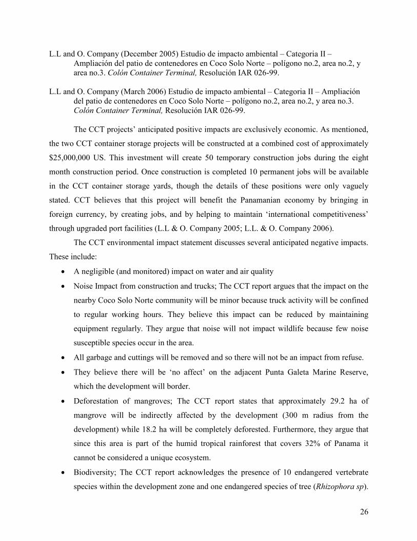
L.L and O. Company (December 2005) Estudio de impacto ambiental – Categoria II – Ampliación del patio de contenedores en Coco Solo Norte – polígono no.2, area no.2, y area no.3. Colón Container Terminal, Resolución IAR 026-99.
L.L and O. Company (March 2006) Estudio de impacto ambiental – Categoria II – Ampliación
del patio de contenedores en Coco Solo Norte – polígono no.2, area no.2, y area no.3. Colón Container Terminal, Resolución IAR 026-99.
The CCT projects’ anticipated positive impacts are exclusively economic. As mentioned,
the two CCT container storage projects will be constructed at a combined cost of approximately
$25,000,000 US. This investment will create 50 temporary construction jobs during the eight
month construction period. Once construction is completed 10 permanent jobs will be available
in the CCT container storage yards, though the details of these positions were only vaguely
stated. CCT believes that this project will benefit the Panamanian economy by bringing in
foreign currency, by creating jobs, and by helping to maintain ‘international competitiveness’
through upgraded port facilities (L.L & O. Company 2005; L.L. & O. Company 2006).
The CCT environmental impact statement discusses several anticipated negative impacts.
These include:
• A negligible (and monitored) impact on water and air quality
• Noise Impact from construction and trucks; The CCT report argues that the impact on the
nearby Coco Solo Norte community will be minor because truck activity will be confined
to regular working hours. They believe this impact can be reduced by maintaining
equipment regularly. They argue that noise will not impact wildlife because few noise
susceptible species occur in the area.
• All garbage and cuttings will be removed and so there will not be an impact from refuse.
• They believe there will be ‘no affect’ on the adjacent Punta Galeta Marine Reserve,
which the development will border.
• Deforestation of mangroves; The CCT report states that approximately 29.2 ha of
mangrove will be indirectly affected by the development (300 m radius from the
development) while 18.2 ha will be completely deforested. Furthermore, they argue that
since this area is part of the humid tropical rainforest that covers 32% of Panama it
cannot be considered a unique ecosystem.
• Biodiversity; The CCT report acknowledges the presence of 10 endangered vertebrate
species within the development zone and one endangered species of tree (Rhizophora sp).

27
Endangered vertebrates include the Central American agouti - Ñeque (Dasyprocta
punctata), Raccoon (Procyon lotor), White Faced Capuchin Monkey (Cebus capucinus),
Mantled Howler Monkey (Alouatta palliate), White Faced Coati (Nasua narica), the
Green Iguana (Iguana iguana), Boa Constrictor (Boa constrictor), Spectacled Caiman
(Caiman crocodilus) and two species of pigeons.
• In addition, they estimate the following diversity values for the development area:
o Invertebrates: They do no examine invertebrate diversity
o Mammals: They argue that 8 mammal species can be found in the area.
o Reptiles: They identify 9 reptile species that can be found in the area.
o Amphibians: They identify only one amphibian species; The Giant Toad (Bufo
Marinus). They argue other frogs cannot live in the area due to high salinity.
o Birds: They argue that only 32 species of birds inhabit the area.
• According to the CCT reports these diversity numbers were determined through
consultation with ANAM staff, through field observation, and by consulting the staff at
the Punta Galeta Marine Laboratory.
• The CCT report argues that this development will actually increase diversity by creating
a new roadside habitat for many species (ie. Palms) which are not native to the nearby
mangroves. By creating a habitat for new species the development will increase the
biodiversity of the area.
• Remediation measures include planting 1500 trees along the road for aesthetics,
monitoring air and water quality, and erosion prevention through the use of a drainage
ditch. In addition, CCT stated its intention to move endangered vertebrate species to
‘acceptable’ habitats the day before construction. How this will be done, which species
will be moved, and where they will be relocated to is not discussed.
• In the report it is stated that consultations with the people of the Coco Solo Norte
community were conducted and that these people were found to generally support the
project. Concerns expressed by the community include worries over the impact of the
development on the environment and who would be employed by the newly created
positions. CCT states in the reports that they intend to maintain constant communication
with the Coco Solo Norte Community, which lies across the street from the development
site.

28
2.9 Summary of Refutation – CCT
There are several important points where the findings of these authors differ from the
opinions express in the CCT Environmental Impact Statements. Points of contention are
summarized below and will be discussed in more detail subsequently. The authors of this report
believe that:
• The mangroves in the cut area are not heavily degraded and act as an essential buffer
protecting the mangroves within the Punta Galeta Reserve. Sufficient marine water
reaches these mangroves for the ecosystem to be maintained. This area has considerable
natural value and is not equivalent to the much more common Humid Tropical Forest.
This mangrove ecosystem is fundamentally different, far less common, and rapidly
disappearing when compared to the Humid Tropical Forest of Panama (as discussed
above).
• There are considerable biodiversity values not identified in the CCT reports. The species
counts presented in the CCT report are far lower than those which have been documented
by the scientists of the Punta Galeta Marine Laboratory, who have monitored the area for
over 40 years. For example, while the CCT report indicates that 32 species of birds live in
the development area, the scientists of Punta Galeta have documented more than 200
species. Furthermore, despite their high ecological importance within mangroves,
invertebrates are neglected by the CCT report.
• Endangered species: Many of the ‘endangered’ species listed in the CCT report are either
not listed as endangered (ie. The Northern Raccoon) or have never been previously
documented in the development area (ie. Howler monkeys). This may result from a
misuse of terminology by the CCT authors, though this is unclear. Furthermore, several
officially endangered species that do frequent the area (ie. The American Crocodile) are
not discussed in the CCT report.
• Numerous potential environmental impacts are not studied, addressed, or discussed by
the CCT reports. These include:
o Noise impacts: The impact of noise cannot be considered negligible simply
because human settlements are unaffected. Noise may have a substantial
unidentified impact on wildlife.
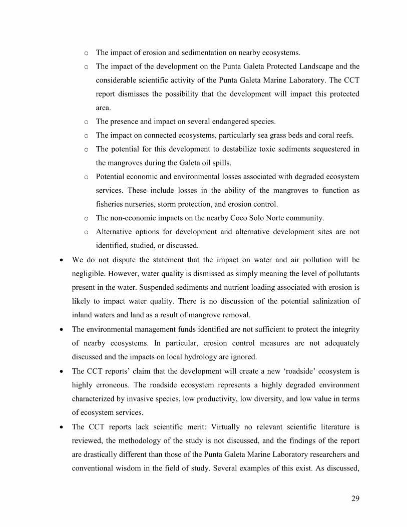
29
o The impact of erosion and sedimentation on nearby ecosystems.
o The impact of the development on the Punta Galeta Protected Landscape and the
considerable scientific activity of the Punta Galeta Marine Laboratory. The CCT
report dismisses the possibility that the development will impact this protected
area.
o The presence and impact on several endangered species.
o The impact on connected ecosystems, particularly sea grass beds and coral reefs.
o The potential for this development to destabilize toxic sediments sequestered in
the mangroves during the Galeta oil spills.
o Potential economic and environmental losses associated with degraded ecosystem
services. These include losses in the ability of the mangroves to function as
fisheries nurseries, storm protection, and erosion control.
o The non-economic impacts on the nearby Coco Solo Norte community.
o Alternative options for development and alternative development sites are not
identified, studied, or discussed.
• We do not dispute the statement that the impact on water and air pollution will be
negligible. However, water quality is dismissed as simply meaning the level of pollutants
present in the water. Suspended sediments and nutrient loading associated with erosion is
likely to impact water quality. There is no discussion of the potential salinization of
inland waters and land as a result of mangrove removal.
• The environmental management funds identified are not sufficient to protect the integrity
of nearby ecosystems. In particular, erosion control measures are not adequately
discussed and the impacts on local hydrology are ignored.
• The CCT reports’ claim that the development will create a new ‘roadside’ ecosystem is
highly erroneous. The roadside ecosystem represents a highly degraded environment
characterized by invasive species, low productivity, low diversity, and low value in terms
of ecosystem services.
• The CCT reports lack scientific merit: Virtually no relevant scientific literature is
reviewed, the methodology of the study is not discussed, and the findings of the report
are drastically different than those of the Punta Galeta Marine Laboratory researchers and
conventional wisdom in the field of study. Several examples of this exist. As discussed,
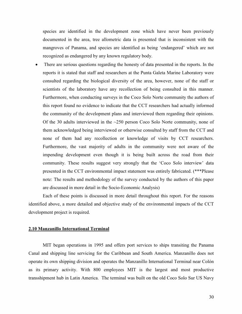
30
species are identified in the development zone which have never been previously
documented in the area, tree allometric data is presented that is inconsistent with the
mangroves of Panama, and species are identified as being ‘endangered’ which are not
recognized as endangered by any known regulatory body.
• There are serious questions regarding the honesty of data presented in the reports. In the
reports it is stated that staff and researchers at the Punta Galeta Marine Laboratory were
consulted regarding the biological diversity of the area, however, none of the staff or
scientists of the laboratory have any recollection of being consulted in this manner.
Furthermore, when conducting surveys in the Coco Solo Norte community the authors of
this report found no evidence to indicate that the CCT researchers had actually informed
the community of the development plans and interviewed them regarding their opinions.
Of the 30 adults interviewed in the ~250 person Coco Solo Norte community, none of
them acknowledged being interviewed or otherwise consulted by staff from the CCT and
none of them had any recollection or knowledge of visits by CCT researchers.
Furthermore, the vast majority of adults in the community were not aware of the
impending development even though it is being built across the road from their
community. These results suggest very strongly that the ‘Coco Solo interview’ data
presented in the CCT environmental impact statement was entirely fabricated. (***Please
note: The results and methodology of the survey conducted by the authors of this paper
are discussed in more detail in the Socio-Economic Analysis)
Each of these points is discussed in more detail throughout this report. For the reasons
identified above, a more detailed and objective study of the environmental impacts of the CCT
development project is required.
2.10 Manzanillo International Terminal
MIT began operations in 1995 and offers port services to ships transiting the Panama
Canal and shipping line servicing for the Caribbean and South America. Manzanillo does not
operate its own shipping division and operates the Manzanillo International Terminal near Colón
as its primary activity. With 800 employees MIT is the largest and most productive
transshipment hub in Latin America. The terminal was built on the old Coco Solo Sur US Navy
31
Sea plane base by the Manzanillo corporation, a partnership between Carrix Inc. and the Motta
and Heilbron families (MIT 2007).
Because MIT was built on the site of the old Coco Solo Sur Navy Base, the construction
of their port-side facilities did not damage the mangroves directly, although this area was
historically mangrove (Heckadon-Moreno, personal communication, January 12, 2007).
However, container storage, warehousing, and maintenance yards associated with MIT have
been built over mangrove forest resulting in the deforestation of 82 ha (Vargas 2005).
2.11 Manzanillo International Terminal – Development Plans
Currently the Manzanillo International Terminal (MIT) is undertaking a large expansion
project involving the construction of several pieces of infrastructure on cleared lots (former
mangrove) and in the portside area. In total the MIT expansion is a $210,000,000 US project that
will span several years and five development sites (Zones A to E). Only the container storage
area in Zone C (as labeled in Vargas 2005) will involve the clearing of new areas of mangrove
forest though several other buildings will be placed in areas that were formerly mangrove but are
already cleared. MIT intends to clear an additional 12 ha of mangrove forests in Zone C for the
construction of a concrete container storage platform. Zone C will neighbor the CCT
developments already discussed and will be built along the south side of the planned CCT
container yard (Vargas 2005). See Figure 3 (above - Section 2.7) and Appendix I for
Development Maps.
2.12 Manzanillo International Terminal – Zone C - Environmental Impact Statement
Because Zone C is the only area of the MIT expansion that is planned in existing
mangroves, this analysis will focus on this area specifically. Key points and areas of dispute are
the focus of this examination and the entirety of the MIT Environmental Impact Statement will
not be discussed. The MIT Environmental Impact Statement was filed at the Colón ANAM
office under the name:

32
Vargas, J.J. (July 2005) Estudio Categoria II Proyecto de Ampliación del Puerto de Manzanillo. Manzanillo International Terminal, RUC 8-194-829-D.V.08.
The MIT project’s anticipated positive impacts are exclusively economic. As mentioned,
the entire MIT expansion project will cost approximately $210,000,000 US and is expected to
create 120 construction jobs followed by 75 permanent positions when construction is
completed. MIT believes that this project will benefit the Panamanian economy by bringing in
large cash investment, by creating jobs, and by increasing the local tax base through increased
economic activity. While this may be true, the MIT statement neglected to discuss where money
will be spent and in which of the five development zones job creation will occur. Thus, the
economic benefits of the relatively small Zone C development is not specifically stated (Vargas
2005). Given that a similarly sized area providing a similar function is expected to generate 10
permanent positions at a development cost of $5,000,000 in the nearby CCT container yards, it
can be expected that the Zone C development will generate a similar number of positions (L.L.
and O Company 2006).
The MIT environmental impact statement discusses several anticipated negative impacts.
These include:
• A negligible (and monitored) impact on water and air quality
• Noise Impact from construction and trucks; The MIT report argues that since their
development is not near human habitation the noise impact will be negligible.
• Deforestation of mangroves; The MIT report argues that the mangroves in this area are
already heavily degraded and surrounded by industrial developments. Furthermore, they
argue that very little marine water reaches this area due to other development projects and
that this forest is part of the humid tropical rainforest that covers 32% of Panama. For
these reasons this area cannot be considered a unique ecosystem.
• Biodiversity; The MIT report does not highlight the presence of any endangered species
within Zone C. In addition, they do not provide species number estimates for any group.
Identified biodiversity is as follows:
o Invertebrates: They identify several taxonomic orders of insects that occur in the
area.

33
o Mammals: They argue that mammals are rare in the area other than four species
which occasionally frequent Zone C. These are Geoffroy’s Tamarin (Saguinus
geoffroyi), Mantled Howler (Alouatta palliate), and two species of rabbits.
o Reptiles: They identify only Ameiva ameiva, Iguana iguana, and several species
of anoles in the development area.
o Amphibians: They identify only The Giant Toad (Bufo marinus) as a species that
occurs in the development area. However, they speculate that species of Ranidae
and Hylidae frog also occur in the area.
o Birds: The only bird species which are identified in the development area are two
species of vulture, Brotogeris jugularis (a parakeet species) and Tachycineta
albilinea (a species of swallow).
• The MIT report argues that invertebrates are the main group to be affected by the
development as other species will simply move to nearby forest.
• They acknowledge that mangroves are important for cleaning air, water, for accumulating
sediments, and for preventing erosion.
• Remediation measures include $2000/year for noise monitoring, $1500/year for garbage
clean-up and aesthetic tree planting, water quality checks 3 times per year, and regular
maintenance of equipment and trucks to minimize noise and pollution.
2.13 Summary of Refutation – MIT
There are several important points where the findings of these authors differ from the
opinions express in the MIT Environmental Impact Statement. Points of contention are
summarized below and will be discussed in more detail subsequently. The authors of this report
believe that:
• The mangroves in the cut area are not heavily degraded and act as an essential buffer
protecting the mangroves within the Punta Galeta Reserve. Sufficient marine water
reaches these mangroves for the ecosystem to be maintained. This area has considerable
natural value and is not equivalent to the much more common Humid Tropical Forest.
This mangrove ecosystem is fundamentally different, far less common, and rapidly
34
disappearing when compared to the Humid Tropical Forest of Panama (as discussed
above).
• There are considerable biodiversity values not identified in the MIT report. Species
counts reveal high biodiversity, particularly for bird species. Furthermore, in depth
analysis reveals the presence of several endangered species of plants and animals.
Mammals are not ‘virtually non-existent’ in this area and numerous mammal species use
this habitat.
• Invertebrates are not the only group that will be affected. Birds and other vertebrates
cannot simply ‘move’ to nearby habitat.
• The report acknowledges the importance of the mangroves for cleaning air and water, for
accumulating sediments, and for preventing erosion. However, the impacts on these
ecosystem services are not discussed.
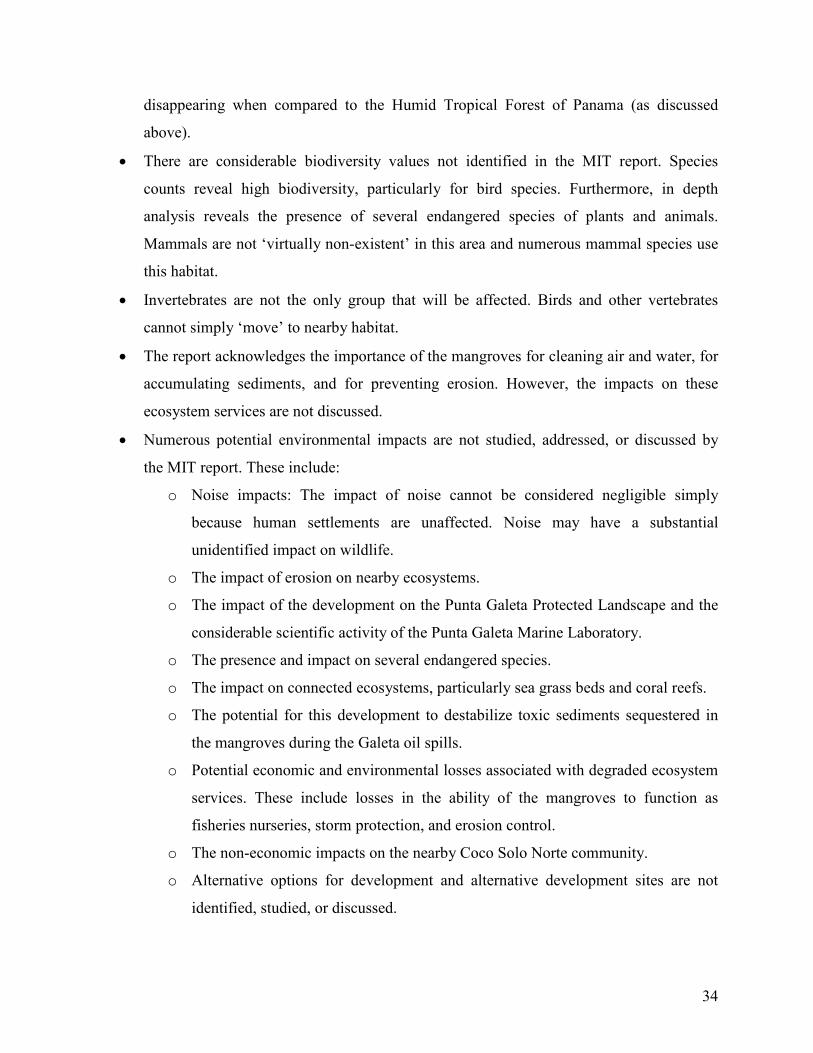
• Numerous potential environmental impacts are not studied, addressed, or discussed by
the MIT report. These include:
o Noise impacts: The impact of noise cannot be considered negligible simply
because human settlements are unaffected. Noise may have a substantial
unidentified impact on wildlife.
o The impact of erosion on nearby ecosystems.
o The impact of the development on the Punta Galeta Protected Landscape and the
considerable scientific activity of the Punta Galeta Marine Laboratory.
o The presence and impact on several endangered species.
o The impact on connected ecosystems, particularly sea grass beds and coral reefs.
o The potential for this development to destabilize toxic sediments sequestered in
the mangroves during the Galeta oil spills.
o Potential economic and environmental losses associated with degraded ecosystem
services. These include losses in the ability of the mangroves to function as
fisheries nurseries, storm protection, and erosion control.
o The non-economic impacts on the nearby Coco Solo Norte community.
o Alternative options for development and alternative development sites are not
identified, studied, or discussed.

35
• We do not dispute the statement that the impact on water and air pollution will be
negligible. However, water quality is dismissed as simply meaning the level of pollutants
present in the water. Suspended sediments and nutrient loading associated with erosion is
likely to impact water quality.
• The environmental management funds identified are not sufficient to protect the integrity
of nearby ecosystems. In particular, erosion control measures are not adequately
discussed and the impacts on local hydrology are ignored.
Each of these points is discussed in more detail throughout this report. For the reasons
identified above, a more detailed and objective study of the environmental impacts of the MIT
development project is required.
2.14 Conclusion
In summation, this situation analysis has found that the zoning laws in the Bahía Las
Minas mangroves allow for considerable development space with no land conservation outside
of the small Punta Galeta protected landscape. Currently two port expansion projects are
scheduled for construction, both of which plan to build part of their infrastructure (specifically
container yards) in old growth mangroves. As discussed, the environmental impact assessments
submitted for these studies are shockingly incomplete and in some areas dishonest (particularly
CCT). Lastly, two much larger development projects (the airport and rail-yard expansions) are
also being discussed in the Bahía Las Minas area. Now that the development situation has been
outlined, environmental values that will be impacted by the development projects are identified
and discussed through a literature review.
36
3.0 Environmental Impact Assessment
In this section of the report scientific literature is reviewed that is relevant to the points of
refutation discussed in the ‘Summary of Refutation’ sections. Through this review it will be
shown that the findings of the MIT and CCT environmental impact statements underestimate the
importance of Colón’s mangrove forests. Furthermore, it will be shown that this ecosystem is
critically important for the region’s ecology, that it holds significant scientific and educational
values, and that conservation measures are necessary to preserve the integrity of the local and
regional environment.
3.1 The Mangrove Ecosystem – Basic Ecology
In much of the tropics mangroves form the juncture between the terrestrial and marine
environments. Typically mangrove forests occupy the dynamic inter-tidal zone where they are
periodically inundated with sea water. As a result, mangrove forest are defined by species of
trees that are adapted to periodic desiccation, high salinity, variable soil level temperature, and
periodically severe weather conditions (Hogarth 1999).
The mangrove trees which create and sustain the mangrove forest ecosystem represent a
wide variety of taxa that are related by ecosystem function rather than through genetic heritage.
Thus, while mangrove trees are not closely related to one another genetically, they grow under
similar conditions, are subject to similar ecological stresses, and display similar adaptive features
(Duke 1992).
The distribution of mangrove species within a mangrove forest is related to the level of
seasonal seawater inundation. In the mangroves surrounding Punta Galeta red mangrove
(Rhizophora mangle) lives in nearly pure stands at 10-20 m from the water’s edge. In the low
inter-tidal zone white mangroves (Laguncularia racemosa) also become common and share the
habitat with the red mangrove. In the mid-inter-tidal zone black mangroves (Avicennia
germinans) begin to grow alongside the white mangrove while the red mangrove becomes rarer.
Finally, in the upper inter-tidal zone black mangroves form almost pure stands with trees of up to
30 meters. Thus, there is a gradual transition in species dominance from red, to white, to black
mangrove trees as one moves further inland (Sousa in press; Duke et al. 1994; Sousa 1998). In
37
the mangroves around Punta Galeta the red mangrove (Rhizophora mangle), the white mangrove
(Laguncularia racemosa), and the black mangrove (Avicennia germinans) are the three most
common species, however, 6-8 species4 of mangrove trees occur in the Caribbean mangroves of
Panama (Duke et al. 1994; Sousa 1998).
3.2 Mangrove Ecosystem Services and Economic Values
Ecosystem services are those services and products created by natural ecosystems which
directly benefit humankind. These services have measurable economic value and include such
things as clean water, clean air, raw materials, food, habitat, etc. (Eamus et al. 2005). In
traditional economic analyses ecosystem services have largely been neglected and, as a result,
the true value of ecosystems is often understated in cost benefit analyses. In the MIT and CCT
environmental impact statements ecosystem services are not discussed and the economic value of
mangrove ecosystem services is ignored. However, mangroves provide a wide variety of
ecosystem services which have both direct and indirect economic value (Harborne et al. 2006).
First and foremost, mangroves are vital for the breeding, growth, and maintenance of a
variety of commercially important fish species. As discussed earlier, mangroves host a great
diversity of fish and invertebrate fauna. Because mangroves provide a salt water environment
that is sheltered from most large predators, many fish and shark species breed near mangroves
and use mangrove ecosystems worldwide as a nursery for their young (Nagelkerken et al. 2000;
Feldheim & Edren 2002). The Caribbean mangroves of Bahía Las Minas are known to function
as a nursery and refuge for the young of commercially important crabs, spiny lobster (Marx &
Herrnkind 1986), penaeid shrimp (Stoner 1988), and over 200 species of fish, many of which are
commercially harvested species (Austin 1971; Philips 1981; Louis & Guyard 1982). When
mangroves are destroyed or degraded their function as fisheries nurseries, water filters, and food
sources for marine species are also removed. As a result, it has been found that both fisheries and
aquaculture activities are heavily dependant on nearby mangroves, and where mangrove
ecosystems have been degraded or removed in the Caribbean, these industries have suffered
(Ronnback et al. 2003). In addition, recent studies have found that the long term sustainability of
4 The number of species depends on the definition of what is and is not a mangrove species. There is considerable debate over whether or not some species should be considered ‘mangrove’ trees (Duke 1992; Duke et al. 1994).

38
coastal aquaculture projects is heavily dependant on the health of surrounding mangrove
ecosystems. Where mangroves have been removed, coastal fisheries and aquaculture production
have historically suffered (Gunawardena & Rowan 2005).
The fisheries sector is vital to the Panamanian economy and currently fisheries products
are the nation’s second largest export. In total, the Panamanian fisheries industry has an annual
productivity worth approximately $250.8 M USD and it employs ~1500 industrial fishermen,
~13,000 individual and artisanal fishermen, and ~37,500 people in processing activities. In
addition, tens of thousands of other jobs are created by this industry through indirect
employment and aquaculture activities (FAO 2007). Clearly the fisheries resources that are
maintained by healthy mangrove ecosystems have major economic value and are essential for the
Panamanian fishing industry and for employment. In particular, these resources are vitally
important for thousands of poor subsistence fishermen, including the impoverished artisanal
fishermen of Colón’s La Playita community (Chirchikova et al. 2006).
Another important ecosystem service provided by mangroves is flood and storm
protection. A wealth of scientific literature exists examining this ecosystem function and it has
been found repeatedly that mangrove ecosystems are among the most valuable biomes in the
world in terms of providing storm protection and flood control. The value of mangrove
ecosystems at reducing property damage and loss of human life caused by storm events is well
documented (Mazda et al. 1997; Massel et al. 1999; Chong 2005). Mangroves are extremely
effective at protecting coastal communities from cataclysmic weather events. In the aftermath of
the 2004 Asian tsunami, for example, it was found that communities which were protected by
healthy mangrove forests suffered far fewer casualties and far less severe property damage than
those areas which had highly degraded or converted their coastal forests (Badola & Hussain
2005; Dahdouh-Guebas et al. 2005; Danielsen et al. 2005; Kathiresan and Rajendran 2005;
UNEP 2005). As a result of this realization, many of the East Asian governments affected by the
Tsunami are now investing heavily in mangrove reforestation and conservation projects (Barbier
2006). The high rate of mangrove deforestation around the city of Colón has already caused
major storm related environmental impacts and parts of the city, including the Zona Libre and
Cuatro Altos areas, have flooded several times in the last decade. Wet season flooding in Colón
is expected to intensify as mangrove deforestation continues (SINAPROC 2006). Given climate
change related transformations to world weather patterns, the expected intensification of
39
worldwide storm activity, and rising sea levels, the importance of mangrove ecosystems for their
flood control and storm protection functions should not be ignored.
In addition to the paramount ecosystem services already discussed, mangroves provide a
variety of other valuable services. Mangroves are known to reduce coastal erosion and siltation,
while also contributing to the long term stabilization of the coast and the process of coast
building (Fondo & Martens 1998; Mazda et al. 2002). These services are particularly important
when linkages to surrounding ecosystems are considered as sediment stabilization is vital for the
health of sea grass beds and coral reef communities. This is discussed in more detail in the
ecosystem linkages section. Also, mangroves are highly effective at water purification and are
particularly useful for absorbing excess nitrates and phosphates that result from agricultural
activities as well as effluents that would otherwise contaminate inshore waters (Nagelkerken et
al. 2000). For example, as discussed in more detail in the Toxic Sediments section (section 3.5),
the mangroves of Bahía Las Minas were effective at controlling and sequestering oil during the
1986 oil spill (Levings et al. 1994).
As discussed, mangrove ecosystems provide a variety of direct economic benefits (aka
ecosystem services) that have been entirely overlooked in the cost benefit analysis of the
development projects. It should be noted that the list of ecosystem services discussed thus far is
not complete and the economic value of mangroves expands exponentially when linkages with
other ecosystems and less easily defined values, such as biodiversity, the spiritual and aesthetic
value of nature, and subsistence utilization, are also discussed (Gunawardena & Rowan 2005). In
order to simplify the argumentation of this analysis, the value of mangrove ecosystems for
biodiversity, as a source of subsistence income, as a source of aesthetic and cultural values, and
in terms of ecosystem linkages is discussed in other sections of the report. However, it should be
noted that these services also have well recognized, albeit indirect, economic value. Tables 1 and
2 (below) summarize the trends and anticipated impact on ecosystem services discussed in this
document.
While quantifying the economic value of mangrove ecosystems is inherently difficult,
total ecosystem valuation estimates have been conducted in the past. In Sri Lanka, for example, it
was estimated that mangrove ecosystems were worth $493/ha/year locally and $1088/ha/year
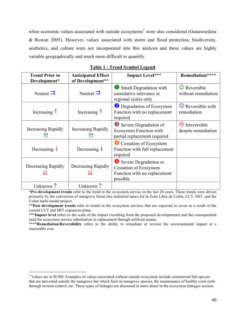
40
when economic values associated with outside ecosystems5 were also considered (Gunawardena
& Rowan 2005). However, values associated with storm and flood protection, biodiversity,
aesthetics, and culture were not incorporated into this analysis and these values are highly
variable geographically and much more difficult to quantify.
Table 1 : Trend Symbol Legend
Trend Prior to
Development*
Anticipated Effect
of Development**
Impact Level*** Remediation****
Neutral �
Neutral �
� Small Degradation with cumulative relevance at regional scales only
☺ Reversible without remediation
Increasing �
Increasing �
� Degradation of Ecosystem Function with no replacement required
� Reversible with remediation
Increasing Rapidly
�
Increasing Rapidly
�
� Severe Degradation of Ecosystem Function with partial replacement required
� Irreversible despite remediation
Decreasing �
Decreasing �
� Cessation of Ecosystem Function with full replacement required
Decreasing Rapidly
�
Decreasing Rapidly
�
� Severe Degradation or Cessation of Ecosystem Function with no replacement possible
Unknown ? Unknown ?
*Pre-development trends refer to the trend in the ecosystem service in the last 20 years. These trends were driven primarily by the conversion of mangrove forest into industrial space for la Zona Libre de Colón, CCT, MIT, and the Colón multi-modal project. **Post development trends refer to trends in the ecosystem services that are expected to occur as a result of the current CCT and MIT expansion plans. ***Impact level refers to the scale of the impact (resulting from the proposed developments) and the consequential need for ecosystem service substitution or replacement through artificial means. ****Remediation/Reversibility refers to the ability to remediate or reverse the environmental impact at a reasonable cost.
5 Values are in $USD. Examples of values associated without outside ecosystem include commercial fish species that are harvested outside the mangrove but which feed on mangrove species, the maintenance of healthy coral reefs through erosion control, etc. These types of linkages are discussed in more detail in the ecosystem linkages section.
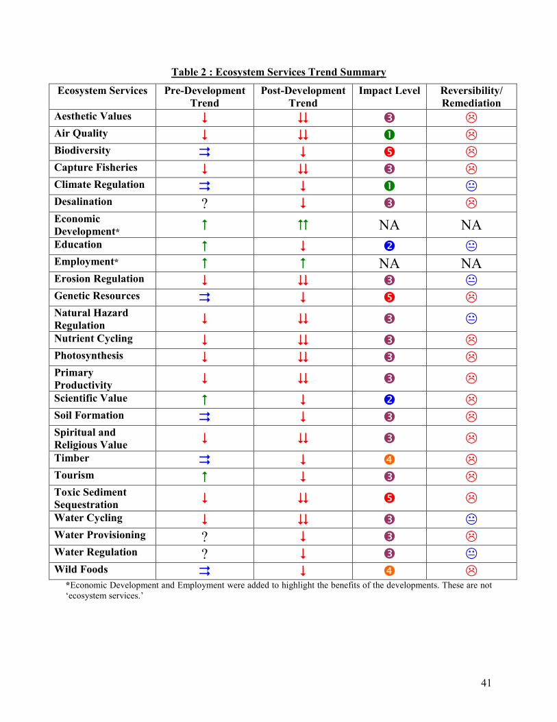
41
Table 2 : Ecosystem Services Trend Summary
Ecosystem Services Pre-Development
Trend
Post-Development
Trend
Impact Level Reversibility/
Remediation
Aesthetic Values � � � � Air Quality � � � � Biodiversity � � � � Capture Fisheries � � � � Climate Regulation � � � � Desalination ? � � � Economic
Development* � � NA NA
Education � � � � Employment* � � NA NA Erosion Regulation � � � � Genetic Resources � � � � Natural Hazard
Regulation � � � �
Nutrient Cycling � � � � Photosynthesis � � � � Primary
Productivity � � � �
Scientific Value � � � � Soil Formation � � � � Spiritual and
Religious Value � � � �
Timber � � � � Tourism � � � � Toxic Sediment
Sequestration � � � �
Water Cycling � � � � Water Provisioning ? � � � Water Regulation ? � � � Wild Foods � � � �
*Economic Development and Employment were added to highlight the benefits of the developments. These are not ‘ecosystem services.’
42
From this analysis it should be abundantly clear that the mangrove ecosystems of Bahía
Las Minas have a very high economic value and provide a variety of services that are important
for the greater environment as well as human communities. These values have not been
adequately addressed by the environmental impact statements submitted by CCT and MIT.
3.3 Biodiversity and the Mangroves of Bahía Las Minas
As mentioned earlier, the species diversity estimates provided in the CCT and MIT
environmental impact assessments greatly underestimate the biodiversity value of the mangrove
ecosystem. While a comprehensive assessment of terrestrial species biodiversity has not been
conducted in the mangrove forests of Bahía Las Minas, exploratory analysis suggests that the
area has considerable biodiversity value. For example, on May 17-18, 2003 the Punta Galeta
Marine Laboratory hosted an international biodiversity day. As part of this event, 221 volunteers,
researchers, and students conducted a species inventory of the terrestrial environment
surrounding the laboratory, documenting all of the species encountered in the 24 hour period.
During this time 316 species of plants, 32 macro-fungi, 10 amphibians, 13 reptiles, 30 mammals,
and 150 birds were documented in the mangroves surrounding Punta Galeta (Punta Galeta
Marine Laboratory 2003). These numbers represent a baseline diversity value, as many
taxonomic groups were not comprehensively examined (ie. terrestrial invertebrates) and many
rare or migratory species were likely missed. In the case of birds, for example, it is estimated that
200-250 species frequent the mangroves of Bahía Las Minas but that many migratory or rare
species were missed during the exploratory 24 hour investigation. This is supported by recent
field experience where the authors of this report, during casual observation, identified several
species that were not documented during the biodiversity day. These includes three species of
unlisted birds (Black Bellied Plover – Pluvialis squatarola, Ruddy Turnstone – Aernaria
interpres morinella, and American Pygmy Kingfisher – Chloroceryle aenea) as well as two
species of unlisted mammals (Common Opossum – Didelphis marsupialis and White Nosed
Coati – Nasua narica). Thus, the actual species numbers are likely much higher than those
observed during the biodiversity day, even for those groups which were studied thoroughly
(Punta Galeta Marine Laboratory 2003). In addition, there are many groups that were not studied
during the biodiversity day which have high biodiversity values. It is known, for example, that

43
the mangrove forests of Bahía Las Minas and the Caribbean of Panama have the highest
mangrove associated invertebrate fauna in the world, with over 90 species of crabs in the Punta
Galeta area alone (Farnsworth and Ellison in press).
When ecosystem linkages are considered it becomes clear that the biodiversity value of
mangrove forests is staggering. In addition to the diversity of animal and plant life that is found
in the mangrove itself, there are considerable linkages between the mangrove, sea grass, and
coral reef communities and many studies have suggested that the even greater biodiversity values
of the offshore reefs are strongly dependant on the mangrove ecosystem. For example, Heck
(1977) found that the invertebrates in the waters of Bahía Las Minas regularly move between the
mangrove, sea grass, and reef environments during different parts of their life cycle. If the
biodiversity value of connected ecosystems (sea grass beds and coral reef) are also considered
then the biological diversity value of the mangrove forest is considerable. The linkages between
the mangroves and surrounding ecosystems are discussed in more detail subsequently and the
interdependence of these ecological systems will be shown in the Ecosystem Linkages section
(section 3.4).
Finally, the mangrove ecosystem provides critical habitat for the endangered American
Crocodile – Crocodylus acutus, a species which retains an abundant and actively breeding
population in the mangroves of Bahía Las Minas (Punta Galeta Marine Laboratory 2003; IUCN
2007). Again, if ecosystem linkages are considered then a wide variety of endangered animals
that live in the offshore environment are supported by the mangrove ecosystem. These include
many endangered species of sharks, rays, sea turtles, and reef fish such as Lachnolaimus
maximus, an endangered hogfish (IUCN 2007).
It is clear from this analysis that the biodiversity value of the mangrove forest is far
greater than expressed in the CCT and MIT environmental impact assessments. It is highly likely
that continued habitat destruction in the Bahía Las Minas mangroves will have harmful effects
on biodiversity and species will be lost as suitable habitat disappears.

44
3.4 Mangrove Ecosystem Linkages
Mangroves, owing to their unique ecology as terrestrial pioneers fringing on marine
systems, occupy the transitional zone between aquatic and terrestrial habitats. From this unique
location they form important linkages between terrestrial and marine ecosystems. Mangroves are
essential to the productivity of near shore habitats and the fallen leaves and branches of
mangroves are an important part of the aquatic nutrient cycle, supporting a large biomass of
detritus feeders that are an essential part of the intricate food webs of shallow marine
communities (Gonneea et al. 2004). However, the importance of energy and biomass flows
emerging from mangroves varies greatly between sites.
Beyond the input of detritus, the mangroves of Colón affect the productivity of sea grass
beds and coral reefs in another important way. Unlike most terrestrial habitats few species that
occupy the mangroves are permanent residents of the ecosystem, other than the mangrove trees
and associated epiphytes themselves. Nearly all other species which inhabit the mangrove
ecosystem use this environment during part of their life cycle only and they occupy other
habitats, such as tropical forest, sea grass beds, coral reefs, or open ocean for the remainder of
their lives. As a result, energy (in the form of biomass) flows in and out of the mangrove
ecosystems almost constantly. The movement of fish between mangroves and adjacent sea grass
beds, for example, has long been documented. At low tide when fish cannot physically occupy
certain areas of the mangroves, they retreat to the sea grass beds surrounding the mangroves
(Jelbart et al. 2007) from which they can still retreat into the shallow creeks linked to the
mangrove ecosystem when threatened (Robertson & Duke 1990a). As discussed, mangrove
habitats are recognized as important nursery habitats for many species of fish and invertebrates
that are commercially important (Monterossa 1991; Pinto & Punchichewa 1996; Kieckbusch et
al. 2004). As a result, destruction of mangroves can result in the loss of marine species that
spend the majority of their lives many kilometers away. Because of their function as nurseries
and the energy that they provide to surrounding ecosystems, mangrove have been found to
increase fish abundance and diversity in adjacent sea grass beds and coral reefs (Jelbart et al.
2007).
In addition to providing habitat for migratory species and nursery grounds, the
mangroves of Colón support diversity in surrounding ecosystems by sheltering them from

45
anthropogenic changes. Through the stabilization of coastlines mangroves prevent erosion and
siltation; a process that can be particularly damaging to sea grass and coral reef communities
(Fondo & Martens 1998). In a Thai study, for example, the disappearance of mangrove cover
along coasts was correlated to the loss of coastal terrain. The only areas in the study where the
coastlines were found to expand were at the edge of mangrove forests. Upstream deforestation or
river blockage associated with damming or port development was linked to increased siltation
levels, erosion, and the degradation of downstream mangroves (Thampanya et al. 2006). Where
mangroves are removed siltation increases which causes water clarity to decline. This causes less
light to reach the sea grasses and the corals, significantly reducing photosynthesis. When
sustained over long periods siltation can eventually result in the extirpation of species and may
favor the persistence of species best adapted to the new conditions, thus reducing structural
complexity and biodiversity (Molles 2005). As the mangroves of Bahía Las Minas continue to
disappear, the flora and fauna of associated ecosystems will also suffer.
From this analysis it should be clear that the removal of mangrove forests affects the
ecosystems that are linked to them in a variety of ways. As mangroves continue to be deforested
the loss of habitat for migratory species, the loss of the mangroves as a nursery, the loss of
energy flows to other ecosystems, and the loss of erosion/siltation protection will affect adjacent
ecosystems adversely, particularly sea grass beds and coral reefs.
3.5 Toxic Sediments
In 1986 a major oil spill occurred in the Bahía Las Minas area that involved the
accidental release of 50,000 barrels of medium weight crude oil, resulting in the oiling of the
coral reefs, sea grass beds, and mangrove forest along the coast east of Colón (Burns et al. 1993).
After causing massive ecological damage in the coastal ecosystems, large amounts of oil from
the Bahía Las Minas spill became trapped in mangrove sediments, penetrating as deep as 20 cm
due to the presence of open crab holes (Burns et al. 1994). While somewhat effective at
sequestering oil within their sediments, numerous studies in the Galeta mangroves have indicated
that the anoxic conditions in mangrove sediments maintain the toxicity of oil for 20 years or
longer (Corredor et al. 1990; Burns et al. 1994; Levings et al. 1994). While repeated re-oiling
events occurred following rains and mangrove die-offs in the years after the initial spill, the re-

46
release of oil into the environment has gradually declined (Levings et al. 1994). This has
occurred as the coastal mangroves, which experienced massive die-offs immediately after the
spill, have re-grown and reestablished mature root systems capable of stabilizing sediments and
preventing continual re-oiling (Guzman & Holst 1993; Burns et al. 1994; Garrity et al. 1994).
While the highly toxic sediments created by the 1986 oil spill are a major ecological concern in
the Bahía Las Minas mangroves, this ecological hazard was not addressed by the CCT or MIT
environmental impact statements. There is a definite danger that mangrove deforestation will
directly destabilize toxic sediments resulting in the release of oil into the coastal ecosystem.
Indirectly, mangrove deforestation inland is known to cause erosion in down slope mangroves
(Burns et al. 1994). Because this type of erosion can cause toxic sediments to be released from
mangroves surrounding the development areas, even if toxic sediments are not directly present in
the development sites there is a real danger that deforestation will cause oil to be released from
contaminated sediments in surrounding areas (Levings et al. 1994). The re-release of toxic
sediments following the 1986 oil spill was extensively studied and it was found that even in very
small quantities the toxic substances stored in the sediments can impact the health of the
mangroves, sea grass beds, and coral reef communities as well as their associated flora and fauna
(Duke & Pinzon 1993; Guzman & Holst 1993; Guzman et al. 1993; Marshall et al. 1993).
Whether direct or indirect, the risk of releasing toxic sediments has not been addressed by the
development proposals and no assessment of the current toxicity of sediments in the
development site or surrounding areas has been conducted.
3.6 The Impacts of Noise Pollution
In the MIT and CCT environmental impact reports the effect of noise pollution on
wildlife is discussed only briefly and in both cases it is stated that the impact of noise will be
negligible, despite the fact that a high noise burden is expected as a result of construction and
regular trucking traffic to and from the container storage yards. Numerous studies have found
that anthropogenic noise can substantially impact wildlife by driving animals away from suitable
habitats and by interfering with the ability of wildlife to communicate, forage for food, and
breed. Such research has lead to the ‘sound niche theory’ which states that “…the sounds of each
of these zones (habitats) are so unique and important to creature life in a given location... that

47
disturbance to this soundscape could be detrimental to the future of the individuals, populations
or entire species…” (Krasse 1993).
Examples of the impact of noise on animal species abound and it has been found that
loud anthropogenic noises, such as those created by trucking traffic, can have a wide range of
negative impacts on animal species. Noise related panic responses, for example, disrupt the
energy budgets of animals and can cause adult animals to become separated from their young
(Radle 2007). This phenomenon is especially common among birds and ‘sound pollution’ has
decimated bird populations in many areas (Kavaler 1975). Loud noises can cause animals that
rely on sound for feeding, such as bats, to starve and can even deafen animals which have
particularly sensitive hearing (Kavaler 1975; Immel 1995). In the desert of the southwest United
States, for example, the sound caused by dune buggy motors has been found to cause both
temporary and permanent deafness in small rodents, making these animals more susceptible to
predation by snakes (Immel 1995). Clearly, there is considerable evidence to support the
conclusion that the sound pollution created by container trucking traffic will negatively impact
wildlife in surrounding areas, including in the adjacent Punta Galeta protected landscape.
3.7 Impacts for Punta Galeta
All of the environmental impacts discussed so far will be felt, at varying degrees, in the
Punta Galeta Protected Landscape and Marine Laboratory which is adjacent to the construction
sites. This is of great concern given the high natural, scientific, and educational value of the
Punta Galeta Protected Landscape. As discussed earlier, Punta Galeta is administered by a
Smithsonian Tropical Research Institute team for research, conservation, and educational
purposes. In addition to the ecological values of this area (as discussed), the Punta Galeta Marine
Laboratory serves as one of the world’s premier marine research labs. As the oldest functioning
marine lab in the Caribbean, the researchers of Punta Galeta have made many important
contributions to the marine, climatic, ecological, and biological sciences. During its 43 years of
operation Punta Galeta has produced over 400 peer reviewed publications, it has hosted some of
the world’s imminent marine and mangrove ecologists, and it has provided a site to study such
important events as a major oil spill and climate change. Because Punta Galeta contains the
world’s oldest continual Caribbean atmospheric and oceanic monitoring data the site is
48
particularly important for climate change studies (STRI 2006; Heckadon-Moreno, personal
communication, January 12, 2007). In addition, Galeta has also hosted an innovative and popular
children’s education program that has been growing steadily since it was founded in 2000. This
program seeks to teach Panamanian elementary school children about ecology, science, and their
environment. In the few years since its inception the education program has been highly
successful and currently it incorporates over a dozen full time guides who collectively received
over 8000 students in 2006 alone. In addition, Punta Galeta provides a research site and support
facilities for dozens of graduate and undergraduate students every year (Heckadon-Moreno,
personal communication, January 12, 2007). Clearly, the Punta Galeta Protected Landscape and
Marine Laboratory has considerable scientific and educational value, in addition to the
ecological values discussed earlier.
However, just as the CCT and MIT developments threaten the ecology of Punta Galeta,
they also threaten the scientific and educational activities of the marine laboratory. The current
director of the Marine Laboratory, Dr. Stanley Heckadon-Moreno (personal communication,
January 12, 2007) has expressed deep concerns about the development projects and is worried
that further degradation of the ecosystems surrounding Punta Galeta will interfere with the
scientific activities of the Smithsonian and its associated researchers. If mangrove deforestation
continues in the Colón area the Bahía Las Minas coastal ecosystem will be so thoroughly
degraded that ecological and biological research projects may no longer be tenable. In particular,
the long term Caribbean monitoring dataset will be disturbed by anthropogenic environmental
changes that will render it useless as a source of baseline data. As Dr. Heckadon-Moreno
explained, the purpose of Punta Galeta is to measure and study the natural state of coastal
ecosystems, in part, so that anthropogenic changes can be put into context. Simply put, if Punta
Galeta becomes a highly degraded ecosystem then it will no longer be useful as a research
institution. Furthermore, because the educational program is an offshoot of the research center, it
too will disappear if the Punta Galeta area is allowed to ecologically degrade any further. It
should be abundantly clear from this analysis that significant scientific and educational values
are also being threatened by the proposed development projects, and with them, our ability to
understand our natural environment is also being jeopardized.
49
3.8 Conclusions: The Need For Conservation
In this literature review a variety of potential environmental impacts and environmental
risks have been identified and discussed, none of which were adequately addressed in the CCT
and MIT environmental impact statements. As discussed, the mangroves of Bahía Las Minas
have considerable ecological, biodiversity, and ecosystem service values which are threatened
directly by the habitat destruction associated with the proposed development projects. In
addition, the proposed development projects will create several other environmental impacts that
threaten the ecological integrity of the mangroves, sea grass beds, and coral reefs surrounding the
development area. These include potential impacts associated with noise pollution, erosion, and
the release of toxic sediments that were sequestered after the 1986 oil spill. In addition to the
damage that the development projects will create in the surrounding ecosystems, and the
consequential loss of ecological services, these development projects will severally jeopardize
the scientific and educational activities of the Punta Galeta Marine Laboratory. Because the
forest will be completely converted to paved industrial areas, most of these impacts cannot be
remediated or reversed at a reasonable cost. If the people of Colón and the nation of Panama
wish to prevent the environmental impacts described and preserve the natural, scientific, and
educational values of the Bahía Las Minas coastal ecosystems, then immediate conservation is
necessary in the small fraction of the region’s mangroves that still exist.

50
4.0 Socio-Economic Impact Assessment
4.1 Introduction
In addition to the environmental, scientific, and educational impacts of the proposed
development projects, there are several potential social and economic impacts which have not
been addressed by the MIT and CCT impact assessments. In this section impacts which are
primarily social or economic are discussed, though the authors acknowledge that many linkages
exist between the socio-economic and environmental impact sections and we believe that these
impacts should not be viewed dichotomously. For example, as discussed earlier, the majority of
environmental impacts associated with the development also have significant economic costs. In
this section the social and economic dimensions of the development projects that have not yet
been addressed are discussed. Potential impacts for the community of Coco Solo Norte, impacts
related to fisheries decline in the community of La Playita¸ and impacts related to flooding in the
city of Colón are examined. In addition, the social and economic impacts related to the Punta
Galeta Laboratory and their education programs are discussed. In the course of this analysis it
will be shown that the development projects will have significant negative social and economic
impacts that need to be addressed prior to continued development.
4.2 The Coco Solo Norte Community6
Coco Solo Norte is a small community with ~250 to 300 members living in the
abandoned barracks and housing facilities of the old United States Coco Solo Naval base. Since
the closure of the naval base the area has been occupied by squatters living in the old navy
buildings and people who were relocated to the area by the Panamanian government following
fires in the slums of Colón. Coco Solo is a very poor community with most of its inhabitants
surviving on less than $1/day. The majority of people living in Coco Solo are unemployed and
survive through various informal activities, though a few have part time jobs in construction or
as wage laborers (Interview results; Thomas, personal interview, March 1, 2007). The Coco Solo
6 The information presented in this section was obtained by talking with members of the Coco Solo Norte community, through formal surveys, and through discussion with a nature guide at Punta Galeta, Gabriel Thomas, who lives in Coco Solo Norte with his family.

51
Norte community is located directly across the road from the proposed site of the CCT container
patio, an area which is currently occupied by old growth mangrove forest. Coco Solo Norte is the
only community located within several kilometers of the MIT and CCT development sites. Due
to the location and economic vulnerability of the Coco Solo Norte community it seemed likely
that the development projects would adversely affect the community. As a result the authors of
this study decided it was necessary to conducted opinion and data collection surveys in the Coco
Solo community.
4.3 Objectives
The objective of the Coco Solo Norte interviews was to determine the potential socio-
economic impacts of the development projects within this community. The authors of this report
were primarily interested in:
• The level of employment for community members as workers of CCT, MIT, or the Zona
Libre.
• The awareness and opinions of community members regarding the mangroves and the
proposed development projects.
• The ways in which community members utilize the mangroves.
4.4 Methodology
In order to gather this information a short and clear survey was administered to 32
members of the Coco Solo Norte community who were selected randomly simply by walking
through the community and interviewing any adults that were encountered who were willing to
participate. Surveying was conducted on a Sunday after 3:00 pm when the majority of the
community was neither working nor in Church. The researchers were advised that at this time of
the week most of the community can be found in the streets of Coco Solo where they socialize
and participate in leisure activities. The surveys were administered in Spanish by the two authors
of the report with the help of Gabriel Thomas, who lives in the community. Surveys were handed
out with writing utensils and the researchers remained nearby in case any questions were found
52
to be unclear or ambiguous. A copy of the survey has been included in Appendix III. Survey data
was compiled using Excel and analyzed using standard statistical methodology.
Because interviews were carried out on the street level with individuals encountered in an
informal manner, it is possible that this biased the results as elderly, infirm, or reclusive
individuals may not have been present on the street at the time of sampling. Nevertheless, this
style of interviewing was implemented as the researchers believed it was the most casual and
least intrusive way to interview the respondents.
4.5 Coco Solo Survey Results: Basic Demographics
A total of 33 surveys were completed by respondents and returned to the interviewers. Of
these surveys one was forfeited by the respondent. In this interview process, 16 men, 15 women,
and one individual who did not select a gender were interviewed. The average age of respondents
was 33.2 and 30 years for women and men respectively.
4.6 Coco Solo Survey Results: Consultancy and Stakeholder Participation
In this environmental impact assessment the members of the Coco Solo Norte community
have been identified as a key stakeholder group who’s input and participation is important when
accessing the impacts of the development project and when devising plans for ecological
management. In the CCT environmental impact statement it was repeatedly stated that members
of the Coco Solo Norte Community were consulted about the development and that they were
generally in favor of it and involved in development planning. However, our analysis strongly
suggests that the data presented in the CCT report is entirely fabricated. While 13% of the
community was surveyed in the course of this investigation, not a single person indicated that
they, or anyone that they knew of, had been consulted in any way about the development project.
Manzanillo also failed to consult the Coco Solo Norte community, though they did not make any
false claims in this regard. The absence of consultancy and the failure to involve the Coco Solo
Norte community represents a major failure in the CCT and MIT developmental plans and is
enough, in itself, to justify a reexamination of the development projects.

53
The survey results indicate very strongly that the people of Coco Solo do not understand
the nature of the development project and that they were unclear about the future of their
community. The majority of Coco Solo residents were moved to this location temporarily (after
fires in Colón) and have no idea if or when they will be relocated to more permanent housing.
After living in the area for several years many individuals now consider Coco Solo to be their
permanent home. However, only three members of the community indicated that they were
aware of CCT’s plans to demolish their homes as part of the fourth phase of their expansion plan
(cutting of the mangroves is phase two of the project). It is undeniably scandalous that members
of the community were almost completely unaware that CCT and Manzanillo plan to cut the
mangroves across the street from them and that CCT plans to demolish the community of Coco
Solo in the near future.
In addition to the complete disregard for stakeholder involvement and the dissemination
of information concerning the project, CCT and MIT have not adequately presented development
alternatives and education about alternative development possibilities is lacking. The possibility
that these developments could be carried out in another less ecologically sensitive location or
that other forms of employment such as ecotourism could be implemented by keeping the
mangroves intact has not been formally presented to the community in an organized manner by
an outside party. Only three respondents indicated that they had received information concerning
alternative uses of the mangroves.
4.7 Coco Solo Survey Results: Developmental Concerns
A significant portion of the population expressed concerns over the development of the
mangroves adjacent to their community (81% of respondents). When asked what specific aspects
of development concerned them, 28% expressed concern over the destruction of local flora and
fauna, 19% said they were uncertain of the consequences of the development for the community,
15% said they were worried about dangerous displaced animals, and 9% said they were worried
about the loss of important ecosystem functions such as erosion control and a reduction in air
quality as a result of dust and smoke from the road. As shown in Figure 1, overall 59% of the
respondents stated that they believed the projects would be ‘bad’ or ‘disastrous,’ 20% were
‘neutral’ or non-responsive, and 21% said the projects were ‘good’ or ‘excellent.’

54
7%
14%
10%
38%
21%
10%
Excellent
Good
Neutral
Bad
Disasterous
Non-responsive
Figure 5 : Distribution of Sentiments: Perceptions of the Development Project in the Community
The majority of those who indicated that the development projects would be ‘good’ or
‘excellent’ also stated that they believed these projects would generate much needed employment
for the community. To put this in perspective, 53% of respondents indicated that they were
currently unemployed. Among the employed, 12% were employed within the Zona Libre and
35% were supported by other forms of employment. This strongly indicates that the desire for
employment is the main source of support for the project among community members.
As mentioned briefly earlier, several issues have been raised in the discussion and survey
session carried out within the community that were not addressed in the environmental impact
assessments submitted by MIT and CCT. Primary amongst them was a sincere concern over the
safety of residents, especially children, during the construction of the development projects.
Numerous parents stated that they believed the machinery and areas around the development
were not secured in any way and were hazardous to the children who may play around them.
Additionally, during previous episodes of mangrove clearing there were numerous incidents
where dangerous displaced animals (crocodiles and venomous snakes) wandered into the
community. In a particularly notorious incident, two large adult crocodiles were discovered in
the flooded streets of Coco Solo. Residents were unable to move the animals and on one
occasion a child was attacked by one of the crocodiles though not seriously harmed. Residents
also told us that whenever mangroves have been cut they have observed a large increase in the
presence of venomous snakes within the community. The mangroves surrounding Coco Solo
house some of the most dangerous snakes in the world such as the Eyelash Pit Viper and the
notorious Fer de Lance. Given that this particular mangrove stand is directly across the street
from the community, the displacement of highly dangerous animals such as crocodiles and
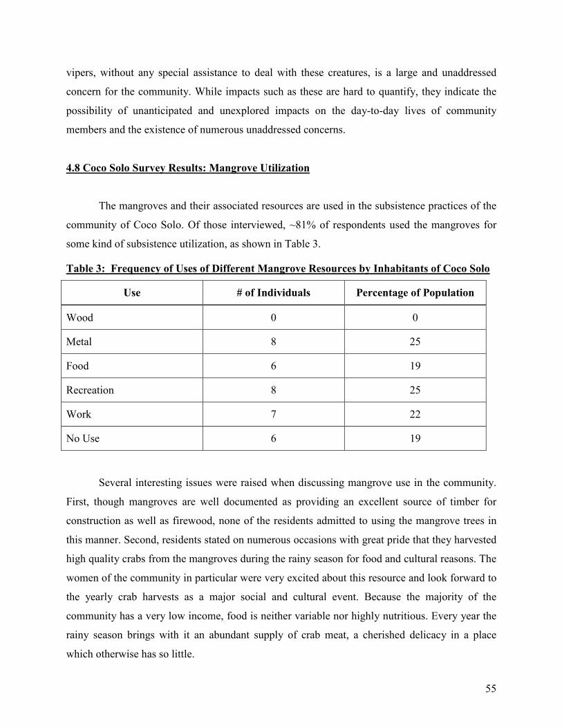
55
vipers, without any special assistance to deal with these creatures, is a large and unaddressed
concern for the community. While impacts such as these are hard to quantify, they indicate the
possibility of unanticipated and unexplored impacts on the day-to-day lives of community
members and the existence of numerous unaddressed concerns.
4.8 Coco Solo Survey Results: Mangrove Utilization
The mangroves and their associated resources are used in the subsistence practices of the
community of Coco Solo. Of those interviewed, ~81% of respondents used the mangroves for
some kind of subsistence utilization, as shown in Table 3.
Table 3: Frequency of Uses of Different Mangrove Resources by Inhabitants of Coco Solo
Use # of Individuals Percentage of Population
Wood 0 0
Metal 8 25
Food 6 19
Recreation 8 25
Work 7 22
No Use 6 19
Several interesting issues were raised when discussing mangrove use in the community.
First, though mangroves are well documented as providing an excellent source of timber for
construction as well as firewood, none of the residents admitted to using the mangrove trees in
this manner. Second, residents stated on numerous occasions with great pride that they harvested
high quality crabs from the mangroves during the rainy season for food and cultural reasons. The
women of the community in particular were very excited about this resource and look forward to
the yearly crab harvests as a major social and cultural event. Because the majority of the
community has a very low income, food is neither variable nor highly nutritious. Every year the
rainy season brings with it an abundant supply of crab meat, a cherished delicacy in a place
which otherwise has so little.

56
The collection of scrap metal was also cited as an unlikely, yet significant, resource
located in the mangroves that is used by a significant number of the interviewees. Informal
interviewing revealed that the United States Galeta Point Naval base used a site within the
mangroves as a dumping ground for waste products, including metal sheeting and metal
equipment. Since the closure of the naval base trees and vegetation have reclaimed this area and
members of the community now enter the mangroves to retrieve this metal in order to sell it as
scrap. This form of recycling provides a critical income source in a community that is extremely
poor. Of the 12 individuals who were unemployed, 5 indicated that they were involved in metal
harvesting as a source of income. On numerous occasions the researchers have observed a team
of 6 to 12 Coco Solo men harvesting scrap metal from within the mangroves.
4.9 Discussion: Developments and the Coco Solo Norte Community
As indicated by the survey results, there are several ways in which the development
projects could impact the Coco Solo Norte community. As discussed, the sole benefit for the
community that is anticipated in relation to the development projects is employment. On the
negative side, the development project will eliminate an important source of subsistence income
(metal scrapping), food (crab and other wild foods), and recreation. In addition, there is a risk
that the developments will create dangerous conditions through the displacement of animals and
the use of unsecured machinery. Once these development projects are completed the Coco Solo
Norte Community will be completely surrounded by heavy industrial activity without any direct
link to nature or other communities. Numerous studies have highlighted both the psychological
benefits of having natural areas nearby residential neighborhoods and the negative psychological
impacts that high intensity transportation noise can have on the mental health of individuals
(Singer 1976; Kaplan 2001). The psychological effects of living in this industrial wasteland, and
the increased noise level due to trucking traffic, could be profound and have been completely
disregarded.
Lastly, the survey results reveal that the majority of community members know nearly
nothing about the development projects, they have nearly no knowledge of other developmental
possibilities, they are very wary of the project, and 59% have very negative feelings towards the
development. Perhaps more troubling than this is the fact that the development projects have

57
been designed and will be implemented without any serious consultation with, or considered of,
the Coco Solo Norte community. CCT and MIT have been able to conduct their expansion plans
in a way that shows no regard for the vulnerable Coco Solo community, its members, and their
psychological and physical health.
4.10 Socio-Economic Impacts of Fisheries Declines
In addition to the anticipated impacts on the Coco Solo Norte community, continued
mangrove deforestation in the Bahía Las Minas area will result in the loss of fish breeding
habitats and hence a reduction in fish stocks for a variety of species. In addition to the impact
that this will have on biodiversity and the natural environment, socio-economic impacts will also
be felt in the fishing communities that depend on these natural resources. As mentioned earlier,
approximately 13,000 artisanal fishermen in Panama generate income for themselves and the
nation by working in the fishing industry (FAO 2007). The majority of these fishermen rely on
near shore fisheries where they hunt for species with high cash values (ie. lobster and octopus) or
those with high subsistence and nutritional values. Colón’s La Playita community is highly
dependent on artisanal fisheries activities and the fishermen from this community regularly fish
in and around the mangroves of Bahía Las Minas (Chirchikova et al. 2006). Approximately half
the population of La Playita relies on fishing for subsistence and cash income; an activity that
brings them an average of only $168/household/month. La Playita is an extremely poor
community that was founded by squatters and continues to have extreme problems with
infrastructure and land ownership. As a pressure tactic, land owners in the La Playita area have
repeatedly cut electricity and water to the community in an effort to expel the squatters from the
land (Chirchikova et al. 2006). Given low education levels, low employability, and the
dependence on local fisheries, declines in fish stocks as a result of over-fishing and habitat
destruction (primarily mangrove deforestation) have conspired to squeeze this highly
marginalized community even tighter. In particular, declines in two commercially important
species, spiny lobster and octopus7, have coincided with falling income levels. As a result, living
standards in an already impoverished community have declined and members of the community
7 Recall that spiny lobsters require mangroves as a nursery habitat. Octopus also feed on a variety of young fish, which may be declining with mangrove deforestation.
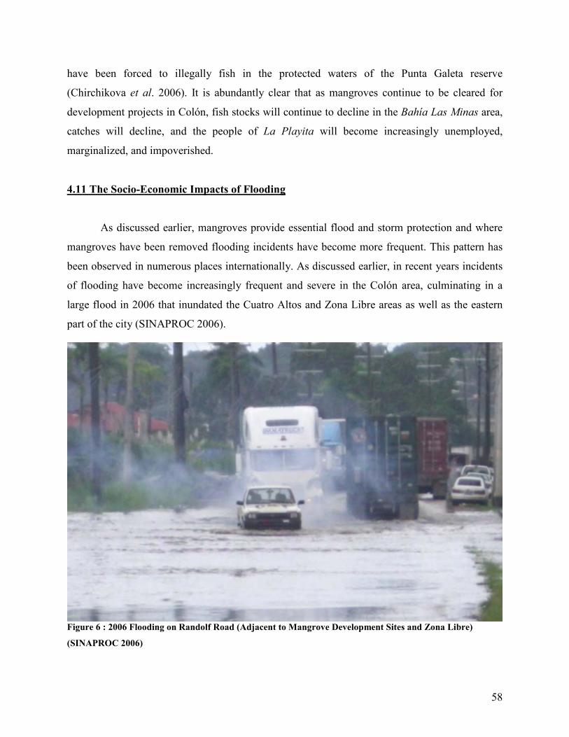
58
have been forced to illegally fish in the protected waters of the Punta Galeta reserve
(Chirchikova et al. 2006). It is abundantly clear that as mangroves continue to be cleared for
development projects in Colón, fish stocks will continue to decline in the Bahía Las Minas area,
catches will decline, and the people of La Playita will become increasingly unemployed,
marginalized, and impoverished.
4.11 The Socio-Economic Impacts of Flooding
As discussed earlier, mangroves provide essential flood and storm protection and where
mangroves have been removed flooding incidents have become more frequent. This pattern has
been observed in numerous places internationally. As discussed earlier, in recent years incidents
of flooding have become increasingly frequent and severe in the Colón area, culminating in a
large flood in 2006 that inundated the Cuatro Altos and Zona Libre areas as well as the eastern
part of the city (SINAPROC 2006).
Figure 6 : 2006 Flooding on Randolf Road (Adjacent to Mangrove Development Sites and Zona Libre)
(SINAPROC 2006)

59
Although the socio-economic impacts of these floods have not been extensively
examined or studied it is certain that they have had high economic and social costs. In the 2006
flood, for example, approximately 1,750 people were affected, most of whom suffered as a result
of property damage. The vast majority of these people were poor or lower middle class
individuals without insurance or the means to cope with the economic losses associated with
flooding (Reliefweb 2006; SINAPROC 2006). As a result, the flooding in Colón has caused
widespread suffering and has had significant unstudied social impacts. While the blame for any
natural disaster cannot be entirely placed on anthropogenic changes, it seems obvious that in a
city that is mostly below or just above sea level, with a semi-functional drainage infrastructure,
in one of the rainiest regions of the world, that the removal of natural storm management systems
without any prior study is dangerous. There is no doubt that the deforestation of mangroves east
of the city is at least partially responsible for the flooding of the last decade. As deforestation
continues (accompanied by erosion) it is very likely that flooding in Colón will intensify and the
poor will continue to bear the burden of ecological mismanagement. This is especially likely
given that large sections of the city and la Zona Libre are only 1 meter above sea level, as shown
in Figure 7 and Appendix I.

60
Figure 7 : Areas With Elevation of 0 to 1 meter (Red Dots)
4.12 Punta Galeta, Aesthetics, and Spiritual Impacts
As discussed earlier, the development projects will have a detrimental impact on the
Punta Galeta Protected Landscape and its scientific and educational programs. The existence of
this research center directly contributes to the education of thousands of elementary aged school
children, university students, researchers, and professional scientists. While it is clear that the
educational and scientific activities of the Punta Galeta Protected Landscape have definite socio-
economic value in terms of the creation and dissemination of knowledge, the integrity of this
protected area also has significant aesthetic and spiritual values. Thousands of people visit this
protected area every year as tourists, for recreation, and for spiritual reasons. This, in itself,
implies that the protected area has a high use value in terms of aesthetics, recreation, and
The City of Colón
La Zona Libre

61
spirituality. As revealed by the Coco Solo surveys (discussed earlier), the people who live closest
to the mangroves highly value the aesthetic and spiritual qualities of the area. While these values
are difficult to quantify due to their particular nature, they are none-the-less important and have
been completely disregarded by the environmental impact statements submitted by CCT and
MIT.
4.13 Conclusion: Socio-Economic Impacts
From this analysis it should be clear that the development projects will have a variety of
direct and indirect socio-economic impacts, nearly none of which have been addressed by the
CCT and MIT environmental impact statements. As revealed by the survey results of this study,
the people of Coco Solo Norte have not been consulted about the development projects and the
majority of the community is very worried about how the development will impact their
precarious social condition. In particular, these projects threaten to remove significant cultural,
economic, and psychological resources from the Coco Solo Norte community without any
guarantee of compensation or employment. The results of this study indicate that the people of
Coco Solo Norte are very concerned about the development projects while simultaneously being
completely excluded from any planning or consultation.
The results of this analysis reveal that there is a strong chance that indirect socio-
economic impacts will be felt outside of the development area. In particular, the decline in
fisheries that result from mangrove deforestation is likely to negatively impact the poor fishing
community of La Playita while the continued flooding of Colón disproportionately affects the
poor, causing significant social and economic damage. Lastly, the degradation of the aesthetic,
spiritual, scientific, and educational values associated with the Punta Galeta Protected Landscape
is disconcerting and completely ignored.
In conclusion, it is clear that significant socio-economic impacts will be created by the
development projects and that nearly none of these have been considered in the CCT and MIT
environmental impact statements. These impacts are very serious and the development projects
should not be allowed to continue until the full range of socio-economic impacts is considered in
an honest and transparent manner.

62
5.0 Development Alternatives
Given the potentially high environmental and social impacts of the development projects,
alternative development sites, modes of development, and methods of development planning
should be examined. In this section alternative development sites, modes of development
(ecotourism), and alternative methods of development planning (the MA Framework) are
discussed.
5.1 Alternative Development Sites
There are several potentially feasible sites in the vicinity of MIT and CCT which could
be used for port expansion projects and specifically the construction of the planned container
storage yards. As shown in Appendix I, Figure 4, there are several large sections of cleared land
east of La Zona Libre de Colón and the Manzanillo International Terminal which are not
currently being utilized. Because these lands are already cleared and are now occupied by
anthropogenic grasslands without human habitations, they could potentially be used for container
storage yard development, greatly reducing the social and environmental impact of the
developments.
5.2 Ecotourism
In an effort to alleviate unemployment and stimulate economic development in the Colón
region, considerable effort and investment has been directed towards the development of the
city’s tourism industry, including the cruise ship oriented Colón 2000 project. The development
of Colón’s tourism industry is a major part of the current government’s national development
plan (Fenix Panama 2004). However, tourism development projects have had mixed success in
the city and it remains primarily a retail stopover point for tourist transiting the canal. The city’s
reputation for crime, poverty, and the lack of cultural and environmental attractions limits the
development of tourism in the area.
The potential for ecotourism in the Bahía Las Minas mangroves was explored in detail by
a 2006 McGill University internship researcher group. The conclusion of their analysis was that

63
significant potential for ecotourism exists in the Bahía Las Minas mangroves due to high
aesthetic and biodiversity values, the diversity of the landscape, its proximity to the area’s major
attraction - Isla Grande, as well as the support capabilities of Punta Galeta. Furthermore, their
investigation revealed that ecotourism in the Bahía Las Minas area has the potential to protect
the environment while simultaneously having significant social and employment related benefits
for La Playita and Colón. Lastly, the 2006 investigation found that investment costs (training and
capital investment) to establish preliminary tourism activities (boat tours) would be relatively
low with a high developmental payoff. Consultations with ANAM, IPAT, and regional tour
operators revealed significant interest in the project (Chirchikova 2006).
While it is clear from the 2006 McGill report that there is significant potential for
ecotourism development in the Bahía Las Minas area, no ecotourism developments have yet
been proposed in the area, despite the central government’s Colón tourism development
initiative. Prior to the continuation of the port expansion other development initiatives with a
high developmental and sustainability potential, such as ecotourism, should be considered.
5.3 Alternative Methods of Development Planning
The CCT and MIT development projects were planned without any input or consultation
from many of the key stakeholders affected by the projects, including the people of Coco Solo
Norte, the staff of Punta Galeta, and various relevant sections of the government. During any
future rounds of development planning or negotiations concerning the MIT and CCT projects, a
fully democratic, inclusive, and social just planning process should be employed. This is
necessary to ensure that the citizens and institutions affected by development projects are
consulted during the planning process in order to guarantee that the true impacts of the
development are properly assessed. In the case of the CCT and MIT developments important
stakeholders in the development area, including members of relevant government departments,
staff from Punta Galeta, community members from Coco Solo Norte, and representatives from
CCT and MIT should meet and discuss the development plans in a participatory and inclusive
manner. This will help identify the true costs and benefits of the development projects, avoid
long term conflict, and ensure that the development projects serve the broader interest of
Panamanian society. Many frameworks and processes exist that allow for inclusive and

64
participatory negotiation processes. One way of creating a participatory, socially just, and
democratic negotiation and planning process is through the implementation of a Millennium
Ecosystem Assessment Framework. This framework is discussed in detail in Appendix IV and
applied to the Bahía Las Minas situation theoretically.

65
6.0 Recommendations
When undertaking large scale development ventures in populated zones bordering
ecologically sensitive areas, special care and attention must be accorded to ensure the project is
planned in an environmentally sound and socially just manner. While this report is by no means
exhaustive, several serious socio-economic and ecological impacts have been identified which
need to be addressed.
Owing to the anticipated social and ecological impacts, the undemocratic nature of the
planning process, and the many failings of the environmental impact statements filed at ANAM
the authors of this report recommend the following actions:
• Revoke all construction permits within the Bahía Las Minas mangroves until proper
assessments have been filed and the projects have been adequately reevaluated by a non
biased third party. This would include:
o A resubmission of the environmental impact studies conducted in a more
rigorous, honest, and scientific fashion.
• Alternatives must be considered fully including:
o Alternative development sites
o Alternative modes of development (ie. capitalizing on tourist influx in the Zona
Libre to promote mangrove ecotourism)
• Planners need to reassess and develop a land use and conservation plan for the region
prior to continued construction. Such a plan would need to emphasize ecosystem
services, conservation in the mangroves, and rezoning of land.
o To this end, a reevaluation of current zoning laws is required as there is currently
no provisioning for the protection of mangroves, ecosystem services, and
conservation. Land use plans must emphasize the conservation of remaining
mangroves.
• Planning approaches that incorporate public participation and highlight the importance of
ecosystem services for the human populations are essential when assessing the value of
habitats threatened by construction. For this reason, the authors recommend the use of an
inclusive and progressive planning framework, such as the Millennium Ecosystem
Assessment (MA) framework (see Appendix IV).
66
7.0 Conclusion
In recent years the potentially harmful effects of economic development have become
apparent in the Republic of Panama and concern is growing over the long term social and
environmental implications of the nation’s development policies. Since 1969 almost 71% of
Panama’s Caribbean mangrove forest cover has been lost, with a corresponding loss of
approximately 56% nationally. This is of great concern given the vital ecological role that
mangrove forests play and their high value in terms of ecosystem services. As mangroves
disappear from Panama, so too do the ecosystem services that they provide. These include such
things as spawning grounds for commercial fish, storm and flood barriers, water and air
filtration, habitat for biodiversity, erosion stabilization and coastline control, aesthetics, tourism,
and cultural values.
Rapid deforestation has occurred in the mangroves of Bahía Las Minas (north east of
Colón) in order to make room for the expansion of la Zona Libre de Colón, its associated port
facilities (Colón Container Terminal and Manzanillo International Terminal), and elements of the
now defunct Multi-Modal Project (including Panama Railway yard and France Field Airport
expansions). Despite very serious environmental and social concerns, and evident negative
consequences (such as flooding in the city of Colón), deforestation in the Bahía Las Minas
mangroves continues. At present both Colón Container Terminal (Evergreen Marine
Corporation) and Manzanillo International Terminal (Stevedoring Services of America) plan port
expansions that will result in the clearing of 18.2 ha and 12 ha of virgin mangrove respectively.
In addition, much larger Panama Railway expansion and France Field Airport expansion projects
are being discussed.
The authors of this report have generated a situation analysis examining the Bahía Las
Minas mangroves, the development projects, and their environmental impact studies. In addition,
the researchers have conducted their own environmental and social impact assessments and
generated several alternative development options and recommendations.
In our research we have found that the environmental impact assessments filed by Colón
Container Terminal and Manzanillo International Terminal were far from comprehensive, they
lacked scientific credibility and professionalism, they were highly biased, and at times blatantly
dishonest. Our report highlights the numerous and widespread environmental and social impacts

67
associated with these development projects, including losses in the ecosystem services discussed
above, as well as impacts specific to this region. Regional impacts include the potential for the
release of toxic sediments sequestered in the mangroves, diminishing value for the scientific and
educational activities of Punta Galeta, and severe socio-economic impacts for the adjacent
impoverished community of Coco Solo Norte.
As a result of these findings, the authors of this report have recommended that:
• All construction permits for projects in the Bahía Las Minas mangroves be revoked until
proper assessments have been filed and the projects has been adequately reevaluated by a
non biased third party.
• The impact assessments be redone in a more rigorous and scientific fashion.
• Consideration be given to development alternatives (alternate sites/ecotourism).
• Planners reassess and develop a land use and conservation plan for the region
emphasizing ecosystem services, conservation in the mangroves, and rezoning of land.
• Governmental agents and project planners make use of a public participatory approach to
development planning such as the Millennium Ecosystem Assessment Framework.
All of these points are discussed in more detail throughout the report. With the impending
expansion of the Panama Canal and the rapid development of the Republic of Panama, the nation
is at a critical point in its history. For the first time Panama is in a position to independent
determine its own economic, social, and ecological future. The people of Panama must decide
whether their country will be more than a canal and its associated industries. Going into the next
century, will Panama be a nation of beauty, cultural diversity, and justice or will it become
consumed by its own narrow developmental aspirations? The choices that are made today will
shape the country in the years to come.

68
Works Cited
ANAM (2005) Ley No 41 de 1 Julio de 1998 por cual se dicta la ley general de ambiente de la
Republica de Panama. ANAM, Panama City. Austin, H.M. (1971) A survey of the ichthyofauna of the mangroves of western Puerto Rico
during December 1967- August 1968. Caribbean Journal of Science, 11, 427-455. Badola, R. & Hussain, S.A. (2005) Valuing ecosystem functions: an empirical study on the storm
protection function of Bhitarkanika mangrove ecosystem, India. Environmental
Conservation, 32(1), 85-92. DOI: 10.1017/S0376892905001967. Barbier, E. (2006) Do mangroves reduce expected storm damages? Valuing the storm protection
service of coastal wetlands. University of Wyoming, Department of Economics and Finance.
Burns, K.A., Garrity, S.D. & Levings, S.C. (1993) How many years until mangrove ecosystems
recover from catastrophic oil spills? Marine Pollution Bulletin, 26(5), 239-248.
Burns, K.A., Garrity, S.D., Jorissen, D., Macpherson, J., Stoelting, M., Tierney, J. & Yelle- Simmons, L. (1994) The Galeta oil spill II: Unexpected persistence of oil trapped in mangroves sediments. Estuarine Coastal and Shelf Science, 38, 349-364.
Burns, K.A in press. Hydrocarbon chemistry. In Long-term assessment of the oil at Bahía Las
Minas, Panamá. (B.D. Kellar & J.B.C. Jackson, eds.). US Department of the Interior, Minerals Management Service, New Orleans.
Business Panama (2007) Port and maritime industries. Business Panama: Panama. Retrieved
February 1, 2007 from <http://www.businesspanama.com/investing/opportunities/ports _maritime.php>
Chirchikova, M., Chaussard, M. & Low-Décarie, E. (2006) The fishermen of La Playita, Colón.
Ecotourism in threatened coastal ecosystems. Punta Galeta Marine Laboratory, Colón. Chong, J. (2005) Protective values of mangrove and coral ecosystems: A review of methods and
evidence. IUCN, Gland, Switzerland. Corredor, J.E., Morell, J.M., & DeCastillo, C.E. (1990) Persistence of spilled crude oil in a
tropical intertidal environment. Marine Pollution Bulletin, 21, 385-388. Dahdouh-Guebas, F., Jayatissa, L.P., Di Nitto, D., Bosire, J.O., Lo Seen, D. & Koedam, N.
(2005) How effective were mangroves as a defense against the recent tsunami? Current
Biology, 15(12), 443-447.

69
Danielsen, F., Sorensen, M.K., Olwig, M.F., Selvam, V., Parish, F., Burgess, N.D., Hiraishi, T., Karunagaran, V.M., Rasmussen, M.S., Hansen, L.B., Quarto, A. & Suryadiputra, N. (2005) The Asian tsunami: A protective role for coastal vegetation. Science, 310, 643. DOI: 10.1126/science.1118387.
D’Croz, L. (1993) Status and uses of mangroves in the Republic of Panama. In Conservation and
sustainable utilization of mangrove forests in Latin America and Africa regions. Part 1-
Latin America. (L.D. Lecerda, ed.). International Society for Mangrove Ecosystems, Okinawa. 115-128.
De Troch, M., Mees, J., Papadopoulos, I., & Wakwabi, E.O. (1996) Fish communities in a tropical bay, Gazi Bay, Kenya: Seagrass beds vs. unvegetated areas. Netherlands Journal
of Zoology, 46(3-4), 236-252.
Duke, N.C. (1992) Mangrove floristic and biogeography. In Tropical Mangrove Ecosystems. Robertson, A.I. & Alongi, D.M. eds. American Geophysical Union: Washington. Pp.63-100.
Duke, N.C. & Pinzón, Z. (1993) Mangrove forest. In Long-term assessment of the oil spill at
Bahía Las Minas, Panamá. (B.D. Kellar & J.B.C. Jackson, eds.). US Department of the Interior, Minerals Management Service, New Orleans.
Duke, N.C., Pinzón, Z.S. & Prada, M.C. (1994) Los manglares. Scientia, 8(2), 80-98. Eamus, D., MacInnis-Ng, C.M, Hose, G.C., Zeppel, M.J., Taylor, D.T., & Murray B.R. (2005)
Ecosystem services: an ecophysiological examination. Australian Journal of Botany, 53, 1-19.
Earth Trends (2003) Biodiversity and protected areas – Panama Earth trends country profile.
Earth Trends. Retrieved April 22, 2007 from <http://earthtrends.wri.org/pdf_library /country_profiles/bio_cou_591.pdf>
Ellison, A.M. & Farnsworth, E.J. (1996) Anthropogenic disturbance of Caribbean mangrove
ecosystems: past impacts, present trends, and future predictions. Biotropica¸ 28(4), 549- 565.
Evergreen Marine Corporation (2006) Evergreen Corporate Profile. Evergreen Marine
Corporation, Cultural Development Division, Taipei, Taiwan. Retrieved February 10, 2007 from <http://www.evergreenmarine.com/tbi1/html/Corporate Profile.pdf>
FAO (2007) Panama fisheries sector overview. Food and Agriculture Organization of the United
Nations – Fisheries and Aquaculture Department. Retrieved March 19, 2007 from <http://www.fao.org/fi/website/FIRetrieveAction.do?xml=FICP_PA.xml&dom=countrysector&xp_nav=1>
Farnsworth, E.J. & Ellison, A.M. in press. Global patterns of pre-dispersal seed predation in
mangrove forests. Biotropica.

70
Feldheim, K.A. & Edren, S.M. (2002) Impacts of dredging on communities –the Bimini Lemon shark. Bahamas Journal of Science, 9(2): 28-36.
Fenix Panama (2004) Presentation by the Minister of Tourism of Panama, Ruben Blades, given
during the IV international tourism forum: Destination Panama, an agenda for the tourism industry. The Panamanian-American Chamber of Commerce, retrieved April 18, 2007 from <http://www.fenixpanama.com/tourism-panama.html>
Fondo, E. N. & Martens, E.E. (1998) Effects of mangrove deforestation on macrofaunal
Densities, Gazi Bay, Kenya. Mangroves and Salt Marshes, 2, 75-83. Food and Agriculture Organization of the United Nations (1969) Ubicación actual de los bosques
de Panamá. Proyecto de inventario y demostración forestal: Unpublished report. Garrity, S.D., Levings, S.C., & Burns, K.A. (1994). The Galeta Oil Spill. I. Long-term effects on
the physical structure of the mangrove fringe. Estuarine Coastal and Shelf Science, 38(4). Geocities (2007) Colón. Geocities. Retrieved February 2, 2007 from <http://www.geocities.com/
Colóncitypanama/> Gonneea, M.E., Paytan, A. & Herrerra-Silveira, J.A. (2004) Tracing organic matter sources and
carbon burial in mangrove sediments over the past 160 years. Estuarine and Coastal
Shelf Science, 61(2), 211-227. Google Maps (2007) Google map; Colón Area. Retrieved April 19, 2007 from
<http://maps.google.com/> Government of Panama (2006) Instrumentos para la gestion ambiental, Ley 41 de 1998.
Administradora General, Retrieved April 18, 2007 from <http://www.anam.gob.pa/pdf/ Rendicion%20de%20Cuentas%202006.pdf>
Granitsas, A. (2002) Taiwanese Shipping Concerns – Evergreen. Far East Economic Review,
October 24, 2002. Taipei and Hong Kong.
Green, Duncan (1996) Country profile: Panama. New Internationalist, May 1996. Retrieved February 2, 2007 from <http://findarticles.com/p/articles/mi_m0JQP/is_279/ai _30327101>
Gunawardena, W. & Rowan, J.S. (2005) Economic valuation of a mangrove ecosystem
threatened by shrimp aquaculture in Sri Lanka. Environmental Management, 36(4), 535- 550.
Guzmán, H.M. & Holst, I. (1993) Effects of chronic oil-sediment pollution on the reproduction
of the Caribbean reef coral Siderastrea siderea. Marine Pollution Bulletin, 26(5), 276- 282.
71
Guzmán, H.M. Jackson, J.B.C. & Holst, I. (1993) Changes recovery of subtidal reef corals. In Long-term assessment of the oil spill at Bahía Las Minas, Panamá. (B.D. Kellar & J.B.C. Jackson, eds.). US Department of the Interior, Minerals Management Service, New Orleans.
Harborne, A.R., Mumby, P.J., Micheli, F., Perry, C.T., Dahlgren, C.P., Holmes, K.E. &
Brumbaugh, D.R. (2006) The functional value of Caribbean coral reef, seagrass and mangrove habitats to ecosystem processes. Advances in Marine Biology, 50(50), 57-189.
Heck, K. L. (1977) Comparative species richness, composition, and abundance of invertebrates
in Caribbean sea-grass (Thalassia testudinum) meadows. Marine Biology, 41(4), 335- 348.
Heck, K. L. (1977) Habitat complexity and invertebrate species richness and abundance in
tropical sea grass meadows. Journal of Biogeography, 4(2), 135-142. Heckadon-Moreno, S. (2007) Personal Communication. Smithsonian Tropical Research
Institute, January 12, 2007. Hogarth, Peter (1999) The biology of mangroves. Oxford University Press: New York. Hunt, J., Wiesner, M., & Holmes C. (2005) Climate change, extreme events, and coastal cities:
conference report. Rice University: Houston. Retrieved February 1, 2007 from <http://cohesion.rice.edu/CentersandInst/ShellCenter/emplibrary/CoastalCities.pdf>
Immel, R. (1995) "Shhh...those peculiar people are listening." Smithsonian, 26(1), 151- 160. IUCN. (2007) IUCN redlist database. International Union for the Conservation of Nature.
Retrieved February 15, 2007 from <http://www.iucnredlist.org/search> Jackson, E. (2002) Colón voices concerns about the project. Panama News, 8(3). Retrieved
March 27, 2007 from <http://www.thepanamanews.com/pn/v_08/issue_03/news_01. html>
Jelbart, J.E., Ross, P.M. & Connolly, R.M. (2007) Fish assemblages in seagrass beds are
influenced by the proximity of mangrove forests. Marine Biology, 150(5), 933-1002. Kaplan, R. (2001) The nature of the view from home. Environment and Behavior, 33(4), 507-
542. Kathiresan, K. & Rajendran, N. (2005) Coastal mangrove forests mitigated tsunami. Estuarine
Coastal and Shelf Science, 65, 601-606.
Kavaler, L. (1975) Noise: the new menace. The John Day Company, New York.
72
Kieckbusch, D.K., Koch, M.S., Serafy, J.E. & Anderson, W.T. (2004) Trophic linkages among primary producers and consumers in fringing mangroves of subtropical lagoons. Bulletin of Marine Science, 74(2), 271-285.
Krause, B. (1993) "The niche hypothesis." The Soundscape Newsletter, June 6, 1993. L.L. and O. Company (December 2005) Estudio de impacto ambiental – Categoria II –
Ampliación del patio de contenedores en Coco Solo Norte – polígono no.2, area no.2, y area no.3. Colón Container Terminal, Resolución IAR 026-99.
L.L. and O. Company (March 2006) Estudio de impacto ambiental – Categoria II – Ampliación
del patio de contenedores en Coco Solo Norte – polígono no.2, area no.2, y area no.3. Colón Container Terminal, Resolución IAR 026-99.
Levings, S.C., Garrity, S.D., & Burns, K.A. (1994) The Galeta oil spill. III. Chronic reoiling,
long-term toxicity of hydrocarbon residues and effects on epibiota in the mangrove fringe. Estuarine Coastal and Shelf Science, 38(4), 365-395.
Louis, M. & Guyard, A. (1982) Contribution a l’étude des pueplements ichtyologiques dans les
mangroves de Guadeloupe (Antilles, Francaises). Ecological Bulletins, 13, 9-24. Marshall, M.J., Keller, B.D., Jackson J.B.C, Batista, V. & Matías, D. (1993) Subtidal seagrass
communities. In Long-term assessment of the oil spill at Bahía Las Minas, Panamá. (B.D. Kellar & J.B.C. Jackson, eds.). US Department of the Interior, Minerals Management Service, New Orleans.
Marx, J.M. & W.F. Herrnkind. (1986) Species profiles: life histories and environmental
requirements of coastal fishes and invertebrates (South Florida) – spiny lobster. U.S. Fish
and Wildlife Service, Biological Report 82(11.61). U.S. Army Corps of Engineers, TR-EL-82-4.
Massel, S.R., Furukawa, K. & Brinkman, R.M. (1999) Surface wave propagation data in
mangrove forests. Fluid Dynamics Research, 24, 219-249. Mazda, Y., Wolanski, E., King, B., Sase, A., Ohtsuka D. & Magi M. (1997) Drag force due to
vegetation in mangrove swamps. Mangroves and Salt Marshes, 1, 193-199. Mazda, Y., Magi, M., Nanoa, H., Kogo, M., Miyagi, T., Kanazawa, N. & Kobashi, D. (2002)
Coastal erosion due to long-term human impact on mangrove forests. Wetlands Ecology
and Management, 10, 1-19. Ministry de Vivienda (1996) Mapa No 3 plan general de usos del suelo del area del canal región
del Atlántico. Ministry de Vivienda, Panama City.

73
MMLC (2002) The zona libre multimodal logistics center. Multi-Modal Logistics Center.
Retrieved March 23, 2007 from <http://www.zonalibredeColón.com.pa/sec05/compone ntes04.htm>
Molles, M.C. (2005) Ecology: Concepts and applications. McGraw Hill Higher Education, New
York.
Monterossa, O.E. (1991) Postlarval recruitment of the spiny lobster, Panulirus argus (Latreile), in southwestern Puerto Rico. Eds. G.T. Waugh and M.H. Goodwin. In “Proceedings of the Fortieth Annual Gulf and Caribbean Fisheries Institute, Caracao” 40, 434-451.
Nagelkerken, I., Van der Velde, G., Gorissen, M.W., Meijer, G.J., Van’t Hof, T. & Den Hartog, C. (2000) Importance of mangroves, sea grass beds and shallow reefs as nursery for important coral reef fishes; Using a visual census technique. Estuarine, Coastal and
Shelf Science, 51, 31-44.
Phillips, P.C. (1981) Diversity and fish community structure in a Central American mangrove embayment. Revista de Biología Tropical, 29, 227-236.
Pinto, L & Punchihewa, N.N. (1996) Utilization of mangroves and seagrasses by fishes in the
Negombo Estuary, Sri Lanka. Marine Biology, 126(2), 333-345. Punta Galeta Marine Laboratory. (2003) Informe del primer dia de la biodiversidad celebrado en
la Republica de Panama. Smithsonian Tropical Research Institute, Panama City. Quarto, Alfredo (1997) The mangrove forest, background paper. RAMSAR convention on
wetlands: Gland, Switzerland. Retrieved February 1, 2006 from <http://www.ramsar.org /about/about_mangroves_2.htm>
Radle, A. L. (2007) The effect of noise on wildlife: A literature review. University of Oregon.
Retrieved February 17, 2007 from <http://interact.uoregon.edu/medialit/wfae/readings /radle.html>
Reliefweb (2006) Mil 750 personas afectadas aproximadamente por inundaciones en Colón.
Reliefweb, December 8, 2006. Retrieved March 25, 2007 from <http://www.reliefweb .int/rw/RWB.NSF/db900SID/VBOL-6WDH4H?OpenDocument>
Robertson, A.L. & Duke, N.C. (1990) Mangrove fish-communities in tropical Queensland, Australia: Spatial and temporal patterns in densities, biomass and community structure. Marine Biology, 104(3), 369-379.
Ronnback, P., Troell, M., Zetterstrom, T., & Babu, D.E. (2003) Mangrove dependence and socio-economic concerns in shrimp hatcheries of Andhra Pradesh, India. Environmental
Conservation, 30(4), 344-352. DOI: 10.1017/S0376892903000365.

74
SINAPROC (2006) Inundaciones en la provincia de Colón. SINAPROC, September 15, 2006. Retrieved March 19, 2007 from <http://www.sinaproc.gob.pa/index.php?option=com content&task=view&id=521&Itemid=1>
Singer, J.E. (1976) Social and psychological impact of transportation noise. The Journal of the
Acoustical Society of America, 59(S1), S38-S39. Smithsonian Tropical Research Institute (2006) Galeta. Smithsonian Tropical Research Institute,
Panama. Retrieved February 2, 2007 from <http://www.stri.org/english/visit_us/galeta/>
Smithsonian Institute (2007) The history of the Smithsonian. Smithsonian Institute, Washington. Retrieved February 2, 2007 from <http://www.si.edu/about/history.htm>
Smithsonian Tropical Research Institute (2007) About us. Smithsonian Tropical Research
Institute, Panama. Retrieved February 2, 2007 from <http://www.stri.org/english/ about_stri/index.php>
Sousa, W.P. in press. Mangrove forest structure and associated edaphic conditions at Punta
Galeta on the Caribbean coast of Panama. Department of Integrative Biology, University
of California, Berkeley. Sousa, W.P. & Mitchell, B.J. (1998) The effect of seed predators on plant distributions: is there a
general pattern in mangroves? Oikos, 86(1), 55-66. Stoner, A.W. (1988) A nursery ground for four tropical Penaues species: Laguna Joyuda, Puerto
Rico. Marine Ecology, 42, 133-141. Thampanya, U. Vermaat, J.E., Sinsakul, S. & Panapitukkul, N. (2006) Coastal erosion and
mangrove progradation of Southern Thailand. Estuarine Coastal Shelf Science, 68, 75-85. The Manzanillo International Terminal. (2007) The Company. Manzanillo International
Terminal. Retrieved February 9, 2007 from <http://www2.mitpan.com/en/TheCompany/ History/tabid/226/Default.aspx>
The Wall Street Journal (2005) Shipping brief – Evergreen group: Shipping unit receives fine for
discharging oil waste. The Wall Street Journal, April 5 2005. New York.
Thomas, G. (2007) Personal Communication. Smithsonian Tropical Research Institute, March 1, 2007. U.N. Environment Program (2005) After the tsunami: Rapid environmental assessment report.
UNEP, Nairobi. Retrieved March 5, 2007 from <www.unep.org/tsunami/reports> Valiela, I., Bowen, J.L. & York, J.K. (2001) Mangrove forests: One of the world’s threatened
major tropical environments. Bioscience, 51(10), 807-815.
75
Vargas, J.J. (July 2005) Estudio Categoria II Proyecto de Ampliación del Puerto de Manzanillo. Manzanillo International Terminal, RUC 8-194-829-D.V.08.
Wilkie, M., & Fortuna, S. (2003) Status and trends in mangrove area extent worldwide – Forest
resources assessment working paper - 63. Forest Department, Food and Agriculture
Organization of the United Nations: New York.
World Resources Institute (2000) World resources 2000-2001: People and ecosystem – the fraying web of life. UNDP: Washington. pp. 400.

76
Appendix I – Maps
Figure 8 : Bahía Las Minas Area and Development Sites (Google 2007)
8
8 La Zona Libre refers to La Zona Libre de Colón, CCT refers to Colón Container Terminal (Evergreen), MIT refers to Manzanillo International Terminal. Development sites (shown in red boxes) are approximations of the size and shape of the development sites and should not be considered exact. Dark green areas are mangrove forest cover.
CCiittyy ooff
CCoollóónn MMIITT
CCCCTT
RRaannddoollff RRooaadd
GGaalleettaa RRooaadd
MMIITT SSiittee
CCCCTT SSiittee
LLaa ZZoonnaa
LLiibbrree
CCooccoo SSoolloo
NNoorrttee
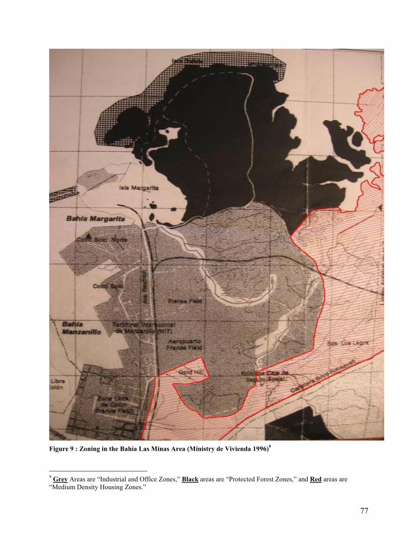
77
Figure 9 : Zoning in the Bahía Las Minas Area (Ministry de Vivienda 1996)
9
9 Grey Areas are “Industrial and Office Zones,” Black areas are “Protected Forest Zones,” and Red areas are “Medium Density Housing Zones.”

78
Figure 10 : Multi-Modal Project Master Plan (MMLC 2002)

79
Figure 11 : Areas with Elevation of 0 to 1 meter (Red Dots)
The City of Colón
La Zona Libre

80
Appendix II – Personal Interviews
• Dr. Stanley Heckadon-Moreno; Dr. Heckadon-Moreno is an expert in Panamanian
history, environmental issues, and agriculture. He has worked for a variety of
Panamanian environmental and agricultural organization for over 30 years and is
currently the Director of the Punta Galeta Marine Laboratory and manager of the Punta
Galeta Reserve. Dr. Heckadon-Moreno was consulted regarding various issues related to
the Punta Galeta Reserve.
• Gabriel Thomas is a nature guide working in the Punta Galeta Laboratories education
program and is currently in a biology program at the University in Colón. Gabriel is from
the nearby Coco Solo Norte community and was interviewed informally about his
community.

81
Appendix III – Coco Solo Survey
ENCUESTA
Colón Container Terminal esta haciendo una proyecto de desarrollo para hacer un patio de contenedores en frente de la comunidad de Coco Solo. Este cuestionario se trata de eso. 1) Edad _____ Sexo_____ 2) Hizo Colón Container Terminal alguna consulta a ti ó a tu familia acerca de este proyecto? Sí____ No____ 3) Te preocupa el desarrollo de este proyecto? Porque? Sí____ No____ ________________________________________________________________________________________________________________________________________________________________________________________________________________________________________________________________________________________________ 4) Visitas o utilizas los manglares de Coco Solo para algo? ____para madera ____metal, chatarra ____para comida ú otros productos del bosque ____para recreación ____para trabajo Otro:___________________________________________________________________________________________________________________________________________________________________________________________________________________ 5) Crees que la tala de los manglares va a beneficiar a la comunidad de Coco Solo Norte? Si su respuesta es sí: como? ________________________________________________________________________________________________________________________________________________________________________________________________________________________ ________________________________________________________________________ Si su respuesta es no, porque?_________________________________________________________________________________________________________________________________________________________________________________________________________________________________________________________________________________________

82
6) Estas trabajando con Colón Container Terminal, Manzanillo Internacional Terminal ú otra empresa relacionado a la Zona Libre de Colón? _______Si Nombre de la empresa: ___________________ _______No _______Esta desempleado Colón Container Terminal propuso dos obras a ANAM que fueron aprobados recientemente. En total la compañía va a cortar 18.2 hectáreas de manglares para la creación de dos grandes patios de contenedores. CCT estima que un área de 47.2 hectáreas van a ser afectadas. Colón Container Terminal estima que este desarrollo va a producir 50 trabajos durante la construcción de manera no permanente y 10 trabajos después de la construcción. También, Manzanillo Internacional Terminal va a cortar unas otras 12 hectáreas de manglares para la construcción de otro patio de contenedores, al lado del patio de contenedores de CCT. Porque los Manglares son Importantes:
-Son una guardería por gamba, langosta y pequeños peces -Funciona como barrera natural contra las tormentas, vientos fuertes y maremotos -Limpia el aire y purifica las aguas -Sirve como casa para muchas especies de animales amenazadas -Previne la erosión de la costa y el levantamiento del nivel del mar
7) Antes de conocer esta información usted pensaba que lo que estaba realizando la empresa CCT era: ____Excelente ____Bueno ____Neutral ____ Malo ____ Desastroso 8) Sabía usted de lo que estas empresas estaban haciendo o alguna persona había discutido con usted acerca de otras alternativas para la utilización de los manglares? Sí____ No____ 9) Esta información cambia tu opinión sobre el desarrollo del proyecto? Sí____ No____ En una manera positiva________ o negativa?___________ Otro Comentarios? ________________________________________________________________________________________________________________________________________________________________________________________________________________________________________________________________________________________________________________________

83
Appendix IV – The Millennium Ecosystem Assessment
Introduction
In anticipation of the widening of the Panama Canal and increased canal traffic, major
port expansions continue in the Colón area. Currently both the Manzanillo International
Terminal (Stevedoring Services of America) and the Colón Container Terminal (Evergreen
International Corporation) are undergoing major expansion programs while expanded airport
facilities at Frances Field Airport and rail yard developments for the Panama Canal Railway have
also been proposed in the Colón area (Business Panama 2007). Despite their large scale, the
socio-economic and environmental impacts of these development projects have not been
substantially studied. In particular, questions regarding the impacts of these developments on the
mangrove ecosystems and the impoverished people of Colón have not been answered.
In the environmental and socio-economic impact study conducted by internship
researchers at the Punta Galeta Marine Laboratory it was found that the environmental impact
statements submitted by Colón Container Terminal (CCT) and Manzanillo International
Terminal (MIT) had many scientific flaws, that they failed to address the full range of social and
environmental issues associated with the project, that they were very dishonest in their
assessment and project planning, and that the development plans were created without consulting
the local community. As a result, the researchers have recommended that all construction in the
Bahía Las Minas mangroves be suspended and re-evaluated. The internship researchers believe
that this action must be taken to ensure the environmental sustainability and social justice of the
project, and in order to alleviate mounting tension between the Coco Solo Norte Community,
environmental groups, MIT, CCT, the Smithsonian Punta Galeta research site, and the
Panamanian government. In order to avoid confrontation and resolve these issues justly and
equitably, a consultative and transparent planning process must be implemented prior to the
resumption of construction in the ecologically and socially sensitive areas. Therefore, the
internship researchers have recommended that a socially and environmentally comprehensive
assessment framework be implemented in order to evaluate the development projects.
The Millennium Ecosystem Assessment framework provides a structure for open public
participation and discussion which can be implemented to address these controversial issues. In

84
this section the potential implications of a Millennium Ecosystem Assessment are discussed as
an example of a consultative planning process which could be implemented in the mangroves of
Bahía Las Minas.
The Millennium Ecosystem Assessment
Given the controversial and highly political nature of the proposed development projects,
a comprehensive and collaborative ecological and social assessment is needed which is mindful
of its own legitimacy and credibility. The Millennium Ecosystem Assessment framework, which
was developed in order to conduct the international Millennium Ecosystem Assessment, is a
framework that is capable of meeting these goals by following principles of transparency,
inclusiveness, consensus building, and objectivity. In essence, implementing an MA framework
assessment would involve meetings with all of the relevant stakeholders to discuss the
controversial issues surrounding the project, to identify our current state of knowledge regarding
the projects and their impacts, and to agree on a consensus based solution to the problems
associated with the project. This section provides some of the background information that
would be needed to conduct a full ecosystem assessment addressing the MIT and CCT expansion
projects that affect the mangroves of Bahía Las Minas and the community of Coco Solo Norte.
For ease of presentation, the major elements of the MA framework have been divided into six
distinct steps.
Step 1: Organization and Identifying Assessment Goals
In Step 1, the assessment facilitators need to outline their organizational goals, core
principles, identify who should be involved in the assessment, and assess the availability of
resources and limits of the assessment. While the facilitators initiate these preliminary decisions,
goals and participants can be changed at a later date once stakeholder participation is initiated.
• Core Principles: The core principles of our assessment are to maintain credibility,
legitimacy, and relevance.
• Who To Involve: The facilitators believe it is important to involve a variety of
stakeholders in the consultation process. Each party should be consulted equally and
85
suggestions for the inclusion of other stakeholders can be tabled during the consultation
process. In this way stakeholder involvement can be equitable and comprehensive. The
initial group of stakeholders should include:
o The Community of Coco Solo Norte
o The Punta Galeta Research Staff
o A representative from ANAM
o Representatives from the Evergreen (CCT) and Manzanillo (MIT) corporations
o Representatives from la Zona Libre de Colón
o Representatives from the Maritime Authority of Panama
o Relevant governmental representatives (ex. Urban Planning, ANAM)
• Available Resources: The facilitators can identify a variety of resources that are
immediately available for the consultation and assessment process. These include:
o The ecology, biology, and climatology research of the nearby Smithsonian Punta
Galeta research site. Through the Smithsonian this consultative process has access
to very high quality scientific expertise, monitoring data, and research.
o Contacts in the Coco Solo Norte Community, the Smithsonian, ANAM, the
Manzanillo corporation, at the Maritime Authority of Panama, and other
governmental offices.
o What is lacking: Contacts at the Evergreen corporation and clear economic
valuations for the mangroves. Up to date information concerning current
mangrove coverage in the area is also lacking.
• The Limits of the Project: The geographic limits of this examination are:
o The Bahía Las Minas Mangroves (including its historic range, ie. la Zona Libre)
o Areas impacted by those mangroves including surrounding coral reefs, sea grass
beds, la Zona Libre de Colón, and the community of Coco Solo Norte. The zone
of indirect influence must be extended as well to include areas inhabited by
species such as crabs, shrimp, lobster, and fish which use these mangrove
ecosystems as nursery habitats and later disperse.
• Potential Conflicts: From the outset it is possible to identify several potential conflicts
among stakeholders. First and foremost, it is likely that the community of Coco Solo
Norte, environmental groups, and many of the scientists of Punta Galeta will feel

86
animosity towards Evergreen, Manzanillo, and members of the Panamanian government
(and vice versa). This arises from the fact that these groups have been in conflict over the
development issue. In addition, it is possible that power disparities will exist between the
highly educated and experienced representatives of Punta Galeta and the corporations, as
they compare to the people of Coco Solo Norte (for example). Both of these issues can be
addressed by promoting a non-confrontational consultation process and by enforcing a
consultation process that values the opinions of all stakeholders. This will require careful
management by the facilitators.
Step 2: Identifying Needs and Goals
In Step 2 the stakeholders are assembled and consultations begin. The first step of this, by
necessity, involves the sharing of knowledge. Stakeholder groups present their knowledge of the
development project and express their individual goals for the development process. It is
expected that this process will produce the following results:
• The goal of Evergreen and Manzanillo is economic expansion achieved through port
development. They would like to build container storage patios in the mangroves.
• The goal of governmental representatives: To provide the greatest good to the populous
while working within national initiatives and policies. They would like to achieve this by
balancing developmental and environmental needs.
• The goal of Coco Solo Norte: To protect the mangroves of Bahía Las Minas and the
ecosystem services that they rely on while also finding ways to relieve rampant
unemployment and poverty.
• The goal of Punta Galeta scientists: To protect the natural environment and maintain their
research activities.
Once the individual goals of group participants are known the group can work towards
defining more fundamental common goals such as human wellbeing, environmental health, and
economic development.

87
Step 3: Identifying Ecosystem Service Dependencies and Impacts
Once knowledge sharing is complete, the goals of the individual stakeholders are known,
and some common goals have been agreed to, the ecosystem services that the proposed
development projects are dependent on, and those that they will impact, can be identified.
Ecosystem services are those services and products created by natural ecosystems which directly
benefit humankind. These services have measurable economic value and include such things as
clean water, clean air, raw materials, food, habitat, etc. (Eamus et al. 2005). The MA assessment
framework is designed to address ecological problems from the ecosystem services approach and
so it is very applicable in this case. Mangroves are known to have very high ecosystem services
values providing such essential and valuable ecosystem functions as spawning grounds and
habitat for commercially important fish species (Nagelkerken et al. 2000; Feldheim & Edren
2002), flood and storm protection (Mazda et al. 1997; Massel et al. 1999; Chong 2005), erosion
control and coastal stabilization (Fondo & Martens 1998; Mazda et al. 2002), and water filtration
(Nagelkerken et al. 2000). In addition, the mangroves of Bahía Las Minas contain significant
biodiversity (Punta Galeta Marine Laboratory 2003), they have considerable scientific, aesthetic
and educational value (STRI 2006; Heckadon-Moreno, personal communication, January 12,
2007), and they provide a source of subsistence income, food, and resources for the people of
Coco Solo Norte (see survey results). Lastly, the mangroves of Bahía Las Minas have
sequestered large amounts of toxic chemicals that were released into the area as a result of an oil
spill in 1986. These substances have been safely sequestered by mangrove sediments but will be
re-released into the environment as a result of deforestation with very severe environmental
consequences (Duke & Pinzon 1993; Guzman & Holst 1993; Marshall et al. 1993; Burns et al.
1994; Garrity et al. 1994; Levings et al. 1994). It is clear that the mangroves have considerable
value in terms of ecosystem services; this value expands exponentially when associated
ecosystems are also considered, particularly sea grass beds and coral reefs (Gunawardena &
Rowan 2005).
Knowing this, it is the expectation of the facilitators that the consultation process will reveal the
following ecosystem service dependencies:
• The Evergreen and Manzanillo development projects will be dependent on erosion
control, drainage control (water regulation), and storm protection.

88
• The Coco Solo Norte Community is dependent on a wide variety of ecosystem services
provided by the mangrove forests including aesthetic values, air quality, desalination,
natural hazard regulation, spiritual and religious values, water provisioning, water
regulation, and wild foods.
• The Punta Galeta Marine Laboratory is also dependent on a wide variety of ecosystem
services provided by the mangroves including aesthetic values, air quality, biodiversity,
climate regulation, education, erosion regulation, genetic resources, natural hazard
regulation, nutrient cycling, photosynthesis, primary production, scientific values, soil
formation, tourism, toxic sediment sequestration, water cycling, water provisioning, and
water regulation.
Furthermore, it is expected that the consultation process will find that the development
projects have the potential to impact a variety of ecosystem services which are currently
provided by the mangrove forests. These include aesthetic values, air quality, biodiversity,
capture fisheries, climate regulation, desalination, education, erosion regulation, genetic
resources, natural hazard regulation, nutrient cycling, photosynthesis, primary productivity,
scientific value, soil formation, spiritual and religious value, timber, tourism, toxic sediment
sequestration, water cycling, water provisioning, water regulation, and wild foods. Each of these
ecosystem services will need to be addressed during the assessment. In this case trade-offs
between different ecosystem services do not exist as the development projects seek to eliminate
all ecosystem services by completely clearing and paving over the mangrove forests. If the
development projects remain in their original form then economic resources and employment
would completely replace the ecosystem services listed here. While this trade off is tangible, the
distribution of benefits from this development must be addressed. The foreign interests of CCT
and MIT will control the profits collected from the proposed projects with little foreseen
redistribution of benefits to surrounding communities. However, the majority of the cost of
ecosystem alteration (erosion, degradation of fisheries, coastal oiling, flooding, reduction in
water quality, etc) will be borne by the people of the Caribbean coast of Panama, specifically in
the Colón area. The long term economic benefit to this community is expected to consist of 20
manual labor positions. Clearly, significant issues of equity surround this project and its benefits
are expected to be concentrated in the hands of a few wealthy and foreign individuals.
89
Step 4: Identifying Drivers of Change and Trends
In Step 4 the stakeholder group will attempt to identify the drivers of change affecting the
ecosystem services provided by the Bahía Las Minas mangroves. It is the expectation of the
facilitators that several drivers of change will be discussed by the stakeholder group. These
include:
• Economic Development: Economic Development in the Bahía Las Minas mangroves is
the principle driver of change. Specifically, expansions of la Zona Libre de Colón, the
CCT and MIT port facilities, and the expansion of the Colón multi-modal project are the
main causes of ecosystem alteration in the region. These projects are driven by the desire
to promote economic development, to alleviate unemployment, and to prepare for the
canal expansion. Trends: It is likely that economic development in the region will slow
once the canal related expansion projects are completed.
• Several secondary and less significant drivers of change affect the Bahía Las Minas
mangroves. These include population growth in the city of Colón, climate change
(perhaps more relevant in the future), and the building of the Panama City –to- Colón
highway. Trends: It is likely that population growth will continue in Colón and its
nearby communities with the completion of the highway and that the impact of climate
change will intensify. Population growth may result in further deforestation.
With the drivers of change identified, trends in specific ecosystem services can be
evaluated. It is expected that consultations with the stakeholder group and the scientists of Punta
Galeta will highlight trends in the availability of ecosystem services. As discussed in Stage 3,
mangrove ecosystems provide a variety of ecosystem services and the conversion of mangrove
forest into industrial activities over the last century in the Bahía Las Minas mangroves has
resulted in a steep decline in the provisioning of ecosystem services. Scientists working at the
Punta Galeta Marine Laboratory believe that while ecosystem services have declined in the area,
sufficient mangrove cover has survived to maintain ecosystem services in a functional state.
However, there is considerable concern that deforestation in the region is reaching a critical
threshold and that the ability of the remaining mangroves to maintain ecosystem services and
harbor biodiversity is becoming increasingly threatened (Duke et al. 1994; Heckadon-Moreno,
personal communication, January 12, 2007). Based on the work of the internship researchers,

90
which included an extensive literature review of the scientific work conducted at Punta Galeta
(as discussed earlier), it is expected that the stakeholder group will articulate the trends in
ecosystem services shown in Tables 4 and 5.
Table 4 : Trend Symbol Legend
Trend Prior to
Development*
Anticipated Effect
of Development**
Impact Level*** Remediation****
Neutral �
Neutral �
� Small Degradation with cumulative relevance at regional scales only
☺ Reversible without remediation
Increasing �
Increasing �
� Degradation of Ecosystem Function with no replacement required
� Reversible with remediation
Increasing Rapidly
�
Increasing Rapidly
�
� Severe Degradation of Ecosystem Function with partial replacement required
� Irreversible despite remediation
Decreasing �
Decreasing �
� Cessation of Ecosystem Function with full replacement required
Decreasing Rapidly
�
Decreasing Rapidly
�
� Severe Degradation or Cessation of Ecosystem Function with no replacement possible
Unknown ? Unknown ?
*Pre-development trends refer to the trend in the ecosystem service in the last 20 years. These trends were driven primarily by the conversion of mangrove forest into industrial space for la Zona Libre de Colón, CCT, MIT, and the Colón multi-modal project. **Post development trends refer to trends in the ecosystem services that are expected to occur as a result of the current CCT and MIT expansion plans. ***Impact level refers to the scale of the impact (resulting from the proposed developments) and the consequential need for ecosystem service substitution or replacement through artificial means. ****Remediation/Reversibility refers to the ability to remediate or reverse the environmental impact at a reasonable cost.

91
Table 5 : Ecosystem Services Trend Summary
Ecosystem Services Pre-Development
Trend
Post-Development
Trend
Impact Level Reversibility/
Remediation
Aesthetic Values � � � � Air Quality � � � � Biodiversity � � � � Capture Fisheries � � � � Climate Regulation � � � � Desalination ? � � � Economic
Development* � � NA NA
Education � � � � Employment* � � NA NA Erosion Regulation � � � � Genetic Resources � � � � Natural Hazard
Regulation � � � �
Nutrient Cycling � � � � Photosynthesis � � � � Primary
Productivity � � � �
Scientific Value � � � � Soil Formation � � � � Spiritual and
Religious Value � � � �
Timber � � � � Tourism � � � � Toxic Sediment
Sequestration � � � �
Water Cycling � � � � Water Provisioning ? � � � Water Regulation ? � � � Wild Foods � � � �
*Economic Development and Employment were added to highlight the benefits of the developments. These are not ‘ecosystem services.’
92
Step 5: Detailed Ecosystem Service Assessment and Related Topics
Following the identification of trends in ecosystem services, it is expected that it will
become clear that significant issues exist with certain ecosystem services and that more detailed
evaluations will be required in some areas. It is the expectation of the facilitators that Stage 5 of
the consultation will produce the following results:
• Services Needing Detailed Assessment: The services most in need of detailed
assessment are those which are likely to have the greatest social and environmental
impact and/or those which have not been extensively studied in the Bahía Las Minas
area. Capture fisheries declines have already been observed in the Colón area and so the
effect that continued deforestation will have on this critical industry is of paramount
importance and needs to be examined in detail (Chirchikova et al. 2006). Furthermore,
the occurrence and severity of flooding events in the city of Colón has been increasing
for at least 10 years and so erosion regulation, natural hazard regulation, and water
regulation all need to be examined in greater detail (Reliefweb 2006; SINAPROC 2006).
• Substitution and Remediation: As shown in Table 5, it is expected that the focus group
will find that most ecosystem services can be substituted but that nearly none can be
remediated or reversed at reasonable costs. This is due to the complete nature of the
habitat alteration, as the forest is being completely converted into paved industrial areas.
In essence, this project represents a complete trade-off between natural values and
industrial economic development. As such, remediation and reversibility in the future is
highly unlikely and would be prohibitively expensive for most services. The most
difficult services to substitute are biodiversity (especially important for the scientific,
education, and tourism activities of Punta Galeta), capture fisheries, genetic resources,
natural hazard regulation, toxic sediment sequestration, and water regulation. In addition,
the cultural services offered by the mangroves will be impossible to replace. Because
development projects have been degrading these services in the Bahía Las Minas area
without any replacement plans, the decline in these services has already had significant
impacts.
• Future Trends: While it is difficult to evaluate the future trends in the area it is expected
that continued economic development and unemployment will maintain political pressure
93
for the conversion of mangroves to other economic uses. However, as the population of
Colón increases it is also highly likely that the need for ecosystem services will continue
to increase and that the rationale for conservation and sustainable management will
become salient. A major unknown factor in the future is the impact of climate change in
the mangroves as this has not been extensively studied in the region. Furthermore, if
attempts to promote ecotourism in the mangroves are successful then this could
significantly alter the economic situation of the area. Unanticipated synergistic effects
may also hamper the adequacy of future visions. For example, the creation of jobs in the
Zona Libre is likely to attract far more people to the area in search of employment than
the region will actually employ or be able to support. It is unknown how they will use
ecosystem services or how this additional stress may affect resources.
Step 6: Risks and Information Gaps
There are several risks and information gaps associated with the proposed development
projects that the facilitators expect the stakeholder group will identify in Step 6. These include:
• Risks: Loss of natural hazard protection, erosion regulation, and water regulation
increase the risk of disasters such as storm damage, flooding, and landslides. The loss of
mangroves also increases the risks of the release of sequestered toxic sediments and the
disappearance of biodiversity. As the effects of climate change intensify, it is likely that
these risks will amplify.
• Regime Shifts: The potential for sudden and possibly irreversible regime shifts exists in
the mangrove ecosystems and its associated habitats. There is a real risk that continued
deforestation will limit habitat size below what is required by many of the resident
species, thus reducing biodiversity (Heckadon-Moreno, personal communication, January
12, 2007). A similar phenomenon could be experienced in the fisheries which are
supported by the mangrove forests. Again, it is possible that if breeding habitat is reduced
below a threshold level that commercially important fish stocks will suddenly crash.
• Information Gaps: Due to the high scientific capacity of the Punta Galeta Marine
Laboratory most of the information that is needed for the assessment already exists or can
be quickly assembled. However, there are major information gaps that could be addressed
94
by Smithsonian scientists. It would be useful to know the impact that deforestation has
had on the fisheries of Colón and recent flooding events in the city, the impact of climate
change in the future, and the economic feasibility of alternative development projects (ie.
ecotourism).
Conclusions
Once the six steps of the assessment are completed the stakeholders will have the
background information that they require to negotiate an equitable, socially just, efficient, and
sustainable solution to the development controversy. In reality, this type of assessment and
planning process can only be implemented if the stakeholders are willing to step beyond the
politics of confrontation and find compromises that respect the needs of other stakeholders and
the natural environment. In the case of the Bahía Las Minas mangroves the biggest obstacle to
finding a sustainable and equitable solution to the developmental conflict is the stakeholders
themselves. If the people of Colón, the Panamanian government, and the stakeholders in the
Bahía Las Minas area are truly committed to achieving sustainability and social justice, then a
considerable change in management practices and managerial attitudes is necessary. The
successful implementation of an MA ecosystem assessment would be a step in the right
direction.


![Papers on Ancient Egypt - excavacionegipto.com · [ 250 ] tua del difunto, acompañado por su esposa y/o por uno o sus dos progenitores. No en vano, el difunto, al ser enterrado siguiendo](https://img.pdfslide.us/doc/110x75/5bff189b09d3f2be278bd042/papers-on-ancient-egypt-250-tua-del-difunto-acompanado-por-su-esposa.jpg)