Embed Size (px)
Citation preview
FINAL DAMAGE ASSESSMENT AND RESTORATION PLAN and
ENVIRONMENTAL ASSESSMENT for the
FEBRUARY 2, 2005, M/V CAPE FLATTERY GROUNDING
at KALAELOA, BARBERS POINT OAHU
Prepared by:
The Natural Resource Trustees for the M/V Cape Flattery Grounding, Oahu Hawaii
U.S. Department of Commerce
National Oceanic and Atmospheric Administration
U.S. Department of the Interior U.S. Fish and Wildlife Service
State of Hawaii
Department of Land and Natural Resources
1
CONTENTS List of Figures ............................................................................................. Error! Bookmark not defined.
1.0 INTRODUCTION: PURPOSE OF AND NEED FOR RESTORATION ................................................. 4
1.1 INTRODUCTION ..................................................................................................................................... 7
1.2 PURPOSE AND NEED ........................................................................................................................... 9
1.3 NATURAL RESOURCE TRUSTEES AND AUTHORITIES ......................................................... 9
1.4 OVERVIEW OF LEGAL AUTHORITIES ........................................................................................... 9
1.4.1 Oil Pollution Act of 1990 & Its Implementing Regulations ............................................ 10
1.4.2 National Environmental Policy Act (NEPA) ......................................................................... 11
1.4.3 Relationship Between NRDA and NEPA ................................................................................ 12
1.5 COORDINATION WITH THE RESPONSIBLE PARTY .................................................................. 12
1.6 PUBLIC PARTICIPATION....................................................................................................................... 13
1.7 ADMINISTRATIVE RECORD .................................................................................................................. 14
1.8 SUMMARY OF THE NATURAL RESOURCE DAMAGE CLAIM ................................................... 14
2.0 AFFECTED ENVIRONMENT ....................................................................................................................... 15
2.1 GENERAL DESCRIPTION ........................................................................................................................ 15
3.0 INJURY DETERMINATION AND QUANTIFICATION ......................................................................... 19
3.1 DESCRIPTION OF THE GROUNDING AND RESPONSE ACTIVITIES .................................... 19
3.2 PREASSESSMENT APPROACH ............................................................................................................ 22
3.3 SUMMARY OF PREASSESSMENT ACTIVITIES .............................................................................. 23
3.4 ASSESSMENT APPROACH AND RESULTS ....................................................................................... 23
3.4.2 SUMMARY OF INJURY DATA AND RESULTS ....................................................................... 26
3.4.3 RECOVERY PROJECTIONS ............................................................................................................ 30
4.0 RESTORATION PLANNING .................................................................................................................. 35
4.1 RESTORATION STRATEGY and Proposed action .................................................................. 35
4.1.1 Proposed action ............................................................................................................................... 36
4.2 EVALUATION CRITERIA .................................................................................................................. 36
4.3 EVALUATION OF NO ACTION ALTERNATIVE ........................................................................ 38
4.4. EVALUATION OF PRIMARY RESTORATION ALTERNATIVES ............................................... 39
4.4.1. Preferred Primary Restoration Alternative 1: Monitored Natural Recovery with the Possibility of Adaptive Management ........................................................................................... 39
4.4.2 Considered but Rejected Primary Restoration Alternatives .................................... 41
4.5 ENVIRONMENTAL IMPACTS OF PREFERRED COMPENSATORY ALTERNATIVES ....... 44
2
4.5.1 Preferred Compensatory Restoration Project 1: Coral Rescue In Kaneohe Bay .... 44
4.5.2 Considered but Rejected Compensatory Restoration Projects ..................................... 49
4.6 RESTORATION MANAGEMENT OUTLINE ..................................................................................... 51
4.6.1 Budget ................................................................................................................................................... 51
4.6.2 Adaptive Project Management ................................................................................................... 52
5.0 COORDINATION WITH OTHER PROGRAMS, PLANS, AND REGULATORY AUTHORITIES ......................................................................................................................................................... 53
5.1 OVERVIEW ................................................................................................................................................ 533
5.2 KEY STATUTES, REGULATIONS AND POLICIES ........................................................................ 533
6.0 LIST OF AGENCIES AND PERSONS CONSULTED………………………………...…………………57
APPENDIX ONE ....................................................................................................................................................... 58
APPENDIX TWO ………………………………………………………...……….……………………...…………………62
3
LIST OF FIGURES
Figure 1. Map showing the grounding site for the M/V Cape Flattery. 5
Figure 2. Map of the Main Hawaiian Island chain, with the island of Oahu labeled and incident area shown. 14
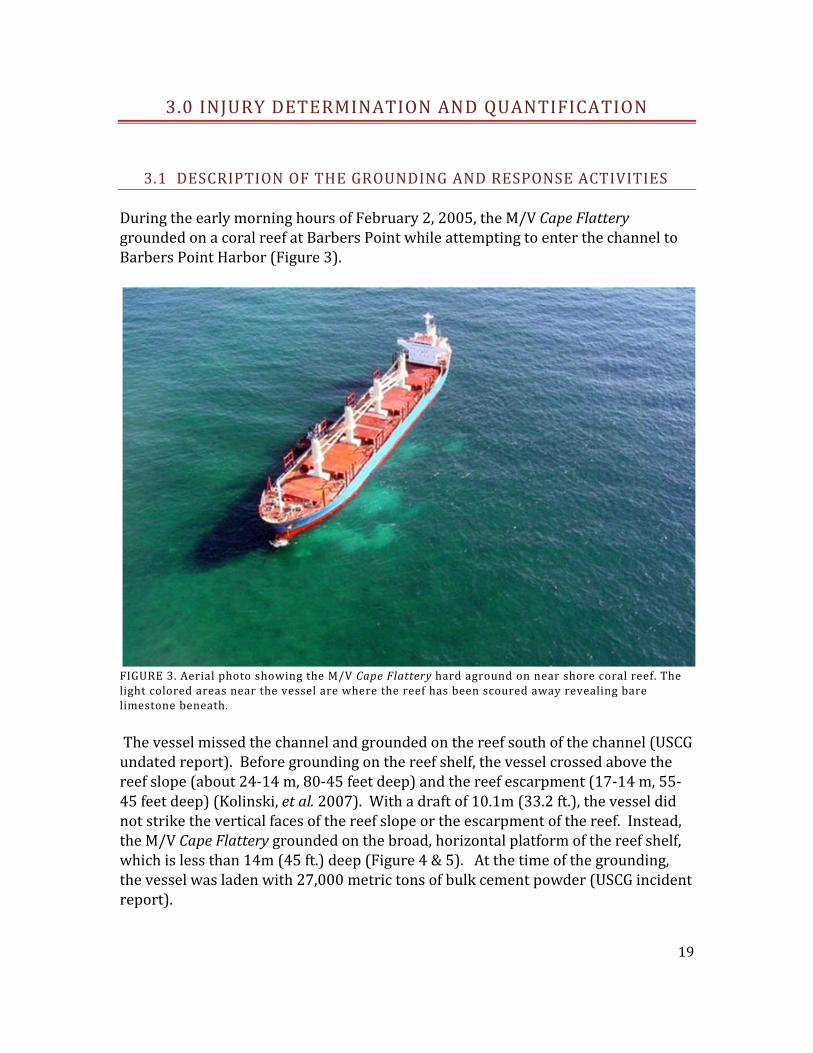
Figure 3. Aerial photo showing the M/V Cape Flattery hard aground on near shore coral reef. The light colored areas near the vessel are where the reef has been scoured away revealing bare limestone beneath. 17
Figure 4. Diagram of the reef structure and grounding position of the M/V Cape Flattery. 18
Figure 5. Aerial view of the hull impact (bare limestone) after the M/V Cape Flattery was towed off the reef. The light colored areas show the extent of the hull impact. The white object is a 8m (26 ft.) long vessel. The edge of the reef shelf (darker blue) can be seen in the top right corner. 18
Figure 6. A drag scar from the anchor and associated chain that was deployed from the M/V Cape Flattery and dragged along the reef. The light colored areas show the injury from the anchor and chain; unaffected coral can be seen to either side of the drag impact. 19
Figure 7. Aerial photo of the M/V Cape Flattery being lightered of its cement powder cargo. Cement can be seen spilling into the ocean. 20
Figure 8. Area of M/V Cape Flattery incident indicating general habitat zones. 22
Figure 9. Coral community composition represented as average number of attached colonies m-2 in reference, non-hull impact and hull-impact areas of the shelf pavement zone. Figure from Kolinski et al. (2007) 26
Figure 10. Projections of recovery of Montipora encrusting colony losses. Recovery of all size classes is expected to require 57 years. Figure from Kolinski (2007). 30
Figure 11. Projections of proportional recovery of estimated Porites encrusting colony losses. Figure from Kolinski (2007). 32
Figure 12. Projection of proportional recovery of coral colony losses within the M/V Cape 32
Figure 13. Map showing the location of Marker 12 reef (Primary) within Kaneohe Bay, Oahu. 43
Figure 14. Percent cover of invasive algae, coral and density of uchins (1/m2) over time at Reef 26. 44
4

Figure 15. Percent cover of invasive algae, coral and density of urchins (1/m2) over time at reef 27. 45
Figure 16. Percent cover of invasive algae and coral over time at reef 28 (R28). 45
Figure 17. Map of central Kaneohe Bay showing locations of Patch reefs 26, 27, and 28 where Supersucker activities have been monitored plus inset map of Oahu to show location of Kaneohe Bay activities. 46
5
LIST OF TABLES
Table 1 . Summary of projected loss/injury to coral functional groups by size category across habitat zones. Values in parentheses reflect estimates at α = 0.050 when estimates differ. Table from Kolinski et al. (2007). 25
Table 2. Summary of projected loss/injury of select macro-invertebrate and algae functional groups across habitat zones. Values in parentheses reflect estimates at α = 0.050 when estimates differ. Table from Kolinski et al. (2007). 25
Table 3. Fish species average abundance (numbers ha-1) at reference (Ref.), non-hull-impact (NHI) and hull-im(HI) sites within the shelf pavement zone. Mob. = mobility class. Table from Kolinski et al. (2007). 27
Table 4. Summary of live fragment estimates across habitat zones. Values in parentheses reflect estimates at α =0.050 when estimates differ. Table from Kolinski et al. (2007). 27
Table 5. Rates of growth for species injured at Barbers Point, Oahu (*estimate partially derived from values in literature; ** total proportion of species’ individuals within a species group as measured in pre-assessment reference transects, see Kolinski et al. 2007). 29
Table 6. Projections of proportional recovery of estimated Montipora encrusting coral losses by size category (represented by category size averages) (Table from Kolinski 2007). 30
Table 7. Projections of proportional recovery of estimated Porites lobate coral losses by size category (represented by category size averages). Table from Kolinski (2007). 31
6
1.0 INTRODUCTION: PURPOSE OF AND NEED FOR RESTORATION
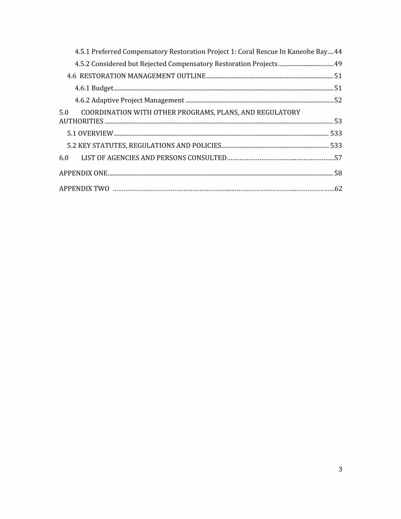
1.1 INTRODUCTION On February 2, 2005, the 555-foot bulk carrier M/V Cape Flattery grounded on coral reef habitat outside the entrance channel to Barbers Point Harbor, Oahu, Hawaii (Figure 1). Because of the substantial threat of a discharge of oil into navigable waters, the U.S. Coast Guard (USCG), State of Hawaii and Responsible Parties (RPs) developed a Salvage Operations Oil Spill Contingency Plan as part of an Incident Action Plan to provide direction for the response operations. Over the following days, responders offloaded fuel and cement cargo. Tugs and other vessels attempted to remove the M/V Cape Flattery from its grounded position and succeeded on February 11, 2005. Although cement cargo spilled into the water during offloading, no substantial discharge of oil to the environment occurred.
FIGURE 1. MAP SHOWING THE GROUNDING SITE FOR THE M/V CAPE FLATTERY. On February 11, 2005 a team of biologists from the State of Hawaii Department of Land and Natural Resources (DLNR), the National Oceanic and Atmospheric Administration (NOAA), and the U.S. Fish and Wildlife Service (USFWS) (collectively “Trustees” or Natural Resource Trustees) and the RPs began assessment activities, collecting direct physical evidence,
7
photo documentation, area measurements and recording observations to determine whether physical injury to natural resources, including coral reef habitat and its associated community, had occurred as a result of the grounding and response operations. The collective evidence and observations from the these activities confirmed that physical injury to coral reef habitats and resources resulting from M/V Cape Flattery stabilization and response activities was widespread (Kenyon 2005, Kolinski 2005a and b, Polaris Applied Sciences, Inc. 2005). The injuries to natural resources in the area included, but were not limited to, pulverized coral, sheared, shattered and overturned corals, scarring and limestone pavement fractures. The Trustees determined that additional actions to quantify and further document injury were necessary. The Trustees conducted initial injury quantification efforts using geo-referenced towed-diver photo documentation surveys on February 15, 2005, and continued initial quantification efforts between September 6 and November 30, 2005. The Trustees estimated that injuries to habitat and resources occurred across 79,085 square meters (7.91 hectares (ha), 19.5 acres) of coral reef. These areas sustained injuries as a result of the deployment and removal of the ship’s anchor and chain; movement of the vessel over nine days; use of tow lines that were not floated (creating a “weed whacker” effect on corals); and movement of Incident-generated rubble. Six habitat zones sustained injuries as a result of the grounding and response actions. The estimated injuries included the injury and/or loss of over one million corals, ranging in size from the barely visible to linear diameters exceeding 160 cm (62 in); 150,000 macro-invertebrates; and 5,000 square meters
(1.23 acres) of crustose coralline algae. The
Trustees observed other evidence of ecological loss associated with a large-scale impact. When compared to reference areas, the Trustees found higher levels of native turf and/or macroalgae, indicating successional colonization of physically altered substrate in late 2005 (dives between Sept. 6-Nov. 30, 2005). Average fish numbers tended to be lower at impact sites, with statistically significant displacement evident in the shelf pavement region. All habitat zones in the impact area displayed significantly higher live fragment levels than at similar reference sites. Preparation of this Damage Assessment and Restoration Plan and Environmental Assessment (DARP/EA) was needed to describe the incident and provide summarized information regarding 1) the environmental consequences of the grounding of the M/V Cape Flattery and the subsequent response activities (collectively “the Incident”), including the affected environment, 2) the determination and quantification of natural resource injuries, and 3) proposed natural resource restoration alternatives to address those injuries. This document also serves, in part, as the Federal Trustees’ compliance with the National Environmental Policy Act (NEPA) and Title 19, Chapter 343, of the Hawaii Revised Statutes (see Chapter 5 for additional information).
8
1.2 PROPOSED ACTION The Trustees propose to implement restoration alternatives for both primary restoration and compensatory restoration, and will rely on known restoration methods previously applied to other incidents, or to related natural resource recovery activities. The proposed primary restoration action is natural recovery and monitoring at the site of the incident with the possibility of adaptive management if natural recovery is not succeeding. The proposed compensatory restoration action is removal of large quantities of the alien algae Kappaphycus and Eucheuma species using a Super Sucker, combined with sea urchin outplanting, to prevent coral mortality in Kaneohe Bay, Oahu.
1.3 PURPOSE, AND NEED The purpose of the proposed action is to restore the affected area and injured resources impacted by the Incident, and to provide compensatory restoration to compensate for interim losses to the coral ecosystems of Oahu.
1.3 NATURAL RESOURCE TRUSTEES AND AUTHORITIES The DARP/EA has been prepared by the National Oceanic and Atmospheric Administration (NOAA), on behalf of the U.S. Department of Commerce; with the U.S. Fish and Wildlife Service (USFWS), on behalf of the U.S. Department of the Interior; and Department of Land and Natural Resources (DLNR), on behalf of the State of Hawaii as cooperating agencies. Each of these agencies acts as a Natural Resource Trustee pursuant to the Oil Pollution Act of 1990 (OPA), 33 U.S.C. §§ 2701 et seq.), the National Oil and Hazardous Substances Pollution Contingency Plan (NCP), 40 C.F.R. § 300.600, Executive Order (EO) 12777, 56 Fed. Reg. 54757 (Oct. 18, 1991) and Haw. Rev. Stat., Title 10, Ch. 128D. As a designated Trustee, each agency is authorized to act on behalf of the public under State and/or federal law to assess and recover natural resource damages and to plan and implement actions to restore natural resources and resource services injured or lost as the result of a discharge, or substantial threat of a discharge, of oil. The Trustees designated NOAA as Lead Administrative Trustee (LAT) (15 C.F.R. § 990.14(a)).
1.4 OVERVIEW OF LEGAL AUTHORITIES
9
1.4.1 OIL POLLUTION ACT OF 1990 & ITS IMPLEMENTING REGULATIONS Under OPA, Trustees can recover the cost of: primary restoration, which is any action, including natural recovery, that returns injured natural resources and services to baseline; compensatory restoration, which is any action taken to compensate for interim losses of natural resources and services that occur from the date of the incident until recovery; and reasonable assessment costs. OPA defines natural resources to include “land, fish, wildlife, biota, air, water, ground water, drinking water supplies, and other such resources belonging to, managed by, held in trust by, appertaining to, or otherwise controlled by the United States (including the resources of the exclusive economic zone), any State or local government or Indian tribe….” 33 U.S.C. § 2701(20); see also15 C.F.R. § 990.30. As described in the OPA Natural Resource Damages Assessment regulations (OPA regulations), a natural resource damage assessment (NRDA) consists of three phases – preassessment, restoration planning, and restoration implementation. The preassessment is an information gathering phase, during which the trustees determine whether they have jurisdiction to pursue restoration under OPA, and if so, whether it is appropriate to do so. Specifically, before initiating an NRDA, the trustees must determine that:
• an incident has occurred; • the incident is not from a public vessel; • the incident is not from an onshore facility subject to the Trans-Alaska Pipeline
Authority Act; • the incident is not permitted under federal, state or local law; and • public trust natural resources and/or services1 may have been injured as a result of
the incident.
Id. at § 990.41(a). If, based on information collected during the preassessment phase, the trustees make a preliminary determination that the conditions listed above are met, they will coordinate with response agencies (e.g., the USCG) to determine whether the oil spill response actions will eliminate the injury or the threat of injury to natural resources. If injuries are expected to continue and feasible restoration alternatives exist to address such injuries, the trustees may proceed with the restoration planning phase. Restoration planning also may be necessary if injuries are not expected to continue, but are nevertheless suspected to have
1 The OPA regulations define natural resource services as “functions performed by a natural resource for the benefit of another natural resource and/or the public.” 15 C.F.R. § 990.30. Examples of natural resource services include shelter for other species; food; recreation for humans such as diving or bird viewing.
10
resulted in interim losses of natural resources and/or services from the time of the incident until the time the resources recover. The purpose of the restoration planning phase is to evaluate the potential injuries to natural resources and services and to use that information to determine the need for and scale of associated restoration actions. This phase provides the link between injury and restoration and has two basic components – injury assessment and restoration selection. The goal of injury assessment is to determine the nature and extent of injuries to natural resources and services, thus providing a factual basis for evaluating the need for, type of, and scale of restoration actions. As the injury assessment is completed, the trustees develop a plan for restoring the injured natural resources and services. The trustees must identify a reasonable range of restoration alternatives, evaluate and select the preferred alternative(s), develop a draft restoration plan presenting the alternative(s) to the public, solicit public comment on the draft restoration plan, and consider those public comments when drafting the final restoration plan. During the restoration implementation phase, if the trustees and the responsible party (RP) have not already resolved the claim, the trustees will present the final restoration plan (a “demand”) to the RP either to implement or to fund the Trustees’ estimated costs to implement the restoration plan. The presentment provides the opportunity for settlement without litigation. Should the RP decline to settle, OPA authorizes trustees to bring a civil action against the RP for damages or to file a claim for these costs with the USCG’s Oil Spill Liability Trust Fund. Trustees may settle claims for natural resource damages under OPA at any time during the damage assessment process, provided that the settlement is adequate in the judgment of the trustees to satisfy the goals of OPA. The trustees should give particular consideration to the adequacy of the settlement to restore, replace, rehabilitate, or acquire the equivalent of the injured natural resources and services. Such settlements must be approved by a court as fair, reasonable, and in the public interest. Sums recovered in settlement of such claims, other than reimbursement of trustees’ assessment costs, may only be expended in accordance with a restoration plan, which has been made available for public review.
1.4.2 NATIONAL ENVIRONMENTAL POLICY ACT (NEPA) While OPA and its implementing regulations provide the underpinnings for the Trustees’ proposed restoration actions, another statute plays a critical role – NEPA, 42 U.S.C. §§ 4321, et seq. Congress enacted NEPA in 1969 to establish a national policy for the protection of the environment. NEPA requires an assessment of any federal action that may impact the environment. The Act establishes the Council on Environmental Quality (CEQ) to advise the President and to carry out certain other responsibilities relating to the implementation of NEPA by federal agencies. Pursuant to Executive Order 11514, federal agencies are required to comply with NEPA regulations adopted by CEQ. These regulations outline the responsibilities of federal agencies under NEPA and provide specific procedures for
11
preparing the environmental documentation necessary to demonstrate compliance with NEPA. Generally, when it is uncertain whether an action will have a significant effect on the quality of the human environment, federal agencies will begin the NEPA planning process by preparing an Environmental Assessment (EA). The EA may undergo a public review and comment period (see section 1.6). Depending on whether an impact is considered significant, the federal agency will either develop an environmental impact statement (EIS) or issue a finding of no significant impact (FONSI).
1.4.3 RELATIONSHIP BETWEEN NRDA AND NEPA NEPA applies to restoration actions undertaken by federal natural resource trustees. The Natural Resource Trustees for the Incident are integrating the OPA and NEPA processes in this DARP/EA. This integrated process allows the Trustees to meet the public involvement requirements of both statutes concurrently. This integrated process is recommended under 40 C.F.R. § 1500.2(c), which provides that federal agencies should “integrate the requirements of NEPA with other planning and environmental review procedures required by law or by agency practice so that all such procedures run concurrently rather than consecutively.” This document serves, in part, as the Federal agencies’ compliance with the National Environmental Policy Act (NEPA) and Title 19, Chapter 343, of the Hawaii Revised Statutes (see Section 5 for additional information). This DARP/EA complies with NEPA by 1) describing the purpose and need for restoration action in Chapter 1, “Introduction: Purpose and Need for Restoration”; 2) summarizing the current environmental setting in Chapter 2, “Affected Environment”; 3) identifying alternative actions and analyzing potential effects in Chapter 4, “Restoration Planning”; and 4) addressing the public participation requirements in Chapter 1.5, “Public Participation”. In regard to NEPA compliance for preparation of this DARP/EA, NOAA is the lead federal agency and will coordinate the public input. The public is invited to review and provide comments on the proposed restoration activities and the alternatives considered in this DARP/EA.
1.5 COORDINATION WITH THE RESPONSIBLE PARTY The OPA regulations direct trustees to invite the RP to participate in the damage assessment and restoration process. Although the RP may contribute to the process in many ways, final authority to make determinations regarding injury and restoration rests solely with the trustees. In this case, the Trustees and RP started informal cooperative assessment activities on February 11, 2005, when they began collection of direct physical evidence, photo
12
documentation, area measurements and recorded observations, to determine whether physical injury to natural resources, including coral reef habitat and its associated community, had occurred as a result of the grounding and response operations. The trustees conducted an initial injury quantification between September 6 and November 30, 2005. The RPs declined to participate in this initial quantification effort. In 2005, the trustees implemented emergency restoration activities to avoid irreversible losses and continuing danger to the coral reef benthic community. Although the RPs did not participate in the first round of emergency restoration, they did participate in a second round of emergency restoration, which began on July 6 and ended on July 24, 2006. During this effort, divers reattached an estimated 2000 corals and removed approximately 45 tons of loose reef material. To facilitate the NRDA for this Incident, the Trustees and the RPs executed the “Cooperative Natural Resource Damage Assessment Agreement for the M/V Cape Flattery Incident,” effective October, 20052 In this MOA, the Trustees and RPs agreed to attempt to perform an expedited assessment of damages in order to minimize assessment costs and to proceed with restoration as soon as possible. The RPs agreed to fund all reasonable costs of assessing injury, destruction or loss of natural resources or the services provided by those resources resulting from the Incident. Thereafter, the Trustees and the RPs continued to gather and analyze data and to exchange their interpretations of those data. Ultimately, they reached agreement on damages that the Trustees determined to be sufficient to compensate the public for the resources that had been injured as a result of the Incident.
1.6 PUBLIC PARTICIPATION In March of 2013 the Consent Decree was legally filed in the United States District Court, District of Hawaii. There was a 30 day public comment period between the filing and subsequent review of the consent decree. No comments were received. Public review of the DARP/EA is an integral component of the restoration planning process. Through the process of public review, the Trustees are seeking public comment on the alternatives being considered to restore injured natural resources or replace services provided by those resources, and on any other aspect of this DARP/EA. When preparing the final restoration plan, the Trustees will review and consider comments received during the public comment period. An additional opportunity for public review will be provided in the
2 Even though the Trustees and RPs began informal cooperative activities shortly after the Incident began, in their June 26, 2008, “Notice of Intent to Conduct Restoration Planning and Notice of Emergency Restoration Activities,” the Trustees extended an official invitation to the RPs to continue participation in the damage assessment, restoration planning and restoration implementation efforts.
13
event that the Trustees decide to make significant changes to the DARP/EA based on the initial public comments. Comments received during the public comment period will be considered by the Trustees before finalizing the document. Public review of the Damage Assessment and Restoration Plan and Environmental Assessment is consistent with all state and federal laws and regulations that apply to the natural resource damage assessment process, including Section 1006 of OPA, the regulations for Natural Resource Damage Assessment under OPA (15 C.F.R. Part 990), NEPA (42 U.S.C. §§ 4371, et seq.), and the regulations implementing NEPA (40 C.F.R. Part 1500, et seq.). Public comment was solicited in a number of ways. A notice of availability for comment on the DARP/EA was published in the local newspaper on 8/20/2014. This notice included links to the website hosting the full restoration plan as well as a mailing address, an email address, and a phone number to receive both written and verbal comments. The notice also advertised the two public meetings that were held to receive comments from the community. Two public meetings were held, one on 8/29/2014 at the University of Hawaii, West Oahu campus in Kapolei and the other on 9/8/2014 at the Heei’a learning center in Kaneohe. Both meetings were held between 4pm and 6pm. The public comment period was open from 8/20/2014 until 9/30/2014. There were no public comments received through any of the media or opportunities presented. No physical mail was received, no emails were received, no phone calls were received and no one attended either of the public meetings.
1.7 ADMINISTRATIVE RECORD The Trustees have compiled an administrative record, which contains documents considered or prepared by the Trustees as they have planned and implemented the NRDA and address restoration and compensation issues and decisions. The administrative record is available online at: http://www.darrp.noaa.gov/southwest/capeflattery/index.html. Although the record is still being updated, it presently contains the information that the Trustees relied upon to develop the proposed alternatives described in the DARP/EA. The administrative record facilitates public participation in the assessment process. This DARP/EA may also be viewed and downloaded at the website mentioned above.
1.8 SUMMARY OF THE NATURAL RESOURCE DAMAGE CLAIM
14
The NRDA damage claim for the Incident encompasses primary and compensatory restoration actions for injuries and potential injuries to the following natural resources and services:
• Coral colonies • Three dimensional reef structure • Reef habitat • Marine fish • Marine Invertebrates • Marine algal communities
The proposed primary restoration action is natural recovery and monitoring at the site of the Incident with the possibility of adaptive management if natural recovery is not succeeding. The proposed compensatory restoration action is removal of large quantities of the alien algae Kappaphycus/Eucheuma spp. to prevent coral mortality in Kaneohe Bay, Oahu. See Chapter Five for a discussion of these restoration actions.
2.0 AFFECTED ENVIRONMENT The purpose of this section is to provide a general description of the environment, which encompasses the geographic area where the incident occurred and where the Trustees conducted assessment activities related to the incident.
2.1 GENERAL DESCRIPTION The island of Oahu is located at roughly 21º 18' North Latitude and 158º 04' West Longitude between the islands of Kauai and Molokai along the Main Hawaiian Islands chain. The island is approximately 1572 km2 (607 square miles) in area. See Figure 2 below.
15
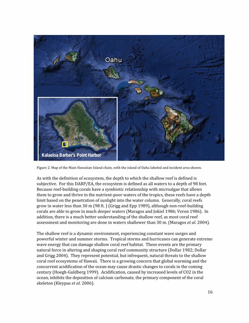
FIGURE 2. Map of the Main Hawaiian Island chain, with the island of Oahu labeled and incident area shown. The M/V Cape Flattery ran aground on the southwest shore of Oahu, Hawaii on a shallow water reef roughly 1220 meters (4000 ft.) south of the entrance channel to Kalaeloa Barber’s Point Harbor/Ko Olina Marina. Kalaeloa Barber’s Point is located on the southwest (leeward) side of Oahu approximately 32 km (20 miles) west of the city of Honolulu. The entrance channel services both the Ko Olina Marina, part of Ko Olina Resorts and Hotel to the north, as well as the Kalaeloa Barber’s Point Harbor and Campbell Industrial Park to the south. The Ko Olina Marina is a man-made basin created from excavating inland and later connecting to the ocean via the Kalaeloa Barbers Point deep draft harbor channel. The marina is roughly 18 ha. (44 acres) and is operated by the neighboring Ko Olina Resort and Marina. The marina has 330 full service slips and can accommodate large vessels up to 60 m (200 ft.) long with a draft of up to 4 m. (13 ft.) (AECOS, 2010). Kalaeloa Barbers Point deep draft harbor, to the south of the entrance channel, is approximately 58 ha (144 acres). The State of Hawaii's Harbors Division is the port authority for Kalaeloa Barbers Point Harbor. Kalaeloa Barbers Point Harbor contains several specialized cargo-handling facilities that are not available in nearby Honolulu Harbor. This commercial harbor services the adjacent Campbell Industrial Park, which houses a refinery, cement plant, as well as other industrial ventures. Figure 2. Map of the Main Hawaiian Island chain, with the island of Oahu labeled and incident area shown. As with the definition of ecosystem, the depth to which the shallow reef is defined is subjective. For this DARP/EA, the ecosystem is defined as all waters to a depth of 98 feet. Because reef-building corals have a symbiotic relationship with microalgae that allows them to grow and thrive in the nutrient-poor waters of the tropics, these reefs have a depth limit based on the penetration of sunlight into the water column. Generally, coral reefs grow in water less than 30 m (98 ft. ) (Grigg and Epp 1989), although non-reef-building corals are able to grow in much deeper waters (Maragos and Jokiel 1986; Veron 1986). In addition, there is a much better understanding of the shallow reef, as most coral reef assessment and monitoring are done in waters shallower than 30 m. (Maragos et al. 2004). The shallow reef is a dynamic environment, experiencing constant wave surges and powerful winter and summer storms. Tropical storms and hurricanes can generate extreme wave energy that can damage shallow coral reef habitat. These events are the primary natural force in altering and shaping coral reef community structure (Dollar 1982; Dollar and Grigg 2004). They represent potential, but infrequent, natural threats to the shallow coral reef ecosystems of Hawaii. There is a growing concern that global warming and the concurrent acidification of the ocean may cause drastic changes to corals in the coming century (Hoegh-Guldberg 1999). Acidification, caused by increased levels of CO2 in the ocean, inhibits the deposition of calcium carbonate, the primary component of the coral skeleton (Kleypas et al. 2006).
Kalaeloa Barber’s Point Harbor
16
The marine reef environment in this area is characterized by a limestone shoreline with an associated wave cut bench. Seaward of this bench, the bottom is characterized by a broad submerged reef platform spanning more than 1220 m (4000 ft.) in width in some areas. This reef platform ranges between 9-15 m (30 to 50 ft.) in depth and gives way to a slope that descends steeply to depths of 18-24 m (60 to 80 ft.) and deeper. In some areas, this slope gives way to ledges and near vertical drop-offs (Bienfang and Brock, 1980). The reef habitat and coral species display distinct zonation patterns with depth and distance from shore. The shoreline in the area consists of limestone rock that gives way to a wave cut bench in the intertidal zone. This feature is covered with a narrow strip of calcium carbonate beach in some areas with narrow dunes shoreward (AECOS, 1991). This limestone face makes direct access to the ocean difficult but does support recreational angling near the harbor entrance channel. The wave cut bench environment supports several species of algae as well as the black rock boring urchin Echinometra oblonga. (AECOS, 1991). The notable higher densities of fleshy algae along this wave cut bench are attributed to high light levels, protection from herbivorous fish (due to the bench’s intertidal nature),and increased access to nutrients from groundwater percolating through the porous limestone strata (McDermid, 1988; AECOS, 1991). Fish abundance and diversity are low in this area and consist mostly of members of two families, the Gobiidae and Blennidae (Parry, pers obs). Directly offshore, the limestone bottom is characterized by surge channels perpendicular to shore, scour holes, and pockets of sand (AECOS, 1991b; Brock 1987). This zone is roughly 2-5 m (6 to 15 ft.) deep and extends 30-90 m (100 to 300 ft.) from shore in places (Bienfang and Brock 1980). This high wave energy habitat zone supports several types of lower growth forms of coral such as Porites lobata and thicker forms of branching species like Pocillopora meandrina (AECOS, 1991b). Sea urchins such as Echinometra mathei (pale rock boring urchin), E. oblonga, and Heterocentrotus mammillatus (slate pencil urchin) are present, and algae species in the area are fairly numerous and diverse (see Brock, 1987). Due to the relative lack of three dimensional habitat, fish abundance and diversity are low. Representative species include Abudefduf abdominalis (sergeant major) and Cantherhines dumerilii (barred filefish) as well as others (USFWS, 2007). Seaward of this low relief inshore area, roughly 90-900 m (300 to 3000 ft.) or more from shore and 5-9 m (15 to 30 ft.) of water, the overall habitat complexity increases. This area is characterized by high vertical relief and high coral cover (Bienfang and Brock, 1980). Large lobate forms of coral such as Porites lobata are common with uniquely large colonies being present. Large colonies of P. lobata (2-3m (6 to 10 ft.) in diameter) have been reported in this area (AECOS, 1985 & 1991). Other common coral species include Pocillopora meandrina as well as various Montipora sp. Sea urchins such as Tripneustes gratilla (collector urchin), Echinothrix diadema (blue black urchin), Echinometra mathaei (pale rock boring urchin) and Echinostrephus aciculatum( (needle spine urchin) also are present. Common fish species found in this area include the surgeonfishes Acanthurus nigrofuscus (brown surgeonfish), Ctenochaetus strigosus (spotted surgeonfish), as well as the wrasse Thalassoma duperrey (saddle wrasse) (AECOS, 1991; USFWS, 2007)
17
Further offshore, roughly 900-1100m (3000 to 3500 ft.) from land and 9-12 m (30 to 40 ft.) deep, the bottom is characterized by low relief and lower coral cover. The habitat consists of flat hard “table-like” bottom with numerous shallow (2-6 m, 5 to 10 feet) deep rubble filled depressions (AECOS, 1991; Bienfang and Brock, 1980; Kolinski et al., 2007). Coral species in the area consist predominantly of Porites lobata, which are found at highest densities on the edges of the depressions. Chelonia mydas (green sea turtle) are common in the area as are Stenella longirostris (Hawaiian spinner dolphin), although the dolphins appear to mostly transit through the area. Echinometra mathaei (pale rock boring urchin) are found in the area, and juvenile fishes are concentrated around and within the depressions. The “table-like” formation gradually slopes offshore to depths of roughly 15 m (50 feet) where coral abundances increase on the edge of a rapidly sloping bottom feature. The top edge of this slope supports higher coral abundances and species than the inshore flat section. Corals in the areas include Pocillopora meandrina, P. eydouxi, Montipora sp., as well as Porites lobata and others (Kolinski et al., 2007). Urchin diversity increases in this zone as well with Tripneustes gratilla, Echinothrix diadema, Echinometra mathaei and Echinostrephus aciculatum all present in the area. The limestone shelf (which includes all the previously discussed habitats) transitions roughly 4000 feet offshore into ledges and drop-offs that descend steeply to depths of 25 m (80 ft.) or more. The slope terminates at a bottom of sand and scattered rubble with isolated coral and limestone outcrops (Kimmerer and Durbin, 1975). Coral is predominantly Porites lobata and Montipora sp. Sand areas appear to be fairly heavily colonized by Halophila decipiens (seagrass that is a known forage species for Hawaiian Green sea turtles, Chelonia mydas; Russell et al. 2003), Caulerpa sp. (a green algae), and the non-indigenous algae Avrainvillea amadelpha (mud weed) (Kolinski et al., 2007). The sand rubble habitat slopes offshore into deeper waters and transitions out of the near shore reef habitat into deeper waters (greater than 30 m, 100 feet).
18
3.0 INJURY DETERMINATION AND QUANTIFICATION
3.1 DESCRIPTION OF THE GROUNDING AND RESPONSE ACTIVITIES During the early morning hours of February 2, 2005, the M/V Cape Flattery grounded on a coral reef at Barbers Point while attempting to enter the channel to Barbers Point Harbor (Figure 3).
FIGURE 3. Aerial photo showing the M/V Cape Flattery hard aground on near shore coral reef. The light colored areas near the vessel are where the reef has been scoured away revealing bare limestone beneath. The vessel missed the channel and grounded on the reef south of the channel (USCG undated report). Before grounding on the reef shelf, the vessel crossed above the reef slope (about 24-14 m, 80-45 feet deep) and the reef escarpment (17-14 m, 55-45 feet deep) (Kolinski, et al. 2007). With a draft of 10.1m (33.2 ft.), the vessel did not strike the vertical faces of the reef slope or the escarpment of the reef. Instead, the M/V Cape Flattery grounded on the broad, horizontal platform of the reef shelf, which is less than 14m (45 ft.) deep (Figure 4 & 5). At the time of the grounding, the vessel was laden with 27,000 metric tons of bulk cement powder (USCG incident report).
19
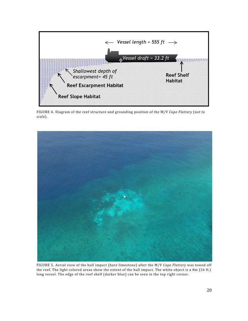
FIGURE 4. Diagram of the reef structure and grounding position of the M/V Cape Flattery (not to scale).
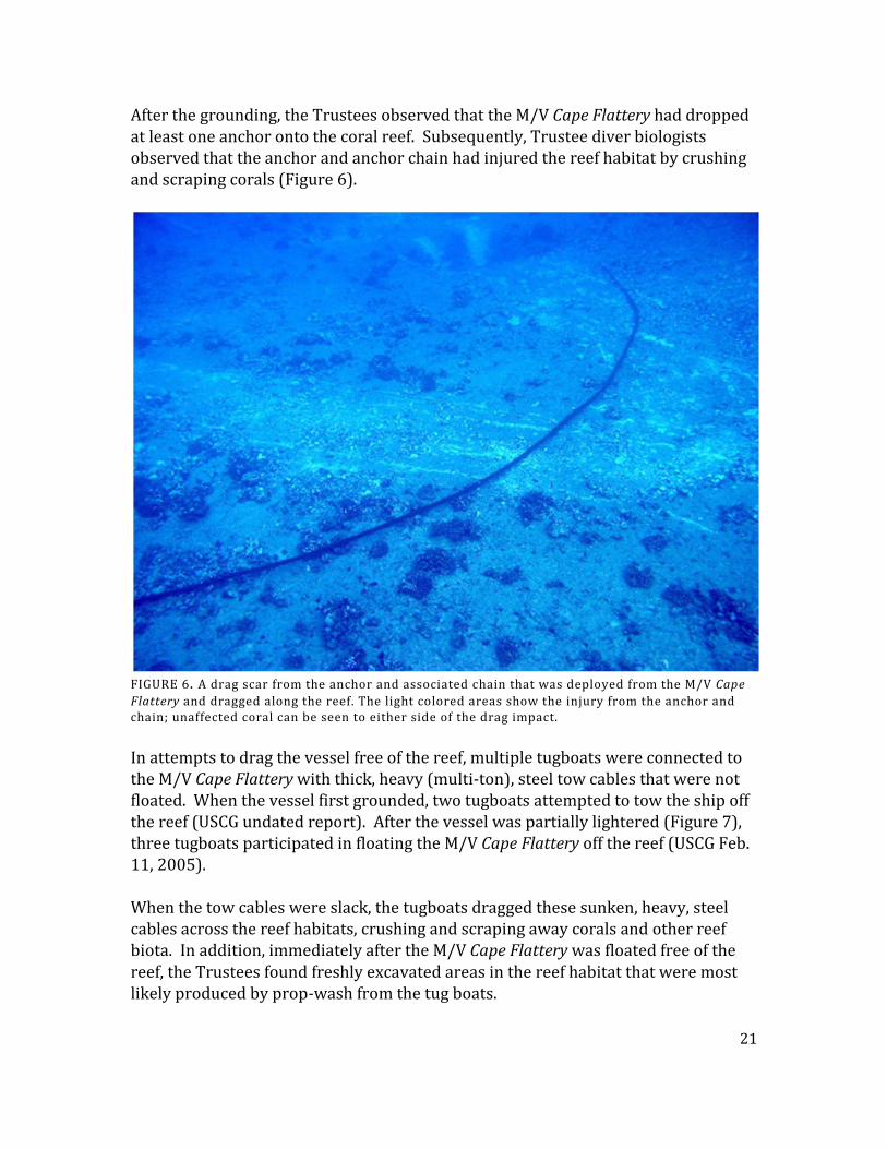
FIGURE 5. Aerial view of the hull impact (bare limestone) after the M/V Cape Flattery was towed off the reef. The light colored areas show the extent of the hull impact. The white object is a 8m (26 ft.) long vessel. The edge of the reef shelf (darker blue) can be seen in the top right corner.
20
After the grounding, the Trustees observed that the M/V Cape Flattery had dropped at least one anchor onto the coral reef. Subsequently, Trustee diver biologists observed that the anchor and anchor chain had injured the reef habitat by crushing and scraping corals (Figure 6).
FIGURE 6. A drag scar from the anchor and associated chain that was deployed from the M/V Cape Flattery and dragged along the reef. The light colored areas show the injury from the anchor and chain; unaffected coral can be seen to either side of the drag impact. In attempts to drag the vessel free of the reef, multiple tugboats were connected to the M/V Cape Flattery with thick, heavy (multi-ton), steel tow cables that were not floated. When the vessel first grounded, two tugboats attempted to tow the ship off the reef (USCG undated report). After the vessel was partially lightered (Figure 7), three tugboats participated in floating the M/V Cape Flattery off the reef (USCG Feb. 11, 2005). When the tow cables were slack, the tugboats dragged these sunken, heavy, steel cables across the reef habitats, crushing and scraping away corals and other reef biota. In addition, immediately after the M/V Cape Flattery was floated free of the reef, the Trustees found freshly excavated areas in the reef habitat that were most likely produced by prop-wash from the tug boats.
21
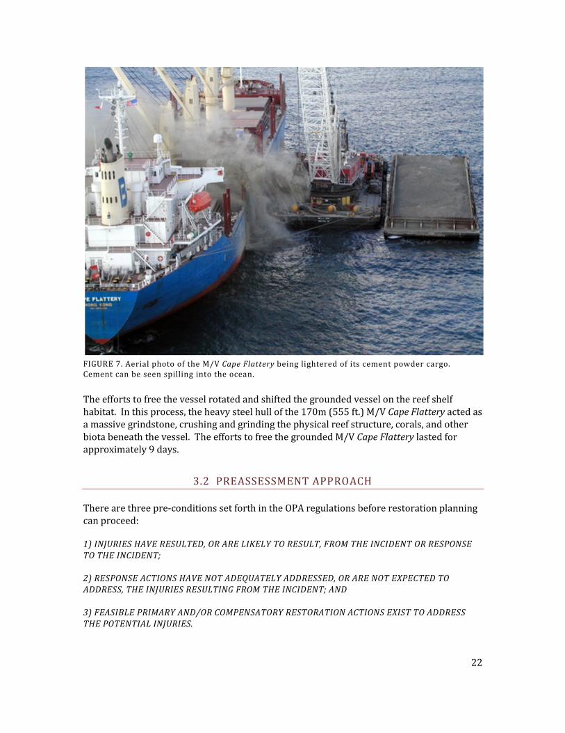
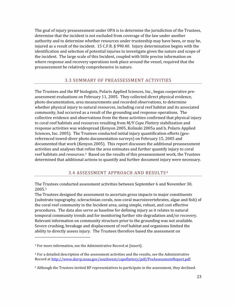
FIGURE 7. Aerial photo of the M/V Cape Flattery being lightered of its cement powder cargo. Cement can be seen spilling into the ocean. The efforts to free the vessel rotated and shifted the grounded vessel on the reef shelf habitat. In this process, the heavy steel hull of the 170m (555 ft.) M/V Cape Flattery acted as a massive grindstone, crushing and grinding the physical reef structure, corals, and other biota beneath the vessel. The efforts to free the grounded M/V Cape Flattery lasted for approximately 9 days.
3.2 PREASSESSMENT APPROACH There are three pre-conditions set forth in the OPA regulations before restoration planning can proceed: 1) INJURIES HAVE RESULTED, OR ARE LIKELY TO RESULT, FROM THE INCIDENT OR RESPONSE TO THE INCIDENT; 2) RESPONSE ACTIONS HAVE NOT ADEQUATELY ADDRESSED, OR ARE NOT EXPECTED TO ADDRESS, THE INJURIES RESULTING FROM THE INCIDENT; AND 3) FEASIBLE PRIMARY AND/OR COMPENSATORY RESTORATION ACTIONS EXIST TO ADDRESS THE POTENTIAL INJURIES.
22
The goal of injury preassessment under OPA is to determine the jurisdiction of the Trustees, determine that the incident is not excluded from coverage of the law under another authority and to determine whether resources under trusteeship may have been, or may be, injured as a result of the incident. 15 C.F.R. § 990.40. Injury determination begins with the identification and selection of potential injuries to investigate given the nature and scope of the incident. The large scale of this Incident, coupled with little precise information on where response and recovery operations took place around the vessel, required that the preassessment be relatively comprehensive in nature.
3.3 SUMMARY OF PREASSESSMENT ACTIVITIES The Trustees and the RP biologists, Polaris Applied Sciences, Inc., began cooperative pre-assessment evaluations on February 11, 2005. They collected direct physical evidence, photo documentation, area measurements and recorded observations, to determine whether physical injury to natural resources, including coral reef habitat and its associated community, had occurred as a result of the grounding and response operations. The collective evidence and observations from the these activities confirmed that physical injury to coral reef habitats and resources resulting from M/V Cape Flattery stabilization and response activities was widespread (Kenyon 2005, Kolinski 2005a and b, Polaris Applied Sciences, Inc. 2005). The Trustees conducted initial injury quantification efforts (geo-referenced towed-diver photo documentation surveys) on February 15, 2005 and documented that work (Kenyon 2005). This report discusses the additional preassessment activities and analyses that refine the area estimates and further quantify injury to coral reef habitats and resources.3 Based on the results of this preassessment work, the Trustees determined that additional actions to quantify and further document injury were necessary.
3.4 ASSESSMENT APPROACH AND RESULTS 4 The Trustees conducted assessment activities between September 6 and November 30, 2005.5 The Trustees designed the assessment to ascertain gross impacts to major constituents (substrate topography, scleractinian corals, non-coral macroinvertebrates, algae and fish) of the coral reef community in the Incident area, using simple, robust, and cost effective procedures. The data also serve as baseline for defining injury as it relates to natural temporal community trends and for monitoring further site degradation and/or recovery. Relevant information on community structure prior to the grounding was not available. Severe crushing, breakage and displacement of reef habitat and organisms limited the ability to directly assess injury. The Trustees therefore based the assessment on
3 For more information, see the Administrative Record at [insert].
4 For a detailed description of the assessment activities and the results, see the Administrative Record at http://www.darrp.noaa.gov/southwest/capeflattery/pdf/PreAssessmentReport.pdf.
5 Although the Trustees invited RP representatives to participate in the assessment, they declined.
23
community comparisons between impact and reference habitats. They designated habitat zones to represent fully the variability of the area and the different species assemblages found there (slope, escarpment, shelf pavement, reef depressions, and Porites zone). 3.4.1 GENERAL METHODS
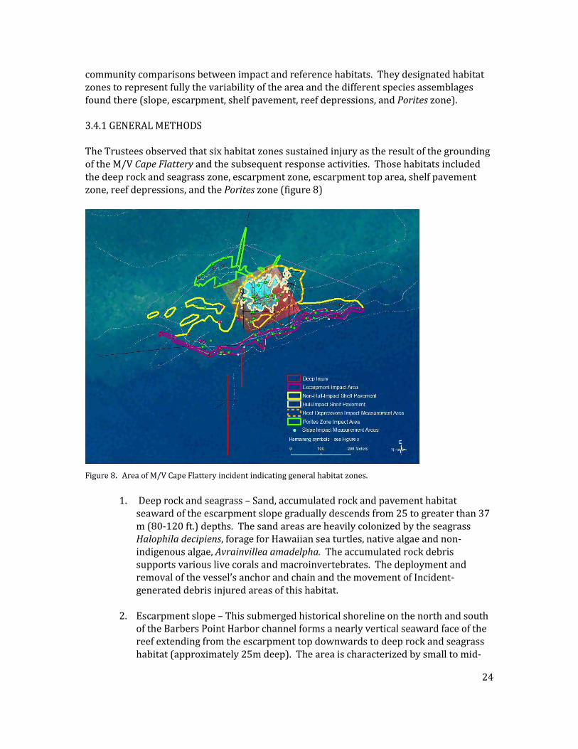
The Trustees observed that six habitat zones sustained injury as the result of the grounding of the M/V Cape Flattery and the subsequent response activities. Those habitats included the deep rock and seagrass zone, escarpment zone, escarpment top area, shelf pavement zone, reef depressions, and the Porites zone (figure 8)
Figure 8. Area of M/V Cape Flattery incident indicating general habitat zones.
1. Deep rock and seagrass – Sand, accumulated rock and pavement habitat seaward of the escarpment slope gradually descends from 25 to greater than 37 m (80-120 ft.) depths. The sand areas are heavily colonized by the seagrass Halophila decipiens, forage for Hawaiian sea turtles, native algae and non-indigenous algae, Avrainvillea amadelpha. The accumulated rock debris supports various live corals and macroinvertebrates. The deployment and removal of the vessel’s anchor and chain and the movement of Incident-generated debris injured areas of this habitat.
2. Escarpment slope – This submerged historical shoreline on the north and south of the Barbers Point Harbor channel forms a nearly vertical seaward face of the reef extending from the escarpment top downwards to deep rock and seagrass habitat (approximately 25m deep). The area is characterized by small to mid-
24
sized lobate, encrusting and branching corals, various macroinvertebrates, high coralline crustose, turf, and macroalgae cover, resident and mobile fishes and caves and crevices used by sharks and sea turtles as resting habitat. The deployment and removal of the vessel’s anchor and chain and/or the movement of Incident-generated debris injured areas of this habitat.
3. Escarpment top area – This area includes the escarpment crest, protruding
ridges and areas within approximately 20 meters shoreward of the crest at 14-17m (45 to 55 ft.) depths. The area is characterized by heavily colonization by lobate and branching corals, various macroinverterates, fairly high turf, macro- and coralline crustose algae cover and high fish numbers and biomass, relative to the other habitat zones investigated by the Trustees. Towlines, anchor chain, cables and Incident-generated reef debris caused injury to this area.
4. Shelf pavement – The hard reef pavement area slopes gradually from approximately 7 m depth to approximately 14m depth. The corals in this area are characterized by encrusting, lobate and branching species that reach large (greater than 80 cm (32 in.)diameter) sizes. Their distribution is varied. This community also includes green sea turtles, macroinvertebrates, turf and coralline crustose algae cover and a variety of resident and semi-vagile fish. This area sustained injury from the direct impact of the ship’s hull, deposition of cement during cargo offloading, and from towlines, anchor chain, cables and Incident-generated reef debris.
5. Reef depressions – Natural depressions of varying sizes and depths are
scattered throughout the shelf pavement area. These depressions are resting areas for Hawaiian green turtles and support a variety of other species such as coral, algae, resident and semi-vagile fish and macroinvertebrates. These depressions sustained injury from movement of the vessel’s hull, towlines, anchor chain, cables and Incident-generated reef debris and sediment.
6. Porites zone – This shoreward extension of the shelf pavement at 8-11 m (25 to 35 ft.) depths, is characterized by large (greater than 160 cm (63 in) diameter) lobate Porities coral aggregations, other corals, algae, macroinvertebrates and resident and semi-vagile fish species. This area sustained injuries from towlines and cables during vessel stabilization and response activities.
(Kolinski, et al. 2007). The methods for estimating areas and quantifying injury to natural resources proceeded as follows. The Trustees selected sample sites by drawing multiple points on area photo maps within and outside suspected regions of Incident- related impact and then randomly selecting a set of points for impact and reference area sampling for each habitat zone (with
25
the exception of impact slope sample sites which were fixed). 6 Reference selection included sites north and south of the site of the Incident. The location of injury in the shelf pavement zone was differentiated into hull- and non-hull impact areas for sampling and analyses. The Trustees measured five general categories of coral reef community composition, including topographic complexity, scleractinian corals, non-coral macroinvertebrates, algae, and fish at impact and reference locations. The Trustees also measured the three dimensional complexity of the bottom (rugosity) along four 10 m (33 ft.) transects at replicate sites in escarpment top, shelf pavement and Porites zone habitats. They assessed site numbers and size categories of live coral fragments and attached colonies for individual species along with numbers of individuals of select groups of Mollusca, Crustacea and Echindermata within multiple 10 m2 (108 ft2) transects in escarpment slope, top, shelf pavement and Porites zones and throughout paired reef depressions at replicate sites. Major coral species were grouped by genus, functional habitat form and growth rate into the following categories: Montipora encrusting, Pocillopora meandrina/cauliflower, Pocillopora eydouxi and Porites lobate groups. The Trustees analyzed these categories with statistics being applied to colony size categories of < or ≥ 10 cm greatest diameter. The Trustees grouped and analyzed select species of macroinvertebrates as mobile urchin, boring urchin and guard crab functional groups. They assessed algal cover within three 0.25 m2
quadrats along established 10 m transects. In reef depressions, they measured two
quadrats along the bottom and one on north and south sides of depression walls. Algae were grouped as turf, macro, crustose coralline and invasive species for analyses. They visually surveyed fish numbers and sizes along two 25 m transects at each site (except slope habitat) or throughout individual reef depressions. Fish were grouped by mobility class (Friedlander and Parrish 1998) for analyses. The Trustees determined separate estimates of injury and loss for corals, macroinvertebrates and coralline crustose algae based on significant differences between reference and impact areas using an α of 0.10 (to account for small sample sizes in a heterogeneous environment) by multiplying the difference in mean densities by estimated area of injury in each habitat zone. Modified injury values and power analysis results were provided when P-values ranged between 0.100 and 0.050. The Trustees further differentiated corals with injury/loss estimates into their original size categories for estimating the length of time needed for coral population recovery.
3.4.2 SUMMARY OF INJURY DATA AND RESULTS The Trustees estimated that over 1 million coral colonies (Table 1), 150,000 macroinvertebrates (Table 2) and 5,000 square meters
of coralline crustose algae were lost
6 The Trustees did not survey the deep rock and seagrass zone for this assessment due to depth related safety and time concerns.
26
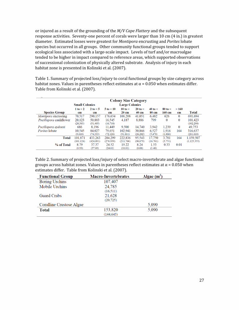
or injured as a result of the grounding of the M/V Cape Flattery and the subsequent response activities. Seventy-one percent of corals were larger than 10 cm (4 in.) in greatest diameter. Estimated losses were greatest for Montipora encrusting and Porites lobate species but occurred in all groups. Other community functional groups tended to support ecological loss associated with a large-scale impact. Levels of turf and/or macroalgae tended to be higher in impact compared to reference areas, which supported observations of successional colonization of physically altered substrate. Analysis of injury in each habitat zone is presented in Kolinski et al. (2007). Table 1. Summary of projected loss/injury to coral functional groups by size category across habitat zones. Values in parentheses reflect estimates at α = 0.050 when estimates differ. Table from Kolinski et al. (2007).
Table 2. Summary of projected loss/injury of select macro-invertebrate and algae functional groups across habitat zones. Values in parentheses reflect estimates at α = 0.050 when estimates differ. Table from Kolinski et al. (2007).
27
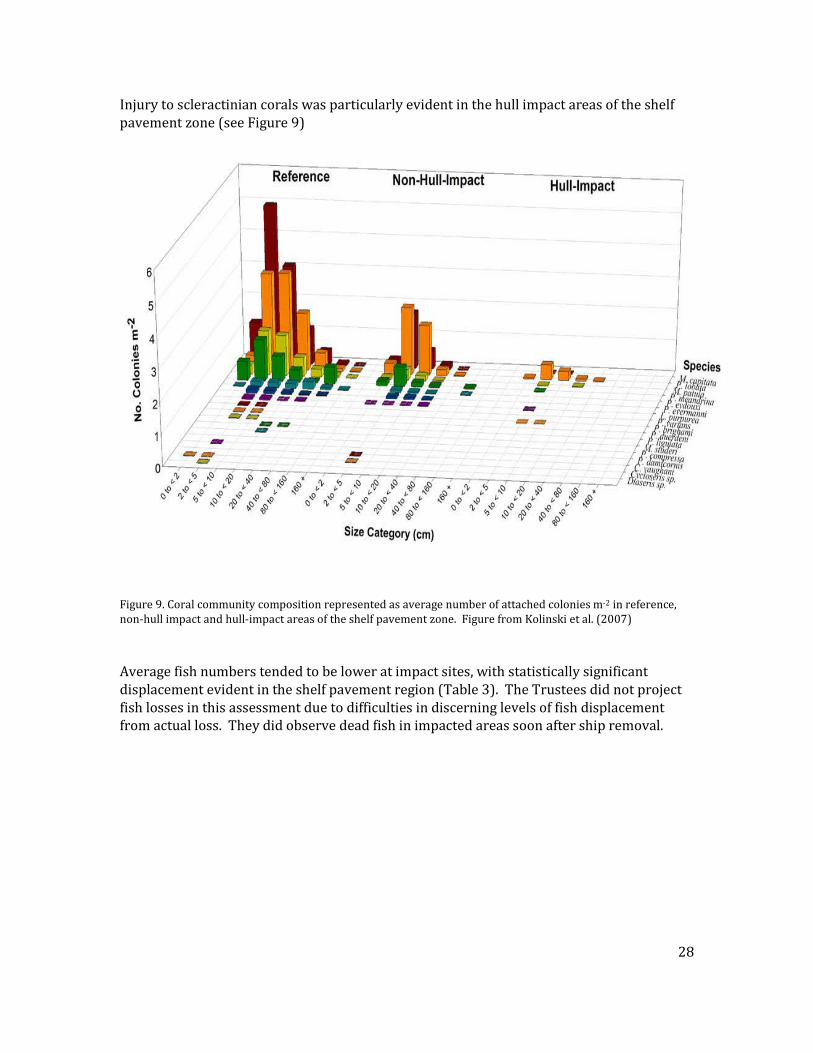
Injury to scleractinian corals was particularly evident in the hull impact areas of the shelf pavement zone (see Figure 9)
Figure 9. Coral community composition represented as average number of attached colonies m-2 in reference, non-hull impact and hull-impact areas of the shelf pavement zone. Figure from Kolinski et al. (2007) Average fish numbers tended to be lower at impact sites, with statistically significant displacement evident in the shelf pavement region (Table 3). The Trustees did not project fish losses in this assessment due to difficulties in discerning levels of fish displacement from actual loss. They did observe dead fish in impacted areas soon after ship removal.
28
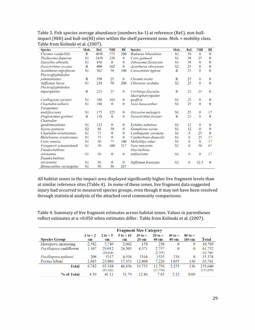
Table 3. Fish species average abundance (numbers ha-1) at reference (Ref.), non-hull-impact (NHI) and hull-im(HI) sites within the shelf pavement zone. Mob. = mobility class. Table from Kolinski et al. (2007).
All habitat zones in the impact area displayed significantly higher live fragment levels than at similar reference sites (Table 4). In some of these zones, live fragment data suggested injury had occurred to measured species groups, even though it may not have been resolved through statistical analysis of the attached coral community comparisons. Table 4. Summary of live fragment estimates across habitat zones. Values in parentheses reflect estimates at α =0.050 when estimates differ. Table from Kolinski et al. (2007).
29
The Trustees did not assess dead attached corals, which provide habitat. Rugosity measurements incorporated the presence of unconsolidated reef debris, which may ultimately shift to reef depressions and/or down the escarpment slope. The Trustees did not survey communities injured by the anchor and chain in deep rock and seagrass habitats below the escarpment slope or communities at the base of the slope where debris had and will continue to accumulate, in this assessment due to depth, dive time and safety reasons. In addition, the Trustees did not design the sampling to assess the presence of coral predators at levels useful for applying statistically appropriate comparative analyses. However, measured averages and anecdotal observations suggest larger mean numbers of the coral eating starfish Acanthaster planci and Culcita novaeguinaeae occurred in impact compared to reference areas in slope and escarpment habitats. The Trustees also observed Drupella sp., a coral eating mollusk not measured in this assessment, to be seriously impacting injured and restored Pocilloporid corals in areas disturbed by response efforts. (Kolinski, pers. obs.) Potential latent injury to corals in the impacted community may have occurred as a result of coral predators being attracted by chemical cues released from the injured corals and then feeding on those corals. Scleractinian corals and crustose coralline algae create and consolidate habitat framework utilized by other sessile and mobile coral reef animals. Herbivorous fish and urchins may facilitate habitat recovery by continuous predation on colonizing fleshy algae, which compete for open space with corals and crustose coralline algae. The Trustees made projections on recovery rates of corals and crustose coralline algae using data from the site and pertinent literature. Recovery levels and rates of the impacted reef will likely depend on the recruitment, growth and activities of multiple coral reef community constituents, including macroinvertebrates and fish.
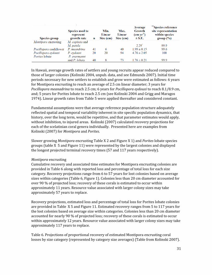
3.4.3 RECOVERY PROJECTIONS The Trustees estimated recovery of injury to scleractinian corals for Montipora encrusting, Pocillopora cauliflower, P. eydouxi and Porites lobate species groups by individual size categories. Recovery modeling incorporated recruitment and proportional survival rates inferred from attached colony size frequencies in reference areas, measured growth of reference colonies within the Incident area, and projected survival and growth of population structure remaining in the Incident area (Table 5 Kolinski 2007). Table 5. Rates of growth for species injured at Barbers Point, Oahu (*estimate partially derived from values in literature; ** total proportion of species’ individuals within a species group as measured in pre-assessment reference transects, see Kolinski et al. 2007).
30
In Hawaii, average growth rates of settlers and young recruits appear reduced compared to those of larger colonies (Kolinski 2004, unpub. data, and see Edmunds 2007). Initial time periods necessary for new settlers to establish and grow were estimated as follows: 6 years for Montipora encrusting to reach an average of 2.5 cm linear diameter; 3 years for Pocillopora meanadrina to reach 2.5 cm; 6 years for Pocillopora eydouxi to reach 8.1/8.9 cm, and; 5 years for Porites lobate to reach 2.5 cm (see Kolinski 2004 and Grigg and Maragos 1974). Linear growth rates from Table 5 were applied thereafter and considered constant. Fundamental assumptions were that average reference population structure adequately reflected spatial and temporal variability inherent in site specific population dynamics, that history, over the long term, would be repetitive, and that parameter estimates would apply, without inhibition, to injured areas. Kolinski (2007) calculated recovery projections for each of the scelatinian coral genera individually. Presented here are examples from Kolinski (2007) for Montipora and Porites. Slower growing Montipora encrusting Table X 2 and Figure X 1) and Porites lobate species groups (table X 5 and Figure 11) were represented by the largest colonies and displayed the longest projected terminal recovery times (57 and 117 years respectively). Montipora encrusting Cumulative recovery and associated time estimates for Montipora encrusting colonies are provided in Table 6 along with reported loss and percentage of total loss for each size category. Recovery projections range from 6 to 57 years for lost colonies based on average sizes within categories (Table 6, Figure 1). Colonies less than 20 cm diameter accounted for over 90 % of projected loss; recovery of these corals is estimated to occur within approximately 11 years. Resource value associated with larger colony sizes may take approximately 57 years to replace. Recovery projections, estimated loss and percentage of total loss for Porites lobate colonies are provided in Table X 5 and Figure 11. Estimated recovery ranges from 5 to 117 years for the lost colonies based on average size within categories. Colonies less than 20 cm diameter accounted for nearly 90 % of projected loss; recovery of these corals is estimated to occur within approximately 12 years. Resource value associated with larger colony sizes may take approximately 117 years to replace. Table 6. Projections of proportional recovery of estimated Montipora encrusting coral losses by size category (represented by category size averages) (Table from Kolinski 2007).
31
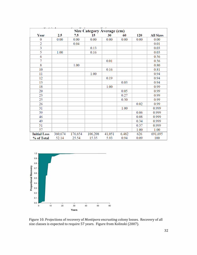
Figure 10. Projections of recovery of Montipora encrusting colony losses. Recovery of all size classes is expected to require 57 years. Figure from Kolinski (2007).
32
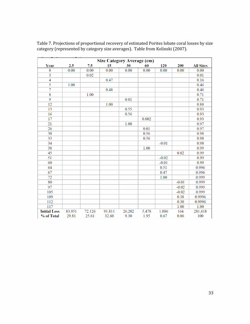
Table 7. Projections of proportional recovery of estimated Porites lobate coral losses by size category (represented by category size averages). Table from Kolinski (2007).
33
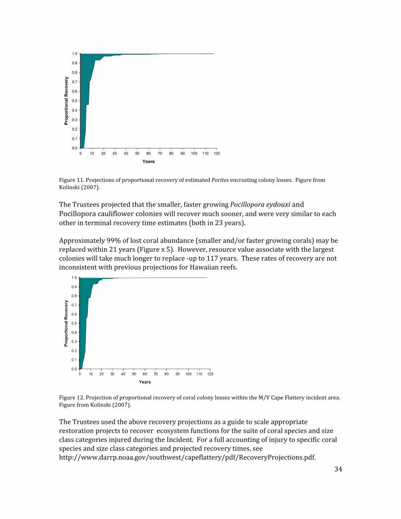
Figure 11. Projections of proportional recovery of estimated Porites encrusting colony losses. Figure from Kolinski (2007). The Trustees projected that the smaller, faster growing Pocillopora eydouxi and Pocillopora cauliflower colonies will recover much sooner, and were very similar to each other in terminal recovery time estimates (both in 23 years). Approximately 99% of lost coral abundance (smaller and/or faster growing corals) may be replaced within 21 years (Figure x 5). However, resource value associate with the largest colonies will take much longer to replace -up to 117 years. These rates of recovery are not inconsistent with previous projections for Hawaiian reefs.
Figure 12. Projection of proportional recovery of coral colony losses within the M/V Cape Flattery incident area. Figure from Kolinski (2007). The Trustees used the above recovery projections as a guide to scale appropriate restoration projects to recover ecosystem functions for the suite of coral species and size class categories injured during the Incident. For a full accounting of injury to specific coral species and size class categories and projected recovery times, see http://www.darrp.noaa.gov/southwest/capeflattery/pdf/RecoveryProjections.pdf.
34
4.0 RESTORATION PLANNING
4.1 RESTORATION STRATEGY AND PROPOSED ACTION The goal of the Oil Pollution Act is to “make the environment and the public whole for injuries to natural resources and services resulting from an incident involving discharge or substantial threat of a discharge of oil….” 15 C.F.R. § 990.10. To achieve this goal, OPA authorizes trustees, after an oil spill or response action to the threat of an oil discharge, to conduct restoration planning to restore, rehabilitate, replace, or acquire the equivalent of injured natural resources resulting from the spill and/or response actions. The OPA regulations direct that this goal be achieved by returning injured natural resources to their baseline condition, but for the incident, and by compensating for any interim losses of natural resources and services during the period of recovery to baseline. Specifically, the preferred restoration alternatives in this DARP/EA are designed to restore injured natural resources and services resulting from the February 2, 2005 grounding of the M/V Cape Flattery off of Kalaeloa, Barbers Point and the subsequent response activities. The OPA regulations designate restoration actions as either “primary” or “compensatory”. Primary restoration is action(s) taken to return injured natural resources and services to baseline on an accelerated time frame -- that is faster than what would occur naturally. The OPA regulations require that trustees consider natural recovery as an alternative under primary restoration. Some of the conditions under which natural recovery would be considered a preferred alternative would be 1) active primary restoration is infeasible, 2) active primary restoration is not cost-effective, and 3) injured natural resources will recover to baseline at a reasonable rate without human intervention. Alternative primary restoration activities can range from natural recovery with monitoring, to actions that prevent interference with natural recovery, to more intensive actions expected to return injured natural resources and services to baseline faster and/or with greater certainty than natural recovery. Compensatory restoration is/are action(s) taken to address the interim losses of natural resources and/or services between the time of injury and recovery to baseline. The type and scale of compensatory restoration can depend on the nature of the primary restoration action(s) and the timeline and scope of recovery of injured resources to baseline. When identifying compensatory restoration alternatives, trustees must first consider actions that provide resources and/or services of the same type and quality and of comparable value as those that were lost. If a reasonable range of alternative compensatory actions cannot provide resources and/or services of the same type, quality, and comparable value as those lost, then trustees can consider actions that will provide resources and/or services of comparable type and quality. Reasonable compensatory restoration alternatives must be “scaled” so that the size or quantity of the proposed project reflects the magnitude of the injuries. The OPA regulations discuss two scaling approaches -- the service-to-service (or resource-to-resource) approach
35
and the valuation approach. The former approach (hereafter referred to as service-to-service) is a simplification of the valuation approach and is used when the injured and replacement resources and services are of the same type, quality, and comparable value. The service-to-service approach is similar to an in-kind trading approach that requires no explicit valuation. Under this approach, the scaling analysis simplifies to selecting the scale of a restoration action for which the present discounted quantity of replacement services equals the present discounted quantity of services lost due to the injury. The habitat version of the approach, habitat equivalency analysis, has been applied in a number of damage assessment cases. For an overview of habitat equivalency analysis, see NOAA (2000). If the trustees determine that the first approach is not appropriate, they will use the second approach and determine the amount of natural resources and/or services that must be provided to produce the same value lost to the public. The trustees must explicitly measure the value of the interim losses from the injured natural resources and/or services and then calculate the value of gains from the proposed restoration actions. Scaling then requires adjusting the size of restoration project(s) to ensure that the value of restoration gains equals the value of the interim losses. Responsible parties are liable for the cost of implementing the restoration action that would generate the equivalent value. The value-to-cost variant of the valuation approach may be employed when valuation of the lost services is practicable but valuation of the replacement natural resources and services cannot be performed within a reasonable time frame or at a reasonable cost. With this approach, the restoration is scaled by equating the cost of the restoration plan to the value (in dollar terms) of losses due to the injury.
4.1.1 PROPOSED ACTION The Trustees propose to implement restoration alternatives for both primary restoration and compensatory restoration, and will rely on known restoration methods previously applied to other incidents, or to related natural resource recovery activities. The proposed primary restoration action is natural recovery and monitoring at the site of the incident with the possibility of adaptive management if natural recovery is not succeeding. The proposed compensatory restoration action is removal of large quantities of the alien algae Kappaphycus and Eucheuma species using a Super Sucker, combined with sea urchin outplanting, to prevent coral mortality in Kaneohe Bay, Oahu.
4.2 EVALUATION CRITERIA The OPA regulations require that Trustees develop a reasonable range of primary and compensatory restoration alternatives and then identify the preferred alternatives based on the six criteria listed in the regulations: 1. Cost to carry out the alternative action,
36
2. Extent to which each alternative is expected to meet the Trustees’ goals and objectives in returning the injured natural resources and services to baseline and/or compensating for interim losses,
3. Likelihood of success of each alternative, 4. Extent to which each alternative will prevent future injury as a result of the
incident and avoid collateral injury as a result of implementing the alternative, 5. Extent to which each alternative benefits more than one natural resource and/or
service, and 6. Effect of each alternative on public health and safety. Id. at § 990.54(a). In addition, the Trustees considered several other factors including: 1. Cost effectiveness (rather than just overall total costs), 2. Nexus to geographic location of the injury,
3. Opportunities to collaborate with other entities involved in restoration projects, and 4. Compliance with applicable federal and state laws and policies. As mentioned in Chapter 1, NEPA applies to actions taken by federal agencies. To reduce transaction costs and avoid delays in restoration, the OPA regulations encourage the trustees to conduct the NEPA process concurrently with the development of the draft restoration plan. As well, NEPA also encourages federal agencies to integrate the requirements of NEPA with other agency planning procedures so that the processes can run concurrently, rather than consecutively. To comply with the requirements of NEPA, the Trustees considered the effects of each preferred alternative on the quality of the human environment. NEPA’s implementing regulations direct federal agencies to evaluate the potential significance of proposed actions by considering both context and intensity. For the actions proposed in this DARP/EA, the appropriate context for considering potential significance of the action is local, as opposed to national or worldwide. With respect to evaluating the impacts in the proposed action, the NEPA regulations and NOAA’s Administrative Order 216-6 require consideration of the following factors:
1. Likely impacts of the proposed projects, 2. Likely effects of the projects on public health and safety,
3. Unique characteristics of the geographic area in which the projects are to be implemented,
4. Controversial aspects of the project or its likely effects on the human environment,
5. Degree to which possible effects of implementing the project are highly uncertain or involve unknown risks,
6. Precedential effect of the project on future actions that may significantly affect the human environment,
7. Possible significance of cumulative impacts from implementing this and other similar projects,
8. Effects of the project on National Historic Places, or likely impacts to significant cultural, scientific or historic resources,
37
9. Degree to which the project may adversely affect endangered or threatened species or their critical habitat,
10. Likely violations of environmental protection laws, 11. Unique characteristics of the geographic area, 12. Degree to which endangered or threatened species, or their critical habitat as
defined under the Endangered Species Act of 1973, are adversely affected, 13. Whether a violation of federal, state, or local law for environmental protection
is threatened, and 14. Whether a federal action may result in the introduction or spread of a
nonindigenous species.
4.3 EVALUATION OF NO ACTION ALTERNATIVE NEPA requires the trustees to consider a “no action” alternative, and the OPA regulations require that a “natural recovery” option is evaluated. Under this alternative, the Trustees would take no direct action to restore injured natural resources or compensate for lost services. In lieu of direct action, the Trustees would rely on natural processes of recruitment and growth for recovery of the injured natural resources including, but not limited to, corals, algae, fishes, sessile invertebrates and coralline algae. There are several advantages to natural recovery as primary restoration. The principle advantages would be simplicity of implementation and no cost. Because an injured area or species is expected to recover naturally, it would make sense to, in essence, “let nature take its course”. Although natural recovery would occur over varying time scales for various injured resources and categories, the public would not be compensated for the interim losses under the no action alternative. OPA clearly establishes trustee authority to seek compensation for interim losses pending recovery of the injured natural resources. Such compensation would not occur under a no action alternative. Natural resource losses were, and continue to be, incurred by the public during this period of recovery from the grounding event and technically feasible alternatives exist to compensate for these interim losses within a reasonable cost framework. Therefore, a no action alternative (natural recovery) would not fully restore lost interim services.
38
4.4. EVALUATION OF PRIMARY RESTORATION ALTERNATIVES
4.4.1. PREFERRED PRIMARY RESTORATION ALTERNATIVE 1: MONITORED NATURAL RECOVERY WITH THE POSSIBILITY OF ADAPTIVE MANAGEMENT
Alternative Description: This proposed alternative provides primary restoration for injury to corals, other benthic macro-invertebrates, and crustose coralline algae using natural recovery of resources to return to baseline conditions. Unlike the no action alternative discussed in subsection 4.3 above, this alternative includes monitoring with the possibility of adaptive management should the injured natural resources fail to meet expected recovery projections. Because of limited opportunities for restoring large established coral communities at the incident site, the monitored natural recovery alternative is the best one for primary restoration. Approximately 99% of the injury to coral resources (smaller and/or faster growing corals) due to the grounding and response activities is expected to recover naturally to pre-incident conditions within 21 years (Kolinski, 2005, 2007). These rates of recovery are within expected values based on previously published coral growth rates and parameters (Grigg and Maragos 1974, Grigg 1995, Holthus et al. 1986, Dollar and Tribble 2003, Connell 1997, Hughes and Connell 1999). While the Trustees anticipate relying on natural recovery for much of the primary restoration of the injury caused by the M/V Cape Flattery grounding and response actions, they intend to monitor natural recovery of the coral reef communities at the impact site to determine if recovery is progressing to the baseline conditions as they have projected (see discussion below). The Trustees will develop and implement an adequate biological monitoring program (See Appendix 1) to determine whether affected coral reef communities meet anticipated recovery goals at the M/V Cape Flattery vessel grounding site. Both qualitative and quantitative data will be collected, including coral species, densities and size classes will be recorded along transects in the affected area.7 Several surveys will be conducted over a 10-11 year time period. Coupled with the information already collected by the Trustees, this time frame will provide data for a twenty-year time period from the date of the vessel grounding – likely adequate time to gauge resource recovery. The Trustees continue to be concerned that the ecological disturbances caused by the M/V Cape Flattery grounding and subsequent response actions could result in the injured reef
7 See Appendix One for more information concerning the types of data to be collected.
39
community undergoing a “phase shift” into another type of biological community, such as one dominated by algae to the exclusion of corals. If monitoring discloses that natural recovery is not progressing as projected, the Trustees will examine the feasibility of active primary restoration actions and may reallocate funds and effort from the compensatory restoration project. Restoration Objective: The goal of the monitored natural recovery alternative is to allow the injury site to continue its natural recovery progression back to baseline conditions or pre-incident levels of coral species, size classes, and abundances. Probability of Success: The probability of success is high. All current information collected by the Trustees suggests that natural recovery is occurring as predicted. There is a possible concern (however remote) that the ecological disturbances caused by the Incident could result in the injured reef community undergoing a “phase shift” into another type of biological community, such as one dominated by algae to the exclusion of corals. The probability of this occurring appears low as all indications to this point show that the incident site is recovering normally back to baseline conditions. Performance Criteria and Monitoring: The performance criteria for this alternative are that natural recruitment and growth of coral resources at the incident site continue to follow predicted recovery models and that the site is recovered to 99% of pre-incident conditions within 21 years. The Trustees intend to monitor natural recovery of the coral reef communities at the incident site to confirm that recovery is progressing acceptably toward baseline conditions throughout the recovery period. Absent any monitoring since the incident, the site (anecdotally) appears to be recovering along projected models. If monitoring discloses that natural recovery is not progressing as projected, the Trustees will evaluate adaptive management activities in the nature of primary restoration at the M/V Cape Flattery vessel grounding site. If they determine that active primary restoration actions are feasible, the Trustees may reallocate funds and effort from the compensatory restoration project. Environmental and Socio-Economic Impacts: Because this alternative is based on the Trustees monitoring the site and allowing the resources to naturally recover with no effect to any recreational or other potential uses in the area, there would be essentially no environmental or socio-economic impacts.
40
4.4.2 CONSIDERED BUT REJECTED PRIMARY RESTORATION ALTERNATIVES The Trustees considered a number of alternatives for primary restoration of the M/V Cape Flattery grounding site. They evaluated these alternatives using the standards delineated in OPA regulation (1) the cost of the alternative, (2) the extent to which the project is expected to return the resource and services to baseline, (3) the likelihood of success, (4) the probability of preventing future injury, (5) the benefit to other resources, and (6) the effects on public health and safety. The Trustees considered but did not select the following alternatives as the preferred restoration methods because of feasibility and cost benefit concerns. The rejected alternatives are listed below with their associated explanations and concerns.
4.4.2.1 PRIMARY RESTORATION ALTERNATIVE 2: AIDS TO NAVIGATION Because the area around Barbers Point/Ko’olina is a fairly high traffic area, there is the chance that future groundings or incidents may occur. One alternative considered by the Trustees was to place specific Aids to Navigation (AToN) at this and other sites around the Hawaiian Islands to help prevent future incidents, thereby preventing future injury to natural resources. The Trustees determined that this alternative was not preferred in this matter for a number of reasons. The costs for putting out and maintaining a system of AToN would be too high with little tangible benefits to natural resources. The additional benefits to navigation, given the systems currently in place around Hawaii and those available on individual vessels, are minimal. In addition, there are questions as to how this alternative would be scaled to future injuries that might be avoided, due to lack of injury information on past incidents that could be projected for these potential future incidents. There are no satisfactory methods for determining how much injury to coral and other natural resources would be avoided by establishing a system of AToN. Without an effective method for scaling the benefits of this project, there are no satisfactory ways to ensure that the public would be fully and justifiably compensated for natural resource losses. Given these questions, the Trustees did not evaluate this alternative further.
4.4.2.2 PRIMARY RESTORATION ALTERNATIVE 3: NATURAL RESOURCE EXCLUSION ZONE
Another idea considered by the Trustees was to designate an exclusion area in the form of a natural reserve around the Porites zone. Because the Porites zone includes some areas of fairly high coral cover consisting of exceptionally large Porites lobata colonies the Trustees considered a project to exclude potentially injurious human activities in this area. There are a number of problems inherent in this alternative. There are not enough commercial and/or recreational activities occurring within the proposed exclusion zone to quantify what if any potential impacts might be avoided. There are questions as to how this alternative would be scaled to future injuries that would be avoided. Like the AToN non-preferred alternative discussed above, there are no
41
satisfactory methods for determining how much injury to coral and other natural resources would be avoided by using this method. Without an effective method for scaling the benefits of this alternative, there are no satisfactory ways to ensure that the public would be fully compensated for natural resource losses if the Trustees selected this alternative. Given these issues, the Trustees did not further evaluate this alternative.
4.4.2.3 PRIMARY RESTORATION ALTERNATIVE 4: RECONSTRUCTION OF THREE DIMENSIONAL HABITAT STRUCTURE
The loss of three dimensional habitat structure (coral colonies and natural terrain) has an impact on fishes, invertebrates and other species in the injury area. Reconstructing some of this three dimensional habitat would provide refuge areas for fishes and invertebrates and could possibly help increase re-colonization rates of coral into the injury area. Some reconstruction of lost three dimensional habitat occurred at the injury site during emergency restoration activities, including re-attaching surviving coral colonies. While this alternative is attractive, the Trustees rejected it for several reasons. The level and pace of possible increased coral recruitment and recovery (above and beyond the natural rates) of the area are not known and may not provide adequate resource compensation. Because the area has been undergoing natural recovery for several years, adding structures to the bottom would result in an initial injury to corals that have naturally colonized to the area, diminishing the initial recovery credits and essentially resetting the recovery curve. Additionally, for determining added benefits, the degree that these structures will result in net increased populations of fishes and invertebrates rather than just attract these species from other areas is also not known (the production versus attraction debate).
4.4.2.4 PRIMARY RESTORATION ALTERNATIVE 5: ALIEN INVASIVE ALGAE CONTROL AND REMOVAL
The presence of alien and invasive algae at and near the injury site is well known(Brostoff, 1989, USFWS 2002). In particular, the alien alga Avrainvillea amadelpha is known to exist along the west coast of Oahu as well as in other areas such as Maunalua Bay on the south east side of the island. At the injury site the primary question is whether, because of the cleared benthic substrate as a result of the Incident, A. amadelpha will progress from its presently pervasive condition to an invasive state by beginning to form large mats that fully occlude or cover the bottom. The Trustees have not yet observed this invasive condition although the density of A. amadelpha varies across the injury site. Also, it is unknown what level of impact A. amadelpha has on coral recovery at the injury site. In a pervasive condition, the effects of A. amadelpha are not well understood. In its invasive state, A. amadelpha likely inhibits coral recruitment as it can completely cover the bottom preventing settlement. Because of these uncertainties, the Trustees are unable to scale adequately restoration benefits in terms of enhanced coral recruitment for this alternative. Moreover, there is currently no accepted methodology for effective removal of this algal species at the injury site. If subsequent monitoring at the injury site reveals a progression to an invasive state, or if the Trustees learn more about the effects on coral recruitment of A. amadelpha in its present state, the Trustees may reconsider this alternative as part of preferred primary restoration alternative 1 -- monitored natural recovery with the
42
possibility of adaptive management. If the monitoring determines that further action is warranted under this alternative, there could be additional consequences, which would be similar to those evaluated for compensatory restoration. A description and analysis of the potential consequences of conducting invasive removal and coral rescue is provided in section 4.5.1
4.4.2.5 PRIMARY RESTORATION ALTERNATIVE 6: REPLANTING OF LOST NATIVE SEAGRASS, HALOPHILA HAWAIIANA
Some native Hawaiian seagrass (Halophila hawaiiana) was injured as the anchor from the M/V Cape Flattery was dragged offshore during the recovery. Because H. hawaiiana is a native seagrass and is known forage for green sea turtles (Chelonia mydas), the Trustees gave some consideration to restoring this resource. A number of issues led the Trustees not to select this alternative. The extent and severity of the injury was minimal. During the assessment, the Trustees observed that the seagrass was beginning to recover as evidenced by re-growth of material back into the anchor drag scar. Given the limited geographic scope of the injury, the observations of rapid initial recovery, the Trustees determined that the small amount of required compensation would not be worth the relatively large expense of a recovery project.
4.4.2.6 PRIMARY RESTORATION ALTERNATIVE 7: TRANSPLANTING DESIRABLE ALGAE TO GROUNDING SCAR
Transplanting desirable algae species into the grounding scar would help restore lost benthic species such as mobile and sessile invertebrates and algae. The algae would provide habitat for benthic biota as well as forage for herbivorous fish species. While this alternative is attractive, there is no way to scale directly for lost fish and invertebrates as the Trustees inferred the injury to these groups from their work on the lost coral colonies. Additionally, there is also some concern that transplanted algae might just become forage for green sea turtles, which are prevalent in the area. If that occurred, there would not be any benefit to the benthic species. Therefore, the Trustees rejected this alternative.
4.4.2.7 PRIMARY RESTORATION ALTERNATIVE 8: ENHANCEMENT OF CORAL RECOVERY WITH A CORAL NURSERY
The Trustees seriously considered a project to establish a land-based coral nursery and transplantation facility that would produce modules encrusted with live coral and serve as a base of operations for transplantation efforts. The modules would be encrusted with live coral by propagation and isogenic colony fusion during a nursery phase that would last up to one year. The modules would be designed so that they could be rapidly deployed and secured directly to the substrate and/or to larger artificial structures. The nursery’s primary focus would be the Porites species, as they are slow to recover naturally, long-lived, tolerant of manipulation, and their growth form contributes to topological complexity. While this alternative is appealing, there are a number of reasons why it is not a preferred alternative. There is no known source area to obtain enough donor material to proceed with this project. The project replaces only Porites sp. corals with an encrusted concrete
43
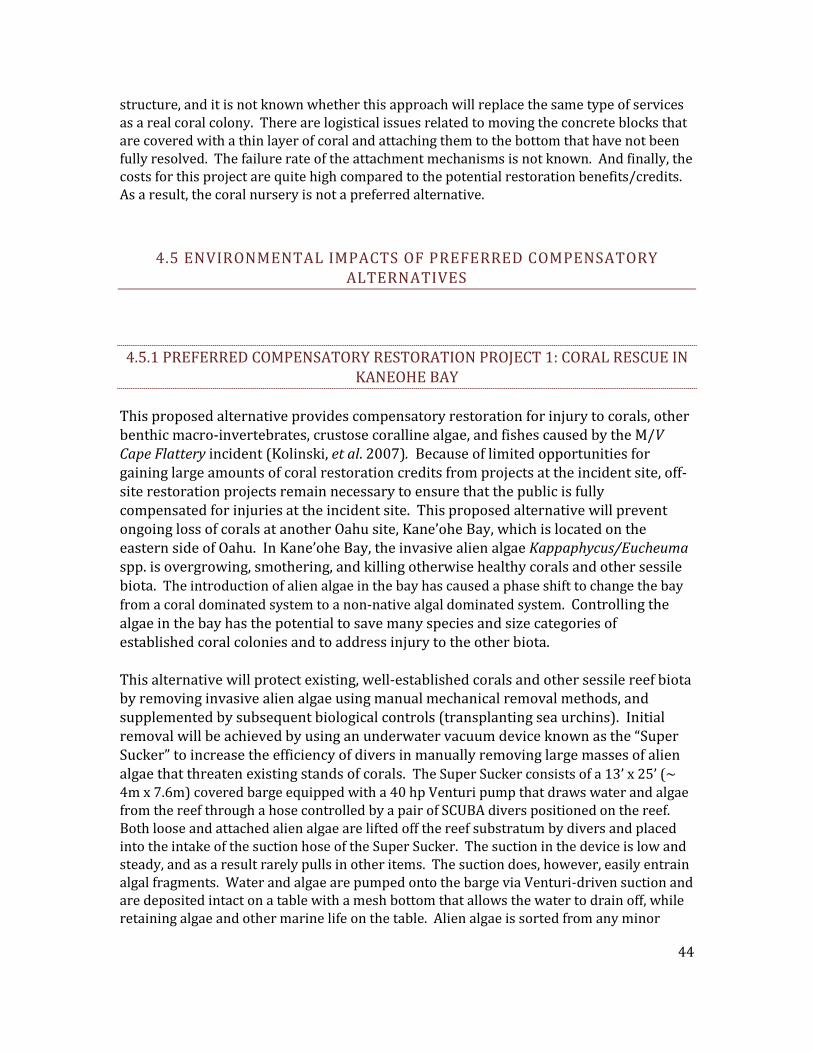
structure, and it is not known whether this approach will replace the same type of services as a real coral colony. There are logistical issues related to moving the concrete blocks that are covered with a thin layer of coral and attaching them to the bottom that have not been fully resolved. The failure rate of the attachment mechanisms is not known. And finally, the costs for this project are quite high compared to the potential restoration benefits/credits. As a result, the coral nursery is not a preferred alternative.
4.5 ENVIRONMENTAL IMPACTS OF PREFERRED COMPENSATORY ALTERNATIVES
4.5.1 PREFERRED COMPENSATORY RESTORATION PROJECT 1: CORAL RESCUE IN KANEOHE BAY
This proposed alternative provides compensatory restoration for injury to corals, other benthic macro-invertebrates, crustose coralline algae, and fishes caused by the M/V Cape Flattery incident (Kolinski, et al. 2007). Because of limited opportunities for gaining large amounts of coral restoration credits from projects at the incident site, off-site restoration projects remain necessary to ensure that the public is fully compensated for injuries at the incident site. This proposed alternative will prevent ongoing loss of corals at another Oahu site, Kane’ohe Bay, which is located on the eastern side of Oahu. In Kane’ohe Bay, the invasive alien algae Kappaphycus/Eucheuma spp. is overgrowing, smothering, and killing otherwise healthy corals and other sessile biota. The introduction of alien algae in the bay has caused a phase shift to change the bay from a coral dominated system to a non-native algal dominated system. Controlling the algae in the bay has the potential to save many species and size categories of established coral colonies and to address injury to the other biota. This alternative will protect existing, well-established corals and other sessile reef biota by removing invasive alien algae using manual mechanical removal methods, and supplemented by subsequent biological controls (transplanting sea urchins). Initial removal will be achieved by using an underwater vacuum device known as the “Super Sucker” to increase the efficiency of divers in manually removing large masses of alien algae that threaten existing stands of corals. The Super Sucker consists of a 13’ x 25’ (~ 4m x 7.6m) covered barge equipped with a 40 hp Venturi pump that draws water and algae from the reef through a hose controlled by a pair of SCUBA divers positioned on the reef. Both loose and attached alien algae are lifted off the reef substratum by divers and placed into the intake of the suction hose of the Super Sucker. The suction in the device is low and steady, and as a result rarely pulls in other items. The suction does, however, easily entrain algal fragments. Water and algae are pumped onto the barge via Venturi-driven suction and are deposited intact on a table with a mesh bottom that allows the water to drain off, while retaining algae and other marine life on the table. Alien algae is sorted from any minor
44
amounts of incidental by-catch and placed in mesh bags. While experience with this system has shown there to be very little to no by-catch, the sorting process allows for control and oversight of the material being removed from the bay. Restoration Objective: The overall goal of the Coral Rescue project is to prevent coral losses by removing alien algae. This project will directly compensate for the coral injury resulting from the grounding incident by increasing the amount of ecological services provided by coral around the Oahu coast (Kolinski, et al. 2008). The ecological services provided by the corals include habitat and forage for fish and invertebrates, among others. The proposed restoration site within Kaneohe Bay is shown in Figure 13 and is known as the Marker 12 reef.
FIGURE 13. Map showing the location of Marker 12 reef (Primary) within Kaneohe Bay, Oahu.- Probability of Success: The probability of preventing alien algae from overgrowing established coral colonies in Kane’ohe Bay with this alternative is extremely high. The State of Hawaii Division of Aquatic Resources, in conjunction with The Nature Conservancy, has been successfully conducting this activity for a number of years. The removal criteria necessary for this project are within established removal rates for existing projects of this nature.
45
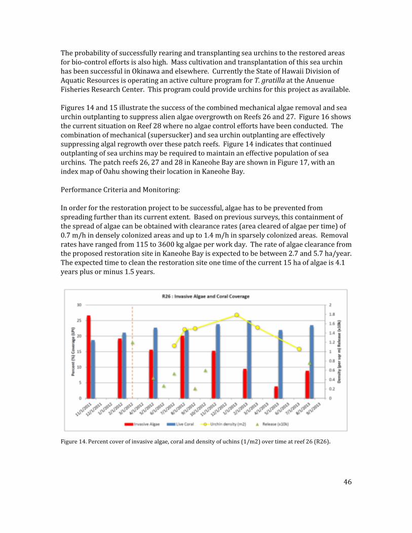
The probability of successfully rearing and transplanting sea urchins to the restored areas for bio-control efforts is also high. Mass cultivation and transplantation of this sea urchin has been successful in Okinawa and elsewhere. Currently the State of Hawaii Division of Aquatic Resources is operating an active culture program for T. gratilla at the Anuenue Fisheries Research Center. This program could provide urchins for this project as available. Figures 14 and 15 illustrate the success of the combined mechanical algae removal and sea urchin outplanting to suppress alien algae overgrowth on Reefs 26 and 27. Figure 16 shows the current situation on Reef 28 where no algae control efforts have been conducted. The combination of mechanical (supersucker) and sea urchin outplanting are effectively suppressing algal regrowth over these patch reefs. Figure 14 indicates that continued outplanting of sea urchins may be required to maintain an effective population of sea urchins. The patch reefs 26, 27 and 28 in Kaneohe Bay are shown in Figure 17, with an index map of Oahu showing their location in Kaneohe Bay. Performance Criteria and Monitoring: In order for the restoration project to be successful, algae has to be prevented from spreading further than its current extent. Based on previous surveys, this containment of the spread of algae can be obtained with clearance rates (area cleared of algae per time) of 0.7 m/h in densely colonized areas and up to 1.4 m/h in sparsely colonized areas. Removal rates have ranged from 115 to 3600 kg algae per work day. The rate of algae clearance from the proposed restoration site in Kaneohe Bay is expected to be between 2.7 and 5.7 ha/year. The expected time to clean the restoration site one time of the current 15 ha of algae is 4.1 years plus or minus 1.5 years.
Figure 14. Percent cover of invasive algae, coral and density of uchins (1/m2) over time at reef 26 (R26).
46
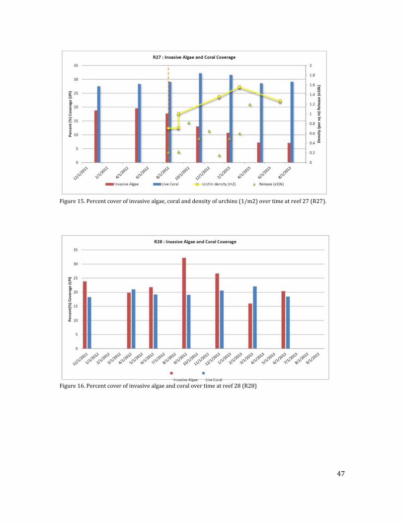
Figure 15. Percent cover of invasive algae, coral and density of urchins (1/m2) over time at reef 27 (R27).
Figure 16. Percent cover of invasive algae and coral over time at reef 28 (R28)
47
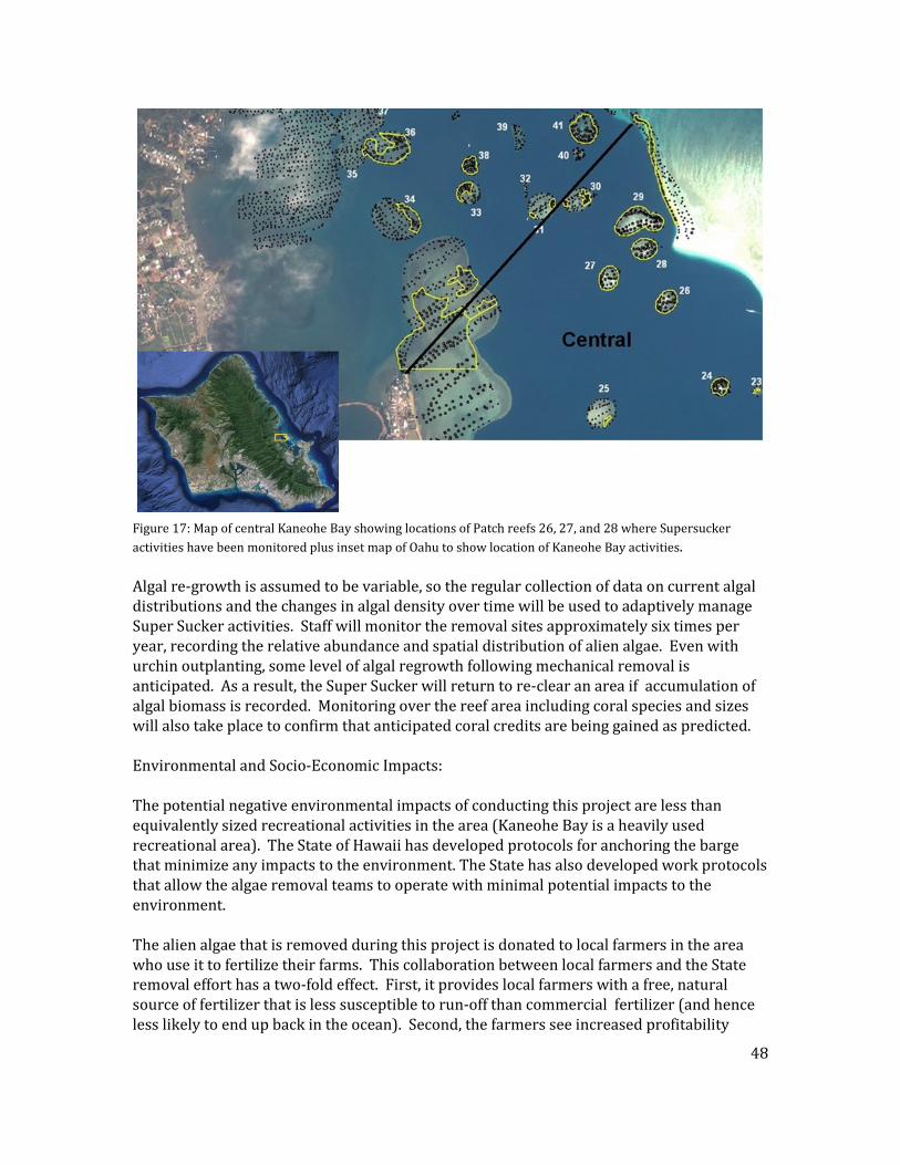
Figure 17: Map of central Kaneohe Bay showing locations of Patch reefs 26, 27, and 28 where Supersucker activities have been monitored plus inset map of Oahu to show location of Kaneohe Bay activities. Algal re-growth is assumed to be variable, so the regular collection of data on current algal distributions and the changes in algal density over time will be used to adaptively manage Super Sucker activities. Staff will monitor the removal sites approximately six times per year, recording the relative abundance and spatial distribution of alien algae. Even with urchin outplanting, some level of algal regrowth following mechanical removal is anticipated. As a result, the Super Sucker will return to re-clear an area if accumulation of algal biomass is recorded. Monitoring over the reef area including coral species and sizes will also take place to confirm that anticipated coral credits are being gained as predicted. Environmental and Socio-Economic Impacts: The potential negative environmental impacts of conducting this project are less than equivalently sized recreational activities in the area (Kaneohe Bay is a heavily used recreational area). The State of Hawaii has developed protocols for anchoring the barge that minimize any impacts to the environment. The State has also developed work protocols that allow the algae removal teams to operate with minimal potential impacts to the environment. The alien algae that is removed during this project is donated to local farmers in the area who use it to fertilize their farms. This collaboration between local farmers and the State removal effort has a two-fold effect. First, it provides local farmers with a free, natural source of fertilizer that is less susceptible to run-off than commercial fertilizer (and hence less likely to end up back in the ocean). Second, the farmers see increased profitability
48
because they are spending less to produce their crops. Kappaphycus/Eucheuma species ``die quickly in low salinity water, insuring that runoff from taro fields will not infect offshore areas near stream runoff (Sulu et al 2004). Because the Super Sucker takes in sea water as it collects the algae and returns it back to the ocean, it technically creates a “discharge” under Section 404 of the Clean Water Act. The State of Hawaii Division of Aquatic Resources has collaborated with the State Department of Health to certify that the “discharge” is not in violation of the law. Cumulative Impacts: The Preferred Compensatory Restoration Alternative is expected to result in positive impacts to the affected area by accelerating recovery and enhancing the coral reef at this site. Preventing further coral losses by removing alien algae will directly compensate for the coral injury resulting from the grounding incident, and will increasing the amount of ecological services provided by coral, and achieve this in a shorter timeframe. The benefits of these ecological services that would be provided by the corals include habitat and forage for fish and invertebrates, among others, but the effects would be local and are not expected to significantly affect the human environment alone or in combination with other reef restoration projects around the Oahu coast. Kaneohe Bay itself is a heavily trafficked recreational area, however Marker 12 specifically is not heavily used. Marker 12 is located on the northern side of the bay, and is subjected to a greater amount of open ocean wind-driven waves that make the area unpalatable for recreational users. The reef area at Marker 12 is well marked for transiting boat vessels in the area, so future groundings are unlikely. Although there are other restoration actions occurring (as noted in the probability of success discussion, the Nature Conservancy has been successfully conducting invasive algae removal in Kaneohe Bay for a number of years, and cultivation and transplantation of sea urchins have been successful in Okinawa and elsewhere), currently they are not being conducted in the northern part of Kaneohe Bay. These other past and potential future similar actions by the Nature Conservancy or others are unlikely to have any additive effects or otherwise have interaction with coral reef resources at the proposed restoration actions at Marker 12. Scientific actions being conducted at the Coconut Island facility by the Hawaii Institute of Marine Biology are also mostly constrained to the south and central portions of Kaneohe Bay, and are also unlikely to interact with the proposed restoration. There are no reasonably foreseeable future restoration or scientific actions planned for the future near Marker 12 in Kaneohe Bay that NOAA is aware of.
4.5. CONSIDERED BUT REJECTED COMPENSATORY RESTORATION PROJECTS
4.5.2.1 COMPENSATORY RESTORATION ALTERNATIVE 1: REEF WARNING BUOYS This alternative consists of using surface marker buoys to identify high coral concentrations that may be susceptible to vessel groundings or other disturbances, and that should be
49
avoided. The Trustees had a number of concerns about this alternative. One is that marking off areas of high coral concentrations might actually attract and focus ocean activities such as snorkeling, SCUBA diving, and fishing in those areas, which could increase the risk of impacts to the corals. Another is that marker buoys require a large amount of upkeep and maintenance and would most likely be subject to vandalism and theft. A final concern with this alternative is that there is no reliable way to scale the coral colony years gained (or protected from future losses) from this activity.
4.5.2.2 COMPENSATORY RESTORATION ALTERNATIVE 2: DAY USE MOORINGS This alternative consists of using surface moorings in areas of high coral concentrations that may be susceptible to anchor impacts from vessels visiting the area. The Trustees have the same concerns about this alternative as the reef warning buoy alternative discussed above – 1) There is very little if any anchoring occurring in the area, 2) the moorings in areas of high coral concentrations might actually attract and focus ocean activities such as snorkeling, SCUBA diving, and fishing in those areas and could increase the risk of impacts to the corals; 3) the moorings would require a large amount of upkeep and maintenance and would most likely be subject to vandalism and theft; and 4) there is no reliable way to scale the coral colony years gained (or protected from future losses) from this activity.
4.5.2.3 COMPENSATORY RESTORATION ALTERNATIVE 3: PROVIDING CURRENT METERS AND COMMUNICATION EQUIPMENT TO BARBERS POINT HARBOR.
Because of the strong shifting currents in the area and the difficulties in communication, which may have contributed to the Flattery grounding, the Trustees discussed an alternative that would provide additional information for vessels entering and leaving the harbor. The alternative would provide real time current information to the harbor master and harbor pilots and could potentially help prevent groundings in the future. However, there is no way to verify the possible effects or outcomes of this alternative and no way to scale possible restoration benefits. 4.5.2.4 COMPENSATORY RESTORATION ALTERNATIVE 4: CAPACITY BUILDING FOR
FUTURE GROUNDINGS The Trustees considered an alternative that would increase response capacity for ship groundings. Building response capacity of local agencies may enhance the timing and effectiveness of measures to reduce impacts to natural resources from future groundings. One aspect of capacity building would be to open a dialog by holding an international workshop on coral restoration in Hawaii. Using the information from this workshop, the Trustees would design a formalized toolbox of techniques for ship grounding response and coral restoration in Hawaii. In addition to formalized techniques for coral restoration, the Trustees would fund and train a Coral Reef Rapid Response Team, which would be used for future vessel groundings and coral injury incidents. While the Trustees agreed that this type of capacity building is much needed in Hawaii, there is no way to scale the restoration benefits and recovery of lost coral colony years, in part because no one can be sure how
50
many groundings will occur in the future and whether those groundings will impact the same types of resources injured by the M/V Cape Flattery Incident.
4.5.2.5 COMPENSATORY RESTORATION ALTERNATIVE 5: CONTROL OF RUN-OFF FROM CAMPBELL INDUSTRIAL PARK.
Control of runoff and sedimentation from nearby Campbell Industrial Park was considered. Building sediment control structures such as sediment traps and basins as well as addressing the channelized streams in the area could reduce runoff and sedimentation, which can impact coral reefs and other resources. The costs of such work would be prohibitively high. Additionally there is no adequate way to measure the possible impacts from the runoff in the Campbell Industrial Park area nor is there a way to scale the subsequent restoration benefits of reducing the runoff.
4.5.2.6 COMPENSATORY RESTORATION PROJECT 7: RESTORING ORPHAN VESSEL GROUNDING SITES
In this project, compensatory restoration would be gained at orphan vessel grounding sites primarily by preventing ongoing injury to intact corals that are threatened by coral debris generated by the grounding incident. This activity would only be pursued where no viable responsible party exists (hence the term “orphan”) to do the necessary restoration at such grounding sites. Some additional restoration credit may be gained for re-attaching intact loose colonies when appropriate. Coral debris, including blocks of coral rock, that are dislodged by vessel groundings can be moved by wave action and can crush, bury, or abrade intact corals surrounding the grounding site. The same basic restoration process described here could also be applied to reef habitats that are threatened by similar injury-causing factors, such as loose derelict fishing gear and other debris. However, experience in Hawaii indicates that the injuries created by so-called orphan vessels are too small in scope and too infrequent to create enough restoration credits to be cost effective for the M/V Cape Flattery injury. As a result, the Trustees rejected this alternative.
4.6 RESTORATION MANAGEMENT OUTLINE
4.6.1 BUDGET The Trustees and the RPs settled the claim for natural resource damages in 2012 for $7,500,000. The U.S. District Court in Honolulu approved the consent decree containing the terms of that settlement on April 27, 2013. The Trustees calculated their claim in this case by scaling the preferred restoration alternatives to match (as closely as possible) the loss of natural resources and services that occurred from the grounding and subsequent response actions as well as accounting for agency past assessment costs and for future costs to oversee implementation of the restoration.
51
The consent decree reimbursed costs incurred by the state and federal trustees to conduct the emergency restoration actions, triage of injured corals, injury assessment, restoration planning, and other related actions. Those costs totaled $1,618,820. The remainder, $5,881,180, is for restoration, enhancement and protection of coral reef habitat and associated resources. The Trustees are proposing the following allocation of restoration funds among three components: Oversight = $381,180 These are essentially overhead costs for processing, planning, and reviewing the restoration actions. Monitoring = $500,000 These costs are for monitoring the natural recovery of the injury site. Restoration = $5,000,000 The costs for implementation of the preferred compensatory restoration project.
4.6.2 ADAPTIVE PROJECT MANAGEMENT The Trustees will review the preferred primary and compensatory restoration projects every two years to determine whether the selected projects are meeting expected goals. If natural recovery of corals at the grounding site is not occurring as expected, and if a method exists to address the cause of reduced recovery, then the Trustees may shift funds from the compensatory restoration project to activities at the grounding site. If the compensatory restoration project fails to yield sufficient coral restoration credits to compensate for coral loss at the incident site, the Trustees will meet to determine a more appropriate compensatory project. The bi-annual review and possible reallocation of resources will be conducted by the Trustees through a Trustee Oversight Committee composed of duly appointed staff from the NOAA Restoration Center, the FWS Ecological Services Office, and the State of Hawaii Division of Aquatic Resources.
52
5.0 COORDINATION WITH OTHER PROGRAMS, PLANS, AND REGULATORY AUTHORITIES
5.1 OVERVIEW Two major federal laws guiding the restoration of the injured resources and services from the M/V Cape Flattery incident are OPA and NEPA. OPA and its natural resource damage assessment regulations provide the basic framework for natural resource damage assessment and restoration. NEPA, as a procedural law, sets forth a specific process of impact analysis and public review. In addition, the Trustees must comply with other applicable laws, regulations and policies at the federal, state and local levels. The potentially relevant laws, regulations and policies are set forth below. The listing below is not necessary exclusive as there may be other laws, regulations or policies with which the Trustees will need to comply. In addition to laws and regulations, the Trustees must consider relevant environmental programs that are ongoing or planned for in the affected environment. By coordinating restoration with other relevant programs and plans, the Trustees can enhance the overall effort to improve the near shore coral reef environment of Hawaii. As noted previously, the Trustees elected to combine the restoration plan required under OPA with the environmental review processes required under NEPA. This will enable the Trustees to implement restoration more rapidly than had these processes been undertaken sequentially.
5.2 KEY STATUTES, REGULATIONS AND POLICIES Oil Pollution Act of 1990 (OPA), 33 U.S.C. §§ 2701, et seq.; 15 C.F.R. Part 990 OPA establishes a liability regime for oil spills which injure or are likely to injure natural resources and/or the services that those resources provide to the ecosystem or humans. Federal and state agencies and Indian tribes act as Trustees on behalf of the public to assess the injuries, scale restoration to compensate for those injuries and implement restoration. Section 1006(e)(1) of OPA,33 U.S.C. § 2706 (e)(1), requires the President, acting through the Under Secretary of Commerce for Oceans and Atmosphere (NOAA), to promulgate regulations for the assessment of natural resource damages resulting from a discharge or substantial threat of a discharge of oil. Assessments are intended to provide the basis for restoring, replacing, rehabilitating, and acquiring the equivalent of injured natural resources and services.
53
The OPA regulations provide a framework for conducting sound natural resource damage assessments that achieve restoration. The process emphasizes both public involvement and participation by the responsible party(ies). The Trustees have followed the regulations in this assessment. Hawaii Environmental Response Law, Title 10, chapter 128D, Hawaii Revised Statutes The State of Hawaii response law addresses the release or threatened release of any hazardous substance, including oil, into the environment. It creates an environmental response fund which can be used to pay for, among other things, costs of removal actions and costs incurred to restore, rehabilitate, replace or acquire the equivalent of any natural resources injured, destroyed or lost as the result of a release of a hazardous substance. The statute further provides that there shall be no double recovery for natural resource damages. The statute states that upon the request of the Department of Health, the attorney general will recover such costs from the responsible parties. The State of Hawaii Department of Health has promulgated regulations to address the cleanup of releases of hazardous substances. The federal and state Trustees have participated in cooperative injury assessment and restoration planning activities so as to avoid the possibility of any double recovery. National Environmental Policy Act (NEPA), as amended, 42 U.S.C. §§ 4321, et seq. 40 C.F.R. Parts 1500-1508 Congress enacted NEPA in 1969 to establish a national policy for the protection of the environment. NEPA applies to federal agency actions that affect the human environment. NEPA established the Council on Environmental Quality (CEQ) to advise the President and to carry out certain other responsibilities relating to implementation of NEPA by federal agencies. Pursuant to Presidential Executive Order 11514, federal agencies are obligated to comply with the NEPA regulations adopted by the CEQ. These regulations outline the responsibilities of federal agencies under NEPA and provide specific procedures for preparing environmental documentation to comply with NEPA. The Trustees have integrated this restoration plan with the NEPA process to comply, in part, with those requirements. This integrated process is recommended under §1500.2 “(c) Integrate the requirements of NEPA with other planning and environmental review procedures required by law or by agency practice so that all such procedures run concurrently rather than consecutively.”. Hawaii Environmental Impact Statements, Title 19, Chapter 343, Hawaii Revised Statutes In this chapter, Hawaii has established a system of environmental review to ensure that environmental concerns are given appropriate consideration in decision making along with economic and technical considerations. The statute provides for public review and opportunity for comments on a range of activities such as proposed use of state or county lands or proposed use within the shoreline area. The statute notes that when an action is subject both to this chapter and NEPA, the state agencies “shall cooperate with federal
54
agencies to the fullest extent possible to reduce duplication between federal and state requirements.” This cooperation would include concurrent public review. The Trustees will integrate the federal and state environmental review requirements as they proceed with restoration planning and implementation. Coastal Zone Management Act (CZMA), 16 U.S.C. §§ 1451, et seq., 15 C.F.R. Part 923 The goal of the CZMA is to preserve, protect, develop, and where possible, restore and enhance the nation’s coastal resources. The federal government provides grants to the states with federally-approved coastal management programs. The State of Hawaii has a federally-approved program. Section 1456 of the CZMA requires that any federal action inside or outside of the coastal zone that affects any land or water use or natural resources of the coastal zone shall be consistent, to the maximum extent practicable, with the enforceable policies of approved state management programs. It states that no federal license or permit may be granted without giving the State the opportunity to concur that the project is consistent with the state’s coastal policies. The regulations outline the consistency procedures. To the extent that the CZMA applies, the Trustees will seek the concurrence of the State of Hawaii that their preferred projects are consistent to the maximum extent practicable with the enforceable policies of the state coastal program. Endangered Species Act (ESA), 16 U.S.C. §§ 1531, et seq., 50 C.F.R. Parts 17, 222, 224 The ESA directs all federal agencies to conserve federally listed endangered and threatened species and their habitats, and encourages such agencies to utilize their authorities to further these purposes. Under the Act, the NOAA Fisheries and the USFWS publish lists of endangered and threatened species. Section 7 of the Act requires that federal agencies consult with these two agencies to minimize the effects of federal actions on endangered and threatened species. Any short-term and temporary localized impacts (such as potential disturbance of endangered species by divers or boat traffic) from the proposed action will be minimized or eliminated by the use of best management practices. For example, algae removal workers could encounter endangered species or marine mammals during restoration activities. To avoid adverse impacts and prevent the potential for unauthorized “take” of a marine mammal or endangered species, divers observing or encountering marine mammals or endangered species while removing algae would be required to cease all activity until the animal departs the area. Algae removal workers will not approach or come within 150 ft of any Hawaiian monk seals that are in the area. In addition, if algae is heavily infested within the interstices of corals the divers will use extreme care when extricating the algae from the coral habitat. Live coral colonies or fragments, fish, and benthic invertebrates which are caught up in the super sucker as the algae are removed will be returned to the sea in the general vicinity as
55
soon as practical and to the greatest extent possible. Accordingly, any potential adverse impacts are expected to be only minor, short term, and not significant overall. The federal Trustees determined that implementing the proposed restoration would not be likely to adversely affect any listed species, and completed an informal section 7 consultation with the NOAA Fisheries Pacific Islands Regional Office, Protected Species Division on 11/13/2013. Magnuson-Stevens Fishery Conservation and Management Act, 16 U.S.C. §§ 1801 et seq. The Magnuson-Stevens Fishery Conservation and Management Act (Magnuson-Stevens Act) requires federal fishery management plans to describe the habitat essential to the fish being managed and describe threats to that habitat from both fishing and non-fishing activities. In addition, in order to protect this Essential Fish Habitat (EFH), federal agencies are required to consult with the National Marine Fisheries Service (NMFS) on activities that may adversely affect EFH. The Trustees determined that implementing the proposed restoration would not adversely affect any designated EFH, and concluded an EFH consultation with the PIRO Habitat Conservation Division on 12/17/2013. Hawaii Conservation of Aquatic Life, Wildlife, and Land Plants, Title 12, Chapter 195D Recognizing that many species of flora and fauna unique to Hawaii have become extinct or are threatened with extinction, the state established procedures to classify species as locally endangered or threatened. The statue directs the DLNR to determine what conservation measures are necessary to ensure the continued ability of species to sustain themselves. Fish and Wildlife Coordination Act (FWCA), 16 U.S.C. §§ 661, et seq. The FWCA requires that federal agencies consult with the USFWS, NMFS, and state wildlife agencies for activities that affect, control or modify waters of any stream or bodies of water, in order to minimize the adverse impacts of such actions on fish and wildlife resources and habitat. This consultation is generally incorporated into the process of complying with Section 404 of the Clean Water Act, NEPA or other federal permit, license or review requirements. In the case of restoration actions under this DARP/EA, the fact that the three consulting agencies for the FWCA (i.e., USFWS, NMFS, DLNR) are represented by the Trustees means that FWCA compliance will be inherent in the Trustee decision making process. Executive Order (EO) 13089 Coral Reef Protection On June 11, 1998, President Clinton issued EO 13089, Coral Reef Protection, to address impacts to coral reefs. Section 2 of that EO states that federal agency actions that may affect U.S. coral reef ecosystems shall: (a) identify their actions that may affect U.S. coral reef ecosystems; (b) utilize their programs and authorities to protect and enhance the conditions of such ecosystems; and (c) to the extent permitted by law, ensure that any
56
actions they authorize, fund, or carry out will not degrade the conditions of such ecosystems. Given that this DARP/EA is designed to restore injured coral and coral reef habitat, compliance with EO 13089 is inherent within the project.
6.0 LIST OF AGENCIES AND PERSONS CONSULTED NOAA Fisheries Protected Resources Division: Donald Hubner NOAA Fisheries Habitat Conservation Division: Danielle Jaywardene Hawaii Coastal Zone Management Program: John Nakagawa Hawaii Department of Land and Natural Resources: William Aila Hawaii Division of Aquatic Resources: Emma Anders U. S. Fish and Wildlife Service: Michael Fry
57
APPENDIX ONE
Monitoring of Natural Recovery as Primary Restoration for the M/V Cape Flattery Impact Site
Basic methods Priority information needed from a natural recovery monitoring program at the Cape Flattery vessel grounding site. Monitoring will be focused directly on recovery of the coral reef community most heavily impacted by the vessel hull and surrounding coral reefs injured from anchors, anchor chains, and tow cables. Reference sites will be selected from adjacent un-impacted areas. Factors used to select appropriate reference sites include similarity to the impact sites by depth, topography and substrate/community type. Types of surveys. The monitoring areas will be qualitatively and quantitatively surveyed. Quantitative surveys will be used to address specific questions of resource recovery concerning coral recruitment, growth rates and species composition. Qualitative surveys will be designed to gauge general ecosystem parameters and to detect unanticipated changes in the reef community. See below for a description of data to be collected. Layout of survey locations. The anticipated survey methodology will include permanent plots/transects marked by fixed stakes or other permanent markers. In order to efficiently cover all habitats and sub-habitats, the survey design will use a stratified random design. Data to be recorded. Both quantitative and qualitative data will be collected. The quantitative surveys will include surveying the following biota using similar methodology used during the trustees’ injury pre-assessment surveys. These metrics include:
• Corals: species, sizes, counts within fixed areas (i.e., to produce records of population densities);
• Algae: percent cover of species and species groupings; • Fish: counts by species and/or by other groupings (family or functional
categories); • Mobile invertebrates (counts by species or genera in fixed areas to give
population densities).
The qualitative data collected will include the following activities:
58
• A one-day qualitative reconnaissance/inspection of the impact site by the 4-member biologist team to detect and record any unexpected phenomena related to the injury (conducted during the quantitative surveys).
• Monitoring of changes in the substratum to track trends in substrate condition (e.g., erosion, build-up of fragmenting substrate, dispersion of fragments).
• Mapping of the area to detect the presence, relative abundance, and distribution of alien algae in the impact and reference sites.
The results of each survey will be analyzed and a written report will be provided to the Trustee Oversight Committee.
REFERENCE LIST
AECOS, Inc. 1985. Biological Reconnaissance of Marine Benthic Communities in the Vicinity of the Barbers Point Deep draft Harbor Construction Project. Report prepared for the Dept. of the Army, U.S. Army Engineer Division, Pacific Ocean. 30pp.
AECOS, Inc. 1991. Biological monitoring program, shoreline marine bench environment near Ko Olina Lagoon 1, West Beach, Oahu. Final Report. Prepared for OI Consultants, Inc. Makapuu Point. AECOS No. 472.
AECOS, Inc. 1991b, Post Construction Surveys of Algae and Invertebrates on the Marine Bench and the Nearshore Bottom Adjacent to the Ko Olina Resort Lagoons. Part III Prepared for OI Consultants, Inc. Makapuu Point. AECOS No. 607.
AECOS, Inc. 2010. Marine biological survey for Ko Olina Marine Improvements, Oahu, Hawaii. Final Report. Prepared for Arnold T. Okuba and Associates. AECOS No. 1242.
Bienfang, P. K., and R. E. Brock. 1980. Predevelopment reconnaissance of the water quality and macrobiota conditions affronting the West Beach coastline, Oahu, Hawaii. Tech. Rept. Submitted to Environmental Communications, Inc., Honolulu.
Brostoff, W. N.. 1989 Avrainvillea amadelpha (Codiales, Chlorophyts) from Oahu, Hawaii. Pacific Science V43 (2):166-169.
Brock, R. E. 1987. Baseline survey of benthic marine resources in the nearshore marine environment off West Beach, Oahu. In: OI Consultants, Inc. Baseline survey of water quality and benthic resources in the nearshore marine environment off West Beach. Oahu. Prep. For West Beach Estates, Honolulu. AECOS No 436. Section B.
59
Dollar, S.J. 1982. Wave stress and coral community structure in Hawaii. Coral Reefs 1:71-81
Dollar, S.J., and R. W. Grigg. 2004. Anthropogenic and Natural Stresses on Selected Coral Reefs in Hawai'i: A Multidecade Synthesis of Impact and Recovery. Pacific Science. Vol. 58(2) pp.281-304.
Friedlander, A. M. and J. D. Parrish. 1998. Habitat characteristics affecting fish assemblages on a Hawaiian coral reef. Journal of Experimental Marine Biology and Ecology 224:1-30.
Grigg RW, Epp D (1989) Critical depth for the survival of coral islands: effects on the Hawaii Archipelago.Science 243(4891):638–641 Hoegh-Guldberg. O. 1999. Climate change, coral bleaching and the future of the world’s coral reefs. Marine and Freshwater Research. 50(8) 839-866.
Kenyon, J. 2005. Assessment of benthic damage using towed-diver surveys following the Cape Flattery vessel grounding incident, Oahu, Hawaii. Attorney Work Product, PIFSC Internal Report IR-05-02, 32 pp. Kimmerer, W.J., and W.W. Durbin, Jr. 1975. The potential for additional marine conservation districs on Oahu and Hawaii. Sea Grant Tech. Rept., UNIHI_SEAGRANT-TR-76-03: 108 p.
Kleypas JA, Feely RA, Fabry VJ, Langdon C, Sabine CL, Robbins LL. 2006. Impacts of ocean acidification mon coral reefs and other marine calcifiers: a guide for future research. 88 pp. Report of a workshop sponsored by NSF, NOAA, and the U.S. Geological Survey. St. Petersburg, Florida Kolinski, S. P. 2005a. Initial observations on biological damage arising from the Cape Flattery ship grounding at Barbers Point, Oahu with recommendations for quantitative surveys and substrate stabilization to minimize further loss of coral reef resources. NOAA PIRO Report, 9 pp.
Kolinski, S. P. 2005b. Emergency restoration of reef habitat and resources damaged in the grounding and removal of the M/V Cape Flattery, Barbers Point, Oahu, Hawaii, 2005. Attorney Work Product, NOAA PIRO Report, 12 pp.
Kolinski, S., E. Cox, R. Okano, M. Parry, K. Foster. (2007) Pre-assessment report of injury to coral reef resources and habitat in association with the grounding and removal of the M/V CAPE FLATTERY, Barbers Point, Oahu. Trustee Pre-Assessment Report.
Kolinksi, S., S. Thur, J. Cubit. (2008) Modeling Coral Year Equivalency between M/V Cape Flattery Injury and Compensatory Restoration in Kaneohe Bay, Hawaii. NOAA PIRO Report, 50 pp.
60
Maragos, J. E., and P. L. Jokiel. 1986. Reef corals of Johnston Atoll: One of the world’s most isolated reefs. Coral Reefs. 4:141-150
Maragos, J.E., D.C. Potts, G.S. Aeby, D. Gulko, J.C. Kenyon, D. Siciliano, and D. VanRavenswaay. 2004. 2000-2002 Rapid Ecological Assessments of corals (Anthozoa) on shallow reefs of the Northwestern Hawaiian Islands. Part 1: species and distribution. Pacific Science 58(2): 211-230.
McDermid, K.J., 1988. Community ecology of some intertidal subtropical algae, and the biology and taxonomy of Hawaiian Laurencia (Rhodophyta). PhD Dissertation, Dept. of Botany. Univ. of Hawaii. 332p.
Polaris Applied Sciences, Inc. 2005. M/V Cape Flattery pre-assessment data review, emergency restoration. PowerPoint presentation, 26 slides.
Russell, D. J., G. H. Balazs, R. C. Phillips and A. K. H. Kam. 2003. Discovery of the sea grass Halophila decipiens (Hydrocharitaceae) in the diet of the Hawaiian green turtle, Chelonia mydas. Pacific Science 57: 393–397.
Sulu R., Kumar L., Hay C., Pickering T., 2004. Kappaphycus seaweed in the Pacific : review of introductions and field testing proposed quarantine protocols. Secretariat for the Pacific Community. Noumea, New Caledonia. Pp84. USCG (undated) Report of Investigation into the Circumstances Surrounding the Incident Involving Grounding-Cape Flattery on 02/20/2005. MISLE Activity Number 2286265. Originating Unit: Sector Honolulu. MISLE Activity Owner: Commandant (G-MRI).
MISLE Activity Controller: Commandant (G-MRI). MISLE Case Number 218555. USCG, Feb. 11, 2005. Cape Flattery floated free of reef. Press Release. M/V Cape Flattery Grounding Unified Command Joint Information Center.
U.S. Fish and Wildlife Service. 1997. Draft Fish and Wildlife Coordination Act Report. Kalaeloa Barber’s Point Deep Draft Harbor Modification Study Island of Oahu, Hawaii. Prepared for U.S. Army Corps of Engineers. 16 p.
U.S. Fish and Wildlife Service. 2002. Proposed Modifications to Kalaeloa Barbers Point Harbor, Oahu, Hawaii. Fish and Wildlife Coordination Act Report. August 2002.
U.S. Fish and Wildlife Service. 2007. Draft Fish and Wildlife Coordination Act Report. Kalaeloa (Barber’s Point) Deep Draft Harbor Oahu, Hawaii. Prepared for U.S. Army Corps of Engineers. 2007. 219 p.
Veron, J. E. N., 1986. Corals of Australia and the Indo-Pacific. Angus and Robertson, North Ryde (N.S.W.) pp 644.
61

APPENDIX TWO Concurrence request letter from NOAA RC to NMFS PIRO Protected Resources Division
62
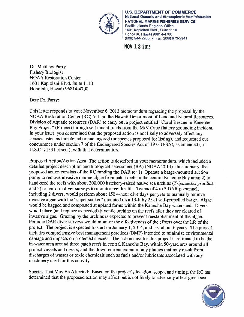
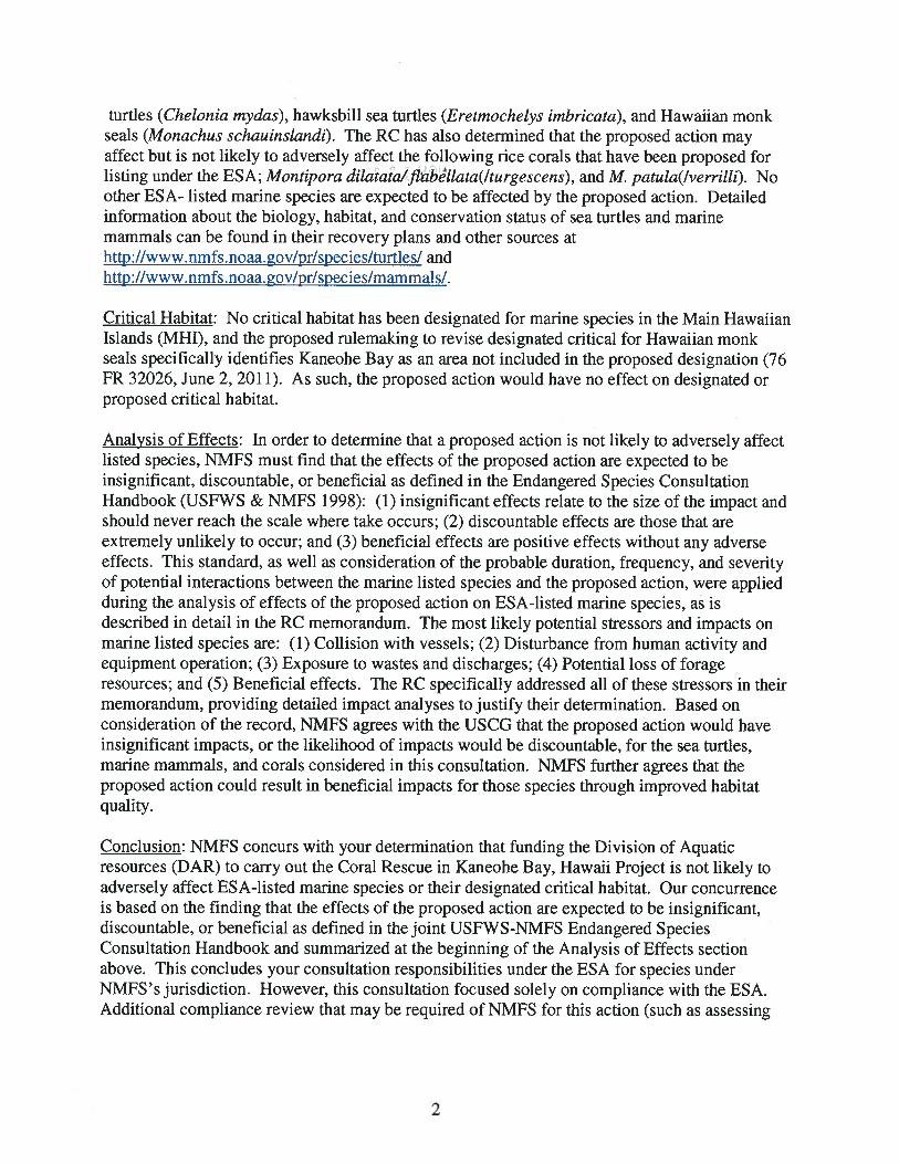
Concurrence request from NOAA RC to NMFS PIRO Protected Resources Division Nov 6, 2013
U.S. DEPARTMENT OF COMMERCE National Oceanic and Atmospheric Administration NATIONAL MARINE FISHERIES SERVICE Pacific Islands Regional Office 1601 Kapiolani Blvd., Suite 1110 Honolulu, Hawaii 96814-4700 (808) 944-2200 ∙ Fax: (808) 973-2941
MEMORANDUM FOR: Lisa Van Atta Assistant Regional Administrator Protected Resources Division FROM: Matthew Parry Fishery Biologist NOAA Restoration Center SUBJECT: Coral Rescue in Kaneohe Bay Restoration project from M/V Cape Flattery settlement The National Oceanic and Atmospheric Administration’s (NOAA) Restoration Center (RC) requests concurrence with our determination that conducting restoration actions to restore lost public trust resources as a result of the M/V Cape Flattery vessel grounding is not likely to adversely affect any species listed as threatened or endangered (or species proposed for listing) under the Endangered Species Act (ESA), or to adversely affect designated or proposed critical habitat under NMFS jurisdiction. Proposed Action The NOAA RC proposes to fund the State of Hawaii Department of Land and Natural Resources, Division of Aquatic Resources (DAR) to carry out a project entitled “Coral Rescue in Kaneohe Bay” (Project) through settlement funds from the M/V Cape Flattery grounding incident. The Project would be implemented by DAR staff. The main focus of this project is a multi-tiered approach including the efficient mechanical removal of algae coupled with an increase in native herbivory via outplanting of the native sea urchin, Tripnuestes gratilla, toward the restoration of coral reefs, which will help to save existing corals as well as create increased habitat for coral recruitment and fish. Section 7(a)(2) of the Endangered Species Act (ESA) of 1973, as amended (16 U.S.C. §1531 et seq.), requires that a federal agency ensure that any action authorized, funded, or
63
carried out by the agency is not likely to jeopardize the continued existence of any endangered or threatened species or result in the destruction or adverse modification of critical habitat of those species. When the action of a federal agency may affect a protected species or its critical habitat, that agency is required to consult with the National Marine Fisheries Service (NMFS) and/or the U.S. Fish and Wildlife Service (FWS), depending upon the protected species that may be affected. Based on a review of the potentially affected federally-listed species or their designated and proposed critical habitats, as presented in the attached biological assessment (BA), NOAA’s RC has determined that the proposed action may affect, but is not likely to adversely affect, Green (T) and Hawksbill (E) Sea Turtles, the Hawaiian Monk Seal (E) and the Coral species that have been proposed for listing, (Montipora dilatata/flabellata(/turgescens) and M. patula(/verrilli). A No Effect determination has been reached for all other listed species. This BA includes the RC’s determination of effects to these species of concern. No critical habitat has been designated for marine species in the Main Hawaiian Islands (MHI), and the proposed rule making to revise designated critical for Hawaiian monk seals specifically identifies Kaneohe Bay as an area not included in the proposed designation (76 FR 32026, June 2, 2011). As such, the proposed action would have no effect on designated or proposed critical habitat. Project Description & Location Summary The proposed project will restore coral reef habitat in Kaneohe Bay through the removal of alien, invasive algae using an underwater vacuum and associated platform called the “Super Sucker”. Direct removal of algal biomass will be followed by the out-planting of the native urchin Tripnuestes gratilla, which has been shown to be an effective bio-control agent capable of keeping invasive algal biomass low over the long-term, allowing for the recovery of native coral and algae species. The Super Sucker is a proven technology that has been operating in the Bay over the past 8 years without impact to listed species. Urchins are being reared at the State’s Anuenue Fisheries Research Center facility to be out-planted at regular intervals over the life of the project period. Reefs will be monitored to assess the impacts of the Super Sucker, to document the extent of alien algae prior to and following removal, and to ascertain the optimal density of urchins per unit area to control alien algae re-growth over the long term. The project is expected to begin on 1/1/2014, and restoration activities will occur over the next 6 years. Monitoring will be long-term and is expected to extend through the life of the project and beyond. Introduction Kaneohe Bay is located on the island of Oahu and is considered a complex mix of both estuarine and coral reef ecosystems. The bay is approximately 11,000 acres with 12 streams and 7 watersheds (Kaneohe Bay Master Plan, 1992).
64
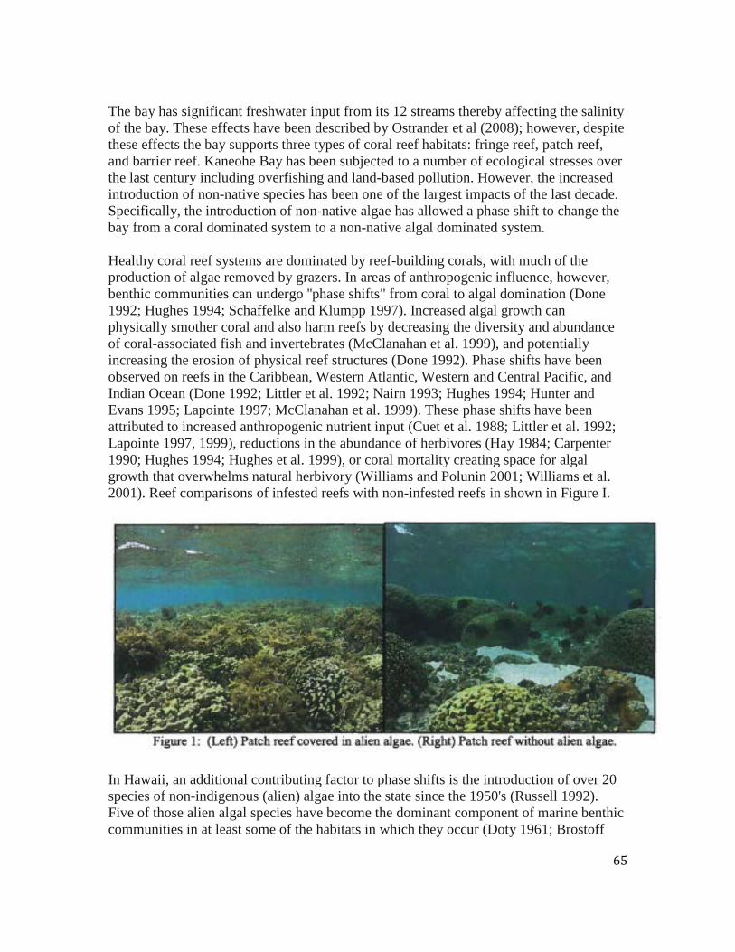
The bay has significant freshwater input from its 12 streams thereby affecting the salinity of the bay. These effects have been described by Ostrander et al (2008); however, despite these effects the bay supports three types of coral reef habitats: fringe reef, patch reef, and barrier reef. Kaneohe Bay has been subjected to a number of ecological stresses over the last century including overfishing and land-based pollution. However, the increased introduction of non-native species has been one of the largest impacts of the last decade. Specifically, the introduction of non-native algae has allowed a phase shift to change the bay from a coral dominated system to a non-native algal dominated system. Healthy coral reef systems are dominated by reef-building corals, with much of the production of algae removed by grazers. In areas of anthropogenic influence, however, benthic communities can undergo ''phase shifts" from coral to algal domination (Done 1992; Hughes 1994; Schaffelke and Klumpp 1997). Increased algal growth can physically smother coral and also harm reefs by decreasing the diversity and abundance of coral-associated fish and invertebrates (McClanahan et al. 1999), and potentially increasing the erosion of physical reef structures (Done 1992). Phase shifts have been observed on reefs in the Caribbean, Western Atlantic, Western and Central Pacific, and Indian Ocean (Done 1992; Littler et al. 1992; Nairn 1993; Hughes 1994; Hunter and Evans 1995; Lapointe 1997; McClanahan et al. 1999). These phase shifts have been attributed to increased anthropogenic nutrient input (Cuet et al. 1988; Littler et al. 1992; Lapointe 1997, 1999), reductions in the abundance of herbivores (Hay 1984; Carpenter 1990; Hughes 1994; Hughes et al. 1999), or coral mortality creating space for algal growth that overwhelms natural herbivory (Williams and Polunin 2001; Williams et al. 2001). Reef comparisons of infested reefs with non-infested reefs in shown in Figure I.
In Hawaii, an additional contributing factor to phase shifts is the introduction of over 20 species of non-indigenous (alien) algae into the state since the 1950's (Russell 1992). Five of those alien algal species have become the dominant component of marine benthic communities in at least some of the habitats in which they occur (Doty 1961; Brostoff
65
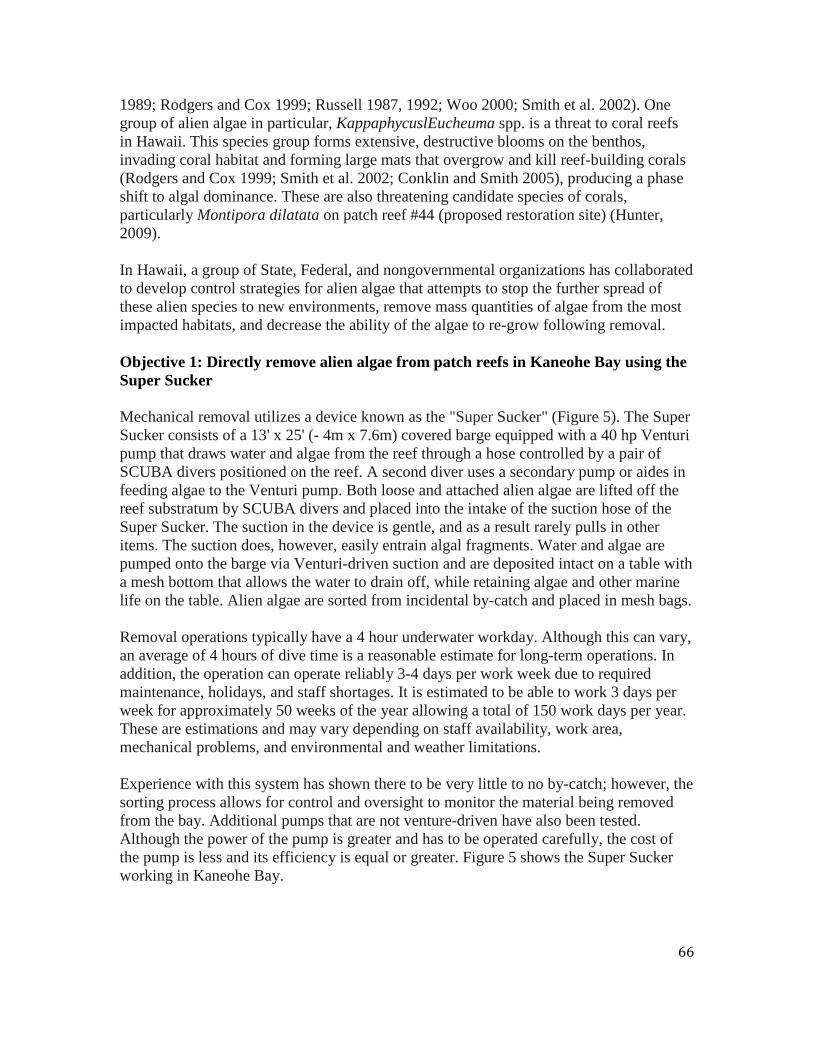
1989; Rodgers and Cox 1999; Russell 1987, 1992; Woo 2000; Smith et al. 2002). One group of alien algae in particular, KappaphycuslEucheuma spp. is a threat to coral reefs in Hawaii. This species group forms extensive, destructive blooms on the benthos, invading coral habitat and forming large mats that overgrow and kill reef-building corals (Rodgers and Cox 1999; Smith et al. 2002; Conklin and Smith 2005), producing a phase shift to algal dominance. These are also threatening candidate species of corals, particularly Montipora dilatata on patch reef #44 (proposed restoration site) (Hunter, 2009). In Hawaii, a group of State, Federal, and nongovernmental organizations has collaborated to develop control strategies for alien algae that attempts to stop the further spread of these alien species to new environments, remove mass quantities of algae from the most impacted habitats, and decrease the ability of the algae to re-grow following removal. Objective 1: Directly remove alien algae from patch reefs in Kaneohe Bay using the Super Sucker Mechanical removal utilizes a device known as the "Super Sucker" (Figure 5). The Super Sucker consists of a 13' x 25' (- 4m x 7.6m) covered barge equipped with a 40 hp Venturi pump that draws water and algae from the reef through a hose controlled by a pair of SCUBA divers positioned on the reef. A second diver uses a secondary pump or aides in feeding algae to the Venturi pump. Both loose and attached alien algae are lifted off the reef substratum by SCUBA divers and placed into the intake of the suction hose of the Super Sucker. The suction in the device is gentle, and as a result rarely pulls in other items. The suction does, however, easily entrain algal fragments. Water and algae are pumped onto the barge via Venturi-driven suction and are deposited intact on a table with a mesh bottom that allows the water to drain off, while retaining algae and other marine life on the table. Alien algae are sorted from incidental by-catch and placed in mesh bags. Removal operations typically have a 4 hour underwater workday. Although this can vary, an average of 4 hours of dive time is a reasonable estimate for long-term operations. In addition, the operation can operate reliably 3-4 days per work week due to required maintenance, holidays, and staff shortages. It is estimated to be able to work 3 days per week for approximately 50 weeks of the year allowing a total of 150 work days per year. These are estimations and may vary depending on staff availability, work area, mechanical problems, and environmental and weather limitations. Experience with this system has shown there to be very little to no by-catch; however, the sorting process allows for control and oversight to monitor the material being removed from the bay. Additional pumps that are not venture-driven have also been tested. Although the power of the pump is greater and has to be operated carefully, the cost of the pump is less and its efficiency is equal or greater. Figure 5 shows the Super Sucker working in Kaneohe Bay.
66
A team of four-five staff is required for safe and effective operation of the Super Sucker system. Two divers control the collection hose in the water, one-two sorters separate out the alien algae from the native by-catch as well as serve as stand-by divers, and one operation supervisor oversees the safety of the operation. In addition, a support boat is required to support the operation by off-loading algae and transporting personnel as needed as well as providing additional safety to the operation. All algal material will be utilized for composting in nearby watersheds. Several farmers in the area currently use the alien algae as fertilizer in crops. One farmer has routinely used algae from Kaneohe Bay as compost in taro and corn crops with excellent success. Previous operations have not exceeded the capacity of the farm to compost, so it is expected that several farms in the immediate area will be able to accommodate the large quantities of biomass during the course of the restoration activities. We have selected farms for disposal carefully in order to minimize the potential for spreading algae to areas not currently infested. Only allowing farms from watersheds within Kaneohe Bay will minimize exposure of other areas to Kappaphycus/Eucheuma spp. In addition, Kappaphycus/Eucheuma species die quickly in low salinity water, insuring that runoff from taro fields will not infect offshore areas near stream runoff (Sulu et al., 2004). Objective 2: Follow direct removal of alien algae with the deployment of Tripnuestes gratilla as a bio-control agent to prevent re-growth of alien algae over the long-term Studies have been conducted both on small-scale and large scale to test the effectiveness of native collector urchins, Tripnuestes gratilla, as a bio-control agent for invasive algae (DLNR, unpublished; Hunter 2002; Stimpson et al 2007). Long-term effectiveness of this strategy requires that urchins be reared in captivity to produce sufficient numbers for outplanting to reefs. In order to achieve this goal, DLNR built an urchin hatchery at Anuenue Fisheries Research Center. The hatchery includes larval culture systems,
67
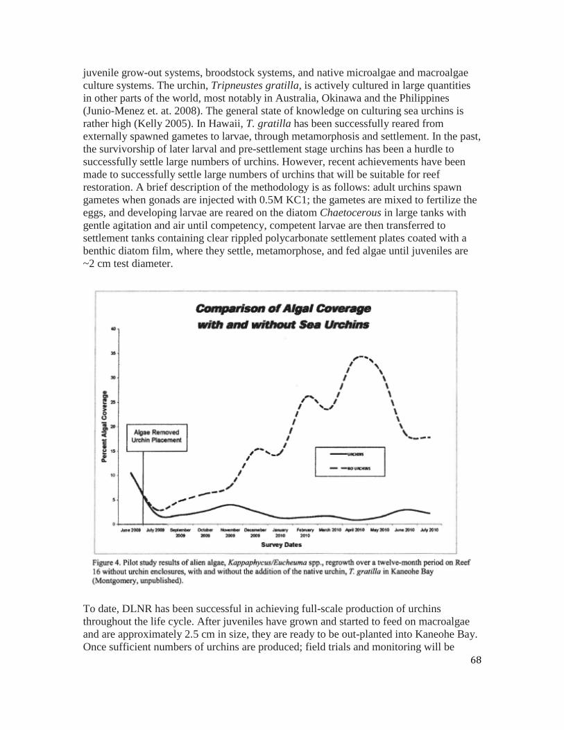
juvenile grow-out systems, broodstock systems, and native microalgae and macroalgae culture systems. The urchin, Tripneustes gratilla, is actively cultured in large quantities in other parts of the world, most notably in Australia, Okinawa and the Philippines (Junio-Menez et. at. 2008). The general state of knowledge on culturing sea urchins is rather high (Kelly 2005). In Hawaii, T. gratilla has been successfully reared from externally spawned gametes to larvae, through metamorphosis and settlement. In the past, the survivorship of later larval and pre-settlement stage urchins has been a hurdle to successfully settle large numbers of urchins. However, recent achievements have been made to successfully settle large numbers of urchins that will be suitable for reef restoration. A brief description of the methodology is as follows: adult urchins spawn gametes when gonads are injected with 0.5M KC1; the gametes are mixed to fertilize the eggs, and developing larvae are reared on the diatom Chaetocerous in large tanks with gentle agitation and air until competency, competent larvae are then transferred to settlement tanks containing clear rippled polycarbonate settlement plates coated with a benthic diatom film, where they settle, metamorphose, and fed algae until juveniles are ~2 cm test diameter.
To date, DLNR has been successful in achieving full-scale production of urchins throughout the life cycle. After juveniles have grown and started to feed on macroalgae and are approximately 2.5 cm in size, they are ready to be out-planted into Kaneohe Bay. Once sufficient numbers of urchins are produced; field trials and monitoring will be
68
necessary to determine the optimal density and restocking protocols necessary to prevent KappaphycuslEucheuma spp. from overgrowing patch reefs following algae removal. The reef will be monitored for changes in urchin and other invertebrate density, coral cover, coral recruitment, and algal density and diversity. The density of urchins will be controlled in order to maintain low algal abundance without any impacts to the reef (i.e. native coralline algae). This approach will be repeated for each reef that previously had significant algal densities. Reefs with lower algal abundance will be monitored closely and urchin density will be tailored to the needs of the individual reefs. In the long-term an overall out-planting strategy will be developed. The goal of the urchin hatchery is to produce approximately 20,000 juvenile urchins per month 10 times per year with an annual production of approximately 200,000 urchins. With an estimated maximum stocking density of 3 urchins per m2 in all primary restored areas, a total of 165,000 urchins would be needed. However, in anticipation of natural and fishing mortality, continual rearing will be conducted to offset any reduced survivorship in order to determine the long-term viability of urchin out-planting. Juvenile urchins will be transported to Kaneohe Bay from the sea urchin hatchery located at Anuenue Fisheries Research Center. Urchins will be transported in plastic trays 18"W x 26"L x 4"D lined with a cotton sheet, presoaked in hatchery sea water for several hours. Depending on size, 50-100 urchins will be carefully placed in the tray in a single layer then covered with an addional presoaked cotton sheet to keep animals moist during transport. Trays will be stacked and loaded into a large white tote then driven to He'eia Kea Boat Harbor in a state vehicle. Tote will be loaded onto a DAR operated vessel and driven to study sites. One or two people will stay aboard the vessel to hand down urchin filled trays to divers and serve as surface support and two-four divers will receive trays in the water. Due to shallow depth, divers will utilize snorkel gear and distribute urchins by hand. Urchins will be carefully placed onto reef areas previously removed of algae to feed on remaining algal fragments. During this iteration, the urchins will be out of the water for approximately two-three hours. This method has been field tested and proven successful with minimal urchin loss.
69
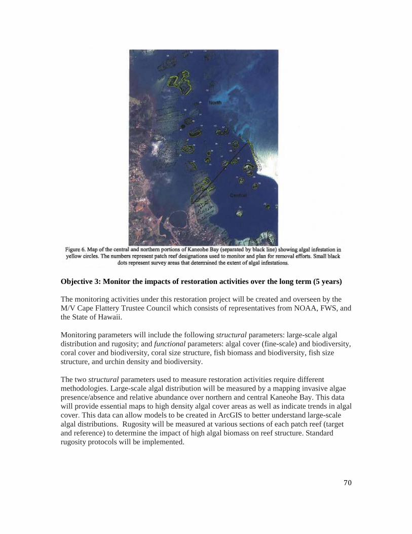
Objective 3: Monitor the impacts of restoration activities over the long term (5 years) The monitoring activities under this restoration project will be created and overseen by the M/V Cape Flattery Trustee Council which consists of representatives from NOAA, FWS, and the State of Hawaii. Monitoring parameters will include the following structural parameters: large-scale algal distribution and rugosity; and functional parameters: algal cover (fine-scale) and biodiversity, coral cover and biodiversity, coral size structure, fish biomass and biodiversity, fish size structure, and urchin density and biodiversity. The two structural parameters used to measure restoration activities require different methodologies. Large-scale algal distribution will be measured by a mapping invasive algae presence/absence and relative abundance over northern and central Kaneohe Bay. This data will provide essential maps to high density algal cover areas as well as indicate trends in algal cover. This data can allow models to be created in ArcGIS to better understand large-scale algal distributions. Rugosity will be measured at various sections of each patch reef (target and reference) to determine the impact of high algal biomass on reef structure. Standard rugosity protocols will be implemented.
70
The functional parameters will be measured with standard transect methodology (Jokiel et al 2005). Size and length of transects will be determined based on appropriateness for patch reef habitat. Frequency and Length of Monitoring- The frequency for monitoring will vary (monthly, quarterly, or annually) depending on the parameter. Algal distribution maps will be produced approximately on an annual basis considering seasonal influences of algal biomass. Coral size structure will also be conducted on an annual basis due to slower, less change expected. Fish biomass and rugosity will be measured on a quarterly basis while algal and coral cover will be monitored monthly. Monitoring of the restored and reference reefs will continue as long as is needed. Current monitoring methods and techniques are under review by the State of Hawaii Division of Aquatic Resources Scientific Review Team. Until this review is completed and new methods have been determined, the current survey methods will continue to be implemented. Project timeline The restoration of Kaneohe Bay is believed to take many years given the distribution and impact alien algae have had on the bay. However, the bay itself is highly compartmentalized and lends itself very well to a step-wise approach to restoration. Since patch reefs in the bay are individual units that can be addressed individually with minimal effect from other reefs, we believe that restoration efforts will be highly effective on a localized scale. As more resources become available, more reefs can be restored until the bay has achieved complete restoration. The bay contains 54 individual patch reefs as well as many kilometers of fringe and barrier reef. This project is targeting the patch reef habitat in the central section of the bay as a starting point due to its large quantities of algal biomass and acreage size that will allow for proper urchin stocking density. It is estimated to achieve the restoration of three patch reefs in twelve months with several years of post-monitoring. With the outplanting of urchins, the long-term outcome and management of the restored reefs is expected to be positive. Ideally, urchin populations will become self-sustaining, but small-scale urchin propagation may be able to sustain the urchin population as well. The long-term effort to maintain these reefs is expected to be low. The best management practices (BMPs) below, shall be employed for this project, and are meant to avoid any potential impacts on the ESA-listed species in discussion that may be present where survey transects and alien algae removal areas will be established. These include controlling boat speeds, minimizing the use of chain and rope to deploy monitoring instrumentation and removal tools; maintaining safe distances from observed species of concern; and preventing against the introduction of rubbish and contaminants in to the water column. A complete list of boat operations, diving, and peripheral construction BMPs to be employed during this project follows this section.
71
The following list of Best Management Practices (BMPs) will be provided to the recipient as a formal addition to their award to guide all relevant project activities:
BMPs for the Coral Rescue in Kaneohe Bay Restoration Project All workers associated with this project, irrespective of their employment arrangement (e.g. employee, contractor, etc.) or affiliation will be fully briefed on these BMPs and be required to adhere to them for the duration of their involvement in this project.
A. Constant vigilance shall be kept for the presence of ESA-listed marine species during all aspects of the proposed action, particularly in-water activities such as boat operations, diving, and deployment of anchors and mooring lines.
1. The project manager shall designate an appropriate number of competent observers to survey the marine areas adjacent to the proposed action for ESA-listed marine species.
2. Surveys shall be made prior to the start of work each day, and prior to resumption of work following any break of more than one half hour. Periodic additional surveys throughout the work day are strongly recommended.
3. All in-water work shall be postponed or halted when ESA-listed marine species (excluding corals proposed for ESA listing) are within 50 yards of the proposed work, and shall only begin/resume after the animals have voluntarily departed the area. If ESA-listed marine species are noticed within 50 yards after work has already begun, that work may continue only if, in the best judgment of the project supervisor, that there is no way for the activity to adversely affect the animal(s). For example; divers performing surveys or underwater work would likely be permissible, whereas operation of heavy equipment is likely not.
4. When piloting vessels, vessel operators shall alter course to remain at least 100 yards from whales, and at least 50 yards from other marine mammals and sea turtles.
5. Reduce vessel speed to 10 knots or less when piloting vessels at or within the ranges described above from marine mammals and sea turtles. Operators shall be particularly vigilant to watch for turtles at or near the surface in areas of known or suspected turtle activity, and if practicable, reduce vessel speed to 5 knots or less.
6. If despite efforts to maintain the distances and speeds described above, a marine mammal or turtle approaches the vessel, put the engine in neutral until the animal is at least 50 feet away, and then slowly move away to the prescribed distance.
7. In-water instrumentation tethers, as well as mooring lines for vessels and marker buoys shall be kept to the minimum lengths necessary, and shall remain deployed only as long as needed to properly accomplish the required task.
8. Marine mammals and sea turtles should not be encircled or trapped between multiple vessels or between vessels and the shore.
9. Do not attempt to feed, touch, ride, or otherwise intentionally interact with any ESA-listed marine species.
B. No contamination of the marine environment should result from project-related activities. 10. A contingency plan to control toxic materials is required. This shall include plans to
control or contain materials potentially encountered during debris removal. 11. Appropriate materials to contain and clean potential spills will be stored onboard
work vessels, and be readily available. 72
12. All project-related materials and equipment placed in the water will be free of pollutants. The project manager and heavy equipment operators will perform daily pre-work equipment inspections for cleanliness and leaks. All heavy equipment operations will be postponed or halted should a leak be detected, and will not proceed until the leak is repaired and equipment cleaned.
13. Fueling of land-based vehicles and equipment should take place at least 50 feet away from the water, preferably over an impervious surface. Fueling of vessels should be done at approved fueling facilities.
14. A plan will be developed to prevent debris and other wastes from entering or remaining in the marine environment during the project.
C. Contact with coral species proposed for listing under the ESA shall be specifically avoided.
15. For corals proposed for ESA listing, all personnel shall be made aware of the status
of those coral species, and provided with imagery and descriptions to aid in their identification. Divers and other workers shall be extra vigilant to avoid contact with colonies of those species during all phases of in-water work (anchoring, super-sucker, urchin outplanting, and monitoring).
16. The following federally listed species are expected to be present in the project area, and may be affected by the proposed action: Green Sea Turtle (T) Chelonia mydas Hawksbill Sea Turtle (E) Eretmochelys imbricata Hawaiian Monk Seal (E) Monachus schauislandi The following candidate species for threatened status are expected to be present in the project area, and may be affected by the proposed action: Rice Corals (Montipora dilatata, M. flabellate, M. turgescens, and M. patula). The included analysis and determination only discuss potential impacts and mitigation for in-water monitoring and associated activities (e.g., diving, boating, and debris removal). Green Sea Turtle Chelonia mydas The Green Sea Turtle is a kind of sea turtle, possessing a dorsoventrally-flattened body covered by a large, teardrop-shaped carapace and a pair of large, paddle-like flippers. It is lightly-colored all around, while its carapace's hues range from olive-brown to black in Eastern Pacific Green Sea Turtles. Unlike other members of its family such as the hawksbill and loggerhead turtles, Chelonia mydas is mostly herbivorous. The adults are commonly found in shallow lagoons, feeding mostly on various species of seagrass. The National Marine Fisheries Service (NMFS) and the U.S. Fish and Wildlife Service (USFWS) share responsibility for the conservation, management, and recovery of marine turtle species found in waters and lands under U.S. jurisdiction as mandated by the
73
Endangered Species Act (ESA). The USFWS has primarily responsibility for sea turtles when they come ashore and for their terrestrial habitats, whereas NMFS is responsible for sea turtles and their habitats in the marine environment. The following sea turtle biology section is summarized from recovery plans and five year status reviews developed by the NMFS and USFWS and the references within (NMFS and USFWS 1998a, 1998b; 2007a; 2007b). Sea turtles are highly migratory, globally distributed, and generally found in tropical and subtropical waters along continental coasts and islands between 30° North and 30° South. The geographic range of sea turtles includes the Caribbean Sea, Atlantic, Pacific, and Indian Oceans and associated bodies of water. The Eastern Pacific population includes turtles that nest on the west coast of Mexico, which are listed under the ESA as endangered. The Western Atlantic population includes turtles that nest in Florida, which are listed under the ESA as endangered. All other Green Sea Turtles (including those in the Eastern Pacific population that nest outside of Mexico, and those in the Western Atlantic population that nest outside of Florida) are listed as threatened. Green Sea Turtles are widely distributed in tropical and subtropical waters. Green Sea Turtle populations are not yet well defined, but distinct populations may occur in the western, central, and eastern Atlantic, the Mediterranean, the western, northern, and eastern Indian Ocean, southeast Asia, and the western, central, and eastern Pacific (NMFS & USFWS 2007a). The Eastern Pacific population includes turtles that nest on the west coast of Mexico, which are listed under the ESA as endangered. The Western Atlantic population includes turtles that nest in Florida, which are listed under the ESA as endangered. All other Green Sea Turtles (including those in the Eastern Pacific population that nest outside of Mexico, and those in the Western Atlantic population that nest outside of Florida) are listed as threatened. The State of Hawaii is an archipelago in the central Pacific Ocean containing hundreds of volcanic islands, separated into two groups: eight large southeastern Main Hawaiian Islands (MHI; seven of which are inhabited), and numerous uninhabited Northwestern Hawaiian Islands (NWHI; designated the Papahanaumokuakea Marine National Monument by Presidential proclamation in June 2006). Green turtles nesting and foraging within the Hawaiian Archipelago are likely comprised of one genetic stock, and may be considered a discreet management unit separate from other Pacific stocks (Dutton et al. 2008). Nesting occurs between May and August, and the primary nesting location at French Frigate Shoals (FFS) in the NWHI supports over 90% of documented green turtle nesting in Hawaii (Balazs 1976, 1980). Minor nesting also occurs at other atolls and islands in the NWHI3 and on Kauai, Oahu, Molokai, Lanai, and Maui within the MHI (PIFSC unpublished). Within FFS, over 50% of all nesting occurs on East Island (Balazs 1976; Niethammer et al. 1997, Balazs and Chaloupka 2004), where nesting surveys have been conducted annually at this index site since 1973 via a collaborative arrangement between NMFS Pacific Islands Fisheries Science Center (PIFSC) and USFWS. The Hawaiian green turtle population was subjected to extensive human exploitation in the form of turtle and egg harvest at foraging and nesting grounds from the mid-1800s until the early 1960s, and nesting habitat destruction as a result of development (Balazs 1975a, 1976; Niethammer et al. 1997; Balazs and Chaloupka 2004).4 Since enactment of State and federal
74
ESA protections in 1974 and 1978, respectively, the nesting population at FFS has exhibited high annual variability in nesting female abundance, and a consistent upward trend over the past thirty years with an estimated annual growth rate of 5.7% (Chaloupka et al. 2008). The largest number of nesting females observed during a field season at East Island occurred in 2008 with 580 females identified during the six week sampling period (PIFSC and FWS unpublished). In addition to protection under the federal ESA and international agreements and conventions, sea turtles in Hawaii are protected by the Hawaii Revised Statutes, Chapter 195D (Hawaii State Legislature, accessed 9/10/2010) and Hawaii Administrative Rules, 13-124 (Hawaii Administrative Rules, accessed 9/10/2010) which adopt the same definitions, status designations, and prohibitions as the federal ESA and carry additional penalties for violations at the State government level. The Hawaii Department of Land and Natural Resources (DLNR) Division of Aquatic Resources (DAR) is the state agency responsible for the conservation and management of protected species in Hawaii. The Division of Conservation and Resources Enforcement (DOCARE) is the agency with enforcement authority at the state level in matters involving violations of Hawaii’s protected species regulations. Hawksbill Sea Turtle Eretmochelys imbricata The hawksbill sea turtle was listed as endangered on June 2, 1970 (35 FR 8490). These turtles are distributed globally in tropical and subtropical waters between 30° N and 30° S. They are highly migratory, use different habitats at different stages of their life cycle, and are most commonly associated with healthy coral reefs. The species has a worldwide distribution, with Atlantic and Pacific subspecies. Eretmochelys imbricata imbricata is the Atlantic subspecies, while Eretmochelys imbricata bissa is found in the Indo-Pacific region, and naturally, is the subspecies of concern for this project. The National Marine Fisheries Service (NMFS) and the U.S. Fish and Wildlife Service (USFWS) share responsibility for the conservation, management, and recovery of marine turtle species found in waters and lands under U.S. jurisdiction as mandated by the Endangered Species Act (ESA). The USFWS has primarily responsibility for sea turtles when they come ashore and for their terrestrial habitats, whereas NMFS is responsible for sea turtles and their habitats in the marine environment. Post-hatchlings and oceanic stage juveniles are believed to occupy the pelagic environment for several years where they probably drift along major current systems and feed primarily at the surface. At about 35 cm carapace length, juveniles recruit to nearshore foraging areas where they begin feeding on benthic sponges, other invertebrates, and algae. Every few years, adult hawksbill sea turtles make breeding migrations that may span thousands of kilometers between their foraging and nesting areas. Detailed information about the biology, habitat, and conservation status of this species is described in the recovery plan (NMFS & USFWS 1998b) and the 5-year status review (NMFS & USFWS 2007b). Globally, hawksbill nesting populations declined substantially during the 20th century, and population declines appear to continue (NMFS & USFWS 2007b). Foraging hawksbill sea turtles occur in the waters around the main Hawaiian Islands, Guam, and Tutuila in American Samoa. They also likely occur in the southern islands of the CNMI, and probably occur around at least some of the islands in the PRIA. Hawksbills are uncommon, occurring in much lower numbers than
75
green sea turtles, but individuals are occasionally sighted foraging in nearshore waters around all of the island groups, particularly along the west side of the island of Hawaii and around Tutuila. Limited nesting is known to occur on the islands of Hawaii and Maui, on Guam, and on Tutuila. Little is known about nesting in the PRIA. The hawkbill's appearance is similar to that of other marine turtles. It has a generally flattened body shape, a protective carapace, and its flipper-like arms are adapted for swimming in the open ocean. E. imbricata is easily distinguished from other sea turtles by its sharp, curving beak with prominent tomium, and the saw-like appearance of its shell margins. While the turtle lives a part of its life in the open ocean, it is most often encountered in shallow lagoons and coral reefs where it feeds on its chosen prey, sea sponges. Some of the sponges eaten by E. imbricata are known to be highly toxic and lethal when eaten by other organisms. In addition, the sponges that hawksbills eat are usually those with high silica content, making the turtles one of few animals capable of eating siliceous organisms. They also feed on other invertebrates, such as comb jellies and jellyfish. Much is unknown about the life history of Eretmochelys imbricata. Hawksbills are known to mate biyearly in secluded lagoons in remote islands throughout their range. Mating season for Atlantic hawksbills usually takes place from April to November. For Indian Ocean populations such as the Seychelles hawksbill population, the mating season is from September to February. As with other sea turtles, hawksbills mate in shallow lagoons off the shores of their prospective nesting beaches. After mating, the females drag their heavy bodies high onto the beach during the night. They will then clear out an area and dig a nesting hole using their rear flippers. The female then lays a clutch of eggs in the nest and then covers them with sand. Caribbean and Florida nests of E. imbricata normally contain around 140 eggs. After the several-hour-long process, the female then returns to the sea. This is the only time when hawksbill turtles are known to leave the ocean. The baby turtles, usually weighing less than two dozen grams, hatch during the night after around two months. These newly emergent hatchlings are dark-colored, with heart-shaped carapaces measuring around 2.5 centimeters (1 in) long. They instinctually head for the sea, attracted by the reflection of the moon on the water (a mechanism which can be disrupted by anthropogenic light sources such as street lamps and lights). While they emerge under the cover of darkness, baby turtles that do not reach the water by daybreak are preyed upon by predators such as shorebirds and shore crabs. The early life history of juvenile hawksbill turtles is unknown. Upon reaching the sea, the hatchlings are assumed to enter a pelagic life stage (like other marine turtles) for an undetermined amount of time. While hawksbill turtle growth rates are not known, when E. imbricata juveniles reach around 35 cm, they switch from a pelagic life style to a coral reef-associated one. Hawksbill turtles are hypothesized to reach maturity after thirty years. While there is no clear consensus because of a lack of data, hawksbill turtles are believed to live from thirty to fifty years in the wild. Like other sea turtles, hawksbill turtles are solitary for most of their lives, they only group together to mate. They were once thought to be habitual, but they are now known to be highly migratory. Because of their tough carapaces, hawksbill turtles have no major predators as there are few creatures that are capable of biting through their protective shell. Sharks and estuarine crocodiles are a few of their natural
76
predators. Octopuses and some species of pelagic fish have also been known to prey on the adult turtles. Because of human fishing practices, Eretmochelys imbricata populations around the world are threatened with extinction and the turtle has been classified as critically endangered by the World Conservation Union, and endangered under the Endangered Species Act of 1970. Several countries, such as China and Japan, have valued hunting hawksbill turtles for their flesh, which is considered good eating. Hawksbill turtle shells are the primary source of tortoise shell material, used for decorative purposes. By the Convention on International Trade in Endangered Species, it is illegal to capture and to trade in hawksbill turtles and products derived from them in many nations. The U.S. government has several recovery plans in place for protecting its populations of E. imbricata. Hawaiian Monk Seal Monachus schauislandi The Hawaiian monk seal was listed as endangered on November 23, 1976 (41 FR 51611). They are among the most evolutionarily-primitive genera of seals, and are one of the most endangered marine mammals in the United States. They are endemic to the Hawaiian Archipelago, and are the only endangered marine mammal that exists wholly within the jurisdiction of the U.S.A. Although they have been reported at Johnston Atoll, in the PRIA, none have been observed since December 2003. To our current knowledge the range of the Hawaiian monk seal is limited to the NWHI and the MHI. The overwhelming majority of the population resides in the NWHI, but they are increasingly found in the MHI, where pupping is becoming more common. Monk seals spend about one third of their time on land and about two thirds in the water. They are non-migratory, but their home ranges are extensive, and inter-island movement is common. They are capable of dives of about 1,500 ft while foraging, and appear to be opportunistic feeders preying on fish, eels, mollusks, and crustaceans. Hawaiian monk seals are thought to live up to 30 years. Females reach sexual maturity at about five to ten years of age and pup a maximum of once a year. They are critically endangered, numbering approximately 1,200 animals, and decreasing by about 4% annually (NMFS 2008). The most current information to describe the biology, habitat, and conservation status of this species can be found in NMFS' 12-month finding for revision of monk seal critical habitat (74 FR 27988), published on June 12, 2009, and in the recovery plan (NMFS 2007). Rice Corals (Montipora dilatata/flabellata(/turgescens) and M. patula(/verrilli)) On October 20, 2009, NOAA Fisheries received a petition from the Center for Biological Diversity to list 83 species of corals as threatened or endangered under the ESA. The petition cited the synergistic threats of ocean warming, ocean acidification, and other impacts, stating that immediate action is needed to reduce greenhouse gas concentrations to levels that do not jeopardize these species. The petition also cited dredging, coastal development, coastal point source pollution, agricultural and land use practices, disease, predation, reef fishing, aquarium trade, physical damage from boats and anchors, marine debris, and aquatic invasive species. In response to that petition, on November 30, 2012, NMFS announced its intention list 66 species of reef-building corals. The NMFS proposal grouped Montipora dilatata, M.
77
flabellata, and M. turgescens into a single “species” as it did with M. patula and M. verrilli, both of which are proposed for listing as threatened. Rice corals are distributed throughout the Indo-Pacific and Hawaii. The skeleton is quite porous and therefore relatively fragile but fast-growing. They are found in a variety of habitats and especially fine plate-like growths may be found in quiet bays. Calices are small, simple pits surrounded by rods, nodules, or fused ridges. Genus Montipora (Pore Corals) - All of the species within the genus Montipora for which the reproductive characteristics have been studied (35 spp.) are hermaphroditic broadcast spawners (Baird et al. 2009). The genus is considered susceptible to the effects of thermal stress, with a relatively high bleaching response to that stress. Within this genus, the affects of increased ocean acidity have been studied only in M. capitata, which demonstrated a significant reduction in growth rate during experimental exposure to acidification levels anticipated within this century. In general, increased ocean acidity is thought to adversely affect fertilization, larval settlement, and zooxanthellae acquisition rates for many corals, and it tends to decrease growth and calcification rates. The genus is considered moderately susceptible to diseases such as black band disease and white syndrome, and the genus is a preferred prey of the crown-of-thorns seastar (Acanthaster planci). The genus is considered “sediment intolerant” with substantial variation in sediment intolerance among species. Land-based pollution may pose significant threats at local scales. The genus Montipora is also heavily exploited in the international aquarium trade (Brainard et al. 2011). The clade, M. dilatata/flabellata(/turgescens) is broadly distributed across the Indo-Pacific region. Depending on the nominal species name considered, it has been reported as extremely rare (M. dilatata) to widespread and common (M. turgescens). Colony morphology is highly plastic, including encrusting, lobed, columnar, and massive forms attached to hard substrate, and occurs in most reef environments at depths down to about 98 ft (30 m). M. dilatata/flabellata is considered to be highly susceptible to bleaching due to thermal stress (Brainard et al. 2011). The specific susceptibility and impacts of increased ocean acidity, predation, sedimentation, and pollution are unknown for this clade, but expected to be similar to those described above for the genus. M. turgescens has been specifically described with mortality from rapid tissue loss (white syndrome) in the NWHI. M. patula(/verrilli) has a very restricted range and disjoint distribution in the Pacific Ocean, but is sometimes reported as common. This coral occurs in Hawaii, Guam, and the CNMI. Colony morphology is typically encrusting or tiered plates up to 6 ft (2 m) across. It is typically found attached to hard substrate in shallow reef environments and reef flats, but has been reported at depths of up to about 131 ft (40 m). M. patula is reported to be among the most bleaching-susceptible species in the NWHI, but only moderately susceptible in the MHI. In the NWHI, M. patula(/verrilli) is noted to have a high occurrence of acute disease conditions involving tissue loss and partial mortality. M. patula is also considered less sediment-tolerant than other Montipora species. The
78
specific susceptibility and impacts of increased ocean acidity, predation, and pollution are unknown for M. patula(/verrilli), but expected to be similar to those described for the genus. Analysis of Effects In order to concur that a proposed action is not likely to adversely affect listed species, we recognize that NMFS PIRO PRD must find that the effects of the proposed action are expected to be insignificant, discountable, or beneficial as defined in the joint USFWS-NMFS Endangered' Species Consultation Handbook: (1) insignificant effects relate to the size of the impact and should never reach the scale where take occurs; (2) discountable effects are those that are extremely unlikely to occur; and (3) beneficial effects are positive effects without any adverse effects (USFWS & NMFS 1998). This standard, as well as consideration of the probable duration, frequency, and severity of potential interactions between the marine listed species and the proposed action, were applied during the analysis of effects of the proposed action on ESA-listed marine species, and is outlined in detail below. Our analysis considered potential stressors and impacts to marine listed species, the most likely of which are: (1) collision with vessels; (2) disturbance from human activity and boat operation; (3) exposure to wastes and discharges; (4) potential loss of forage resources; and (5) beneficial effects. 1. Collision with vessels: Sea turtles and monk seals must surface to breathe, and they are known to rest or bask at the surface. Therefore, when at or near the surface, turtles are particularly at risk of being struck by vessels or their propellers as the vessels transit to and from the project site, and while the water surveys are conducted. Potential injuries and their severity will depend on the speed of the vessel, the part of the vessel that strikes the animal, and the body part impacted. Injuries from boat strikes may include bruising, broken bones or carapaces, and lacerations. The recovery plan for green sea turtles indicates that boat collision is a threat for sea turtles. For monk seals, this is highly improbable, but still possible. The incidence of collision is expected to increase as vessel size, speed, and traffic density increases, or as animal density increases (NMFS & USFWS 1998a & b). Existing information about sea turtle sensory biology suggests that sea turtles rely more heavily on visual cues, rather than auditory, to initiate threat avoidance. Research also suggests that sea turtles cannot be expected to consistently notice and avoid vessels that are traveling faster than 2 knots. Consequently, vessel operators must be responsible to actively watch for and avoid sea turtles, and to adjust their speed based on expected animal density and on lighting and turbidity conditions to allow adequate reaction time to avoid marine animals. Based on the limited number of trips expected, and on the expectation that the vessels would be operated in accordance with the BMPs for this action that require operators to watch for and avoid protected species, and to operate vessels at reduced speeds, RC considers that the risk of collisions between action-related vessels and listed species covered by this consultation to be discountable.
79
The candidate species of rice corals would also be at risk due to a collision or grounding of project vessels. Based on the nature of the proposed work (intention of participating personnel to protect corals) and on the expectation that the vessels would be operated in accordance with BMP that require care during vessel operation and specific avoidance of corals, RC considers that the risk of collisions between action-related vessels and candidate species of rice corals to be discountable. 2. Disturbance from alien algae removal activity and boat operation: Exposure to in-water survey, urchin-out-planting, and alien algae removal activities could startle protected sea turtles and monk seals should they become aware of them. However; based on the precautionary BMPs (e.g., requirement to maintain a 50 yard distance from sea turtles and monk seals) and the expectation that the most likely effect due to this stressor would be infrequent behavioral modification through temporary areal avoidance wherein the sea turtle or monk seal would be likely to leave the area without injury, RC has determined that this stressor would have insignificant effects on the listed species covered by this consultation. Physical disturbance of corals from these activities is possible but not likely to injure the candidate species. In-water actions are conducted by highly trained staff that can recognize and work around listed species without damaging them. As a matter of policy the in-water staff make a point to not contact the substrate and avoid injuring corals regardless of listing status. 3. Exposure to wastes and discharges: Regulations prohibit the intentional discharge of toxic wastes and plastics into the marine environment, and the RC BMPs (herein) contain detailed instructions and procedures to ensure equipment, particularly the diesel engine that drives the barge-based vacuum, is properly inspected and maintained, and that spills are quickly contained and cleaned. Based on the information above, we expect that discharges and spills are unlikely to occur, but that they would be small and quickly cleaned up in the unlikely event a spill did occur. Therefore, we have determined that exposure to wastes and discharges that may result from this project would result in insignificant effects on protected or candidate marine species. 4. Potential loss of forage resources: Russell and Balazs have recently documented the gradual inclusion of the Kappaphycus/Euchema Spp. complex in the diets of Green Sea Turtles of Kaneohe Bay over the past 28 years (2009). However, we feel the loss of this specific food source would be short-term, as native food sources re-colonize the restored coral reef area. Moreover, the lower preference of these targeted species compared to other algae (even other non-native species) (Russell & Balazs, 2009) suggests that turtles would not be significantly affected when higher-preference species would remain readily available in the Bay (native and non-native alike). Lastly, the possible connection of this alien species with the aetiology of Fibropapillomatosis that is currently pervasive among Hawaiian Green Sea Turtle populations (Houtan, Hargrove, and Balazs, 2010), has led us to conclude that any potential adverse impacts associated with these alien algae control activities are short-term, and counterbalanced by the positive outcomes for turtles associated with the removal of these species from the system. Based on the information
80
above, the RC has determined that this stressor would have insignificant effects on the listed species covered by this consultation. 5. Beneficial effects: The coral reefs of Kaneohe Bay support fishing and recreational activities, a tourism-based economy, and are an important part of Hawaii's unique cultural heritage. In addition to providing habitat which is essential for healthy fisheries, the reefs also serve as protection to minimize wave impacts and storm surges. Currently, alien algae present one of the most insidious threats to the health of Hawaii's coral reef ecosystems and is an increasing threat to Kaneohe Bay, specifically. The most successful alien algae (i.e. the most invasive) out-compete and overgrow corals (Stimson et al 2001). This project will directly benefit coral reefs, including the candidate species, by removing large amounts of alien algae, allowing coral and native algae recolonization. These coral reefs also serve as potential habitat for sea turtles ad monk seals. The removal of alien algae will improve this potential habitat. Improvement in habitat quality would be expected to be beneficial to the recovery of these protected species. Determination of Effect for these species: Not Likely to Adversely Affect In-water activities associated with removing alien algae and boat-based activities such as monitoring and urchin out-planting pose the greatest risk of affecting listed species covered by this consultation, utilizing the bays and nearshore waters as sheltering and forage habitat. However, no activities are directed toward the animals themselves, and all efforts will be made to avoid encountering, entangling, or otherwise affecting the animals. Based on the information presented in this BA, the RC has determined that the proposed action would result in insignificant impacts, or the likelihood of adverse impacts would be discountable, for green and hawksbill sea turtles, for Hawaiian monk seals, and for candidate coral species. The RC has further determined that the proposed action would result in beneficial impacts for these species thorough improved habitat quality. As such, The NOAA Restoration Center has determined that the proposed action is not likely to adversely affect green and hawksbill sea turtles, Hawaiian monk seals, and the candidate coral species referenced above, and requests your written concurrence with our determination. For further information, please contact the NOAA Restoration Center’s: Matthew Parry Fishery Biologist National Oceanic and Atmospheric Administration Pacific Islands Regional Office 1601 Kapi‘olani Blvd., Suite 1110 Honolulu, HI 96814
Literature review Bohnsack JA (1993) Marine reserves: they enhance fisheries, reduce conflicts, and protect resources. Oceanus 36:63-71
81
Bowen, B.W. 1995. Tracking marine turtles with genetic markers. BioScience 45(8):528-534. BrostoffW (1989) Avrainvillea amadelpha (Codiales, Chlorophyta) from Oahu, Hawaii. Pacific Science 43: 166-169 Carpenter RC (1990) Mass mortality of Diadema antillarum I: long-term effects on sea urchin population-dynamics and coral reef algal communities. Marine Biology 104: 67-77 Conklin E and Smith J (2005) Abundance and Spread of the Invasive Red Algae, Kappaphycus spp., in Kane'ohe Bay, Hawai'i and an Experimental Assessment of Management Options. Biological Invasions 7: 1029-1039 Conklin, E.J. 2007. The influence of preferential foraging, alien algal species, and predation risk on the interaction between herbivorous fishes and reef macroalgae. Doctoral dissertation, Department of Zoology, University of Hawai'i, Honolulu, HI. Cuet P, Nairn 0, Faure G, Conan J-Y (1988) Nutrient-rich groundwater impact on benthic communities of La Saline fringing reef (Reunion Island, Indian Ocean): Preliminary results. Proceedings of the 6th International Coral Reef Symposium 2: 207-212 Done TJ (1992) Phase shifts in coral reef communities and their ecological significance. Hydrobiologia 247:121-132 Doty MS (1961) Acanthophora, a possible invader of the marine flora of Hawaii. Pacific Science 15: 547-552 Edmunds P.J. and Carpenter R.C. (2001) Recovery of Diadema antillarum reduces macro algal cover and increases abundance of juvenile corals on a Caribbean reef. PNAS.98:5067-5071 Harrold, C. and Pearse, lS. (1987) The ecological role of echinoderms in kelp forests. In: Jangoux, M. & Lawrence, lM. (eds.) Echinoderm studies, Vol. 2. AA Balkema, Rotterdam. pp. 137-233. Houtan, K.S; Hargrove, S.K.; and Balazs, G.H (2010). Land Use, Macroalgae, and a Tumor-forming Disease in Marine Turtles. PLoS ONE f(9): e 12900 doi:10.1371/journal.pone.0012900 Hunter CL, Evans CW (1995) Coral reefs in Kaneohe Bay, Hawaii: two centuries of western influence and two decades of data. Bulletin of Marine Science 57: 501-515 Hunter CL (2009) Distribution and abundance of Montipora dilatata in Kaneohe Bay, Oahu, Hawaii. Unpublished technical report. 15 pgs. Hay ME (1984) Predictable spatial escapes from herbivory: how do these affect the evolution of herbivore resistance in tropical marine communities? Oecologia 64:396-407
82
Hughes TP (1994) Catastrophes, phase shifts, and large-scale degradation of a Caribbean coral reef. Science 265: 1547- 1551 Hughes T, Szmant AM, Steneck R, Carpenter R, Miller S (1999) Algal blooms on coral reefs: What are the causes? Limnology and Oceanography 44: 1583-1586 Hobson ES, Chave EH (1990) Hawaiian Reef Animals. University of Hawaii Press, 152 pp. IUCN Red List of Threatened Species: http://www.iucnredlist.org/apps/redlist/details/148396/0 Jokiel PL, Brown EK, Friedlander AM, Rodgers SK, and Smith WR (2004) Hawaii coral reef assessment and monitoring program: Spatial patterns and temporal dynamics in reef coral communities. Pacific Science 58(2): 159-174. Jokiel PL, Rodgers SK, Brown EK, KenyonJC, Aeby G, Smith WR, Farrell, F (2005) Comparison of Methods Used to Estimate Coral Cover in the Hawaiian Islands. NOAAINOS NWHI Coral Reef Ecosystem Reserve Report. 22 pp. Juinio-Menez, AM, Bangi, HG, Malay, MC, Pastor, D (2008) Enhancing the recovery of depleted Tripneustes gratilla stocks through grow-out culture and restocking. Reviews in Fisheries Science 16-35-43. Kelly, MS 2005. Echinoderms: Their Culture and Bioactive Compounds. In: Matranga, V (Ed.) Echinodermata. Springer. 270 pp. Keesing JK, Hall, KC (1998) Review of harvests and status of world sea urchin fisheries point to opportunities for aquaculture. J. Shellfish Res. 17: 1505-1506. Kline DI, Kuntz NM, Breitbart M, Knowlton N, Rohwer F, (2006) Role of elevated organic carbon levels and microbial activity in coral mortality. Marine Ecology Progress Series 314, 119-125. Lapointe BE (1997) Nutrient thresholds for eutrophication and macroalgal blooms on coral reefs in Jamaica and southeast Florida. Limnology and Oceanography 42: 1119-1131 Lapointe BE (1999) Simultaneous top-down and bottom-up forces control macroalgal blooms on coral reefs. Limnology and Oceanography 44: 1586-1592 Littler MM, Littler DS, Lapointe BE (1992) Modification of tropical reef community structure due to cultural eutrophication: the southwest coast of Martinique. Proceedings of the 7th International Coral Reef Symposium I: 335-343 Lawrence, J.M. (1975) On the relationship between marine plants and sea urchins. Oceanogr. Mar. BioI. Ann. Rev. 13: 213-286.
83
Lawrence, J & Sammarco, P.W. (1982) Effects of feeding: Echinoidea. In: Jangoux, M. & Lawrence, J.M. (eds.) Echinoderm Nutrition. AA Balkema, Rotterdam. pp 499-519. Maragos, JE (1972) A study of the ecology of Hawaiian reef corals. Ph.D. Thesis. University of Hawaii at Manoa. Honolulu, HI. 290 pp. McClanahan TR, Hendrick V, Rodrigues MJ, Polunin NVC (1999) Varying responses of herbivorous and invertebrate feeding fish to macroalgal reduction on a coral reef. Coral Reefs 18: 195-203 Mumby P J (2006) The impact of exploiting grazers (Scaridae) on the dynamics of Caribbean coral reefs. Ecological Applications 16: 747-769 Nairn 0 (1993) Seasonal responses of a fringing reef community to eutrophication (Reunion Island, Western Indian Ocean). Maison, K.A., Kinan Kelly, I. and K.P. Frutchey. 2010. Green Turtle Nesting Sites and Sea Turtle Legislation throughout Oceania. U.S. Dep. Commerce, NOAA Technical Memorandum. NMFS-F/SPO-110, 52 pp. Marine Ecology Progress Series 99: 137-151 National Marine Fisheries Service and U.S. Fish and Wildlife Service (NMFS and USFWS). 1998a. Recovery Plan for U.S. Pacific Populations of the Green Sea Turtle (Chelonia mydas). National Marine Fisheries Service, Silver Spring, MD. 95 pp. National Marine Fisheries Service and U.S. Fish and Wildlife Service (NMFS and USFWS). 1998b. Recovery Plan for U.S. Pacific Populations of the Hawksbill Turtle (Eretmochelys imbricata). National Marine Fisheries Service, Silver Spring, MD. 95pp. National Marine Fisheries Service and U.S. Fish and Wildlife Service (NMFS and USFWS). 2007a. Green sea turtle (Chelonia mydas) 5-year review: summary and evaluation. 105 pp. National Marine Fisheries Service and U.S. Fish and Wildlife Service (NMFS and USFWS). 2007b. Hawksbill sea turtle (Eretmochelys imbricata) 5-year review: summary and evaluation. 93 pp. Ogden, lC. & Lobel, P.S. (1979) The role of herbivorous fishes and urchins in coral reef communities. Environmental Biology of Fishes. 3:49-63 Ostrander,CE, McManu, MA, DeCarlo, EH, and Mackenzie, FT. (2008) Temporal and Spatial Variability of Freshwater Plumes in a Semienclosed Estuarine-Bay System. Estuaries and Coasts 31(1): 192-203.
84
Rodgers SK, Cox EF (1999) Rate of spread of introduced rhodophytes Kappaphycus a/varezii, Kappaphycus striatum and Gracilaria salicornia and their current distributions in Kaneohe Bay, Oahu, Hawai'i. Pacific Science 53:232-241 Russell DJ (1987) Introduction and establishment of alien marine algae. Bulletin of Marine Science 42: 641-642 Russell DJ (1992) The ecological invasion of Hawaiian reefs by two marine red algae, Acanthophora spicifera (Vahl) Boerg, and Hypnea musciformis (Wulfen) lAg., and their association with two native species, Laurencia nidifica lAg. and Hypnea cervicornis lAg. International Council for the Exploration of the Sea Marine Science Symposia 194: 110-125 Russell DJ and Balazs GH (2009) Dietary Shifts by Green Turtles (Chelonia mydas) in the Kāne‘ohe Bay Region of the Hawaiian Islands: A 28-Year Study. Pacific Science, vol. 63, no. 2:181-192. University of Hawaii Press. SchaffeIke B, Klumpp DW (1997) Biomass and productivity of tropical macroalgae on three nearshore fringing reefs in the Central Great Barrier Reef, Australia. Botanica Marina 40:373-383 Sloan, N.A. (1985) Echinoderm fisheries of the world: a review. In: Keegan, B.F. & O'Connor, B.D.S. (eds.). AA BaIkema, Rotterdam. pp 109-124. Smith JE, Hunter CL, Smith CM (2002) Distribution and reproductive characteristics of non indigenous and invasive marine algae in the Hawaiian Islands. Pacific Science 56: 299-315 Smith, 1.E., Most, R., Sauvage, T., Hunter, c., Squair, C. & Conklin, E. (2004) Ecology of the invasive red alga Gracilaria salicornia in Waikiki and possible mitigation strategies. Pac. Sci. 58:325-343. Smith, 1.E, Shaw, M., Edwards, R.A., Obura, D., Pantos, 0, Sala, E., Sandin, S.A., Smriga, S., Hatay, M., Rohwer, F. L..2006. Indirect effects of algae on coral: algae-mediated, microbe-induced coral mortality. Ecology Letters 9: 835-845 Stimson, 1, Lamed ST, ConklinE (2001) Effects of herbivory, nutrient levels, and introduced algae on the distribution and abundance of the invasive macroalga Dictyosphaeria cavernosa in Kaneohe Bay, Hawaii. Coral Reefs 19:343-357. Stimson, J., Cunha, T. & Philippoff, 1 (2007) Food preferences and related behavior of the browsing sea urchin Tripneustes gratilla (Linnaeus) and its potential for use as a biological control agent. Mar. BioI. 151: 1761-1772. Sulu, R., Kumar, L., Hay, C. and Pickering, T. 2004. Kappaphycus seaweed in the Pacific : review of introductions and field testing proposed quarantine protocols. Noumea: Secretariat of the Pacific Community.
85
Titcomb, A. 1978. Native Use of Marine Invertebrates in Old Hawaii. University Press of Hawaii, Honolulu, HI. U.S. Fish and Wildlife Service Species Profile in the Environmental Conservation Online System (ECOS): http://ecos.fws.gov/speciesProfile/profile/speciesProfile.action?spcode=B043 Williams ID, Polunin NVC (200 I) Large-scale associations between macroalgal cover and grazer biomass on mid-depth reefs in the Caribbean. Coral Reefs 19: 358-366 Williams ID, Polunin NVC, Hendrick VJ (2001) Limits to grazing by herbivorous fish and the impact of low coral cover on macroalgal abundance on a coral reef in Belize. Marine Ecology Progress Series 22: 187-196 Woo M (2000) Ecological impacts and interactions of the introduced red alga Kappaphycus striatum in Kaneohe Bay, O'ahu. Master's Thesis, Department of Botany, University ofHawai'i, Honolulu, HI.
86