Embed Size (px)
Citation preview

Cruise No: MF-03-07 April 10, 2003 FOCI No: 4MF03
FINAL CRUISE INSTRUCTIONS FOCI
NOAA Ship MILLER FREEMAN, MF-03-07 May 17 – May 24, 2003
Chief Scientist: Janet Duffy-Anderson, NOAA/AFSC
1.0 FINAL CRUISE INSTRUCTIONS
1.1 Cruise Title – Fisheries-Oceanography Coordinated Investigations (FOCI).
1.2 Cruise Numbers
1.2.1 Cruise Number – MF-03-07
1.2.2 FOCI Number – 4MF03
1.3 Cruise Dates
1.3.1 Departure – Depart Dutch Harbor, Alaska, at 1500 hrs. on Saturday, May 17, 2003. 1.3.2 Arrival – Arrive Dutch Harbor, Alaska, at 0800 hrs. on Saturday, May 24, 2003.
2.0 CRUISE OVERVIEW
2.1 Cruise Objectives – We will conduct an ichthyoplankton survey in the Bering Sea in the vicinity of Unimak Island, Alaska. This work is needed to describe larval fish assemblages in the Bering Sea (slope, outer shelf, and middle shelf) in spring. In particular, this area is a known spawning ground for walleye pollock, and abundances of pollock larvae at this time of year are high. Zooplankton data and data on physical characteristics of the water column will also be collected.
2.2 Applicability – These instructions, with FOCI Standard Operating Instructions for NOAA
Ship MILLER FREEMAN, dated April 8, 2002, present complete information for this cruise.
2.3 Operating Area – Southeastern Bering Sea.
2.4 Participating Organizations NOAA – Alaska Fisheries Science Center (AFSC) 7600 Sand Point Way N.E. Seattle, Washington 98115-0070
Page 1 of 15

Cruise No: MF-03-07 April 10, 2003 FOCI No: 4MF03
2.5 Personnel
2.5.1 Chief Scientist
Name Gender Affiliation E-mail Address Janet Duffy-Anderson Female AFSC [email protected] (206) 526-6465
2.5.2 Participating Scientists
Name Gender Affiliation E-mail Address Janet Duffy-Anderson Female AFSC [email protected] Christina Deliyanides Female AFSC [email protected] Jennifer Lanksbury Female AFSC [email protected] Kathy Mier Female AFSC [email protected] Wiebke Boeing Female AFSC [email protected] Debbie Blood Female AFSC [email protected] Susan Picquelle Female AFSC [email protected]
2.6 Administration
2.6.1 Ship Operations
Marine Operations Center, Pacific 1801 Fairview Avenue East Seattle, Washington 98102-3767 Telephone: (206) 553-4548, Fax: (206) 553-1109 Commander Michele G. Bullock, NOAA Chief, Operations Division (MOP1) Telephone: (206) 553-8705, Cellular: (206) 390-7527 E-mail: [email protected]
Larry W. Mordock Deputy Chief, Operations Division (MOP1x1) Telephone - Work: (206) 553-4764, Home: (206) 365-3567 Cellular: (206) 465-9316 E-mail: [email protected]
2.6.2 Scientific Operations
Dr. Jeffrey M. Napp, AFSC Telephone: (206) 526-4148 E-mail: [email protected]
Page 2 of 15
Cruise No: MF-03-07 April 10, 2003 FOCI No: 4MF03
3.0 OPERATIONS
3.1 Data To Be Collected – A goal of the FOCI program is to identify the physical and biological factors that underlie ecosystem change and to understand how those factors interact. One focus is the effects of perturbations at lower trophic levels. To this end, we will collect ichthyoplankton and zooplankton data using 60-cm Bongo nets (60BON) and 20-cm Bongo nets (20BON), a Neuston net, and a Multiple Opening/Closing Net and Environmental Sensing System (MOCNESS). We intend to deploy up to three ARGOS satellite-tracked drifters in patches of Alaska plaice to study movement of Alaska plaice larvae. Finally, we will collect data on the physical environment using the Sea-Bird Electronics SBE 19 SEACAT Profiler to relate larval assemblage structure to environmental variables (temperature, salinity). If any remaining time permits, we may test the ship’s CUFES (Continuous Underway Fish Egg Sampler). Sea-Bird Electronics SBE 911plus Conductivity, Temperature, and Depth (CTD) profiler casts will collect physical data as well as data on microzooplankton concentrations. This cruise will provide new information on walleye pollock egg and larval distribution and on larval fish assemblages in general, on the Bering Sea shelf in the spring. Samples will be collected from a grid of approximately 85 stations.
3.1.1 Scientific Computer System (SCS) – The ship's SCS shall operate throughout the
cruise, acquiring and logging data from navigation, meteorological, oceanographic, and fisheries sensors. See FOCI Standard Operating Instructions for NOAA Ship MILLER FREEMAN (SOI 5.2) for specific requirements.
3.2 Staging Plan – The majority of the equipment necessary for the cruise will be loaded onto the
NOAA ship MILLER FREEMAN before the ship’s departure from Seattle, Washington, on Tuesday, April 29, 2003. We request that we be allowed to set up equipment, including the MOCNESS, on Friday, May 16, 2003, one day prior to departure from Dutch Harbor, Alaska. We anticipate sending two scientists up the evening of Thursday, May 15, for this purpose, and we request that these two persons be allowed to stay on board the ship if space is available. We will use the chemistry lab, the rough lab, and the slime lab for sample and equipment preparation and request as much counter and cabinet space as possible. We will also be using DataPlot for CTD, MOCNESS, and SEACAT operations.
3.3 De-staging Plan – Samples and gear will remain on board the ship until the completion of
Cruise MF-03-08, where the samples will be then offloaded in Kodiak, Alaska, on Monday, June 2, 2003. Sampling equipment will remain on board, in the hold, for use during Cruise MF-03-11.
3.4 Cruise Plan – The cruise will depart from Dutch Harbor, Alaska, at 1500 hrs. on Saturday,
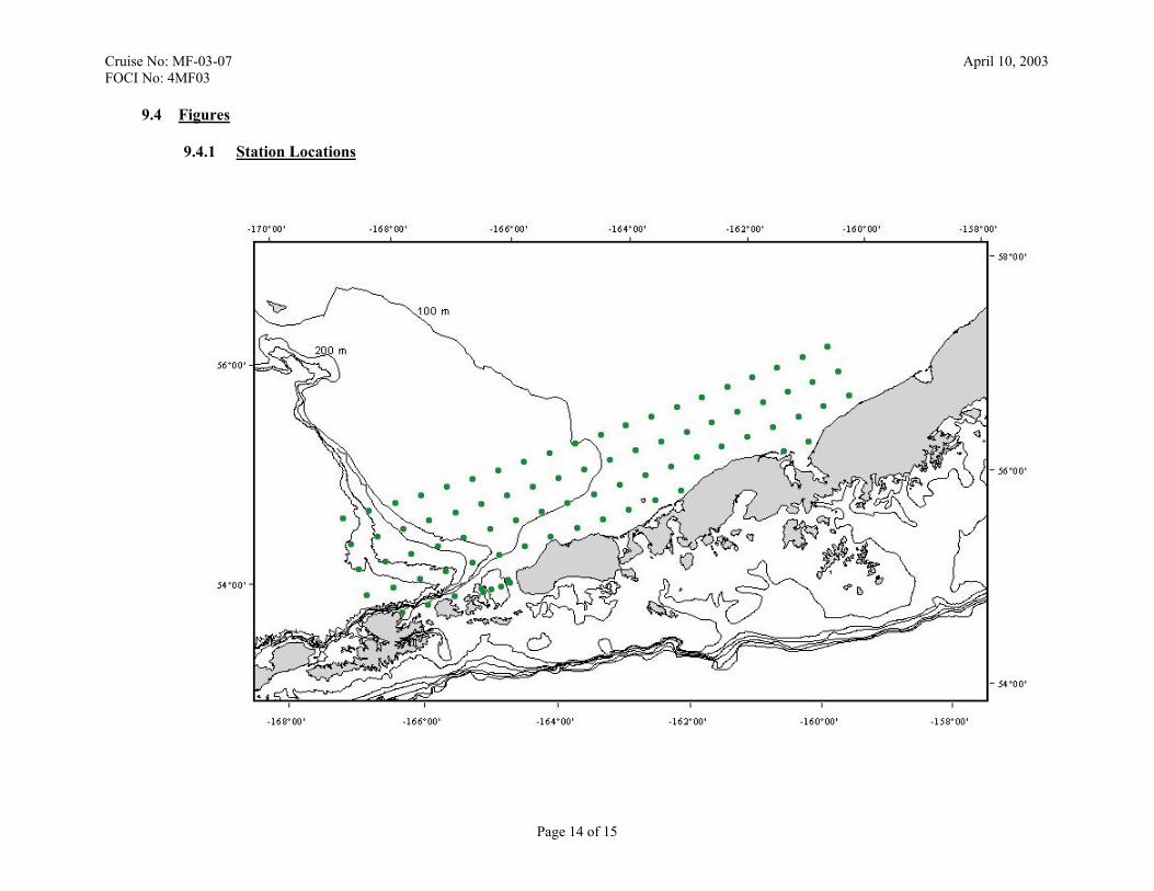
May 17, 2003, and occupy a series of approximately 85 stations on the Bering Sea FOCI grid. The first station is located immediately outside of Dutch Harbor, Alaska. Station positions of the working area and figures are located in Sections 9.1 Station Locations and 9.4 Figures, respectively.
At every station, a Sameoto Neuston net will be deployed first to collect fish larvae in the surface layer. Samples from the Neuston net gear will be preserved in 1.8% buffered formaldehyde.
Page 3 of 15

Cruise No: MF-03-07 April 10, 2003 FOCI No: 4MF03
Following completion of the Neuston tow, a Marine Assessment Monitoring and Prediction (MARMAP) Bongo tow (SOI 3.2.2) will be conducted. The SBE 19 SEACAT, the 20-cm Bongo net with 0.150-mm mesh netting and the 60-cm Bongo net with 0.505-mm mesh netting (Net 1) and 0.333-mm mesh netting (Net 2) will all be mounted together for this tow. Bongo tows will be to a depth of 300 meters, or to 10 meters off bottom, whichever is shallower. The sample from 60BON Net 1 will be preserved in its entirety in 1.8% buffered formaldehyde. The sample from 60BON Net 2 will be sorted for Alaska plaice larvae and then preserved in 1.8% buffered formaldehyde for quantitative zooplankton estimates. The sample from 20BON Net 1 will be preserved in its entirety in 1.8% buffered formaldehyde; the sample from Net 2 will be discarded. When it is determined that sufficient numbers of Alaska plaice larvae have been located, up to three satellite-tracked drifters will be deployed. In addition, a series of MOCNESS tows at a single station (0.505-mm mesh) will be performed to determine vertical distribution of larvae. It is anticipated that MOCNESS towing will occur in the same general vicinity as the drifter release over one 36-hour period (Station location to be determined at sea based on larval catch). CTDs will be conducted prior to each MOCNESS tow to collect physical data and microzooplankton samples.
3.5 Station Locations – Please see Section 9.1 Station Locations.
3.6 Station Operations – The following are operations to be conducted on this cruise. The
procedures for these operations are listed in the FOCI Standard Operating Instructions for NOAA Ship MILLER FREEMAN (SOI). Operations not addressed in the SOI and changes to standard procedures are addressed below.
• CTD/Water Sample Operations (SOI 3.2.1), • MARMAP Bongo Tows (SOI 3.2.2), • MOCNESS Tows (SOI 3.2.5), • ARGOS Satellite Tracked Drifter Buoy Deployments (SOI 3.2.11), and • SIMRAD EQ 50 and EK 500 Scientific Echosounder Monitoring (SOI 3.2.12).
3.6.1 Neuston Net Tows
3.6.1.1 Description – Neuston nets are used for sampling the upper few centimeters of the water column. There are many frame styles that may be used; however, we use a Sameoto sampler made of stainless steel. The mouth opening is 30-cm x 50-cm, and is designed to fish half in and half out of the water.
3.6.1.2 Rates/Fishing – The vessel should be moving slowly ahead, about 1.5 to 2.0
knots so that the net is fishing half in and half out of the water. The exact speed is a learning process and may vary with sea conditions. Lower the Neuston net to the surface and pay out 10 to 15 meters of wire. It may be necessary to adjust the ship's speed to maintain the proper skimming action. Start the stopwatch when the net starts to fish and tow the net for approximately 9.5 minutes (unless otherwise instructed). After 9.5 minutes, the vessel should decrease speed so that the net can be hauled in. Advise winch operator when time is nearly up and retrieve when ready. Read and record flow meter revolutions, time of tow, and any comments.
Page 4 of 15

Cruise No: MF-03-07 April 10, 2003 FOCI No: 4MF03
3.6.1.3 Preservation – The Neuston sample should be preserved immediately, as
specified in the FOCI Field Manual or sample collection request forms.
3.6.1.4 Maintenance – Check net for holes and fill flow meter with water.
3.7 Underway Operations – The following are underway operations to be conducted on this cruise. The procedures for these operations are list in the FOCI Standard Operating Instructions for NOAA ship MILLER FREEMAN (SOI). Operations not addressed in the SOI and changes to standard procedures are addressed below.
• Scientific Computer System (SCS) data acquisition (SOI 5.2), and • Thermosalinograph monitoring (SOI 5.3)
3.7.1 Continuous Underway Fish Egg Sampler (CUFES)
3.7.1.1 Description – The CUFES is used to map the distribution of fish eggs in the surface waters. In the Southeast Bering Sea most pollock eggs are believed to be in the upper 10 m of the water column and the CUFES system may be an important tool to examine abundance, transport, and interannual variability. The intake of the CUFES system on the Freeman is about 5-7 m below the surface.
3.7.1.2 Methods – The Chief Scientist will work with the ship's command to
establish a track line in the area of high abundance of fish eggs and larvae. The track should be oriented across the current that flows along the 50-m isobath into Bristol Bay. With the ship steaming at 10 knots (18.5 km/hr), we will attempt to take a new sample every 15 minutes (every 4.6 km or 2.5 nm). The sampling frequency may need to be modified depending on the amount of plankton retained by the mesh. During the sampling the data acquisition system (DAS) will acquire time and GPS position from a dedicated GPS unit or the ship's GPS signal fed to the DAS.
3.7.1.3 Preservation – Each CUFES sample should be preserved immediately with
1.8% formaldehyde and labeled according to methods to be supplied before the cruise.
3.7.1.4 Maintenance – The sample cups should be checked after each use for holes.
In addition the shaker apparatus should be checked frequently for clogging.
3.8 Applicable Restrictions – None.
3.9 Small Boat Operations – None.
Page 5 of 15

Cruise No: MF-03-07 April 10, 2003 FOCI No: 4MF03
4.0 FACILITIES
4.1 Equipment and Capabilities Provided by Ship
• Oceanographic winch with slip rings and 3-conductor cable terminated for CTD, • Manual wire-angle indicator, • Oceanographic winch with slip rings and 3-conductor cable terminated for the SBE
SEACAT, for net tow operations, • Sea-Bird Electronics’ SBE 911plus CTD system with stand, each CTD system should
include underwater CTD, weights, and pinger. There should be one deck unit and tape recorder for the two systems,
• 10-liter Niskin sampling bottles for use with rosette (10 plus 4 spares), • AUTOSAL salinometer, for CTD field corrections, • Sea-Bird Electronics’ SBE-19 SEACAT system, • Meter block for plankton tows, • Wire speed indicators and readout for quarterdeck and Rowe winches • For meteorological observations: 2 anemometers (one R. M. Young system interfaced
to the SCS), calibrated air thermometer (wet-and dry-bulb) and a calibrated barometer and/or barograph,
• Freezer space for storage of biological and chemical samples (both blast and storage freezers, -20° C and -80° C) turned on and operating,
• SIMRAD EQ-50 echosounder, • Bench space in DataPlot for PCs, monitor, and printer to fly MOCNESS, • Use of Pentium PC in DataPlot for data analysis, • Scientific Computer System (SCS), • Aft Rowe winch with single conductor cable and slip rings for MOCNESS, • Electrical connection between Rowe winch and DataPlot, • Removable stern platform removed, • Laboratory space with exhaust hood, sink, lab tables and storage space, • Sea-water hoses and nozzles to wash nets (quarterdeck and aft deck), • Adequate deck lighting for night-time operations, • Navigational equipment including GPS and radar, • Safety harnesses for working on quarterdeck and fantail, • Ship’s crane(s) used for loading and/or deploying, and • Ship’s egg pump system.
4.2 Equipment and Capabilities Provided by Scientists
• Sea-Bird Electronics’ SBE 911plus CTD system to be used with PMEL stand , • Sea-Bird Electronics’ SBE-19 SEACAT system, • PMEL PC with SEASOFT software for CTD data collection and processing, • Fluorometer and light meter to be mounted on CTD, • CTD stand modified for attachment of fluorometer, • Conductivity and temperature sensor package to provide dual sensors on the primary
CTD, • CTD rosette sampler, • 60-cm bongo sampling arrays, • 20-cm bongo arrays, • Spare wire angle indicator,
Page 6 of 15

Cruise No: MF-03-07 April 10, 2003 FOCI No: 4MF03
• MOCNESS, • ARGOS satellite tracked drifter buoys with optical sensors, • Miscellaneous scientific sampling and processing equipment, • Scientific ultra-cold freezer, and • Cruise Operations Database (COD).
5.0 DISPOSITION OF DATA AND REPORTS
5.1 The following data products will be included in the cruise data package:
• NOAA Form 77-13d – Deck Log – Weather Observation Sheets, • Electronic Marine Operations Abstracts, • SCS backup – recordable compact diskette (CD-RW), • Calibration Sheets for all ship's instruments used, • CTD VHS videocassettes, • CTD Cast Information/Rosette Log, • Autosalinometer Logs, • Electronic Navigation suite’s export files on diskette, • Ultra-cold Freezer Temperature Daily Log (SOI 5.4), and • Computer, software, and nets for the ship’s egg pump system.
5.2 Pre- and Post-cruise Meetings – Cruise meetings may be held in accordance with FOCI
Standard Operating Instructions for NOAA Ship MILLER FREEMAN (SOI 5.5). 6.0 ADDITIONAL PROJECTS
6.1 Definition – Ancillary and piggyback projects are secondary to the objectives of the cruise and should be treated as additional investigations. The difference between the two types of secondary projects is that an ancillary project does not have representation aboard and is accomplished by the ship's force.
6.2 Ancillary Projects – Any ancillary work done during this project will be accomplished with
the concurrence of the Chief Scientist and on a not-to-interfere basis with the programs described in these instructions and in accordance with the NOAA Fleet Standing Ancillary Instructions.
6.3 Piggyback Projects – None
7.0 HAZARDOUS MATERIALS
7.1 Inventory – See Section 9.3 HAZMAT Inventory.
7.2 Material Safety Data Sheet (MSDS) – All MSDSs can be found on the OERD HAZMAT Emergency Guidelines – MSDS compact diskette dated January 15, 2003, supplied to the ship.
Page 7 of 15

Cruise No: MF-03-07 April 10, 2003 FOCI No: 4MF03
8.0 MISCELLANEOUS
8.1 Communications – Specific information on how to contact the NOAA Ship MILLER FREEMAN and all other fleet vessels can be found at:
http://www.pmc.noaa.gov/phone.htm
8.2 Important Telephone and Facsimile Numbers and E-mail Addresses
8.2.1 Pacific Marine Environmental Laboratory (PMEL)
FOCI – Ocean Environmental Research Division (OERD2):
• (206) 526-4700 (voice) • (206) 526-6485 (fax)
Administration: • (206) 526-6810 (voice) • (206) 526-6815 (fax)
E-Mail: [email protected]
8.2.2 Alaska Fisheries Science Center (AFSC)
FOCI – Resource Assessment and Conservation Engineering (RACE): • (206) 526-4171 (voice) • (206) 526-6723 (fax)
E-Mail: [email protected]
8.2.3 NOAA Ship MILLER FREEMAN – Telephone methods listed in order of
increasing expense:
Homeport – Seattle, Washington: • (206) 553-4589 • (206) 553-4581 • (206) 553-8344
United States Coast Guard – Kodiak, Alaska
• (907) 487-9752 • (907) 487-9753 • (907) 487-4397 • (907) 487-4398
Cellular:
• (206) 660-7167
INMARSAT Mini-M • 011-872-761-267-346 (voice/PBX) • 011-872-761-267-347 (voice) • 011-872-761-267-348 (fax)
Page 8 of 15
Cruise No: MF-03-07 April 10, 2003 FOCI No: 4MF03
INMARSAT B
• 011-872-330-394-120 (voice) • 011-872-330-394-121 (fax)
E-Mail: [email protected] (mention the person’s name in SUBJECT field)
8.2.4 Marine Operations Center, Pacific (MOP)
Operations Division (MOP1):
• (206) 553-4548 (voice) • (206) 553-1109 (facsimile)
E-Mail: [email protected]
E-Mail to Radio Room: [email protected]
Page 9 of 15

Cruise No: MF-03-07 April 10, 2003 FOCI No: 4MF03
9.0 APPENDICES
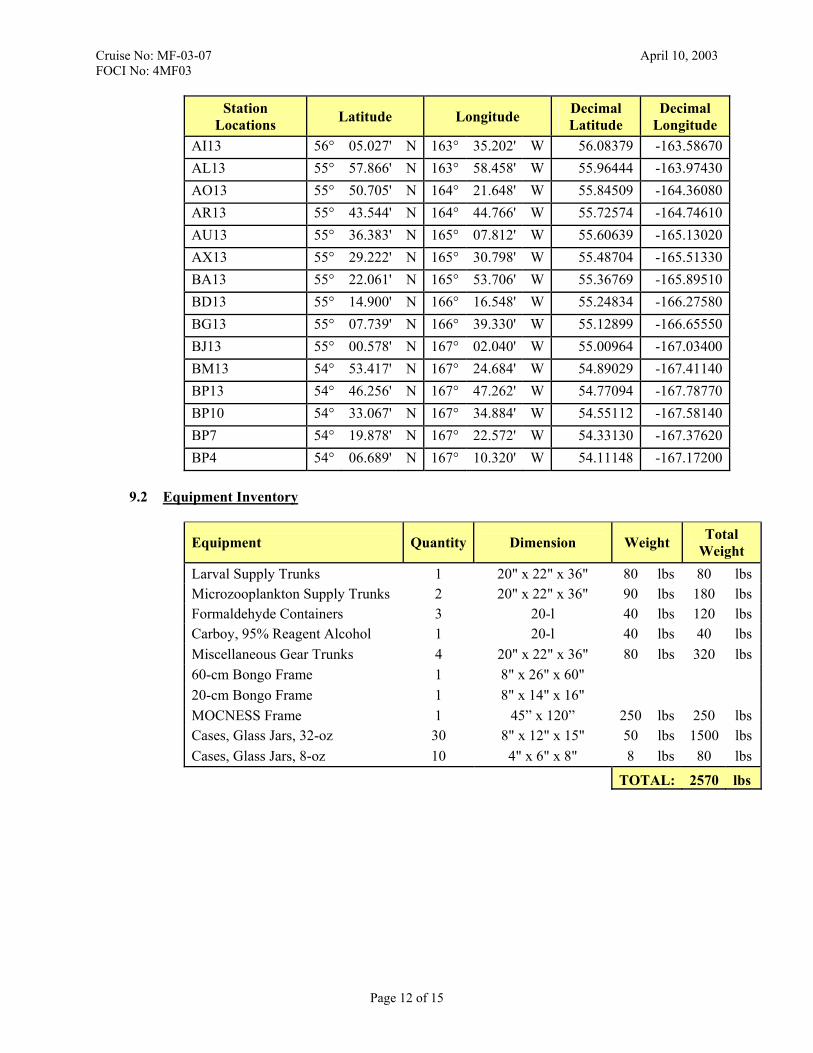
9.1 Station Locations
Station Locations Latitude Longitude Decimal
Latitude Decimal
Longitude BM1 54° 00.661' N 166° 35.418' W 54.01101 -166.59030BM4 54° 13.850' N 166° 47.634' W 54.23083 -166.79390BJ4 54° 21.011' N 166° 24.882' W 54.35018 -166.41470BJ1 54° 07.822' N 166° 12.624' W 54.13036 -166.21040BG1 54° 14.983' N 165° 49.770' W 54.24971 -165.82950BG4 54° 28.172' N 166° 02.058' W 54.46953 -166.03430BD4 54° 35.333' N 165° 39.174' W 54.58888 -165.65290BD1 54° 22.144' N 165° 26.844' W 54.36906 -165.44740Unimak Pass A 54° 19.782' N 165° 24.432' W 54.32970 -165.40720Unimak Pass C 54° 22.290' N 165° 17.058' W 54.37150 -165.28430Unimak Pass E 54° 24.900' N 165° 09.012' W 54.41500 -165.15020Unimak Pass G 54° 27.642' N 165° 00.828' W 54.46070 -165.01380BA1 54° 29.305' N 165° 03.852' W 54.48841 -165.06420BA4 54° 42.494' N 165° 16.218' W 54.70823 -165.27030AX4 54° 49.655' N 164° 53.190' W 54.82758 -164.88650AU4 54° 56.816' N 164° 30.096' W 54.94693 -164.50160AR4 55° 03.977' N 164° 06.936' W 55.06628 -164.11560AO4 55° 11.138' N 163° 43.704' W 55.18563 -163.72840AL4 55° 18.299' N 163° 20.400' W 55.30499 -163.34000AI4 55° 25.460' N 162° 57.024' W 55.42434 -162.95040AF4 55° 32.621' N 162° 33.582' W 55.54369 -162.55970T4 56° 01.265' N 160° 59.070' W 56.02109 -160.98450Q4 56° 08.426' N 160° 35.262' W 56.14044 -160.58770K7 56° 35.938' N 160° 00.384' W 56.59896 -160.00640N7 56° 28.777' N 160° 24.306' W 56.47961 -160.40510Q7 56° 21.616' N 160° 48.150' W 56.36026 -160.80250T7 56° 14.455' N 161° 11.922' W 56.24091 -161.19870W7 56° 07.294' N 161° 35.622' W 56.12156 -161.59370Z7 56° 00.132' N 161° 59.244' W 56.00220 -161.98740AC7 55° 52.971' N 162° 22.794' W 55.88285 -162.37990AF7 55° 45.810' N 162° 46.272' W 55.76350 -162.77120AI7 55° 38.649' N 163° 09.678' W 55.64415 -163.16130AL7 55° 31.488' N 163° 33.018' W 55.52480 -163.55030
Page 10 of 15

Cruise No: MF-03-07 April 10, 2003 FOCI No: 4MF03
Station Locations Latitude Longitude Decimal
Latitude Decimal
Longitude AO7 55° 24.327' N 163° 56.280' W 55.40545 -163.93800AR7 55° 17.166' N 164° 19.476' W 55.28610 -164.32460AU7 55° 10.005' N 164° 42.600' W 55.16675 -164.71000AX7 55° 02.844' N 165° 05.658' W 55.04740 -165.09430BA7 54° 55.683' N 165° 28.644' W 54.92805 -165.47740BD7 54° 48.522' N 165° 51.564' W 54.80870 -165.85940BG7 54° 41.361' N 166° 14.412' W 54.68935 -166.24020BJ7 54° 34.200' N 166° 37.200' W 54.57000 -166.62000BM7 54° 27.039' N 166° 59.916' W 54.45065 -166.99860BM10 54° 40.228' N 167° 12.270' W 54.67047 -167.20450BJ10 54° 47.389' N 166° 49.584' W 54.78982 -166.82640BG10 54° 54.550' N 166° 26.838' W 54.90917 -166.44730BD10 55° 01.711' N 166° 04.020' W 55.02852 -166.06700BA10 55° 08.872' N 165° 41.142' W 55.14787 -165.68570AX10 55° 16.033' N 165° 18.192' W 55.26722 -165.30320AU10 55° 23.194' N 164° 55.176' W 55.38657 -164.91960AR10 55° 30.355' N 164° 32.088' W 55.50592 -164.53480AO10 55° 37.516' N 164° 08.928' W 55.62527 -164.14880AL10 55° 44.677' N 163° 45.702' W 55.74462 -163.76170AI10 55° 51.838' N 163° 22.404' W 55.86397 -163.37340AF10 55° 58.999' N 162° 59.034' W 55.98332 -162.98390AC10 56° 06.160' N 162° 35.598' W 56.10267 -162.59330Z10 56° 13.321' N 162° 12.084' W 56.22202 -162.20140W10 56° 20.482' N 161° 48.504' W 56.34137 -161.80840T10 56° 27.643' N 161° 24.846' W 56.46072 -161.41410Q10 56° 34.804' N 161° 01.116' W 56.58007 -161.01860N10 56° 41.965' N 160° 37.308' W 56.69942 -160.62180K10 56° 49.127' N 160° 13.428' W 56.81878 -160.22380K13 57° 02.315' N 160° 26.556' W 57.03859 -160.44260N13 56° 55.154' N 160° 50.394' W 56.91924 -160.83990Q13 56° 47.993' N 161° 14.154' W 56.79989 -161.23590T13 56° 40.832' N 161° 37.842' W 56.68054 -161.63070W13 56° 33.671' N 162° 01.458' W 56.56119 -162.02430Z13 56° 26.510' N 162° 25.002' W 56.44184 -162.41670AC13 56° 19.349' N 162° 48.474' W 56.32249 -162.80790AF13 56° 12.188' N 163° 11.874' W 56.20314 -163.19790
Page 11 of 15
Cruise No: MF-03-07 April 10, 2003 FOCI No: 4MF03
Station Locations Latitude Longitude Decimal
Latitude Decimal
Longitude AI13 56° 05.027' N 163° 35.202' W 56.08379 -163.58670AL13 55° 57.866' N 163° 58.458' W 55.96444 -163.97430AO13 55° 50.705' N 164° 21.648' W 55.84509 -164.36080AR13 55° 43.544' N 164° 44.766' W 55.72574 -164.74610AU13 55° 36.383' N 165° 07.812' W 55.60639 -165.13020AX13 55° 29.222' N 165° 30.798' W 55.48704 -165.51330BA13 55° 22.061' N 165° 53.706' W 55.36769 -165.89510BD13 55° 14.900' N 166° 16.548' W 55.24834 -166.27580BG13 55° 07.739' N 166° 39.330' W 55.12899 -166.65550BJ13 55° 00.578' N 167° 02.040' W 55.00964 -167.03400BM13 54° 53.417' N 167° 24.684' W 54.89029 -167.41140BP13 54° 46.256' N 167° 47.262' W 54.77094 -167.78770BP10 54° 33.067' N 167° 34.884' W 54.55112 -167.58140BP7 54° 19.878' N 167° 22.572' W 54.33130 -167.37620BP4 54° 06.689' N 167° 10.320' W 54.11148 -167.17200
9.2 Equipment Inventory
Equipment Quantity Dimension Weight Total Weight
Larval Supply Trunks 1 20" x 22" x 36" 80 lbs 80 lbs Microzooplankton Supply Trunks 2 20" x 22" x 36" 90 lbs 180 lbs Formaldehyde Containers 3 20-l 40 lbs 120 lbs Carboy, 95% Reagent Alcohol 1 20-l 40 lbs 40 lbs Miscellaneous Gear Trunks 4 20" x 22" x 36" 80 lbs 320 lbs 60-cm Bongo Frame 1 8" x 26" x 60" 20-cm Bongo Frame 1 8" x 14" x 16" MOCNESS Frame 1 45” x 120” 250 lbs 250 lbs Cases, Glass Jars, 32-oz 30 8" x 12" x 15" 50 lbs 1500 lbs Cases, Glass Jars, 8-oz 10 4" x 6" x 8" 8 lbs 80 lbs
TOTAL: 2570 lbs
Page 12 of 15

Cruise No: MF-03-07 April 10, 2003 FOCI No: 4MF03
9.3 HAZMAT Inventory
Chemical CAS Number Respondee Organization Quantity H F R C Storage Color
Code Hazard Class Packing Group
Number UN Reportable
Quantity Response Indices
Ethanol 64-17-5 Duffy-Anderson AFSC 3 4 Flammable 3 II 1170 5000 Lb 1Formaldehyde mix Duffy-Anderson AFSC 3 2 Flammable 3 & 8 III 1198 100 Lb 1 Sodium Borate 1330-43-4 Duffy-Anderson AFSC 2 0 General Not regulated None 2
Spill Response 1: Ventilate area of leak or spill. Remove all sources of ignition. Wear appropriate personal protective equipment. Isolate hazard area. Keep unnecessary and unprotected personnel from entering. Contain and recover liquid when possible. Use non-sparking tools and equipment. Collect liquid in an appropriate container or absorb with an inert material (e. g., vermiculite, dry sand, or earth), and place in a chemical waste container. Do not use combustible materials, such as saw dust. Do not flush to sewer! If a leak or spill has not ignited, use water spray to disperse the vapors, to protect personnel attempting to stop leak, and to flush spills away from exposures. U.S. Regulations (CERCLA) requires reporting spills and releases to soil, water and air in excess of reportable quantities. The toll free number for the U.S. Coast Guard National Response Center is (800) 424-8802.
Spill Response 2: Ventilate area of leak or spill. Wear appropriate personal protective equipment. Pick up and place in a suitable container for reclamation or disposal, using a method that does not generate dust.
2 2 0
Page 13 of 15
Cruise No: MF-03-07 April 10, 2003 FOCI No: 4MF03
9.4 Figures
9.4.1 Station Locations
Page 14 of 15

Cruise No: MF-03-07 April 10, 2003 FOCI No: 4MF03
Page 15 of 15
9.4.2 Station Location Details (NOAA Chart 16006)