Embed Size (px)
Citation preview
FINAL
Total Maximum Daily Load (TMDL) for
Siltation in Bayview Lake of the Village Creek Watershed
Bayview Lake AL/03160111-140_03
Alabama Department of Environmental Management
Water Quality Branch Water Division December 2005

Final Bayview Lake TMDL Siltation AL/03160111-140_03
Table of Contents LIST OF FIGURES ....................................................................................................................III
LIST OF TABLES ......................................................................................................................III
LIST OF ABBREVIATIONS ..................................................................................................... V
1.0 EXECUTIVE SUMMARY .............................................................................................. 1
2.0 BASIS FOR THE §303(D) LISTING.............................................................................. 2 2.1 INTRODUCTION ................................................................................................................ 2 2.2 PROBLEM DEFINITION...................................................................................................... 2
3.0 TECHNICAL BASIS FOR TMDL DEVELOPMENT................................................. 4 3.1 WATER QUALITY TARGET IDENTIFICATION..................................................................... 4 3.2 DATA AVAILABILITY AND ANALYSIS............................................................................... 5 3.3 SOURCE ASSESSMENT...................................................................................................... 8
3.3.1 Nonpoint Sources .................................................................................................... 9 3.3.2 Point Sources ........................................................................................................ 11
4.0 MODEL DEVELOPMENT ........................................................................................... 11
5.0 DEVELOPMENT OF TOTAL MAXIMUM DAILY LOAD..................................... 12 5.1 NUMERIC TARGETS FOR THE TMDL.............................................................................. 12 5.2 EXISTING CONDITIONS................................................................................................... 13 5.3 CRITICAL CONDITIONS................................................................................................... 14 5.4 MARGIN OF SAFETY (MOS)........................................................................................... 14 5.5 SEASONAL VARIATION................................................................................................... 14 5.6 WASTELOAD ALLOCATIONS .......................................................................................... 14 5.7 LOAD ALLOCATIONS...................................................................................................... 15 5.8 TMDL RESULTS ............................................................................................................ 15
6.0 FOLLOW-UP MONITORING ..................................................................................... 16
7.0 PUBLIC PARTICIPATION.......................................................................................... 16
8.0 REFERENCES................................................................................................................ 17
APPENDIX A.............................................................................................................................. 20
Prepared by ADEM/Water Quality Branch and Tetra Tech, Inc. ii

Final Bayview Lake TMDL Siltation AL/03160111-140_03
List of Figures
Figure I Village Creek Watershed in the Black Warrior River Basin HUC AL/03160111-140.......................................................................................................................... iv
Figure 3-1 USGS Stations in the Impaired Segments of the Watershed .................................. 6 Figure 3-2 ADEM Water Quality Stations in the Impaired Segments of the Watershed......... 7 Figure 3-3 EPA Water Quality Stations in the Impaired Segments of the Watershed ............. 7 Figure 3-4 Landuse Map of the Village Creek Watershed ....................................................... 8 Figure 3-5 Village Creek Hydrograph Response to the 2- year – 24-Hour Storm Event or
4 inches in 24 Hours, at Ave W. ........................................................................... 10 Figure 3-6 Level IV Ecoregions in the Village Creek Watershed.......................................... 11
List of Tables
Table 1-1 Siltation TMDL in for Bayview Lake HUC AL/03160111-140_03 ...................... 1 Table 2-1 2002 §303(d) Siltation Impairment to Bayview Lake AL/03160111-140_03........ 2 Table 3-1 Data Utilized in TMDL Development .................................................................... 5 Table 3-2 USGS Gaging Stations on Village Creek ............................................................... 6 Table 3-3 Landuse Characteristics within the Village Creek Watershed................................ 9 Table 5-1 Village Creek Existing Sediment Conditions ....................................................... 13 Table 5-2 Camp Branch Existing Sediment Conditions from Landuse Activities................ 13 Table 5-3 Siltation TMDL in for Bayview Lake HUC AL/03160111-140_03 .................... 15 Table 6-1 Basin Monitoring Schedule................................................................................... 16 Table A-1 Sampling Stations in Bayview Lake ..................................................................... 20
Prepared by ADEM/Water Quality Branch and Tetra Tech, Inc. iii

Final Bayview Lake TMDL Siltation AL/03160111-140_03
Figure I Village Creek Watershed in the Black Warrior River Basin HUC AL/03160111-140
Prepared by ADEM/Water Quality Branch and Tetra Tech, Inc. iv

Final Bayview Lake TMDL Siltation AL/03160111-140_03
List of Abbreviations
ADEM Alabama Department of Environmental Management AWW Alabama Water Watch BMP Best Management Practices CAFO Confined Animal Feeding Operation CFR Code of Federal Regulations CFS Cubic Feet per Second CWA Clean Water Act CWP Clean Water Partnership DEM Digital Elevation Model EPA Environmental Protection Agency FSA Farm Services Agency GIS Geographic Information System HUC Hydrologic Unit Code LA Load Allocation MOS Margin of Safety MRLC Multi-Resolution Land Characteristic MS4 Municipal Separate Stormwater System NED National Elevation Database NHD National Hydrography Dataset NPDES National Pollutant Discharge Elimination System NPS Nonpoint Source Pollution NRCS Natural Resources Conservation Service OEO Office of Education and Outreach RF3 Reach File 3 STORET STOrage RETrieval Database SWMA Storm Water Management Authority TMDL Total Maximum Daily Load TSS Total Suspended Solids USDA United States Department of Agriculture USF&WS United States Fish and Wildlife Service USGS United States Geological Survey USLE Universal Soil Loss Equation WCS Watershed Characterization System WLA Waste Load Allocation WWTF Wastewater Treatment Facility WWTP Wastewater Treatment Plant
Prepared by ADEM/Water Quality Branch and Tetra Tech, Inc. v

Final Bayview Lake TMDL Siltation AL/03160111-140_03
1.0 Executive Summary
Bayview Lake is a 440-acre impoundment on the mainstem of Village Creek just downstream of the City of Birmingham. The Village Creek watershed is located in the Black Warrior River basin in Jefferson County, Alabama. The watershed drains 94.5 square miles at its confluence with the Locust Fork (HUC AL/03160111). Urban activities dominate the upper most portion of the watershed. Total Maximum Daily Loads (TMDLs) were put out for public notice in 2002 for three segments identified on the State of Alabama’s §303(d) list of impaired waters: an upper segment of Village Creek (HUC AL/03160111-140_02), Camp Branch (HUC AL/03160111-140_01), and Bayview Lake (HUC AL/03160111-140_03). Both Camp Branch and Village Creek discharge into Bayview Lake. Bayview Lake is designated for Limited Warmwater Fishery (LWF) use.
Bayview Lake (HUC AL/03160111-140_03) has been included on the State of Alabama’s §303(d) list of impaired waters since 1996. More recent data has removed the lake from the list of impaired waters for ammonia and organic enrichment/dissolved oxygen (OE/DO). This report presents the results of a siltation Total Maximum Daily Load (TMDL) developed for Bayview Lake (HUC AL/03160111-140_03). Based on the assessment of all available physical, chemical, and biological data, ADEM has determined that tributary loads of siltation cause impairment to Bayview Lake; therefore, compliance of this TMDL will be met through siltation reductions to the upstream contributing tributaries, Village Creek and Camp Branch. Thus, no action is required for the Bayview Lake siltation TMDL at this time. Table 1-1, below, illustrates the existing and allowable siltation loads for Bayview Lake.
Table 1-1 Siltation TMDL in for Bayview Lake HUC AL/03160111-140_03
Existing Loads Allowable Loads Reductions (4)
Impaired Segment
Drainage Area
(acres)
WLA(1) (Continuous
Sources)
WLA(2) (Stormwater
Sources) L A(3)
WLA(1) (Continuous
Sources)
WLA(2) (Stormwater
Sources) L A(3)
WLA(1) (Continuous
Sources)
WLA(2) (Stormwater
Sources) L A(3) TMDL Camp
Branch AL/03160111-
140_01 3,562 NA 964
lb/acre/yr
964 lb/acre/
yr NA 279
lb/acre/yr
279 lb/acre
/yr NA 71% 71% 499
tons/yr
Village Creek AL/03160111-
140_02 21,440 16571 lb/day
12.9 lb/acre/hr
12.9 lb/acre/
hr 15571 lb/day
8.3 lb/acre/hr
8.3 lb/acre
/hr 0% 35% 35%
178,000
lbs/hr Bayview
Lake Direct Discharge
AL/03160111-140_03 7,385 NA
964 lb/acre/yr
964 lb/acre/
yr NA 279
lb/acre/yr
279 lb/acre
/yr -- -- --
1030 tons/yr
(4)
(1) No continuous WLAs discharge to Bayview Lake. (2) Stormwater WLAs are based on the MS4 (ALS000001). (3) LA is equal to the WLA based on the MS4 (ALS000001). (4) The actual contribution of sediment discharged directly to Bayview Lake, not including Village Creek
and Camp Branch, is less than 1% of the total load from upstream sources; therefore no action is required to meet this TMDL.
Prepared by ADEM/Water Quality Branch and Tetra Tech, Inc. 1

Final Bayview Lake TMDL Siltation AL/03160111-140_03
2.0 Basis for the §303(d) Listing
2.1 Introduction
Section §303(d) of the Clean Water Act (CWA) as amended by the Water Quality Act of 1987 and EPA’s Water Quality Planning and Management Regulations [Title 40 of the Code of Federal Regulations (CFR), Part 130] require states to identify waterbodies, which are not meeting water quality criteria applicable to their designated use classifications. The identified waters are prioritized based on severity of pollution with respect to designated use classifications. TMDLs for all pollutants resulting in violations of applicable water quality criteria are established for each identified waterbody. Such loads are established at levels necessary to implement the applicable water quality criteria with seasonal variations and margins of safety. The TMDL process establishes allowable loading of pollutants (or other quantifiable parameters for a waterbody) based on the relationship between pollution sources and instream water quality conditions, so that states can establish water quality based controls to reduce pollution from both point and nonpoint sources and to restore and maintain the quality of their water resources (EPA, 1991).
Bayview Lake was added to the §303(d) list based on data collected for the 1988 §305(b) Report to Congress. Site visits and data collected by ADEM identified impairments to this waterbody in the Locust Fork-Black Warrior River basin. Table 2-1 describes the designated use and cause of impairment of Bayview Lake as they appear on the 2002 §303(d) list.
Table 2-1 2002 §303(d) Siltation Impairment to Bayview Lake AL/03160111-140_03
Waterbody Name (ID)
Use Classification
Causes of Impairment
Sources of Impairment
Size (Miles)
Downstream/ Upstream Locations
Bayview Lake (03160111-140_03)
Limited Warmwater
Fishery Siltation
Municipal Urban Runoff/Storm sewers
Industrial Surface Mining-abandoned
440 acres
Bayview Lake Dam/ Village Creek
2.2 Problem Definition
Bayview Lake (HUC AL/03160111-140_03) has been impacted by upstream activities from two impaired tributaries, Camp Branch and Village Creek. The 440-acre lake was built in 1911 by the Tennessee Coal and Iron Company to provide water supply for a mining village and mill operation. Historical sources of pollution and loadings from upstream tributaries contribute to the lake’s impairment.
Bayview Lake been listed as impaired due to siltation from urban runoff, instream erosion from Village Creek, and other, unknown sources.
Waterbody Impaired: Bayview Lake
Pollutant of Concern: Siltation
Water Use Classification: Limited Warmwater Fishery
Prepared by ADEM/Water Quality Branch and Tetra Tech, Inc. 2
Final Bayview Lake TMDL Siltation AL/03160111-140_03 Bayview Lake is classified as a Limited Warmwater Fishery. Usages of waters in this classification are described in ADEM Admin. Code. The seasonal usages are described below:
Admin. Code R. 335-6-10-.09(5)(a), (b), (c), and (d) December through April
(a) Best usage of waters: fishing, propagation of fish, aquatic life, and wildlife, and any other usage except for swimming and water-contact sports or as a source of water supply for drinking or food-processing purposes.
(b) Conditions related to best usage: the waters will be suitable for fish, aquatic life and wildlife propagation. The quality of salt and estuarine waters to which this classification is assigned will also be suitable for the propagation of shrimp and crabs. (c) Other usage of waters: it is recognized that the waters may be used for incidental water contact and recreation during June through September, except that water contact is strongly discouraged in the vicinity of discharges or other conditions beyond the control of the Department or the Alabama Department of Public Health. (d) Conditions related to other usage: the waters, under proper sanitary supervision by the controlling health authorities, will meet accepted standards of water quality for outdoor swimming places and will be considered satisfactory for swimming and other whole body water-contact sports. Admin. Code R. 335-6-10-.09(6)(a), (b), (c), and (d) May through November (a) The provisions of the Fish and Wildlife water use classification at Rule 335-6-10- .09(5) shall apply to the Limited Warmwater Fishery water use classification, except as noted below. Unless alternative criteria for a given parameter are provided in paragraph (e) below, the applicable Fish and Wildlife criteria at paragraph 10- .09(5)(e) shall apply year-round. At the time the Department proposes to assign the Limited Warmwater Fishery classification to a specific waterbody, the Department may apply criteria from other classifications within this chapter if necessary to protect a documented, legitimate existing use. (b) Best usage of waters (May through November): agricultural irrigation, livestock watering, industrial cooling and process water supplies, and any other usage, except fishing, bathing, recreational activities, including water-contact sports, or as a source of water supply for drinking or food-processing purposes. (c) Conditions related to best usage (May through November): 1. The waters will be suitable for agricultural irrigation, livestock watering, and industrial
cooling waters. The waters will be usable after special treatment, as may be needed under each particular circumstance, for industrial process water supplies. The waters will also be suitable for other uses for which waters of lower quality will be satisfactory.
2. This category includes watercourses in which natural flow is intermittent, or under
certain conditions non-existent, and which may receive treated wastes from existing municipalities and industries. In such instances, recognition is given to the lack of
Prepared by ADEM/Water Quality Branch and Tetra Tech, Inc. 3

Final Bayview Lake TMDL Siltation AL/03160111-140_03
opportunity for mixture of the treated wastes with the receiving stream for purposes of compliance. It is also understood in considering waters for this classification that urban runoff or natural conditions may impact any waters so classified.
(d) Other usage of waters: none recognized.
The State has established a narrative criterion to maintain the biological integrity of waters of the State of Alabama where numerical criteria have not been established (ADEM 335-6-10-.06 (a) & (c)). Alabama’s Water Quality Program does not include numerical water quality criteria for aquatic life protection due to sediment. However, ADEM uses narrative criteria as shown in ADEM Rule 335-6-10-.06 to address impairments of this nature. ADEM and EPA guidance documents are used to establish numerical targets for the purposes of developing TMDLs.
3.0 Technical Basis for TMDL Development
3.1 Water Quality Target Identification
Biological assessment data is used in combination with other physical and chemical data or information to arrive at an overall use support determination for siltation. Use support determinations for the State of Alabama’s §303(d) list are made with the following guidelines for interpretation of biological data:
• Fully Supporting - Macroinvertebrates determined to be Excellent (Unimpaired), Good (Slightly Impaired), and Fair (Moderately Impaired) rating if Chemical/Physical/Field Data indicates compliance.
• Partial Supporting - Macroinvertebrates determined to be Fair (Moderately Impaired) and Chemical/Physical/Field Data indicates impairment.
• Not Supporting - Macroinvertebrates determined to be Poor (Severely Impaired) and Chemical/Physical/Field Data indicates impairment.
Alabama’s water quality standards do not include numerical water quality criteria for aquatic life protection due to sediment. Narrative criteria are considered to maintain the biological integrity of the waters of the State of Alabama. Therefore, it is necessary to develop numerical targets based upon these narrative criteria for Bayview Lake. The siltation impairment of Bayview Lake is primarily a function of loads being delivered from Camp Branch and Village Creek. It is believed that reductions in these segments will alleviate the primary sediment loads to Bayview Lake.
For Camp Branch, a numerical target for siltation was established through the use of an Ecoregion reference watershed within the Tennessee River basin that reflects similar conditions within the listed segment, and that has been determined through biological assessment to be unimpaired. As the impairment of biological integrity is generally a long-term process of sediment build up, the use of the Sediment Tool to determine annual average loading conditions through the Universal Soil Loss Equation (USLE) is appropriate for developing numerical targets in reference watersheds, as well as determining existing loads and reductions in nonpoint source loads to the system. Baseline annual average loading conditions, numerical targets, are then defined using reference watersheds.
Prepared by ADEM/Water Quality Branch and Tetra Tech, Inc. 4

Final Bayview Lake TMDL Siltation AL/03160111-140_03 The goal of the approach to address the siltation TMDL for Village Creek is to restore and protect the habitat and biological community present in the stream. A sediment model, such as the sediment tool, is not appropriate in this case because the large contributor of degradation to the habitat in the stream is due to peak flows and the carrying (shaping) capacity of the stream. A technique is used that calculates and compares the specific stream power to that of a stable system. A stable system is defined as a cross-section that its width and thalweg depth remain relatively constant over a long period (i.e., 15-20 years). If the cross-section is remaining constant through time, the net sedimentation/deposition and erosion/scouring is zero. This idea was used to develop a target of stream power that could be used to assess if the impaired stream is stable or unstable and help determine the evolution of the stream channel. Specific stream power has been used in prior studies to predict channel stability, with most streams attaining relative stability less than 30 W/m2 (Bledsoe et al., 2002).
3.2 Data Availability and Analysis
A wide range of data and information were used to characterize the watershed and instream conditions. The categories of data used include physiographic data that describe the physical conditions of the watershed, environmental monitoring data that identify potential pollutant sources and their contribution, and instream water quality monitoring data.
Instream water quality data are necessary to evaluate impairment and characterize watershed loads. Figures 3-1 and 3-2 illustrate the location of water quality stations, USGS flow stations, and the weather station utilized in the development of TMDLs for Village Creek and Camp Branch. The data used in the development of these TMDLs is detailed in the Final Village Creek and Camp Branch TMDLs, ADEM, 2005. A brief description of the data sources and station locations is provided in the following section. Various data types and sources are listed in Table 3-1.
Table 3-1 Data Utilized in TMDL Development
Data Category Description Source(s) Landuse – 1992 MRLC USGS National Elevation Data-30 x 30 meter grid USEPA National Hydrography Database Reach Network USGS
Watershed Physiographic Data
Level IV Ecoregion Coverage ADEM, USEPA and NRCS Meteorological Data Rainfall, Air Temperature, Solar Radiation, Wind Speed and
Direction, Relative Humidity, and Cloud Cover at Birmingham International Airport
National Climatic Data Center
NPDES Permits ADEM Discharge Monitoring Reports ADEM 303(d) Listed Waters ADEM
Environmental Monitoring Data
Water Quality Monitoring Data ADEM, USEPA, USGS, B’ham SWMA, AWW, and STORET
Prepared by ADEM/Water Quality Branch and Tetra Tech, Inc. 5
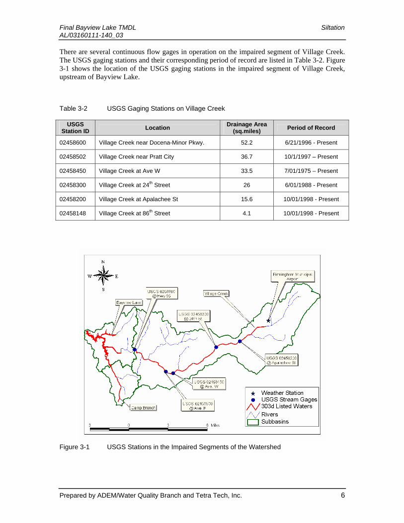
Final Bayview Lake TMDL Siltation AL/03160111-140_03 There are several continuous flow gages in operation on the impaired segment of Village Creek. The USGS gaging stations and their corresponding period of record are listed in Table 3-2. Figure 3-1 shows the location of the USGS gaging stations in the impaired segment of Village Creek, upstream of Bayview Lake.
Table 3-2 USGS Gaging Stations on Village Creek
USGS Station ID Location Drainage Area
(sq.miles) Period of Record
02458600 Village Creek near Docena-Minor Pkwy. 52.2 6/21/1996 - Present
02458502 Village Creek near Pratt City 36.7 10/1/1997 – Present
02458450 Village Creek at Ave W 33.5 7/01/1975 – Present
02458300 Village Creek at 24th Street 26 6/01/1988 - Present
02458200 Village Creek at Apalachee St 15.6 10/01/1998 - Present
02458148 Village Creek at 86th Street 4.1 10/01/1998 - Present
Figure 3-1 USGS Stations in the Impaired Segments of the Watershed
Prepared by ADEM/Water Quality Branch and Tetra Tech, Inc. 6

Final Bayview Lake TMDL Siltation AL/03160111-140_03
Figure 3-2 ADEM Water Quality Stations in the Impaired Segments of the Watershed
Figure 3-3 EPA Water Quality Stations in the Impaired Segments of the Watershed
Prepared by ADEM/Water Quality Branch and Tetra Tech, Inc. 7

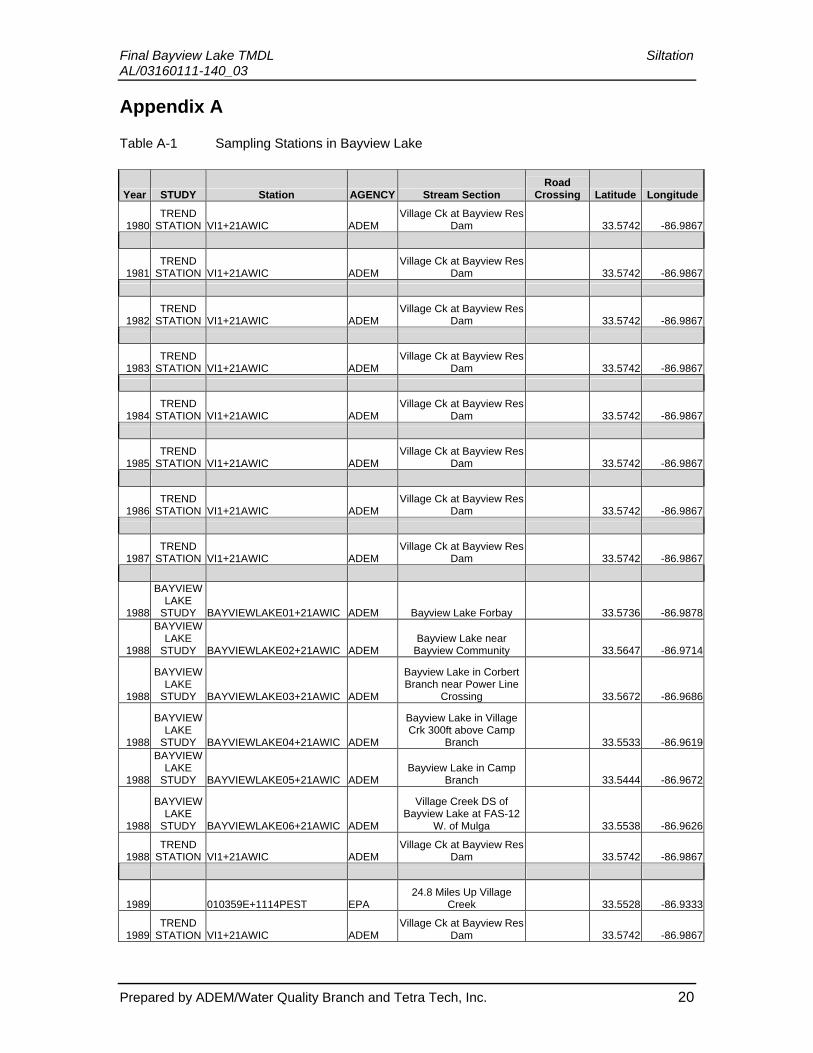
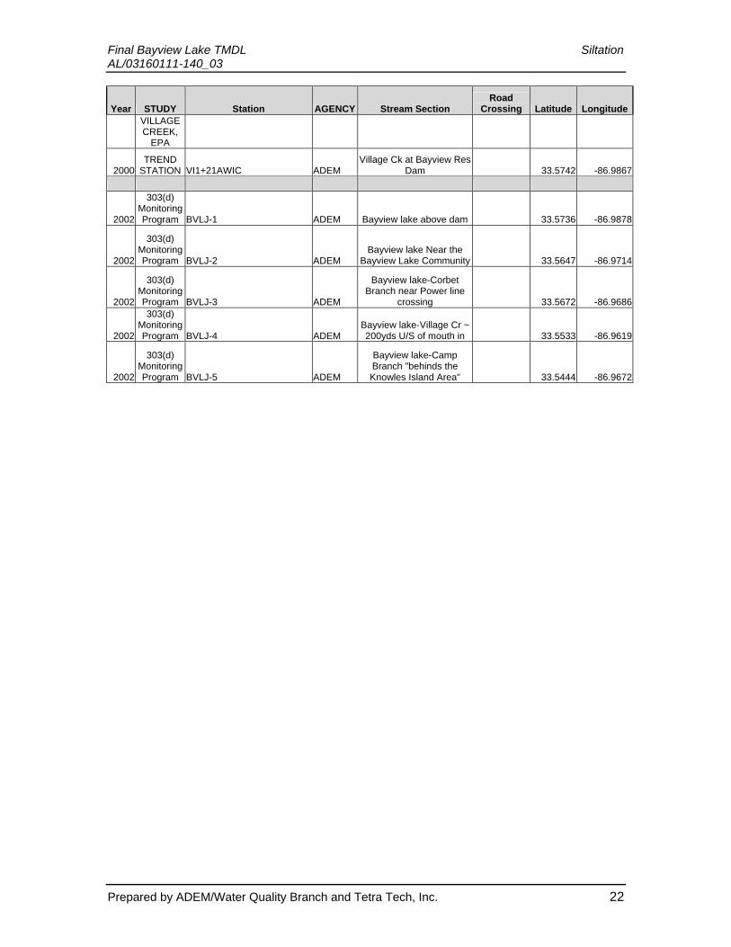
Final Bayview Lake TMDL Siltation AL/03160111-140_03 Limited water quality sampling has been conducted in Bayview Lake. Table A-1 of the appendix describes the location of stations and the years when data were collected. ADEM conducted two studies in 1988 and 1991 to access lake water quality (ADEM, 1989; ADEM, 1991). As part of §303(d) Monitoring Program, ADEM collected data on Bayview Lake in 2002. The 2002 data were compared with data collected in 1988 and 1991 to determine current violations of the use classification for Bayview Lake.
Several studies cite Village Creek as contributing siltation to Bayview Lake (EPA, 1999; EPA, 1989; USGS, 2002; ADEM, 2001). Examination of aerial photographs show sediment deposition in the embayments of Village Creek and Camp Branch (GlobXplorer, 2002). The Village Creek and Camp Branch TMDLs, finalized and approved by EPA in 2005, will reduce the sediment loadings into Bayview Lake. The adjacent land use and the contribution from Corbett Branch are not significant contributors of sediment to the lake.
3.3 Source Assessment
TMDL evaluations examine the known potential sources of pollutants in the watershed including point sources, nonpoint sources and background levels. For the purpose of these TMDLs, facilities permitted under the National Pollutant Discharge Elimination System (NPDES) Program are considered point sources. The source assessment was used as the basis of the TMDL allocations.
Figure 3-4 Landuse Map of the Village Creek Watershed
Prepared by ADEM/Water Quality Branch and Tetra Tech, Inc. 8

Final Bayview Lake TMDL Siltation AL/03160111-140_03 Table 3-3 Landuse Characteristics within the Village Creek Watershed
Landuse Classification Percent of Watershed
Open Water 0.6% Low Intensity Residential 20.2% High Intensity Residential 6.9% High Intensity Commercial/Industrial/Transportation 12% Quarries/Strip Mines/Gravel Pits 0.6% Transitional 0.4% Forest 48.6% Pasture/Crops/Other Grasses (Urban/recreational; e.g. parks, lawns) 10.4% Wetlands 0.3%
3.3.1 Nonpoint Sources
A landuse map of the Village Creek watershed, areas contributing to Bayview Lake, is presented in Figure 3-4. The predominant landuses within the watershed are forest and urban with respective percentages of the total watershed equal to 49 percent and 50 percent respectively. Much of the urban area is commercial and industrial, including the Birmingham International Airport. Table 3-3 lists landuse percentages determined from the 1992 Multi-Resolution Land Characteristics (MRLC) map. Each landuse type has the potential to contribute sediment to the receiving waters. Urban stormwater runoff can be a significant source of sediment load in the watershed.
The major sources of habitat impairment in the watershed are due to nonpoint sources from urban runoff. The large percentage of impervious area and limited stream buffer create dynamic flow events that destroy riparian habitat and impair water quality as noted in several studies (EPA, 1999; EPA, 1989; USGS, 2002; ADEM, 2001). Water reaches the stream very quickly in urban areas at high velocities. Figure 3-5 illustrates the hydrograph response of an area upstream of Bayview Lake in Village Creek to a 2-year, 24-hour storm; within hours Village Creek flows increase 6,000 cfs. The dramatic change to velocity increases instream scour. Instream scour in Village Creek generates a large amount of sediment that settles in the backwater area of Bayview Lake causing impairment to both segments.
Prepared by ADEM/Water Quality Branch and Tetra Tech, Inc. 9

Final Bayview Lake TMDL Siltation AL/03160111-140_03
0
0.2
0.4
0.6
0.8
1
1.2
1.4
1.6
1.8
3/9/2000 3/10/2000 3/11/2000 3/12/2000Date
Rai
n (in
/hou
r)
0
1000
2000
3000
4000
5000
6000
7000
Flow
(cfs
)
Rain (in/hr) Flow (cfs)
Figure 3-5 Village Creek Hydrograph Response to the 2- year – 24-Hour Storm Event or
4 inches in 24 Hours, at Ave W.
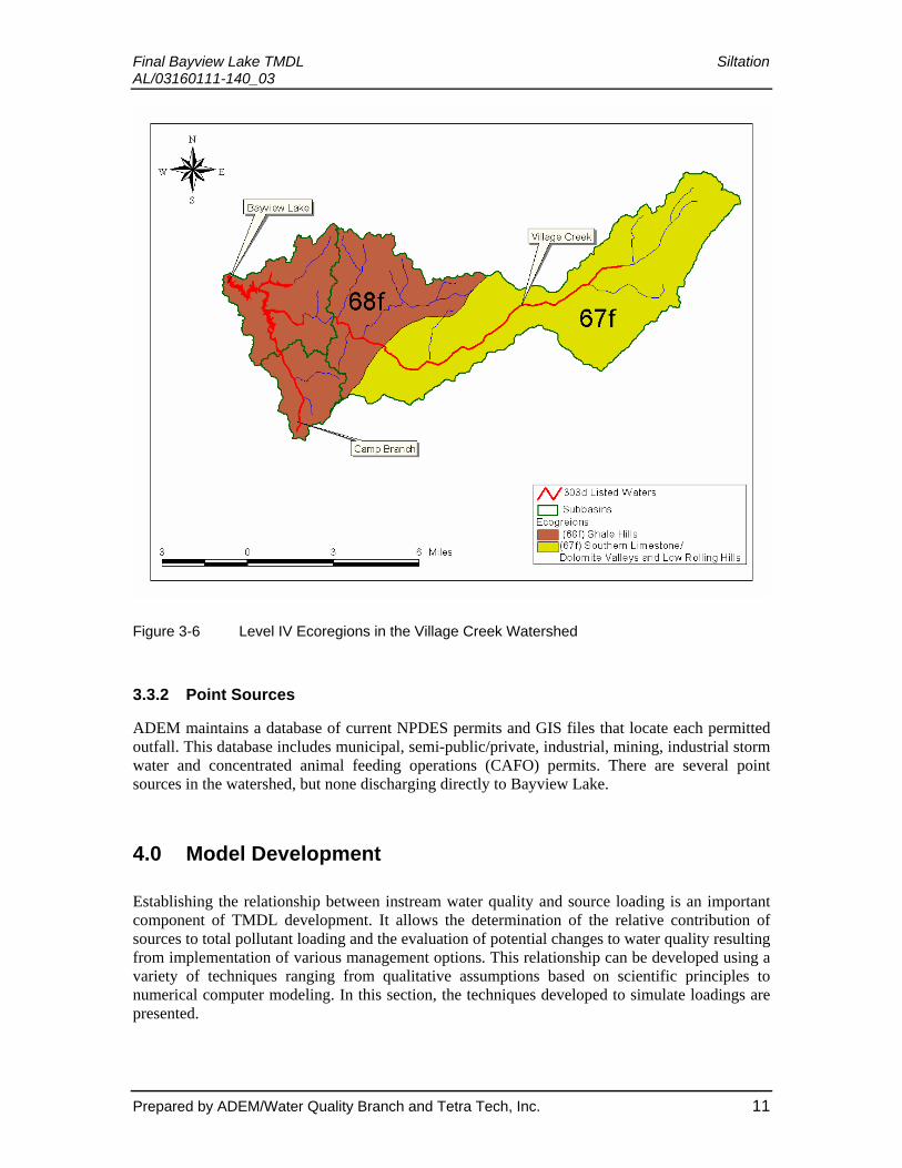
The Village Creek watershed lies within the Southern Limestone/Dolomite Valleys and Low Rolling Hills (67f) and Shale Hills (68f) Level IV Ecoregions (Omernik, 1995). Figure 3-6 illustrates the watershed coverage for each Ecoregion described below.
• (67f.) The Southern Limestone/Dolomite Valleys and Low Rolling Hills form a heterogeneous region composed predominantly of limestone and cherty dolomite. Landforms are mostly undulating valleys and rounded ridges and hills, with many caves and springs. Soils vary in their productivity, and land cover includes oak-hickory and oak-pine forests, pasture, intensive agriculture, and urban and industrial. Along the Coosa River floodplain, biota more typical of coastal plain regions can be found due to the valley and riverine connection to Ecoregion 65.
• (68f.) The Shale Hills Ecoregion, sometimes called the Warrior Coal Field, has more shale and less sandstone than 68e. The soils generally have silt loam surfaces rather than sandy loams and have a silty clay or clayey subsoil. Although it has the lowest elevations in Ecoregion 68, the surface features are characterized by extensive hills and mostly strongly sloping topography. The shale, siltstone, and sandstone are relatively impermeable, and streams do not have the base flow found in more permeable adjacent areas, such as 65i or 67f. The region is mostly forested, but coal mining is a major industry, and the extensive open-pit mines have altered the landscape, soils, and streams.
Prepared by ADEM/Water Quality Branch and Tetra Tech, Inc. 10
Final Bayview Lake TMDL Siltation AL/03160111-140_03
Figure 3-6 Level IV Ecoregions in the Village Creek Watershed
3.3.2 Point Sources
ADEM maintains a database of current NPDES permits and GIS files that locate each permitted outfall. This database includes municipal, semi-public/private, industrial, mining, industrial storm water and concentrated animal feeding operations (CAFO) permits. There are several point sources in the watershed, but none discharging directly to Bayview Lake.
4.0 Model Development
Establishing the relationship between instream water quality and source loading is an important component of TMDL development. It allows the determination of the relative contribution of sources to total pollutant loading and the evaluation of potential changes to water quality resulting from implementation of various management options. This relationship can be developed using a variety of techniques ranging from qualitative assumptions based on scientific principles to numerical computer modeling. In this section, the techniques developed to simulate loadings are presented.
Prepared by ADEM/Water Quality Branch and Tetra Tech, Inc. 11

Final Bayview Lake TMDL Siltation AL/03160111-140_03 Siltation TMDLs proposed in 2002 used a system of models to quantify contributions of sediment from landuse activities and instream scour. The system of models includes the following:
• Sediment Tool – to quantify the sediment load from landuse activities in the watershed.
• Stream Power – to quantify the instream sediment transport potential.
These models were discussed in the Final TMDLs for Camp Branch and Village Creek in 2005. Details of the models will therefore not be discussed in this report.
5.0 Development of Total Maximum Daily Load
A TMDL is the total amount of a pollutant that can be assimilated by the receiving water while still achieving water quality standards. In the case of Bayview Lake, it is the water quality criteria necessary to protect aquatic life for a Limited Warmwater Fishery use. TMDLs can be expressed in terms of mass per time (e.g., pounds per day), toxicity, or other appropriate measures. TMDLs are comprised of the sum of individual wasteload allocations (WLAs) for point sources, load allocations (LAs) for nonpoint sources, and natural background levels. In addition, the TMDL must include a margin of safety (MOS), either implicitly or explicitly, that accounts for the uncertainty in the relationship between pollutant loads and the quality of the receiving waterbody. Conceptually, this definition is denoted by the equation:
TMDL = ∑WLAs + ∑LAs + MOS
This section presents the siltation TMDL developed for Bayview Lake (HUC AL/03160111-140_03).
5.1 Numeric Targets for the TMDL
Alabama’s water quality criteria do not include numerical water quality criterion for aquatic life protection due to sediment. Instead, the State of Alabama’s water quality criteria document (ADEM Admin. Code R. 335-6-10-06-(a) & (c)) provides a narrative criteria that establishes the biological integrity within the stream segment that must be maintained.
In Village Creek, the siltation TMDL target was determined using a specific stream power as discussed in the 2005 EPA approved TMDL. The peak hydrograph with an average recurrence interval of 1.5 years, Q1.5, was calculated based on measured peak flows and reduced to meet a stability requirement of 25 W/m2, including a margin of safety. The proposed peak hydrograph would allow the stream to reach an equilibrium so that instream sedimentation would be reduced and ultimately provide a sustainable habitat.
In order to develop a numeric criterion that protects the designated use in Camp Branch, a target annual average loading of sediment to the listed reach was determined. The target represents loading conditions within a reference watershed where physical conditions are similar and biological assessments have identified the reference waterbody as fully supporting its designated use(s). It has been determined that biological impairment of waterbodies due to excessive siltation is a long-term process and therefore the use of annual average loading conditions, as
Prepared by ADEM/Water Quality Branch and Tetra Tech, Inc. 12

Final Bayview Lake TMDL Siltation AL/03160111-140_03 calculated through the Universal Soil Loss Equation (USLE), are appropriate as the TMDL target loading conditions.
The siltation impairment to Bayview Lake is the result of instream loads from Village Creek and overland loads similar to those calculated for Camp Branch. Compliance with the siltation targets established for Bayview Lake will be met when reductions are made to these upstream segments.
5.2 Existing Conditions
The habitat in Village Creek is currently degraded due to excessive sedimentation, originating instream due to urban runoff (Table 5-1). The TMDL target is representative of a recurring phenomenon of flashy hydrology that typically has a higher energy than the stream can handle. By targeting a low return interval (1.5 years), it is more protective of frequent storms; therefore, providing the greatest mechanism against instream erosion. The TMDL condition for Village Creek is to increase the timing of the peak of the hydrograph by catching and retaining the runoff during storm events. The volume of runoff would not change, but the peak flow magnitude and timing would be modified to stabilize the stream and reduce the siltation load to Bayview Lake.
Table 5-1 Village Creek Existing Sediment Conditions
Watershed Flow (cfs)
Suspended Sediment Load
(tons/hr) Area
(sq. miles) Suspended
Sediment Load (tons/sq. mile/hr)
Suspended Sediment Load (lbs/sq. mile/hr)
Suspended Sediment Load
(lbs/acre/hr)
Village Creek 3120 138.4 33.5 4.13 8,262 12.9
The sediment tool was used to establish sediment loads from various landuse activities in the watershed. The summation of the sediment loads coming from the various landuses equates to an overall existing annual load of 0.4818 tons/acre/year (Table 5-2). This load was extended over the area of the entire Bayview Lake watershed for consideration of the overland contribution of siltation to Bayview Lake.
Table 5-2 Camp Branch Existing Sediment Conditions from Landuse Activities
Area Road Erosion
Source Erosion
Composite Erosion
Road Sediment
Source Sediment
Composite Sediment Unit Sediment
Watershed sq. miles acres (tons/yr) (tons/year) (tons/yr) (tons/yr) (tons/yr) (tons/yr) tons/acre/yr lb/acre/yr
Camp Branch 5.57 3,562 2,947 713 3,661 1390 326 1,716 0.48 964
Prepared by ADEM/Water Quality Branch and Tetra Tech, Inc. 13

Final Bayview Lake TMDL Siltation AL/03160111-140_03
5.3 Critical Conditions
The critical condition for the siltation TMDL on Bayview is the 1.5-year recurrence interval peak flow. This flow is the effective discharge that performs most of the channel shaping activities in the urban portions of Village Creek. The critical condition was determined to be 3,120 cfs by analyzing available USGS flow and peak hourly flow records.
5.4 Margin of Safety (MOS)
There are two methods for incorporating a MOS in the analysis: a) by implicitly incorporating the MOS using conservative model assumptions to develop allocations; or b) by explicitly specifying a portion of the TMDLs as the MOS and using the remainder for allocations.
An explicit MOS was incorporated in the instream contributions of the siltation TMDL, calculated using the Village Creek siltation TMDL. The stability target of the stream was based on the specific stream power approach. The literature values indicate that 30 W/m2 is an appropriate target and that any stream power less than that would indicate a stable stream. The explicit MOS was determined to be 17 percent by expressing the target as 25 W/m2, rather than 30 W/m2, to provide for a conservative approach.
An implicit MOS was incorporated in the overland siltation TMDL through the use of conservative modeling assumptions. These include setting sediment target values using reference streams within Alabama that represent “least-impaired” conditions. This was accomplished by using annual average sediment loads from the reference watershed as target values for the calculation of needed load reductions, and the use of the sediment delivery process that results in the most sediment transport to surface waters.
5.5 Seasonal Variation
Sediment loading is expected to fluctuate according to the amount and distribution of rainfall. In Bayview Lake seasonal variation was handled in the development of TMDLs for the contributing tributaries, Village Creek and Camp Branch.
5.6 Wasteload Allocations
There are no permitted direct discharges to Bayview Lake. The Village Creek watershed draining Bayview Lake is within a Phase I Municipal Separate Stormwater System (MS4). Given the MS4 designation, the TMDL is considered a WLA for Bayview Lake. Compliance with the Village Creek TMDL for siltation will allow the TMDL developed herein to meet the allowable loads. Therefore, no reductions are provided to the WLA for Bayview Lake. For further explanation of the reductions and WLA to Village Creek above Bayview Lake please see the Final Village Creek TMDL, approved by EPA in 2005.
Prepared by ADEM/Water Quality Branch and Tetra Tech, Inc. 14
Final Bayview Lake TMDL Siltation AL/03160111-140_03 5.7 Load Allocations
The nonpoint source loads to Bayview Lake were based on overland contributions of siltation. The overland contribution represents less than one percent of the total siltation load. The LA was developed based on sediment yields calculated for the Camp Branch TMDL. Compliance with the Camp Branch TMDL for siltation will allow the TMDL developed herein to meet the allowable loads. Therefore, no reductions are provided to the LA for Bayview Lake. For further explanation of the reductions and LA to Camp Branch, a tributary to Bayview Lake, please see the Final Camp Branch TMDL, approved by EPA in 2005.
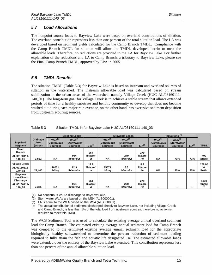
5.8 TMDL Results
The siltation TMDL (Table 5-3) for Bayveiw Lake is based on instream and overland sources of siltation in the watershed. The instream allowable load was calculated based on stream stabilization in the urban areas of the watershed, namely Village Creek (HUC AL/03160111-140_01). The long-term goal for Village Creek is to achieve a stable stream that allows extended periods of time for a healthy substrate and benthic community to develop that does not become washed out during each major rain event or, on the other hand, has excessive sediment deposition from upstream scouring sources.
Table 5-3 Siltation TMDL in for Bayview Lake HUC AL/03160111-140_03
Existing Loads Allowable Loads Reductions (4)
Impaired Segment
Drainage Area
(acres)
WLA(1) (Continuous
Sources)
WLA(2) (Stormwater
Sources) L A(3)
WLA(1) (Continuous
Sources)
WLA(2) (Stormwater
Sources) L A(3)
WLA(1) (Continuous
Sources)
WLA(2) (Stormwater
Sources) L A(3) TMDL Camp
Branch AL/03160111-
140_01 3,562 NA 964
lb/acre/yr
964 lb/acre/
yr NA 279
lb/acre/yr
279 lb/acre
/yr NA 71% 71% 499
tons/yr
Village Creek AL/03160111-
140_02 21,440 16571 lb/day
12.9 lb/acre/hr
12.9 lb/acre/
hr 15571 lb/day
8.3 lb/acre/hr
8.3 lb/acre
/hr 0% 35% 35%
178,000
lbs/hr Bayview
Lake Direct Discharge
AL/03160111-140_03 7,385 NA
964 lb/acre/yr
964 lb/acre/
yr NA 279
lb/acre/yr
279 lb/acre
/yr -- -- --
1030 tons/yr
(4)
(1) No continuous WLAs discharge to Bayview Lake. (2) Stormwater WLAs are based on the MS4 (ALS000001). (3) LA is equal to the WLA based on the MS4 (ALS000001). (4) The actual contribution of sediment discharged directly to Bayview Lake, not including Village Creek
and Camp Branch, is less than 1% of the total load from upstream sources; therefore no action is required to meet this TMDL.
The WCS Sediment Tool was used to calculate the existing average annual overland sediment load for Camp Branch. The estimated existing average annual sediment load for Camp Branch was compared to the estimated existing average annual sediment load for the appropriate biologically healthy subwatershed to determine the percent reduction of sediment loading required to fully attain the fish and aquatic life designated use. The estimated allowable loads were extended over the entirety of the Bayview Lake watershed. This contribution represents less than one percent of the annual allowable siltation load.
Prepared by ADEM/Water Quality Branch and Tetra Tech, Inc. 15
Final Bayview Lake TMDL Siltation AL/03160111-140_03
6.0 Follow-up Monitoring
ADEM has adopted a basin approach to water quality management; an approach that divides Alabama’s fourteen major river basins into five groups. Each year, the ADEM water quality resources are concentrated in one of the basin groups. One goal is to continue to monitor §303(d) listed waters. This monitoring will occur in each basin according to the schedule listed below.
Table 6-1 Basin Monitoring Schedule
River Basin Group Schedule
Choctawhatchee, Chipola, Perdido-Escambia and Chattahoochee 2004
Tallapoosa, Alabama and Coosa 2005
Escatawpa, Lower Tombigbee, Upper Tombigbee, Mobile 2006
Cahaba, Black Warrior 2007
Tennessee 2008
Monitoring will help further characterize water quality conditions resulting from the implementation of best management practices in the watershed.
7.0 Public Participation
As part of the public participation process, this TMDL was placed on public notice and made available for review and comment. The public notice was prepared and published in the four major daily newspapers in Montgomery, Huntsville, Birmingham, and Mobile, as well as submitted to persons who have requested to be on ADEM’s postal and electronic mailing distributions. In addition, the public notice and subject TMDL was made available on ADEM’s Website: www.adem.state.al.us. The public can also request paper or electronic copies of the TMDL by contacting Mr. Chris Johnson at 334-271-7827 or [email protected]. The public was given an opportunity to review the TMDL and submit comments to the Department in writing. At the end of the public review period, all written comments received during the public notice period became part of the administrative record. ADEM considered all comments received by the public prior to finalization of this TMDL and subsequent submission to EPA Region 4 for final review and approval.
Prepared by ADEM/Water Quality Branch and Tetra Tech, Inc. 16

Final Bayview Lake TMDL Siltation AL/03160111-140_03
8.0 References
- ADEM. 1988. Water Report to Congress, For Calendar Years 1986 and 1987. Alabama Department of Environmental Management – Water Division, Montgomery, Alabama, April 1988.
- ADEM. 1989. Water Quality Study of Bayview Lake. Alabama Department of Environmental Management – Water Division, January 1989.
- ADEM. 1991. Water Quality Study of Bayview Lake. Alabama Department of Environmental Management – Water Division, February 1992.
- ADEM. 1996. Alabama’s Clean Water Strategy Report. Alabama Department of Environmental Management – Water Division, 1996.
- ADEM. 1996. Water Report to Congress, For Calendar Years 1994-1995. Alabama Department of Environmental Management – Water Division, Montgomery, Alabama, June 1996.
- ADEM. 1997. 303(d) Monitoring Program Data Collection. Alabama Department of Environmental Management, Water Division, 1997.
- ADEM. 1999. FY 1999 Clean Water Action Plan Workplan. Alabama Department of Environmental Management – Water Division.
- ADEM. 2000. Chapter 335-6-10 Water Quality Criteria. Alabama Department of
- Environmental Management Water Division - Water Division.
- ADEM. 2001. Use Attainability Analysis of Village Creek, Birmingham, AL. Alabama Department of Environmental Management – Water Division, Montgomery, AL, 2001.
- ADEM. 2001. Comprehensive Monitoring Evaluation for Ashland Chemical Company. Alabama Department of Environmental Management - Land Division, Birmingham, AL, November 2001.
- ADEM. 2002. 303(d) Monitoring Program Data Collection. Alabama Department of Environmental Management, Water Division, 2002.
- ADEM. 2002. Jefferson County, Village Creek Wastewater Treatment Plant Compliance Reports 1996 – 2002. Alabama Department of Environmental Management – Water Division, Montgomery, Alabama, 2002.
- ADEM. 2002. Jefferson County, Village Creek Wastewater Treatment Plant Daily Monitoring Reports 1996 – 2001. Alabama Department of Environmental Management – Water Division, Montgomery, Alabama, 2002.
- ADEM. 2002. Status of 1989 Nonpoint Source Assessment Report. Montgomery, AL. Alabama Department of Environmental Management, Montgomery, Alabama, 2002.
- ADEM. 2002. PEMCO Daily Monitoring Reports. Alabama Department of Environmental Management – Water Division, Montgomery, Alabama, 2002.
- Andrew, E.D. 1980. Effective and bankfull discharge of streams in the Yampa River Basin, Colorado and Wyoming. Journal of Hydrology, 46, 311-330.
- Andrews, E.D., and Nankervis, J.M. 1995. Effective discharge and the design of channel maintenance flow for gravel-bed rivers. In Costa, J.E. Miller, A.J. Potter, and Wilcock,
Prepared by ADEM/Water Quality Branch and Tetra Tech, Inc. 17
Final Bayview Lake TMDL Siltation AL/03160111-140_03
P.R., (Eds.), Natural and Anthropogenic Influences in Fluvial Geomorphology, Geophysical Monograph 89, p. 151-164. American Geophysical Union.
- AWW. 2002. Water Quality Data Collected on Village Creek by Friends of Village Creek. Alabama Water Watch. 2002.
- Bledsoe, B. P., C.C. Watson, and D.S. Biedenharn. 2002. Quantification of Incised Channel Evolution and Equilibrium. Journal of the American Water Resources Association, Vol. 38, No. 3.
- Brookes, Andrew 1990. Restoration and Enhancement of Engineered River Channels: Some European Experiences. Regulated Rivers: Research & Management, Vol. 5, 45-56.
- Consent Decree. 1996. Civil Action No. 93-G-2492-S and 94-G-2947-S. Cahaba River Society, Inc. vs. Jefferson County, AL.
- Dunne, Thomas & Leopold, Luna (1978). Water in Environmental Planning. New York.
- EPA. 1986. Quality Criteria for Water, 1986, (The Gold Book), Office of Water, EPA 440/5-86-001.
- EPA. 1989. Water Quality Assessment Opossum, Valley, Village and Fivemile Creeks, Birmingham, AL. U. S. Environmental Protection Agency; Region IV, Environmental Services Division.
- EPA. 1991. Guidance for Water Quality Based Decisions: The TMDL Process. EPA 440/49 1-00 1. U. S. Environmental Protection Agency; Assessment and Watershed Protection Division.
- EPA. 1996. The Metals Translator: Guidance For Calculating A Total Recoverable Permit Limit From A Dissolved Criterion. EPA 823-B-96-007. U. S. Environmental Protection Agency, Office of Water, June 1996.
- EPA. 1998. Better Assessment Science Integrating Point and Nonpoint Sources, BASINS, Version 2.0 User’ s Manual. U.S. Environmental Protection Agency, Office of Water, Washington, D.C.
- EPA. 1999. 1999 Update of Ambient Water Quality Criteria for Ammonia. EPA 822-R-99-014. U.S. Environmental Protection Agency, Office of Water, December 1999.
- EPA. 1999. “Protocol for Developing Sediment TMDLs, First Edition.”
- EPA. 1999. Village Creek Qual2eu Model, Birmingham AL. U.S.
- Environmental Protection Agency, Region 4, Athens, Georgia.
- EPA. 1999. 1999 Village Creek Water Quality Report. U.S. Environmental Protection Agency, Science and Ecosystem Support Division, Athens, GA.
- EPA. 2001. Watershed Characterization System – User’s Manual. U.S.
- Environmental Protection Agency, Region 4, Atlanta, Georgia.
- EPA. 2002. Discussions of Sediment TMDL approaches in urban streams.
- GSA. 2002. Possible Anthropogenic Source of Atmospheric Carbon Dioxide From The Decay of BETX In Groundwater at Petroleum Impacted Sites. http://gsa.confex.com/gsa/2001Amfinalprogram/abstract_27566.htm. (February, 2002).
- GlobXpolorer. 2002. Bayview Lake Aerial Photograph. http://www.mapquest.com (September, 2002).
Prepared by ADEM/Water Quality Branch and Tetra Tech, Inc. 18
Final Bayview Lake TMDL Siltation AL/03160111-140_03
- Gray, Danny. 2002. Air& Heavy Metals: Definitions. http://sld.state.nm/air/definitions.htm (September, 2002).
- McPherson, A. 2002. USGS Birmingham Watershed Project.
- NCDC. 2002. National Climate Data for Birmingham International Airport. http://lwf.ncdc.noaa.gov/oa/ncdc.html (February, 2002).
- Omernik, J. M., 1995. Ecoregions: A Spatial Framework for Environmental Management. Jo: Biological Assessment and Criteria: Tools for Water Resource Planning and Decision Making, W. Davis and T. Simon (Editors). Lewis Publishers, Boca Raton, Florida, pp.49-62.
- Simon, A. 1989. A Model of Channel Response in Disturbed Alluvial Channels. Earth Surface Processes and Landforms 14:11-26.
- Simon, A. 2002. Actual and Reference Sediment Yields for the James Creek Watershed – Mississippi. Channel and Watershed Processes Research Unit, National Sediment Laboratory, Oxford, Mississippi.
- Sun, G. and McNulty, S.G., 1998. Modeling soil erosion and transport on forest landscape. Proceedings of Conference 29. International Erosion Control Association. pp. 187-198.
- Swift, Lloyd W. 2000. Equation to dissipate sediment from a grid cell downslope. U. S. Forest Service.
- SWMA. 2002. Stormwater Management Authority Data Collection on Village Creek. 2002.
- U.S. Department of Agriculture Soil Conservation Service. 1983. Sedimentation. Section 3, Chapter 6. National Engineering Handbook.
- U.S. Department of Agriculture Soil Conservation Service. 2002. Communication on C-factors of county and crop management practices in Alabama.
- United States Fish and Wildlife Service. 2000. Letter to ADEM regarding the expansion of the Jefferson County Village Creek WWTP and threatened species of the flattened musk turtle (Sternotherus depressus) .
- USGS. 2001. Water Resources of the United States. NWISweb online hydrologic data: http://water.usgs.gov. (March, 2002).
- USGS. 2002. Investigation of Water Quality and Aquatic-Community Structure in Village and Valley Creeks, City of Birmingham, Jefferson County, Alabama, 2000-01. Water-Resources Investigations Report 02-4182, Montgomery, Alabama, 2002.
- USX. 1992. Edgewater Mine/Exum Solid Waste Facility Demonstration Wetland Treatment System Design Basis Report. Fairfield, AL, January 1992.
- USX. 1994. Edgewater Mine/Exum Solid Waste Facility Camp Branch Data Collection.
- Yagow, E. R., V. O. Shanholtz, B. A. Julian and J. M. Flagg. 1988. A Water quality module for CAMPS. American Society of Agricultural Engineers Meeting Presentation Paper No. 88-2653.
Prepared by ADEM/Water Quality Branch and Tetra Tech, Inc. 19
Final Bayview Lake TMDL Siltation AL/03160111-140_03
Appendix A
Table A-1 Sampling Stations in Bayview Lake
Year STUDY Station AGENCY Stream Section Road
Crossing Latitude Longitude
1980 TREND
STATION VI1+21AWIC ADEM Village Ck at Bayview Res
Dam 33.5742 -86.9867
1981 TREND
STATION VI1+21AWIC ADEM Village Ck at Bayview Res
Dam 33.5742 -86.9867
1982 TREND
STATION VI1+21AWIC ADEM Village Ck at Bayview Res
Dam 33.5742 -86.9867
1983 TREND
STATION VI1+21AWIC ADEM Village Ck at Bayview Res
Dam 33.5742 -86.9867
1984 TREND
STATION VI1+21AWIC ADEM Village Ck at Bayview Res
Dam 33.5742 -86.9867
1985 TREND
STATION VI1+21AWIC ADEM Village Ck at Bayview Res
Dam 33.5742 -86.9867
1986 TREND
STATION VI1+21AWIC ADEM Village Ck at Bayview Res
Dam 33.5742 -86.9867
1987 TREND
STATION VI1+21AWIC ADEM Village Ck at Bayview Res
Dam 33.5742 -86.9867
1988
BAYVIEW LAKE
STUDY BAYVIEWLAKE01+21AWIC ADEM Bayview Lake Forbay 33.5736 -86.9878
1988
BAYVIEW LAKE
STUDY BAYVIEWLAKE02+21AWIC ADEM Bayview Lake near
Bayview Community 33.5647 -86.9714
1988
BAYVIEW LAKE
STUDY BAYVIEWLAKE03+21AWIC ADEM
Bayview Lake in Corbert Branch near Power Line
Crossing 33.5672 -86.9686
1988
BAYVIEW LAKE
STUDY BAYVIEWLAKE04+21AWIC ADEM
Bayview Lake in Village Crk 300ft above Camp
Branch 33.5533 -86.9619
1988
BAYVIEW LAKE
STUDY BAYVIEWLAKE05+21AWIC ADEM Bayview Lake in Camp
Branch 33.5444 -86.9672
1988
BAYVIEW LAKE
STUDY BAYVIEWLAKE06+21AWIC ADEM
Village Creek DS of Bayview Lake at FAS-12
W. of Mulga 33.5538 -86.9626
1988 TREND
STATION VI1+21AWIC ADEM Village Ck at Bayview Res
Dam 33.5742 -86.9867
1989 010359E+1114PEST EPA 24.8 Miles Up Village
Creek 33.5528 -86.9333
1989 TREND
STATION VI1+21AWIC ADEM Village Ck at Bayview Res
Dam 33.5742 -86.9867
Prepared by ADEM/Water Quality Branch and Tetra Tech, Inc. 20

Final Bayview Lake TMDL Siltation AL/03160111-140_03
Year STUDY Station AGENCY Stream Section Road
Crossing Latitude Longitude
1990 TREND
STATION VI1+21AWIC ADEM Village Ck at Bayview Res
Dam 33.5742 -86.9867
1991
BAYVIEW LAKE
STUDY BAYVIEWLAKE01+21AWIC ADEM Bayview Lake Forbay 33.5736 -86.9878
1991
BAYVIEW LAKE
STUDY BAYVIEWLAKE02+21AWIC ADEM Bayview Lake near
Bayview Community 33.5647 -86.9714
1991
BAYVIEW LAKE
STUDY BAYVIEWLAKE02a+21AWIC ADEM
Downstream of Confluence of Camp
Branch and Village Creek
1991
BAYVIEW LAKE
STUDY BAYVIEWLAKE03+21AWIC ADEM
Bayview Lake in Corbert Branch near Power Line
Crossing 33.5672 -86.9686
1991
BAYVIEW LAKE
STUDY BAYVIEWLAKE04+21AWIC ADEM
Bayview Lake in Village Crk 300ft above Camp
Branch 33.5533 -86.9619
1991
BAYVIEW LAKE
STUDY BAYVIEWLAKE05+21AWIC ADEM Bayview Lake in Camp
Branch 33.5444 -86.9672
1991
BAYVIEW LAKE
STUDY BAYVIEWLAKE06+21AWIC ADEM
Village Creek DS of Bayview Lake at FAS-12
W. of Mulga 33.5538 -86.9626
1991 TREND
STATION VI1+21AWIC ADEM Village Ck at Bayview Res
Dam 33.5742 -86.9867
1992 TREND
STATION VI1+21AWIC ADEM Village Ck at Bayview Res
Dam 33.5742 -86.9867
1993 USX Study CAMP6+USX USX Camp Branch AL HWY 269 33.5367 -86.9634
1993 TREND
STATION VI1+21AWIC ADEM Village Ck at Bayview Res
Dam 33.5742 -86.9867
1994 USX Study CAMP6+USX USX Camp Branch AL HWY 269 33.5367 -86.9634
1994 TREND
STATION VI1+21AWIC ADEM Village Ck at Bayview Res
Dam 33.5742 -86.9867
1995 TREND
STATION VI1+21AWIC ADEM Village Ck at Bayview Res
Dam 33.5742 -86.9867
1996 TREND
STATION VI1+21AWIC ADEM Village Ck at Bayview
Dam 33.5742 -86.9867
1997 TREND
STATION VI1+21AWIC ADEM Village Ck at Bayview Res
Dam 33.5742 -86.9867
1998 TREND
STATION VI1+21AWIC ADEM Village Ck at Bayview Res
Dam 33.5742 -86.9867
1999 TREND
STATION VI1+21AWIC ADEM Village Ck at Bayview Res
Dam 33.5742 -86.9867
1999
1999 WATER
QUALITY ON VIC6+EPA EPA Village Creek Mulga Rd. 33.5462 -86.9508
Prepared by ADEM/Water Quality Branch and Tetra Tech, Inc. 21
Final Bayview Lake TMDL Siltation AL/03160111-140_03
Year STUDY Station AGENCY Stream Section Road
Crossing Latitude LongitudeVILLAGE CREEK,
EPA
2000 TREND
STATION VI1+21AWIC ADEM Village Ck at Bayview Res
Dam 33.5742 -86.9867
2002
303(d) Monitoring Program BVLJ-1 ADEM Bayview lake above dam 33.5736 -86.9878
2002
303(d) Monitoring Program BVLJ-2 ADEM
Bayview lake Near the Bayview Lake Community 33.5647 -86.9714
2002
303(d) Monitoring Program BVLJ-3 ADEM
Bayview lake-Corbet Branch near Power line
crossing 33.5672 -86.9686
2002
303(d) Monitoring Program BVLJ-4 ADEM
Bayview lake-Village Cr ~ 200yds U/S of mouth in 33.5533 -86.9619
2002
303(d) Monitoring Program BVLJ-5 ADEM
Bayview lake-Camp Branch "behinds the Knowles Island Area" 33.5444 -86.9672
Prepared by ADEM/Water Quality Branch and Tetra Tech, Inc. 22