Embed Size (px)
Citation preview
FINAL ADDENDUM TO ENVIRONMENTAL IMPACT REPORT No.104495
Project No. N/A SCHNo. N/A
SUBJECT: CITY COUNCIL APPROVAL FOR AMENDMENTS TO THE CITY OF SAN DIEGO GENERAL PLAN. The 2014 General Plan amendments cover six elements which assist in enhancing and implementing the plan goals and vision. General Plan amendments are part of the continued effort to maintain a current and effective General Plan. Staff has identified the need for amendments to the General Plan to correct errors, to ensure consistency with other adopted City documents and programs, and refine policies based on new information and implementation efforts. The 2014 amendments include edits to the Land Use and Community Planning Element; Mobility Element; Economic Prosperity Element; Public Facilities, Services and Safety Element; Recreation Element; Noise Element and Glossary.
The Land Use Element amendments address the initiation criteria for plan amendments and provide additional legislative history and context regarding Proposition A Lands. The Mobility Element edits are to revise the introduction language to reflect changes in how the region addresses congestion management. The Economic Prosperity Element amendments are to revise use restrictions regarding existing hospitals and adult education uses in Prime Industrial Lands, expand the discussion and policies on community investment and revitalization tools, edit the Redevelopment discussion to be up-to-date, and clarify policy language regarding economic and fiscal impact repmis. Amendments to the Public Facilities Element reflect new performance measures for the Fire-Rescue Department and additional language related to the City's Municipal Storm Sewer System (MS4) Pennit. The Recreation Element incorporates Council Policy 600-17 and 600-11. Amendments to the Noise Element are proposed to adjust noise level compatibility for parks and religious assembly, to use land use terms that are consistent with the Land Development Code, to add a new policy on park siting, and other refinements. Also included with the General Plan amendments are a revision to the Glossary definition of infill development and map edits to the General Land Use and Street System Map, Community Plan Designated Open Space and Parks Map, and Industrial and Prime Industrial Land Identification Map to reflect Community Plan Land Use changes.
I. PROJECT DESCRIPTION:
The City of San Diego General Plan (General Plan) is a citywide comprehensive policy-level document that anticipated future actions, including community plan updates, land development code amendments and applicable ordinances to be required as a result of its implementation. As stated in the General Plan, "State law requires each city to adopt a general plan to guide its future development and mandate that the plan be periodically updated to assure its continuing relevance and value. It also requires the inclusion of seven mandatory elements: Land Use, Circulation, Housing, Conservation, Noise, Open Space, and Safety. However, state law pennits flexibility in
the presentation of elements and the inclusion of optional elements to best meet the needs of a particular city. The City of San Diego's General Plan addresses state requirements through the following ten elements: Land Use and Community Planning, Mobility, Economic Prosperity; Public Facilities, Services and Safety; Urban Design; Recreation; Historic Preservation; Conservation; Noise and Housing."
The proposed amendments to specific elements of the General Plan, as described below, would include minor corrections, clarifying language, and updates to policies and goals to be consistent with new and existing policies and laws. Edits to the Urban Design; Historic Preservation; Conservation; and Housing Elements are not proposed.
Land Use Element The Land Use and Community Planning Element (Land Use Element) provides policies to implement the City of Villages strategy within the context of San Diego's community planning program. The Land Use Element establishes a structure that respects the diversity of each community and includes policy direction to govern the preparation of community plans. The element addresses zoning and policy consistency, the plan amendment process, annexation policies, airport-land use planning, balanced communities, equitable development, and enviromnental justice.
The proposed revisions to Section D. Plan Amendment Process ofthe Land Use Element would fmiher clarify the plan amendment initiation criteria. The new language explains how to process public projects that do not involve land use changes; describes the technical amendment initiation process; provides allowance for the administrative conection of mistakes in ce1iain circumstances; and addresses the public meeting procedures.
The amendments to the Land Use Element Section J. Proposition A- The Managed Growth Initiative (1985) provide additional legislative history and context regarding Proposition A Lands. Proposition A, also known as the Managed Growth Initiative, was passed as a ballot measure in 1985 that restricted development in future urbanizing areas of the City of San Diego. The proposed revisions include additional background infonnation as well as a new goal regarding the applicability of the North City Future Urbanizing Framework Plan and a new policy (LU-J.3.) related to the purpose, intent, and requirements of Proposition A to provide guidance to its continued implementation in the General Plan.
Mobility Element The Mobility Element contains policies that promote a balanced, multi-modal transportation network that gets us where we want to go and minimizes environmental and neighborhood impacts. In addition to addressing walking, bicycling, transit, and streets, the element also includes policies related to regional collaboration, parking, the movement of goods, and other components of our transportation system.
The Mobility Element revisions would only revise the introductory language to reflect changes in how the region addresses congestion management. The clarifying language is based on the 2050 Regional Transportation Plan (RTP) prepared and adopted by the San Diego Association of Governments (SANDAG). The bulleted reference to the region's Congestion Management Program (CMP) which serves as a short term element of the RTP would also be deleted. No policies would be revised. Economic Prosperity Element
As described in the General Plan's Economic Prosperity Element, the structure of San Diego's economy influences the City's physical development and capacity to fund essential services. A strong economy creates wealth that makes continued investment in and maintenance of San Diego's infi·astructure possible.
In Section A. Industrial Land Use, policy EP-A.14 would be refined to allow for continued operation of existing hospitals and adult education uses in Prime Industrial Lands. Section G. Community and Infrastructure Investment would include additional information and new polices on community investment and revitalization tools.
Section K. Redevelopment would be amended to provide historical infonnation on the Redevelopment process and its dissolution by the State of California Legislature in 2011. As a result, the policies and goals under this section have been deleted, however the intent to revitalize communities have been incorporated by reference into amended Section G. Community and Infrastructure.
The revisions to Section L. Economic Information, Monitoring, and Strategic Initiatives would include deleting the term Community and Economic Benefit (CEBA) from Policy EP-L-2. This tenn is not defined or described in the General Plan, or used in common practice. However, the requirement to prepare a report that addresses economic and fiscal impacts will still be required as part ofthis policy.
Public Facilities, Services, and Safety Element The Public Facilities, Services, and Safety Element addresses the City's challenge to provide adequate public facilities and services that are needed to serve the current and future population. Policies address public financing strategies, public and developer financing responsibilities, prioritization, and the provision of specific facilities and services that must accompany growth.
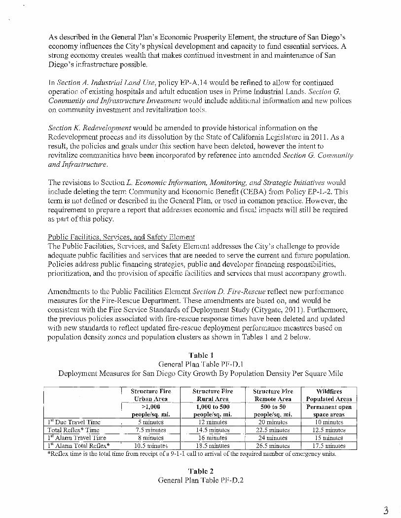
Amendments to the Public Facilities Element Section D. Fire-Rescue reflect new perfonnance measures for the Fire-Rescue Department. These amendments are based on, and would be consistent with the Fire Service Standards of Deployment Study (Citygate, 2011). Furthermore, the previous policies associated with fire-rescue response times have been deleted and updated with new standards to reflect updated fire-rescue deployment perfonnance measures based on population density zones and population clusters as shown in Tables 1 and 2 below.
Table 1 General Plan Table PF-D.1
Deployment Measures for San Diego City Growth By Population Density Per Square Mile
Structure Fire Structure Fire Structure Fire Wildfires Urban Area Rural Area Remote Area Populated Areas
>1,000 1,000 to 500 500 to 50 Permanent open people/sq. mi. people/sq. mi. people/sq. mi. space areas
1st Due Travel Time 5 minutes 12 minutes 20 minutes 10 minutes Total Reflex* Time 7.5 minutes 14.5 minutes 22.5 minutes 12.5 minutes 1st Alarm Travel Time 8 minutes 16 minutes 24 minutes 15 minutes 1'1 Alarm Total Reflex* 10.5 minutes 18.5 minutes 26.5 minutes 17.5 minutes *Reflex tlme IS the total time from receipt of a 9-1-1 call to arnval of the reqmred number of emergency umts.
Table 2 General Plan Table PF-D .2
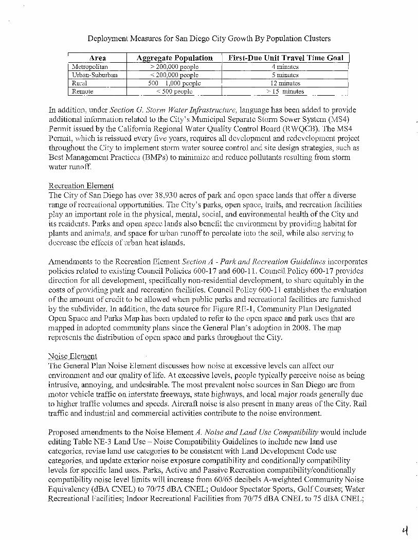
Deployment Measures for San Diego City Growth By Population Clusters
Area Aggregate Population First-Due Unit Travel Time Goal Metropolitan > 200,000 people 4 minutes Urban-Suburban < 200,000 people 5 minutes Rural 500- 1,000 people 12 minutes Remote < 500 people > 15 minutes
In addition, under Section G. Storm Water Infrastructure, language has been added to provide additional information related to the City's Municipal Separate Stann Sewer System (MS4) Pennit issued by the Califomia Regional Water Quality Control Board (RWQCB). The MS4 Pennit, which is reissued every five years, requires all development and redevelopment project throughout the City to implement storm water source control and site design strategies, such as Best Management Practices (BMPs) to minimize and reduce pollutants resulting from stom1 water runoff.
Recreation Element The City of San Diego has over 38,930 acres of park and open space lands that offer a diverse range of recreational opportunities. The City's parks, open space, trails, and recreation facilities play an important role in the physical, mental, social, and enviromnental health of the City and its residents. Parks and open space lands also benefit the environment by providing habitat for plants and animals, and space for urban runoff to percolate into the soil, while also serving to decrease the effects of urban heat islands.
Amendments to the Recreation Element Section A - Park and Recreation Guidelines incorporates policies related to existing Council Policies 600-17 and 600-11. Council Policy 600-17 provides direction for all development, specifically non-residential development, to share equitably in the costs of providing park and recreation facilities. Council Policy 600-11 establishes the evaluation of the amount of credit to be allowed when public parks and recreational facilities are furnished by the subdivider. In addition, the data source for Figure RE-1, Community Plan Designated Open Space and Parks Map has been updated to refer to the open space and park uses that are mapped in adopted community plans since the General Plan's adoption in 2008. The map represents the distribution of open space and parks throughout the City.
Noise Element The General Plan Noise Element discusses how noise at excessive levels can affect our enviromnent and our quality of life. At excessive levels, people typically perceive noise as being intrusive, annoying, and undesirable. The most prevalent noise sources in San Diego are from motor vehicle traffic on interstate freeways, state highways, and local major roads generally due to higher traffic volumes and speeds. Aircraft noise is also present in many areas of the City. Rail traffic and industrial and commercial activities contribute to the noise environment.
Proposed amendments to the Noise Element A. Noise and Land Use Compatibility would include editing Table NE-3 Land Use- Noise Compatibility Guidelines to include new land use categories, revise land use categories to be consistent with Land Development Code use categories, and update exterior noise exposure compatibility and conditionally compatibility levels for specific land uses. Parks, Active and Passive Recreation compatibility/conditionally compatibility noise level limits will increase from 60/65 decibels A-weighted Community Noise Equivalency (dBA CNEL) to 70/75 dBA CNEL; Outdoor Spectator Sports, Golf Courses; Water Recreational Facilities; Indoor Recreational Facilities from 70/75 dBA CNEL to 75 dBA CNEL;
Places ofWorship to Assembly & Entertainment (includes public and religious assembly) from 60/65 (interior 45) dBA CNEL to 65175 (interior 50) dBA CNEL; and Educational Facilities would include Vocational/Trade Schools and Colleges and Universities with an exterior noise exposure of compatibility at 60 dBA CNEL and conditionally compatible at 70 dB A CNEL ( 45 dBA CNEL interior), respectively. Additional land uses such as Community Gardens and Maintenance & Repair, and Personal Services uses would be incorporated into the appropriate land use category. Clarifying language related to peak-hour traffic noise and a new policy on park plam1ing for parks located in noisier areas have been included under Section B. Motor Vehicle Traffic Noise. In addition, a new policy and clarifying language incorporated into Section D. Aircraft Noise would acknowledge that that land use noise compatibility policies in the airport compatibility plans could be more or less restrictive than what is shown in Table NE-3.
Glossary and Figures The General Plan amendments include a revision to the glossary definition of infill development to broaden the tenn to include "underutilized" land and map edits to Figure LU-2, General Land Use and Street System Map; RE-1, Community Plan Designated Open Space and Parks Map; and EP-1, Industrial and Prime Industrial Land Identification Map to be consistent with land use changes updated in community land use plans since the General Plan's adoption in 2008. Although these figures have been updated to reflect a more accurate data source, one should refer to the specific community plan for the specific land use designation.
II. ENVIRONMENTAL SETTING:
See Final PEIR No. 1 04495/SCH No. 2006091032 for the City of San Diego General Plan.
III. PROJECT BACKGROUND:
DISCUSSION
The City of San Diego previously prepared a Program Environmental Impact Report (PEIR) No. 1 04495/SCH No. 2006091032 for the Draft General Plan described in the attached Conclusions (Attachment 2). Since the adoption of the General Plan and PEIR certification, there have been two addenda to the previously certified PEIR related to amendments to the City Land Development Code associated with the MCAS Miramar, Brown Field, Gillespie Field, and Montgomery Field Airport Land Use Compatibility Plan Implementation (Project No. 218845/SCH No. 2006091032) and the General Plan Housing Element Update for 2013-2020 (Project No. 270400). Both previous General Plan amendments and the associated addenda to PEIR No. 104495 addressed minor technical changes or additions to the General Plan but did not require or result in the preparation of a subsequent or Supplemental EIR or negative declaration consistent with CEQA Section 15162.
Similarly, for the following enviromnental issue areas, the proposed amendments would result in teclmical changes or additions to the analysis previously discussed in the PEIR and environmental review but the conclusions would remain the same.
Health and Safety As previously discussed in the associated General Plan PEIR, the potential for exposure of sensitive receptors to health hazards and wildfires is considered significant and unavoidable at the program level; and impacts associated with flooding, seiche, tsunami and mudflows as well as potential conflicts with emergency operations plans will be less than significant.
The proposed amendments to Public Facilities, Services and Safety Element would reflect new perfonnance measures for the Fire-Rescue Department based on recommendations outlined in the Fire Service Standards of Deployment Study (Citygate, 2011). These recommendations were adopted by City Council in 2011, subsequent to the adoption of the General Plan and PEIR ce1iification in 2008. The new performance measures and policies to be incorporated into the General Plan are specific to the San Diego region's fire-rescue needs based on the City's population density and population clusters rather than national standards for total response times for deployment. Meeting these performance measures are dependent on funding and operating expenses that would not result in a physical impact on the environment. The need for additional new fire stations and fire station upgrades would be evaluated through community plan updates and amendments.
In addition, the proposed revisions to the General Plan Table NE-3 Land Use- Noise Compatibility Guidelines (PEIR Table 3.1 0-7) would increase the noise compatibility exposure levels (interior and exterior) for specific land use categories (e.g. neighborhood parks, religious assembly). These revisions may be inconsistent with noise compatibility criteria identified in adopted Airport Land Use Compatibility Plans (ALUCPs) and Land Development Code Table 132-15D. As such, language and a new policy has been added to the General Plan that would limit future uses within airport influence areas when the noise policies in the compatibility plans are more restrictive for uses affected by aircraft noise than shown on Table NE-3. It should be noted however, as afforded under State law (Public Utilities Code section21670) and allowed per Land Development Code Section 132.1555, the City Council could overrule, by a two-thirds vote, the Airport Authority's detennination of inconsistency if specific findings can be made protecting public health, safety and welfare; minimizing the public's exposure to excessive noise; and minimizing safety hazards within areas surrounding the airport. As previously disclosed in the original PEIR, "since a City Council overrule of the ALUC [Airport Land Use Commission] detennination will not be consistent with the ALUCP, it may result in potentially significant land use and planning impacts as a result of potential conflicts between the ALUCPs and more importantly, it may result in the creation of physical impacts associated with new incompatible land uses." Therefore, the potential for a significant and unavoidable impact related to airport health and safety hazards remains. Refer to Land Use and Noise discussions below.
The PEIR concluded that the potential for exposure of sensitive receptors to health hazards and wildfires is considered significant and unavoidable at the program level. Mitigation Framework Measures have been identified to reduce program level impacts but because no development is being proposed with these amendments the degree of impact, applicability and feasibility of these measures cannot be adequately known for each specific project. The proposed amendments would include minor corrections, clarifying language, and updates to policies and goals as described in this addendum that would supplement the original PEIR Health and Safety discussion. Health and Safety impacts remain significant and unavoidable and no new significant environmental impact beyond those analyzed in the PEIR would result.
6
Land Use As previously discussed in the General Plan PEIR, program-level impacts related to conflicts with policies and goals in adopted plans, incompatible land uses, and those that may physically divide established communities remains significant and unavoidable. An inconsistency with an adopted plan is not in and of itself a significant impact. The inconsistency must relate to a physical environmental impact to be considered significant under CEQA.
Proposition A: The Managed Growth Initiative was previously discussed in the General Plan PEIR Land Use Section as part of the existing conditions assessment. The proposed amendments to provide additional legislative history and context regarding Proposition A Lands in the General Plan would not affect the analysis or conclusions previously disclosed as pmi of the PEIR. The proposed revisions to the General Plan only add background infonnation, a new goal and new policy related to the purpose, intent, and requirements of Proposition A, which was passed as a ballot initiative in 1985.
Since the General Plan's adoption and PEIR ce1iification in 2008, the Otay Mesa Community Plan and Ocean Beach Community Plan have been updated and adopted by City Council on March 11, 2014 and July 29, 2014, respectively. As a result, General Plan Figure. LU-2 General Land Use and Street System Map, RE-1, Community Plan Designated Open Space and Parks Map and General Plan Figure EP-1, Industrial and Prime Industrial Land Identification Map would be revised to be consistent with the new land use changes fi·om these updated community plans. As part of this addendum, PEIR Figure 2.2-5 Community Plan Designated Open Space and Parks Map (General Plan Figure RE-1) and PEIR Figure 3.8-1 General Land Use and Street System Map (General Plan Figure LU-2) would be mnended (Attaclunent 1).
An inconsistency with an adopted land use plan, such as an ALUCP, is not in and of itself a significant impact. However, a land use impact may be identified if the inconsistency results in a secondary enviromnental effect with a potential to be considered significant. As discussed in the Health and Safety and Noise discussions of this addendum, the proposed edits to the General Plan Table NE-3 Land Use- Noise Compatibility Guidelines (PEIR Table 3.10-7) would increase the noise compatibility exposure levels (interior and exterior) for specific land use categories (e.g. neighborhood parks, religious assembly). As a result, this change may conflict with ALUCPs resulting in secondary noise and health and safety impacts that could be considered significant. To some degree, the proposed policy to limit future uses within airport influence areas when the noise policies in the compatibility plans are more restrictive for uses affected by aircraft noise than shown on Table NE-3 would preclude incompatible uses and safety impacts. However, as afforded under State law (Public Utilities Code section 21670) and allowed per Land Development Code Section 132.1555, the City Council could overrule, by a two-thirds vote, the Airport Authority's detennination of inconsistency if specific findings can be protecting public health safety and welfare, minimizing the public's exposure to excessive noise, and minimizing safety hazards within areas surrounding the airport. Therefore, the potential for a significant and unavoidable lm1d use impact related to potentially significant airport noise and health and safety hazards remains.
The proposed amendments would not change the conclusions that have been previously discussed in the certified General Plan PEIR. Proposition A had been previously discussed and analyzed in the PEIR and the document acknowledges that updates to the community plans will be necessary over the next several years to maintain consistency with the General Plan.
7

The PEIR concluded that inconsistencies or conflicts with adopted land use and environmental plans are considered significant and unavoidable at the program level. Mitigation Framework Measures have been identified to reduce program level impacts but because no development is being proposed with these amendments; the degree of impact, applicability and feasibility of these measures cmmot be adequately known for each specific project. The proposed amendments would include minor corrections, clarifying language, and updates to policies and goals as described in this addendum that would supplement the original PEIR Land Use discussion. Land Use impacts remain significant and unavoidable and no new significant environmental impact beyond those analyzed in the PEIR would result.
Noise As discussed in the associated General Plan PEIR, noise impacts related to land use incompatibilities and exceedance of noise levels established in the adopted General Plan, community plans, noise ordinance, Airport Land Use Compatibility Plans (ALUCPs ), or applicable standards of other agencies for noise-sensitive land uses would be considered significant and unavoidable at the program-level. Impacts related to implementation of the General Plan resulting in a substantial increase in the existing ambient noise levels would be considered significant and unavoidable at a program level, as well.
The proposed edits to the General Plan Noise Element would include adding new policies and language related to park siting in nosier areas and limiting uses within airport influence areas; as well as a revised Table NE-3 Land Use- Noise Compatibility Guidelines, which is also Table 3.10-7 in the PEIR. Specific land use categories listed in the table would also be revised to be consistent with the City's land use categories/subcategories used in the City's Land Development Code use regulation tables. These noise level adjustments would be consistent State of California General Plan Guidelines, Appendix C- Guidelines for the Preparation and Content of the Noise Element of the General Plan (Office ofPla1U1ing and Research, 2003).
Based on research that was conducted by the Planning Department (Park and Noise Threshold Research, February 2015), major cities in California, including several in San Diego County, allow a wider range of noise-land use compatibility levels for parks a11d recreational land uses than what is currently identified in the City's General Plan. Consistent with these findings, the Land Use Noise Compatibility Guidelines table in the General Plan and PEIR would adjust the compatible noise level for parks and recreational land uses. Per the revised table (General Plan Table NE-3/PEIR Table 3.1 0-7); Parks, Active and Passive Recreation uses would be compatible with exterior noise exposure levels up to 70 dBA CNEL and conditionally compatible up to 75 dBA CNEL. The conditionally compatible exterior noise exposure for Outdoor Spectator Sports, Golf Course; Water Recreational Facilities; and Indoor Recreational Facilities would also be adjusted from 70 dBA CNEL to 75 dBA CNEL. Considering the current ambient noise levels in the urbanized areas and lack of available lands to develop parks that meet the 65 dB CNEL threshold could limit development and require costly mitigation, such as noise walls.
In addition, the Places of Worship category identified in Table NE-3 would be deleted under institutional uses and incorporated into the commercial use category under Assembly & Entertaimnent (public and religious assembly). For these uses, the exterior noise exposure levels would increase from 60 dbA CNEL (compatible) and 65 dBA CNEL (conditionally compatible) to 65 db A CNEL (compatible) and 7 5 dB A CNEL (conditionally compatible), respectively. The interior noise exposure levels would also increase from 45 dBA CNEL to 50 dBA.
Increasing the compatibility noise levels for specific land uses such as parks and religious assemblies could allow these types of uses to be developed in a generally noisier urban environment next to freeways or other noise-generating sources. Furthermore, park and assembly uses could also expose surrounding noise sensitive receptors to higher ambient noise levels since they would be considered compatible or conditionally compatible at a higher dBA CNEL levels than previously allowed. Based on Caltrans' Technical Noise Supplement (October 1998) and illustrated in PEIR Table 3.10-1, common outdoor activities at the 70 dB A noise level include a noisy urban area during the daytime or a gas lawn mower heard at 30 meters (1 00 feet); whereas indoor activities at 50 dBA would include a large business office or hearing a dishwasher in the next room.
Within airport influence areas, the increase in noise compatibility levels for specific land uses could also trigger an inconsistency with an adopted ALCUP and expose sensitive receptors to louder aircraft noise. This could be identified not only as a direct noise impact, but also result in a Land Use and Health and Safety impact. Development that would be incompatible with respect to noise would be subject to a discretionary permit and CEQA review that would likely require site-specific mitigation to reduce exterior and interior noise levels to a level below significance. To some degree, the proposed policy to limit future uses within airport influence areas when the noise policies in the compatibility plans are more restrictive for uses affected by aircraft noise than shown on Table NE-3 would preclude incompatible uses and safety impacts. However, as afforded under State law (Public Utilities Code section21670) and addressed in the Land Development Code Section 132.1555, the City Council could overrule, by a two-thirds vote, the Airpmi Authority's determination of inconsistency if specific findings can be made protecting public health safety and welfare, minimizing the public's exposure to excessive noise, and minimizing safety hazards within areas surrounding the airport. Therefore, the potential for a significant and unavoidable airport-related noise impact would remain.
Edits to the text would include language and new policies that would clarify that parks that are sited in noisier areas, should reduce exposure of noise sensitive uses to quieter areas of the park and land use noise compatibility policies in airport influence areas could be more or less restrictive for uses affected by aircraft noise than shown in the revised Table NE-3. Adopted local ALUCPs (MCAS Miramar, Brown Field, Gillespie Field and Montgomery Field) may have more restrictive criteria for comparable land uses, such as community parks and places of worship, than what is identified in the revised table.
The PEIR concluded that Draft General Plan policies and noise guidelines would preclude or reduce significant noise impact to a degree; however, there is no guarantee that all future project level impacts would avoid or mitigate noise levels to a less than significant. Therefore noise impacts related to land use incompatibilities and the substantial increase in the existing ambient noise levels would be considered significant and unavoidable at a program level. Mitigation Framework Measures have been identified to reduce program level impacts but because no development is being proposed with these amendments; the degree of impact, applicability and feasibility ofthese measures cannot be adequately known for each specific project. In addition, compliance with standards, codes, and regulations required of all projects is not considered mitigation. The proposed amendments would include minor corrections, clarifying language, and updates to policies and goals as described in this addendum that would supplement the original PEIR Noise discussion. Noise impacts remain significant and unavoidable and no new significant environmental impact beyond those analyzed in the PEIR would result.
q
Population and Housing As previously discussed in the associated General Plan PEIR, the population and housing impacts would be significant and unavoidable since it is infeasible at the program level to provide specific mitigation measures that would reduce impacts to a less than significant level.
This conclusion was based, in part, on the provision to provide affordable housing for low and moderate-low income households within the City's 17 redevelopment project areas, thus increasing, improving, and preserving the supply of housing for very low-, low, and moderateincome households. The dissolution ofthe Redevelopment Agency by the State of Califomia Legislature in 2011 and the associated General Plan amendments related to this program's demise would not; however, change the conclusions or reduce population and housing impacts to a level below significance. The PEIR concluded that despite City programs and policies, some displacement of residents would likely occur as older housing units are replaced. As areas redevelop, older housing units, and in some cases more affordable housing units will be replaced by higher cost housing units. This would most likely adversely affect low-income households, displacing and relocating people away from the City and the region in search of more affordable housing. It is still likely that the inventory of affordable housing units would be reduced without the incentives to provide low to moderate income housing under California Redevelopment Law, thus displacing substantial number of people or housing. The displacement may be considered a social and economic impact, but not a physical impact under CEQA. However, this situation regardless ofthe dissolution ofthe Redevelopment Agency may still necessitate the construction of replacement housing elsewhere and the potential for a significant and unavoidable impact remams.
The PEIR concluded that the construction of replacement housing related to population and housing needs would be considered significant and unavoidable at a program level. Mitigation Framework Measures have been identified to reduce program level impacts but because no development is being proposed with these amendments; the degree of impact, applicability and feasibility of these measures cannot be adequately known for each specific project. In addition, compliance with standards, codes, and regulations required of all projects is not considered mitigation. The proposed amendments would include minor corrections, clarifying language, and updates to policies and goals as described in this addendum that would supplement the original PEIR Population and Housing discussion. Population and Housing impacts remain significant and unavoidable and no new significant environmental impact beyond those analyzed in the PEIR would result.
Public Services and Facilities As discussed in the associated General Plan PEIR, the need for new or upgraded public services and facilities such as libraries parks, schools, fire-rescue and police stations/services are addressed through various means the City uses to fund the capital and operating expenses related to public facilities (e.g. developer fees and City Council budget decision). However, the analysis in the PEIR focused on the physical environmental impacts that could result from the construction of new facilities or the alteration of existing facilities, which are considered significant and unavoidable at the program-level of review.
The proposed amendments associated with the new performance measures for the Fire-Rescue Department; as well as the amendments to included additional language in the General Plan related to funding responsibilities for park and recreational facilities (City Council Policies 600-17 and 600-11) would not affect the PEIR's analysis related to the physical environmental impacts from the construction of new facilities or alteration of existing facilities. The need to
fund public services and facilities to meet new Fire-Rescue perfonnance measures or clarification on funding responsibilities for park and recreational facilities is not considered a physical impact on the environment to be evaluated under CEQ A. However, the proposed amendment language would be consistent with the General Plan's intent to provide policies that would evaluate growth, determine facilities needs, and to require development to pay its fair share of costs.
The PEIR concluded that the construction of future public facilities needed to support future growth is considered a significant and unavoidable Public Services and Facilities impact at the program level. Mitigation Framework Measures have been identified to reduce program level impacts but because no development is being proposed with these amendments; the degree of impact, applicability and feasibility of these measures cannot be adequately known for each specific project. In addition, compliance with standards, codes, and regulations required of all projects is not considered mitigation. The proposed amendments would include minor corrections, clarifying language, and updates to policies and goals as described in this addendum that would supplement the original PEIR Public Services and Facilities discussion. Public Services and Facilities impacts remain significant and unavoidable and no new significant enviromnental impact beyond those analyzed in the PEIR would result.
Transportation/Traffic/Circulation/Parking As discussed in the General Plan PEIR, transportation/traffic/circulation/parking impacts are considered significant and unavoidable. The proposed General Plan edits to the Mobility Element reflect changes that occurred subsequent to the certification of the PEIR on how the region addresses congestion management to meet federal requirements. The clarifying language is based on the 2050 Regional Transpmiation Plan (RTP) prepared and adopted by the San Diego Association of Governments (SANDA G) in 2011. In the PEIR' s Transpmiation/Traffic/ Circulation/Parking, the Mobility 2030 RTP and Congestion Management Plan (CMP) were discussed under the Regulatory Framework context of the project's existing conditions.
Using SANDAG's Transpmiation Model to detennine impacts, the General Plan PEIR concluded that vehicular travel is expected to increase, yet congestion is expected to decrease when comparing Year 2005 with Year 2030 scenarios. The PEIR stated that the congestion decrease is primarily attributed to the implementation of SANDAG's MOBILITY 2030 RTP and land use recommendations in the Regional Comprehensive Plan. The PEIR stated that a major update to the 2030 RTP was underway which could result in adoption of different strategies and project that are unknown at this time. As a result, impacts to traffic LOS are considered significant and unavoidable and future enviromnental analysis would be required for future projects where project-specific mitigation measures would be determined. Consistent with the analysis based on the 2030 RTP previously discussed in the PEIR, the proposed edits to the Mobility Element would reflect these changes in how the region addresses congestion management based on the 2050 RTP. The CMP, which was a short tenn element ofthe MOBILITY 2030 RTP, established programs for mitigating traffic impacts that have since been updated and any reference to the CMP have been deleted.
The PEIR concluded that Transportation/Traffic/Circulation/Parking impacts are considered significant and unavoidable at the program level. Mitigation Framework Measures have been identified to reduce program level impacts but because no development is being proposed with these amendments; the degree of impact, applicability and feasibility of these measures cam1ot be adequately known for each specific project. In addition, compliance with standards is not considered mitigation. The proposed amendments would include minor corrections, clruifying
language, and updates to policies and goals as described in this addendum that would supplement the original PEIR Transportation/Traffic/Circulation/Parking discussion. Transportation/Traffic/ Circulation/Parking impacts remain significant and unavoidable and no new significant environmental impact beyond those analyzed in the PEIR would result.
Water Quality The General Plan PEIR concluded that program-level impacts related to water quality would be significant and unavoidable. The proposed Municipal Separate Stann Sewer System (MS4) Permit language that has been added to the Public Facilities Services and Safety Element would not change the Water Quality impact analysis, conclusions or mitigation framework outlined in the PEIR. Issued by the State of California Regional Water Quality Control Board, the City of San Diego's MS4 Pennit implements stonn water regulations ofthe Clean Water Act and Federal National Pollutant Discharge Elimination System (NPDES). The MS4 Pennit, which is reissued every five years, requires all development and redevelopment projects throughout the City to implement stonn water source control and site design strategies, such as Best Management Practices (BMPs), to minimize and reduce pollutants resulting from storm water runoff.
The requirements ofthe MS4 Pennit (NPDES Municipal Pennit), including development of Watershed Urban Runoff Management Plans (WURMPs), was covered by the specific policies outlined in the environmental document. Compliance with the MS4 Permit would avoid or reduce impacts to a degree, but cannot guarantee that all future project level impacts will be avoided or mitigated to a level less than significant. As stated in the PEIR, the program-level impact related to local and regional water quality is considered significant and unavoidable. Compliance with the standards is required for all projects and is not considered to be mitigation.
The PEIR concluded that water quality impacts are considered significant and unavoidable at the program level. Mitigation Framework Measures have been identified to reduce program level impacts but because no development is being proposed with these amendments; the degree of impact, applicability and feasibility of these measures cannot be adequately known for each specific project. In addition, compliance with standards is not considered mitigation. The proposed amendments would include minor corrections, clarifying language, and updates to policies and goals as described in this addendum that would supplement the original PEIR Water Quality discussion. Water Quality impacts remain significant and unavoidable and no new significant enviromnental impact beyond those analyzed in the PEIR would result.
Other PEIR Envirol1111ental Issue Areas Previously Discussed The following issue areas would not require any technical changes resulting from the implementation of the proposed amendments:
Agricultural Resources, Air Quality, Biological Resources, Geologic Conditions, Historical Resources, Hydrology, Mineral Resources, Paleontological Resources, Public Utilities, Visual Effects and Neighborhood Character and Cumulative Impacts.
IV. DETERMINATION:
The City of San Diego previously prepared an Environmental Impact Report for the project and has attached the conclusions of the Final Environmental Impact Report to this Addendum.
Based upon a review of the cunent project, it has been detem1ined that:
a. There are no new significant enviromnental impacts not considered in the previous EIR; b. No substantial changes have occurred with respect to the circumstances under which the
project is undertaken; and c. There is no new infonnation of substantial importance to the project.
Therefore, in accordance with Section 15164 of the State CEQA Guidelines this addendum has been prepared. Additionally, in accordance with requirements in Section128.0306(b) of the San Diego Municipal Code, a 14-day public review period is required for this Addendum.
V. MITIGATION, MONITORING AND REPORTING PROGRAM INCORPORATED INTO THE PROJECT:
No mitigation is required for these proposed amendments to the General Plan. As development occurs, individual discretionary projects would be subject to environmental review, impact analysis, and identification of project-specific mitigation measures as required.
For each environmental issue area analyzed in the General Plan PEIR, a Mitigation Framework was included to identify the means by which potentially significant impacts could be reduced or avoided in cases where the EIR analysis detennined such impacts to be potentially significant. Standard exiting regulations, requirements, programs, and procedures that are applied to all similar projects were taken into account in identifying additional project specific mitigation that may be needed to reduce identified significant impacts. However, at the program-level of review, there is no project specific Mitigation, Monitoring, and Reporting Program proposed and significant and unavoidable impacts associated with the project remain.
VI. SIGNIFICANT UNMITIGATED IMPACTS:
There are no new significant impacts identified for the current project and significant effects previously examined will not be substantially more severe than shown in the previous PEIR. However, the final EIR for the original project identified significant umnitigated impacts relating to: Agricultural Resources, Air Quality, Biological Resources, Geologic Conditions, Health and Safety, Historical Resources, Hydrology, Land Use, Mineral Resources, Noise, Paleontological Resources, Population and Housing, Public Facilities, Public Utilities, Transportation/Traffic/ Circulation/Parking, Visual Effects and Neighborhood Character, and Water Quality. The General Plan PEIR included a Mitigation Framework to identify means by which potentially significant impacts could be reduced or avoided in cases where the PEIR analysis detennined such impacts to be potentially significant. Standard existing regulations requirements, programs and procedures that are applied to all similar projects were taken into account in identifying additional project specific mitigation that may be needed to reduce identified significant impacts. Because there were significant unmitigated impacts, associated with the original project approval required the decision-maker to make specific and substantiated CEQA Findings which stated that: a) specific economic, social or other considerations make infeasible the mitigation measures or project altematives identified in the final EIR, and b) these
i3
impacts have been found acceptable because of specific overriding considerations. No new CEQA Findings are required with this project.
VI. PUBLIC REVIEW DISTRIBUTION:
The Addendum to Enviromnental Impact Report No. 104495 was distributed for a 14-day public review period pursuant to San Diego Municipal Code (SDMC) Chapter 6, Article 9, Paragraph 69.0211 (Addenda to Enviromnental Reports) which requires for addenda to enviromnental documents cetiified more than three years previously, to be distributed by the Planning Department for public review for a fourteen calendar day period, along with the previously certified Enviromnental Document. Since the environmental document prepared for the previously approved project was certified in March 2008 and is not within the three year timeline, additional public review is required. Therefore, in accordance with CEQA Section 15164 notice ofthe draft Addendum to EIR No. 104495 was distributed to the following groups/individuals for public disclosure:
United States Government Federal Aviation Administration (1) Naval Facilities Engineering Command, SW Division, Enviromnental Planning (12) MCAS Miramar (13) U. S. Fish and Wildlife Service (23)
State of California Caltrans District 11 (31) Department of Fish and Game (32) California Enviromnental Protection Agency (3 7) Housing & Community Development Department (3 8) Natural Resources Agency (43) Regional Water Quality Control Board, Region 9 (44) California Coastal Commission ( 4 7) California Transportation Commission (51) Califomia Transpmiation Commission (51A) Native American Heritage Commission (56)
County of San Diego Department ofPlmming and Land Use (68) Parks Department (69) Noise Control Hearing Board (71) County Water Authority (73) Department ofEnviromnental Health (76)
City of San Diego Office of the Mayor (91) Council President Pro Tem Lightner, District 1 Councilmember Harris, District 2 Council President Gloria, District 3 Councilmember Cole, District 4 Councilmember Kersey, District 5 Councilmember Zapf, District 6 Councilmember Shennan, District 7 Councilmember Alvarez, District 8 Councilmember Emerald, District 9
Development Services Department Ann Gonsalves Louis Schultz Kerry Santoro Anne Jm·que
Planning Department Tom Tomlinson Nancy Bragado Brian Schoenfisch Sara Osborn Tait Galloway Jeff Harkness Kristy Forburger
Economic Development Russ Gibbon Jim Davies
Park and Recreation Department Hennan Parker Jim Winter
Fire Rescue Department Fire and Life Safety Services (79) Kem1eth Barnes, Fire -Rescue Dept Logistics (80)
City Attorneys' Office Shannon Thomas (MS 59)
Environmental Services Departlnent Lisa Wood, Enviromnental Services Department
Transportation & Stann Water Department Sumer Hasenin Linda M arabian
City Government Civic San Diego (448) San Diego Housing Commission (MS 49N) Park and Recreation Board (83) Small Business Advisory Board (MS 904) Historical Resources Board (87) Wetland Advisory Board (91A)
Advisory Committees Mission Bay Park Committee (318A) Airports Advisory Committee (MS 14) La Jolla Shores PDO Advisory Board (279)
Libraries Central Library, Government Documents (81 & 81A) Balboa Branch Library (81B) Beckwourth Branch Library (81 C) Benjamin Branch Library (81D) Cannel Mountain Ranch Branch Library (81E) Cannel Valley Branch Library (81 F) City Heights/Weingart Branch Library (81 G) Clairemont Branch Library (81H) College-Rolando Branch Library (811) Kensington-Nom1al Heights Branch Library (81K) La Jolla!Riford Brm1ch Library (81L) Linda Vista Branch Library (81M)
Logan Heights Branch Library (81N) Malcolm X Library & Performing Arts Center (81 0) Mira Mesa Branch Library (81 P) Mission Hills Branch Library (81 Q) Mission Valley Branch Library (81R) Nmih Clairemont Branch Library (81 S) North Park Branch Library (81T) Oak Park Branch Library (81 U) Ocean Beach Branch Library (81 V) Otay Mesa-Nestor Branch Library (81 W) Pacific Beach/Taylor Branch Library (81X) Paradise Hills Branch Library (81 Y) Point Loma/Hervey Branch Library (81Z) Rancho Bernardo Branch Library (81 AA) Rancho Pefiasquitos Branch Library (81BB) READ San Diego (81 CC) San Carlos Branch Library (81DD) San Ysidro Branch Library (81EE) Scripps Miramar Ranch Branch Library (81FF) Serra Mesa Branch Library (81 GG) Skyline Hills Branch Library (81 HH) Tierrasanta Branch Library (81 II) University Community Branch Library (81JJ) North University Branch Library (81JJJ) University Heights Branch Library (81KK)
Community Groups, Associations, Boards, Committees and Councils Community Plarmers Committee (J 94) Balboa Park Committee (226) Black Mountain Ranch -Subarea I (226C) Otay Mesa- Nestor Planning Committee (228) Otay Mesa Planning Committee (235) Clairemont Mesa Planning Committee (248) Greater Golden Hill Plarming Committee (259) Serra Mesa Planning Group (263A) Kearny Mesa Community Planning Group (265) Linda Vista Community Planning Committee (267) La Jolla Community Planning Association (27 5) City Heights Area Planning Committee (287) Kensington-Talmadge Plam1ing Committee (290) N orn1al Heights Community Planning Cmmnittee (291) Eastem Area Plam1ing Committee (302) Midway/Pacific Highway Community Planning Group (307) Mira Mesa Community Plarming Group (31 0) Mission Beach Precise Planning Board (325) Mission Valley Unified Planning Organization (331) Navajo Community Planners Inc. (336) Cannel Valley Community Planning Board (350) Del Mar Mesa Community Planning Board (361) North Park Planning Committee (363) Ocean Beach Planning Board (367) Old Town Community Planning Committee (368) Pacific Beach Community Planning Committee (375) Pacific Highlands Ranch- Subarea III (3 77 A) Rancho Pefiasquitos Planning Board (380) Peninsula Community Planning Board (390) Rancho Bernardo Community Planning Board ( 400)
ih
Sabre Springs Community Planning Group ( 406B) San Pasqua! - Lake Hodges Planning Group ( 426) San Ysidro Planning and Development Group (433) Scripps Ranch Community Planning Group (437) Miramar Ranch North Planning Committee (439) Skyline- Paradise Hills Plam1ing Committee (443) Toney Hills Community Planning Board ( 444A) Southeastern San Diego Planning Committee ( 449) Encanto Neighborhoods Cmmnunity Planning Group (449A) College Area Community Planning Board ( 456) Tienasanta Community Council ( 462) Toney Highlands- Subarea IV ( 467) Toney Pines Community Planning Board ( 469) University City Community Planning Group ( 480) Uptown Planners ( 498)
Town/Community Councils Town Council Presidents Association (197) Downtown Community Planning Council (243) Clairemont Town Council (257) Sena Mesa Community Council (264) La Jolla Town Council (273) Rolando Community Council (288) Oak Park Community Council (298) Darnell Community Cmmcil (306) Mission Beach Town Council (326) Mission Valley Community Council (328 C) San Carlos Area Council (338) Cannel Mountain Ranch Community Council (344) Ocean Beach Town Council, Inc. (367 A) Pacific Beach Town Council (374) Rancho Penasquitos Town Council (383) Rancho Bernardo Community Council, Inc. (398) San Dieguito Planning Group (412) United Border Community Town Council ( 434) Tienasanta Community Council ( 462) Murphy Canyon Community Council (463)
Other Agencies San Diego Association of Govermnents (1 08) San Diego Unified Port District (1 09) San Diego County Regional Airport Authority (11 0) Metropolitan Transit System (112) Air Pollution Control District (65) San Dieguito River Park (116)
Other Interested Parties San Diego Gas & Electric Co. (114) San Diego Chamber of Commerce (157) Building Industry Association (158) San Diego River Park Foundation (163) Siena Club (165) San Diego Canyonlands (165A) San Diego Natural History Museum (166) San Diego Audubon Society (167) Jim Peugh (167A) San Diego River Conservancy (168)
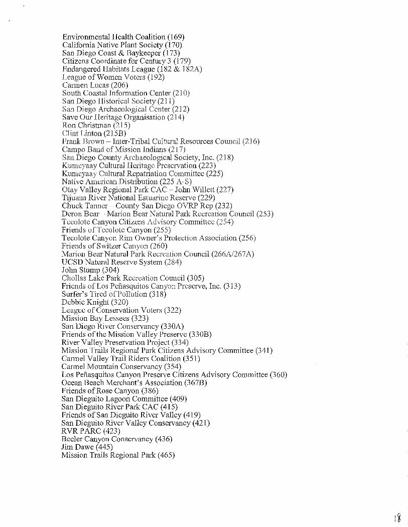
Environmental Health Coalition (169) California Native Plant Society (170) San Diego Coast & Baykeeper (173) Citizens Coordinate for Century 3 (179) Endangered Habitats League (182 & 182A) League ofWomen Voters (192) Cannen Lucas (206) South Coastal Infonnation Center (21 0) San Diego Historical Society (211) San Diego Archaeological Center (212) Save Our Heritage Organisation (214) Ron Christman (215) Clint Linton (215B) Frank Brown - Inter-Tribal Cui tural Resources Council (216) Campo Band of Mission Indians (21 7) San Diego County Archaeological Society, Inc. (218) Kumeyaay Cultural Heritage Preservation (223) Kumeyaay Cultural Repatriation Committee (225) Native American Distribution (225 A-S) Otay Valley Regional Park CAC- John Willett (227) Tijuana River National Estuarine Reserve (229) Chuck Tanner- County San Diego OVRP Rep (232) Deron Bear- Marion Bear Natural Park Recreation Council (253) Tecolote Canyon Citizens Advisory Committee (254) Friends of Tecolote Canyon (255) Tecolote Canyon Rim Owner's Protection Association (256) Friends of Switzer Canyon (260) Marion Bear Natural Park Recreation Council (266A/267 A) UCSD Natural Reserve System (284) John Stump (304) Chollas Lake Park Recreation Council (305) Friends of Los Pefiasquitos Canyon Preserve, Inc. (313) Surfer's Tired ofPollution (318) Debbie Knight (320) League of Conservation Voters (322) Mission Bay Lessees (323) San Diego River Conservancy (330A) Friends ofthe Mission Valley Preserve (330B) River Valley Preservation Project (334) Mission Trails Regional Park Citizens Advisory Committee (341) Cannel Valley Trail Riders Coalition (351) Carmel Mountain Conservancy (354) Los Pefiasquitos Canyon Preserve Citizens Advisory Committee (360) Ocean Beach Merchant's Association (367B) Friends of Rose Canyon (3 86) San Dieguito Lagoon Committee ( 409) San Dieguito River Park CAC (415) Friends of San Dieguito River Valley (419) San Dieguito River Valley Conservancy (421) RVR PARC (423) Beeler Canyon Conservancy ( 436) Jim Dawe ( 445) Mission Trails Regional Park ( 465)
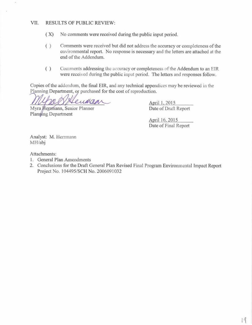
VII. RESULTS OF PUBLIC REVIEW:
(X) No comments were received dming the public input period.
( ) Comments were received but did not address the accuracy or completeness of the environmental report. No response is necessary and the letters are attached at the end of the Addendum.
( ) Comments addressing the accuracy or completeness of the Addendum to an ErR were recei ved during the public input period. The letters and responses follow.
Copies of the addendum, the final EIR, and any technical appendices may be reviewed in the Planning Department, o ·purchased for the cost of reproduction.
Analyst: M. Herrmann MH/abj
Attachments: 1. General Plan Amendments
April 1, 2015 Date of Draft Report
April 16, 2015 Date of Final Report
2. Conclusions for the Draft General Plan Revised Final Program Environmental Impact Report Project No. 1 04495/SCH No. 2006091032
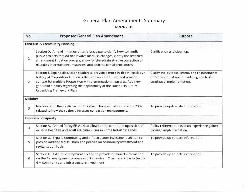
General Plan Amendments Summary March 2015
No. Proposed General Plan Amendment Purpose
Land Use & Community Planning
Section D. Amend initiation criteria language to clarify how to handle Clarification and clean -up.
1 public projects that do not involve land use changes, clarify the technical amendment initiation process, allow for the administrative correction of mistakes in certain circumstances, and address denial procedures.
Section J. Expand discussion section to provide a more in-depth legislative Clarify the purpose, intent, and requirements history of Proposition A, discuss the Environmental Tier, and provide of Proposition A and provide a guide to its
2 context for multiple Proposition A implementation measures. Add new continued implementation. goals and a policy regarding the applicability of the North City Future Urbanizing Framework Plan.
M obility
3 Introduction. Revise discussion to reflect changes that occurred in 2009 To provide up-to-date information. related to how the region addresses congestion management.
Economic Prosperity
4 Section A. Amend Policy EP-A.14 to allow for the continued operation of Policy refinement based on experience gained existing hospitals and adult education uses in Prime Industrial Lands. through implementation.
Section G. Expand Community and Infrastructure Investment section to To provide up-to-date information. 5 provide additional discussion and policies on community investment and
revitalization tools.
Section K. Edit Redevelopment section to provide historical information To provide up-to-date information. 6 on the Redevelopment process and its demise. Cross reference to Section
G- Community and Infrastructure Investment . -- ' -----
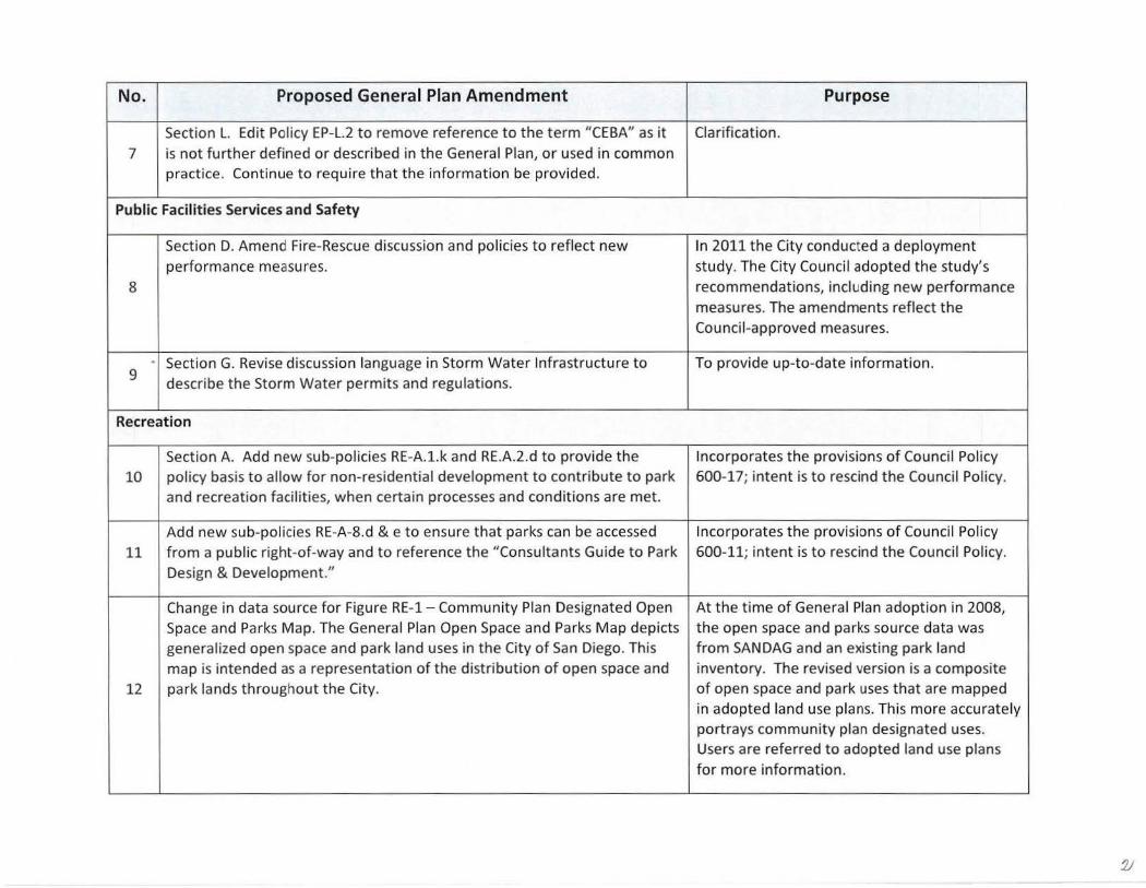
No. Proposed General Plan Amendment Purpose
Section L. Edit Policy EP-L.2 to remove reference to the term "CEBA" as it Cia rification. 7 is not further defined or described in the General Plan, or used in common
practice . Continue to require that the information be provided.
Public Facilities Services and Safety
Section D. Amend Fire-Rescue discussion and policies to reflect new In 2011 the City conducted a deployment performance measures. study. The City Council adopted the study's
8 recommendations, including new performance measures. The amendments reflect the Council-approved measures.
9 • Section G. Revise discussion language in Storm Water Infrastructure to To provide up-to-date information.
describe the Storm Water permits and regulations.
Recreation
Section A. Add new sub-policies RE-A.l.k and RE.A.2.d to provide the Incorporates the provisions of Council Pol icy 10 policy basis to allow for non-residential development to contribute to park 600-17; intent is to rescind the Council Policy.
and recreation facilities, when certain processes and conditions are met.
Add new sub-policies RE-A-8.d & e to ensure that parks can be accessed Incorporates the provisions of Council Policy
11 from a public right-of-way and to reference the "Consultants Guide to Park 600-11; intent is to rescind the Council Policy. Design & Development."
Change in data source for Figure RE-1- Community Plan Designated Open At the time of Genera l Plan adoption in 2008, Space and Parks Map. The General Plan Open Space and Parks Map depicts the open space and parks source data was generalized open space and park land uses in the City of San Diego. This from SAN DAG and an existing park land map is intended as a representation of the distribution of open space and inventory. The revised version is a composite
12 park lands throughout the City. of open space and park uses that are mapped in adopted land use plans. Th is more accurately portrays community plan designated uses. Users are referred to adopted land use plans for more information.
v
No. Proposed General Plan Amendment Purpose
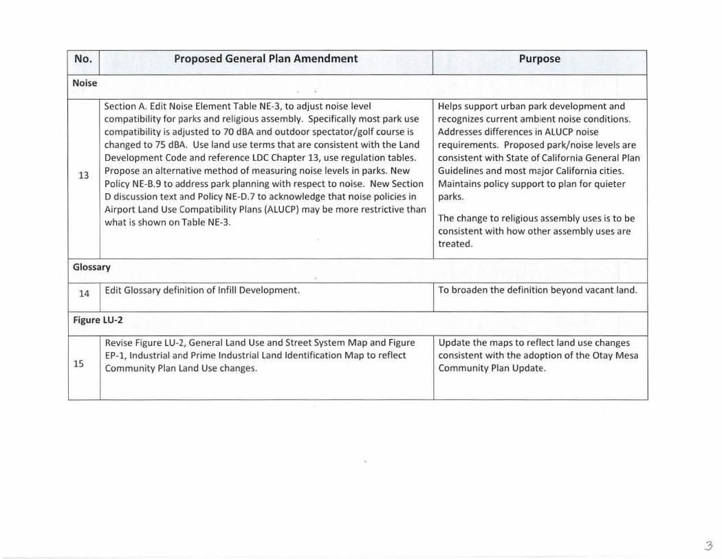
Noise
Section A. Edit Noise Element Table NE-3, to adjust noise level Helps support urban park development and compatibility for parks and religious assembly. Specifically most park use recognizes current ambient noise conditions. compatibility is adjusted to 70 dBA and outdoor spectator/golf course is Addresses differences in ALU CP noise changed to 75 dBA. Use land use terms that are consistent with the land requirements. Proposed park/noise levels are Development Code and reference LDC Chapter 13, use regulation tables. consistent with State of California General Plan
13 Propose an alternative method of measuring noise levels in parks. New Guidelines and most major California cities. Policy NE-B.9 to address park planning with respect to noise. New Section Maintains policy support to plan for quieter D discussion text and Policy NE-D.7 to acknowledge that noise policies in parks. Airport Land Use Compatibility Plans (ALUCP) may be more restrictive than
The change to religious assembly uses is t o be what is shown on Table NE-3. consistent with how other assembly uses are treated.
Glossary
14 Edit Glossary definition of lnfill Development. To broaden the definition beyond vacant land.
Figure LU-2
Revise Figure LU-2, General land Use and Street System M ap and Figure Update the maps to reflect land use changes
15 EP-1, Industrial and Prime Industrial land Identification Map to reflect consistent with the adoption of the Otay Mesa Community Plan land Use changes. Community Plan Update.
3
General Plan Amendments Errata Sheet March 2015 Draft
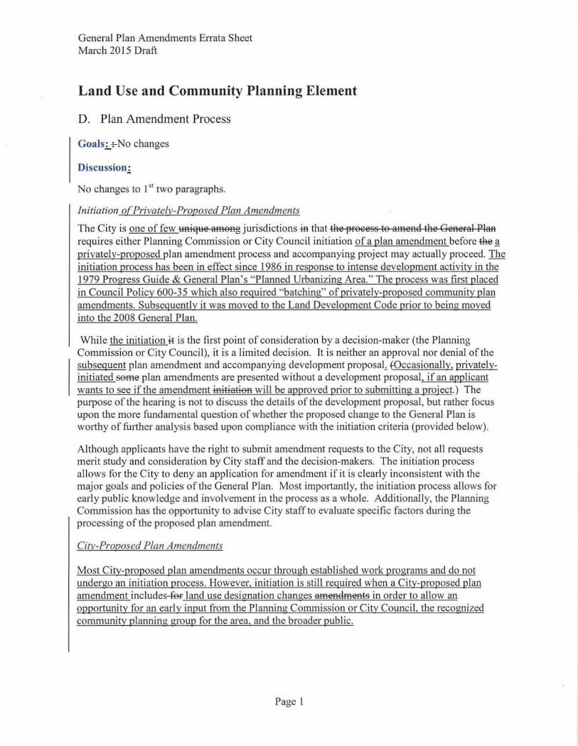
Land Use and Community Planning Element
D. Plan Amendment Process
Goals..:_+-No changes
Discussion:
No changes to l 51 two paragraphs.
Initiation o(Privately-Proposed Plan Amendments
The City is one of few unique among jurisdictions tn that the process to amend the General Plan requires either Planning Commission or City Council initiation of a plan amendment before the~ privately-proposed plan amendment process and accompanying project may actually proceed. The initiation process has been in effect since 1986 in response to intense development activity in the 1979 Progress Guide & General Plan's "Planned Urbanizing Area." The process was ftrst placed in Council Policy 600-35 which also required "hatching" of privately-proposed community plan amendments. Subsequently it was moved to the Land Development Code prior to being moved into the 2008 General Plan.
While the initiation tt is the first point of consideration by a decision-maker (the Planning Commission or City Council), it is a limited decision. It is neither an approval nor denial of the subsequent plan amendment and accompanying development proposat fOccasionally, privatelyinitiated seme plan amendments are presen.ted without a development proposal, if an applicant wants to see if the amendment initiation will be approved prior to submitting a project.) The purpose of the hearing is not to discuss the details of the development proposal , but rather focus upon the more fundamental question of whether the proposed change to the General Plan is worthy of further analysis based upon compliance with the initiation criteria (provided below).
Although applicants have the right to submit amendment requests to the City, not all requests merit study and consideration by City staff and the decision-makers. The initiation process allows for the City to deny an application for amendment if it is clearly inconsistent with the major goals and policies of the General Plan. Most imp011antly, the initiation process allows for early public knowledge and involvement in the process as a whole. Additionally, the Planning Commission has the oppottunity to advise City staff to evaluate specific factors during the processing of the proposed plan amendment.
City-Proposed Plan Amendrnents
Most City-proposed plan amendments occur through established work programs and do not undergo an initiation process. However, initiation is still required when a City-proposed plan amendment includes-fef land use designation changes amendments in order to allow an opportunity for an early input from the Planning Commission or City Council. the recognized community planning group for the area. and the broader public.
Page 1
General Plan Amendments En·ata Sheet March 20 15 Draft
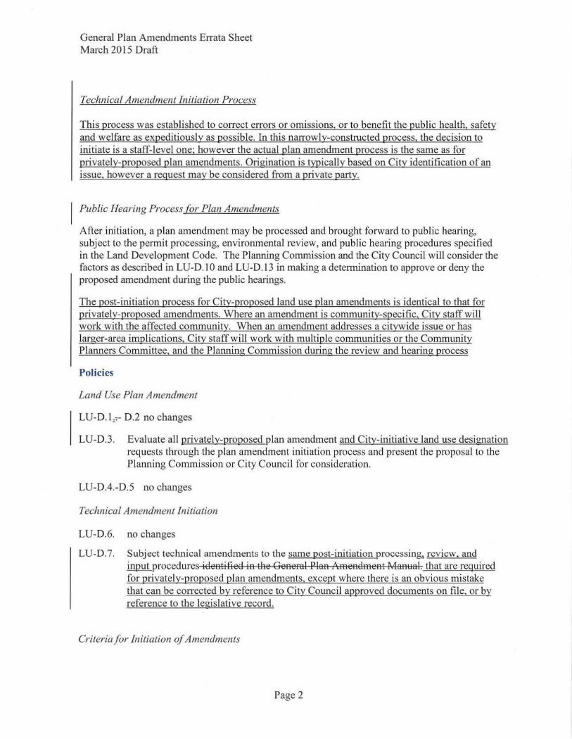
Technical Amendment Initiation Process
This process was established to conect errors or omissions, or to benefit the public health, safety and welfare as expeditiously as possible. In this narrowly-constructed process, the decision to initiate is a staff-level one; however the actual plan amendment process is the same as for privately-proposed plan amendments. Origination is typicaUy based on City identification of an issue. however a request may be considered from a private party.
Public Hearing Process (or Plan Amendments
After initiation, a plan amendment may be processed and brought forward to public hearing, subject to the permit processing, environmental review, and public hearing procedures specified in the Land Development Code. The Planning Commission and the City Council will consider the factors as described in LU-D.l 0 and LU-D.l3 in making a determination to approve or deny the proposed amendment during the public hearings.
The post-initiation process for City-proposed land use plan amendments is identical to that for privately-proposed amendments. Where an amendment is community-specific, City staff will work with the affected community. When an amendment addresses a citywide issue or has larger-area implications, City staff will work with multiple communities or the Community Planners Committee, and the Planning Commission during the review and hearing process
Policies
Land Use Plan Amendment
LU-D.l~.,-- D.2 no changes
LU-D.3. Evaluate all privately-proposed plan amendment and City-initiative land use designation requests through the plan amendment initiation process and present the proposal to the Planning Commission or City Council for consideration.
LU-0.4.-0.5 no changes
Technical Amendment Initiation
LU-0.6. no changes
LU-0.7. Subject technical amendments to the same post-initiation processin& review, and input procedures identified in the General Plan Amendment Manual. that are required for privately-proposed plan amendments, except where there is an obvious mistake that can be corrected by reference to City Council approved documents on file, or by reference to the legislative record.
Criteria for Initiation of Amendments
Page 2
General Plan Amendments Errata Sheet March 2015 Draft
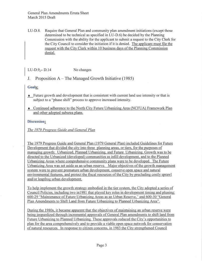
LU-D.8. Require that General Plan and community plan amendment initiations (except those determined to be technical as specified in LU-D.6) be decided by the Planning Commission with the ability for the applicant to submit a request to the City Clerk for the City Council to consider the initiation if it is denied. The applicant must file the request with the City Clerk within 10 business days of the Planning Commission denial.
LU-0.9~7- D.l4 No changes
1. Proposition A - The Managed Growth Initiative (1985)
Goals:
.!_Future growth and development that is consistent with current land use intensity or that is subject to a "phase sruft" process to approve increased intensity.
+ Continued adherence to the North City Future Urbanizing Area (NCFUA) Framework Plan and other adopted subarea plans.
Discussion:
The 1979 Progress Guide and General Plan
The 1979 Progress Guide and General Plan ( 1979 General Plan) included Guidelines for Future Development that divided the city into three planning areas, or tiers, for the purposes of managing growth: Urbanized, Planned Urbanizing, and Future Urbanizing. Growth was to be directed to the Urbanized (developed) communities as infill development, and to the Planned Urbanizing Areas where comprehensive community plans were to be developed. The Future Urbanizing Area was set aside as an urban reserve. Major objectives of the growth management system were to prevent premature urban development, conserve open space and natural environmental features, and protect the fiscal resources of the City by precluding costly sprawl and/or leapfrog urban development.
To help implement the growth strategy embodied in the tier system, the City adopted a series of Council Policies, including two in 1981 that played key roles in development timing and phasing: 600-29 "Maintenance of Future Urbanizing Areas as an Urban Reserve," and 600-30 "General Plan Amendments to Shift Land from Future Urbanizing to Planned Urbanizing Area".
During the 1980s, it became apparent that the objectives of maintaining an urban reserve were being jeopardized through incremental approvals of General Plan amendments to shift land from Future Urbanizing to Planned Urbanizing. These approvals reduced the City's opportunities to plan for the area comprehensively and to provide a viable open space network for conservation of natural resources. In response to citizen concerns, in 1983 the City strengthened Council
Page 3
General Plan Amendments Errata Sheet March 2015 Draft
Policy 600-30 by adding a "Threshold Determination" which was a two-step process to evaluate the need of a phase shift by analyzing the need for developable land and the fiscal and environmental impacts of proposed shifts.
The Managed Growth Initiative
The public remained concerned with the extent of phase shifts that were occurring and, in 1985, the electorate approved Proposition A, The Managed Growth Initiative. This initiative amended the 1979 General Plan to state that: "no property shall be changed from the "future urbanizing" land use designation in the Progress Guide and General Plan to any other land use designation, and the provisions restricting development in the future urbanizing area shall not be amended except by majority vote of the people ... " In addition to restrictions on land use designation changes, Proposition A (Section 3, Implementation) directed the City to implement the proposition by taking actions "including but not limited to adoption and implementation on any amendments to the General Plan and zoning ordinance or City Code reasonably necessary to carry out the intent and purpose of this initiative measure." A comprehensive package of legislative and regulatory actions implementing Proposition A was adopted by the City Council in 1990, including amendments to: the 1979 General Plan Guidelines for Future Development; Council Policy 600-29 "Maintenance of Future Urbanizing Area as an Urban Reserve"; and zoning regulations for Planned Residential Developments, A-1 zones, and Conditional Use Permits. The full text of Proposition A is included in Appendix B.
Land Use Policy Development Following the Passage o(Proposition A
Proposition A was effective in insuring that full evaluation of general plan amendments proposing phase shifts on individual properties would occur. However, the opportunity to comprehensively plan the urban reserve was in jeopardy due to approvals of residential subdivisions at rural densities consistent with existing Agriculture zones and Proposition A. As a result, a public planning process took place and the City adopted the North City Future Urbanizing Area Framework Plan (NCFUA) in1992. This plan established the vision for the City's 12,000 acre northern urban reserve and identified five subareas where more detailed land use, transportation and open space planning was to occur. It also called for the establishment of an interconnected open space system that would comprise a new "Environmental Tier" of the General Plan.
The NCFUA Framework Plan is still in effect for Subarea II. Additional planning took place in the remaining four subareas resulting in voter-approved phase shifts for property within Black Mountain Ranch (Subarea I), Pacific Highlands Ranch (Subarea III), and Torrey Highlands (Subarea IV); and a specific plan for Del Mar Mesa (NCFUA Subarea V) that limits residential development to rural densities and identifies MSCP core habitat area for conservation, without processing a phase shift.
The NCFUA encompasses about one-quarter of all non-shifted acres. Other planning areas that contain Proposition A lands are: Los Penasguitos Canyon Preserve; Tijuana River Valley; Rancho Encantada; and the San Pasqua! Valley. The City, in collaboration with landowners and other agencies, completed additional planning efforts to address land use in the Future
Page4
General Plan Amendments Errata Sheet March 2015 Draft
Urbanizing Area, including: • a comprehensive update to the San Pasqua! Valley Plan that calls for preservation of the
valley for agricultural, open space, and habitat uses;
• the Multiple Species Conservation Program (MSCP) and associated preserve system that encompassed much of the land called out as a part of the potential "environmental tier"
• the San Dieguito River Park Concept Plan; and
• open space and habitat preservation actions in the Tijuana River Valley.
Proposed "environmental tier" lands have become protected through the MSCP, dedications or easements, or through Open Space land use designation. In addition, Environmentally Sensitive Lands regulations and new open space zoning tools were added to the Land Development Code. While the "Environmental Tier" was not formally added to the General Plan, the MSCP and the Environmentally Sensitive Lands regulations have become the primary means of implementing the Environmental Tier concept and protecting open space lands.
The two remaining areas of Proposition A lands shown on Figure LU-4 are Military Use Facilities and County lands (both County Islands and Prospective Annexation Areas). Since military lands are not presently subject to the City's land use authority, the City has chosen to follow the development intensity restrictions and the requirements for a vote of the people to approve an amendment to shift the area from Proposition A lands upon receipt of jurisdiction of former military installations. County lands that have not been annexed into the City are unlikely to do so in the future. However, the annexation evaluation criteria required through the Local Agency Formation Commission (LAFCO) process appropriately address the future land use and impact on City services issues that are key to the City's desire to annex.
By 2005, phase shifts, per Proposition A and the 1979 General Plan, lnwe occurred for the land determined to be appropriate for more urban levels of development within the planning horizon of this General Plan. _Completion of these large-scale comprehensive planning efforts and public land acquisition of open space has changed the planning focus in the remaining undeveloped Proposition A lands from maintaining an urban reserve for future growth to implementing NCFUA and General Plan policies for natural resource conservation, public recreation, and protection of agriculture and open space lands. Proposition A lands also include military and other lands not subject to the City's jurisdiction. In the past, the City Council has chosen to follow the development intensity restrictions and the requirement for a vote of the people to approve an amendment to shift the area from Future to Planned Urbanizing Area as specified in Proposition A .. , upon receipt ofjurisdiction over former military installations.
As described previously, the phased development areas system has, for the most part, become an outdated system to address future growth and development. The City has grown into a jurisdiction with primarily two tiers, {see Figure LU-4, Proposition A Lands Map):
• Proposition A Lands (Managed Growth Initiative) Lands as previously defined) characterized by very low-density, residential, open space, natural resource-based park, and
Page 5
General Plan Amendments Errata Sheet March 2015 Draft
agricultural uses; and
• Urbanized Lands - characterized by older, recently developed, and developing communities at urban and suburban Levels of density and intensity.
J.iy_As-e.f2006, communities formerly known as Planned Urbanizing were largely completed according to the adopted community plan, and of that group, the oldest were beginning to experience limited redevelopment on smaller sites. For information on how the tier system was linked to public facilities financing, see the Public Facilities Element Introduction and Section A.
Policies
LU-1.1. Identify non-phase shifted lands as Proposition A lands and no longer refer to them as Future Urbanizing Area.
LU-1.2. Follow a public planning and voter approval process consistent with the provisions of thjs Land Use Element for reuse planning of additional military lands identified as Proposition A lands, and other areas if and when they become subject to the City's jurisdiction.
LU-1.3. Continue to implement Proposition A - The Managed Growth Initiative of 1985 (see Appendix B).
Mobility Element
Introduction
1st four paragraphs: No changes.
5th paragraph - reformat bullets and edit text as follows:
The Mobility Element is part of a larger body of plans and programs that guide the development and management of our transpm1ation system. The Regional Transpo11ation Plan (RTP), prepared and adopted by the San Diego Association of Governments (SANDA G)~ is the region's long-range mobility plan. The RTP plans for and identifies projects for multiple modes of transportation in order to achieve a balanced regional system. It establishes the basis for state funding of local and regional transportation projects, and is a prerequisite for federal funding. SANDAG prioritizes and allocates the expenditure of regional, state and federal transportation funds to implement RTP projects. In order to meet federal congestion management requirements, the 2050 RTP includes: performance monitoring and measurement of the regional transportation system, multimodal altematives and non-single occupancy vehicle analysis, land use impact analysis, the provision of congestion management tools, and integration with the regional transportation improvement program CRTIP). The RTIP, also prepared by SANDAG, identifies RTP highway, a11erial, transit, and bikeway projects that are planned for
Page 6
General Plan Amendments Errata Sheet March 20 15 Draft
implementation over the next five years.
• The region's Congestion Management Program (GMP), also prepared by SANDAG, serves as a short term element of the RTP. It fucuses on actions that can be implemented in adva:Rce of the longer range transportation solutions contained •.vithin the RTP. The GMP establishes programs for mitigating the traffic impacts of new development and moaitoring the ~erformance of system roads relati•f'e to Level of Sert'ice (LOS) sta:Rdards. It links land use, traR-Sportation, a:Rd air quality concerns.
The Mobility Element and; the RTP and the GMP all both highlight the importance of integrating transportation and land use planning decisions, and us ing multi-modal strategies to reduce congestion and increase travel choices. However, the Mobility Element more specifically plans for the City of San Diego's transportation goals and needs. The City recognizes that regional planning necessitates close working relationships between City and SANDAG planners and that optimum transportation infrastructure planning must be coordinated through state agencies such as Caltrans. To this end, staffpatticipation on SANDAG advisory committees is critical. The Mobility Element, Section K, and Public Facilities Element, Section B, contain policies on how to work effectively with SANDAG to help ensure that City of San Diego transpottation priorities are implemented.
Economic Prosperity Element
A. Industrial Land Use
Goals: No changes
Discussion: No changes
EP-A. l -A.l3 No changes
EP-A.l4. In areas identified as Prime Industrial Land as shown on Figure EP-1, the following uses may be considered and allowed under certain conditions:
.L..._Qehild care fac ilities for employees' children, as an ancillary use to industrial uses on a s ite, may be considered and allovll:~d when they~ are s ited at a demonstrably adequate distance from the property line, so as not to limit the current or future operations of any adjacent industrially-designated property; can assure that health
Page 7
General Plan Amendments Enata Sheet March 20 15 Draft
and safety requirements are met in compliance with required permits; and are not precluded by the applicable Airport Land Use Compatibility Plan.
a:-b. Existing hospitals previously approved through Conditional Use Petmits (CUPs), provided that no new child care or long-tetm care facilities are established.
c. Existing colleges and universities, previousLy approved through CUPs. provided that the facilities are for adult education and do not include day care facilities.
G. Community and Infrastructure Investment
Goals: No changes
Discussion.:.
Capital is necessary for communities, small businesses, and industries to grow, improve productivity, and compete. The City, with the assistance of state and federal programs, invests in communities and provides assistance to small business and targeted base sector industries. These public investments leverage private investments many times over, to the benefit of San Diego's economic prosperity. Access to public and private capital is impottant for all communities within the City, without discrimination.
A city's most important investment in support of economic prospetity is its investment in infrastructure, particularly infrastructure that helps communities and base sector industries become more productive, leverages private investment, and help direct investment to areas with the greatest needs or potential benefits.
Some of San Diego's communities need fu1ther investment and revitalization. These areas may have issues related to vacant and underutilized propetties, aging infrastructure, and economic activity that should be addressed. The well-being of neighborhoods will require an economically balanced housing supply and sufficient infrastructure. as well as businesses that enhance the community, create jobs and have community support. There are existing local, state and federal programs and incentives designed to spur revitalization, and work continues on new strategies and partnerships to achieve community goals.
Policies
EP-G. l. No changes
EP-0.2. Priotitize economic development effotts to attract and induce investment in local businesses throughout the City.
a. Foster economic development using the incentives of the City' s development programs that include business improvement districts and the Foreign Trade Zone program, and incentives authorized by CP 900-12.
Page 8
General Plan Amendments Errata Sheet March 2015 Draft
&.b.Assist existing business owners in accessing programs that can provide financial assistance and business consulting services. Such programs include Small Business Administration loans, the City's Small Business Loan program, fa<;ade renovation grants, and Community Development Block Grant (CDBG) redevelopment assistance .
.Q,_&.--Expand small business assistance to include direct or referred technical and financial assistance for small emerging technology firms and firms involved in international trade.
d.e-:Pursue public/private partnerships to provide incubation spaces for small business.
e.d-: Enhance funding opportunities for local businesses by supporting communitybased lending initiatives and equity programs
EP-G .. - G.5 No changes
EP-G.6 Partner with other municipalities, school districts, and other public or non-profit agencies, whenever possible, to achieve General Plan and community plan goals.
EP-G.7. Eliminate or minimize land use conflicts that pose a significant hazard to human health and safety.
EP-G.8. Minimize displacement of existing residents, businesses, and uses. Those displaced should have adequate access to institutions, employment and services.
EP-G.9 Work closely with the Workforce Investment Board, school districts, and job training/placement providers to facilitate employment opportunities for San Diego residents created through the City's economic development efforts. Support education and training programs which improve the quality of San Diego's labor force and coordinate these efforts with economic development activities to ensure that unemployed, underemployed and disadvantaged San Diegans find jobs.
EP-G.l 0 Utilize existing tools and zones for revitalization that include the Capital Improvement Program, Infrastructure Financing Districts, Business Improvement Districts, Maintenance Assessment Districts, Community Facilities Districts, and conduit revenue bond financing for industrial development.
EP-G.ll Pursue new tools, programs, and funding mechanisms for continued community revitalization and economic development.
EP-G.l2 Consider the contribution to economic development and revitalization as one of the factors used in the prioritization of Capital Improvement Projects.
Page 9
General Plan Amendments Errata Sheet March 20 15 Draft
K. Redevelopment
Goal.:.
• A city which redevelops and revitalizes areas which were blighted, to a condition of social, economic, and physical vitality consistent with community plan.
Discussion.:.
Within the State of Califomia Redevelopment wasis a state enab led legal process and financial tool that assisteds in the elimination of blight from designated areas:... through new development, iflfrastR:lcture, public spaces and facilities, reconstruction, and rehabilitation. It provideQs cities and counties with a powerful tool to address detetiorating conditions of slum afld blight within older urbanized areas of their jurisdictions. The Redevelopment Agency of the City (Former RD A) operated between 'NBS established in 1958 and 20 12, and ;managed 14 adopted project areas to alleviate conditions of blight, increase housing opportunities, and promote economic development. The City Council also established two public corporations, the Centre City Development Corporation and the Southeastern Economic Development Corporation, to manage redevelopment and economic development projects and activities within specific geographic areas. ln 2011. the State Legislature dissolved all redevelopment agencies. In February 2012, the City of San Diego's Former RDA dissolved, and its rights, powers, duties and obligations vested in the Successor Agency. The Successor Agency and its Oversight Board oversee the winding down of the Former RDA operations that include enforceable and recognized obligation payments. Future state legislation could implement programs that replicate some ofthe redevelopment agencies' activities. Refer to Section G for applicable policies for revitalization. based on California Comm~it)' Redevelopment Lav1 (CCRL), Health & Safety Code,§ 33000, et. seq.
Rede'>'Oiopment plafls define the boundaries of the project area and proYide a general description of the projects to be implemented therein. The redeYelopment plan adoption process is prescribed by CCRL and pro•,rides for substantial citizen participation. Rede'>'elopment plans must conform to the General Plaa and respecti't'e community plan(s). Project areas are predominantly urbanized and e:~dl:ibit conditions of both physical and economic blight. "Predominantly urbanized" is defined as developecl, vacant parcels that are an integral part of aad surrounded by urban uses, and irregular subdivided lots in multiple o'.vnership that cannot be properly used. Blight co·<'ers conditions that constitute a serious physical and economic burclen on the eemmuaity, •Nhieh the eommunity aannot reasenably ee eJtpeeteE:I te ee reversed, er alle'>'iatecl, by private eaterprise or government action, or both, v1ithout reclevelopment. The CCRL defines the various coaditions of physical and economie blight which iaclude unsafe or unhealthy builclings, substanclard desiga, lack ofparkiag, incompatible uses, and subcliviclecllots of in·egular form and shape, and inaclequate size for proper usefulness ancl development that are in multiple o·.-•mership.
Redevelopment project areas are frequently proposecl as a tool for cornmunit)' revitalization. There are potential social costs, as ·.yell as benefits, associated with reclevelopment. Social costs
Page 10
General Plan Amendments En·ata Sheet March 20 15 Draft
can include displacement of residents and businesses, while social benefits may include new employment opportunities, affordable housing, improved physical appearance, new or renovated public facilities, and increased community p1ide. Per the CCRL, the Redevelopment Agency is required to assist vlith the relocation of any persons or businesses that are displaced. Implementation of redevelopment projects typically occurs over a number of decades and the revitalization that redevelopment is intended to spark may take seYeral years. Adoption of a redevelopment plan allows the Agency to utilize a variety of extraordinary financial and legal tools, such as ta>t increment financing, owner participation agreements, eminent domain, and affordable housing requirements, in promoting sustainable development in the comm~mity.
Polieies
EP K.l. Support the use of redevelopment in conjunction •.vith input from the respective communities, subject to public hearings and approvals by the City Counoil, for those urbanized areas meeting the requirements of California Community Redevelopment Lav,. (CCRL).
gp K.2. Establish project areas that are large enough to create critical mass and generate sufficient tax increment to stimulate successful redevelopment activities over the life of the redevelopment plan and achieYe long term community objectives.
EP K.3. Use tax increment funds for projects and associated infrastructure improvements that >tvill stimulate future tax increment gro·Nth within the project areas that are consistent 'Nith the respecti·,ce five year implementation plans.
EP K.4. Rede .. ·elop assisted affordable housing investment within the same redevelopment project area, or in close proximity to, ·uhere the ta>t increment is generated, only to the degree that such affordable housing is not over concentrated in particular areas.
EP K.5. Ensure the timely· provision of affordable housing with all redevelopment assisted residential and mixed use development projects.
EP K.6. Partner with other municipalities, school dist1icts, and other public or non profit agencies, vthene·,·er possible, to acilieve General Plan, rede•,·elopment, and community plan goals.
L. Economic Information, Monitoring, and Strategic Initiatives
Goal: No changes
Discussion: No changes
Policies
EP-L. l. No changes
Page II
General Plan Amendments Errata Sheet March 2015 Draft
I EP-L.2. Prepare a CommuRity aHd economic Beaefit AssessmeHt (CEBA) process focusiRg OR report that addresses economic and fiscal impact§. associated with informatioH for significant community plan amendments involving land use or intensity revisions. A determination of whether a this report GeM is required for commuHity plaH ameHdmeHts will be made when the community plan amendment is initiated.
EP-L.3.- L.5 No changes
Public Facilities, Services and Safety Element
D. Fire-Rescue
Goal: No changes
Discussion.;_
Historically, the primary mission of the fire service was limited to fire protection. Over the past two decades the fire service's mission has expanded both locally and nationally to include the management and mitigation of broader hazards and risks to public safety. This expansion included the delivery of medical advanced life support services through a comprehensive firstresponder paramedic system. In conjunction with a contracted medical transportation provider, the Fire-Rescue department has provided a system of care utilizing paramedics on first responder apparatus as well as ambulances . . OYer the past two decades the fire seF>'ice's missioH has expaHded both locally aRd natioRally. lR 1997 the SaR Diego Medical Services EHterprise limited liability corporatioH was formed, through a partHership betweeR the City aRe Rural/Metro Corporatioa, to deliver paramedic services cit)'Wide. Tbis program utilizes paramedics OR the first reSf;lOHder apparatus as well as the arnbulaRce uHits. In addition to the wide variety of traditional fire suppression services such as sttuctural, airport, marine, and vegetation firefighting, today's services include emergeRcy Medical SerYices (EMS), water rescue, hazardous matetial response, confined space rescue, cliff rescue, high angle rescue, mass casualty incidents, and response to terrorism and weapons of mass destruction. Figure PF-3, Fire and Lifeguard Facilities, illustrates the location of fire stations and permanent lifeguard towers. The fire service is also responsible for hazard prevention and public safety education.
Due to climate, topography, and native vegetation, the City is subject to both wildland and urban fires. In 2001 and 2007, the City experienced wildland fires that resulted in the loss ofsttuctures and significant burned acreage.
The extended droughts characteristic of the region's Meditenanean climate and increasingly severe dry periods associated with global wa1ming results in large areas of dry, native vegetation that provides fuel for wildland fires. The most critical times of year for wildland fires are late summer and fall when Santa Ana winds bring hot, dry desert air into the region. The air temperature quickly dries vegetation, thereby increasing the amount of natural fuel. The Santa
Page 12
General Plan Amendments Errata Sheet March2015 Draft
Ana conditions create wind-driven fires such as 2003 and 2007 wildfires, which require a huge number of assets, more than the City has available.
Development pressures increase the threat of wildland fire on human populations and property as development is located adjacent to areas of natural vegetation. The City contains over 900 linear miles of wildland/urban interface due to established development along the open space areas and canyons. In 2005, the brush management regulations were updated to require 100 foot defensible space between structures and native wildlands (see also Conservation Element, policy CE-B.6 on the management ofthe urban/wildland interface and Urban Design Element, policy UD-A.3.p on the design of structures adjacent to open space).
The San Diego-Fire Rescue Department is responsible for the preparation, maintenance, and execution of Fire Preparedness and Management Plans and participates in multi-jurisdictional disaster preparedness efforts (see also PF Section P). In the event of a large wildfire within or threatening City limits, they could be assisted by state and federal agencies, or other jurisdictions.
The City is challenged with meeting current and future public facilities needs, as well as covering operations and maintenance costs for each new or expanded facility. Generally, operations and maintenance issues are addressed as part of the initial phase in developing specific Capital Improvement Projects and within the annual operating budget development once the facility is under construction. The Public Facilities Financing Strategy is being developed to address the funding of operations and maintenance and identify major revenue options. In addition, during community plan updates, fiscal impact analyses will be prepared which compare annual revenues against costs.
The few remaining newly developing areas of the City often present challenges associated with proper site location, funding of fire stations, and timing of development. In redeveloping communities, funding and site locations for new or expanded facilities also require great effort and coordination. Typically a t\vo to two and one half three mile distance between fire stations is sufficient to achieve response time objectives. The natural environment throughout the City presents considerable demands on fire-rescue services under various conditions and can also affect response times. For additional support, City forces rely on numerous Automatic Aid agreements with jurisdictions adjoining the City. These agreements assure that the closest engine company responds to a given incident regardless of which jurisdiction they represent. Mutual Aid agreements with county, state, and federal government agencies futiher allow the City, and any other participating agency, to request additional resources depending on the complexity and needs of a given incident.
Suburban residential development patterns and anticipated future inflil development throughout the City will place an increasing demand on the capabilities of fire-rescue resources to deliver an acceptable level of emergency service. Service delivery depends on the availability of adequate equipment, sufficient numbers of qualified personnel, effective alarm/monitoring systems, and proper siting of fire stations and lifeguard towers. As fire-rescue facilities built in the 1950s and equipment continue to age, new investments must be made to support growth patterns and maintain levels of service to ensure public safety.
Page 13
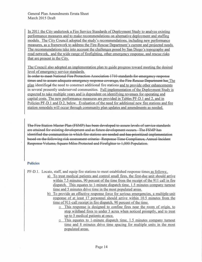
General Plan Amendments Errata Sheet March 20 L 5 Draft
In 201 L the City undettook a Fire Service Standards of Deployment Study to analyze existing performance measures and to make recommendations on alternative deployment and staffmg models. The City Council adopted the study's recommendations, including new performance measures, as a framework to address the Fire-Rescue Department's cunent and projected needs. The recommendations take into account the challenges posed by San Diego's topography and road network, and the wide range of firefighting, other emergency response, and rescue risks that are present in the City.
The Council also adopted an implementation plan to guide progress toward meeting the desired level of emergency service standards. [n order to meet National fire Protection Association l7l 0 standards for emergenc~· respoA:se times and to ass~:~re adequate emergeA:C~' response coverage, the fire Resc1:1e DepartmeA:t has The plan identifie.§e the need to construct additional fire stations and to provide other enhancements in several presently underserved communities. Full implementation of the Deployment Study is expected to take multiple years and is dependent on identifying revenues for operating and capital costs. The new performance measures are provided in Tables PF-D. L and 2, and in Policies PF-D.l and 0 .2, below. Evaluation of the need for additional new fire stations and fire station remodels will occur through community plan updates and amendments as needed.
The fire Station Master Plan (FSMP) has been de·,,eloped to ass1:1re levels of service standards are attained for existing development and as future development occ~:~rs . The FSMP has ideA:tified the comm~:~nities in \'l'h:ich fire stations are needed Rnd lias prioritized implementation based on tee followiRg risk assessment criteria: Response Time Compliance, An:A~:~al Lncident Response Volume, Square Miles Protected and firefighter to I ,000 Popt:Jlation.
Policies
PF-D. L. Locate, staff, and equip fire stations to meet established response times as follows:. a) To treat medical patients and control small fires, the first-due unit should arrive
within 7.5 minutes, 90 percent of the time from the receipt of the 911 call in fire dispatch. This equates to !-minute dispatch time, 1.5 minutes company turnout time and 5 minutes drive time in the most populated areas.
b) To provide an effective response force for serious emergencies, a multiple-unit response of at least 17 personnel should arrive within 10.5 minutes from the time of 911-call receipt in frre dispatch, 90 percent of the time.
o This response is designed to confine fires near the room of origin, to stop wildland fires to under 3 acres when noticed promptly, and to treat up to 5 medical patients at once,
o This equates to !-minute dispatch time, 1.5 minutes company turnout time and 8 minutes drive time spacing for multiple units in the most populated areas.
Page 14
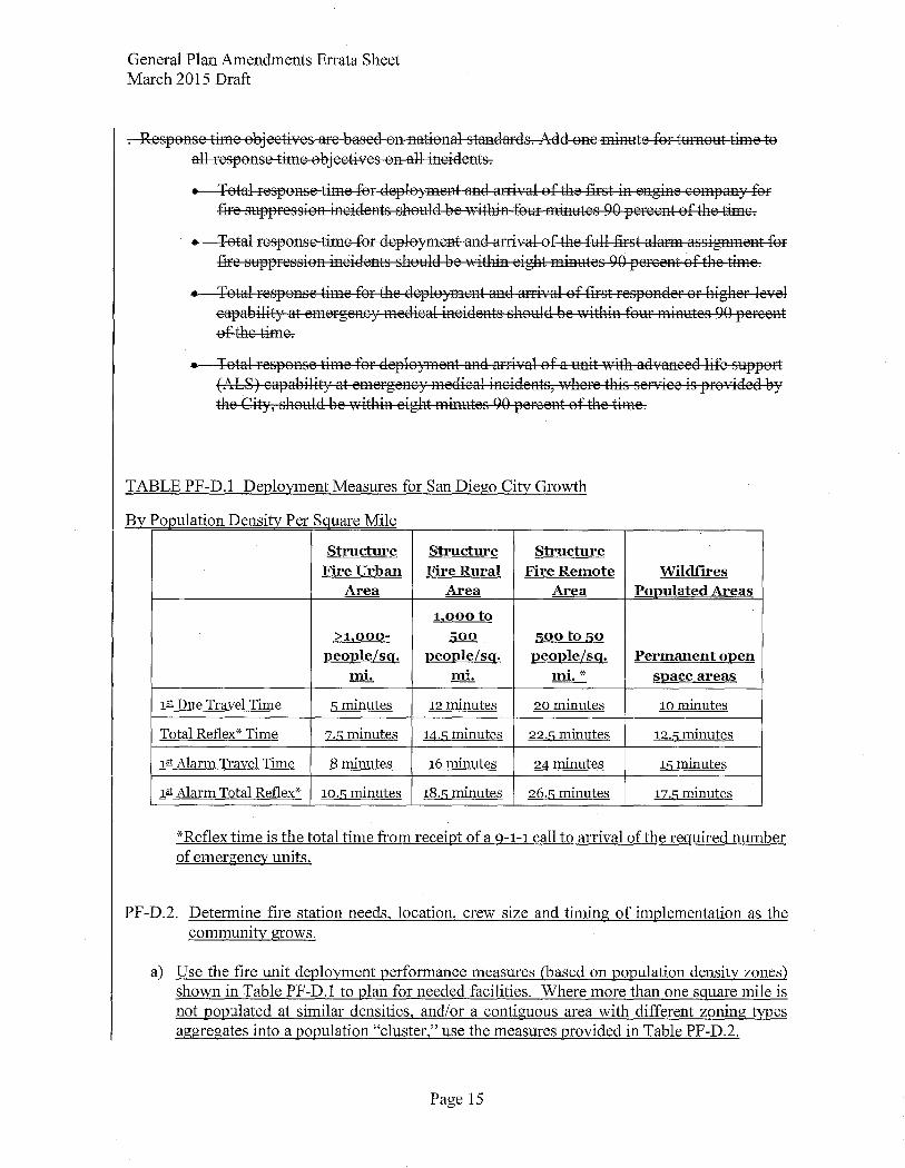
General Plan Amendments Errata Sheet March 2015 Draft
Response time objectives are based on national standards. Add one minute for turnout time to all response time objectives on all incidents.
• Total response time for deployment and arrival of the first in engine company for fire suppression incidents should be within four minutes 90 percent of the time.
• Total response time for deployment and arrival of the full first alarm assignment for fire suppression inCidents should be within eight minutes 90 percent of the time.
• Total response time for the deployment and arrival of first responder or higher level capability at emergency medical incidents should be 'Nithin four minutes 90 percent ofthe time.
• Total response time for deployment and arrival of a unit with advanced life support (AcLS) capability at emergency medical incidents, where this service is provided by the City, should be vlithin eight minutes 90 percent of the time.
TABLE PF-D.l Deployment Measures for San Diego City Growth
By Population Density Per Sguare Mile
Structure Structure Structure Fire Urban Fire Rural Fire Remote Wildfires
Area Area Area Ponulated Areas
1,ooo to >1,000- 500 sooto 50
ueouleLsg. neonleLsg. neonleLsg. Permanent onen mi. mi. mi.* snace areas
1m: Due Travel Time 5 minutes t2 minutes 20 minutes to minutes
Total Reflex* Time :Z·5 minutes t4.5 minutes 22.5 minutes t2.5 minutes
tiD: Alarm Travel Time 8 minutes t6 minutes 24 minutes t5 minutes
tiD: Alarm Total Reflex* t0.5 minutes t8.5 minutes 26.5 minutes t:Z.5 minutes
*Reflex time is the total time from receipt of a g-1-1 call to arrival of the required number of emergency units.
PF-D.2. Determine fire station needs, location, crew size and timing of implementation as the community grows.
a) Use the fire unit deployment performance measures (based on population density zones) shown in Table PF-D.l to plan for needed facilities. Where more than one sguare mile is not populated at similar densities, and/or a contiguous area with different zoning types aggregates into a population "cluster," use the measures provided in Table PF-D.2.
Page 15
General Plan Amendments Errata Sheet March 2015 Draft
b) Revise community plans and facilities financing plans as a part of community plan updates and amendments to reflect needed fire-rescue facilities.
Deploy to advance life support emergency responses EMS personnel including a minimum of
two members trained at the emergency medical technician paramedic
level and two members trained at the emergency medical technician
basic level arriving on scene \Vithin the established response time as follovls:
Total response time for deployment and arrival of EMS first responder \vith Automatic External
Defibrillator (AED) should be within four minutes to 90 percent of
the incidents; and
Total response time for deployment and arrival of EMS for providing advanced life support
should be within eight minutes to 90 percent of the incidents.
TABLE PF-D.2 Deployment Measures for San Diego City Growth
By Population Clusters
Area Aggregate Ponulation First-Due Unit Travel Time
Goal
Metropolitan > 200,000 J2eOJ2le 4 minutes
Urban-Suburban < 200,000 people 5 minutes
Rural 500 - 1,000 people 12 minutes
Remote < 500 > 15 minutes
PF-D.3. Adopt, Mmonitor, and maintain adopted service delivery objectives based on time standards for all fire, rescue, emergency response, and lifeguard services.
J PF-D.4. Provide a minimum 3/4-acre fire station site area and allow room for station expansion with additional considerations:
• Consider the inclusion of fire station facilities in villages or development projects as an alternative method to the acreage guideline;
• Acquire adjacent sites that would allow for station expansion as opportunities allow; and
Page 16
General Plan Amendments Errata Sheet March 2015 Draft
• Gain greater utility of fire facilities by pursuing joint use opportunities such as community meeting rooms or collocating with police, libraries, or parks where appropriate.
PF-D.5.- D. 11 No changes
G. Storm Water Infrastructure
Discussion
The City's storm water pollution prevention efforts and conveyance system strive to protect the quality of our recreational waters and potable water resources as mandated by the federal Clean Water Act of 1972 and the San Diego Regional Water Quality Control Board. The City also maintains compliance with the Water Quality Control Plan for the San Diego Region 9 also referred to as the Basin Plan, and with storm water permits. These functions require a multi-faceted approach that couples infrastructure improvements and maintenance, water quality monitoring, source identification of pollutants, land use planning policies and regulations, and pollution prevention activities such as education, code enforcement, outreach, public advocacy, and training. Additional discussion on Urban Runoff Management, Section E, is included in the Conservation Element.
The City has more than 39,000 storm drain structures and over 900 miles of storm drain pipes and channels serving approximately 237 square miles of urbanized development. Many storm water infrastructure projects do not have the opportunity to affect site design or implement other means to keep pollutants from entering storm drain flows. Therefore, prevention through education, outreach, code enforcement, and other efforts continues to be the most effective method of protecting water resources. Secondly, capital improvement investments in storm water structures (curbs, gutters, inlets, catch basins, pipes, and others) determined through Best Management Practices (BMP) are critical in order to reduce pollutant loading to acceptable levels. Public projects should be evaluated for their impact on the storm drain conveyance system and incorporate storm water quality and conveyance structures during the design process. Similarly, private development will mitigate the impacts of its development on the storm water conveyance system while overall system monitoring including the identification of needs is also performed by the City.
In addition to capital investments in storm water structures, operations and maintenance are equally critical to ensure governmental compliance and clean water resources. Furthermore, state regulations require that the City keep track of storm water structure locations and maintenance via inspections, and in some cases, collection and/ or reporting of storm water quality monitoring data. The storm drain fee and other sources of funds are instrumental in ensuring compliance with legal mandates and maintaining storm water prevention and conveyance functions.
Page 17
General Plan Amendments Errata Sheet March 2015 Draft
The Municipal Storm Sewer System Permit (MS4 Permit). issued by the San Diego Regional Water Quality Control Board [RWOCB). requires all development and redevelopment projects to implement storm water source control and site design practices to minimize the generation of pollutants. Additionally. the Permit requires new development and significant redevelopment projects that exceed certain size threshold to implement Structural Storm Water Best Management Practices (Structural BMPs) to reduce pollutant in storm water runoff and control runoff volume.
The MS4 Permit is re-issued every five years. typically imposing more stringent requirements on a wider range of development. These requirements are adopted in the City's Land Development Manual: Storm Water Standards Manual and apply to both private development and public improvements. There is an increased reliance on Low Impact Development (LID) strategies to meet the MS4 Permit requirements and TMDL as well. Examples of LID techniques are bioretention cells. green roofs. porous pavement. infiltration basins and biofiltration planters.
Recreation Element
A. Park and Recreation Guidelines
Policies Park Planning
RE-A.1. Develop a citywide Parks Master Plan through a public process.
a. - j No changes.
k. Develop a policy on non-residential development contributions to park and recreation facilities. See Policy RE-A.2.d.
RE-A.2. Use community plan updates to further refine citywide park and recreation land use policies consistent with the Parks Master Plan.
a.- c No changes.
d. Evaluate whether non-residential development benefits from park and recreation facilities, on a community basis. Where a benefit can be demonstrated, include a policy in the community plan, or in a citywide Park Master Plan, that nonresidential development should contribute to the cost of park and recreation facilities. In order to adopt and implement such a policy there must be:
• A determination that the non-residential development would create an impact to park and recreation infrastructure, and would benefit from improvements to such infrastructure;
Page 18
General Plan Amendments Errata Sheet March 2015 Draft
• A nexus study that provides justification for the proposed sharing of facilities costs between residential and non-residential uses, and identifies
which costs will be shared; and
• A fee established that equitably reflects the proportions of the populationbased costs to be shared by residential and non-residential development.
RE-A.3.- RE-A.7 No changes.
Park Standards
RE-A.8. Provide population-based parks at a minimum ratio of2.8 useable acres per 1,000 residents (see also Table RE-2, Parks Guidelines).
a. -c: No changes
d. Ensure that parks can be accessed from a public right-of-way.
e. Reference the "Consultant's Guide to Park Design &Development" maintained by the Park and Recreation Department.
Page 19
General Plan Amendments Errata Sheet March 20 15 Draft
Noise Element
A. Noise and Land Use Compatibility
Goal :
+ Consider existing and future noise levels when making land use planning decisions to minimize people's exposure to excessive noise.
Discussion:
The Noise Element influences Land Use Element policies since excessive noise affects land uses, specifically, the quality of life of people working and living in the City. The planning of future noise-sensitive land uses should have a sufficient spatial separation or incorporate site design and construction techniques to ensure compatibility with noise-generating uses. Noise-sensitive land uses include, but are not necessarily limited to residential uses, hospitals, nursing facilities, intermediate care facilities, child educational facilities, libraries, museums, places ofworshipand, child care facilities, and certain types of passive recreational parks and open space.
The City uses the Land Use- Noise Compatibility Guidelines shown on Table NE-3 for evaluating land use noise compatibility when reviewing proposed land use development projects. The land uses described provide examples of uses under each land use category. A more complete listing of use categories and subcategories is found in the Land Development Code Chapter 13. in the use regulation tables. A "compatible" land use indicates that standard construction methods will attenuate exterior noise to an acceptable indoor noise level and people can cany out outdoor activities with minimal noise interference. Evaluation of land use that falls into the "conditionally compatible" noise environment should have an acoustical study. In general, an acoustical study should include, but is not limited to the analysis listed on Table NE-4, Acoustical Study Guidelines, with consideration of the type of noise source, the sensitivity of the noise receptor, and the degree to which the noise source may interfere with speech, sleep, or other activities characteristic of the land use. For land uses indicated as conditionally compatible, structures must be capable of attenuating ex terior noise to the indoor noise level as shown on Table NE-3. For land uses indicated as incompatible, new construction should generally not be undertaken. Due to severe noise interference, outdoor activities are generally unacceptable and for structures, extensive mitigation techniques are required to make the indoor environment acceptable. For uses related to motor vehicle traffic noise, refer to Section B for additional guidance. For uses affected by aircraft noise. refer to Section D. since noise compatibility policies in the Airpott Land Use Compatibility Plans could be more or less restrictive for uses affected by aircraft noise than shown on Table NE-3. Refer to Section I for a discussion of typical noise attenuation measures:.,
Policies
NE-A. l. Separate excessive noise-generating uses from residential and other noise-sensitive land uses with a sufficient spatial buffer of less sensitive uses.
Page 19
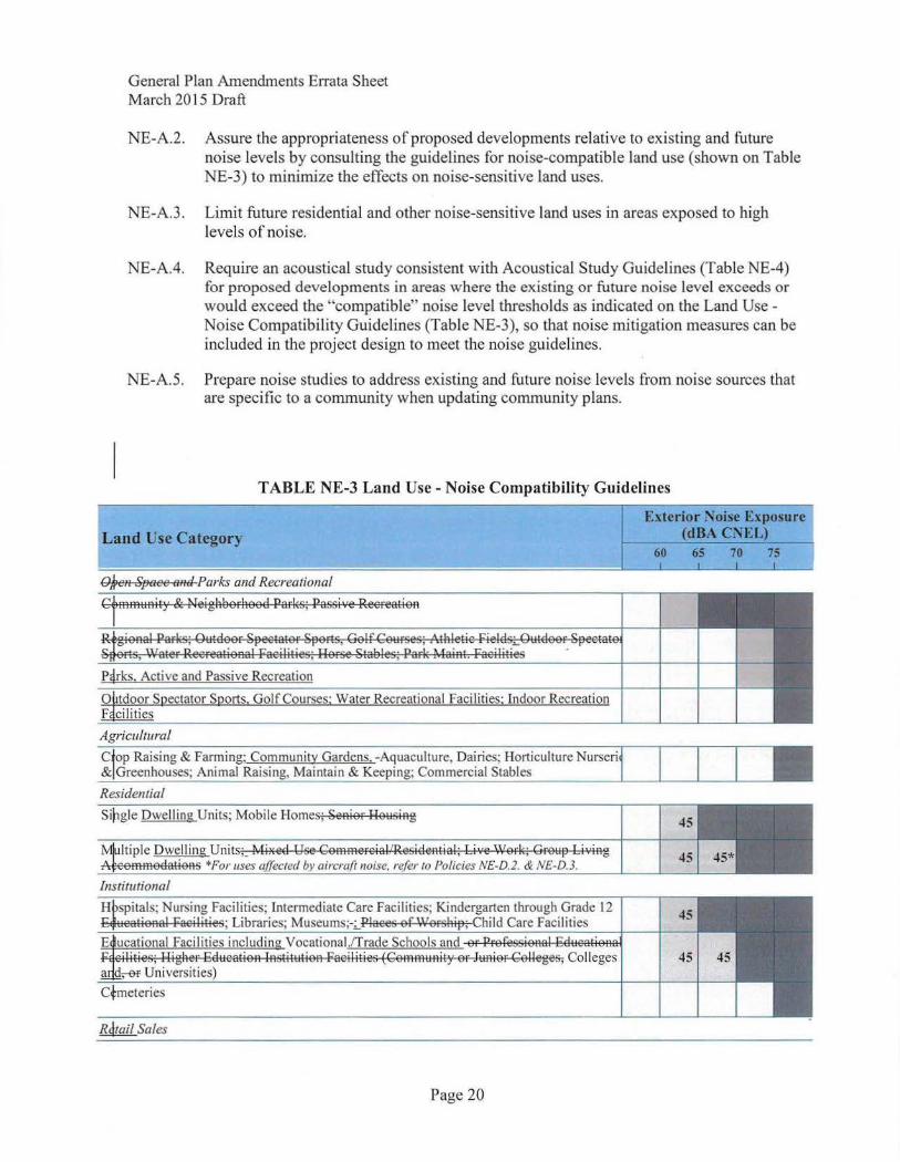
General Plan Amendments Errata Sheet March 20 15 Draft
NE-A.2. Assure the appropriateness of proposed developments relative to existing and future noise levels by consulting the guidelines for noise-compatible land use (shown on Table NE-3) to minimize the effects on noise-sensitive land uses.
NE-A.3. Limit future residential and other noise-sensitive land uses in areas exposed to high levels of noise.
NE-A.4. Require an acoustical study consistent with Acoustical Study Guidelines (Table NE-4) for proposed developments in areas where the existing or future noise level exceeds or would exceed the "compatible" noise level thresholds as indicated on the Land Use -Noise Compatibility Guidelines (Table NE-3), so that noise mitigation measures can be included in the project design to meet the noise guidelines.
NE-A.5. Prepare noise studies to address existing and future noise levels from noise sources that are specific to a community when updating community plans.
Land Use Category
Residential
TABLE NE-3 Land Usc- Noise Compatibility Guidelines
uaculture, Dairies; Horticulture Nurseri · Commercial Stables
Exterior ~oise Exposure (dBACNEL)_
Sil1gle Dwelling Units; Mobile Homes; SeAier He~:~siRg 45
Institutional
Rdtail Sales
Page 20
45
45
45 I ••
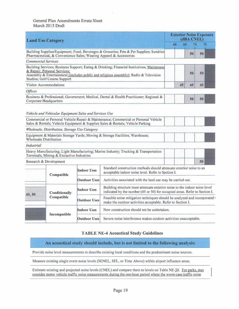
General Plan Amendments Errata Sheet March 2015 Draft
Land Use Category
Building Supplies/Equipment; Food, Beverages Pharmaceutical, & Convenience Sales; W ·
Commercial Services
Building Services; Busi ness Support; Eating & Drinking; Financial Institutions; !.!.!o!'-'-'-"""'-""-'-'-"1
& Repair. Personal Services; Assembly & Entertainment (includes public and religious assembly); Radio & Television Studios; Golf Course
50 50
Visitor Accommodations 45 45 45
Offices
onal; Government; Medical, Dental & Health Practit ioner; Regional &
Vehicle and Vehicular Equipment Sales and Services Use
Wholesale, Distribution, Storage Use Category
Equipment & Materials Storage Yards; Moving & Storage Facilities; Warehouse; Wholesale Distribution
Industrial
ring; Light Manufacturing; Marine Industry; Trucking & Transportation & Extractive Industries
Research & Development 50
45,50
Compa tible
ConditionaHy Compatible
Incompatible
Standard construction methods should attenuate exterior noise to an acceptable indoor noise level. Refer to Section I.
Activities associated with the land use may be carried out.
Building structure must attenuate exterior noise to the indoor noise level indicated by the number (45 or 50) for occupied areas. Refer to Section I.
Feasible noise mitigation techniques should be analyzed and incorporated 1
make the outdoor activities acceptable. Refer to Section I.
New construction should not be undertaken.
Severe noise interference makes outdoor activities unacceptable.
TABLE N.l!:-4 Acoustical Study Guidelines
An acoustical study should include, but is not limited to the following analysis:
Provide noise level measurements to describe existing local conditions and the predominant noise sources.
Measure existing single event noise levels (SENEL, SEL, or Time Above) within airport influence areas.
Estimate existing and projected noise levels (CNEL) and compare them to levels on Table NE-J~. For parks. may consider motor vehicle traffic noise measurements during the one-hour period where the worst-case traffic noise
Page 19
General Plan Amendments Errata Sheet March 20 15 Draft
levels are expected to occur from dawn to dusk at a park.
Recommend appropriate mitigation measures to achieve acceptable noise levels on Table NE-J.~.
Estimate noise exposure levels with recommended mitigation measures.
Describe a post-project assessment to evaluate the effectiveness of the proposed mitigation measures.
B. Motor Vehicle Traffic Noise
Goal :
+ Minimal excessive motor vehicle traffic noise on residential and other noise-sensitive land uses.
Discussion:
Motor vehicle traffic noise is a major contributor of noise within the City. Excessive noise levels along arterial roads, interstate freeways, and state highways affect much of the urban environment. Traffic noise level is dependent upon traffic volume, speed, flow, vehicle mix, pavement type and condition, the use of ban·iers, as well as distance to the receptor.
Local roadway design features and traffic management and calming techniques can minimize noise from traffic speed and frequent vehicle acceleration and deceleration, and innovative roadway paving material can further reduce traffic noise. Vehicles equipped with a properly functioning muffler system help to limit excessive exhaust noise. Future use of hybrid transit buses could help to reduce noise along mixed-use transit corridors.
At higher speeds, typically on freeways, highways and primary arterials, the noise from tire/pavement interaction can be greater than from vehicle exhaust and engine noise. The use of lower noise paving surfaces can reduce tire/pavement interaction noise. For noise-sensitive land uses adjacent to freeways and highways, these uses should be buffered from excessive noise levels by intervening, less sensitive, industrial-commercial uses or shielded by sound walls or landscaped berms. The City can, however, influence daily traffic volumes and reduce peak-hour traffic by promoting altemative transpo1tation modes and integration of mixed-use infill development. The peak hour traffic may or may not be the worst-case noise levels since higher traffic volumes can lead to higher congestion and lower operating speeds. The worst-case noise levels may occur in hours with lower volumes and higher speeds.
Page 22
General Plan Amendments Errata Sheet March 2015 Draft
Although not generally considered compatible, the City conditionally allows multiple unit and mixed-use residential uses up to 75 dBA CNEL in areas affected primarily by motor vehicle traffic noise with existing residential uses. Any future residential use above the 70 dBA CNEL must include noise attenuation measures to ensure an interior noise level of 45 dB A CNEL and be located in an area where a community plan allows multiple unit and mixed-use residential uses.
Policies
NE-B. I. Encourage noise-compatible land uses and site planning adjoining existing and future highways and freeways.
NE-B.2. Consider traffic calming design, traffic control measures, and low-noise pavement surfaces that minimize motor vehicle traffic noise (see also Mobility Element, Policy ME-C.5 regarding traffic calming).
NE-B.3. Require noise reducing site design, and/or traffic control measures for new development in areas of high noise to ensure that the mitigated levels meet acceptable decibel limits.
NE-B.4. Require new development to provide facilities which support the use of alternative transportation modes such as walking, bicycling, carpooling and, where applicable, transit to reduce peak-hour traffic.
NE-B.5. Designate local truck routes to reduce truck traffic in noise-sensitive land uses areas.
NE-B.6. Work with Caltrans to landscape freeway-h ighway rights-of-way buffe rs and install low noise pavement surfaces, berms, and noise bmTiers to mitigate state freeway and highway traffic noise.
NE-B.7. Promote the use of berms, landscaping, setbacks, and architectural design where appropriate and effective, rather than conventional wall barriers to enhance aesthetics.
NE-B.8. Enforce the state vehicle code to ensure that motor vehicles are equipped with a functioning muffler and are not producing excessive noise levels.
NE-B.9 When parks are located in noisier areas, seek to reduce exposure through site planning, including locating the most noise sensitive uses, such as children's play areas and picnic tables. in the quieter areas of the site; and in accordance with the other policies of this section.
C. Trolley and Train Noise
Goal:
+ Minimal excessive fixed rail-related no ise on residential and other noise-sensitive land uses.
Discussion:
Page 19
General Plan Amendments Errata Sheet March 2015 Draft
Daily traffic from passenger and freight train and trolley operations produces noise that may disrupt adjacent noise-sensitive uses. Trains can generate high, yet relatively brief, intermittent noise events. The interaction of the steel wheels and rails is a major component of train noise. Factors that influence the overall rail noise include the train speed, train horns, type of engine, track conditions, use of concrete cross ties and welded track, the intermittent nature of train events, time of day, and sound walls or other barriers. When operating in residential areas, trains are required to travel at a reduced speed to minimize noise.
Federal regulations require trains to sound their horns at all roadway-rail grade crossings and the warning sound of train horns is a common sound experienced by communities near the rail corridor. In an effort to minimize excess train hom noise, the federal government allows local jurisdictions to establish train hom "quiet zones." This requires the implementation of supplementary and alternative safety measures to compensate for the loss of the train hom usage.
The state is planning for high-speed rail service that would connect the San Diego region to other regions in the state. Air turbulence noise generated from high-speed train traffic may affect noise-sensitive uses along the potential rail corridors.
Policies
NE-C.l. Use site planning to help minimize exposure of noise sensitive uses to rail cotTidor and trolley line noise.
NE-C.2. Work with the San Diego Association of Governments (SANDAG), Caltrans, Metropolitan Transit System (MTS), California High-Speed Rail Authority, and passenger and freight rail operators to install noise attenuation features to minimize impacts to adjacent residential or other noise-sensitive uses. Such features include rail and wheel maintenance, grade separation along existing and future rail corridors, and other means.
NE-C.3. Establish train hom ·'quiet zones" consistent with the federal regulations, where applicable.
NE-C.4. Work with SANDAG, Caltrans, MTS, and passenger and freight rail operators to install grade separation at existing roadway-rail grade crossings as a noise and safety measure.
D. Aircraft Noise
Go::. I:
+ Minimal excessive aircraft-related noise on residential and other noise-sensitive land uses.
Discussion:
Aircraft noise primarily affects communities within an airport influence area. The noise impact or the perceived annoyance depends upon the noise volume, length of the noise event and the time of day. In general, aircraft noise varies with the type and size of the aircraft, the power the aircraft is using, and the altitude or distance of the aircraft from the receptor. Another variable
Page 24
General Plan Amendments Errata Sheet March 2015 Draft
affecting the overall impact of noise is a perceived increase in aircraft noise at night. The City evaluates the potential aircraft noise impacts on noise sensitive land uses when considering the siting or expansion of airports, heliports, and helistops/helipads as addressed in the Land Use Element.
Aircraft noise is one of the factors that the state-required Airport Land Use Compatibility Plan~ addresses with established policies for land use compatibility for each public use airport and military air installation. The Airport Land Use Compatibility Plan2, as discussed in the Land Use Element, incorporate-s the California Airport Noise Standards that establishes the 65-dBA CNEL as the boundary for the normally acceptable level of aircraft noise for noise-sensitive land uses including residential uses near airports. The land use noise compatibility policies in the compatibility plans could be more or less restrictive for uses affected by aircraft noise than shown on Table NE-3. The City implements the noise policies contained in the compatibility plans through development regulations and zoning ordinances in the Land Development Code.
Since CNEL represents averaged noise exposure over a 24-hour period, there can be single event noise levels that may exceed the reported CNEL. Although there is no single event standard for aircraft noise exposure, the measurement of the duration and maximum noise levels during single event noises can assist in evaluating potential affects on future noise sensitive land uses.
Uses that have outdoor areas exposed to high levels of aircraft noise cannot mitigate noise levels to an acceptable level due to overflights. Noise-sensitive uses that have outdoor areas used daily by the occupants, such as schools for children and child care centers, are incompatible in areas that exceed the 65 dBA CNEL since mitigation measures cannot reduce exposure to outdoor play areas from prolonged periods of high aircraft noise.
San Diego International Airport (SDIA)
San Diego International Airport (SDIA) at Lindbergh Field is the commercial air carrier airport serving the region located in the City's urban center and is adjacent to downtown. Although various industrial, commercial, and residential uses surround the airport, residential is the primary use and the most affected by the airport. Primarily commercial air carrier aircraft with a limited number of general aviation corporate jet aircraft use SDIA. Normally, aircraft arrive from the east and depart to the west. Noise from aircraft taking off and climbing affect more areas west or adjacent to SDIA, whereas noise from aircraft approaching and landing affects fewer areas east of the airport. Commercial aircraft noise has been declining due to advances in engine technology. However, noise will affect more areas as operations at SDIA increase in the future.
The SDIA requires a variance from the California Airport Noise Standards in order to operate with noise in excess of the 65 dBA CNEL affecting residential uses. As the airport operator, the San Diego County Regional Airport Authority has implemented monitoring and mitigation measures to minimize aircraft noise affecting residential areas. The SDIA prohibits most late night takeoffs to help limit noise impacts. As a mitigation measure, the Quieter Home Program retrofits affected homes to reduce interior noise levels to an acceptable level. The variance requires that the Airport Authority obtain avigation easements for new residential uses and other noise sensitive uses above the 60 dBA CNEL and for participating homes in the Quieter Home Program.
Page 19
General Plan Amendments Errata Sheet March 2015 Draft
Communities surrounding SDIA contain existing and planned areas for residential uses including higher-density residential uses. Higher-density residential structures use construction materials that can mitigate higher exterior noise levels to acceptable levels. Higher-density residential uses also contain limited outdoor areas, which limit the length of outdoor exposure to higher noise levels. Given the geographic extent of the areas above the 65 dBA CNEL within the SDIA airport influence area and the desire to maintain and enhance the character of these neighborhoods, the City conditionally allows future single unit, multiple unit, and mixed-use residential uses in the areas above the 65 dBA CNEL. Although not generally considered compatible with aircraft noise, the City conditionally allows multiple unit and mixed-use residential uses above the 65 dBA CNEL only in areas with existing residential uses, and single unit residential uses only on existing single unit lots. Any future residential use above the 65 dBA CNEL must include noise attenuation measures to ensure an interior noise level of 45 dBA CNEL, provision of an avigation easement, and be located in an area where a community plan and the Airport Land Use Compatibility Plan allow residential uses.
Marine Corps Air Station (MCAS) Miramar
MCAS Miramar operates a mixture of jet fighter, transport, and helicopter aircraft. Noise from military air installations presents different noise issues compared to civilian airports. Military readiness requires constant training. Aircraft training includes touch and goes (takeoffs and landings with a close-in circuit around the airport), aircraft carrier simulated landings, practice instrument approaches, and normal departures to and arrivals from other installations or training areas. As a result, noise can affect more areas than from civilian airports. Helicopter noise can be an annoyance since helicopter noise events last longer and pulsate.
As indicated by the Air Installations Compatibility Use Zones (AICUZ) study, adjacent industrial and commercial uses are compatible with MCAS Miramar's noise levels. Noise from MCAS Miramar affects residential areas in surrounding communities. To minimize aircraft noise impact on residential areas, the Marine Corps implements noise abatement and monitoring programs as described in the AICUZ study.
Brown Field and Montgomery Field
Noise levels from Brown Field and Montgomery Field municipal airports are not as extensive as the noise levels from SDIA and MCAS Miramar. Typically, the smaller general aviation aircraft, both propeller and jet aircraft operate from Brown and Montgomery Fields.
Due to the length of its runways, Montgomery Field cannot accommodate all types of general aviation aircraft. Noise-compatible commercial and industrial uses are adjacent to the airport. Aircraft noise affects residential areas in surrounding communities. To minimize the impact on surrounding residential areas, Montgomery Field has a noise-monitoring program to assess aircraft noise and regulations, including a nighttime noise limits and a weight limit for aircraft using the airport.
Page 26
General Plan Amendments Errata Sheet March 2015 Draft
General aviation propeller and jet aircraft, as well as law enforcement and military aircraft, use Brown Field. Noise-compatible open space and industrial uses are primarily adjacent to Brown Field. Aircraft noise affects residential uses to the west of the airpott.
Airports Outside of the City
Aircraft noise from airports outside of the City is also less extensive than noise from SOIA and MCAS Miramar. Military aircraft operations at Naval Air Station (NAS) North Island and Naval Outlying Field (NOLF) Imperial Beach primarily use the airspace over the Pacific Ocean and the San Diego Bay. The primary traffic pattern for helicopters training at NOLF Imperial Beach is along the Tijuana River Valley and then offshore. Overflight noise from general aviation aircraft operating at Gillespie Field has the potential to affect residential areas in the City west of the airp01t. Aircraft noise from commercial air caiTier operations at the Tijuana International Airport in Me:dco primarily affect open space and industrial uses adjacent to the international border in the Otay Mesa area. Helicopter Operations
The noise levels associated with operations at a heliport or helipad/helistop depend upon the flight path, the helicopter types used, the number of operations, and the time of day. Helicopter activity from military helicopters, private, police, fire/rescue, medical, and news/traffic monitoring helicopters contribute to the general noise environment in the City. ln particular, low-flying helicopters are a source of noise complaints in the City, especially at night. Within the City, most helicopters operate from existing airports. Emergency medical or public safety helicopters primarily use the few certified off-airport heliports.
Policies
NE-0.1. Encourage noise-compatible land use within airport influence areas in accordance with federal and state noise standards and guidelines.
NE-0.2. Limit future residential uses within airport influence areas to the 65 dBA CNEL airpo1t noise contour, except for multiple-unit, mixed-use, and live work residential uses within the San Diego International Airport influence area in areas with existing residential uses and where a community plan and the Airp011 Land Use Compatibility Plan allow future residential uses.
NE-0.3. Ensure that future multiple-unit, mixed-use, and live work residential uses within the San Diego International Airport influence area that are located greater than the 65 dBA CNEL airpo1t noise contour are located in areas with existing residential uses and where a community plan and Airpott Land Use Compatibility Plan allow future residential uses.
a. Limit the amount of outdoor areas subject to exposure above the 65 dBA CNEL; and;
b. Provide noise attenuation to ensure an interior noise level that does not exceed 45 dBA CNEL.
Page 19
General Plan Amendments Errata Sheet March 2015 Draft
NE-D.4. Discourage outdoor uses in areas where people could be exposed to prolonged periods of high aircraft noise levels greater than the 65 dBA CNEL airport noise contour.
NE-D.5. Minimize excessive aircraft noise from aircraft operating at Montgomery Field to sunounding residential areas.
a. Implement a noise-monitoring program to assess aircraft noise.
b. Implement nighttime aircraft noise limits and a weight limit for aircraft using the airport.
NE-D.6. Encourage civilian and military airport operators, to the extent practical, to monitor aircraft noise, implement noise-reducing operation measures, and promote pilot awareness of where aircraft noise affects noise-sensitive land uses.
NE-D.7. Limit future uses within airport influence areas when the noise policies in the compatibility plans are more restrictive for uses affected by aircraft noise than shown on Table NE-3.
Page 28
General Plan Amendments Errata Sheet March 2015 Draft
terminals.
Infill Development: Development of vacant or underutilized land within areas that are already largely developed.
Information Infrastructure: The underlying network that allows the transfer and distribution of information via telecommunication and computer transactions.
Intelligent Transportation Electronics, communications, or information processmg
Systems: used singly or in combination to improve the efficiency or safety of the surface transportation system. See page Mobile Element Section D for more information.
Intensity: A measure of development impact as defined by characteristics such as the number of employees per acre.
Jobs-Housing Balance:
Joint Use:
Land Conversion:
Landfill:
Landform:
A planning tool used to achieve an optimal number of jobs to housing units within a jurisdiction, matching the skills of the workforce with housing costs, sizes, and locations.
The development of two or more adjacent zoning lots located in the same zoning district and used for a single, unified development. Also refers to the shared use of recreational areas by the school and community during non-school hours as defined in joint use lease agreements.
A redesignation or change of use from one major category of uses to another, such as industrial use to residential use.
A system of trash and garbage disposal in which the waste is buried between layers of earth to build up low-lying land.
A landform is a characteristically shaped feature of the earth's surface that is produced by natural forces.
1 r I
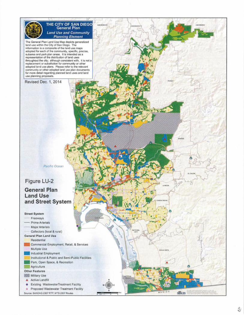
11 THE CITY OF SAN DIEGO General Plan
Land Use and Community Planning Element
The General Plan Land Use Map depicts generalized land use within the City of San Diego. The infonnation is a composite of the land use maps adopted for each of the community. specifoc, precise, subarea and par1< plan areas. It is intended as a representation of the distribution of land uses throughout the city; although consistent with, it Is not a replacement or substitution for community or other adopted land use plans. Please refer to the relevant community or other adopted land use plan documents for more detail regarding planned land uses and land use planning proposals.
Revised Dec. 1, 2014
Pactfic Ocean
Figure LU-2
General Plan Land Use and Street System
Street System
- Freeways
-- Prime Arterials
- - Major Arteria ls
Collectors (local & rural)
General Plan L and Uso
Residential
Commercial Employment, Retail, & Services
Multiple Use
• Industrial Employment
Institutional & Public and Semi-Public Facilities
• Park, Open Space, & Recreation
Agriculture
Other Features
Military Use
• Active Landfill
• Existing WastewaterTreatment Facility
Proposed Wastewater Treatment Facility
Source: SANDAG 2007 RTP; MTS 2007 Routes
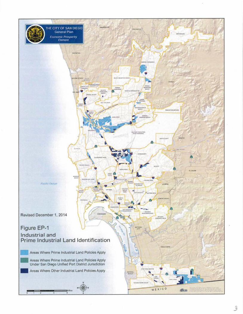
Revised December 1, 2014
Figure EP-1 Industrial and Prime Industrial Land Identification
Areas Where Prime Industrial Land Policies Apply
• Areas Where Prime Industrial Land Policies Apply Under San Diego Unified Port District Jurisdiction
• Areas Where Other Industrial Land Policies Apply
!1111-===!11---====!.Mileo B
w
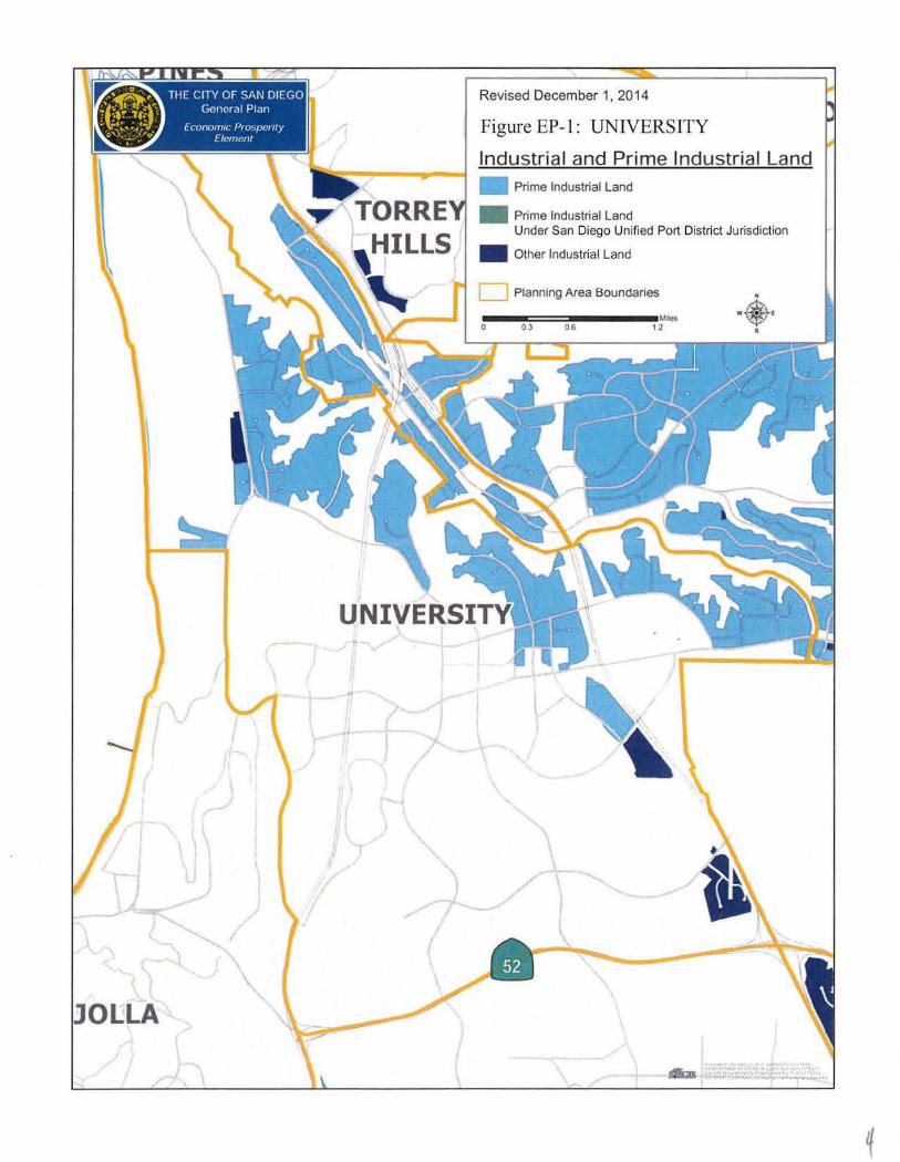
THE CITY OF SAN DIEGO General Plan
Econom1c Prospemy Element
Revised December 1, 2014
Figure EP-1: UNIVERSITY
Industrial and Prime Industrial Land
• Prime Industrial Land Under San Diego Unified Port District Jurisdiction
• Other Industrial Land
•
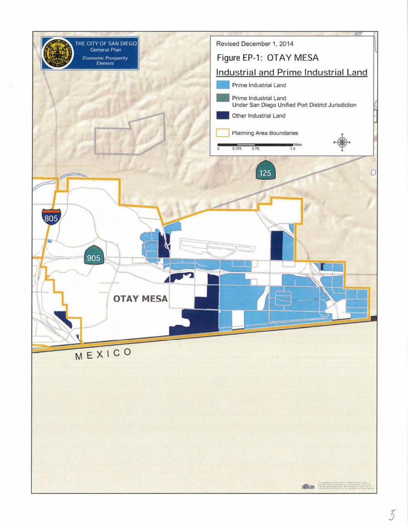
Revised December 1, 2014
Figure EP-1 : OTA Y MESA
Industrial and Prime Industrial Land • Prime Industrial Land
• Prime Industrial Land Under San Diego Unified Port District Jurisdiction
• Other Industrial Land
[__ Planning Area Boundanes
~-11:==::1111111111---•Mies 0 0.375 0.75 , 5
3
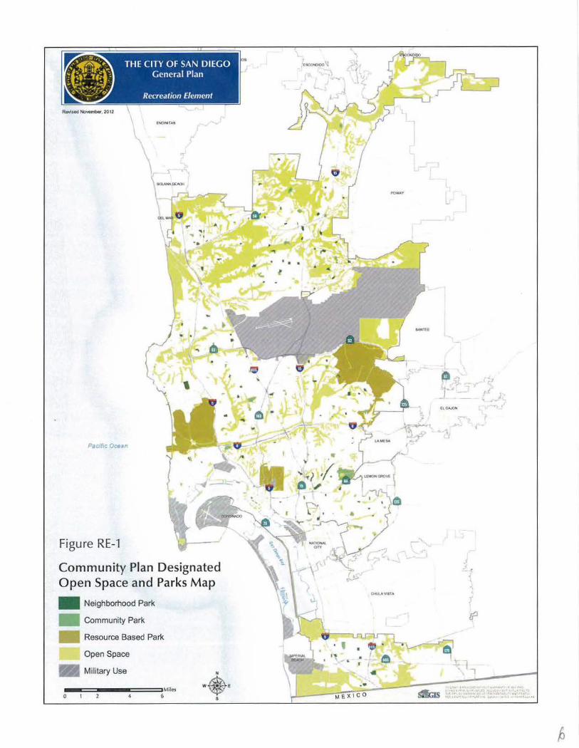
Rovlsod November, 2012
Pa c ftc Ocean
Figure RE-1
Community Plan Designated Open Space and Parks Map
• Neighborhood Park
Community Park
Resource Based Park
Open Space
Military Use
--==----===Miles 0 6
POWAY
ENTITLEMENTS DIVISION (619) 446·5460
REVISED FINAL
PROGRAM ENVIRONMENTAL IMPACT REPORT
Project No. 104495 SCHNo. 2006091032
SUBJECT: DRAFT GENERAL PLAN: CITY COUNCIL ADOPTION OF THE DRAFT GENERAL PLAN. The City of San Diego Draft General Plan is prOposed to replace the existing 1979 Progress Guide and GeneratPian (1979 General Plan). The General Plan sets out a long:-range, comprehensive framework for how the city will gtow and develop, provide public services arid maintain the qualities that define Sail Diego over the next 20-30 years. :The proposed update has been guided by the City of Villages growth strategy and citywide policy direction contained within the General Plan Strategic Framework Element (ad. opted by the City'Coi.irtcilon October 22, 2002). · The Draft General Plan is colnprised Of an intrqdtictoty Strategic ·Framework chapter and nine eleinentsd::and Use and Coinmuriity Plaririing; Mobility; Urban Design; Economic Prosperity; Public Facilities, Services and Safety; Recreation; Consel'V~tion; Noise; and Historic Preseriation. The update to the Housing Element was adopted by 'the City Council under separate- cover on December 5, 2006. Applicant: City Planning arid Community Investment Departinent · ·
DECEMBER 2008 UPDATE: ...
The Final PEIR has been updated to include revisions to the General Plan policies adopted by the City Council o'n March 2008. Copies of the Final PEIR. errata pages showing the March 2008 revisions in strikeout/underline format are available upon request.
SEPTEMBER 2007 UPDATE:
In response to comments made on the Draft General Plan PEIR during the public review period, the City has uridertak~'n the follo-wing actions to reduce the GHG emissions of future development and City operations under the General Plan·and meet its obligations under CEQA to mitigate the cumulatively significant global warming
impacts ofthe General Plan: (1) modify the policy language of the October 2006 Draft General Plan to expand and strengthen climate change policies; (2) ensure that policies to reduce greenhouse gas (GHG) emissions are imposed on future development and City operations by incorporating them into the Mitigation Monitoring and Reporting Program (MMRP) for the Final EIR; and (3) initiate work on a General Plan Action Plan to identify measures such as new or amended regulations, programs and incentives to implement the GHG reduction policies.
Based on this approach, the Conservation Element of the General Plan has been revised to: incorporate an overview of climate change; discuss existing state and City actions to address climate change impacts; and establish comprehensive policies that would reduce the GHG emissions of future development, the existing community-at-large, and City operations. A key new Conservation Element policy is to "reduce the City's carbon footprint" and to "develop and adopt new or amended regulations, programs and incentives as appropriate to implement the goals and policies set forth" related to climate change (CE-A.2). Additional policies have been added to "colla_borate with climate science experts" to allow informed pul;Jlic decisions (CE-A.3) arid to "regularly monitor· and update the City's Climat~ Protection Action Plan (CE-A.13)." The overall intent ofthese new policies is to unequivocally support climate protection actions, while retaining flexibility in. the design of implementation ¥Jeasures which could be influenced by technological advances, environD,Iental conditions, state and federal legislation, or other factors.
In addition, the Draft General Plan Land Use and Community Planning; Mobility; Urban Design-; and PublicFacilities,Services, and S~fety elements have been edited to better support GHG re.duction and clim_ate change ~daptation goals. These elements contain policy language related to sustainable land use patterns, altermi.tive modes of transportation,. energy-,efflciency, water supply, and GHG emissions associated with landfills. The Draft General Plan also calls fOr the City to employ sustainable building techniques, minimize energy use, maximize waste reduction and diversion, and implement water conservation measures. By adding these comprehensive policies into
· the Draft General Plan and MMRP and identifying Action Plan measures to implement these policies, the City has incorporated the principal objectives of the environmentally superior Enhanced Sustainability Alternative into the Draft General Plan~ Furthermore, the addition of Policy ME~G.S to the Mobility Element to "implement parking strategies that are designed to help _reduce the number and length of ... automobile trips ... " implements the principal objective oftheincreased Parking Management Alternative. · ·
The Mitigation, Monitoring and Reporting Program (MMRP) containing a list of the General Plan policies which provide mitigation at the program level can be found in Section 9 of this PEffi. The revisions and/or information added to the draft PEIR, with the exception.of~he Section 9 ~' a:t:e showQ in standard strikeout/underline format. Per CEQA Section 15088.5 (b) the addition of new information which clarifies or amplifies does no.t require redrculatiop._ pf an :Em. ·
2
(,-.,_ . ·;-
··-
CONCLUSIONS:
This Program Environmental Impact Report (PEIR) analyzes the environmental impacts cif the proposed Draft General Plan Project. The proposed Draft General Plan and this PEIR will be considered for adoption by the San Diego City Council. Prior to the City Council hearing, the adoption process also requires that the Planning Commission hold a noticed public hearing. Based on the outcome of the hearing, the Planning Commission is required to forward a written recommendation to the City Council addressing the adoption of the General Plan.
The review ·and formal recommendation by the Planning Commission and adoption of the Draft General Plan by the City Council are the discretionary actions addressed in this PEIR. Since the General Plan is a citywide comprehensive policy-level dbcument, future actions will be required for its implementation. The future actions include, but are not limited to the adoption/approval of the following: community plan updates, public facilities financing plan updates, land development code amendments, applicable ordinances, development of a park master plan, development of a pedestrian master plan, an update to the bicycle master plan, an update to the City's Economic Development Strategic Plan, development projects, and Capital Improvement Program (CIP) projects.
For each environmental issue area analyzed, a Mitigation Framework which identifies the means by which potentially significant impacts could be reduced or avoided in cases where the EIR analysis determined such impacts to be potentially significant, was included. Standard existing regulations, requirements, programs, and procedures that .are applied to all similar projects were taken into account in identifying additional project specific mitigation that may be needed to reduce identified significant impacts;
SIGNIFICANT.UNMITIGATED IMPACTS:
Agricultural Resources
Implementation of the Draft General Plan could result in significant impacts to agricultural resources due to the potential for development consistent with General Plan policies to conflict with agricul:tural productivity or with existing agricultural resources. Mitigation for impacts to agricultural resources would occur at the project level and may involve . preservation of important agricultural lands or the establishment of buffers between new uses and existing adjacent agricultural uses.
Mitigation for project~specific impacts is not available at the Program EIR level since specific development projects are not known. Therefore, the impact to agricultural resources is significant and unavoidable.
Air Quality
Implementation of the Draft General Plan could result in significant impacts to air quality. Specifically, particulate matter from construction and concentrated carbon monoxide (CO)
3
"hot spots" would be significant and unavoidable at the program level. Greenhouse gas emissions would also be significant and unavoidable. In general, compliance with goals, policies, and recommendations enacted by the City combined with the federal, state and local regulations would preclude or reduce air quality impacts. Compliance with the standards is required of all projects and is not considered to be mitigation. However, it is possible that for c~rtain projects, adherence to the regulations may not adequately protect air quality, and such projects would require additional measures to avoid or reduce significant air quality impacts. These additional measures would be considered mitigation.
For each future project requiring mitigation (i.e., measures that go beyond what is required by existing regulations), site~specific measures will be identified that reduce significant project-level impacts to less than significant or the project level impact may remain . significant and unavoidable where no feasible mitigation exists. Where mitigation is determined to be necessary and feasible, these measures will be included in a Mitigation Monitoring and Reporting Program (MMRP) for fhe project. Because the degree of impact and applicability, feasibility, and success of these measures cannot be adequately known for each specific project at this program level of analysis, the program level impact related to deterioration of ambient air quality remains significant and unavoidable.
Biological Resources
Implementation ofthe Draft General Plan could result in significant impacts to biological resources. Specific project impacts to biological resources will be addressed through existing regulations: development projects must be designed to minimize impacts to natural habitats consistent with City plans and ordinances. Biological mitigation for upland impacts must be in accordance with the City's Biology Guidelines, Table 3.3.4. Development projects must provide for continued wildlife movement through wildlife corridors as identified in the MSCP Subarea Plan or as identified through project-level analysis. For all projects adjacent to the MHPA, the development must conform to all applicable MHPA Land Use Adjacency Guidelines (Section 1.4.3) of the MSCP Subarea Plan. Also, individual project mitigation measures may include, but are not limited to, provision of appropriately-sized bridges, culverts, or other openings to allow wildlife movement. The City can also require developers to schedule the construction of projects to avoid impacts to wildlife (e.g., avoid the breeding season for sensitive species) to the extent practiCable, and can determine appropriate noise attenuation measures-as it affects sensitive-avian-species, post construction, to reduce noise levels at the edge of occupied habitat. Lastly, the City requires the protection of wetlands and vernal pools and the prevention of disturbances to native vegetation to the extent practicable.
Mitigation for project-specific impacts is not available at the Program EIR level since specific development projects are not known. Therefore, the impact to biological resources remains significant and unavoidable.
Geologic Conditions
Implementation of the Draft General Plan could result in significant impacts to geologic conditions. Future development consistent with the General Plan may result in an increase in the number of people and buildings exposed to seismic ground~shaking. Potential effects from surface rupture and severe groundshaking could cause damage ranging frcim minor to catastrophic. Groundshaking could also cause secondary geologic hazards such as slope failures and seismically-induced settlement. This is considered a potentially significant impact.
Slope failure results in landslides and mudslides from unstable soils or geologic units. Given that future development would occur in the course of implementing the Draft General Plan; it is anticipated that some of this development would be constructed on geologic formations susceptible to slope failure, thereby increasing the risk to people and structures. This is considered a potentially significant impact.
Future development that is on or in proximity to areas with steep s·lopes could increase erosion potential. Therefore, there is potential for a significant and unavoidable impact associated with erosion.
Future development may be proposed in areas prone to landslides or where soil limitations (i.e. those prone to liquefaction, subsidence, collapse, etc.) present a hazard to people~ This is considered a potentially significant impact
Adherence to regulations and engineering design specifications are generally considered to preclude significant geologic impacts, and no mitigation i:S proposed at this program level of review. Goals, policies, and recommendations enacted by the City combined ~ith the federal state and local regulations described above provide a framework for developing project level measures for future projects. Through the City's project review process compliance with standards is required of all projects and is not considered to be mitigation. However, it is possible that for certain projects, adherence to the regulations may not adequately protect against geologic impacts and such projects would tequire additional measures to avoid or reduce impacts. These additional measures would be considered for future projects requiring mitigation (i.e., measures that go beyond what is required by existing regulations). Where mitigation is determined to be necessary and feasible, these measures will be included in a Mitigation Monitoring and Reporting Program (MMRP) for the project. General measures that may be implemented to preclude project level impacts inciude preparation of soil and geologic conditions surveys, implementation ofStat"e se1smic and structural design requirements, and grading techniques that reduce landslide and erosion hazard impacts.
Implementation of mitigation measures would reduce potential impacts. However, since the Draft General Plan does not include specific development projects, it is infeasible at the Program EIR level tci provide project-specific mitigation that would reduce impacts to a less than significant level. Therefore, there is a potential for a significant and unavoidable impact associated with geologic hazards, erosion, and unstable geology and soils.
Health and Safety
Implementation of the Draft General Plan could result in significant impacts to health and safety. The potential for exposure of sensitive receptors to health hazards and wildfires will remain significant and unavoidable at the program level. Impacts associated with flooding, seiche, tsunami and mudflows, as well as potential conflicts with emergency operations plans, are expected to be precluded. Implementation of the General Plan policies that address airport land use compatibility support the development of future uses that are consistent with the adopted ALUCP and will ensure that the health and safety impact of off-airport aircraft accidents is precluded.
The City implements the adopted Airport Land Use Compatibility Plans (ALUCPs) with the Airport Environs Overlay Zone (AEOZ). The AEOZ boundaries cover less area than the boundaries of the airport influence area, which could allow the development of future projects that could pose a potentially significant impact to health and safety outside ofthe AEOZ boundaries. The City will continue to submit discretionary projects within the airport influence area for each airport in the City with an adopted ALUCP to the ALUC for consistency determinations. The City will work with the Airport Authority to identify to the types of ministerial projects within airport influence areas to submit to the ALUC for consistency determinations. The City will continue to submit development projects up until the time when the ALUC adopts the updated ALUCPs and subsequently determines that the City's affected land·use plans, development regulations, and zoning ordnances are consistent with the ALUCPs.
The FAR Part 77 imaginary surfaces extend beyond the boundaries ofthe Airport Influence Area and the adopted zoning ordinanqes and development regulations could cause the development of future structures that could pose a potentially significant impact to health and safety. The City will inform project applicants when proposed projects meet the Part 77 criteria for notification to the FAA as identified in City of San Diego Development Services Department Information Bulletin 520. The City will not approve ministerial projects that require FAA notification without a FAA determination of"No Hazard to Air Navigation" for the project. The City will not recommend approval for discretionary projects that require FAA notification without a FAA determination of ''No Hazard to Air Navigation" for the project until the project can fulfill state and ALUC requirements. - .. . .. . .
Mitigation measures that could decrease the identified health and safety impacts at the project level include the following: future projects that locate non~residential employment uses in proximity to residential development, or vice versa, must be sited and designed in a manner that reduces or avOids potential health and safety incompatibility impacts. Prior to the approval of any entitlement, the City would evaluate the project in light of the Conversion/Collocation Suitability Factors (located in Appendix C of the Draft General Plan), which would be used to analyze compatibility of site specific proposals. Additionally, future projects located in known High Fire Hazard Areas must be sited and designed to minimize impacts of fire. Prior to approval of any entitlement for a future project, the City would ensure that any impacts from wildfire or landslides will be reduced and, if necessary, .
( "·· ~ -/f
mitigated in accordance with the requirements of the City of San Diego. ()
Historical Resources
Implementation of the Draft General Plan could result in significant impacts to historical resources associated with the built environment through substantial alteration, relocation, or demolition of historic buildings, structures, objects, landscapes, and sites and to important archaeological sites that occur on property proposed for development, including construction activities, such as grading and excavation. Additionally, the potential for encountering human remains during construction development activities is possible and impacts to human remains as a result of the Draft General Plan may occur. Although future development in accordance with the General Plan could have a significant impact on historical resources, adoption of the Plan would not, in and of itself, have a significant impact. In fact, the emphasis placed by the General Plan on conserving historical resources and integrating the protection of historical resources into the broader planning process would reduce impacts to historical resources that may have otherwise occurred with future projects could result in significant impacts. Measures incorporated into future projects can reduce potential impacts to historical resources. As part of the discretionary review of development projects, steps are taken to identify and mitigate significant impacts to historical resources.
Although significant impacts to historical resources may be mitigated through review of discretionary projects, project-specific mitigation at the Program EIR level is not available since specific development projects are not known. Therefore, the impact to historical resources is significant and unavoidable.
Hydrology
Implementation of the Draft General Plan could result in .significant impacts to hydrology. Th~ Draft General Pl<~.n calls for future growth tq be focused into mixed-use activity centers. Implementation ofthe Plan would result in infill and redevelopment ocqurring jn selected built areas, which would be identifie~ through the community plan update/amendment process. The General Plan would also guide the development ofremaining developable vac_cu1t land. Redevelopment and infill developme11t could have impacts on existing absorption rates, drainage patterns, or the rate of surface runoff. Mitigation ofthese impacts can be addressed through project review. At this time, no specific projects have been proposed, and therefore it is not possible to propose feasible mitigation measures to reduce project-level impacts. Future projects must be sited and designed to minimize impacts to absorption _rates, drainage patterns,· and rates of surface runoff in accordance with City requirements and other appropriate agencies including the San Diego Regional Wat_er Quality Control Board. Such siting and design may include implementation of the mitigation framework measures identified for impacts to Water Quality.
It is infeasible in this program level EIR to provide project-specjfic mitigation that would reduce any further impacts to a less than significant level. As such, significant unavoidable impacts related to absorption rates, drainage patterns, or rates of surface runoff remain.
7
Land Use
Implementation of the Draft General Plan could result in significant impacts to land use related to General Plan conflicts with goals in other adopted plans, incompatible land uses, and physically dividing communities. Existing and future regulations will provide development standards aimed at reducing land use incompatibilities. Currently, a Community Plan update program is being established to help ensure that the City's community plans are consistent with the General Plan, and that they serve as an effective means to implement citywide environmental policies and address policies related to Airport Land Use Plans. Future projects must also be implemented to ensure that they do not conflict with the General Plan and applicable community plans resulting in a physical impact on the environment. Prior to the approval of any entitlement, the City would evaluate whether proposed projects implement specified land use, density/intensity, design guidelines, Airport/Land Use Compatibility Plans, and other General Plan and community plan policies including open space preservation, community identity, mobility, and the timing, phasing, and provision of public facilities.
Because the degree of future impacts and applicability, feasibility, and success of future mitigation measures cannot be adequately known for each specific future project at this program level of analysis, the program-level impacts related to conflicts with goals in adopted plans; incompatible land uses; and that may physically divide established communities remains significant and unavoidable.
Mineral Resources
Implementation ·of the Draft General Plan could result in significant impacts to mineral resources. These impacts may occur when access to important mineral resources is restricted or prohibited through development oflands containing the resource or when non-compatible land uses are developed in close proximity thereby reducing the likelihood for extraction of those resources. No Mitigation Measures are available at the Program EIR level of review that could reduce project-specific significant impacts to important mineral resources. Thus, there is a potential for significant unavoidable impacts related to mineral resources.
Implementation of the Draft General Plan could yield significant noise impacts including short-term noise impacts to noise-sensitive land uses located adjacent to construction sites and long-term noise impacts associated with transportation improvements that increase the rate of use of buses and trains which can generate more noise per vehicle, development of commercial and industrial land uses which could result in the generation of unacceptable noise levels, and special civic or entertainment events held at various locations that have the potential to generate significant noise levels and adversely affect nearby sensitive receptors and land uses. The increase in population growth and increased economiC and development activity in the City as a result of implementation of the General Plan has the potential to
increase noise generated by various transportation modes, stationary sources and related activities affecting both human and wildlife receptors. Implementation of the Draft General Plan could potentially locate multifamily residential land uses above the 65 dBA CNEL (except for aircraft noise in the Brown Field, Montgomery Field, MCAS Miramar Airport Influence Areas) including SDIA influence area where allowed by the Airport Land Use Compatibility Plan, and therefore subject them to a higher level of existing and future noise.
In order to mitigate these impacts, future development projects in areas where the existing or future noise level exceeds or would exceed the compatible noise level thresholds, as indicated in the Land Use Compatibility for Community Noise Environment Table (Table 3.1 0-6), must perform an acoustical study consistent with Acoustical Study Guidelines (Table NE-4 in the Draft General Plan), so that appropriate noise mitigation measures are included in the project design to meet the noise guidelines. Also, future projects must be sited and designed in a manner that avoids nois"e impacts to noise-sensitive land uses (e.g., residences, hospitals, schools, and libraries) and sensitive receptors. Where uses; particularly habitable structures, are planned near noise-generating sources, future projects must use a combination of architectural treatments or alternative methods to bring interior noise levels to below 45 dBA. Future development projects that are located in an Airport Influence Area must use appropriate noise attenuation methods recommended in the appropriate Airport Land .Use Compatibility Plans in order to meet acceptable interior noise levels for the use and aviation easements where required. All non-emergency construction activjty for future projects must comply with the limits (maximum noise levels, hours and days of activity) established in state and City noise regulations ..
Although the General Plan PEIR identifies Mitigation Framework Measures to reduce these program level impacts, the degree of impact and applicability, feasibility, and success of these measures cannot be adequately known for each specific project at this program level of analysis. Therefore, the program level noise impact related to adoption of the Draft General Plan remains significant and unavoidable.
Paleontological Resources
Implementation of the Draft General Plan could result in significant impacts to paleontological resollorces through the loss of significant fossil resources through development consistent with the General Plan. Although steps are taken to identifY and mitigate significant impacts to paleontological resources as part of the discretionary review of development projects, mitigation for the proposed project is not available. Ad!iitionally, impacts at the project level for non-discretionary projects would not be mitigated due to a lack of regulatory language in the land development code requiring protection of paleontological resources. Although mitigation measures would reduce impacts, it is infeasible at this Program EIR level to provide more project-specific mitigation that would· reduce impacts to a less than significant level, since specific development projects are not known. Thus, the impact to paleontological resources is considered significant and unavoidable.
Population and Housing
Implementation of the Draft General Plan could result in significant impacts to population and housing. Some displacement of residents is likely to occur as older housing units are replaced. As areas redevelop, older housing units, and in some cases more affordable housing units will be replaced by higher cost housing units. Low-income households are most likely to be adversely affected. This could result in displacement and relocation of people away from the City and the region in search of more affordable housing. Ifthe displacement necessitates construction of some replacement housing in the City and/or region, the construction may result in significant CEQA impacts. In some instances, people will have access to City programs providing housing assistance. Potential future project conditions could include: provision of on-site affordable housing, or affordable housing within the neighborhood in which the project is being built; provision of affordable housing targeted to very low-income households; and/or other tailored strategies designed to address specific neighborhood goals and priorities.
However, many of the programs are limited and not available in every area of the City. Since no specific development projects have been identified, it is infeasible at this Program EIR level to provide project-specific mitigation that would reduce impacts to a less than significant level. Therefore, displacement of substantial numbers residents necessitating the construction of replacement housing is considered a significant and unavoidable impact at this program level of review.
Public Facilities
Implementation of the Draft General Plan could result in significant impacts related to the construction of new or altered public facilities. No specific projects or actions have been identified with the Draft General Plan that would result in any direct or indirect physical . change in the environment. However, future growth is anticipated and the construction of future public facilities needed to support that growth may result in environmental impacts. The need for new or upgraded facilities is addressed through the various means the City uses to fund the capital and operating expenses related to public facilities (e.g., developer fees and City Council budget decisions). However, the. CEQA analysis. of public services and facilities in this document focuses on the physical environmental impacts that could result from the construction of new facilities or the alteration of existing facilities. It is anticipated that many of these activities would result in physical impacts. Therefore, the framework for the mitigation of public services and facilities projects will vary, depending on the type of physical impacts resulting from each project
No specific projects ot actions have been identified with the Draft General Plan that would result in any direct or indirect physical change in the environment. However, future growth is anticipated and the construction of future public facilitie.s needed to support that growth may result in environmental impacts. Future environmental analysis would be required for specific public facilities projects necessary to implement the Draft General Plan to identify associated construction-related impacts and project-specific mitigation. At this program
I 0
( ··-
' ...__)
level of review, impacts associated with the construction of public facilities are considered significant and unavoidable.
Public Utilities
Implementation of the Draft General Plan could result in significant impacts related to the construction of public utilities. No specific projects or actions have been identified with the Draft General Plan that would result in any direct or indirect physical change in the environment. However, future growth is anticipated and the construction of future public utilities needed to support that growth may result in environmental impacts. Therefore, · impacts associated with the construction of public utilities may occur and even though mitigation measures ha:ve been identified, those impacts remain significant and unavoidable.
These impacts may be mitigated through innovative project design, construction and operations to reduce stormwater pollution, energy use, and waste generation. The strategic planting of trees in quantities and locations that maximize environmental benefits such as shading, could also mitigate certain impacts. Specific city~ wide policies that apply to project review include the City's Sustainable Building Policy (900-14), which allows an expedited review time for the private sector building projects meeting LEED silver criteria. The City of Villages strategy, which is a part of the General Plan, t calls for strategic project siting, mix of land uses, and design that reduces the need to drive, thus reducing vehicle miles traveled compared to what would occur through conventional development. Additionally, the City's implementation of water and energy conservation measures is beyond what is required by local, state, and federal regulations. Additional policies within the Draft General Plan augment water supply contingency plans. The revised Draft General Plan contains strengthened and amplified policies to address the GHG emissions offuture development, and sustainable development.
Transportation/Traffic/CirculatiowParking
Implementation of the Draft General Plan could result in significant impacts to traffic. At this time, no .specific projects have been proposed, and therefore it is not possible to propose feasible mitigation measures to reduce project-level impacts. The Draft General Plan has established measures that will guide transportation development and planning in the future. Policies that address walkable communities, street and freeway system improvements, transportation demand management (TDM), bicycling, and parking management will serve to mitigate certain traffic impacts both at the project and city-wide level.
It is infeasible in this program level EIR to provide project-specific mitigation that would reduce impacts to a less than significant leveL As such, significant unavoidable impacts related to transportation, traffic, circulation, and parking remain.
I I
Visual Effects and Neighborhood Character
Implementadon of the Draft General Plan could result in significant impacts to visual effects and neighborhood character. Future discretionary actions, private development projects, and public facilities (i.e. roads, transit lines, utilities) that occur subsequent to General Plan adoption may result in significant impacts associated with changes to the landform that may occur through site-specific grading, blocked public views from development that is incompatible in shape, form or intensity, and substantially altering the existing character of the City's neighborhoods. While the Draft General Plan policies are designed to minimize such impacts, there is no guarantee that all future implementation actions and development projects will 'adequately implement Draft General Plan policies.
The policies resulting from the adoption of the Draft General Plan could avoid or reduce the potential significant impacts to topography, public views and the existing character of established communities, but possibly not to below a level of significance. In addition, future community plan updates and the existing development review process could reduce potential impacts to visual and neighborhood quality. Because the degree of impact and applicability, feasibility, and success of future mitigation measures can not be adequately known for each specific future project at this program level of analysis, the program-level impacts related to topography, public views and character remains significant and unavoidable.
Water Quality
Implementation of the Draft General Plan could result in significant impacts to water quality. Almost all pollutants found in the impaired water bodies within the City have anthropogenic (man-made) origins; therefore increasing the population could increase the amount of pollution entering the aquatic ecosystem. Redevelopment and infill activities iri urbanized areas could result in an increased amount of impervious surfaces. In addition, most development of vacant land could also decrease permeability. These impervious surfaces would result in increased runoff, adding to local non-point source pollution. Development could also cause erosion due to exposed graded surfaces, excavation, stock piling; or boring, and would potentially contribute to the sediment load in surface waters. Deposition of sediments-downstream may be significant if they are introduced into a potable water supply (reservoirs), flood control channels,.orwetlands .. Increased deposition of sediments into water bodies can result in increased turbidity, clog streambeds, degrade aquatic habitat, and interfere with flow.
Future growth and development also has the potential to create impacts to groundwater quality. Groundwater degradation takes three forms: stock depletion, contamination, and secondary problems such as land subsidence and saline intrusion.
Mitigation can be conducted at the project review level by requiring developers to increase on-site filtration, preserve/restore/incorporate natural drainage systems into site design, and direct concentrated flows away from MHPA and open space areas. To the extent feasible,
f2-
( '·· .. ··--'
r·-~. ~}
avoiding development of areas particularly susceptible to erosion and sediment loss can additionally serve as a mitigation measure.
Because the degree offuture impacts and applicability, feasibility, and success of future mitigation measures cannot be adequately known for each specific future project at this program level of analysis, the program-level impact related to water quality remains significant and unavoidable.
RECOMMENDED ALTERNATIVES FOR REDUCING SIGNIFICANT UNMITIGATED IMPACTS:
None of the project alternatives analyzed in this EIR would completely eliminate all ofthe significant impacts of the project. Selection of any ofthe project alternatives would, however, reduce the project's contribution to one or more of the significant impacts.
No Project
The No Project Alternative represents buildout under the currently adopted plans and does not represent a "no build" scenario in which no future development would occur. Under the No Project Alternative, the Draft General Plan would not be implemented and projected future growth would occur in accordance with the 1979 Progress Guide and General Plan (existing General Plan), the Strategic Framework. Element, which was adopted by the City Council in October 2002, and the City's Housing Element, which was adopted in December 2006.
The No Project Alternative Would generally meet all ofthe project objectives. Impacts associated with agricultural resources, biological resources, geologic conditions, health and safety, historic resources, hydrology, mineral resources, noise, paleontological resources, population and ,housing, public services and facilities, public utilities, visual effects and neighborhood character, and water quality would be similar compared to the Draft General Plan. Air quality, global warming, land use and traffic impacts would be greater when compared to the Draft General Plan.
Enhanced Sustainability
This alternative is analyzed as a means of further reducing the environmental effects of the Draft General Plan related to energy and water consumption, solid waste generation, water quality and air quality. Specifically, this alternative would add mandatory policies to the Draft General Plan to enhance the sustainability of future development within the plan area.
The Enhanced Sustainability alternative would meet all of the project objectives. Impacts associated with agricultural resources, biological resources, geologic conditions, health and safety, historic resources, land use, mineral resources, noise, paleontological resources, population and housing, public services and facilities,. traffic, and visual-effects and neighborhood character would be similar compared to the Draft General Plan. Air quality, global warming, hydrology, public utilities, and water quality impacts were originally
determined to be less under this alternative. However, since the City has incorporated the principal objectives of this alternative into the Draft General Plan, the Draft General Plan now approaches the level of impacts estimated to occur under the Enhanced Sustainability Alternative. This is the environmentally superior alternative to the Draft General Plan.
Increased Parking Management
This alternative expands the currently available parking management tools by expanding implementation of Community Parking Districts and permit parking districts throughout the City. This alternative would also increase parking ~eter fees and extend the hours when parking meter payment is required. The Community Parking District program allows for direct investment and benefit of the parking management revenue generated within its boundaries, thus providing a source of revenue for community infrastructure and amenities. Permit parking districts address transient and spillover parking problems by restricting onstreet parking to permit holders within a specified area. This alternative would substantially reduce free on-street parking in the City, increase parking meter fees and hours of enforcement thereby increasing the cost of parking. This would serve to reduce and or eliminate a number of automobile trips, reduce parking demand, and increase the number of multimodal trips such as carpooling, transit, walking and biking. This alternative is analyzed as a means of :further reducing the environmental effects of the Draft General Plan relating to air quality and traffic.
The Increased Parking Management Alternative would meet all of the project objectives. Impacts associated with agricultural resources, biological resources, geologic conditions, health and safety, his~oric resources, hydrology, land use, mineral resources, noise, paleontological resources, population and housing, public services and facilities, public utilities, visual effects and neighborhood character, and water quality would be similar compared to the Draft General Plan. Air quality, global warming, and traffic impacts were initially determined to be less under this alternative. However, since the City has incorporated the principal environmental objective of this altemative into the Draft General Plan, and the implementation mechanisms for the plan and the alternative would be similar (e.g. community specific parking plans and ordinance amendments), the Draft General Plan now approaches the level of impacts of the Increased Parking Management Alternative.
Concentrated Growth
This alternative is analyzed within this Program EIR as a means to focus projected growth into four subareas of the City that are served by high quality transit Global warming impacts would be greater under this alternative. Other environmental impacts would be greater in the four subareas, but would likely decrease in other areas ofthe City. Under this alternative, infill and redevelopment would be focused in the Downtown San Diego and Uptown communities; and in Urban Village Cen~ers within the Mission Valley/Morena/ Grantville, University/Sorrento Mesa, and Midway-Pacific Highway subareas to a greater extent than is envisioned under the Draft General Plan, In addition, under this
r4-
_; (---
J W'
alternative, higher density infill and redevelopment would be discouraged in Neighborhood/Community Villages and within Transit Corridors outside of the abovereferenced subareas. Due to the high cost of land and the scarcity of vacant developable land in the four subareas, it would be difficult to secure the population-based park lands needed to provide public facilities in accordance with General Plan, as compared to the Draft General Plan.
MITIGATION, MONITORING AND REPORTING PROGRAM INCORPORATED INTO THE PROJECT:
The Mitigation Framework has been revised and amplified to further clarify within the MMRP (PEIR Section 9) the General Plan policies that would provide mitigation at the program level. Since the Draft General Plan does not include specific development projects, it is infeasible at the Program EIR level to provide project-specific mitigation that would reduce any future impacts to a less than significant level. Therefore, at this program level of review there is no project-specific Mitigation, Monitoring and Reporting Program proposed and significant and unavoidable impacts associated with the project remain .
. ·~~ Jl ~J.M ·s~ Deputy Director Development Services Department
Analyst: M. Mirrasoul
RESULTS OF PUBLIC REVIEW
Apri1261 2007 Date ofDraftReport
· September 28, 2007 .. Date of Final Report
December 2008 Date of Revised Final Report·
() No comments were received during the public input period.
( ) Comments were received but the comm·ents do not address the accuracy or completeness of the environmental report. No response is necessary and the letters are attached at the end of the EIR. ·,_ ·
(X) Comments addressing the accuracy or completeness of the EIR were received during the public input period. The letters and responses are located in AppendiX C of this document. ·
-------···-
PUBLIC REVIEW:
The following individuals, organizations, and agencies re.ceived a copy or notice of the draft Effi. and were invited to comment on its accuracy and sufficiency.
Federal Agencies Federal Aviation Administration (1) U. S. Fish and Wildlife Service (23) U. S. Army Corps ofEngineers (26) U. S. Department of Agriculture (25)
Military · Naval Facilities Engineering Command, SW Division, Environmental Planning (12) MCAS Miramar (13)
State of California
Departments Department of Justice, Attorney General Edmund G. Brown Department of Transportation, District 11 (33) Department of Fish and Game (32) Department ofParks and Recreation (40) Department of Parks and Recreation, Office ofHistoric Preservation (41) Department of Housing and Community Development (38) Department of Toxic Substances Control (39) Department of Co.n,seryation (60) Department of Water Resources (45) Department ofB6ating and Waterways (52) Office of Planning and Research (57)
State Clearinghouse ( 46A)
Agencies Resources Agency ( 43) Regional Water Quality Control Board, Region 9 (44) California Environmental Protection Agency (3 7)
Commissions/Boards California Coastal Commission ( 4 7) Native American Heritage Commission (56) California State Lands Commission (62) California Energy Commission (59) California Public Utilities Commission California Integrated Waste Management Board (35) California State Coastal Conservancy (54)
Universities University of San Diego (251) San Diego State University (455) University of California, San Diego (134)
San Diego County
~' C·,
.;!
Department of Planning and Land Use (68) Department of Environmental Health (75 &76) Department of Parks and Recreation (69) Department of Agriculture (64) Department of Education (66) Department ofPublic Works (72)
City of San Diego
Elected Officials Mayor Sanders Council President Peters, District 1 Co'uncilmember Faulconer, District 2 Councilmember Atkins, District 3 Couneilmember Young, District 4 Councilmember Maienschein, District 5 Councilmember Frye, District 6 Councilmember Madaffer, District 7 Councilmember Hueso, District 8 City Attorney Aguirre, Shirley Edwards
Departments Development Services Department
Noise Analysis (82)- Werner Landry LDR Engineering (MS 501)- Don Weston LDR BAS (MS 501)- Marilyn Mirrasoul LDR Landscaping (MS 501)- Christine Rothman LDR Floodplain (MS 501)- Steve Lindsay LDR Planning (MS 501)- Anna McPherson LDR Transportation (MS 501)- Labib Qasem, Victoria Huffman, Ann Gonsalves LEA (MS 606L)- Bill Prinz
Park and Recreation Department (89)- Deborah Sharpe Park Development (93)- JeffHarkness
Environmental Services Department (MS 11 02A)- Lisa Wood Water Department (MS 906) - George Adrian Metropolitan Wastewater Department (MS 922)- Mehdi Rastakhiz Library Department (81)- Mary Ann Tilotta Fire-Rescue Department (MS 603) - Javier Mainar, Assistant Fire Chief Police Department (MS 71 0)- Darryl Hoover, Sergeant City Planning & Community Investment Department (MS 5A)
MSCP Reviewer (5A)- Jeanne Krosch Facilities Financing (.MS 606F) - Charlene Gabriel
Governmental Relations Department (MS 51 M) Neighborhood Code Compliance (MS 51N) Real Estate Assets Department (85) Engineering and Capital Projects Department (86)
City Agencies San Diego Housing Commission (MS 49N) City of San Diego Redevelopment Agency (MS 904) Centre City Development Corporation (MS 51 D) Southeastern Economic Development Corporation (SEDC) ( 448)
17
San Diego Regional Economic Development Corporation
Commissions Commission for Arts and Culture (MS 652) Library Commission (MS 17) Planning Commission (MS 401)
Advisory Boards San Diego Park and Recreation Board (MS 37C) Small Business Advisory Board (MS 904) Historical Resources Board (87) Wetland Advisory Board (91A) . La Jolla Shores PDO Advisory Board (279)
Advisory Committees Mission Bay Park Committee (320) Balboa Park Committee (MS 35) Airports Advisory Committee (MS 14)
Libraries Balboa Branch Library (81B) Beckwourth Branch Library (81 C) Benjamin Branch Library (810) Cannel Mountain Ranch Branch (81E) Carmel Valley Branch Library (81F) City Heights/Weingart Branch Library (81G) Clairemont Branch Library (81H) College-Rolando Branch Library (81I) Kensington-Normal Heights Branch Library (81K) La Jolla/Riford branch Library{81L) Linda Vista Branch Library (81M) Logan Heights Branch Library (81 N) Malcolm X Library & Performing Arts Center (810) Mira Mesa Branch Library (81P) Mission Hills Branch Library (81 Q) Mission Valley Branch Library (81R) North Clairemont Branch Library (81 S) North Park Branch Library (81 T) Oak Park Branch Library (81 U) Ocean Beach Branch Library (81 V) Otay Mesa-Nestor Branch Library (81 W) Pacific Beach/Taylor Branch Library (81 V) Paradise Hills Branch Library (81 Y) Point Loma/Hervey Branch Library (81Z) Rancho Bernardo Branch Library (81AA) Rancho Pefiasquitos Branch Library (81BB) San Carlos Branch Library (81DD) San Ysidro Branch Library (81EE) Scripps Miramar Ranch Branch Library (81FF) Serra Mesa Branch Library (81 GG) Skyline Hills Branch Library (81IDI) Tierrasanta Branch Library (81 II)
University Community Branch Library (81JJ) University Heights Branch Library (81K.K) Malcolm A: Love Library (457)
Community Service Centers Clairemont (274) · Navajo (337) Peninsula (3 89) Rancho Bernardo (399) San Ysidro (435) Scripps Ranch (442)
Other Cities City of Chula Vista (94) City of Coronado City of Del Mar (96) City ofEl Cajon (97) City of Escondido (9 8) City oflmperial Beach (99) City ofLa Mesa (100) City ofLemon Grove (101) City ofNational City (102) City ofPoway (103) City of Santee (1 04) City of Solana Beach (1 05)
Native Americans ·Ron Christman (215) .Louie Guassac (215A) Clint Linton (215B) Kumeyaay Cultural Repatriation Committee (225) Native American Bands and Groups (225A- Q) Other Agencies San Diego Association of Governments (1 08) San Diego Transit Corporation (112) Sempra (114) Metropolitan Transit Systems (115) San Diego County Regional Airport Authority (110) Local Agency Formation Commission (LAFCO) (111) Otay River Park Joint Powers Authority 5201 Ruffin Road, Suite P, San Diego, CA 92123 San Dieguito River Park Joint Power Authority (425A) County Water Authority (73) Air Pollution Control District (65) . San Diego Unified Port District (1 09)
Community Groups, Associations, Boards, Committees and Councils Community Planners Committee ( 194)
Community Planning Groups Centre City Advisory Committee (243) Otay Mesa -Nestor Planning Committee (228)
Otay Mesa Planning Committee (23 5) Clairemont Mesa Planning Committee (248) Greater Golden Hill Planning Committee (259) Serra Mesa Planning Group (263A) Kearny Mesa Community Planning Group (265) Linda Vista Community Planning Committee (267) La Jolla Community Planning Association (275) · City Heights Area Planning Committee (287) Kensington-Talmadge Planning Committee (290) Normal Heights Community Planning Committee (291) Eastern Area Planning Committee (302) Midway Community Planning Advisory Committee (307) Mira Mesa Community Planning Group (31 0) Mission Beach Precise Planning Board (325) Mission Valley Unified Planning Organization (331) Navajo Community Planners Inc. (336) Carmel Mountain Ranch Community Council (344) Carmel Valley Community Planning Board (350) Del Mar Mesa Community Planning Board (361) Greater North Park Planning Committee (363) Ocean Beach Planning Board (367) Old Town Community Planning Committee (368) Pacific Beach Community Planning Committee (375) Rancho Peiiasquitos Planning Board (380) Peninsula Community Planning Board (390) Rancho Bernardo Community Planning Board (400) Sabre Springs Community Planning Group ( 407) San Pasqual- Lake Hodges Planning Group (426) San Ysidro Planning and Development Group (433) Scripps Ranch Community Planning Group (437) Miramar Ranch North Planning Committee (439) Skyline- Paradi;,;e Hills Planning Committee (443) Torrey Hills Community Planning Board (444A) Southeastern San Diego Planning Committee ( 449) Encanto Neighborhoods Community Planning Group (449A) College Area Community Council ( 456) Tierrasanta Community Council ( 462) Torrey Pines Commtmity Planning Group ( 469) University City Community Planning Group ( 480) Uptown Planners ( 498)
Town/Community Councils Clairemont Town Council (257) Serra Mesa Community Council (264) Rolando Community Council (288) Oak Park Community Council (298) Webster Community Council (301) Darnell Community Council (306) · La Jolla Town Council (273) Mission Beach Town Council (326) Mission Valley Community Council (328 C) San Carlos Area Council (338)
Ocean Beach Town Council, Inc. (376 A) Pacific Beach Town Council (374) . . Rancho Penasquitos Community Council (378) Rancho Bernardo Community Council, Inc. (398) Rancho Penasquitos Town Council (383) United Border Community Town Council (434) San Dieguito Planning Group ( 412) Murphy Canyon Community Council (463)
Community Associations/Committees North Park Community Association (366) Normal Heights Community Center (293) Normal Heights Community Association (292) La Jollans for Responsible Planning (282) Mission Hills Association (327) La Jolla Shores Association (272) Southeastern San Diego Development Committee ( 449) Arroyo Sorrento Homeowners Association (356) Burlingame Homeowners Association (364) Crown Point Association (376) Torrey Pines Association (379) The San Dieguito Lagoon Committee ( 409) Scripps Ranch Civic Association ( 440) Torrey Pines Association (472) Crest Canyon Citizens Advisory Committee (475) University City Community Association (486) Hillside Protection Association (501) Allen Canyon Committee (504)
Redevelopment Project Area Committees Barrio Logan Crossroad College Community City Heights North Park North Bay
Other Interested Parties San Diego Apartment Association (152) San Diego Chamber of Commerce (157) Building Industry Association/Federation (158) San Diego River Park Foundation (163) Sierra Club (165) San Diego Natural History Museum (166) San Diego Audubon Society (167, 167 A) California Native Plant Society (170) Center for Biological Diversity (176) San Diego River Conservancy ( 168) Environmental Health Coalition (169) Endangered Habitats League (182 & 182A) Carmel Mountain Conservancy (184) Torrey Pines Association (186)
21
AIA (190) League ofWomen Voters (192) Carmen Lucas (206) Dr. Jerry Schaefer (208A) South Coastal Information Center (210) San Diego Historical Society (211) San Diego Archaeological Center (212) Save Our Heritage Organisation (214) San Diego County Archaeological Society Inc. (218) La Jolla Historical Society (221) University of San Diego (251) Tecolote Canyon Citizens Advisory Committee (254) Friends ofTecolote Canyon (255) Tecolote Canyon Rim Owner's Protection Association (256) Marian Bear Natural Park Recreation Council (267 A) UCSD Natural Reserve System (284) Friends ofthe Mission Valley Preserve (330) Mission Trails Regional Park Citizens Advisory Committee (341) Los Pefiasquitos Canyon Preserve Citizens Advisory Committee (360) Friends ofRose Canyon (386) Pacific Beach Historical Society (3 77) Sunset Cliffs Natural Park Recreation Council (388) San Dieguito Lagoon Committee ( 409)
. San Pieguito River Park CAC ( 415) San Dieguito River Valley Conservancy ( 421) RVRPARC(423) Beeler Canyon Conservancy (436) Mission Trails Regional Park ( 465) Friends of Los Pefiasquitos Canyon Preserve, Inc., (313) Tijuana River National Estuarine Reserve (229) Tijuana's Municipal Planning Institute San Dieguito River Park (116) San Diego Regulatory Alert (174) League of Conservation Voters (322) Citizens Coordinate for Century III (324 A) River Valley Preservation Project (334) Friends of Adobe Falls (335) Carmel Valley Trail Riders Coalition (3 51) Carmel Mountain Conservancy (354) Friends of San Dieguito River Valley ( 419) Beeler Canyon Conservancy (436) San Diego Board ofRealtors (155) San Diego Convention and Visitors Bureau (159) CalPIRG (154) San Diego Baykeeper (173) San Diego Civic Solutions (Canyonlands) Bobbie Herdes, RECON Environmental Donna Jones, Otay Mesa Planning Coalition John Ponder, Otay Mesa Planning Coalition Everett Delano, Friends of San Diego Bruce Warren, EnvironMINE; Inc., Lee Campbell
. ( ·----
Eric Gennain Carolyn R. Thomas Randy Berkman Rebecca Robinson-Wood Stephen Haase, NAIOP
School Districts Elementary Chula Vista School District (118) Del Mar Union School District (119) Solana Beach School District (129) South Bay Union School District (130) La Mesa-Spring Valley School District (121) Lemon Grove School District (122) National City School District (123) San Ysidro School District (127) Santee School District (128)
High School San Dieguito Union High School District (126) Sweetwater Union High School District (131) Grossmont Union High School District (120)
Unified San Diego Unified School District (132) Poway Unified School District (124)
Community College Districts San Diego Community College District (133) San Diego Mesa College (268) Southwestern Community College District
General Pian EN mail Distribution List The CPCI Department maintains an emailing distribution list with over 2,000 contacts. These contacts received the public notfce via e-mail with a link to the website document.