Embed Size (px)
Citation preview


APPENDIXA Field Investigation
W:\27667021\00030-b-r.doc\10-Jun-08\SDG

APPENDIXA Field Investigation
W:\27667021\00030-b-r.doc\10-Jun-08\SDG A-1
Twenty seven small-diameter borings (designated B-1 through B-27) were performed between March 27 and April 11, 2008 to depths ranging from about 25 to 85 feet below existing grade. The borings were advanced by Pacific Drilling of San Diego, California with a Unimog Marl M5 all terrain truck mounted drill rig that utilized 6-inch or 8-inch diameter hollow stem augers. The borings were backfilled according to County of San Diego Department of Environmental Health (DEH) requirements. URS obtained approval for alternate backfill materials consisting of a 3-foot bentonite seal at the bottom of the boring followed by native soil cuttings with 2-foot bentonite seal placed every 10 feet and a surface seal placed from 1 to 3 feet below the ground surface.
Relatively intact samples were obtained from the borings with a modified California sampler lined with four-inch-long brass tubes and driven using a 140-pound hammer dropping 30 inches. Disturbed samples were obtained from the borings using Standard Penetration Test (SPT) samplers driven with a 140-pound hammer dropping 30 inches. The number of blows shown on the logs is the field blow count for the last 12 inches of penetration (or less for blowcounts greater than 50). The reported field blowcounts have not been corrected for sampler size. Bulk samples were collected in 5-gallon buckets and sealed with lids and smaller grab samples were placed in sealed plastic bags prior to transport to our laboratory.
Twenty-three test pits (designated TP-1 through TP-23) were excavated between April 15 and 18, 2008 to depths ranging from about 4 to 10 feet below existing grade. The test pits were excavated by San Diego Concrete Cutting of San Diego, California with a rubber tired, four wheel drive Komatsu WB140 backhoe with a 24 inch bucket. The upper 1.5 to 2 feet of material was removed and placed to the side of the excavation for observation by the environmental monitors on site. This upper material was then replaced on the surface of the nominally compacted backfilled excavation. Bulk and grab samples were collected by hand from the spoils pile or from the sidewalls of the trench no deeper than 5 feet below the surface. Deeper bulk and grab samples were collected using the backhoe bucket. All samples were preserved in the same manner previously described.
The materials encountered in the borings and test pits were classified in accordance with the Unified Soil Classification System. Samples were typically collected at five-foot depth intervals or changes in stratigraphy, removed from the sampler, classified in the field, sealed to preserve the natural moisture content, and returned to our laboratory for further examination and testing.
The locations of all explorations were recorded on a hand-held Global Positioning System (GPS) unit and plotted on the site plan using the topography on the conceptual grading plan provided by SDG&E. The ground surface elevation at each exploration was obtained from the plotted locations on the electronic topographic layer.
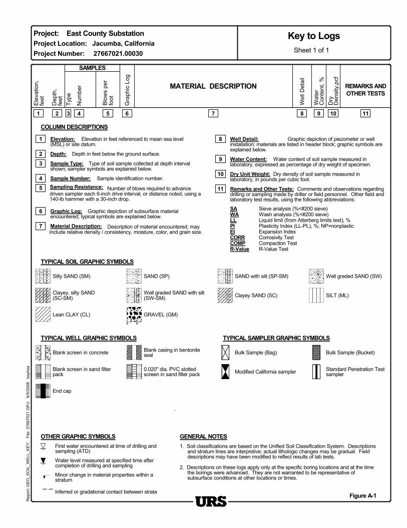
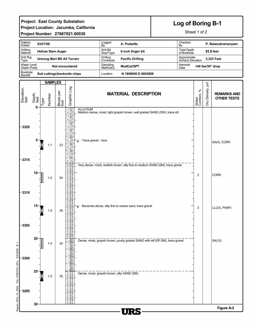
The Key to Logs is presented on Figure A-1. Logs of the borings are presented on Figures A-2 through A-28; test pit logs are presented on Figures A-29 through A-51.
8
1
4
Graphic depiction of piezometer or wellinstallation; materials are listed in header block; graphic symbols areexplained below.
3 Sample Type:
6
Number of blows required to advancedriven sampler each 6-inch drive interval, or distance noted, using a140-lb hammer with a 30-inch drop.
Remarks and Other Tests:
Elevation in feet referenced to mean sea level(MSL) or site datum.
7
Depth in feet below the ground surface.
Water level measured at specified time aftercompletion of drilling and sampling
TYPICAL SAMPLER GRAPHIC SYMBOLS
First water encountered at time of drilling andsampling (ATD)
TYPICAL WELL GRAPHIC SYMBOLS
0.020" dia. PVC slottedscreen in sand filter pack
2
GENERAL NOTES
Figure A-1
Sieve analysis (%<#200 sieve)Wash analysis (%<#200 sieve)Liquid limit (from Atterberg limits test), %Plasticity Index (LL-PL), %; NP=nonplasticExpansion IndexCorrosivity TestCompaction TestR-Value Test
8
10
7
Minor change in material properties within astratum
Sample identification number.Dry Unit Weight:
1 9
Material Description:
Water Content:
COLUMN DESCRIPTIONS
Comments and observations regardingdrilling or sampling made by driller or field personnel. Other field andlaboratory test results, using the following abbreviations:
6
Type of soil sample collected at depth intervalshown; sampler symbols are explained below.
2Water content of soil sample measured in
laboratory, expressed as percentage of dry weight of specimen.
Description of material encountered; mayinclude relative density / consistency, moisture, color, and grain size.
Sampling Resistance:
Elevation:
Sample Number:
Depth:
11
1. Soil classifications are based on the Unified Soil Classification System. Descriptionsand stratum lines are interpretive; actual lithologic changes may be gradual. Fielddescriptions may have been modified to reflect results of lab tests.
2. Descriptions on these logs apply only at the specific boring locations and at the timethe borings were advanced. They are not warranted to be representative ofsubsurface conditions at other locations or times.
Well Detail:
54
5 11
Graphic depiction of subsurface materialencountered; typical symbols are explained below.
3
SAWALLPIEICORRCOMPR-Value
Dry density of soil sample measured inlaboratory, in pounds per cubic foot.
9
10
Graphic Log:
Project: East County Substation
Dry
Den
sity
,pcf
Rep
ort:
GE
O_S
OIL
_WE
LL_K
EY
; F
ile: 2
7667
021.
GP
J;
6/5/
2008
ke
yhsa
Project Location: Jacumba, California
Inferred or gradational contact between strata
Project Number: 27667021.00030
MATERIAL DESCRIPTION
Ele
vatio
n,fe
et
Type
Wat
erC
onte
nt, %
Gra
phic
Log
SAMPLES
Blo
ws
per
foot
Num
ber
Wel
l Det
ail
REMARKS ANDOTHER TESTS
Key to Logs
Dep
th,
feet
Blank screen in sand filterpack
Clayey, silty SAND(SC-SM)
SAND (SP)
GRAVEL (GM)
Well graded SAND (SW)
Blank screen in concrete Bulk Sample (Bag)
End cap
Bulk Sample (Bucket)
TYPICAL SOIL GRAPHIC SYMBOLS
Clayey SAND (SC)
Sheet 1 of 1
OTHER GRAPHIC SYMBOLS
Standard Penetration Testsampler
Lean CLAY (CL)
Silty SAND (SM)
Well graded SAND with silt(SW-SM)
Blank casing in bentoniteseal
SILT (ML)
SAND with silt (SP-SM)
Modified California sampler
Num
ber
TypeDep
th,
feet
Blo
ws
per
footE
leva
tion,
feet
SAMPLES
MATERIAL DESCRIPTION REMARKS ANDOTHER TESTS
Gra
phic
Log
1-1
Soil cuttings/bentonite chips
3,323 Feet
Hollow Stem Auger
ApproximateSurface Elevation
Dry
Den
sity
, pcf
CORR
Wat
erC
onte
nt, %
54
23
30
LL(23), PI(NP)
35
SA(4), CORR
3
2
1-5
1-4
1-3
1-2
SA(10)
Trace gravel, mica
Dense, moist, grayish brown, silty SAND (SM)
Dense, moist, grayish brown, poorly graded SAND with silt (SP-SM), trace gravel
39
Very dense, moist, reddish brown, silty fine to medium SAND (SM), trace gravel
ALLUVIUMMedium dense, moist, light grayish brown, well graded SAND (SW), trace silt
Becomes dense, silty fine to coarse sand, trace gravel
Project Location: Jacumba, California
Figure A-2
3320
3315
3310
3305
3300
3295
DrillingMethod
N 1809050 E 6603908
Rep
ort:
GE
O_1
0_S
NA
; F
ile: 2
7667
021.
GP
J;
6/5/
2008
B
- 1
Log of Boring B-1Sheet 1 of 2
Project: East County Substation
Project Number: 27667021.00030
BoreholeBackfill
0
5
10
15
20
25
30
Date(s)Drilled
6 inch finger bit
Not encountered HammerData
Water LevelDepth (Feet)
Drill RigType Pacific Drilling
P. BalasubramanyamA. Podwiltz03/27/08
Unimog Marl M5 All Terrain
CheckedByTotal Depthof Borehole
DrillingContractor
51.5 feet
ModCal/SPT
Location
Drill BitSize/Type
LoggedBy
SamplingMethod(s) 140 lbs/30" drop
51.5
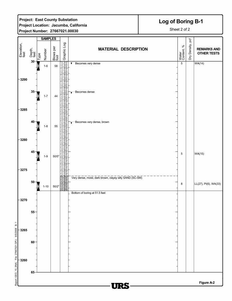
Very dense, moist, dark brown, clayey silty SAND (SC-SM)
Bottom of boring at 51.5 feet
Becomes dense
Becomes very dense
Wat
erC
onte
nt, % REMARKS AND
OTHER TESTS
1-6 58
1-7
1-8
1-9
1-10
5
5
8
WA(14)
WA(15)
LL(27), PI(6), WA(33)
Becomes very dense, brown
MATERIAL DESCRIPTION
44
55
50/5"
50/2"
Figure A-2
Project Location: Jacumba, CaliforniaProject Number: 27667021.00030
3290
3285
3280
3275
3270
3265
3260
30
35
40
45
50
55
60
65
Sheet 2 of 2
Log of Boring B-1R
epor
t: G
EO
_10_
SN
A;
File
: 276
6702
1.G
PJ;
6/
5/20
08
B- 1
Project: East County Substation
Blo
ws
per
foot
Gra
phic
Log
Dep
th,
feet
Type
Num
ber
Ele
vatio
n,fe
et
Dry
Den
sity
, pcfSAMPLES
Num
ber
TypeDep
th,
feet
Gra
phic
Log
SAMPLES
MATERIAL DESCRIPTION REMARKS ANDOTHER TESTS
Wat
erC
onte
nt, %
Blo
ws
per
foot
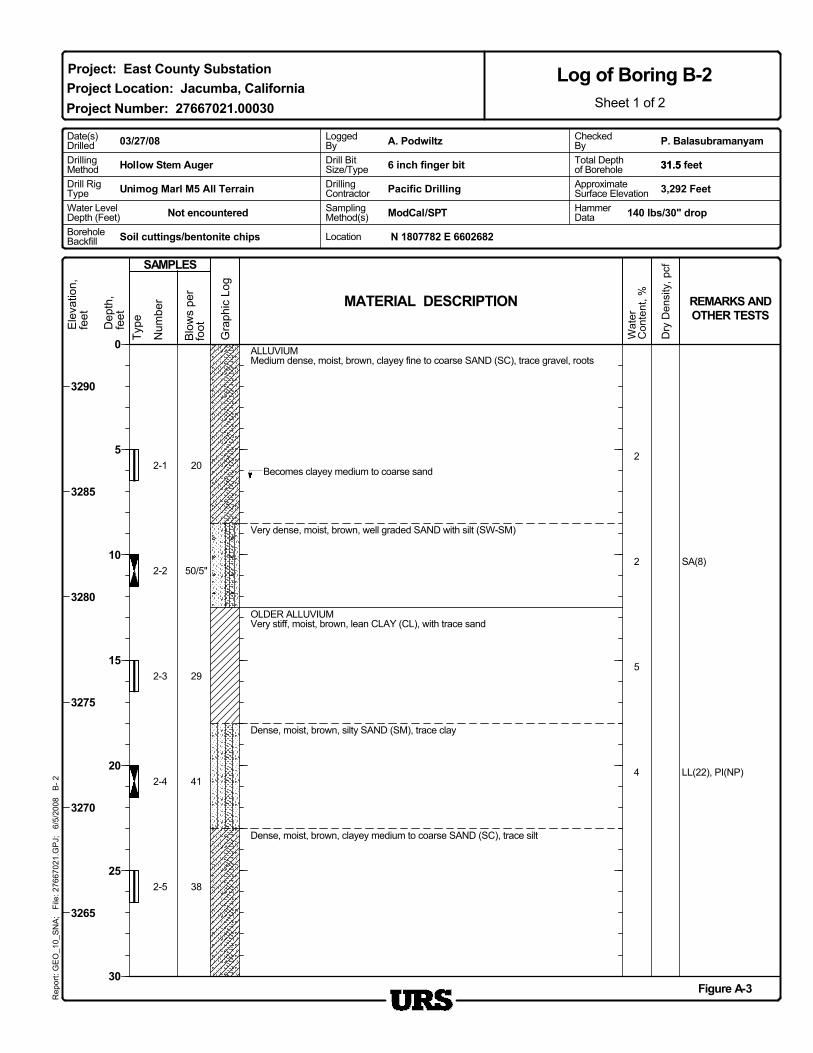
2-1
3,292 Feet
Hollow Stem Auger
ApproximateSurface Elevation
Dry
Den
sity
, pcf
Ele
vatio
n,fe
et
4
20
29
SA(8)
41
5
2
2
2-5
2-4
2-3
2-2
LL(22), PI(NP)
ALLUVIUMMedium dense, moist, brown, clayey fine to coarse SAND (SC), trace gravel, roots
Dense, moist, brown, clayey medium to coarse SAND (SC), trace silt
Dense, moist, brown, silty SAND (SM), trace clay
OLDER ALLUVIUMVery stiff, moist, brown, lean CLAY (CL), with trace sand
50/5"
Becomes clayey medium to coarse sand
38
Very dense, moist, brown, well graded SAND with silt (SW-SM)
Figure A-3
3290
3285
3280
3275
3270
3265
N 1807782 E 6602682Soil cuttings/bentonite chips
Rep
ort:
GE
O_1
0_S
NA
; F
ile: 2
7667
021.
GP
J;
6/5/
2008
B
- 2
Log of Boring B-2Sheet 1 of 2
Project Location: Jacumba, California
BoreholeBackfill
Project: East County Substation
Project Number: 27667021.00030
0
5
10
15
20
25
30
Not encountered
P. Balasubramanyam
6 inch finger bit
Date(s)Drilled
ModCal/SPT
Drill RigType Pacific Drilling
DrillingMethod
Drill BitSize/Type
A. Podwiltz03/27/08
Unimog Marl M5 All Terrain
CheckedByTotal Depthof Borehole
DrillingContractor
31.5 feet31.5
HammerData
Water LevelDepth (Feet)
LoggedBy
SamplingMethod(s) 140 lbs/30" drop
Location
Blo
ws
per
foot
REMARKS ANDOTHER TESTS
MATERIAL DESCRIPTION
SAMPLES
Gra
phic
Log
Dep
th,
feet
Type
Num
ber
2-6WA(28)
37
Bottom of boring at 31.5 feet
Wat
erC
onte
nt, %
30
35
40
45
50
55
60
65
Project Number: 27667021.00030
Project: East County Substation
Sheet 2 of 2
Log of Boring B-2R
epor
t: G
EO
_10_
SN
A;
File
: 276
6702
1.G
PJ;
6/
5/20
08
B- 2
Ele
vatio
n,fe
et
Dry
Den
sity
, pcf
3260
3255
3250
3245
3240
3235
3230
Figure A-3
Project Location: Jacumba, California
Dep
th,
feet
Num
ber
Dry
Den
sity
, pcf
Gra
phic
Log
Blo
ws
per
foot
SAMPLES
Type
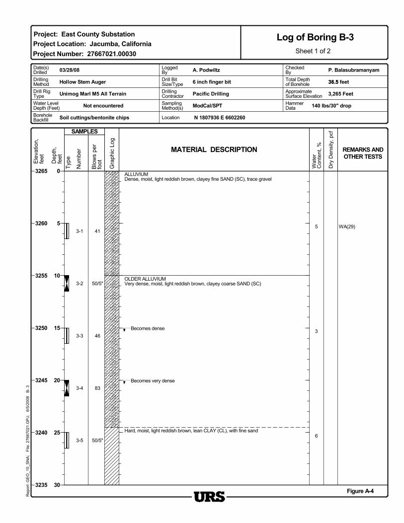
3-1
Soil cuttings/bentonite chips
3,265 Feet
Ele
vatio
n,fe
et
ApproximateSurface Elevation
Hollow Stem Auger
WA(29)
MATERIAL DESCRIPTION
83
46
50/5"
41
6
3
5
3-5
3-4
3-3
3-2
Becomes very dense
REMARKS ANDOTHER TESTS
Wat
erC
onte
nt, %
50/5"
Hard, moist, light reddish brown, lean CLAY (CL), with fine sand
Becomes dense
OLDER ALLUVIUMVery dense, moist, light reddish brown, clayey coarse SAND (SC)
ALLUVIUMDense, moist, light reddish brown, clayey fine SAND (SC), trace gravel
Project Location: Jacumba, California
Figure A-4
3265
3260
3255
3250
3245
3240
3235
N 1807936 E 6602260
DrillingMethod
Rep
ort:
GE
O_1
0_S
NA
; F
ile: 2
7667
021.
GP
J;
6/5/
2008
B
- 3
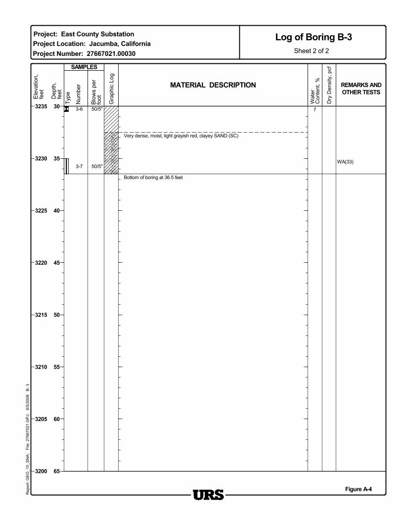
Log of Boring B-3Sheet 1 of 2
0
5
10
15
20
25
30
BoreholeBackfill
Project: East County Substation
Project Number: 27667021.00030
P. Balasubramanyam
6 inch finger bit
ModCal/SPTNot encountered HammerData
Location
140 lbs/30" drop
Date(s)Drilled
Drill RigType Pacific Drilling
36.5
A. Podwiltz03/28/08
Unimog Marl M5 All Terrain
CheckedByTotal Depthof Borehole
DrillingContractor
Water LevelDepth (Feet)
36.5 feetDrill BitSize/Type
LoggedBy
SamplingMethod(s)
MATERIAL DESCRIPTION
Type
Wat
erC
onte
nt, % REMARKS AND
OTHER TESTS
SAMPLES
Blo
ws
per
foot
Gra
phic
Log
Dep
th,
feet
3-6
3-7
7
WA(33)
50/5"
50/5"
Very dense, moist, light grayish red, clayey SAND (SC)
Bottom of boring at 36.5 feet
Project Number: 27667021.00030
Project: East County SubstationProject Location: Jacumba, California
30
35
40
45
50
55
60
65
Sheet 2 of 2
Log of Boring B-3R
epor
t: G
EO
_10_
SN
A;
File
: 276
6702
1.G
PJ;
6/
5/20
08
B- 3
Num
ber
Ele
vatio
n,fe
et
Dry
Den
sity
, pcf
3235
3230
3225
3220
3215
3210
3205
3200
Figure A-4
Num
ber
TypeDep
th,
feet
Blo
ws
per
footE
leva
tion,
feet
SAMPLES
MATERIAL DESCRIPTION REMARKS ANDOTHER TESTS
Gra
phic
Log
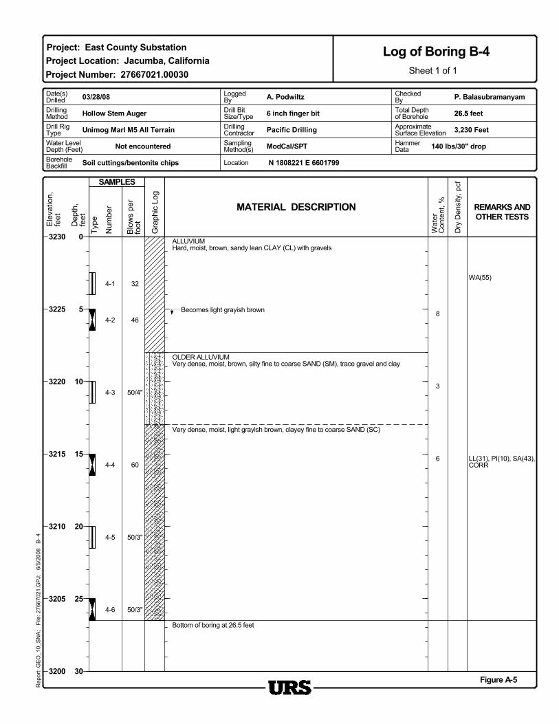
4-1
Soil cuttings/bentonite chips
3,230 Feet
Hollow Stem Auger
ApproximateSurface Elevation
Dry
Den
sity
, pcf
6
Wat
erC
onte
nt, %
50/4"
46
32
50/3"
WA(55)
50/3"
3
8
4-6
4-5
4-4
4-3
4-2
LL(31), PI(10), SA(43),CORR
ALLUVIUMHard, moist, brown, sandy lean CLAY (CL) with gravels
Bottom of boring at 26.5 feet
Very dense, moist, light grayish brown, clayey fine to coarse SAND (SC)
60
Becomes light grayish brown
OLDER ALLUVIUMVery dense, moist, brown, silty fine to coarse SAND (SM), trace gravel and clay
Project Location: Jacumba, California
Figure A-5
3230
3225
3220
3215
3210
3205
3200
DrillingMethod
N 1808221 E 6601799
Rep
ort:
GE
O_1
0_S
NA
; F
ile: 2
7667
021.
GP
J;
6/5/
2008
B
- 4
Log of Boring B-4Sheet 1 of 1
Project: East County Substation
Project Number: 27667021.00030
BoreholeBackfill
0
5
10
15
20
25
30
Date(s)Drilled
6 inch finger bit
Not encountered HammerData
Water LevelDepth (Feet)
Drill RigType Pacific Drilling
P. BalasubramanyamA. Podwiltz03/28/08
Unimog Marl M5 All Terrain
CheckedByTotal Depthof Borehole
DrillingContractor
26.5 feet
ModCal/SPT
Location
Drill BitSize/Type
LoggedBy
SamplingMethod(s) 140 lbs/30" drop
26.5
Num
ber
Dry
Den
sity
, pcf
Ele
vatio
n,fe
et
TypeDep
th,
feet
Gra
phic
Log
Blo
ws
per
foot
3,252 Feet
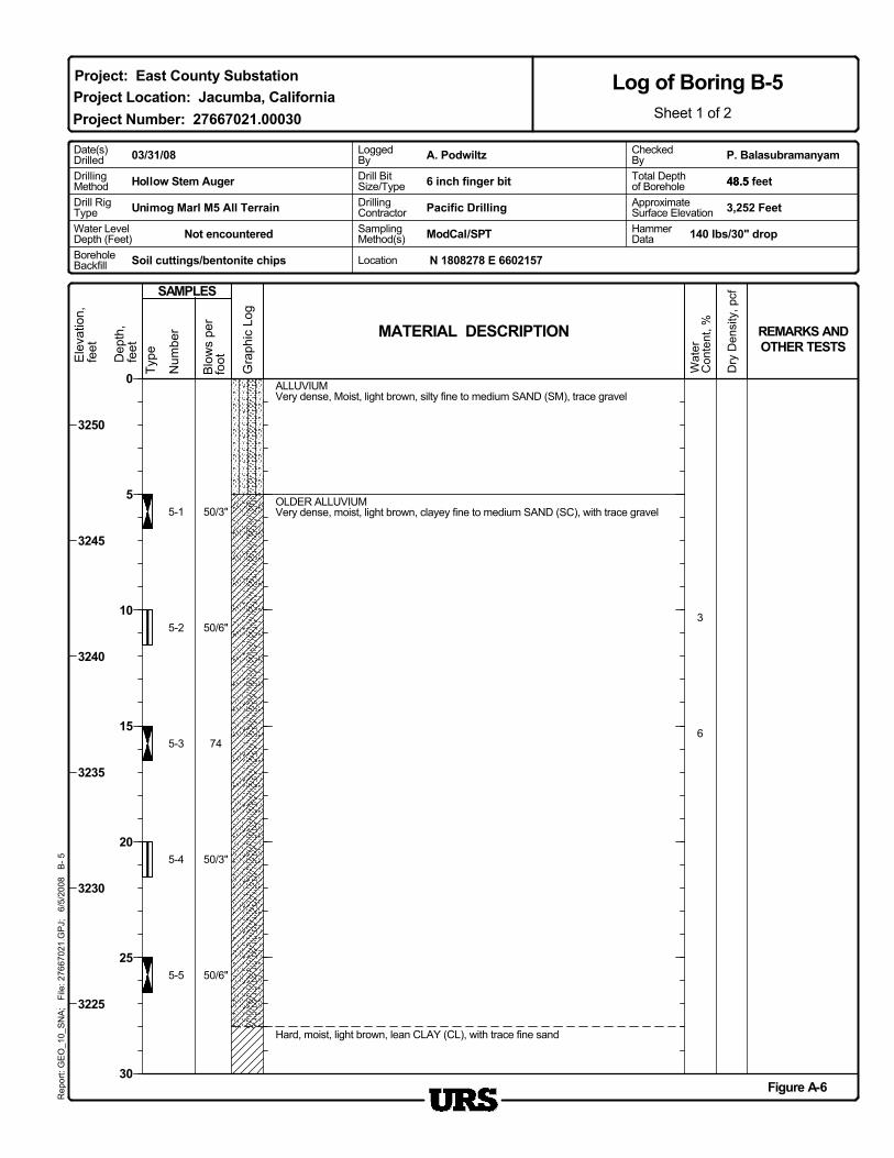
5-1
DrillingMethod
Soil cuttings/bentonite chips
SAMPLES
Hollow Stem Auger
ApproximateSurface Elevation
50/6"
50/3"
74
50/6"
50/3"
6
3
5-5
5-4
5-3
5-2
MATERIAL DESCRIPTION REMARKS ANDOTHER TESTS
Hard, moist, light brown, lean CLAY (CL), with trace fine sand
OLDER ALLUVIUMVery dense, moist, light brown, clayey fine to medium SAND (SC), with trace gravel
ALLUVIUMVery dense, Moist, light brown, silty fine to medium SAND (SM), trace gravel
Wat
erC
onte
nt, %
Project Location: Jacumba, California
Figure A-6
3250
3245
3240
3235
3230
3225
Pacific Drilling
Rep
ort:
GE
O_1
0_S
NA
; F
ile: 2
7667
021.
GP
J;
6/5/
2008
B
- 5
Log of Boring B-5Sheet 1 of 2
0
5
10
15
20
25
30
Project: East County Substation
Project Number: 27667021.00030
N 1808278 E 6602157Location
Water LevelDepth (Feet)
6 inch finger bit
ModCal/SPTNot encountered SamplingMethod(s)
P. BalasubramanyamDate(s)Drilled
Drill RigType
HammerData
DrillingContractor
A. Podwiltz03/31/08
Unimog Marl M5 All Terrain
CheckedBy
140 lbs/30" drop
Total Depthof Borehole 48.5 feet48.5Drill Bit
Size/Type
LoggedBy
BoreholeBackfill
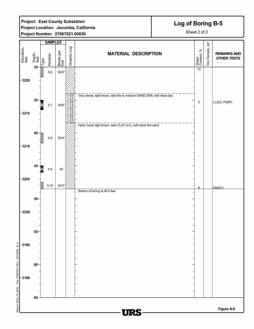
Bottom of boring at 48.5 feet
Very dense, light brown, silty fine to medium SAND (SM), with trace clay
Wat
erC
onte
nt, % REMARKS AND
OTHER TESTS
5-6
5-7
5-8
5-9
5-10
10
5
9
LL(22), PI(NP)
WA(51)
Hard, moist, light brown, lean CLAY (CL), with trace fine sand
SAMPLES
50/6"
50/6"
50/4"
50
50/3"
MATERIAL DESCRIPTION
Project Location: Jacumba, CaliforniaProject Number: 27667021.00030
Figure A-6
30
35
40
45
50
55
60
65
Sheet 2 of 2
Log of Boring B-5R
epor
t: G
EO
_10_
SN
A;
File
: 276
6702
1.G
PJ;
6/
5/20
08
B- 5
Project: East County SubstationE
leva
tion,
feet
Blo
ws
per
foot
Gra
phic
Log
Dep
th,
feet
Type
Num
ber
3220
3215
3210
3205
3200
3195
3190
Dry
Den
sity
, pcf
Gra
phic
Log
Dry
Den
sity
, pcf
Num
ber
Type
Drill RigType
Ele
vatio
n,fe
et
6-1
Pacific Drilling
DrillingMethod
Blo
ws
per
foot
Soil cuttings/bentonite chips
3,249 Feet
Hollow Stem Auger
ApproximateSurface Elevation
Dep
th,
feet
50/6"
50/6"
50/3"
50/6"
LL(23), PI(3)
3
6-5
6-4
6-3
6-2
25
Wat
erC
onte
nt, %
SAMPLES
MATERIAL DESCRIPTION REMARKS ANDOTHER TESTS
OLDER ALLUVIUMHard, moist, light brown, lean CLAY (CL), with silt and fine sand
ALLUVIUMVery stiff, moist, light brown, SILT (ML), with fine sand and trace clay
Project Location: Jacumba, California
Figure A-7
3245
3240
3235
3230
3225
3220
Rep
ort:
GE
O_1
0_S
NA
; F
ile: 2
7667
021.
GP
J;
6/5/
2008
B
- 6
Log of Boring B-6Sheet 1 of 2
0
5
10
15
20
25
30
Project: East County Substation
Project Number: 27667021.00030
HammerData
N 1808511 E 6602136
SamplingMethod(s) 140 lbs/30" drop
Location
Water LevelDepth (Feet)
6 inch finger bit
Not encountered
LoggedBy P. BalasubramanyamDate(s)
Drilled
ModCal/SPT
CheckedBy
BoreholeBackfill
A. Podwiltz03/31/08
Unimog Marl M5 All Terrain
Total Depthof Borehole
DrillingContractor
41.5 feet41.5Drill BitSize/Type
MATERIAL DESCRIPTION
Type
Wat
erC
onte
nt, % REMARKS AND
OTHER TESTS
SAMPLES
Blo
ws
per
foot
Gra
phic
Log
Dep
th,
feet
6-6
6-7
6-8
6
4
84
50/5"
Bottom of boring at 41.5 feet
50/2"
Project Number: 27667021.00030
Project: East County SubstationProject Location: Jacumba, California
30
35
40
45
50
55
60
65
Sheet 2 of 2
Log of Boring B-6R
epor
t: G
EO
_10_
SN
A;
File
: 276
6702
1.G
PJ;
6/
5/20
08
B- 6
Num
ber
Ele
vatio
n,fe
et
Dry
Den
sity
, pcf
3215
3210
3205
3200
3195
3190
3185
Figure A-7
Num
ber
TypeDep
th,
feet
Gra
phic
Log
SAMPLES
MATERIAL DESCRIPTION REMARKS ANDOTHER TESTS
Wat
erC
onte
nt, %
Blo
ws
per
foot
7-1
Soil cuttings/bentonite chips
3,370 Feet
Hollow Stem Auger
ApproximateSurface Elevation
Dry
Den
sity
, pcf
Ele
vatio
n,fe
et
2
48
CORR
CORR
39
1
54
2
115
107
7-5
7-4
7-3
7-2
SA(5)
ALLUVIUMDense, moist, light brown, silty fine to medium SAND (SM) with gravel
Becomes dense
Very dense, light brown, poorly graded SAND (SP)
Becomes very dense
70
Very dense, moist, light brown, well graded SAND with silt (SW-SM), with trace gravel
32
Becomes dense
Figure A-8
3370
3365
3360
3355
3350
3345
3340
N 1807856 E 6604182BoreholeBackfill
Rep
ort:
GE
O_1
0_S
NA
; F
ile: 2
7667
021.
GP
J;
6/5/
2008
B
- 7
Log of Boring B-7Sheet 1 of 2
Project Location: Jacumba, CaliforniaProject: East County Substation
Project Number: 27667021.00030
0
5
10
15
20
25
30
ModCal/SPT HammerData
P. BalasubramanyamDate(s)Drilled
6 inch finger bit
Drill RigType Pacific Drilling
DrillingMethod
Drill BitSize/Type
A. Podwiltz04/01/08
Unimog Marl M5 All Terrain
CheckedByTotal Depthof Borehole
DrillingContractor
51.5 feet51.5
Not encounteredWater LevelDepth (Feet)
LoggedBy
SamplingMethod(s) 140 lbs/30" drop
Location
Bottom of boring at 51.5 feet
MATERIAL DESCRIPTION
Very dense, moist, light grayish yellow, silty medium to coarse SAND (SM), with tracegravel
Wat
erC
onte
nt, % REMARKS AND
OTHER TESTS
7-6
54
7-7
7-8
7-9
7-10
982
3
44
With gravel
39
Becomes very dense
66
With silt
With trace gravel40
Figure A-8
Project Location: Jacumba, CaliforniaProject Number: 27667021.00030
3340
3335
3330
3325
3320
3315
3310
3305
30
35
40
45
50
55
60
65
Sheet 2 of 2
Log of Boring B-7R
epor
t: G
EO
_10_
SN
A;
File
: 276
6702
1.G
PJ;
6/
5/20
08
B- 7
Project: East County Substation
SAMPLES
Blo
ws
per
foot
Gra
phic
Log
Dep
th,
feet
TypeEle
vatio
n,fe
et
Dry
Den
sity
, pcf
Num
ber
MATERIAL DESCRIPTION
Ele
vatio
n,fe
et
Num
ber
TypeDep
th,
feet
Gra
phic
Log
Blo
ws
per
foot
SAMPLES
ApproximateSurface Elevation
8-1
Soil cuttings/bentonite chips
Dry
Den
sity
, pcf
Hollow Stem Auger
3,357 Feet
CORR
24
20
30
38
CORR
WA(3)
3
8-5
8-4
8-3
8-2
Medium dense, moist, light yellowish brown, silty fine to coarse SAND (SM)
REMARKS ANDOTHER TESTS
Wat
erC
onte
nt, %
38
Medium dense, moist, light yellowish gray, well graded SAND (SW), with trace silt
Medium dense, moist, light yellowish brown, poorly graded SAND (SP)
ALLUVIUMDense, moist, light yellowish brown, silty fine to medium SAND (SM), with trace gravel
Pacific Drilling
Project Location: Jacumba, California
Figure A-9
3355
3350
3345
3340
3335
3330
N 1808068 E 6603977
DrillingMethod
Rep
ort:
GE
O_1
0_S
NA
; F
ile: 2
7667
021.
GP
J;
6/5/
2008
B
- 8
Log of Boring B-8Sheet 1 of 2
0
5
10
15
20
25
30
Project: East County Substation
Project Number: 27667021.00030
Location
6 inch finger bit
ModCal/SPTNot encountered HammerData
BoreholeBackfill
140 lbs/30" drop
P. BalasubramanyamDate(s)Drilled
Drill RigType
51.5
A. Podwiltz04/01/08
Unimog Marl M5 All Terrain
CheckedByTotal Depthof Borehole
DrillingContractor
Water LevelDepth (Feet)
51.5 feet
SamplingMethod(s)
Drill BitSize/Type
LoggedBy
Bottom of boring at 51.5 feet
Medium dense, moist, light yellowish brown, silty fine to coarse SAND (SM) withgravel
Wat
erC
onte
nt, % REMARKS AND
OTHER TESTS
8-6
8-7
8-8
8-9
8-10
101
100
3
3
SA(5)
Trace gravel
SAMPLES
48
30
37
38
40
WA(14)
MATERIAL DESCRIPTION
Project Location: Jacumba, CaliforniaProject Number: 27667021.00030
Figure A-9
30
35
40
45
50
55
60
65
Sheet 2 of 2
Log of Boring B-8R
epor
t: G
EO
_10_
SN
A;
File
: 276
6702
1.G
PJ;
6/
5/20
08
B- 8
Project: East County SubstationE
leva
tion,
feet
Blo
ws
per
foot
Gra
phic
Log
Dep
th,
feet
Type
Num
ber
3325
3320
3315
3310
3305
3300
3295
Dry
Den
sity
, pcf
Dry
Den
sity
, pcf
Ele
vatio
n,fe
et
Num
ber
TypeDep
th,
feet
Gra
phic
Log
Blo
ws
per
foot
SAMPLES
ApproximateSurface Elevation
9-1
DrillingMethod
Soil cuttings/bentonite chips
Hollow Stem Auger
3,313 Feet
WA(22)
50/4"
58
44
15WA(7)
2
4
9-5
9-4
9-3
9-2
Very dense, moist, reddish brown, silty medium to coarse SAND (SM), with tracegravel
Pacific Drilling
REMARKS ANDOTHER TESTS
Wat
erC
onte
nt, %
55
MATERIAL DESCRIPTION
Very dense, muist, reddish brown, clayey fine to medium SAND (SC)
Becomes dense, fine to medium sand, with trace gravel
ALLUVIUMMedium dense, moist, reddish brown, poorly graded medium to coarse SAND with silt(SP-SM), with trace gravel
Project Location: Jacumba, California
Figure A-10
3310
3305
3300
3295
3290
3285
N 1807888 E 6603017
Rep
ort:
GE
O_1
0_S
NA
; F
ile: 2
7667
021.
GP
J;
6/5/
2008
B
- 9
Log of Boring B-9Sheet 1 of 2
0
5
10
15
20
25
30
Project: East County Substation
Project Number: 27667021.00030
Location
6 inch finger bit
ModCal/SPTNot encountered HammerData
BoreholeBackfill
140 lbs/30" drop
P. BalasubramanyamDate(s)Drilled
Drill RigType
46.5 feet
A. Podwiltz04/01/08
Unimog Marl M5 All Terrain
CheckedByTotal Depthof Borehole
Water LevelDepth (Feet)
DrillingContractorSamplingMethod(s)
46.5Drill BitSize/Type
LoggedBy
Blo
ws
per
foot
Wat
erC
onte
nt, % REMARKS AND
OTHER TESTSMATERIAL DESCRIPTION
SAMPLES
9-6
37
9-7
9-8
9-9
1
WA(4)
50/6"
70
Gra
phic
Log
Very dense, moist, reddish brown, poorly graded fine to coarse SAND (SP), with tracegravel
Becomes dense
Bottom of boring at 46.5 feet
52
Project Number: 27667021.00030
Project: East County Substation
30
35
40
45
50
55
60
65
Sheet 2 of 2
Log of Boring B-9R
epor
t: G
EO
_10_
SN
A;
File
: 276
6702
1.G
PJ;
6/
5/20
08
B- 9
Dep
th,
feet
Type
Num
ber
Project Location: Jacumba, California
Dry
Den
sity
, pcf
3280
3275
3270
3265
3260
3255
3250
Figure A-10
Ele
vatio
n,fe
et
Type
Dry
Den
sity
, pcf
Ele
vatio
n,fe
et
SAMPLES
Dep
th,
feet
Gra
phic
Log
Blo
ws
per
foot
Pacific Drilling
Num
ber
Hollow Stem Auger
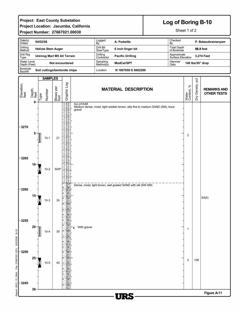
10-1
DrillingMethod
3,274 FeetApproximateSurface Elevation
Soil cuttings/bentonite chips
130
35
50/6"
21
2
2
10810-5
10-4
10-3
10-2
SA(5)
With gravel
MATERIAL DESCRIPTION REMARKS ANDOTHER TESTS
Wat
erC
onte
nt, %
45
Dense, moist, light brown, well graded SAND with silt (SW-SM)
ALLUVIUMMedium dense, moist, light reddish brown, silty fine to medium SAND (SM), tracegravel
Project Location: Jacumba, California
Figure A-11
3270
3265
3260
3255
3250
3245
N 1807650 E 6602290
Rep
ort:
GE
O_1
0_S
NA
; F
ile: 2
7667
021.
GP
J;
6/5/
2008
B
-10
Log of Boring B-10Sheet 1 of 2
0
5
10
15
20
25
30
Project: East County Substation
Project Number: 27667021.00030
Location
Water LevelDepth (Feet)
6 inch finger bit
ModCal/SPTNot encountered SamplingMethod(s)
P. BalasubramanyamDate(s)Drilled
Drill RigType
HammerData
56.5 feet
BoreholeBackfill
A. Podwiltz04/02/08
Unimog Marl M5 All Terrain
CheckedBy
140 lbs/30" drop
DrillingContractor
56.5Drill BitSize/Type
LoggedBy
Total Depthof Borehole
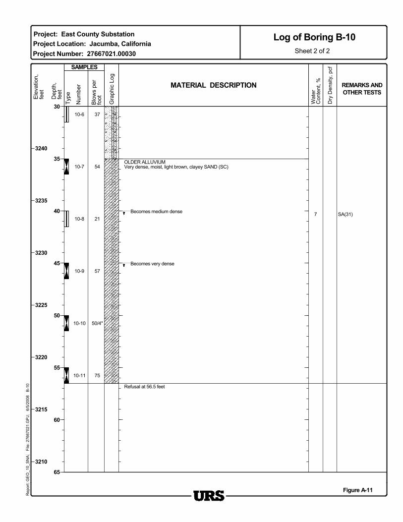
Refusal at 56.5 feet
Becomes medium dense
OLDER ALLUVIUMVery dense, moist, light brown, clayey SAND (SC)
Wat
erC
onte
nt, % REMARKS AND
OTHER TESTS
10-6
21
10-7
10-8
10-9
10-10
10-11
7 SA(31)
Becomes very dense
54
SAMPLES
57
50/4"
75
37
MATERIAL DESCRIPTION
Project Location: Jacumba, CaliforniaProject Number: 27667021.00030
Figure A-11
3240
3235
3230
3225
3220
3215
3210
30
35
40
45
50
55
60
65
Sheet 2 of 2
Log of Boring B-10R
epor
t: G
EO
_10_
SN
A;
File
: 276
6702
1.G
PJ;
6/
5/20
08
B-1
0
Project: East County Substation
Blo
ws
per
foot
Gra
phic
Log
Dep
th,
feet
Type
Num
ber
Ele
vatio
n,fe
et
Dry
Den
sity
, pcf
Dry
Den
sity
, pcf
Ele
vatio
n,fe
et
Num
ber
TypeDep
th,
feet
Gra
phic
Log
Blo
ws
per
foot
SAMPLES
ApproximateSurface Elevation
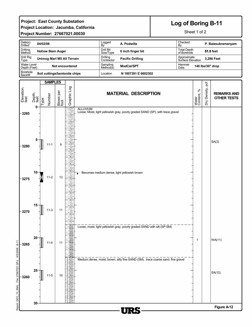
11-1
DrillingMethod
Soil cuttings/bentonite chips
Hollow Stem Auger
3,286 Feet
SA(12)
11
11
13
9
WA(11)
SA(3)
1
11-5
11-4
11-3
11-2
Medium dense, moist, brown, silty fine SAND (SM), trace coarse sand, fine gravel
Pacific Drilling
REMARKS ANDOTHER TESTS
Wat
erC
onte
nt, %
10
MATERIAL DESCRIPTION
Loose, moist, light yellowish gray, poorly graded SAND with silt (SP-SM)
Becomes medium dense, light yellowish brown
ALLUVIUMLoose, Moist, light yellowish gray, poorly graded SAND (SP), with trace gravel
Project Location: Jacumba, California
Figure A-12
3285
3280
3275
3270
3265
3260
N 1807381 E 6602302
Rep
ort:
GE
O_1
0_S
NA
; F
ile: 2
7667
021.
GP
J;
6/5/
2008
B
-11
Log of Boring B-11Sheet 1 of 2
0
5
10
15
20
25
30
Project: East County Substation
Project Number: 27667021.00030
Location
6 inch finger bit
ModCal/SPTNot encountered HammerData
BoreholeBackfill
140 lbs/30" drop
P. BalasubramanyamDate(s)Drilled
Drill RigType
51.5 feet
A. Podwiltz04/02/08
Unimog Marl M5 All Terrain
CheckedByTotal Depthof Borehole
Water LevelDepth (Feet)
DrillingContractorSamplingMethod(s)
51.5Drill BitSize/Type
LoggedBy
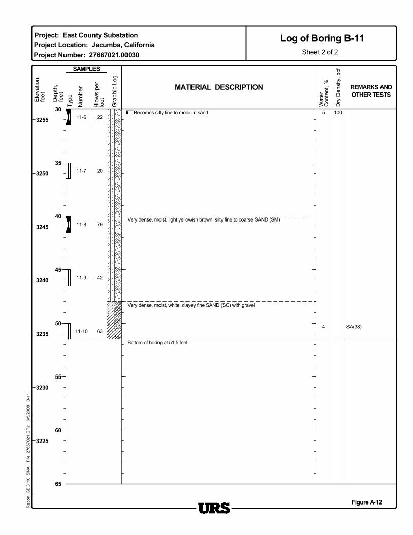
Bottom of boring at 51.5 feet
Very dense, moist, light yellowish brown, silty fine to coarse SAND (SM)
Becomes silty fine to medium sand
Wat
erC
onte
nt, % REMARKS AND
OTHER TESTS
11-6
MATERIAL DESCRIPTION
22
11-7
11-8
11-9
11-10
1005
4 SA(38)
Very dense, moist, white, clayey fine SAND (SC) with gravel
20
79
42
63
Project Location: Jacumba, CaliforniaProject Number: 27667021.00030
SAMPLES
Figure A-12
30
35
40
45
50
55
60
65
Sheet 2 of 2
Log of Boring B-11R
epor
t: G
EO
_10_
SN
A;
File
: 276
6702
1.G
PJ;
6/
5/20
08
B-1
1
Project: East County SubstationE
leva
tion,
feet
Gra
phic
Log
Dep
th,
feet
Type
Num
ber
Blo
ws
per
foot
Dry
Den
sity
, pcf
3255
3250
3245
3240
3235
3230
3225