Embed Size (px)
Citation preview

39
12
3 4
567
8
2 0 2 4 Miles
Reshab031 - 2
Ecfsj 02
N
EW
S
Figure 12a. Potential Scrub Reserve Units (blue lines) and Potential Habitat (yellow) North of Buck Lake.
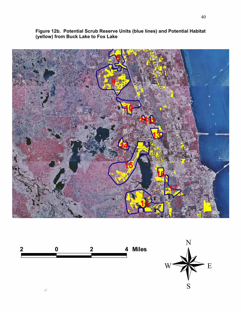
40
8
9
101112
1314
1516
17
18
2 0 2 4 Miles
Reshab031 - 2
Ecfsj 02
N
EW
S
Figure 12b. Potential Scrub Reserve Units (blue lines) and Potential Habitat (yellow) from Buck Lake to Fox Lake

41
18
19
2021
2223
24
2526 27
28
2 0 2 4 Miles
Reshab031 - 2
Ecfsj 02
N
EW
S
Figure 12c. Potential Scrub Reserve Units (blue lines) and Potential Habitat (yellow) Near Tico.

42
28
29 30
31
3233
2 0 2 4 Miles
Reshab031 - 2
Ecfsj 02
N
EW
S
Figure 12d. Potential Scrub Reserve Units (blue lines) and Potential Habitat (yellow) Near Port St. John.

43
33
34
35
36
2 0 2 4 Miles
Reshab031 - 2
Ecfsj 02
N
EW
S
Figure 12e. Potential Scrub Reserve Units (blue lines) and Potential Habitat (yellow) from Cocoa to Viera.

44
3738
394041 4243 4445 46
4748
4950
2 0 2 4 Miles
Reshab031 - 2
Ecfsj 02
N
EW
S
Figure 12f. Potential Scrub Reserve Units (blue lines) and Potential Habitat (yellow) near Wickham.

45
4950
5152 53545556
57
585960
6162
63
2 0 2 4 Miles
Reshab031 - 2
Ecfsj 02
N
EW
S
Figure 12g. Potential Scrub Reserve Units (blue lines) and Potential Habitat (yellow) near Melbourne.
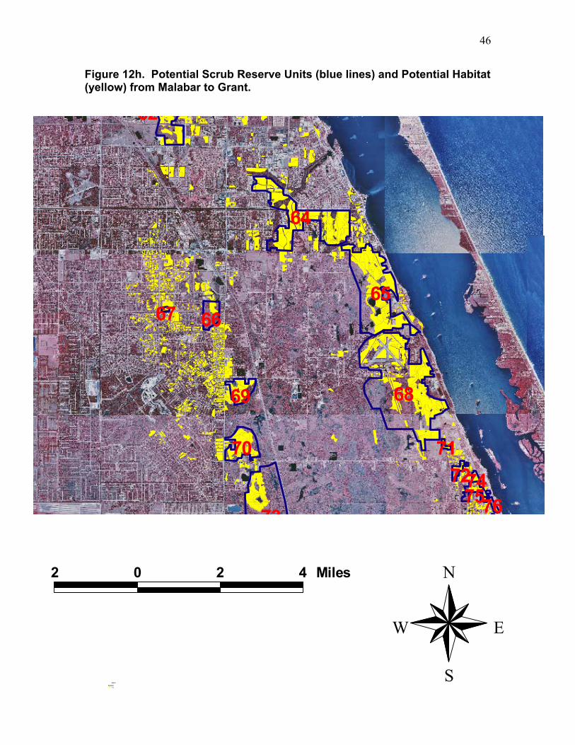
46
62
64
656667
6869
70 7172
73
747576
2 0 2 4 Miles
Reshab031 - 2
Ecfsj 02
N
EW
S
Figure 12h. Potential Scrub Reserve Units (blue lines) and Potential Habitat (yellow) from Malabar to Grant.

47
70 7172
73
747576
7778
79
8081 82
83 84
858688 89
2 0 2 4 Miles
Reshab031 - 2
Ecfsj 02
N
EW
S
Figure 12i. Potential Scrub Reserve Units (blue lines) and Potential Habitat (yellow) from Grant to Sebastian.

48
72
73
747576
7778
79
8081 82
83 84
8586
87
88 89
9091 9394 95
96
2 0 2 4 Miles
Reshab031 - 2
Ecfsj 02
N
EW
S
Figure 12j. Potential Scrub Reserve Units (blue lines) and Potential Habitat (yellow) near Sebastian.
49
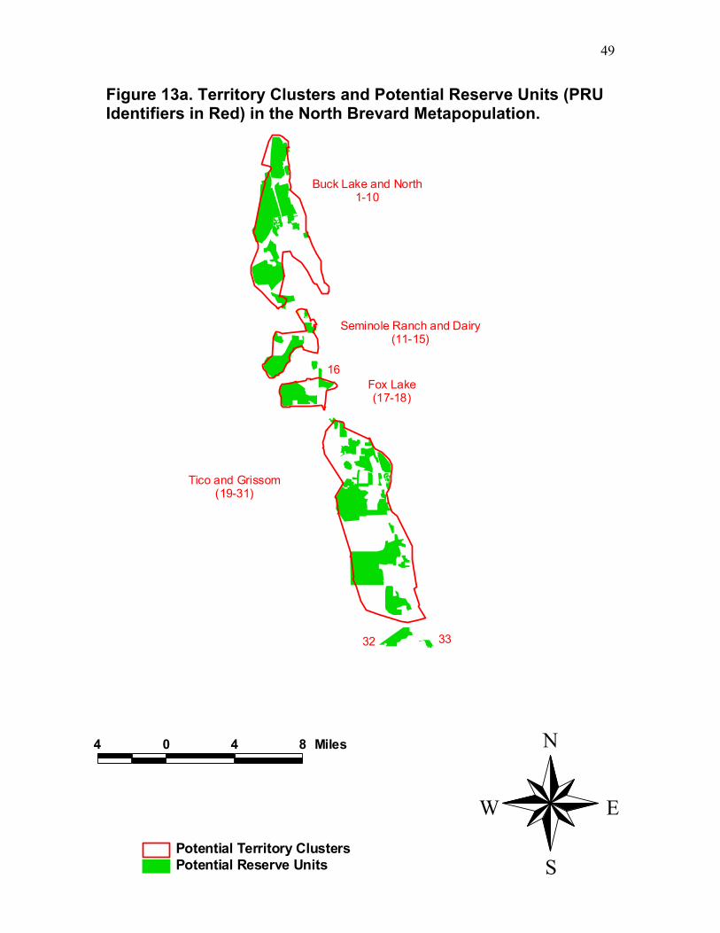
Figure 13a. Territory Clusters and Potential Reserve Units (PRU Identifiers in Red) in the North Brevard Metapopulation.
Tico and Grissom(19-31)
Buck Lake and North1-10
Fox Lake(17-18)
Seminole Ranch and Dairy(11-15)
32 33
16
4 0 4 8 Miles
Potential Reserve UnitsPotential Territory Clusters
N
EW
S

50
Figure 13b. Territory Clusters and Potential Reserve Units (PRU Identifiers in Red) in Central Brevard and the Northern Part of South Brevard-Indian River-St Lucie Metapopulation.
Viera(36)
Wickam Road(37-48)
Pirate (61, 63)
Melbourne Airport(51-57)
Hollywood Road(60, 62)
Stewart Road(49-50)
34
35
59
Lake Washington
58
5 0 5 10 Miles
Potential Reserve UnitsPotential Territory Clusters
N
EW
S

51
Sebastian(84-86, 88-91, 93-96)
Fellsmere(83, 87, 92, 97-101)
Palm Bay(66-67, 69)
Malabar ,Valkaria, Grant(64-65, 68, 71, 75, 77)
West Grant and Micco(70, 73, 78-79, 84) East Micco
(80)78
8281
6 0 6 12 Miles
Potential Reserve UnitsPotential Territory Clusters
N
EW
S
Figure 13c. Territory Clusters and Potential Reserve Units (PRU Identifiers in Red) in the Central Part of South Brevard-Indian River-St Lucie Metapopulation). PRUs Were Not Mapped South of Wabasso on the Atlantic Coastal Ridge or South of SR60 on the Ten Mile Ridge.

52
Buck Lake and North
3 0 3 6 Miles
Sjcl us03
Suit .shp
N
EW
S
Figure 14a. Territory Clusters (blue lines) and Suitable Oak and Palmetto-oak (lime) from Buck Lake North.

53
Fox Lake
Seminole Ranch and Dairy
3 0 3 6 Miles
Sjcl us03
Suit .shp
N
EW
S
Figure 14b. Territory Clusters (blue lines) and Suitable Oak and Palmetto-oak (lime) near South Lake.

54
Tico and Grissom
4 0 4 8 Miles
Suit .shp
Sjcl us03
N
EW
S
Figure 14c. Territory Clusters (blue lines) and Suitable Oak and Palmetto-oak (lime) near Tico.

55
Viera
4 0 4 8 Miles
Suit .shp
Sjcl us03
N
EW
S
Figure 14d. Territory Clusters (blue lines) and Suitable Oak and Palmetto-oak from Titusville to Viera.
56
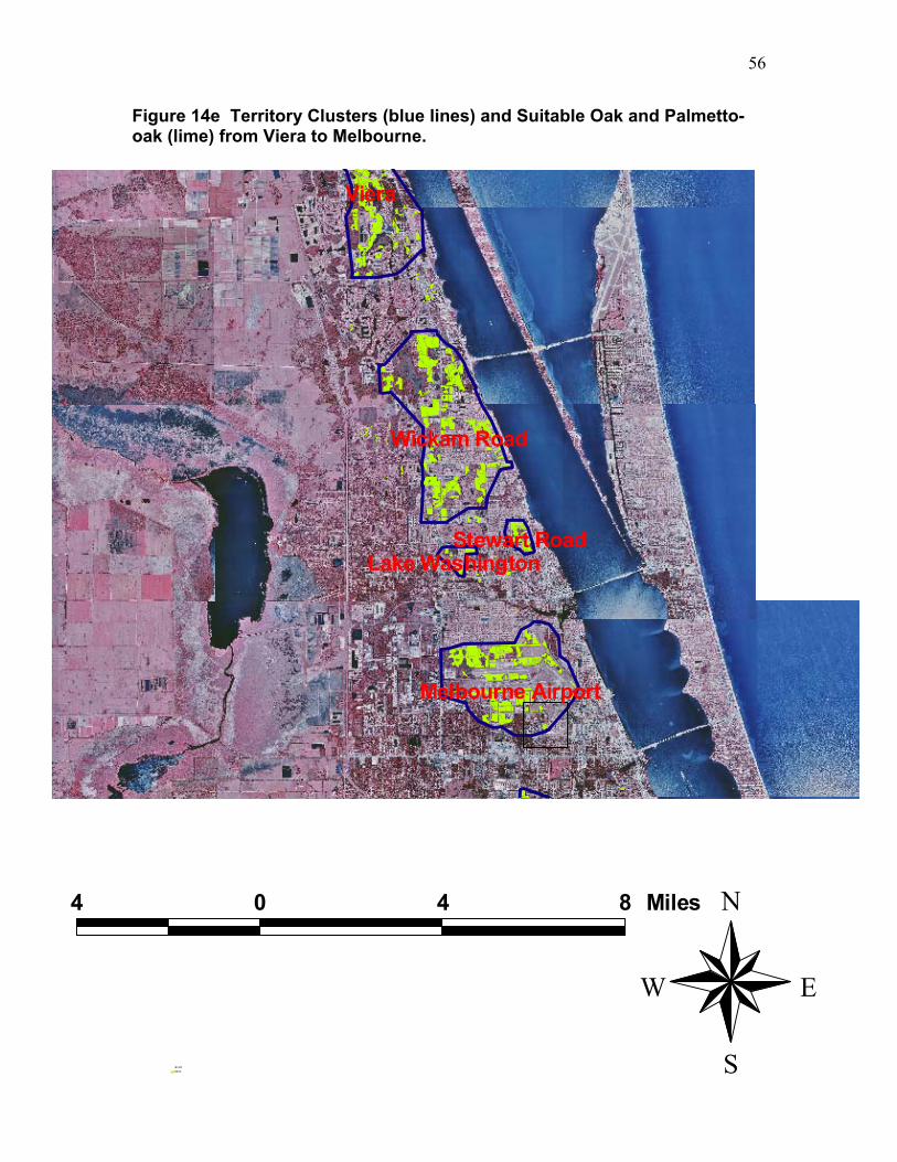
Viera
Wickam Road
Melbourne Airport
Stewart RoadLake Washington
4 0 4 8 Miles
Suit .shp
Sjcl us03
N
EW
S
Figure 14e Territory Clusters (blue lines) and Suitable Oak and Palmetto-oak (lime) from Viera to Melbourne.

57
Palm BayMalabar ,Valkaria, Grant
Pirate
Melbourne Airport
Hollywood Road
4 0 4 8 Miles
Suit .shp
Sjcl us03
N
EW
S
Figure 14f. Territory Clusters (blue lines) and Suitable Oak and Palmetto-oak (lime) from Melbourne to Grant.

58
SebastianFellsmere
Palm BayMalabar ,Valkaria, Grant
West Grant and Micco
East Micco
5 0 5 10 Miles
Suit .shp
Sjcl us03
N
EW
S
Figure 14g. Territory Clusters (blue lines) and Suitable Oak and Palmetto-oak (lime) from Palm Bay to Sebastian.


![12a -OilFieldSafetyNEO1[1]](https://img.pdfslide.us/doc/110x75/55cf97e3550346d03394398e/12a-oilfieldsafetyneo11.jpg)