Embed Size (px)
Citation preview
FACTS 2012 59
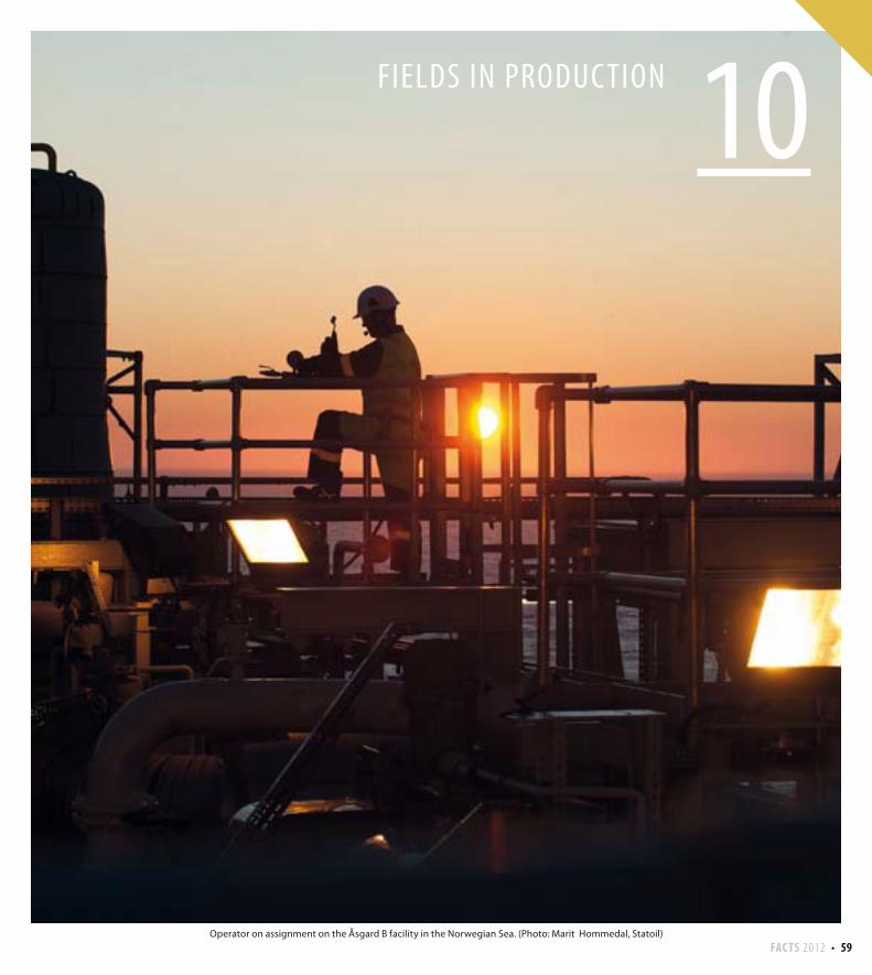
10FIELDS IN PRODUC TION
Operator on assignment on the Åsgard B facility in the Norwegian Sea. (Photo: Marit Hommedal, Statoil)
60 FACTS 2012
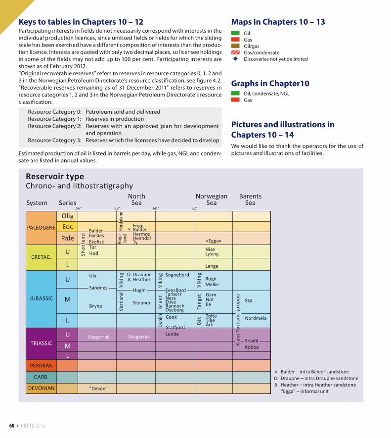
Maps in Chapters 10 – 13
Graphs in Chapter10
Pictures and illustrations in
Chapters 10 – 14
We would like to thank the operators for the use of
pictures and illustrations of facilities.
Keys to tables in Chapters 10 – 12Participating interests in fields do not necessarily correspond with interests in the
individual production licences, since unitised fields or fields for which the sliding
scale has been exercised have a different composition of interests than the produc-
tion licence. Interests are quoted with only two decimal places, so licensee holdings
in some of the fields may not add up to 100 per cent. Participating interests are
shown as of February 2012.
“Original recoverable reserves” refers to reserves in resource categories 0, 1, 2 and
3 in the Norwegian Petroleum Directorate’s resource classification, see figure 4.2.
“Recoverable reserves remaining as of 31 December 2011” refers to reserves in
resource categories 1, 2 and 3 in the Norwegian Petroleum Directorate’s resource
classification.
Resource Category 0: Petroleum sold and delivered
Resource Category 1: Reserves in production
Resource Category 2: Reserves with an approved plan for development
and operation
Resource Category 3: Reserves which the licensees have decided to develop
Estimated production of oil is listed in barrels per day, while gas, NGL and conden-
sate are listed in annual values.
Oil, condensate, NGL
Gas
)È)È
Oil
Gas
Oil/gas
Gas/condensate
Discoveries not yet delimited
Hord
aland
Eko sk
BalderFor es
DraupneHeather
Sleipner
Cook
Skagerrak
HermodHeimdalTy
FriggBalder
RognMelke
Lange
LysingNise
GarnNotIle
Stø
Nordmela
SnaddKobbe
To eTiljeÅre
Lunde
Sogne ord
Fens ordTarbertNessE veRannochOseberg
TorHod
Ula
Sandnes
Bryne
Skagerrak
«Egga»Pale
EocOlig
Shet
lan
d
Roga
-la
nd
Dunl
in
Vik
ing
Vest
land
Vik
ing
Fang
stBå
t
Vik
ing
Bren
t
Kapp
Tos
cana
-gru
ppa
Hugin
Sta jord
×
×
56° 58° 60° 62°
U
L
L
U
LM
M
U
System Series
CRETAC.
JURASSIC
TRIASSIC
PERMIAN
CARB.
DEVONIAN
PALEOGENE
Reservoir typeChrono- and lithostra graphy
NorwegianSea
NorthSea
BarentsSea
Balder – intra Balder sandstoneDraupne – intra Draupne sandstoneHeather – intra Heather sandstone“Egga” – informal unit“Devon”
FACTS 2012 61
70°
65°
60°
55°
60°
65°
70°
40°30°20°10°0°-10°
0° 10° 20°
Finland
Jan Mayen
0 200 400 km100
Norway
Sweden
Denmark
Russia
North Sea
Norwegian Sea
Barents Sea
Awarded area, february 2012
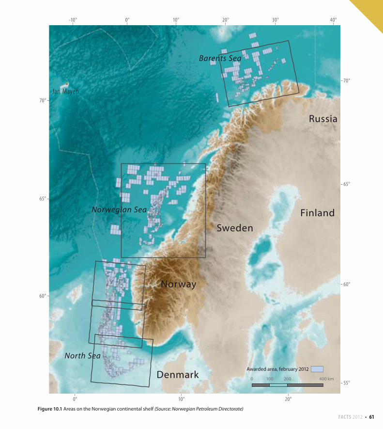
Figure 10.1 Areas on the Norwegian continental shelf (Source: Norwegian Petroleum Directorate)
62 FACTS 2012
))
)
0 30 6015 k m
ÈÈÈ
Farsund
58°
57°
56°
Ula
Gyda
Eldfisk
Embla
Blane
Tor
Hod
Ekofisk
Rev
TambarTambar Øst
Valhall
Varg
Sigyn
Trym
2/4-17 Tjalve
1/5-2 Flyndre
1/9-1 Tommeliten AlphaTommeliten Gamma
Edda
Mime
Brynhild
Cod
2/12-1 Mjølner
17/12-1 Bream
Vest Ekofisk
Albuskjell
2/5-3 Sørøst Tor
Oselvar
15/12-21
Gaupe
7/8-3
Yme
LANG
ELED
EUROPIPE II
ZEEP
IPE
I
STATPIPE
FRANPIPE
EUROPIPE I
7/11-12 S8/10-4 S
7/11-12 A
58°
57°
56°
6°4°2°
6°4°2°ZE
EPIP
E II B
Awarded area, february 2012
ULA OIL TRANSPORT
NORPIPE GAS PIPELINE
NORPIPE OIL PIPELINE
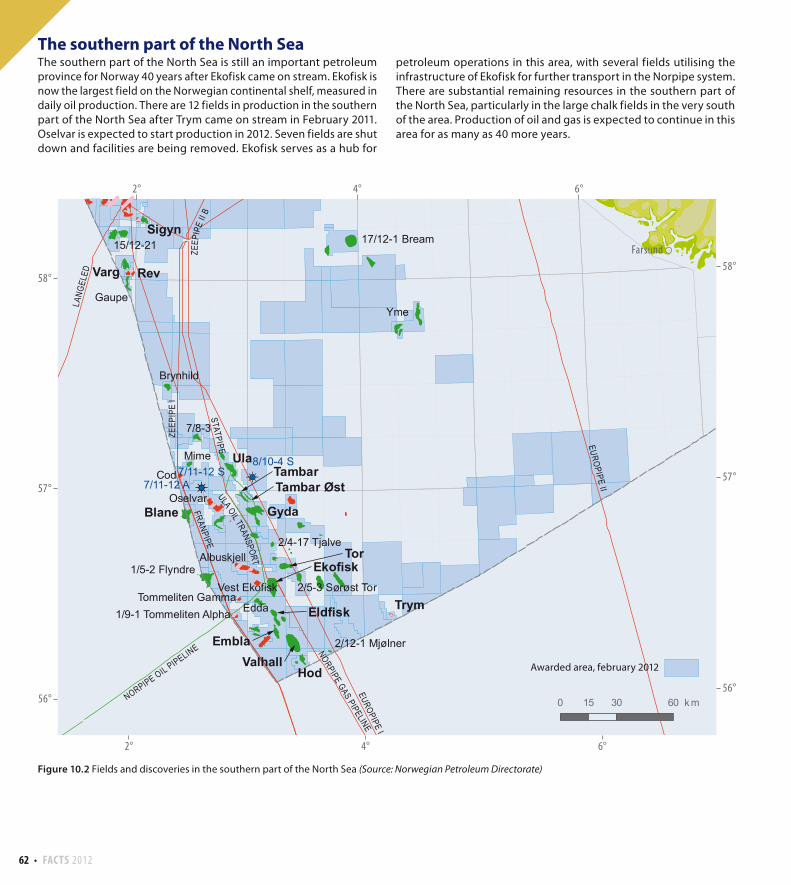
The southern part of the North Sea The southern part of the North Sea is still an important petroleum
province for Norway 40 years after Ekofisk came on stream. Ekofisk is
now the largest field on the Norwegian continental shelf, measured in
daily oil production. There are 12 fields in production in the southern
part of the North Sea after Trym came on stream in February 2011.
Oselvar is expected to start production in 2012. Seven fields are shut
down and facilities are being removed. Ekofisk serves as a hub for
petroleum operations in this area, with several fields utilising the
infrastructure of Ekofisk for further transport in the Norpipe system.
There are substantial remaining resources in the southern part of
the North Sea, particularly in the large chalk fields in the very south
of the area. Production of oil and gas is expected to continue in this
area for as many as 40 more years.
Figure 10.2 Fields and discoveries in the southern part of the North Sea (Source: Norwegian Petroleum Directorate)
FACTS 2012 63
0 30 60 km15
Sandnes
Haugesund
Stavanger
60°
59°
58°
60°
59°
58°
2° 4° 6°
2° 4° 6°
EUROPIPE II
ZEEP
IPE
II B
FRAN
PIPE
VESTERLED
ZEEP
IPE
I
ÅSGARD TRANSPORT
STATPIPE
LANG
ELED ZE
EPIP
E II A
VolveSleipner Øst
Gungne
Ringhorne ØstBalder
Enoch
ValeHeimdal
Sleipner Vest
Glitne
Grane
SkirneAlvheim
Rev
VolundJotun
Varg
Vilje
Sigyn
25/8-4
25/11-16 Svalin
16/7-2
15/5-2 Eirin
Frigg 25/2-10 S
17/12-1 Bream
15/5 J-struktur
16/1-9
16/2-416/2-3
15/5-1 Dagny
16/2-5
15/12-21
15/3-4
30/11-7
Lille-Frigg
Frøy
15/8-1 Alpha
24/9-9 S Bøyla
Gaupe
25/1-11 R
Odin
16/1-14
Nordøst Frigg
Atla
15/3-916/2-6 Johan Sverdrup
25/8-17 Jette
16/2-9 S
24/9-10 S
15/6-12
16/1-816/1-12
24/6-1 Peik
Øst Frigg
25/2-5 Lille Frøy
Gudrun
17/6-1
25/10-11
16/7-10
25/4-2
)È
)È
)È
)È
)È
$
$Snurrevarden
Kårstø
30/11-8 A30/11-8 S
Awarded area, february 2012
GRANE OIL
PIPELINE
SLEIPNER CONDENSATE PIPELINE
HULD
RA G
AS T
RANS
PORT
OSEB
ERG
GAS
TRAN
SPOR
T
GRANE GAS PIPELINE
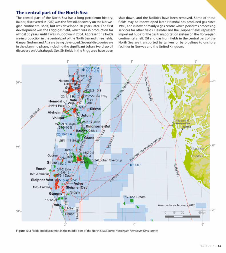
The central part of the North SeaThe central part of the North Sea has a long petroleum history.
Balder, discovered in 1967, was the first oil discovery on the Norwe-
gian continental shelf, but was developed 30 years later. The first
development was the Frigg gas field, which was in production for
almost 30 years, until it was shut down in 2004. At present, 19 fields
are in production in the central part of the North Sea and three fields,
Gaupe, Gudrun and Atla are being developed. Several discoveries are
in the planning phase, including the significant Johan Sverdrup oil
discovery on Utsirahøgda Sør. Six fields in the Frigg area have been
shut down, and the facilities have been removed. Some of these
fields may be redeveloped later. Heimdal has produced gas since
1985, and is now primarily a gas centre which performs processing
services for other fields. Heimdal and the Sleipner fields represent
important hubs for the gas transportation system on the Norwegian
continental shelf. Oil and gas from fields in the central part of the
North Sea are transported by tankers or by pipelines to onshore
facilities in Norway and the United Kingdom.
Figure 10.3 Fields and discoveries in the middle part of the North Sea (Source: Norwegian Petroleum Directorate)
64 FACTS 2012
35/11-5
0 30 60 km15
Bergen
Florø
Måløy
62°
61°
60°
61°
60°
62°
2° 4° 6°
2° 4° 6°
Mongstad
Stura
Kollsnes$
$
$
STATPIPE
LANG
ELED
STATPIPIE
ÅSGA
RD T
RANS
PORT
Sygna
Visund
Gullfaks Sør
Snorre
StatfjordStatfjord Øst
Statfjord Nord
Oseberg
Gullfaks
Veslefrikk
Kvitebjørn
Oseberg Øst
Fram
Tordis
Gimle
Gjøa
Huldra
Murchison
BrageTune
Oseberg Sør
Vigdis
Vega
Vega Sør
Troll
34/11-2 S Nøkken
35/10-2
Frigg25/2-10 S
30/7-6 Hild
33/9-6 Delta
35/11-13
31/2-N-11 H
35/2-1
35/8-3
34/12-1
Knarr
30/11-7Lille-frigg
34/8-13 A
30/5-3 S
Odin
Valemon
34/5-1 S
Nordøst Frigg
35/9-6 S
34/4-1134/4-10
35/12-2
Visund Sør
Øst Frigg
34/3-3 S
34/10-53 S34/10-53 A
30/11-8 S
30/11-8 A
34/10-52 A 34/10-52 B33/12-9 S
29/6 ISLAY
)È)È
)È
)È
)È
)È)È)È
30/5-3 A
Awarded area, february 2012
GRANE OIL
PIPEL
INE
GJØA GAS EXSPORT
GJØA OIL PIPELINE
OSEBERG OIL TRANSPORT
KVITEBJØRN GAS PIPELINE
TROLL OIL PIPELINE II
HULD
RA G
AS T
RANS
PORT
OSEB
ERG
GAS
TRAN
SPOR
T
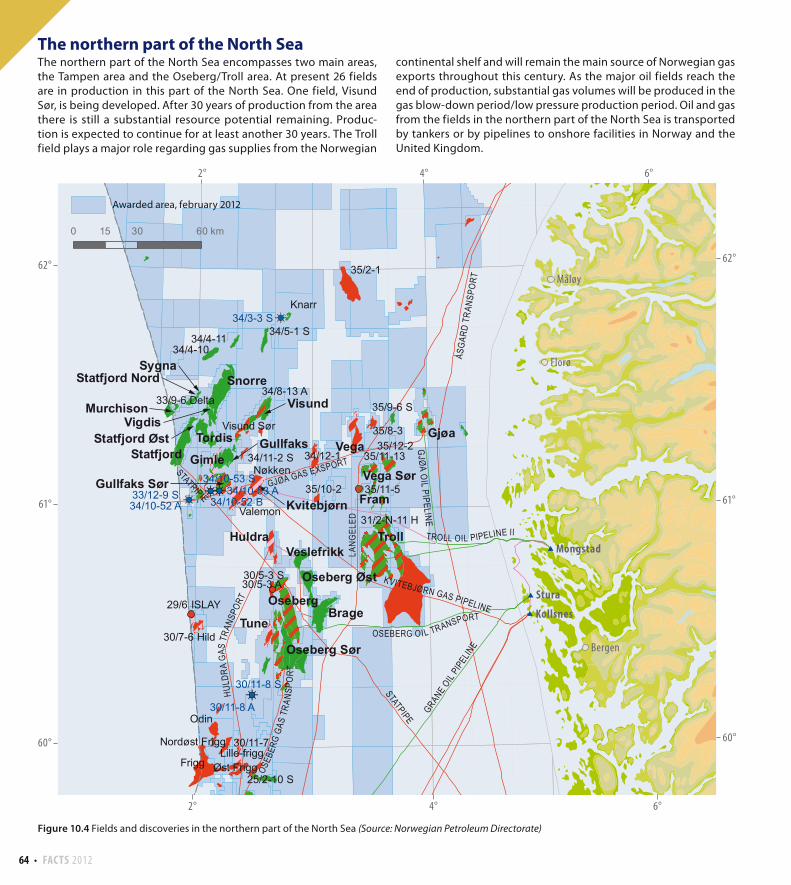
The northern part of the North Sea The northern part of the North Sea encompasses two main areas,
the Tampen area and the Oseberg/Troll area. At present 26 fields
are in production in this part of the North Sea. One field, Visund
Sør, is being developed. After 30 years of production from the area
there is still a substantial resource potential remaining. Produc-
tion is expected to continue for at least another 30 years. The Troll
field plays a major role regarding gas supplies from the Norwegian
continental shelf and will remain the main source of Norwegian gas
exports throughout this century. As the major oil fields reach the
end of production, substantial gas volumes will be produced in the
gas blow-down period/low pressure production period. Oil and gas
from the fields in the northern part of the North Sea is transported
by tankers or by pipelines to onshore facilities in Norway and the
United Kingdom.
Figure 10.4 Fields and discoveries in the northern part of the North Sea (Source: Norwegian Petroleum Directorate)
FACTS 2012 65
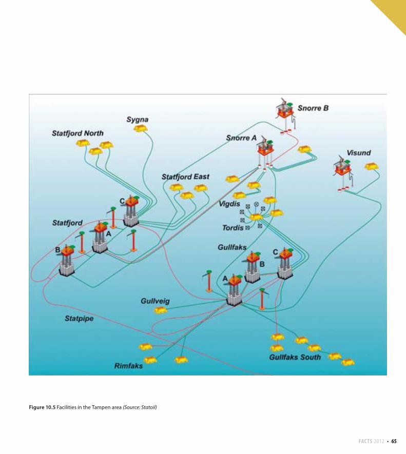
Figure 10.5 Facilities in the Tampen area (Source: Statoil)
66 FACTS 2012
0 50 100 km25
Trondheim
Namsos
Brønnøysund
Sandnessjøen
Stjørdal
Kristiansund
Molde
63°
64°
65°
66°
67°67°
66°
65°
64°
63°
4°2° 6° 8° 10° 12°
4° 6° 8° 10° 12°
Nyhamna
Tjeldbergodden$
$
Åsgard
Urd
Tyrihans
NjordDraugen
Norne
Mikkel
Kristin
Ormen Lange
Yttergryta
Alve
MorvinHeidrun
6506/11-2 Lange
Skarv
6407/9-9
6406/2-7 Erlend
6506/6-1
6507/7-13
6406/9-1 Linnorm
6506/12-3 Lysing
6406/3-2 Trestakk
6507/11-6 Sigrid
6406/2-1 Lavrans
6407/6-6 Mikkel Sør
6707/10-16705/10-1
6407/7-8
Skuld
6507/3-7
Hyme
6407/2-5 S
Marulk
6506/9-2 S
6407/2-6 S
6406/3-8
6507/7-14 S
6507/3-86508/1-2
6607/12-2 S
6407/5-2 S
)È)È
)È
ÅSG
ARD
TRAN
SPO
RT
LANGELED
HALTENPIPE
NORN
E GAS TR
ANSP
ORT
DRAUGEN G AS EXSPORT
Awarded area, february 2012
ORMEN LANGE PIPELINE
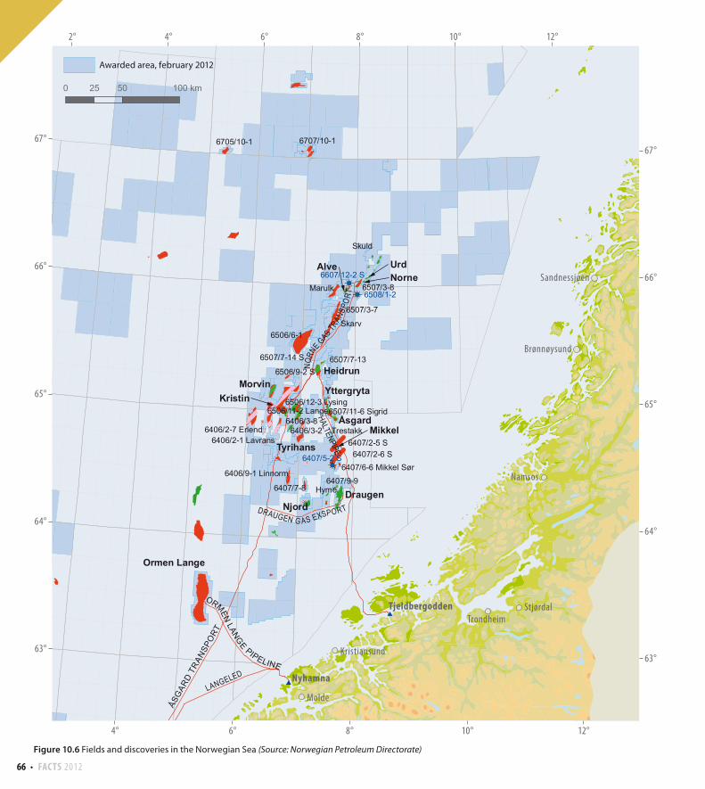
Figure 10.6 Fields and discoveries in the Norwegian Sea (Source: Norwegian Petroleum Directorate)
FACTS 2012 67
0 50 100 km25
)
)
)
$
73°
72°
71°
71°
72°
73°
30°28°26°24°22°20°18°
20° 22° 24° 26° 28°
HammerfestMelkøya
È
È
È
7122/6-1
7120/12-37120/12-2
Goliat
7226/2-1
7223/5-17220/8-1
Snøhvit
7225/3-1
7120/2-3 S
7220/7-1
Awarded area, february 2012
SNØHVIT GAS PIPELINE
The Norwegian SeaThe Norwegian Sea is a less mature petroleum province than the
North Sea. Draugen was the first field to come on stream, in 1993,
and now 13 fields are producing in the Norwegian Sea after the
development of Morvin. Four fields, Skarv, Marulk, Hyme and Skuld,
are being developed. Yttergryta have ceased production. There are
significant gas reserves in the Norwegian Sea. The gas produced from
the fields is transported in the Åsgard Transport pipeline to Kårstø in
Rogaland and in Haltenpipe to Tjeldbergodden in Møre og Romsdal.
Gas production from Ormen Lange is transported by pipeline to
Nyhamna, and from there on to Easington in the United Kingdom.
Oil from the fields in the Norwegian Sea is transported by tankers.
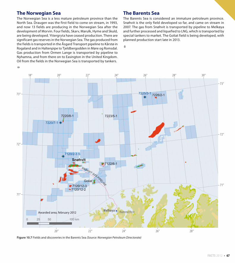
The Barents SeaThe Barents Sea is considered an immature petroleum province.
Snøhvit is the only field developed so far, and came on stream in
2007. The gas from Snøhvit is transported by pipeline to Melkøya
and further processed and liquefied to LNG, which is transported by
special tankers to market. The Goliat field is being developed, with
planned production start late in 2013.
Figure 10.7 Fields and discoveries in the Barents Sea (Source: Norwegian Petroleum Directorate)
68 FACTS 2012
Blocks and production licences Block 24/6 - production licence 088 BS, awarded 2003Block 24/6 - production licence 203, awarded 1996.Block 25/4 - production licence 036 C, awarded 2003Block 25/4 - production licence 203, awarded 1996.
Development approval 06.10.2004 by the King in Council Discovered 1998
On stream 08.06.2008
Operator Marathon Oil Norge AS
Licensees ConocoPhillips Skandinavia AS 20.00 %
Lundin Norway AS 15.00 %
Marathon Oil Norge AS 65.00 %
Recoverable reserves Original Remaining as of 31.12.201138.9 million Sm³ oil 23.2 million Sm³ oil
6.8 billion Sm³ gas 5.3 billion Sm³ gas
Estimated production in 2012 Oil: 70 000 barrels/day, Gas: 0.57 billion Sm³
Expected investment from 2011 4.9 billion 2011 values
Total investment as of 31.12.2010 16.4 billion nominal values
Alve
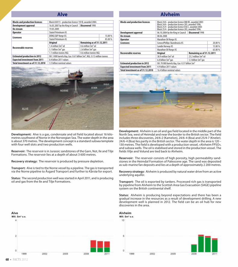
Development: Alve is a gas, condensate and oil field located about 16 kilo-metres southwest of Norne in the Norwegian Sea. The water depth in the area is about 370 metres. The development concept is a standard subsea template with four well slots and two production wells.
Reservoir: The reservoir is in Jurassic sandstones of the Garn, Not, Ile and Tilje Formations. The reservoir lies at a depth of about 3 600 metres.
Recovery strategy: The reservoir is produced by pressure depletion.
Transport: Alve is tied to the Norne vessel by a pipeline. The gas is transported via the Norne pipeline to Åsgard Transport and further to Kårstø for export.
Status: The second production well was started in April 2011, and is producing oil and gas from the Ile and Tilje Formations.
Alvheim
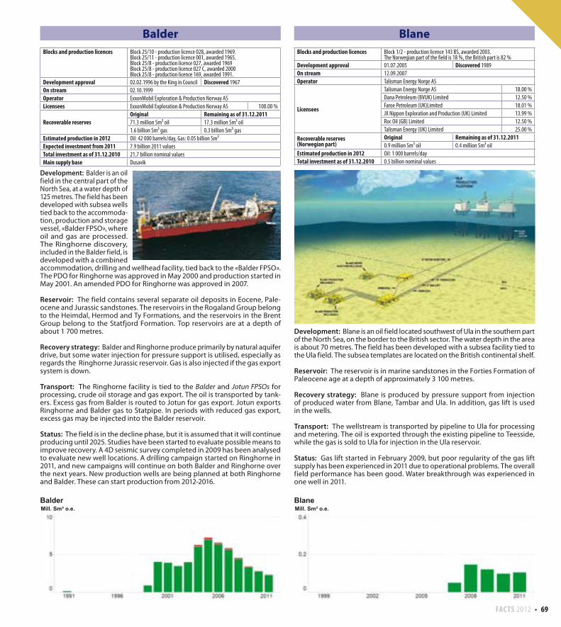
Development: Alvheim is an oil and gas field located in the middle part of the North Sea, west of Heimdal and near the border to the British sector. The field includes three discoveries, 24/6-2 (Kamelon), 24/6-4 (Boa) and 25/4-7 (Kneler). 24/6-4 (Boa) lies partly in the British sector. The water depth in the area is 120 – 130 metres. The field is developed with a production vessel, «Alvheim FPSO», and subsea wells. The oil is stabilised and stored in the production vessel. The fields Vilje and Volund are tied back to Alvheim.
Reservoir: The reservoir consists of high porosity, high permeability sand-stones in the Heimdal Formation of Paleocene age. The sand was deposited as sub-marine fan deposits and lies at a depth of approximately 2 200 metres.
Recovery strategy: Alvheim is produced by natural water drive from an active underlying aquifer.
Transport: The oil is exported by tankers. Processed rich gas is transported by pipeline from Alvheim to the Scottish Area Gas Evacuation (SAGE) pipeline system on the British continental shelf.
Status: Alvheim is producing beyond expectations and there has been a gradual increase in the resources as a result of development drilling. A new development well is planned in 2012. The field can be an oil hub for new discoveries in the area.
Blocks and production licences Block 6507/3 - production licence 159 B, awarded 2004.
Development approval 16.03.2007 by the King in Council Discovered 1990
On stream 19.03.2009
Operator Statoil Petroleum AS
LicenseesDONG E&P Norge AS 15.00 %
Statoil Petroleum AS 85.00 %
Recoverable reserves
Original Remaining as of 31.12.20111.4 million Sm³ oil 0.6 million Sm³ oil
5.1 billion Sm³ gas 2.6 billion Sm³ gas
1.1 million tonnes NGL 0.6 million tonnes NGL
Estimated production in 2012 Oil: 3 000 barrels/day, Gas: 0.61 billion Sm³, NGL: 0.13 million tonnes
Expected investment from 2011 0.4 billion 2011 values
Total investment as of 31.12.2010 3.5 billion nominal values
FACTS 2012 69
Balder
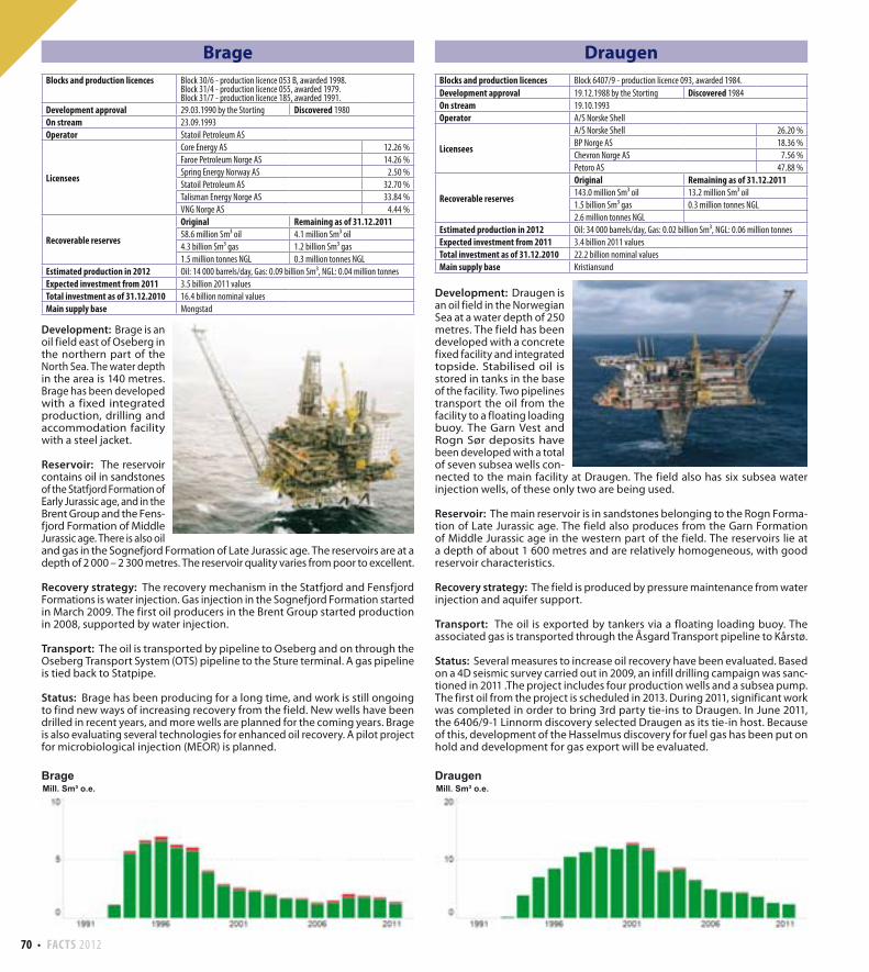
Development: Balder is an oil field in the central part of the North Sea, at a water depth of 125 metres. The field has been developed with subsea wells tied back to the accommoda-tion, production and storage vessel, «Balder FPSO», where oil and gas are processed. The Ringhorne discovery, included in the Balder field, is developed with a combined accommodation, drilling and wellhead facility, tied back to the «Balder FPSO». The PDO for Ringhorne was approved in May 2000 and production started in May 2001. An amended PDO for Ringhorne was approved in 2007.
Reservoir: The field contains several separate oil deposits in Eocene, Pale-ocene and Jurassic sandstones. The reservoirs in the Rogaland Group belong to the Heimdal, Hermod and Ty Formations, and the reservoirs in the Brent Group belong to the Statfjord Formation. Top reservoirs are at a depth of about 1 700 metres.
Recovery strategy: Balder and Ringhorne produce primarily by natural aquifer drive, but some water injection for pressure support is utilised, especially as regards the Ringhorne Jurassic reservoir. Gas is also injected if the gas export system is down.
Transport: The Ringhorne facility is tied to the Balder and Jotun FPSOs for processing, crude oil storage and gas export. The oil is transported by tank-ers. Excess gas from Balder is routed to Jotun for gas export. Jotun exports Ringhorne and Balder gas to Statpipe. In periods with reduced gas export, excess gas may be injected into the Balder reservoir.
Status: The field is in the decline phase, but it is assumed that it will continue producing until 2025. Studies have been started to evaluate possible means to improve recovery. A 4D seismic survey completed in 2009 has been analysed to evaluate new well locations. A drilling campaign started on Ringhorne in 2011, and new campaigns will continue on both Balder and Ringhorne over the next years. New production wells are being planned at both Ringhorne and Balder. These can start production from 2012-2016.
Blane
Development: Blane is an oil field located southwest of Ula in the southern part of the North Sea, on the border to the British sector. The water depth in the area is about 70 metres. The field has been developed with a subsea facility tied to the Ula field. The subsea templates are located on the British continental shelf.
Reservoir: The reservoir is in marine sandstones in the Forties Formation of Paleocene age at a depth of approximately 3 100 metres.
Recovery strategy: Blane is produced by pressure support from injection of produced water from Blane, Tambar and Ula. In addition, gas lift is used in the wells.
Transport: The wellstream is transported by pipeline to Ula for processing and metering. The oil is exported through the existing pipeline to Teesside, while the gas is sold to Ula for injection in the Ula reservoir.
Status: Gas lift started in February 2009, but poor regularity of the gas lift supply has been experienced in 2011 due to operational problems. The overall field performance has been good. Water breakthrough was experienced in one well in 2011.
Blocks and production licences Block 25/10 - production licence 028, awarded 1969.Block 25/11 - production licence 001, awarded 1965.Block 25/8 - production licence 027, awarded 1969Block 25/8 - production licence 027 C, awarded 2000Block 25/8 - production licence 169, awarded 1991.
Development approval 02.02.1996 by the King in Council Discovered 1967
On stream 02.10.1999
Operator ExxonMobil Exploration & Production Norway AS
Licensees ExxonMobil Exploration & Production Norway AS 100.00 %
Recoverable reservesOriginal Remaining as of 31.12.201171.3 million Sm³ oil 17.3 million Sm³ oil
1.6 billion Sm³ gas 0.3 billion Sm³ gas
Estimated production in 2012 Oil: 42 000 barrels/day, Gas: 0.05 billion Sm³
Expected investment from 2011 7.9 billion 2011 values
Total investment as of 31.12.2010 21.7 billion nominal values
Main supply base Dusavik
Blocks and production licences Block 1/2 - production licence 143 BS, awarded 2003.The Norwegian part of the field is 18 %, the British part is 82 %
Development approval 01.07.2005 Discovered 1989
On stream 12.09.2007
Operator Talisman Energy Norge AS
Licensees
Talisman Energy Norge AS 18.00 %
Dana Petroleum (BVUK) Limited 12.50 %
Faroe Petroleum (UK)Limited 18.01 %
JX Nippon Exploration and Production (UK) Limited 13.99 %
Roc Oil (GB) Limited 12.50 %
Talisman Energy (UK) Limited 25.00 %
Recoverable reserves(Norwegian part)
Original Remaining as of 31.12.20110.9 million Sm³ oil 0.4 million Sm³ oil
Estimated production in 2012 Oil: 1 000 barrels/day
Total investment as of 31.12.2010 0.5 billion nominal values
70 FACTS 2012
Brage
Development: Brage is an oil field east of Oseberg in the northern part of the North Sea. The water depth in the area is 140 metres. Brage has been developed with a fixed integrated production, drilling and accommodation facility with a steel jacket.
Reservoir: The reservoir contains oil in sandstones of the Statfjord Formation of Early Jurassic age, and in the Brent Group and the Fens-fjord Formation of Middle Jurassic age. There is also oil and gas in the Sognefjord Formation of Late Jurassic age. The reservoirs are at a depth of 2 000 – 2 300 metres. The reservoir quality varies from poor to excellent.
Recovery strategy: The recovery mechanism in the Statfjord and Fensfjord Formations is water injection. Gas injection in the Sognefjord Formation started in March 2009. The first oil producers in the Brent Group started production in 2008, supported by water injection.
Transport: The oil is transported by pipeline to Oseberg and on through the Oseberg Transport System (OTS) pipeline to the Sture terminal. A gas pipeline is tied back to Statpipe.
Status: Brage has been producing for a long time, and work is still ongoing to find new ways of increasing recovery from the field. New wells have been drilled in recent years, and more wells are planned for the coming years. Brage is also evaluating several technologies for enhanced oil recovery. A pilot project for microbiological injection (MEOR) is planned.
Draugen
Development: Draugen is an oil field in the Norwegian Sea at a water depth of 250 metres. The field has been developed with a concrete fixed facility and integrated topside. Stabilised oil is stored in tanks in the base of the facility. Two pipelines transport the oil from the facility to a floating loading buoy. The Garn Vest and Rogn Sør deposits have been developed with a total of seven subsea wells con-nected to the main facility at Draugen. The field also has six subsea water injection wells, of these only two are being used.
Reservoir: The main reservoir is in sandstones belonging to the Rogn Forma-tion of Late Jurassic age. The field also produces from the Garn Formation of Middle Jurassic age in the western part of the field. The reservoirs lie at a depth of about 1 600 metres and are relatively homogeneous, with good reservoir characteristics.
Recovery strategy: The field is produced by pressure maintenance from water injection and aquifer support.
Transport: The oil is exported by tankers via a floating loading buoy. The associated gas is transported through the Åsgard Transport pipeline to Kårstø.
Status: Several measures to increase oil recovery have been evaluated. Based on a 4D seismic survey carried out in 2009, an infill drilling campaign was sanc-tioned in 2011 .The project includes four production wells and a subsea pump. The first oil from the project is scheduled in 2013. During 2011, significant work was completed in order to bring 3rd party tie-ins to Draugen. In June 2011, the 6406/9-1 Linnorm discovery selected Draugen as its tie-in host. Because of this, development of the Hasselmus discovery for fuel gas has been put on hold and development for gas export will be evaluated.
Blocks and production licences Block 30/6 - production licence 053 B, awarded 1998.Block 31/4 - production licence 055, awarded 1979.Block 31/7 - production licence 185, awarded 1991.
Development approval 29.03.1990 by the Storting Discovered 1980
On stream 23.09.1993
Operator Statoil Petroleum AS
Licensees
Core Energy AS 12.26 %
Faroe Petroleum Norge AS 14.26 %
Spring Energy Norway AS 2.50 %
Statoil Petroleum AS 32.70 %
Talisman Energy Norge AS 33.84 %
VNG Norge AS 4.44 %
Recoverable reserves
Original Remaining as of 31.12.201158.6 million Sm³ oil 4.1 million Sm³ oil
4.3 billion Sm³ gas 1.2 billion Sm³ gas
1.5 million tonnes NGL 0.3 million tonnes NGL
Estimated production in 2012 Oil: 14 000 barrels/day, Gas: 0.09 billion Sm³, NGL: 0.04 million tonnes
Expected investment from 2011 3.5 billion 2011 values
Total investment as of 31.12.2010 16.4 billion nominal values
Main supply base Mongstad
Blocks and production licences Block 6407/9 - production licence 093, awarded 1984.
Development approval 19.12.1988 by the Storting Discovered 1984
On stream 19.10.1993
Operator A/S Norske Shell
Licensees
A/S Norske Shell 26.20 %
BP Norge AS 18.36 %
Chevron Norge AS 7.56 %
Petoro AS 47.88 %
Recoverable reserves
Original Remaining as of 31.12.2011143.0 million Sm³ oil 13.2 million Sm³ oil
1.5 billion Sm³ gas 0.3 million tonnes NGL
2.6 million tonnes NGL
Estimated production in 2012 Oil: 34 000 barrels/day, Gas: 0.02 billion Sm³, NGL: 0.06 million tonnes
Expected investment from 2011 3.4 billion 2011 values
Total investment as of 31.12.2010 22.2 billion nominal values
Main supply base Kristiansund
FACTS 2012 71
Ekofisk
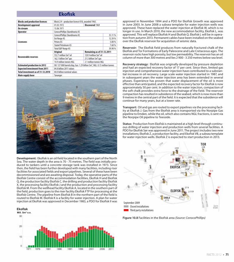
Development: Ekofisk is an oil field located in the southern part of the North Sea. The water depth in the area is 70 - 75 metres. The field was initially pro-duced to tankers until a concrete storage tank was installed in 1973. Since then, the field has been further developed with many facilities, including riser facilities for associated fields and export pipelines. Several of these have been decommissioned and are awaiting disposal. Today, the operative parts of the Ekofisk Centre consist of the accommodation facilities, Ekofisk H and Ekofisk Q, the production facility Ekofisk C, the drilling and production facility Ekofisk X, the processing facility Ekofisk J and the production and processing facility Ekofisk M. From the wellhead facility Ekofisk A, located in the southern part of the field, production goes to the riser facility Ekofisk FTP for processing at the Ekofisk Centre. The pipeline from Ekofisk B in the northern part of the field is routed to Ekofisk M. Ekofisk K is a facility for water injection. A plan for water injection at Ekofisk was approved in December 1983, a PDO for Ekofisk II was
TOR2/4E
COD7/11 A
ALBUSKJELL1/6 A
2/4 F
Edda2/7 C
37/4 A
36/22 A
2/4 B 2/4 S
2/4 G 2/4 T2/4 H
2/4 C2/4 Q2/4 FTP
2/4 W
2/4 X
2/4 M
2/4 J
2/4 AB-11
H-7
EMBLA2/7 D
ELDFISK
2/7 B
2/7 A
2/7 E
2/7 FTP
2/4 K
EKOFISK
ULA GYDA
WESTEKOFISK2/4 D
Oil to
Teesside
Gas toEmden
September 2009
Closed installations
Third party installations
VALHALL and HODVALHALL and HOD
approved in November 1994 and a PDO for Ekofisk Growth was approved in June 2003. In June 2008 a subsea template for water injection wells was approved. These have replaced the water injection at Ekofisk W, which is no longer in use. In March 2010, the new accommodation facility, Ekofisk L, was approved. This will replace Ekofisk H and Ekofisk Q. Ekofisk L will be in opera-tion from autumn 2013. Permanent cables have been installed on the seabed over the Ekofisk reservoir for acquisition of seismic data.
Reservoir: The Ekofisk field produces from naturally fractured chalk of the Ekofisk and Tor Formations of Early Paleocene and Late Cretaceous ages. The reservoir rocks have high porosity, but low permeability. The reservoir has an oil column of more than 300 metres and lies 2 900 - 3 250 metres below sea level.
Recovery strategy: Ekofisk was originally developed by pressure depletion and had an expected recovery factor of 17 per cent. Since then, limited gas injection and comprehensive water injection have contributed to a substan-tial increase in oil recovery. Large scale water injection started in 1987, and in subsequent years the water injection area has been extended in several phases. Experience has proven that water displacement of the oil is more effective than anticipated, and the expected recovery factor for Ekofisk is now approximately 50 per cent. In addition to the water injection, compaction of the soft chalk provides extra force to the drainage of the field. The reservoir compaction has resulted in subsidence of the seabed, which is now more than 9 metres in the central part of the field. It is expected that the subsidence will continue for many years, but at a lower rate.
Transport: Oil and gas are routed to export pipelines via the processing facil-ity at Ekofisk J. Gas from the Ekofisk area is transported via the Norpipe Gas pipeline to Emden, while the oil, which also contains NGL fractions, is sent via the Norpipe Oil pipeline to Teesside.
Status: Production from Ekofisk is maintained at a high level through continu-ous drilling of water injection and production wells from several facilities. A PDO for Ekofisk Sør was approved in June 2011. The project includes two new installations; Ekofisk Z, a production facility, and Ekofisk VB, a subsea template for water injection wells. Ekofisk Z is expected to start production in 2013.
Figure 10.8 Facilities in the Ekofisk area (Source: ConocoPhillips)
Blocks and production licences Block 2/4 - production licence 018, awarded 1965.
Development approval 01.03.1972 Discovered 1969
On stream 15.06.1971
Operator ConocoPhillips Skandinavia AS
Licensees
ConocoPhillips Skandinavia AS 35.11 %
Eni Norge AS 12.39 %
Petoro AS 5.00 %
Statoil Petroleum AS 7.60 %
Total E&P Norge AS 39.90 %
Recoverable reserves
Original Remaining as of 31.12.2011552.7 million Sm³ oil 120.9 million Sm³ oil
162.1 billion Sm³ gas 21.5 billion Sm³ gas
14.9 million tonnes NGL 2.1 million tonnes NGL
Estimated production in 2012 Oil: 127 000 barrels/day, Gas: 1.29 billion Sm³, NGL: 0.15 million tonnes
Expected investment from 2011 84.8 billion 2011 values
Total investment as of 31.12.2010 84.0 billion nominal values
Main supply base Tananger
72 FACTS 2012
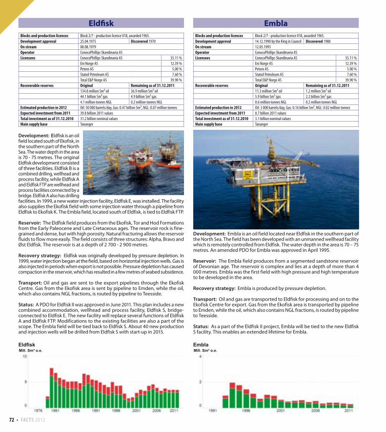
Eldfisk
Development: Eldfisk is an oil field located south of Ekofisk, in the southern part of the North Sea. The water depth in the area is 70 - 75 metres. The original Eldfisk development consisted of three facilities. Eldfisk B is a combined drilling, wellhead and process facility, while Eldfisk A and Eldfisk FTP are wellhead and process facilities connected by a bridge. Eldfisk A also has drilling facilities. In 1999, a new water injection facility, Eldfisk E, was installed. The facility also supplies the Ekofisk field with some injection water through a pipeline from Eldfisk to Ekofisk K. The Embla field, located south of Eldfisk, is tied to Eldfisk FTP.
Reservoir: The Eldfisk field produces from the Ekofisk, Tor and Hod Formations from the Early Paleocene and Late Cretaceous ages. The reservoir rock is fine-grained and dense, but with high porosity. Natural fracturing allows the reservoir fluids to flow more easily. The field consists of three structures: Alpha, Bravo and Øst Eldfisk. The reservoir is at a depth of 2 700 - 2 900 metres.
Recovery strategy: Eldfisk was originally developed by pressure depletion. In 1999, water injection began at the field, based on horizontal injection wells. Gas is also injected in periods when export is not possible. Pressure depletion has caused compaction in the reservoir, which has resulted in a few metres of seabed subsidence.
Transport: Oil and gas are sent to the export pipelines through the Ekofisk Centre. Gas from the Ekofisk area is sent by pipeline to Emden, while the oil, which also contains NGL fractions, is routed by pipeline to Teesside.
Status: A PDO for Eldfisk II was approved in June 2011. This plan includes a new combined accommodation, wellhead and process facility, Eldfisk S, bridge-connected to Eldfisk E. The new facility will replace several functions of Eldfisk A and Eldfisk FTP. Modifications to the existing facilities are also a part of the scope. The Embla field will be tied back to Eldfisk S. About 40 new production and injection wells will be drilled from Eldfisk S with start-up in 2015.
Embla
Development: Embla is an oil field located near Eldfisk in the southern part of the North Sea. The field has been developed with an unmanned wellhead facility which is remotely controlled from Eldfisk. The water depth in the area is 70 – 75 metres. An amended PDO for Embla was approved in April 1995.
Reservoir: The Embla field produces from a segmented sandstone reservoir of Devonian age. The reservoir is complex and lies at a depth of more than 4 000 metres. Embla was the first field with high pressure and high temperature to be developed in the area.
Recovery strategy: Embla is produced by pressure depletion.
Transport: Oil and gas are transported to Eldfisk for processing and on to the Ekofisk Centre for export. Gas from the Ekofisk area is transported by pipeline to Emden, while the oil, which also contains NGL fractions, is routed by pipeline to Teesside.
Status: As a part of the Eldfisk II project, Embla will be tied to the new Eldfisk S facility. This enables an extended lifetime for Embla.
Blocks and production licences Block 2/7 - production licence 018, awarded 1965.
Development approval 25.04.1975 Discovered 1970
On stream 08.08.1979
Operator ConocoPhillips Skandinavia AS
Licensees ConocoPhillips Skandinavia AS 35.11 %
Eni Norge AS 12.39 %
Petoro AS 5.00 %
Statoil Petroleum AS 7.60 %
Total E&P Norge AS 39.90 %
Recoverable reserves Original Remaining as of 31.12.2011134.8 million Sm³ oil 36.9 million Sm³ oil
44.1 billion Sm³ gas 4.9 billion Sm³ gas
4.1 million tonnes NGL 0.2 million tonnes NGL
Estimated production in 2012 Oil: 50 000 barrels/day, Gas: 0.47 billion Sm³, NGL: 0.07 million tonnes
Expected investment from 2011 39.8 billion 2011 values
Total investment as of 31.12.2010 31.2 billion nominal values
Main supply base Tananger
Blocks and production licences Block 2/7 - production licence 018, awarded 1965.
Development approval 14.12.1990 by the King in Council Discovered 1988
On stream 12.05.1993
Operator ConocoPhillips Skandinavia AS
Licensees ConocoPhillips Skandinavia AS 35.11 %
Eni Norge AS 12.39 %
Petoro AS 5.00 %
Statoil Petroleum AS 7.60 %
Total E&P Norge AS 39.90 %
Recoverable reserves Original Remaining as of 31.12.201111.3 million Sm³ oil 1.2 million Sm³ oil
5.9 billion Sm³ gas 2.2 billion Sm³ gas
0.6 million tonnes NGL 0.2 million tonnes NGL
Estimated production in 2012 Oil: 3 000 barrels/day, Gas: 0.16 billion Sm³, NGL: 0.02 million tonnes
Expected investment from 2011 0.7 billion 2011 values
Total investment as of 31.12.2010 3.1 billion nominal values
Main supply base Tananger
FACTS 2012 73
Enoch
Development: Enoch is located in the central part of the North Sea on the border to the British sector, just northwest of Sleipner. The field has been developed with a subsea facility on the British continental shelf and is tied to the British field Brae.
Reservoir: The reservoir, containing oil, is in Paleocene sandstones at a depth of approximately 2 100 metres. The reservoir quality is variable.
Recovery strategy: The field is recovered by pressure depletion, but water injection may be implemented at a later stage.
Transport: The wellstream from Enoch is transported to the Brae A facility for processing and further transport by pipeline to Cruden Bay. The gas is sold to Brae.
Fram
Development: Fram is an oil field located in the northern part of the North Sea, about 20 kilometres north of Troll. The water depth in the area is approximately 350 metres. The field comprises two deposits, Fram Vest and Fram Øst. The Fram Vest deposit is developed by two subsea templates tied back to Troll C. The gas is sepa-rated from the liquid on Troll C and re-injected into the Fram Vest reservoir. The development of the Fram Øst deposit was approved on 22.04.2005. This development includes two subsea templates tied back to Troll C. Production from Fram Øst started in October 2006.
Reservoir: The reservoirs in Fram Vest and Fram Øst consist partly of Upper Jurassic sandstones in the Draupne Formation and shallow marine sandstones in the Sognefjord Formation, and partly of sandstones of the Brent Group of Middle Jurassic age. The reservoirs are in several isolated, rotated fault blocks and contain oil with an overlying gas cap. The reservoir depth is 2 300 - 2 500 metres. The reservoir in the Fram Vest deposit is complex while the reservoirs in the Fram Øst deposit are generally of good quality.
Recovery strategy: The Fram Øst deposit in the Sognefjord Formation is produced by injection of produced water as pressure support, in addition to natural aquifer drive. The Brent reservoir in the Fram Øst deposit is recovered by pressure support from natural aquifer drive.Gas lift is used in the wells. Oil production from Fram is balanced in proportion to gas production capacity at Troll C. Gas export from Fram started in the autumn of 2007. The gas blow down phase has started at Fram Vest.
Transport: The Fram wellstream is transported by pipeline to Troll C for process-ing. The oil is then transported to Mongstad through the Troll Oljerør II pipeline. Gas is exported via Troll A to Kollsnes.
Status: Additional resources have been proven in new deposits near the field. These are being considered in connection with the further development of Fram. Several prospects have been identified within the PL090 licence.
Blocks and production licences Block 15/5 - production licence 048 D, awarded 2005.The Norwegian part of the field is 20 %, the British part is 80%
Development approval 01.07.2005 Discovered 1991
On stream 31.05.2007
Operator Talisman North Sea Limited
Licensees
Altinex Oil Norway AS 4.36 %
Det norske oljeselskap ASA 2.00 %
Faroe Petroleum Norge AS 1.86 %
Statoil Petroleum AS 11.78 %
Dana Petroleum (BVUK) Limited 20.80 %
Dyas UK Limited 14.00 %
Endeavour Energy (UK) Limited 8.00 %
Roc Oil (GB) Limited 12.00 %
Talisman LNS Limited 1.20 %
Talisman North Sea Limited 24.00 %
Recoverable reserves(Norwegian Part)
Original Remaining as of 31.12.20110.4 million Sm³ oil 0.1 million Sm³ oil
Estimated production in 2012 Oil: 400 barrels/day
Total investment as of 31.12.2010 0.2 billion nominal values
Blocks and production licences Block 31/2 - production licence 090 E, awarded 2010.Block 35/11 - production licence 090, awarded 1984.
Development approval 23.03.2001 by the King in Council Discovered 1992
On stream 02.10.2003
Operator Statoil Petroleum AS
Licensees
ExxonMobil Exploration & Production Norway AS 25.00 %
GDF SUEZ E&P Norge AS 15.00 %
Idemitsu Petroleum Norge AS 15.00 %
Statoil Petroleum AS 45.00 %
Recoverable reserves
Original Remaining as of 31.12.201128.0 million Sm³ oil 5.7 million Sm³ oil
8.5 billion Sm³ gas 6.6 billion Sm³ gas
0.5 million tonnes NGL 0.4 million tonnes NGL
Estimated production in 2012 Oil: 36 000 barrels/day, Gas: 0.57 billion Sm³, NGL: 0.04 million tonnes
Expected investment from 2011 0.1 billion 2011 values
Total investment as of 31.12.2010 9.9 billion nominal values
Main supply base Mongstad
74 FACTS 2012
Gimle
Development: Gimle is a small oil field in the northern part of the North Sea. The water depth in the area is about 220 metres. The field is tied to the Gullfaks C facility by two production wells and one water injection well drilled from Gullfaks C.
Reservoir: The reservoir consists of sandstones of the Tarbert Formation of Middle Jurassic age, in a downfaulted structure northeast of the Gullfaks field. There are also slumped sands of Late Jurassic age. The reservoir depth is about 2 900 metres, and the reservoir has good quality.
Recovery strategy: The field is recovered by pressure support from water injection.
Transport: The production from Gimle is processed on the Gullfaks C facility and transported together with oil and gas from the Gullfaks field.
Status: Drilling of a new well northeast of Gimle is being considered. The aim is to drill an exploration pilot in combination with a new production well in 2012.
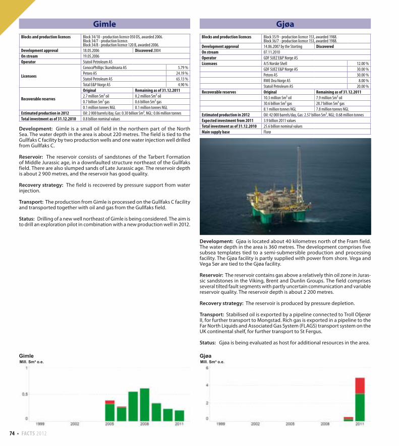
Gjøa
Development: Gjøa is located about 40 kilometres north of the Fram field. The water depth in the area is 360 metres. The development comprises five subsea templates tied to a semi-submersible production and processing facility. The Gjøa facility is partly supplied with power from shore. Vega and Vega Sør are tied to the Gjøa facility.
Reservoir: The reservoir contains gas above a relatively thin oil zone in Juras-sic sandstones in the Viking, Brent and Dunlin Groups. The field comprises several tilted fault segments with partly uncertain communication and variable reservoir quality. The reservoir depth is about 2 200 metres.
Recovery strategy: The reservoir is produced by pressure depletion.
Transport: Stabilised oil is exported by a pipeline connected to Troll Oljerør II, for further transport to Mongstad. Rich gas is exported in a pipeline to the Far North Liquids and Associated Gas System (FLAGS) transport system on the UK continental shelf, for further transport to St Fergus.
Status: Gjøa is being evaluated as host for additional resources in the area.
Blocks and production licences Block 34/10 - production licence 050 DS, awarded 2006.Block 34/7 - production licence.Block 34/8 - production licence 120 B, awarded 2006.
Development approval 18.05.2006 Discovered 2004
On stream 19.05.2006
Operator Statoil Petroleum AS
Licensees
ConocoPhillips Skandinavia AS 5.79 %
Petoro AS 24.19 %
Statoil Petroleum AS 65.13 %
Total E&P Norge AS 4.90 %
Recoverable reserves
Original Remaining as of 31.12.20112.7 million Sm³ oil 0.2 million Sm³ oil
0.7 billion Sm³ gas 0.6 billion Sm³ gas
0.1 million tonnes NGL 0.1 million tonnes NGL
Estimated production in 2012 Oil: 2 000 barrels/day, Gas: 0.30 billion Sm³, NGL: 0.06 million tonnes
Total investment as of 31.12.2010 0.8 billion nominal values
Blocks and production licences Block 35/9 - production licence 153, awarded 1988.Block 36/7 - production licence 153, awarded 1988.
Development approval 14.06.2007 by the Storting DiscoveredOn stream 07.11.2010
Operator GDF SUEZ E&P Norge AS
Licensees A/S Norske Shell 12.00 %
GDF SUEZ E&P Norge AS 30.00 %
Petoro AS 30.00 %
RWE Dea Norge AS 8.00 %
Statoil Petroleum AS 20.00 %
Recoverable reserves Original Remaining as of 31.12.201110.3 million Sm³ oil 7.9 million Sm³ oil
30.6 billion Sm³ gas 28.7 billion Sm³ gas
8.1 million tonnes NGL 7.8 million tonnes NGL
Estimated production in 2012 Oil: 42 000 barrels/day, Gas: 2.57 billion Sm³, NGL: 0.68 million tonnes
Expected investment from 2011 3.9 billion 2011 values
Total investment as of 31.12.2010 25.6 billion nominal values
Main supply base Florø
FACTS 2012 75
Glitne
Development: Glitne is an oil field in the central part of the North Sea, 40 kilometres north of the Sleipner area. The water depth in the area is about 110 metres. The field is developed with six horizontal production wells and one water injection well, tied back to the production and storage vessel “Petrojarl 1”.
Reservoir: The reservoir consists of several separate sand lobes deposited as deep marine fans in the upper part of the Heimdal Formation of Paleocene age. The reservoir lies at a depth of approximately 2 150 metres.
Recovery strategy: Glitne is recovered by pressure support from a large natural aquifer in the Heimdal Formation. Associated gas is used for gas lift in the horizontal wells.
Transport: Oil from Glitne is processed and stored on the production vessel and exported by tankers. Excess gas is injected in the Utsira Formation.
Status: Glitne is a mature field with limited remaining reserves. A new well is planned in 2012. It is expected that production from the field will cease in late 2014.
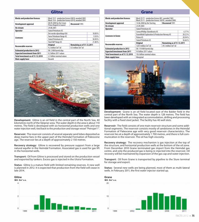
Grane
Development: Grane is an oil field located east of the Balder field in the central part of the North Sea. The water depth is 128 metres. The field has been developed with an integrated accommodation, drilling and processing facility with a fixed steel jacket. The facility has 40 well slots.
Reservoir: The field consists of one main reservoir structure and some addi-tional segments. The reservoir consists mostly of sandstones in the Heimdal Formation of Paleocene age with very good reservoir characteristics. The reservoir lies at a depth of approximately 1 700 metres, and there is full com-munication in the reservoir. The oil has high viscosity.
Recovery strategy: The recovery mechanism is gas injection at the top of the structure, and horizontal production wells at the bottom of the oil zone. From December 2010 Grane terminated gas import from the Heimdal gas centre, and only the produced gas is being re-injected into the reservoir. Oil recovery will be maintained by expansion of the gas cap and water injection.
Transport: Oil from Grane is transported by pipeline to the Sture terminal for storage and export.
Status: Several new wells are being planned, most of them as multi-lateral wells. In February 2011, the first water injector started up.
Blocks and production licences Block 15/5 - production licence 048 B, awarded 2001.Block 15/6 - production licence 029 B, awarded 2001.
Development approval 08.09.2000 by the Crown Prince Regent in Council Discovered 1995
On stream 29.08.2001
Operator Statoil Petroleum AS
Licensees
Det norske oljeselskap ASA 10.00 %
Faroe Petroleum Norge AS 9.30 %
Statoil Petroleum AS 58.90 %
Total E&P Norge AS 21.80 %
Recoverable reservesOriginal Remaining as of 31.12.20119.2 million Sm³ oil 0.5 million Sm³ oil
Estimated production in 2012 Oil: 2 000 barrels/day
Expected investment from 2011 0.2 billion 2011 values
Total investment as of 31.12.2010 2.5 billion nominal values
Main supply base Dusavik
Blocks and production licences Block 25/11 - production licence 001, awarded 1965Block 25/11 - production licence 169 B1, awarded 2000.
Development approval 14.06.2000 by the Storting Discovered 1991
On stream 23.09.2003
Operator Statoil Petroleum AS
Licensees in Grane
ConocoPhillips Skandinavia AS 6.17 %
ExxonMobil Exploration & Production Norway AS 28.22 %
Petoro AS 28.94 %
Statoil Petroleum AS 36.66 %
Recoverable reservesOriginal Remaining as of 31.12.2011120.9 million Sm³ oil 39.5 million Sm³ oil
Estimated production in 2012 Oil: 110 000 barrels/day
Expected investment from 2011 9.0 billion 2011 values
Total investment as of 31.12.2010 18.6 billion nominal values
Main supply base Mongstad
76 FACTS 2012
Gullfaks
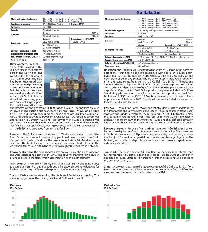
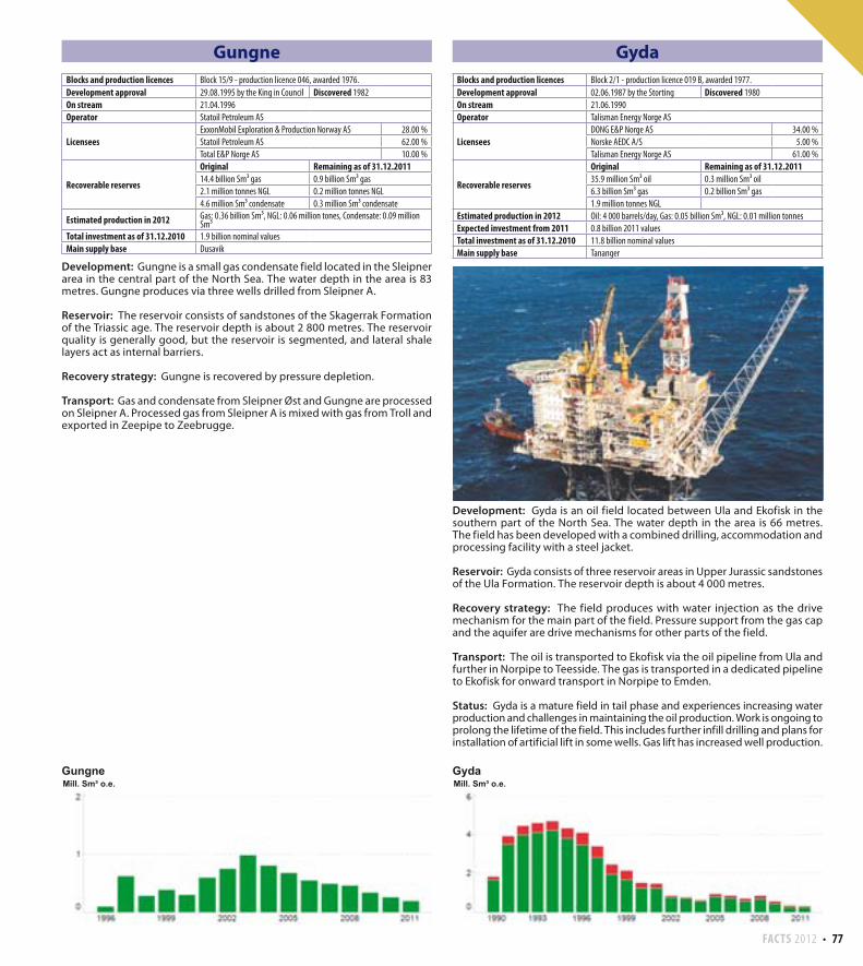
Development: Gullfaks is an oil field located in the Tampen area in the northern part of the North Sea. The water depth in the area is 130 – 220 metres. The field has been developed with three integrated processing, drilling and accommodation facilities with concrete bases and steel topsides (Gullfaks A, B and C). Gullfaks B has a simplified processing plant with only first stage separa-tion. Gullfaks A and C receive and process oil and gas from Gullfaks Sør and Gimle. The facilities are also involved in production and transport from the Tordis, Vigdis and Visund fields. The Tordis production is processed in a separate facility on Gullfaks C. A PDO for Gullfaks C was approved on 1 June 1985, a PDO for Gullfaks Vest was approved on 15 January 1993, and recovery from the Lunde Formation was approved on 3 November 1995. In December 2005, an amended PDO for the Gullfaks field was approved, covering prospects and small discoveries which can be drilled and produced from existing facilities. Reservoir: The Gullfaks reservoirs consist of Middle Jurassic sandstones of the Brent Group, and Lower Jurassic and Upper Triassic sandstones of the Cook, Statfjord and Lunde Formations. The reservoirs lie 1 700 – 2 000 metres below sea level. The Gullfaks reservoirs are located in rotated fault blocks in the west and a structural horst in the east, with a highly faulted area in-between.
Recovery strategy: The drive mechanisms are water injection, gas injection and water/alternating gas injection (WAG). The drive mechanisms vary between drainage areas in the field, with water injection as the main strategy.
Transport: Oil is exported from Gullfaks A and Gullfaks C via loading buoys to shuttle tankers. Rich gas is sent through the export pipeline to Statpipe for further processing at Kårstø and export to the Continent as dry gas.
Status: Evaluations for extending the lifetime of Gullfaks are ongoing. This includes upgrades of the drilling facilities at Gullfaks A, B and C.
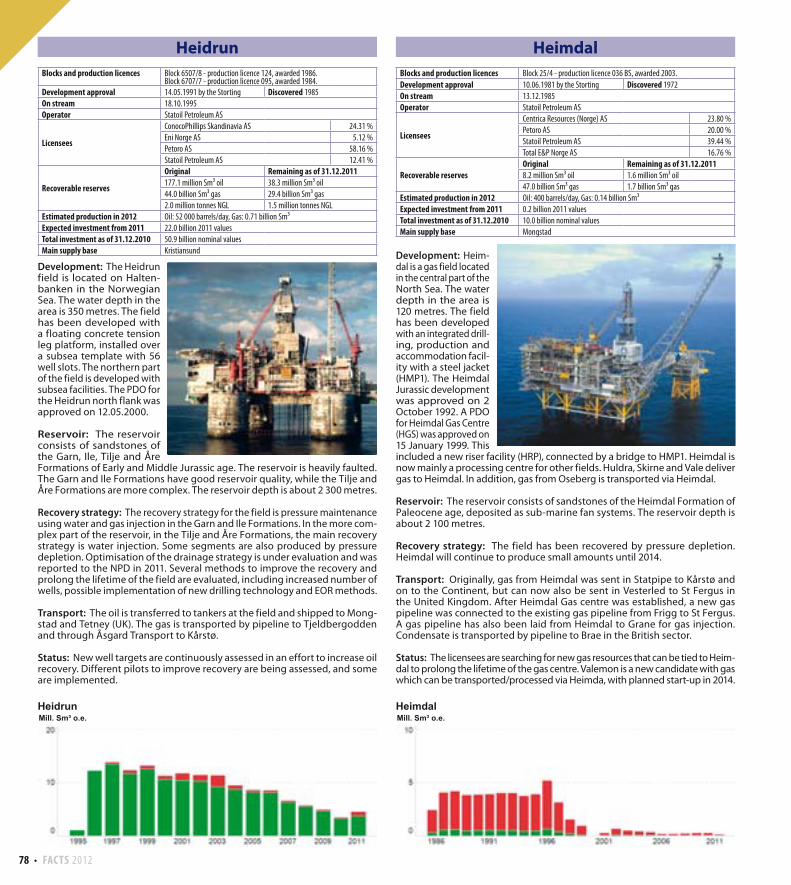
Gullfaks Sør
Development: Gullfaks Sør is located to the south of Gullfaks in the northern part of the North Sea. It has been developed with a total of 12 subsea tem-plates tied back to the Gullfaks A and Gullfaks C facilities. Gullfaks Sør has been developed in two phases. The PDO for Phase 1 included production of oil and condensate from the 34/10-2 Gullfaks Sør, 34/10-17 Rimfaks and 34/10-37 Gullveig deposits. The PDO for Phase 2 was approved on 8 June 1998 and covered production of gas from the Brent Group in the Gullfaks Sør deposit. In 2004, the 34/10-47 Gulltopp discovery was included in Gullfaks Sør. Gulltopp is produced through an extended reach production well from Gullfaks A. A PDO for the 33/12-8 A Skinfaks discovery and Rimfaks IOR was approved on 11 February 2005. The development included a new subsea template and a satellite well.
Reservoir: The Gullfaks Sør reservoirs consist of Middle Jurassic sandstones of the Brent Group and Lower Jurassic and Upper Triassic sandstones of the Cook, Statfjord and Lunde Formations. The reservoirs lie 2 400 - 3 400 metres below the sea level in rotated fault blocks. The reservoirs in the Gullfaks Sør deposit are heavily segmented, with many internal faults, and the Statfjord Formation has poor flow characteristics. The other deposits show good reservoir qualities.
Recovery strategy: Recovery from the Brent reservoir in Gullfaks Sør is driven by pressure depletion after gas injection ceased in 2009. The Brent reservoir in Rimfaks is produced by full pressure maintenance by gas injection, whereas the Statfjord Formation has partial pressure support from gas injection. The Gullveig and Gulltopp deposits are recovered by pressure depletion and natural aquifer drive.
Transport: The oil is transported to Gullfaks A for processing, storage and further transport by tankers. Rich gas is processed on Gullfaks C and then exported through Statpipe to Kårstø for further processing and export to the Continent as dry gas.
Status: A project to evaluate the redevelopment of the Gullfaks Sør Statfjord Formation is ongoing. In order to increase gas production from Gullfaks Sør, a subsea gas compressor will be installed on the field.
Blocks and production licences Block 34/10 - production licence 050, awarded 1978Block 34/10 - production licence 050 B, awarded 1995.
Development approval 09.10.1981 by the Storting Discovered 1978
On stream 22.12.1986
Operator Statoil Petroleum AS
LicenseesPetoro AS 30.00 %
Statoil Petroleum AS 70.00 %
Recoverable reserves
Original Remaining as of 31.12.2011365.4 million Sm³ oil 14.0 million Sm³ oil
23.1 billion Sm³ gas
2.7 million tonnes NGL
Estimated production in 2012 Oil: 40 000 barrels/day
Expected investment from 2011 14,4 billion 2011 values
Total investment as of 31.12.2010 72.0 billion nominal values
Main supply base Sotra and Florø
Blocks and production licences Block 32/12 - production licence 152, awarded 1988.Block 33/12 - production licence 037 B, awarded 1998Block 33/12 - production licence 037 E, awarded 2004.Block 34/10 - production licence 050, awarded 1978Block 34/10 - production licence 050 B, awarded 1995.
Development approval 29.03.1996 by the King in Council Discovered 1978
On stream 10.10.1998
Operator Statoil Petroleum AS
LicenseesPetoro AS 30.00 %
Statoil Petroleum AS 70.00 %
Recoverable reserves
Original Remaining as of 31.12.201152.1 million Sm³ oil 11.8 million Sm³ oil
64.4 billion Sm³ gas 33.9 billion Sm³ gas
8.0 million tonnes NGL 4.2 million tonnes NGL
Estimated production in 2012 Oil: 30 000 barrels/day, Gas: 2.3 billion Sm³, NGL: 0.26 million tonnes
Expected investment from 2011 20.0 billion 2011 values
Total investment as of 31.12.2010 26.7 billion nominal values
Main supply base Sotra and Florø
FACTS 2012 77
Gungne
Development: Gungne is a small gas condensate field located in the Sleipner area in the central part of the North Sea. The water depth in the area is 83 metres. Gungne produces via three wells drilled from Sleipner A.
Reservoir: The reservoir consists of sandstones of the Skagerrak Formation of the Triassic age. The reservoir depth is about 2 800 metres. The reservoir quality is generally good, but the reservoir is segmented, and lateral shale layers act as internal barriers.
Recovery strategy: Gungne is recovered by pressure depletion.
Transport: Gas and condensate from Sleipner Øst and Gungne are processed on Sleipner A. Processed gas from Sleipner A is mixed with gas from Troll and exported in Zeepipe to Zeebrugge.
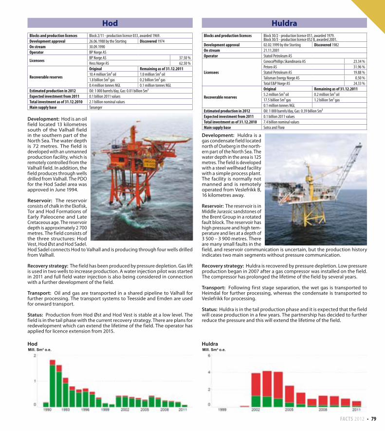
Gyda
Development: Gyda is an oil field located between Ula and Ekofisk in the southern part of the North Sea. The water depth in the area is 66 metres. The field has been developed with a combined drilling, accommodation and processing facility with a steel jacket.
Reservoir: Gyda consists of three reservoir areas in Upper Jurassic sandstones of the Ula Formation. The reservoir depth is about 4 000 metres.
Recovery strategy: The field produces with water injection as the drive mechanism for the main part of the field. Pressure support from the gas cap and the aquifer are drive mechanisms for other parts of the field.
Transport: The oil is transported to Ekofisk via the oil pipeline from Ula and further in Norpipe to Teesside. The gas is transported in a dedicated pipeline to Ekofisk for onward transport in Norpipe to Emden.
Status: Gyda is a mature field in tail phase and experiences increasing water production and challenges in maintaining the oil production. Work is ongoing to prolong the lifetime of the field. This includes further infill drilling and plans for installation of artificial lift in some wells. Gas lift has increased well production.
Blocks and production licences Block 15/9 - production licence 046, awarded 1976.
Development approval 29.08.1995 by the King in Council Discovered 1982
On stream 21.04.1996
Operator Statoil Petroleum AS
LicenseesExxonMobil Exploration & Production Norway AS 28.00 %
Statoil Petroleum AS 62.00 %
Total E&P Norge AS 10.00 %
Recoverable reserves
Original Remaining as of 31.12.201114.4 billion Sm³ gas 0.9 billion Sm³ gas
2.1 million tonnes NGL 0.2 million tonnes NGL
4.6 million Sm³ condensate 0.3 million Sm³ condensate
Estimated production in 2012 Gas: 0.36 billion Sm³, NGL: 0.06 million tones, Condensate: 0.09 million Sm³
Total investment as of 31.12.2010 1.9 billion nominal values
Main supply base Dusavik
Blocks and production licences Block 2/1 - production licence 019 B, awarded 1977.
Development approval 02.06.1987 by the Storting Discovered 1980
On stream 21.06.1990
Operator Talisman Energy Norge AS
LicenseesDONG E&P Norge AS 34.00 %
Norske AEDC A/S 5.00 %
Talisman Energy Norge AS 61.00 %
Recoverable reserves
Original Remaining as of 31.12.201135.9 million Sm³ oil 0.3 million Sm³ oil
6.3 billion Sm³ gas 0.2 billion Sm³ gas
1.9 million tonnes NGL
Estimated production in 2012 Oil: 4 000 barrels/day, Gas: 0.05 billion Sm³, NGL: 0.01 million tonnes
Expected investment from 2011 0.8 billion 2011 values
Total investment as of 31.12.2010 11.8 billion nominal values
Main supply base Tananger
78 FACTS 2012
Heidrun
Development: The Heidrun field is located on Halten-banken in the Norwegian Sea. The water depth in the area is 350 metres. The field has been developed with a floating concrete tension leg platform, installed over a subsea template with 56 well slots. The northern part of the field is developed with subsea facilities. The PDO for the Heidrun north flank was approved on 12.05.2000.
Reservoir: The reservoir consists of sandstones of the Garn, Ile, Tilje and Åre Formations of Early and Middle Jurassic age. The reservoir is heavily faulted. The Garn and Ile Formations have good reservoir quality, while the Tilje and Åre Formations are more complex. The reservoir depth is about 2 300 metres.
Recovery strategy: The recovery strategy for the field is pressure maintenance using water and gas injection in the Garn and Ile Formations. In the more com-plex part of the reservoir, in the Tilje and Åre Formations, the main recovery strategy is water injection. Some segments are also produced by pressure depletion. Optimisation of the drainage strategy is under evaluation and was reported to the NPD in 2011. Several methods to improve the recovery and prolong the lifetime of the field are evaluated, including increased number of wells, possible implementation of new drilling technology and EOR methods.
Transport: The oil is transferred to tankers at the field and shipped to Mong-stad and Tetney (UK). The gas is transported by pipeline to Tjeldbergodden and through Åsgard Transport to Kårstø.
Status: New well targets are continuously assessed in an effort to increase oil recovery. Different pilots to improve recovery are being assessed, and some are implemented.
Heimdal
Development: Heim-dal is a gas field located in the central part of the North Sea. The water depth in the area is 120 metres. The field has been developed with an integrated drill-ing, production and accommodation facil-ity with a steel jacket (HMP1). The Heimdal Jurassic development was approved on 2 October 1992. A PDO for Heimdal Gas Centre (HGS) was approved on 15 January 1999. This included a new riser facility (HRP), connected by a bridge to HMP1. Heimdal is now mainly a processing centre for other fields. Huldra, Skirne and Vale deliver gas to Heimdal. In addition, gas from Oseberg is transported via Heimdal.
Reservoir: The reservoir consists of sandstones of the Heimdal Formation of Paleocene age, deposited as sub-marine fan systems. The reservoir depth is about 2 100 metres.
Recovery strategy: The field has been recovered by pressure depletion. Heimdal will continue to produce small amounts until 2014.
Transport: Originally, gas from Heimdal was sent in Statpipe to Kårstø and on to the Continent, but can now also be sent in Vesterled to St Fergus in the United Kingdom. After Heimdal Gas centre was established, a new gas pipeline was connected to the existing gas pipeline from Frigg to St Fergus. A gas pipeline has also been laid from Heimdal to Grane for gas injection. Condensate is transported by pipeline to Brae in the British sector.
Status: The licensees are searching for new gas resources that can be tied to Heim-dal to prolong the lifetime of the gas centre. Valemon is a new candidate with gas which can be transported/processed via Heimda, with planned start-up in 2014.
Blocks and production licences Block 6507/8 - production licence 124, awarded 1986.Block 6707/7 - production licence 095, awarded 1984.
Development approval 14.05.1991 by the Storting Discovered 1985
On stream 18.10.1995
Operator Statoil Petroleum AS
Licensees
ConocoPhillips Skandinavia AS 24.31 %
Eni Norge AS 5.12 %
Petoro AS 58.16 %
Statoil Petroleum AS 12.41 %
Recoverable reserves
Original Remaining as of 31.12.2011177.1 million Sm³ oil 38.3 million Sm³ oil
44.0 billion Sm³ gas 29.4 billion Sm³ gas
2.0 million tonnes NGL 1.5 million tonnes NGL
Estimated production in 2012 Oil: 52 000 barrels/day, Gas: 0.71 billion Sm³
Expected investment from 2011 22.0 billion 2011 values
Total investment as of 31.12.2010 50.9 billion nominal values
Main supply base Kristiansund
Blocks and production licences Block 25/4 - production licence 036 BS, awarded 2003.
Development approval 10.06.1981 by the Storting Discovered 1972
On stream 13.12.1985
Operator Statoil Petroleum AS
Licensees
Centrica Resources (Norge) AS 23.80 %
Petoro AS 20.00 %
Statoil Petroleum AS 39.44 %
Total E&P Norge AS 16.76 %
Recoverable reservesOriginal Remaining as of 31.12.20118.2 million Sm³ oil 1.6 million Sm³ oil
47.0 billion Sm³ gas 1.7 billion Sm³ gas
Estimated production in 2012 Oil: 400 barrels/day, Gas: 0.14 billion Sm³
Expected investment from 2011 0.2 billion 2011 values
Total investment as of 31.12.2010 10.0 billion nominal values
Main supply base Mongstad
FACTS 2012 79
Hod
Development: Hod is an oil field located 13 kilometres south of the Valhall field in the southern part of the North Sea. The water depth is 72 metres. The field is developed with an unmanned production facility, which is remotely controlled from the Valhall field. In addition, the field produces through wells drilled from Valhall. The PDO for the Hod Sadel area was approved in June 1994.
Reservoir: The reservoir consists of chalk in the Ekofisk, Tor and Hod Formations of Early Paleocene and Late Cretaceous age. The reservoir depth is approximately 2 700 metres. The field consists of the three structures: Hod Vest, Hod Øst and Hod Sadel. Hod Sadel connects Hod to Valhall and is producing through four wells drilled from Valhall.
Recovery strategy: The field has been produced by pressure depletion. Gas lift is used in two wells to increase production. A water injection pilot was started in 2011 and full field water injection is also being considered in connection with a further development of the field.
Transport: Oil and gas are transported in a shared pipeline to Valhall for further processing. The transport systems to Teesside and Emden are used for onward transport.
Status: Production from Hod Øst and Hod Vest is stable at a low level. The field is in the tail phase with the current recovery strategy. There are plans for redevelopment which can extend the lifetime of the field. The operator has applied for licence extension from 2015.
Huldra
Development: Huldra is a gas condensate field located north of Oseberg in the north-ern part of the North Sea. The water depth in the area is 125 metres. The field is developed with a steel wellhead facility with a simple process plant. The facility is normally not manned and is remotely operated from Veslefrikk B, 16 kilometres away.
Reservoir: The reservoir is in Middle Jurassic sandstones of the Brent Group in a rotated fault block. The reservoir has high pressure and high tem-perature and lies at a depth of 3 500 – 3 900 metres. There are many small faults in the field, and reservoir communication is uncertain, but the production history indicates two main segments without pressure communication.
Recovery strategy: Huldra is recovered by pressure depletion. Low pressure production began in 2007 after a gas compressor was installed on the field. The compressor has prolonged the lifetime of the field by several years.
Transport: Following first stage separation, the wet gas is transported to Heimdal for further processing, whereas the condensate is transported to Veslefrikk for processing.
Status: Huldra is in the tail production phase and it is expected that the field will cease production in a few years. The partnership has decided to further reduce the pressure and this will extend the lifetime of the field.
Blocks and production licences Block 2/11 - production licence 033, awarded 1969.
Development approval 26.06.1988 by the Storting Discovered 1974
On stream 30.09.1990
Operator BP Norge AS
LicenseesBP Norge AS 37.50 %
Hess Norge AS 62.50 %
Recoverable reserves
Original Remaining as of 31.12.201110.4 million Sm³ oil 1.0 million Sm³ oil
1.8 billion Sm³ gas 0.2 billion Sm³ gas
0.4 million tonnes NGL 0.1 million tonnes NGL
Estimated production in 2012 Oil: 1 000 barrels/day, Gas: 0.01 billion Sm³
Expected investment from 2011 0.1 billion 2011 values
Total investment as of 31.12.2010 2.1 billion nominal values
Main supply base Tananger
Blocks and production licences Block 30/2 - production licence 051, awarded 1979.Block 30/3 - production licence 052 B, awarded 2001.
Development approval 02.02.1999 by the Storting Discovered 1982
On stream 21.11.2001
Operator Statoil Petroleum AS
Licensees
ConocoPhillips Skandinavia AS 23.34 %
Petoro AS 31.96 %
Statoil Petroleum AS 19.88 %
Talisman Energy Norge AS 0.50 %
Total E&P Norge AS 24.33 %
Recoverable reserves
Original Remaining as of 31.12.20115.2 million Sm³ oil 0.2 million Sm³ oil
17.5 billion Sm³ gas 1.2 billion Sm³ gas
0.1 million tonnes NGL
Estimated production in 2012 Oil: 1 000 barrels/day, Gas: 0.39 billion Sm³
Expected investment from 2011 0.1 billion 2011 values
Total investment as of 31.12.2010 7.4 billion nominal values
Main supply base Sotra and Florø
80 FACTS 2012
Jotun
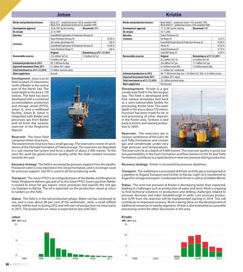
Development: Jotun is an oil field located 25 kilometres north of Balder in the central part of the North Sea. The water depth in the area is 126 metres. The field has been developed with a combined accommodation, production and storage vessel (FPSO), Jotun A, and a wellhead facility, Jotun B. Jotun is integrated with Balder and processes gas from Balder and oil from the Jurassic reservoir in the Ringhorne deposit.
Reservoir: The Jotun field comprises three structures. The easternmost structure has a small gas cap. The reservoirs consist of sand-stones of the Heimdal Formation of Paleocene age. The reservoirs are deposited in a sub-marine fan system and lie at a depth of about 2 000 metres. To the west the sand has good reservoir quality, while the shale content increases towards the east.
Recovery strategy: The field is recovered by pressure support from the aquifer. Produced water is now injected in the Utsira Formation, and is no longer used for pressure support. Gas lift is used in all the producing wells.
Transport: The Jotun FPSO is an integrated part of the Balder and Ringhorne fields. Ringhorne delivers gas and oil to the Jotun FPSO. Excess gas from Balder is routed to Jotun for gas export. Jotun processes and exports the rich gas via Statpipe to Kårstø. The oil is exported via the production vessel at Jotun to tankers on the field.
Status: The field is in the tail production phase. Water cut has continued to rise, and is now about 96 per cent of the wellstream. Jette, a small oilfield nearby, will be tied-in during 2012 and will start oil production via Jotun early in 2013. The production on Jotun is expected to last until 2021.
Kristin
Development: Kristin is a gas condensate field in the Norwegian Sea. The field is developed with four subsea templates tied back to a semi-submersible facility for processing, Kristin Semi. The water depth in the area is about 370 metres. Provision has been made for tie-in and processing of other deposits in the Kristin area. Tyrihans is tied back to Kristin and started produc-tion in 2009.
Reservoir: The reservoirs are in Jurassic sandstones of the Garn, Ile and Tofte Formations and contain gas and condensate under very high pressure and temperatures. The reservoirs lie at a depth of 4 600 metres. The reservoir quality is good, but low permeability in the Garn Formation and flow barriers in the Ile and Tofte Formations contribute to a rapid decline in reservoir pressure during production.
Recovery strategy: Kristin is recovered by pressure depletion.
Transport: The wellstream is processed at Kristin and the gas is transported in a pipeline to Åsgard Transport and further to Kårstø. Light oil is transferred to Åsgard for storage and export. Condensate from Kristin is sold as oil (Halten Blend).
Status: The reservoir pressure at Kristin is decreasing faster than expected, leading to challenges such as production of water and sand. Work is ongoing to find technical solutions to production and drilling challenges related to pressure decrease and water breakthrough in wells. Low pressure produc-tion (LPP) from the reservoir will be implemented starting in 2014. This will contribute to improved recovery. Work is being done on the development of additional resources in nearby segments. Kristin is also evaluated as a possible processing centre for other discoveries in the area.
Blocks and production licences Block 25/7 - production licence 103 B, awarded 1998.Block 25/8 - production licence 027 B, awarded 1999.
Development approval 10.06.1997 by the Storting Discovered 1994
On stream 25.10.1999
Operator ExxonMobil Exploration & Production Norway AS
Licensees
Dana Petroleum Norway AS 45.00 %
Det norske oljeselskap ASA 7.00 %
ExxonMobil Exploration & Production Norway AS 45.00 %
Faroe Petroleum Norge AS 3.00 %
Recoverable reservesOriginal Remaining as of 31.12.201123.6 million Sm³ oil 1.0 million Sm³ oil
0.9 billion Sm³ gas
Estimated production in 2012 Oil: 3 000 barrels/day
Expected investment from 2011 0.1 billion 2011 values
Total investment as of 31.12.2010 9.5 billion nominal values
Main supply base Dusavik
Blocks and production licences Block 6406/2 - production licence 199, awarded 1993.Block 6506/11 - production licence 134 B, awarded 2000.
Development approval 17.12.2001 by the Storting Discovered 1997
On stream 03.11.2005
Operator Statoil Petroleum AS
Licensees Eni Norge AS 8.25 %
ExxonMobil Exploration & Production Norway AS 10.88 %
Petoro AS 19.58 %
Statoil Petroleum AS 55.30 %
Total E&P Norge AS 6.00 %
Recoverable reserves Original Remaining as of 31.12.201122.2 million Sm³ oil 6.4 million Sm³ oil
28.6 billion Sm³ gas 11.2 billion Sm³ gas
6.4 million tonnes NGL 2.8 million tonnes NGL
2.1 million Sm³ condensate
Estimated production in 2012 Oil: 17 000 barrels/day, Gas: 1.45 billion Sm³, NGL: 0.32 million tonnes
Expected investment from 2011 2.4 billion 2011 values
Total investment as of 31.12.2010 24.2 billion nominal values
Main supply base Kristiansund
FACTS 2012 81
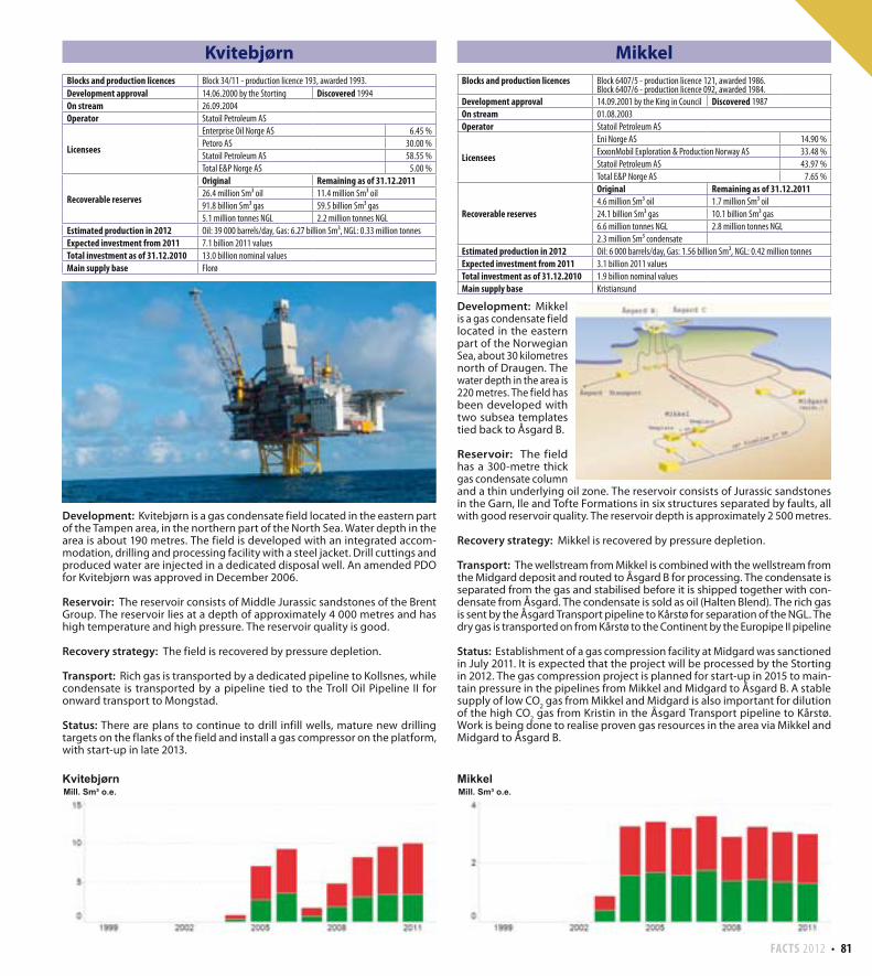
Kvitebjørn
Development: Kvitebjørn is a gas condensate field located in the eastern part of the Tampen area, in the northern part of the North Sea. Water depth in the area is about 190 metres. The field is developed with an integrated accom-modation, drilling and processing facility with a steel jacket. Drill cuttings and produced water are injected in a dedicated disposal well. An amended PDO for Kvitebjørn was approved in December 2006.
Reservoir: The reservoir consists of Middle Jurassic sandstones of the Brent Group. The reservoir lies at a depth of approximately 4 000 metres and has high temperature and high pressure. The reservoir quality is good.
Recovery strategy: The field is recovered by pressure depletion.
Transport: Rich gas is transported by a dedicated pipeline to Kollsnes, while condensate is transported by a pipeline tied to the Troll Oil Pipeline II for onward transport to Mongstad.
Status: There are plans to continue to drill infill wells, mature new drilling targets on the flanks of the field and install a gas compressor on the platform, with start-up in late 2013.
Mikkel
Development: Mikkel is a gas condensate field located in the eastern part of the Norwegian Sea, about 30 kilometres north of Draugen. The water depth in the area is 220 metres. The field has been developed with two subsea templates tied back to Åsgard B.
Reservoir: The field has a 300-metre thick gas condensate column and a thin underlying oil zone. The reservoir consists of Jurassic sandstones in the Garn, Ile and Tofte Formations in six structures separated by faults, all with good reservoir quality. The reservoir depth is approximately 2 500 metres.
Recovery strategy: Mikkel is recovered by pressure depletion.
Transport: The wellstream from Mikkel is combined with the wellstream from the Midgard deposit and routed to Åsgard B for processing. The condensate is separated from the gas and stabilised before it is shipped together with con-densate from Åsgard. The condensate is sold as oil (Halten Blend). The rich gas is sent by the Åsgard Transport pipeline to Kårstø for separation of the NGL. The dry gas is transported on from Kårstø to the Continent by the Europipe II pipeline
Status: Establishment of a gas compression facility at Midgard was sanctioned in July 2011. It is expected that the project will be processed by the Storting in 2012. The gas compression project is planned for start-up in 2015 to main-tain pressure in the pipelines from Mikkel and Midgard to Åsgard B. A stable supply of low CO
2 gas from Mikkel and Midgard is also important for dilution
of the high CO2 gas from Kristin in the Åsgard Transport pipeline to Kårstø.
Work is being done to realise proven gas resources in the area via Mikkel and Midgard to Åsgard B.
Blocks and production licences Block 34/11 - production licence 193, awarded 1993.
Development approval 14.06.2000 by the Storting Discovered 1994
On stream 26.09.2004
Operator Statoil Petroleum AS
Licensees
Enterprise Oil Norge AS 6.45 %
Petoro AS 30.00 %
Statoil Petroleum AS 58.55 %
Total E&P Norge AS 5.00 %
Recoverable reserves
Original Remaining as of 31.12.201126.4 million Sm³ oil 11.4 million Sm³ oil
91.8 billion Sm³ gas 59.5 billion Sm³ gas
5.1 million tonnes NGL 2.2 million tonnes NGL
Estimated production in 2012 Oil: 39 000 barrels/day, Gas: 6.27 billion Sm³, NGL: 0.33 million tonnes
Expected investment from 2011 7.1 billion 2011 values
Total investment as of 31.12.2010 13.0 billion nominal values
Main supply base Florø
Blocks and production licences Block 6407/5 - production licence 121, awarded 1986.Block 6407/6 - production licence 092, awarded 1984.
Development approval 14.09.2001 by the King in Council Discovered 1987
On stream 01.08.2003
Operator Statoil Petroleum AS
Licensees
Eni Norge AS 14.90 %
ExxonMobil Exploration & Production Norway AS 33.48 %
Statoil Petroleum AS 43.97 %
Total E&P Norge AS 7.65 %
Recoverable reserves
Original Remaining as of 31.12.20114.6 million Sm³ oil 1.7 million Sm³ oil
24.1 billion Sm³ gas 10.1 billion Sm³ gas
6.6 million tonnes NGL 2.8 million tonnes NGL
2.3 million Sm³ condensate
Estimated production in 2012 Oil: 6 000 barrels/day, Gas: 1.56 billion Sm³, NGL: 0.42 million tonnes
Expected investment from 2011 3.1 billion 2011 values
Total investment as of 31.12.2010 1.9 billion nominal values
Main supply base Kristiansund
82 FACTS 2012
Morvin
Development: Morvin is located approximately 20 kilometres north of Kristin and 15 kilometres west of Åsgard. The water depth in the area is about 350 metres. The field is developed with two subsea templates tied back to Åsgard B.
Reservoir: The reservoir contains oil and gas in a rotated and tilted fault block at a depth of 4 500 - 4 700 metres, in Middle Jurassic sandstones in the Garn and Ile Formations. The reservoir in the Garn Formation is relatively homogeneous, while the reservoir in the Ile Formation is more heterogeneous. Recovery strategy: Morvin will be produced by pressure depletion.
Transport: The wellstream from Morvin is transported by a 20 kilometre long pipeline to Åsgard B for processing and further transport.
Status: The field came on stream in August 2010.
Murchison
Development: Murchison straddles the border between the Norwegian and British sectors in the Tampen area, in the northern part of the North Sea. The field has been developed with a combined drilling, accommodation and pro-duction facility with a steel jacket situated in the British sector. The British and Nor-wegian licensees entered into an agreement in 1979 concerning common exploi-tation of the resources in the Murchison field. The agree-ment also involves British and Norwegian authorities.
Reservoir: The reservoirs are in Jurassic sandstones.
Recovery strategy: The field is recovered by pres-sure support from water injection.
Transport: The production is sent through the Brent system to Sullom Voe in the Shetlands.
Status: Murchison is in the tail phase, and production may end within a few years.
Blocks and production licences Block 6506/11 - production licence 134 B, awarded 2000Block 6506/11 - production licence 134 C, awarded 2006.
Development approval 25.04.2008 by the King in Council Discovered 2001
On stream 01.08.2010
Operator Statoil Petroleum AS
LicenseesEni Norge AS 30.00 %
Statoil Petroleum AS 64.00 %
Total E&P Norge AS 6.00 %
Recoverable reserves
Original Remaining as of 31.12.20119.2 million Sm³ oil 7.2 million Sm³ oil
3.1 billion Sm³ gas 3.1 billion Sm³ gas
0.7 million tonnes NGL 0.7 million tonnes NGL
Estimated production in 2012 Oil: 30 000 barrels/day, Gas: 0.22 billion Sm³, NGL: 0.04 million tonnes
Expected investment from 2011 0.6 billion 2011 values
Total investment as of 31.12.2010 7.4 billion nominal values
Blocks and production licences Block 33/9 - production licence 037 C, awarded 2000.The Norwegian part of the field is 22.2 %, the British part is 77.8 %
Development approval 15.12.1976 Discovered 1975
On stream 28.09.1980
Operator CNR International (UK) Limited
Licensees Wintershall Norge ASA 22.20 %
CNR International (UK) Limited 77.80 %
Recoverable reserves(Norwegian part)
Original Remaining as of 31.12.201113.9 million Sm³ oil 0.1 million Sm³ oil
0.3 billion Sm³ gas
Estimated production in 2012 Oil: 1 000 barrels/day
Expected investment from 2011 0.1 billion 2011 values
Total investment as of 31.12.2010 2.6 billion nominal values
Main supply base Peterhead, Scotland
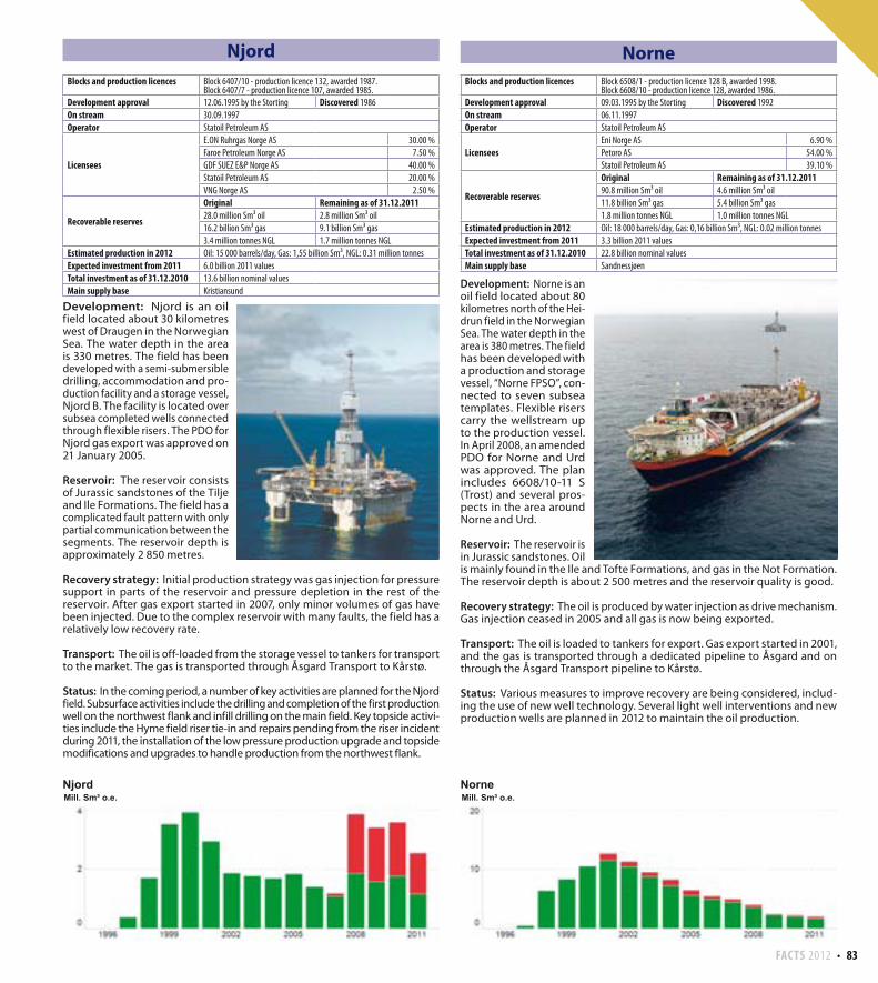
FACTS 2012 83
Njord
Development: Njord is an oil field located about 30 kilometres west of Draugen in the Norwegian Sea. The water depth in the area is 330 metres. The field has been developed with a semi-submersible drilling, accommodation and pro-duction facility and a storage vessel, Njord B. The facility is located over subsea completed wells connected through flexible risers. The PDO for Njord gas export was approved on 21 January 2005.
Reservoir: The reservoir consists of Jurassic sandstones of the Tilje and Ile Formations. The field has a complicated fault pattern with only partial communication between the segments. The reservoir depth is approximately 2 850 metres.
Recovery strategy: Initial production strategy was gas injection for pressure support in parts of the reservoir and pressure depletion in the rest of the reservoir. After gas export started in 2007, only minor volumes of gas have been injected. Due to the complex reservoir with many faults, the field has a relatively low recovery rate.
Transport: The oil is off-loaded from the storage vessel to tankers for transport to the market. The gas is transported through Åsgard Transport to Kårstø.
Status: In the coming period, a number of key activities are planned for the Njord field. Subsurface activities include the drilling and completion of the first production well on the northwest flank and infill drilling on the main field. Key topside activi-ties include the Hyme field riser tie-in and repairs pending from the riser incident during 2011, the installation of the low pressure production upgrade and topside modifications and upgrades to handle production from the northwest flank.
Norne
Development: Norne is an oil field located about 80 kilometres north of the Hei-drun field in the Norwegian Sea. The water depth in the area is 380 metres. The field has been developed with a production and storage vessel, “Norne FPSO”, con-nected to seven subsea templates. Flexible risers carry the wellstream up to the production vessel. In April 2008, an amended PDO for Norne and Urd was approved. The plan includes 6608/10-11 S (Trost) and several pros-pects in the area around Norne and Urd.
Reservoir: The reservoir is in Jurassic sandstones. Oil is mainly found in the Ile and Tofte Formations, and gas in the Not Formation. The reservoir depth is about 2 500 metres and the reservoir quality is good.
Recovery strategy: The oil is produced by water injection as drive mechanism. Gas injection ceased in 2005 and all gas is now being exported.
Transport: The oil is loaded to tankers for export. Gas export started in 2001, and the gas is transported through a dedicated pipeline to Åsgard and on through the Åsgard Transport pipeline to Kårstø.
Status: Various measures to improve recovery are being considered, includ-ing the use of new well technology. Several light well interventions and new production wells are planned in 2012 to maintain the oil production.
Blocks and production licences Block 6407/10 - production licence 132, awarded 1987.Block 6407/7 - production licence 107, awarded 1985.
Development approval 12.06.1995 by the Storting Discovered 1986
On stream 30.09.1997
Operator Statoil Petroleum AS
Licensees
E.ON Ruhrgas Norge AS 30.00 %
Faroe Petroleum Norge AS 7.50 %
GDF SUEZ E&P Norge AS 40.00 %
Statoil Petroleum AS 20.00 %
VNG Norge AS 2.50 %
Recoverable reserves
Original Remaining as of 31.12.201128.0 million Sm³ oil 2.8 million Sm³ oil
16.2 billion Sm³ gas 9.1 billion Sm³ gas
3.4 million tonnes NGL 1.7 million tonnes NGL
Estimated production in 2012 Oil: 15 000 barrels/day, Gas: 1,55 billion Sm³, NGL: 0.31 million tonnes
Expected investment from 2011 6.0 billion 2011 values
Total investment as of 31.12.2010 13.6 billion nominal values
Main supply base Kristiansund
Blocks and production licences Block 6508/1 - production licence 128 B, awarded 1998.Block 6608/10 - production licence 128, awarded 1986.
Development approval 09.03.1995 by the Storting Discovered 1992
On stream 06.11.1997
Operator Statoil Petroleum AS
Licensees Eni Norge AS 6.90 %
Petoro AS 54.00 %
Statoil Petroleum AS 39.10 %
Recoverable reserves
Original Remaining as of 31.12.201190.8 million Sm³ oil 4.6 million Sm³ oil
11.8 billion Sm³ gas 5.4 billion Sm³ gas
1.8 million tonnes NGL 1.0 million tonnes NGL
Estimated production in 2012 Oil: 18 000 barrels/day, Gas: 0,16 billion Sm³, NGL: 0.02 million tonnes
Expected investment from 2011 3.3 billion 2011 values
Total investment as of 31.12.2010 22.8 billion nominal values
Main supply base Sandnessjøen
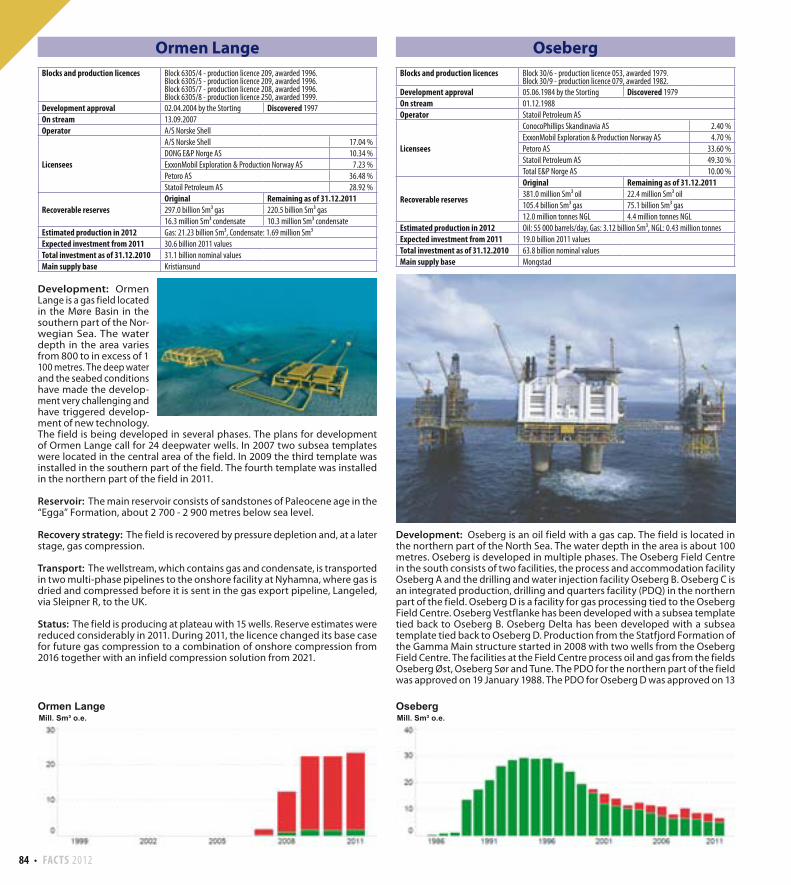
84 FACTS 2012
Ormen Lange
Development: Ormen Lange is a gas field located in the Møre Basin in the southern part of the Nor-wegian Sea. The water depth in the area varies from 800 to in excess of 1 100 metres. The deep water and the seabed conditions have made the develop-ment very challenging and have triggered develop-ment of new technology. The field is being developed in several phases. The plans for development of Ormen Lange call for 24 deepwater wells. In 2007 two subsea templates were located in the central area of the field. In 2009 the third template was installed in the southern part of the field. The fourth template was installed in the northern part of the field in 2011.
Reservoir: The main reservoir consists of sandstones of Paleocene age in the “Egga” Formation, about 2 700 - 2 900 metres below sea level.
Recovery strategy: The field is recovered by pressure depletion and, at a later stage, gas compression.
Transport: The wellstream, which contains gas and condensate, is transported in two multi-phase pipelines to the onshore facility at Nyhamna, where gas is dried and compressed before it is sent in the gas export pipeline, Langeled, via Sleipner R, to the UK.
Status: The field is producing at plateau with 15 wells. Reserve estimates were reduced considerably in 2011. During 2011, the licence changed its base case for future gas compression to a combination of onshore compression from 2016 together with an infield compression solution from 2021.
Oseberg
Development: Oseberg is an oil field with a gas cap. The field is located in the northern part of the North Sea. The water depth in the area is about 100 metres. Oseberg is developed in multiple phases. The Oseberg Field Centre in the south consists of two facilities, the process and accommodation facility Oseberg A and the drilling and water injection facility Oseberg B. Oseberg C is an integrated production, drilling and quarters facility (PDQ) in the northern part of the field. Oseberg D is a facility for gas processing tied to the Oseberg Field Centre. Oseberg Vestflanke has been developed with a subsea template tied back to Oseberg B. Oseberg Delta has been developed with a subsea template tied back to Oseberg D. Production from the Statfjord Formation of the Gamma Main structure started in 2008 with two wells from the Oseberg Field Centre. The facilities at the Field Centre process oil and gas from the fields Oseberg Øst, Oseberg Sør and Tune. The PDO for the northern part of the field was approved on 19 January 1988. The PDO for Oseberg D was approved on 13
Blocks and production licences Block 6305/4 - production licence 209, awarded 1996.Block 6305/5 - production licence 209, awarded 1996.Block 6305/7 - production licence 208, awarded 1996.Block 6305/8 - production licence 250, awarded 1999.
Development approval 02.04.2004 by the Storting Discovered 1997
On stream 13.09.2007
Operator A/S Norske Shell
Licensees
A/S Norske Shell 17.04 %
DONG E&P Norge AS 10.34 %
ExxonMobil Exploration & Production Norway AS 7.23 %
Petoro AS 36.48 %
Statoil Petroleum AS 28.92 %
Recoverable reservesOriginal Remaining as of 31.12.2011297.0 billion Sm³ gas 220.5 billion Sm³ gas
16.3 million Sm³ condensate 10.3 million Sm³ condensate
Estimated production in 2012 Gas: 21.23 billion Sm³, Condensate: 1.69 million Sm³
Expected investment from 2011 30.6 billion 2011 values
Total investment as of 31.12.2010 31.1 billion nominal values
Main supply base Kristiansund
Blocks and production licences Block 30/6 - production licence 053, awarded 1979.Block 30/9 - production licence 079, awarded 1982.
Development approval 05.06.1984 by the Storting Discovered 1979
On stream 01.12.1988
Operator Statoil Petroleum AS
Licensees
ConocoPhillips Skandinavia AS 2.40 %
ExxonMobil Exploration & Production Norway AS 4.70 %
Petoro AS 33.60 %
Statoil Petroleum AS 49.30 %
Total E&P Norge AS 10.00 %
Recoverable reserves
Original Remaining as of 31.12.2011381.0 million Sm³ oil 22.4 million Sm³ oil
105.4 billion Sm³ gas 75.1 billion Sm³ gas
12.0 million tonnes NGL 4.4 million tonnes NGL
Estimated production in 2012 Oil: 55 000 barrels/day, Gas: 3.12 billion Sm³, NGL: 0.43 million tonnes
Expected investment from 2011 19.0 billion 2011 values
Total investment as of 31.12.2010 63.8 billion nominal values
Main supply base Mongstad
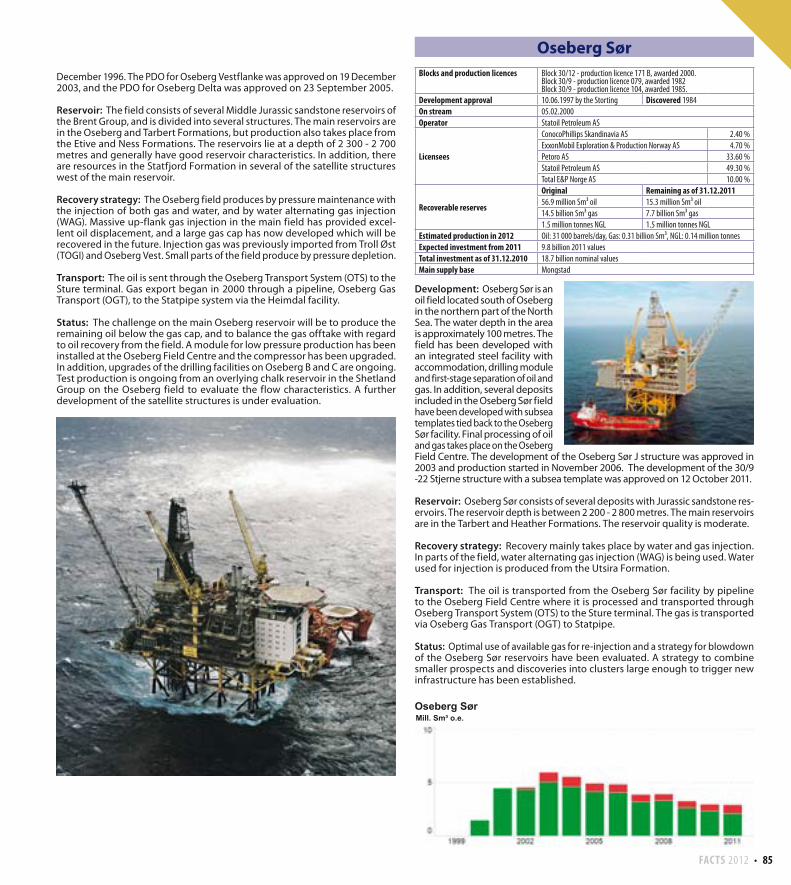
FACTS 2012 85
Oseberg Sør
Development: Oseberg Sør is an oil field located south of Oseberg in the northern part of the North Sea. The water depth in the area is approximately 100 metres. The field has been developed with an integrated steel facility with accommodation, drilling module and first-stage separation of oil and gas. In addition, several deposits included in the Oseberg Sør field have been developed with subsea templates tied back to the Oseberg Sør facility. Final processing of oil and gas takes place on the Oseberg Field Centre. The development of the Oseberg Sør J structure was approved in 2003 and production started in November 2006. The development of the 30/9 -22 Stjerne structure with a subsea template was approved on 12 October 2011.
Reservoir: Oseberg Sør consists of several deposits with Jurassic sandstone res-ervoirs. The reservoir depth is between 2 200 - 2 800 metres. The main reservoirs are in the Tarbert and Heather Formations. The reservoir quality is moderate.
Recovery strategy: Recovery mainly takes place by water and gas injection. In parts of the field, water alternating gas injection (WAG) is being used. Water used for injection is produced from the Utsira Formation.
Transport: The oil is transported from the Oseberg Sør facility by pipeline to the Oseberg Field Centre where it is processed and transported through Oseberg Transport System (OTS) to the Sture terminal. The gas is transported via Oseberg Gas Transport (OGT) to Statpipe.
Status: Optimal use of available gas for re-injection and a strategy for blowdown of the Oseberg Sør reservoirs have been evaluated. A strategy to combine smaller prospects and discoveries into clusters large enough to trigger new infrastructure has been established.
December 1996. The PDO for Oseberg Vestflanke was approved on 19 December 2003, and the PDO for Oseberg Delta was approved on 23 September 2005.
Reservoir: The field consists of several Middle Jurassic sandstone reservoirs of the Brent Group, and is divided into several structures. The main reservoirs are in the Oseberg and Tarbert Formations, but production also takes place from the Etive and Ness Formations. The reservoirs lie at a depth of 2 300 - 2 700 metres and generally have good reservoir characteristics. In addition, there are resources in the Statfjord Formation in several of the satellite structures west of the main reservoir.
Recovery strategy: The Oseberg field produces by pressure maintenance with the injection of both gas and water, and by water alternating gas injection (WAG). Massive up-flank gas injection in the main field has provided excel-lent oil displacement, and a large gas cap has now developed which will be recovered in the future. Injection gas was previously imported from Troll Øst (TOGI) and Oseberg Vest. Small parts of the field produce by pressure depletion.
Transport: The oil is sent through the Oseberg Transport System (OTS) to the Sture terminal. Gas export began in 2000 through a pipeline, Oseberg Gas Transport (OGT), to the Statpipe system via the Heimdal facility.
Status: The challenge on the main Oseberg reservoir will be to produce the remaining oil below the gas cap, and to balance the gas offtake with regard to oil recovery from the field. A module for low pressure production has been installed at the Oseberg Field Centre and the compressor has been upgraded. In addition, upgrades of the drilling facilities on Oseberg B and C are ongoing. Test production is ongoing from an overlying chalk reservoir in the Shetland Group on the Oseberg field to evaluate the flow characteristics. A further development of the satellite structures is under evaluation.
Blocks and production licences Block 30/12 - production licence 171 B, awarded 2000.Block 30/9 - production licence 079, awarded 1982Block 30/9 - production licence 104, awarded 1985.
Development approval 10.06.1997 by the Storting Discovered 1984
On stream 05.02.2000
Operator Statoil Petroleum AS
Licensees
ConocoPhillips Skandinavia AS 2.40 %
ExxonMobil Exploration & Production Norway AS 4.70 %
Petoro AS 33.60 %
Statoil Petroleum AS 49.30 %
Total E&P Norge AS 10.00 %
Recoverable reserves
Original Remaining as of 31.12.201156.9 million Sm³ oil 15.3 million Sm³ oil
14.5 billion Sm³ gas 7.7 billion Sm³ gas
1.5 million tonnes NGL 1.5 million tonnes NGL
Estimated production in 2012 Oil: 31 000 barrels/day, Gas: 0.31 billion Sm³, NGL: 0.14 million tonnes
Expected investment from 2011 9.8 billion 2011 values
Total investment as of 31.12.2010 18.7 billion nominal values
Main supply base Mongstad
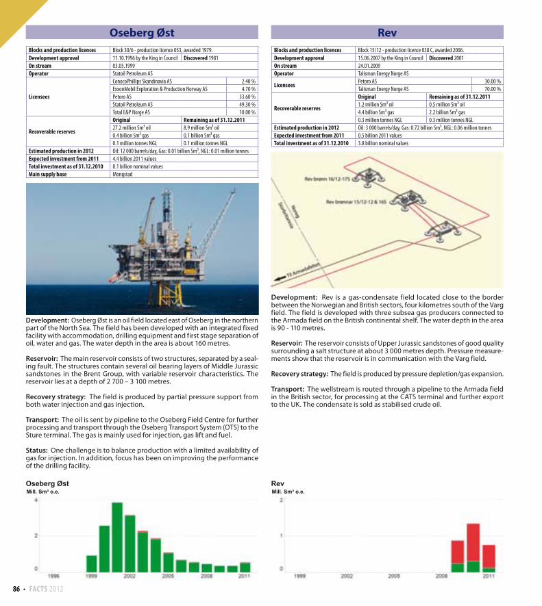
86 FACTS 2012
Rev
Development: Rev is a gas-condensate field located close to the border between the Norwegian and British sectors, four kilometres south of the Varg field. The field is developed with three subsea gas producers connected to the Armada field on the British continental shelf. The water depth in the area is 90 - 110 metres.
Reservoir: The reservoir consists of Upper Jurassic sandstones of good quality surrounding a salt structure at about 3 000 metres depth. Pressure measure-ments show that the reservoir is in communication with the Varg field. Recovery strategy: The field is produced by pressure depletion/gas expansion.
Transport: The wellstream is routed through a pipeline to the Armada field in the British sector, for processing at the CATS terminal and further export to the UK. The condensate is sold as stabilised crude oil.
Oseberg Øst
Development: Oseberg Øst is an oil field located east of Oseberg in the northern part of the North Sea. The field has been developed with an integrated fixed facility with accommodation, drilling equipment and first stage separation of oil, water and gas. The water depth in the area is about 160 metres.
Reservoir: The main reservoir consists of two structures, separated by a seal-ing fault. The structures contain several oil bearing layers of Middle Jurassic sandstones in the Brent Group, with variable reservoir characteristics. The reservoir lies at a depth of 2 700 – 3 100 metres.
Recovery strategy: The field is produced by partial pressure support from both water injection and gas injection.
Transport: The oil is sent by pipeline to the Oseberg Field Centre for further processing and transport through the Oseberg Transport System (OTS) to the Sture terminal. The gas is mainly used for injection, gas lift and fuel.
Status: One challenge is to balance production with a limited availability of gas for injection. In addition, focus has been on improving the performance of the drilling facility.
Blocks and production licences Block 30/6 - production licence 053, awarded 1979.
Development approval 11.10.1996 by the King in Council Discovered 1981
On stream 03.05.1999
Operator Statoil Petroleum AS
Licensees
ConocoPhillips Skandinavia AS 2.40 %
ExxonMobil Exploration & Production Norway AS 4.70 %
Petoro AS 33.60 %
Statoil Petroleum AS 49.30 %
Total E&P Norge AS 10.00 %
Recoverable reserves
Original Remaining as of 31.12.201127.2 million Sm³ oil 8.9 million Sm³ oil
0.4 billion Sm³ gas 0.1 billion Sm³ gas
0.1 million tonnes NGL 0.1 million tonnes NGL
Estimated production in 2012 Oil: 12 000 barrels/day, Gas: 0.01 billion Sm³, NGL: 0.01 million tonnes
Expected investment from 2011 4.4 billion 2011 values
Total investment as of 31.12.2010 8.1 billion nominal values
Main supply base Mongstad
Blocks and production licences Block 15/12 - production licence 038 C, awarded 2006.
Development approval 15.06.2007 by the King in Council Discovered 2001
On stream 24.01.2009
Operator Talisman Energy Norge AS
LicenseesPetoro AS 30.00 %
Talisman Energy Norge AS 70.00 %
Recoverable reserves
Original Remaining as of 31.12.20111.2 million Sm³ oil 0.5 million Sm³ oil
4.4 billion Sm³ gas 2.2 billion Sm³ gas
0.3 million tonnes NGL 0.3 million tonnes NGL
Estimated production in 2012 Oil: 3 000 barrels/day, Gas: 0.72 billion Sm³, NGL: 0.06 million tonnes
Expected investment from 2011 0.5 billion 2011 values
Total investment as of 31.12.2010 3.8 billion nominal values
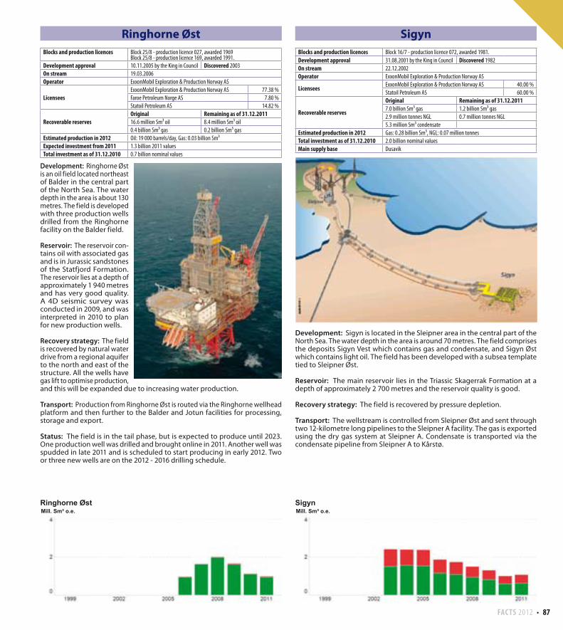
FACTS 2012 87
Ringhorne Øst
Development: Ringhorne Øst is an oil field located northeast of Balder in the central part of the North Sea. The water depth in the area is about 130 metres. The field is developed with three production wells drilled from the Ringhorne facility on the Balder field.
Reservoir: The reservoir con-tains oil with associated gas and is in Jurassic sandstones of the Statfjord Formation. The reservoir lies at a depth of approximately 1 940 metres and has very good quality. A 4D seismic survey was conducted in 2009, and was interpreted in 2010 to plan for new production wells. Recovery strategy: The field is recovered by natural water drive from a regional aquifer to the north and east of the structure. All the wells have gas lift to optimise production, and this will be expanded due to increasing water production.
Transport: Production from Ringhorne Øst is routed via the Ringhorne wellhead platform and then further to the Balder and Jotun facilities for processing, storage and export.
Status: The field is in the tail phase, but is expected to produce until 2023. One production well was drilled and brought online in 2011. Another well was spudded in late 2011 and is scheduled to start producing in early 2012. Two or three new wells are on the 2012 - 2016 drilling schedule.
Sigyn
Development: Sigyn is located in the Sleipner area in the central part of the North Sea. The water depth in the area is around 70 metres. The field comprises the deposits Sigyn Vest which contains gas and condensate, and Sigyn Øst which contains light oil. The field has been developed with a subsea template tied to Sleipner Øst.
Reservoir: The main reservoir lies in the Triassic Skagerrak Formation at a depth of approximately 2 700 metres and the reservoir quality is good.
Recovery strategy: The field is recovered by pressure depletion.
Transport: The wellstream is controlled from Sleipner Øst and sent through two 12-kilometre long pipelines to the Sleipner A facility. The gas is exported using the dry gas system at Sleipner A. Condensate is transported via the condensate pipeline from Sleipner A to Kårstø.
Blocks and production licences Block 25/8 - production licence 027, awarded 1969Block 25/8 - production licence 169, awarded 1991.
Development approval 10.11.2005 by the King in Council Discovered 2003
On stream 19.03.2006
Operator ExxonMobil Exploration & Production Norway AS
Licensees ExxonMobil Exploration & Production Norway AS 77.38 %
Faroe Petroleum Norge AS 7.80 %
Statoil Petroleum AS 14.82 %
Recoverable reservesOriginal Remaining as of 31.12.201116.6 million Sm³ oil 8.4 million Sm³ oil
0.4 billion Sm³ gas 0.2 billion Sm³ gas
Estimated production in 2012 Oil: 19 000 barrels/day, Gas: 0.03 billion Sm³
Expected investment from 2011 1.3 billion 2011 values
Total investment as of 31.12.2010 0.7 billion nominal values
Blocks and production licences Block 16/7 - production licence 072, awarded 1981.
Development approval 31.08.2001 by the King in Council Discovered 1982
On stream 22.12.2002
Operator ExxonMobil Exploration & Production Norway AS
LicenseesExxonMobil Exploration & Production Norway AS 40.00 %
Statoil Petroleum AS 60.00 %
Recoverable reserves
Original Remaining as of 31.12.20117.0 billion Sm³ gas 1.2 billion Sm³ gas
2.9 million tonnes NGL 0.7 million tonnes NGL
5.3 million Sm³ condensate
Estimated production in 2012 Gas: 0.28 billion Sm³, NGL: 0.07 million tonnes
Total investment as of 31.12.2010 2.0 billion nominal values
Main supply base Dusavik
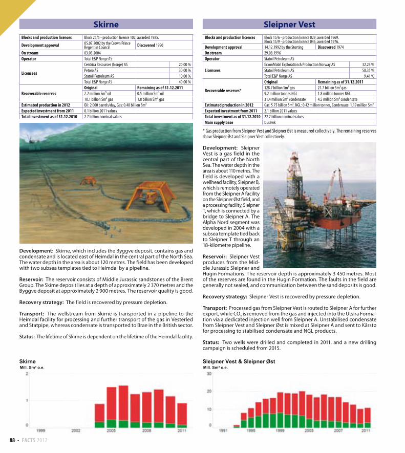
88 FACTS 2012
Sleipner Vest
* Gas production from Sleipner Vest and Sleipner Øst is measured collectively. The remaining reserves show Sleipner Øst and Sleipner Vest collectively.
Development: Sleipner Vest is a gas field in the central part of the North Sea. The water depth in the area is about 110 metres. The field is developed with a wellhead facility, Sleipner B, which is remotely operated from the Sleipner A facility on the Sleipner Øst field, and a processing facility, Sleipner T, which is connected by a bridge to Sleipner A. The Alpha Nord segment was developed in 2004 with a subsea template tied back to Sleipner T through an 18-kilometre pipeline.
Reservoir: Sleipner Vest produces from the Mid-dle Jurassic Sleipner and Hugin Formations. The reservoir depth is approximately 3 450 metres. Most of the reserves are found in the Hugin Formation. The faults in the field are generally not sealed, and communication between the sand deposits is good.
Recovery strategy: Sleipner Vest is recovered by pressure depletion.
Transport: Processed gas from Sleipner Vest is routed to Sleipner A for further export, while CO
2 is removed from the gas and injected into the Utsira Forma-
tion via a dedicated injection well from Sleipner A. Unstabilised condensate from Sleipner Vest and Sleipner Øst is mixed at Sleipner A and sent to Kårstø for processing to stabilised condensate and NGL products.
Status: Two wells were drilled and completed in 2011, and a new drilling campaign is scheduled from 2015.
Skirne
Development: Skirne, which includes the Byggve deposit, contains gas and condensate and is located east of Heimdal in the central part of the North Sea. The water depth in the area is about 120 metres. The field has been developed with two subsea templates tied to Heimdal by a pipeline.
Reservoir: The reservoir consists of Middle Jurassic sandstones of the Brent Group. The Skirne deposit lies at a depth of approximately 2 370 metres and the Byggve deposit at approximately 2 900 metres. The reservoir quality is good.
Recovery strategy: The field is recovered by pressure depletion.
Transport: The wellstream from Skirne is transported in a pipeline to the Heimdal facility for processing and further transport of the gas in Vesterled and Statpipe, whereas condensate is transported to Brae in the British sector.
Status: The lifetime of Skirne is dependent on the lifetime of the Heimdal facility.
Blocks and production licences Block 25/5 - production licence 102, awarded 1985.
Development approval 05.07.2002 by the Crown Prince Regent in Council Discovered 1990
On stream 03.03.2004
Operator Total E&P Norge AS
Licensees
Centrica Resources (Norge) AS 20.00 %
Petoro AS 30.00 %
Statoil Petroleum AS 10.00 %
Total E&P Norge AS 40.00 %
Recoverable reservesOriginal Remaining as of 31.12.20112.2 million Sm³ oil 0.5 million Sm³ oil
10.1 billion Sm³ gas 1.8 billion Sm³ gas
Estimated production in 2012 Oil: 2 000 barrels/day, Gas: 0.48 billion Sm³
Expected investment from 2011 0.1 billion 2011 values
Total investment as of 31.12.2010 2.7 billion nominal values
Blocks and production licences Block 15/6 - production licence 029, awarded 1969.Block 15/9 - production licence 046, awarded 1976.
Development approval 14.12.1992 by the Storting Discovered 1974
On stream 29.08.1996
Operator Statoil Petroleum AS
Licensees ExxonMobil Exploration & Production Norway AS 32.24 %
Statoil Petroleum AS 58.35 %
Total E&P Norge AS 9.41 %
Recoverable reserves*
Original Remaining as of 31.12.2011128.7 billion Sm³ gas 21.7 billion Sm³ gas
9.2 million tonnes NGL 1.8 million tonnes NGL
31.4 million Sm³ condensate 4.5 million Sm³ condensate
Estimated production in 2012 Gas: 5.75 billion Sm³, NGL: 0.42 million tonnes, Condensate: 1.19 million Sm³
Expected investment from 2011 2.1 billion 2011 values
Total investment as of 31.12.2010 22.7 billion nominal values
Main supply base Dusavik
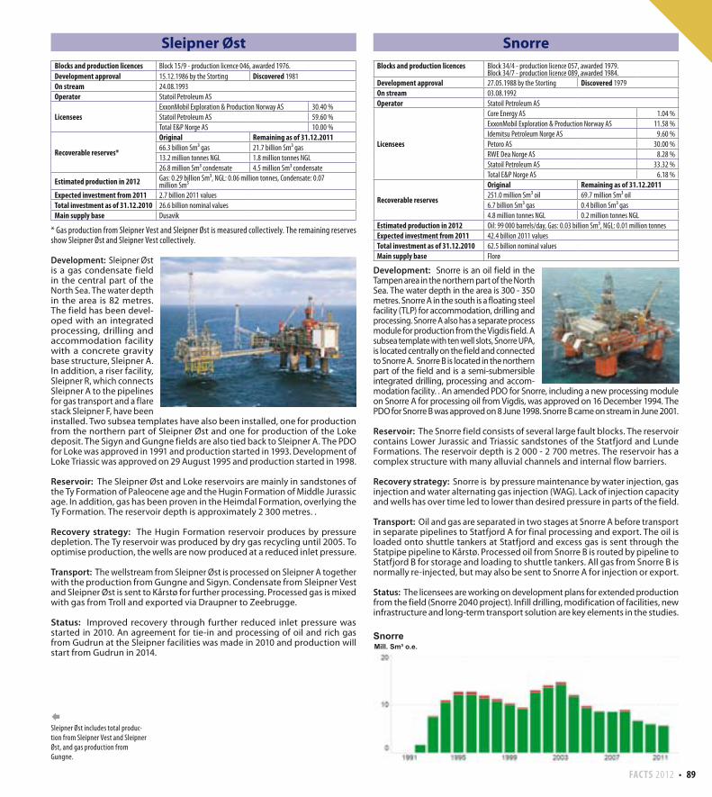
FACTS 2012 89
Sleipner Øst
* Gas production from Sleipner Vest and Sleipner Øst is measured collectively. The remaining reserves show Sleipner Øst and Sleipner Vest collectively.
Development: Sleipner Øst is a gas condensate field in the central part of the North Sea. The water depth in the area is 82 metres. The field has been devel-oped with an integrated processing, drilling and accommodation facility with a concrete gravity base structure, Sleipner A. In addition, a riser facility, Sleipner R, which connects Sleipner A to the pipelines for gas transport and a flare stack Sleipner F, have been installed. Two subsea templates have also been installed, one for production from the northern part of Sleipner Øst and one for production of the Loke deposit. The Sigyn and Gungne fields are also tied back to Sleipner A. The PDO for Loke was approved in 1991 and production started in 1993. Development of Loke Triassic was approved on 29 August 1995 and production started in 1998.
Reservoir: The Sleipner Øst and Loke reservoirs are mainly in sandstones of the Ty Formation of Paleocene age and the Hugin Formation of Middle Jurassic age. In addition, gas has been proven in the Heimdal Formation, overlying the Ty Formation. The reservoir depth is approximately 2 300 metres. .
Recovery strategy: The Hugin Formation reservoir produces by pressure depletion. The Ty reservoir was produced by dry gas recycling until 2005. To optimise production, the wells are now produced at a reduced inlet pressure.
Transport: The wellstream from Sleipner Øst is processed on Sleipner A together with the production from Gungne and Sigyn. Condensate from Sleipner Vest and Sleipner Øst is sent to Kårstø for further processing. Processed gas is mixed with gas from Troll and exported via Draupner to Zeebrugge.
Status: Improved recovery through further reduced inlet pressure was started in 2010. An agreement for tie-in and processing of oil and rich gas from Gudrun at the Sleipner facilities was made in 2010 and production will start from Gudrun in 2014.
Sleipner Øst includes total produc-tion from Sleipner Vest and Sleipner Øst, and gas production from Gungne.
Snorre
Development: Snorre is an oil field in the Tampen area in the northern part of the North Sea. The water depth in the area is 300 - 350 metres. Snorre A in the south is a floating steel facility (TLP) for accommodation, drilling and processing. Snorre A also has a separate process module for production from the Vigdis field. A subsea template with ten well slots, Snorre UPA, is located centrally on the field and connected to Snorre A. Snorre B is located in the northern part of the field and is a semi-submersible integrated drilling, processing and accom-modation facility. . An amended PDO for Snorre, including a new processing module on Snorre A for processing oil from Vigdis, was approved on 16 December 1994. The PDO for Snorre B was approved on 8 June 1998. Snorre B came on stream in June 2001.
Reservoir: The Snorre field consists of several large fault blocks. The reservoir contains Lower Jurassic and Triassic sandstones of the Statfjord and Lunde Formations. The reservoir depth is 2 000 - 2 700 metres. The reservoir has a complex structure with many alluvial channels and internal flow barriers.
Recovery strategy: Snorre is by pressure maintenance by water injection, gas injection and water alternating gas injection (WAG). Lack of injection capacity and wells has over time led to lower than desired pressure in parts of the field.
Transport: Oil and gas are separated in two stages at Snorre A before transport in separate pipelines to Statfjord A for final processing and export. The oil is loaded onto shuttle tankers at Statfjord and excess gas is sent through the Statpipe pipeline to Kårstø. Processed oil from Snorre B is routed by pipeline to Statfjord B for storage and loading to shuttle tankers. All gas from Snorre B is normally re-injected, but may also be sent to Snorre A for injection or export.
Status: The licensees are working on development plans for extended production from the field (Snorre 2040 project). Infill drilling, modification of facilities, new infrastructure and long-term transport solution are key elements in the studies.
Blocks and production licences Block 15/9 - production licence 046, awarded 1976.
Development approval 15.12.1986 by the Storting Discovered 1981
On stream 24.08.1993
Operator Statoil Petroleum AS
Licensees ExxonMobil Exploration & Production Norway AS 30.40 %
Statoil Petroleum AS 59.60 %
Total E&P Norge AS 10.00 %
Recoverable reserves*
Original Remaining as of 31.12.201166.3 billion Sm³ gas 21.7 billion Sm³ gas
13.2 million tonnes NGL 1.8 million tonnes NGL
26.8 million Sm³ condensate 4.5 million Sm³ condensate
Estimated production in 2012 Gas: 0.29 billion Sm³, NGL: 0.06 million tonnes, Condensate: 0.07 million Sm³
Expected investment from 2011 2.7 billion 2011 values
Total investment as of 31.12.2010 26.6 billion nominal values
Main supply base Dusavik
Blocks and production licences Block 34/4 - production licence 057, awarded 1979.Block 34/7 - production licence 089, awarded 1984.
Development approval 27.05.1988 by the Storting Discovered 1979
On stream 03.08.1992
Operator Statoil Petroleum AS
Licensees
Core Energy AS 1.04 %
ExxonMobil Exploration & Production Norway AS 11.58 %
Idemitsu Petroleum Norge AS 9.60 %
Petoro AS 30.00 %
RWE Dea Norge AS 8.28 %
Statoil Petroleum AS 33.32 %
Total E&P Norge AS 6.18 %
Recoverable reserves
Original Remaining as of 31.12.2011251.0 million Sm³ oil 69.7 million Sm³ oil
6.7 billion Sm³ gas 0.4 billion Sm³ gas
4.8 million tonnes NGL 0.2 million tonnes NGL
Estimated production in 2012 Oil: 99 000 barrels/day, Gas: 0.03 billion Sm³, NGL: 0.01 million tonnes
Expected investment from 2011 42.4 billion 2011 values
Total investment as of 31.12.2010 62.5 billion nominal values
Main supply base Florø
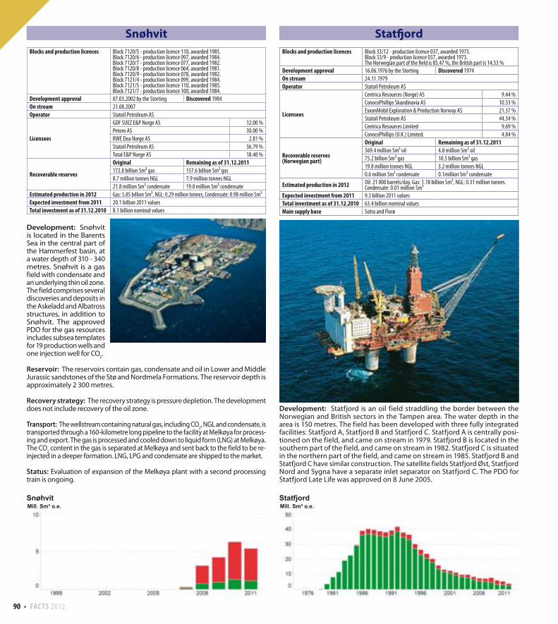
90 FACTS 2012
Statfjord
Development: Statfjord is an oil field straddling the border between the Norwegian and British sectors in the Tampen area. The water depth in the area is 150 metres. The field has been developed with three fully integrated facilities: Statfjord A, Statfjord B and Statfjord C. Statfjord A is centrally posi-tioned on the field, and came on stream in 1979. Statfjord B is located in the southern part of the field, and came on stream in 1982. Statfjord C is situated in the northern part of the field, and came on stream in 1985. Statfjord B and Statfjord C have similar construction. The satellite fields Statfjord Øst, Statfjord Nord and Sygna have a separate inlet separator on Statfjord C. The PDO for Statfjord Late Life was approved on 8 June 2005.
Snøhvit
Development: Snøhvit is located in the Barents Sea in the central part of the Hammerfest basin, at a water depth of 310 - 340 metres. Snøhvit is a gas field with condensate and an underlying thin oil zone. The field comprises several discoveries and deposits in the Askeladd and Albatross structures, in addition to Snøhvit. The approved PDO for the gas resources includes subsea templates for 19 production wells and one injection well for CO
2.
Reservoir: The reservoirs contain gas, condensate and oil in Lower and Middle Jurassic sandstones of the Stø and Nordmela Formations. The reservoir depth is approximately 2 300 metres.
Recovery strategy: The recovery strategy is pressure depletion. The development does not include recovery of the oil zone.
Transport: The wellstream containing natural gas, including CO2, NGL and condensate, is
transported through a 160-kilometre long pipeline to the facility at Melkøya for process-ing and export. The gas is processed and cooled down to liquid form (LNG) at Melkøya. The CO
2 content in the gas is separated at Melkøya and sent back to the field to be re-
injected in a deeper formation. LNG, LPG and condensate are shipped to the market.
Status: Evaluation of expansion of the Melkøya plant with a second processing train is ongoing.
Blocks and production licences Block 7120/5 - production licence 110, awarded 1985.Block 7120/6 - production licence 097, awarded 1984.Block 7120/7 - production licence 077, awarded 1982.Block 7120/8 - production licence 064, awarded 1981.Block 7120/9 - production licence 078, awarded 1982.Block 7121/4 - production licence 099, awarded 1984.Block 7121/5 - production licence 110, awarded 1985.Block 7121/7 - production licence 100, awarded 1984.
Development approval 07.03.2002 by the Storting Discovered 1984
On stream 21.08.2007
Operator Statoil Petroleum AS
Licensees
GDF SUEZ E&P Norge AS 12.00 %
Petoro AS 30.00 %
RWE Dea Norge AS 2.81 %
Statoil Petroleum AS 36.79 %
Total E&P Norge AS 18.40 %
Recoverable reserves
Original Remaining as of 31.12.2011172.8 billion Sm³ gas 157.6 billion Sm³ gas
8.7 million tonnes NGL 7.9 million tonnes NGL
21.8 million Sm³ condensate 19.0 million Sm³ condensate
Estimated production in 2012 Gas: 5.85 billion Sm³, NGL: 0.29 million tonnes, Condensate: 0.98 million Sm³
Expected investment from 2011 20.1 billion 2011 values
Total investment as of 31.12.2010 8.1 billion nominal values
Blocks and production licences Block 33/12 - production licence 037, awarded 1973.Block 33/9 - production licence 037, awarded 1973.The Norwegian part of the field is 85.47 %, the British part is 14.53 %
Development approval 16.06.1976 by the Storting Discovered 1974
On stream 24.11.1979
Operator Statoil Petroleum AS
Licensees
Centrica Resources (Norge) AS 9.44 %
ConocoPhillips Skandinavia AS 10.33 %
ExxonMobil Exploration & Production Norway AS 21.37 %
Statoil Petroleum AS 44.34 %
Centrica Resources Limited 9.69 %
ConocoPhillips (U.K.) Limited. 4.84 %
Recoverable reserves(Norwegian part)
Original Remaining as of 31.12.2011569.4 million Sm³ oil 4.8 million Sm³ oil
75.2 billion Sm³ gas 10.5 billion Sm³ gas
19.8 million tonnes NGL 3.2 million tonnes NGL
0.6 million Sm³ condensate 0.1million Sm³ condensate
Estimated production in 2012 Oil: 21 000 barrels/day, Gas: 1.18 billion Sm³, NGL: 0.31 million tonnes. Condensate: 0.01 million Sm³
Expected investment from 2011 9.3 billion 2011 values
Total investment as of 31.12.2010 63.4 billion nominal values
Main supply base Sotra and Florø
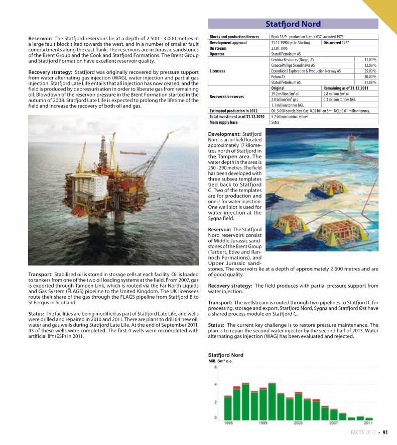
FACTS 2012 91
Reservoir: The Statfjord reservoirs lie at a depth of 2 500 - 3 000 metres in a large fault block tilted towards the west, and in a number of smaller fault compartments along the east flank. The reservoirs are in Jurassic sandstones of the Brent Group and the Cook and Statfjord Formations. The Brent Group and Statfjord Formation have excellent reservoir quality.
Recovery strategy: Statfjord was originally recovered by pressure support from water alternating gas injection (WAG), water injection and partial gas injection. Statfjord Late Life entails that all injection has now ceased, and the field is produced by depressurisation in order to liberate gas from remaining oil. Blowdown of the reservoir pressure in the Brent Formation started in the autumn of 2008. Statfjord Late Life is expected to prolong the lifetime of the field and increase the recovery of both oil and gas.
Transport: Stabilised oil is stored in storage cells at each facility. Oil is loaded to tankers from one of the two oil loading systems at the field. From 2007, gas is exported through Tampen Link, which is routed via the Far North Liquids and Gas System (FLAGS) pipeline to the United Kingdom. The UK licensees route their share of the gas through the FLAGS pipeline from Statfjord B to St Fergus in Scotland.
Status: The facilities are being modified as part of Statfjord Late Life, and wells were drilled and repaired in 2010 and 2011. There are plans to drill 64 new oil, water and gas wells during Statfjord Late Life. At the end of September 2011, 43 of these wells were completed. The first 4 wells were recompleted with artificial lift (ESP) in 2011.
Statfjord Nord
Development: Statfjord Nord is an oil field located approximately 17 kilome-tres north of Statfjord in the Tampen area. The water depth in the area is 250 - 290 metres. The field has been developed with three subsea templates tied back to Statfjord C. Two of the templates are for production and one is for water injection. One well slot is used for water injection at the Sygna field.
Reservoir: The Statfjord Nord reservoirs consist of Middle Jurassic sand-stones of the Brent Group (Tarbert, Etive and Ran-noch Formations), and Upper Jurassic sand-stones. The reservoirs lie at a depth of approximately 2 600 metres and are of good quality.
Recovery strategy: The field produces with partial pressure support from water injection.
Transport: The wellstream is routed through two pipelines to Statfjord C for processing, storage and export. Statfjord Nord, Sygna and Statfjord Øst have a shared process module on Statfjord C.
Status: The current key challenge is to restore pressure maintenance. The plan is to repair the second water injector by the second half of 2013. Water alternating gas injection (WAG) has been evaluated and rejected.
Blocks and production licences Block 33/9 - production licence 037, awarded 1973.
Development approval 11.12.1990 by the Storting Discovered 1977
On stream 23.01.1995
Operator Statoil Petroleum AS
Licensees
Centrica Resources (Norge) AS 11.04 %
ConocoPhillips Skandinavia AS 12.08 %
ExxonMobil Exploration & Production Norway AS 25.00 %
Petoro AS 30.00 %
Statoil Petroleum AS 21.88 %
Recoverable reserves
Original Remaining as of 31.12.201139.2 million Sm³ oil 2.8 million Sm³ oil
2.0 billion Sm³ gas 0.3 million tonnes NGL
1.1 million tonnes NGL
Estimated production in 2012 Oil: 5 000 barrels/day, Gas: 0.02 billion Sm³, NGL: 0.01 million tonnes.
Total investment as of 31.12.2010 5.7 billion nominal values
Main supply base Sotra
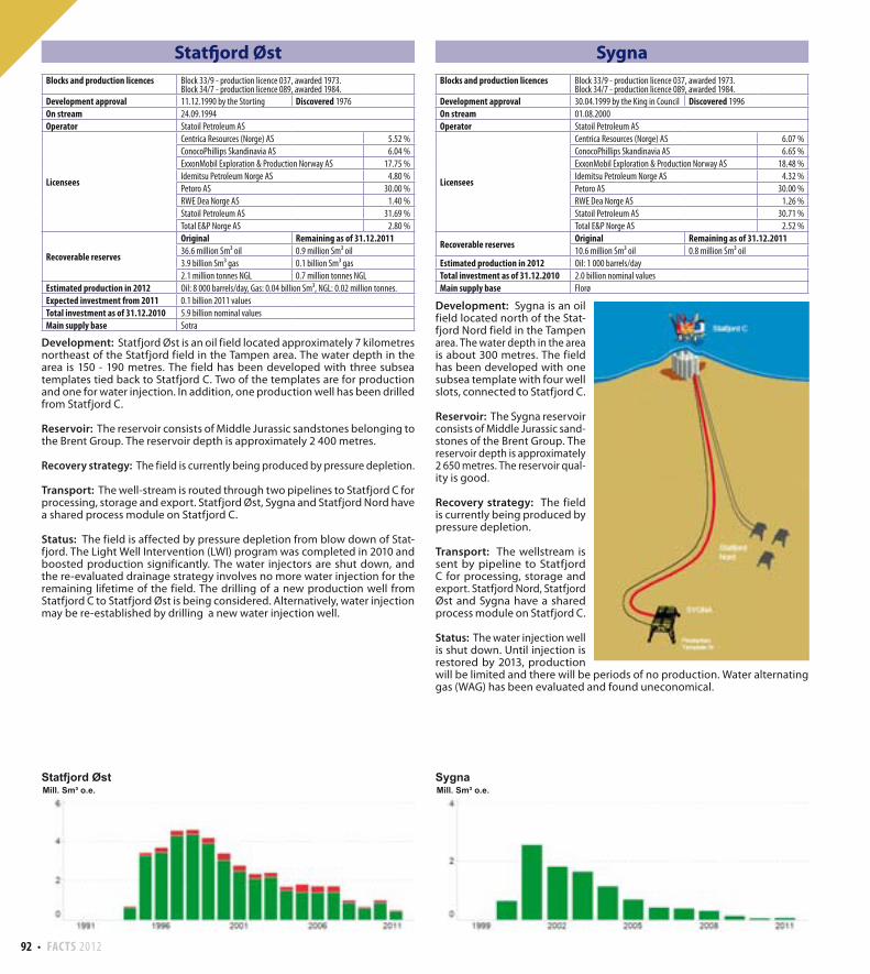
92 FACTS 2012
Sygna
Development: Sygna is an oil field located north of the Stat-fjord Nord field in the Tampen area. The water depth in the area is about 300 metres. The field has been developed with one subsea template with four well slots, connected to Statfjord C.
Reservoir: The Sygna reservoir consists of Middle Jurassic sand-stones of the Brent Group. The reservoir depth is approximately 2 650 metres. The reservoir qual-ity is good.
Recovery strategy: The field is currently being produced by pressure depletion.
Transport: The wellstream is sent by pipeline to Statfjord C for processing, storage and export. Statfjord Nord, Statfjord Øst and Sygna have a shared process module on Statfjord C.
Status: The water injection well is shut down. Until injection is restored by 2013, production will be limited and there will be periods of no production. Water alternating gas (WAG) has been evaluated and found uneconomical.
Statfjord Øst
Development: Statfjord Øst is an oil field located approximately 7 kilometres northeast of the Statfjord field in the Tampen area. The water depth in the area is 150 - 190 metres. The field has been developed with three subsea templates tied back to Statfjord C. Two of the templates are for production and one for water injection. In addition, one production well has been drilled from Statfjord C.
Reservoir: The reservoir consists of Middle Jurassic sandstones belonging to the Brent Group. The reservoir depth is approximately 2 400 metres.
Recovery strategy: The field is currently being produced by pressure depletion.
Transport: The well-stream is routed through two pipelines to Statfjord C for processing, storage and export. Statfjord Øst, Sygna and Statfjord Nord have a shared process module on Statfjord C.
Status: The field is affected by pressure depletion from blow down of Stat-fjord. The Light Well Intervention (LWI) program was completed in 2010 and boosted production significantly. The water injectors are shut down, and the re-evaluated drainage strategy involves no more water injection for the remaining lifetime of the field. The drilling of a new production well from Statfjord C to Statfjord Øst is being considered. Alternatively, water injection may be re-established by drilling a new water injection well.
Blocks and production licences Block 33/9 - production licence 037, awarded 1973.Block 34/7 - production licence 089, awarded 1984.
Development approval 11.12.1990 by the Storting Discovered 1976
On stream 24.09.1994
Operator Statoil Petroleum AS
Licensees
Centrica Resources (Norge) AS 5.52 %
ConocoPhillips Skandinavia AS 6.04 %
ExxonMobil Exploration & Production Norway AS 17.75 %
Idemitsu Petroleum Norge AS 4.80 %
Petoro AS 30.00 %
RWE Dea Norge AS 1.40 %
Statoil Petroleum AS 31.69 %
Total E&P Norge AS 2.80 %
Recoverable reserves
Original Remaining as of 31.12.201136.6 million Sm³ oil 0.9 million Sm³ oil
3.9 billion Sm³ gas 0.1 billion Sm³ gas
2.1 million tonnes NGL 0.7 million tonnes NGL
Estimated production in 2012 Oil: 8 000 barrels/day, Gas: 0.04 billion Sm³, NGL: 0.02 million tonnes.
Expected investment from 2011 0.1 billion 2011 values
Total investment as of 31.12.2010 5.9 billion nominal values
Main supply base Sotra
Blocks and production licences Block 33/9 - production licence 037, awarded 1973.Block 34/7 - production licence 089, awarded 1984.
Development approval 30.04.1999 by the King in Council Discovered 1996
On stream 01.08.2000
Operator Statoil Petroleum AS
Licensees
Centrica Resources (Norge) AS 6.07 %
ConocoPhillips Skandinavia AS 6.65 %
ExxonMobil Exploration & Production Norway AS 18.48 %
Idemitsu Petroleum Norge AS 4.32 %
Petoro AS 30.00 %
RWE Dea Norge AS 1.26 %
Statoil Petroleum AS 30.71 %
Total E&P Norge AS 2.52 %
Recoverable reservesOriginal Remaining as of 31.12.201110.6 million Sm³ oil 0.8 million Sm³ oil
Estimated production in 2012 Oil: 1 000 barrels/day
Total investment as of 31.12.2010 2.0 billion nominal values
Main supply base Florø
FACTS 2012 93
Tambar
Development: Tambar is an oil field located southeast of the Ula field in the southern part of the North Sea. The water depth in the area is 68 metres. The field has been developed with a remotely controlled wellhead facility without processing equipment.
Reservoir: The reservoir consists of Upper Jurassic sandstones of the Ula Forma-tion, deposited in a shallow marine environment. The reservoir lies at a depth of 4 100 - 4 200 metres and the reservoir characteristics are generally very good.
Recovery strategy: The field is recovered by pressure depletion and limited aquifer drive. The production went off plateau in 2002 and is now declining.
Transport: The oil is transported to Ula through a pipeline which was installed in June 2007. After processing at Ula, the oil is exported in the existing pipeline system to Teesside via Ekofisk while the gas is injected in the Ula reservoir to improve oil recovery.
Status: A multi-phase pump installed in 2008 to reduce the wellhead pres-sure and increase recovery from Tambar, has failed and is not in use. A major challenge in the future is that high water cut in the wells restricts production. In 2012, the licensees will concentrate on well work and surveillance. Artificial gas lift to increase the oil recovery will be considered.
Tambar inkluderer produksjonen frå Tambar Øst
Tambar Øst
Development: Tambar Øst has been developed with one production well drilled from the Tambar facility.
Reservoir: The reservoir is in sandstones of Late Jurassic age, deposited in a shallow marine environment. The reservoir lies at a depth of 4 050 – 4 200 metres and the quality varies.
Recovery strategy: The field is recovered by pressure depletion and limited aquifer drive.
Transport: The oil is transported to Ula via Tambar. After processing at Ula, the oil is exported in the existing pipeline system to Teesside via Ekofisk. The gas is used for gas injection in the Ula reservoir to improve oil recovery.
Status: Production from Tambar Øst has not met expectations and the reserve estimates have been reduced.
Blocks and production licences Block 1/3 - production licence 065, awarded 1981.Block 2/1 - production licence 019 B, awarded 1977.
Development approval 03.04.2000 by the King in Council Discovered 1983
On stream 15.07.2001
Operator BP Norge AS
LicenseesBP Norge AS 55.00 %
DONG E&P Norge AS 45.00 %
Recoverable reservesOriginal Remaining as of 31.12.20119.0 million Sm³ oil 0.3 million Sm³ oil
2.0 billion Sm³ gas 0.1 billion Sm³ gas
Estimated production in 2012 Oil: 2 000 barrels/day, Gas: 0.03 billion Sm³
Expected investment from 2011 0.1 billion 2011 values
Total investment as of 31.12.2010 2.2 billion nominal values
Main supply base Tananger
Blocks and production licences Block 1/3 - production licence 065, awarded 1981.Block 2/1 - production licence 019 B, awarded 1977Block 2/1 - production licence 300, awarded 2003.
Development approval 28.06.2007 Discovered 2007
On stream 02.10.2007
Operator BP Norge AS
Licensees
BP Norge AS 46.20 %
DONG E&P Norge AS 43.24 %
Norske AEDC A/S 0.80 %
Talisman Energy Norge AS 9.76 %
Recoverable reservesOriginal Remaining as of 31.12.20110.3 million Sm³ oil
Estimated production in 2012 Oil: 290 barrels/day
Total investment as of 31.12.2010 1.0 billion nominal values

94 FACTS 2012
Tordis
Development: Tordis is an oil field located between the Snorre and Gullfaks fields in the Tampen area in the northern part of the North Sea. The water depth in the area is approximately 200 metres. The field has been developed with a central subsea manifold tied back to Gullfaks C. Seven separate satellite wells and two subsea templates are tied back to the manifold. In addition, a subsea separator was installed at the field in 2007. Injection water is transported by pipeline from Gullfaks C. Tordis comprises four deposits: Tordis, Tordis Øst, Borg and 34/7-25 S. The PDO for Tordis Øst was approved on 13 October 1995. The PDO for Borg was approved on 29 June 1999. An amended PDO for Tordis (Tordis IOR) was approved on 16 December 2005.
Reservoir: The reservoirs in Tordis and Tordis Øst consist of Middle Jurassic sandstones of the Brent Group. The reservoir in Borg consists of Upper Juras-sic sandstones in the intra-Draupne Formation, and the reservoir in 34/7-25 S consists of sandstones of the Brent Group and sandstones of Late Jurassic age. The Tordis reservoirs lie at a depth of 2 000 - 2 500 metres.
Recovery strategy: Production is accomplished by partial pressure mainte-nance and by water injection and natural aquifer drive. Pressure at Borg is fully maintained using water injection. Tordis Øst is produced with pressure support from natural aquifer drive.
Transport: The wellstream from Tordis is transported through two pipelines to Gullfaks C for processing. The oil is then exported by tankers, while the gas is routed through Statpipe to Kårstø.
Status: The Tordis subsea separator has been shut down since 2008 and as a result all production is sent to Gullfaks for processing. Production is currently restricted due to ongoing repairs on one of the two pipelines to Gullfaks C.
Tor
Development: Tor is an oil field in the Ekofisk area in the southern part of the North Sea. The water depth in the area is about 70 metres. The field has been developed with a combined wellhead and processing facility tied to Ekofisk.
Reservoir: The main reservoir consists of fractured chalk of the Tor Formation from theLate Cretaceous age. The reservoir lies at a depth of approximately 3 200 metres. The Ekofisk Formation of Early Paleocene age also contains oil, but has poorer reservoir quality. So far, minor volumes have been produced from this formation.
Recovery strategy: Tor was originally recovered by pressure depletion. In 1992, limited water injection commenced. The facility has subsequently been upgraded and the scope of water injection has been expanded. Transport: Oil and gas are transported by pipelines to the processing facility at Ekofisk J. Gas from the Ekofisk area is transported by pipeline to Emden, while the oil, also containing NGL fractions, is sent via pipeline to Teesside.
Status: The Tor facility has a limited remaining lifetime. A redevelopment of the field, to recover significant remaining resources in both the Tor and the Ekofisk formations, is being evaluated.
Blocks and production licences Block 2/4 - production licence 018, awarded 1965.Block 2/5 - production licence 006, awarded 1965.
Development approval 04.05.1973 Discovered 1970
On stream 28.06.1978
Operator ConocoPhillips Skandinavia AS
Licensees
ConocoPhillips Skandinavia AS 30.66 %
Eni Norge AS 10.82 %
Petoro AS 3.69 %
Statoil Petroleum AS 6.64 %
Total E&P Norge AS 48.20 %
Recoverable reserves
Original Remaining as of 31.12.201124.4 million Sm³ oil 0.8 million Sm³ oil
10.9 billion Sm³ gas 0.1 billion Sm³ gas
1.2 million tonnes NGL
Estimated production in 2012 Oil: 3 000 barrels/day, Gas: 0.01 billion Sm³
Expected investment from 2011 0.7 billion 2011 values
Total investment as of 31.12.2010 3.5 billion nominal values
Main supply base Tananger
Blocks and production licences Block 34/7 - production licence 089, awarded 1984.
Development approval 14.05.1991 by the Storting Discovered 1987
On stream 03.06.1994
Operator Statoil Petroleum AS
Licensees
ExxonMobil Exploration & Production Norway AS 10.50 %
Idemitsu Petroleum Norge AS 9.60 %
Petoro AS 30.00 %
RWE Dea Norge AS 2.80 %
Statoil Petroleum AS 41.50 %
Total E&P Norge AS 5.60 %
Recoverable reserves
Original Remaining as of 31.12.201161.5 million Sm³ oil 6.4 million Sm³ oil
4.7 billion Sm³ gas 0.4 billion Sm³ gas
1.8 million tonnes NGL 0.2 million tonnes NGL
Estimated production in 2012 Oil: 14 000 barrels/day, Gas: 0.07 billion Sm³, NGL: 0.03 million tonnes.
Expected investment from 2011 3.7 billion 2011 values
Total investment as of 31.12.2010 11.0 billion nominal values
Main supply base Florø
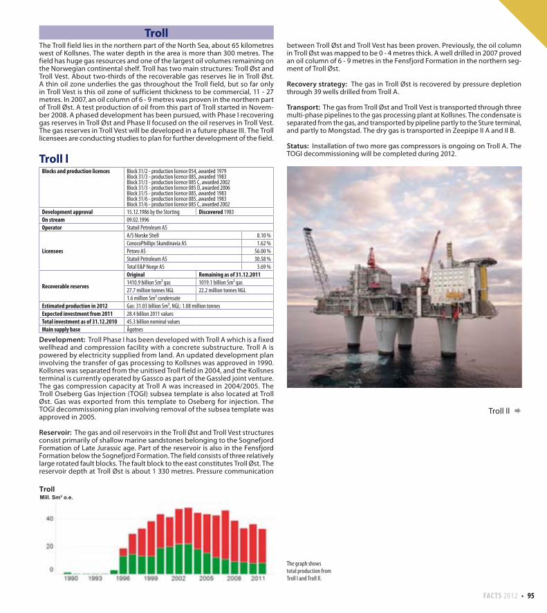
FACTS 2012 95
between Troll Øst and Troll Vest has been proven. Previously, the oil column in Troll Øst was mapped to be 0 - 4 metres thick. A well drilled in 2007 proved an oil column of 6 - 9 metres in the Fensfjord Formation in the northern seg-ment of Troll Øst.
Recovery strategy: The gas in Troll Øst is recovered by pressure depletion through 39 wells drilled from Troll A.
Transport: The gas from Troll Øst and Troll Vest is transported through three multi-phase pipelines to the gas processing plant at Kollsnes. The condensate is separated from the gas, and transported by pipeline partly to the Sture terminal, and partly to Mongstad. The dry gas is transported in Zeepipe II A and II B.
Status: Installation of two more gas compressors is ongoing on Troll A. The TOGI decommissioning will be completed during 2012.
Troll ll
TrollThe Troll field lies in the northern part of the North Sea, about 65 kilometres west of Kollsnes. The water depth in the area is more than 300 metres. The field has huge gas resources and one of the largest oil volumes remaining on the Norwegian continental shelf. Troll has two main structures: Troll Øst and Troll Vest. About two-thirds of the recoverable gas reserves lie in Troll Øst. A thin oil zone underlies the gas throughout the Troll field, but so far only in Troll Vest is this oil zone of sufficient thickness to be commercial, 11 - 27 metres. In 2007, an oil column of 6 - 9 metres was proven in the northern part of Troll Øst. A test production of oil from this part of Troll started in Novem-ber 2008. A phased development has been pursued, with Phase I recovering gas reserves in Troll Øst and Phase II focused on the oil reserves in Troll Vest. The gas reserves in Troll Vest will be developed in a future phase III. The Troll licensees are conducting studies to plan for further development of the field.
Troll l
Development: Troll Phase I has been developed with Troll A which is a fixed wellhead and compression facility with a concrete substructure. Troll A is powered by electricity supplied from land. An updated development plan involving the transfer of gas processing to Kollsnes was approved in 1990. Kollsnes was separated from the unitised Troll field in 2004, and the Kollsnes terminal is currently operated by Gassco as part of the Gassled joint venture. The gas compression capacity at Troll A was increased in 2004/2005. The Troll Oseberg Gas Injection (TOGI) subsea template is also located at Troll Øst. Gas was exported from this template to Oseberg for injection. The TOGI decommissioning plan involving removal of the subsea template was approved in 2005.
Reservoir: The gas and oil reservoirs in the Troll Øst and Troll Vest structures consist primarily of shallow marine sandstones belonging to the Sognefjord Formation of Late Jurassic age. Part of the reservoir is also in the Fensfjord Formation below the Sognefjord Formation. The field consists of three relatively large rotated fault blocks. The fault block to the east constitutes Troll Øst. The reservoir depth at Troll Øst is about 1 330 metres. Pressure communication
The graph shows total production from Troll l and Troll ll.
Blocks and production licences Block 31/2 - production licence 054, awarded 1979Block 31/3 - production licence 085, awarded 1983Block 31/3 - production licence 085 C, awarded 2002Block 31/3 - production licence 085 D, awarded 2006Block 31/5 - production licence 085, awarded 1983Block 31/6 - production licence 085, awarded 1983Block 31/6 - production licence 085 C, awarded 2002
Development approval 15.12.1986 by the Storting Discovered 1983
On stream 09.02.1996
Operator Statoil Petroleum AS
Licensees
A/S Norske Shell 8.10 %
ConocoPhillips Skandinavia AS 1.62 %
Petoro AS 56.00 %
Statoil Petroleum AS 30.58 %
Total E&P Norge AS 3.69 %
Recoverable reserves
Original Remaining as of 31.12.20111410.9 billion Sm³ gas 1019.1 billion Sm³ gas
27.7 million tonnes NGL 22.2 million tonnes NGL
1.6 million Sm³ condensate
Estimated production in 2012 Gas: 31.03 billion Sm³, NGL: 1.08 million tonnes
Expected investment from 2011 28.4 billion 2011 values
Total investment as of 31.12.2010 45.3 billion nominal values
Main supply base Ågotnes
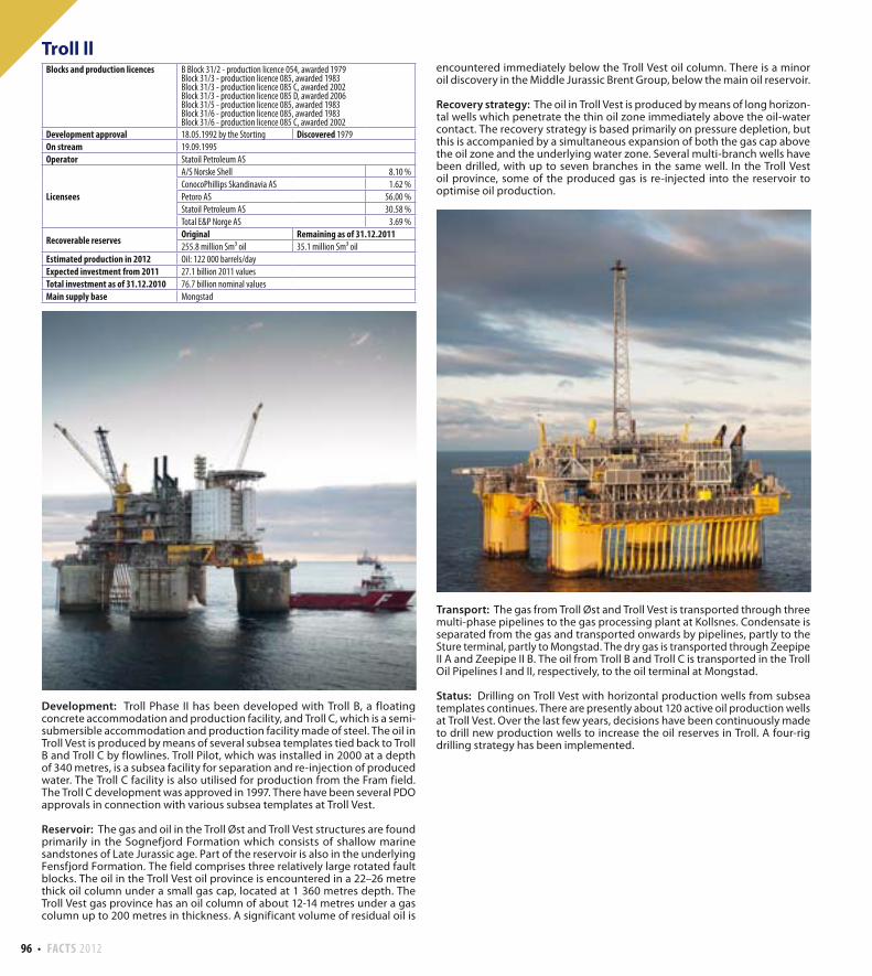
96 FACTS 2012
encountered immediately below the Troll Vest oil column. There is a minor oil discovery in the Middle Jurassic Brent Group, below the main oil reservoir.
Recovery strategy: The oil in Troll Vest is produced by means of long horizon-tal wells which penetrate the thin oil zone immediately above the oil-water contact. The recovery strategy is based primarily on pressure depletion, but this is accompanied by a simultaneous expansion of both the gas cap above the oil zone and the underlying water zone. Several multi-branch wells have been drilled, with up to seven branches in the same well. In the Troll Vest oil province, some of the produced gas is re-injected into the reservoir to optimise oil production.
Transport: The gas from Troll Øst and Troll Vest is transported through three multi-phase pipelines to the gas processing plant at Kollsnes. Condensate is separated from the gas and transported onwards by pipelines, partly to the Sture terminal, partly to Mongstad. The dry gas is transported through Zeepipe II A and Zeepipe II B. The oil from Troll B and Troll C is transported in the Troll Oil Pipelines I and II, respectively, to the oil terminal at Mongstad.
Status: Drilling on Troll Vest with horizontal production wells from subsea templates continues. There are presently about 120 active oil production wells at Troll Vest. Over the last few years, decisions have been continuously made to drill new production wells to increase the oil reserves in Troll. A four-rig drilling strategy has been implemented.
Troll ll
Development: Troll Phase II has been developed with Troll B, a floating concrete accommodation and production facility, and Troll C, which is a semi-submersible accommodation and production facility made of steel. The oil in Troll Vest is produced by means of several subsea templates tied back to Troll B and Troll C by flowlines. Troll Pilot, which was installed in 2000 at a depth of 340 metres, is a subsea facility for separation and re-injection of produced water. The Troll C facility is also utilised for production from the Fram field. The Troll C development was approved in 1997. There have been several PDO approvals in connection with various subsea templates at Troll Vest.
Reservoir: The gas and oil in the Troll Øst and Troll Vest structures are found primarily in the Sognefjord Formation which consists of shallow marine sandstones of Late Jurassic age. Part of the reservoir is also in the underlying Fensfjord Formation. The field comprises three relatively large rotated fault blocks. The oil in the Troll Vest oil province is encountered in a 22–26 metre thick oil column under a small gas cap, located at 1 360 metres depth. The Troll Vest gas province has an oil column of about 12-14 metres under a gas column up to 200 metres in thickness. A significant volume of residual oil is
Blocks and production licences B Block 31/2 - production licence 054, awarded 1979Block 31/3 - production licence 085, awarded 1983Block 31/3 - production licence 085 C, awarded 2002Block 31/3 - production licence 085 D, awarded 2006Block 31/5 - production licence 085, awarded 1983Block 31/6 - production licence 085, awarded 1983Block 31/6 - production licence 085 C, awarded 2002
Development approval 18.05.1992 by the Storting Discovered 1979
On stream 19.09.1995
Operator Statoil Petroleum AS
Licensees
A/S Norske Shell 8.10 %
ConocoPhillips Skandinavia AS 1.62 %
Petoro AS 56.00 %
Statoil Petroleum AS 30.58 %
Total E&P Norge AS 3.69 %
Recoverable reservesOriginal Remaining as of 31.12.2011255.8 million Sm³ oil 35.1 million Sm³ oil
Estimated production in 2012 Oil: 122 000 barrels/day
Expected investment from 2011 27.1 billion 2011 values
Total investment as of 31.12.2010 76.7 billion nominal values
Main supply base Mongstad
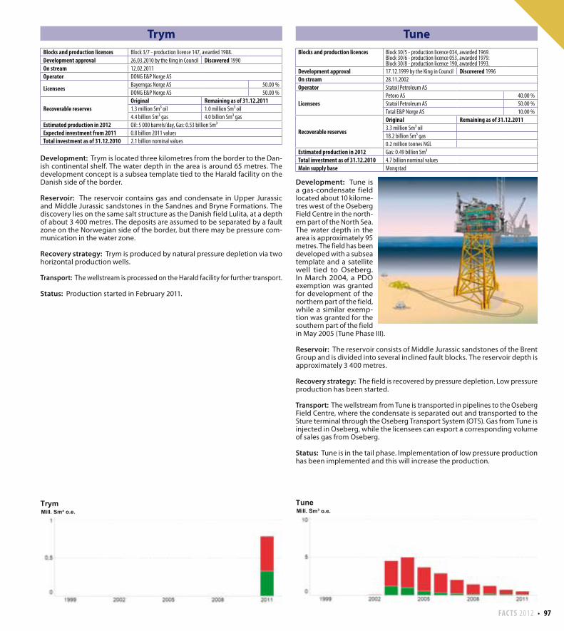
FACTS 2012 97
Trym
Development: Trym is located three kilometres from the border to the Dan-ish continental shelf. The water depth in the area is around 65 metres. The development concept is a subsea template tied to the Harald facility on the Danish side of the border.
Reservoir: The reservoir contains gas and condensate in Upper Jurassic and Middle Jurassic sandstones in the Sandnes and Bryne Formations. The discovery lies on the same salt structure as the Danish field Lulita, at a depth of about 3 400 metres. The deposits are assumed to be separated by a fault zone on the Norwegian side of the border, but there may be pressure com-munication in the water zone.
Recovery strategy: Trym is produced by natural pressure depletion via two horizontal production wells.
Transport: The wellstream is processed on the Harald facility for further transport.
Status: Production started in February 2011.
Tune
Development: Tune is a gas-condensate field located about 10 kilome-tres west of the Oseberg Field Centre in the north-ern part of the North Sea. The water depth in the area is approximately 95 metres. The field has been developed with a subsea template and a satellite well tied to Oseberg. In March 2004, a PDO exemption was granted for development of the northern part of the field, while a similar exemp-tion was granted for the southern part of the field in May 2005 (Tune Phase III).
Reservoir: The reservoir consists of Middle Jurassic sandstones of the Brent Group and is divided into several inclined fault blocks. The reservoir depth is approximately 3 400 metres.
Recovery strategy: The field is recovered by pressure depletion. Low pressure production has been started.
Transport: The wellstream from Tune is transported in pipelines to the Oseberg Field Centre, where the condensate is separated out and transported to the Sture terminal through the Oseberg Transport System (OTS). Gas from Tune is injected in Oseberg, while the licensees can export a corresponding volume of sales gas from Oseberg.
Status: Tune is in the tail phase. Implementation of low pressure production has been implemented and this will increase the production.
Blocks and production licences Block 3/7 - production licence 147, awarded 1988.
Development approval 26.03.2010 by the King in Council Discovered 1990
On stream 12.02.2011
Operator DONG E&P Norge AS
LicenseesBayerngas Norge AS 50.00 %
DONG E&P Norge AS 50.00 %
Recoverable reservesOriginal Remaining as of 31.12.20111.3 million Sm³ oil 1.0 million Sm³ oil
4.4 billion Sm³ gas 4.0 billion Sm³ gas
Estimated production in 2012 Oil: 5 000 barrels/day, Gas: 0.53 billion Sm³
Expected investment from 2011 0.8 billion 2011 values
Total investment as of 31.12.2010 2.1 billion nominal values
Blocks and production licences Block 30/5 - production licence 034, awarded 1969.Block 30/6 - production licence 053, awarded 1979.Block 30/8 - production licence 190, awarded 1993.
Development approval 17.12.1999 by the King in Council Discovered 1996
On stream 28.11.2002
Operator Statoil Petroleum AS
LicenseesPetoro AS 40.00 %
Statoil Petroleum AS 50.00 %
Total E&P Norge AS 10.00 %
Recoverable reserves
Original Remaining as of 31.12.20113.3 million Sm³ oil
18.2 billion Sm³ gas
0.2 million tonnes NGL
Estimated production in 2012 Gas: 0.49 billion Sm³
Total investment as of 31.12.2010 4.7 billion nominal values
Main supply base Mongstad
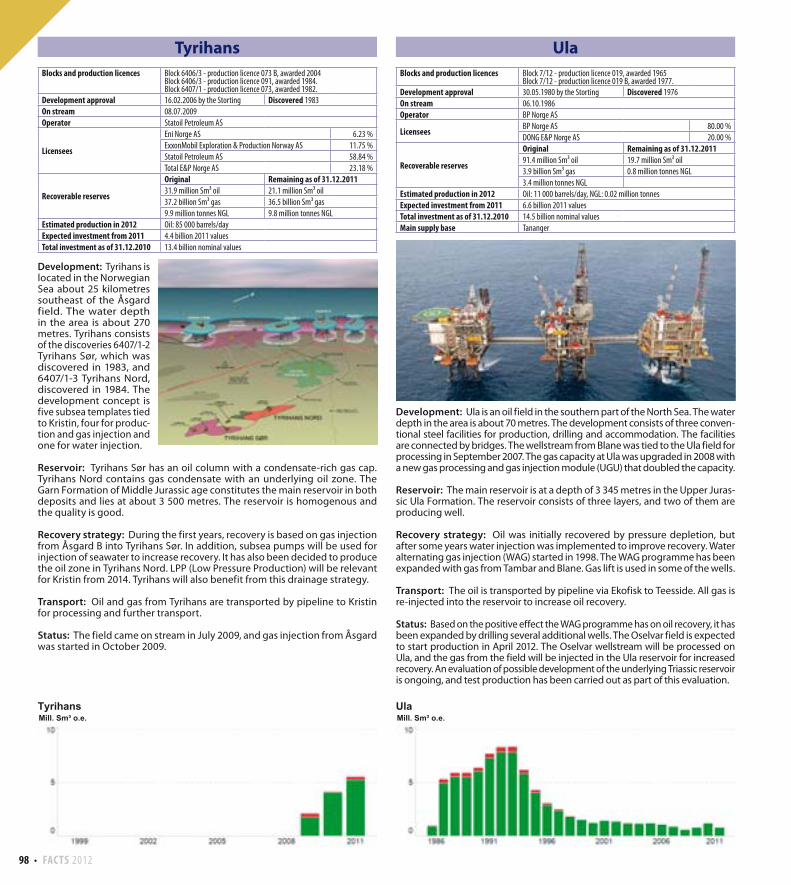
98 FACTS 2012
Ula
Development: Ula is an oil field in the southern part of the North Sea. The water depth in the area is about 70 metres. The development consists of three conven-tional steel facilities for production, drilling and accommodation. The facilities are connected by bridges. The wellstream from Blane was tied to the Ula field for processing in September 2007. The gas capacity at Ula was upgraded in 2008 with a new gas processing and gas injection module (UGU) that doubled the capacity.
Reservoir: The main reservoir is at a depth of 3 345 metres in the Upper Juras-sic Ula Formation. The reservoir consists of three layers, and two of them are producing well.
Recovery strategy: Oil was initially recovered by pressure depletion, but after some years water injection was implemented to improve recovery. Water alternating gas injection (WAG) started in 1998. The WAG programme has been expanded with gas from Tambar and Blane. Gas lift is used in some of the wells.
Transport: The oil is transported by pipeline via Ekofisk to Teesside. All gas is re-injected into the reservoir to increase oil recovery.
Status: Based on the positive effect the WAG programme has on oil recovery, it has been expanded by drilling several additional wells. The Oselvar field is expected to start production in April 2012. The Oselvar wellstream will be processed on Ula, and the gas from the field will be injected in the Ula reservoir for increased recovery. An evaluation of possible development of the underlying Triassic reservoir is ongoing, and test production has been carried out as part of this evaluation.
Tyrihans
Development: Tyrihans is located in the Norwegian Sea about 25 kilometres southeast of the Åsgard field. The water depth in the area is about 270 metres. Tyrihans consists of the discoveries 6407/1-2 Tyrihans Sør, which was discovered in 1983, and 6407/1-3 Tyrihans Nord, discovered in 1984. The development concept is five subsea templates tied to Kristin, four for produc-tion and gas injection and one for water injection.
Reservoir: Tyrihans Sør has an oil column with a condensate-rich gas cap. Tyrihans Nord contains gas condensate with an underlying oil zone. The Garn Formation of Middle Jurassic age constitutes the main reservoir in both deposits and lies at about 3 500 metres. The reservoir is homogenous and the quality is good.
Recovery strategy: During the first years, recovery is based on gas injection from Åsgard B into Tyrihans Sør. In addition, subsea pumps will be used for injection of seawater to increase recovery. It has also been decided to produce the oil zone in Tyrihans Nord. LPP (Low Pressure Production) will be relevant for Kristin from 2014. Tyrihans will also benefit from this drainage strategy.
Transport: Oil and gas from Tyrihans are transported by pipeline to Kristin for processing and further transport.
Status: The field came on stream in July 2009, and gas injection from Åsgard was started in October 2009.
Blocks and production licences Block 6406/3 - production licence 073 B, awarded 2004Block 6406/3 - production licence 091, awarded 1984.Block 6407/1 - production licence 073, awarded 1982.
Development approval 16.02.2006 by the Storting Discovered 1983
On stream 08.07.2009
Operator Statoil Petroleum AS
Licensees
Eni Norge AS 6.23 %
ExxonMobil Exploration & Production Norway AS 11.75 %
Statoil Petroleum AS 58.84 %
Total E&P Norge AS 23.18 %
Recoverable reserves
Original Remaining as of 31.12.201131.9 million Sm³ oil 21.1 million Sm³ oil
37.2 billion Sm³ gas 36.5 billion Sm³ gas
9.9 million tonnes NGL 9.8 million tonnes NGL
Estimated production in 2012 Oil: 85 000 barrels/day
Expected investment from 2011 4.4 billion 2011 values
Total investment as of 31.12.2010 13.4 billion nominal values
Blocks and production licences Block 7/12 - production licence 019, awarded 1965Block 7/12 - production licence 019 B, awarded 1977.
Development approval 30.05.1980 by the Storting Discovered 1976
On stream 06.10.1986
Operator BP Norge AS
LicenseesBP Norge AS 80.00 %
DONG E&P Norge AS 20.00 %
Recoverable reserves
Original Remaining as of 31.12.201191.4 million Sm³ oil 19.7 million Sm³ oil
3.9 billion Sm³ gas 0.8 million tonnes NGL
3.4 million tonnes NGL
Estimated production in 2012 Oil: 11 000 barrels/day, NGL: 0.02 million tonnes
Expected investment from 2011 6.6 billion 2011 values
Total investment as of 31.12.2010 14.5 billion nominal values
Main supply base Tananger
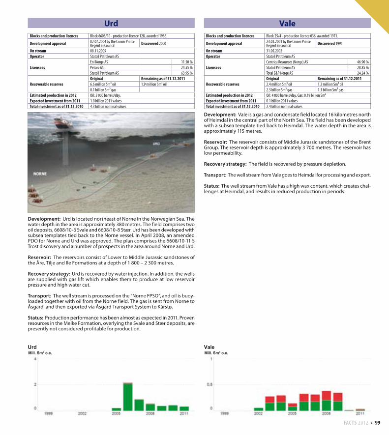
FACTS 2012 99
Urd
Development: Urd is located northeast of Norne in the Norwegian Sea. The water depth in the area is approximately 380 metres. The field comprises two oil deposits, 6608/10-6 Svale and 6608/10-8 Stær. Urd has been developed with subsea templates tied back to the Norne vessel. In April 2008, an amended PDO for Norne and Urd was approved. The plan comprises the 6608/10-11 S Trost discovery and a number of prospects in the area around Norne and Urd.
Reservoir: The reservoirs consist of Lower to Middle Jurassic sandstones of the Åre, Tilje and Ile Formations at a depth of 1 800 – 2 300 metres.
Recovery strategy: Urd is recovered by water injection. In addition, the wells are supplied with gas lift which enables them to produce at low reservoir pressure and high water cut.
Transport: The well stream is processed on the “Norne FPSO”, and oil is buoy-loaded together with oil from the Norne field. The gas is sent from Norne to Åsgard, and then exported via Åsgard Transport System to Kårstø.
Status: Production performance has been almost as expected in 2011. Proven resources in the Melke Formation, overlying the Svale and Stær deposits, are presently not considered profitable for production.
Vale
Development: Vale is a gas and condensate field located 16 kilometres north of Heimdal in the central part of the North Sea. The field has been developed with a subsea template tied back to Heimdal. The water depth in the area is approximately 115 metres.
Reservoir: The reservoir consists of Middle Jurassic sandstones of the Brent Group. The reservoir depth is approximately 3 700 metres. The reservoir has low permeability.
Recovery strategy: The field is recovered by pressure depletion.
Transport: The well stream from Vale goes to Heimdal for processing and export.
Status: The well stream from Vale has a high wax content, which creates chal-lenges at Heimdal, and results in reduced production in periods.
Blocks and production licences Block 6608/10 - production licence 128, awarded 1986.
Development approval 02.07.2004 by the Crown Prince Regent in Council Discovered 2000
On stream 08.11.2005
Operator Statoil Petroleum AS
LicenseesEni Norge AS 11.50 %
Petoro AS 24.55 %
Statoil Petroleum AS 63.95 %
Recoverable reservesOriginal Remaining as of 31.12.20116.6 million Sm³ oil 1.9 million Sm³ oil
0.1 billion Sm³ gas
Estimated production in 2012 Oil: 5 000 barrels/day.
Expected investment from 2011 1.0 billion 2011 values
Total investment as of 31.12.2010 4.3 billion nominal values
Blocks and production licences Block 25/4 - production licence 036, awarded 1971.
Development approval 23.03.2001 by the Crown Prince Regent in Council Discovered 1991
On stream 31.05.2002
Operator Statoil Petroleum AS
LicenseesCentrica Resources (Norge) AS 46.90 %
Statoil Petroleum AS 28.85 %
Total E&P Norge AS 24.24 %
Recoverable reservesOriginal Remaining as of 31.12.20112.4 million Sm³ oil 1.2 million Sm³ oil
2.3 billion Sm³ gas 1.3 billion Sm³ gas
Estimated production in 2012 Oil: 4 000 barrels/day, Gas: 0.19 billion Sm³
Expected investment from 2011 0.1 billion 2011 values
Total investment as of 31.12.2010 2.4 billion nominal values
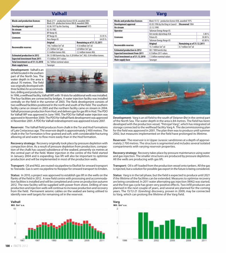
100 FACTS 2012
Valhall
Development: Valhall is an oil field located in the southern part of the North Sea. The water depth in the area is about 70 metres. The field was originally developed with three facilities for accommoda-tion, drilling and production. In 1996, a wellhead facility, Valhall WP, with 19 slots for additional wells was installed. The four facilities are connected by bridges. A water injection facility was installed centrally on the field in the summer of 2003. The flank development consists of two wellhead facilities positioned in the north and south of the field. The southern facility came on stream in 2003 and the northern facility came on stream in 2004. Valhall processes production from Hod, and delivers gas for gas lift in Hod. The PDO for Valhall WP was approved in June 1995. The PDO for Valhall water injection was approved in November 2000. The PDO for Valhall flank development was approved in November 2001. A PDO for Valhall redevelopment was approved inJune 2007.
Reservoir: The Valhall field produces from chalk in the Tor and Hod Formations of Late Cretaceous age. The reservoir depth is approximately 2 400 metres. The chalk in the Tor Formation is fine-grained and soft, with considerable fracturing allowing oil and water to flow more easily than in the Hod formation.
Recovery strategy: Recovery originally took place by pressure depletion with compaction drive. As a result of pressure depletion from production, compac-tion of the chalk has caused subsidence of the seabed, presently six metres at the central part of the field. Water injection in the centre of the field started in January 2004 and is expanding. Gas lift will also be important to optimise production and will be implemented in most of the production wells.
Transport: Oil and NGL are routed via pipeline to Ekofisk for onward transport to Teesside. Gas is sent via pipeline to Norpipe for onward transport to Emden.
Status: In 2010, a project was approved to establish gas lift in the wells on the flanks of the field in 2012. A new field centre with processing and accommoda-tion facilities is installed and will be completed and come on production autumn 2012. The new facility will be supplied with power from shore. Drilling of new production and injection wells will continue to increase production and recovery from the field. Permanent seismic cables on the seabed are being utilised to identify new well targets for remaining oil in the reservoir.
Varg
Development: Varg is an oil field to the south of Sleipner Øst in the central part of the North Sea. The water depth in the area is 84 metres. The field has been developed with the production vessel, “Petrojarl Varg”, which has integrated oil storage connected to the wellhead facility Varg A. The decommissioning plan for the field was approved in 2001. The plan then was to produce until summer 2002, but measures implemented on the field have prolonged its lifetime.
Reservoir: The reservoir is in Upper Jurassic sandstones at a depth of approxi-mately 2 700 metres. The structure is segmented and includes several isolated compartments with varying reservoir properties.
Recovery strategy: Recovery takes place by pressure maintenance using water and gas injection. The smaller structures are produced by pressure depletion. All the wells are producing with gas lift.
Transport: Oil is off-loaded from the production vessel onto tankers. All the gas is injected, but a solution for possible gas export in the future is being considered.
Status: Varg is in the tail phase, but the field is expected to produce until 2021 if the lifetime of the facilities can be extended. Measures to optimise recovery are being considered. In 2011 water alternating gas injection (WAG) was started, and the first gas cycle has given very positive effects. Two infill producers are planned in the next couple of years, and several are planned for the coming years. The 15/12-21 (Grevling) discovery, proven in 2009, may be connected to Varg, which can prolong the lifetime of the Varg field.
Blocks and production licences Block 2/11 - production licence 033 B, awarded 2001.Block 2/8 - production licence 006 B, awarded 2000.
Development approval 02.06.1977 by the Storting Discovered 1975
On stream 02.10.1982
Operator BP Norge AS
Licensees BP Norge AS 35.95 %
Hess Norge AS 64.05 %
Recoverable reserves
Original Remaining as of 31.12.2011146.7 million Sm³ oil 41.8 million Sm³ oil
27.2 billion Sm³ gas 6.8 billion Sm³ gas
5.5 million tonnes NGL 2.2 million tonnes NGL
Estimated production in 2012 Oil: 33 000 barrels/day, Gas: 0.28 billion Sm³, NGL: 0.04 million tonnes.
Expected investment from 2011 17.6 billion 2011 values
Total investment as of 31.12.2010 56.7 billion nominal values
Main supply base Tananger
Blocks and production licences Block 15/12 - production licence 038, awarded 1975.
Development approval 03.05.1996 by the King in Council Discovered 1984
On stream 22.12.1998
Operator Talisman Energy Norge AS
LicenseesDet norske oljeselskap ASA 5.00 %
Petoro AS 30.00 %
Talisman Energy Norge AS 65.00 %
Recoverable reservesOriginal Remaining as of 31.12.201115.1 million Sm³ oil 0.7 million Sm³ oil
Estimated production in 2012 Oil: 7 000 barrels/day
Expected investment from 2011 0.5 billion 2011 values
Total investment as of 31.12.2010 7.5 billion nominal values
Main supply base Tananger
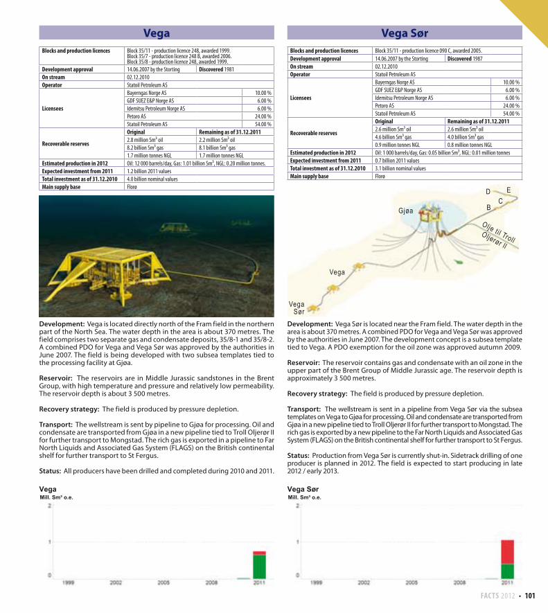
FACTS 2012 101
Vega
Development: Vega is located directly north of the Fram field in the northern part of the North Sea. The water depth in the area is about 370 metres. The field comprises two separate gas and condensate deposits, 35/8-1 and 35/8-2. A combined PDO for Vega and Vega Sør was approved by the authorities in June 2007. The field is being developed with two subsea templates tied to the processing facility at Gjøa.
Reservoir: The reservoirs are in Middle Jurassic sandstones in the Brent Group, with high temperature and pressure and relatively low permeability. The reservoir depth is about 3 500 metres.
Recovery strategy: The field is produced by pressure depletion.
Transport: The wellstream is sent by pipeline to Gjøa for processing. Oil and condensate are transported from Gjøa in a new pipeline tied to Troll Oljerør II for further transport to Mongstad. The rich gas is exported in a pipeline to Far North Liquids and Associated Gas System (FLAGS) on the British continental shelf for further transport to St Fergus.
Status: All producers have been drilled and completed during 2010 and 2011.
Vega Sør
Development: Vega Sør is located near the Fram field. The water depth in the area is about 370 metres. A combined PDO for Vega and Vega Sør was approved by the authorities in June 2007. The development concept is a subsea template tied to Vega. A PDO exemption for the oil zone was approved autumn 2009.
Reservoir: The reservoir contains gas and condensate with an oil zone in the upper part of the Brent Group of Middle Jurassic age. The reservoir depth is approximately 3 500 metres.
Recovery strategy: The field is produced by pressure depletion.
Transport: The wellstream is sent in a pipeline from Vega Sør via the subsea templates on Vega to Gjøa for processing. Oil and condensate are transported from Gjøa in a new pipeline tied to Troll Oljerør II for further transport to Mongstad. The rich gas is exported by a new pipeline to the Far North Liquids and Associated Gas System (FLAGS) on the British continental shelf for further transport to St Fergus.
Status: Production from Vega Sør is currently shut-in. Sidetrack drilling of one producer is planned in 2012. The field is expected to start producing in late 2012 / early 2013.
Gjøa
Vega
VegaSør
D EC
B
Oil to TrollTroll Oil Pipeline II
Olje ti l TrollOljerør ll
Blocks and production licences Block 35/11 - production licence 248, awarded 1999.Block 35/7 - production licence 248 B, awarded 2006.Block 35/8 - production licence 248, awarded 1999.
Development approval 14.06.2007 by the Storting Discovered 1981
On stream 02.12.2010
Operator Statoil Petroleum AS
Licensees
Bayerngas Norge AS 10.00 %
GDF SUEZ E&P Norge AS 6.00 %
Idemitsu Petroleum Norge AS 6.00 %
Petoro AS 24.00 %
Statoil Petroleum AS 54.00 %
Recoverable reserves
Original Remaining as of 31.12.20112.8 million Sm³ oil 2.2 million Sm³ oil
8.2 billion Sm³ gas 8.1 billion Sm³ gas
1.7 million tonnes NGL 1.7 million tonnes NGL
Estimated production in 2012 Oil: 12 000 barrels/day, Gas: 1.01 billion Sm³, NGL: 0.20 million tonnes.
Expected investment from 2011 1.2 billion 2011 values
Total investment as of 31.12.2010 4.0 billion nominal values
Main supply base Florø
Blocks and production licences Block 35/11 - production licence 090 C, awarded 2005.
Development approval 14.06.2007 by the Storting Discovered 1987
On stream 02.12.2010
Operator Statoil Petroleum AS
Licensees
Bayerngas Norge AS 10.00 %
GDF SUEZ E&P Norge AS 6.00 %
Idemitsu Petroleum Norge AS 6.00 %
Petoro AS 24.00 %
Statoil Petroleum AS 54.00 %
Recoverable reserves
Original Remaining as of 31.12.20112.6 million Sm³ oil 2.6 million Sm³ oil
4.6 billion Sm³ gas 4.0 billion Sm³ gas
0.9 million tonnes NGL 0.8 million tonnes NGL
Estimated production in 2012 Oil: 1 000 barrels/day, Gas: 0.05 billion Sm³, NGL: 0.01 million tonnes
Expected investment from 2011 0.7 billion 2011 values
Total investment as of 31.12.2010 3.1 billion nominal values
Main supply base Florø
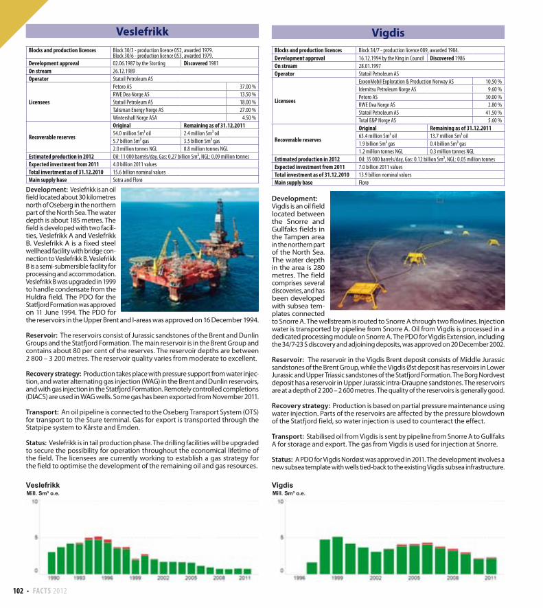
102 FACTS 2012
Veslefrikk
Development: Veslefrikk is an oil field located about 30 kilometres north of Oseberg in the northern part of the North Sea. The water depth is about 185 metres. The field is developed with two facili-ties, Veslefrikk A and Veslefrikk B. Veslefrikk A is a fixed steel wellhead facility with bridge con-nection to Veslefrikk B. Veslefrikk B is a semi-submersible facility for processing and accommodation. Veslefrikk B was upgraded in 1999 to handle condensate from the Huldra field. The PDO for the Statfjord Formation was approved on 11 June 1994. The PDO for the reservoirs in the Upper Brent and I-areas was approved on 16 December 1994.
Reservoir: The reservoirs consist of Jurassic sandstones of the Brent and Dunlin Groups and the Statfjord Formation. The main reservoir is in the Brent Group and contains about 80 per cent of the reserves. The reservoir depths are between 2 800 – 3 200 metres. The reservoir quality varies from moderate to excellent.
Recovery strategy: Production takes place with pressure support from water injec-tion, and water alternating gas injection (WAG) in the Brent and Dunlin reservoirs, and with gas injection in the Statfjord Formation. Remotely controlled completions (DIACS) are used in WAG wells. Some gas has been exported from November 2011.
Transport: An oil pipeline is connected to the Oseberg Transport System (OTS) for transport to the Sture terminal. Gas for export is transported through the Statpipe system to Kårstø and Emden.
Status: Veslefrikk is in tail production phase. The drilling facilities will be upgraded to secure the possibility for operation throughout the economical lifetime of the field. The licensees are currently working to establish a gas strategy for the field to optimise the development of the remaining oil and gas resources.
Vigdis
Development: Vigdis is an oil field located between the Snorre and Gullfaks fields in the Tampen area in the northern part of the North Sea. The water depth in the area is 280 metres. The field comprises several discoveries, and has been developed with subsea tem-plates connected to Snorre A. The wellstream is routed to Snorre A through two flowlines. Injection water is transported by pipeline from Snorre A. Oil from Vigdis is processed in a dedicated processing module on Snorre A. The PDO for Vigdis Extension, including the 34/7-23 S discovery and adjoining deposits, was approved on 20 December 2002.
Reservoir: The reservoir in the Vigdis Brent deposit consists of Middle Jurassic sandstones of the Brent Group, while the Vigdis Øst deposit has reservoirs in Lower Jurassic and Upper Triassic sandstones of the Statfjord Formation. The Borg Nordvest deposit has a reservoir in Upper Jurassic intra-Draupne sandstones. The reservoirs are at a depth of 2 200 – 2 600 metres. The quality of the reservoirs is generally good.
Recovery strategy: Production is based on partial pressure maintenance using water injection. Parts of the reservoirs are affected by the pressure blowdown of the Statfjord field, so water injection is used to counteract the effect.
Transport: Stabilised oil from Vigdis is sent by pipeline from Snorre A to Gullfaks A for storage and export. The gas from Vigdis is used for injection at Snorre.
Status: A PDO for Vigdis Nordøst was approved in 2011. The development involves a new subsea template with wells tied-back to the existing Vigdis subsea infrastructure.
Blocks and production licences Block 30/3 - production licence 052, awarded 1979.Block 30/6 - production licence 053, awarded 1979.
Development approval 02.06.1987 by the Storting Discovered 1981
On stream 26.12.1989
Operator Statoil Petroleum AS
Licensees
Petoro AS 37.00 %
RWE Dea Norge AS 13.50 %
Statoil Petroleum AS 18.00 %
Talisman Energy Norge AS 27.00 %
Wintershall Norge ASA 4.50 %
Recoverable reserves
Original Remaining as of 31.12.201154.0 million Sm³ oil 2.4 million Sm³ oil
5.7 billion Sm³ gas 3.5 billion Sm³ gas
2.0 million tonnes NGL 0.8 million tonnes NGL
Estimated production in 2012 Oil: 11 000 barrels/day, Gas: 0.27 billion Sm³, NGL: 0.09 million tonnes
Expected investment from 2011 4.0 billion 2011 values
Total investment as of 31.12.2010 15.6 billion nominal values
Main supply base Sotra and Florø
Blocks and production licences Block 34/7 - production licence 089, awarded 1984.
Development approval 16.12.1994 by the King in Council Discovered 1986
On stream 28.01.1997
Operator Statoil Petroleum AS
Licensees
ExxonMobil Exploration & Production Norway AS 10.50 %
Idemitsu Petroleum Norge AS 9.60 %
Petoro AS 30.00 %
RWE Dea Norge AS 2.80 %
Statoil Petroleum AS 41.50 %
Total E&P Norge AS 5.60 %
Recoverable reserves
Original Remaining as of 31.12.201163.4 million Sm³ oil 13.7 million Sm³ oil
1.9 billion Sm³ gas 0.4 billion Sm³ gas
1.2 million tonnes NGL 0.3 million tonnes NGL
Estimated production in 2012 Oil: 35 000 barrels/day, Gas: 0.12 billion Sm³, NGL: 0.05 million tonnes
Expected investment from 2011 7.0 billion 2011 values
Total investment as of 31.12.2010 13.9 billion nominal values
Main supply base Florø
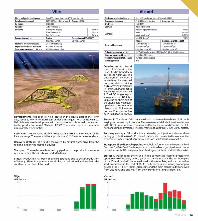
FACTS 2012 103
Vilje
Development: Vilje is an oil field located in the central part of the North Sea, about 20 kilometres northeast of Alvheim and just north of the Heimdal field. It is a subsea development with two horizontal subsea wells connected to the production vessel “Alvheim FPSO”. The water depth in the area is approximately 120 metres.
Reservoir: The reservoir is a turbidite deposit, in the Heimdal Formation of the Paleocene age. The reservoir lies approximately 2 150 metres below sea level.
Recovery strategy: The field is recovered by natural water drive from the regional underlying Heimdal aquifer.
Transport: The wellstream is routed by pipeline to the production vessel at Alvheim, where the oil is buoy-loaded to tankers.
Status: Production has been above expectations due to better production efficiency. There is a potential for drilling an additional well to drain the southern extension of the field.
Visund
Development: Visund is an oil field east of the Snorre field in the northern part of the North Sea. The development includes a semi-submersible integrated accommodation, drilling and processing steel facility (Visund A). The water depth is about 335 metres at Visund A. The PDO for gas export was approved on 4 October 2002. The northern part of the Visund field was devel-oped with a subsea tem-plate, about 10 kilometres north of Visund A, but has been shut down since 2006.
Reservoir: The Visund field contains oil and gas in several tilted fault blocks with varying pressure and liquid systems. The reservoirs are in Middle Jurassic sandstones in the Brent Group, and Lower Jurassic and Upper Triassic sandstones in the Stat-fjord and Lunde Formations. The reservoirs lie at a depth of 2 900 - 3 000 metres.
Recovery strategy: Oil production is driven by gas injection and water alter-nating gas injection (WAG). Produced water is also re-injected into one of the reservoirs. Limited export of produced gas was started autumn of 2005.
Transport: The oil is sent by pipeline to Gullfaks A for storage and export with oil from the Gullfaks field. Gas is exported to the Kvitebjørn gas pipeline and on to Kollsnes, where the NGL is separated and the dry gas is further exported to the market.
Status: A challenge for the Visund field is to maintain reservoir pressure to optimise the oil recovery before gas export levels increase. The northern part of the Visund field will be redeveloped with a template, and is expected to start production at the end of 2013. The licencees are currently working to develop the 34/8-13 A (Titan) discovery, and the main plan is to drill one well from Visund A, and one well from the Visund Nord template later on.
Blocks and production licences Block 25/4 - production licence 036 D, awarded 2008.
Development approval 18.03.2005 by the King in Council Discovered 2003
On stream 01.08.2008
Operator Statoil Petroleum AS
Licensees Marathon Oil Norge AS 46.90 %
Statoil Petroleum AS 28.85 %
Total E&P Norge AS 24.24 %
Recoverable reserves Original Remaining as of 31.12.201111.3 million Sm³ oil 5.6 million Sm³ oil
Estimated production in 2012 Oil: 21 000 barrels/day
Expected investment from 2011 1.1 billion 2011 values
Total investment as of 31.12.2010 1.9 billion nominal values
Blocks and production licences Block 34/8 - production licence 120, awarded 1985.
Development approval 29.03.1996 by the Storting Discovered 1986
On stream 21.04.1999
Operator Statoil Petroleum AS
Licensees
ConocoPhillips Skandinavia AS 9.10 %
Petoro AS 30.00 %
Statoil Petroleum AS 53.20 %
Total E&P Norge AS 7.70 %
Recoverable reserves
Original Remaining as of 31.12.201133.0 million Sm³ oil 11.3 million Sm³ oil
49.5 billion Sm³ gas 43.0 billion Sm³ gas
6.2 million tonnes NGL 5.8 million tonnes NGL
Estimated production in 2012 Oil: 15 000 barrels/day, Gas: 0.48 billion Sm³, NGL: 0.06 million tonnes
Expected investment from 2011 11.1 billion 2011 values
Total investment as of 31.12.2010 20.7 billion nominal values
Main supply base Florø
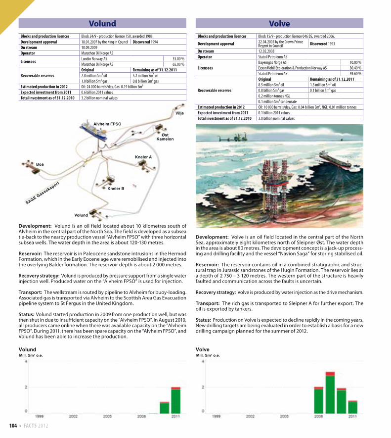
104 FACTS 2012
Volund
Development: Volund is an oil field located about 10 kilometres south of Alvheim in the central part of the North Sea. The field is developed as a subsea tie-back to the nearby production vessel ”Alvheim FPSO” with three horizontal subsea wells. The water depth in the area is about 120-130 metres.
Reservoir: The reservoir is in Paleocene sandstone intrusions in the Hermod Formation, which in the Early Eocene age were remobilised and injected into the overlying Balder formation. The reservoir depth is about 2 000 metres.
Recovery strategy: Volund is produced by pressure support from a single water injection well. Produced water on the ”Alvheim FPSO” is used for injection.
Transport: The wellstream is routed by pipeline to Alvheim for buoy-loading. Associated gas is transported via Alvheim to the Scottish Area Gas Evacuation pipeline system to St Fergus in the United Kingdom.
Status: Volund started production in 2009 from one production well, but was then shut in due to insufficient capacity on the ”Alvheim FPSO”. In August 2010, all producers came online when there was available capacity on the ”Alvheim FPSO”. During 2011, there has been spare capacity on the “Alvheim FPSO”, and Volund has been able to increase the production.
Volve
Development: Volve is an oil field located in the central part of the North Sea, approximately eight kilometres north of Sleipner Øst. The water depth in the area is about 80 metres. The development concept is a jack-up process-ing and drilling facility and the vessel “Navion Saga” for storing stabilised oil.
Reservoir: The reservoir contains oil in a combined stratigraphic and struc-tural trap in Jurassic sandstones of the Hugin Formation. The reservoir lies at a depth of 2 750 – 3 120 metres. The western part of the structure is heavily faulted and communication across the faults is uncertain.
Recovery strategy: Volve is produced by water injection as the drive mechanism.
Transport: The rich gas is transported to Sleipner A for further export. The oil is exported by tankers.
Status: Production on Volve is expected to decline rapidly in the coming years. New drilling targets are being evaluated in order to establish a basis for a new drilling campaign planned for the summer of 2012.
Vilje
Volund
Boa
Alvheim FPSO
Kneler B
Kneler A
ØstKamelon
SAGE Gasseksport
Blocks and production licences Block 24/9 - production licence 150, awarded 1988.
Development approval 18.01.2007 by the King in Council Discovered 1994
On stream 10.09.2009
Operator Marathon Oil Norge AS
LicenseesLundin Norway AS 35.00 %
Marathon Oil Norge AS 65.00 %
Recoverable reservesOriginal Remaining as of 31.12.20117.8 million Sm³ oil 5.2 million Sm³ oil
1.0 billion Sm³ gas 0.8 billion Sm³ gas
Estimated production in 2012 Oil: 24 000 barrels/day, Gas: 0.19 billion Sm³
Expected investment from 2011 0.6 billion 2011 values
Total investment as of 31.12.2010 3.2 billion nominal values
Blocks and production licences Block 15/9 - production licence 046 BS, awarded 2006.
Development approval 22.04.2005 by the Crown Prince Regent in Council Discovered 1993
On stream 12.02.2008
Operator Statoil Petroleum AS
LicenseesBayerngas Norge AS 10.00 %
ExxonMobil Exploration & Production Norway AS 30.40 %
Statoil Petroleum AS 59.60 %
Recoverable reserves
Original Remaining as of 31.12.20118.5 million Sm³ oil 1.5 million Sm³ oil
0.8 billion Sm³ gas 0.1 billion Sm³ gas
0.2 million tonnes NGL
0.1 million Sm³ condensate
Estimated production in 2012 Oil: 10 000 barrels/day, Gas: 0.04 billion Sm³, NGL: 0.01 million tonnes
Expected investment from 2011 0.1 billion 2011 values
Total investment as of 31.12.2010 3.0 billion nominal values
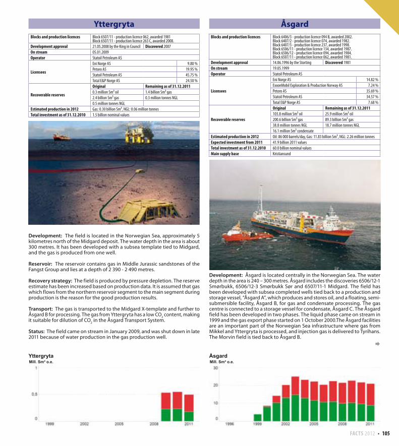
FACTS 2012 105
Yttergryta
Development: The field is located in the Norwegian Sea, approximately 5 kilometres north of the Midgard deposit. The water depth in the area is about 300 metres. It has been developed with a subsea template tied to Midgard, and the gas is produced from one well.
Reservoir: The reservoir contains gas in Middle Jurassic sandstones of the Fangst Group and lies at a depth of 2 390 - 2 490 metres.
Recovery strategy: The field is produced by pressure depletion. The reserve estimate has been increased based on production data. It is assumed that gas which flows from the northern reservoir segment to the main segment during production is the reason for the good production results.
Transport: The gas is transported to the Midgard X-template and further to Åsgard B for processing. The gas from Yttergryta has a low CO
2 content, making
it suitable for dilution of CO2 in the Åsgard Transport System.
Status: The field came on stream in January 2009, and was shut down in late 2011 because of water production in the gas production well.
Åsgard
Development: Åsgard is located centrally in the Norwegian Sea. The water depth in the area is 240 – 300 metres. Åsgard includes the discoveries 6506/12-1 Smørbukk, 6506/12-3 Smørbukk Sør and 6507/11-1 Midgard. The field has been developed with subsea completed wells tied back to a production and storage vessel, “Åsgard A”, which produces and stores oil, and a floating, semi-submersible facility, Åsgard B, for gas and condensate processing. The gas centre is connected to a storage vessel for condensate, Åsgard C. The Åsgard field has been developed in two phases. The liquid phase came on stream in 1999 and the gas export phase started on 1 October 2000.The Åsgard facilities are an important part of the Norwegian Sea infrastructure where gas from Mikkel and Yttergryta is processed, and injection gas is delivered to Tyrihans. The Morvin field is tied back to Åsgard B.
Blocks and production licences Block 6507/11 - production licence 062, awarded 1981Block 6507/11 - production licence 263 C, awarded 2008.
Development approval 21.05.2008 by the King in Council Discovered 2007
On stream 05.01.2009
Operator Statoil Petroleum AS
Licensees
Eni Norge AS 9.80 %
Petoro AS 19.95 %
Statoil Petroleum AS 45.75 %
Total E&P Norge AS 24.50 %
Recoverable reserves
Original Remaining as of 31.12.20110.3 million Sm³ oil 1.4 billion Sm³ gas
2.4 billion Sm³ gas 0.3 million tonnes NGL
0.5 million tonnes NGL
Estimated production in 2012 Gas: 0.30 billion Sm³, NGL: 0.06 million tonnes
Total investment as of 31.12.2010 1.5 billion nominal values
Blocks and production licences Block 6406/3 - production licence 094 B, awarded 2002.Block 6407/2 - production licence 074, awarded 1982.Block 6407/3 - production licence 237, awarded 1998.Block 6506/11 - production licence 134, awarded 1987.Block 6506/12 - production licence 094, awarded 1984.Block 6507/11 - production licence 062, awarded 1981.
Development approval 14.06.1996 by the Storting Discovered 1981
On stream 19.05.1999
Operator Statoil Petroleum AS
Licensees
Eni Norge AS 14.82 %
ExxonMobil Exploration & Production Norway AS 7.24 %
Petoro AS 35.69 %
Statoil Petroleum AS 34.57 %
Total E&P Norge AS 7.68 %
Recoverable reserves
Original Remaining as of 31.12.2011103.8 million Sm³ oil 25.9 million Sm³ oil
200.6 billion Sm³ gas 89.3 billion Sm³ gas
38.8 million tonnes NGL 18.7 million tonnes NGL
16.1 million Sm³ condensate
Estimated production in 2012 Oil: 86 000 barrels/day, Gas: 11.83 billion Sm³, NGL: 2.26 million tonnes
Expected investment from 2011 41.9 billion 2011 values
Total investment as of 31.12.2010 60.0 billion nominal values
Main supply base Kristiansund
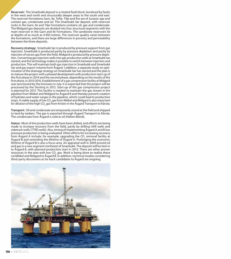
106 FACTS 2012
Reservoir: The Smørbukk deposit is a rotated fault block, bordered by faults in the west and north and structurally deeper areas to the south and east. The reservoir formations Garn, Ile, Tofte, Tilje and Åre are of Jurassic age and contain gas, condensate and oil. The Smørbukk Sør deposit, with reservoir rocks in the Garn, Ile and Tilje Formations contains oil, gas and condensate. The Midgard gas deposits are divided into four structural segments with the main reservoir in the Garn and Ile Formations. The sandstone reservoirs lie at depths of as much as 4 850 metres. The reservoir quality varies between the formations, and there are large differences in porosity and permeability between the three deposits.
Recovery strategy: Smørbukk Sør is produced by pressure support from gas injection. Smørbukk is produced partly by pressure depletion and partly by injection of excess gas from the field. Midgard is produced by pressure deple-tion. Converting gas injection wells into gas production wells at Smørbukk has started, and the technology makes it possible to switch between injection and production. This will maintain both gas injection in Smørbukk and Smørbukk Sør and gas export volume from Åsgard. I addition, a separate study on opti-misation of the drainage strategy on Smørbukk Sør has started and the plan is to mature the project with a phased development with production start-up of the first phase in 2014 and the second phase, depending on the results of the first phase, in 2015/2016. Establishment of a gas compression facility at Midgard was sanctioned by the licensees in July. It is expected that the project will be processed by the Storting in 2012. Start-up of the gas compression project is planned for 2015. This facility is needed to maintain the gas stream in the pipeline from Mikkel and Midgard to Åsgard B and thereby prevent creation of hydrates and water surges in the pipeline, which could lead to production stops. A stable supply of low CO
2 gas from Mikkel and Midgard is also important
for dilution of the high CO2 gas from Kristin in the Åsgard Transport to Kårstø.
Transport: Oil and condensate are temporarily stored at the field and shipped to land by tankers. The gas is exported through Åsgard Transport to Kårstø. The condensate from Åsgard is sold as oil (Halten Blend).
Status: Most of the production wells have been drilled, and efforts are being made to increase recovery from the field, partly by drilling infill wells and sidetrack wells (TTRD wells). Also, timing of implementing Åsgard A and B low pressure production is being evaluated. Other efforts for increasing recovery from Åsgard A include, for example, upgrading the CO
2 removal facility at
Åsgard B and extending the lifetime of Åsgard A. Prolonging the economic lifetime of Åsgard B is also a focus area. An appraisal well in 2009 proved oil and gas in a new segment northeast of Smørbukk. The deposit will be tied-in to Åsgard B, with planned production start in 2013. There are other proven resources in the area with low CO
2 gas. Work is being done to realise these
via Mikkel and Midgard to Åsgard B. In addition, technical studies considering third-party discoveries as tie-back candidates to Åsgard are ongoing.